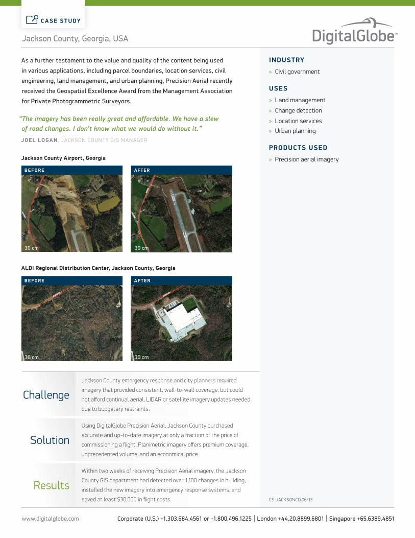
+ All Categories
Home > Documents > Using precision aerial imagery to accomplish county-level ... · The mission of the Jackson County,...

Using precision aerial imagery to accomplish county-level ... · The mission of the Jackson County,...

Date post: 12-Apr-2018
Category:
Upload: lamthien
View: 215 times
Download: 0 times
Share this document with a friend
2
www.digitalglobe.com Corporate (U.S.) +1.303.684.4561 or +1.800.496.1225 | London +44.20.8899.6801 | Singapore +65.6389.4851 CASE STUDY Product solution for: Company information The mission of the Jackson County, Georgia GIS Department is to provide and support GIS technology in an effective, intelligible, and timely manner, enabling local government to better serve the public. GEORGIA, U.S.A. Analysis and planning At the heart of any successful GIS system is the need for new and updated orthoimagery. In 2009 Jackson County was able to fly imagery and LIDAR, but like most local governments, Jackson County has not had the funding to com- mission a new flight. The county continues to see negative growth in tax digest, which is one of the largest sources of funding for local government. However, tracking change in a high-growth community is essential for EMS and public safety. It is critical that 911 dispatchers and first responders have accurate data on structure placement and road changes due to highway realignment. Precision aerial imagery Jackson County discovered an alternative to commissioning new flights at a fraction of the price. The county purchased Precision Aerial imagery from DigitalGlobe and, within two weeks, was able to detect more than 1,100 changes in building, plus install new imagery into its emergency response system. Precision Aerial leverages Microsoſt’s UltraCamG digital imaging technology to provide comprehensive coverage with high-quality and accuracy. The product has saved Jackson County at least $30,000 in flight costs and has allowed staff to track changes efficiently. Using precision aerial imagery to accomplish county-level goals Jackson County, Georgia, has been one of the fastest growing counties in the United States for the past decade. In 2007, the Jackson County Board of Commissioners formed a GIS department to help track and manage growth as well as streamline county records and processes. Jackson County uses GIS extensively to inform 911 dispatchers, aid in city planning, and for property appraisal. Jackson County, Georgia, USA
Transcript

www.digitalglobe.com Corporate (U.S.) +1.303.684.4561 or +1.800.496.1225 | London +44.20.8899.6801 | Singapore +65.6389.4851

C A SE S T UDY

Product solution for:

Company informationThe mission of the Jackson County, Georgia

GIS Department is to provide and support GIS

technology in an effective, intelligible, and

timely manner, enabling local government to

better serve the public.

JACKSON COUNTY

GEORGIA, U.S.A.

Analysis and planningAt the heart of any successful GIS system is the need for new and updated

orthoimagery. In 2009 Jackson County was able to fly imagery and LIDAR, but

like most local governments, Jackson County has not had the funding to com-

mission a new flight. The county continues to see negative growth in tax digest,

which is one of the largest sources of funding for local government. However,

tracking change in a high-growth community is essential for EMS and public

safety. It is critical that 911 dispatchers and first responders have accurate

data on structure placement and road changes due to highway realignment.

Precision aerial imageryJackson County discovered an alternative to commissioning new flights at

a fraction of the price. The county purchased Precision Aerial imagery from

DigitalGlobe and, within two weeks, was able to detect more than 1,100

changes in building, plus install new imagery into its emergency response

system. Precision Aerial leverages Microsoft’s UltraCamG digital imaging

technology to provide comprehensive coverage with high-quality and accuracy.

The product has saved Jackson County at least $30,000 in flight costs and has

allowed staff to track changes efficiently.

Using precision aerial imagery to accomplish county-level goalsJackson County, Georgia, has been one of the fastest growing counties in the United States for the past decade. In 2007, the Jackson County Board of Commissioners formed a GIS department to help track and manage growth as well as streamline county records and processes. Jackson County uses GIS extensively to inform 911 dispatchers, aid in city planning, and for property appraisal.

Jackson County, Georgia, USA

www.digitalglobe.com Corporate (U.S.) +1.303.684.4561 or +1.800.496.1225 | London +44.20.8899.6801 | Singapore +65.6389.4851

C A SE S T UDY

InDUSTrY

» Civil government

USES

» Land management

» Change detection

» Location services

» Urban planning

ProDUCTS USED

» Precision aerial imagery

CS-JACKSONCO 06/13

As a further testament to the value and quality of the content being used

in various applications, including parcel boundaries, location services, civil

engineering, land management, and urban planning, Precision Aerial recently

received the Geospatial Excellence Award from the Management Association

for Private Photogrammetric Surveyors.

“The imagery has been really great and affordable. We have a slew of road changes. I don’t know what we would do without it.”

JoEl l oGA n , JaCkson CoUnty GIs ManaGer

30 cm

30 cm

30 cm

30 cm

BEForE

BEForE

AFTEr

AFTEr

ChallengeJackson County emergency response and city planners required

imagery that provided consistent, wall-to-wall coverage, but could

not afford continual aerial, LIDAR or satellite imagery updates needed

due to budgetary restraints.

solutionUsing DigitalGlobe Precision Aerial, Jackson County purchased

accurate and up-to-date imagery at only a fraction of the price of

commissioning a flight. Planimetric imagery offers premium coverage,

unprecedented volume, and an economical price.

resultsWithin two weeks of receiving Precision Aerial imagery, the Jackson

County GIS department had detected over 1,100 changes in building,

installed the new imagery into emergency response systems, and

saved at least $30,000 in flight costs.

Jackson County, Georgia, USA

Jackson County Airport, Georgia

AlDI regional Distribution Center, Jackson County, Georgia


Recommended