Utilizing Remote Sensing Data to Guide the Surveillance and Control of Parasitic Diseases Investigators: Speaker: Email: Dr. Shizhu Li (Deputy Director of NIPD) Dr. Kun Yang (Deputy Director of JIPD) Dr. Shang XIA (NIPD) [email protected]National Institute of Parasitic Diseases (NIPD), China CDC Jiangsu Institute of Parasitic Diseases (JIPD), China
Transcript
Utilizing Remote Sensing Data to Guide the Surveillance and Control of Parasitic Diseases
Investigators:
Speaker: Email:
Dr. Shizhu Li (Deputy Director of NIPD) Dr. Kun Yang (Deputy Director of JIPD) Dr. Shang XIA (NIPD) [email protected]
National Institute of Parasitic Diseases (NIPD), China CDC Jiangsu Institute of Parasitic Diseases (JIPD), China
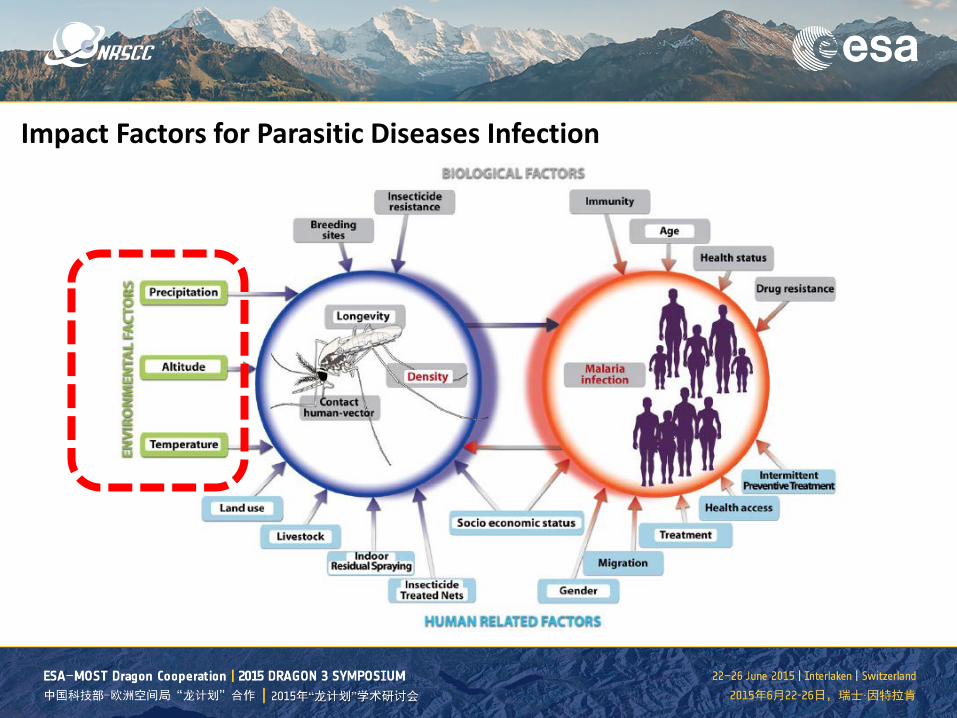
Challenges on parasitic diseases surveillance and control
1. Multiple impact factors: biological, ecological, meteorically 2. Cross nations: human movement, socioeconomic situations 3. Underdeveloped health system: national wide CDC system 4. Data missing about remote regions or countryside
0 50 100 150 200 221
2
4
6
8
village
infe
cted
cas
es
Utilizing remote sensing data
For all regions of interest (ROI), selecting the minimum number of targets that are prioritized to scan, which would sufficiently guarantee to cover a large percentage (or a threshold predefined according to the limitation of available resources) of all potential incidences within a period of time in the future.
Parasitic diseases
Disease vectors
Environmental factors
Remote sensing data
Utilizing remote sensing data to guide the surveillance and control of parasitic diseases
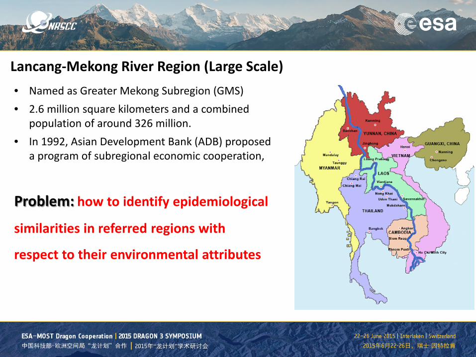
Lancang-Mekong River Region (Large Scale) • Named as Greater Mekong Subregion (GMS) • 2.6 million square kilometers and a combined
population of around 326 million. • In 1992, Asian Development Bank (ADB) proposed
a program of subregional economic cooperation,
Problem: how to identify epidemiological
similarities in referred regions with
respect to their environmental attributes
Clustering Method is defined as the process of finding a structure where the data objects are grouped into clusters which are similar behavior.
Let denote the data set consisting of 𝑛𝑛 samples (points) over 𝑛𝑛-dimensional space (attributes)
1. Given a set of observations (x1, x2 , …, xn ) ,
2. where each observation is a d-dimensional real vector,
3. aims to partition the n observations into k sets (k ≤ n) S = {S1, S2 , …, Sk }
4. so as to minimize the within-cluster sum of squares (WCSS):
where μi is the mean of points in Si
Remote sensing data
(a) DEM (b) NDVI
(c) LSTD (d) LSTN
(a) K=2 (b) K=3
(c) K=4 (d) K=5
Remote sensing data were retrieved from Moderate Resolution Imaging Spectroradiometer (MODIS), ranging from Jan. 2010 to Jan. 2014 with temporal interval of eight days and spatial resolution of 1KM.
SPOT5 images covering the whole study area and acquired on March 16, 2006 were obtained from the China Remote Sensing Satellite Ground Station (Beijing, China). This imagery has a spatial resolution of 2.5m in panchromatic mode and 10 m in colored mode.
Snail habitats prediction (Middle Scale)
Flooding season in 1983 Normal water level in 1984 Three cloud-free Landsat-5 TM images of the study area with a spatial resolution of 30m
Three cloud-free Landsat-5 TM images of the study area with a spatial resolution of 30m.
Result: snail habitats prediction
Parasitic diseases
Disease vectors
Environmental factors
Remote sensing data
Utilizing remote sensing data to guide the surveillance and control of parasitic diseases
Next steps
1. Extension and improvement of existing approaches through the front fields epidemiological practice
2. Small scale local environment analysis to investigate the transmission mechanism of parasitic diseases
3. Large scale regional analysis to evaluate the risks of environmental changes, including climate and land usage.
Conclusions
1. Parasitic diseases and environmental factors
2. Challenges in diseases surveillance and control
3. Active surveillance planning
4. Two case studies by exploring remote sensing data