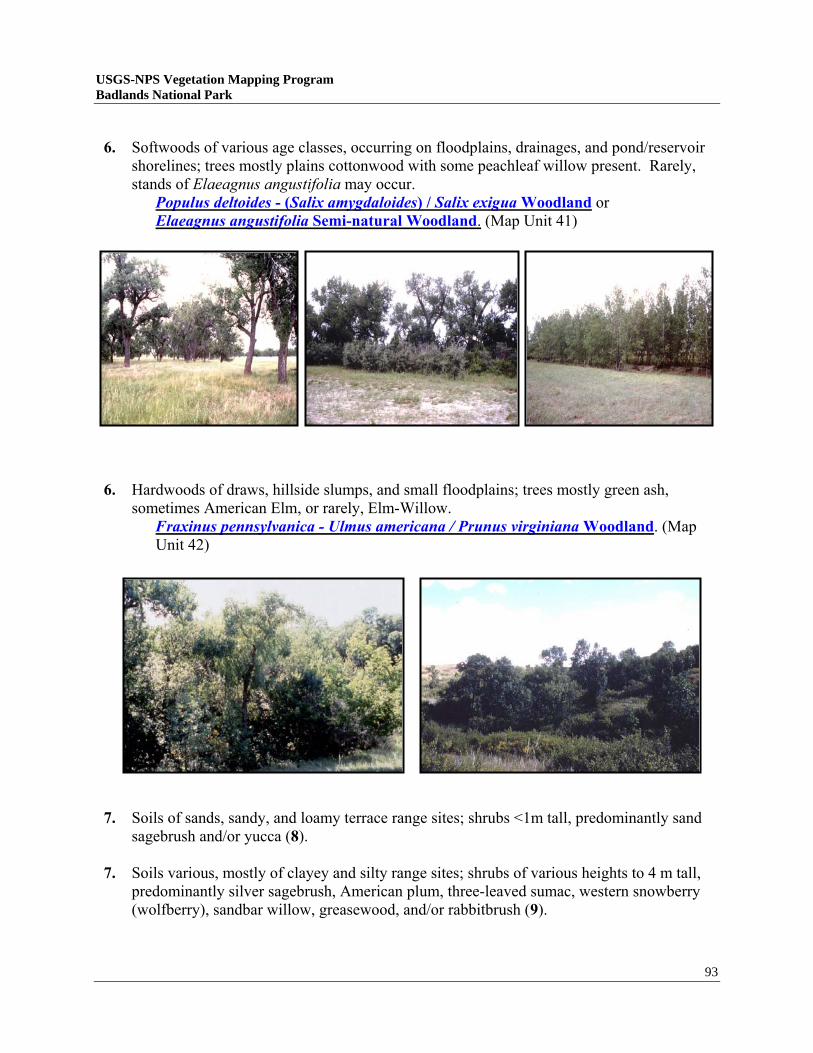
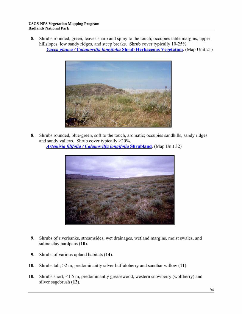
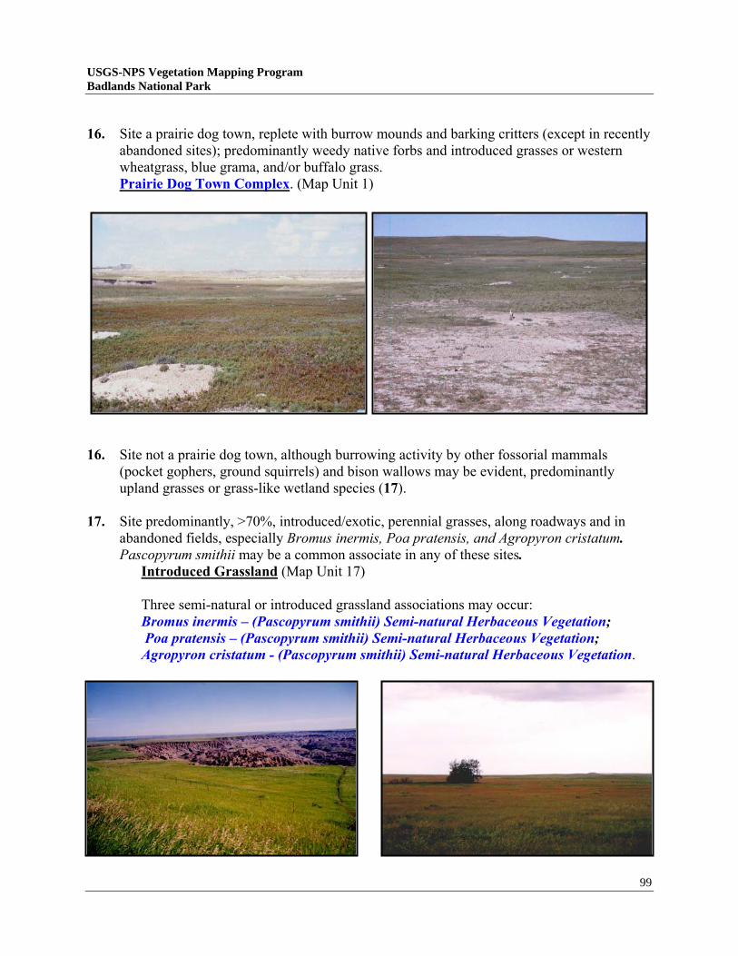
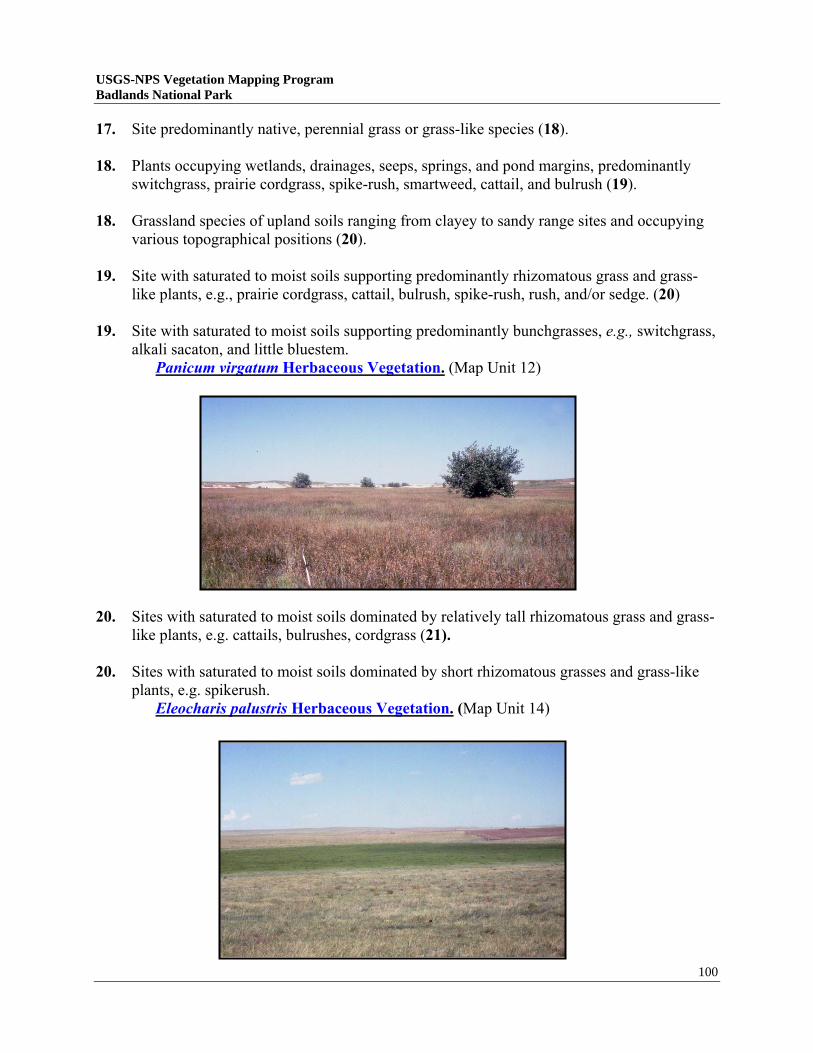
USGS-NPS Vegetation Mapping Program Badlands National Park USGS-NPS Vegetation Mapping Program Badlands National Park, South Dakota Jim Von Loh ACS Government Solutions Group Dan Cogan ACS Government Solutions Group Don Faber-Langendoen The Nature Conservancy Doug Crawford Bureau of Reclamation Michael J. Pucherelli Bureau of Reclamation November 19, 1999 U.S. Department of the Interior Bureau of Reclamation’s Remote Sensing and GIS Group Denver Federal Center Denver, Colorado The Reclamation Remote Sensing and Geographic Information Group, organized in 1975 provides advice and assistance regarding the application of remote sensing and geographic information system (GIS) technologies to meet the spatial information needs of Bureau of Reclamation and other clients.
Transcript
USGS-NPS Vegetation Mapping Program Badlands National Park
USGS-NPS Vegetation Mapping Program Badlands National Park, South Dakota
Jim Von Loh
ACS Government Solutions Group
Dan Cogan ACS Government Solutions Group
Don Faber-Langendoen The Nature Conservancy
Doug Crawford
Bureau of Reclamation
Michael J. Pucherelli Bureau of Reclamation
November 19, 1999
U.S. Department of the Interior Bureau of Reclamation’s Remote Sensing and GIS Group
Denver Federal Center Denver, Colorado
The Reclamation Remote Sensing and Geographic Information Group, organized in 1975 provides advice and assistance regarding the application of remote sensing and geographic information system (GIS) technologies to
meet the spatial information needs of Bureau of Reclamation and other clients.
USGS-NPS Vegetation Mapping Program Badlands National Park
TABLE OF CONTENTS
LIST OF TABLES......................................................................................................................... ..IV
LIST OF FIGURES.......................................................................................................................... .V
LIST OF CONTACTS ..................................................................................................................... VI
LIST OF CONTRIBUTORS.............................................................................................................VIII
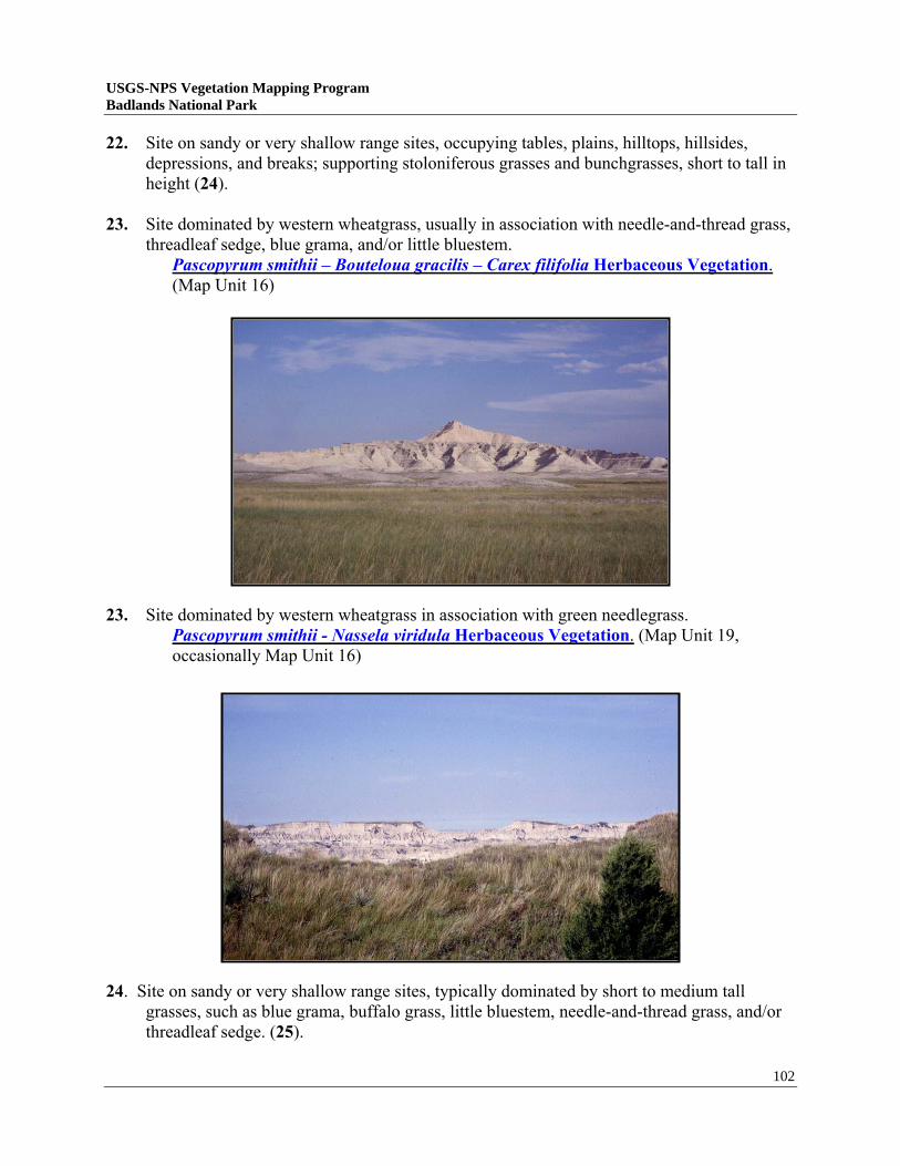
ACKNOWLEDGEMENTS ................................................................................................................ IX
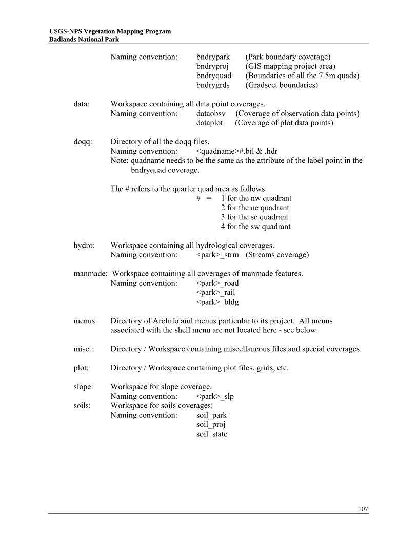
USGS-NPS Vegetation Mapping Program Badlands National Park
LIST OF CONTRIBUTERS Bureau of Reclamation
Jack Butler, Dan Cogan, Doug Crawford, Brent Dekker, Kathy Fenton, Trudy Meyer, Jean Pennell, Mike Pucherelli, David Salas, Jim Von Loh, and Keldyn West U.S. Forest Service
Peter MacDonald and Greg Schenbeck The Nature Conservancy
Jim Drake and Don Faber-Langendoen National Park Service
Doug Albertson, Bruce Bessken, Glenn Plumb, and Cindy Reed
Oglala Lakota Nation
Emma Featherman-Sam, Robin White, and Joe Amiotte Bureau of Indian Affairs
Pat Keatts and Gene Seagle Natural Resources Conservation Service
Lynn Shell and Rod Voss
viii
USGS-NPS Vegetation Mapping Program Badlands National Park
ACKNOWLEDGEMENTS Mapping the vegetation at Badlands National Park was made much easier and more thorough because of the involvement of, and guidance provided by Mr. Bruce Bessken (Chief, Resource Management) and Dr. Glenn Plumb (Wildlife Biologist). Bruce and Glenn assisted in all decision-making and review phases, contributing to scoping meetings, sampling area selection, map class selection, and review of vegetation map products. They were instrumental in securing access from the Oglala Lakota Nation, supplying boundary information and lodging for field crews, and in providing sage advice. Since the project beginning in 1997, both of these men have taken new directions, Bruce in retirement and Glenn at Yellowstone National Park, but their legacy at Badlands National Park remains, partly within this study. Thanks for the assistance and memories Bruce and Glenn!
ix
USGS-NPS Vegetation Mapping Program Badlands National Park
EXECUTIVE SUMMARY The USGS Biological Resources Division (USGS/BRD) in cooperation with the Inventory and Monitoring Program of the National Park Service has initiated a multi-year project to classify, describe, and map vegetation for 250 national parks. As a contractor under this program, the Bureau of Reclamation’s Remote Sensing and Geographic Information Group with assistance from The Nature Conservancy has classified and mapped the vegetation occurring in and around Badlands National Park (near Interior, South Dakota). Twenty-three vegetation map classes and ten Anderson Level II land-use classes were used for interpretation of approximately 1.3 million acres encompassing the Park (approximately 242,755 acres) and surrounding environs. From this, approximately 0.9 million acres in and around the Park were digitally transferred into a Geographic Information Systems database. Vegetation map classes were determined through extensive field reconnaissance, data collection, and analysis in accordance with the National Vegetation Classification System. The vegetation map was created from photographic interpretation of 1997, 1:12,000 scale color infrared aerial photography (0.5 hectare minimum mapping unit). All vegetation and land-use information was then transferred to 1995, black-and-white USGS digital orthophoto quarter-quads using a combination of on-screen digitizing and scanning techniques. Arc/Info™ (ESRI, Inc.) software was used throughout the project for digitizing, scanning, transforming, registering, and plotting the interpreted data. Overall map accuracy for the entire mapping effort was assessed at 80.6% (78.2% Kappa Index). Final map products comply with national map accuracy standards, are described in this report, and occur on the accompanying compact disk. They include the following: • Vegetation Classification Descriptions • Land Use Classification System • Vegetation Key • Representative Photos and Slides from Field Studies • Field Data (Digital Database) • Digital and Hard Copy Vegetation Maps • Accuracy Assessment • Metadata • Final Report Badlands National Park and similar national park vegetation mapping databases can be accessed at the USGS/BRD website: http://biology.usgs.gov/npsveg.
1
USGS-NPS Vegetation Mapping Program Badlands National Park
INTRODUCTION The Inventory and Monitoring (I&M) Program of the National Park Service (NPS) was created in 1991 to provide park managers with critical information on natural resources. A long-term goal of this program is to provide baseline inventories of the biological and geophysical resources for all natural resource parks. As part of the National Biological Information Infrastructure (NBII), the NPS entered a multi-year partnership with the United States Geological Survey’s (USGS) Biological Resources Division (BRD) to map the vegetation resources of 250 National Park units across the United States. Goals of the USGS-NPS Vegetation Mapping Program include the following: • Provide support for NPS Resources Management • Promote vegetation-related research for both NPS and USGS/BRD • Provide support for NPS Planning and Compliance • Add to the information base for NPS Interpretation • Assist in NPS Operations Efforts to make this program successful have led to various work contracts with other government agencies and private organizations. Among those contracted was the United States Bureau of Reclamation’s (BOR) Remote Sensing and Geographic Information Group (RSGIG) based at the Denver Federal Center, Colorado. The tasks for the RSGIG were to classify and describe the vegetation and create a digital, spatial database representative of the vegetation and land use occurring at Badlands National Park (BADL), South Dakota during 1997. The primary subcontractor for review of vegetation classification and characterization was The Nature Conservancy (TNC) (Midwest Resource Offices - Minneapolis, MN). The specific objectives of this study include: • Collection and analysis of vegetation data. • Creation of vegetation and mapping classifications based on the National Vegetation Classification System (NVCS). • Development of a spatial database for the vegetation of BADL using remote sensing and Geographic Information System (GIS) techniques. • Production of digital and hard copy vegetation maps, assessed to be at least 80% accurate. Vegetation mapping for BADL falls under the USGS-NPS Vegetation Mapping Program’s general task of completing all the National Parks within the Great Plains Ecosystem. Other Parks in this region that have been mapped or are currently in progress include: Theodore Roosevelt National Park, Wind Cave National Park, Mount Rushmore National Memorial, Agate Fossil Beds National Monument, Jewel Cave National Monument, Devil’s Tower National Monument, Scott’s Bluff National Monument, and Fort Laramie National Historic Site. Any available data pertaining to these and other USGS-NPS Vegetation Mapping projects can be accessed at the USGS/BRD’s website: http://biology.usgs.gov/npsveg.
Introduction 2
PROJECT AREA
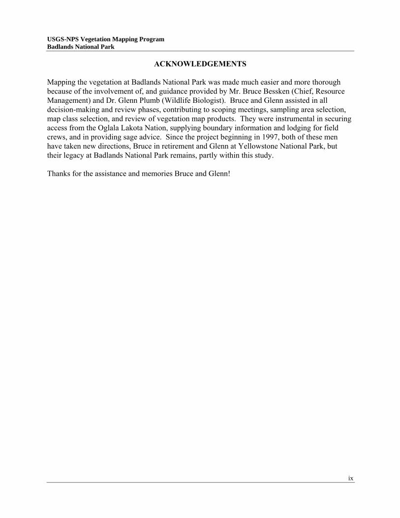
Badlands was first authorized by Congress on March 4, 1929 and set aside as a national monument in 1939. The management area at this time consisted only of the current North Unit (111,000 acres). Badlands National Monument doubled in size with the addition of the South Unit (133,300 acres) from the Lakota Tribe’s Pine Ridge Reservation and subsequent boundary changes in 1936, 1952, and 1968. Wilderness designation was assigned to the Sage Creek area in 1976 and Badlands National Park was designated on November 10, 1978. BADL is best known for its extensive geologic processes/exposures, significant fossil resources, scenic vistas, and its mixed grass prairie ecosystem supporting abundant wildlife. BADL personnel presently manage 242,756 surface acres in the North and South Units. The South Unit consists of an area contiguous to the North Unit known as the Stronghold Unit and the separate Palmer Creek Unit (Mills 1998) (Figure 1). Both units contain predominantly badlands erosion features and mixed-grass prairie interspersed with swales, draws, and drainages containing trees and shrubs (Figure 2). Location and Regional Setting BADL is situated on the Northern Great Plains Region of South Dakota, about 8 miles south of Wall, SD (DeLorme 1997). The Park lies in Pennington, Jackson, and Shannon Counties and is roughly bounded by the towns of Wall, Scenic, Interior, Cactus Flats, Red Shirt, Rockyford, and Kyle. South Dakota Highways 240, 44, and 37, and Bureau of Indian Affairs (BIA) Highways 2 and 27 are the Park’s major roads. Secondary roads within BADL include NPS Sage Creek and Sheep Mountain Table Roads and U.S. Forest Service (USFS) roads through the Conata Basin and Quinn Table areas. Tertiary roads include a variety of trails or 2-tracks on Pine Ridge Reservation and USFS lands accessible only by high-clearance vehicles (used primarily for access to public grazing lands). BADL maintains nature and hiking trails into the North Unit. The three self-guided nature trails are the Fossil Exhibit (0.25 miles), Door (0.75 miles), and Cliff Shelf (0.3 miles) trails. Hiking trails include Sage Creek (6 miles) The Notch (0.5 miles), Saddle Pass (0.5 miles), Medicine Root (3 miles) Window, (0.25 miles) and Castle (6 miles) trails. Climate Badlands National Park lies within the northern Great Plains. This region normally records warm summers and relatively cold winters. A semi-arid, continental climate that includes short, hot, and dry summers, long, cold, and dry winters, and precipitation events occurring mostly in late spring and early summer, typify the area. Average temperatures recorded for Wasta, SD (west of the Park) range from 24o F in the winter to 72o F in the summer (the average daily maximum temperature is 87oF) (USDA-SCS 1996). Temperatures in the spring and fall seasons can vary dramatically and change abruptly within short time periods. The Park usually experiences at least 130 frost-free days a year (USDA-SCS 1987).
Project Area 3
USGS-NPS Vegetation Mapping Program Badlands National Park
USGS-NPS Vegetation Mapping Program Badlands National Park
Figure 1. Map of Badlands National Park showing unit boundaries, infrastructure, and facilities (map courtesy of Badlands NP).
Project Area 4
tsingh
tsingh
USGS-NPS Vegetation Mapping Program Badlands National Park
Project Area 5
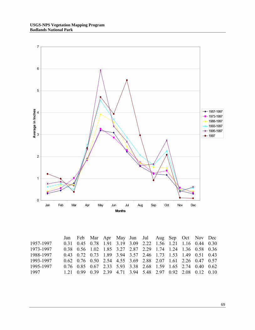
photo by D. Cogan Figure 2. The landscape of Badlands National Park showing pronounced erosion features and mixed-grass prairie. Precipitation for this region is usually heaviest in late spring and early summer, with a total annual amount of 15.53 inches (USDA-SCS 1996). Local observations by BADL personnel report the last nine years as wetter than normal (Bessken 1999), although average monthly precipitation data for Interior and Wasta, SD show only minor increases (Appendices 1 and 2). However, the weather can be quite active and violent. For example, during the summer of 1997 a large hailstorm flattened the grasslands and stripped leaves from trees and shrubs within the Roberts Prairie Dog Town vicinity. (Note: this area was revisited the following year to insure accurate identification and mapping.) Geology and Topography Geologically, the area of Badlands National Park is known as “The Big Badlands” (Gries 1996) or the “White River Badlands” (O’Harra 1920, revised 1976). They have also been referred to as “Mako Sica” (bad land) by the Lakota Tribe and “Mauvaises Terres a Traverser” (bad lands to cross) by French explorers. Badland development can be attributed to the following main factors: 1) a climate with low rainfall that is more or less concentrated into heavy showers, 2) scarcity of deep-rooted vegetation, and 3) slightly consolidated mudstones, siltstones, and sandstones lying at a considerable height above the main drainage channels (the occasional hard layers or beds that may be present being thin and in horizontal position) (O’Harra 1920, revised 1976).
Project Area 6
Bedrock within the Park and surrounding area consists principally of Cretaceous Pierre Formation clayey shale; Oligocene White River Group (Brule Formation siltstone and Chadron Formation clayey mudstone and shale); and Oligocene Sharps Formation (Gries 1996, USDA-SCS 1987, O’Harra 1920, revised 1976). The Pierre shale produces dark gumbo clay upon weathering, which is most easily observed west of Scenic, SD and along the Cheyenne River drainage (Gries 1996). The Chadron Formation weathers to low hummocks, locally called “haystacks”, and consisting mainly of greenish-gray bentonite clay. The Brule Formation weathers to white, gray, pink, and lavender clays and silty clays; it is capped by bright, white Rocky Ford volcanic ash (Gries 1996). In some places the Chadron and Brule Formations contain veins of dark gray chalcedony (a translucent variety of quartz), which break into shards and covers many acres of underlying soil. Exposed Chadron and Brule Formation landforms are abundant throughout the Park and veins of chalcedony are most observable in the vicinity of Sheep Mountain Table continuing southward to Cedar Table. Approximately 46% of BADL consists of steeply inclined, narrow gorges, knife-edged ridges, flat-topped buttes, peaks, out-wash fans, and their associated drainages all eroded from the Chadron and Brule Formations (Butler and Batt 1995). Locally the northernmost Brule Formation rock outcrops (capped by Rocky Ford volcanic ash) are known as the “Wall”; named for its nearly vertical cliff of exposed siltstone (a geographical barrier for early travelers moving northward). A variety of fossils are found within the geologic formations, the oldest being molluscs and other shells of the Cretaceous inland sea that deposited the Pierre shale. Oligocene fossils associated with the Chadron Formation include algae, snails, and clams in limestone lenses and turtles, crocodiles, and many mammals (including titanotheres, oreodons, early horses, rhinoceros, felines, and canines, among others) more generally distributed throughout the formation (Gries 1996 and O’Harra 1920, revised 1976). Oligocene Brule Formation fossils include the richest group of mammals exposed/unearthed in the world, perhaps 150 different genera (Gries 1996 and O’Harra 1920, revised 1976). These range in size from mouse-like rodents to species of rhinoceros and include early relatives of horses, camels, pigs, deer, antelope, beaver, felines, canines, and small rodents. Badlands topography is a mixture of relatively flat plains, moderately wide flood plains associated with the White and Cheyenne rivers, hills of eolian sands, and highly dissected erosion features. BADL lies in the Pierre Hills and Tertiary Table Lands divisions of the Great Plains (South Dakota Geological Survey n.d. in USDA-SCS 1996). Elevation ranges from below 2,300-ft., where the White River exits the study area to more than 3,100-ft. near “The Pinnacles” at the northern boundary of the North Unit and Red Shirt Table on the western edge of the South Unit. The highest points in the study area occur just west of Stronghold Table and on Sheep Mountain Table both at nearly 3,300-ft. elevation.
USGS-NPS Vegetation Mapping Program Badlands National Park
USGS-NPS Vegetation Mapping Program Badlands National Park
Badlands National Park
Figure 3. Geologic formations found throughout Badlands National Park. Clockwise from top left corner: hills along Sage Creek derived from Pierre shale; haystack mounds of the Chadron formation (foreground) and cliffs and ridges of the Brule formation (background); cliffs and ridges of the Brule formation; cliffs and slopes of the Brule formation; badlands “wall” (Brule formation) near Interior, SD; small buttes and tables; alkali flats and clay outwash fans; chalcedony beds; cliffs and ridges of the Brule formation; badlands overview with intermingled grasslands; Brule formation capped with eolian sands; rugged Brule formation containing Rocky Ford volcanic ash.
Project Area 7
Project Area 8
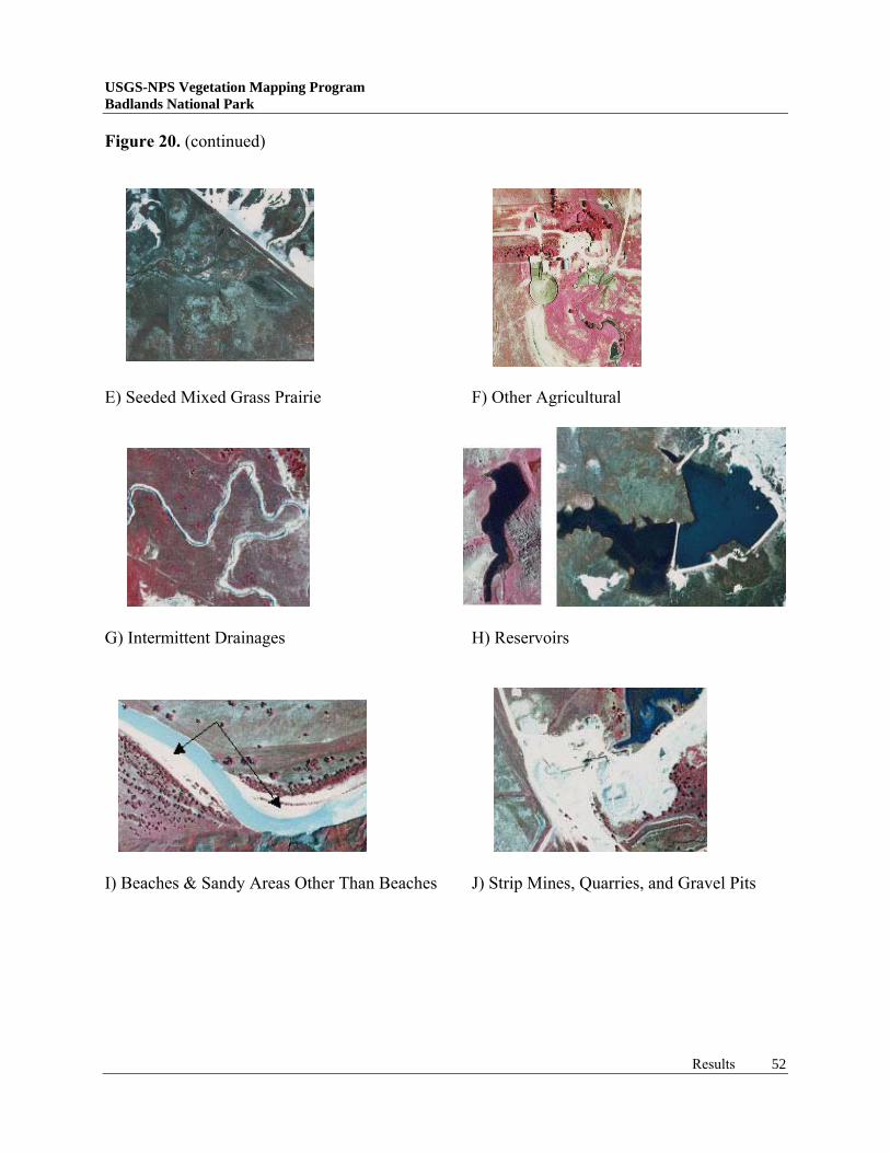
The White and Cheyenne Rivers, flowing generally northeast and east border BADL. Important tributary creeks of these rivers typically trend southeast and northwest. These include Sage, Crooked, Whitewater, Buffalo, Cain, Clifford, Wind, Medicine Root, Palmer, Porcupine, Wounded Knee, Big Hollow, Spring, Cottonwood, Fog, Sand, Battle, and Cedar Creeks, sections of which flow all or most of the year. There are many smaller drainages that are typically dry, flowing only during or immediately following precipitation events. Active springs are occasional and found at scattered locations. Many small ponds and reservoirs are present, in addition to wetland depressions and channels. Water sources have been developed to support bison herds in the North Unit and cattle grazing in the South Unit by using dugouts, check dams, larger earth fill dams, pumped ground water, and natural surface water supplies, as appropriate. Many wildlife species are attracted to the open water and wetlands including a variety of waterfowl and shorebirds. Soils Most soil associations occurring at BADL formed from eroded bedrock deposited as old alluvial deposits on high terraces; recent alluvial deposits on flood plains, swales, and in upland depressions; and from sand and loess on uplands. Soils relate to specific geologic landforms, topographic relief, climate, and the corresponding natural vegetation (Ensz 1990). Soils on and adjacent to badland exposures and in drainage channels are rapidly deposited, and support a sparse plant community. Conversely, deeper soils mantling the buttes, hills, and alluvial valleys support relatively dense and diverse plant communities, typically grasslands. In many instances plant associations are further affected by wildlife or grazing livestock use. A common example is the intense grazing in prairie dog colonies, often resulting in different plant associations than otherwise would be present. Regional soils represent four orders, Entisols, Aridisols, Mollisols, and Vertisols (Batt 1991). Vertisols are upland clays with very high shrink/swell potential characterized by deep, wide cracks formed at the soil surface. Mollisols are prairie soils found on grassy bluffs that are characterized by melanization, a darkening of the soil due to addition of organic matter. Aridisols are soils of arid uplands, typically dry for more than 50% of the year. Entisols are newly formed upland soils developed from steep slope erosion, alluvial floodplain deposition, and eolian deposition. One way to assess regional soil patterns is to consider Range Site Classifications provided by the U. S. Department of Agriculture in their countywide soil surveys. A range site is a distinctive kind of habitat, or group of soils, that is capable of supporting similar kinds, proportions, and amounts of native vegetation. Factored into these are soil properties important to the distribution of plant associations including moisture supply, nutrient availability, salt content, soil reaction, and seasonal high water levels (USDA-SCS 1996). Table 1 contains range site names and descriptions, the major soil associations present, and the typical NVCS plant alliance or complex observed growing there. Some plant associations can be found on any soil if other parameters occur (such as sufficient hydrology to support wetlands). Each soil association consists of a variety of major and minor soil units that are sometimes combined to form soil complexes.
USGS-NPS Vegetation Mapping Program Badlands National Park
Project Area 9
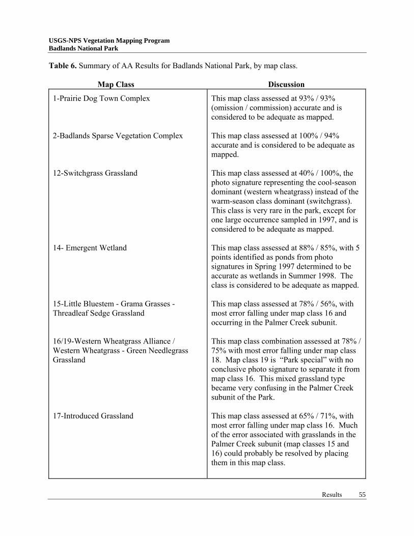
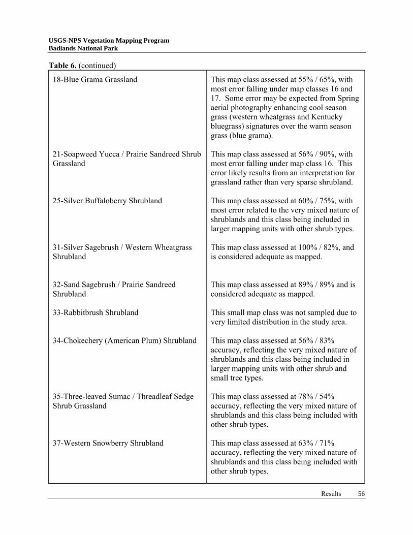
Table 1. Range sites, soil associations, and related NVCS vegetation types occurring in the Badlands National Park Vegetation Mapping area. (Note: plant alliances are described in Appendix 12 and Badlands Sparse Vegetation Complex is described in Table 3.)
Range Site: Definition Soil Association Typical Vegetation Type Badland: unvegetated erosion features. Overflow: sandy to clayey alluvial soils on bottomlands. Badland Overflow: silty to clayey alluvial soils on badland drainages. Subirrigated Range Site: deep, nearly level soils of basins and valleys among or adjacent to sandhills. Clayey: moderately deep to deep, level to sloping soils. Clayey Overflow: deep, level soils of floodplains Claypan: slight rises between shallow depressions. Closed Depression: claypans on uplands. Dense Clay: thin crust over strongly alkaline subsoil. Loamy Overflow: deep, level soils of floodplains Loamy Terrace: deep, level soils of floodplain terraces
Badlands Sparse Vegetation Complex Western wheatgrass Alliance Badlands Sparse Vegetation Complex and Western wheatgrass Alliance Western wheatgrass Alliance Western wheatgrass Alliance Western wheatgrass Alliance Blue grama Alliance Western wheatgrass Alliance Western wheatgrass Alliance Western wheatgrass Alliance Western wheatgrass Alliance Western wheatgrass Alliance
USGS-NPS Vegetation Mapping Program Badlands National Park
Project Area 10
Table 1. (continued) Range Site:Definition Soil Association Typical Plant Association Saline Lowland: Narrow areas along upland drains and flats in stream valleys. Sands and Choppy Sands: deep, loose undulating, rolling, or hilly soils. Sandy: deep, level to undulating sands. Shallow: shallow soils over bedded geologic material. Shallow Clay: shallow, steep upland soil with scattered stones and/or rock outcrops Silty: nearly level to sloping soils, moderately deep. Thin Claypan: thin surface soils over claypans. Thin Upland: thin, alkaline soils. Very Shallow: deep, sandy and gravelly alluvium.
Western wheatgrass Alliance Blue grama Alliance Sand sagebrush Alliance Blue grama Alliance Little bluestem Alliance Blue grama Alliance Little bluestem Alliance Western wheatgrass Alliance Western wheatgrass Alliance Blue grama Alliance Blue grama Alliance Little bluestem Alliance Little bluestem Alliance Blue grama Alliance
USGS-NPS Vegetation Mapping Program Badlands National Park
Project Area 11
Wildlife BADL supports numerous wildlife species including many animals native to the Northern Great Plains. Some of the larger mammals are actively managed by Park personnel to insure the overall health of the Park’s vegetation resource. These include bison (Bison bison), pronghorn antelope (Antilocapra americana), mule and white-tailed deer (Odocoileus hemionus and O. virginianus), bighorn sheep (Ovis canadensis), and black-tailed prairie dog (Cynomys ludovicianus) (Figure 4). Two major wildlife programs underway include reintroduction of the federally endangered black-footed ferret (Mustela nigripes) to black-tailed prairie dog colonies within the Park and research on bighorn sheep, specifically their reproduction, distribution, and ecology. Bighorn sheep (Rocky Mountain subspecies) were introduced to the Monument in 1964 to replace the now extinct subspecies Audubon bighorn (O. canadensis auduboni) (Butler and Batt 1995). It was thought that this would also serve as a supply herd for transplants to other areas within the state of South Dakota.
photos by D. Cogan Figure 4. Bison, black-tailed prairie dog, and bighorn sheep in Badlands National Park. Domesticated cattle and sheep do not currently graze within the Park’s North Unit, although adjacent grasslands under private ownership or managed by USFS are annually grazed. Livestock grazed the Badlands North Unit up to 1963 when the Monument was fenced to exclude cattle (Butler and Batt 1995). Following fencing, bison were reintroduced into the western half of the North Unit and are currently being managed for a minimum population of 500 animals. Cattle regularly graze the South Unit, but stocking rates are unknown. Livestock grazing does have an influence on the distribution of some plant species and plant associations. For example, yellow sweetclover (Melilotus officianalis) occurs in greater abundance on ungrazed lands of the North Unit versus similar grazed lands in the South Unit and in the surrounding environs (Figure 5). Conversely, Blue grama - Buffalo grass (Bouteloua gracilis - Buchloe dactyloides) Xeric Soil grasslands tend to be absent within the lightly grazed (only by bison and other wildlife species) or ungrazed lands of the North Unit. Soil types should also be taken into consideration when determining grazing effects on distribution of plant associations. This is illustrated by the higher incidence of sandy and sandy-loam soils supporting Blue grama - Buffalo grass Xeric Soil grasslands in the South Unit compared to the
USGS-NPS Vegetation Mapping Program Badlands National Park
Project Area 12
clay, clay-loam and silty soils supporting Western Wheatgrass Alliance grasslands in the North Unit. Another interesting grazing influence is the large number of prairie dog colonies present within and adjacent to the Park and the plant associations that are maintained or result from prairie dog grazing and burrow construction. This is described in more detail under the vegetation section and under the project results.
photos by J. Von Loh Figure 5. Biennial yellow sweetclover in Badlands National Park demonstrating the effects of 1) livestock grazing (grazed right of the fence) and 2) coverage within the North Unit of the Park. Photos were taken in 1998, a “sweetclover year”. Vegetation BADL vegetation can be divided into two major types; sparse vegetation of highly eroded soils and mixed grass prairie. Badlands formations comprise over 46% of the Park, just slightly larger than the area covered by prairie grasslands (42%). Sparse vegetation associated with badlands ridges, slopes, haystack mounds, and drainages is comprised of a mixture of low-growing shrubs, forbs, and grasses. Grasslands are distributed across areas of deeper soils, including plains, valleys, buttes, and sand hills and ridges. They also occupy thin soils on gravelly hill slopes that rapidly release moisture to the plants (Figure 6). Shrub communities tend to be confined to drainages with meandering rivers or streams, sandy ridges, sand hill complexes, gravelly or rocky draws, and moist swale habitats. Woodlands occur in the river floodplains, in draws and deep swales, hillside slumps, and along ridgelines (Figure 6). A particular habitat for both shrubs and trees is at the edge of sand hill complexes where water seeps from the hills at their interface with underlying, relatively impermeable, clay soils. Other widely distributed vegetation types at BADL and its surrounding area include emergent wetlands and prairie dog towns (Figure 6). Wetlands occupy depressions, meandering drainages, seeps, springs, and old oxbows throughout the project area. In many cases, stock ponds developed to support livestock grazing also support wetland vegetation in the shallower water
USGS-NPS Vegetation Mapping Program Badlands National Park
Project Area 13
stored behind dams and in the zone of seepage below the dam structure. Prairie dog towns are distributed on appropriate soils, comprising 2% of BADL. Many non-native or exotic plant species have been introduced to BADL mostly prior to its designation as a park. Historic agricultural fields are still dominated by species such as crested wheatgrass (Agropyron cristatum) and Kentucky bluegrass (Poa pratensis). Disturbed roadsides typically support smooth brome (Bromus inermis) and alfalfa (Medicago sativa). Yellow sweetclover, a biennial species from Eurasia, prefers relatively moist conditions and has successfully invaded the entire North Unit (Figure 5). However, it does appear to be suppressed in the South Unit by livestock grazing and drier soils (sand and sandy loam).
photos by D. Cogan & J. Von Loh Figure 6. Characteristic vegetation at Badlands National Park including from upper left corner:
mixed grass prairie, sparse vegetation, shrub and tree communities in mesic swale, shrubs on sand hill, floodplain shrubs and trees, and wetland depression with large expanse of prairie dog town in background.
USGS-NPS Vegetation Mapping Program Badlands National Park
USGS-NPS Vegetation Mapping Program Badlands National Park
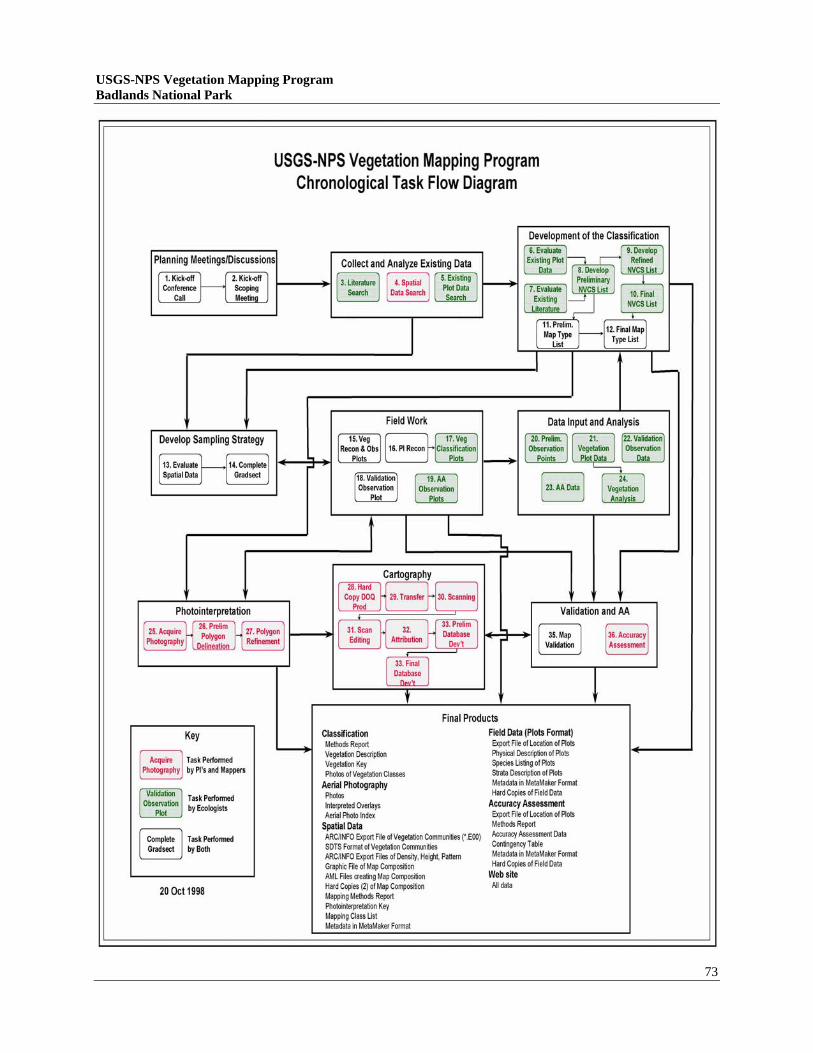
MATERIALS AND METHODS The organization of this project followed protocols and procedures set forth by the USGS/BRD (Appendix 3) as described in Field Methods for Vegetation Mapping, Standardized National Vegetation Classification System (TNC 1994), and Accuracy Assessment Procedures (TNC 1994). Basic steps to fulfill protocols include: 1. Planning and Scoping 2. Preliminary Data Collection and Review of Existing Information 3. Aerial Photography Acquisition 4. Gradsect Design
5. Field Survey 6. Vegetation Classification and Characterization 7. Vegetation Map Preparation 8. Accuracy Assessment
1. Planning and Scoping BADL vegetation mapping incorporated the combined expertise and oversight of several organizations. 1) Oversight and programmatic considerations were managed by the Center for Biological Informatics (CBI) of the USGS/BRD; 2) The National Park Service and BADL personnel provided additional guidance on specific Park needs; 3) Fieldwork, data reduction, plant association descriptions, and technical mapping portions were contracted to the Bureau of Reclamation’s RSGIG; 4) The Nature Conservancy was sub-contracted to review local plant association descriptions, provide corresponding global descriptions, and review the plant association key and accuracy assessment results; and 5) Management and collection of accuracy assessment data was contracted to Dr. Jack Butler, Central Missouri State University, with logistical assistance provided by RSGIG staff. Specific technical responsibilities and deliverables for the project include the following: BOR RSGIG Responsibilities and Deliverables: • Acquire aerial photography under contract to Horizons, Incorporated (Rapid City, SD); • Conduct a gradsect meeting to determine intensive vegetation sampling locations; • Design a sampling strategy; • Collect observation point data to refine the preliminary vegetation classification and
familiarize investigators with community characteristics and their range of variation; • Collect relevϑ plot data to determine plant associations and vegetative variability within
BADL by selecting and sampling representative stands for all communities; • Conduct a meeting to evaluate “park special” mapping concerns, particularly prairie dog
colony edge location and distribution; • Prepare final classification, community descriptions, and key to plant communities; • Conduct a meeting to determine vegetation and land-use map classes; • Interpret aerial photographs for map classes; • Transfer interpreted information to a digital spatial database and produce hard copy (paper)
vegetation maps; Materials and Methods 14
USGS-NPS Vegetation Mapping Program Badlands National Park • Conduct field verification trip to assess visual accuracy of draft vegetation maps; • Field test final classification, descriptions, and key during accuracy assessment; • Collect accuracy assessment points (contracted to Dr. Jack Butler); • Create digital vegetation coverages including relevant attribute information; • Produce Arc/Info export file of gradsect locations, vegetation plot, observation point, and
accuracy assessment locations; • Provide an annotated list of representative field site photographs/slides; • Create a spreadsheet and contingency table comparing the mapped classes with the AA
classes in order to determine map accuracy; • Provide any ancillary digital files developed during the mapping process; • Document and record digital FGDC compliant metadata files (*.html) for all created spatial
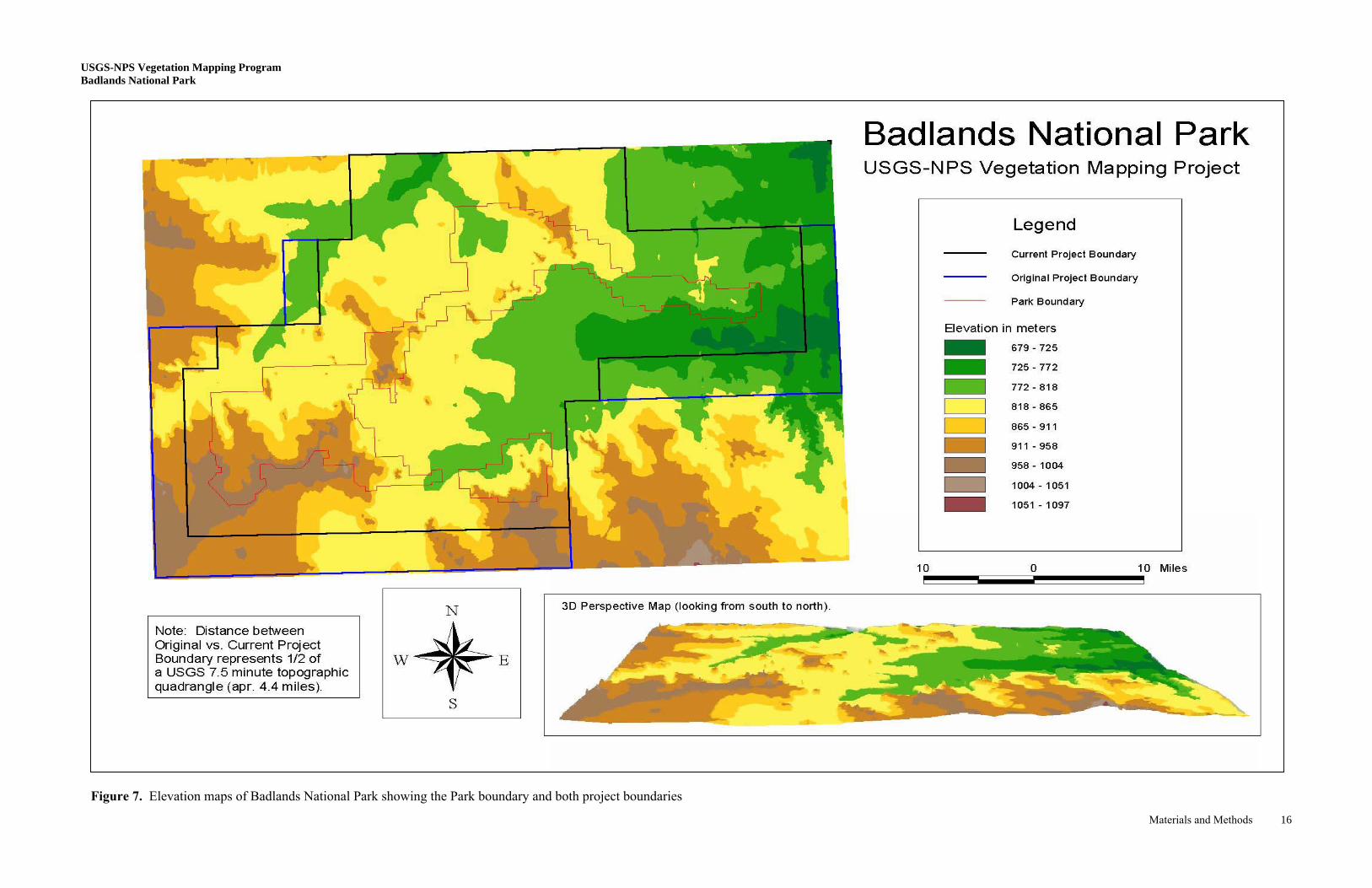
data; • Final report and CD-ROM describing procedures used in preparing all products. TNC Responsibilities and Deliverables: • Develop a preliminary vegetation classification for the study area from secondary sources; • Review and comment on relevant vegetation data, participate in meetings, and review draft report; • Prepare global plant association descriptions. Scoping Meeting: A scoping meeting was held at the BADL Library with all interested parties during March 1997. The purpose of this meeting was to determine the project mapping extent, aerial photography acquisition, digital orthophoto availability, and discuss logistics. A project boundary covering 44, 7.5-minute USGS topographic quadrangles (Appendix 4) or approximately 1,314,450 acres was determined (Figure 7)*. Following the data sampling protocols for large parks outlined in the Field Methods for Vegetation Mapping (TNC 1994), it was decided that a gradient-oriented transect or gradsect sampling approach (Austin and Heyligers 1989, Gillison & Brewer 1985) would be used at BADL. * Budgetary constraints required that the 1.3+ million acre project area be reduced to approximately 920,000 acres, based on a meeting between RSGIG, NPS, and USGS/BRD in June, 1999 and further discussion with BADL staff (Story 1999). Figure 7. shows the originally proposed project boundary and the current mapping area. It should be noted that RSGIG completed aerial photo-interpretation of the 1.3+ million acre area prior to this decision and that the decision affects only digital transfer of interpreted information.
Materials and Methods 15
etation Mapping Program tional Park
Materials and Methods 16
Figure 7. Elevation maps of Badlands National Park showing the Park boundary and both project boundaries
USGS-NPS VegBadlands Na
tsingh
tsingh
UB
SGS-NPS Vegetation Mapping Program adlands National Park
Materials and Methods
2. Preliminary Data Collection and Review of Existing Informationary Data Collection and Review of Existing Information To minimize duplication of previous work and to aid in the overall mapping project, existing maps and reports were obtained from various sources. The staff at BADL provided digital and hard copy background material for boundaries, geology, soils, and prairie dog town locations. The Bureau of Indian Affairs (BIA) and Lakota Tribe provided transportation and prairie dog colony maps for the southern portion of the project area along with letters of permission to access tribal lands for data collection. The U.S. Forest Service (Buffalo Gap National Grassland, Wall District Office) supplied field maps and vegetation information. Soil surveys were obtained from the Natural Resources Conservation Service (NRCS) (formally Soil Conservation Service) for Shannon, Jackson, and Pennington Counties. The NRCS also provided information for Conservation Reserve Program registered lands (mapped as “Seeded Mixed Grass Prairies”). Topographic maps, digital elevation models (DEM=s), digital line graphics (DLG=s), and digital raster graphics (DRG=s) were obtained from the USGS. The DEM=s were further manipulated to create slope and aspect maps. USGS digital orthophoto quarter-quads (DOQQ’s) based on 1995 black-and-white photography, were obtained and used as base maps. A preliminary list of community types thought to have a high likelihood of being in the mapping area was prepared by TNC and used to develop the preliminary vegetation classification. This preliminary list contained vegetation associations and alliances generated for the Park in May of 1996 from the Midwest portion of the NVCS (Faber-Langendoen et al. 1996). Modifications were made to the list through a literature review of BADL and Northern Great Plains vegetation, and by contacting knowledgeable experts. Final revisions were made during a map classification meeting where results of field studies were also presented for consideration. 3. Aerial Photography Acquisition Horizons, Incorporated of Rapid City, South Dakota acquired the aerial photography for BADL. Forty-seven flight lines were used to cover the entire project area (Figure 8). Flight lines were flown and photographs taken on June 16, 18, and 26, 1997. A total of 2,461 color-infrared (CIR) photographs were taken at 1:12,000 (1"=1,000') scale and printed as 9"x9" contact glass positives. Overlap between photos is approximately 50-60% and sidelap between flight lines is approximately 20-30%. Additional aerial photography information is presented in Appendix 5. 4. Environmental Gradient Transect (Gradsect) Design The BADL study area was deemed sufficiently large to allow a gradsect approach to vegetation sampling. Gradsects were used to concentrate the sampling effort into smaller areas representing the full range of vegetation variability. This was achieved using the following assumptions: 1) certain site characteristics or combination of characteristics dictate the presence and growth of plant communities, 2) these characteristics tend to repeat themselves across a landscape, and 3) the concentration of sampling efforts across small heterogeneous areas provides an accurate representation of the vegetation diversity for a much larger region (Austin & Heyligers 1989).
17
etation Mapping Program tional Park
Materials and Methods 18
Figure 8. Flight line map for the Badlands National Park vegetation mapping program (photos flown in June 1997). Flight line map for the Badlands National Park vegetation mapping program (photos flown in June 1997).
Note: Aerial photos are sequentially numbered starting with #1 at the bottom and ending with the total number at the top. Photos are evenly spaced l h fli h li
USGS-NPS VegBadlands Na
tsingh
tsingh
UB
SGS-NPS Vegetation Mapping Program adlands National Park
Materials and Methods
Gradsects for BADL were designed at a meeting of Park, BOR/RSGIG, and TNC staff held in the BADL Library prior to the 1997 field season. Aerial photography was reviewed and compared with soils, geologic, topographic, slope and aspect, and transportation/access maps. Composite maps were also used showing the relative variability of different environmental factors. Gradsects were placed on a majority of the stratigraphic units, elevations, major soil types, and major drainages within the study area. Accessibility and land ownership influenced placement of the gradsects, Park personnel from Pine Ridge Reservation provided input on access to the less-visited southern lands. Locations and design were also slightly modified based on prior knowledge of the BADL vegetation. The resulting gradsects included roughly 5-10% of the overall study area, and were considered highly likely to include the full range of plant communities found in the area (Figure 9).
Figure 9. Map of the gradsect locations for Badlands National Park.
19
USGS-NPS Vegetation Mapping Program Badlands National Park 5. Field Survey Field surveys began in the second week of August 1997 after aerial photography was acquired. Data collection included both plot and observation points, which allowed investigators to record typical vegetation types and also to record variation within plant communities across larger areas. Observation points were used to become quickly familiar with community characteristics, ranges of variation, and to field check the preliminary classification. Observation point sampling included basic information on habitat and vegetation structure and composition. Specific information recorded included UTM X-Y coordinates, dominant species cover data, and brief environmental characteristics (Appendix 6). Limitations of observation point data included no measurement or delineation of the sampling area and cover was only estimated for the common species in each stratum. Data from 137 observation points were collected during the field survey. Points were recorded mainly within gradsects, and were chosen to sample the range of habitat and vegetation variability observed on aerial photography, on preliminary maps, and in the field (Figure 10).
Figure 10. Map of observation point locations sampled during summer of 1997.
Materials and Methods 20
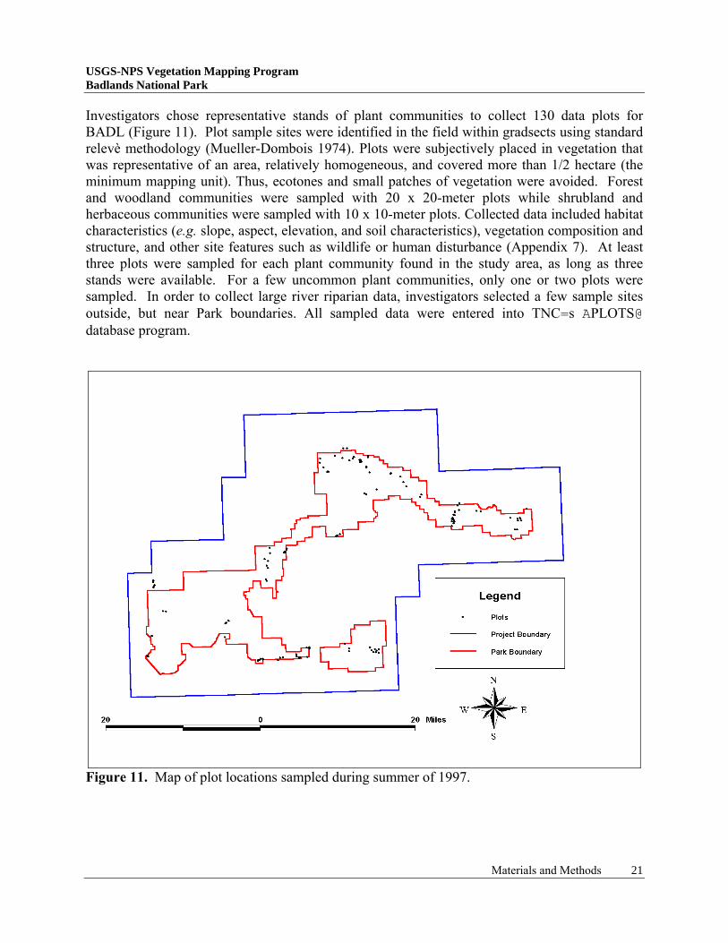
Investigators chose representative stands of plant communities to collect 130 data plots for BADL (Figure 11). Plot sample sites were identified in the field within gradsects using standard relevè methodology (Mueller-Dombois 1974). Plots were subjectively placed in vegetation that was representative of an area, relatively homogeneous, and covered more than 1/2 hectare (the minimum mapping unit). Thus, ecotones and small patches of vegetation were avoided. Forest and woodland communities were sampled with 20 x 20-meter plots while shrubland and herbaceous communities were sampled with 10 x 10-meter plots. Collected data included habitat characteristics (e.g. slope, aspect, elevation, and soil characteristics), vegetation composition and structure, and other site features such as wildlife or human disturbance (Appendix 7). At least three plots were sampled for each plant community found in the study area, as long as three stands were available. For a few uncommon plant communities, only one or two plots were sampled. In order to collect large river riparian data, investigators selected a few sample sites outside, but near Park boundaries. All sampled data were entered into TNC=s APLOTS@ database program.
Figure 11. Map of plot locations sampled during summer of 1997.
Materials and Methods 21
USGS-NPS Vegetation Mapping Program Badlands National Park
To characterize vegetation structure, all species found within a plot were noted and foliar cover for each species by strata was estimated using a modified Daubenmire (1959) classification. Since cover was estimated independently for both species and strata, total coverage for some of the plots was greater than 100%. In forests and woodlands, dbh (diameter at breast height) was measured for all trees greater than 10-cm dbh. Various environmental data were also collected for each plot to characterize the abiotic conditions under which the sampled vegetation occurred. The UTM coordinates and elevation of all plots where logged using a hand-held Precision Lightweight Global Positioning System (GPS) Receiver (PLGR) unit. 35mm slides were taken for each plot and scanned representatives are included in this report (Appendix 8). 6. Vegetation Classification and Characterization The procedure for classifying vegetation followed guidelines set forth in the Vegetation Classification Standard (FGDC 1996) which was developed from the Standardized National Vegetation Classification System (NVCS) (TNC 1994). This national system contains seven classification levels with the two finest (lowest) being the alliance and association (community) levels. Associations are separated from alliances through the use of floristic composition and are named by the most dominant and/or indicator species. If two or more dominant species occur in the same stratum a dash symbol is used. If the species occur in different strata then a slash is used. Parentheses are used in instances when the diagnostic species are not consistently present in the vegetation unit. Classification for the BADL study area involved placing all observation point data and plot data into groups based on vegetation structure and composition. From here, extensive floristic knowledge of the field team allowed most of the sampled community types to be qualitatively evaluated and subjectively assigned to an existing NVCS class. In a few instances, new NVCS classes were discerned and prepared from evaluations of the floristic data. Additional analyses were performed using the plot data combined with other similar data to provide a better regional perspective on vegetation types. TNC quantitatively analyzed the plot data using ordination techniques (Detrended Correspondence Analysis ADCA@and Non-Metric Multidimensional Scales ANMS@), a clustering algorithm, Unweighted Pair-Group Method Using Arithmetic Means (UPGMA), and Two-Way Indicator Species Analysis (TWINSPAN). Since, in a number of cases, there were only a few sample plots per vegetation type, the above analyses could not be solely relied upon for classification. However, the results of the numerical analyses were compared to the subjective classification in order to detect any discrepancies between the two. All analyses were completed using PC-ORD (McCune and Mefford 1997). A dichotomous vegetation key for BADL was prepared following the 1997 field season (Appendix 8). The key was tested during the Accuracy Assessment process and reviewed by TNC, resulting in some modifications. This dichotomous key leading to association descriptions provided guidance to researchers in the field during the accuracy assessment.
Materials and Methods 22
USGS-NPS Vegetation Mapping Program Badlands National Park
7. Vegetation Map Preparation Map Units Final BADL map units used for photo-interpretation were based on a combination of 1) NVCS, 2) Anderson (1976) Level II classification system, and 3) special requests by BADL personnel. The preliminary NVCS classification was used to determine relationships between signatures on aerial photos and vegetation associations on the ground. In most instances, one NVCS association corresponded to one map unit. However, due to various limitations in the aerial photography, certain individual NVCS associations had to be merged into a larger map unit (i.e. complex). Anderson (1976) Level II classes were used to classify land-use types including semi-natural and cultural types (i.e. roads, facilities, and agricultural fields). Finally, prairie dog colonies, a special vegetation type/habitat recognized by the Park but not included in the NVCS at the time of preparation, was also included as a map unit. In this situation, the vegetation had an unique photo signature and could be easily interpreted from the aerial photography. Aerial Photograph Interpretation All aerial photographs for BADL were covered with translucent mylar overlays. Fiducial points (corner and side marks), flight line, and photograph numbers were transferred from each photo onto its corresponding overlay. The center portion of each aerial photograph was systematically delineated to minimize the effects of edge distortion. Aerial photos and their overlays were then back-lit on a light table and visually scanned for photographic signatures using magnification and stereo. The actual interpretation of the photographs involved three basic steps. First, all of the photos were initially interpreted into broad classes based solely on standard photo-interpretation signature characteristics. These included: tone, texture, color, pattern, topographic position, size, and shadow. Second, field note overlays and plot and observation point locations were used, if available, to refine the preliminary delineation into the appropriate map units. Finally, in order to ensure completeness and accuracy, digital transfer specialists reviewed all of the interpreted photos for consistency and recommended changes where necessary. Additional references aided in aerial photo-interpretation. These included: the Soil Surveys of Pennington, Shannon, and Jackson Counties, SD (USDA-SCS 1996, 1980, 1971), USGS topographic maps, and previous vegetation inventory work (Batt 1991 and Butler and Batt 1995). Map Validation Before the accuracy assessment, verification or map validation trips were taken in June and August 1998 to refine and assess the initial mapping effort. These trips included collecting additional observation points and ground-truthing aerial photographs using landmarks and GPS waypoints. Map classes were modified to reflect any inadequacies in the initial photo-interpretation. The area heavily impacted by a 1997 hailstorm was reviewed during the June verification trip to determine the distribution of grass species such as green needlegrass (Stipa viridula), Kentucky bluegrass (Poa pratensis), smooth brome (Bromopsis inermis), and crested wheatgrass (Agropyron cristatum) within the otherwise western wheatgrass (Pascopyrum smithii) dominated prairie. Aerial photo signatures that were not identifiable during
Materials and Methods 23
USGS-NPS Vegetation Mapping Program Badlands National Park
interpretation, such as large four-wing saltbush (Atriplex canescens) clumps growing on badlands complex soils (initially thought to be greasewood (Sarcobatus vermiculatus) shrubland) were also examined. Digital Transfer An ArcInfoJ (ESRI) GIS database was designed for BADL using the National Park GIS Database Design, Layout, and Procedures created by RSGIG (Appendix 9). This was created through Arc Macro Language (AML) scripts that helped automate the transfer process and ensure that all spatial and attribute data was consistent and stored properly. Actual transfer of information from the interpreted aerial photographs to a digital, geo-referenced format involved two techniques: scanning and on-screen digitizing. Both techniques required the use of 176, 1995 digital black-and-white orthophoto quarter quadrangles (DOQQ’s) supplied by USGS and covering the study area. The scanning technique used for BADL involved a multi-step process whereby mylar overlays, with interpreted line work, were scanned into digital form. The essential principle behind this process was to match the scale and position of features on the photographs with the scale and position of the same features on DOQQ’s. This was accomplished by readjusting the scale of the photography, shifting the origin of the photo, rotating the axes, and bending/warping (rubber-sheeting) the photo between known control points (tic marks) and origin and destination points (links). The actual manipulation was conducted by computer program routines until the adjustment was considered a good fit by technicians. Any remaining map units that were not already scanned were quickly transferred through on-screen digitizing. This process entered interpreted line work from aerial photos into the GIS database by manually drawing digital lines over the DOQQ (using the mouse with the DOQQ on the computer screen as a background image). Finally, the digitized line work was connected to produce a digital coverage. Adjacent transferred coverages were joined and edge-matched to create vegetation polygon coverages corresponding to each BADL DOQQ. Ancillary linear coverages (i.e. secondary roads and trails and linear wetland features) and attribute information including vegetation map unit, location, and aerial photo number was subsequently entered for all DOQQ’s. Completed DOQQ’s were also edge-matched creating a contiguous vegetation coverage and corresponding spatial database for the entire BADL project area. All spatial data for BADL and the processes used are described in the BADL Metadata (Appendix 10). 8. Accuracy Assessment The accuracy assessment (AA) for the BADL vegetation mapping project consisted of preliminary planning and discussion, logistical planning, fieldwork, analysis of fieldwork, and computation of final results. Preliminary planning involved BOR/RSGIG and Dr. Jack Butler (a plant ecologist contracted to collect the field AA data). Following detailed discussion, a modified accuracy assessment procedure dubbed Afront-loading@ (Owens 1998) was selected using protocols outlined in the Accuracy Assessment Procedures (TNC 1994).
Materials and Methods 24
USGS-NPS Vegetation Mapping Program Badlands National Park
The following guidelines for the AA procedure were adopted at this time: • Observations of vegetation classes were to be ground-based. • Ground sampling techniques were to be similar to the Observation Points collected during
initial classification. • The number of samples per plant association/map class would vary depending on abundance
of the class upon the landscape. • No maximum number of points was assigned so that the Park could be sampled as
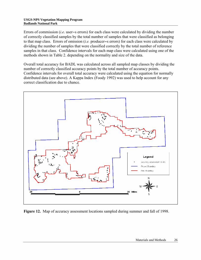
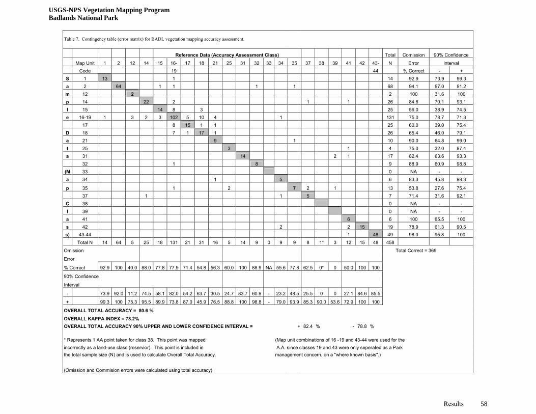
completely as possible. Logistical planning for the AA revolved around coordination of work schedules and finding reasonable work areas within the Park. Collection of AA points was confined to within Park boundaries but not limited to the previously described gradsects. Instead, AA’s were based on availability of access and to a lesser extent, time constraints. The actual assessment was begun prior to completion of preliminary vegetation maps for the Park, thus the need for the front-loading of the sample points. Selecting random AA sampling sites beforehand was deemed unnecessary due to familiarity of the principal researcher with vegetation types and distribution at BADL. The final point chosen for assessment was selected to be as representative as possible of the vegetation in the immediate area, well away from stand boundaries, and in a stand larger than the minimum mapping unit (exceptions were made for wetland and some shrub classes which rarely exceeded 0.5 hectares in size). Field ecologists were supplied with a vegetation key, to be used to determine plant associations/map classes entered on field forms (Appendix 8). AA data, including limited habitat and vegetation data, was recorded on field forms to document the classification decision made by the investigator (Appendix 11). This form was modified and expanded from previous forms to include fields for additional community types found within 50 meters of the actual assessment point. Modifications were made to help accommodate several types of difficult situations, such as AA points located in small inclusions, heterogeneous polygons/stands, and GPS PLGR error. 465 AA data points were collected during August 1998 (Figure 12). The weather at this time was unusually warm and vegetation readily identifiable unless heavily grazed. In the Park=s North Unit, an extremely heavy growth of yellow sweetclover was present over most grassland and shrub communities. While noted during the AA sampling, very little yellow sweetclover was present during the previous year (1997), the year of aerial photography acquisition and interpretation. AA points were collected in proportion to the size of the plant association/map class within the Park; e.g. more points were collected within extensive types. Accuracy assessment of the BADL project area was conducted in September 1999. This involved entering all accuracy data points into a digital coverage and overlaying these electronically onto final vegetation maps (by DOQQ). AA identification numbers plotted alongside each point allowed for comparison with accuracy assessment data forms. A contingency table was set up to record the reference data (collected in the field) versus the sample data (vegetation map) for each map unit.
Materials and Methods 25
USGS-NPS Vegetation Mapping Program Badlands National Park
Errors of commission (i.e. user=s errors) for each class were calculated by dividing the number of correctly classified samples by the total number of samples that were classified as belonging to that map class. Errors of omission (i.e. producer=s errors) for each class were calculated by dividing the number of samples that were classified correctly by the total number of reference samples in that class. Confidence intervals for each map class were calculated using one of the methods shown in Table 2. depending on the normality and size of the data. Overall total accuracy for BADL was calculated across all sampled map classes by dividing the number of correctly classified accuracy points by the total number of accuracy points. Confidence intervals for overall total accuracy were calculated using the equation for normally distributed data (see above). A Kappa Index (Foody 1992) was used to help account for any correct classification due to chance.
Figure 12. Map of accuracy assessment locations sampled during summer and fall of 1998.
Materials and Methods 26
USGS-NPS Vegetation Mapping Program Badlands National Park
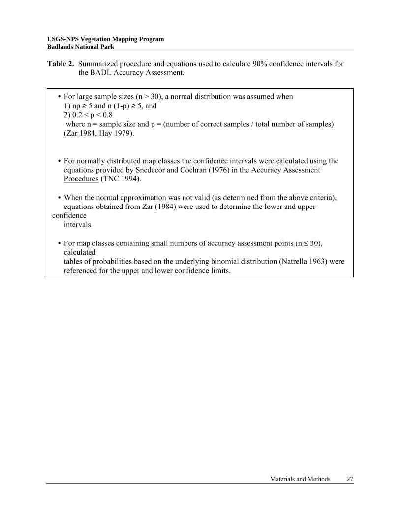
Table 2. Summarized procedure and equations used to calculate 90% confidence intervals for the BADL Accuracy Assessment.
• For large sample sizes (n > 30), a normal distribution was assumed when 1) np ≥ 5 and n (1-p) ≥ 5, and 2) 0.2 < p < 0.8 where n = sample size and p = (number of correct samples / total number of samples) (Zar 1984, Hay 1979).
• For normally distributed map classes the confidence intervals were calculated using the equations provided by Snedecor and Cochran (1976) in the Accuracy Assessment Procedures (TNC 1994).
• When the normal approximation was not valid (as determined from the above criteria), equations obtained from Zar (1984) were used to determine the lower and upper confidence intervals.
• For map classes containing small numbers of accuracy assessment points (n ≤ 30), calculated
tables of probabilities based on the underlying binomial distribution (Natrella 1963) were referenced for the upper and lower confidence limits.
Materials and Methods 27
USGS-NPS Vegetation Mapping Program Badlands National Park
RESULTS
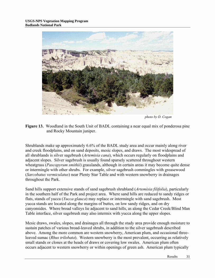
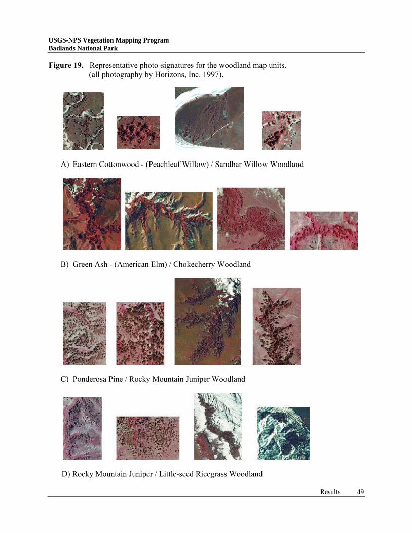
Vegetation Classification and Characterization The NVCS for the BADL study area includes 28 natural and semi-natural associations and two complexes. The natural associations are comprised of four woodland, ten shrubland, six upland herbaceous/grassland, four wetland and four sparse vegetation types. The semi-natural associations are comprised of one woodland and three grassland types. The final classification is presented in Table 3. A field key and detailed type descriptions are included in Appendices 8 and 12, respectively. As expected, many of the vegetation types are representative of the mixed-grass prairie found throughout the Great Plains physiographic region and sparse vegetation associated with badland formations. Woodlands are minor components of the regional vegetation, covering approximately 1.8% of the project area. These are generally restricted to floodplains, drainage bottoms, toeslopes of sandhills, draws associated with eroding buttes, and slumps on butte and cliff faces. Rocky Mountain juniper (Juniperus scopulorum) forms the most common woodland in the project area, occurring as its purest form on drier slopes, along butte edges, and in upper draws. It likely hybridizes with eastern red cedar (J. virginiana), as characteristics of both species were observed in the field, often on the same tree. A special habitat occupied by Rocky Mountain juniper is the side-slope slump, where additional moisture collects following the landslide. Juniper trees are often knocked sideways, or felled during this movement, some of these were even observed to be rooting along the trunk with each major branch becoming a new tree. Rocky Mountain juniper often intergrades with other woodlands, especially ponderosa pine (Pinus ponderosa) and green ash (Fraxinus pennsylvanica). Ponderosa pine woodlands occur in the upper elevations of the South Unit, where cover values for ponderosa pine and Rocky Mountain juniper are often nearly equal (Figure 13). Throughout the Park’s lower elevations, Rocky Mountain juniper and hardwood trees also intermix along a broad gradient, with hardwoods occupying more mesic sites. Green ash and American elm (Ulmus americana) are the most common hardwood trees present, occupying bottoms of draws, river floodplains, and toeslopes of sand hills. The upper portion of hardwood draws is commonly dominated by various shrub species, particularly American plum (Prunus americana) and western snowberry (Symphoricarpos occidentalis). Extremely mesic sites within the project area support stands of Eastern or plains cottonwood (Populus deltoides) trees. Along with peachleaf willow (Salix amygdaloides), these typically occur within the Park as small clumps along minor streams, around seeps and springs, and around ponds. Immediately adjacent to BADL, Eastern or plains cottonwood trees form riparian woodlands within floodplains of the White and Cheyenne Rivers. These riparian woodlands tend to be separated into different age classes relative to year of establishment and position within the floodplain. Young trees establish from seed on newly scoured point bars and islands, while mature trees occupy deeper sediment deposits of river meanders or oxbows and higher, more permanent islands (Figure 14). Green ash and Rocky Mountain juniper are usually present as co-dominants or as principal understory species.
Results 28
USGS-NPS Vegetation Mapping Program Badlands National Park
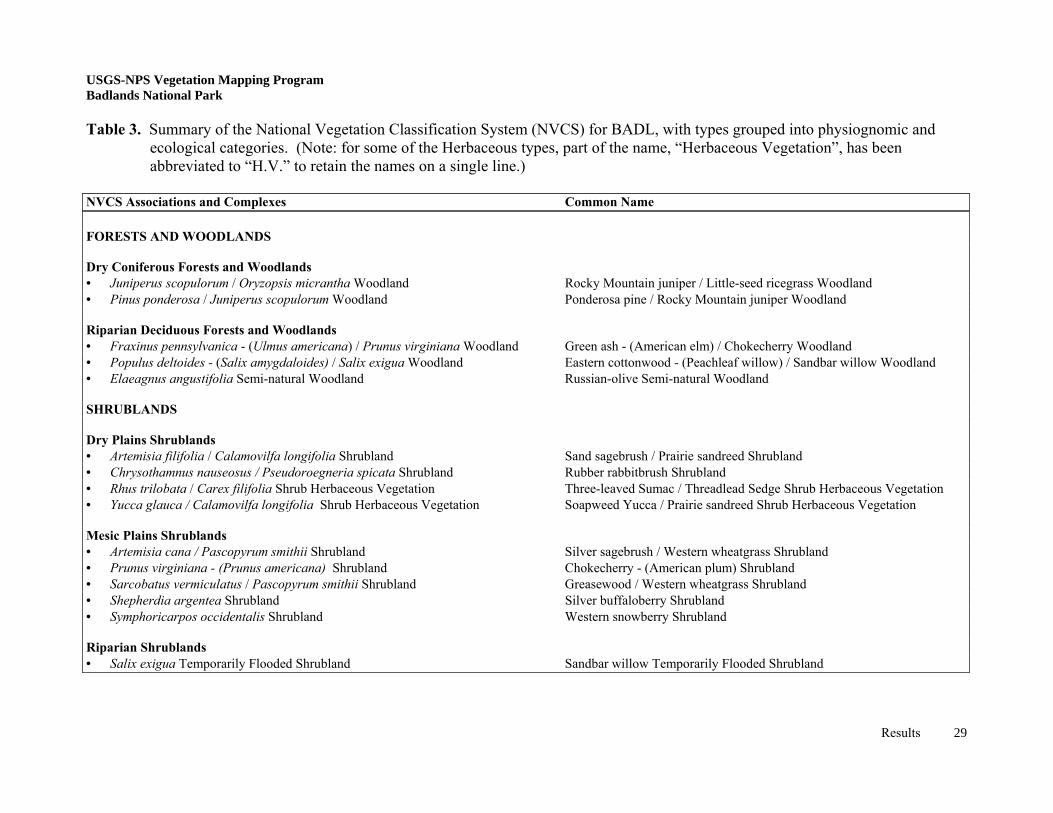
USGS-NPS Vegetation Mapping Program Badlands National Park Table 3. Summary of the National Vegetation Classification System (NVCS) for BADL, with types grouped into physiognomic and
ecological categories. (Note: for some of the Herbaceous types, part of the name, “Herbaceous Vegetation”, has been abbreviated to “H.V.” to retain the names on a single line.)
USGS-NPS Vegetation Mapping Program Badlands National Park
photo by D. Cogan
Figure 13. Woodland in the South Unit of BADL containing a near equal mix of ponderosa pine
and Rocky Mountain juniper. Shrublands make up approximately 6.6% of the BADL study area and occur mainly along river and creek floodplains, and on sand deposits, mesic slopes, and draws. The most widespread of all shrublands is silver sagebrush (Artemisia cana), which occurs regularly on floodplains and adjacent slopes. Silver sagebrush is usually found sparsely scattered throughout western wheatgrass (Pascopyrum smithii) grasslands, although in certain areas it may become quite dense or intermingle with other shrubs. For example, silver sagebrush commingles with greasewood (Sarcobatus vermiculatus) near Plenty Star Table and with western snowberry in drainages throughout the Park. Sand hills support extensive stands of sand sagebrush shrubland (Artemisia filifolia), particularly in the southern half of the Park and project area. Where sand hills are reduced to sandy ridges or flats, stands of yucca (Yucca glauca) may replace or intermingle with sand sagebrush. Most yucca stands are located along the margins of buttes, on low sandy ridges, and on dry canyonsides. Where broad valleys lie adjacent to sand hills, as along the Cedar Creek/Blind Man Table interface, silver sagebrush may also intermix with yucca along the upper slopes. Mesic draws, swales, slopes, and drainages all through the study area provide enough moisture to sustain patches of various broad-leaved shrubs, in addition to the silver sagebrush described above. Among the more common are western snowberry, American plum, and occasional three-leaved sumac (Rhus trilobata). Western snowberry is the most prevalent, occurring as relatively small stands or clones at the heads of draws or covering low swales. American plum often occurs adjacent to western snowberry or within openings of green ash. American plum typically
Results 31
grows in clumps that produce almost impenetrable thickets. Three-leaved sumac is present at BADL as both very dense (moist conditions) and very sparse (dry conditions) shrubland types. Typically, this shrubland occurs as sparse stands along the rims of buttes. Outside the Park, there are dense stands of three-leaved sumac, particularly in the Cheyenne River drainage, where they dominate exposures of Pierre shale or clay soils derived from Pierre shale.
photos by D. Cogan Figure 14. Plains cottonwood riparian woodlands occurring in the floodplain of the Cheyenne
River. Demonstrating (from left) the young, medium, and old age classes. The remaining shrublands represent relatively rare types found only in a few locations in and around BADL. Sandbar willow shrublands grow in saturated ox-bows or cut-banks of Sage Creek in the North Unit and Fog Creek in the South Unit (Figure 15). One very large stand is located along the Conata Basin Road just outside of the Park boundary. Habitat similar to and slightly drier than that of sandbar willow may contain clumps of silver buffaloberry (Shepherdia argentea). These are typically distributed along drainages and streams and seem to be more common in the South Unit along the White River. Greasewood shrublands are known only from two small patches on Cuny Table in the South Unit and a small hilltop in the Sage Creek Wilderness of the North Unit. Finally, rabbitbrush (Chyrsomthamnus nauseosus) shrubs become dominant in disturbed sites throughout the project area, such as areas of road-construction. The largest of these communities occurs along the Cuny Table Road and the road-cut on the southern edge of Red Shirt Table (both in the environs adjacent to the South Unit), while smaller patches occur along the main Park road in the North Unit. Grassland and sparse vegetation communities cover the majority of area in and around BADL. Four associations were found in the sparsely vegetated badlands (approximately 19.2% of the project area) ranging from completely barren slopes to vegetated erosion fans (Table 3). Badlands sparse vegetation develops on siltstone, volcanic ash, and claystone eroded to form pinnacle, cliff, mound, outwash fan, and intermittent drainage habitats. Also, a relatively unique badlands formation occurs on large expanses of low hills covered by chalcedony, a flat, crystalline rock with properties similar to quartz. Drought-tolerant shrubs such as silverscale saltbush (Atriplex argentea) and broom snakeweed (Gutierrezia sarothrae) and annual forbs can be found dispersed throughout variable badlands environments/habitats.
Results 32
USGS-NPS Vegetation Mapping Program Badlands National Park
Sparse vegetation can also be found within areas of established prairie dog towns (approximately 2% of the project area). Prairie dog towns occupy deeper soils on large flats dissected by many drainages, such as in the Conata Basin. Prairie dogs may alter grassland vegetation types over time through their cycle of burrow establishment, grazing, and burrow abandonment. This constant use causes the native vegetation to revert back to an early successional state, i.e. a weedy, forb-dominated community. For the purpose of this study, an attempt was made to separate the older, forb-dominated towns from the newer or less heavily grazed towns dominated by grass species. However, the various associations that may be present in a prairie dog town have not been described by the NVCS for BADL, rather they are simply treated as a Prairie Dog Town Complex. Grasslands of the project area are directly influenced by many natural and anthropogenic factors such as soil depth, soil composition, landscape position, moisture levels, lack of fire, past disturbance, and grazing. This has resulted in a diverse grassland mixture that intermingles in small units across the landscape. Western wheatgrass is the predominant grass occurring in the project area. This sod-forming grass thrives on clayey soils were it ranges from almost pure, monotypic stands on clay to a true mixed grass prairie on silty/sandy clays or loamy clays. Common associated species include various forbs and grasses such as prairie coneflower (Ratibida columnifera), white milkwort (Polygala alba), needle-and-thread (Stipa comata), and prairie dropseed (Sporobolus heterolepis). The heterogeneous species composition of western wheatgrass made it difficult, if not impossible to consistently identify and separate unique associations. Consequently, these associations were mapped at the alliance level, except where stands of western wheatgrass - green needlegrass (Nassella viridula) could be distinguished. Two non-native annual grasses, Japanese brome (Bromus japonicus) and downy brome (B. tectorum) are also usually present to some degree in all grassland associations, especially western wheatgrass stands. Western wheatgrass also tends to be replaced in drier areas or places with increased grazing by blue grama. This shorter grass often grows in association with needle-and-thread and threadleaf sedge (Carex filifolia), especially around the extremely dry edges of buttes and small tables. On gravelly soils, side draws, and broad swales, little bluestem becomes dominant, often in association with side-oats grama (Bouteloua curtipendula). These areas are quite small in the North Unit even though they appear relatively widespread in the fall due to the bright coloration of the grass. In the South Unit and along the Cheyenne River in the northwest corner of the study area, little bluestem is common on gravelly soils of side slopes, draws, breaks, and drainages. Unique and predictable grassland associations for this project include switchgrass, which occurs in very wet, shallow basins, and western wheatgrass / green needlegrass, which is present on selected hills, slopes, and buttes. Switchgrass is a facultative wetland species restricted to temporarily flooded areas such as the upland drainage just north of the main Park access Road in the North Unit (Figure 15). In this area and a few others scattered through the North Unit, switchgrass grows as a fairly homogenous stand surrounded by western wheatgrass and little bluestem on slightly higher ground. The Western Wheatgrass / Green Needlegrass Association is present on small rises and slopes of the North Unit and in somewhat flat mesic sites on buttes (such as Stronghold Table) in the South Unit. Typically, this vegetation association contains
Results 33
USGS-NPS Vegetation Mapping Program Badlands National Park
thick clumps of green needlegrass characterized by 1m tall seed heads amongst solid mats of western wheatgrass. Regions throughout the project area that were disturbed historically by agricultural or transportation activity are primarily re-vegetated by non-native grass species. Representative locations include road corridors in the Park seeded with smooth brome (Bromus inermis), old fields in the North Unit seeded with crested wheatgrass (Agropyron cristatum), and old pastures on Sheep Mountain Table grazed by sheep and invaded by Kentucky bluegrass (Poa pratensis). These three grasses form large enough mono-dominant stands that they were treated as separate associations, though they were mapped as a unit. Other relatively common non-native species found in various disturbed sites include alfalfa (Medicago sativa), Canada thistle (Cirsium arvense), and giant ragweed (Ambrosia trifida). A biennial, yellow sweetclover (Melilotus officianalis) is an exotic that is widespread within the North Unit of the Park. During peak growing years, yellow sweetclover can cover native grasslands growing over 2 meters tall.
photos by D. Cogan and J. Von Loh Figure 15. Switchgrass (left) and sandbar willow (right), two rare wetland associations found
within the North Unit of BADL. Besides the switchgrass and sandbar willow associations, other riparian or wet meadow associations comprise approximately 0.7% of the project area. These include both naturally occurring wetlands along basins, depressions, and on seeps and springs and introduced wetlands, created indirectly as a result of sedimentation into man-made ponds and dugouts. Introduced wetlands are typically dominated by broad- and/or narrow-leaved cattail (Typha angustifolia and T. latifolia) and soft-stem bulrush (Scirpus validus), while naturally occurring wetlands support species of spikerush (Eleocharis spp.), foxtail barley (Hordeum jubatum), and true rushes (Juncus spp.). Another common wetland species found in small, linear strips in BADL is prairie cordgrass (Spartina pectinata). Due to its limited size and patchy distribution it was difficult to separate from the other wetland types in this study.
Results 34
USGS-NPS Vegetation Mapping Program Badlands National Park
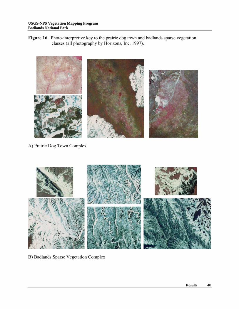
Vegetation Map Production Map Units Thirty-three map classes or units were recognized and used for BADL (Table 4). These were divided into 23 vegetation units and ten Anderson Level II (Anderson et al. 1976) land use classes. Map units were developed through a combination of fieldwork, preliminary photo-interpretation, and the NVCS for BADL. Deviations from the NVCS occurred when distinct photo signatures could not be discerned from aerial photography, such as some of the grassland and badlands types. Also, some map units did not directly correspond to the USGS-NPS vegetation-mapping program but were included to aid with BADL’s management needs. Various minor grassland associations within the Western Wheatgrass Alliance could not be differentiated well in the field or from aerial photographs. These common grasslands were so finely intertwined that only at the alliance level could they be consistently recognized and delineated. However, the Western Wheatgrass / Green Needlegrass Association was clearly identifiable in the field and marginally recognizable on the photos. It was agreed that when this class met the minimum-mapping unit (mmu) of 0.5 hectares, an attempt would be made to interpret it and enter the polygon in the database on an as-known or as-observed basis. A relatively high concentration and large expanse of black-tailed prairie dogs has made BADL a very important and successful site for the re-introduction of black-footed ferrets (an endangered species). In order to monitor and maintain the current population of ferrets and possibly increase the number of released individuals, park managers are interested in the location, size, and edge identification of prairie dog towns within the Park (Plumb 1997; Appendix 13). Typically, wildlife habitats would not be candidates for mapping under this program, however prairie dogs do alter the vegetation around them to the point of creating and sustaining predictable vegetation types. Largely from similar work conducted at nearby Wind Cave National Park, prairie dog towns have been designated as belonging to the Purple Threeawn-Fetid Marigold Herbaceous Vegetation Association (Cogan, et al. 1999). It was determined during fieldwork and from the aerial photos, that similar prairie dog towns at BADL did not always change the grassland type in which they occurred. To address this situation, the prairie dog town classification was only applied to core town areas where the vegetation was seriously altered. In lesser-disturbed areas, prairie dog towns were still delineated but classified as the native grassland type. In this manner, two separate areas could be calculated, one for the native grasslands pertaining to this study and one for prairie dog towns necessary for the Park. This distinction is represented on the final maps as stippled overlay patterns. Three map classes routinely occur within the study area below the mmu even though they could be consistently identified on the photos. These include emergent wetlands, western snowberry shrublands, and silver buffaloberry shrublands. Partially based on the importance of these types for wildlife habitat, the ability to easily discern them on the photography, and the need to adequately represent shrubs in an otherwise grassland/badlands environment a decision was made to map all three regardless of size. This included the use of a line coverage for long, linear wetlands.
Results 35
USGS-NPS Vegetation Mapping Program Badlands National Park
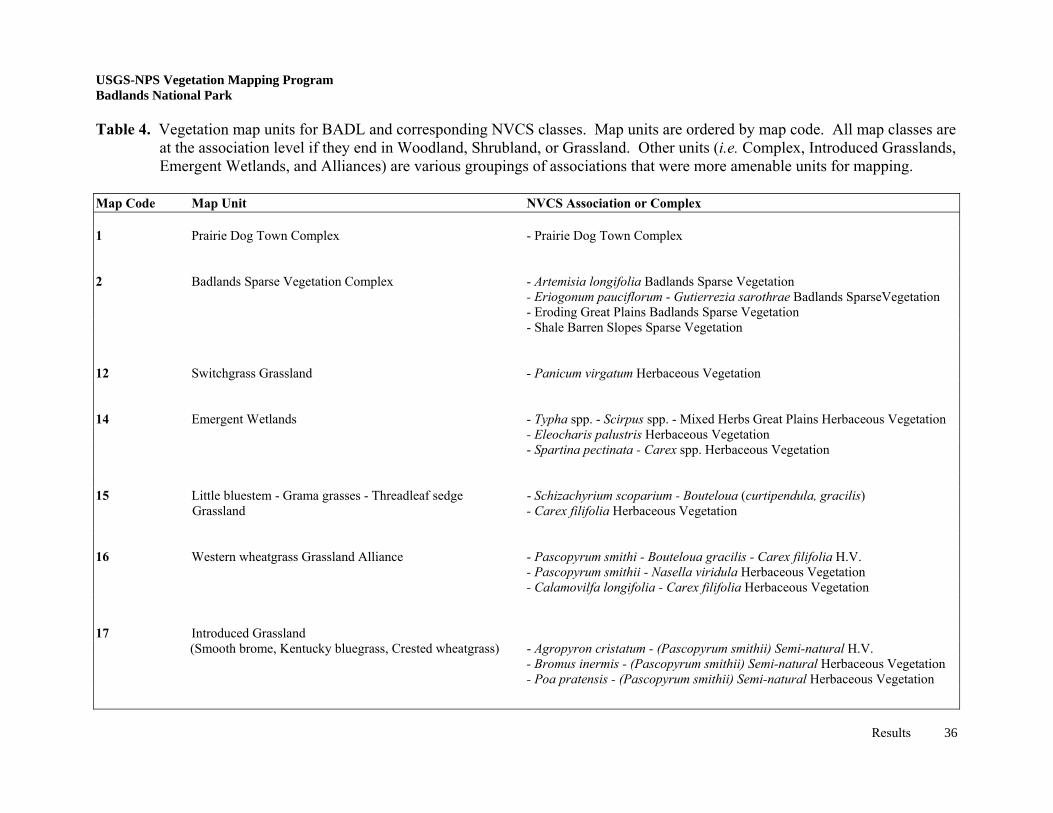
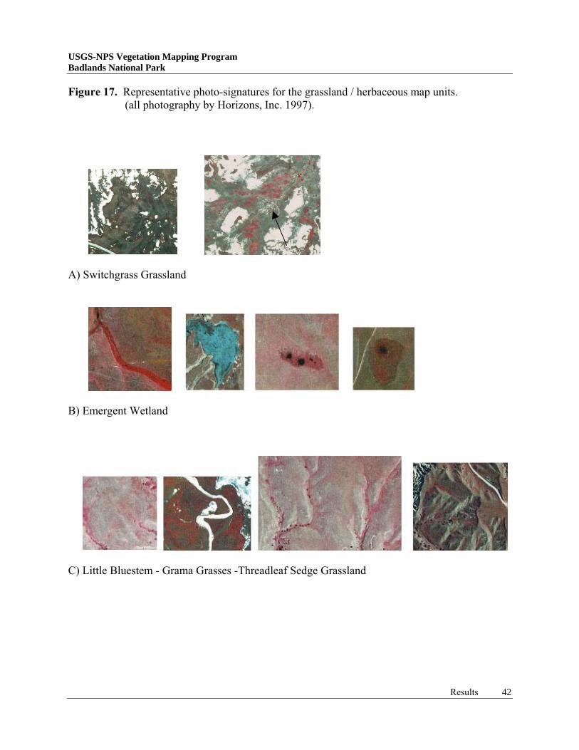
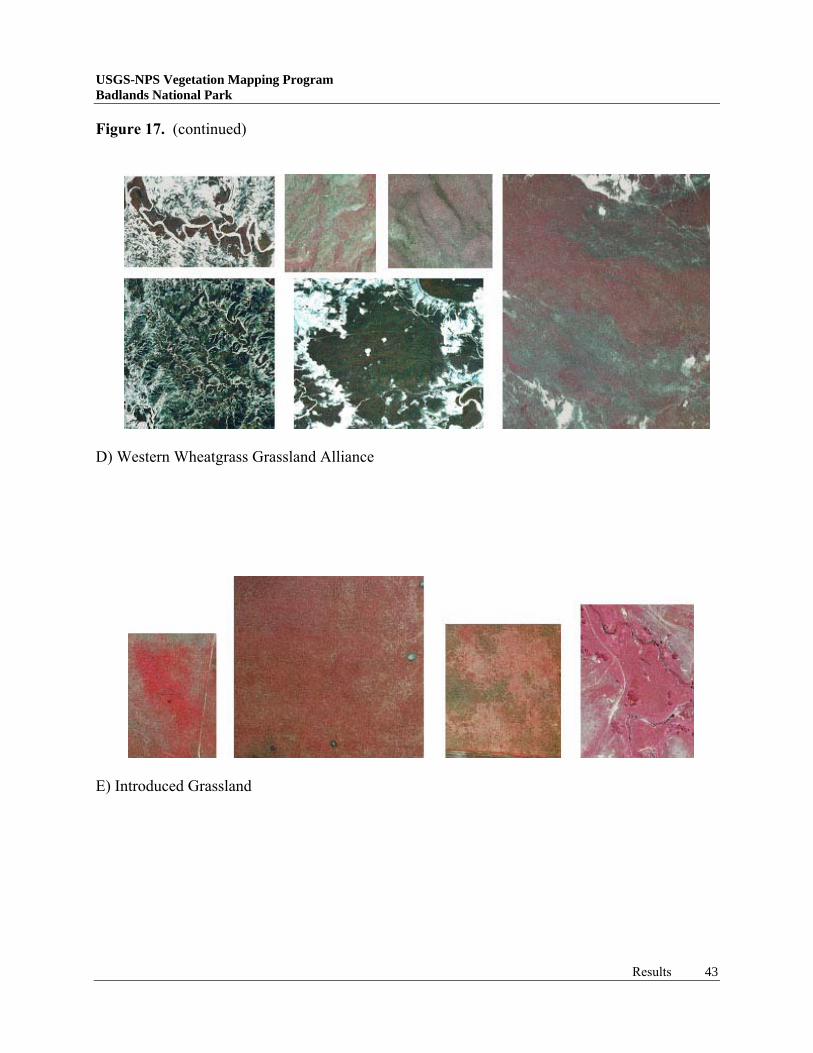
USGS-NPS Vegetation Mapping Program Badlands National Park Table 4. Vegetation map units for BADL and corresponding NVCS classes. Map units are ordered by map code. All map classes are
at the association level if they end in Woodland, Shrubland, or Grassland. Other units (i.e. Complex, Introduced Grasslands, Emergent Wetlands, and Alliances) are various groupings of associations that were more amenable units for mapping.
Map Code Map Unit NVCS Association or Complex 1 Prairie Dog Town Complex - Prairie Dog Town Complex 2 Badlands Sparse Vegetation Complex - Artemisia longifolia Badlands Sparse Vegetation
USGS-NPS Vegetation Mapping Program Badlands National Park Aerial Photograph Interpretation A brief description of each map class (plant association, alliance, or complex), its location in the project area, and photo signature characteristics is presented as follows: Prairie Dog Town Complex (1). This vegetation class occupies broad drainages, swales, terraces, and gentle slopes within the project region. It contains high forb cover versus low graminoid cover. The aerial photo signature consists of small, white stipples (prairie dog burrows), usually somewhat interconnected by narrow trails and lying within bright red, pink, and green colors. The class is delineated to the edge of the obviously grazed zone (Plumb 1997)(Figure 16A). Badlands Sparse Vegetation Complex (2). This geologic feature and sparse vegetation class provides the Park’s aesthetic focus and consists of barren to sparsely vegetated walls, cliffs, bluffs, pinnacles, mounds or haystacks, table lands, escarpments, erosion fans, alkaline flats, overflows, and drainages. Siltstone, claystone, sandstone, volcanic ash, and sediments contribute to a bright white photographic signature, often with some shadowing which may appear as black. Layers of chalcedony over the white sediments create a gray signature, making it difficult to discern from light gray-green grassland signatures (Figure 16B). Switchgrass Grassland (12). This vegetation class occupies a basin with a high ground water table, adjacent to the North Unit access road and a few broad drainages, all associated with the North Unit. Some individual cottonwood trees dot the associated drainages. Aerial photo signatures include dark brown to maroon in color, a smooth texture, and a brush stroke appearance (Figure 17A). Emergent Wetland (14). This vegetation class occurs on saturated and inundated soils, where water depths do not exceed about one meter. Wetland vegetation is found along drainages, in swales and closed basins, and around dugouts, ponds, and reservoirs. All wetlands are delineated for this study, whether or not they meet the mmu. Linear wetlands of swales are delineated in a line coverage. Aerial photo signatures range from dark brown for spikerush wetlands, to pink for prairie cordgrass wetlands, to bright red for wetlands dominated by cattail and bulrush. Small pockets of open water are often present, usually black in color (Figure 17B). Little Bluestem - Grama Grasses - Threadleaf Sedge Grassland (15). This vegetation class occurs on gravelly hillsides, ridges, and in drainages, more so in the South Unit of the Park and the northwestern environs outside the Park. Aerial photo signatures range from a stippled pattern of white dots on slopes and ridges to a brushed, blood red appearance in drainages (Figure 17C). This vegetation type sometimes supports sparse yucca and three-leaved sumac and may be delineated under Classes 21 or 35, as well. Western Wheatgrass Grassland Alliance (16). This vegetation class is widespread throughout the Park and region, particularly on clay and silt soils. Ungrazed western wheatgrass may be 0.5 m tall and screen all associated species in aerial view, the exotic annual Japanese brome is common in this vegetation type and has a strong influence on photo signatures. Aerial photo signatures are typically a smooth gray-green to dark green color or brownish maroon for this grassland.
Results 39
Figure 16. Photo-interpretive key to the prairie dog town and badlands sparse vegetation classes (all photography by Horizons, Inc. 1997).
A) Prairie Dog Town Complex
B) Badlands Sparse Vegetation Complex
Results 40
USGS-NPS Vegetation Mapping Program Badlands National Park
When exotic annuals are abundant, or the grassland is regularly grazed, reducing the overstory, a pink to light red signature is common (Figure 17D). Introduced Grassland (17). This vegetation class occurs along roadways, on historic agricultural fields, and in pastures where exotic species have escaped or been inter-seeded. Notable examples occur on Sheep Mountain Table, the northern boundary of the North Unit, and on the Cuny/Stronghold Table interface. Aerial photo signatures vary by species and condition: smooth brome is dark brown and circular when undisturbed, but bright red when burned, mown, or grazed; Kentucky bluegrass is light gray to green-gray when not mown or grazed, but light pink to bright pink when it is grazed; and crested wheatgrass is lime green to gray-green (Figure 17E). Blue Grama Grassland (18). This vegetation class is common in the South Unit on sandy and sandy loam soils, and in grazed areas outside the Park. On the predominantly clay and silt soils in the vicinity of the North Unit, this class is restricted to hilltops and ridges and the dry edges of buttes. Under the influence of heavy grazing, western wheatgrass can be reduced and replaced by blue grama, even on clay and silt soils, as observed on the northwestern portion of the Palmer Creek Unit of Pine Ridge Reservation. Aerial photo signatures for this short-grass type are olive-brown to greenish-brown on sandy soils, reddish-gray color along the dry edges of buttes, and a pinkish, cloudy signature on regularly grazed sites (Figure 17F). Western Wheatgrass - Green Needlegrass Grassland (19). This vegetation class has a patchy distribution in the Park, and is only delineated on a when-observed basis. Unless green needlegrass is the truly dominant species, the aerial photo signature is that of Class 16, described above. Large patches of dense green needlegrass produce a reddish-maroon splotch within the gray-green western wheatgrass signature (Figure 17G). Soapweed Yucca / Prairie Sandreed Shrub Grassland (21). This shrub grassland type occupies low, sandy ridges and the edges of some buttes. It is also a component of Class 32 on sand hills and can be difficult to interpret separately. Aerial photo signatures include a yellow-green to medium green color associated with an olive-green to dull brown background color, coupled with a texture like that of coarse sandpaper (Figure 18A). Silver Buffaloberry Shrubland (25). This shrub class occurs as small patches along several creeks and the White River, typically outside Park boundaries. The patches usually occur below the mmu, but are delineated for overall vegetation mapping accuracy. Aerial photo signatures include a large, pebbly texture and a gray to light pink color (Figure 18B). Silver Sagebrush / Western Wheatgrass Shrubland (31). This shrub class occupies broad drainages, creek beds, and gentle slopes of creek and river valleys within the project area. Typical habitat is the oxbow bends of meandering creeks draining the project area lands. Photo signatures vary, ranging from black dots against a white background in recently flooded drainages, to maroon dots against a green background on well-vegetated drainages. The texture appears rough as on medium-grit sandpaper (Figure 18C).
Results 41
USGS-NPS Vegetation Mapping Program Badlands National Park
Figure 17. Representative photo-signatures for the grassland / herbaceous map units. (all photography by Horizons, Inc. 1997).
A) Switchgrass Grassland
B) Emergent Wetland
C) Little Bluestem - Grama Grasses -Threadleaf Sedge Grassland
Results 42
USGS-NPS Vegetation Mapping Program Badlands National Park
Figure 17. (continued)
D) Western Wheatgrass Grassland Alliance
E) Introduced Grassland
Results 43
USGS-NPS Vegetation Mapping Program Badlands National Park
Figure 17. (continued)
F) Blue Grama Grassland
G) Western Wheatgrass - Green Needlegrass Grassland
Results 44
USGS-NPS Vegetation Mapping Program Badlands National Park
Sand Sagebrush / Prairie Sandreed Shrubland (32). This shrub class occupies sand hills and ridges deposited along the White River drainage, mostly in the South Unit of the Park. Typical examples of these sand hill complexes include Blind Man Table, a portion of Red Shirt Table, and the complex just north of Imlay. Occasional pure stands of prairie sandreed may be included in this map unit. Aerial photo signatures include the crescent-shaped blowouts and swirls of dune sand, over which a grayish to flesh-tone colored, pebbly texture is observed (Figure 18D). Rabbitbrush Shrubland (33). This shrub class was only observed on slopes disturbed during road construction activities. Stands bigger than the mmu occur along the North Unit access road and along Cuny Table Road and Red Shirt Road in the South Unit. Aerial photo signatures include very small individual bumps that are gray to maroon in color (Figure 18E). Chokecherry - (American Plum) Shrubland (34). This shrub class commonly occurs in mesic draws, slumps, along the edge of sand hills, and on some slopes where mesic conditions persist. Often, this class mixes with western snowberry, making them difficult to separate during interpretation. Aerial photo signatures include a rank, brushy texture with orange, red, or pink colors (Figure 18F). Three-leaved Sumac / Threadleaf sedge Shrub Grassland (35). This shrub class includes a sparse component when it grows along the upper edge of buttes and cliffs and a denser component when observed on low ridges and swales of Pierre Shale derived soils. More dense stands are common in the project environs of the Cheyenne River drainage, while less dense stands are more common to the South Unit. Aerial photo signatures include a regular distribution of rounded shrubs that are dull red, orange-red, or brown in color (Figure 18G). Western snowberry Shrubland (37). This shrub class is distributed throughout the project area, but occurs as larger patches in the swales and draws of the southern portion of the South Unit. Within the Park, western snowberry patches usually occur below the mmu, so delineation included relatively small inclusions for overall vegetation mapping accuracy. Aerial photo signatures range from bright pink to bright orange in color, but sometimes a dull brown was noted; the margins are smooth and clones are oval (Figure 18H). Sandbar Willow Temporarily Flooded Shrubland (38). This wetland shrub class is rare and usually occurs below the mmu on point bars and creek/river shorelines. Good examples were observed along Sage and Fog Creeks within the Park and along the White and Cheyenne Rivers and Wounded Knee Creek in the environs. Signatures include brushy, bright orange to dull red color (Figure 18I). Greasewood / Western Wheatgrass Shrubland (39). This shrub grassland vegetation class is rare, observed only on one small hilltop in the Sage Creek Wilderness and on small flats on Cuny Table. A few small greasewood shrubs grow on badlands formations and are delineated as part of Class 2. Photo signatures for greasewood shrubs are black dots over a gray-white to whitish-green background color (Figure 18J).
Results 45
USGS-NPS Vegetation Mapping Program Badlands National Park
Figure 18. Representative photo-signatures for the shrubland map units. (all photography by Horizons, Inc. 1997).
A) Soapweed Yucca / Prairie Sandreed Shrub Grassland B) Silver Buffaloberry Shrubland
C) Silver Sagebrush / Western Wheatgrass Shrubland
D) Sand Sagebrush / Prairie Sandreed Shrubland
Results 46
USGS-NPS Vegetation Mapping Program Badlands National Park
USGS-NPS Vegetation Mapping Program Badlands National Park
Eastern Cottonwood - (Peachleaf Willow) / Sandbar Willow Woodland (41). This woodland class grows primarily along the White and Cheyenne Rivers and Wounded Knee Creek all outside Park boundaries. Within the Park, riparian woodland species are limited to small clumps of trees growing in creek meanders, toeslopes of sandhills, around seeps and springs, and along the perimeter of ponds and lakes. Along river courses, as many as four age classes were observed for riparian woodlands dominated by plains cottonwood. Aerial photo signatures include large-crowned trees to brushy thick stands of young trees that are dull orange to brownish in color (Figure 19A). Green Ash - (American Elm) / Chokecherry Woodland (42). This woodland class occupies mesic draws, drainages, and outer edges of river floodplains. It is short-statured with denser crown cover than plains cottonwood (mature stands) and it tends to intermix with both cottonwood and Rocky Mountain juniper stands. Aerial photo signatures include dense, rounded tree canopies that appear brushy and bright orange and red in color (Figure 19B). Ponderosa Pine / Rocky Mountain Juniper Woodland (43). This woodland class is distributed entirely within the South Unit, beginning in the vicinity of Sheep Mountain Table (Cedar Butte - north) and Red Shirt Table. It is most noticeable on the two Cedar Buttes (Cedar Butte - south is near the Cuny Table Road) and on the ridge along the eastern Palmer Creek sub-unit. It occupies ridge and butte tops within the Park and some drainages in the southern environs. Aerial photo signatures include extremely large canopied trees, pebbly or brushy in texture, and medium-orange to dark green in color (Figure 19C). Rocky Mountain Juniper / Littleseed Ricegrass Woodland (44). This woodland class occupies drier draws, ridge and butte tops, and slumps on side-slopes. It often intermixes with Class 42 and is the understory canopy for Class 43. Aerial photo signatures include a dull, dusty-gray to gray-green color, and tight, pebbly canopy (Figure 19D). Perennial Drainages (50). Few drainages carry water most or all of the year in and around BADL. The White and Cheyenne Rivers and Sage and Wounded Knee Creeks fall into this category with a few others. Photo signatures range from pure white for turbid water filled with sediment to black for deep water reaches; clear, shallow water reflects a light blue to medium blue color (Figure 20A). Transportation, Communications, and Utilities (51). This land use class represents Federal, state, NPS, USFS, BIA and other paved highways, disturbed powerline rights-of-way, electrical substations, missile silos, sewage lagoons, and railroad rights-of-way. These are interpreted between the right-of-way or facility fences since they are often disturbed by mowing and during other maintenance activities. Photo signatures are typically a linear, square, or rectangular stark white color when compared with adjacent vegetation (Figure 20B). Mixed Urban or Built-up Land (52). This land use class represents small towns and villages such as Wall, Interior, Scenic, Red Shirt, etc., BADL facilities, and other developed land. The aerial photo signature ranges from white or gray on non-vegetated surfaces to pink and orange
Results 48
USGS-NPS Vegetation Mapping Program Badlands National Park
Figure 19. Representative photo-signatures for the woodland map units. (all photography by Horizons, Inc. 1997).
A) Eastern Cottonwood - (Peachleaf Willow) / Sandbar Willow Woodland
B) Green Ash - (American Elm) / Chokecherry Woodland
C) Ponderosa Pine / Rocky Mountain Juniper Woodland
USGS-NPS Vegetation Mapping Program Badlands National Park
for lawns and tree and shrub plantings. This class generally has a very rough texture because of all the various land uses and plantings (Figure 20C). Croplands and Pasture (53). This land use class includes dry-farmed and irrigated fields, introduced pastures, and intensively used winter pastures. Aerial photo signatures include a striped or tilled pattern ranging from dull gray to gray-green for fallow land, to bright pink, orange, and red for cropped land. The texture for this class is smooth, often showing mowing lines, windrows of mown hay, hay bales, etc. (Figure 20D). Seeded Mixed Grass Prairie (54). This land use class represents agricultural fields placed under the Conservation Reserve Program of the NRCS. To comply with program goals, restoration of these fields is typically undertaken using mid- to tall grass species. The aerial photo signature is that of a farmed field (53), except it is muted to a pink, red or dull brown color (Figure 20E). Other Agricultural Land (55). This land use class includes farmsteads, ranch headquarters, corrals, equipment storage areas, windbreak and shelterbelt plantings, and more remote windmill structures. Aerial photo signatures range from white for barren ground to pink, orange, and/or bright red depending on the vegetation present (Figure 20F). Intermittent Drainages (56). This land use class includes numerous small and medium-sized drainages that flow periodically throughout the region. These drainages meander along large oxbow bends and occasionally support scattered trees or patches of shrubs. This map class includes both the drainage channel and the adjacent scoured terraces, which are typically dry, except during flash floods. The drainages reflect bright white, unless they are carrying water that reflects from white to black depending on depth and clarity/turbidity. Tree and shrub patches are usually bright orange to pink in color, while silver sagebrush shrubs are a dull maroon (Figure 20G). Reservoirs (57). This land use class ranges in size from small holes dug into the ground water table (dugouts), to large ponds and small lakes backed up behind earth-fill dams. Aerial photo signatures range from white for turbid, sediment-laden water, blue for water of medium depths, and black for deep water bodies. Emergent wetlands (14) are almost always associated with reservoir margins, and often grow into the shallower waters present (Figure 20H). Beaches and Sandy Areas Other Than Beaches (58). This land use class represents point bars and islands along and within perennial drainage channels. These mostly unvegetated soils reflect pure white on aerial photos and are interpreted using their landscape position (Figure 20I). Strip Mines, Quarries, and Gravel Pits (59). This land use class represents areas where the surface soils or geologic formations have been removed or drastically disturbed by heavy equipment. Check dams used to pond water in support of livestock grazing and irrigation are also included in this class. The photo signature is typically bright white, with a corresponding haul road, and often piles or mounds of material are present. In some instances, this excavation exposes ground water and by their nature, check dams pond water, which may appear as white, blue, or black depending on depth and clarity/turbidity (Figure 20J).
Results 50
USGS-NPS Vegetation Mapping Program Badlands National Park
Figure 20. Photo-interpretative key for land-use map units. (all photography by Horizons, Inc. 1997.)
A) Perennial Drainages
B) Transportation, Communications, &Utilities C) Mixed Urban or Built-up Land
D) Croplands and Pastures
Results 51
USGS-NPS Vegetation Mapping Program Badlands National Park
Figure 20. (continued)
E) Seeded Mixed Grass Prairie F) Other Agricultural
G) Intermittent Drainages H) Reservoirs
I) Beaches & Sandy Areas Other Than Beaches J) Strip Mines, Quarries, and Gravel Pits
Results 52
USGS-NPS Vegetation Mapping Program Badlands National Park
Digital Transfer Vegetation coverages were created in ArcInfo™ (ESRI, Inc.) corresponding to each quarter quadrangle in the BADL vegetation mapping project area. Quarter quadrangles were numbered 1-4 per quad, starting in the northwest corner and working clockwise. A list of USGS quadrangles for this project can be found in Appendix 4. Total area and number of polygons for each map unit were generated for each quarter quadrangle. The final total of polygons and area for the entire study is summarized in Table 5. Accuracy Assessment A total of 458 accuracy assessment points were used to assess the accuracy of the BADL vegetation map by: • using AA points collected during the summer of 1998 (front-loading method); • entering AA point coordinates into an electronic format to overlay on the vegetation map; • comparing map vegetation classification (transferred from photo interpretation) with field
assessment of vegetation type to determine errors of omission and commission; • resolving questions by referring to original data forms, so that Dr. Butler could make the
final determination; • recording all information on the attached AA matrix (Table 7). Overall, initial accuracy of the vegetation map is 80.6% for all vegetation classes and the Kappa Index is 78.2%. Results for each vegetation class are discussed here, and recommendations are made relative to creating a more accurate vegetation map, as desired. The specific results are presented in Tables 5 and 6 below. In general, the percentage of the Park that an individual map class covered is reflected in the number of AA points collected for that type. For example, map class 16-19 (Western Wheatgrass Alliance / Western Wheatgrass - Green Needlegrass Grassland) covers approximately 38% of the Park, and is represented by 29% of the AA points, and map Class 1 (Prairie Dog Town Complex) occupies approximately 2% of the Park and is represented by 3% of the AA points. An exception for this is map class 2 (Badlands Sparse Vegetation Complex), which covers approximately 46% of the Park but is represented by only 14% of the AA points. Two rare shrub classes were either not assessed or lightly assessed, due to their lack of abundance within the Park. These include map class 33 (Rabbitbrush Shrubland), which was not assessed and map class 38 (Sandbar Willow Temporarily Flooded Shrubland), which had one AA point but the polygon was attributed with a land use type; map class 56 (intermittent stream).
Results 53
USGS-NPS Vegetation Mapping Program Badlands National Park
Table 5. Area (meters2 / 4046.9acres/m2 / 2.471 acres/hectare) and number of polygons per
mapping unit. The map codes are described in Appendix 14.
USGS-NPS Vegetation Mapping Program Badlands National Park
Table 6. Summary of AA Results for Badlands National Park, by map class.
Map Class Discussion 1-Prairie Dog Town Complex 2-Badlands Sparse Vegetation Complex 12-Switchgrass Grassland 14- Emergent Wetland 15-Little Bluestem - Grama Grasses - Threadleaf Sedge Grassland 16/19-Western Wheatgrass Alliance / Western Wheatgrass - Green Needlegrass Grassland 17-Introduced Grassland
This map class assessed at 93% / 93% (omission / commission) accurate and is considered to be adequate as mapped. This map class assessed at 100% / 94% accurate and is considered to be adequate as mapped. This map class assessed at 40% / 100%, the photo signature representing the cool-season dominant (western wheatgrass) instead of the warm-season class dominant (switchgrass). This class is very rare in the park, except for one large occurrence sampled in 1997, and is considered to be adequate as mapped. This map class assessed at 88% / 85%, with 5 points identified as ponds from photo signatures in Spring 1997 determined to be accurate as wetlands in Summer 1998. The class is considered to be adequate as mapped. This map class assessed at 78% / 56%, with most error falling under map class 16 and occurring in the Palmer Creek subunit. This map class combination assessed at 78% / 75% with most error falling under map class 18. Map class 19 is “Park special” with no conclusive photo signature to separate it from map class 16. This mixed grassland type became very confusing in the Palmer Creek subunit of the Park. This map class assessed at 65% / 71%, with most error falling under map class 16. Much of the error associated with grasslands in the Palmer Creek subunit (map classes 15 and 16) could probably be resolved by placing them in this map class.
Results 55
USGS-NPS Vegetation Mapping Program Badlands National Park
This map class assessed at 55% / 65%, with most error falling under map classes 16 and 17. Some error may be expected from Spring aerial photography enhancing cool season grass (western wheatgrass and Kentucky bluegrass) signatures over the warm season grass (blue grama). This map class assessed at 56% / 90%, with most error falling under map class 16. This error likely results from an interpretation for grassland rather than very sparse shrubland. This map class assessed at 60% / 75%, with most error related to the very mixed nature of shrublands and this class being included in larger mapping units with other shrub types. This map class assessed at 100% / 82%, and is considered adequate as mapped. This map class assessed at 89% / 89% and is considered adequate as mapped. This small map class was not sampled due to very limited distribution in the study area. This map class assessed at 56% / 83% accuracy, reflecting the very mixed nature of shrublands and this class being included in larger mapping units with other shrub and small tree types. This map class assessed at 78% / 54% accuracy, reflecting the very mixed nature of shrublands and this class being included with other shrub types. This map class assessed at 63% / 71% accuracy, reflecting the very mixed nature of shrublands and this class being included with other shrub types.
Results 56
USGS-NPS Vegetation Mapping Program Badlands National Park
Only one site was sampled for this map class and it had been mapped as a land use class (56) that includes small drainages. Only three sites were sampled for this map class and it was included in the silver sagebrush (31) type and three-leaved sumac (35) type. This reflects the very mixed nature of shrublands in the park. This map class was assessed at 50% / 100% accuracy, with no clear alternative map class chosen. This is partly due to different age classes of trees resembling shrub communities. This map class was assessed at 100% / 79% accuracy and is considered to be adequate as mapped. Minor errors resulted where this class was confused with tall, mixed shrubs or with short cottonwood woodlands. This map class combination assessed at 100% / 98% accuracy. Map class 43 is considered a “Park special” since the majority of ponderosa pine in the study area are short and appear as mature Rocky mountain junipers on the photos.
Results 57
USGS-NPS Vegetation Mapping Program Badlands National Park
USGS-NPS Vegetation Mapping Program Badlands National Park
OVERALL KAPPA INDEX = 78.2% OVERALL TOTAL ACCURACY 90% UPPER AND LOWER CONFIDENCE INTERVAL = + 82.4 % - 78.8 %
* Represents 1 AA point taken for class 38. This point was mapped (Map unit combinations of 16 -19 and 43-44 were used for the incorrectly as a land-use class (reservior). This point is included in A.A. since classes 19 and 43 were only seperated as a Park the total sample size (N) and is used to calculate Overall Total Accuracy. management concern, on a "where known basis".)
(Omission and Commision errors were calculated using total accuracy)
tsingh
tsingh
USGS-NPS Vegetation Mapping Program Badlands National Park
DISCUSSION Badlands National Park lies within the Northern Great Plains grasslands between and adjacent to the White and Cheyenne River drainages. The Park occupies relatively level plains from the eastern and central portions of this study area continuing to Red Shirt Table on the west. Here the Plains grasslands merge into the lower elevations of the Black Hills escarpment. The geology and topography of this region creates an interesting landscape mosaic of plant associations. This complexity is compounded by the land use differences between the North (protected and lightly grazed by bison in the Sage Creek Wilderness Area) and South (grazed by livestock) Units of the Park and the introduction of exotic, perennial grasses. Together, these presented unique challenges in terms of vegetation classification, photographic interpretation, and digital transfer that had to be met and addressed in the USGS-NPS National Park vegetation mapping effort. Final accuracy for the vegetation map reflects the time and effort required and given by researchers to understand and appreciate the complex nature of BADL vegetation. The importance of developing this database should not be underestimated; during the 2 ½-year course of this study, the following data requests and ideas were received by RSGIG: • draft vegetation plots to be used by the Park Interpretive Coordinator; • aerial photographs to search for potential ordinance sites for the Badlands Bombing Range Project; • aerial photographs to review habitat for lambing by bighorn sheep ewes; • draft vegetation plots to correlate with information on soils appropriate for emergency take-off and landing by military aircraft; • aerial photographs and draft vegetation plots to examine prairie dog town mapping protocols and proper photograph scale on Northern Cheyenne Tribal lands; • black-footed ferret introduction program requests for aerial photographs and draft vegetation plots; • draft vegetation plots and aerial photographs for a burrowing owl distribution study, • draft vegetation database for fire management program development; and • a proposal to cross-match this vegetation database with a 1990 vegetation study prepared by Batt, 1991 and Butler and Batt, 1995. Vegetation Classification and Characterization Most of the vegetation found in the Badlands study area was classified using existing community types for the Northern Great Plains. In a few cases, new types were described and created which also occur outside the study area but were not identified and/or described prior to this project. For example, the work with prairie dog town disturbed community vegetation at BADL supported similar work being conducted simultaneously at WICA. As a result, the Purple three-awn / Fetid marigold Disturbed Vegetation type was created for WICA, and could now be used to describe similar vegetation at BADL.
Discussion 59
The ponderosa pine type for BADL is not typical when compared to those found at higher elevations in the Black Hills and further south on the Pine Ridge Reservation. The stands in the Park can then be thought of as representing the northernmost extension of ponderosa pine in this region of the country. At BADL, ponderosa pines either provide a canopy layer over Rocky Mountain juniper or simply intersperse among Rocky Mountain juniper trees. It was never found in any abundance as a separate type devoid of Rocky Mountain juniper. In fact, the pine trees tended to be short statured with round crowns, similar to the growth form of mature junipers. Based on these observations and the difficulty in interpreting ponderosa pine trees into a separate map class with accuracy, this type at BADL was viewed as a variation of the Rocky Mountain juniper woodland type but retained as a mapping unit. Several shrub types occur within the BADL study area occurring in relatively low abundance, but are recognizable during on-ground surveys. However, to map these types from one another often requires interpreting below the mmu requirement of 0.5 hectares. Although it is useful for park managers to know the amount and location of different shrub types, these types are often intermixed in a mosaic of dominant species. A case could be made for having only five shrub classes at BADL instead of the current ten. The five would be silver sagebrush shrubland, sand sagebrush shrubland, yucca sparse shrubland, western snowberry shrubland, and a mixed shrub vegetation complex or mosaic. The mixed class would combine shrub dominants, including American plum, rabbitbrush, three-leaved sumac, and greasewood. Finally, sandbar willow could be combined with either cottonwood - willow woodlands or with wetlands map classes since they all grow in similar habitat. For the purposes of this study, all ten shrub classes regardless of their accuracy were mapped and retained in the final database. Grasslands within BADL can be extremely simple to interpret and map, such as the western wheatgrass alliance encompassing the lower elevations of the North Unit, or they can be extremely confusing. Particularly puzzling grassland types occur where exotic grass species intermix with native grassland species, as on the uplands of the Palmer Creek sub-unit of the South Unit. Here, the soils suggest typical habitat for little bluestem and sideoats grama with western wheatgrass occupying swales and playas and the area was so interpreted. However, with heavy, annual grazing and the introduction of exotic grasses this area actually supports a very mixed grassland of Kentucky bluegrass, Japanese brome, western wheatgrass, green needlegrass, little bluestem, and sideoats grama. This mixture of species led researchers to place the grasslands under the western wheatgrass alliance, resulting in a rather large error determined during accuracy assessment for this area. Future studies of the vegetation in the Palmer Creek sub-unit should focus on the species composition and how it changes over time with respect to grazing pressures. In this way, an appropriate NVCS association and corresponding map class can be applied that better describe the actual long-term dominant grasses as recognized in the field.
Discussion 60
USGS-NPS Vegetation Mapping Program Badlands National Park
Vegetation Map Production The USGS-NPS vegetation mapping projects are designed to produce both a vegetation classification and a set of map units. Typically the systems are very similar, but sometimes there is not a strict one-to-one correspondence between the two. Photographic interpretation centers around the ability to accurately and consistently delineate map classes based on complex signatures. Vegetation characteristics that can be seen on aerial photography are not necessarily the same as those apparent on the ground and vice versa. Effective fieldwork and map verification work aided enormously in developing the map units and discerning the inherent variability of each photographic signature. The final mapping scheme for BADL contains 5 basic elements: • NVCS associations represented by an unique photo-signature, e.g., silver sagebrush / western wheatgrass shrubland; • multiple NVCS associations that together are represented by unique signature, e.g., western wheatgrass grassland alliance; • NVCS associations that could not be consistently recognized on the aerial photography, but were mapped at known locations for the benefit of the park’s management e.g., western wheatgrass - green needlegrass grasslands and ponderosa pine / rocky mountain juniper woodlands. • wildlife habitat units that were also identified as management concerns, e.g., prairie dog town complex; and • geologic formations and land-use classes that were not addressed by the NVCS. At the time of aerial overflight (Spring 1997), large rainfall events had occurred which influenced several photo signatures. Small reservoirs and dugouts were completely full of water and were interpreted under map class 57. Instead of the typical blue to black range of color signatures for water, signatures ranged from milky white to black, because of white sediments washed into some reservoirs and dugouts. During the accuracy assessment (Summer 1998), data points taken in five of these reservoirs and dugouts indicated cattail - bulrush wetland species were present instead of open water. Also, as a result of this heavy rainfall in Spring 1997, intermittent drainages (map class 56) in some areas were scoured into wide channels (or new sediments were deposited over existing vegetation) resulting in very wide drainage bottoms when interpreted using the pure white photo signature. These drainages appeared to be much wider than the perennial rivers flowing near the park, causing some concerns among vegetation map users at the Park. The sheer amount and variability of grassland signatures made them difficult to distinguish and consistently interpret. Environmental factors such as grazing pressure (especially in the South Unit and all environs), moisture gradients, presence and density of annual grasses, forbs, and shrubs, and soil diversity result in several photographic signatures for each grassland class. It was apparent early in this study, that western wheatgrass / green needlegrass could not be easily separated from other western wheatgrass associations. This is largely because green needlegrass varies greatly in density from one site to another. An agreement to map western wheatgrass /
Discussion 61
USGS-NPS Vegetation Mapping Program Badlands National Park
green needlegrass where it was observed during fieldwork was accepted. However, the class required accuracy assessment within the larger western wheatgrass alliance to insure adequate coverage and to avoid error related to incomplete coverage. Another grassland type that presented similar challenges is the blue grama grassland association. This type is confined to a few dry plateaus, edges of buttes, sandhills, and ridges within BADL and on some grazed areas in the environs. Here the photo signature is very similar to that of the western wheatgrass alliance, but appearing Adrier@. Rather than combining the two types into a complex, the blue grama association was primarily interpreted from the aerial photography based on a combination of landscape position, location and signature. Seasonal changes from the time of the aerial photography (June 1997) to the collection of accuracy assessment data (August 1998) also results in a change in dominance (with respect to foliar cover) from cool season to warm season grasses. For example, little bluestem is a warm season bunch grass that is somewhat innocuous in the spring but gradually changes to very prominent clumps of reddish B brown stems in the fall. The aerial photography records spring phenology where western wheatgrass and Kentucky bluegrass are the dominant plants, which would also be readily observable on the ground. Floristic composition changes in the fall as areas with little bluestem become more pronounced. The distinctness of little bluestem at this time may cause an observer to classify it out of proportion to its actual dominance; especially if the litter layer is not examined for Kentucky bluegrass or western wheatgrass. This may in part explain some of the error associated between map class 15 and map class 16\19. A similar seasonal phenomenon was also witnessed with respect to the vegetation occurring on badlands formations. In the spring, exotic annuals, particularly kochia (Kochia scoparia) and Russian thistle (Salsola iberica), were absent but gradually became quite prominent in the summer. Livestock grazing in the environs and South Unit of the Park influenced not only the grassland composition but also exotic species distribution. Whereas some non-native species may actually increase under grazing pressure (e.g. Canada thistle), yellow sweetclover was clearly controlled by cattle grazing. For example, yellow sweetclover dominated the vegetation cover of the North Unit during 1998, with some individual plants and stands of plants exceeding 1.5m tall. However, all grazed lands of the South Unit and adjacent U. S. Forest Service and private lands had no noticeable cover by yellow sweetclover. It was fortuitous that aerial photography was flown during 1997 for this project, when there was little contribution to vegetative cover by yellow sweetclover, because most of the vegetation signatures for the North Unit would have been concealed by this species in the 1998 growing season. As it was, collection of accuracy assessment points during 1998 was made more challenging by hiking through dense stands of yellow sweetclover, while assessing the understory beneath this rank cover. Digital transfer and registration of information from aerial photographs to a spatial database proved to be a challenging task for BADL. This was largely due to the complex and intricate line work needed to delineate each photograph. To guarantee transfer of all the line work, scanning and multiple transformation processes using landmarks as controls were used for each aerial photograph overlay. Other transfer processes such as on-screen or zoom transfer received discussion and/or experimentation. However, these were either considered too time consuming
Discussion 62
USGS-NPS Vegetation Mapping Program Badlands National Park
or insufficient for the needs of this project. Scanning and multiple geographic transformations efficiently produced digital polygons across the entire project area. Further editing and quality checking of the digital polygons created borders that tightly bounded corresponding features on the digital ortho-photo quarter quad (DOQQ) base map. Comparison of the AA points collected for BADL and the areas covered by individual map units reveal that nine classes represent approximately 90% of the vegetated surface within the Park. These classes (Map Classes 1, 2, 14, 16/19, 17, 32, 42, and 43-44) are considered accurate near or above the desired 80% minimum accuracy level for the program. One rare vegetation type was not sampled for this effort (Map Class 33) due to lack of abundance. Subsequently, the remaining thirteen map classes lend themselves to be further considered to improve map accuracy. These considerations include: • Combine map classes 25, 33, 34, 35, 37, and 39 into a single Mixed Shrub type, increasing accuracy by 6 additional correct assessment points. • Consider 4 additional points accurate for Western Wheatgrass Herbaceous Alliance Grassland, mapped as the Yucca Sparse Shrubland Alliance, because of the marginal shrub cover. • Combine map classes 16 and 18 into a Western Wheatgrass/Blue Grama Herbaceous Alliance type, increasing accuracy by 17 additional correct assessment points. Two changes were incorporated into the final products for this project. First, map classes 43 and 44 were combined for the accuracy assessment but were retained as separate map units in the vegetation database. On any hardcopy maps produced directly from this data, one color will be used for both classes and a pattern will be placed over map class 43 polygons to distinguish them. 2) Five sparse silver sagebrush accuracy assessment points originally considered incorrect due to lack of silver sagebrush cover were subsequently changed to accurate upon further review of the data. Recommendations for Future Projects Several recommendations for future mapping projects have come out of the experience gained at BADL. Determining the size of the project environs in relation to the Park size, layout, and management needs must be examined closely for each vegetation mapping project. In the case of BADL, nearly 80% of the interpretive effort was focused outside the Park, while about 60% of the data transfer was so directed. The percentages differ because interpretation was performed for the entire 1.3 million-acre area project area proposed initially while data transfer occurred over about 920,000 acres.
Discussion 63
USGS-NPS Vegetation Mapping Program Badlands National Park
It is strongly recommended that future mapping projects begin fieldwork with a reconnaissance step involving observation point data collection from a large number of points. This type of sampling is conducted relatively fast, and allows investigators to become familiar with plant communities and their variability in the study area. Following this step, representative stands within gradsects can be selected and sampled using more detailed vegetation plots. Data collected for observation points also supplements vegetation plot data in preparing community descriptions and provides an interim assessment of accuracy useful for photo-interpretation. Developing two compatible classification systems (plant communities and map units) has proven to be challenging, not just at Badlands, but at other Parks in South Dakota, as well. It is important for users of the vegetation map that the two classifications be as similar as possible. At the beginning of this project, emphasis was placed on developing a protocol for communication between photo-interpreters and field ecologists. A preliminary vegetation classification and an initial photo signature classification with delineated polygons for a portion of the study area was available early so compatibility problems could be addressed.
Discussion 64
USGS-NPS Vegetation Mapping Program Badlands National Park
BIBLIOGRAPHY
Anderson, J.R., E.E. Hardy, J.T. Roach, R.E. Witmer. 1976. A land use and land cover
classification system for use with remote sensor data. Geological Survey Professional Paper 964. U.S. Government Printing Office, Washington. 28pp.
Austin, M.P. and P.C. Heyligers. 1989. Vegetation survey design for conservation:
gradsect sampling of forests in northeastern New South Wales, Biological Conservation. 50: 13-32.
Batt, J. E. 1991. Grassland Community Types of The Sage Creek Wilderness Area, Badlands
National Park, South Dakota. Master=s Thesis Submitted to: Biology Department, The University of South Dakota. Vermillion, SD. 152 pp.
Bessken, 1999. Personal Communication with Jim Von Loh concerning natural resource topics
at Badlands National Park. Butler, J. L. and J. E. Batt. 1995. Final Report: Grassland Community Types of Badlands
National Park, South Dakota. University of South Dakota. Vermillion, SD. 133 pp. Cogan, D., H. Marriott, J. Von Loh, and M. Pucherelli. 1999 USGS-NPS Vegtation Mapping
Program, Wind Cave National Park (Final Report). Technical Memorandum No. 8260- 99-03. U.S. Bureau of Reclamation Technical Service Center. Denver, Colorado.
Daubenmire R. 1959. A canopy-coverage method of vegetational analysis. Northwest
Science. 23: 69-82. DeLorme, 1997. South Dakota Atlas and Gazetteer. DeLorme. Yarmouth, Maine. Ensz, Edgar H. 1990. Soil Survey of Custer and Pennington Counties, Black Hills Parts, South Dakota. U.S. Dept. of Agriculture, Soil Conservation Service. Faber-Langendoen, D. and Midwest State Natural Heritage Program Ecologists. 1996. Terrestrial vegetation of the Midwestern United States. From, International Classification of Ecological Communities: Terrestrial Vegetation of the United States, The Nature Conservancy, Arlington, VA, USA. 33 pp. (+ tables). Federal Geographic Data Committee. 1996. FGDC Vegetation Classification and Information
Standards. Reston, VA. 35 pp. Foody, G.M. 1992. On the compensation for chance agreement in image classification accuracy
assessment. Photogrammetric Engineering and Remote Sensing. 58 (10): 1459-1460. Gillison, A.N. and K.R.W. Brewer. 1985. The use of gradient directed transects or gradsescts in
natural resource survey. Journal of Environmental Management. 20: 103-127.
Bibliography 65
USGS-NPS Vegetation Mapping Program Badlands National Park
Gries, J. P. 1996. Roadside Geology of South Dakota. Mountain Press Publishing Company.
Missoula, MT. 358 pp. Hay, A.M. 1979. Sampling designs to test land-use map accuracy, Photogrammetric
Engineering and Remote Sensing. 45 (4): 529-533. McCune, B.and M.J.Mefford. 1997. PC-ORD. Multivariate Analysis of Ecological Data, Version 3.0. MjM Software Design, Gleneden Beach, OR. Mc Gregor, R., T. Barkley, R. Brooks, and E. Schofield. 1986. Flora of the Great Plains. The
Great Plains Flora Association. University Press of Kansas. Lawrence, KS. 1392 pp. Mueller-Dombois, D. and H. Ellenberg. 1974. Aims and Methods of Vegetation
Ecology. Wiley. New York. Natrella, M.G. 1963 Experimental Statistics, National Bureau of Standards Handbook
91. U.S. Government Printing Office, Washingtion, DC. O=Harra, C. C. 1920, revised 1976. The White River Badlands. South Dakota School of Mines,
Bulletin Number 13, Department of Geology. Argus Printers. Stickney, SD. 277 pp. Owens, T. 1998. Comments and forms for front-loading accuracy assessment methodology. Plumb, G. 1997. Badlands National Park and Wall District 1997 Prairie Dog Aerial Photo
Interpretation U.S. Government Memorandum. Snedecor, G.W. and W.G. Cochran. 1976. Statistical Methods. Ames, Iowa: The Iowa State
University Press. Stephens, H. 1973. Woody Plants of the North Central Plains. University Press of Kansas.
Lawrence, KS. 530 pp. Story, M. 1999. Facsimile Illustrating New Badlands Project Area Boundary. (Facsimile
Communication between NPS-USGS/BRD and US BOR).
The Nature Conservancy and Environmental Research Systems Institute. 1994. NBS/NPS Vegetation Mapping Program: Accuracy Assessment Procedures. Arlington, VA.
_____. 1994. NBS/NPS Vegetation Mapping Program: Field Methods for Vegetation Mapping.
USGS-NPS Vegetation Mapping Program Badlands National Park
USDA Soil Conservation Service. 1971. Soil Survey: Bennett County, South Dakota.
Washington, D. C. 78 pp, plus maps. _____. 1996. Soil Survey of Custer and Pennington Counties, Prairie Parts, South Dakota.
Washington, D. C. 288 pp, plus maps. _____. 1987. Soil Survey: Jackson County, Northern Part, South Dakota. Washington, D. C.
216 pp, plus maps. _____. 1980. Soil Survey of Fall River County, South Dakota. Washington, D. C. 192 pp, plus
maps. _____. 1971. Soil Survey: Shannon County, South Dakota. Washington, D. C. 92 pp, plus
maps.
Van Bruggen, T. 1983. Wildflowers, Grasses & Other Plants of the Northern Plains and Black Hills. Badlands Natural History Association. Interior, SD. 97 pp.
_____. 1976. Vascular Plants of South Dakota. Iowa State Press. Ames, IA. Zar, J.H. 1984. Biostatistical Analysis, second edition. Prentice-Hall, Inc., New Jersey,
718.
Bibliography 67
USGS-NPS Vegetation Mapping Program Badlands National Park
Appendix 1.
Average Monthly Precipitation Values for Interior, SD. Comparisons of 1997 values with the last 3, 5, 10, 15, and 40 year averages.
(Summarized from National Weather Service (NWS) and monthly precipitation data.) (URL: http://www.ncdc.noaa.gov/ol/climate/online/coop-precip.html).
68
USGS-NPS Vegetation Mapping Program Badlands National Park
0
1
2
3
4
5
6
7
Jan Feb Mar Apr May Jun Jul Aug Sep Oct Nov Dec
Months
Ave
rage
in In
ches 1957-1997
1973-19971988-19971993-19971995-19971997
Jan Feb Mar Apr May Jun Jul Aug Sep Oct Nov Dec 1957-1997 0.31 0.45 0.78 1.91 3.19 3.09 2.22 1.56 1.21 1.16 0.44 0.30 1973-1997 0.38 0.56 1.02 1.85 3.27 2.87 2.29 1.74 1.24 1.36 0.58 0.36 1988-1997 0.43 0.72 0.73 1.89 3.94 3.57 2.46 1.73 1.53 1.49 0.51 0.43 1993-1997 0.62 0.76 0.50 2.54 4.55 3.69 2.88 2.07 1.61 2.26 0.47 0.57 1995-1997 0.76 0.85 0.67 2.33 5.93 3.38 2.68 1.59 1.65 2.74 0.40 0.62 1997 1.21 0.99 0.39 2.39 4.71 3.94 5.48 2.97 0.92 2.08 0.12 0.10
69
USGS-NPS Vegetation Mapping Program Badlands National Park
Appendix 2.
Average Monthly Precipitation Values for Wasta, SD. Comparisons of 1997 values with the last 3, 5, 10, 15, and 40 year averages.
(Summarized from National Weather Service (NWS) and monthly precipitation data.) (URL: http://www.ncdc.noaa.gov/ol/climate/online/coop-precip.html).
70
USGS-NPS Vegetation Mapping Program Badlands National Park
0
1
2
3
4
5
6
7
8
9
Jan Feb Mar Apr May Jun Jul Aug Sep Oct Nov Dec
Months
Ave
rage
in In
ches 1957-1997
1973-19971988-19971993-19971995-19971997
Jan Feb Mar Apr May Jun Jul Aug Sep Oct Nov Dec 1957-1997 0.32 0.44 0.89 1.91 2.98 2.93 2.14 1.53 1.18 1.20 0.53 0.37 1973-1997 0.30 0.44 1.13 1.81 3.05 2.56 2.28 1.60 1.20 1.40 0.63 0.35 1988-1997 0.32 0.53 1.02 1.93 3.72 2.54 2.63 1.36 1.41 1.59 0.64 0.32 1993-1997 0.47 0.53 0.86 2.65 4.35 2.67 3.34 1.31 1.47 2.60 0.63 0.20 1995-1997 0.44 0.60 1.07 2.32 5.86 2.32 3.53 1.18 1.40 3.34 0.64 0 1997 - - 0.55 2.40 4.71 2.23 8.07 1.09 0.92 - 0.85 0 “- ” indicates no average recorded for that month
71
USGS-NPS Vegetation Mapping Program Badlands National Park
Appendix 3.
Flowchart of USGS-NPS National Parks Vegetation Program
(created by Tom Owens USGS/BRD)
72
USGS-NPS Vegetation Mapping Program Badlands National Park
USGS-NPS Vegetation Mapping Program Badlands National Park
73
USGS-NPS Vegetation Mapping Program Badlands National Park
Appendix 4.
USGS 7.5-minute topographic quadrangle maps for Badlands National Park and project mapping area.
74
USGS-NPS Vegetation Mapping Program Badlands National Park Map of Badlands National Park, project mapping area, and corresponding USGS quadrangles.
Index to USGS 1:24K Quadrangle Maps: 1 Brennan Flat 2 Quinn Table 3 Quinn Table NE 4 Wall 5 Scenic SW 6 Scenic 7 Quinn Table SW 8 Quinn Table SE 9 Wall SW 10 Wall SE 11 Cottonwood SW 12 Cottonwood SE 13 Red Shirt 14 Red Shirt NE 15 Heutmacher Table 16 Sheep Mountain Table 17 Imlay 18 Bouquet Table 19 Conata 20 Conata NE 21 Interior 22 School Section Butte 23 Red Shirt SW 24 Cuny Table West 25 Cuny Table East 26 Stirk Table 27 Imlay SW 28 Imlay SE 29 Willow Creek NW 30 Willow Creek NW 31 Rockyford NW 32 Rockyford 33 Sharps Corner 34 Evergreen NE
75
tsingh
tsingh
USGS-NPS Vegetation Mapping Program Badlands National Park
Appendix 5.
Index to 1997, 9x9-inch, color infrared aerial photographs used for vegetation interpretation. Sorted by flight line number and USGS quadrangle.
76
Aerial photos sorted by flight line number (starting with flight line #3). Quad Name Quarter Quad Flight line and Photos Willow Creek NW ne 3 09 to 15 4 9 to 15 5 9 to 15 Red Shirt SW se 3 15 to 22 4 15 to 22 5 15 to 22 Red Shirt SW ne 3 22 to 28 4 22 to 28 5 22 to 28 Red Shirt se 3 28 to 35 4 28 to 35 5 29 to 35 Willow Creek NE nw 5 09 to 15 6 9 to 15 7 9 to 15 Cuny Table West sw 5 15 to 22 6 15 to 22 7 15 to 22 Cuny Table West nw 5 22 to 28 6 22 to 28 7 22 to 28 Red Shirt NE sw 5 29 to 35 6 28 to 35 7 28 to 35 Red Shirt NE nw 5 35 to 42 6 35 to 42 7 35 to 42 Willow Creek NE ne 7 09 to 15 8 9 to 15 9 9 to 15 10 9 to 15 Cuny Table West se 7 15 to 22 8 15 to 22 9 15 to 22 10 15 to 22 Cuny Table West ne 7 22 to 28 8 22 to 28 9 22 to 28 10 22 to 28 Red Shirt NE se 7 29 to 35 8 28 to 35 9 28 to 35 10 28 to 35 Red Shirt NE ne 8 35 to 42 9 35 to 42 10 35 to 42 Rocky Ford NW nw 10 09 to 15 11 9 to 15 12 9 to 15 Cuny Table East sw 10 15 to 22 11 15 to 22 12 15 to 22 Cuny Table East nw 10 22 to 28 11 22 to 28 12 22 to 28 Heutmacher Table sw 10 29 to 35 11 29 to 35 12 29 to 35 Heutmacher Table nw 10 35 to 42 11 35 to 42 12 35 to 42 Rocky Ford NW ne 12 09 to 15 13 09 to 15 14 09 to 15 Cuny Table East se 12 15 to 22 13 15 to 22 14 15 to 22 Cuny Table East ne 12 22 to 28 13 22 to 28 14 22 to 28 Heutmacher Table se 12 29 to 35 13 29 to 35 14 29 to 35 Heutmacher Table ne 12 35 to 42 13 35 to 42 14 35 to 42 Scenic SW se 12 42 to 48 13 42 to 49 14 42 to 48 Scenic SW ne 12 48 to 55 13 49 to 55 14 48 to 55 Rocky Ford nw 14 09 to 15 15 9 to 15 16 9 to 15 17 9 to 15 Stirk Table sw 14 15 to 22 15 15 to 22 16 15 to 22 17 15 to 20 Stirk Table nw 14 22 to 28 15 22 to 28 16 22 to 28 17 22 to 28 Sheep Mt Table sw 14 29 to 35 15 29 to 35 16 28 to 35 17 29 to 35 Sheep Mt Table nw 14 35 to 42 15 35 to 42 16 35 to 42 17 35 to 41 Scenic sw 14 42 to 48 15 42 to 48 16 42 to 48 17 42 to 48 Scenic nw 14 48 to 55 15 48 to 55 16 49 to 55 17 49 to 55 Sheep Mt Table sw 14 55 to 57 15 55 to 62 16 55 to 62 17 55 to 62 Brennan Flat nw 15 62 to 68 16 62 to 68 17 62 to 68 Rocky Ford ne 17 09 to 15 18 9 to 15 19 9 to 15 Stirk Table se 17 15 to 22 18 15 to 22 19 16 to 23 Stirk Table ne 17 22 to 28 18 22 to 28 19 22 to 29 Sheep Mt Table se 17 29 to 35 18 29 to 35 19 29 to 35 Sheep Mt Table ne 17 35 to 42 18 35 to 42 19 35 to 42 Scenic se 17 42 to 48 18 42 to 48 19 42 to 48 Scenic ne 17 49 to 55 18 49 to 55 19 49 to 55 Sheep Mt Table se 17 55 to 62 18 55 to 62 19 55 to 62 Sheep Mt Table ne 17 62 to 68 18 62 to 68 19 62 to 68 Sharpes Corner nw 19 09 to 15 20 9 to 15 21 9 to 15 Imlay SW sw 19 15 to 22 20 15 to 22 21 15 to 22 Imlay SW nw 19 22 to 28 20 22 to 28 21 22 to 28 Imlay sw 19 29 to 35 20 29 to 35 21 29 to 35 Imlay nw 19 35 to 42 20 35 to 42 21 35 to 42 Quinn Table SW sw 19 42 to 48 20 42 to 48 21 42 to 48 Quinn Table SW nw 19 49 to 55 20 48 to 55 21 48 to 55
77
USGS-NPS Vegetation Mapping Program Badlands National Park
Quinn Table sw 19 55 to 62 20 55 to 62 21 55 to 61 Quinn Table nw 19 62 to 68 20 62 to 68 21 62 to 68 Sharpes Corner ne 21 09 to 15 22 9 to 15 23 9 to 15 Imlay SW se 21 15 to 22 22 15 to 22 23 15 to 22 Imlay SW ne 21 22 to 28 22 22 to 28 23 22 to 29 24 22,23 Imlay se 21 29 to 35 22 29 to 35 23 29 to 35 Imlay ne 21 35 to 41 22 35 to 42 23 35 to 42 Quinn Table SW se 21 42 to 48 22 42 to 48 23 42 to 48 Quinn Table SW ne 21 48 to 55 22 48 to 55 23 48 to 55 Quinn Table se 21 55 to 61 22 55 to 61 23 55 to 61 Quinn Table ne 21 62 to 68 22 62 to 68 23 62 to 68 Quinn Table NE nw 23 63 to 68 24 62 to 68 25 62 to 68 26 62 to 68 Evergreen NE nw 24 09 to 15 25 9 to 15 26 9 to 15 Imlay SE sw 24 15 to 22 25 15 to 22 26 15 to 22 Imlay SE nw 24 22 to 28 25 22 to 29 26 22 to 28 Bouguet Table sw 24 29 to 35 25 29 to 35 26 29 to 35 Bouguet Table nw 24 35 to 42 25 35 to 42 26 35 to 42 Quinn Table SE sw 24 42 to 48 25 42 to 48 26 42 to 48 Quinn Table SE nw 24 48 to 55 25 48 to 55 26 48 to 55 Quinn Table NE sw 24 55 to 61 25 55 to 61 26 55 to 61 Evergreen NE ne 26 09 to 15 27 9 to 15 28 9 to 15 Imlay SE se 26 15 to 22 27 15 to 22 28 15 to 22 Imlay SE ne 26 22 to 28 27 22 to 28 28 22 to 29 Bouguet Table se 26 28 to 35 27 28 to 35 28 29 to 35 Bouguet Table ne 26 35 to 42 27 35 to 42 28 35 to 42 Quinn Table SE se 26 42 to 48 27 42 to 48 28 42 to 48 Quinn Table SE ne 26 48 to 55 27 48 to 55 28 48 to 55 Quinn Table NE se 26 55 to 61 27 55 to 61 28 55 to 61 Quinn Table NE ne 26 62 to 68 27 61 to 68 28 62 to 68 Conata sw 28 29 to 35 29 29 to 35 30 29 to 35 Conata nw 28 35 to 41 29 21 to 28 30 21 to 28 Wall SW sw 28 42 to 48 29 28 to 35 30 29 to 35 Wall SW nw 28 48 to 55 29 35 to 42 30 35 to 42 Wall sw 28 55 to 61 29 42 to 48 30 42 to 48 Wall nw 28 62 to 68 29 48 to 55 30 49 to 55 Conata ne 30 22 to 28 31 22 to 38 32 22 to 28 33 22 to 28 Wall SW se 30 29 to 35 31 29 to 35 32 28 to 35 33 29 to 33 Wall SW ne 30 35 to 42 31 35 to 42 32 35 to 42 Wall se 30 42 to 48 31 42 to 48 32 42 to 48 Wall ne 30 49 to 55 31 48 to 55 32 48 to 55 Conata NE nw 33 22 to 29 34 9 to 15 35 9 to 15 Wall SE sw 33 29 to 35 34 15 to 22 35 15 to 22 Wall SE nw 33 36 to 42 34 22 to 28 35 22 to 28 Conata NE ne 35 09 to 15 36 9 to 15 37 9 to 15 Wall SE se 35 15 to 22 36 15 to 22 37 15 to 22 Wall SE ne 35 22 to 28 36 22 to 28 37 22 to 28 Interior nw 37 09 to 15 38 9 to 15 39 9 to 15 Cottonwood SW sw 37 15 to 22 38 15 to 22 39 15 to 22 Cottonwood SW nw 37 22 to 28 38 22 to 28 39 22 to 28 Interior ne 39 09 to 15 40 9 to 15 41 9 to 15 42 9 to 15 Cottonwood SW se 39 16 to 22 40 15 to 22 41 15 to 22 42 15 to 22 Cottonwood SW ne 39 22 to 28 40 22 to 29 41 22 to 28 42 22 to 28 Cottonwood SE sw 42 15 to 22 43 15 to 22 44 15 to 22 Cottonwood SE nw 42 22 to 28 43 22 to 28 44 22 to 28 School Section Butte nw 42 9 to 15 43 9 to 15 44 9 to 15 (R&C: Reviewed and Corrected)
78
USGS-NPS Vegetation Mapping Program Badlands National Park
Aerial photos sorted by USGS Quadrangle Name Quad Name QQ Photos Bouguet Table nw 24 35 to 42 25 35 to 42 26 35 to 42 Bouguet Table ne 26 35 to 42 27 35 to 42 28 35 to 42 Bouguet Table se 26 28 to 35 27 28 to 35 28 29 to 35 Bouguet Table sw 24 29 to 35 25 29 to 35 26 29 to 35 Brennan Flat nw 15 62 to 68 16 62 to 68 17 62 to 68 Bouguet Table ne 17 62 to 68 18 62 to 68 19 62 to 68 Bouguet Table se 17 55 to 62 18 55 to 62 19 55 to 62 Bouguet Table sw 14 55 to 57 15 55 to 62 16 55 to 62 17 55 to 62 Conata nw 28 35 to 41 29 21 to 28 30 21 to 28 Conata ne 30 22 to 28 31 22 to 38 32 22 to 28 33 22 to 28 Conata sw 28 29 to 35 29 29 to 35 30 29 to 35 Conata NE nw 33 22 to 29 34 9 to 15 35 9 to 15 Conata NE ne 35 9 to 15 36 9 to 15 37 9 to 15 Cottonwood SE nw 42 22 to 28 43 22 to 28 44 22 to 28 Cottonwood SE sw 42 15 to 22 43 15 to 22 44 15 to 22 Cottonwood SW nw 37 22 to 28 38 22 to 28 39 22 to 28 Cottonwood SW ne 39 22 to 28 40 22 to 29 41 22 to 28 42 22 to 28 Cottonwood SW se 39 16 to 22 40 15 to 22 41 15 to 22 42 15 to 22 Cottonwood SW sw 37 15 to 22 38 15 to 22 39 15 to 22 Cuny Table East nw 10 22 to 28 11 22 to 28 12 22 to 28 Cuny Table East ne 12 22 to 28 13 22 to 28 14 22 to 28 Cuny Table East se 12 15 to 22 13 15 to 22 14 15 to 22 Cuny Table East sw 10 15 to 22 11 15 to 22 12 15 to 22 Cuny Table West nw 5 22 to 28 6 22 to 28 7 22 to 28 Cuny Table West ne 7 22 to 28 8 22 to 28 9 22 to 28 10 22 to 28 Cuny Table West se 7 15 to 22 8 15 to 22 9 15 to 22 10 15 to 22 Cuny Table West sw 5 15 to 22 6 15 to 22 7 15 to 22 Evergreen NE nw 24 9 to 15 25 9 to 15 26 9 to 15 Evergreen NE ne 26 9 to 15 27 9 to 15 28 9 to 15 Heutmacher Table nw 10 35 to 42 11 35 to 42 12 35 to 42 Heutmacher Table ne 12 35 to 42 13 35 to 42 14 35 to 42 Heutmacher Table se 12 29 to 35 13 29 to 35 14 29 to 35 Heutmacher Table sw 10 29 to 35 11 29 to 35 12 29 to 35 Imlay nw 19 35 to 42 20 35 to 42 21 35 to 42 Imlay ne 21 35 to 41 22 35 to 42 23 35 to 42 Imlay se 21 29 to 35 22 29 to 35 23 29 to 35 Imlay sw 19 29 to 35 20 29 to 35 21 29 to 35 Imlay SE nw 24 22 to 28 25 22 to 29 26 22 to 28 Imlay SE ne 26 22 to 28 27 22 to 28 28 22 to 29 Imlay SE se 26 15 to 22 27 15 to 22 28 15 to 22 Imlay SE sw 24 15 to 22 25 15 to 22 26 15 to 22 Imlay SW nw 19 22 to 28 20 22 to 28 21 22 to 28 Imlay SW ne 21 22 to 28 22 22 to 28 23 22 to 29 24 22,23 Imlay SW se 21 15 to 22 22 15 to 22 23 15 to 22 Imlay SW sw 19 15 to 22 20 15 to 22 21 15 to 22 Interior nw 37 9 to 15 38 9 to 15 39 9 to 15 Interior ne 39 9 to 15 40 9 to 15 41 9 to 15 42 9 to 15 Quinn Table nw 19 62 to 68 20 62 to 68 21 62 to 68 Quinn Table ne 21 62 to 68 22 62 to 68 23 62 to 68 Quinn Table se 21 55 to 61 22 55 to 61 23 55 to 61 Quinn Table sw 19 55 to 62 20 55 to 62 21 55 to 61 Quinn Table NE nw 23 63 to 68 24 62 to 68 25 62 to 68 26 62 to 68
79
USGS-NPS Vegetation Mapping Program Badlands National Park
Quinn Table NE ne 26 62 to 68 27 61 to 68 28 62 to 68 Quinn Table NE se 26 55 to 61 27 55 to 61 28 55 to 61 Quinn Table NE sw 24 55 to 61 25 55 to 61 26 55 to 61 Quinn Table SE nw 24 48 to 55 25 48 to 55 26 48 to 55 Quinn Table SE ne 26 48 to 55 27 48 to 55 28 48 to 55 Quinn Table SE se 26 42 to 48 27 42 to 48 28 42 to 48 Quinn Table SE sw 24 42 to 48 25 42 to 48 26 42 to 48 Quinn Table SW nw 19 49 to 55 20 48 to 55 21 48 to 55 Quinn Table SW ne 21 48 to 55 22 48 to 55 23 48 to 55 Quinn Table SW se 21 42 to 48 22 42 to 48 23 42 to 48 Quinn Table SW sw 19 42 to 48 20 42 to 48 21 42 to 48 Red Shirt SE 3 28 to 35 4 28 to 35 5 29 to 35 Red Shirt NE nw 5 35 to 42 6 35 to 42 7 35 to 42 Red Shirt NE ne 8 35 to 42 9 35 to 42 10 35 to 42 Red Shirt NE se 7 29 to 35 8 28 to 35 9 28 to 35 10 28 to 35 Red Shirt NE sw 5 29 to 35 6 28 to 35 7 28 to 35 Red Shirt SW ne 3 22 to 28 4 22 to 28 5 22 to 28 Red Shirt SW se 3 15 to 22 4 15 to 22 5 15 to 22 Rocky Ford nw 14 9 to 15 15 9 to 15 16 9 to 15 17 9 to 15 Rocky Ford ne 17 9 to 15 18 9 to 15 19 9 to 15 Rocky Ford NW nw 10 9 to 15 11 9 to 15 12 9 to 15 Rocky Ford NW ne 12 9 to 15 13 9 to 15 14 9 to 15 Scenic nw 14 48 to 55 15 48 to 55 16 49 to 55 17 49 to 55 Scenic ne 17 49 to 55 18 49 to 55 19 49 to 55 Scenic se 17 42 to 48 18 42 to 48 19 42 to 48 Scenic sw 14 42 to 48 15 42 to 48 16 42 to 48 17 42 to 48 Scenic SW ne 12 48 to 55 13 49 to 55 14 48 to 55 Scenic SW se 12 42 to 48 13 42 to 49 14 42 to 48 School Section Butte nw 42 9 to 15 43 9 to 15 44 9 to 15 Sharpes Corner nw 19 9 to 15 20 9 to 15 21 9 to 15 Sharpes Corner ne 21 9 to 15 22 9 to 15 23 9 to 15 Sheep Mt Table nw 14 35 to 42 15 35 to 42 16 35 to 42 17 35 to 41 Sheep Mt Table ne 17 35 to 42 18 35 to 42 19 35 to 42 Sheep Mt Table se 17 29 to 35 18 29 to 35 19 29 to 35 Sheep Mt Table sw 14 29 to 35 15 29 to 35 16 28 to 35 17 29 to 35 Stirk Table nw 14 22 to 28 15 22 to 28 16 22 to 28 17 22 to 28 Stirk Table ne 17 22 to 28 18 22 to 28 19 22 to 29 Stirk Table se 17 15 to 22 18 15 to 22 19 16 to 23 Stirk Table sw 14 15 to 22 15 15 to 22 16 15 to 22 17 15 to 20 Wall nw 28 62 to 68 29 48 to 55 30 49 to 55 Wall ne 30 49 to 55 31 48 to 55 32 48 to 55 Wall se 30 42 to 48 31 42 to 48 32 42 to 48 Wall sw 28 55 to 61 29 42 to 48 30 42 to 48 Wall SE nw 33 36 to 42 34 22 to 28 35 22 to 28 Wall SE ne 35 22 to 28 36 22 to 28 37 22 to 28 Wall SE se 35 15 to 22 36 15 to 22 37 15 to 22 Wall SE sw 33 29 to 35 34 15 to 22 35 15 to 22 Wall SW nw 28 48 to 55 29 35 to 42 30 35 to 42 Wall SW ne 30 35 to 42 31 35 to 42 32 35 to 42 Wall SW se 30 29 to 35 31 29 to 35 32 28 to 35 33 29 to 33 Wall SW sw 28 42 to 48 29 28 to 35 30 29 to 35 Willow Creek NE nw 5 9 to 15 6 9 to 15 7 9 to 15 Willow Creek NE ne 7 9 to 15 8 9 to 15 9 9 to 15 10 9 to 15 Willow Creek NW ne 3 9 to 15 4 9 to 15 5 9 to 15 R&C: Reviewed and Corrected
80
USGS-NPS Vegetation Mapping Program Badlands National Park
Appendix 6.
National Park Vegetation Mapping Program: Observation Point Form
81
USGS-NPS Vegetation Mapping Program Badlands National Park
USGS-NPS Vegetation Mapping Program Badlands National Park IDENTIFIERS/LOCATORS
Plot Code_________________________________ Polygon Code_________________________________________________________ Provisional Community Name_____________________________________________________________________________________ State _________ Park Name___________________________________________ Park Site Name_______________________________ Quad Name___________________________________________________________ Quad Code________________________________ GPS file name_________________________ Field UTM X___ ___ ___ ___ ___ ___ mE Field UTM Y___ ___ ___ ___ ___ ___ mN Please do not complete the following information when in the field. Corrected UTM X___ ___ ___ ___ ___ ___ mE Corrected UTM Y___ ___ ___ ___ ___ ___ ___mN UTM Zone_________________ Survey Date_____________ Surveyors______________________________________________________________________________
Leaf phenology Leaf Type Physiognomic class Cover Scale for Strata Height Scale for Strata (of dominant stratum) (of dominant stratum) & Unvegetated Surface Trees and Shrubs ____Broad-leaved ____Forest 01 0 - 10% 01 < 0.5 m ____Evergreen ____Needle-leaved ____Woodland 02 10 - 25% 02 0.5 -1 m ____Cold-deciduous ____Microphyllous ____Shrubland 03 25 - 60% 03 1-2 m ____Drought-deciduous ____Graminoid ____Dwarf Shrubland 04 60 - 100% 04 2-5 m ____Mixed evergreen - ____Forb ____Herbaceous 05 5-10 m cold-deciduous ____Pteridophyte ____Nonvascular 06 10-15 m ____Mixed evergreen - ____Sparsely Vegetated 07 15-20 m drought-deciduous 08 20-35 m 09 35-50 m Herbs 10 > 50 m ____Annual ____Perennial
83
tsingh
tsingh
USGS-NPS Vegetation Mapping Program Badlands National Park
Strata Height % Cover Dominant species (mark any known diagnostic species with a *) % Cover T1 Emergent _____ _______ _________________________________________________________________________ _________________________________________________________________________ _________________________________________________________________________ _________________________________________________________________________ _________________________________________________________________________ T2 Canopy _____ _______ _________________________________________________________________________ _________________________________________________________________________ _________________________________________________________________________ _________________________________________________________________________ _________________________________________________________________________ T3 Sub-canopy _____ _______ _________________________________________________________________________ _________________________________________________________________________ _________________________________________________________________________ _________________________________________________________________________ _________________________________________________________________________ S1 Tall Shrub _____ _______ _________________________________________________________________________ _________________________________________________________________________ _________________________________________________________________________ _________________________________________________________________________ _________________________________________________________________________ S2 Short Shrub _____ _______ _________________________________________________________________________ _________________________________________________________________________ _________________________________________________________________________ _________________________________________________________________________ _________________________________________________________________________ H Herbaceous _____ _______ __________________________________________________________________________ __________________________________________________________________________ __________________________________________________________________________ __________________________________________________________________________ __________________________________________________________________________ N Non-vascular _____ _______ ___________________________________________________________________________ ___________________________________________________________________________ V Vine/liana _____ _______ ___________________________________________________________________________ ___________________________________________________________________________ E Epiphyte _____ _______ ___________________________________________________________________________ ___________________________________________________________________________ Please see the table on the previous page for height and cover scales ______________________________________________________________________________________________________________ Other Comments
84
USGS-NPS Vegetation Mapping Program Badlands National Park
Appendix 7.
National Park Vegetation Mapping Program: Plot Survey Form
85
USGS-NPS Vegetation Mapping Program Badlands National Park
86
IDENTIFIERS/LOCATORS Plot Code_________________________________ Polygon Code_________________________________________________________ Provisional Community Name_____________________________________________________________________________________ State _________ Park Name___________________________________________ Park Site Name_______________________________ Quad Name___________________________________________________________ Quad Code________________________________ GPS file name_________________________ Field UTM X___ ___ ___ ___ ___ ___ mE Field UTM Y___ ___ ___ ___ ___ ___ mN Please do not complete the following information when in the field. Corrected UTM X___ ___ ___ ___ ___ ___ mE Corrected UTM Y___ ___ ___ ___ ___ ___ ___mN UTM Zone_________________ Survey Date_____________ Surveyors______________________________________________________________________________ Directions to Plot Plot length__________ Plot width__________ Plot photos (y/n)___ Roll Number____ Frame Number_____ Plot Permanent (y/n)___ Plot Representativeness
USGS-NPS Vegetation Mapping Program Badlands National Park
88
VEGETATION DESCRIPTION
Leaf phenology Leaf Type Physiognomic class Cover Scale for Strata Height Scale for Strata (of dominant stratum) (of dominant stratum) & Unvegetated Surface Trees and Shrubs ____Broad-leaved ____Forest 01 0 - 10% 01 < 0.5 m ____Evergreen ____Needle-leaved ____Woodland 02 10 - 25% 02 0.5 -1 m ____Cold-deciduous ____Microphyllous ____Shrubland 03 25 - 60% 03 1-2 m ____Drought-deciduous ____Graminoid ____Dwarf Shrubland 04 60 - 100% 04 2-5 m ____Mixed evergreen - ____Forb ____Herbaceous 05 5-10 m cold-deciduous ____Pteridophyte ____Nonvascular 06 10-15 m ____Mixed evergreen - ____Sparsely Vegetated 07 15-20 m drought-deciduous 08 20-35 m 09 35-50 m Herbs 10 > 50 m ____Annual ____Perennial
Strata Height % Cover Dominant species (if known) T1 Emergent _____ _______ _________________________________________________________________________ T2 Canopy _____ _______ _________________________________________________________________________ T3 Sub-canopy _____ _______ _________________________________________________________________________ S1 Tall Shrub _____ _______ _________________________________________________________________________ S2 Short Shrub _____ _______ _________________________________________________________________________ H Herbaceous _____ _______ _________________________________________________________________________ N Non-vascular _____ _______ _________________________________________________________________________ V Vine/liana _____ _______ _________________________________________________________________________ E Epiphyte _____ _______ _________________________________________________________________________ Please see the table on the previous page for height and cover scales ______________________________________________________________________________________________________________ Animal Evidence ______________________________________________________________________________________________________________ Natural and Anthropogenic Disturbance Comments ______________________________________________________________________________________________________________ Other Comments
tsingh
tsingh
USGS-NPS Vegetation Mapping Program Badlands National Park
89
Species Name % Cover Species Name % Cover Cover Scale for Species 01 < 1% 02 1-5% 03 5-25% 04 25-50% 05 50-75% 06 75-100%
tsingh
tsingh
USGS-NPS Vegetation Mapping Program Badlands National Park
Appendix 8.
Field Key to the NVCS Vegetation Associations at Badlands National Park
90
USGS-NPS Vegetation Mapping Program Badlands National Park PLANT ASSOCIATION/ALLIANCE KEY - BADLANDS NATIONAL PARK How to Use the Key--- On the following pages, associations/alliances are arranged in twenty-two dichotomous couplets with corresponding field descriptions. Starting with number “1”, read through the statements and choose the one that is most appropriate. If necessary, follow the numbers within parentheses until a “best match” is found. Read the description to verify the match. It may be necessary to compare descriptions for similar associations by backtracking. The map code for each association is given in parenthesis after each association name. Note that not all associations were mapped directly (1:1) on the BADL map, so some may not appear directly on the map. There will be some stands that do not match any of the descriptions exactly. Many plant associations are variable in composition, and while the descriptions attempt to address variability, there will be exceptions. Stands can represent transition zones between two types. There can be small inclusions of one type in larger stands of another. It is important to survey sufficiently large stands (~0.5 ha or at least 50 m diameter area around a point, or at least 100 m length in riparian areas) when classifying, and to base decisions on representative areas within stands. 1. Site unvegetated to <25% vegetated; comprised of eroding cliffs, mounds, haystacks, fans,
drainages, and flats formed from mudstone, claystone, siltstone, and some sandstone. Badlands Sparse Vegetation Complex. (Map Unit 1)
Four associations occur within this complex, and each has their own description: Artemisia longifolia Badlands Sparse Vegetation, Eriogonum pauciflorum - Gutierrezia sarothrae Badlands SparseVegetation, Eroding Great Plains Badlands Sparse Vegetation, Shale Barren Slopes Sparse Vegetation.
91
USGS-NPS Vegetation Mapping Program Badlands National Park 1. Site vegetated >25%; topography is varied and developed soils are present (2). 2. Site supports >10% tree and/or shrub aerial cover (3). 2. Site mostly herbaceous; grasses and forbs, shrubs and/or trees, if present, providing <10%
aerial cover (16). 3. Site mostly vegetated by trees >4 m tall (tree cover >10%, and typically >25%) (4). 3. Site mostly vegetated by shrubs <4m tall (shrub cover >10%, and typically >25%) (7). 4. Trees mostly evergreen, i.e., Rocky Mountain juniper and ponderosa pine (5). 4. Trees mostly deciduous, i.e., cottonwood, peachleaf willow, green ash, American elm;
rarely Russian-olive (6). 5. Ponderosa pine present, >25% aerial cover, associated with Rocky Mountain juniper,
littleseed ricegrass, and little bluestem; occupies table margins and upper drainages typically on very shallow range sites.
Pinus ponderosa / Juniperus scopulorum Woodland. (Map Unit 43)
and green ash, and ponderosa pine <25% cover; occupies slumps, drainages, mesic slopes, and table margins on a variety of range sites.
Juniperus scopulorum / Oryzopsis micrantha Woodland. (Map Unit 44)
92
USGS-NPS Vegetation Mapping Program Badlands National Park 6. Softwoods of various age classes, occurring on floodplains, drainages, and pond/reservoir
shorelines; trees mostly plains cottonwood with some peachleaf willow present. Rarely, stands of Elaeagnus angustifolia may occur.
Populus deltoides - (Salix amygdaloides) / Salix exigua Woodland or Elaeagnus angustifolia Semi-natural Woodland. (Map Unit 41)
6. Hardwoods of draws, hillside slumps, and small floodplains; trees mostly green ash,
sometimes American Elm, or rarely, Elm-Willow. Fraxinus pennsylvanica - Ulmus americana / Prunus virginiana Woodland. (Map Unit 42)
7. Soils of sands, sandy, and loamy terrace range sites; shrubs <1m tall, predominantly sand
sagebrush and/or yucca (8). 7. Soils various, mostly of clayey and silty range sites; shrubs of various heights to 4 m tall,
predominantly silver sagebrush, American plum, three-leaved sumac, western snowberry (wolfberry), sandbar willow, greasewood, and/or rabbitbrush (9).
93
USGS-NPS Vegetation Mapping Program Badlands National Park 8. Shrubs rounded, green, leaves sharp and spiny to the touch; occupies table margins, upper
hillslopes, low sandy ridges, and steep breaks. Shrub cover typically 10-25%. Yucca glauca / Calamovilfa longifolia Shrub Herbaceous Vegetation. (Map Unit 21)
8. Shrubs rounded, blue-green, soft to the touch, aromatic; occupies sandhills, sandy ridges
and sandy valleys. Shrub cover typically >20%. Artemisia filifolia / Calamovilfa longifolia Shrubland. (Map Unit 32)
9. Shrubs of riverbanks, streamsides, wet drainages, wetland margins, moist swales, and
saline clay hardpans (10). 9. Shrubs of various upland habitats (14). 10. Shrubs tall, >2 m, predominantly silver buffaloberry and sandbar willow (11). 10. Shrubs short, <1.5 m, predominantly greasewood, western snowberry (wolfberry) and
silver sagebrush (12). 94
USGS-NPS Vegetation Mapping Program Badlands National Park 11. Shrub thickets along river and creek banks, predominantly silver buffaloberry (although
Russian-olive often is sometimes present), silvery green color, dense, spiny, impenetrable. Shepherdia argentea Shrubland. (Map Unit 25)
11. Shrub thickets along river and creek banks, wet and moist drainages, and around pond and
USGS-NPS Vegetation Mapping Program Badlands National Park 12. Shrubs 1-1.5 m tall, occupying saline clay hardpans, predominantly greasewood, yellow-
green with white stems, brittle, spiny, cover often between 10 and 25%. Sarcobatus vermiculatus / Pascopyrum smithii Shrubland. (Map Unit 39)
12. Shrubs not spiny, typically shorter than 1 m tall, occupying floodplains, draws, depressions,
swales, and oxbows, predominantly silver sagebrush and western snowberry (13). 13. Short-statured silver sagebrush shrubs, <1.5 m tall, occupying shrub savannas (10-25%
cover) within river and creek floodplains, draws, gentle slopes, and depressions in relatively open stands. Shrub cover often <25%, but may vary.
Artemisia cana / Pascopyrum smithii Shrubland. (Map Unit 31)
96
USGS-NPS Vegetation Mapping Program Badlands National Park 13. Short-statured western snowberry and poison-ivy shrubs, <0.5 m tall, forming rounded
colonies in oxbows, moist drainages, swales, and depressions. Symphoricarpos occidentalis Shrubland. (Map Unit 37)
14. Shrubs of draws, drainages, and old river oxbows, and often occurring along the margin of hardwood woodlands, 0.5 to 4 m tall, predominantly American plum with a mixture of other mesic shrubs, forming a nearly impenetrable thicket.
Prunus virginiana – (Prunus americana) Shrubland. (Map Unit 34).
14. Shrubs of drier sites, predominantly three-leaved sumac and rabbitbrush, occupying ridges,
steep slopes, sandhill margins, and cut and fill slopes along roadways (15).
97
USGS-NPS Vegetation Mapping Program Badlands National Park 15. Site supporting predominantly three-leaved sumac shrubs, on naturally distributed rocky or
gravelly substrate on ridgelines and/or adjacent to steep drainages, in old river oxbows, and along the margins of sandhill formations; shrub cover is often between 10 and 25%.
15. Site supporting predominantly rabbitbrush, on disturbed substrate, usually cut and fill slopes adjacent to roadways (rabbitbrush is also a minor component of the Badlands Sparse Vegetation Complex).
Chrysothamnus nauseosus Shrubland. (Map Unit 33)
98
USGS-NPS Vegetation Mapping Program Badlands National Park
16. Site a prairie dog town, replete with burrow mounds and barking critters (except in recently
abandoned sites); predominantly weedy native forbs and introduced grasses or western wheatgrass, blue grama, and/or buffalo grass.
Prairie Dog Town Complex. (Map Unit 1)
16. Site not a prairie dog town, although burrowing activity by other fossorial mammals
(pocket gophers, ground squirrels) and bison wallows may be evident, predominantly upland grasses or grass-like wetland species (17).
17. Site predominantly, >70%, introduced/exotic, perennial grasses, along roadways and in
abandoned fields, especially Bromus inermis, Poa pratensis, and Agropyron cristatum. Pascopyrum smithii may be a common associate in any of these sites.
USGS-NPS Vegetation Mapping Program Badlands National Park 17. Site predominantly native, perennial grass or grass-like species (18). 18. Plants occupying wetlands, drainages, seeps, springs, and pond margins, predominantly
switchgrass, prairie cordgrass, spike-rush, smartweed, cattail, and bulrush (19). 18. Grassland species of upland soils ranging from clayey to sandy range sites and occupying
various topographical positions (20). 19. Site with saturated to moist soils supporting predominantly rhizomatous grass and grass-
like plants, e.g., prairie cordgrass, cattail, bulrush, spike-rush, rush, and/or sedge. (20) 19. Site with saturated to moist soils supporting predominantly bunchgrasses, e.g., switchgrass,
alkali sacaton, and little bluestem. Panicum virgatum Herbaceous Vegetation. (Map Unit 12)
20. Sites with saturated to moist soils dominated by relatively tall rhizomatous grass and grass-
like plants, e.g. cattails, bulrushes, cordgrass (21). 20. Sites with saturated to moist soils dominated by short rhizomatous grasses and grass-like
plants, e.g. spikerush. Eleocharis palustris Herbaceous Vegetation. (Map Unit 14)
100
USGS-NPS Vegetation Mapping Program Badlands National Park 21. Sites with saturated to moist soils dominated by cattails and bulrushes.
Typha spp. - Scirpus spp. – Mixed Herbs Great Plains Herbaceous Vegetation. (Map Unit 14)
21. Sites with saturated to moist soils dominated by prairie cordgrass and sedges. Spartina pectinata – Carex spp. Herbaceous Vegetation. (Map Unit 14)
22. Site on clayey and silty range sites, occupying drainages, valleys, hillsides, supporting
predominantly rhizomatous grasses and some bunchgrasses, occasionally dominated by yellow or, less often, white sweet clover (23).
101
USGS-NPS Vegetation Mapping Program Badlands National Park 22. Site on sandy or very shallow range sites, occupying tables, plains, hilltops, hillsides,
depressions, and breaks; supporting stoloniferous grasses and bunchgrasses, short to tall in height (24).
23. Site dominated by western wheatgrass, usually in association with needle-and-thread grass,
threadleaf sedge, blue grama, and/or little bluestem. Pascopyrum smithii – Bouteloua gracilis – Carex filifolia Herbaceous Vegetation. (Map Unit 16)
23. Site dominated by western wheatgrass in association with green needlegrass.
Pascopyrum smithii - Nassela viridula Herbaceous Vegetation. (Map Unit 19, occasionally Map Unit 16)
24. Site on sandy or very shallow range sites, typically dominated by short to medium tall
grasses, such as blue grama, buffalo grass, little bluestem, needle-and-thread grass, and/or threadleaf sedge. (25).
102
USGS-NPS Vegetation Mapping Program Badlands National Park 24. Sites on sand hills or silt deposits along intermittent streams, typically dominated by mid to
tall grasses, especially prairie sandreed, with needle-and-thread and blue grama as common associates.
Calamovilfa longifolia / Carex filifolia Herbaceous Vegetation. (Map Unit 16 on silty sites, Map Unit 32 on sand hill sites)
25. Site on sandy and loamy sand range sites, typically grazed on a regular basis, dominated by
short grasses, including blue grama, threadleaf sedge, purple three-awn, needle-and-thread, and buffalograss.
Bouteloua gracilis – Buchloe dactyloides Xeric Soil Herbaceous or Stipa comata – Bouteloua gracilis – Carex filifolia Herbaceous Vegetation (Both types may occur in BADL but there is insufficient information available at this time to provide reliable field key characteristics to distinguish them.) (Map Unit 18)
103
USGS-NPS Vegetation Mapping Program Badlands National Park
104
25. Site on very shallow range sites, occupying breaks, hillslopes, drainages, broad drainages, and hilltops, dominated by the medium tall grasses little bluestem and sideoats grama.
USGS-NPS Vegetation Mapping Program Badlands National Park
Appendix 9.
Bureau of Reclamation’s RSGIG National Parks GIS Database Design, Layout, and Procedures
(Created by Doug Crawford and Jay Carlson of the Bureau of Reclamation’s RSGIG 1997)
(Revised 01-19-98)
105
USGS-NPS Vegetation Mapping Program Badlands National Park
106
Parks GIS Database Design, Layout, and Procedures
I. Design and Layout Each GIS park project directory should be set up as follows: 1. Each park project should have its own directory. Naming convention for the directory should be either the first four letters of its name, or if the name consists of two or more words, the first two letters of the first two words.
Example: Badlands directory name is: badl Jewel Cave directory name is: jeca
2. The main project directory should consist primarily of directories / workspaces with very few individual files and no coverages/grids. All coverages/grids should be located in workspaces below the main project directory. 3. All coverages should be in datum NAD83. If you need a working coverage in NAD27, put suffix _d27 at the end of the coverage name. For a project such as Badlands which covers more than one utm zone, the final, main coverages should be in one particular zone and if you need working covers in another zone, indicate its difference by putting suffix _z14 (for zone 14 for example) at the end of the coverage name. For example, if you need to designate different datum and zone, use suffix _z14d27. This would limit your coverage name to 7 characters before the addition of the suffix. 4. Each park project directory should have the following sub-directories and workspaces. Naming convention for coverages should include either the four-letter park name (i.e.; for Badlands it is badl) or the workspace name (i.e.: for bndry workspace, covers named bndrypark)
amls: This directory contains amls particular to its project. All AMLS associated with the shell menu are not located here - see item 6. below.
aspect: Workspace containing any aspect coverages.
Naming convention: <park>_asp
biology: Workspace containing all coverages related to biological features. Note: this workspace has sub-workspaces named according to USGS quads.
where # indicates the quarter quad area (1,2,3, or 4)
A base coverage may exist (biology_base) which is used in creating all the individual quarter-quad _veg coverages. If aerial photos will have mylars scanned, each quad biology workspace needs to have a blank coverage named cirtics wich is used for transforming arcs into the correct geo-space.
bndry: Workspace containing all boundary coverages.
107
Naming convention: bndrypark (Park boundary coverage) bndryproj (GIS mapping project area) bndryquad (Boundaries of all the 7.5m quads) bndrygrds (Gradsect boundaries)
data: Workspace containing all data point coverages.
Naming convention: dataobsv (Coverage of observation data points) dataplot (Coverage of plot data points)
doqq: Directory of all the doqq files.
Naming convention: <quadname>#.bil & .hdr Note: quadname needs to be the same as the attribute of the label point in the
bndryquad coverage.
The # refers to the quarter quad area as follows: # = 1 for the nw quadrant
2 for the ne quadrant 3 for the se quadrant 4 for the sw quadrant
hydro: Workspace containing all hydrological coverages.
Naming convention: <park>_strm (Streams coverage)
manmade: Workspace containing all coverages of manmade features. Naming convention: <park>_road
<park>_rail <park>_bldg
menus: Directory of ArcInfo aml menus particular to its project. All menus
associated with the shell menu are not located here - see below.
misc.: Directory / Workspace containing miscellaneous files and special coverages.
plot: Directory / Workspace containing plot files, grids, etc.
slope: Workspace for slope coverage. Naming convention: <park>_slp
soils: Workspace for soils coverages: Naming convention: soil_park
soil_proj soil_state
USGS-NPS Vegetation Mapping Program Badlands National Park
108
5. Each coverage should be setup for attributing as follows:
biology_veg: Polygon coverage with labels in each polygon with item veg_code (3 3 I) attributed with the proper vegetation classification number; item location (6 6 c) attributed with either park or buffer; item photo (4 4 I) attributed with the CIR photo number from which the polygons were derived; and item pdog (2 2 I) attribute with 0 (none) or 1 (yes). Also, the .aat file (for the arcs) should have the veg_code item and another item that indicates the type of arc called digtype (2 2 I) with attributes of:
1 = indicates arc derived from on screen digitizing 2 = indicates arc derived from scanned mylar. 3 = border arc representing edge of GIS study area 4 = border arc of the quarter-quad 5 = border arc representing park boundary
bndrypark: line coverage - no special attributing needed. Exception: THRO
has three units (north, middle, south) therefore it is built as a polygon cover with labels in each unit with item unit (6 6 c) attributed with north, middle, or south.
bndryproj: line coverage - no special attributing needed. Exception: same as
bndrypark for THRO. bndryquad: polygon coverage with labels in each quad with the following
items: quadname (8 8 c) - abbreviated name for each quad
fullname (20 20 c) - full quadname with 1st letter in caps Exception: each quad label is also attributed with unit for THRO
(same as bndrypark for THRO). dataobsv and point coverages of label points with items as follows: dataplot plot_code (3 3 n) with plot number from plot data sheets
veg_code (14 14 c) with veg. class text. type (10 10 c) with broad veg. type (e.g.: woodland) x-coord and y-coord added with addxy command
6. Special considerations:
6.1) Note, ArcInfo=s maximum filename length is 13 characters, therefore, base cover names should not exceed 9 characters so the _veg#, _z## or _d## (see 6.2 and 6.3 below) can be added. 6.2) For Badlands project, the GIS project area encompasses more than one utm zone, therefore, preliminary coverages may have a suffix on its covername, either _z13 for
USGS-NPS Vegetation Mapping Program Badlands National Park
109
zone 13 or _z14 for zone 14. All final coverages should be in zone 13 and the _z13 would be dropped from the covername.
6.3) For the Data point coverages, the data points were sometimes collected using GPS units set to datum NAD27; therefore preliminary coverages may have suffix _d27 added to distinguish from (final) coverage in datum nad83. CAUTION: If you need coverages in nad27, do not re-project bndryquad into nad27 - the tics will be wrong - need to create a new bndryquad cover from scratch and name it bndryquad_d27.
7. Shell AML’s and MENU’s. At the main login directory, there is a directory called shell. It contains three sub-directories called amls, menus, and misc. The misc. directory contains miscellaneous files used by the shell amls and menus. The amls and menus directories contain files used by shell.aml. You can use this shell to do most if not all of your ArcInfo work. To use it, you must have shell.aml in your project directory and type &r shell from the arc prompt. Note, the database setup conventions mentioned under items 4. and 5. above must be maintained for shell.aml to function properly. II. Digital Orthophoto Quarter Quads The parks projects will be using doqqs as the basemap for transfer of information from the CIR photos to the GIS database. The images are stored on CD-ROM’s As mentioned above, the naming convention for the doqqs should be <quadname>#.bil. In addition to the image, there needs to be a world header file and its name should be <quadname>#.hdr. The filenames on the CD-ROMs (from USGS) do not match this format and will need to be renamed. The CD-ROMs also do not contain the needed .hdr files. The shell menu has an Aux Program named doqqhdr that renames the file and creates the .hdr file. The header file for each bil (.hdr) is a simple text file that should be set up as follows for display in ArcInfo:
nrows <value> (Number of rows or lines in the image) ncols <value> (Number of columns or samples in the image) skipbytes <value> (Old header format = 4 x ncols; new format = ncols) ulxmap <value> (X-Coordinate of upper left pixel) ulymap <value> (Y-Coordinate of upper left pixel) xdim 1 (Size of pixel in x direction in meters) ydim 1 (Size of pixel in y direction in meters) nbands 1 (These BIL=s only have one band)
All data for this file can be read from the image file. For the old file format, use program header.exe on DOS machine (note - all : must be deleted after the .hdr file is generated). For the new format, USGS has not yet made an executable file to read the header info directly into a text file so you have to read from the image file using the more command at Unix prompt.
USGS-NPS Vegetation Mapping Program Badlands National Park
110
III. Registration and Transfer Procedures A. Introduction. Data interpreted from aerial photography must often be joined together in one large file. In most cases these data must be geo-referenced, so that a point in the data can be explicitly associated with a point on the earth=s surface, therefore: 1) The point can be located on a map or with a Global Positioning System receiver, for field checking. 2) Area can be measured in hectares, acres, etc. more accurately (since each photo scale varies). 3) Data interpreted on one photograph do not overlap or have gaps with the adjacent photograph, due to distortion in the photograph introduced by aircraft pitch, roll, and yaw as well as elevation change of the aircraft relative to the ground. There are various ways to get air photo classification line work onto a geo-registered map base. Three of those methods include: (1) heads-up digitizing, (2) use of a zoom transfer scope or projector such as a Map-o-Graph or Saltzman, and (3) scanning the air photo mylar overlay. Briefly, heads-up digitizing is a procedure whereby the operator digitizes by hand and eye on a computer terminal screen showing a digital image of an ortho-rectified photo. By looking at similar features on both the aerial photograph from which the classification was made and on the ortho-photo, the line drawn on the aerial photo overlay is transferred to the digital image, which is registered to coordinates on the earth. This technique should produce good results except where there is little feature contrast on the ortho-photo, in which case the operator must estimate the shape and location of the line work. Using this technique, a curve on the photo may appear to be a series of short, differently angled straight-line segments, since it is easier to make a curve with a pencil or pen than it is with digitized discrete points. Depending on the density of digitized points, this may or may not be a problem. The analyst may set the digitizing software to calculate a pseudo-curve of many points by inputting as few as three points to define a curve. The Saltzman or Map-o-Graph is a device that projects the image of an air photo onto a map base (ortho-photo, topo. quad map, etc.). By adjusting the scale of projection, the operator can match features from one image to the other. The classification lines, projected with the photo, can be traced on the ortho-photo hard copy map base. This technique should produce good results if the scale of projection is accurate and the focus is crisp. In some places, the ortho-photo can be dark and consequently the projected line to be traced is difficult to see. It can be difficult to set the scale precise enough to do all but a small area, and either the photo or the map must be shifted to the next small area. The tracing of one line with another introduces an additional, but small source of error. The third technique of scanning involves digital manipulation of the scanned mylar by first converting the scanned image into a line coverage and then geo-referencing the coverage (scale, shift, rotate, and rubber-sheet). It still relies on the human eye, just like the other two, but only for fine-tuning the transfer accuracy, not for the transfer itself. The essential idea is that the air
USGS-NPS Vegetation Mapping Program Badlands National Park
111
photo overlay has a certain number of scanner inches for a particular distance on the ground; so does the ortho-photo. If the scale of the overlay can be adjusted to the scale of the ortho-photo, then the lines should match features of the ortho-photo without any digitizing or tracing. The shift accounts for the different origin on each photo: approximately 0,0 on the air photo and probably some high number on the ortho-photo (whose coordinates are determined by a map projection and grid system). The rotation occurs due to the unlikelihood of perfect alignment of axes between the air photo and the ortho-photo map. Finally, the rubber sheeting occurs due to minor error in the scale, shift, and rotate procedures. Even if these things were perfect, there would be distortion in the air photo that has been removed from the ortho-photo map, necessitating rubber-sheeting the air photo. Rubber sheeting involves the recording of origin and destination points (i.e., links) and the higher-order mathematical adjustment of locations to best fit the origin points. If many adjustment links are used and are evenly distributed throughout the data, and locations linked actually represent the same place on the earth, the adjustment should be good. B. Procedures and Techniques. Transfer work for the parks projects will consist of two methods, either heads-up digitizing or scanning. Heads-up digitizing will be used whenever the CIR photo (1) does not include many complicated grassland polygons as these are the most difficult to transfer using heads-up digitizing, and (2) does not differ in time of photography from the doqq by more than a couple of years. This usually means photos that have polygon boundaries that are easy to see on the digital ortho image will be transferred using the heads-up method. All others will be scanned as describe below. B.1 Manual Method.
B.1.1) Mark photo control points (i.e., road junctions, farmhouses, boulders, other identifiable small points that do not move or disappear) on each mylar. Six control points should be located for best results though a minimum of 4 are required for a projective transform and 3 for an affine transform plus one additional tic if you want an RMS error generated. Mark each control point with sequential ID numbers (important if using the AML as described below). The control points are found by displaying the doqq in an ArcEdit session.
If you use the AML, choose coverage bndrycirtics as the editcoverage for displaying the doqq. When a control point is found, place (Add) a tic at the location with tic id same as the ID marked on the Mylar. Save bndrycirtics with the new tics you just added. Make sure the Tic ID you choose does not already exist in the coverage.
B.1.2) Scan Mylar (into scanner inches). - Both options below are for the Scansmith Scan software either on the color or Black and White scanner:
USGS-NPS Vegetation Mapping Program Badlands National Park
112
a) Gray scale scan. - Scan as Gray scale, around 300dpi, tif image. This will produce a file about 5Meg in size. Using the Scansmith software, can crop and rotate the image as needed. b) Line art scan. - Scan as linear, around 400 dpi, tif image, packbits option with the following additional settings:
Threshold: For graphite line work - 125 to 150
For green lead - 100 For red lead - 75
Hysteresis: 7 Dynamic: 4
B.1.3) Use imagegrid (arc command) to convert scanned image (probably .tif format) into Arc Grid format.
B.1.4) Use gridline (arc command) to convert grid into arc/info line coverage format. Use the photo number (4 digits) in the arc cover name. Could also use Provec software to convert into line coverage.
B.1.5) In ArcEdit:
a) Edit line coverage fixing badly converted lines, dangles, and extraneous arcs such as those associated with the class numbers that are marked on the mylars.
b) Add, or move, if necessary, tics until you have five or more tics located at the perimeter of the line work area. Must have at least five tics to do a projective transform.
c) Put labels where photocontrol marks exist on line coverage (with image or grid as backdrop to show marks, if necessary). Idea is to have labels at places that can be seen both on ortho-photoquad and on air photo (the control points mentioned in step 1).
d) Instead of c), you can add tics to the line coverage at the photo-control points and a blank coverage in the exact real-world locations as shown on the ortho. Then bypass items B.1.6 and 7 below.
Alternative: Instead of turning the image into a line coverage, use the image as backdrop and digitize over the lines to make a line coverage, thereby avoiding possibly excessive editing of poorly scanned mylars.
B.1.6) Create an empty coverage containing only tics that are located in the real-world location of the photo as follows:
USGS-NPS Vegetation Mapping Program Badlands National Park
113
a) Determine scale factor between CIR photo and real-world units. Measure distance between two points on photo and same two points on digital. These points should be chosen so the line connecting them goes through the center area of the photo, and ideally should not be very close together, nor close to photo edge, nor be greatly different in elevation. These measurements will allow calculation of a rescaling factor, i.e., how many inches on the scan correspond to how many ortho-photoquad units on the ground (typically in meters). The approximate number will be 12000/39.37 (air photo nominal scale 1:12,000 divided by 39.37 inches/meter). The actual number will usually be slightly above or below this number.
b) Rescale the line coverage using the scaling factor just calculated. Copy the line coverage and delete all arcs in the copy coverage. Go into tables or info (in arc), select the .tic file for the copy coverage. Subtract the lowest xtic and ytic values from the xtic and ytic items so that the lower left corner has value 0,0. Then multiply the xtic and ytic items by the rescaling factor. Example: input tics 1,1; 1,6; 6,1; 6,6 Shift to: 0,0 0,5 5,0 5,5 Multiply by 12,000/39.37: 0,0; 0,1524; 1524,0; 1524,1524
c) Add appropriate x + y offsets to the output copy coverage tics in info, so that you will end up in approximate neighborhood of your ortho. That is, if the coordinates of the area of interest on your ortho are approximately x=100000 and y=500000, then in info or tables, calculate your x tics to be your x tics + 100000 and your y tics to be your y tics + 50000, in effect shifting the tics.
d) Now you have a copy coverage that is approximately the right size and position. You may want to make a backup copy before transforming. Transform (arc command) the scanned image line coverage to the empty (tics only) copy coverage. Try with the fine (default) option and with the projective (specifically for air photo) option and see which appears better.
B.1.7) Now, in ArcEdit, you may have to rotate or move the coverage to get it to line up approximately with the (backdrop) ortho-photoquad features. You can use the multiple-select command in ArcEdit to select both the labels and the arcs simultaneously for movement/rotation. Do not forget to make your snap distance small so that lines do not snap together inappropriately.
B.1.8) Once things line up approximately (i.e., the best you can obtain from shift, rotate, and scale), add links from the label locations to the same feature locations on the (backdrop) ortho-photoquad. The more links, the better. Link any additional features you can make out (that are unlikely to have changed) between coverage and ortho-photoquad, e.g., sharp points, small ponds, stream junctions, etc. Try to distribute the links throughout the coverage instead of clustering them in one portion. If a point on the cover correct and you do not need it to move, put a link of zero displacement (appears square) there. If you have trouble making one, copy it from the outside of the coverage, where outermost zero displacement links were automatically created when the
USGS-NPS Vegetation Mapping Program Badlands National Park
114
“editfeature link” and “add” commands were selected. Read the arc info documentation on links and rubber sheeting. Make a backup copy of the coverage in case the rubber sheeting does not produce the desired result. B.1.9) Use the adjust command in ArcEdit to rubber sheet. Make sure snap distance is very small. If the results are poor, you can issue the “oops” command and go back (unless you issue a save command first).
B.1.10) Place the completed, converted coverage in the biology directory for final attribution and rubbersheeting to other line work. Naming convention for this coverage should be: p####_arcs where #### is the photo number.
B.2 Automated Method using AML. Run LINK program from the shell menu. This aml has been developed to automate the transfer process. The AML incorporates 3 steps as follows:
Step 1 - Establish Control Tics. Step one starts an ArcEdit session where you will be adding at least 6 tics that are common control points between the CIR photo and the doqq to a coverage named cirtics. Mark these control points on the mylar overlaying the CIR photo and add tics in coverage cirtics in exact same location as the photocontrol points marked on the mylar. Make sure tic id matches id on the mylar and that the tic id number does not already exist in the coverage.
Quit and save at this point.
CAUTION: Do Not Build the CIRTICS coverage!
Step 2 - Scan the mylar and ftp it to your workspace. The scanned image file (.tif) needs to be in the same workspace as your biology “_veg” coverage.
Step 3 - Convert Scanned Image. This session:
a. Converts the scanned image (.tif) into an arc coverage. The program names the coverage p####_1_scan. (The #### refers to the CIR photo number)
b. Starts an ArcEdit session so you can clean up the arc coverage (which is not geo-referenced yet, i.e., it is in digitizer inches) and add tics (and label points*). First, delete the generic tics that where created when the image was converted into an arc coverage. Second, add tics at the locations that where marked on the mylar. *Third, at the location of each tic you have added, add a label point. Set snapfeature to lab tic (sf lab tic), set the snapping tolerance to a circle surrounding the tic (snapping button on the menu under TOLERANCES), and add labels with the add command. The labels should snap right to the tics. Last, edit line-work as needed to clean up dangles and unclosed polygons that may not have come through during the conversion.
USGS-NPS Vegetation Mapping Program Badlands National Park
115
c. Once the arc coverage has tics/labels added and arcs cleaned up, Quit (and save) and you will be asked to transform the coverage. Once the transform completes, the program will ask you to proceed, i.e., is the RMS error acceptable. If the RMS value is not acceptable, you will need to stop and move the labels to more accurate locations or create new ones until an acceptable RMS error is reached. When completed, this step creates an intermediate coverage that will be named p####_2_xfrm. (Note, xfrm is abbreviation for transform)
d. The next session starts another ArcEdit session where you will be adding links from the label points to the tics. After the transform, the tics have moved relative to the arcs/labels so this step adds links that will be used to adjust or rubber-sheet the line work according to the new (transformed) tic locations.
The edit cover is p####_2_xfrm and the back cover is p####_3_ltic. NOTE: the program copies the cirtics coverage to p####_3_ltic at this point. Also, the program sets snapping so that links snap to the tic in p####_3_ltic. However, the user needs to set the snapping distance tolerance with the snapping button on the menu. Once you have added links from all the labels to tics, Quit (and save) and you will be asked to adjust the coverage. If you answer yes, you will be done converting and a coverage named p####_4_link is created. e. After the adjust, your ArcEdit session will display the adjusted coverage and its associated doqq image. At this point, you need to examine the coverage for accuracy, i.e., how well does the line work match features on the doqq. If everything looks ok and only minor changes are needed to the line work, type &return and the program will ask you if the _4_link coverage is acceptable. If you answer yes, the program will clean _4_link and a new and final coveage name p####_final is created. If you answer no, the program will terminate without creating the _final coverage and you will need to start the program again and edit either the _1_scan or _2_xfrm coverage in order to improve the result achieved in the _4_link coverage.
USGS-NPS Vegetation Mapping Program Badlands National Park
116
B.3 Editing. The final arc coverage should be compared to the doqq and existing _veg coverage and erroneous line work should be cleaned. You can build this coverage and add labels and attribute at this point or bring the arcs (get) into the main _veg coverage and attribute the labels there. Edge-matching should also be performed between the _final and _veg coverages. IV. Edgematch, Merge, and Attribute Coverages.
The coverage produced from the transfer procedure (p<photo_no>_final) needs to be edge matched, attributed, and merged into the proper quarter-quad veg. coverage (<quadname>_veg#). The polygons can be attributed either before or after it is merged. However, before it is merged, the _final coverage should be edge-matched to any existing line work in the _veg# coverages. Suggested procedures are as follows: A. Edgematch. 1. Start an ArcEdit session and choose the _final coverage as the edit coverage. 2. Display the _veg# coverage(s) associated with the edit coverage as a backcover. This may involve displaying more than one _veg# coverage if the _final coverage overlaps into another quarter-quad area. 3. Edit arcs as needed to match to arcs in the backcover. Best edit commands to use are snap, split, vmove, and extend. You can also display doqqs to aid in the edge matching (you may need to fill in gaps via heads-up digitizing). This step may show that arcs in the _final coverage are better than arcs in the _veg# coverage. If so, save the current edit coverage and then reverse coverages so that the _veg# coverage is the editcover and _final is the backcover and edit arcs in _veg# to match those in _final. 4. If you want to attribute polygons now, make _final the editcoverage and go to keyboard prompt and type build. If the build is successful, it will add labels to each polygon. If the build fails, you will need to quit and save. You will then be asked if you want to build, clean, or exit. Choose clean. When the clean is done, you will be asked to create labels - hit yes. Move back into ArcEdit and begin attributing the polygon labels (see Section IV.C. below for attributing procedures). B. Merge Coverage. 1. Start an ArcEdit session and select the _veg# coverage associated with the _final coverage as the edit cover. 2. On the AE menu, there is a button titled MENUS. Click on it and there will be a list of programs you can run. Choose GetFeatures. Select the appropriate _final coverage from the pop-up list. The program will merge arcs (and labels) from _final into the current edit coverage. You will need to do some arc editing at this point to clean up dangles and to connect arcs as needed. Note, if you obtain major snapping errors after the merge, check the PRECISION on your coverage as you may need to switch to double precision.
USGS-NPS Vegetation Mapping Program Badlands National Park
117
3. After all line work has been edited, you are ready to add labels and attribute. Note, even if you added and attributed labels in the _final coverage, there will be new polygons created in the _veg# coverage (due to the merge) that will need to have labels added and attributed. To add labels, either (1) go to keyboard prompt and type build; or (2), quit and save, build, and create labels from arc, i.e., using the List button on the main menu, go to the appropriate workspace, highlight the coverage you want, and hit the Create labels button on the List menu. C. Attribute Polygons.
The vegetation coverages need to have the polygons attributed for veg_code, location, photo number, and for certain projects, pdog:
veg_code: refers to the vegetation or land use classification. location : refers to polygons that are in the park or outside the park (buffer). photo no: refers to the CIR photo number which the polygon was interpreted from. pdog : Some projects need two classifications for veg-code. If a polygon is, for example, a grassland type but also a prairie dog colony the polygon would be attributed for the pdog item which would mean it includes pdog=s.
Answering yes to the pdog menu item calc=s the pdog item to 1.
Each of these items can be attributed via the button titled ATTR on the AE menu. Note: the word cal on the ATTR list means calculate which is the ArcEdit command to attribute a label or arc.
There are several ways that one can attribute the labels. What follows is the author=s technique:
1. After new labels have been created, go to the SELECT button on the AE menu and choose Sel Photo No (note, must do a save if the labels were created in ArcEdit before this button will recognize the new labels). Select 0 and all the new labels will be highlighted in red. May need to do a reselect if there are other un-attributed labels in the coverage that are not associated with the photo on which you are working. Once all the desired labels are selected you can attribute for photo number, location, and color ($symbol) all at once. Change the color of the labels so they stand out better, plus the color demotes recently attributed labels for photo_no and location. 2. Next, select labels randomly for veg_code. Notice that after you calculate (calc) the veg_code via the menu button, the color of the label point changes to green. This will help you see which labels have been attributed for veg_code and which ones have not.
USGS-NPS Vegetation Mapping Program Badlands National Park
118
D. Attribute Arcs The vegetation coverages may need to have some arcs attributed with veg_code for linear features such as wetlands. For example, if wetland was class 14 and you needed to attribute an arc as a linear wetland, select the arc, go to the ATTR button on the menu, select Cal Veg and enter 14 at the prompt. Also, all arcs should be attributed with digtype as explained under Section I. above. From the ATTR button on the menu, select Cal digtype and select the appropriate number from the pop-up list. To repeat, the numbers are defined as follows:
1 = arcs derived from heads-up digitizing. 2 = arcs derived from scanning (Note: the Link program automatically calculates arcs in the _final coverage to digtype 2). 3 = arcs representing GIS project area boundary. 4 = arcs for the veg. cover border (same as quarter-quad boundary). 5 = arcs representing a park boundary.
E. Put Features. In certain instances you may have arcs (and labels) that fall outside of the _veg# cover=s boundary since the original CIR photo covered an area that overlapped into another doqq. You will need to put those features into the neighboring _veg# coverage as follows: 1. Select the arcs that need to be moved. 2. From the MENUS button on the AE menu, chose PutFeatures. You will be asked where you want to put the features via pop-up menus. Once you select the correct coverage, the program will put the selected features into the selected coverage and then it will ask you if you want to delete the selected features in the current editcover. If the put was successful, answer yes. Do a save immediately after putting so as to save the features in the put-to coverage. 3. If there are any labels that need putting, select them and repeat step #2 above. F. On-Screen QA/QC. 1. When you are done attributing for a particular photo or the entire veg coverage, there are several quick checks you can do to make sure that all labels have been attributed. 1.1 The Sel Photo No. item under the SELECT button on the AE menu. -. This will
display all the photo_no=s that have been attributed and will list a 0 if there are any labels that have not been attributed for this item. It also will list all the photo numbers so if you typed the photo number wrong , that wrong number will show up on the pop-up list so check the entire to list to make sure there are no typographic errors.
USGS-NPS Vegetation Mapping Program Badlands National Park
119
1.2 The Sel VegCode item under the SELECT button on the AE menu. - This will display all the veg_codes that have been attributed and will list a 0 if there are any labels that have not been attributed for veg_code. It also will list all the veg_code numbers so if you typed the veg_code number wrong , that wrong number will show up on the pop-up list so check the entire to list to make sure there are no typographic erros. Note: this button is set for editfeature label so you can not use it check arcs that have been attributed for veg_code. 1.3 The Sel Location item under the SELECT button on the AE menu. - This will display all the location attributes and will list a blank for a label that has not been attributed for location. You can also use this button to highlight all the labels that you attributed in the park or in the buffer to see if you made any mistakes.
2. Once the veg cover is complete, there are two QAQC programs you should run on the entire coverage as follows:
2.1 The PhotoChk item under the MENUS button on the AE menu. - This program checks to see if you attributed all the polygons correctly related to the photo flight-line number. Follow the prompts given by the program. When the program completes, your screen will have the labels highlighted based on flightline - if there is a color out of place or a label that is still white, it means that label has the wrong photo number or is not attributed at all.
2.1 The LblError item under the MENUS button on the AE menu. - This program checks for label errors, i.e., it will check to see that all polygons have a label and/or check to see if there is a polygon that has more than one label - every polygon should have ONE label. NOTE: This program may not run if the coverage needs building - if it fails, quit and save and build the cover (do not do the build in ArcEdit) and then run the LblError program again. You may notice a lot of polygons that have duplicate labels. This usually arises when you have done some editing where you have deleted or changed a polygon that had a label in it. So whenever you edit a polygon, make sure to move or delete its label point.
Doug Crawford, Jay Carlson Revised 01-19-98
USGS-NPS Vegetation Mapping Program Badlands National Park
USGS-NPS Vegetation Mapping Program Badlands National Park
120
Appendix 10.
Metadata for the Badlands Vegetation Mapping Project
USGS-NPS Vegetation Mapping Program Badlands National Park
Badlands National Park, Spatial Vegetation Data Metadata
Identification_Information: Citation: Citation_Information: Originator: Remote Sensing and GIS Group, Technical Service Center, US Bureau of Reclamation, Mail Code D-8260, POB 25007, Denver CO 80225 Publication_Date: 1999 Title: Spatial Vegetation Data for Badlands National Park Vegetation Mapping Project Geospatial_Data_Presentation_Form: Map Series_Information: Series_Name: USGS-NPS Vegetation Mapping Program Issue_Identification: Badlands National Park Publication_Information: Publication_Place: Denver, CO Publisher: USGS-BRD Other_Citation_Details: Created under contract to the USGS-BRD-CBI Online_Linkage: http://biology.usgs.gov/npsveg/ftp/vegmapping/badl/badl.zip Online_Linkage: http://www.usbr.gov/pmts/rsgis/index.html Description: Abstract: This metadata is for all coverages associated with the vegetation land cover and land use geospatial database for Badlands National Park and surrounding areas. The project is authorized as part of the USGS/NPS Vegetation Mapping Program http://biology.usgs.gov/npsveg. The program is being administered by the Biological Resources Division (BRD) of the United States Geological Survey (USGS). The USGS/BRD is responsible for Overall management and oversight of all ongoing mapping efforts. This mapping effort was performed by the US Bureau of Reclamation's (USBR) Remote Sensing and GIS Group, Technical Service Center, Denver, CO. The vegetation mapping program is part of a larger Inventory and Monitoring (I&M) program started by the National Park Service (NPS) Their website is: http://science.nature.nps.gov/im/index.cfm Purpose: The purposes of the mapping effort are varied and include the following: Provides support for NPS Resources Management; Promotes vegetation-related research for both NPS and USGS/BRD; Provides support for NPS Planning and Compliance; Adds to the information base for NPS Interpretation; and Assists in NPS Operations. The NPS I&M goals are, among others, to map the vegetation of all national parks and monuments and provide a baseline inventory of vegetation. Supplemental_Information: The following vegetation and land use classes were mapped for this project: LAND USE: 50 Rivers - Perennial 51 Transportation, Communications, and Utilities; 52 Mixed Urban or Built-up Land; 53 Croplands and Pasture; 54 Seeded Mixed Grass Prairie; 55 Other Agricultural Land; 56 Streams - Intermittent; 57 Reservoirs; 58 Beaches and Sandy Areas; and 59 Strip Mines, Quarries, and Gravel Pits. VEGETATION:
121
USGS-NPS Vegetation Mapping Program Badlands National Park
1 Prairie Dog Town Complex; 2 Badlands Sparse Vegetation Complex; 12 Switchgrass Grassland; 14 Emergent Wetland; 15 Little Bluestem - Grama Grasses - Threadleaf Sedge Grasssland; 16 Western Wheatgrass Grassland Alliance; 17 Introduced Grassland; 18 Blue Grama Grassland; 19 Western Wheatgrass - Green Needlegrass Grassland; 21 Soapweed Yucca / Prairie Sandreed Shrubland; 25 Buffaloberry Shrubland; 31 Silver Sagebrush/Western Wheatgrass Shrubland; 32 Sand Sagebrush / Prairie Sandreed Shrubland; 33 Rabbitbrush Shrubland; 34 Chokecherry - (American Plum) Shrubland; 35 Three-leaved Sumac / Threadleaf Sedge Shrub Grassland; 37 Western Snowberry Shrubland; 38 Sandbar Willow Temporarily Flooded Shrubland; 39 Greasewood / Western Wheatgrass Shrubland; 41 Eastern Cottonwood - (Peachleaf Willow) / Sandbar Willow Woodland; 42 Green Ash - (American Elm)/Chokecherry Woodland; 43 Ponderosa Pine / Rocky Mountain Juniper Woodland; 44 Rocky Mountain Juniper / Littleseed Ricegrass Woodland Time_Period_of_Content: Time_Period_Information: Single_Date/Time: Calendar_Date: 199706 Currentness_Reference: Source Photography Date Status: Progress: Complete Maintenance_and_Update_Frequency: None Planned Spatial_Domain: Description_of_Geographic_Extent: Badlands National Park, SD including approx 5 mile buffer around park which includes private lands, portions of Buffalo Gap National Grassland, and Pine Ridge Indian Reservation. Bounding_Coordinates: West_Bounding_Coordinate: -102.943 East_Bounding_Coordinate: -101.817 North_Bounding_Coordinate: 44 South_Bounding_Coordinate: 43.432 Keywords: Theme: Theme_Keyword_Thesaurus: None Theme_Keyword: Land cover Theme_Keyword: Land use Theme_Keyword: Vegetation Theme_Keyword: National Park Service Place: Place_Keyword_Thesaurus: None Place_Keyword: South Dakota Place_Keyword: Badlands National Park Place_Keyword: Pine Ridge Indian Reservation Place_Keyword: Red Shirt Place_Keyword: Scenic Place_Keyword: Cheyenne River Place_Keyword: Buffalo Gap National Grassland
122
USGS-NPS Vegetation Mapping Program Badlands National Park
Place_Keyword: Badlands Wilderness Area Place_Keyword: White River Place_Keyword: Interior Taxonomy: Keywords/Taxon: Taxonomic_Keyword_Thesaurus: None Taxonomic_Keywords: Plants Taxonomic_Keywords: Vegetation Taxonomic_Keywords: National Vegetation Classification System Taxonomic_System: Classification_System/Authority: Classification_System_Citation: Citation_Information: Originator: The Nature Conservancy Publication_Date: 199411 Title: National Vegetation Classification System Geospatial_Data_Presentation_Form: document Online_Linkage: http://biology.usgs.gov/npsveg/classificationrpt.pdf Classification_System/Authority: Classification_System_Citation: Citation_Information: Originator: Anderson, et al Publication_Date: 1976 Title: A Land Use and Land Cover Classification System for Use with Remote Sensor Data. Geospatial_Data_Presentation_Form: document Series_Information: Series_Name: Geological Survey Professional Paper Issue_Identification: No. 964 Publication_Information: Publication_Place: Washington, DC Publisher: US GPO Other_Citation_Details: This project used the Anderson Level II Land Use Classification from this publication. Identification_Reference: Citation_Information: Originator: None Publication_Date: Unknown Title: None Geospatial_Data_Presentation_Form: none Identifier: Contact_Information: Contact_Organization_Primary: Contact_Organization: Remote Sensing and GIS Group, Technical Service Center, US Bureau of Reclamation Contact_Address: Address_Type: Mailing Address Address: POB 25007 City: Denver State_or_Province: CO Postal_Code: 80225 Country: USA Contact_Voice_Telephone: 303-446-2283 Contact_Facsimile_Telephone: 303-445-6337 Contact_Electronic_Mail_Address: [email protected]
123
USGS-NPS Vegetation Mapping Program Badlands National Park
Hours_of_Service: 7:30 a.m. to 4:00 p.m. Monday Thru Friday, MST Taxonomic_Procedures: Sequence of field test data plots, observation plots, and CIR photo signature field observations. General_Taxonomic_Coverage: Refer to complete listing of mapped plant alliances/associations under Supplemental Information above. Taxonomic_Classification: Taxon_Rank_Name: Kingdom Taxon_Rank_Value: Plantae Applicable_Common_Name: Plant Taxonomic_Classification: Taxon_Rank_Name: Division-Phylum Taxon_Rank_Value: Tracheophyta Taxonomic_Classification: Taxon_Rank_Name: Class Taxon_Rank_Value: Angiospermai Taxonomic_Classification: Taxon_Rank_Name: Class Taxon_Rank_Value: Gymnospermae Access_Constraints: None Use_Constraints: Acknowledgment of the USGS/BRD and the USBR/RSGIS Group would be appreciated in products derived from these data. Any person using the information presented here should fully understand the data collection and compilation procedures, as Described in the metadata, before beginning analysis. The burden for determining fitness for use lies entirely with the user Point_of_Contact: Contact_Information: Contact_Organization_Primary: Contact_Organization: USGS BRD Center for Biological Informatics Contact_Person: USGS-NPS Vegetation Mapping Program Coordinator Contact_Address: Address_Type: mailing and physical address Address: Denver Federal Center, Building 810, Room 8000, MS 302 City: Denver State_or_Province: Colorado Postal_Code: 80225 Contact_Voice_Telephone: (303) 202-4220 Contact_Facsimile_Telephone: 303-202-4219 Contact_Electronic_Mail_Address: [email protected] Browse_Graphic: Browse_Graphic_File_Name: http://biology.usgs.gov/npsveg/badl/images/badlvegmap.pdf Browse_Graphic_File_Description: Graphic in map composition layout Browse_Graphic_File_Type: PDF Data_Set_Credit: Dan Cogan, Doug Crawford, Trudy Meyer, Jean Pennell & Jim Von Loh with RSGIS Group of USBR; Jim Drake of TNC; Bruce Bessken and Glenn Plumb of Badlands NP, NPS Native_Data_Set_Environment: ARC/INFO using HP-Unix workstation Data_Quality_Information: Attribute_Accuracy: Attribute_Accuracy_Report: The database has an overall vegetation classification accuracy of 80.6% (78.2% Kappa index) within a 90% confidence interval of 78.8% to 82.4%. Logical_Consistency_Report: All polygon features are checked for topology and existance of label points using the ARC/INFO software. Each polygon begins and ends at the same point with the node feature. All nodes are checked for error so that there are no dangling Features except for linear features such as
124
USGS-NPS Vegetation Mapping Program Badlands National Park
streams and roads. There are no duplicate lines or polygons. All nodes will snap together and close polygons based on a specified tolerance. If the node is not with the tolerance it is adjusted manually. The tests for logical consistency are performed in ARC/INFO using certain commands. Completeness_Report: All data that can be photo-interpreted is digitized in accordance with the minimum mapping unit of .5 hectares. This includes features that fall into the NVCS vegetation classification and the Anderson Level II land use classification. Minimum mapping unit is ostensibly .5 hectares but some classes below the MMU are included such as wetlands and grasslands in badlands areas and polygons cut off by other features and borders. Roads (out to visible disturbed ground right-of-way or fence line) and streams/drainages wider than approx 10 meters were digitized as polygons and attributed accordingly. Roads visible on the DOQQ's but thinner than 10 meters were digitized as lines. Wet drainages thinner than 10 meters were digitized as lines and attributed with code #14. Dry drainages thinner than 10 meters were not digitized. Positional_Accuracy: Horizontal_Positional_Accuracy: Horizontal_Positional_Accuracy_Report: USGS DOQQ's were used as basemap to acquire geospatial horizontal locations. Lineage: Methodology: Methodology_Type: Field Methodology_Identifier: Methodology_Keyword_Thesaurus: None Methodology_Keyword: Ground Truth Methodology_Keyword: Field Sample Methodology_Keyword: GPS Methodology_Keyword: Field Plot Methodology_Keyword: Vegetation Classification Methodology_Keyword: Anderson Level II Methodology_Keyword: National Vegetation Classification System Methodology_Description: All vegetation and land use classes were interpreted and mapped from 1:12,000 scale, color infrared photography flown in June 1997. Color prints were developed from the CIR negatives and have an approximate 20% overlap east-to-west and 60% north-to-south. Data from the photos was interpreted on mlyar overlays. Vegetation was delineated and classified on the mylars using a combination of field and remote sensing techniques. Field techniques followed the standards described in Field Methods for Vegetation Mapping (The Nature Conservancy, 1994). These included preliminary reconnaissance, environmental stratification of the study area using a gradsect approach (Austin and Heyligers, 1989), and observation point and detailed plot data collection. Multiple plot and observation data were collected for each unique vegetation association found within the study area. Biological, environmental, locational, and biological interactions/historical/disturbance data were collected at each sample point using the standard plot survey or observation point form developed by The Nature Conservancy (1994). Remote sensing techniques included ground verification of unique photo signatures, stereoscopic magnification, and photo interpretation of the vegetation and land-use practices using standard photo interpretation characteristics such as tone, texture, color, pattern, topographic position, and shadow. Soil maps were also used to aid in proper interpretation. Photographs were examined using a stereoscope as needed and light tables. A detailed photo-interpretation key is provided in the USBR Technical Memorandum cited elsewhere in this document. Source_Information: Source_Citation:
125
USGS-NPS Vegetation Mapping Program Badlands National Park
Citation_Information: Originator: USGS Publication_Date: 1997 Title: Digital Orthophoto Quarter Quadrangles (DOQQ). See other info below for list. Geospatial_Data_Presentation_Form: Remote-Sensing Image Other_Citation_Details: Refer to USGS web site for metadata information. List of quads used for this database are (text in parenthesis indicates name used in Arc/Info): Bouquet Table (buqettbl); Brennan Flat (brnanflt); Conata (conata); Conata NE (conatane); Cottonwood SE (ctnwd_se); Cottonwood SW (ctnwd_sw); Cuny Table East (cnytbl_e); Cuny Table West (cnytbl_w); Evergreen NE (evrgrnne); Heutmacher Table (htmkrtbl); Imlay (imlay); Imlay SE (imlay_se); Imlay SW (imlay_sw); Interior (interior); Quinn Table (quin_tbl); Quinn Table NE (qtbl_ne); Quinn Table SE (qtbl_se); Quinn Table SW (qtbl_sw); Red Shirt (redshirt); Red Shirt NE (rdsrt_ne); Red Shirt SW (rdsrt_sw); Rockyford (rckyfd); Rockyford NW (rckyfdnw); Scenic (scenic); Scenic SW (scnic_sw); School Section Butte (schlsctb); Sharpes Corner (shrpscrn); Sheep Mtn Table (shpmttbl); Stirk Table (strk_tbl); Wall (wall); Wall SE (wall_se); Wall SW (wall_sw); Willow Creek NE (wlcrk_ne); Willow Creek NW (wlcrk_nw). Online_Linkage: http://www.usbr.gov/pmts/rsgis/index.html Source_Scale_Denominator: 12000 Type_of_Source_Media: Digital Source_Time_Period_of_Content: Time_Period_Information: Single_Date/Time: Calendar_Date: 1995 Source_Currentness_Reference: Ground Condition Source_Citation_Abbreviation: USGS Source_Contribution: None Source_Information: Source_Citation: Citation_Information: Originator: Horizons, Inc., POB 3134, Rapid City, SD 57709 Originator: Voice: 605-343-0280; Fax: 605-343-0305 Originator: EMail: [email protected] Publication_Date: 199706 Title: Aerial CIR Photos Geospatial_Data_Presentation_Form: photography Online_Linkage: http://www.horizonsinc.com Source_Scale_Denominator: 12000 Type_of_Source_Media: CIR prints Source_Time_Period_of_Content: Time_Period_Information: Single_Date/Time: Calendar_Date: 199706 Source_Currentness_Reference: Ground Condition Source_Citation_Abbreviation: CIR Source_Contribution: None Process_Step: Process_Description: PHOTO INTERPRETATION: All map classes were interpreted from 1:12,000 scale, color infrared photography flown in June 1997. The photographs were produced by Horizons Inc., Rapid City, SD. Photointerpretation used the standard identification features such as tone, texture, color, pattern, topographic position, and shadow. In addition, field sample locations and their vegetation descriptions aided in assigning map class to each polygon. Photographs were examined using a stereoscope as needed. GIS PROCEDURES: Transfer work for the Badlands project will consist of two methods, either heads-up digitizing or scanning. METHOD I: Heads-up digitizing will be used whenever the CIR photo does not include many complicated grassland polygons as these are
126
USGS-NPS Vegetation Mapping Program Badlands National Park
the most difficult to transfer using heads-up digitizing. This will usually mean photos with mostly badlands topography or agricultural lands (i.e., have boundaries that are easy to see on the digital ortho image) will be transferred using the heads-up method. Briefly, heads-up digitizing is a procedure whereby the operator digitizes by hand and eye on a computer terminal screen showing a digital image of an ortho-rectified photo. By looking at similar features on both the aerial photograph from which the classification was made and on the orthophoto, the line drawn on the aerial photo overlay is transferred to the digital image, which is registered to coordinates on the earth. This technique should produce good results except where there is little feature contrast on the ortho, in which case the operator must estimate the shape and location of the linework. Using this technique, a curve on the photo may appear to be a series of short, differently-angled straight line segments, since it is easier to make a curve with a pencil or pen than it is with digitized discrete points. Depending on the density of digitized points, this may or may not be a problem. The analyst may set the digitizing software to calculate a pseudo-curve of many points by inputting as few as three points to define a curve. METHOD II: Photos that are too difficult to accurately transfer via heads-up will be scanned, ie, the mylar overlays will be scanned, not the actual CIR photo. Before the mylar is scanned, it will be marked with control points that correspond to visible points on the DOQQ. Six control points should be located for best results though a minimum of 4 are required For a projective transform. The GIS software was used to convert the scanned mylar into a geo-referenced coverage which was then attributed and combined with the larger vegetation coverage associated with the quarter quad area. The entire transfer and editing sequence was automated via an in-house ARC/INFO AML. The final vegetation coverages consist of (1) Quarter-quad border, (2) Park boundary arcs, if applicable, and (3) vegetation polygons and linear features. Another step involved heads-up digitizing of roads and railroads visible on the CIR/DOQQ in accordance with the criteria discussed under the Completness Report above. Process_Date: 1999 Process_Contact: Contact_Information: Contact_Organization_Primary: Contact_Organization: Remote Sensing and GIS Group, Technical Service Center, US Bureau of Reclamation Contact_Address: Address_Type: Mailing Address Address: POB 25007 City: Denver State_or_Province: CO Postal_Code: 80225 Country: USA Contact_Voice_Telephone: 303-446-2283 Contact_Facsimile_Telephone: 303-445-6337 Contact_Electronic_Mail_Address: [email protected] Hours_of_Service: 7:30 a.m. to 4:00 p.m. Monday Thru Friday, MST Process_Step: Process_Description: Coverages for the plot and observation data points were created from the plot and observation data sheets. The coordinates on the data sheets were in datum NAD27. Once the coverages were finalized they were reprojected into datum NAD83. Process_Date: 1999 Process_Contact: Contact_Information: Contact_Organization_Primary: Contact_Organization: Remote Sensing and GIS Group, Technical Service Center, US Bureau of Reclamation Contact_Address: Address_Type: Mailing Address
127
USGS-NPS Vegetation Mapping Program Badlands National Park
Address: POB 25007 City: Denver State_or_Province: CO Postal_Code: 80225 Country: USA Contact_Voice_Telephone: 303-446-2283 Contact_Facsimile_Telephone: 303-445-6337 Contact_Electronic_Mail_Address: [email protected] Hours_of_Service: 7:30 a.m. to 4:00 p.m. Monday Thru Friday, MST Cloud_Cover: 0 Spatial_Data_Organization_Information: Indirect_Spatial_Reference: Badlands National Park Direct_Spatial_Reference_Method: Vector Spatial_Reference_Information: Horizontal_Coordinate_System_Definition: Planar: Grid_Coordinate_System: Grid_Coordinate_System_Name: Universal Transverse Mercator Universal_Transverse_Mercator: UTM_Zone_Number: 13 Transverse_Mercator: Longitude_of_Central_Meridian: -105 Latitude_of_Projection_Origin: 0 False_Easting: 500000 False_Northing: 0 Scale_Factor_at_Central_Meridian: .9996 Planar_Coordinate_Information: Planar_Coordinate_Encoding_Method: coordinate pair Coordinate_Representation: Abscissa_Resolution: 1 Ordinate_Resolution: 1 Planar_Distance_Units: meters Geodetic_Model: Horizontal_Datum_Name: North American Datum of 1983 Ellipsoid_Name: Geodedic Reference System 80 Semi-major_Axis: 6378137 Denominator_of_Flattening_Ratio: 298.257 Entity_and_Attribute_Information: Overview_Description: Entity_and_Attribute_Overview: VEGETATION COVERAGES: Due to the large size of the database, vegetation coverages were named according to associated USGS 7.5m quads. Naming convention: <quadname>_veg# with # referring to the quarter quadrant as follows: 1 – Northwest quadrant; 2 - Northeast quadrant; 3 - Southeast quadrant; 4 - Southwest quadrant. Coding Information: Polygon coverage with labels in each polygon with the following custom items: (veg_code - 3 3 I) coded with vegetation classification number. See Supplemental Info under Id Info above for complete listing of attribute codes and their descriptions; (photo - 4 4 I) coded with associated CIR photo number; (location - 10 10 I) coded according to whether the polygon is in the park or environs area; (pdog - 2 2 I) coded with 0 (no pdog holes) or 1 (polygon has pdog holes). Used to show areas that were not classified as prairie dog colonies but had substantial pdog use; Also, each arc was coded as follows: (digtype - 2 2 I)) coded to identify how the arc was transferred into the database or type of arc as follows: 1 = heads-up, on screen digitizing; 2 = scanned mylar; 4 = arc associated with quarterquad border; 5 = arc associated with park border. (veg_code - 3 3 I) linear wetland features coded
128
USGS-NPS Vegetation Mapping Program Badlands National Park
with vegetation classification number. Arcs coded class 14 were extracted and put into a separate (line) coverage named drainage. Some of the class 14 arcs remained in the _veg coverage if it also delineated a unique polygon. BOUNDARY COVERAGES: bndrypark - Park boundary coverage. This coverage was obtained from Badlands National Park Headquarters. bndryproj - GIS mapping project area. bndryquad - Boundaries of all the 7.5m quads. bndrygrds - Grad-sect boundaries. Coding Information: bndrypark - line coverage - no custom attributing. bndryproj - line coverage - no custom attributing. bndryquad - polygon coverage with labels in each quad polygon with the following items: (quadname - 8 8 c) - abbreviated name for each quad; (fullname - 20 20 c) - full quadname. DATA COVERAGES: dataobsv - Point coverage of observation data points. dataplot - Point coverage of plot data points. Coding Information: Label points with items as follows: (plot_code - 3 3 n) coded with plot number from plot data sheets; (veg_code - 14 14 c) coded with veg class text; (type - 10 10 c) coded with broad vegetation class (eg: woodland). Note1: x-coord and y-coord added with ARC/INFO "addxy" command. Note2: Field data points were collected with GPS units set to datum NAD27. All coverages were re-projected into Datum NAD83 so the x- y- coordinates will not match those shown on the data sheets. OTHER COVERAGES: sec_roads - Line coverage of secondary roads digitized from USGS DOQQ. railroads - Line coverage of railroads digitized from USGS DOQQ. spiritw - Line coverage of cultural features observed on the CIR and or DOQQ. The parks projects will be using DOQQ's as the basemap for transfer of information from the CIR photos to the GIS database. The DOQQ's are standard USGS product and are in datum of NAD83. Entity_and_Attribute_Detail_Citation: Badlands National Park, USGS/NPS Vegetation Mapping Program, Technical Memorandum No. 8260-99-___, USBR Distribution_Information: Distributor: Contact_Information: Contact_Organization_Primary: Contact_Organization: USGS BRD Center for Biological Informatics Contact_Person: USGS-NPS Vegetation Mapping Program Coordinator Contact_Address: Address_Type: mailing and physical address Address: Denver Federal Center, Building 810, Room 8000, MS 302 City: Denver State_or_Province: Colorado Postal_Code: 80225 Contact_Voice_Telephone: (303) 202-4220 Contact_Facsimile_Telephone: 303-202-4219 Contact_Electronic_Mail_Address: [email protected] Resource_Description: Badlands National Park Vegetation Map Distribution_Liability: The U.S. Geological Survey and the National Park Service shall not be held liable for improper or incorrect use of
the data described and/or contained herein. These data and related graphics (if available) are not legal documents and are not intended to be used as such.
The information contained in these data is dynamic and may change over time. The data are not better than the
original sources from which they were derived. It is the responsibility of the data user to use the data appropriately and consistent within the limitations of geospatial data in general and these data in particular. Any related graphics (if available) are intended to aid the data user in acquiring relevant data; it is not approriate to use the related graphics as data.
The U.S. Geological Survey and the National Park Service gives no warranty, expressed or implied, as to the
accuracy, reliability, or completeness of these data. It is strongly recommended that these data are directly acquired from an U.S. Geological Survey and National Park Service servers and not indirectly through other sources which may have changed the data in some way. Although these data have been processed successfully on a computer system at the U.S. Geological Survey, no warranty expressed or implied is made regarding the utility of the data on another system or for general or scientific purposes, nor shall the act of distribution
129
USGS-NPS Vegetation Mapping Program Badlands National Park
130
constitute any such warranty. This disclaimer applies both to individual use of the data and aggregate use with other data. It is also strongly recommended that careful attention be paid to the contents of the metadata file associated with these data. Mention of trade names or commercial products in this metadata report does not constitute endorsement or recommendation for use by the U. S. Department of the Interior, U. S. Geological Survey and National Park Service.
Standard_Order_Process: Digital_Form: Digital_Transfer_Information: Format_Name: HTML Digital_Transfer_Option: Online_Option: Computer_Contact_Information: Network_Address: Network_Resource_Name: http://biology.usgs.gov/npsveg/badl/index.html Access_Instructions: Internet Access Fees: none Metadata_Reference_Information: Metadata_Date: 199908 Metadata_Review_Date: 20100517 Metadata_Contact: Contact_Information: Contact_Organization_Primary: Contact_Organization: USGS BRD Center for Biological Informatics Contact_Person: USGS-NPS Vegetation Mapping Program Coordinator Contact_Address: Address_Type: mailing and physical address Address: Denver Federal Center, Building 810, Room 8000, MS 302 City: Denver State_or_Province: Colorado Postal_Code: 80225 Contact_Voice_Telephone: (303) 202-4220 Contact_Facsimile_Telephone: 303-202-4219 Contact_Electronic_Mail_Address: [email protected] Metadata_Standard_Name: FGDC Biological Data Profile of the Content Standard for Digital Geospatial Metadata Metadata_Standard_Version: FGDC-STD-001.1-1999 Metadata_Extensions: Online_Linkage: http://www.nbii.gov/portal/server.pt/community/fgdc_metadata/255
USGS-NPS Vegetation Mapping Program Badlands National Park
131
Appendix 11.
National Park Vegetation Mapping Program: Accuracy Assessment Form and Instructions
USGS-NPS Vegetation Mapping Program Badlands National Park
132
ACCURACY ASSESSMENT FIELD FORM USGS-NPS VEGETATION MAPPING PROGRAM
1. Plot Number______________ 2. Park Code_____________ 3. Date____________________ 4. Observer(s)_________________________ 5. Datum__________ 6. Accuracy___________ 7. UTM Coordinates: Easting__ __ __, __ __ __ Nothing__, __ __ __, __ __ __ 8. UTM Zone________ 9. Offset from Point: Easting____________m Northing____________m 10. Topographic Description_________________________________________________________ 11. Elevation_______________m 12. Aspect________________ 13. Veg Assoc. at Site______________________________________________________________ 14. Veg Assoc. 2 within 50m of Site___________________________________________________ 15. Veg Assoc. 3 within 50m of Site___________________________________________________ 16. Major Species Present (by strata)___________________________________________________ _________________________________________________________________________________ _________________________________________________________________________________ _________________________________________________________________________________ 17. Canpoy Closure of Top Layer____________________ 18. Rationale for Classification________________________________________________________ _________________________________________________________________________________ _________________________________________________________________________________ _________________________________________________________________________________ _________________________________________________________________________________ 19. Comments____________________________________________________________________ _________________________________________________________________________________ _________________________________________________________________________________ _________________________________________________________________________________ _________________________________________________________________________________ _________________________________________________________________________________
USGS-NPS Vegetation Mapping Program Badlands National Park
Instructions for Accuracy Assessment The basic document for accuracy assessment is “Accuracy Assessment Procedures”, developed by the Program in 1994. The document can be downloaded from the Program web site at http://biology.usgs.gov/npsveg. This accuracy assessment (AA) form is the result of an additional 4 years of field experience. The purpose of this form is to generate concise data to document the accuracy assesment procedure that occurred in the field and to compare it to the mapped data. All navigation must occur with either a Y-code GPS receiver (e.g. Rockwell PLGR) or in real time differential mode if using other types of receivers. This unit allows the user to navigate to sites within a few meters of their actual locations. The AA sites will be selected using randomly located samples stratified according to the associations. Before beginning each morning, make sure the datum is set to NAD83, and that the projection system is UTM, with the proper zone. A comass is needed to estimate aspect. The materials you should have before you begin are a 1) plots of the DOQQ’s showing the polygon boundaries, but no information on polygon attributes, and the location of the AA sites with numbers, 2) AA site coordinates loaded into your GPS receiver, 3) the field key, and 4) association descriptions. Once you have navigated to an accuracy assessment site, and the FOM (Figure of Merit) is at 1, if using a PLGR, observe the vegetation within a 50 meters radius of the site. To gauge how far 50 meters is, it is helpful to have the navigator pace 50 meters in one direction. Document what the vegetation community is at the site, and if there are more than one community present within a 50 meter radius, document those as well under Veg Assoc 2 & 3. Specific Instructions: 1. Plot Number - self explanatory 2. Park Code - the four character code for the park (e.g. Voyageurs is VOYA, Scotts Bluff is SCBL) 3. Date - self explanatory 4. Observor(s) - self explanatory 5. Datum - the reference system for the projection, should be NAD83 (NAR on the PLGR) 6. Accuracy - the distance in meters the GPS receiver displays, if using a PLGR 7. UTM Coordinates - easting and northing in meters 8. UTM Zone - UTM zones in continental US range between 10 (126' W longitude on the Pacific Coast) and 19 (66' W longitude on the Alantic Coast) 9. Offset from Site - if you are unable to navigate directly to a site due to terrain problems (e.g. rivers, canyons), record the distance from the site displayed on your GPS receiver, record 0 if there is no offset 10. Topographic Description - where you are on the terrain; on the top of a hill, in a small valley, midslope on a south facing slope, etc. 11. Elevation - above sea level in meters 12. Aspect - using a compass estimate the aspect of the whole site, record in degrees of azimuth (0-360) 13. Veg Assoc at Site - use the field key determine the association directl on the AA site 14. Veg Assoc 2 within 50 m of Site - if a second vegetation association is found within 50 meters of the site, record that association. 15. Veg Assoc 3 within 50 m of Site - if a third vegetation association is found within 50 meters of the site, record that association 16. Major Species Present (by strata) - record the major and indicator species present 17. Canopy Closure of Top Layer - estimate canopy closure of top stratum, eliminating the contribution from lower strata. 18. Rationale for Classification - record the logical procedure you used to determine the vegetation association based on indicator species, major species, structure, etc. 19. Comments - all relevant information that does not fit into the fields above. Note such things as multiple associations near the site, indications of artificial influences on the vegetation, such as grazing, logging, animal presence or use, influences of elevation, aspect, water tables, etc.
133
USGS-NPS Vegetation Mapping Program Badlands National Park
Appendix 12.
National Vegetation Classification System (NVCS) for Badlands National Park
(Classification created and compiled from field data by Don Faber-Langendoen and Jim Drake of The Nature Conservancy.)
134
USGS-NPS Vegetation Mapping Program Badlands National Park
Juniperus scopulorum / Oryzopsis micrantha Woodland COMMON NAME Rocky Mountain Juniper / Little-seed Mountain Ricegrass Woodland SYNONYM Rocky Mountain Juniper / Little-seed Ricegrass Woodland PHYSIOGNOMIC CLASS Woodland (II) PHYSIOGNOMIC SUBCLASS Evergreen woodland (II.A) PHYSIOGNOMIC GROUP Temperate or subpolar needle-leaved evergreen woodland (II.A.4) PHYSIOGNOMIC SUBGROUP Natural/Semi-natural (II.A.4.N) FORMATION Rounded-crowned temperate or subpolar needle-leaved evergreen woodland (II.A.4.N.a) ALLIANCE JUNIPERUS SCOPULORUM WOODLAND ALLIANCE
CLASSIFICATION CONFIDENCE LEVEL 1
USFWS WETLAND SYSTEM Terrestrial
RANGE Badlands National Park Rocky Mountain juniper / littleseed ricegrass woodlands occupy draws and the edges of buttes and tables, scattered throughout the park. The trees are probable hybrids between Rocky Mountain juniper and eastern red cedar.
Globally This community is found in southeastern Montana, southwestern North Dakota, western South Dakota, eastern Wyoming, and western and central Nebraska.
ENVIRONMENTAL DESCRIPTION Badlands National Park Rocky Mountain juniper / littleseed ricegrass woodlands occupy dry draws and the small ledges and crevices that occur along crowns of buttes and tables. Draws tend to be steep and incised, and aspect does not seem to play a large role in the community’s distribution, as it occupies all aspects.
Globally This community typically occurs on moderate to steep (16-70%) north-facing slopes, but can occur on a variety of aspects (Johnston 1987, Von Loh et al. 1999). The soils are poorly developed, shallow, loamy sands, sandy loams, and clay loams, sometimes with high gravel content. These woodlands are frequently associated with outcrops of sandstone (DeVelice et al. 1995) or scoria and clay slopes (Girard et al. 1989).
MOST ABUNDANT SPECIES Badlands National Park Stratum Species Tree Fraxinus pennsylvanica, Juniperus virginiana, Juniperus scopulorum Shrub Rhus trilobata, Symphoricarpos occidentalis, Prunus virginiana, Juniperus virginiana, J. scopulorum Herbaceous Maianthemum stellatum, Pascopyrum smithii, Nassella viridula, Bouteloua curtipendula, Oryzopsis
micrantha
Globally Stratum Species Tree canopy Juniperus scopulorum, Juniperus virginiana Short shrub Rhus trilobata, Symphoricarpos occidentalis Forb Campanula rotundifolia, Galium boreale, Maianthemum stellatum Graminoid Oryzopsis micrantha
CHARACTERISTIC SPECIES Badlands National Park Juniperus scopulorum (Juniperus virginiana), Oryzopsis micrantha
OTHER NOTABLE SPECIES Globally Stratum Species Graminoid Pascopyrum smithii
VEGETATION DESCRIPTION Badlands National Park Stands of Rocky Mountain juniper / littleseed ricegrass woodlands typically have very closed canopies, from 50-90% cover. Rocky Mountain Juniper (Juniperus scopulorum) and its hybrid with Eastern Red Cedar (Juniperus virginiana) dominate the
135
USGS-NPS Vegetation Mapping Program Badlands National Park
stands. Under the tree canopy, shrub and herbaceous cover is sparse; however, alongside the woodland and in draw heads shrub cover can be extremely dense. Shrubs growing under the tree canopy typically include Rocky Mountain juniper, green ash (Fraxinus pennsylvanica), and choke cherry (Prunus virginiana), which together generally provide from 5-15% cover. Shrubs growing adjacent to tree stands and up draw heads include snowberry (Symphoricarpos occidentalis) and ill-scented sumac (Rhus trilobata). Littleseed ricegrass (Oryzopsis hymenoides) is the common understory herb but does not usually exceed 5% cover.
Globally This woodland community is dominated by small Juniperus scopulorum trees through most of its range, and is replaced by J. virginiana and introgressant hybrids in the eastern portion of its range in Nebraska and South Dakota (Kaul et al. 1983, Von Loh et al. 1999). Some stands contain Fraxinus pennsylvanica. Most of these trees are 10-20 cm dbh and 4-6 meters tall (Nelson 1961, Hansen et al. 1984). Some trees can be up to 30-40 cm dbh. The basal area has been reported at 22-29 m2/ha in North Dakota (Hansen et al. 1984) and up to 22-41 m2/ha in southeastern Montana and northwestern South Dakota (Hansen and Hoffman 1988). Tree canopy is moderate to dense. In North Dakota, Girard et al. (1989) measured densities of 975 trees/ha. Where the canopy is dense the shrub and herbaceous strata are poorly developed. Where the canopy is less full, shrubs and herbaceous species are more abundant. On 7 stands in southwest North Dakota mosses and lichens covered 72% of the ground surface, shrubs covered 17.4%; graminoids - 69.1%; forbs - 9.4% (Hansen et al. 1984). Three stands in southeastern Montana had less coverage in each strata (Hansen and Hoffman 1988). Among the shrubs that may be found in this community are Juniperus communis, J. horizontalis, small J. scopulorum or J. virginiana, Mahonia repens, Pentaphylloides floribunda, Prunus virginiana, Rhus trilobata, Ribes aureum, R. cereum, Rosa woodsii, Symphoricarpos albus, and S. occidentalis. Typical herbaceous species include Anemone patens, Antennaria microphylla, Campanula rotundifolia, Carex inops ssp. heliophila, Chenopodium fremontii, Elymus lanceolatus, E. trachycaulus, Galium boreale, Geum triflorum, Koeleria macrantha, Oryzopsis micrantha, Maianthemum stellatum, Parietaria pensylvanica, and Taraxacum officinale. Acer negundo and Fraxinus pennsylvanica saplings are sometimes found in depressions where soil and moisture accumulate.
CONSERVATION RANK G3. A number of sites have been impacted by cutting for fenceposts or railroad ties. Fire suppression may increase the extent of the community within its range.
DATABASE CODE CEGL000747
MAP UNITS Rocky Mountain juniper / little-seed ricegrass stands are mapped under map class 44 (Rocky Mountain juniper / Little-seed ricegrass Woodland) on the Badlands NP vegetation map.
SIMILAR ASSOCIATIONS
COMMENTS Badlands National Park This type grades into green ash - American elm woodlands as the slope lessens and/or more mesic conditions are present in the draw. The type also grades into ponderosa pine (Pinus ponderosa) trees in the steepest draws of the southernmost South Unit. Where Rocky Mountain Juniper and ponderosa pine are co-dominant in the canopy, stands can be difficult to map, falling between class 43 and 44. Many stands were assessed while preparing the Badlands NP vegetation map.
REFERENCES DeVelice, R. L., S. V. Cooper, J. T. McGarvey, J. Lichthardt, and P. S. Bourgeron. 1995. Plant communities of northeastern
Montana: A first approximation. Montana Natural Heritage Program, Helena, MT. 116 p. Girard, M. M., H. Goetz, and A. J. Bjugstad. 1989. Native woodland habitat types of southwestern North Dakota. Research
Paper RM-281. USDA Forest Service, Rocky Mountain Forest and Range Experiment Station, Fort Collins, CO. 36 p. Godfread, C. 1994. The vegetation of the Little Missouri Badlands of North Dakota. In Proceedings of the Leafy Spurge
Strategic Planning Workshop, March 29-30, Dickinson, ND. Pages 17-24. Hansen, P. L., G. R. Hoffman, and A. J. Bjugstad. 1984. The vegetation of Theodore Roosevelt National Park, North Dakota: A
habitat type classification. U. S. Dep. Agric., For. Serv., Rocky Mt. For. and Range Exp. Sta., Gen. Tech. Rep. RM-113. Fort Collins, Colo. 35 p.
Hansen, P.L. 1985. An ecological study of the vegetation of the Grand River/Cedar River, Sioux, and Ashland Districts of the Custer National Forest. Unpublished dissertation, South Dakota State University. 257 pp.
Hansen, P.L. and G.R. Hoffman. 1988. The vegetation of the Grand River/Cedar River, Sioux, and Ashland Districts of the Custer National Forest: a habitat type classification. USDA Forest Service General Technical Report RM-157, Rocky Mountain Forest and Range Experiment Station, Fort Collins, CO.
Johnston, B. C. 1987. Plant associations of region two: potential plant communities of Wyoming, South Dakota, Nebraska, Colorado, and Kansas. Edition 4. USDA Forest Service, Rocky Mountain Region. R2-Ecol-87-2. 429 pp.
Kaul, R. B., Challaiah, and K. H. Keeler. 1983. Effects of grazing and juniper-canopy closure on the prairie flora in Nebraska high-plains canyons. Proceedings of the Seventh North American Prairie Conference (1980):95-105.
Nelson, J.R. 1961. Woody plant communities in the badlands of western North Dakota. Proc. North Dakota Acad. Sci. 15:42-44.
Von Loh, J., D. Cogan, D. Faber-Langendoen, D. Crawford, and M. Pucherelli. 1999. USGS-NPS Vegetation Mapping Program, Badlands National Park, South Dakota (Final Report). Technical Memorandum No. 8260-00-02. U.S. Bureau of Reclamation Technical Service Center. Denver Colorado.
136
USGS-NPS Vegetation Mapping Program Badlands National Park
Pinus ponderosa / Juniperus scopulorum Woodland COMMON NAME Ponderosa Pine / Rocky Mountain Juniper Woodland SYNONYM Ponderosa Pine / Rocky Mountain Juniper Woodland PHYSIOGNOMIC CLASS Woodland (II) PHYSIOGNOMIC SUBCLASS Evergreen woodland (II.A) PHYSIOGNOMIC GROUP Temperate or subpolar needle-leaved evergreen woodland (II.A.4) PHYSIOGNOMIC SUBGROUP Natural/Semi-natural (II.A.4.N) FORMATION Rounded-crowned temperate or subpolar needle-leaved evergreen woodland (II.A.4.N.a) ALLIANCE PINUS PONDEROSA WOODLAND ALLIANCE
CLASSIFICATION CONFIDENCE LEVEL 1
USFWS WETLAND SYSTEM Terrestrial
RANGE Badlands National Park Ponderosa pine / Rocky Mountain juniper Woodlands are a rare type in Badlands NP, becoming more common to the south. In Badlands NP, this community occupies the rims of some tables and buttes, i.e., both Cedar Buttes and Red Shirt Table, and the heads of some draws in the Palmer Creek subunit.
Globally The range of this community includes southeastern Montana, eastern Wyoming, southwestern North Dakota, western South Dakota, western Nebraska, and possibly northeastern Colorado. A community of this name has been reported in New Mexico but its present status and similarity to this community is uncertain. In southwestern North Dakota this type is restricted to near the Little Missouri River and its tributaries (Girard et al. 1989).
ENVIRONMENTAL DESCRIPTION Badlands National Park Ponderosa pine / Rocky Mountain juniper woodlands occupy the heads of steep draws, and steep slopes of table and butte rims. There is little relationship to aspect, as long as habitat for successful seedling establishment is present.
Globally This community has been found primarily on slopes between 16-45 percent with a variety of aspects. In the central and southern portions of its range, it is predominantly on dry-mesic north- or east-facing slopes. In more mesic local climates or with heavier soils this community can exist on south-facing slopes. In North Dakota, Girard et al. (1989) found Pinus ponderosa stands on level to gently sloping (0-15 percent) mostly south-facing slopes. Throughout its range, the type can be found on bedrock of sandstone, limestone, or shale. Soils are usually well-drained, shallow, very stony, clay loams, silt loams, and sandy loams.
MOST ABUNDANT SPECIES Badlands National Park Stratum Species Tree Juniperus virginiana, Juniperus scopulorum, Pinus ponderosa Shrub Rhus trilobata, Prunus virginiana, Pinus ponderosa, Juniperus virginiana, Juniperus scopulorum Herbaceous Thermopsis rhombifolia, Bouteloua curtipendula, Schizachyrium scoparium
Globally Stratum Species Tree Canopy Pinus ponderosa Tree sub-canopy Juniperus scopulorum
CHARACTERISTIC SPECIES Badlands National Park Pinus ponderosa, Juniperus scopulorum (Juniperus virginiana), Schizachyrium scoparium, Bouteloua curtipendula
OTHER NOTABLE SPECIES Badlands National Park Globally Stratum Species Short Shrub Cercocarpus montanus, Rhus trilobata Graminoid Bouteloua gracilis, Schizachyrium scoparium
137
USGS-NPS Vegetation Mapping Program Badlands National Park
VEGETATION DESCRIPTION Badlands National Park Stands of ponderosa pine/Rocky Mountain juniper woodland typically have a relatively open canopy along butte and table tops, but are quite closed within draws. Ponderosa pine (Pinus ponderosa) forms an open canopy ranging from 10-40% cover, with a subcanopy occasionally present. Canopy cover for Rocky Mountain juniper (Juniperus scopulorum) generally ranges from 10-30% when growing in ponderosa pine stands. Shrub cover is sparse, usually less than 15%, with ill-scented sumac (Rhus trilobata), western snowberry (Symphoricarpos occidentalis), choke cherry (Prunus virginiana), and poison ivy (Toxicodendron rydbergii) the common species. Herbaceous cover typically ranges from 20-40%, depending on the size of canopy openings. Little bluestem (Schizachyrium scoparium) and sideoats grama (Bouteloua curtipendula) are common graminoids in the herbaceous layer.
Globally This community has a dense to moderately open canopy of Pinus ponderosa that is typically 10-20 m high. Most of the trees in the canopy are 20-40 cm dbh (Hoffman and Alexander 1987). Juniperus scopulorum forms a subcanopy that is 2-4 m high and is also moderately dense to open. There is usually a shrub layer that contains Cercocarpus montanus, Rhus trilobata, Symphoricarpos occidentalis, and Yucca glauca. The herbaceous layer is sparse or absent, especially under areas of dense canopy or on very steep, eroding slopes. Total vegetation cover averaged 33 percent in seven stands in southeastern Montana (Brown 1971). Litter can accumulate to a depth of 10 cm or more where conifers are dense (Thilenius et al. 1995). Where the herbaceous stratum is present it is dominated by prairie graminoids. These include Bouteloua curtipendula, B. gracilis, Carex filifolia, Pseudoroegneria spicata, and Schizachyrium scoparium.
CONSERVATION RANK G4. Type is fairly widespread across 4 states, though it is not known to be very extensive in any of its range. Protection status across the range of this type is not known.
DATABASE CODE CEGL000861
MAP UNITS The Ponderosa pine/Rocky Mountain juniper woodland community is mapped as map class 43 (Ponderosa pine/Rocky Mountain juniper Woodland) on the Badlands NP vegetation map.
SIMILAR ASSOCIATIONS Juniperus scopulorum / Oryzopsis micrantha Woodland (Stands dominated by both Pinus ponderosa and Juniperus scopulorum,
but with less than 25% Pinus ponderosa, are placed in this type.) Juniperus scopulorum Woodland (is very similar, but the density of Juniperus scopulorum is high.)
COMMENTS Badlands National Park The Ponderosa Pine / Rocky Mountain Juniper/ type often occupies heads of draws, and it quickly intergrades with the Rocky Mountain Juniper / Littleseed Ricegrass Woodland a short distance down the draw. It is difficult to separate these woodland types on aerial photography and it may be necessary to map them together to meet accuracy requirements. Ponderosa pine seedlings and saplings were observed invading adjacent little bluestem - sideoats grama grasslands. A few stands were visited during preparation of the vegetation map.
REFERENCES Brown, R. W. 1971. Distribution of plant communities in southeastern Montana badlands. The American Midland Naturalist
85(2):458-477. Girard, M. M., H. Goetz, and A. J. Bjugstad. 1989. Native woodland habitat types of southwestern North Dakota. Research
Paper RM-281. USDA Forest Service, Rocky Mountain Forest and Range Experiment Station, Fort Collins, CO. 36 p. Hoffman, G.R. and R.R. Alexander. 1987. Forest Vegetation of the Black Hills National Forest of South Dakota and Wyoming:
A Habitat Type Classification. USDA Forest Service Research Paper RM-276. Rocky Mountain Forest and Range Experiment Station, Ft. Collins, CO. 48 pp.
Johnston, B. C. 1987. Plant associations of region two: potential plant communities of Wyoming, South Dakota, Nebraska, Colorado, and Kansas. Edition 4. USDA Forest Service, Rocky Mountain Region. R2-Ecol-87-2. 429 pp.
Roberts, D.W. 1980. Forest habitat types of the Bear's Paw Mountains and Little Rocky Mountains, Montana. Unpublished thesis, Department of Forestry, University of Montana, Missoula. 116 pp.
Steinauer, G. 1989. Characterization of the natural communities of Nebraska. Appendix D, p. 103-114 in: M. Clausen, M. Fritz, and G. Steinauer. The Nebraska Natural Heritage Program, two year progresss report. Unpubl. doc. Nebr. Game and Parks Comm., Nat. Heritage Prog. Lincoln, Nebr.
Thilenius, J. F., G. R. Brown, and A. L. Medina. 1995. Vegetation on semi-arid rangelands, Cheyenne River Basin, Wyoming. General Technical Report RM-GTR-263. USDA Forest Service, Rocky Mountain Forest and Range Experiment Station, Fort Collins, CO. 60 pp.
Watson, J. R. 1912. Plant geography of north central New Mexico: Contributions from the Hull Botanical Laboratory 160 Botanical Gazette 54:194-217.
138
USGS-NPS Vegetation Mapping Program Badlands National Park
Eleagnus angustifolia Semi-natural Woodland COMMON NAME Russian Olive Semi-natural Woodland SYNONYM Russian Olive Woodland PHYSIOGNOMIC CLASS Woodland (II) PHYSIOGNOMIC SUBCLASS Deciduous woodland (II.B) PHYSIOGNOMIC GROUP Cold-deciduous woodland (II.B.2) PHYSIOGNOMIC SUBGROUP Natural/Semi-natural (II.B.2.N) FORMATION Cold-deciduous woodland (II.B.2.N.a) ALLIANCE ELAEAGNUS ANGUSTIFOLIA SEMI-NATURAL WOODLAND ALLIANCE
CLASSIFICATION CONFIDENCE LEVEL 3
USFWS WETLAND SYSTEM Terrestrial
RANGE Badlands National Park Only one stand of Russian olive woodland was observed, along the White River in the South Unit, near the Visitor Center.
Globally The type is currently reported from western South Dakota, in Badlands National Park, but it is undoubtedly more widespread.
ENVIRONMENTAL DESCRIPTION Badlands National Park The Russian olive woodland occupies a portion of shoreline along the White River, upstream of a highway bridge.
Globally In Badlands National Park, this type occupies a portion of shoreline along the White River, upstream of a highway bridge.
MOST ABUNDANT SPECIES Badlands National Park Stratum Species Tree Elaeagnus angustifolia Shrub Amorpha fruticosa, Salix exigua Herbaceous Pascopyrum smithii
Globally Stratum Species Tree Canopy Elaeagnus angustifolia Shrub Amorpha fruticosa, Salix exigua Graminoid Pascopyrum smithii
CHARACTERISTIC SPECIES Badlands National Park Elaeagnus angustifolia, Salix exigua, Pascopyrum smithii
VEGETATION DESCRIPTION Badlands National Park The Russian olive semi-natural woodland occupies a portion of the riparian zone along the White River. Russian olive (Eleagnus angustifolia) dominates the stand. Canopy closure approaches 40-50%, about equal to the tall shrub cover provided by sandbar willow (Salix exigua). Lead plant (Amorpha fruticosa) and western wheatgrass (Pascopyrum smithii) make up the short shrub and herbaceous cover, which are less than 10%.
Globally In Badlands National Park of South Dakota, the Russian olive semi-natural woodland occupies a portion of the riparian zone along the White River. Elaeagnus angustifolia dominates the stand. Canopy closure approaches 40-50%, about equal to the tall shrub cover provided by Salix exigua. Amorpha fruticosa and Pascopyrum smithii make up the short shrub and herbaceous cover, which are less than 10%.
CONSERVATION RANK GW.
DATABASE CODE CEGL005269
MAP UNITS The Russian olive woodland is mapped under map class 41, Eastern cottonwood - (Peachleaf willow) / Sandbar
139
USGS-NPS Vegetation Mapping Program Badlands National Park
willow woodland.
SIMILAR ASSOCIATIONS
COMMENTS Badlands National Park Russian olive is becoming established along rivers and perennial streams within Badlands NP and the region. This exotic tree is probably being spread by birds that carry the seeds from landscape plantings and windbreaks in agricultural areas. Only one large stand was observed along the White River and it is represented by plot data.
Globally Elaeagnus angustifolia is often planted for windbreaks and ornamental purposes, and is now firmly established in the Great Plains. It thrives on dry to moist soils of all types, especially on sandy floodplains (Great Plains Flora Association 1986). It is becoming established along rivers and perennial streams within Badlands National Park, South Dakota, and the region. This exotic tree is probably being spread by birds that carry seeds from landscape plantings and windbreaks in agricultural areas (Von Loh et al. 1999).
REFERENCES Great Plains Flora Association. 1986. Flora of the Great Plains. University of Kansas Press, Lawrence. 1392 pp. Von Loh, J., D. Cogan, D. Faber-Langendoen, D. Crawford, and M. Pucherelli. 1999. USGS-NPS Vegetation Mapping
Program, Badlands National Park, South Dakota (Final Report). Technical Memorandum No. 8260-00-02. U.S. Bureau of Reclamation Technical Service Center. Denver Colorado.
140
USGS-NPS Vegetation Mapping Program Badlands National Park
Fraxinus pennsylvanica - Ulmus americana / Prunus virginiana Woodland COMMON NAME Green Ash - American Elm / Choke Cherry Woodland SYNONYM Green Ash - Elm Woody Draw PHYSIOGNOMIC CLASS Woodland (II) PHYSIOGNOMIC SUBCLASS Deciduous woodland (II.B) PHYSIOGNOMIC GROUP Cold-deciduous woodland (II.B.2) PHYSIOGNOMIC SUBGROUP Natural/Semi-natural (II.B.2.N) FORMATION Cold-deciduous woodland (II.B.2.N.a) ALLIANCE FRAXINUS PENNSYLVANICA - (ULMUS AMERICANA) WOODLAND ALLIANCE
CLASSIFICATION CONFIDENCE LEVEL 2
USFWS WETLAND SYSTEM Terrestrial
RANGE Badlands National Park Green ash - American elm woodlands are distributed throughout Badlands NP, occupying mesic draws, small drainages, and the outer edge of river floodplains. A more specialized habitat supporting this type is the interface between the base of sandhills and clay soils, where seeps and springs emerge.
Globally This community is reported from Montana, North Dakota, and South Dakota; it is found in four sections of two ecoregion provinces.
ENVIRONMENTAL DESCRIPTION Badlands National Park Green ash - American elm woodlands are found in less-steep, mesic draws, small perennial drainages, base of sandhills, and edge of floodplains within the park.
Globally In western South Dakota and North Dakota, this community occurs in upland ravines and broad valleys or on moderately steep slopes. It also occurs along small permanent or ephemeral streams. In central North Dakota, this community is also found along the north slopes of end moraines or kames and along lakeshores (Williams 1979 and Godfread 1976). On these sites, soil and topography permit greater than normal moisture conditions. In south-central South Dakota this community occurs on steep, north-facing escarpments and around boulder outcrops. In the western Dakotas soils are clay loams, sandy clay loam, silty clay, and sandy loam. Soil pH ranges from 6.3 to 7.5 in South Dakota, while soils in North Dakota have pH of 6.0-8.1. Slopes range from 0 to 40 percent. In south-central South Dakota soils are dry to moist, and moderately drained (Hansen and Hoffman 1988, Girard et al. 1989).
MOST ABUNDANT SPECIES Badlands National Park Stratum Species Tree Populus deltoides, Juniperus scopulorum, Ulmus americana, Fraxinus pennsylvanica Shrub Toxicodendron rydbergii, Rosa arkansana, Ribes odoratum, Prunus virginiana, Rhus trilobata Herbaceous Maianthemum stellatum, Pascopyrum smithii, Andropogon gerardii, Poa pratensis
Globally Stratum Species Tree canopy Fraxinus pennsylvanica Tall shrub Prunus virginiana Graminoid Carex sprengelii
CHARACTERISTIC SPECIES Badlands National Park Fraxinus pennsylvanica, Ulmus americana, Juniperus scopulorum, Prunus virginiana, Rhus trilobata, Pascopyrum smithii, Poa pratensis, Andropogon gerardii
OTHER NOTABLE SPECIES Globally Stratum Species Tree canopy Ulmus americana Tall shrub Prunus americana Shrub Amelanchier alnifolia, Amelanchier sanguinea, Elaeagnus angustifolia, Rosa woodsii, Shepherdia
141
USGS-NPS Vegetation Mapping Program Badlands National Park
VEGETATION DESCRIPTION Badlands National Park Stands of green ash - American elm woodland have a tightly closed canopy ranging from 75-100% closure, dominated by green ash (Fraxinus pennsylvanica), with some American elm (Ulmus americana). A subcanopy of seedling/sapling green ash and American elm is usually present, and when the site includes a spring or seep, a few cottonwood (Populus deltoides) and peachleaf willow (Salix amygdaloides) trees often become established. Shrub cover is relatively sparse, ranging from 10-25%, with ill-scented sumac (Rhus trilobata), choke cherry (Prunus virginiana), western snowberry (Symphoricarpos occidentalis), and poison ivy (Toxicodendron rydbergii) common. Often, a very dense shrub community becomes established along the edges of the draw and in the head of the draw, above the deciduous trees. Herbaceous species generally contribute less than 10% of the ground cover and include western wheatgrass (Pascopyrum smithii), Kentucky bluegrass (Poa pratensis), and big bluestem (Andropogon gerardii).
Globally This community is an open to closed canopy woodland dominated by Fraxinus pennsylvanica. Ulmus americana sometimes achieves codominance. The largest trees are 50 to 60 cm dbh, but most trees are 20 to 30 cm dbh. In sharply cut, V-shaped upland ravines, the largest trees are near the center or bottom of the ravine where there is greater soil moisture. The average tree age is 70 to 80 years. In undisturbed stands, the understory is composed of two layers. The taller and more conspicuous layer is a shrub layer 2 to 3 m tall. This layer is dominated by Prunus virginiana with smaller amounts of Symphoricarpos occidentalis. The lower layer is dominated by grasses and sedges such as Elymus virginicus and Carex sprengelii. Common herbaceous species include Galium boreale, G. aparine, and Maianthemum stellatum. In central South Dakota this community is a woodland with an open canopy of ash trees and an extremely dense shrubby understory. The average tree height is 6.7 m and the shrub understory is 1.6 m high. There are few herbaceous species (U.S. Army Corp of Engineers 1979). The continuation of the status of Ulmus americana as a prominent part of this community is uncertain due to the effects of Dutch Elm disease (Hansen et al. 1984, Hansen and Hoffman 1988, Girard et al. 1989, Hansen et al. 1990).
CONSERVATION RANK G2G3. There are probably fewer than 100 occurrences of this community rangewide. It is reported from Montana (where it is ranked S1Q), North Dakota (SU), and South Dakota (SU). Currently 41 occurrences are documented from North Dakota. Historical acreage and trends are unknown.
DATABASE CODE CEGL000643
MAP UNITS The green ash - American elm woodland type is mapped under map class 42 (Green ash - (American elm) / Choke cherry Woodland) on the Badlands NP vegetation map.
SIMILAR ASSOCIATIONS Acer negundo / Prunus virginiana Forest (may represent a disturbed variant of this type) Fraxinus pennsylvanica - Ulmus americana / Symphoricarpos occidentalis Forest (may resemble stands which are overgrazed
(Girard et al. 1989).) Fraxinus pennsylvanica / Prunus virginiana Forest
COMMENTS Badlands National Park The green ash - American elm woodland type grades into Rocky Mountain juniper/littleseed ricegrass woodland in drier portions of draws and grades into American plum, ill-scented sumac, and western snowberry shrublands at draw sides and heads. In drainages and along floodplains, it can be difficult to separate this type from cottonwood - peachleaf willow woodland stands. This type is well-represented in sampling efforts conducted at Badlands NP.
Globally In Theodore Roosevelt National Park, cattle grazing was common in these stands, as is true elsewhere in the range of this type. In Theodore Roosevelt National Park, bison utilize this habitat for grazing, watering, and summer-time shade (Hansen et al. 1984). Past heavy grazing by cattle is reflected in the dominance of some weedy species, such as Melilotus officinalis, Melilotus alba, and Poa pratensis (Hansen et al. 1984).
REFERENCES Daubenmire, R. and J.B. Daubenmire. 1968. Forest vegetation of eastern Washington and northern Idaho. Washington
Agricultural Experiment Station, Technical Bulletin 60. Daubenmire, R. F. 1970. Steppe vegetation of Washington. Washington State University Agricultural Experiment Station
Technical Bulletin No. 62. 131 pp. Girard, M. M., H. Goetz, and A. J. Bjugstad. 1989. Native woodland habitat types of southwestern North Dakota. Research
Paper RM-281. USDA Forest Service, Rocky Mountain Forest and Range Experiment Station, Fort Collins, CO. 36 p.
142
USGS-NPS Vegetation Mapping Program Badlands National Park
Godfread, C. 1994. The vegetation of the Little Missouri Badlands of North Dakota. In Proceedings of the Leafy Spurge Strategic Planning Workshop, March 29-30, Dickinson, ND. pages 17-24.
Godfread, C. S. 1976. Vascular flora of Barnes and Stutsman Counties, North Dakota. Ph.D. thesis. North Dakota State University, Fargo. 225 p.
Hansen, P. L., G. R. Hoffman, and A. J. Bjugstad. 1984. The vegetation of Theodore Roosevelt National Park, North Dakota: A habitat type classification. U. S. Dep. Agric., For. Serv., Rocky Mt. For. and Range Exp. Sta., Gen. Tech. Rep. RM-113. Fort Collins, Colo. 35 p.
Hansen, P. L., G. R. Hoffman, and G. A. Steinauer. 1985. Upland forest and woodland habitat types of the Missouri Plateau, Great Plains Province. In: Noble, D.L.; Winokur, R.P., eds. Wooded draws: characteristics and values for the northern Great Plains: Proceedings of the symposium; 1984 June 12-13; Rapid City, SD: South Dakota School of Mines and Technology: 15-26.
Hansen, P. L., K. Bogs, R. Pfister, and J. Joy. 1990. Classification and management of riparian and wetland sites in central and eastern Montana (Draft version 2). Montana Riparian Association, Montana Forest and Conservation Experiment Station, School of Forestry. University of Montana, Missoula, MT. 279 p.
Hansen, P.L. and G.R. Hoffman. 1988. The vegetation of the Grand River/Cedar River, Sioux, and Ashland Districts of the Custer National Forest: a habitat type classification. USDA Forest Service General Technical Report RM-157, Rocky Mountain Forest and Range Experiment Station, Fort Collins, CO.
Mack, S. E. 1981. Hardwood ravines and associated vegetation in west-central North Dakota. M.S. thesis. North Dakota State University, Fargo. 168 p.
Montana Natural Heritage Program. No Date. Unpublished data on file. Helena, Montana. U.S. Army Corps of Engineers. 1979. A cultural resources reconnaissance of the federal lands on the east bank of Lake Francis
Case, South Dakota. U.S. Army Engineer District, Corps of Engineers, Omaha, NE. Wali, M. K., K. T. Killingbeck, R. H. Bares, and L. E. Shubert. 1980. Vegetation-environment relationships of woodland and
shrub communities, and soil algae in western North Dakota. Report of a project of the North Dakota Regional Environmental Assessment Program. ND REAP Project No. 7-01-1. Department of Biology, University of North Dakota, Grand Forks, ND.
Williams, R.P. 1979. Vascular flora of south central North Dakota. PhD Thesis, NDSU, Fargo.
143
USGS-NPS Vegetation Mapping Program Badlands National Park
Populus deltoides - (Salix amygdaloides) / Salix exigua Woodland COMMON NAME Eastern Cottonwood - (Peachleaf Willow) / Sandbar Willow Woodland SYNONYM Cottonwood - Peach-Leaf Willow Floodplain Woodland PHYSIOGNOMIC CLASS Woodland (II) PHYSIOGNOMIC SUBCLASS Deciduous woodland (II.B) PHYSIOGNOMIC GROUP Cold-deciduous woodland (II.B.2) PHYSIOGNOMIC SUBGROUP Natural/Semi-natural (II.B.2.N) FORMATION Temporarily flooded cold-deciduous woodland (II.B.2.N.b) ALLIANCE POPULUS DELTOIDES TEMPORARILY FLOODED WOODLAND ALLIANCE
CLASSIFICATION CONFIDENCE LEVEL 2
USFWS WETLAND SYSTEM Terrestrial
RANGE Badlands National Park Cottonwood - willow woodlands are distributed in the floodplains of the White and Cheyenne Rivers, smaller creeks and drainages, and around ponds and reservoirs throughout Badlands NP.
Globally This community is found in southern Manitoba, North Dakota, South Dakota, central and western Nebraska, western Kansas, eastern Colorado, and Oklahoma. It may occur in Texas and New Mexico.
ENVIRONMENTAL DESCRIPTION Badlands National Park Cottonwood - willow woodlands occupy river and creek floodplains, pond and reservoir margins, seeps and springs in mesic draws, and seeps and springs that occur along the edge of sandhill complexes.
Globally This community is found along the banks of streams and rivers, usually within 100 feet of the stream channel. It develops on newly deposited alluvium. The soils are predominantly sand, although silt, clay, or loam may be present. Soils are poorly developed. The water table fluctuates with the level of the river or stream and flooding is common, especially in the spring. In Wyoming, height above the stream channel varies from 1.5 to 10 feet (Jones and Walford 1995).
MOST ABUNDANT SPECIES Badlands National Park Stratum Species Tree Fraxinus pennsylvanica, Juniperus virginiana, Salix amygdaloides, Populus deltoides Shrub Rhus trilobata, Shepherdia argentea, Symphoricarpos occidentalis Herbaceous Nassella viridula, Poa pratensis, Pascopyrum smithii
Globally Stratum Species Tree canopy Populus deltoides, Salix amygdaloides Short shrub Salix exigua, Symphoricarpos occidentalis Forb Ambrosia psilostachya, Glycyrrhiza lepidota, Helianthus petiolaris Fern Equisetum arvense Graminoid Carex emoryi, Carex lanuginosa, Pascopyrum smithii, Poa pratensis, Spartina pectinata, Sporobolus
cryptandrus
CHARACTERISTIC SPECIES Badlands National Park Populus deltoides, Salix amygdaloides, Symphoricarpos occidentalis, Pascopyrum smithii, Poa pratensis
Globally Populus deltoides, Salix amygdaloides, Salix exigua
OTHER NOTABLE SPECIES Globally Stratum Species Forb Cirsium arvense, Euphorbia esula, Taraxacum officinale Graminoid Bromus tectorum, Poa pratensis
144
USGS-NPS Vegetation Mapping Program Badlands National Park
VEGETATION DESCRIPTION Badlands National Park Stands of cottonwood - peachleaf willow woodland have a range of canopy closure, depending on stand age and landscape position. Those stands sampled ranged from 25-75% cover for trees and understory grasses, but shrubs generally contributed less than 5% cover. Cottonwood (Populus deltoides) is the dominant tree, with peachleaf willow (Salix amygdaloides) a frequent associate. Older trees are generally further out on the floodplain, and tend to have large canopy openings. Older stands also tend to be invaded by other tree species including green ash (Fraxinus pennsylvanica) and eastern red cedar (Juniperus virginiana). Western wheatgrass (Pascopyrum smithii), Kentucky bluegrass (Poa pratensis), and green needlegrass (Nassella viridula) are the common herbaceous species, and western snowberry (Symphoricarpos occidentalis) is the most common shrub species present.
Globally This community has an open canopy 6-12 m tall and typically dominated by Populus deltoides and Salix amygdaloides, though Salix amygdaloides can be absent in some examples of this community. Fraxinus pennsylvanica may be present, especially on the upland side of this community, and Elaeagnus angustifolia or Juniperus spp. may invade some sites. This woodland community has closely spaced shrubs and small trees. Salix exigua is usually more abundant along the streamside margins of this community and where the canopy of taller trees is most open, which may occur following a scouring (heavy flood) event. This shrub grows to 2-5 m tall. Other shorter shrubs that can be found are Symphoricarpos occidentalis and Toxicodendron rydbergii. Graminoids adapted to mesic sites dominate the understory of most sites, the most common species including Carex emoryi, C. pellita, Elymus canadensis, Hordeum jubatum, Muhlenbergia racemosa, Pascopyrum smithii, Poa pratensis, and Spartina pectinata. Forbs that are frequently abundant in relatively undisturbed sites include Equisetum arvense and Glycyrrhiza lepidota. Flooding often creates open patches in the herbaceous layer that are available for colonization by nearby species. The floristic composition of these patches is greatly affected by the species that are near and can invade the disturbed areas. Because of the high permeability of the sandy floodplain soils, species typical of upland prairie may invade in addition to annual forbs typical of disturbed sites. Widely distributed species that are adapted to these sites include Ambrosia psilostachya, Artemisia campestris ssp. caudata, A. ludoviciana, Calamovilfa longifolia, Cenchrus longispinus, Euphorbia serpyllifolia, E. esula, Grindelia squarrosa, Helianthus petiolaris, Heterotheca villosa, Lippia lanceolata, Opuntia macrorhiza, Poa pratensis, and Sporobolus cryptandrus. These sites are prone to invasion by exotic grasses and forbs, the most widely established being Agrostis stolonifera, Bromus tectorum, Cirsium arvense, Kochia scoparia, Melilotus spp., Taraxacum officinale, and Tragopogon dubius.
CONSERVATION RANK G3G4. In the absence of regular flooding, many sites will undergo succession to later seral stages. Many sites are overgrazed and invaded by exotic woody and herbaceous species.
DATABASE CODE CEGL000659
MAP UNITS The cottonwood - peachleaf willow woodland type is mapped under map class 41 (Eastern cottonwood - (Peachleaf willow) / Sandbar willow Woodland) on the Badlands NP vegetation map.
SIMILAR ASSOCIATIONS Populus deltoides / Panicum virgatum - Schizachyrium scoparium Woodland (may be a subtype of this community whose
character is maintained by winter grazing.)
COMMENTS Badlands National Park Little riparian woodland of any type is present within Badlands NP; stands are restricted to drainages, ponds and reservoirs. The cottonwood - peachleaf willow type was interpreted wherever a stand occurred, often below the minimum mapping unit of 0.5 hectares, because of its importance as a habitat. In order to better understand this woodland in the region, sampling was conducted off-park on both the Cheyenne and White Rivers. A good representation of this woodland type has been obtained following field sampling efforts.
Globally Populus deltoides/ Panicum virgatum - Schizachyrium scoparium Woodland (CEGL001454) may be a subtype of this community whose character is maintained by winter grazing. Flooding and scouring by sand and ice are common in most examples of this community. During floods, erosion and deposition of material may occur. Drought stress affects shallow-rooted plants when the water table drops. This community is a seral community and requires the creation of new sandbars, mudflats, and other barren stretches for its continued existence. Bellah and Hulbert (1974) found that this community existed for only about 20 years before succession altered the forest to another community. Johnson (1994) believed that alteration of the hydrology of the Platte River in Nebraska has reduced the frequency of flooding. Thus, early successional communities such as this one were not being reestablished as quickly as they were being replaced by later seral communities. This type is subject to, and maintained by, periodic flooding. Thirty years post-flood, this type will likely transition into a grassland type, as the cottonwood and willow species do not regenerate (Bellah and Hulbert 1974).
REFERENCES Bellah, R. G., and L. C. Hulbert. 1974. Forest succession on the Republican River floodplain in Clay County, Kansas. The
Southwestern Naturalist. 19(2):155-166.
145
USGS-NPS Vegetation Mapping Program Badlands National Park
Bunin, J.E. 1985. Vegetation of the City of Boulder, Colorado open space lands. Report prepared for the City of Boulder, Real Estate/Open Space, Boulder, Colorado. 114 pp.
Burgess, R. L., W. C. Johnson, and W. R. Keammerer. 1973. Vegetation of the Missouri river floodplain in North Dakota. Department of Botany, North Dakota State University, Fargo.
Christy, S. 1973. An analysis of the woody vegetation on the South Platte River flood plain in northeastern Colorado. Unpublished thesis, University of Northern Colorado, Greeley. 82 pp.
Cooper, D.J. 1988. Advanced Identification of Wetlands in the City of Boulder Comprehensive Planning Area. Unpublished technical report prepared for United States Enviromental Protection Agency, Region VIII and the City of Boulder, CO.
Crouch, G. L. 1961a. Inventory and analysis of wildlife populations and habitat, South Platte River Valley. Final report, Federal Aid in Wildlife Restoration, Project W-104-R-1-2, Colorado Game & Fish Department. 68 pp.
Crouch, G. L. 1961b. Wildlife populations and habitat conditions on grazed and ungrazed bottomlands in Logan County, Colorado. Unpublished thesis, Colorado State University, Fort Collins.
Crouch, G. L. 1978. Effects of protection from livestock grazing on a bottomland wildlife habitat in northeastern Colorado. Pages 118-125 in Lowland river and stream habitat in Colorado: a symposium. Greeley, Co. 4-5 October, 1978.*
Crouch, G. L. 1979. Changes in the vegetation complex of a cottonwood ecosystem on the South Platte River. Pages 19-22 in: Riparian and wetland habitats of the Great Plains: Proceedings of the 31th annual meeting. Great Plains Agricultural Council Publication 91. Rocky Mountain Forest and Range Experiment Station, Fort Collins, CO.
Crouch, G. L. 1979. Long-term changes in cottonwoods on a grazed and an ungrazed plains bottomland in northeastern Colorado. USDA Forest Service Research Note RM-370. Rocky Mountain Forest and Range Exp.Station, Fort Collins,Co. 4 pp.
Currier, P.J. 1982. The floodplain vegetation of the Platte River: phytosociology, forest development, and seedling establishment (Nebraska).
Fitzgerald, J. P. 1978. Vertebrate associations in plant communities along the South Platte River in northeastern Colorado. Pages 73-88 in: Graul, W. D. and J. Bissell eds. Lowland river and stream habitat in Colorado: a symposium, Greeley, Colorado, Oct 4-5, 1978. Colorado Chapter of the Wildlife Society and Colorado Audubon Council.
Hefley, H. M. 1937. Ecological studies on the Canadian River floodplain in Cleveland County, Oklahoma. Ecol. Monogr. 7:347-402.
Hoagland, B. W. 1997. Preliminary plant community classification for Oklahoma. Unpubl. draft doc. version 35629. Univ. of Okla., Okla. Nat. Heritage Inv. Norman, Okla. 47 p.
Jackson, J. R. 1972. Vegetation of the flood plain of the South Platte River in the proposed Narrows Reservoir site. Unpublished thesis, University of Northern Colorado, Greeley 83 pp.
Jackson, J. R. and I. E. Lindauer. 1978. Vegetation of the flood plain of the south Platte River in the proposed Narrows Reservoir site. Transactions of the Missouri Academy of Science 12:37-46.
Johnson, W. C. 1994. Woodland expansion in the Platte River, Nebraska: patterns and causes. Ecological Monographs. 64(1):45-84.
Johnston, B. C. 1987. Plant associations of region two: potential plant communities of Wyoming, South Dakota, Nebraska, Colorado, and Kansas. Edition 4. USDA Forest Service, Rocky Mountain Region. R2-Ecol-87-2. 429 pp.
Jones, G. P. and G. M. Walford. 1995. Major riparian vegetation types of eastern Wyoming. A Report Submitted to the Wyoming Department of Environmental Quality, Water Quality Division. Grant 9-01136. 244 pp.
Knopf, F.L. 1985. Significance of riparian vegetation to breeding birds along an altitudinal cline. Pages 105-111 in Johnson, R.R., et al., eds., Riparian ecosystems and their management. USDA Forest Service General Technical Report RM-120.
Lindauer, I. E. 1970. The vegetation of the flood plain of the Arkansas River in southeastern Colorado. Unpublished dissertation, Colorado State University, Fort Collins. 92 pp
Lindauer, I. E. and J. P. Fitzgerald. 1974. Ecological survey and analysis of terrestrial communities at the Weld County (Hardin) proposed reservoir site. Unpublished report to U.S. Bureau of Reclamation, Denver, Colorado by University of Northern Colorado, Greeley. 45 pp.
Lindauer, I. E., J. P. Fitzgerald and L. L. Lindauer. 1973. Ecological analyses of flood plain communities, Narrows Reservoir Site, Colorado. Unpublished report to U.S. Bureau of Reclamation, Denver, Colorado by the University of Northern Colorado. Department of Biology, Greeley. 108 pp.
Lindauer, I.E. 1978. A comparison of the vegetative communities of the South Platte and Arkansas River drainages in eastern Colorado. Pages 56-72 in Graul, W.D. and S.J. Bissel, eds., Lowland River and Stream Habitat in Colorado: A Symposium, 4-5 October 1978. Colorado Chapter of Wildlife Society and Audubon Council.
Lindauer, I.E. and S.J. Christy. 1972. An analysis of the woody vegetation on the South Platte River floodplain in northeastern Colorado. Unpublished report to the U.S. Bureau of Rec., Denver, CO. by the University of N. Colorado Biol. Dept., Greeley, CO.
McAdams, A.G., D.A. Stutzman, and D. Faber-Langendoen. 1998. Black Hills Community Inventory, unpublished data. The Nature Conservancy, Midwest Regional Office, Minneapolis, MN.
Ramaley, F. 1939. Sand-hill vegetation of northeastern Colorado. Ecol. Mono. 9(1):1-51. Steinauer, G. 1989. Characterization of the natural communities of Nebraska. Appendix D, p. 103-114 in: M. Clausen, M. Fritz,
and G. Steinauer. The Nebraska Natural Heritage Program, two year progresss report. Unpubl. doc. Nebr. Game and Parks Comm., Nat. Heritage Prog. Lincoln, Nebr.
146
USGS-NPS Vegetation Mapping Program Badlands National Park
RANGE Badlands National Park Sand sagebrush shrublands occupy sand hills and high sand ridges, which are mostly distributed on Red Shirt and Blind Man Tables in the park’s South Unit. A small amount of sand hills habitat lies within park boundaries southeast of Sheep Mountain Table and on the eastern edge of the Palmer Creek Unit.
Globally This type is only reported from western South Dakota, where it is found in sandy habitats in Badlands National Park on Red Shirt and Blind Man Tables in the park's South Unit. A small amount of sand hills habitat lies within park boundaries southeast of Sheep Mountain Table and on the eastern edge of the Palmer Creek Unit (Von Loh et al. 1999).
ENVIRONMENTAL DESCRIPTION Badlands National Park Sand sagebrush shrublands are confined to the highest sand hills and ridges; this type forms a mosaic with yucca shrub grasslands on some lower sand ridges and where sand hills/ridges adjoin butte tops.
Globally Sand sagebrush shrublands are confined to the highest sand hills and ridges; this type forms a mosaic with yucca shrub grasslands (Yucca glauca) on some lower sand ridges and where sand hills/ridges adjoin butte tops (Von Loh et al. 1999).
MOST ABUNDANT SPECIES Badlands National Park Stratum Species Shrub Opuntia polyacantha, Yucca glauca, Artemisia filifolia Herbaceous Bromus tectorum, Carex filifolia, Bouteloua gracilis, Calamovilfa longifolia
Globally Stratum Species Short Shrub Artemisia filifolia, Opuntia polyacantha, Yucca glauca Graminoid Bouteloua gracilis, Bromus tectorum, Calamovilfa longifolia, Carex filifolia
CHARACTERISTIC SPECIES Badlands National Park Artemisia filifolia, Yucca glauca, Opuntia polyacantha, Calamovilfa longifolia, Andropogon hallii, Bouteloua gracilis, Carex filifolia, Sporobolus cryptandrus
OTHER NOTABLE SPECIES Globally Stratum Species Graminoid Schizachyrium scoparium
VEGETATION DESCRIPTION Badlands National Park Sand sagebrush communities within Badlands NP have sparse to moderate cover, between 15-50%. Higher sand hills also have a large proportion of bare sand to vegetation between individual shrubs. The only shrub that becomes co-dominant with sand sagebrush (Artemisia filifolia) is yucca (Yucca glauca), and it typically occurs on lower sand ridges and places where sand hills interface with nearly flat butte tops. Herbaceous cover is sparse to moderate, typically consisting of blue grama (Bouteloua gracilis), prairie sandreed (Calamovilfa longifolia), sand dropseed (Sporobolus cryptandrus), threadleaf sedge (Carex filifolia),
147
USGS-NPS Vegetation Mapping Program Badlands National Park
and sand bluestem (Andropogon hallii).
Globally Sand sagebrush communities within Badlands National Park have sparse to moderate cover, between 15-50%. Higher sand hills also have a large proportion of bare sand to vegetation between individual shrubs. The only shrub that becomes co-dominant with Artemisia filifolia is Yucca glauca, and it typically occurs on lower sand ridges and places where sand hills interface with nearly flat butte tops. Herbaceous cover is sparse to moderate, typically consisting of Bouteloua gracilis, Calamovilfa longifolia, Sporobolus cryptandrus, Carex filifolia, and Andropogon hallii. Some stands may contain Schizachyrium scoparium (Von Loh et al. 1999).
CONSERVATION RANK G?.
DATABASE CODE CEGL002177
MAP UNITS Sand sagebrush shrublands are mapped under map class 32 (Sand sagebrush / Prairie sandreed Shrubland) on the Badlands NP vegetation map.
SIMILAR ASSOCIATIONS Artemisia filifolia / Andropogon hallii Shrubland (Andropogon hallii occurs only rarely in 2177, but the habitat is similar. Types
could well be combined upon range-wide review.) Yucca glauca / Calamovilfa longifolia Shrub Herbaceous Vegetation
COMMENTS Badlands National Park Stands of the sand sagebrush shrublands have been classified as the Artemisia filifolia / Calamovilfa longifolia Shrubland type (CEGL002177). However, this type may overlap in concept with the Artemisia filifolia / Andropogon hallii Shrubland type (CEGL001459) reported from Nebraska, Wyoming and southward. Further range-wide review is necessary.
The sand sagebrush shrubland is confined to sandhills of the Valentine association, and to a lesser extent, sand ridges of the Anselmo association. It is on these sand ridges where sand sagebrush may form a mosaic with yucca shrub grasslands. Several stands were visited during field inventory work and they appeared quite consistent in vegetation structure and composition.
Globally The sand sagebrush shrubland is confined to sandhills of the Valentine association, and to a lesser extent, sand ridges of the Anselmo association. It is on these sand ridges where Artemisia filifolia (sand sagebrush) may form a mosaic with Yucca glauca shrub grasslands, such as Yucca glauca / Calamovilfa longifolia Shrub Herbaceous Vegetation (CEGL002675) (Von Loh et al. 1999).
REFERENCES Steinauer, G. and S. Rolfsmeier. Terrestrial natural communities of Nebraska. Second Draft. Nebraska Game and Parks
Commission, Lincoln, NE. 119 p. Von Loh, J., D. Cogan, D. Faber-Langendoen, D. Crawford, and M. Pucherelli. 1999. USGS-NPS Vegetation Mapping
Program, Badlands National Park, South Dakota (Final Report). Technical Memorandum No. 8260-00-02. U.S. Bureau of Reclamation Technical Service Center. Denver Colorado.
148
USGS-NPS Vegetation Mapping Program Badlands National Park
Chrysothamnus nauseosus / Pseudoroegneria spicata Shrubland COMMON NAME Rubber Rabbitbrush / Bluebunch Wheatgrass Shrubland SYNONYM Common Rabbitbrush/Bluebunch Wheatgrass Shrubland PHYSIOGNOMIC CLASS Shrubland (III) PHYSIOGNOMIC SUBCLASS Evergreen shrubland (III.A) PHYSIOGNOMIC GROUP Microphyllous evergreen shrubland (III.A.4) PHYSIOGNOMIC SUBGROUP Natural/Semi-natural (III.A.4.N) FORMATION Microphyllous evergreen shrubland (III.A.4.N.a) ALLIANCE CHRYSOTHAMNUS NAUSEOSUS SHRUBLAND ALLIANCE
CLASSIFICATION CONFIDENCE LEVEL 3
USFWS WETLAND SYSTEM Terrestrial
RANGE Badlands National Park Rabbitbrush shrublands are rare within Badlands NP and are most easily observed where they are colonizing roadsides or other recently disturbed habitats. Small stands occur along the main park road in the North Unit and along Cuny Table Road and Red Shirt Road in the South Unit. The largest stand of rabbitbrush occurring in a non-human created habitat was observed in a small drainage near Plenty Star Table in the park’s South Unit.
Globally This Common Rabbitbrush shrubland type may occur across the northern Great Plains.
ENVIRONMENTAL DESCRIPTION Badlands National Park Rabbitbrush shrublands occur on nearly level to steep sites on road cuts and fill areas, and along moderately steep drainages. Dwarf rabbitbrush shrubs are also a component of Badlands Sparse Vegetation Complex types, described under other sections of this report.
Globally As described from the Dakotas, stands occur either on dry, steep slopes along roadcuts or in heavily grazed floodplains.
MOST ABUNDANT SPECIES Badlands National Park Stratum Species Shrub Gutierrezia sarothrae, Chrysothamnus nauseosus Herbaceous Bromus tectorum, Bromus japonicus, Artemisia dracunculus, Pascopyrum smithii
Globally Stratum Species Short Shrub Chrysothamnus nauseosus
CHARACTERISTIC SPECIES Badlands National Park Chrysothamnus nauseosus, Pascopyrum smithii, Bromus japonicus
OTHER NOTABLE SPECIES Globally Stratum Species Graminoid Pascopyrum smithii, Pseudoroegneria spicata
VEGETATION DESCRIPTION Badlands National Park Rabbitbrush shrublands at Badlands NP are small and have moderate to dense shrub cover, from 30-65%. Rabbitbrush (Chrysothamnus nauseosus) occurs as a nearly monotypic stand, with few other shrubs present. The herbaceous cover is quite dense, dominated by either the native perennial western wheatgrass (Pascopyrum smithii) or the exotic annuals Japanese brome (Bromus japonicus) and cheatgrass (Bromus tectorum).
Globally In the Dakotas, the vegetation has an open structure, with clumps of shrubs around 0.5 to 1 m tall scattered over a medium-tall herbaceous layer. Chrysothamnus nauseosus is the dominant shrub. Other less common shrubs include Prunus virginiana and Symphoricarpos occidentalis. The herbaceous layer may contain the graminoids Elymus trachycaulus ssp. trachycaulus and Pascopyrum smithii. Forbs include Melilotus officinalis. Stands may contain a variety of other weedy species, such as Bromus
149
USGS-NPS Vegetation Mapping Program Badlands National Park
japonicus and Bromus tectorum (Von Loh et al. 1999). Further west, in Montana, the type may occur in entirely natural habitats, and the dominant graminoid is Pseudoroegneria spicata.
CONSERVATION RANK G3Q. Type may be weedy (semi-natural) as well as natural, making ranking difficult.
DATABASE CODE CEGL001330
MAP UNITS The rabbitbrush shrubland type is represented by map class 33 (Rabbitbrush Shrubland), on the Badlands NP vegetation map.
SIMILAR ASSOCIATIONS
COMMENTS Badlands National Park Although stands of rabbitbrush shrubland are classified as the Chrysothamnus nauseosus / Pseudoroegneria spicata Shrubland (CEGL001330), a type reported from Montana, they do not appear to fit that type concept very well, as no bluebunch wheatgrass (Pseudoroegneria spicata) occurs in this type. Because stands at Badlands NP are rather weedy, it may be difficult to define characteristic species. The global type has not been well described globally, so further review is still needed.
Rabbitbrush shrublands along natural drainages intergrade with silver sagebrush and are difficult to classify. This is a rare type at Badlands NP, but it is relatively well-sampled given this rarity.
Globally Chrysothamneus nauseosus increases in abundance in heavily grazed floodplain stands of cottonwood (Thilenius et al. 1995). Stands in Montana contain Pseudoroegneria spicata. It's possible that the weedy stands in South Dakota should not be assigned to this type.
REFERENCES Lesica, P. and R.L. DeVelice. 1992. Plant communities of the Pryor Mountains. Preliminary Report prepared by the Montana
Natural Heritage Program, Helena, MT. Thilenius, J. F., G. R. Brown, and A. L. Medina. 1995. Vegetation on semi-arid rangelands, Cheyenne River Basin, Wyoming.
General Technical Report RM-GTR-263. USDA Forest Service, Rocky Mountain Forest and Range Experiment Station, Fort Collins, CO. 60 pp.
150
USGS-NPS Vegetation Mapping Program Badlands National Park
Artemisia cana / Pascopyrum smithii Shrubland COMMON NAME Coaltown Sagebrush / Western Wheatgrass Shrubland SYNONYM Silver Sagebrush / Western Wheatgrass Shrubland PHYSIOGNOMIC CLASS Shrubland (III) PHYSIOGNOMIC SUBCLASS Evergreen shrubland (III.A) PHYSIOGNOMIC GROUP Microphyllous evergreen shrubland (III.A.4) PHYSIOGNOMIC SUBGROUP Natural/Semi-natural (III.A.4.N) FORMATION Temporarily flooded microphyllous shrubland (III.A.4.N.c) ALLIANCE ARTEMISIA CANA TEMPORARILY FLOODED SHRUBLAND ALLIANCE
CLASSIFICATION CONFIDENCE LEVEL 1
USFWS WETLAND SYSTEM Terrestrial
RANGE Badlands National Park Silver Sagebrush / Western Wheatgrass Shrublands are widely distributed within Badlands NP, but are mostly confined to drainage bottoms, where they occupy sediment deposits between meanders.
Globally This community is found in western North and South Dakota, eastern Montana, and is rare in Nebraska.
ENVIRONMENTAL DESCRIPTION Badlands National Park Silver sagebrush shrublands occur most commonly on level sites between the meanders of minor drainages, creeks, and rivers. Sometimes this shrubland also occurs on gentle to moderate hillslopes and along the edges of broad drainages. The dominant shrub, silver sagebrush, is a minor component of several other shrub communities throughout the park. Western wheatgrass is a graminoid that is dominant throughout the park.
Globally This community occurs on flat alluvial deposits on floodplains, terraces or benches, or alluvial fans. The soils are moderately deep to deep (USFS 1992) and either silt loam, clay loam, or sandy loam (Johnston 1987, Hansen and Hoffman 1988). The soils may have moderate salt content (Hanson and Whitman 1938). Flooding occurs periodically and this tends to retard soil profile development (Hirsch 1985).
MOST ABUNDANT SPECIES Badlands National Park Stratum Species Shrub Artemisia cana Herbaceous Bromus japonicus, Bouteloua gracilis, Pascopyrum smithii
Globally Stratum Species Short Shrub Artemisia cana Graminoid Bouteloua gracilis, Nassella viridula, Pascopyrum smithii
CHARACTERISTIC SPECIES Badlands National Park Artemisia cana, Pascopyrum smithii, Bouteloua gracilis
OTHER NOTABLE SPECIES Globally Stratum Species Short Shrub Gutierrezia sarothrae, Symphoricarpos occidentalis Graminoid Koeleria macrantha, Poa pratensis, Stipa comata
VEGETATION DESCRIPTION Badlands National Park Silver sagebrush shrublands at Badlands NP typically have sparse to moderate cover, the values ranging from 15-50%. The shrub cover of silver sagebrush (Artemisia cana) is variable, but typically is between 10 and 25%. Recently flooded sites have a large amount of bare ground between individual shrubs, but sites that are relatively undisturbed are well-covered by western wheatgrass (Pascopyrum smithii) and blue grama (Bouteloua gracilis).
151
USGS-NPS Vegetation Mapping Program Badlands National Park
Globally This community is dominated by a combination of shrubs and graminoids. The total vegetation cover is typically moderate, but depends on frequency of flooding. The USFS (1992) found that on 14 stands in western North Dakota, shrubs averaged 28 percent canopy cover, graminoids 59 percent, and forbs 2 percent. The tallest and most conspicuous stratum is a shrub layer that is usually 0.6-1.2 m, but it may be as short as 0.4 m or as tall as 1.5 m (Hansen and Hoffman 1988). The variation in soils within and between stands of this community results in variable species composition. Artemisia cana and Pascopyrum smithii are the dominant shrub and graminoid species, respectively. Symphoricarpos occidentalis is frequently present. There are also shorter shrubs such as Artemisia frigida, Krascheninnikovia lanata, Rosa woodsii, and Gutierrezia sarothrae. The most abundant graminoid is Pascopyrum smithii. This species is typically 0.5-1.0 m tall. It is often accompanied by Nassella viridula and sometimes Koeleria macrantha, Poa pratensis, and Stipa comata. Bouteloua gracilis is the most abundant short graminoid. Typical forb constituents of this community are Achillea millefolium, Gaura coccinea, Sphaeralcea coccinea, and Lactuca tatarica var. pulchella.
CONSERVATION RANK G4.
DATABASE CODE CEGL001072
MAP UNITS The Silver Sagebrush / Western Wheatgrass Shrubland community is mapped under map class 31 (Silver sagebrush / Western wheatgrass Shrubland) of the Badlands NP vegetation map.
SIMILAR ASSOCIATIONS
COMMENTS Badlands National Park Silver sagebrush shrubland communities are relatively common within Badlands NP, even though confined largely to drainages. Floristically, it is quite simple, usually with only a few species present in a plot. This community was well-sampled during field research at Badlands NP.
Globally Periodic flooding occurs in many stands of this community.
REFERENCES Hansen, P. L., G. R. Hoffman, and A. J. Bjugstad. 1984. The vegetation of Theodore Roosevelt National Park, North Dakota: A
habitat type classification. U. S. Dep. Agric., For. Serv., Rocky Mt. For. and Range Exp. Sta., Gen. Tech. Rep. RM-113. Fort Collins, Colo. 35 p.
Hansen, P., K. Boggs, R. Pfister. 1991. Classification and management of riparian and wetland sites in Montana. Unpublished draft version prepared for Montana Riparian Association, Montana Forest and Conservation Experiment Station, School of Forestry, University of Montana, Missoula, MT. 478 pp.
Hansen, P.L. and G.R. Hoffman. 1988. The vegetation of the Grand River/Cedar River, Sioux, and Ashland Districts of the Custer National Forest: a habitat type classification. USDA Forest Service General Technical Report RM-157, Rocky Mountain Forest and Range Experiment Station, Fort Collins, CO.
Hansen, P.L., R.D. Pfister, K. Boggs, B.J. Cook, J. Joy and D.K. Hinckley. 1995. Classification and management of Montana's riparian and wetland sites. Montana Forest and Conservation Experiment Station, School of Forestry, University of Montana, Misc. Publ. No. 54. 646 pp.
Hanson, H. C., and W. Whitman. 1938. Characteristics of major grassland types in western North Dakota. Ecol. Monogr. 8(1):57-114.
Hirsch, K.J. 1985. Habitat type classification of grasslands and shrublands of southwestern North Dakota. Ph.D. Thesis. NDSU, Fargo, ND.
Johnston, B. C. 1987. Plant associations of region two: potential plant communities of Wyoming, South Dakota, Nebraska, Colorado, and Kansas. Edition 4. USDA Forest Service, Rocky Mountain Region. R2-Ecol-87-2. 429 pp.
Nelson, J. R. 1961. Woody plant communities in the badlands of western North Dakota. Proc. North Dakota Acad. Sci. 15:42-44.
Steinauer, G. and S. Rolfsmeier. 1997. Terrestrial natural communities of Nebraska. Draft - October 28, 1997. Nebraska Game and Parks Commission, Lincoln, NE. 117 p.
United States Forest Service. 1992. Draft habitat types of the Little Missouri National Grasslands. Medora and McKenzie Ranger Districts, Custer National Forest. Dickinson, ND.
152
USGS-NPS Vegetation Mapping Program Badlands National Park
RANGE Badlands National Park American plum stands, occasionally mixed with chokecherry, occupy mesic draws, typically at the head of green ash or Rocky Mountain juniper woodland types. A few stands are also found at the seep zone on the edge of sandhills, mesic hillslope slumps, and in old river oxbows.
Globally This community has a wide distribution, being reported from states primarily in the northwestern United States, including the northwestern Great Plains, but also in Nevada.
ENVIRONMENTAL DESCRIPTION Badlands National Park American plum stands occupy moderately sloping to nearly level mesic draws and nearly level oxbows. These stands occur at the head of woodland types and are often bordered by western snowberry shrublands.
Globally In Colorada, this association grows at the interface between the riparian areas and the adjacent upland. Stands usually occur as small pockets on higher terraces or as narrow bands along the high water mark of steep banks and incised channels. It can also grow at the base of cliffs adjacent to rivers and streams where it forms impenetrable thickets (Colorado NHP personal communication 1998). In southwestern South Dakota, stands are found in a variety of habitats. Slope varies from flat to very steep, with variable aspect. Stands are commonly found in the bottoms of draws and drainages. This type also occurs associated with rock outcrops (H. Marriott personal communication 1999, Von Loh et al. 1999).
MOST ABUNDANT SPECIES Badlands National Park Stratum Species Shrub Rhus trilobata, Ribes odoratum, Symphoricarpos occidentalis, Prunus virginiana, Prunus americana Herbaceous Nassella viridula, Pascopyrum smithii, Poa pratensis
Globally Stratum Species Short Shrub Prunus virginiana
CHARACTERISTIC SPECIES Badlands National Park Prunus americana, Prunus virginiana, Symphoricarpos occidentalis, Ribes odoratum, Poa pratensis
Globally Prunus virginiana
OTHER NOTABLE SPECIES Globally Stratum Species Short Shrub Prunus americana, Symphoricarpos occidentalis Graminoid Pascopyrum smithii, Poa pratensis
VEGETATION DESCRIPTION Badlands National Park American plum shrubland stands are near 100% cover wherever they occur. The stands are very dense and compact in the draws occupied and are dominated by American plum (Prunus americana) and choke cherry (Prunus virginiana). A variety of other shrubs are always present and western snowberry (Symphoricarpos occidentalis) with poison ivy (Toxicodendron rydbergii) typically form a border around the taller shrubs. Herbaceous species cover is sparse with Kentucky bluegrass (Poa pratensis),
153
USGS-NPS Vegetation Mapping Program Badlands National Park
western wheatgrass (Pascopyrum smithii), and green needlegrass (Nassella viridula) the most common species noted.
Globally In Colorado, this community type is a medium-height (1.5-2 m) shrubland with dense vegetation that is almost impossible to walk through. (Colorado NHP pers. comm. 1998). In southwestern South Dakota, this type is characterized by moderate to dense shrub cover, typically in the 25-75% range. Shrub cover is generally greater in drainage bottoms and on lowermost slopes, and less on slopes. Prunus virginiana may be the dominant shrub species, but often other species are codominant or dominant, especially on slopes, including Prunus americana, Rhus trilobata, Amorpha canescens, Symphoricarpos occidentalis and Toxicodendron pubescens. In drainage bottom situations, herbaceous cover is usually sparse, less than 10%. On slopes, the shrubs typically occur in some grassland type, and graminoid cover can be greater than 75%.
CONSERVATION RANK G4Q. This type is widespread, but it represents a broadly defined dominance type, with little information on the associated species or habitats that might help define the type more precisely. If, for example, a Great Plains type was separated out from the other types, such a type could be relatively rare.
DATABASE CODE CEGL001108
MAP UNITS The American plum shrubland type is represented by map class 34 (Choke cherry - (American plum) Shrubland) on the Badlands NP vegetation map.
SIMILAR ASSOCIATIONS Fraxinus pennsylvanica - Ulmus americana / Prunus virginiana Woodland
COMMENTS Badlands National Park American plum shrublands grade into western snowberry patches along their margins and into woodland communities lower in the drainage occupied. Many stands were visited during the course of data collection, map verification and accuracy assessment work. They are classified globally as part of the Prunus virginiana - (Prunus americana) Shrubland type, as mixtures often occur. However, at Badlands NP, American plum is the typical dominant.
Globally Stands dominated by Prunus americana only occur in the eastern (Great Plains) part of this types range, and they may either form a separate type. Some stands on slopes are the result of recent fire that killed the overlying canopy, converting a Pinus ponderosa / Prunus virginiana Forest (CEGL000192) to this Prunus virginiana shrubland type.
REFERENCES Caicco, S.L. and C.A. Wellner. 1983n. Research Natural Area recommendation for Little Jacks Creek, BLM, Boise District ID.
Idaho Natural Areas Coordinating Committee mimeo report. 14pp. Evans, S. 1989. Riparian survey of Washington's Columbia Basin. Unpublished report prepared for The Nature Conservancy
Washington Natural Heritage Program, Olympia, Washington. Hansen, P., K. Boggs, R. Pfister. 1991. Classification and management of riparian and wetland sites in Montana. Unpublished
draft version prepared for Montana Riparian Association, Montana Forest and Conservation Experiment Station, School of Forestry, University of Montana, Missoula, MT. 478 pp.
Hansen, P.L., R.D. Pfister, K. Boggs, B.J. Cook, J. Joy and D.K. Hinckley. 1995. Classification and management of Montana's riparian and wetland sites. Montana Forest and Conservation Experiment Station, School of Forestry, University of Montana, Misc. Publ. No. 54. 646 pp.
Jones, G.P. and G.M. Walford. 1995. Major riparian vegetation types of eastern Wyoming. Submitted to: Wyoming Dept. of Environmental Quality, Water Quality Division. Wyoming Natural Diversity Database. Laramie, WY. 245 pp.
Kittel, G., R. Rondeau and A. McMullen. 1996. A classification of the riparian vegetation of the Lower South Platte and parts of the Upper Arkansas River basins, Colorado. Submitted to Colorado Department of Natural Resources and the Environmental Protection Agency, Region VIII. Prepared by Colorado Natural Heritage Program, Fort Collins, Colorado. 243 pp.
Osborn, R., G. Kittel, and M. Reid. 1998. Colorado Riparian Plant Associations and Western States Vegetation Classification. CDROM. U.S. Geological Survey, Mid-Continent Ecology Research Center, Fort Collins, CO.
Von Loh, J., D. Cogan, D. Faber-Langendoen, D. Crawford, and M. Pucherelli. 1999. USGS-NPS Vegetation Mapping Program, Badlands National Park, South Dakota (Final Report). Technical Memorandum No. 8260-00-02. U.S. Bureau of Reclamation Technical Service Center. Denver Colorado.
154
USGS-NPS Vegetation Mapping Program Badlands National Park
RANGE Badlands National Park Sandbar willow shrubland stands are quite small and rare within Badlands NP. They were observed along the banks of Sage Creek, Fog Creek, White River, and Cheyenne River.
Globally This community is found along rivers and streams in Oregon, Washington, Idaho, Montana, southern Manitoba, Wyoming, Colorado, Oklahoma, Nebraska, South Dakota, and Iowa. It probably extends into North Dakota.
ENVIRONMENTAL DESCRIPTION Badlands National Park Sandbar willow shrubland stands occur adjacent to creeks and rivers where moist sediments collect, and adjacent to some wetland communities. These sites are nearly level and well-supplied with near-to-surface ground water.
Globally This community is found on recently deposited or disturbed alluvial material. The parent material is alluvial sand, although silt, clay, or gravel may be present. Soil development is poor to absent.
MOST ABUNDANT SPECIES Badlands National Park Stratum Species Shrub Fraxinus pennsylvanica, Salix exigua Herbaceous Spartina pectinata
Globally Stratum Species Shrub Salix exigua
CHARACTERISTIC SPECIES Badlands National Park Salix exigua, Spartina pectinata
Globally Salix exigua
OTHER NOTABLE SPECIES
VEGETATION DESCRIPTION Badlands National Park Mature sandbar willow shrublands typically have dense cover, between 60-90%. Sandbar willow is strongly dominant in established stands, but may be relatively sparse along sediment deposits where it is becoming established as seedlings along with cottonwood (Populus deltoides).
Globally This community is dominated by shrubs, generally between 2 and 4 meters tall. The most common of these is Salix exigua. Salix irrorata and saplings of Populus deltoides or Salix amygdaloides are also frequently found in the shrub layer. This stratum can have moderate to high stem density in the community as a whole. The species in the shrub layer do not form a closed canopy, allowing significant light to reach the ground layer. There are often patches where the shrub layer is absent. The herbaceous cover is sparse to moderate. Older stands and places with less competition from the shrubs have greater herbaceous cover. The composition of the herbaceous layer can vary greatly. Species that are often found in this community are Cenchrus longispinus, Polygonatum lapathifolium, Scirpus americanus, Triglochin maritimum, and Xanthium strumarium.
CONSERVATION RANK G5. This type is widespread and common throughout its range.
155
USGS-NPS Vegetation Mapping Program Badlands National Park
DATABASE CODE CEGL001197
MAP UNITS Stands of sandbar willow shrubland rarely meet the minimum mapping unit of 0.5 hectares, but a few were large enough to assign to map class 38 (Sandbar willow Temporarily Flooded Shrubland) on the Badlands NP vegetation map.
SIMILAR ASSOCIATIONS Salix exigua / Mesic Graminoids Shrubland (These two types may be essentially the same.)
COMMENTS Badlands National Park Sandbar willow shrubland stands are small and nearly insignificant in cover value for the park. Only a few stands were visited during the course of the study, particularly along Sage Creek and the White River near the Visitor’s Center.
Globally In Nebraska, Steinauer and Rolfsmeier (1997) report that Amorpha fruticosa, Cornus sericea, and Salix lutea are also present in the shrub layer. In the herbaceous layer they report the following species: Ambrosia artemisiifolia and Aster lanceolatus.
REFERENCES Bellah, R. G. and L. C. Hulbert. 1974. Forest succession on the Republican River floodplain in Clay County, Kansas. The
Southwestern Naturalist. 19(2):155-166. Evenden, A.G. 1990. Ecology and distribution of riparian vegetation in the Trout Creek Mountains of southeastern Oregon.
Ph.D. dissertation. Oregon State Univ., Corvallis. 156 pp. Foti, T., M. Blaney, X. Li, and K. G. Smith. 1994. A classification system for the natural vegetation of Arkansas. Proc. Ark.
Acad. of Sci. 48:50-53. Hansen, P., K. Boggs, R. Pfister. 1991. Classification and management of riparian and wetland sites in Montana. Unpublished
draft version prepared for Montana Riparian Association, Montana Forest and Conservation Experiment Station, School of Forestry, University of Montana, Missoula, MT. 478 pp.
Hansen, P., R. Pfister, J. Joy, D. Svoboda, K. Boggs, L. Myers, S. Chadde, and J. Pierce. 1989. Classification and management of riparian sites in Southwestern Montana. Unpublished draft prepared for the Montana Riparian Association, School of Forestry, University of Montana, Missoula, MT. 292 pp.
Hansen, P.L., R.D. Pfister, K. Boggs, B.J. Cook, J. Joy and D.K. Hinckley. 1995. Classification and management of Montana's riparian and wetland sites. Montana Forest and Conservation Experiment Station, School of Forestry, University of Montana, Misc. Publ. No. 54. 646 pp.
Hoagland, B. W. 1997. Preliminary plant community classification for Oklahoma. Unpubl. draft doc. version 35629. Univ. of Okla., Okla. Nat. Heritage Inv. Norman, Okla. 47 p.
Kittel, G.M. and N.D. Lederer. 1993. A preliminary classification of the riparian vegetation of the Yampa and San Miguel/Dolores River Basins. Unpublished report prepared for Colorado Department of Health and the Environmental Protection Agency by The Nature Conservancy, Colorado Field Office, Boulder, CO.
Kovalchik, B.L. 1987. Riparian zone associations - Deschutes, Ochoco, Fremont, and Winema National Forests. USDA Forest Service Technical Paper 279-87. Pacific Northwest Region, Portland, OR. 171 pp.
Phillips, C.M. 1977. Willow carrs of the upper Laramie River Valley, Colorado. Unpublished thesis, Colorado State University, Fort Collins. 71 pp.
Steinauer, G. 1989. Characterization of the natural communities of Nebraska. Appendix D, p. 103-114 in: M. Clausen, M. Fritz, and G. Steinauer. The Nebraska Natural Heritage Program, two year progresss report. Unpubl. doc. Nebr. Game and Parks Comm., Nat. Heritage Prog. Lincoln, Nebr.
Steinauer, G. and S. Rolfsmeier. 1997. Terrestrial natural communities of Nebraska. Draft - October 28, 1997. Nebraska Game and Parks Commission, Lincoln, NE. 117 p.
The Nature Conservancy (TNC). 1991. North Dakota state community abstract - pioneer riparian community. Midwest Regional Office, Minneapolis, MN.
Wilson, R. E. 1970. Succession in stands of Populus deltoides along the Missouri River in southeastern South Dakota. Am. Midl. Nat. 83(2):330-342.
156
USGS-NPS Vegetation Mapping Program Badlands National Park
RANGE Badlands National Park The silver buffalo-berry vegetation type is uncommon and occurs in very small patches. Stands are very dense, typically exceeding 100% vegetative cover. Stands are located near the northeastern park boundary along small drainages and along the White River near the White River Visitor Center.
Globally This community is found in Colorado, Wyoming, Montana, southern Saskatchewan, and possibly North Dakota.
ENVIRONMENTAL DESCRIPTION Badlands National Park Silver buffalo-berry shrublands establish in the riparian zone along the edge of streams and rivers. They appear to establish after species such as cottonwood (Populus deltoides) trees have colonized the zone, as well as on the outside margin of cottonwood stands, perhaps because seeds are eaten and distributed by avifauna that roost/nest in these larger trees. Soils are sediments deposited during high flows. The shrubs are excellent bank stabilizers, once established.
Globally This community is found on stream terraces, rolling uplands, and badlands. It occurs where moisture is more plentiful than on the surrounding landscape, such as in swales, ravines, near streams, and on northwest to east facing slopes (Hansen and Hoffman 1988, DeVelice et al. 1995). This trend is more pronounced in Wyoming where Jones and Walford (1995) only found this community near streams and may be less pronounced in Saskatchewan and northern Montana. Soils are loamy sand, sandy loam, silty loam, or loam and are derived from glacial drift, siltstone, or sandstone (USFS 1992, DeVelice et al. 1995). This community does not flood often, but some sites show evidence of a high water table (DeVelice et al. 1995).
MOST ABUNDANT SPECIES Badlands National Park Stratum Species Shrub Ribes odoratum, Toxicodendron rydbergii, Symphoricarpos occidentalis, Shepherdia argentea Herbaceous Bouteloua curtipendula
Globally Stratum Species Shrub Shepherdia argentea
CHARACTERISTIC SPECIES Badlands National Park Shepherdia argentea, Symphoricarpos occidentalis, Toxicodendron rydbergii, Ribes odoratum, Bouteloua curtipendula
Globally Shepherdia argentea
OTHER NOTABLE SPECIES Badlands National Park Globally Stratum Species Forb Parietaria pensylvanica Graminoid Poa pratensis
VEGETATION DESCRIPTION Badlands National Park Silver buffalo-berry shrubland occurs as small stands with dense vegetation cover, often greater than 75%. Stands are always dominated by silver buffalo-berry (Shepherdia argentea). Western snowberry (Symphoricarpos occidentalis) and side-oats
157
USGS-NPS Vegetation Mapping Program Badlands National Park
grama (Bouteloua curtipendula) are typical understory associates for two of the three stands sampled.
Globally This community is dominated by a moderate to dense canopy of medium-tall shrubs. The most abundant of these, Shepherdia argentea, is typically 1.5-3 m tall. Other species commonly found in the shrub layer are Juniperus horizontalis, Prunus virginiana, Ribes spp., Rhus aromatica, Rosa woodsii, and Symphoricarpos occidentalis. Herbaceous species are not important in this community. Graminoids and forbs may have only half the coverage of the shrub layer (Hansen and Hoffman 1988, USFS 1992). Graminoids include Poa pratensis, Pascopyrum smithii, and Bromus spp. Common forbs are Achillea millefolium, Artemisia ludoviciana, and Parietaria pennsylvanica. Litter may accumulate in this community (DeVelice et al. 1995).
CONSERVATION RANK G3G4. The number of occurrences is unknown. The community is reported from Montana (where it is ranked S3?), Wyoming (?), Colorado (S1), Saskatchewan (S?), and possibly North Dakota (SP).
DATABASE CODE CEGL001128
MAP UNITS The silver buffalo-berry shrubland is mapped as a separate unit, Map Class 25 (Silver buffalo-berry Shrubland) on the vegetation map.
SIMILAR ASSOCIATIONS Fraxinus pennsylvanica - Ulmus americana / Prunus virginiana Woodland (The similarity is based on overall composition, but
there are few Fraxinus pennsylvanica individuals in CEGL001128.)
COMMENTS Badlands National Park Stands of silver buffalo-berry shrubland at Badlands NP are small, rarely meeting the minimum mapping unit of 0.5 hectares. An attempt was made to map all silver buffalo-berry shrubland stands in the park, irregardless of stand size. These stands were well-surveyed during preparation of the vegetation map.
Globally Livestock and deer frequent these thickets and and establish numerous trails throughout. The disturbances open the stands for the invasion of such species as Symphoricarpos occidentalis, Toxicodendron rydbergii, Achillea millefolium, and Artemisia ludovicia.
REFERENCES DeVelice, R. L., S. V. Cooper, J. T. McGarvey, J. Lichthardt, and P. S. Bourgeron. 1995. Plant communities of northeastern
Montana: A first approximation. Montana Natural Heritage Program, Helena, MT. 116 p. Hansen, P., K. Boggs, R. Pfister. 1991. Classification and management of riparian and wetland sites in Montana. Unpublished
draft version prepared for Montana Riparian Association, Montana Forest and Conservation Experiment Station, School of Forestry, University of Montana, Missoula, MT. 478 pp.
Hansen, P.L. and G.R. Hoffman. 1988. The vegetation of the Grand River/Cedar River, Sioux, and Ashland Districts of the Custer National Forest: a habitat type classification. USDA Forest Service General Technical Report RM-157, Rocky Mountain Forest and Range Experiment Station, Fort Collins, CO.
Jones, G. P., and G. M. Walford. 1995. Major riparian vegetation types of eastern Wyoming. A Report Submitted to the Wyoming Department of Environmental Quality, Water Quality Division. Grant 9-01136. 244 pp.
Kittel, G., R. Rondeau, N. Lederer and D. Randolph. 1994. A classification of the riparian vegetation of the White and Colorado River basins, Colorado. Final report submitted to Colorado Department of Natural Resources and the Environmental Protection Agency. Colorado Natural Heritage Program, Boulder, Colorado. 166 pp.
Kittel, G.M. and N.D. Lederer. 1993. A preliminary classification of the riparian vegetation of the Yampa and San Miguel/Dolores River Basins. Unpublished report prepared for Colorado Department of Health and the Environmental Protection Agency by The Nature Conservancy, Colorado Field Office, Boulder, CO.
Osborn, R., G. Kittel, and M. Reid. 1998. Colorado Riparian Plant Associations and Western States Vegetation Classification. CDROM. U.S. Geological Survey, Mid-Continent Ecology Research Center, Fort Collins, CO.
United States Forest Service. 1992. Draft habitat types of the Little Missouri National Grasslands. Medora and McKenzie Ranger Districts, Custer National Forest. Dickinson, ND.
158
USGS-NPS Vegetation Mapping Program Badlands National Park
Symphoricarpos occidentalis Shrubland [Provisional] COMMON NAME Western Snowberry Shrubland SYNONYM Western Snowberry Shrubland PHYSIOGNOMIC CLASS Shrubland (III) PHYSIOGNOMIC SUBCLASS Deciduous shrubland (III.B) PHYSIOGNOMIC GROUP Cold-deciduous shrubland (III.B.2) PHYSIOGNOMIC SUBGROUP Natural/Semi-natural (III.B.2.N) FORMATION Temporarily flooded cold-deciduous shrubland (III.B.2.N.d) ALLIANCE SYMPHORICARPOS OCCIDENTALIS TEMPORARILY FLOODED SHRUBLAND
ALLIANCE
CLASSIFICATION CONFIDENCE LEVEL 1
USFWS WETLAND SYSTEM Terrestrial
RANGE Badlands National Park Western snowberry, or wolfberry, shrublands are more common to the South Unit of the park, the largest stands occurring in the Palmer Creek subunit. Small stands are observed in the North Unit, typically less than 300 square meters in size. A giant ragweed - western snowberry stand was observed at one location of approximately 5 hectares along the access road in the Sage Creek Wilderness.
Globally This community is widespread in western Montana and North Dakota. It is also present in South Dakota, Nebraska, Wyoming, and Saskatchewan.
ENVIRONMENTAL DESCRIPTION Badlands National Park Western snowberry shrublands occur most commonly in swales, draws, oxbows, and drainage bottoms, that are nearly level. Small stands are also found at the heads of draws on the upper margin of woodlands and mixed shrublands. A few stands were noted on sidehills and slumps, where extra soil moisture is available. Giant ragweed represented the dominant growth form in a drainage channel adjacent to the Park access road.
Globally This community is found in mesic swales, depressions, ravines and floodplains. Some examples of this community experience intermittent and brief flooding. The soils are fertile and well drained to imperfectly drained silts and loams. The upper soil horizon is usually deep, although a thin layer of sand may be present if the site has been recently flooded (Jones 1995).
MOST ABUNDANT SPECIES Badlands National Park Stratum Species Shrub Rhus trilobata, Rosa arkansana, Toxicodendron rydbergii, Symphoricarpos occidentalis Herbaceous Bromus tectorum, Bromus japonicus, Nassella viridula, Pascopyrum smithii, Artemisia ludoviciana
Globally Stratum Species Short Shrub Symphoricarpos occidentalis
CHARACTERISTIC SPECIES Badlands National Park Symphoricarpos occidentalis, Toxicodendron rydbergii, Artemisia ludoviciana, Pascopyrum smithii, Bromus japonicus
Globally Symphoricarpos occidentalis
OTHER NOTABLE SPECIES Badlands National Park Globally Stratum Species Forb Cirsium arvense Graminoid Pascopyrum smithii, Poa pratensis
VEGETATION DESCRIPTION Badlands National Park Western snowberry, or wolfberry, shrublands have dense shrub cover, typically from 70-100%. Often, poison ivy (Toxicodendron rydbergii) is the dominant short-shrub in terms of vegetative cover, and this species is always present in the type.
159
USGS-NPS Vegetation Mapping Program Badlands National Park
In the southern portion of the park, particularly in the Palmer Creek subunit, western snowberry (Symphoricarpos occidentalis) becomes the dominant shrub, and patches of this vegetation type become more extensive. Coincidentally, this is the area where ponderosa pine begin to appear as part of the Rocky Mountain juniper woodland flora. Other than white sagebrush (Artemisia ludoviciana), herbaceous species contribute little vegetative cover, the most common being Japanese brome and cheatgrass (Bromus japonicus and Bromus tectorum), western wheatgrass (Pascopyrum smithii), and wild lettuce (Lactuca serriola).
One stand of giant ragweed (Ambrosia trifida) with western snowberry was observed, covering approximately 5 hectares within a drainage. Vegetation cover was moderate, between 50-75%, with more than 40% provided by giant ragweed plants that exceeded 2m in height. Another important exotic species observed at this site is Kentucky bluegrass (Poa pratensis). Shrubs associated with this drainage include American plum (Prunus americana) and currant (Ribes odoratum).
Globally Throughout its range this community is dominated by shrubs approximately 1 m tall. Shrub cover is typically greater than 50%, and in places it can approach 100%. These shrubs form dense clumps that exclude most other species. Symphoricarpos occidentalis is the most common shrub, but Rhus aromatica (or Rhus trilobata) and Prunus virginiana can be locally abundant and can grow to 2-3 meters in places. Herbaceous species and smaller shrubs are most abundant at the edge of this community and in gaps between the clumps of taller shrubs where the shading is less complete. Rosa woodsii is a typical smaller shrub. Common graminoids include Pascopyrum smithii and Poa pratensis. Achillea millefolium, Artemisia ludoviciana, Galium boreale, and Solidago spp. are common forbs of this community. Woody vines sometimes occur, including Parthenocissus vitacea.
CONSERVATION RANK G4G5. This type is common througout the northen Great Plains. Historically, it may never have been very extensive. It has been observed to grow out from forest or woodland edges and shade out the grasses. It is tolerant of both grazing and fire (Hansen and Hoffman 1988), and is under no threat from human activities. In some cases, heavily grazed pastures may favor this types. Many examples are somewhat weedy; thus the type is not demonstrably secure.
DATABASE CODE CEGL001131
MAP UNITS The western snowberry type corresponds to map class 37 (Western snowberry Shrubland) on the vegetation map. The giant ragweed type was not mapped separately; rather, upon request by TNC it was included with this Western Snowberry Shrubland Map Unit.
SIMILAR ASSOCIATIONS Fraxinus pennsylvanica - Ulmus americana / Prunus virginiana Woodland (Related in terms of habitat; floristically distinct.)
COMMENTS Badlands National Park The western snowberry type consists of generally small patches through most of the park, except for the South Unit. It often forms an extension of mixed shrub communities up the heads of draws and a rim around green ash and Rocky Mountain juniper woodlands. Several stands were visited during the course of the study, and the structure and compositon of stands is very consistent. The giant ragweed stand was observed at only one location, where plot data were recorded.
Globally The Symphoricarpos occidentalis shrubland type occurs as thickets thoughout its range. These thickets are surrounded by grasslands or occasionally by tall shrublands (e.g., Prunus virginana). Symphoricarpos occidentalis Shrublands often have a significant component of exotic species, especially where grazing has been heavy. Bromus inermis, Cirsium arvense, and Poa pratensis are among the most abundant of these exotics. Overgrazing of prairies can lead to the expansion of degraded forms of this community. Symphoricarpos occidentalis seems to thrive in disturbed areas (Hansen and Hoffman 1988), especially those subject to disturbance by fire and cattle grazing.
REFERENCES Christy, S. 1973. An analysis of the woody vegetation on the South Platte River flood plain in northeastern Colorado.
Unpublished thesis, University of Northern Colorado, Greeley. 82 pp. Clark, S. J. V. 1977. The vegetation of Rocky Flats, Colorado. Unpublished thesis, University of Colorado, Boulder. Clark, S. V., P. J. Webber, V. Komarkova, and W. A. Weber. 1980. Map of mixed prairie grassland vegetation-Rocky Flats,
Colorado. University of Colorado, Institute of Arctic and Alpine Research Occassional Paper 35. 66 pp. Hansen, P. L., G. R. Hoffman, and A. J. Bjugstad. 1984. The vegetation of Theodore Roosevelt National Park, North Dakota: A
habitat type classification. U. S. Dep. Agric., For. Serv., Rocky Mt. For. and Range Exp. Sta., Gen. Tech. Rep. RM-113. Fort Collins, Colo. 35 p.
Hansen, P., K. Boggs, R. Pfister. 1991. Classification and management of riparian and wetland sites in Montana. Unpublished draft version prepared for Montana Riparian Association, Montana Forest and Conservation Experiment Station, School of Forestry, University of Montana, Missoula, MT. 478 pp.
Hansen, P.L. and G.R. Hoffman. 1988. The vegetation of the Grand River/Cedar River, Sioux, and Ashland Districts of the Custer National Forest: a habitat type classification. USDA Forest Service General Technical Report RM-157, Rocky Mountain Forest and Range Experiment Station, Fort Collins, CO.
160
USGS-NPS Vegetation Mapping Program Badlands National Park
Johnston, B. C. 1987. Plant associations of region two: potential plant communities of Wyoming, South Dakota, Nebraska, Colorado, and Kansas. Edition 4. USDA Forest Service, Rocky Mountain Region. R2-Ecol-87-2. 429 pp.
Jones, G. 1992. Wyoming plant community classification (Draft). Wyoming Natural Diversity Database, Laramie, WY. 183 pp.
Jones, G. P., and G. M. Walford. 1995. Major riparian vegetation types of eastern Wyoming. A Report Submitted to the Wyoming Department of Environmental Quality, Water Quality Division. Grant 9-01136. 244 pp.
Kittel, G., R. Rondeau, N. Lederer and D. Randolph. 1994. A classification of the riparian vegetation of the White and Colorado River basins, Colorado. Final report submitted to Colorado Department of Natural Resources and the Environmental Protection Agency. Colorado Natural Heritage Program, Boulder, Colorado. 166 pp.
McAdams, A.G., D.A. Stutzman, and D. Faber-Langendoen. 1998. Black Hills Community Inventory, unpublished data. The Nature Conservancy, Midwest Regional Office, Minneapolis, MN.
Meyer, M. I. 1985. Classification of native vegetation at the Woodworth Station, North Dakota. Prairie Nat. 17(3):167-175. Osborn, R., G. Kittel, and M. Reid. 1998. Colorado Riparian Plant Associations and Western States Vegetation Classification.
CDROM. U.S. Geological Survey, Mid-Continent Ecology Research Center, Fort Collins, CO. Steinauer, G. and S. Rolfsmeier. 1997. Terrestrial natural communities of Nebraska. Draft - October 28, 1997. Nebraska Game
and Parks Commission, Lincoln, NE. 117 p.
161
USGS-NPS Vegetation Mapping Program Badlands National Park
RANGE Badlands National Park The switchgrass type is confined to a large basin near Norbeck Pass and a few small drainages in the eastern-most portion of the North Unit.
Globally This type has been reported from eastern Wyoming and western South Dakota, but its range is not well understood.
ENVIRONMENTAL DESCRIPTION Badlands National Park Switchgrass is a common component of many wetlands and mesic sites, but is a rare dominant in one large, saturated basin and a few minor drainages of the North Unit.
Globally Switchgrass is a common component of many wetlands and mesic sites, but becomes dominant in wetter parts of drainages and wetland basins (Von Loh et al. 1999)
MOST ABUNDANT SPECIES Badlands National Park Stratum Species Herbaceous Aster ericoides, Glycyrrhiza lepidota, Sporobolus heterolepis, Schizachyrium scoparium, Pascopyrum
VEGETATION DESCRIPTION Badlands National Park The switchgrass herbaceous vegetation type provides dense ground cover, typically between 50-80%. Switchgrass (Panicum virgatum) is the dominant species in more mesic areas, western wheatgrass (Pascopyrum smithii) is more abundant on elevated sites within the drainages and basins, and little bluestem (Schizachyrium scoparium) is the dominant species along the upper margin of the type. Where this type is found in drainages, the distribution often becomes "patchy" and prairie sandreed (Calamovilfa longifolia) replaces little bluestem on the upper type margin. Commonly associated species include wild licorice (Glycyrrhiza lepidota), white aster (Aster ericoides), and occasional cottonwood trees (Populus deltoides). All sites supporting this type were visited by researchers during the course of this study.
Globally
In Badland National Park, South Dakota, the switchgrass grassland type provides dense ground cover, typically between 50-80%. Panicum virgatum is the dominant species in more mesic areas, Pascopyrum smithii is more abundant on elevated sites within the
162
USGS-NPS Vegetation Mapping Program Badlands National Park
drainages and basins, and Schizachyrium scoparium is the dominant species along the upper margin of the type. Where this type is found in drainages, the distribution often becomes "patchy" and Calamovilfa longifolia replaces Schizachyrium scoparium on the upper type margin. Commonly associated species include Glycyrrhiza lepidota, Aster ericoides, and occasional tree stems of Populus deltoides.
CONSERVATION RANK G2Q.
DATABASE CODE CEGL001484
MAP UNITS Switchgrass herbaceous vegetation is mapped as a separate unit, Map Class 12 (Switchgrass Grassland) on the Badlands NP vegetation map.
SIMILAR ASSOCIATIONS
COMMENTS Badlands National Park Extensive areas dominated by switchgrass, as near Norbeck Pass, are rare in the Great Plains and this type is unique in that regard. The basin and drainages which the type dominates are saturated throughout the growing season and some standing water was present at the time of data collection. This type was very well-visited during field data collection.
Global The concept of this type is still under review, as well as its alliance placement. Other candidate alliances include Panicum virgatum Temporarily Flooded Herbaceous Alliance (A.1343), which is currently reported only from the southern United States, and the Pascopyrum smithii Temporarily Flooded Herbaceous Alliance (A.1354), which has many floristic affinities with stands in this type.
REFERENCES Montana Natural Heritage Program. No Date. Unpublished data on file. Helena, Montana. Von Loh, J., D. Cogan, D. Faber-Langendoen, D. Crawford, and M. Pucherelli. 1999. USGS-NPS Vegetation Mapping
Program, Badlands National Park, South Dakota (Final Report). Technical Memorandum No. 8260-00-02. U.S. Bureau of Reclamation Technical Service Center. Denver Colorado.
163
USGS-NPS Vegetation Mapping Program Badlands National Park
RANGE Badlands National Park The prairie sandreed type occupies the margins of intermittent drainages, where sediments are deposited (analogous to point bars on flowing rivers).
Globally This community is found in 3 ecoregional sections in Wyoming, Montana, North Dakota, South Dakota, and Saskatchewan.
ENVIRONMENTAL DESCRIPTION Badlands National Park Prairie sandreed grassland was found on silt deposits along intermittent drainages. These species are also common components of sand hill sites classified as the Sand Sagebrush Shrubland type.
Globally Stands are found on gently rolling uplands with little to moderate slopes (typically between 0 and 20%, but occasionally as high as 39%, Hirsch 1985, Hansen and Hoffman 1988). The soils are sand, sandy loam, or loamy sand and there is rarely substantial soil horizon development (Hanson and Whitman 1938). The parent material is sandstone (USFS 1992). Moisture levels may be high deep in the profile.
MOST ABUNDANT SPECIES Badlands National Park Stratum Species Information not available.
OTHER NOTABLE SPECIES Globally Stratum Species Graminoid Koeleria macrantha, Schizachyrium scoparium, Stipa comata
VEGETATION DESCRIPTION Badlands National Park Small stands of prairie sandreed grasslands are found along intermittent drainages. These are only occasionally observed and are always below the minimum mapping unit of 0.5 hectares. Foliar cover is moderate, ranging from 35-60%. The dominant grass is prairie sandreed (Calamovilfa longifolia). Needle-and-thread (Stipa comata), sideoats grama (Bouteloua curtipendula), and purple threeawn (Aristida purpurea) are graminoids that were also observed in this type. Commonly occurring forbs include yellow sweetclover (Melilotus officianalis), scurfpea (Psoralidium tenuiflorum), and white aster (Aster ericoides).
Globally The vegetation structure is somewhat open, with cover averaging 65 percent in parts of its range (USFS 1992). The vegetation is dominated by graminoids, with two strata, one of mid- to tall-grasses, the other of dense short sedges. In the taller grass layer, the most abundant species is Calamovilfa longifolia. Other species found in this layer include Koeleria macrantha, Schizachyrium scoparium, and Stipa comata. Pascopyrum smithii may be present on some stands with finer soil textures. The
164
USGS-NPS Vegetation Mapping Program Badlands National Park
short graminoid layer is composed chiefly of Carex filifolia and Carex inops ssp. heliophila, which may have high cover values. Other upland Carices, such as Carex duriuscula (=Carex eleocharis), as well as Bouteloua gracilis and Muhlenbergia pungens, may also be present. Forb species diversity is moderate, but they do not contribute greatly to the cover (Hanson and Whitman 1938, USFS 1992). The forbs that are typical of this community include Artemisia dracunculus, Artemisia frigida (a shrub to some), Artemisia ludoviciana, Chenopodium album, Chenopodium leptophyllum, Lathyrus spp., Liatris punctata, Lygodesmia juncea, Phlox hoodii, and Psoralidium lanceolatum. Shrubs are uncommon. When shrubs are present they are short shrubs such as Yucca glauca, Rosa spp., and Artemisia frigida (a forb to some).
CONSERVATION RANK G3. No occurrences have been documented, but the community is reported in 3 ecoregional subsections in Wyoming, Montana, North Dakota, South Dakota, and Saskatchewan. It is a very uncommon community in Badlands National Park, South Dakota.
DATABASE CODE CEGL001471
MAP UNITS This type is not mapped separately on the Badlands NP vegetation map. These small inclusions along drainages are typically placed in Map Class 16, (Western wheatgrass Grassland Alliance), because this is the adjacent vegetation community. On sandhills, this type is placed in Map Class 32 (Sand sagebrush / Prairie sandreed Shrubland).
SIMILAR ASSOCIATIONS Calamovilfa longifolia - Stipa comata Herbaceous Vegetation
COMMENTS Badlands National Park Calamovilfa longifolia - Stipa comata Herbaceous Vegetation (CEGL001473) may be an equally good fit.
Prairie sandreed grasslands are uncommon in Badlands NP and are classified under larger, more encompassing vegetation map units. A few sites were sampled during the course of field work at the Park, to help describe grassland variability.
REFERENCES Hansen, P.L. 1985. An ecological study of the vegetation of the Grand River/Cedar River, Sioux, and Ashland Districts of the
Custer National Forest. Unpublished dissertation, South Dakota State University. 257 pp.
165
USGS-NPS Vegetation Mapping Program Badlands National Park
Pascopyrum smithii - Bouteloua gracilis - Carex filifolia Herbaceous Vegetation COMMON NAME Western Wheatgrass - Blue Grama - Threadleaf Sedge Herbaceous Vegetation SYNONYM Western Wheatgrass - Blue Grama - Threadleaf Sedge Prairie PHYSIOGNOMIC CLASS Herbaceous Vegetation (V) PHYSIOGNOMIC SUBCLASS Perennial graminoid vegetation (V.A) PHYSIOGNOMIC GROUP Temperate or subpolar grassland (V.A.5) PHYSIOGNOMIC SUBGROUP Natural/Semi-natural (V.A.5.N) FORMATION Medium-tall sod temperate or subpolar grassland (V.A.5.N.c) ALLIANCE PASCOPYRUM SMITHII HERBACEOUS ALLIANCE
CLASSIFICATION CONFIDENCE LEVEL 2
USFWS WETLAND SYSTEM Terrestrial
RANGE Badlands National Park Extensive areas of western wheatgrass - blue grama vegetation are found throughout the Park and the project environs. Associations of this type occupy clay, silt, loam, and sandy soils of flats, swales, drainages, hills, and slopes. The type adjoins little bluestem stands in drainages and on steeper slopes and silver sagebrush shrublands along drainages. In some areas stands of western wheatgrass has been converted to exotic perennial grasses, including smooth brome, Kentucky bluegrass, and crested wheatgrass, or stands have been grazed heavily enough that blue grama is the dominant species.
Globally This community is found in Colorado, Wyoming, Montana, North Dakota, South Dakota, and Saskatchewan.
ENVIRONMENTAL DESCRIPTION Badlands National Park Western wheatgrass - blue grama stands occur in a wide variety of habitats throughout the Park. Sites generally are flat to moderately steep in slope and occur on all aspects. This type is more heavily grazed in the South Unit where it may become more heavily dominated by blue grama and threadleaf sedge on drier soils, and Kentucky bluegrass on more mesic sites.
Globally This community is found on flat or gently sloping terrain. Many stands are on floodplains or gentle valley slopes, others are on uplands. Surface layers of soils are usually clay loams, although stands of this type may also be found on loams, silt loams, silty clays and clays (Hanson and Whitman 1938, Hansen and Hoffman 1988). In Alberta and Saskatchewan this association grows on solonetzic soils (with an elluvial horizon above a dense clay horizon high in sodium salts) developed on thin glacial till over Cretaceous shale (Coupland 1961). This community does not appear to be found in mountain valleys (Hanson and Dahl 1956, Jones 1992).
MOST ABUNDANT SPECIES Badlands National Park Stratum Species Herbaceous Bromus japonicus, Poa pratensis, Nassella viridula, Bouteloua gracilis, Pascopyrum smithii
OTHER NOTABLE SPECIES Globally Stratum Species Graminoid Bromus inermis, Bromus tectorum, Poa pratensis
VEGETATION DESCRIPTION Badlands National Park Stands of the western wheatgrass - grama type range from moderate to complete herbaceous cover, between 40-100%. Western wheatgrass (Pascopyrum smithii) is strongly dominant in ungrazed stands, less so in stands subjected to annual grazing by livestock. Species dominance can vary locally within a stand, dependent on soils and land use factors. Dominant graminoids are western wheatgrass, blue grama (Bouteloua gracilis), buffalograss (Buchloe dactyloides), and Japanese brome (Bromus
166
USGS-NPS Vegetation Mapping Program Badlands National Park
japonicus). Other common herbaceous species include green needlegrass (Nassella viridula), wild alfalfa (Psoralidium tenuiflorum), poverty cactus (Opuntia polyacantha), and white sagebrush (Artemisia ludoviciana).
In western wheatgrass - grama stands within Badlands NP, species dominance varies within the stand. Western wheatgrass, blue grama, and buffalograss all can be locally dominant, often to the exclusion of other species. For this reason, multiple sample points were taken to characterize this vegetation type.
Globally This community is dominated by medium and short graminoids. Total vegetation cover is usually high (Hanson and Dahl 1956, Hansen et al. 1984). Pascopyrum smithii or Elymus lanceolatus or both (the two species are similar both morphologically and ecologically) and Bouteloua gracilis usually contribute the most cover; however, Bouteloua gracilis may contribute little cover and it may be absent locally. Carex filifolia, Carex duriuscula (=Carex eleocharis), and Carex pensylvanica often are secondary species, but in many stands they contribute little cover and they may be absent locally. Stipa comata usually is present as a secondary species, but it often codominates on sandy loam soils.. In Alberta and Saskatchewan, Stipa spartea var. curtiseta may be as common as Stipa comata. Koeleria macrantha is present in most stands and may contribute substantial cover. The forbs most likely to be found in this association are Phlox hoodii, Sphaeralcea coccinea, Polygonum ramosissimum, Plantago patagonica, Opuntia polyacantha, Artemisia frigida, Antennaria microphylla, and Hedeoma hispida. In southeastern Montana, western North Dakota, and northeastern Wyoming, stands of this association often contain Artemisia tridentata ssp. wyomingensis. Exotic brome grasses, especially Bromus commutatus and B. tectorum, are present in many stands of this association and they commonly contribute substantial cover (Hanson and Dahl 1956, Coupland 1961, Hansen et al. 1984, Hansen and Hoffman 1988).
CONSERVATION RANK G4. The G4 rank is based on the broad geographic range of this type, and its status as a common vegetation type within that geographic range.
DATABASE CODE CEGL001579
MAP UNITS The Western Wheatgrass - Blue Grama - Threadleaf Sedge Herbaceous Vegetation type is included under Map Class 16 (Western wheatgrass Grassland Alliance) on the Badlands NP vegetation map. This map unit includes all western wheatgrass associations. The Western Wheatgrass - Green Needlegrass Herbaceous Vegetation association is mapped separately under Map Class 19 only when it was directly observed during field data collection.
SIMILAR ASSOCIATIONS Pascopyrum smithii - Bouteloua gracilis Herbaceous Vegetation (is similar to this type but occurs in the southern portion of the
Great Plains (where Carex filifolia is not as prevalent.) Pascopyrum smithii - Nassella viridula Herbaceous Vegetation (Drier graminoids, such as Bouteloua gracilis or Carex filifolia
are rare or absent in this type.) Pascopyrum smithii - Stipa comata Central Mixedgrass Herbaceous Vegetation Stipa comata - Bouteloua gracilis - Carex filifolia Herbaceous Vegetation (Stipa comata contributes more cover than do
Pascopyrum smithii or Elymus lanceolatus, and the association grows on soils of loam or coarser textural classes.)
COMMENTS Badlands National Park Western wheatgrass stands are extensive and many sites were visited in preparing the vegetation map. It’s possible that other western wheatgrass associations could be recognized at Badlands NP. However, this type and the Western wheatgrass - Green Needlegrass Herbaceous Vegetation association (CEGL001583) appear to be the main ones.
The western wheatgrass - blue grama type ranges from very low diversity on clay flats to high diversity on clay-loam and sandy-loam soils. Where this type intergrades with little bluestem, Kentucky bluegrass, and silver sagebrush, it can become very difficult to classify. Difficulty in classification can also occur on sites grazed annually, because the cool-season western wheatgrass is grazed initially, resulting in warm-season grasses like blue grama appearing to be the stand dominant. During some years, this type will be covered with very tall yellow sweetclover (Melilotus officianalis) plants, which have invaded the un-/lightly-grazed North Unit.
Globally The coverage of Pascopyrum smithii varies more with use than geographic range. Bouteloua gracilis and Buchloe dactyloides have been observed to increase with grazing as Pascopyrum smithii decreases. This type, as currently understood by MRO, is equivalent to the Pascopyrum smithii / Carex filifolia Herbaceous Vegetation in the Western Region's 1994 classification (Bourgeron and Engelking 1994). Fire was likely a common event in this type historically.
REFERENCES Bourgeron, P. S., and L. D. Engelking, eds. 1994. A preliminary vegetation classification of the western United States. Unpubl.
rep. The Nature Conservancy, West. Heritage Task Force. Boulder, Colo. 175 p. plus app. Hansen, P. L., G. R. Hoffman, and A. J. Bjugstad. 1984. The vegetation of Theodore Roosevelt National Park, North Dakota: A
habitat type classification. U. S. Dep. Agric., For. Serv., Rocky Mt. For. and Range Exp. Sta., Gen. Tech. Rep. RM-113. Fort Collins, Colo. 35 p.
167
USGS-NPS Vegetation Mapping Program Badlands National Park
Hansen, P.L. 1985. An ecological study of the vegetation of the Grand River/Cedar River, Sioux, and Ashland Districts of the Custer National Forest. Unpublished dissertation, South Dakota State University. 257 pp.
Hansen, P.L. and G.R. Hoffman. 1988. The vegetation of the Grand River/Cedar River, Sioux, and Ashland Districts of the Custer National Forest: a habitat type classification. USDA Forest Service General Technical Report RM-157, Rocky Mountain Forest and Range Experiment Station, Fort Collins, CO.
Hanson, H. C, and E. Dahl. 1956. Some grassland communities in the mountain-front zone in northern Colorado. Vegetatio 7:249-270.
Hanson, H. C., and W. Whitman. 1938. Characteristics of major grassland types in western North Dakota. Ecol. Monogr. 8(1):57-114.
Johnston, B. C. 1987. Plant associations of region two: potential plant communities of Wyoming, South Dakota, Nebraska, Colorado, and Kansas. Edition 4. USDA Forest Service, Rocky Mountain Region. R2-Ecol-87-2. 429 pp.
Jones, G. 1992. Wyoming plant community classification (Draft). Wyoming Natural Diversity Database, Laramie, WY. 183 pp. Ode, D. 1997. Personal communication. South Dakota Natural Heritage Program, Pierre, South Dakota. March 17,1998. Steinauer, G. and S. Rolfsmeier. 1997. Terrestrial natural communities of Nebraska. Draft - October 28, 1997. Nebraska Game
and Parks Commission, Lincoln, NE. 117 p. Weaver, J. E. and F. W. Albertson. 1956. Grasslands of the Great Plains: their nature and use. Johnsen Publishing Company,
Lincoln, Nebraska. 395 pp.
168
USGS-NPS Vegetation Mapping Program Badlands National Park
Pascopyrum smithii - Nassella viridula Herbaceous Vegetation COMMON NAME Western Wheatgrass - Green Needlegrass Herbaceous Vegetation SYNONYM Western Wheatgrass - Green Needlegrass Mixedgrass Prairie PHYSIOGNOMIC CLASS Herbaceous Vegetation (V) PHYSIOGNOMIC SUBCLASS Perennial graminoid vegetation (V.A) PHYSIOGNOMIC GROUP Temperate or subpolar grassland (V.A.5) PHYSIOGNOMIC SUBGROUP Natural/Semi-natural (V.A.5.N) FORMATION Medium-tall sod temperate or subpolar grassland (V.A.5.N.c) ALLIANCE PASCOPYRUM SMITHII HERBACEOUS ALLIANCE
CLASSIFICATION CONFIDENCE LEVEL 1
USFWS WETLAND SYSTEM Terrestrial
RANGE Badlands National Park Large stands of western wheatgrass - green needlegrass occur within the Park, occupying flats, swales, and moderate slopes with clay-loam soils.
Globally This community is found in Wyoming, Montana, Saskatchewan, Manitoba, North Dakota, and South Dakota.
ENVIRONMENTAL DESCRIPTION Badlands National Park Western wheatgrass - green needlegrass stands occur on deeper soils within the Park, typically on flats on plains and buttes and moderate hillslopes of all aspects.
Globally This community is found at the bottom of narrow valleys, on stream terraces, and on rolling uplands (Jones 1992, USFS 1992). Soils are fine-textured (clays, silty clays, clay loams, or rarely loams) and well-drained. The soil profile is typically well developed. The parent material is siltstone and mixed sedimentary rock (USFS 1992). This community usually occurs on level or nearly level ground but sometimes may be on moderate slopes of any aspect.
MOST ABUNDANT SPECIES Badlands National Park Stratum Species Herbaceous Bromus japonicus, Bouteloua gracilis, Nassella viridula, Pascopyrum smithii
Globally Stratum Species Graminoid Nassella viridula, Pascopyrum smithii
CHARACTERISTIC SPECIES Badlands National Park Pascopyrum smithii, Nassella viridula, Bouteloua gracilis, Buchloe dactyloides, Bromus japonicus, Poa pratensis
Globally Nassella viridula, Pascopyrum smithii
OTHER NOTABLE SPECIES Badlands National Park Globally Stratum Species Graminoid Elymus lanceolatus, Koeleria macrantha, Stipa comata
VEGETATION DESCRIPTION Badlands National Park Stands of western wheatgrass - green needlegrass typically have moderate to dense herbaceous cover, ranging from 45-100%. Dominant graminoids include western wheatgrass (Pascopyrum smithii), green needlegrass (Stipa viridula), blue grama (Bouteloua gracilis), and Japanese brome (Bromus japonicus). Species dominance varies locally within a stand, particularly for green needlegrass, which is usually present at less than 10% foliar cover, but on some flats it may provide up to 65% vegetative cover. Other common herbaceous species present include white sagebrush (Artemisia ludoviciana), white aster (Aster ericoides), and scurfpea (Psoralidium tenuiflorum).
In stands of western wheatgrass - green needlegrass at Badlands NP, species dominance varies within the stand; therefore, multiple points were sampled to characterize the type.
169
USGS-NPS Vegetation Mapping Program Badlands National Park
Globally This community is dominated by midgrasses, generally between 0.6 and 1 m tall. The vegetation cover tends to be moderate to high, with almost all of the canopy provided by graminoids (Redmann 1975, USFS 1992). The dominant species are Pascopyrum smithii and Nassella viridula, although Elymus lanceolatus (another rhizomatous wheatgrass that is similar in morphology and ecology to Pascopyrum smithii) is the dominant species in some stands. At least 5% canopy cover of Nassella viridula may be diagnostic for this association. Other common grasses are Stipa comata, Koeleria macrantha, Poa secunda (=Poa juncifolia), Poa pratensis, Sporobolus cryptandrus, and, on sandier soils, Calamovilfa longifolia. Shorter graminoids are less common, but may include Bouteloua gracilis, Carex duriuscula (=Carex eleocharis), Carex filifolia, C. inops ssp. heliophila, and C. pensylvanica. These species are present in many stands, but they usually contribute little cover. The wheatgrass basin association of Nebraska (Steinauer and Rolfsmeier 1997), which may belong to this association, also contains Schizachyrium scoparium. Cheatgrasses (Bromus commutatus, Bromus japonicus, Bromus tectorum) are present in many stands and contribute substantial cover in some. The forbs Aster falcatus, Astragalus spp., Achillea millefolium, Sphaeralcea coccinea, Artemisia ludoviciana, Lepidium densiflorum, and Vicia americana are also typical of this community. Artemisia cana ssp. cana or Artemisia tridentata ssp. wyomingensis may be present, often as scattered shrubs contributing little cover. Stands with denser shrubs are transitional to shrub-herbaceous vegetation.
CONSERVATION RANK G3G4. The G3G4 rank is based on the broad geographic distribution and the relatively broad environmental requirements of this association. The prevalence of cheatgrass in many stands, though, may necessitate a review of this rank.
DATABASE CODE CEGL001583
MAP UNITS The western wheatgrass - green needlegrass mixedgrass prairie is mapped as Map Class 19 (Western wheatgrass - Green needlegrass Grassland) on the Badlands NP vegetation map. It should be understood that only stands observed during field work are delineated, because there is no distinction between aerial photo signatures of this class and that of the western wheatgrass herbaceous alliance types. The two types were combined for accuracy assessment.
SIMILAR ASSOCIATIONS Pascopyrum smithii - Bouteloua gracilis - Carex filifolia Herbaceous Vegetation (Drier graminoids, such as Bouteloua gracilis
or Carex filifolia, tend to predominate in this association.)
COMMENTS Badlands National Park It’s possible that other western wheatgrass associations could be recognized at Badlands NP. However, this type and the Western Wheatgrass - Blue Grama - Threadleaf Sedge Herbaceous Vegetation association (CEGL001579) appear to be the main ones.
Only occasionally is green needlegrass equal to or greater than western wheatgrass in stand dominance. In many cases, green needlegrass provides less than 10% vegetative cover. During field work, several large stands of western wheatgrass - green needlegrass mixedgrass prairie were sampled to adequately characterize the type. The stands are found more commonly in the North Unit, north of the badlands wall, but large stands were observed on Sheep Mountain Table and on Stronghold Table in the South Unit.
REFERENCES Bear Creek Uranium Mine Application. No date. Unpublished report No. 399 prepared for Wyoming Department of
Environmental Quality, Land Quality Division, Cheyenne, WY. DeVelice, R.L., J. Lichthardt, and P.S. Bourgeron. 1991. A preliminary classification of the plant communities of northeastern
Montana. Prepared for the Montana Natural Heritage Program. Helena, MT. 144 pp. Hirsch, K.J. 1985. Habitat type classification of grasslands and shrublands of southwestern North Dakota. Ph.D. Thesis. NDSU,
Fargo, ND. Johnston, B. C. 1987. Plant associations of region two: potential plant communities of Wyoming, South Dakota, Nebraska,
Colorado, and Kansas. Edition 4. USDA Forest Service, Rocky Mountain Region. R2-Ecol-87-2. 429 pp. Jones, G. 1992. Wyoming plant community classification (Draft). Wyoming Natural Diversity Database, Laramie, WY. 183 pp. Redmann, R. E. 1975. Production ecology of grassland plant communities in western North Dakota. Ecol. Mono. 45:83-106. Stoecker-Keammerer Consultants. No Date (b). Coal Creek Mine Application No. 483-T1, on file at Wyoming Department of
Environmental Quality, Land Quality Division, Cheyenne. United States Forest Service. 1992. Draft habitat types of the Little Missouri National Grasslands. Medora and McKenzie
Ranger Districts, Custer National Forest. Dickinson, ND. Western Resources Development Corporation. No Date (b). North Antelope Mine Application No. 532-T2. On file at Wyoming
Department of Environmental Quality, Land Quality Division, Cheyenne.
170
USGS-NPS Vegetation Mapping Program Badlands National Park
Schizachyrium scoparium - Bouteloua (curtipendula, gracilis) - Carex filifolia Herbaceous Vegetation COMMON NAME Little Bluestem - (Sideoats Grama, Blue Grama) - Threadleaf Sedge Herbaceous Vegetation SYNONYM Northern Great Plains Little Bluestem Prairie PHYSIOGNOMIC CLASS Herbaceous Vegetation (V) PHYSIOGNOMIC SUBCLASS Perennial graminoid vegetation (V.A) PHYSIOGNOMIC GROUP Temperate or subpolar grassland (V.A.5) PHYSIOGNOMIC SUBGROUP Natural/Semi-natural (V.A.5.N) FORMATION Medium-tall sod temperate or subpolar grassland (V.A.5.N.c) ALLIANCE SCHIZACHYRIUM SCOPARIUM - BOUTELOUA CURTIPENDULA HERBACEOUS
ALLIANCE
CLASSIFICATION CONFIDENCE LEVEL 2
USFWS WETLAND SYSTEM Terrestrial
RANGE Badlands National Park Little bluestem grassland occurs in patches along drainageways and along the edges and at the heads of draws, where thin, gravelly soils occur within the Park. The most extensive stands occur in the Palmer Creek Unit associated with stands of short-statured ponderosa pine. Large areas of little bluestem - sideoats grama grassland occur in the environs south of the Palmer Creek Unit and along the breaks of the Cheyenne River in the northwestern project environs.
Globally This community is found in western North Dakota, western South Dakota, eastern and northern Wyoming, central and eastern Montana, southern Saskatchewan, and southern Manitoba.
ENVIRONMENTAL DESCRIPTION Badlands National Park Little bluestem stands occur in drainages and on slopes of variable steepness and aspect, as well as on rolling sites. However, sites generally are drier, steeper and/or have shallower soils than sites that support western wheatgrass types. Soils supporting little bluestem stands tend to be gravelly, while those supporting blue grama and western wheatgrass are sandy, silty, or clayey.
Globally This community is usually found on gentle to steep slopes with variable aspects (Hansen et al. 1984, Johnston 1987, Hansen and Hoffman 1988). The soil may be loamy sand, sandy loam, loam, or clay loam. There may be a substantial component of gravel. Hansen et al. (1984) found 7-36% gravel by weight in 16 stands in western North Dakota. The soils are typically shallow and occur over sandstone or limestone (Johnston 1987, Thilenius et al. 1995).
MOST ABUNDANT SPECIES Badlands National Park Stratum Species Herbaceous Bouteloua curtipendula, Schizachyrium scoparium
Globally Stratum Species Graminoid Bouteloua curtipendula, Bouteloua gracilis, Schizachyrium scoparium
CHARACTERISTIC SPECIES Badlands National Park Schizachyrium scoparium, Bouteloua curtipendula, Solidago missouriensis, Calamovilfa longifolia, Symphoricarpos occidentalis, Rhus trilobata
OTHER NOTABLE SPECIES Badlands National Park Globally Stratum Species Graminoid Bromus inermis, Bromus tectorum, Poa pratensis
VEGETATION DESCRIPTION Badlands National Park Little bluestem grasslands typically have moderate to dense cover, ranging from 40 to 90%, with all ground surfaces covered by dense litter. Little bluestem (Schizachyrium scoparium) is strongly dominant, and sideoats grama (Bouteloua curtipendula) is
171
USGS-NPS Vegetation Mapping Program Badlands National Park
almost always present. Other frequently occurring graminoids include prairie sandreed (Calamovilfa longifolia) and plains muhly (Muhlenbergia cuspidata). Some forbs may be present, but only Missouri goldenrod (Solidago missouriensis) and white sagebrush (Artemisia ludoviciana) regularly occur in little bluestem stands. The shrubs western snowberry (Symphoricarpos occidentalis) and ill-scented sumac (Rhus trilobata) may be present. Ill-scented sumac may appear dominant on aerial photos, causing this type to occasionally be identified as a shrubby grassland community.
Globally This community is predominantly composed of graminoid species less than 1 m tall. Occasional Pinus ponderosa are scattered throughout the type. The vegetation cover is moderate to high. Thilenius et al. (1995) found that vegetation cover was 44 percent in Wyoming, and Hansen and Hoffman (1988) found 75 percent cover in North Dakota. The dominant species is Schizachyrium scoparium, with Bouteloua curtipendula, Bouteloua gracilis, and Carex filifolia as associates or codominants. Andropogon gerardii, Carex inops ssp. heliophila, Carex duriuscula (= Carex eleocharis), Koeleria macrantha and Calamovilfa longifolia are often present. Calamovilfa longifolia may be abundant on sandier soils. Muhlenbergia cuspidata, Stipa comata, Pascopyrum smithii, and Nassella viridula may also be present. Pseudoroegneria spicata may be found in the western portions of this community (Jones 1992). In Manitoba, the graminoids Festuca ovina and Elymus trachycaulus and the lichen Selaginella densa are more abundant (Greenall 1995). Forbs do not contribute greatly to the canopy, but many species may be found in this community (Hanson and Whitman 1938). Among the forbs that may be found are Echinacea angustifolia, Aster oblongifolius, Aster ericoides, Gaura coccinea, Lygodesmia juncea, Helianthus pauciflorus ssp. pauciflorus, Rosa arkansana, Liatris punctata, Pediomelum argophyllum (=Psoralea argophyllum), Dalea purpurea, Phlox hoodii, and Campanula rotundifolia. There are very few woody species; those that are present are usually short shrubs such as Artemisia frigida, Juniperus horizontalis, and Yucca glauca. Litter often accumulates and may cover more than 50 percent of the ground (Hirsch 1985).
CONSERVATION RANK G3G4.
DATABASE CODE CEGL001681
MAP UNITS The little bluestem - sideoats grama grassland corresponds to Map Class 15 (Little bluestem - Grama grasses - Threadleaf Sedge Grassland) on the Badlands NP vegetation map.
SIMILAR ASSOCIATIONS Pinus ponderosa / Schizachyrium scoparium Woodland (has similar composition to this type; the presence of Pinus ponderosa is
the best distinguishing characteristic.)
COMMENTS Badlands National Park Significant amounts of little bluestem can be found in other grassland types, particularly along intermittent drainages and in some swales. This intermixing usually occurs within grasslands dominated by western wheatgrass and/or green needlegrass. Little bluestem vegetation is relatively uncommon in the Park, except for the area of the Palmer Creek Unit. In the environs surrounding the Park, particularly the breaks of the Cheyenne River and the ridges south of the Palmer Unit, little bluestem grasslands are very common.
Several stands were visited in preparing the vegetation map; however, aerial photo signatures were variable and only reliable on steep, gravelly slopes.
Globally This type occurs on variable aspects throughout its range. Hansen et al. (1984) and McAdams et al. (1998) report this type on southerly aspects for western South Dakota and southwestern North Dakota. In southeast Montana and the Cheyenne River Basin, Butler et al. (1986) found that, in a ravine in western North Dakota, the most abundant species on a south-facing footslope were Bouteloua curtipendula and Carex filifolia. Other species that were abundant were Schizachyrium scoparium, Calamovilfa longifolia, Stipa comata, and Artemisia frigida. Pascopyrum smithii, Bouteloua gracilis, and Koeleria macrantha were also present. Fire probably played a major role in this type, whereby periodic fires would increase graminoid production and deter tree growth.
REFERENCES Butler, J. and H. Goetz. 1986. Vegetation and soil-landscape relationships in the North Dakota Badlands. Am. Midl. Nat.
116(2):278-386. Greenall, J. A. 1995. Draft element descriptions for natural communities of southern Manitoba (prairie and parkland regions).
Manitoba Conservation Data Centre, Winnipeg. 17p. Hansen, P. L., G. R. Hoffman, and A. J. Bjugstad. 1984. The vegetation of Theodore Roosevelt National Park, North Dakota: A
habitat type classification. U. S. Dep. Agric., For. Serv., Rocky Mt. For. and Range Exp. Sta., Gen. Tech. Rep. RM-113. Fort Collins, Colo. 35 p.
Hansen, P.L. 1985. An ecological study of the vegetation of the Grand River/Cedar River, Sioux, and Ashland Districts of the Custer National Forest. Unpublished dissertation, South Dakota State University. 257 pp.
Hansen, P.L. and G.R. Hoffman. 1988. The vegetation of the Grand River/Cedar River, Sioux, and Ashland Districts of the Custer National Forest: a habitat type classification. USDA Forest Service General Technical Report RM-157, Rocky Mountain Forest and Range Experiment Station, Fort Collins, CO.
172
USGS-NPS Vegetation Mapping Program Badlands National Park
Hansen, P.L. and G.R. Hoffman. 1988. The vegetation of the Grand River/Cedar River, Sioux, and Ashland Districts of the Custer National Forest: a habitat type classification. USDA Forest Service General Technical Report RM-157, Rocky Mountain Forest and Range Experiment Station, Fort Collins, CO.
Hanson, H. C., and W. Whitman. 1938. Characteristics of major grassland types in western North Dakota. Ecol. Monogr. 8(1):57-114.
Hirsch, K.J. 1985. Habitat type classification of grasslands and shrublands of southwestern North Dakota. Ph.D. Thesis. NDSU, Fargo, ND.
Johnston, B. C. 1987. Plant associations of region two: potential plant communities of Wyoming, South Dakota, Nebraska, Colorado, and Kansas. Edition 4. USDA Forest Service, Rocky Mountain Region. R2-Ecol-87-2. 429 pp.
Jones, G. 1992. Wyoming plant community classification (Draft). Wyoming Natural Diversity Database, Laramie, WY. 183 pp.
McAdams, A.G., D.A. Stutzman, and D. Faber-Langendoen. 1998. Black Hills Community Inventory, unpublished data. The Nature Conservancy, Midwest Regional Office, Minneapolis, MN.
Montana Natural Heritage Program (MT NHP). 1988. Draft Guide to the natural vegetation of Montana. Montana Natural Heritage Program, Helena. 389 p.
Thilenius, J. F. 1972. Classification of deer habitat in the ponderosa pine forest of the Black Hills, South Dakota. RM-91. USDA Forest Service, Rocky Mountain Forest and Range Experiment Station, Fort Collins, CO. 28p.
Thilenius, J. F., G. R. Brown, and A. L. Medina. 1995. Vegetation on semi-arid rangelands, Cheyenne River Basin, Wyoming. General Technical Report RM-GTR-263. USDA Forest Service, Rocky Mountain Forest and Range Experiment Station, Fort Collins, CO. 60 pp.
173
USGS-NPS Vegetation Mapping Program Badlands National Park
Agropyron cristatum - (Pascopyrum smithii, Stipa comata) Semi-natural Herbaceous Vegetation COMMON NAME Crested Wheatgrass - (Western Wheatgrass, Needle-and-Thread Grass) Semi-natural
RANGE Badlands National Park Introduced, exotic grasslands occur throughout the Park and are associated with disturbances such as roadsides, abandoned farm fields, and areas that were interseeded with exotic grasses to "improve" the range for grazing. Areas especially noted are adjacent to the Park access road and facilities, abandoned agricultural fields along the northern boundary, abandoned agricultural fields on Sheep Mountain Table, and interseeded grasslands on Cuny and Stronghold Tables.
Globally This type occurs most commonly in the northern Great Plains of the United States and Canada.
ENVIRONMENTAL DESCRIPTION Badlands National Park Introduced grasslands are on relatively level sites accessible to farming equipment. Typically the soils are silt and/or clay loams, which historically supported western wheatgrass (Pascopyrum smithii) alliance grasslands.
Globally This type can occur in a wide variety of human-disturbed habitats, including highway rights-of-way, jeep trails, etc. It is also widely planted to revegetate pastures and rangelands.
MOST ABUNDANT SPECIES Badlands National Park Stratum Species Herbaceous Agropyron cristatum
Globally Stratum Species Graminoid Agropyron cristatum
CHARACTERISTIC SPECIES Badlands National Park Agropyron cristatum, Pascopyrum smithii, Bromus japonicus, Psoralidium tenuiflorum
Globally Agropyron cristatum, Pascopyrum smithii
OTHER NOTABLE SPECIES
VEGETATION DESCRIPTION Badlands National Park Stands typically have moderate herbaceous cover, ranging from 40-90%, and very dense litter over the ground surface. A few abandoned agricultural fields are dominated by crested wheatgrass (Agropyron cristatum), often with a host of invasive species, particularly Japanese brome (Bromus japonicus), field bindweed (Convolvulus arvensis), and common mullein (Verbascum thapsus). Many species of forbs and occasional shrubs are also found in the type.
Globally The vegetation is dominated by medium-tall (0.5 - 1 m) graminoids. The dominant grass is Agropyron cristatum, a naturalized species from Europe. Other weedy species may occur as well, but native species are generally less than 10% cover. Native species may include mixed-grass prairie grasses, such as Pascopyrum smithii and Stipa comata, as well as others.
CONSERVATION RANK GW. This is a naturalized type from Europe, widely planted to revegetate roadsides and pastures.
174
USGS-NPS Vegetation Mapping Program Badlands National Park
DATABASE CODE CEGL005266
MAP UNITS The crested wheatgrass grassland type is mapped as part of the Introduced Grassland unit, Map Class 17 on the Badlands NP vegetation map.
SIMILAR ASSOCIATIONS
COMMENTS Badlands National Park The introduced grassland group occupies previously disturbed sites, including roadsides, abandoned agricultural fields, and interseeded rangeland. Stands dominated by the bunchgrass, crested wheatgrass (Agropyron cristatum), are more diverse than those of Kentucky bluegrass or smooth brome. One introduced grassland site was observed where prairie dogs had invaded, and through grazing and burrow construction activities were instrumental in reclaiming some of the introduced grassland back to western wheatgrass and blue grama grasslands. Present management of exotic grasses consists of limited mowing and light grazing by bison in the North Unit and heavy grazing by livestock in the South Unit.
Several introduced grassland sites were visited, and the group was well-surveyed into its components during preparation of the vegetation map.
Some smaller areas of annual, exotic vegetation were also encountered during field data collection in support of vegetation map production. These patches of vegetation typically grew around livestock watering areas, such as windmills, and generally were placed under land use Map Class 55, Other Agricultural Land.
Globally Hansen and Hoffman (1988, p 6, Fig. 6) show a seral stand of Agropyron cristatum, with signs of succession leading to the Stipa comata / Carex filifolia habitat type.
REFERENCES Hansen, P.L. and G.R. Hoffman. 1988. The vegetation of the Grand River/Cedar River, Sioux, and Ashland Districts of the
Custer National Forest: a habitat type classification. USDA Forest Service General Technical Report RM-157, Rocky Mountain Forest and Range Experiment Station, Fort Collins, CO.
175
USGS-NPS Vegetation Mapping Program Badlands National Park
Bromus inermis - (Pascopyrum smithii) Semi-natural Herbaceous Vegetation COMMON NAME Smooth Brome - (Western Wheatgrass) Semi-natural Herbaceous Vegetation SYNONYM Smooth Brome Semi-natural GrasslandPHYSIOGNOMIC CLASS Herbaceous
RANGE Badlands National Park Introduced, exotic grasslands occur throughout the Park and are associated with disturbances such as roadsides, abandoned farm fields, and areas that were interseeded with exotic grasses to "improve" the range for grazing. Areas especially noted are adjacent to the Park access road and facilities, abandoned agricultural fields along the northern boundary, abandoned agricultural fields on Sheep Mountain Table, and interseeded grasslands on Cuny and Stronghold Tables.
Globally This type occurs widely throughout the northern Great Plains, and perhaps more widely in the Midwest, depending on how the type is defined.
ENVIRONMENTAL DESCRIPTION Badlands National Park Introduced grasslands are on relatively level sites accessible to farming equipment. Typically the soils are silt and/or clay loams, which historically supported western wheatgrass (Pascopyrum smithii) alliance grasslands.
Globally This type can occur in a wide variety of human-disturbed habitats, including highway rights-of-way, jeep trails, etc. It is also widely planted for cover, pasture, and hay, and has escaped into a variety of habitats.
MOST ABUNDANT SPECIES Badlands National Park Stratum Species Herbaceous Bromus inermis
Globally Stratum Species Graminoid Bromus inermis
CHARACTERISTIC SPECIES Badlands National Park Bromus inermis, Pascopyrum smithii, Bromus japonicus, Psoralidium tenuiflorum
Globally Bromus inermis, Pascopyrum smithii
OTHER NOTABLE SPECIES
VEGETATION DESCRIPTION Badlands National Park Stands of introduced grasses typically have moderate herbaceous cover, ranging from 40-90%, and very dense litter over the ground surface. Along roadsides, smooth brome (Bromus inermis) is strongly dominant, with alfalfa (Medicago sativa) and yellow sweetclover (Melilotus officianalis) included in the plantings along State Highways. Many species of forbs and occasional shrubs are also found in the type.
Globally The vegetation is dominated by medium-tall (0.5 - 1 m) graminoids. The dominant grass is Bromus inermis, a naturalized species from Europe and Asia. Other weedy species may occur as well, but native species are generally less than 10% cover. Native species may include mixed-grass prairie grasses, such as Pascopyrum smithii and Stipa comata, as well as others.
CONSERVATION RANK GW. This is a naturalized type from Europe and Asia, widely planted for cover, pasture, and hay, and has escaped into a variety of habitats.
DATABASE CODE CEGL005264
176
USGS-NPS Vegetation Mapping Program Badlands National Park
MAP UNITS Smooth brome grasslands are mapped as part of the Introduced Grassland unit, Map Class 17 on the Badlands NP vegetation map.
SIMILAR ASSOCIATIONS
COMMENTS Badlands National Park Several brome grassland sites were visited, and the type was well-surveyed into its components during preparation of the vegetation map. Some smaller areas of annual, exotic vegetation were also encountered during field data collection in support of vegetation map production. These patches of vegetation typically grew around livestock watering areas, such as windmills, and generally were placed under land use Map Class 55, Other Agricultural Land.
The introduced grassland group occupies previously disturbed sites, including roadsides, abandoned agricultural fields, and interseeded rangeland. Stands of bromegrass tend to be monotypic. They tend to have dense litter layers which impede other species establishment and also serves to store moisture following precipitation events. One introduced grassland site was observed where prairie dogs had invaded, and through grazing and burrow construction activities were instrumental in reclaiming some of the introduced grassland back to western wheatgrass and blue grama grasslands. Present management of exotic grasses consists of limited mowing and light grazing by bison in the North Unit and heavy grazing by livestock in the South Unit.
Globally This type could be defined very broadly to include almost any Bromus inermis dominated stand, in which case the variability of the minor species associated with the type may be very high.
REFERENCES
177
USGS-NPS Vegetation Mapping Program Badlands National Park
Poa pratensis - (Pascopyrum smithii) Semi-natural Herbaceous Vegetation COMMON NAME Kentucky Bluegrass - (Western Wheatgrass) Semi-natural Herbaceous Vegetation SYNONYM Kentucky Bluegrass Semi-natural Grassland PHYSIOGNOMIC CLASS Herbaceous Vegetation (V) PHYSIOGNOMIC SUBCLASS Perennial graminoid vegetation (V.A) PHYSIOGNOMIC GROUP Temperate or subpolar grassland (V.A.5) PHYSIOGNOMIC SUBGROUP Natural/Semi-natural (V.A.5.N) FORMATION Medium-tall bunch temperate or subpolar grassland (V.A.5.N.d) ALLIANCE POA PRATENSIS SEMI-NATURAL HERBACEOUS ALLIANCE
CLASSIFICATION CONFIDENCE LEVEL 3
USFWS WETLAND SYSTEM Terrestrial
RANGE Badlands National Park Introduced, exotic grasslands occur throughout the Park and are associated with disturbances such as roadsides, abandoned farm fields, and areas that were interseeded with exotic grasses to "improve" the range for grazing. Areas especially noted are adjacent to the Park access road and facilities, abandoned agricultural fields along the northern boundary, abandoned agricultural fields on Sheep Mountain Table, and interseeded grasslands on Cuny and Stronghold Tables.
Globally This type is potentially widespread throughout the Great Plains and into the Midwest, depending on how the type is defined.
ENVIRONMENTAL DESCRIPTION Badlands National Park Introduced grasslands are on relatively level sites accessible to farming equipment. Typically the soils are silt and/or clay loams, which historically supported western wheatgrass (Pascopyrum smithii) alliance grasslands.
Globally This type can occur in a wide variety of human-disturbed and native habitats.
MOST ABUNDANT SPECIES Badlands National Park Stratum Species Herbaceous Poa pratensis
Globally Stratum Species Graminoid Poa pratensis
CHARACTERISTIC SPECIES Badlands National Park Poa pratensis, Pascopyrum smithii, Bromus japonicus, Psoralidium tenuiflorum
Globally Pascopyrum smithii, Poa pratensis
OTHER NOTABLE SPECIES
VEGETATION DESCRIPTION Badlands National Park Stands of introduced grasses typically have moderate herbaceous cover, ranging from 40-90%, and very dense litter over the ground surface. Many abandoned agricultural fields and selected range interseeding sites are strongly dominated by Kentucky bluegrass (Poa pratensis). In some cases, a few plants of western wheatgrass (Pascopyrum smithii) and fairly large stands of ragweed (Ambrosia psilostachya) may also be present. Many species of forbs and occasional shrubs are also found in the type.
Globally The vegetation is dominated by medium-tall (0.5 - 1 m) graminoids. The dominant grass is Poa pratensis, considered to be both a native and naturalized species from Eurasia (Great Plains Flora Association 1986, Gleason and Cronquist 1991). Other native species may occur as well, but they are generally less than 10% cover. Native species may include mixed-grass prairie grasses, such as Pascopyrum smithii and Stipa comata, as well as others.
CONSERVATION RANK GW. This is primarily a naturalized type from Europe and Asia, widely planted for lawns and pasture, and it has escaped into a variety of habitats (Great Plains Flora Association 1986, Gleason and Cronquist 1991). Although native populations do exist,and may be integral parts of some prairie and other native habitats, most stands that are thoroughly dominated by Poa pratensis are a result of human modifications to the habitat.
178
USGS-NPS Vegetation Mapping Program Badlands National Park
DATABASE CODE CEGL005265
MAP UNITS Kentucky bluegrass grasslands are mapped as part of the Introduced Grassland unit, Map Class 17 on the Badlands NP vegetation map.
SIMILAR ASSOCIATIONS
COMMENTS Badlands National Park The introduced grassland group occupies previously disturbed sites, including roadsides, abandoned agricultural fields, and interseeded rangeland. Stands of Kentucky bluegrass tend to be monotypic. They tend to have dense litter layers that impede other species establishment and also serves to store moisture following precipitation events. One introduced grassland site was observed where prairie dogs had invaded, and through grazing and burrow construction activities were instrumental in reclaiming some of the introduced grassland back to western wheatgrass and blue grama grasslands. Present management of exotic grasses consists of limited mowing and light grazing by bison in the North Unit and heavy grazing by livestock in the South Unit.
Several introduced grassland sites were visited, and the units were well-surveyed into their components during preparation of the vegetation map.
Some smaller areas of annual, exotic vegetation were also encountered during field data collection in support of vegetation map production. These patches of vegetation typically grew around livestock watering areas, such as windmills, and generally were placed under land use Map Class 55, Other Agricultural Land.
REFERENCES Gleason, H.A., and A. Cronquist. 1991. Manual of vascular plants of northeastern United States and adjacent Canada. New
York Botanical Garden, Bronx, NY. 910 pp. Great Plains Flora Association. 1986. Flora of the Great Plains. University of Kansas Press, Lawrence. 1392 pp.
179
USGS-NPS Vegetation Mapping Program Badlands National Park
Bouteloua gracilis - Buchloe dactyloides Xeric Soil Herbaceous Vegetation COMMON NAME Blue Grama - Buffalo Grass Xeric Soil Herbaceous Vegetation SYNONYM Blue Grama - Buffalo Grass Xeric Soil Shortgrass Prairie PHYSIOGNOMIC CLASS Herbaceous Vegetation (V) PHYSIOGNOMIC SUBCLASS Perennial graminoid vegetation (V.A) PHYSIOGNOMIC GROUP Temperate or subpolar grassland (V.A.5) PHYSIOGNOMIC SUBGROUP Natural/Semi-natural (V.A.5.N) FORMATION Short sod temperate or subpolar grassland (V.A.5.N.e) ALLIANCE BOUTELOUA GRACILIS HERBACEOUS ALLIANCE
CLASSIFICATION CONFIDENCE LEVEL 2
USFWS WETLAND SYSTEM Terrestrial
RANGE Badlands National Park The blue grama grassland type is limited to the dry edges of buttes and dry hilltops within the North Unit and is more widespread because of soils and regular livestock grazing in the South Unit. In the South Unit, this type occupies hilltops, ridges, and sandy soils that are not dominated by yucca or sand sagebrush shrubs.
Globally This community is found in western North Dakota, western South Dakota, extreme northwestern Nebraska, and Saskatchewan, and should also be in Wyoming and Montana.
ENVIRONMENTAL DESCRIPTION Badlands National Park Blue grama grasslands are limited to drier soils within the project area and areas with a consistent grazing regime, including that provided by prairie dogs. Most sites are relatively flat to undulating, typically on the edges of buttes/tables, ridgetops, and hilltops. Flat sites are typically clay and silty clay soils, while ridges and hilltops tend to be sandy soils. Blue grama and its associated species are common understory components of western wheatgrass grasslands. Grazing reduces the ground cover provided by western wheatgrass, a mid-grass, allowing the shorter blue grama and its associates to dominate.
Globally This community is found on dry slopes or xeric soils with a high clay content. In Nebraska this type can occur on level to gently sloping ground on stream terraces. Soils are poorly drained silty clay and clay. In Badlands National Park, South Dakota, stands are limited to drier soils within the project area and areas with a consistent grazing regime, including that provided by prairie dogs. Most sites are relatively flat to undulating, typically on the edges of buttes/tables, ridgetops, and hilltops. Flat sites are typically clay and silty clay soils, while ridges and hilltops tend to be sandy soils. Blue grama and its associated species are common understory components of western wheatgrass grasslands. Grazing reduces the ground cover provided by western wheatgrass, a mid-grass, allowing the shorter blue grama and its associates to dominate (Von Loh et al. 1999).
MOST ABUNDANT SPECIES Badlands National Park Stratum Species Shrub Opuntia polyacantha, Artemisia filifolia, Yucca glauca, Gutierrezia sarothrae Herbaceous Bromus tectorum, Bromus japonicus, Pascopyrum smithii, Stipa comata, Buchloe dactyloides, Carex
filifolia, Bouteloua gracilis
Globally Stratum Species Short Shrub Artemisia filifolia, Gutierrezia sarothrae, Opuntia polyacantha, Yucca glauca Graminoid Bouteloua gracilis, Buchloe dactyloides
CHARACTERISTIC SPECIES Badlands National Park Bouteloua gracilis, Carex filifolia, Pascopyrum smithii, Bromus japonicus
VEGETATION DESCRIPTION Badlands National Park The blue grama grassland type provides moderate to high vegetative cover, typically between 40-90%. Blue grama (Bouteloua gracilis) is usually strongly dominant on sandier soils, while threadleaf sedge (Carex filifolia) is a strong dominant on clay and
180
USGS-NPS Vegetation Mapping Program Badlands National Park
silty clay soils at the edge of bluffs and tables. Species commonly associated with blue grama on sandier soils include threadleaf sedge, western wheatgrass (Pascopyrum smithii), needle-and-thread (Stipa comata), buffalograss (Buchloe dactyloides), purple three-awn (Aristida purpurea), Japanese brome (Bromus japonicus), and a variety of forbs. Shrubs that are typically observed in this type include fringed sagewort (Atremisia frigida), poverty cactus (Opuntia polyacantha), yucca (Yucca glauca), and snakeweed (Gutierrezia sarothrae). On Red Shirt Table, blue grama grassland types are overgrown by horseweed (Conyza canadensis), which grows to 1.5 m tall by late summer.
Species commonly associated with threadleaf sedge on clay and silty clay soils include needle-and-thread, Japanese brome, cheatgrass, blue grama, and prairie coneflower (Ratibida columnifera). Typical shrubs are the same as those listed in the above paragraph.
Globally The blue grama grassland type provides moderate to high vegetative cover, typically between 40-90%. Bouteloua gracilis is usually strongly dominant on sandier soils, while Carex filifolia is a strong dominant on clay and silty clay soils at the edge of bluffs and tables. In Badlands National Park, South Dakota, common associates on sandier soils include Pascopyrum smithii, Stipa comata, Buchloe dactyloides, Aristida purpurea, Bromus japonicus, and a variety of forbs, including Conyza canadensis. Shrubs that are typically observed in this type include Atremisia frigida, Opuntia polyacantha, Yucca glauca, and Gutierrezia sarothrae. Species commonly associated with Carex filifolia on clay and silty clay soils include Stipa comata, Bouteloua gracilis, Bromus japonicus, and Ratibida columnifera. Typical shrubs are the same as those listed on sandy soils. (Von Loh et al. 1999). Forbs in Nebraska include Lomatium foeniculaceum, Monolepis nuttalliana, Musineon divaricatum, Oonopsis multicaulis, and Plantago elongata. Shrubs are sparse to absent, and include Artemisia tridentata, Artemisia cana, Artemisia frigida, and, more westward in Nebraska, Chrysothamnus nauseosus and Sarcobatus vermiculatus (Steinauer and Rolfsmeier 1997).
CONSERVATION RANK G3G5. The natural distribution of this type may be limited to special xeric soil sites in the northwestern Great Plains. However, it is not clear how these sites compare floristically to similar looking stands on heavily grazed pastures that are widespread in the same region. Hence, the exact rank is uncertain.
DATABASE CODE CEGL002270
MAP UNITS The blue grama grassland type is presented as Map Class 18 (Blue Grama Grassland) on the Badlands NP vegetation map.
SIMILAR ASSOCIATIONS Bouteloua gracilis - Buchloe dactyloides Herbaceous Vegetation (The more widespread shortgrass association of the southern
Great Plains.) Pascopyrum smithii - Bouteloua gracilis - Carex filifolia Herbaceous Vegetation (On heavily grazed sites, this type can be
degraded to CEGL002270.) Stipa comata - Bouteloua gracilis - Carex filifolia Herbaceous Vegetation (On degraded sites, or on intermediate habitats, this
type can be confused with CEGL002270. Generally, it occupies less xeric sites than CEGL002270.)
COMMENTS Badlands National Park Many stands were visited in preparing the vegetation map. It is possible that the name of this type could be changed to the Stipa comata - Bouteloua gracilis - Carex filifolia Herbaceous Vegetation association, but all descriptions would remain the same under either title. Insufficient range-wide information is available to clarify how best to name the stands in Badlands NP.
The blue grama grassland type occupies butte/table margins and sandy ridges, flats, and hilltops. Along the butte and table tops, this type is rather narrow and ribbon-like in distribution. On sandy ridges, flats, and hilltops, this type is widespread, particularly in the heavily grazed South Unit and the surrounding project environs. Grazing helps to dry soils by removing/limiting mid and tall grass growth from the landscape and by the action of livestock hooves breaking the ground surface or by burrowing activities as with prairie dogs. Blue grama vegetation is common where heavy grazing and/or sandy soils are present and less common where the type is limited to butte/table margins.
Globally Dave Ode (1998) makes the following comments with respect to CEGL002270 in southwestern South Dakota (Fall County) and its relation to CEGL001756, which at this time is not in South Dakota: "I looked at the NRCS Tech Guide and several county soil surveys to get a better idea of the extent and distribution of this range site [claypan range site]. It always occurs on sodium-affected soils with less than four inches of topsoil over an impervious hardpan. (There is also a claypan rangesite that has 40% midgrasses and only 25% shortgrasses). Thin claypans often occur in association with slickspots or rock outcrops (shale), i.e. areas that are so bad that they have no perennial vegetation. Topographically, thin claypans lie on footslopes, broad flats, alluvial fans, and linear strips along drainageways. They generally have very shallow slopes, i.e. less than 5%. These areas range from 10 to 400 acres in size."
"In terms of percent of the landscape, here are a few rough numbers that I calculated from the Soil Surveys: Fall River 6%, Custer/Pennington Prairie 2%, Shannon County 3%, Harding County is tough to estimate because of the mixed associations but
181
USGS-NPS Vegetation Mapping Program Badlands National Park
probably about 5%. My tendency would be to lump these in with the northern Badlands shortgrass community type and revise the definition to include these thin claypan flats. You could change the name to xeric soil rather than xeric slope. At an even coarser level I see the central shortgrass region as having the matrix occurrences of this type, as you move north you have these large patch occurrences on claypans and maybe other unique soils, and by the time you get to Saskatchewan you just have small patches on Badland slopes."
"Some complicating factors that would tend to split this one out are that many of these claypans are on floodplains and could end up being called riparian. In terms of species composition, because of the high salt content, many forbs don't grow on these soils and with overuse saltgrass (Distichlis) apparently can increase in abundance (I can' t tell from the NRCS data how constant or abundant saltgrass is on these range sites, except that they mention it increasing under over-grazing.) In terms of forb composition, it's pretty depauperate but probably would be more similar to dense clay habitats than even to this badlands slope communty. Several forbs, e.g. coneflower, globemallow, wild parsley that are mentioned in the central shortgrass type do occur on these claypans and everywhere else. In one sense it's handy to have two blue grama/buffalograss types, e.g. if you want to see patches of blue grama prairie go to the Northern Plains (CEGL002270), if you want to see blue grama prairie landscapes go to the Central Plains (CEGL001756)."
Others have observed that this type can also appear to occur in heavily grazed pastures; however, these heavily grazed pastures probably would have been classified as wheagrass - blue grama prairie (CEGL001579) prior to such grazing, and can revert back to that type fairly quickly (3-5 years?) if grazing is removed. In general it would be better to restrict CEGL002270 to only the xeric soil habitats.
REFERENCES Hanson, H. C., and W. Whitman. 1938. Characteristics of major grassland types in western North Dakota. Ecol. Monogr.
8(1):57-114. Ode, D. 1998. Personal communication. South Dakota Natural Heritage Program, Pierre, South Dakota. March 17,1998. Steinauer, G. and S. Rolfsmeier. 1997. Terrestrial natural communities of Nebraska. Draft - October 28, 1997. Nebraska Game
and Parks Commission, Lincoln, NE. 117 p. Thilenius, J. F., G. R. Brown, and A. L. Medina. 1995. Vegetation on semi-arid rangelands, Cheyenne River Basin, Wyoming.
General Technical Report RM-GTR-263. USDA Forest Service, Rocky Mountain Forest and Range Experiment Station, Fort Collins, CO. 60 pp.
Von Loh, J., D. Cogan, D. Faber-Langendoen, D. Crawford, and M. Pucherelli. 1999. USGS-NPS Vegetation Mapping Program, Badlands National Park, South Dakota (Final Report). Technical Memorandum No. 8260-00-02. U.S. Bureau of Reclamation Technical Service Center. Denver Colorado.
182
USGS-NPS Vegetation Mapping Program Badlands National Park
Spartina pectinata - Carex spp. Herbaceous Vegetation COMMON NAME Prairie Cordgrass - Sedge species Herbaceous Vegetation SYNONYM Prairie Cordgrass - Sedge Wet Meadow PHYSIOGNOMIC CLASS Herbaceous Vegetation (V) PHYSIOGNOMIC SUBCLASS Perennial graminoid vegetation (V.A) PHYSIOGNOMIC GROUP Temperate or subpolar grassland (V.A.5) PHYSIOGNOMIC SUBGROUP Natural/Semi-natural (V.A.5.N) FORMATION Temporarily flooded temperate or subpolar grassland (V.A.5.N.j) ALLIANCE SPARTINA PECTINATA TEMPORARILY FLOODED HERBACEOUS ALLIANCE
CLASSIFICATION CONFIDENCE LEVEL 2
USFWS WETLAND SYSTEM Palustrine
RANGE Badlands National Park The prairie cordgrass wetland is rare within Badlands NP, restricted to the margins of linear wetlands with a perennial hydrologic regime. A good example is Kinney Creek at the northern edge of the North Unit.
Globally This type is found in the northwestern Great Plains in eastern Montana and western North and South Dakota.
ENVIRONMENTAL DESCRIPTION Badlands National Park Prairie cordgrass wetland stands occur in drainage bottoms, along perennial stream courses, forming a patchy mosaic with other wetland species.
Globally At Wind Cave NP in South Dakota, stands occur in drainage bottoms where the soil is wet for at least part of the growing season (H. Marriot personal communication 1999). At Theodore Roosevelt and Badlands National Parks, stands occur in poorly drained depressions within floodplains of major rivers.
MOST ABUNDANT SPECIES Badlands National Park Stratum Species Herbaceous Scirpus americanus, Carex spp., Spartina pectinata
Globally Stratum Species Graminoid Spartina pectinata
CHARACTERISTIC SPECIES Badlands National Park Spartina pectinata, Carex spp., Scirpus americanus, Eleocharis palustris
Globally Spartina pectinata
OTHER NOTABLE SPECIES Globally Stratum Species Graminoid Carex nebrascensis, Hordeum jubatum
VEGETATION DESCRIPTION Badlands National Park Prairie cordgrass stands within Badlands NP are small, but dense. Aerial cover of the entire herbaceous layer is typically estimated at 75-100%. Prairie cordgrass (Spartina pectinata) is the dominant species. The stands occupy moist soils and occur adjacent to spikerush (Eleocharis palustris), water smartweed (Polygonum amphibium), cattails (Typha angustifolia, Typha latifolia), and bulrush (Scirpus americanus (= Scirpus pungens)) stands, these latter stands occupying saturated to inundated soils. Adjacent uplands are typically vegetated by western wheatgrass (Pascopyrum smithii) grasslands.
Globally At Wind Cave NP in South Dakota, this type has dense herbaceous cover, greater than 75 percent. Species dominance is patchy within stands, with various graminoids locally abundant, often to the exclusion of other species. In the single sampled stand, Spartina pectinata, Carex nebrascensis, and Eleocharis palustris were locally dominant. Epilobium ciliatum was common in shallow water (H. Marriott pers. comm. 1999). At Theodore Roosevelt National Park in North Dakota Spartina pectinata is the dominant species. Species richness is generally low. Hordeum jubatum and Pascopyrum smithii are the most prominent
183
USGS-NPS Vegetation Mapping Program Badlands National Park
secondary species (J. Butler personal communication 1999). At Badlands National Park in South Dakota, Prairie cordgrass stands are small, but dense. Aerial cover of the entire herbaceous layer is typically estimated at 75-100%. Spartina pectinata is the dominant species. The stands occupy moist soils and occur adjacent to spikerush Eleocharis palustris, Polygonum amphibium, Typha angustifolia, Typha latifolia, and Scirpus americanus (= Scirpus pungens) stands, these latter stands occupying saturated to inundated soils. Adjacent uplands are typically vegetated by Pascopyrum smithii.
CONSERVATION RANK G3?. This type has a relatively restricted distribution, and occurs in somewhat specialized wetland habitats in an arid climate. In addition, many such wetland sites are subject to heavy grazing pressure by cattle, who favor these moist locations. No element occurrences have been documented for this type, but at least several stands occur within three National Parks in the western Dakotas.
DATABASE CODE CEGL001477
MAP UNITS Prairie cordgrass stands are one type included in Map Class 14 (Emergent Wetlands).
SIMILAR ASSOCIATIONS Spartina pectinata - Calamagrostis stricta - Carex spp. Herbaceous Vegetation (This is the northern tallgrass region equivalent
of 1477.) Spartina pectinata - Scirpus pungens Herbaceous Vegetation (This association may simply need to be split between a Scirpus
pungens association and a Spartina pectinata association.)
COMMENTS Badlands National Park Prairie cordgrass stands or patches only occur along perennial flowing waters of slow-moving creeks in Badlands NP. Outside the Park, they are also observed along irrigation and water collection ditches.
Globally Sites may occasionally flood from rivers or ponding up of depressions.
REFERENCES Culwell, L.D. and K.L. Scow. 1982. Terrestrial vegetation inventory: Dominy Project Area, Custer County, Montana 1979-
1980. Unpublished technical report for Western Energy Company by Westech, Helena, Montana. 144 pp. + 15 pp. Appendix.
184
USGS-NPS Vegetation Mapping Program Badlands National Park
Eleocharis palustris Herbaceous Vegetation COMMON NAME Pale Spikerush Herbaceous Vegetation SYNONYM Creeping Spikerush Wet Meadow PHYSIOGNOMIC CLASS Herbaceous Vegetation (V) PHYSIOGNOMIC SUBCLASS Perennial graminoid vegetation (V.A) PHYSIOGNOMIC GROUP Temperate or subpolar grassland (V.A.5) PHYSIOGNOMIC SUBGROUP Natural/Semi-natural (V.A.5.N) FORMATION Seasonally flooded temperate or subpolar grassland (V.A.5.N.k) ALLIANCE ELEOCHARIS PALUSTRIS SEASONALLY FLOODED HERBACEOUS ALLIANCE
CLASSIFICATION CONFIDENCE LEVEL 1
USFWS WETLAND SYSTEM Terrestrial
RANGE Badlands National Park Species of spikerush are common throughout the Park, but cover relatively small acreages associated with saturated/inundated soils. Saturated soils occur in depressions, drainages, along pond margins, and along water conveyance ditches.
Globally This association is found in Montana, Utah, California, Nevada, Washington, Idaho, Oregon, Cororado, Wyoming, Nebraska, South Dakota, and Saskatchewan.
ENVIRONMENTAL DESCRIPTION Badlands National Park Spikerush vegetation is best developed in depressions on broad level sites that hold water for at least part of the growing season. Species of spikerush are present in nearly every wetland site on the Park and in its environs.
Globally In northwest Nebraska, this community occurs in small depressions in intermittent stream beds that flood early in the season and dry out by summer. Soils are silty clay formed from weathered siltstone and shale (Steinauer and Rolfsmeier 1997).
MOST ABUNDANT SPECIES Badlands National Park Stratum Species Herbaceous Eleocharis compressa, Eleocharis palustris
Globally Stratum Species Information not available.
CHARACTERISTIC SPECIES Badlands National Park Eleocharis palustris, Eleocharis compressa, Eleocharis acicularis, Hordeum jubatum, Sagittaria cuneata
Globally Information not available.
OTHER NOTABLE SPECIES
VEGETATION DESCRIPTION Badlands National Park Species of spikerush (Eleocharis palustris, Eleocharis compressa, and Eleocharis acicularis) are found in nearly pure stands where they occupy entire depressions or form a "zone" around other types of wetlands. Vegetative cover is usually very dense, between 50-75% at most sites. Shallow areas are more conducive to annual species, particularly Eleocharis acicularis and Hordeum jubatum. Deeper water typically contains some spikerush, but here the species give way to taller emergents, primarily Typha spp. and Scirpus spp.
Globally In northwestern Nebraska, stands are dominated by submersed and emergent rooted vegetation under 1 m tall. Eleocharis acicularis and Eleocharis palustris commonly cover the bottoms of the pools and emerge above the water as the pools dry out. Ephemeral submersed aquatics, such as Callitriche verna, Potamogeton diversifolius and Marsilea vestita, may be present. As the pools dry out in mid-summer, ephemeral annual forbs, such as Limosella aquatica and Plagiobothrys scouleri, may appear. By late summer Amaranthus californicus and Gnaphalium palustre may dominate in the lowest parts of the depression (Steinauer and Rolfsmeier 1997). At Wind Cave NP in South Dakota, vegetation is composed of nearly homogeneous stands of Eleocharis palustris (pale spikerush). Other emergents, such as Polygonum amphibium (water smartweed), Marsilea vestita (hairy water-
185
USGS-NPS Vegetation Mapping Program Badlands National Park
fern), and Eleocharis ovata (ovate spikerush) are occasionally found. Herbaceous cover is greater than 75 percent except in areas of deeper open water where floating and submerged aquatic plants occur, including Bacopa rotundifolia (roundleaf water-hyssop) and Heteranthera limosa (blue mud-plantain) (H. Marriott pers. comm. 1999).
CONSERVATION RANK G5.
DATABASE CODE CEGL001833
MAP UNITS The spikerush community is one type included in Map Class 14 (Emergent Wetlands). A case could be made for two spikerush communities at Badlands, as both Eleocharis compressa and Eleocharis palustris form mono-dominant stands in the park.
SIMILAR ASSOCIATIONS
COMMENTS Badlands National Park The spikerush emergent wetland type is found throughout the Park, almost always in stands that are below the project minimum mapping unit. An effort was made to identify and interpret every wetland, no matter the size, including narrow drainages as a line coverage. Typical habitats are depressions on flats or in basins, which receive runoff following precipitation events. These sites are often visited by bison within the Park and by cattle outside the Park, presumably for the water and more vigorous vegetation growing there.
REFERENCES Baker, W. L. and S. C. Kennedy. 1985. Presettlement vegetation of part of northwestern Moffat County, Colorado, described
from remnants. Great Basin Naturalist 45:747-777. Baker, W.L. 1983e. Natural vegetation of part of northwestern Moffat County, Colorado. Unpublished report prepared for the
State of Colorado Natural Areas Program, Department of Natural Resources, Denver by Colorado Natural Heritage Inventory, Denver.
Brotherson, J. D. and S. J. Barnes. 1984. Habitat relationships of Glaux maritima in central Utah. Great Basin Naturalist 44(2):299-309.
Bunin, J.E. 1985. Vegetation of the City of Boulder, Colorado open space lands. Report prepared for the City of Boulder, Real Estate/Open Space, Boulder, Colorado. 114 pp.
Ellis, S.L., T. Shoemaker and R. Sanz. 1979. Inventories of plants birds, mammals, reptiles, and amphibians of the Unaweep Canyon Springs, Mesa County, Colorado. Unpublished report prepared for Colorado Natural Areas Program, Department of Natural Resources, Denver.
Flowers, S. 1962. Vegetation of Morrow Point and Blue Mesa Reservoir basins of the upper Gunnison River, Colorado. Pages 47-102 in A.M. Woodbury, ed., Ecological studies of the flora and fauna of the Curecanti Reservoir Basins.
Hansen, P., K. Boggs, R. Pfister. 1991. Classification and management of riparian and wetland sites in Montana. Unpublished draft version prepared for Montana Riparian Association, Montana Forest and Conservation Experiment Station, School of Forestry, University of Montana, Missoula, MT. 478 pp.
Hansen, P.L., S.W. Chadde, and R.D. Pfister. 1987a. Riparian dominance types of Montana. Unpublished review draft, Montana Riparian Association, University of Montana, Missoula, MT. 358 pp.
Kettler, S and A. McMullen. 1996. Routt National Forest Riparian Vegetation Classification. Report prepared for Routt National Forest by the Colorado Natural Heritage Program, Colorado State University, Fort Collins.
Kittel, G., R. Rondeau, N. Lederer and D. Randolph. 1994. A classification of the riparian vegetation of the White and Colorado River basins, Colorado. Final report submitted to Colorado Department of Natural Resources and the Environmental Protection Agency. Colorado Natural Heritage Program, Boulder, Colorado. 166 pp.
Kittel, G.M. and N.D. Lederer. 1993. A preliminary classification of the riparian vegetation of the Yampa and San Miguel/Dolores River Basins. Unpublished report prepared for Colorado Department of Health and the Environmental Protection Agency by The Nature Conservancy, Colorado Field Office, Boulder, CO.
Kovalchik, B.L. 1987. Riparian zone associations - Deschutes, Ochoco, Fremont, and Winema National Forests. USDA Forest Service Technical Paper 279-87. Pacific Northwest Region, Portland, OR. 171 pp.
Kovalchik, B.L. 1993. Riparian plant associations on the National Forests of eastern Washington - Draft version 1. USDA Forest Service, Colville National Forest, Colville, WA. 203 pp.
Mutel, C. and J. W. Marr. 1973. A vegetative study of three montane herbaceous basins. Journal of the Colorado-Wyoming Academy of Science 7(4):28. (Abstract).
Mutel, C.F. 1973. An ecological study of the plant communities of certain montane meadows in the Front Range of Colorado. Unpublished thesis, University of Colorado, Boulder. 77 pp.
Padgett, W. G, A. P. Youngblood, and A. H. Winward. 1988. Riparian community type classification of Utah. USDA Forest Service Intermountain Region Publication R4-Ecol-88-01. Ogden, Utah.
Padgett, W.G., A.P. Youngblood, and A.H. Winward. 1989. Riparian community type classification of Utah and southeastern Idaho. USDA Forest Service, Intermountain Region, Report R4-ECOL-89-01. Ogden, UT. 191 pp.
Ramaley, F. 1919. The role of sedges in some Colorado plant communities. American Journal of Botany 6:120-130.
186
USGS-NPS Vegetation Mapping Program Badlands National Park
Ramaley, F. 1942. Vegetation of the San Luis Valley in southern Colorado. University of Colorado Studies, Series D, 1:231-277.
Stearns-Roger, Inc. 1978b. Rawhide Energy Project. Transmission system, ecological investigations. Vol. II. Technical Baseline Report. Report to Platte River Power Authority. 51 pp.
Steinauer, G. and S. Rolfsmeier. 1997. Terrestrial natural communities of Nebraska. Draft - October 28, 1997. Nebraska Game and Parks Commission, Lincoln, NE. 117 p.
Stewart, B. K. 1940. Plant ecology and paleoecology of the Creede Valley, Colorado. Unpublished dissertation,University of Colorado, Boulder. 154 pp.
Youngblood, A. P., W. G. Padgett, and A. H. Winward. 1985a. Riparian community type classification of eastern Idaho- western Wyoming. USDA Forest Service, Intermountain Region, R4-Ecol-85-01. Ogden, Utah. 78 pp.
187
USGS-NPS Vegetation Mapping Program Badlands National Park
Typha spp. - Scirpus spp. - Mixed Herbs Great Plains Herbaceous Vegetation COMMON NAME Cattail species - Bulrush species - Mixed Herbs Great Plains Herbaceous Vegetation SYNONYM Great Plains Cattail - Bulrush Marsh PHYSIOGNOMIC CLASS Herbaceous Vegetation (V) PHYSIOGNOMIC SUBCLASS Perennial graminoid vegetation (V.A) PHYSIOGNOMIC GROUP Temperate or subpolar grassland (V.A.5) PHYSIOGNOMIC SUBGROUP Natural/Semi-natural (V.A.5.N) FORMATION Semipermanently flooded temperate or subpolar grassland (V.A.5.N.l) ALLIANCE TYPHA (ANGUSTIFOLIA, LATIFOLIA) - (SCIRPUS SPP.) SEMIPERMANENTLY
FLOODED HERBACEOUS ALLIANCE
CLASSIFICATION CONFIDENCE LEVEL 2
USFWS WETLAND SYSTEM Palustrine
RANGE Badlands National Park Cattail-bulrush wetlands occur throughout the park, occupying depressions, drainages, seeps, springs, and ponds where saturated soils or shallow standing water is present on a more-or-less permanent basis.
Globally This community ranges broadly over the northern Great Plains of the United States.
ENVIRONMENTAL DESCRIPTION Badlands National Park Cattail-bulrush wetlands occupy flats, slow-flowing drainages, sidehill and toeslope seeps and springs, and the edges of ponds and small reservoirs.
Globally Stands occur in basin-like depressions, backwater areas of floodplains and shallow margins of lakes or ponds. Hydrology varies from seasonally flooded to semipermanently flooded.
MOST ABUNDANT SPECIES Badlands National Park Stratum Species Herbaceous Hordeum vulgare, Juncus spp., Scirpus americanus, Scirpus validus, Typha angustifolia, Typha latifolia
OTHER NOTABLE SPECIES Globally Stratum Species Graminoid Eleocharis palustris, Leersia oryzoides
VEGETATION DESCRIPTION Badlands National Park Naturally occurring, emergent wetlands growing along slow-moving creeks are dominated by prairie cordgrass (Spartina pectinata), spikerush, three-square bulrush (Scirpus americanus or Scirpus pungens), and softstem bulrush (Scirpus validus). Vegetative cover for emergent wetlands established along streams is dense, between 75-100% in most cases. Emergent wetlands that have formed around and in constructed ponds and reservoirs are dominated by species of cat-tail (Typha angustifolia and Typha latifolia) and bulrush (Scirpus validus and Scirpus americanus). These sites may also support some wetland shrubs such as sandbar willow (Salix exigua). Typically, vegetative cover in emergent wetlands of disturbed sites ranges from approximately 50-90%.
Globally Vegetation varies from zones dominated by tall emergents 1-2 m tall to those with floating-leaved or submerged aquatics in the deeper margins and perennial forbs <1 m tall in the shallower margins. In the tall emergent zone, Scirpus ssp. (tabernaemontani, fluviatilis, acutus) and Typha spp. (angustifolia, latifolia) may dominate, mixed with a variety of other herbaceous species, such
188
USGS-NPS Vegetation Mapping Program Badlands National Park
as Leersia oryzoides, Eleocharis palustris, Juncus spp. and Sparganium spp. Floating-leaved and submerged aquatics are sometimes present, including Azolla caroliniana, Lemna spp., Spirodela polyrrhiza, and Potamogeton spp. (Steinauer and Rolfsmeier 1997).
CONSERVATION RANK G4G5. Although occurring in very small patches in the Great Plains, this relatively simple floristic association may be very widespread.
DATABASE CODE CEGL002228
MAP UNITS Cattail - bulrush wetlands are mapped under map class 14 (Emergent Wetlands) on the Badlands NP vegetation map. Linear wetlands are prepared as a line coverage. Almost all emergent wetlands are below the minimum mapping unit of 0.5 hectares, but are readily observable on the aerial photographs. Other wetlands mapped as separate units include those dominated by switchgrass (Panicum virgatum), map class 12 and sandbar willow (Salix exigua), map class 38.
SIMILAR ASSOCIATIONS Scirpus tabernaemontani - Typha spp. - (Sparganium spp., Juncus spp.) Herbaceous Vegetation Scirpus tabernaemontani Temperate Herbaceous Vegetation Typha latifolia Western Herbaceous Vegetation Typha spp. Great Plains Herbaceous Vegetation
COMMENTS Badlands National Park Many wetland sites were encountered and sampled during the course of fieldwork at Badlands NP. It is possible that a number of separate wetland associations could have been recognized, e.g. relatively pure stands of Typha spp. or Scirpus pungens, but stands were in general so small (<<0.5 ha) that such an approach did not seem practical.
Cattail - bulrush wetlands represent a regulated resource and are a valuable wildlife habitat. The presence of wetlands and ponded water controls the movement of livestock and many wildlife species, particularly bison, the largest grazing mammal on the park.
REFERENCES Steinauer, G. and S. Rolfsmeier. 1997. Terrestrial natural communities of Nebraska. Draft - October 28, 1997. Nebraska Game
and Parks Commission, Lincoln, NE. 117 p.
189
USGS-NPS Vegetation Mapping Program Badlands National Park
Rhus trilobata / Carex filifolia Shrub Herbaceous Vegetation COMMON NAME Ill-scented Sumac / Threadleaf Sedge Shrub Herbaceous Vegetation SYNONYM Ill-scented Sumac / Thread-leaved Sedge Shrub Prairie PHYSIOGNOMIC CLASS Herbaceous Vegetation (V) PHYSIOGNOMIC SUBCLASS Perennial graminoid vegetation (V.A) PHYSIOGNOMIC GROUP Temperate or subpolar grassland with a sparse shrub layer (V.A.7) PHYSIOGNOMIC SUBGROUP Natural/Semi-natural (V.A.7.N) FORMATION Medium-tall temperate or subpolar grassland with a sparse cold-deciduous shrub layer
RANGE Badlands National Park Stands of sparse ill-scented sumac occur throughout the park along the upper cliff borders of buttes, and on some ridges and knolls. Moderately sparse stands occupy hillslope slumps near Cedar Pass, near a road-cut on Red Shirt Table, and along the White River Valley. Dense stands of ill-scented sumac are present in the Sage Creek Wilderness of the park’s North Unit, along the Cheyenne River drainage, northwest of the park boundary, and at the base of various sand hill complexes.
Globally This community is found in eastern Montana, western North Dakota, and western South Dakota.
ENVIRONMENTAL DESCRIPTION Badlands National Park Sparse stands of ill-scented sumac occur most commonly on very steep slopes, where the upper butte cliffs meet the well-vegetated butte top and along the edge of draws. The geologic formation of cliff faces is predominantly Brule siltstone that is rapidly eroding, resulting in small ledges, nearly vertical faces, and steep slopes with rocks and fine sediments. Dense stands of ill-scented sumac occur sporadically within Badlands NP, but are a regular landscape feature along the breaks of the Cheyenne River, northwest of the park. They occupy ridgetops and hillslopes with gravelly to sandy soils; one stand is located in a large slump just east of Cedar Pass. A few stands are located in old oxbows along the White and Cheyenne Rivers.
Globally This community occurs on moderate to steep slopes on protected ridgetops and upper slopes of draws (Johnston 1987, USFS 1992). Hansen and Hoffman (1988) found four stands in western South Dakota on sandy loam soil. In Badlands National Park, South Dakota, sparse stands of ill-scented sumac occur most commonly on very steep slopes, where the upper butte cliffs meet the well-vegetated butte top and along the edge of draws. The geologic formation of cliff faces is predominantly Brule siltstone that is rapidly eroding, resulting in small ledges, nearly vertical faces, and steep slopes with rocks and fine sediments. Dense stands of ill-scented sumac occur sporadically within Badlands National Park, but are a regular landscape feature along the breaks of the Cheyenne River, northwest of the park. They typically occupy ridgetops and hillslopes with gravelly to sandy soils, though a few stands are located in old oxbows along the White and Cheyenne Rivers (Von Loh et al. 1999).
MOST ABUNDANT SPECIES Badlands National Park Stratum Species Shrub Ribes odoratum, Prunus virginiana, Symphoricarpos occidentalis, Toxicodendron rydbergii,
USGS-NPS Vegetation Mapping Program Badlands National Park
OTHER NOTABLE SPECIES Globally Stratum Species Short Shrub Chrysothamnus nauseosus, Prunus virginiana, Ribes aureum var villosum, Symphoricarpos occidentalis,
VEGETATION DESCRIPTION Badlands National Park This ill-scented sumac shrub herbaceous type occurs either as open shrubland with an open graminoid cover or as denser shrubland. The open shrubland variant typically has vegetation cover values of less than 30% because of its scattered nature along the top of cliff faces and along the edge of draws. Ill-scented sumac (Rhus trilobata) is clearly dominant, with each individual shrub covering a relatively large area. Other short shrubs commonly associated with ill-scented sumac include yucca (Yucca glauca), silver sagebrush (Artemisia cana), rabbitbrush (Chrysothamnus nauseosus), and poison-ivy (Toxicodendron rydbergii). Sideoats grama (Bouteloua curtipendula) is nearly always an understory associate and little bluestem (Schizachyrium scoparium) is the dominant grass along many draws. The dense shrubland variant has moderate to dense vegetative cover, depending on the landscape location. Sites with extra available soil moisture, such as seeps and slumps or old river oxbows, support dense vegetative cover in the 75-100% range. Sites on ridges and hilltops support less vegetative cover, in the 50-75% range. Ill-scented sumac is typically the overstory dominant, but in terms of vegetative cover, western snowberry (Symphoricarpos occidentalis), poison ivy (Toxicodendron rydbergii), and chokecherry (Prunus virginiana) can contribute nearly equal amounts. Understory grasses often include little bluestem (Schizachyrium scoparium), sideoats grama (Bouteloua curtipendula), and Kentucky bluegrass (Poa pratensis).
Globally This community is dominated by herbaceous vegetation, overtopped by a shrub canopy of 10-25%. The tallest shrubs are typically 0.6 m tall (Hansen and Hoffman 1988). Total coverage is moderate; exposed mineral soil is common. The USFS (1992) found an average vegetation cover of 70% on 10 stands in western North Dakota, most of that graminoids and shrubs. The most abundant shrub is Rhus trilobata, with lesser amounts of Artemisia frigida, Gutierrezia sarothrae, Rosa arkansana, and Symphoricarpos occidentalis. The most abundant herbaceous species is Carex filifolia, usually accompanied by Koeleria macrantha, Muhlenbergia cuspidata, and Stipa comata. Carex inops ssp. heliophila and Elymus lanceolatus are found in the shade of shrubs. Forbs have very low coverage. Common forbs include Artemisia dracunculus, Echinacea angustifolia, Dalea purpurea, Opuntia polyacantha, and Phlox andicola.
In Badlands National Park, South Dakota, this sparse shrubland is found along with a more densely shrubby variant. The dense shrubland variant has moderate to dense vegetative cover, depending on the landscape location. Sites with extra available soil moisture, such as seeps and slumps or old river oxbows, support dense vegetative cover in the 75-100% range. Sites on ridges and hilltops support less vegetative cover, in the 50-75% range. Rhus trilobata is typically the overstory dominant, but in terms of vegetative cover, Symphoricarpos occidentalis, Toxicodendron rydbergii, and Prunus virginiana can contribute nearly equal amounts. Understory grasses often include Schizachyrium scoparium, Bouteloua curtipendula, and Poa pratensis (Von Loh et al. 1999).
CONSERVATION RANK G3. This community has a relatively restricted range, being found in three states. It is relatively small patch in scale. It was considered to be an infrequent type in National Forest areas sampled in the western Dakotas and southeastern Montana (Hansen and Hoffman 1988).
DATABASE CODE CEGL001504
MAP UNITS The two variants of the ill-scented sumac shrub grassland type are mapped together as Map Class 35 (Ill-scented sumac / Threadleaf sedge Shrub Grassland) on the Badlands NP vegetation map.
COMMENTS Badlands National Park Although stands of ill-scented sumac are classified as the Rhus trilobata / Carex filifolia Shrub Herbaceous Vegetation type, they appear to contain very little Carex filifolia. They may fit better with the Rhus trilobata / Schizachyrium scoparium Shrub Herbaceous Vegetation type, reported from Montana. That type has not yet been described globally, so further review is still needed.
Sparse ill-scented sumac stands occur sporadically within the park, but are more common along butte tops and in draws that support little bluestem (Schizachyrium scoparium) grasslands. Both of these situations are more commonly observed in the park’s South Unit. In some cases, it may not be possible to determine whether a stand is a sparse shrubland versus a grassland with scattered shrubs from the ground. In the dense shrub variant, the co-dominant species found with ill-scented sumac stands
191
USGS-NPS Vegetation Mapping Program Badlands National Park
are also present in the understory of other shrub communities, particularly American plum (Prunus americana) stands. These stands are very extensive and best represented in the Cheyenne River breaks. Several stands were visited, including a few that had been regularly grazed by livestock.
Globally Although stands of ill-scented sumac in Badlands National Park are classified as the Rhus trilobata / Carex filifolia Shrub Herbaceous Vegetation type, they appear to contain very little Carex filifolia. They may fit better with the Rhus trilobata / Schizachyrium scoparium Shrub Herbaceous Vegetation type (CEGL001506), reported from Montana. That type has not yet been described globally, so further review is still needed.
REFERENCES Hansen, P.L. 1985. An ecological study of the vegetation of the Grand River/Cedar River, Sioux, and Ashland Districts of the
Custer National Forest. Unpublished dissertation, South Dakota State University. 257 pp. Hansen, P.L. and G.R. Hoffman. 1986. Selected habitat types of the Custer National Forest. Pages 79-81 in: Clambey, G.K. and
R.H. Pemble, eds. The prairie: past, present and future. Proceedings of the Ninth North American Prairie Conference. Tri-College University Center for Environmental Studies, Fargo, North Dakota. 264 pp.
Hansen, P.L. and G.R. Hoffman. 1988. The vegetation of the Grand River/Cedar River, Sioux, and Ashland Districts of the Custer National Forest: a habitat type classification. USDA Forest Service General Technical Report RM-157, Rocky Mountain Forest and Range Experiment Station, Fort Collins, CO.
Johnston, B. C. 1987. Plant associations of region two: potential plant communities of Wyoming, South Dakota, Nebraska, Colorado, and Kansas. Edition 4. USDA Forest Service, Rocky Mountain Region. R2-Ecol-87-2. 429 pp.
United States Forest Service. 1992. Draft habitat types of the Little Missouri National Grasslands. Medora and McKenzie Ranger Districts, Custer National Forest. Dickinson, ND.
Von Loh, J., D. Cogan, D. Faber-Langendoen, D. Crawford, and M. Pucherelli. 1999. USGS-NPS Vegetation Mapping Program, Badlands National Park, South Dakota (Final Report). Technical Memorandum No. 8260-00-02. U.S. Bureau of Reclamation Technical Service Center. Denver Colorado.
192
USGS-NPS Vegetation Mapping Program Badlands National Park
Yucca glauca / Calamovilfa longifolia Shrub Herbaceous Vegetation COMMON NAME Soapweed Yucca / Prairie Sandreed Shrub Herbaceous Vegetation SYNONYM Soapweed / Prairie Sandreed Shrub Prairie PHYSIOGNOMIC CLASS Herbaceous Vegetation (V) PHYSIOGNOMIC SUBCLASS Perennial graminoid vegetation (V.A) PHYSIOGNOMIC GROUP Temperate or subpolar grassland with a sparse shrub layer (V.A.7) PHYSIOGNOMIC SUBGROUP Natural/Semi-natural (V.A.7.N) FORMATION Medium-tall temperate grassland with a sparse xeromorphic (often thorny) shrub layer
RANGE Badlands National Park Yucca shrub grasslands occupy sandy ridges and silty clay flats on butte edges within the park and the slopes of scarp canyons along the Cheyenne River breaks northwest of the park. Sandy ridges occur predominantly in the South Unit near the White River, but one prominent sandy ridge is also present on the North Unit.
Globally This type is found in the northwestern Great Plains, including eastern Wyoming and Montana, and western South Dakota.
ENVIRONMENTAL DESCRIPTION Badlands National Park Yucca shrub grasslands occur most commonly as small stands of shrubs near the edge of buttes. These shrublands are also associated with sand hill complexes, where they occupy the lower sandy ridges as the dominant shrub, but also intergrade with sand sagebrush (Artemisia filifolia) on sandy slopes and hills.
Globally Stands dominated by Stipa comata are more typically found only along sandstone outcrop ridge tops and a short distance down the adjacent slopes (the Yucca glauca / Stipa comata association of Thilenius et al. 1995). Soils are relatively deep (> 1 m), pure sands, with medium to coarse-textured lower horizons. The substrate is well-drained, but not xeric. Stands with Calamovilfa longifolia occur on a broader range of ridge tops and upper slopes (Yucca glauca / Calamovilfa longifolia association of Thilenius et al. 1995).
MOST ABUNDANT SPECIES Badlands National Park Stratum Species Shrub Yucca glauca Herbaceous Bromus tectorum, Carex filifolia, Sporobolus cryptandrus, Bouteloua gracilis
Globally Stratum Species Short Shrub Yucca glauca Graminoid Bouteloua gracilis, Calamovilfa longifolia, Carex filifolia, Stipa comata
CHARACTERISTIC SPECIES Badlands National Park Yucca glauca, Bouteloua gracilis, Sporobolus cryptandrus, Calamovilfa longifolia, Carex filifolia
VEGETATION DESCRIPTION Badlands National Park Yucca shrub grasslands have a sparse cover of yucca (Yucca glauca) shrubs, typically between 15-25%, but they usually have good cover in the herbaceous stratum. This plant association rarely has other shrubs present; rather, the understory species change relative to soil types. On silty clay to clay soils, threadleaf sedge (Carex filifolia) dominates, while on clay soils western wheatgrass (Pascopyrum smithii) provides dense understory cover. Sandy ridges dominated by yucca also support prairie sand-reed grass (Calamovilfa longifolia), sand dropseed (Sporobolus cryptandrus), sand bluestem (Andropogon hallii), and purple three-awn (Aristida purpurea) in abundance.
193
USGS-NPS Vegetation Mapping Program Badlands National Park
Globally Stands contain an open to moderately dense (at least 10% cover), low-shrub layer above a species-rich herbaceous layer. Dominance of the shrub layer by Yucca glauca is characteristic (average cover in 6 stands was 9.8%). Artemisia tridentata ssp. wyomingensis and Artemisia cana ssp. cana may be present but are sparse and contribute little cover. In the herbaceous layer, Stipa comata and Calamovilfa longifolia codominate (16% cover and 8% cover, respectively), and Bouteloua gracilis and Carex filifolia often are present but contribute much less cover than do Stipa or Calamovilfa. Forbs are common but contribute little cover; Artemisia frigida (dwarf shrub-like) has the highest constancy, but no forb is characteristic of the association. Litter covers up to about half of the ground surface, and most of the rest of the ground surface is bare soil.
CONSERVATION RANK G4.
DATABASE CODE CEGL002675
MAP UNITS Yucca shrub grasslands are mapped under map class 21 (Soapweed yucca / Prairie sandreed Shrub Grassland) on the Badlands NP vegetation map.
SIMILAR ASSOCIATIONS
COMMENTS Badlands National Park The yucca shrub grassland type can occur as very small stands or patches on the landscape, which are difficult to map. This community intergrades and may be co-dominant with sand sagebrush (Artemisia filifolia) on higher sand ridges and hillslopes/tops. Several stands were visited during the course of the study, and they appeared quite consistent in vegetation structure and composition. One instance of illegal collection of yucca shrubs, presumably for their home landscape values, was witnessed on Sheep Mountain Table.
Globally In Badlands National Park, South Dakota vegetation cover varies with soil conditions. Sandy soils have characteristic dominants, but on more silty clay soils, Carex filifolia and Pascopyrum smithii may dominate.
REFERENCES Barnes, P. W., A. T. Harrison, and S. P. Heinisch. 1984. Vegetation patterns in relation to topography and edaphic variation in
Nebraska Sandhills prairie. Prairie Naturalist 16(4):145-158. Faber-Langendoen, D., J. Drake, G. Jones, D. Lenz, P. Lesica, S. Rolfsmeier. 1997. Rare plant communities of the northern
Great Plains. Report to Nebraska National Forest. The Nature Conservancy. 155pp. Johnston, B. C. 1987. Plant associations of region two: potential plant communities of Wyoming, South Dakota, Nebraska,
Colorado, and Kansas. Edition 4. USDA Forest Service, Rocky Mountain Region. R2-Ecol-87-2. 429 pp. Prodgers, R. 1978. Circle West vegetation baseline study: Final Report. Circle West Technical Report No. 1. Energy Division,
Montana Department of Natural Resources and Conservation. Helena. 115 pp. Ross, R.L., and H.E. Hunter. 1976. Climax vegetation of Montana, based on soils and climate. USDA-SCS. Bozeman, Mont. Thilenius, J. F., G. R. Brown, and A. L. Medina. 1995. Vegetation on semi-arid rangelands, Cheyenne River Basin, Wyoming.
General Technical Report RM-GTR-263. USDA Forest Service, Rocky Mountain Forest and Range Experiment Station, Fort Collins, CO. 60 pp.
Thilenius, J.F., and G.R. Brown. 1990. Vegetation on semi-arid rangelands, Cheyenne River Basin, Wyoming. Unpublished report prepared for USDA Forest Service, Rocky Mountain Forest and Range Experiment Station, Laramie, WY. 147 pp.
USDA Soil Conservation Service. 1986. Technical guide to range sites, section II. Wyoming State Office, Casper, WY.
194
USGS-NPS Vegetation Mapping Program Badlands National Park
Sarcobatus vermiculatus / Pascopyrum smithii Shrub Herbaceous Vegetation COMMON NAME Greasewood / Western Wheatgrass Shrub Herbaceous Vegetation SYNONYM Greasewood / Western Wheatgrass Shrub Prairie PHYSIOGNOMIC CLASS Herbaceous Vegetation (V) PHYSIOGNOMIC SUBCLASS Perennial graminoid vegetation (V.A) PHYSIOGNOMIC GROUP Temperate or subpolar grassland with a sparse shrub layer (V.A.7) PHYSIOGNOMIC SUBGROUP Natural/Semi-natural (V.A.7.N) FORMATION Intermittently flooded temperate or subpolar grassland with a sparse xeromorphic (evergreen
RANGE Badlands National Park The greasewood shrubland vegetation type is uncommon to Badlands NP, with small stands occurring on flats on Cuny Table, along a drainage near Plenty Star Table, and on a small ridge in the Sage Creek Wilderness.
Globally This community is found in eastern Wyoming, Montana, southern Saskatchewan, western North Dakota, western South Dakota, and western Nebraska.
ENVIRONMENTAL DESCRIPTION Badlands National Park Greasewood shrubland occurs on an alkaline flat, an alkali-affected drainageway, and a small ridge, the last two sites have a strong odor of selenium. It is occasionally flooded on the flat, and occupies areas with subsurface ground water seepage along the small drainage. Within the drainage, greasewood replaces silver sagebrush (Artemisia cana), which grows at slightly lower elevations.
Globally This community is found on flat to gently sloping alluvial fans, terraces, lakebeds, and floodplains (Mueggler and Stewart 1978, Hansen and Hoffman 1988). Dodd and Coupland (1966) found Sarcobatus vermiculatus in association with Pascopyrum smithii only on the most arid parts of southwest Saskatchewan. The soil is usually deep clay, silty clay, sandy clay, or loam (Hirsch 1985, Jones and Walford 1995), although coarse soils are possible (USFS 1992, Thilenius et al. 1995). They are saline or alkaline but salt crusts on the surface are absent (Thilenius et al. 1995, but see Steinauer and Rolfsmeier 1997). Parent material is usually alluvium. Flooding during the spring is possible.
MOST ABUNDANT SPECIES Badlands National Park Stratum Species Shrub Gutierrezia sarothrae, Eriogonum pauciflorum, Sarcobatus vermiculatus Herbaceous Cryptantha thyrsifolia, Grindelia squarrosa, Atriplex argentea, Bouteloua curtipendula, Pascopyrum
smithii
Globally Stratum Species Short Shrub Sarcobatus vermiculatus Graminoid Pascopyrum smithii
CHARACTERISTIC SPECIES Badlands National Park Sarcobatus vermiculatus, Eriogonum pauciflorum, Gutierrezia sarothrae, Atriplex argentea, Grindelia squarrosa
OTHER NOTABLE SPECIES Globally Stratum Species Short Shrub Artemisia tridentata ssp wyomingensis Graminoid Bouteloua gracilis, Distichlis spicata, Poa secunda
195
USGS-NPS Vegetation Mapping Program Badlands National Park
VEGETATION DESCRIPTION Badlands National Park Greasewood shrubland vegetation cover is sparse, generally below 15% cover. Greasewood (Sarcobatus vermiculatus) is the dominant large shrub and other species occur in a patchy distribution between individuals and clumps of greasewood. Typical species include the dwarf-shrubs Eriogonum pauciflorum and Gutierrezia sarothrae, the graminoids Pascopyrum smithii and Bouteloua curtipendula, and the forbs Atriplex argentea, Grindelia squarrosa, and Cryptantha thyrsifolia.
Globally This community has moderate to dense vegetation cover (Jones and Walford 1995, Thilenius et al. 1995). Medium-tall (0.5-1.5 m) shrubs are scattered throughout, with a total shrub canopy of 10-25% (Hansen and Hoffman 1988, USFS 1992). The shrub layer is dominated by Sarcobatus vermiculatus, with Atriplex confertifolia, A. argentea, Artemisia tridentata, and Chrysothamnus viscidiflorus in smaller amounts. Symphoricarpos occidentalis and Rhus aromatica are sometimes found in more mesic microhabitats within this community (Hirsch 1985). Herbaceous cover is sparse beneath the shrubs and moderate to dense in between. The dominant species are typically 0.5-1 m tall. The most abundant species is Pascopyrum smithii, usually accompanied by Bouteloua gracilis, Bromus japonicus, B. tectorum, and Stipa comata. Few forbs are found in this community. Achillea millefolium and Opuntia polyacantha are the only species with high constancy. Other species present may include Grindella squarrosa. Overall species diversity in this community is low (Hansen and Hoffman 1988, Von Loh et al. 1999).
CONSERVATION RANK G4.
DATABASE CODE CEGL001508
MAP UNITS The greasewood shrubland type is mapped as a separate unit, Map Class 39 (Greasewood / Western wheatgrass) on the vegetation map.
COMMENTS Badlands National Park Stands of greasewood shrubland are small and uncommon in the park. Only stands with shrubs large enough to be observed on aerial photographs are included in the mapping. Stands that occur in small drainages are easily confused with silver sagebrush (Artemisia cana) stands on aerial photography. Short-statured greasewood shrubs that are distributed across the badlands landscape are included in Map Class 2, Badlands Sparse Vegetation Complex, for mapping purposes. Greasewood shrublands were surveyed when they were encountered during preparation of the vegetation map.
Globally Some authors recognize a Sarcobatus vermiculatus / Pseudoroegneria spicata Shrub Herbaceous Vegetation (Hansen and Hoffman 1988, MTNHP 1988, USFS 1992) in addition to or combined with S. vermiculatus / Pascopyrum smithii Shrub Herbaceous Vegetation (Brown 1971).
REFERENCES Brown, R. W. 1971. Distribution of plant communities in southeastern Montana badlands. The American Midland Naturalist
85(2):458-477. Dodd, J. D. and R. T. Coupland. 1966. Vegetation of saline areas in Saskatchewan. Ecology. 47(6):958-968. Earth Resource Technology. No Date. Vanguard II Mine Application No. 334-T2, on file at Wyoming Department of
Environmental Quality, Land Quality Division, Cheyenne. Fisser, H.G., J.R. Wight, J.R. Flesland, and L.D. Robinson. 1965. Halogeton research. 1964 results. University of Wyoming
Cooperative Research Report to the BLM. Sections I-VI. Wyoming Agricultural Experiment Station Mimeographed Circular pp. 1-82. University of Wyoming, Laramie, WY.
Hamner, R. W. 1964. An ecological study of Sarcobatus vermiculatus communities of the Big Horn Basin, Wyoming. Unpublished thesis, University of Wyoming, Laramie, WY.
Hansen, P.L. and G.R. Hoffman. 1988. The vegetation of the Grand River/Cedar River, Sioux, and Ashland Districts of the Custer National Forest: a habitat type classification. USDA Forest Service General Technical Report RM-157, Rocky Mountain Forest and Range Experiment Station, Fort Collins, CO.
Hansen, P.L. and G.R. Hoffman. 1988. The vegetation of the Grand River/Cedar River, Sioux, and Ashland Districts of the Custer National Forest: a habitat type classification. USDA Forest Service General Technical Report RM-157, Rocky Mountain Forest and Range Experiment Station, Fort Collins, CO.
Hirsch, K.J. 1985. Habitat type classification of grasslands and shrublands of southwestern North Dakota. Ph.D. Thesis. NDSU, Fargo, ND.
Johnston, B. C. 1987. Plant associations of region two: potential plant communities of Wyoming, South Dakota, Nebraska, Colorado, and Kansas. Edition 4. USDA Forest Service, Rocky Mountain Region. R2-Ecol-87-2. 429 pp.
Jones, G. P., and G. M. Walford. 1995. Major riparian vegetation types of eastern Wyoming. A Report Submitted to the Wyoming Department of Environmental Quality, Water Quality Division. Grant 9-01136. 244 pp.
196
USGS-NPS Vegetation Mapping Program Badlands National Park
Montana Natural Heritage Program (MT NHP). 1988. Draft Guide to the natural vegetation of Montana. Montana Natural Heritage Program, Helena. 389 p.
Mueggler, W. F. and W. L. Stewart. 1980. Grassland and shrubland habitat types of western Montana. USDA Forest Service General Tech. Report INT-66. Intermountain Forest & Range Experiment Station, Ogden, Utah. 155 pp.
Mueggler, W. F. and W. L. Stewart. 1978. Grassland and shrubland habitat types of western Montana. USDA For. Serv., Gen. Tech. Rep. INT-66, Ogden, Utah. 154 pp.
Olson, R.A. and W.A. Gerhart. 1982. A physical and biological characterization of riparian habitat and its importance to wildlife in Wyoming. Unpublished report prepared for Wyoming Fish and Game Department, Cheyenne, Wyoming. 188 pp.
Steinauer, G. and S. Rolfsmeier. 1997. Terrestrial natural communities of Nebraska. Draft - October 28, 1997. Nebraska Game and Parks Commission, Lincoln, NE. 117 p.
Thilenius, J. F., G. R. Brown, and A. L. Medina. 1995. Vegetation on semi-arid rangelands, Cheyenne River Basin, Wyoming. General Technical Report RM-GTR-263. USDA Forest Service, Rocky Mountain Forest and Range Experiment Station, Fort Collins, CO. 60 pp.
United States Forest Service. 1992. Draft habitat types of the Little Missouri National Grasslands. Medora and McKenzie Ranger Districts, Custer National Forest. Dickinson, ND.
Von Loh, J., D. Cogan, D. Faber-Langendoen, D. Crawford, and M. Pucherelli. 1999. USGS-NPS Vegetation Mapping Program, Badlands National Park, South Dakota (Final Report). Technical Memorandum No. 8260-00-02. U.S. Bureau of Reclamation Technical Service Center. Denver Colorado.
197
USGS-NPS Vegetation Mapping Program Badlands National Park
Blacktailed Prairie Dog Town Grassland Complex COMMON NAME Blacktailed Prairie Dog Town Grassland Complex SYNONYM Blacktailed Prairie Dog Town Grassland Complex PHYSIOGNOMIC CLASS () PHYSIOGNOMIC SUBCLASS () PHYSIOGNOMIC GROUP () PHYSIOGNOMIC SUBGROUP () FORMATION () ALLIANCE
CLASSIFICATION CONFIDENCE LEVEL 3
USFWS WETLAND SYSTEM Terrestrial
RANGE Badlands National Park Black-tailed prairie dog (Cynomys ludovicianus) towns are widespread within Badlands NP and its environs, where soils are deep enough and have sufficient structure to support burrowing activity. Towns may range in size from less than one hectare to several hundred hectares; the largest occur adjacent to and contiguous with the Conata Basin. A black-footed ferret (Mustela nigripes) reintroduction program is underway within Badlands NP, to help return this predator of prairie dogs to portions of its former range.
Globally This complex occurs widely throughout the Great Plains of the central United States. The blacktailed prairie dogs (Cynomys ludovicianus ludovicianus) occur on the Great Plains and the whitetailed prairie dogs (Cynomus leucurus) occur in the Great Basin (Knight 1994). Prairie dog towns historically covered millions of hectares in the Great Plains; currently their towns range in size from tens to hundreds of hectares, with an average density of 10 to 55 animals/ha (Whicker and Detling 1988).
ENVIRONMENTAL DESCRIPTION Badlands National Park Prairie dog towns are located on clay, clay loam, silty loam and some sandy loam soils deposited following erosion from adjacent uplands, including badlands formations. The soils are primarily derived from the Brule, Chadron, and Pierre Shale formations. Soils are deep, structured and not easily eroded. This type is found on level sites along drainages, in broad valleys, on gentle to moderately sloping hillslopes, and flats on tables and buttes.
Globally Prairie dog towns are located on a wide variety of soils, including clay, clay loam, silty loam and some sandy loam soils deposited following erosion from adjacent uplands, including badlands formations. Soils are deep, structured and not easily eroded. This type is found on level sites along drainages, in broad valleys, on gentle to moderately sloping hillslopes, and flats on tables and buttes (Von Loh et al. 1999). Prairie dogs create extensive burrows in their towns. Large volumes of soil are moved, improving filtration, hastening the incorporation of organic matter, facilitating nutrient cycling, and increasing the spatial heterogeneity of vegetation, soils, and other ecosystem components (Knight 1994).
MOST ABUNDANT SPECIES Badlands National Park Stratum Species Herbaceous Verbena bracteata, Conyza ramosissima, Hedeoma hispida, Dyssodia papposa, Aristida purpurea,
Buchloe dactyloides, Pascopyrum smithii
Globally Stratum Species Short Shrub Artemisia frigida Forb Dyssodia papposa Graminoid Aristida purpurea, Bouteloua gracilis, Buchloe dactyloides, Pascopyrum smithii
CHARACTERISTIC SPECIES Badlands National Park Pascopyrum smithii, Aristida purpurea, Dyssodia papposa, Hedeoma hispida, Conyza ramosissima, Verbena bracteata
USGS-NPS Vegetation Mapping Program Badlands National Park
VEGETATION DESCRIPTION Badlands National Park The prairie dog towns are extremely variable in their vegetation characteristics, which are dependent largely on age of town, soil type, and population density (as it relates to grazing frequency). Vegetation cover averages between 30-80% with frequent patches of 100% cover. The vegetation sometimes occurs in relatively concentric zones, relating to outward expansion of town boundaries over time. Abandoned towns, towns with sparse prairie dog populations, and the outer edges of most towns are typically dominated by western wheatgrass (Pascopyrum smithii), blue grama (Bouteloua gracilis), and/or buffalograss (Buchloe dactyloides). Vegetation is typically patchy in distribution, and towns may encompass other plant associations as they expand, including emergent wetlands and badlands complex vegetation (no burrows are dug in these types, they merely become surrounded). The more common patches of vegetation within towns include purple three-awn (Aristida purpurea), fetid dogweed (Dyssodia papposa), dwarf conyza (Conyza ramosissima), field bindweed (Convolvulus arvensis), and large-bract verbena (Verbena bracteata).
Prairie dog towns are patchy in terms of species distribution, with dominance varying locally within a stand of vegetation. This is typical of early successional species on disturbed sites.
Globally Blacktailed prairie dog towns are located in open mixedgrass or shortgrass prairie habitat, and their activity has both direct and indirect effects on the vegetation. The blacktailed prairie dogs keep the surrounding vegetation clipped close to the ground, presumably to improve their ability to detect stalking predators. This clipping gives the impression of a mowed lawn, or overgrazed rangeland. Cover averages between 30 and 80%, but some patches may be 100%. Prairie dogs repeatedly clip and graze plants, rarely allowing shoots to reach full size. Thus, canopy height within the colony is about 5-10 cm, compared to 20-50 cm in nearby, uncolonized grassland (Whicker and Detling 1988). Changes in plant species composition may begin as early as 2 or more years after colonization. Shortgrass species, such as Bouteloua gracilis and Buchloe dactyloides, and annual forbs become abundant and replace mid-height or tall grasses, such as Pascopyrum smithii. Continued heavy grazing may eventually result in complete dominance by a few species of forbs or dwarf shrubs, such as Artemisia frigida, Dyssodia papposa, and Aristida purpurea (Whicker and Detling 1988). Grazing may even cause genetic shifts within species. The shorter, more prostrate, growth forms of Pascopyrum smithii on prairie dog towns have been shown to be more abundant than those away from towns, suggesting that some genotypes within the species may tolerate grazing better than others (Jaramillo and Detling 1988, Whicker and Detling 1988).
Bison may be attracted to the prairie dog towns, and a series of studies found that bison preferentially graze them (Coppock et al. 1983, Coppock and Detling 1986, Day and Detling 1990). The forage on the colonies is more nutritious than off, with higher nitrogen content and younger shoots, apparently because the animal waste products are deposited there. In turn, the presence of bison waste products further increases the soil fertility and forage quality (Knight 1994). Pronghorns may also prefer the prairie dog towns (Knight 1994). Plant species diversity is increased by the small-scale disturbances caused by the digging of prairie dogs, and animal species diversity may also increase because of the habitat provided for the badger, rattlesnake, burrowing owl, black-footed ferret, and cottontail, in addition to the bison and pronghorn (Knight 1994).
Prairie dog towns also move over time, expanding and contracting, and, as larger towns can cover thousands of hectares at a time, the effect on the prairie landscape is substantial.
The plant community types on a prairie dog colony are roughly indicative of the extent of herbivore disturbance and reflect the cumulative impact of grazing intensity, grazing duration, activities of other animals, soil characteristics, and weather (Whicker and Detling 1988). Early stages of the town may have a typical mixed grass or shortgrass prairie type. With continued grazing and age of the town, the composition may shift to a mix of annual species and dwarf-shrubs. These latter stages have not been classified, but are treated here as a complex. Species richness appears to be highest under moderate levels of disturbance, because grass species have not yet begun to disappear, but forb species have begun to increase.
CONSERVATION RANK G4. This rank has been assigned based on the G4 rank that is currently assigned to the Blacktailed prairie dog itself. However, more careful review of the rank from a community perspective is needed.
DATABASE CODE CECX002003
MAP UNITS The Prairie Dog Town Complex is mapped as a separate unit, Map Class 1 (Prairie Dog Town Complex), on the vegetation map. Where prairie dogs occupy other plant associations, but have not yet altered the existing vegetation, their towns are mapped as the vegetation class present, overlain with a stippled pattern of dots. In this example, the area covered by prairie dog town is calculated as a plant community on the vegetation map, and it is also included in a second calculation that records the area of prairie dog town.
USGS-NPS Vegetation Mapping Program Badlands National Park
COMMENTS Badlands National Park The disturbance-related vegetation occurs on the naturally-disturbed soils of prairie dog towns. Prairie dog town disturbed vegetation is quite patchy in distribution, and variable in terms of species distribution, with dominance varying locally within a stand. This is typical of early successional species on disturbed sites.
Prairie dog towns at Badlands NP range from less than a hectare to over 200 hectares in size. The Prairie Dog Town Complex was well-surveyed during the preparation of the vegetation map.
REFERENCES Coppock, D.L. and J.K. Detling. 1986. Alteration of bison and black-tailed prairie dog grazing interaction by prescribed
burning. J. Wildl. Mgmt. 50(3):452-455. Coppock, D.L. et al. 1983. Plant-herbivore interactions ina North American mixed-grass prairie. Oecologia (Berlin) 56:1-9. Day, T. A. and J. K. Detling. Grassland patch dynamics and herbivore grazing preference following urine deposition. Ecology.
71(1):180-188. Jaramillo, V. J. and J. K. Detling. 1988. Grazing history, defoliation, and competition: Effects on shortgrass production and
nitrogen accumulation. Ecology. 69(5):1599-1608. Von Loh, J., D. Cogan, D. Faber-Langendoen, D. Crawford, and M. Pucherelli. 1999. USGS-NPS Vegetation Mapping
Program, Badlands National Park, South Dakota (Final Report). Technical Memorandum No. 8260-00-02. U.S. Bureau of Reclamation Technical Service Center. Denver Colorado.
Whicker, A. D., and J. K. Detling. 1988. Ecological consequences of prairie dog disturbances. BioScience. 38(11):778-784.
200
USGS-NPS Vegetation Mapping Program Badlands National Park
Shale Barren Slopes Sparse Vegetation COMMON NAME Shale Barren Slopes Sparse Vegetation SYNONYM Shale Barren Slopes PHYSIOGNOMIC CLASS Sparse Vegetation (VII) PHYSIOGNOMIC SUBCLASS Consolidated rock sparse vegetation (VII.A) PHYSIOGNOMIC GROUP Sparsely vegetated cliffs (VII.A.1) PHYSIOGNOMIC SUBGROUP Natural/Semi-natural (VII.A.1.N) FORMATION Cliffs with sparse vascular vegetation (VII.A.1.N.a) ALLIANCE OPEN CLIFF SPARSE VEGETATION ALLIANCE
CLASSIFICATION CONFIDENCE LEVEL 3
USFWS WETLAND SYSTEM Terrestrial
RANGE Badlands National Park Mappable stands of Shale Barren Slopes Sparse Vegetation occur within the Cheyenne River drainage, northwest of the park boundary. This area is under private ownership and was not accessible for survey.
Globally A few stands are reported in areas near Badlands National Park (Von Loh et al. 1999).
ENVIRONMENTAL DESCRIPTION Badlands National Park This vegetation type was not observed within the boundaries of Badlands NP. Mappable stands of shale barren slopes occur on private land within the Cheyenne River drainage, and were not surveyed during this study.
Globally Information not available
MOST ABUNDANT SPECIES Badlands National Park Stratum Species Information not available.
Globally Stratum Species Information not available.
CHARACTERISTIC SPECIES Badlands National Park Information not available.
Globally Information not available.
OTHER NOTABLE SPECIES
VEGETATION DESCRIPTION Badlands National Park Mappable stands of shale barren slopes occur within the Cheyenne River drainage, northwest of the park boundary. This area is under private ownership and was not accessible for survey.
Globally Information not available
CONSERVATION RANK G?.
DATABASE CODE CEGL002294
MAP UNITS The Shale Barren Slopes Sparse Vegetation type was included in the Badlands Sparse Vegetation Complex, Map Class 2, on the vegetation map. There is no separate map class for this vegetation type.
SIMILAR ASSOCIATIONS Quercus macrocarpa / Carex inops ssp. heliophila Woodland (this woodland type also occurs on shale in western South Dakota).
COMMENTS Badlands National Park Shale barren slopes were not observed within Badlands NP. Only a few small areas of this sparse vegetation type are included on
201
USGS-NPS Vegetation Mapping Program Badlands National Park
the vegetation map, in the environs northwest of the park, because the current study area includes only a small amount of the Cheyenne River drainage. No shale barren slopes were surveyed during preparation of the vegetation map.
REFERENCES Von Loh, J., D. Cogan, D. Faber-Langendoen, D. Crawford, and M. Pucherelli. 1999. USGS-NPS Vegetation Mapping
Program, Badlands National Park, South Dakota (Final Report). Technical Memorandum No. 8260-00-02. U.S. Bureau of Reclamation Technical Service Center. Denver Colorado.
202
USGS-NPS Vegetation Mapping Program Badlands National Park
RANGE Badlands National Park The Long-leaf Sagebrush Badlands Sparse Vegetation type is rare within Badlands NP, restricted to small patches on exposed clay knobs and hillslopes.
Globally This type is found in the badlands regions of the northern Great Plains.
ENVIRONMENTAL DESCRIPTION Badlands National Park The long-leaf sagebrush type occupies exposed clay soils on hillslopes and knobs (haystack mounds) weathered from the Chadron Formation. This type is rarely observed and occurs in small patches of less than 250 square meters.
Globally Stands, which may be less than 0.1 ha in size (at least in Badlands National Park, South Dakota, are found on sparsely vegetated eroding slopes or flat clay ridges. Some slopes may be acidic, others more alkaline. Soils are poorly consolidated clays and silts. Stands may be particularly common on bentonite clay bands found on the ridges and slopes of the badlands (Von Loh et al. 1999).
MOST ABUNDANT SPECIES Badlands National Park Stratum Species Shrub Atriplex canescens, Eriogonum pauciflorum, Gutierrezia sarothrae, Artemisia longifolia
Globally Stratum Species Information not available.
CHARACTERISTIC SPECIES Badlands National Park Artemisia longifolia, Gutierrezia sarothrae
OTHER NOTABLE SPECIES Globally Stratum Species Short Shrub Artemisia longifolia, Atriplex nuttallii
VEGETATION DESCRIPTION Badlands National Park This long-leaf sagebrush type typically has less than 5% cover. The type is extremely rare at Badlands NP, occupying small areas of exposed Chadron Formation clays. Species that are often present are long-leaf sagebrush (Artemisia longifolia) and snakeweed (Gutierrezia sarothrae).
Globally The vegetation is sparse, often much less than 10% cover, and species richness is very low. Short shrubs are the most conspicuous. Artemisia longifolia is the most frequent, and it may be associated with Atriplex nuttallii, Eriogonum pauciflorum, or Gutierrezia sarothrae.
CONSERVATION RANK G?.
DATABASE CODE CEGL002195
203
USGS-NPS Vegetation Mapping Program Badlands National Park
MAP UNITS The Long-leaf Sagebrush Sparse Vegetation type is included in the Badlands Sparse Vegetation Complex, Map Class 2, on the vegetation map. There is no separate map unit for this type.
SIMILAR ASSOCIATIONS Badlands Sparse Vegetation Complex (This badlands complex includes this association.) Eroding Great Plains Badlands Sparse Vegetation (This type contains virtually no vegetation.)
COMMENTS Badlands National Park This long-leaf sagebrush type is only rarely observed in the park, occurring in small patches on the slopes of eroded Chadron Formation clays. They occur as small inclusions within the Badlands Sparse Vegetation Complex. Only a few stands were surveyed during preparation of the vegetation map. A two hectare stand of Atriplex canescens is included in this type. It occupies a large badlands flat and erosion fan, consisting of hardpacked silty clay. This area collects and holds run-off water for a period of time following rainfall. The shrubs are large (0.5-2 m) and trap windblown particles of silt and clay, creating mounds up to 0.5 m high (Von Loh et al. 1999). Associated shrubs include Gutierrezia sarothrae and Opuntia polyacantha. Associated herbs include Salsola iberica, Pascopyrum smithii, Bouteloua gracilis, and Stipa comata.
Globally In Badlands National Park, South Dakota, a two hectare stand of Atriplex canescens is included in this type. It occupies a large badlands flat and erosion fan, consisting of hardpacked silty clay. Associated shrubs include Gutierrezia sarothrae and Opuntia polyacantha. Associated herbs include Salsola iberica, Pascopyrum smithii, Bouteloua gracilis, and Stipa comata (Von Loh et al. 1999).
REFERENCES Von Loh, J., D. Cogan, D. Faber-Langendoen, D. Crawford, and M. Pucherelli. 1999. USGS-NPS Vegetation Mapping
Program, Badlands National Park, South Dakota (Final Report). Technical Memorandum No. 8260-00-02. U.S. Bureau of Reclamation Technical Service Center. Denver Colorado.
204
USGS-NPS Vegetation Mapping Program Badlands National Park
Eroding Great Plains Badlands Sparse Vegetation COMMON NAME Eroding Great Plains Badlands Sparse Vegetation SYNONYM Eroding Great Plains Badlands PHYSIOGNOMIC CLASS Sparse Vegetation (VII) PHYSIOGNOMIC SUBCLASS Unconsolidated material sparse vegetation (VII.C) PHYSIOGNOMIC GROUP Sparsely vegetated soil slopes (VII.C.3) PHYSIOGNOMIC SUBGROUP Natural/Semi-natural (VII.C.3.N) FORMATION Dry slopes (VII.C.3.N.b) ALLIANCE LARGE ERODING BLUFFS SPARSE VEGETATION ALLIANCE
CLASSIFICATION CONFIDENCE LEVEL 3
USFWS WETLAND SYSTEM Terrestrial
RANGE Badlands National Park Badland formations are widespread within Badlands NP, covering approximately 45% of the park area, and are exposed as spires, cliffs, ridges, slopes, narrow gorges, buttes, mounds, fans, and drainages. This type covers the most sparsely vegetated or unvegetated portions of the badlands formations.
Globally This type is found in the badlands formations of the western Great Plains of the United States and Canada.
ENVIRONMENTAL DESCRIPTION Badlands National Park This type is found on eroded formations of Oligocene Brule siltstone and Chadron clayey mudstone and shale, and Miocene Arickaree sandstone. Brule formation siltstone is often capped by Rocky Ford volcanic ash and may also contain veins of chalcedony. Soils are undeveloped, poor, loose, and easily eroded; the topography tends to be somewhat sloping to vertical.
Globally Badlands are produced by a combination of factors, including elevation, type of rainfall, carving action of streams, and a particular material. Badlands are basically a type of mature dissection with a finely-textured drainage pattern and steep slopes. Badlands can only form where the land lies well above its local base level. The land must also be easily erodable, or vegetation cover will stabilize the surface. An arid climate will also discourage vegetation growth and will tend to have infrequent, but torrential, rains with great eroding action. In the Great Plains, the geologic formations are from Cretaceous shales, Oligocene siltstones, sandstones, and cleyey mudstones (Von Loh et al. 1999). The soils in the Great Plains badlands are generally poorly consolidated clays with bands of sandstone or isolated conglomerates (Froiland 1990).
MOST ABUNDANT SPECIES Badlands National Park Stratum Species Information not available.
Globally Stratum Species Information not available.
CHARACTERISTIC SPECIES Badlands National Park Eriogonum pauciflorum, Gutierrezia sarothrae, Grindelia squarrosa
VEGETATION DESCRIPTION Badlands National Park This type is virtually devoid of any vegetation, typically less than 1% vegetative cover. On the steeper slopes and cliffs, what little vegetation there is, may grow in patches and in rows or seams. Plant species that may be present include small-flowered wild buckwheat (Eriogonum pauciflorum), snakeweed (Gutierrezia sarothrae), and curlycup gumweed (Grindelia squarrosa).
Globally The clay soils of the badland eroding slopes and walls are almost devoid of vegetation. Widely scattered individuals of Grindelia squarrosa, Gutierrezia sarathroe, or Eriogonum pauciflorum may be present (Froiland 1990).
CONSERVATION RANK G4G5.
205
USGS-NPS Vegetation Mapping Program Badlands National Park
DATABASE CODE CEGL002050
MAP UNITS The Eroding Great Plains Badlands Sparse Vegetation is mapped as part of Map Class 2 (Badlands Sparse Vegetation Complex) on the vegetation map.
SIMILAR ASSOCIATIONS Artemisia longifolia Badlands Sparse Vegetation Badlands Sparse Vegetation Complex (This complex includes this association.) Eriogonum pauciflorum - Gutierrezia sarothrae Badlands Sparse Vegetation Shale Barren Slopes Sparse Vegetation
COMMENTS Badlands National Park This type occupies naturally eroded features of the Brule siltstone, and Chadron clayey mudstone and shale formations. The vegetation is patchy or even linear on steeper slopes and along drainages. Many truly barren cliffs, slopes and mounds are present. Barren slopes of Pierre shale are described as a separate type - Shale Barrens Slopes Sparse Vegetation. Badlands formations shed water rapidly following precipitation events and reflect a tremendous amount of solar energy. Other associations with somewhat more vegetation, though still sparse, have also been described in the badlands complex. These include the Artemisia longifolia Badlands Sparse Vegetation and the Eriogonum pauciflorum - Gutierrezia sarothrae Badlands SparseVegetation.
REFERENCES Froidland, S.G. 1990. Natural history of the Black Hills and Badlands. The Center for Western Studies, Augustana College,
Sioux Falls, South Dakota. 225 pp. Frolick, A.L. and F.D. Keim. 1933. Native vegetation in the prairie hay district of north central Nebraska. Ecology 14:298-305. Steinauer, G. and S. Rolfsmeier. 1997. Terrestrial natural communities of Nebraska. Draft - October 28, 1997. Nebraska Game
and Parks Commission, Lincoln, NE. 117 p. Von Loh, J., D. Cogan, D. Faber-Langendoen, D. Crawford, and M. Pucherelli. 1999. USGS-NPS Vegetation Mapping
Program, Badlands National Park, South Dakota (Final Report). Technical Memorandum No. 8260-00-02. U.S. Bureau of Reclamation Technical Service Center. Denver Colorado.
206
USGS-NPS Vegetation Mapping Program Badlands National Park
Eriogonum pauciflorum - Gutierrezia sarothrae Badlands Sparse Vegetation COMMON NAME Small-flowered Wild Buckwheat - Snakeweed Badlands Sparse Vegetation SYNONYM Wild Buckwheat- Snakeweed Badlands Sparse Vegetation PHYSIOGNOMIC CLASS Sparse Vegetation (VII) PHYSIOGNOMIC SUBCLASS Unconsolidated material sparse vegetation (VII.C) PHYSIOGNOMIC GROUP Sparsely vegetated soil flats (VII.C.4) PHYSIOGNOMIC SUBGROUP Natural/Semi-natural (VII.C.4.N) FORMATION Soil slumps or landslides (VII.C.4.N.a) ALLIANCE ERIOGONUM PAUCIFLORUM SPARSE VEGETATION ALLIANCE
CLASSIFICATION CONFIDENCE LEVEL 3
USFWS WETLAND SYSTEM Terrestrial
RANGE Badlands National Park The Small-flowered Wild Buckwheat - Snakeweed Sparse Vegetation type occupies badland formations, which cover approximately 45% of the park. Badlands formations are exposed as spires, cliffs, ridges, slopes, narrow gorges, buttes, mounds, fans, and drainages.
Globally In Badlands National Park, South Dakota, this community type occupies badland formations, which cover approximately 45% of the park (Von Loh et al. 1999). It is probably found in other badlands habitats in the Northern Great Plains.
ENVIRONMENTAL DESCRIPTION Badlands National Park This type is typically found on silty/sandy outwash fans newly deposited by eroding badlands formations. These formations include Cretaceous Pierre shale, Oligocene Brule siltstone and Chadron clayey mudstone and shale, and Miocene Arickaree sandstone. One stand, comprised of four-wing saltbush, occupies a large badlands flat and erosion fan.
Globally In Badlands National Park, South Dakota, this type is typically found on silty/sandy outwash fans newly deposited by eroding badlands formations. These formations include Cretaceous Pierre shale, Oligocene Brule siltstone and Chadron clayey mudstone and shale, and Miocene Arickaree sandstone. One stand, comprised of four-wing saltbush, occupies a large badlands flat and erosion fan (Von Loh et al. 1999).
MOST ABUNDANT SPECIES Badlands National Park Stratum Species Short Shrub Opuntia polyacantha, Gutierrezia sarothrae, Eriogonum pauciflorum Herbaceous Cryptantha thyrsifolia, Atriplex argentea, Grindelia squarrosa
Globally Stratum Species Short Shrub Eriogonum pauciflorum, Gutierrezia sarothrae, Opuntia polyacantha Forb Atriplex argentea, Cryptantha thyrsiflora, Grindelia squarrosa
CHARACTERISTIC SPECIES Badlands National Park Eriogonum pauciflorum, Gutierrezia sarothrae, Opuntia polyacantha, Grindelia squarrosa, Atriplex argentea, Atriplex canescens, Cryptantha thyrsifolia
VEGETATION DESCRIPTION Badlands National Park The small-flowered wild buckwheat - snakeweed type rarely exceeds 10% vegetative cover and is often less than 5%. On level terrain, the vegetation is relatively evenly distributed, but on steeper slopes and cliffs the vegetation may grow in patches and in rows or seams. Plant species that are nearly always present include small-flowered wild buckwheat (Eriogonum pauciflorum), snakeweed (Gutierrezia sarothrae), prickly pear cactus (Opuntia polyacantha), curlycup gumweed (Grindelia squarrosa), silver spearscale (Atriplex argentea), and cat’seye (Cryptantha thyrsifolia). Atriplex canescens (four-wing saltbush) shrubs were
207
USGS-NPS Vegetation Mapping Program Badlands National Park
observed throughout the type, but were typically short-statured and scattered in distribution. One stand, comprised of large four-wing saltbush (Atriplex canescens) shrubs, covered approximately two hectares, with shrub cover approximately 5%. Total vegetative cover is approximately 45% (mostly due to a heavy infestation of the exotics yellow sweetclover (Melilotus officianalis), white sweetclover (Melilotus alba), Japanese brome (Bromus japonicus), and cheatgrass (Bromus tectorum). Other associates in this stand include snakeweed (Gutierrezia sarothrae), western wheatgrass (Pascopyrum smithii), and blue grama (Bouteloua gracilis).
Globally This badlands community type rarely exceeds 10% vegetative cover and is often less than 5%. On level terrain, the vegetation is relatively evenly distributed, but on steeper slopes and cliffs the vegetation may grow in patches and in rows or seams. Plant species that are nearly always present include the dwarf-shrubs Eriogonum pauciflorum, Gutierrezia sarothrae, Opuntia polyacantha, Atriplex argentea, Cryptantha thyrsifolia, and the forb Grindelia squarrosa. Atriplex canescens dwarf-shrubs were observed throughout the type, but were typically short-statured and scattered in distribution (Von Loh et al. 1999).
CONSERVATION RANK G?.
DATABASE CODE CEGL005270
MAP UNITS The small-flowered wild buckwheat - snakeweed type is the common association of the Badlands Sparse Vegetation Complex, Map Class 2, on the vegetation map. This association is not mapped separately from other, minor components of the complex. The four-wing saltbush stand is also placed in this type, and thus within the Badlands Sparse Vegetation Complex. No separate map class was created for this stand.
SIMILAR ASSOCIATIONS Artemisia longifolia Badlands Sparse Vegetation (This badlands sparse vegetation type contains some of the same species.) Badlands Sparse Vegetation Complex (This is a badlands complex of which this association is a part.)
COMMENTS Badlands National Park The Small-flowered Wild Buckwheat - Snakeweed Sparse Vegetation type occupies naturally eroded features of the Pierre shale, Brule siltstone, and Chadron clayey mudstone and shale formations. The vegetation is evenly distributed across relatively flat and rolling sites. Badlands formations shed water rapidly following precipitation events and reflect a tremendous amount of solar energy. Many sites were visited, and the type was well-surveyed during preparation of the vegetation map.
Large four-wing saltbush (Atriplex canescens) shrubs growing in a stand were only observed at one location within the park, at the southern boundary of the North Unit, approximately 400 meters west of the Conata Basin Road. The stand covers approximately two hectares. During aerial photointerpretation, these shrubs were mistakenly identified as greasewood (Sarcobatus vermiculatus) shrubs, but this identification was modified following a verification survey. For the purpose of classification, the stand is placed under the badlands sparse vegetation complex, per the request of park natural resource managers.
REFERENCES Von Loh, J., D. Cogan, D. Faber-Langendoen, D. Crawford, and M. Pucherelli. 1999. USGS-NPS Vegetation Mapping
Program, Badlands National Park, South Dakota (Final Report). Technical Memorandum No. 8260-00-02. U.S. Bureau of Reclamation Technical Service Center. Denver Colorado.
208
USGS-NPS Vegetation Mapping Program Badlands National Park
Great Plains Badlands Sparse Vegetation Complex COMMON NAME Great Plains Badlands Sparse Vegetation Complex SYNONYM Great Plains Badlands Complex PHYSIOGNOMIC CLASS () PHYSIOGNOMIC SUBCLASS () PHYSIOGNOMIC GROUP () PHYSIOGNOMIC SUBGROUP () FORMATION () ALLIANCE
CLASSIFICATION CONFIDENCE LEVEL 2
USFWS WETLAND SYSTEM Terrestiral
RANGE Badlands National Park Badland formations are widespread within Badlands NP, covering approximately 45% of the park area, and are exposed as spires, cliffs, ridges, slopes, narrow gorges, buttes, mounds, fans, and drainages.
Globally This complex is found in the badlands formations of the western Great Plains of the United States and Canada.
ENVIRONMENTAL DESCRIPTION Badlands National Park The Badlands Sparse Vegetation Complex is found on eroded formations of Cretaceous Pierre shale, Oligocene Brule siltstone and Chadron clayey mudstone and shale, and Miocene Arickaree sandstone. Brule formation siltstone is often capped by Rocky Ford volcanic ash and may also contain veins of chalcedony. Soils are undeveloped, poor, loose, and easily eroded; the topography ranges from flat to vertical.
Globally Badlands are produced by a combination of factors, including elevation, type of rainfall, carving action of streams, and a particular material. Badlands are basically a type of mature dissection with a finely-textured drainage pattern and steep slopes. Badlands can only form where the land lies well above its local base level. The land must also be easily erodable, or vegetation cover will stabilize the surface. An arid climate will also discourage vegetation growth and will tend to have infrequent, but torrential, rains with great eroding action. In the Great Plains, the geologic formations forming the badlands complex include Cretaceous shales, Oligocene siltstones, sandstones, and cleyey mudstones (Von Loh et al. 1999). The soils in the Great Plains badlands complex are generally poorly consolidated clays with bands of sandstone or isolated conglomerates (Froiland 1990).
MOST ABUNDANT SPECIES Badlands National Park Stratum Species Shrub Chrysothamnus nauseosus, Gutierrezia sarothrae, Eriogonum pauciflorum Herbaceous Oenothera cespitosa, Atriplex argentea, Grindelia squarrosa
Globally Stratum Species Short Shrub Eriogonum pauciflorum, Gutierrezia sarothrae, Opuntia polyacantha Forb Atriplex argentea, Cryptantha thyrsiflora, Grindelia squarrosa
CHARACTERISTIC SPECIES Badlands National Park Eriogonum pauciflorum, Gutierrezia sarothrae, Chrysothamnus nauseosus, Sarcobatus vermiculatus, Atriplex canescens, Artemisia longifolia, Grindelia squarrosa, Atriplex argentea, Oenothera cespitosa
OTHER NOTABLE SPECIES Globally Stratum Species Forb Astragalus barrii, Eriogonum visheri, Oenothera cespitosa
209
USGS-NPS Vegetation Mapping Program Badlands National Park
210
VEGETATION DESCRIPTION Badlands National Park The Badlands Sparse Vegetation Complex rarely exceeds 10% vegetative cover and is usually <5% vegetative cover. On most level terrain, the vegetation is relatively evenly distributed, but on steeper slopes and cliffs the vegetation may grow in patches and in rows or seams. Plant species that are often present include small-flowered wild buckwheat (Eriogonum pauciflorum), snakeweed (Gutierrezia sarothrae), rabbitbrush (Chrysothamnus nauseosus), curlycup gumweed (Grindelia squarrosa), and gumbo lily (Oenothera cespitosa). Other, less common species include Atriplex canescens, Artemisia longifolia, Grindelia squarrosa, and Atriplex argentea.
Globally This badlands community complex varies from stands with virtually no vegetation (eroding slopes and badland walls) to stands that may exceed 10% vegetative cover, but more often are less than 5%. On level terrain, the vegetation is relatively evenly distributed, but on steeper slopes and cliffs the vegetation may grow in patches and in rows or seams. Plant species that are nearly always present include the dwarf-shrubs Eriogonum pauciflorum, Gutierrezia sarothrae, Opuntia polyacantha, Atriplex argentea, and Cryptantha thyrsifolia, and the forb Grindelia squarrosa. Atriplex canescens dwarf-shrubs were observed throughout the type, but were typically short-statured and scattered in distribution (Von Loh et al. 1999). Eriogonum visheri, a spring annual, is a rare plant found primarily in badlands in the Dakotas (Froiland 1990). Astragalus barrii is another uncommon Great Plains species that is associated with these badlands habitats (Froiland 1990).
CONSERVATION RANK G5. This badlands complex is somewhat restricted in distribution, occurring in selected localities where geologic conditions are right for its formation, but it is a rugged, persistent type, with extensive areas protected.
DATABASE CODE CECX002004
MAP UNITS The Badlands Sparse Vegetation Complex is mapped as a single unit, Map Class 2 (Badlands Sparse Vegetation Complex) on the vegetation map. None of the 4 component associations were mapped separately.
SIMILAR ASSOCIATIONS
COMMENTS Badlands National Park Many badlands sparse vegetation sites were visited, and the complex was well-surveyed into four component associations during preparation of the vegetation map. These four associations are: Artemisia longifolia Badlands Sparse Vegetation, Eriogonum pauciflorum - Gutierrezia sarothrae Badlands SparseVegetation, Eroding Great Plains Badlands Sparse Vegetation, and Shale Barren Slopes Sparse Vegetation. Each association is described elsewhere in this report.
The Badlands Sparse Vegetation Complex occupies naturally eroded features of the Pierre shale, Brule siltstone, and Chadron clayey mudstone and shale formations. The vegetation is evenly distributed across relatively flat and rolling sites, but is patchy or even linear on steeper slopes and along drainages. Many truly barren cliffs, slopes and mounds are present. Badlands formations shed water rapidly following precipitation events and reflect a tremendous amount of solar energy.
Globally Four associations are currently included in the complex, based on work in South Dakota: CEGL002050, CEGL002195, CEGL002294, CEGL00005270. Other associations may be added with further range-wide review: e.g. CEGL000993.
REFERENCES Froiland, S.G. 1990. Natural History of the Black Hills and Badlands. The Center For Western Studies, Augustana College,
Sioux Falls, South Dakota. 224 pp. Von Loh, J., D. Cogan, D. Faber-Langendoen, D. Crawford, and M. Pucherelli. 1999. USGS-NPS Vegetation Mapping
Program, Badlands National Park, South Dakota (Final Report). Technical Memorandum No. 8260-00-02. U.S. Bureau of Reclamation Technical Service Center. Denver Colorado.
USGS-NPS Vegetation Mapping Program Badlands National Park
Appendix 13.
Prairie Dog Mapping Protocols
211
USGS-NPS Vegetation Mapping Program Badlands National Park Date: August 8, 1997 Reply To Attn Of: Glen Plumb, Ph.D., Wildlife Biologist, Badlands NP Subject: Badlands National Park and Wall District 1997 Prairie Dog Aerial Photo Interpretation To: Bruce Bessken, Chief RM Badlands National Park Greg Schenbeck, USFS Nebraska National Forest Jim Vonloh, US Bureau Reclamation Tim Langer, North Carolina State University On August 6, 1997, we met at Cedar Pass Park HQ library to develop simple, qualified and consistent methodology for interpreting prairie dog colonies from a series of June 1997 1:12,000 CIR aerial photos covering Badlands National Park and a large portion of USFS Wall District, Buffalo Gap National Grassland. The principal purpose of these photos is to support development of a plant community map of Badlands NP. An additional goal of the NPS and USFS is to produce a digital map delineating prairie dog colonies. After three hours of discussions we agreed on the following photo interpretation criteria. 1. There will be no minimum size threshold for interpreting prairie dog colonies, in contrast to the 0.5 hectare minimum size for other plant communities. 2. Prairie dog colonies are to be considered as distinct plant communities characterized principally by concentrations of whitened stipples indicative on mounded prairie dog burrows. Depending on disturbance story, soils and yearly climate, differences in the reflectance signature between prairie dog colony plant communities and adjacent uncolonized plant communities will vary substantially. It may be that the lack of apparent change in reflectance signature between the area of concentrated burrow mounds and adjacent area with no burrow mounds will indicate no change in predominate plant community classification while retaining a prairie dog colony classification. As such, two potential classesof prairie dog colonies will likely be interpreted. Photo interpretation criteria should include:
212
USGS-NPS Vegetation Mapping Program Badlands National Park
a) Prairie dog colony with substantial change in plant community: the linear edge is delineated by eliminating whitened stipples indicative of mounded prairie dog burrows which are greater than 0.10" (30 meters) from the contiguous concentration of whitened stipples indicative of mounded prairie dog burrows accompanied by an obvious whitened color change from surrounding plant community reflectance signature(s), or
b) Prairie dog colony with little apparent change in plant community: the linear edge is delineated by eliminating whitened stipples indicative of mounded prairie dog burrows which are greater than 0.10" (30 meters) from the contiguous concentration of whitened stipples indicative of mounded prairie dog burrows characterized by greater than 35 whitened mounded burrows per hectare and not accompanied by an obvious whitened color change from surrounding plant community reflectance signature(s). 3. When appropriate, prairie dog colony delineation will also incorporate physical features such as surface roads (not 2 track roads), erosion features, ephemeral gullies and washes, permanent water sources (i.e. creeks and stock dams) and major badlands topographic features (i.e. spires, ridges). 4. In the case where the two above classifications are contiguous, final prairie dog colony map could combine different but contiguous prairie dog colony plant communities
213
USGS-NPS Vegetation Mapping Program Badlands National Park
Appendix 14.
Badlands National Park Vegetation Mapping Classes and Map Codes
50 Rivers – Perennial 51 Transportation, Communications, and Utilities 52 Croplands and Pasture 53 Seeded Mixed Grass Prairie 54 Other Agricultural Land 55 Streams and Canals 56 Reservoirs 57 Beaches and Sandy Areas Other Than Beaches 58 Strip Mines, Quarries, and Gravel Pits
Vegetation
1 Prairie Dog Town Community 2 Badlands Sparse Vegetation Complex 12 Switchgrass Grassland 14 Emergent Wetland 15 Little Bluestem - Grama Grasses - Threadleaf Sedge Grassland 16 Western Wheatgrass Herbaceous Alliance 17 Introduced Grassland 18 Blue Grama Grassland 19 Western Wheatgrass - Green Needlegrass Grassland 21 Soapweed Yucca / Prairie Sandreed Shrub Grassland 25 Silver Buffaloberry Shrubland 31 Silver Sagebrush / Western Wheatgrass Shrubland 32 Sand Sagebrush / Prairie Sandreed Shrubland 33 Rabbitbrush Shrubland