Dakus Dakus Geeslin Geeslin , TCEQ , TCEQ Gordon Gordon Linam Linam , TPWD , TPWD Mark Mark Wentzel Wentzel , TWDB , TWDB Guadalupe, San Antonio, Mission, & Aransas Rivers Guadalupe, San Antonio, Mission, & Aransas Rivers & Mission, & Mission, Copano Copano , Aransas, & San Antonio Bays , Aransas, & San Antonio Bays BBASC & BBEST Meeting BBASC & BBEST Meeting April 7, 2010 April 7, 2010 Update on the Update on the Texas Texas Instream Instream Flow Program: Flow Program: Lower San Antonio River Lower San Antonio River
Transcript
DakusDakus
GeeslinGeeslin, TCEQ, TCEQGordon Gordon LinamLinam, TPWD, TPWDMark Mark WentzelWentzel, TWDB, TWDB
Guadalupe, San Antonio, Mission, & Aransas Rivers Guadalupe, San Antonio, Mission, & Aransas Rivers & Mission, & Mission, CopanoCopano, Aransas, & San Antonio Bays , Aransas, & San Antonio Bays
Update on theUpdate on theTexas Texas InstreamInstream
Flow Program: Flow Program:
Lower San Antonio RiverLower San Antonio River
Presenter
Presentation Notes
Good Morning. (Introductions) We’re here today to give you an update on the Senate Bill 2 Texas Instream Flow Program, and particularly activities in the Lower San Antonio sub-basin. Our intention is to give you a good idea of what has happened with our program and hopefully you’ll be able to see some areas where what we’re doing could benefit your Senate Bill 3 process to develop Environmental Flows.
Senate Bill 2 (2001)Senate Bill 2 (2001)“…“…conduct studies and analyses to determine conduct studies and analyses to determine appropriate methodologies for determining appropriate methodologies for determining flow conditions in the stateflow conditions in the state’’s rivers and s rivers and streams necessary to support a sound streams necessary to support a sound ecological environment.ecological environment.””
Texas Texas InstreamInstream
Flow ProgramFlow Program
S A N A N T O N I O RIVER AUTHORITY
Presenter
Presentation Notes
Let’s start with a quick overview of the Texas Instream Flow Program. This program was created by Senate Bill 2 passed in 2001. That legislation created the program as a partnership between three state agencies: TCEQ, TPWD and TWDB. The Instream Flow Program was directed to conduct studies to determine flow conditions that support a “sound ecological environment” in rivers and streams. In conducting those studies, we attempt to collaborate with other federal, state and local authorities working in the area. The San Antonio River Authority has been our study partner for our work on the Lower San Antonio.
Current Priority StudiesCurrent Priority Studies•• Lower SabineLower Sabine•• Middle & Lower BrazosMiddle & Lower Brazos•• Lower San AntonioLower San AntonioStudy Designs Study Designs -- 20092009--1010Completed Studies Completed Studies –– 20122012--1313
Other StudiesOther Studies•• Upper GuadalupeUpper Guadalupe•• NechesNeches•• Upper SabineUpper Sabine•• Bois Bois dd’’ArcArc
TIFP StudiesTIFP Studies
Presenter
Presentation Notes
Here’s a look at where the TIFP is currently doing work. In red, you can see the six sub-basins that were identified as priority studies. Those include the lower Sabine, middle and lower Brazos, and Lower San Antonio rivers, where we expect to complete work by 2013. For the purposes of TIFP, the middle and lower Brazos is the Brazos River downstream of the City of Waco to the coast. Also included in the priority studies are the middle Trinity and lower Guadalupe rivers, which will be completed by 2016. There are a number of other instream flow studies in the state that are being conducted by other parties but reviewed by TIFP or are slated for consideration after 2016.
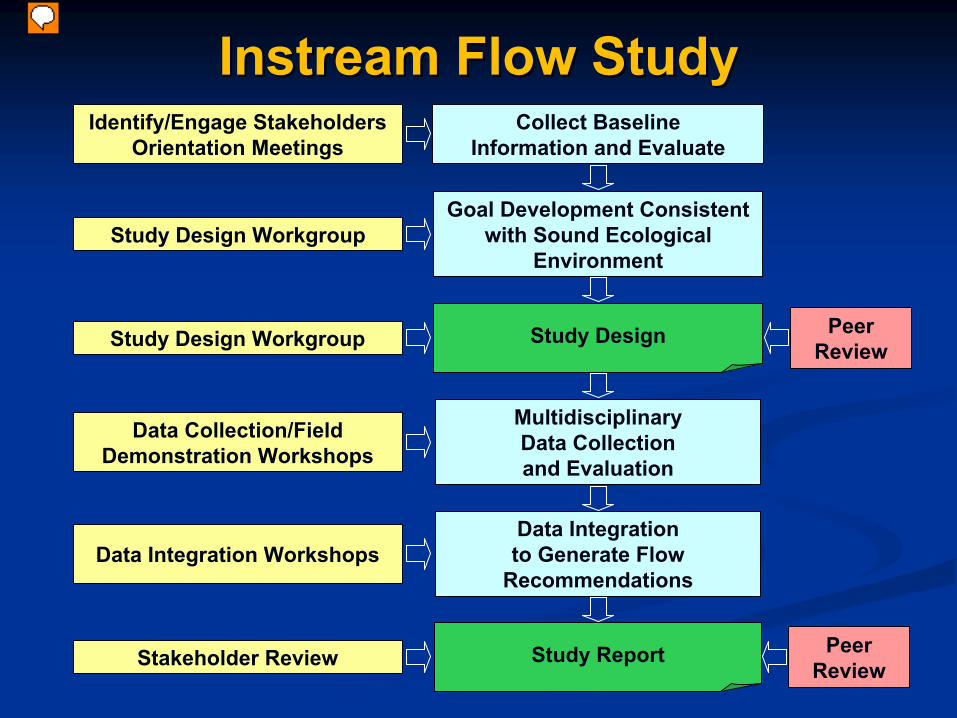
Study Design
Multidisciplinary Data Collection and Evaluation
Study Report
Data Integration to Generate Flow
Recommendations
Collect BaselineInformation and Evaluate
Goal Development Consistent with Sound Ecological
Environment
Peer Review
Peer Review
Identify/Engage StakeholdersOrientation Meetings
Study Design Workgroup
Data Collection/Field Demonstration Workshops
Data Integration Workshops
Stakeholder Review
Study Design Workgroup
Instream Flow StudyInstream Flow Study
Presenter
Presentation Notes
Here’s a flow chart that shows the basic structure of what these studies look like. The first step is collection and evaluation of all of the baseline data available for the particular river or stream segment being considered. It’s an attempt to see what we know about the system already. It may also include the collection of some baseline data in areas where it was previously unavailable. Second step is development of a specific goal for the river or stream consistent with the statewide goal of a “Sound Ecological Environment.” Essentially defining the term “Sound Ecological Environment” for a particular river or stream. The product of these activities is a Study Design, describing how the agencies and partners intended to conduct the instream flow study, what indicators they will focus on, what flow/environment relationships they will investigate. After completion of the study design, the field data collection and evaluation efforts begin in earnest. After the those efforts are completed, there is a process of integrating the results of the various studies to generate flow recommendations. The final outcome is a study report, documenting the results of the studies, how they were conducted, and how they were used to make instream flow recommendations. That’s the basic structure of these studies, now lets add in the input from the local areas. The TIFP is designed to include lots of input from and interaction with local stakeholders for each river sub-basin. From the first, we want to identify and engage stakeholders in order to understand what they value about their river system, gain local knowledge about the system, and identify any local concerns. We’ve followed that up with orientation meetings in each sub-basin to describe the instream flow study process to the public, get their values for the river system, and recruit them to take part in a workgroup to help the agencies develop the study design for their sub-basin. Development of both the sub-basin goal and study design has been a collaborative effort between the agencies and the study design work group. During field studies, we will be conducting workshops for stakeholders and the public to demonstrate how we are conducting the studies. Integrating study results in order to make flow recommendations will also be a collaborative effort with local stakeholders. And the final product, our study report, will be reviewed by local stakeholders. The final outcome of this stakeholder process will be that study results reflect local knowledge, values and concerns. To insure that study results are technically sound, both the study design and study report will be reviewed by scientific peers. This will insure that our proposed methods and final results are sound and conform with current scientific practice.
What we’ve added on this slide are some dates showing where we are in this process for the lower San Antonio. In this sub-basin, we began baseline data collection and interaction with stakeholders in 2005. There was a bit of delay at that time as our program was reviewed by the National Academy of Sciences, but that review has proven very valuable moving forward. During that time, we were also complete some baseline studies. In 2008, we conducted orientation meetings in the sub-basin and recruited a study design workgroup. That workgroup assisted us in development of the sub-basin goal and study design, which was recently peer reviewed by the US Geological Survey. The USGS review tapped into both in-state and national expertise. Field efforts for our studies, will continue over the next few years. A few years is required to conduct these studies, not just because they take time to set up and complete, but also to insure we get data from a range of hydrologic conditions. We anticipate beginning the integration work in 2011, with a final study report expected by 2012.
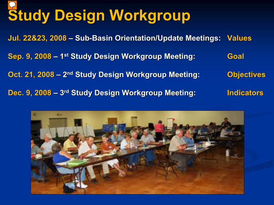
Study Design Workgroup Meeting: Study Design Workgroup Meeting: GoalGoal
Oct. 21, 2008 Oct. 21, 2008 ––
22ndnd
Study Design Workgroup Meeting: Study Design Workgroup Meeting: ObjectivesObjectives
Dec. 9, 2008 Dec. 9, 2008 ––
33rdrd
Study Design Workgroup Meeting: Study Design Workgroup Meeting: IndicatorsIndicators
Presenter
Presentation Notes
Here’s picture of one the lower San Antonio update meetings, where we gathered input on the values important to local stakeholders. We also used the update meeting to recruit local stakeholders to join a voluntary Workgroup to collaborate with the Agencies to develop the Study Design for their sub-basin. At our first meeting with the Study Design Workgroup, we formed the values into a goal for the sub-basin. In following meetings, we developed objectives and indicators for each discipline.
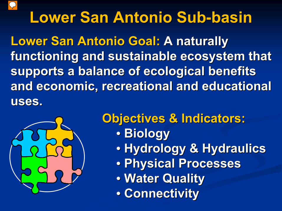
Lower San Antonio SubLower San Antonio Sub--basinbasinLower San Antonio Goal:Lower San Antonio Goal:
A naturally A naturally
functioning and sustainable ecosystem that functioning and sustainable ecosystem that supports a balance of ecological benefits supports a balance of ecological benefits and economic, recreational and educational and economic, recreational and educational uses.uses.
Here’s the overall goal for the sub-basin. For each discipline, we also developed objectives associated with this goal and indicators to measure how those objectives are being met. You can find all of this material (and more) on our TIFP website, which I’ll give you at the end of this presentation. Based on this goal/objectives/and indicators developed with the Workgroup, the agencies and study partner developed a study design for the sub-basin.
Study DesignStudy Design
Jun. 19, 2009 Jun. 19, 2009 ––
Draft Provided to Draft Provided to Study Design WorkgroupStudy Design Workgroup
Comments Received Comments Received from Scientific Peer Reviewfrom Scientific Peer Review
Summer 2010 Summer 2010 --
Study Design FinalizedStudy Design Finalized
Presenter
Presentation Notes
That Study Design was provided in draft form to the workgroup members in mid-June of last year. We meet together a fourth time later in June to discuss that draft. All feedback from workgroup members was received by early August, after which the Agencies revised the document and delivered a draft to the USGS for scientific peer review in November. The USGS provided their comments back to us in February of this year. We’ll be responding to their comments and finalizing the study design early this summer.
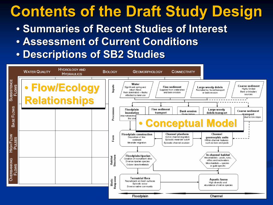
Contents of the Draft Study DesignContents of the Draft Study Design•• Summaries of Recent Studies of InterestSummaries of Recent Studies of Interest•• Assessment of Current ConditionsAssessment of Current Conditions•• Descriptions of SB2 StudiesDescriptions of SB2 Studies
• Conceptual Model•• Conceptual ModelConceptual Model
•• GIS Database of GIS Database of Available DataAvailable Data
SARA (2005)SARA (2005)
Presenter
Presentation Notes
Our activities to date have produced a number of intermediate products that may be of value to the SB3 process, including a GIS database of historical data available for the sub-basin. That effort was completed by the San Antonio River Authority in October 2005. In 2006, we completed baseline fish collections at eight sites on the San Antonio River and Cibolo Creek and documented those results in a report. Since that time, we’ve continued to collect fish data in the sub-basin and we can make that data available to you.
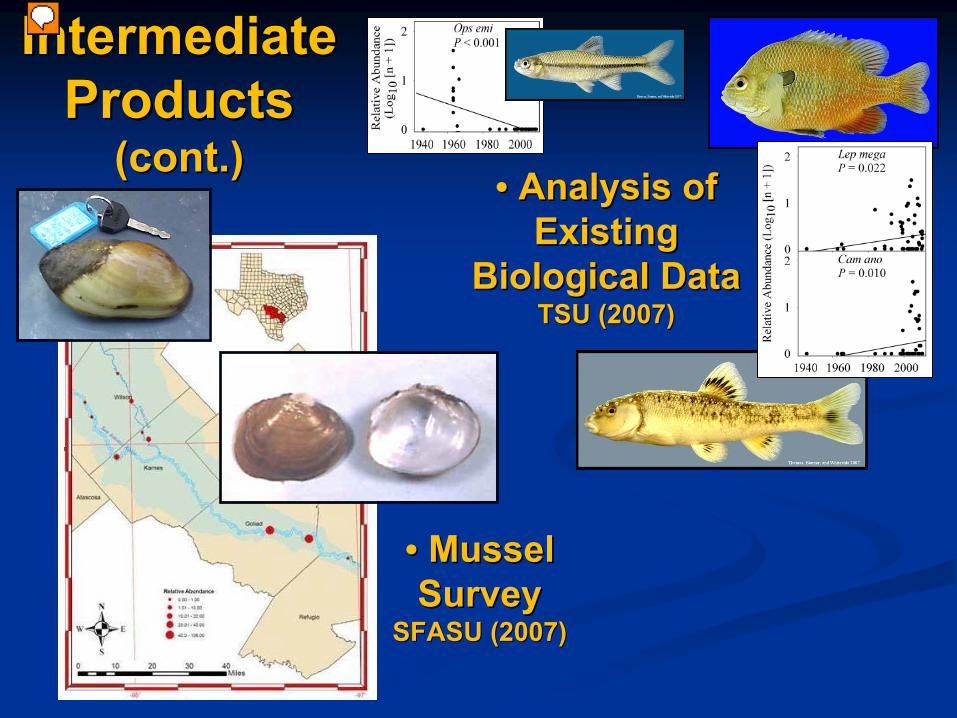
Intermediate Intermediate ProductsProducts
(cont.)(cont.)•• Analysis of Analysis of
Existing Existing Biological DataBiological Data
TSU (2007)TSU (2007)
•• Mussel Mussel SurveySurvey
SFASU (2007)SFASU (2007)
Presenter
Presentation Notes
In 2007, Dr. Tim Bonner of Texas State University completed a study that examined the available fish collection data for the Lower San Antonio Basin and looked for trends. Of 57 species collected in the Lower San Antonio, Bonner detected a decreasing trend in the relative abundance of 2 species, an increasing trend for 3 others, and stable or undetermined trends for the rest. In 2006 and 2007, scientists from Stephen F. Austin State University conducted a survey of freshwater mussels in the sub-basin. They were able to find live samples of four species including Golden Orb, a species that was thought by some to have been eliminated from the San Antonio River.
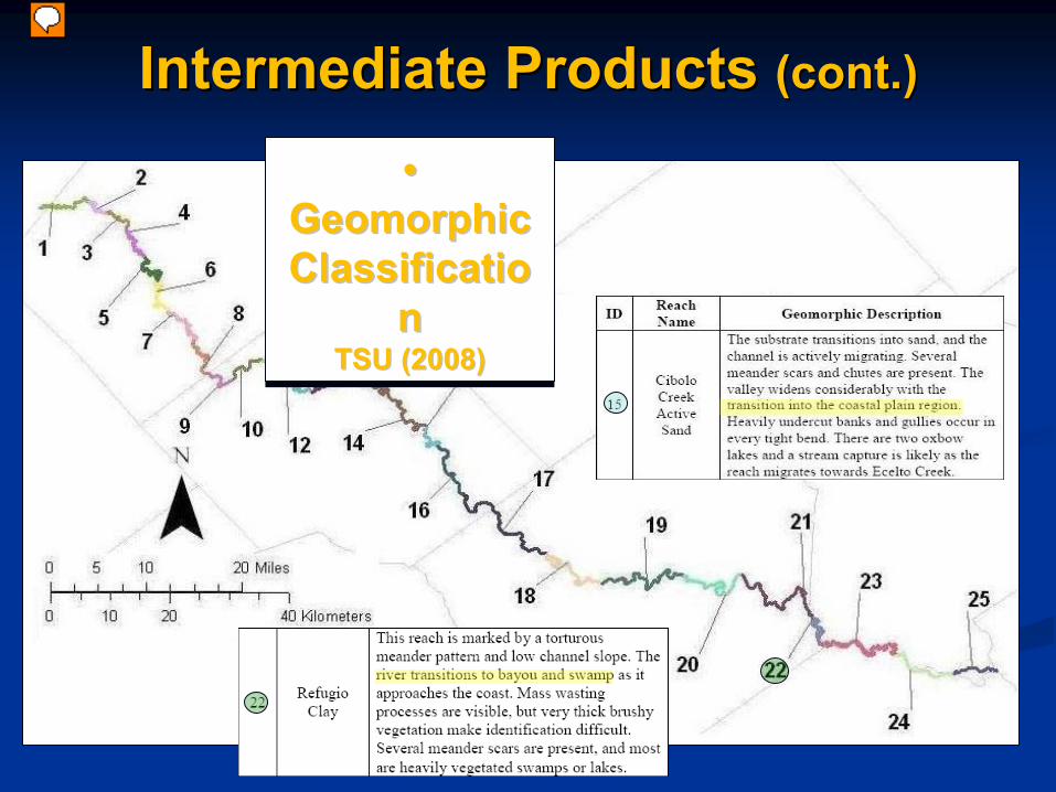
In 2008, Dr. Joanne Curran (then at TSU) and her graduate students completed a geomorphic segmentation of the mainstem of the lower San Antonio River. That study is of value in understanding the variation in physical conditions along the length of the river.
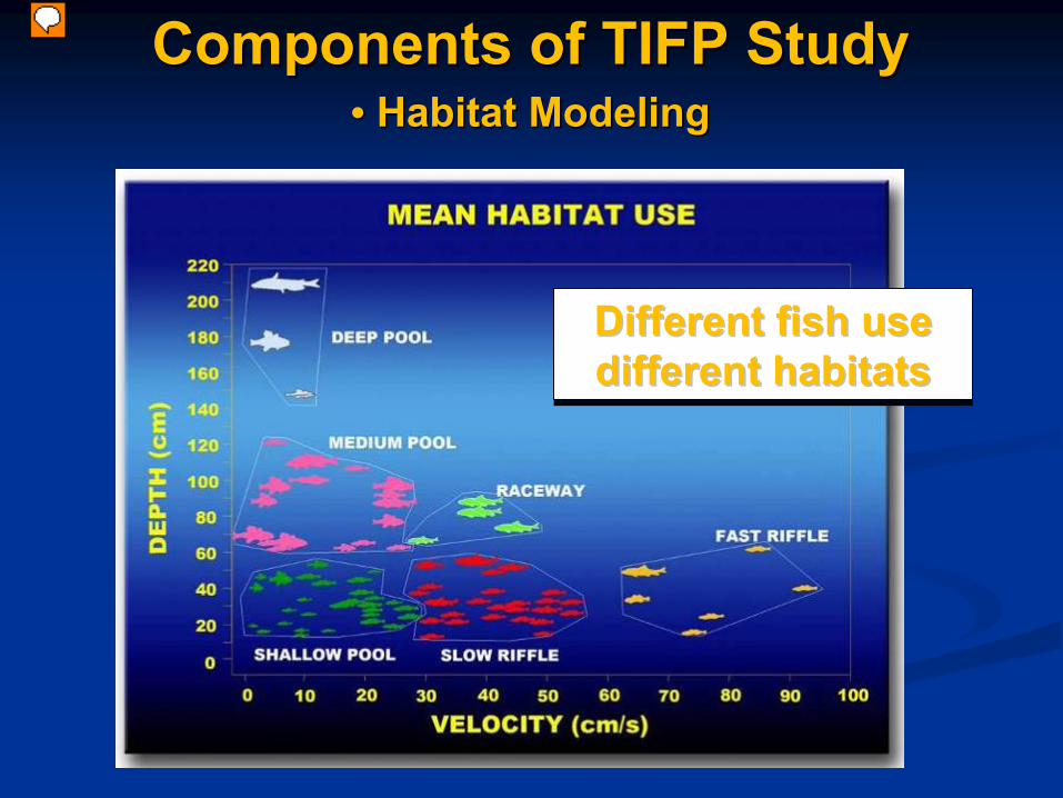
Components of TIFP StudyComponents of TIFP Study•• Habitat ModelingHabitat Modeling
Different fish use different habitats
Different fish use Different fish use different habitatsdifferent habitats
Presenter
Presentation Notes
A swift, shallow water guild in the Trinity system might include several darter and minnow species A guild associated with deep pool might include sunfish, gar species, largemouth bass, and some of the minnows
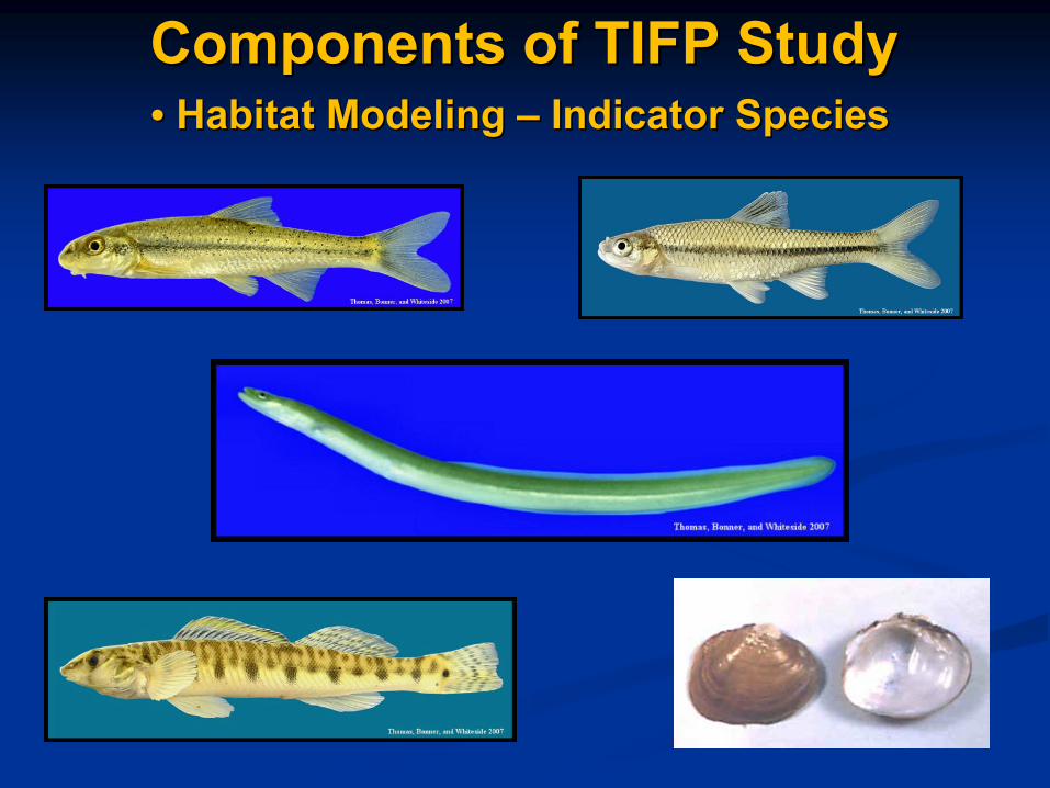
Components of TIFP StudyComponents of TIFP Study•• Habitat Modeling Habitat Modeling ––
Indicator SpeciesIndicator Species
Evaluation of data from existing programs Evaluation of data from existing programs (CRP, TPDES, TMDL)(CRP, TPDES, TMDL)
Extended deployment of WQ data sondesExtended deployment of WQ data sondes
Water Quality modelingWater Quality modeling
Existing models Existing models
QualTX QualTX ––Steady StateSteady State
Future modelsFuture models
? ? ––
ability to model parameters ability to model parameters across a range of flow conditionsacross a range of flow conditions
Components of TIFP StudyComponents of TIFP Study•• Water Quality Analysis / ModelingWater Quality Analysis / Modeling
Presenter
Presentation Notes
Currently the TCEQ has a contract with SARA to develop a modeling approach to model WQ parameters across a range of flows.
Presenter
Presentation Notes
During the Summer of 2009 we deployed WQ sondes at 4 of the study sites for approximately 30 days with a calibration check during the mid-point. WQ sondes recorded temp, DO, ph, and conductivity measurements every 15 minutes.
DO –
Typical Diurnal Swings.
Highest during later afternoon and lowest before dawn.
DO/Temp. track well. ↑
Temp = ↑Photosynth. = ↑
DO
Weak Relationship between Q and DO/Temp
Components of TIFP StudyComponents of TIFP Study•• Water Quality Analysis / ModelingWater Quality Analysis / Modeling


![Welcome [] to government... · 2020. 8. 18. · When do they \⠀最漀瘀攀爀渀洀攀渀琀尩 use shall. \⠀圀栀攀渀 礀漀甀 最漀琀琀愀 搀漀 椀琀尩 When do they](https://static.documents.pub/doc/80x56/60208b67fa545219ab54974c/welcome-to-government-2020-8-18-when-do-they-aoeccc.jpg)