Virginia Transportation Research Council, 530 Edgemont Road, Charlottesville, VA 22903-2454, www.vtrc.net, (434) 293-1900 http://www.virginiadot.org/vtrc/main/online_reports/pdf/07-r36.pdf Final Report VTRC 07-R36 research report Use of Photogrammetry as a Tool for Accident Investigation and Reconstruction: A Review of the Literature and State of the Practice Virginia Transportation Research Council E. D. ARNOLD, Jr., P.E. Associate Principal Research Scientist
Transcript
Virginia Transportation Research Council, 530 Edgemont Road,Charlottesville, VA 22903-2454, www.vtrc.net, (434) 293 -1900
Standard Title Page - Report on State Project Report No.
Report Date
No. Pages
Type Report: Final
Project No.: 80638
VTRC 07-R36 June 2007 32 Period Covered: March 2006–June 2007
Contract No.
Title: Use of Photogrammetry as a Tool for Accident Investigation and Reconstruction: A Review of the Literature and State of the Practice
Key Words: Photogrammetry, accident investigation, accident reconstruction, total station
Authors: E. D. Arnold, Jr., P.E.
Performing Organization Name and Address: Virginia Transportation Research Council 530 Edgemont Road Charlottesville, VA 22903
Sponsoring Agencies’ Name and Address Virginia Department of Transportation 1401 E. Broad Street Richmond, VA 23219
Supplementary Notes
Abstract One of the key goals of incident management is the rapid clearance of traffic incidents. Many transportation agencies focus their incident management on quicker and more reliable detection techniques. Another focus, however, should be the reduction in time required by law enforcement officers to complete on-scene investigations of crashes. As the price of high-quality digital cameras has steadily declined, more agencies are beginning to use photogrammetry as a method for accident investigation and reconstruction. The investigative time needed for certain crash sites is reduced because taking photographs is quicker and simpler than employing other methods typically used, such as coordinate and the total station survey method. Pictures are taken at the site and then brought back to the office and analyzed to obtain measurements of the scene. The analysis can be very time-consuming; therefore, the trade-off for reduced field time and road closure time is increased analysis time. Many law enforcement agencies in Virginia, including the Virginia State Police, use the total station survey method for accident investigation and reconstruction. Its main disadvantages are its relatively high cost and complexity, with the latter necessitating extensive training on how to use the system. Because of these factors, it is often the case that only a few systems and operators are available. Given the commitment of the Virginia State Police and other law enforcement agencies to total stations, the purpose of this study was to determine if photogrammetry is a valid tool for accident investigation and reconstruction in Virginia. The scope was limited to reviews of the literature and the state of the practice. Findings and conclusions are provided regarding the use of photogrammetry in Virginia and the United States, its advantages and disadvantages, associated legal issues, and its cost. The report recommends that the Virginia Department of Transportation in conjunction with the Virginia State Police undertake several case studies of accident investigation and reconstruction at either mock or real crash scenes in which both total station and the most current photogrammetry methods are used and compared.
FINAL REPORT
USE OF PHOTOGRAMMETRY AS A TOOL FOR ACCIDENT INVESTIGATION AND RECONSTRUCTION: A REVIEW OF THE LITERATURE AND STATE
OF THE PRACTICE
E. D. Arnold, Jr., P.E. Associate Principal Research Scientist
Virginia Transportation Research Council (A partnership of the Virginia Department of Transportation
and the University of Virginia since 1948)
Charlottesville, Virginia
June 2007 VTRC 07-R36
ii
DISCLAIMER
The contents of this report reflect the views of the author, who is responsible for the facts and the accuracy of the data presented herein. The contents do not necessarily reflect the official views or policies of the Virginia Department of Transportation or the Commonwealth Transportation Board. This report does not constitute a standard, specification, or regulation.
Copyright 2007 by the Commonwealth of Virginia. All rights reserved.
iii
ABSTRACT One of the key goals of incident management is the rapid clearance of traffic incidents. Many transportation agencies focus their incident management on quicker and more reliable detection techniques. Another focus, however, should be the reduction in time required by law enforcement officers to complete on-scene investigations of crashes. As the price of high-quality digital cameras has steadily declined, more agencies are beginning to use photogrammetry as a method for accident investigation and reconstruction. The investigative time needed for certain crash sites is reduced because taking photographs is quicker and simpler than employing other methods typically used, such as coordinate and the total station survey method. Pictures are taken at the site and then brought back to the office and analyzed to obtain measurements of the scene. The analysis can be very time-consuming; therefore, the trade-off for reduced field time and road closure time is increased analysis time. Many law enforcement agencies in Virginia, including the Virginia State Police, use the total station survey method for accident investigation and reconstruction. Its main disadvantages are its relatively high cost and complexity, with the latter necessitating extensive training on how to use the system. Because of these factors, it is often the case that only a few systems and operators are available. Given the commitment of the Virginia State Police and other law enforcement agencies to total stations, the purpose of this study was to determine if photogrammetry is a valid tool for accident investigation and reconstruction in Virginia. The scope was limited to reviews of the literature and the state of the practice. Findings and conclusions are provided regarding the use of photogrammetry in Virginia and the United States, its advantages and disadvantages, associated legal issues, and its cost. The report recommends that the Virginia Department of Transportation in conjunction with the Virginia State Police undertake several case studies of accident investigation and reconstruction at either mock or real crash scenes in which both total station and the most current photogrammetry methods are used and compared.
FINAL REPORT
USE OF PHOTOGRAMMETRY AS A TOOL FOR ACCIDENT INVESTIGATION AND RECONSTRUCTION: A REVIEW OF THE LITERATURE AND STATE
OF THE PRACTICE
E. D. Arnold, Jr., P.E. Associate Principal Research Scientist
INTRODUCTION
Background
One of the key goals of incident management is the rapid clearance of traffic incidents. It has been estimated that for each minute the time to clear blocked lanes is reduced, at least 4 or 5 minutes will be cut from the delays each motorist will experience.1 Many transportation agencies have focused their incident management on quicker and more reliable detection techniques. Another focus, however, should be the reduction in time required by response agencies, notably law enforcement, to complete on-scene investigations. The on-scene investigation of highway crashes is conducted for particular types of crashes by law enforcement responders. There do not seem to be universally accepted standards regarding which crash types require an investigation; anticipation of future litigation is likely the underlying criterion. Generally, law enforcement must conduct a crash investigation in the event of a fatal or serious injury crash, an incident involving suspected alcohol or drug use, or an incident involving a suspected felony. The judicial system demands a comprehensive and accurate investigation. This necessitates the collection of a large amount of data, including the accurate measurement of skid marks, wrecked vehicle position, crash debris field, and gouges and scratches denoting the area of impact.2 Data collection techniques used by law enforcement for site crash investigations include global positioning system (GPS) mapping devices, laser measuring devices, the coordinate (traditional) method, the total station survey method, and the photogrammetry method. As a part of the research for NCHRP Synthesis 318, a comprehensive 49-question survey targeting transportation and law enforcement individuals was distributed to Transportation Research Board representatives in all 50 states. One of the questions asked about data collection techniques used by police for on-site crash investigations. Nineteen of 25 responding agencies used the coordinate method and/or the total station surveying method. Only 6 used photogrammetry.2 These three methods are described here. Coordinate Method2 In this method, the locations of all objects and sites of concern are measured as a distance along and perpendicular to a baseline tape that is laid down straight through the crash scene; i.e.,
2
x-y coordinates. Three people are usually required to keep the baseline tape in place, take measurements, and record data. Support staff back at the office, using the data collected, must then recreate the crash scene by hand. They start by drawing the baseline established in the field and then plot each object and site of concern to scale relative to the baseline. Although the procedures are relatively simple and straightforward, disadvantages include the following:
• Lack of safety: most measurements must be taken in the highway traveled way, which can subject investigators to hazardous conditions.
• Time intensive: depending on the accident type, measurements can take considerable
time, which increases motorists’ delay and the potential for secondary collisions.
• Possibility of inaccurate and incomplete data: measurements must be made at precise right angles from the baseline tape to ensure accuracy.
• Inconvenience: it may be difficult to clear a path for the baseline tape and to keep it
steady. Total Station Survey Method The total station survey method consists of several elements. A theodolite with an internal level is used to measure horizontal and vertical angles and an infrared electronic distance meter obtains distances to a rod-mounted prism placed on the objects of concern. A computer accompanying the total station stores all data collected electronically. The first step in the procedure is to locate the theodolite at a site from which all the objects to be measured can be seen. The investigator with the rod-mounted prism places it on a point or object to be measured, and a second investigator sites the total station on the prism, measuring distance, horizontal angle, and vertical angle simultaneously. Because the prism is connected to a tall rod, a total station can measure over the top of objects, including moving traffic. Once these field measurements are completed, the total station is taken back to the office and connected to a computer that reads the data and loads them into a computer-aided drafting (CAD) package for measurement and diagramming.2 Use of the total station system is purported to require less than half the time required by the coordinate method to make the same number of measurements. Therefore, it reduces the duration of accident-related lane closures, which in turn reduces traffic delay and the potential of secondary accidents.3
The main disadvantages of a total station are its relatively high cost and complexity, with the latter requiring extensive training on its use.3 Because of these factors, it is often the case that only a few systems and operators are available. In addition, equipment must be brought to the scene and set up to take the measurements. This process can involve an officer being dispatched to the scene, arriving, determining the incident requires a detailed investigation, and then notifying a trained accident investigator to bring the equipment and perform the investigation. This process can take anywhere from 1.5 to more than 3 hours, depending on the travel time and complexity of the incident scene.4
3
Photogrammetry Method3
Photogrammetry is simply the technique of measuring objects from photographs or digital images. There are two categories: far range or aerial photogrammetry and close range or terrestrial photogrammetry. The former is used primarily to produce topographical maps and digital terrain models. The latter, which is of interest here, is used for several purposes, including accident investigation and reconstruction by law enforcement agencies. Close range photogrammetry involves three steps: taking photographs, measuring the photographs, and processing the measurements to produce an accurate diagram.3
First, photographs are taken of the accident scene with key and relevant objects
designated with evidence markers. In order to obtain a three-dimensional representation of the scene, these markers must be included in at least three different photographs taken at wide angles. One scale measurement must also be taken at the scene; normally, an object of known scale is simply placed in the scene. Steps 2 and 3 are undertaken back in the office by importing the pictures into specialized software that develops measurements, scale diagrams, and computer-generated pictures.3
Early efforts of using photogrammetry for accident investigation required expensive professional equipment; however, recent developments in digital imaging and computer vision technology have made it possible to obtain measurements with sufficient accuracy using commercially available and affordable equipment. Since the equipment is relatively inexpensive, more systems can be procured and the time required to transport it to the accident scene can be eliminated or at least greatly reduced. It has also been suggested that the time to take the measurements is less that that required by a total station. Two other disadvantages cited are that accident scenes of considerable length cannot be measured accurately and that considerable office time is required to develop the measurements and drawings. On the other hand, developers of the software used suggest that newer versions overcome these limitations.
Accident Investigation in Virginia
The Virginia Department of Transportation (VDOT) has a vested interested in traffic incident management and supports strategies that promote rapid clearance of incidents, including the use of techniques/procedures that expedite accident investigation. However, the Virginia State Police (VSP) and local law enforcement agencies are responsible for investigating and documenting traffic incidents, not VDOT. This is generally accomplished through the use of trained crash investigation teams.
The type of investigative procedure and equipment used varies among these agencies. For example, the VSP is divided into seven divisions and each has a total station system. Four additional total stations were recently obtained through a medical grant, and 10 more are needed. Having additional units will reduce the response time needed to transport a system to the site of the incident. The VSP is committed to the use of the total station system and regards photogrammetry as having limited use because of the disadvantages cited previously; i.e., the long-distance accident scenes typically encountered and the excessive office time required for
4
analysis. The latter is a problem because there are a limited number of crash investigation teams, and since they are most often in the field at accident sites, there is limited office time available for conducting the analysis.
PURPOSE AND SCOPE
Given the commitment of the VSP to the total station surveying method and the advantages and disadvantages of the three most common methods of crash investigation discussed previously, the purpose of this study was to determine if the newest method, photogrammetry, is a valid tool for accident investigation and reconstruction in Virginia.
The scope was limited to reviews of the literature and the state of the practice of the use of photogrammetry as a tool for accident investigation and reconstruction. A detailed review of the technology and the theory behind the use of total stations and photogrammetry was not undertaken. In addition, the reviews focused on comparing photogrammetry with total stations; a preliminary review of the literature indicated that both are far superior to the coordinate method and are the most commonly used advanced methods (with GPS and laser technologies being much less common).
METHODS
The research was undertaken with the following tasks:
1. Review the literature concerning photogrammetry, especially in comparison to total stations.
2. Obtain information from vendors of software that supports photogrammetry
techniques.
3. Conduct a telephone survey of law enforcement agencies in Virginia to determine their use of total stations and photogrammetry.
4. Obtain a review of judicial experiences with photogrammetry.
Literature Review
A literature review was conducted by searching the Transport database through SilverPlatter WebSPIRS 5.1 via the Internet. The Internet was also searched using the Google search engine. Further the holdings of the VDOT Research Library were electronically searched and its staff developed a research synthesis bibliography on photogrammetry.
5
Obtaining Information from Vendors of Software That Supports Photogrammetry
Based on the literature review, several commonly used photogrammetry software packages were identified. Websites of the companies selling these packages were reviewed in this task.
Telephone Survey of Law Enforcement Agencies in Virginia to Determine Their Use of Total Stations and Photogrammetry
In order to determine the accident investigation and reconstruction methods being used locally, law enforcement agencies in Virginia’s incorporated cities and towns and counties with a population over 80,000 were contacted via telephone. Twenty agencies involved with accident investigation and reconstruction were interviewed. Information was solicited on methods used, advantages and disadvantages, costs, and training required, as well as any general comments. Two additional state law enforcement agencies and a state department of transportation (DOT) were also contacted. The VSP was contacted to determine its latest thoughts, concerns, and questions about photogrammetry versus total stations. The Minnesota State Patrol and the Florida DOT were contacted as each had been identified in the literature as users of photogrammetry. Information was solicited on methods used, advantages and disadvantages, cost, and training required, as well as any general comments.
Obtaining a Review of Judicial Experiences with Photogrammetry
One of the disadvantages of photogrammetry often cited in the literature review is the concern that the judicial system is not yet ready to accept evidence obtained and developed by photogrammetric means. On the other hand, evidence developed by total stations (a surveying system) is well accepted. To address this claim, graduate legal assistants on staff at the Virginia Transportation Research Council were asked to provide information on the following question: Will measurements made from crash scene photographs, more specifically known as photogrammetry, be admissible in Virginia courts for the purposes of traffic accident investigation, analysis, and recreation?
RESULTS
Literature Review Three key studies of the use of photogrammetry were identified: the most recent from the Kentucky Transportation Center3 and two older ones from the Texas Transportation Institute (TTI).4,5 Researchers conducting these studies interviewed personnel from law enforcement agencies. These interviews provided important insights to the use of total stations and photogrammetry, and summaries of these interviews are also provided.
6
Kentucky Transportation Center: Study Evaluating Methods to Reduce Crash Investigation Times3
Survey of State Police Agencies
As part of their 2005 study, the researchers at the Kentucky Transportation Center asked state police agencies to describe the methods of accident investigation and reconstruction they employed. Thirty-seven responses were received. Three states reported using total stations exclusively; one state reported using the coordinate method exclusively. Most respondents reported the use of more than one method. Nine states indicated the use of total stations 50 percent or more of the time; one state reported the use of photogrammetry the majority of the time (70%). Ten states reported some experience with photogrammetry. Comments about their experiences were mixed, with seven being generally negative and three being generally positive. An additional four states had just completed training or were in the process of testing photogrammetry, and one state was set to begin training. The Kentucky researchers cited some of the advantages and disadvantages of photogrammetry they found in the literature as follows: Advantages
• less time on scene (than other methods) • scenes diagrammed only as needed • cost less than total station • acceptable level of accuracy • training may be less than for total station • photos taken by single officer.
Disadvantages
• more analysis time needed in office • lighting may be problematic • significant cost of equipment • early stages of deployment of this application of this technology • significant training needed • problematic when used on long scenes.
The researchers also summarized the advantages and disadvantages of photogrammetry cited in the interviews with law enforcement officials: Advantages
• Photogrammetry is useable in any location. • Accuracy of the data is comparable to that of total stations. • Time needed for collecting data in the field is reduced. • One officer can do all the measurements.
7
Disadvantages
• Cost of implementing a change to photogrammetry is high. • Photographic analysis is labor intensive and time-consuming. • Data analysis requires a steep learning curve. • Mapping large scenes or scenes with significant changes in elevation is difficult. • Obtaining line-of-sight with objects in the way is problematic. • Qualifying the data for courtroom purposes is difficult.
Interviews Conducted in Early 20053 California Highway Patrol (CHP). Reconstruction teams handle approximately 500 accidents per year and collect data with a total station system. Some of the crashes investigated were conducted by using roll meters and tape measures. Photogrammetry was considered; however, the cost of implementing such a change, along with the steep learning curve, kept the CHP from implementing it. Georgia State Patrol. Georgia’s Specialized Collision Reconstruction Team uses total stations for nearly 100 percent of the accident investigations. They considered this method to be much easier to use than the coordinate method and to provide excellent information for courtroom presentations. There was no mention of the use of photogrammetry. Missouri Highway Patrol. Missouri’s state police use total station systems for reconstruction. Seven troopers had attended training on photogrammetry and decided that the software to analyze the photographs was not practical to use. Some of the disadvantages cited to using photogrammetry included:
• difficulty in mapping large scenes or those with significant changes in elevation • problems with line of sight (objects getting in the way) • extensive time needed for preparing diagrams.
New Jersey State Police. The state police do not use photogrammetry; they use a laser technology system. Several received training in photogrammetry and use the software to retrieve information from photographs when no laser mapping was undertaken. New York State Police. New York’s Collision Reconstruction Unit has 25 total station units and is committed to using that method. The state police had previously investigated photogrammetry after being encouraged by the New York Department of Transportation to find a better and faster method of reconstruction in order to open the roadway more quickly. In comparing total stations and photogrammetry, the investigation found some information to be similar and some to show several feet of difference. Three primary disadvantages of photogrammetry were cited:
1. difficult to use on a large scene 2. difficult to qualify the data for courtroom purposes 3. extensive time needed to analyze the data.
8
Utah Highway Patrol. The highway patrol uses photogrammetry almost exclusively for accident investigation and reconstruction. They started using the method in 1999, and now all officers are trained in how to take appropriate photographs. One or two officers in each district are trained to prepare the diagrams from the photographs. There have been no problems at trials with introducing evidence developed from photogrammetry. The following advantages were cited:
• useable at any location • very accurate (equivalent to that of total stations) • less time needed for collecting data in the field.
Washington State Police. The state police use photogrammetry, total stations, and baseline coordinate methods for accident investigation and reconstruction. Training in photogrammetry was first provided in April 2002, and about 30 detectives are versed in the method. Approximately 20 to 25 percent of accidents requiring investigation are captured with photogrammetry. It is considered an excellent and effective tool, has had no associated problems with courtroom admissibility, and has the following specific advantages:
• One officer can take the measurements. • Roadway closures are shortened. • Accuracy is comparable to that of total stations.
The following specific disadvantages were also cited:
• Large scenes need to be broken into zones and merged. • People and objects need to be removed in order to photograph the scene. • A certain level of lighting is needed in order to obtain adequate photographs. • A lot of time is needed to learn the method.
It is noted that the four additional agencies interviewed (i.e., Idaho State Police, Memphis
Police Department, Nevada Highway Patrol, Ohio State Highway Patrol) indicated without comment that they did not use photogrammetry. Texas Transportation Institute: Study of Road Rage4
As part of a study to understand road rage, researchers at TTI evaluated promising mitigation measures, including the use of photogrammetry for crash investigation and reconstruction. Researchers contacted law enforcement agencies throughout the United States and reported in depth the experiences with photogrammetry in Dallas and Chattanooga. This information was obtained in the 2000 and 2001 and should be considered in the context of the recent advances in the quality of both digital cameras and the analysis software. Dallas County Sheriff Department The Dallas County Sheriff Department began using photogrammetry in November 2000 for the investigation of traffic incidents in order to reduce the average clearance time. Their
9
philosophy was to reduce this time even it meant much more work back in the office. The department established an overall average of 20 minutes as the goal for clearing accidents to which its officers responded. Researchers obtained data for 34 incidents to which deputies responded during the period February through May 2001. Eighteen of the incidents were classified as major (i.e. with injuries) and occurred on four roadways. Three key statistics were calculated.
1. Clearance time (defined as the difference in time from when the deputy arrived on scene until there was no freeway lane blocked): the average was 17 minutes and 39 seconds, well below the goal of 20 minutes. In every incident, freeway lanes were opened in less than 1 hour.
2. Blockage time (defined as the total time there was any lane blockage on the freeway,
calculated from the time the call was received until the deputy advised there were no lanes blocked: the average was 22 minutes and 38 seconds.
3. Deputy clear time (defined as the total time spent on the incident by deputies): the
average was 26 minutes and 31 seconds. Chattanooga Police Department The Chattanooga Police Department began using photogrammetry to investigate traffic incidents in November 2000 based on the recommendation of the local area’s highway incident management team. Anticipated benefits included:
• reduction in time needed to get traffic flowing smoothly following an incident • increases in accuracy of critical measurements that are sometimes referred to in court • reduction in motorist frustration due to clearing the accident scene in a timely way • reduction in occurrence of secondary collisions due to stopped traffic • ease in archiving data to use in trials in which charges are not brought immediately.
Researchers obtained incident clearance data (defined as the time to investigate the scene, remove the vehicles, and restore the scene to normal conditions) from 11 crashes between October 2000 and June 2001. The department used its traditional investigative method, laser and roller tape with three investigators, as well as photogrammetry with one officer placing the markers and taking the photographs at each crash scene in order to evaluate the effectiveness of the new technique. Analysis of the data showed that the average clearance time using photogrammetry was reduced by 61 minutes, or 58 percent, when compared to the use of the laser and roller tape method. The department also compared the measurement accuracy of photogrammetry versus its traditional technique. The evaluation compared 69 measurements from seven cases in which incident measurements were taken in the field with laser and roller tape and back in the office using photogrammetry software. The average percentage difference between photogrammetry and traditional measurements was only 2.3 percent, with 44 percent of the measurements being less than 1 percent different.
10
Although there were considerable benefits in terms of reduced scene clearance time and fewer personnel required for the investigation, there were drawbacks. Police personnel spent more office time calculating the measurements and producing the scale diagram than with the use of traditional methods. This office time was reduced, however, as the officers became more familiar with the software programs. Texas Transportation Institute: Use of Photogrammetry to Assist in Clearing of Major Incident Scenes 5 As part of a study to examine how the Texas DOT and police agencies might use photogrammetry to assist in the clearing of major incident scenes, researchers at TTI conducted a literature review and interviewed a number of agencies about their use of photogrammetry. The interviews were conducted in 1999 and 2000 and comments should be considered in the context of the recent advances in the quality of both digital cameras and the analysis software. Literature Review The literature review found the following advantages and disadvantages of using photogrammetry. Advantages
• Traffic closure for the time necessary to take detailed measurements may be impossible.
• Unstable scene data, such as tire marks in gravel, snow, or slush, may be disturbed, melted, or obliterated by diverted traffic, rescue vehicles, and salvage activity.
• Additional details of vehicle damage may be observed prior to salvage and towing. • Scene details may be so numerous or complex that locating each by field
measurement is impractical. • Photographs can be taken by a single officer. • An analyst can check scene measurements taken by others. • Any objects or items visible in the scene photos can be measured later if needed for
later litigation. Disadvantages
• Photogrammetry requires expensive equipment and highly trained operators. • Police agencies may not endorse the relatively complex concepts and mathematics in
photogrammetry. • The need for photogrammetry may not be obvious if simple measurements meet the
needs of police or analysts. • Evidence at the scene may need to be enhanced, especially at night, to show
adequately in photos. This may offset some of the time-saving potential of photogrammetry.
11
• It is easier to convince a judge or jury of the reliability of a simple measurement taken by hand than to educate them in a more complex computer-based analytical technique.
In an interview with the researchers, Dr. Harry Townes, Professor Emeritus, Montana State University, provided the following information. At the time of the interview, Dr. Townes was an instructor in the course entitled “Photogrammetry in Accident Reconstruction” offered by the Society of Automotive Engineers.
• Photogrammetry is not a difficult technique for investigating collisions; however, one must receive training in how to take a photograph in order for it to be useable. A 2- to 3- day training session is adequate.
• The accuracy of photogrammetry can be as good as several inches at 200 feet. • There are no known legal challenges to photogrammetry measurements being used in
court. • If done carefully, photogrammetry can be the only technique used to process an
incident scene. • Compared to using total station, photogrammetry has a shorter “up front” time but a
longer “back end” analysis time. • Photographs have the advantage of recording all of the information at the scene,
which might become important later if further evidence is needed. Interviews Conducted 1999 to 20005
Arizona Highway Patrol. At the time of the interview, the patrol had five methods for measuring data at crash scenes: total stations, tape measure (especially for measurement of an object to serve as a control distance), laser units, GPS, and close-range photogrammetry. The last was used for collision scenes approximately 5 to 10 percent of the time. None of the five methods listed is applicable in all situations; all have strengths and weaknesses. The officer interviewed indicated that he would be comfortable with using close-range photogrammetry for documenting the majority of collision scenes. He mentioned the accuracy and relative ease of use as positives. Oregon State Police. The state police were using total stations for reconstruction purposes but were in the process of testing photogrammetry as a means to open the highways faster after accidents. Three copies of the PhotoModeler 3.1 software and three digital cameras had been procured. They did not believe that photogrammetry would replace total stations as their primary method and intended to continue to use total stations on criminally prosecutable cases. Photographs would be used as a back-up should evidence at the scene be missed and need to be measured later. The agency anticipated relying heavily on photogrammetry for conducting the investigation and capturing all of the evidence at less serious accident scenes.
12
Information from Vendors Regarding Costs of Total Station and Photogrammetry Systems
Total Station The following cost information was obtained from the websites of vendors selling several common brands of total stations and from a quote sent to the VSP. Table 1 provides cost information from Visual Statement as of June 4, 2007.
Table 1. Combination Total Station Hardware and Diagramming Software: Visual Statement Nikon
Total Stations Sokkia
Total Stations Leica
Total Stations TopCon
Total Stations Model Cost ($) Model Cost ($) Model Cost ($) Model Cost ($)
NPL - 332 8,673 630R 7,598 TCR407Power 7,752 GPT3007W 8,378 NPL - 352 9,393 530R3 9,149 TCR407Ultra 8,878 GPT3005W 9,316 NPL - 362 9,989 Total stations includes tripod, prism pole, prism, cable (link to PC). Software included is the Vista FX3 LE (lists separately at $1,395.00).
Source: http://www.visualstatement.com/default.aspx. Table 2 provides cost information from RC Gravel, Inc., as of June 5, 2007.
Table 2. Total Station Packages: RC Gravel, Inc. Unit List Price ($)
Sokkia Set 630r 10,450 Sokkia Set 530r 11,500 Nikon NPL 332 10,673 Nikon NPL 352 11,481 Packages include fiberglass tripod, 8-ft prism pole, tripod stabilizer, single tilt prism, strobe prism.
Source: http://www.rcgravel.com/packages.htm. Table 3 provides cost information from GeoSolution/Q L Enterprises, Inc., as of June 5, 2007.
Table 3. Total Station Packages with Accessory Add-Ons: Geosolution/Q L Enterprises, Inc.
Unit List Price Leica TCR407 Power Regular price: $7,995
Sale price: $7,195 Leica TCR407 Ultra Regular price: $8,995 TPS400 Accessory, Set A Sturdy wooden tripod Mini prism set Basic Data Transfer Cable Camcorder NiMH battery
Regular price: $930 Sale price: $880
TPS400 Accessory, Set B Sturdy wooden tripod All-in-one Prism Prism Pole w-light weight telescopic extension with clamp Transfer Cable 3.6Ah 6V Camcorder NiMH battery
Source: http://www.makepeace.com/index.html?lang=en-us&target=d43.html. Table 5 provides cost information from a Virginia vendor.
Table 5. Total Station Package: Virginia Vendor Components Cost ($)
Nikon NPL- 332 with case battery and charger 5,869 Heavy wooden tripod 150 Prism pole, 12 feet 150 Carrying case, soft, for tripod and prism pole 100 Single prism, metal tilting yoke, with target, lighted 165 Soft case for prism 25 Black toolbox 80 Plumb hammer, 48 oz. 16 Pocket rod 15 Steel tape, 25 feet, 10ths, power 15 Magnetized masonry nails, 1¼ inches long, 100 per box 8/box Flags, 2x 3 x 21 inch wire, bundle of 100, case of 10 bundles 5/bdl Power inverter 27 Total 6,625
Source: Quotation dated June 5, 2006. Email from R. C. Dowsett, Master Trooper, Virginia State Police Crash Investigation Team, May 24, 2007. Photogrammetry The following cost information was obtained from the websites of vendors selling several common brands of photogrammetry analysis software. Table 6 provides cost information from DeChant Consulting Services, Inc., as of June 4, 2007.
Table 6. iWitness Close Range Photogrammetry: DeChant Consulting Services, Inc. Item Cost ($)
iWitness Version 1.0 895 CAD Zones “Crash Zone” Diagramming Software (3D diagramming software program in accident reconstruction mapping offered by vendor).
695
Source: http://www.photomeasure.com/training.html. Table 7 provides cost information from Eos Systems as of May 31, 2007.
Table 7. PhotoModeler: Eos Systems Component Cost ($)
Basic Software PhotoModeler 6 995 Cameras and Bundles PhotoModeler - Nikon D80 Bundle 2,930 Nikon D80 Calibrated Camera 2,050 PhotoModeler - Canon XT Camera Bundle 2,640 Canon XT Calibrated Camera 1,760 Add-On Modules Coded Targets Module (allows a higher degree of automation and efficiency) 295 PhotoModeler Video Module (allows circular targets to be placed or projected on an object that is moving or changing shape)
995
Idealize Module (used by film and game production customers) 795 Accessories Dot Slides (high accuracy dot targets in the form of a 35mm slide, 6 included) 45 Two Point Fiducial Insert (Plastic Film Plane inserts for use with 35mm film cameras, 2 included) 25 Large Calibration Sheet - large dots (used with PhotoModeler's Camera Calibrator program to produce accurate camera parameters)
40
Large Calibration Sheet - small dots (used with PhotoModeler's Camera Calibrator program to produce accurate camera parameters)
40
Eos Evidence Markers (used to locate items of interest, 20 included) 530 Source: http://www.photomodeler.com/store/. Table 8 provides cost information from Visual Statement as of June 6, 2007.
Designed to interface with Vista FX3 diagramming program to transform a perspective crash scene photograph into a top-down view. Need only 4 reference points in photograph with dimensions known between points and scene is transformed to scale with photo as part of Vista FX3 diagram
• $795, as a program including basic diagramming software
• $395 as an optional component for Vista FX 3 • $0, when included in cost of several Vista FX3
Survey of Local Law Enforcement Agencies in Virginia and Others Survey of Local Law Enforcement Agencies in Virginia In order to determine the accident investigation and reconstruction methods being used locally, law enforcement agencies in Virginia’s incorporated cities and towns and counties with a population over 80,000 were contacted via telephone. Twenty agencies involved with accident investigation and reconstruction were interviewed. (It is noted that researchers were unable to make contact with any of the largest cities and counties in Virginia. In an interview with Master Trooper R. C. Dowsett of the VSP, discussed later, it was noted that additional total stations were concentrated in the Northern Virginia and Hampton Roads areas, which have some of the largest cities and counties in Virginia.) Information was obtained on method used, advantages and disadvantages, cost, and training.
Seven agencies use the coordinate method only, 7 use total stations exclusively, 3 use both the coordinate method and total stations, 2 use a laser system, and 1 uses the coordinate method in conjunction with a hand-held laser unit. Two agencies have a total station unit but have either just received training and are not yet using it or are waiting for the measuring/drawing software. Three agencies are either in the process of buying a total station unit, are very interested in buying a total station unit, or are considering a total station unit. Costs cited for the total station system ranged from $13,000 to $15,000, including estimates of $5,000 to $6,000 for software and $6,500 to $10,000 for the unit. Training was most often provided by the software or hardware company from which it was procured. General training in accident reconstruction was provided by Virginia Commonwealth University. Agencies also relied on training from other local law enforcement agencies and subsequently from their own officers once the method was learned. Advantages of total stations over the coordinate method include:
• provides accurate measurements with fewer personnel and in less time • is safer for the investigators • allows the roadway to be cleared more quickly • produces accurate scaled diagrams quickly and easily that are acceptable in court
Disadvantages of total stations include:
• high cost • difficult to set up and thus time-consuming • bulky equipment • problematic in inclement weather • extensive training required in its use.
Albemarle County Police Department The county currently uses the coordinate method, supplemented with a hand-held laser unit for triangulation, to map serious crash scenes. This method is time-consuming, takes more personnel than other available methods, and disrupts traffic. Officers receive 80 hours of training in reconstruction at Virginia Commonwealth University (VCU). The department has been trying to obtain a grant for a total station unit for the past 2 years. Ashland Police Department The town currently uses the coordinate method to map serious crash scenes. This method is easy to use, thus providing the needed consistency. Officers take VCU’s basic and advanced reconstruction training courses.
16
Blacksburg Police Department The town currently uses the coordinate method to map serious crash scenes. The contact person cited the possibility of human error as a disadvantage and noted the need for someone to double check measurements. Charlottesville Police Department The department currently uses total stations to map serious crash scenes. Officers are very happy with this equipment and that it does everything that is needed. Training is received through VCU. Chesapeake Police Department The department currently uses both total stations and the coordinate method to map serious crash scenes. Using total stations saves time and provides more accurate information than does the coordinate method. They provide detailed information for criminal or civil court proceedings. Disadvantages are their cost and the amount of time set up takes. The contact cited the cost of total stations as between $13,000 and $15,000. This price included 40 hours of training in the use of the equipment. Chesterfield County Police Department The department currently uses total stations to map serious crash scenes and highly recommend it. The advantage is that “it leaves little room for error and provides a scaled diagram to use right away.” The contact cited the cost as $15,000 and noted a 2-week training course for certification. Christiansburg Police Department The department currently uses the coordinate method to map serious crash scenes. Officers report that the method is time-consuming and not very accurate. The department purchased a total station unit for $8,000 about 1 year ago but still needs to purchase the diagramming software, estimated at $6,000. Training will then be provided by Roanoke County. Danville Police Department The department currently uses the coordinate method to map serious crash scenes. A total station unit has been purchased but is not being used at the present time as only two officers have received training in its use. Fredericksburg Police Department The department currently uses the coordinate method to map crash scenes. If the crash is considered “serious,” the VSP is called in to conduct the investigation and mapping with a total station unit. The total stations method requires fewer personnel than does the coordinate method
17
and the roadway is not closed as long. It also produces an accurate diagram that is cleaner and more presentable. The disadvantage of total stations is the bulkiness of the equipment. The city will be purchasing a total station unit at an estimated cost of $7,000, which includes limited training by the manufacturer. The department will be requesting detailed training from other police departments in Virginia. Harrisonburg Police Department The department currently uses a laser system to map crash scenes. They are pleased with the system and find it quicker than the coordinate method. The laser cannot be used in rain or fog to obtain measurements and is problematic in heavy traffic. Obtaining proper training is also an issue. Henrico County Police Department The department currently uses total stations to map serious crash scenes. The system provides precise scale diagrams; however, it takes two to three officers to operate. The system was said to cost $20,000. Training was received in-house from officers currently trained in its operation. Hopewell Police Department The department currently uses both total stations (with Vista software) and the coordinate method to map serious crash scenes. The total stations method is more accurate than the coordinate method; however, inclement weather prevents its use. The method must be used regularly or officers can easily forget their training. Training is received through a 2-week course at VCU. Lynchburg Police Department The department currently uses the total stations method to map serious crash scenes. It is more precise than the coordinate method and is easily and quickly input to drawing software. A reference point is not needed as the system creates its own reference. A disadvantage is that it is difficult to set up and that training must be provided regularly as officers do not use it on a frequent basis. The cost was $6,500 for the total station unit and $5,000 for the map scene software. Portsmouth Police Department The department currently uses the coordinate method to map crash scenes. The method is time-consuming and is open to error. There are no advantages in using the method. Training is obtained at VCU.
18
Prince William County The county currently uses both the total stations and the coordinate method to map serious crash scenes. The coordinate method is not as accurate as with total stations, which obtains measurements by simply pointing at the items of interest. The cost was cited as being between $5,000 and $10,000, and training was obtained at VCU and then in-house. Roanoke County Police Department The department currently uses total stations (a unit shared with Salem) to map serious crash scenes and has been doing so since 1995. The method is fast, safe, and accurate, but traffic lanes need to be closed. The cost was cited as $9,500, including extra poles. Training was received from the company providing the software. Salem Police Department The department currently uses total stations (a unit shared with Roanoke County) to map serious crash scenes. The method is valuable in that it reduces measuring time and requires fewer personnel than the coordinate method. The use of accompanying software makes it easy to produce critical drawings. A disadvantage is that it cannot be used in bad weather. The cost was cited as $8,000, and 3 to 4 days of training was provided by the software company. It was noted that the equipment can also be used for crime scene investigation. Stafford County Sheriff Department The department currently uses total stations to map serious crash scenes. Proper usage ensures accuracy; however, the roadway needs to be closed, two officers are required to map the scene, and it takes time to obtain the measurements. Training is obtained from the manufacturer, VCU, and subsequently in-house. Suffolk Police Department The department currently uses the coordinate method to map serious crash scenes. The advantage is that it is accurate because officers are doing the actual measurements; the disadvantage is that it is time-consuming. Training in reconstruction is obtained through VCU. The department is considering total stations and is investigating which software will be compatible with their current computer system. Waynesboro Police Department The department currently uses a laser system to map crash scenes. The system provides good graphical representation and helps determine causes of accidents. The cost was cited as $10,000. Eight hours of training was received from the company providing the software, and additional training on reconstruction was obtained from VCU. Only a couple of officers are trained in its use.
19
Additional Interviews The researcher also interviewed members of the VSP, the Minnesota State Patrol, and the Florida DOT as a means of obtaining divergent views regarding investigative technology. Virginia State Police (Master Trooper R. C. Dowsett, Crash Investigation Team, May 25, 2007) The VSP has 11 total station systems. They had 1 per division for a long time but just recently received 4 more under a medical grant (at a cost of less than $6,000 per unit). Trooper Dowsett estimates there are about 24 units scattered around the state in other jurisdictions. These are concentrated in Northern Virginia and Hampton Roads localities. He is not aware of any jurisdictions with photogrammetry units. He believes that the VSP could use 10 more total station units. The response time of getting a unit to the crash scene could be reduced with the availability of these additional units, and this is where the time savings can be found in Virginia’s incident management efforts. Training in total stations takes 2 days to learn the equipment (field set-up, shooting, etc.) and 3 days to train in the use of the drawing package. The VSP uses the Vista FX3 drawing package from Visual Statements. The VSP also has Visual Statement’s Hawkeye Photo Rectification Software Program for use with photographs to obtain measurements. The program requires four known points, with the distance between each measured in the field. The photograph is then scaled using these measurements and does triangulation to obtain other scene measurements, which are then input to the Vista FX3 software for drawing. The VSP are completely satisfied with total stations and are not interested in making a total conversion to photogrammetry. Trooper Dowsett feels there may be instances where the use of photogrammetry might be advantageous; however, his initial interest is in experimenting with the currently owned Hawkeye software for measuring photographs. Trooper Dowsett cites the following disadvantages of photogrammetry:
• Lighting can be an issue with digital photography. It is difficult to take pictures of crash scenes at night. This is not an issue with total stations as they have lighted targets.
• Courts are skeptical of digital photographs because of how easy it is to manipulate a
photograph. Courts, on the other hand, are quite receptive to results from surveying instruments.
• Crash scenes must be short and compact; his rule of thumb is within 150 feet in order
for photographs to work.
20
Minnesota State Patrol (Sergeant Brent Richter, Office of Investigative Service, Metro Crash Reconstruction Team, June 1, 2007) The Minnesota State Patrol (MSP) uses the coordinate, total station, and photogrammetry methods for accident investigation. It has 23 total stations and 13 photogrammetry units (digital camera, markers, and iWitness software for each). The photogrammetry units were purchased with a grant from the Minnesota DOT. They have tried various software packages and have settled on iWitness. All troopers are trained in the coordinate method. It is still used in simple scenes as the time it takes to stretch a line and measure off to the objects is comparable to the time required to set up a total station. Sergeant Richter is of the opinion that a total station is more accurate than photogrammetry. It is the method of choice for serious crash scenes (e.g., fatalities involved) where litigation and other major questions are expected. Court acceptance of photogrammetry is in its early stages; that is, in most cases, the validity of photogrammetry evidence must be proven before being admissible. In a recent grant application, he estimated a cost of approximately $2,500 for a photogrammetry set-up. This included a good quality camera, evidence markers, and analysis software. It did not include the diagramming/drawing software. This compares to a cost of $10,500 for a total station set-up, which includes the diagramming/drawing software. Training for total stations and photogrammetry takes about the same time: approximately 1 week for learning the on-site and office measuring techniques plus 1 additional week for learning the mapping. Sergeant Richter feels learning a total station is easier because one can see the results of the field measurements immediately. On the other hand, with photogrammetry, one takes a picture in the field and then has to wait for the later analysis to determine if the pictures were taken correctly. Sergeant Richter made the following comments regarding photogrammetry and total stations:
• Obtaining quality digital cameras is a problem. • Using photogrammetry saves time in the field. Anyone can be trained to take a
correct picture, and taking pictures is quick. Office time to analyze the crash scene, however, is tripled. Accordingly, photogrammetry saves time on the front end but takes more time than total stations at the back end.
• Photogrammetry is good for scenes when police need to get out of the road very
quickly due to unsafe or difficult conditions (ice, snow, very cold or hot).
21
• Photogrammetry is good for compact crashes. If the crash scene spread out, taking pictures becomes more complex and time-consuming. The procedure is called “stitching” and, if this is needed, the “scene time goes through the roof.”
• Taking pictures at night is not a problem with a modern, relatively high-end digital
camera if the photographer is well versed in its operation and capabilities. Florida Department of Transportation (Jennifer D. Heller, Traffic Operations, District 5, June 20, 2007) The Florida Department of Transportation (FDOT) does not conduct accident investigations and reconstruction; rather, this is done by state and local law enforcement agencies. The Florida Highway Patrol (FHP) is responsible for this activity at the state level. Due to its interest and role in incident management, FDOT works closely with the FHP and local agencies to promote and encourage rapid scene investigation in order to minimize road closure time. This has resulted in a number of “open road policies” being implemented between FDOT and these law enforcement agencies. The main purpose of these agreements is to clear the roadway as quickly as possible after an accident so that the road can be reopened to traffic. Prior to this initiative, the FHP primarily used the coordinate method for measuring crash scenes. There was minimal use of total stations. Under this initiative, FDOT established a fund of $200,000 in 2005 to procure photogrammetry systems for the FHP and local law enforcement in central Florida. The funding included purchases of digital cameras, analysis software, evidence markers, and training; it did not include CAD or drawing software. Based on requests for bids, FDOT was able to obtain 51 digital cameras for $21,000 and 52 iWitness analysis software programs with manuals, 68 sets of weighted evidence markers, and three 3-day training workshops for 86 officers for the balance of $179,000. Eventually, this led to FDOT providing funding for iWitness photogrammetry for the FHP statewide. The FHP, local law enforcement agencies, and FDOT are pleased with the system. Ms. Heller offered the following observations:
• Photogrammetry was selected because of the primary goal of clearing the roadway as quickly as possible in order for it to be reopened to traffic; i.e., less time is spent in the field as compared to other methods.
• Many law enforcement agencies received photogrammetry training, equipment, and
software licenses; however, a number of them, including the FHP, had to update their computer hardware so it would be capable of running the photogrammetry software.
• Not all law enforcement agencies had CAD software; many were still drawing
accident investigation diagrams by hand. Since CAD software is needed to produce drawings of the photogrammetry measurements, many agencies had to purchase CAD software licenses on their own.
22
• As with any computer application, officers must use the software on a regular basis in order to maintain proficiency. In fact, FDOT encourages law enforcement agencies to employ accident investigation and reconstruction on “small crashes” for this reason.
• The training required for photogrammetry and total stations is comparable. • There are two parts to photogrammetry training: the proper way to take a photograph
in the field for later use by the analyst and the use of the analysis software. One possible procedure that might prove advantageous is to train a large number of officers in proper photo-taking techniques. Then they can provide the digital photographs to a fewer number of office analysts. The photo-taking training has additional value in that many officers become knowledgeable of what is important at the crash scene.
• Photogrammetry has been useful if additional measurements were needed later in the
investigation. If any field measurements are initially missed using other methods, officers have to go back out to the scene to obtain them (if indeed the item or object of interest is still present). However, measurements can be obtained at any time from digital photographs using the photogrammetry software without the necessity of further field review.
• It is possible to analyze photographs without evidence markers as long there is an
object in the picture (e.g., a stop sign) from which a measurement can be scaled. • It is perfectly acceptable to employ different methods of investigation and
reconstruction depending on which is best for the situation. It is also possible to integrate the two methods; total stations can be used along with photogrammetry.
Legal Analysis
The following represents the results of the legal search conducted by VTRC law students regarding the admissibility of photogrammetric crash scene investigations in court.6 Photogrammetry is specifically referenced in the Code of Virginia; however, it is in reference to its use in land surveys and the qualifications of surveyors. The specific term photogrammetry has been referenced little, if any, in the courts of Virginia, i.e. case law. Photogrammetry has been referenced in a number of cases throughout the United States, including the Federal 4th Circuit, which includes Virginia. In these cases, photogrammetry was used mostly for the analysis of surveillance camera images in robbery cases or in cases involving land surveys. There has been very limited use in cases involving traffic-related accidents, only 10 to 15 cases. There is no suggestion in these cases that photogrammetry itself is an unacceptable method of obtaining measurements.
23
In Virginia, photographic evidence can generally be used as “pictorial testimony,” meaning its contents have been validated by a witness as to the accuracy in depiction of the scene, or as an “independent silent witness,” where the photograph and its contents speak for themselves. Crash scene photos will almost exclusively fall under pictorial testimony as their contents can be easily corroborated by the photographer as well as other officers or investigators at the scene. Given this witness verification, therefore, the photographs from the scene should almost always be admissible. The question of admissibility, therefore, is mostly related to the measurements and analysis of the images. As with any scientific method or analysis offered into evidence, photogrammetry must be shown to be reliable and generally accepted by the scientific community. Measurements must be shown to have at least a minimal level of accuracy and consistency. Specifically, accident investigators must show that they can achieve a comparable level of accuracy in measurements from photographs taken at the crash site as would be achieved through physical measurements taken at the site. Assuming that a comparable level of accuracy can be achieved, photogrammetric evidence will, in all likelihood, become generally admissible in court proceedings. In summary, there is neither statutory prohibition nor specific bar in the case law that would prevent the introduction of properly produced and analyzed photogrammetry evidence of traffic accident scenes. Photogrammetry would be held to the same standard, at least initially, as other scientific evidence: expert testimony as to its accuracy and validity. There is no indication that Virginia courts would bar this evidence out of hand. There will likely be a period of time during which the admissibility of photogrammetric evidence in a court proceeding will require testimony as to its reliability, accuracy, and consistent reproducibility. Assuming that these facts are proven, there is reason to believe that, over time, photogrammetry will have the same basic acceptance at trial that physical measurements taken at the accident scene have today or, as claimed in the literature review, the same basic acceptance that physical measurements taken by total stations has today.
KEY FINDINGS • The use of photogrammetry for accident investigation and reconstruction is relatively new,
and both equipment (digital cameras) and analysis software are still evolving. • The literature on photogrammetry and its use for accident investigation and reconstruction is
informative; however, the most current published studies by traditional research organizations are limited and about 2 years old. This is relatively old with regard to an issue that is still evolving. There is newer “testimonial” literature available from proponents of photogrammetry; however, the results must be considered with care.
• Partly due to the evolving nature of using photogrammetry for accident investigation and
reconstruction and probably in part due to personal bias, the information in the literature is
24
often contradictory. This is especially true of personal interviews with users of photogrammetry. One particular case in point is the accuracy of the measurements taken at the scene using photogrammetry. There are claims of measurements being extremely accurate and/or as accurate as those from total stations; however, there are also claims that measurements are not as accurate as those from total stations.
• Methods for accident investigation and reconstruction are in a state of change. Originally,
the coordinate method (manually laying out and measuring a crash scene) was used exclusively. As technology developed, the total station method became predominant and investigation and reconstruction became simpler, quicker, and safer. Many law enforcement agencies invested significant amounts of money in equipment and training, and courts of law began to recognize the output as admissible evidence. Most recently, with the price of high-quality digital cameras steadily declining, more and more agencies are beginning to use photogrammetry as a method for accident investigation and reconstruction. Available information indicates that the investigative or mapping time (i.e., obtaining needed measurements) needed for certain crash sites is reduced because taking digital photographs is quicker and simpler than setting up a total station. The photographs are then analyzed back at the office using photogrammetry software to obtain the needed measurements from the scene. Available information also indicates that this analysis can be very time-consuming; therefore, the trade-off for reduced field time and thus road closure is increased analysis time. Though no documentation was found, one might surmise, therefore, that the total time for mapping the scene, determining the measurements from the scene, and producing the drawings that reconstruct the accident are not that different between total stations and photogrammetry. Accordingly, one aspect regarding a decision to use photogrammetry or total stations is that a law enforcement agency must decide at what step in the multi-step procedure of mapping, measurement, and reconstruction it wants to save time.
• In the case of the VSP, it was found that all trained investigators are always on demand for
field investigations and mapping and therefore do not have the office time to analyze photographs. (One could argue, however, that less time spent mapping in the field can translate to more available office time.) Accordingly, the use of total stations has been and still is the main method of choice for the VSP.
• The majority of local law enforcement agencies in Virginia use either the coordinate or total
stations method for accident investigation and reconstruction. No agencies were found that use photogrammetry; however, it is noted that contact was not made with all law enforcement agencies in Virginia. Of those using the coordinate method, several are in the process of implementing total stations. Those currently using total stations are very pleased with this method of investigation and reconstruction.
• It is impossible within the scope of a cursory cost analysis to develop detailed costs of
photogrammetry versus a total station. There are too many variations in quality and brands of equipment, market competition, quantity savings, and package deals. Costs also depend on the number of software licenses needed and whether there is a need to purchase diagramming/drawing software. In a very general analysis, a photogrammetry package, including a quality camera, evidence markers, analysis software, and a drawing program, can
25
cost $3,000 to $4,000. A total station, including the instrument and field equipment and drawing package, can easily cost upward of $8,600 to $10,000. It is clear, therefore, that a total station is significantly more expensive, in the range of 3 to 4 times that of photogrammetry.
• The training needed in order to use photogrammetry for accident investigation and
reconstruction is extensive; the general finding seemed to be about 1 week. This includes training in taking appropriate pictures and in using the analysis software. Training for total stations seemed to be about the same; accordingly, in initiating a new method, training should not be factor.
• The issue regarding whether evidence developed through photogrammetry, specifically the
accuracy of the measurements, is admissible does not seem, in fact, to be an issue. A legal review of case law indicated that there is nothing out of hand that would prevent the introduction of properly produced and analyzed photogrammetry evidence of traffic accident scenes. Photogrammetry would, however, be initially held to the same standard as other scientific evidence: expert testimony as to its accuracy and validity. Thus, there will likely be a period of time during which admissibility will require testimony as to reliability, accuracy, and consistent reproducibility. Assuming that these facts are proven, there is reason to believe that measurements from photogrammetry will have the same basic acceptance as that of physical measurements taken at the scene, that is, the same basic acceptance that measurements from total stations now have.
• The key advantages to using photogrammetry (vs. total stations) are that it is less expensive
and less time to process a scene is required. The former advantage means that more units can be purchased (ideally one per police cruiser) and, thus, time to get equipment to the scene is reduced.
• Mapping of large scenes and scenes with significant changes in elevation with
photogrammetry is often cited as problematic. Developers of analysis software suggest this is not an issue with recent advancements in software. Regardless, opponents of photogrammetry who cite this disadvantage seem to concede that photogrammetry is suitable for small, compact scenes with minimal elevation changes. Accordingly, there is consensus that photogrammetry is acceptable for small and compact crash scenes.
• In most cases, fewer officers (potentially just one officer) are required to map a scene than
are required with total stations. • With photogrammetry, accurate photographs allow additional measurements to be
determined at a later date should the need arise. This option is not available with total stations as all measurements are taken at the time of the incident. This also raises the potential of using photogrammetry, specifically the photo-taking element, as a backup to a total station analysis.
• A summary of advantages and disadvantages of photogrammetry is provided in Table 9.
26
Table 9. Summary of Advantages and Disadvantages of Photogrammetry Advantages
• Time needed for collecting data in the field is reduced, therefore: − Investigative officers’ exposure to hazardous conditions is minimized. − Time needed to get traffic flowing smoothly following an incident is reduced. − Motorist delay is reduced. − Motorist frustration is reduced by clearing the accident scene in a timely way. − Occurrence of secondary collisions due to stopped traffic is reduced. − Air pollution is reduced. − Economic savings from reduced fuel consumption is realized.
• Photogrammetry is useable in any location. • Fewer personnel are required to complete the processing of the scene compared to traditional techniques; in fact,
photographs can be taken by a single officer. • If done properly, photogrammetry can be the only technique used to process an incident scene. • Photogrammetry has an acceptable level of accuracy for accident reconstruction, and is comparable to total
stations. • Traffic closure for the time necessary to take detailed measurements using traditional methods may be
impossible. • Quickly taken photographs can preserve unstable scene data. For example, tire marks in gravel, snow, or slush
may be disturbed, melted, or obliterated by diverted traffic, rescue vehicles, and salvage activity. • Additional details of vehicle damage may be revealed in the photos prior to salvage and towing. • Scene details may be so numerous or intricate that locating each mark by field measurement is impractical. • Photogrammetry is good for scenes when police need to get out of the road very quickly due to unsafe or
difficult conditions (ice, snow, very cold or hot). • Photogrammetry is good for compact crashes. • Taking pictures at night is not a problem with a modern, relatively high end digital camera if the photographer is
well versed in its operation and capabilities. • Cost is less than total station and cost-effective. • Training may be less than for total station. • Measurements are made away from the scene through the analysis software. • Scenes are drawn or diagrammed only as needed. • The analyst can confirm scene measurements that were obtained using traditional methods. • Accuracy of critical measurements that are sometimes referred to in court is increased. • Data to use in trials in which charges are not brought immediately can be archived easily. • Photos have the advantage of recording all of the information at the scene, which might become important later
if further evidence is needed; e.g., for subsequent litigation. Disadvantages
• Mapping large or long scenes or scenes with significant changes in elevation is difficult because multiple pictures (or blocks) must be taken to capture all the scene and elevation changes and then merged (a total station takes the entire scene).
• Obtaining line-of-sight with objects in the way is problematic; there may be a need to remove people and objects in order to photograph the scene.
• Skid marks and other evidence at the scene might need to be enhanced, particularly at night, in order to be visible in the scene photos. This offsets some of the time savings associated with photogrammetry.
• Lighting can be an issue with digital photography. It is difficult to take pictures of crash scenes at night. This is not an issue with total stations as lighted targets are used.
• More time is spent in the office calculating the measurements and producing the scale diagram than when using traditional methods. That is, photographic analysis is labor intensive, time-consuming, and requires expensive equipment. The net result is an increase in investigative time.
• Measurements are not as accurate as those from total stations. • Cost of implementing a change to photogrammetry is high.
continues
27
• The concepts and mathematics supporting photogrammetry are relatively complex and may not be enthusiastically adopted by police agencies.
• Significant training is required; photogrammetry requires highly trained operators. • Qualifying the data for court room purposes is difficult. • It is easier to convince a judge or jury of the reliability of a simple measurement taken by hand than to educate
them in a more complex computer-based analytical technique. • Courts are skeptical of digital photographs because of how easy it is to manipulate a photograph. Courts, on
the other hand, are quite receptive to results from surveying instruments.
CONCLUSIONS • The fact that the cost of a total station is high compared to photogrammetry equipment has a
couple of impacts. On the one hand, law enforcement agencies have a lot of money invested in total stations in both equipment and training and are naturally and justifiably reluctant to pursue the use of photogrammetry. On the other hand, by virtue of the high cost, law enforcement agencies often have only a few units. Thus the time involved with getting a total station to a crash site for investigation becomes an issue, especially for a state police organization having responsibility for roads statewide. This is one of the key advantages of photogrammetry: more units can be purchased and thus the time required to get the equipment to the site becomes less of an issue. This fact, coupled with the fact that taking pictures generally reduces on-scene investigative time, is likely the key advantage of photogrammetry.
• For local law enforcement agencies, especially in smaller cities and towns, where road
coverage is not as large as for state agencies, photogrammetry has more potential, especially if the agency is just initiating accident investigation and reconstruction. The lower front-end costs, a smaller geographic area that minimizes the issue of getting equipment to the scene, and quicker investigative time due to data gathering by simply taking pictures offer real advantages.
• In general, given the advantages and disadvantages of photogrammetry, the higher cost of a
total station, and the natural and justifiable reluctance of total station users to change, there are still questions regarding the use of photogrammetry for accident investigation and reconstruction by law enforcement agencies in Virginia. One way to answer many of these questions is to conduct case studies of real or mock accidents using both total station and the latest photogrammetry techniques. A point-by-point comparison of time involved, accuracy of measurements, etc. can then be made.
RECOMMENDATIONS 1. Several case studies of accident investigation and reconstruction at either mock or real
crash scenes using both the total station and the most current photogrammetry methods should be undertaken. These should be closely controlled and monitored to allow accurate and valid comparisons of all facets of the two methods. The ultimate goal is to determine
28
whether photogrammetry is a valid tool for accident investigation and reconstruction in Virginia and, if so, how it can be most effectively used. Given the current investment in total stations by the VSP, it is unlikely that photogrammetry will replace the method as a tool. Rather, photogrammetry will likely be used to supplement total stations. On the other hand, photogrammetry may be the method of choice for local enforcement agencies.
2. VDOT, in conjunction with the VSP and possibly a local law enforcement agency, should
lead this effort. Specific units in VDOT that should be involved include VDOT’s Traffic Engineering Division, VDOT’s Operations and Security Division, and the Virginia Transportation Research Council.
COSTS AND BENEFITS ASSESSMENT If the results of the recommended case study indicate that photogrammetry is a viable method of accident investigation and reconstruction, even if only in certain situations, the following monetary-related benefits would easily offset the cost of conducting the recommended case studies in a short time:
• Photogrammetry requires less time on-scene to collect data and therefore less roadway or lane closure time, which in turn means reduced motorist delay, reduced potential for secondary collisions and their associated costs, reduced air pollution, and reduced fuel consumption.
• Personnel costs for on-scene data collection are reduced since fewer officers are
typically required to collect data. More time is required for data analysis, but the overall personnel costs are expected to be lower.
• The equipment required for photogrammetry has a lower capital cost than for a total
station, which will result in either a reduction in cost for an agency or the ability to procure more units than is possible using total stations. Having more accident investigation units available would reduce the response time to the scene of an incident, further reducing the resulting delay.
ACKNOWLEDGMENTS A number of individuals contributed to this research and the author appreciates their help and support. Penny Via at the Virginia Transportation Research Council conducted the survey of local law enforcement agencies in Virginia. Master Trooper Rick Dowsett of the Virginia State Police provided invaluable information, insight, and advice on the use of total stations by the VSP and in the review of the final report. Sergeant Brent Richter of the Minnesota State Patrol and Jennifer Heller of the Florida Department of Transportation provided excellent information
29
on the use of total stations and photogrammetry in their agencies. Linda Evans at the Virginia Transportation Research Council edited the final report.
Research Board, Washington, DC, 1990. 2. Dunn, W.M., and Latoski, S.P. Safe and Quick Clearance of Traffic Incidents. NCHRP
Synthesis 318. Transportation Research Board, Washington, DC, 2003. 3. Walton, J.R., Barrett, M.L., and Agent, K.R. Evaluation of Methods to Limit the Time Taken
to Investigate Crash Sties. Research Report KTC-05-15/SPR280-04-1F. Kentucky Transportation Center, University of Kentucky, Lexington, 2005.
4. Walters, C.H., and Cooner, S.A. Understanding Road Rage: Evaluation of Promising
Mitigation Measures. Report 4945-2. Texas Transportation Institute, The Texas A&M University System, College Station, 2001.
5. Cooner, S.A., and Balke, K.N. Use of Photogrammetry for Investigation of Traffic Incident
Scenes. Report 4907-2. Texas Transportation Institute, The Texas A&M University System, College Station, 2000.
6. Luck, R. Photogrammetry Evidentiary Concerns. Email to Gene Arnold, Wayne Ferguson

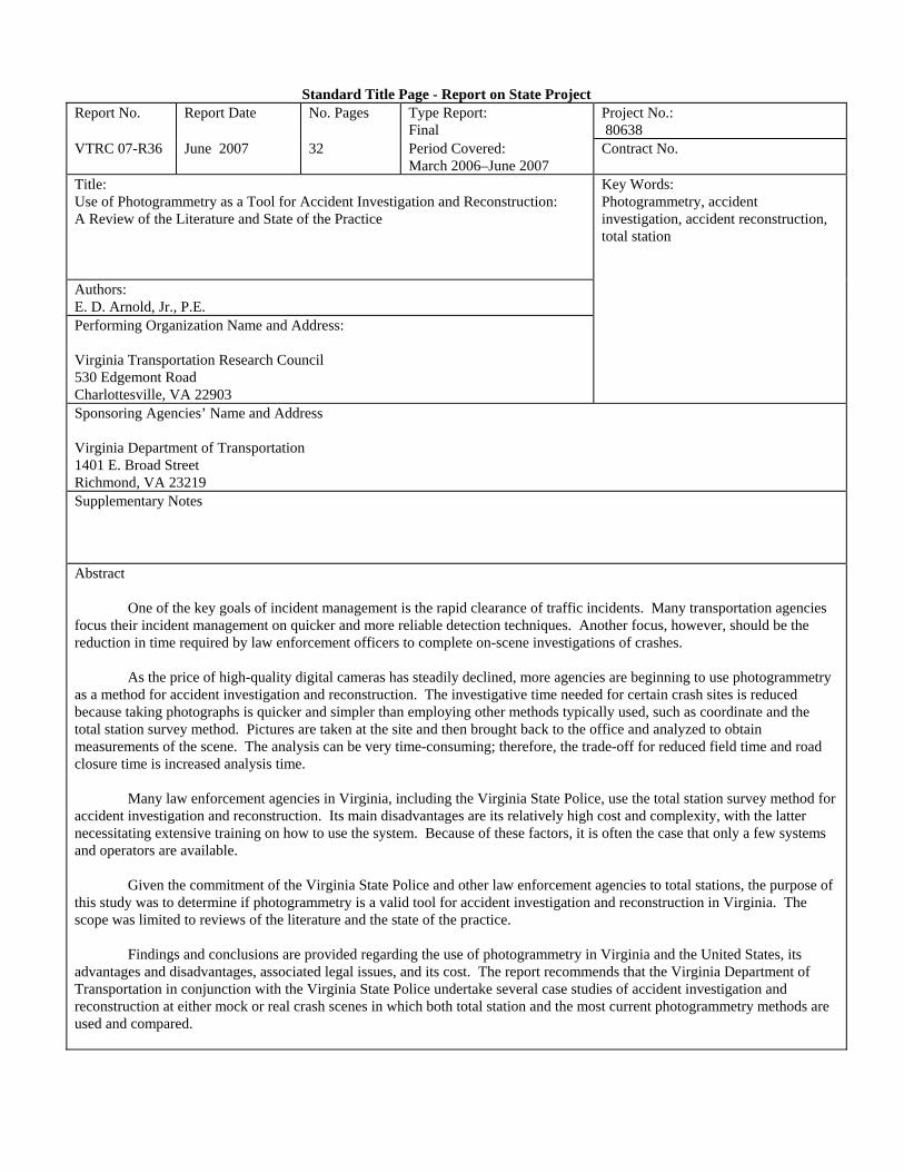


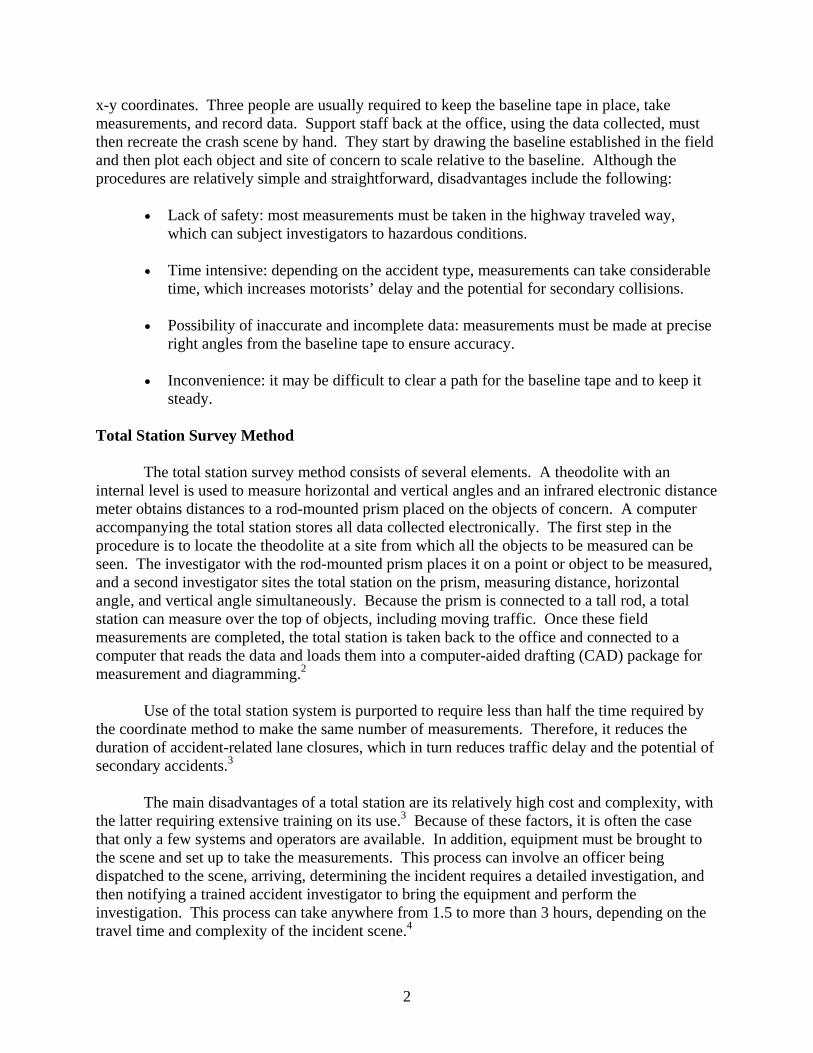


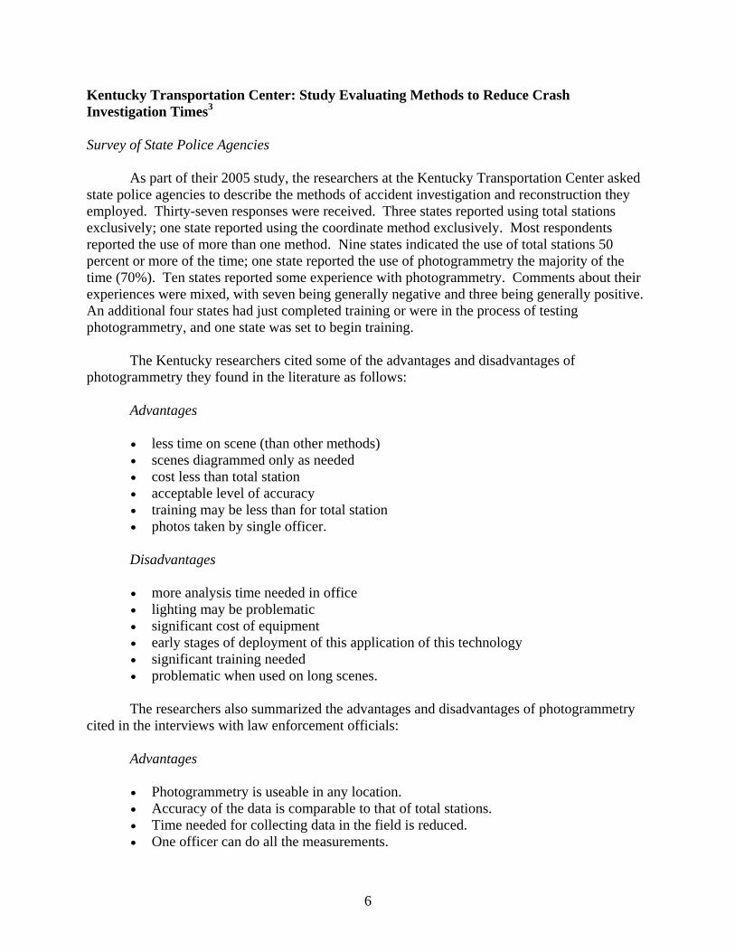


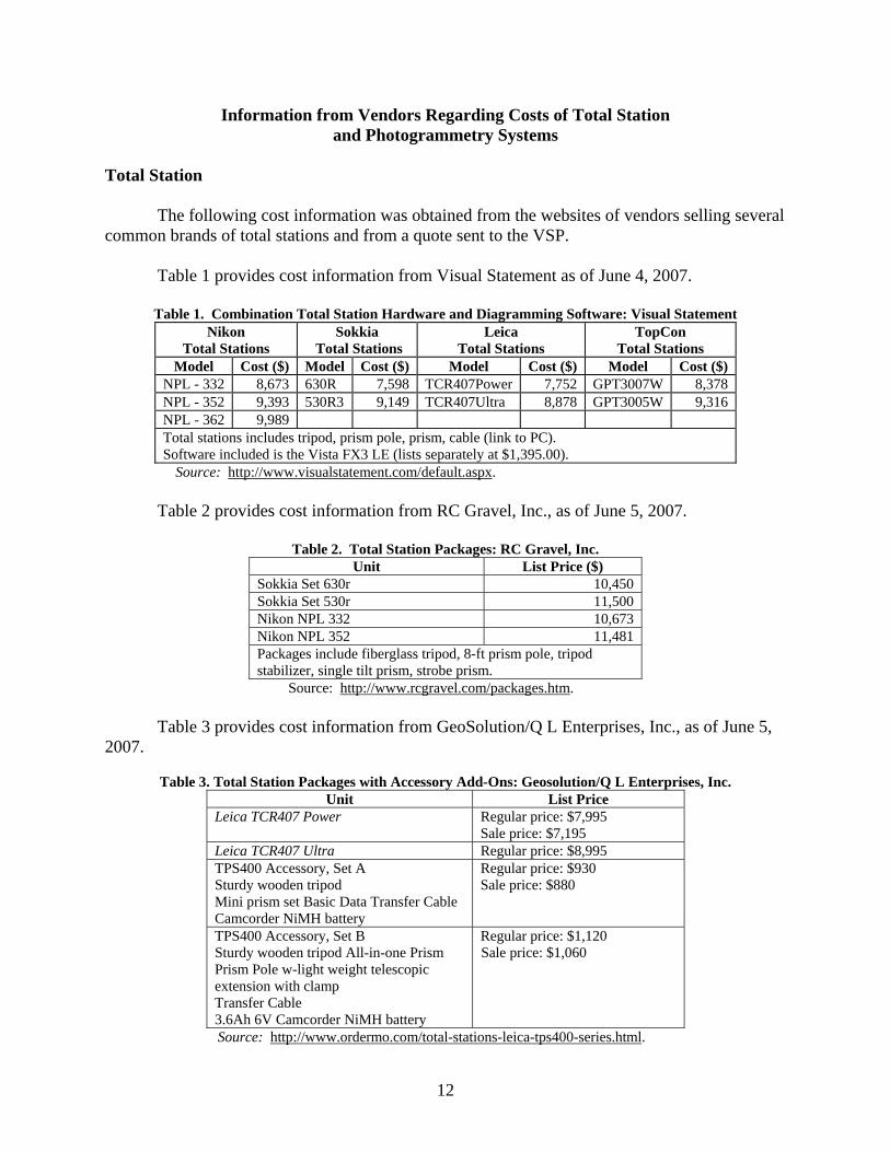
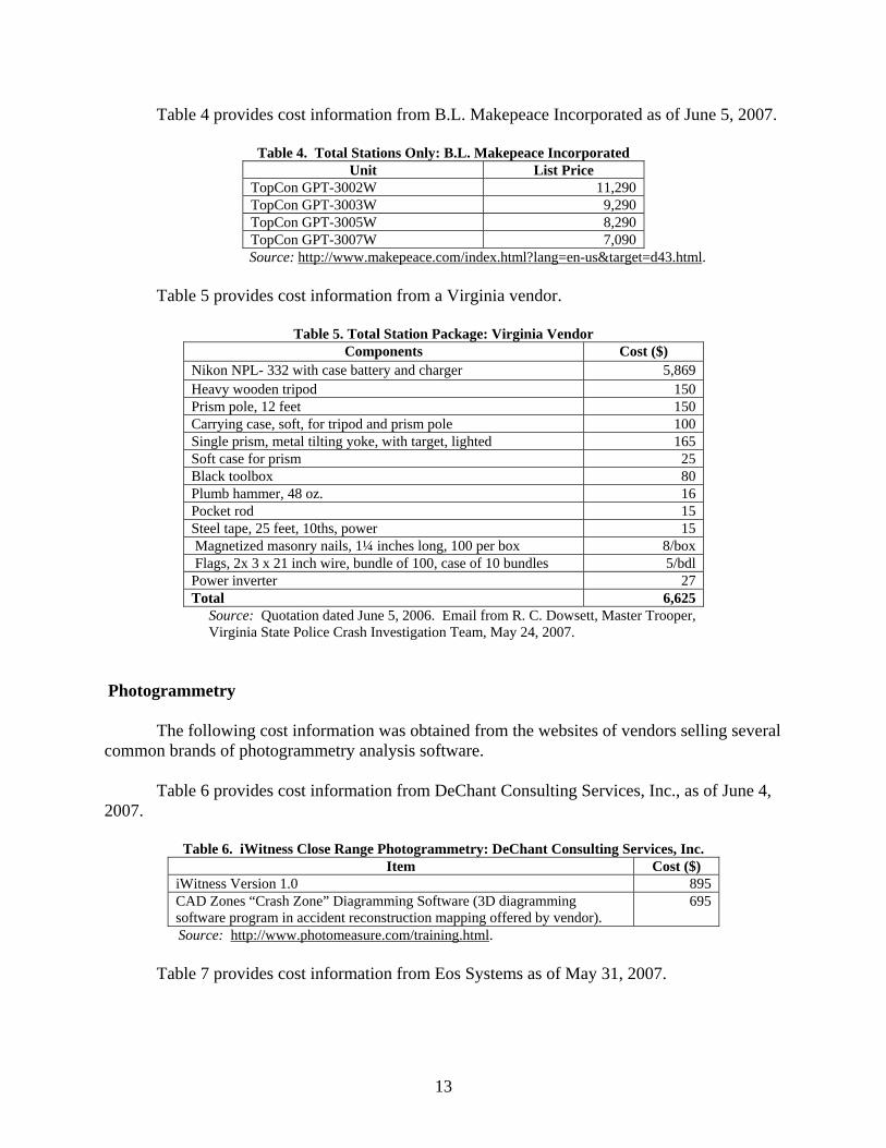
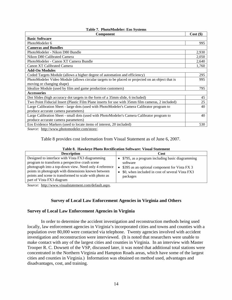


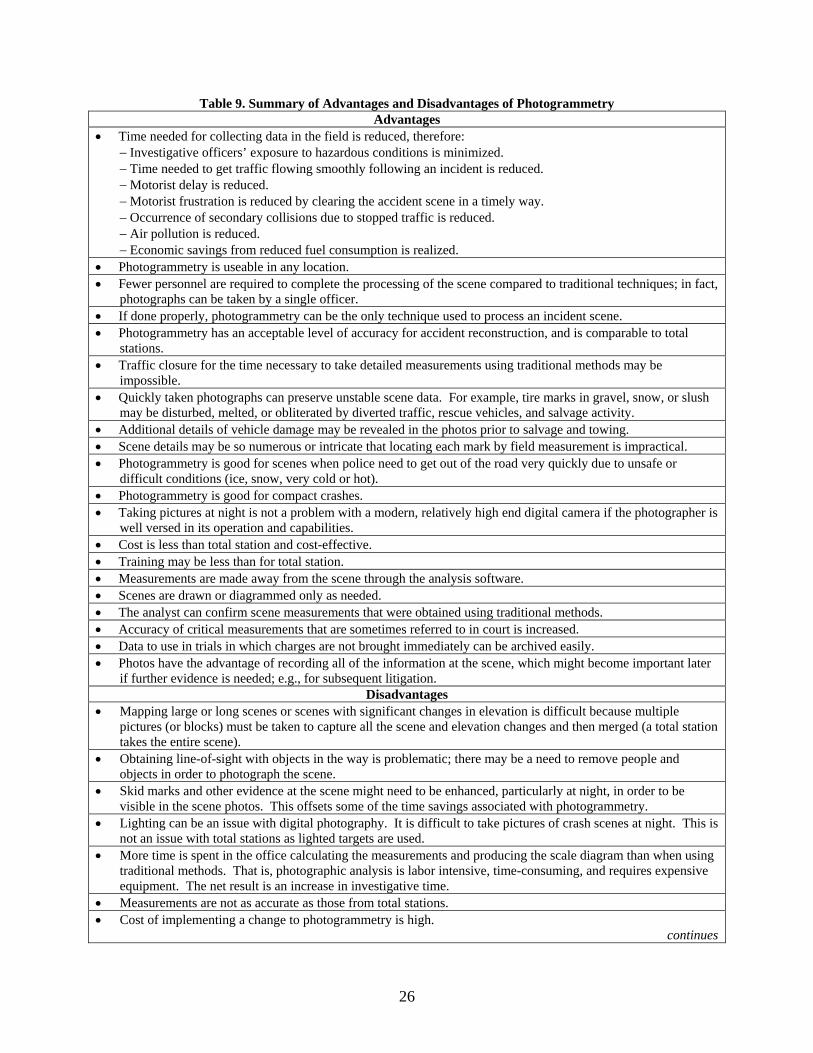


![Uppsala University - DiVA portaluu.diva-portal.org/smash/get/diva2:576768/FULLTEXT02.pdfmemory circuits [19]. Other disadvantages with magnetoresistive sensors are their relatively](https://static.documents.pub/doc/80x56/60ffeb8cca0125006e0919b4/uppsala-university-diva-576768fulltext02pdf-memory-circuits-19-other-disadvantages.jpg)


