135
Snohomish County Drainage Manual Volume I Minimum Technical Requirements November 2017

Snohomish County Drainage Manual
Volume I
Minimum Technical Requirements
November 2017


November 2017 Snohomish County Drainage Manual Volume I - Minimum Technical Requirements i
Table of Contents
Chapter 1 - Introduction ...........................................................................................................1
1.1 Background and Objective ..............................................................................................1
1.1.1 Background ............................................................................................................1
1.1.2 Stormwater and Low Impact Development ...........................................................1
1.1.3 Objective of this manual ........................................................................................2
1.2 Organization of the Snohomish County Drainage Manual .............................................3
1.3 Organization of Volume I ...............................................................................................3
1.4 How to Use this Manual .................................................................................................3
1.5 Development of Best Management Practices for Stormwater Management ..................4
1.5.1 Best Management Practices (BMPs) .....................................................................4
1.5.2 Source Control BMPs and Erosion and Sedimentation Control BMPs .................4
1.5.3 Treatment BMPs ....................................................................................................5
1.5.4 Flow Control BMPs ...............................................................................................5
1.5.5 Low Impact Development (LID) BMPs…………………………………………..5
1.6 Relationship of this Manual to Federal and State Regulatory Requirements .................10
1.6.1 Introduction ............................................................................................................10
1.6.2 More Stringent Measures .......................................................................................10
1.6.3 Retrofitting .............................................................................................................10
1.6.4 NPDES Industrial Stormwater General Permit ......................................................10
1.6.5 NPDES Construction Stormwater General Permit ................................................10
1.6.6 Endangered Species Act ........................................................................................11
1.6.7 Section 401 Water Quality Certifications ..............................................................11
1.6.8 Hydraulic Project Approvals (HPAs) ....................................................................11
1.6.9 Aquatic Lands Use Authorizations ........................................................................11
1.6.10 Underground Injection Control Authorizations ...................................................13

November 2017 Snohomish County Drainage Manual Volume I - Minimum Technical Requirements ii
Table of Contents, continued
Chapter 2 - Minimum Requirements for New Development and Redevelopment ..............14
2.1 [Reserved] .......................................................................................................................14
2.2 Exemptions and exceptions.............................................................................................14
2.3 [Reserved] .......................................................................................................................15
2.4 Applicability of the Minimum Requirements .................................................................15
2.5 Minimum Requirements .................................................................................................20
2.5.1 Minimum Requirement 1: Preparation of Stormwater Site Plans .........................20
2.5.2 Minimum Requirement 2: Stormwater Pollution Prevention Plans (SWPPPs) ...20
2.5.3 Minimum Requirement 3: Source Control of Pollution .......................................20
2.5.4 Minimum Requirement 4: Preservation of
Natural Drainage Systems and Outfalls ................................................................20
2.5.5 Minimum Requirement 5: On-site Stormwater Management ...............................20
2.5.6 Minimum Requirement 6: Runoff Treatment .......................................................24
2.5.7 Minimum Requirement 7: Flow Control ...............................................................25
2.5.8 Minimum Requirement 8: Wetlands Protection ...................................................27
2.5.9 Minimum Requirement 9: Operation and Maintenance .......................................27
Chapter 3 - Preparation of Stormwater Site Plans .................................................................28
3.1 Site Analysis ...................................................................................................................28
3.2 Preliminary Development Layout ...................................................................................31
3.3 Off-site (Upstream and Downstream) Analysis ..............................................................31
3.4 Determination of Applicable Minimum Requirements ..................................................35
3.5 Preparation of Permanent Stormwater Control Plan .......................................................35
3.6 Preparation of Stormwater Pollution Prevention Plan (SWPPP) ....................................37
3.7 Completion of Stormwater Site Plan. .............................................................................37
Chapter 4 - BMP and Facility Selection Process for
Permanent Stormwater Control Plans................................................................39
4.1 Purpose ............................................................................................................................39
4.2 BMP and Facility Selection Process ...............................................................................39

November 2017 Snohomish County Drainage Manual Volume I - Minimum Technical Requirements iii
Table of Contents, continued
Appendix I-A - RESERVED ....................................................................................................52
Appendix I-B - RESERVED ....................................................................................................53
Appendix I-C Basic Treatment Receiving Waters .................................................................54
Appendix I-D Wetlands and Stormwater Management........................................................55
Appendix I-E Surface Waters Exempt From Flow Control Requirements ........................59
Appendix I-F Stormwater Pollution Prevention Plan (SWPPP) Submittal
Requirements for Small Projects Pursuant to SCC 30.63A.810 ..................61
Appendix I-G Area of Snohomish County with 40% or more
impervious area as of 1985 ..............................................................................68
Glossary and Notations..............................................................................................................69
Tables
Table 1.0 Minimum Requirement credit and ancillary benefits of LID BMPs .......................... 7
Table 1.1 On-site Stormwater Management Requirements for Projects
Triggering Minimum Requirements 1 -9 ...................................................................21
Table 1.2 Treatment Trains for Phosphorus Removal ................................................................48
Table 1.3 Treatment Trains for Dissolved Metals Removal .......................................................50
Figures
Figure 1.1 Minimum Requirements (MR’s) for New Development Projects ............................17
Figure 1.2 Minimum Requirements (MR’s) for Redevelopment Projects .................................18
Figure 1.3 Minimum Requirements (MR’s) for Road-related Redevelopment Projects ............19
Figure 1.4 Treatment Facility Selection Flow Chart ..................................................................45

November 2017 Snohomish County Drainage Manual Volume I - Minimum Technical Requirements iv

November 2017 Snohomish County Drainage Manual Volume I - Minimum Technical Requirements 1
Chapter 1 - Introduction
1.1 Background and Objective
1.1.1 Background
The Snohomish County Drainage Manual is one of the three main components of the County’s
stormwater regulations developed to meet the requirements of the 2013 National Pollutant
Discharge Elimination System (NPDES) municipal stormwater permit. The other two
components are relevant chapters of Snohomish County code (primarily Chapters 30.63A and
30.63B SCC) and the Snohomish County Engineering Design and Development Standards
(EDDS).
The primary difference between this Drainage Manual and the previous version is an expansion
of requirements related to low impact development (LID), mostly focusing on requirements for
on-site stormwater management (see Volume I, Minimum Requirement 5). Other important
changes include a revised hydrologic model (WWHM12), a fundamentally different way to
account for stormwater impacts to wetlands (see Volume I, Appendix I-D), and revisions to
design requirements for a number of stormwater best management practices (BMPs) including
bioretention, rain gardens, and stormwater infiltration systems.
1.1.2 Stormwater and Low Impact Development
Low impact development (LID) means a stormwater and land use management strategy that
strives to mimic pre-disturbance hydrologic processes of infiltration, filtration, storage,
evaporation, and transpiration by emphasizing conservation, use of on-site natural features, site
planning, and distributed stormwater management practices that are integrated into a project
design. The goal of LID is to prevent measurable physical, chemical or biological degradation to
streams, lakes, wetlands, and other natural aquatic systems from commercial, residential or
industrial development sites.
This manual and Snohomish County's drainage and land-disturbing activity codes operate at the
project scale. At that scale, and from the perspective of drainage engineering and plan review,
stormwater LID and conventional stormwater management have a fair amount in common.
Stormwater LID relies heavily on infiltration of water into soil, which is well understood and
incorporated into both conventional stormwater facilities (such as infiltration ponds) and LID
facilities and materials (such as bioretention systems and permeable pavement).
There is much discussion of the need for incorporating stormwater LID into watershed-scale
actions such as land use planning. The Drainage Manual is not invoked in watershed-scale land
use planning, but even at the project scale there are opportunities to incorporate concepts of LID
at the project planning and early design decision processes. Doing so could provide a
considerable departure from conventional stormwater management. For example, decisions
about where to locate a building on a lot and decisions about other land surfaces that will be
installed can affect the feasibility of installing on-site stormwater infiltration or dispersion
trenches. Such decision processes are within the scope of "site-scale" regulations such as a
drainage code, but a given decision process could drive quite different outcomes depending on
how the decisions within it are sequenced.

November 2017 Snohomish County Drainage Manual Volume I - Minimum Technical Requirements 2
1.1.3 Objective of this manual
The objective of this manual is to set forth requirements for identifying, selecting, designing, and
implementing stormwater management best management practices (BMPs) required by
Snohomish County codes, primarily Snohomish County Code (SCC) Title 30 - Unified
Development Code, Chapter 7.53 SCC - Water Pollution Control, and Chapter 7.54 SCC –
Maintenance of Constructed Stormwater Control Facilities. This manual also provides additional
non-binding guidance and recommendations about these BMPs. The requirements set forth in
this manual apply within the unincorporated area of Snohomish County.
If any conflict exists between the requirements or definitions in this manual and those set forth in
applicable chapters of County code, the requirements and definitions in the code shall control.
Similarly, if any conflict exists between the requirements or definitions of Snohomish County
Engineering Design and Development Standards (EDDS) and this manual, the requirements and
definitions of the EDDS shall control.
The purpose of the stormwater management BMPs contained in this manual is to control the
quantity and quality of stormwater discharges produced by new development, redevelopment,
and activities at currently-developed properties, such that the discharges comply with state water
quality standards and do not impair beneficial uses of the receiving waters. The state water
quality standards include: Chapter 173-200 WAC, Water Quality Standards for Ground Waters
of the State of Washington; Chapter 173-201A, Water Quality Standards for Surface Waters of
the State of Washington; and Chapter 173-204, Sediment Management Standards.
This manual may also be helpful in identifying options for retrofitting BMPs as mitigation in
areas of existing development. Stand-alone retrofitting projects may or may not fit neatly into the
criteria and decision processes set forth in this manual. The developer is responsible in all cases
to determine all applicable code and manual requirements.
It is not the intent of this manual to preclude alternative engineering solutions to design
situations. It is expected that the professional engineer will bring to each project the best of
his/her skills and abilities to see that the project is thoroughly analyzed and designed correctly,
accurately, and in compliance with generally accepted engineering practices. Alternatives to
standard plans, specifications, and design details found in this manual will be accepted if they
meet or exceed the performance of these standards as determined by the county. Engineers are
encouraged to be innovative. The burden of proof, however, is on the engineer to document that
his/her innovations meet or exceed the performance of the standards.
This manual is based on the premise that development and redevelopment shall not negatively
impact adjacent and/or downstream property owners, nor degrade groundwater or the natural
drainage system, including but not limited to streams, ravines, wetlands, potholes, and rivers.
Further, development activities should not impact adjacent and/or downstream property owners
in a detrimental manner compared to the predeveloped condition.
It is not the intent of this manual to make Snohomish County a guarantor or protector of public
or private property with regards to land development activities. Through this manual, Snohomish
County is complying in part with the National Pollutant Discharge Elimination System (NPDES)
Phase 1 municipal stormwater permit. Where requirements in this document are also covered in
any other law, ordinance, resolution, rule or regulation of any kind the more restrictive law shall
govern.

November 2017 Snohomish County Drainage Manual Volume I - Minimum Technical Requirements 3
1.2 Organization of the Snohomish County Drainage Manual
The Snohomish County Drainage Manual is divided into five volumes.
Volume I of this manual describes the requirements of Snohomish County code (SCC) that are
satisfied by the use of this manual, including a detailed description of the nine Minimum
Requirements set forth in Chapter 30.63A SCC. Volume I also sets forth the processes to
determine appropriate BMPs to meet these requirements, and contains additional information and
requirements referenced by Snohomish County code.
Volume II contains BMPs for stormwater management during and immediately following the
period of construction or land disturbance. These BMPs are typically referred to as erosion and
sedimentation control BMPs, or ESC BMPs.
Volume III contains hydrologic analysis methods and BMPs to control flow volumes from
developed sites. These BMPS are typically referred to as flow control BMPs.
Volume IV contains BMPs to prevent or minimize pollution generated by potential pollution
sources at developed sites. These BMPs are typically referred to as source control BMPs.
Volume V contains BMPs to treat runoff that contains sediment or other pollutants from
developed sites. These BMPs are typically referred to as treatment BMPs.
1.3 Organization of Volume I
Chapter 1 of this volume explains the contents of the volume and presents additional general
information about stormwater, best management practices, and state and federal regulations that
may apply to construction projects in Snohomish County (note: state and federal regulations are
not administered by the County).
Chapter 2 of this volume describes the Minimum Requirements for stormwater control and site
development for all new development and redevelopment in the county, as required in SCC
30.63A.300 and SCC 30.63A.310. This chapter also provides additional explanatory information
about how to determine the requirements applicable to any particular land disturbing activity or
development project.
Chapter 3 contains detailed information about the preparation of Stormwater Site Plans.
Chapter 4 contains detailed information about the selection of flow control and stormwater
treatment BMPs that may be required.
Specific information about the design and construction of required BMPs is contained in
volumes II through V of this manual.
Appendices are included to support these topics.
1.4 How to Use this Manual
People who are applying to Snohomish County for a land development permit or drainage plan
approval should read all of Chapter 1 and Chapters 2.1 through 2.4 of this volume, in order to
determine the Minimum Requirements applicable to the proposed project. Having determined
the applicable requirements, applicants should read the chapters of this volume and Volumes II
through V related to these requirements to determine the BMPs that will be used for the project.

November 2017 Snohomish County Drainage Manual Volume I - Minimum Technical Requirements 4
Modifications and waivers of the requirements of this manual may be approved by Snohomish
County according to SCC 30.63A.830 through SCC 30.63A.842.
People who are required by Chapter 7.53 SCC to implement source control BMPs at sites with
existing development should read Volume IV and, for the control of erosion and sediment
pollution, Volume II. People who are required by Chapter 7.54 SCC to inspect and maintain
their stormwater flow control or treatment facilities should refer to Volume V, Chapter 4.6.
The Snohomish County Department of Planning and Development Services website has
information on the county’s land use permitting process, including online permit information.
Permit information can also be obtained by calling 425-388-3411, or visiting the Planning and
Development Services Permit Counter at 3000 Rockefeller Ave, Second Floor, Everett WA.
1.5 Development of Best Management Practices for Stormwater
Management
1.5.1 Best Management Practices (BMPs)
Adverse impacts of development and redevelopment are prevented or minimized through the
application of Best Management Practices (BMPs). BMPs are defined in Chapter 7.53 SCC as
physical objects, structures, managerial practices, or behaviors, that, when used singly or in
combination, eliminate or reduce the introduction of contaminants to stormwater, receiving
waters, or groundwater. They are defined in Chapter 30.91 SCC as physical, structural, or
managerial practices which have gained general acceptance for their ability to prevent or reduce
public safety impacts and other environmental impacts, and which are adopted in the Snohomish
County Drainage Manual, or approved by the director of planning and development services.
Generally speaking, BMPs can be categorized as erosion control BMPs, flow control BMPs,
source control BMPs, and treatment BMPs. BMPs that involve construction of engineered
structures are often referred to as facilities in this manual. For instance, the BMPs referenced in
the menus of Volume V, Chapter 3 are called treatment facilities.
The primary purpose of using BMPs is to protect beneficial uses of water resources through the
reduction of pollutant loads and concentrations, and through reduction of discharges (volumetric
flow rates) causing stream channel erosion.
1.5.2 Source Control BMPs and Erosion and Sedimentation Control BMPs
Source control BMPs are defined specifically in Chapter 7.53 SCC as structures, equipment,
supplies, or operations that are intended to prevent pollutants from coming into contact with
stormwater through physical separation of areas or careful management of activities that are
sources of pollutants. Source control BMPs to be used for compliance with Chapter 7.53 SCC
and Chapter 30.63A SCC are set forth in Volume IV of this manual. Historically, erosion and
sedimentation control (ESC) BMPs have been kept as a separate class, probably due to the fact
that they have been required primarily through the regulation of construction and land
development. However, many ESC BMPs are essentially source controls for a particular
pollutant (sediment). Alternatively, a single BMP (such as covering exposed or stockpiled soil
with mulch) could be considered an ESC BMP at a construction site and a source control BMP at
an existing developed site with exposed soil.

November 2017 Snohomish County Drainage Manual Volume I - Minimum Technical Requirements 5
1.5.3 Treatment BMPs
Treatment BMPs include facilities that remove pollutants by processes such as sedimentation,
adsorption, filtration, biological uptake, and phytoremediation. Treatment BMPs can accomplish
significant levels of pollutant load reductions if properly designed and maintained.
1.5.4 Flow Control BMPs
Flow control BMPs typically control the rate, frequency, and flow duration of stormwater
surface runoff. The need to provide flow control BMPs depends on the size and type of the
proposed project. Generally speaking, the amount of impervious surface in a development is the
biggest factor in determining the amount of runoff generated. The primary means of controlling
the stormwater flow that is generated are detention (slowing the flow rate of surface runoff),
infiltration, and, to a lesser degree, evapotranspiration.
The concept of detention is to collect runoff from a developed area and release it at a slower rate
than it enters the collection system. The reduced release rate requires temporary storage of the
stormwater generated from the developed area. The volume of storage needed is dependent on
1) the size of the drainage area; 2) the extent of disturbance of the natural vegetation,
topography, and soils and creation of effective impervious surfaces (surfaces that drain to a
stormwater collection system); and 3) how rapidly the water is allowed to leave the detention
pond, i.e., the target release rates.
The detention design standard in this manual is called a "flow duration" standard. Instead of
matching the pre-development and post-development peak stormwater flow rates related to
rainstorms of certain recurrence intervals, the flow duration standard requires matching, for
predevelopment and postdevelopment conditions, the amount of time (the duration) at which
specific flow rates are exceeded. For example, if one of the specific flow rates for a project is
100 gallons per minute, and modeling with many years of rainfall records indicated that this flow
rate was exceeded 10% of the time in the predevelopment condition, the detention facility would
need to be designed so that flow from the development does not exceed this duration statistic.
The size of flow control facilities can be reduced by reducing the extent to which native
vegetation and soil on a site are disturbed, reducing the amount impervious surface included in
the development, and using low impact development (LID) BMPs. Some LID BMPs are
included in this manual, and others can be incorporated into projects in Snohomish County
provided that code requirements and standards are met.
1.5.5 Low Impact Development (LID) BMPs
Low impact development (LID) is the preferred and commonly-used approach to land
development in Snohomish County. To this end, the Drainage Manual contains a number of LID
BMPs, which are distributed stormwater management practices, to be integrated into project
design, that emphasize pre-disturbance hydrologic processes of infiltration, filtration, storage,
evaporation and transpiration.
LID BMPs are used in various steps in the process of developing a Stormwater Site Plan for a
development project. Some of the LID BMPs must be considered if the designer is using the
“BMP list” approach for compliance with Minimum Requirement 5 – On-Site Stormwater
Management. In addition, most of the LID BMPs can be used to comply with Minimum
Requirement 6 (Runoff Treatment), Minimum Requirement 7 (Flow Control), or both. Finally,
November 2017 Snohomish County Drainage Manual Volume I - Minimum Technical Requirements 6
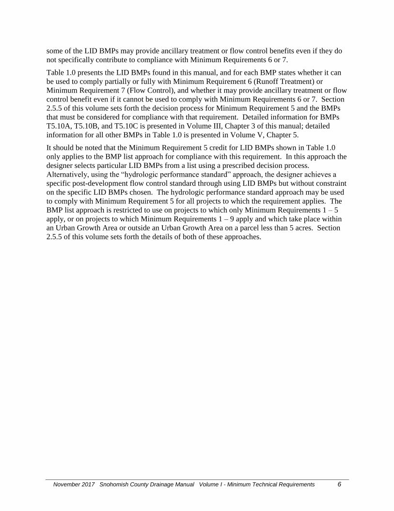
some of the LID BMPs may provide ancillary treatment or flow control benefits even if they do
not specifically contribute to compliance with Minimum Requirements 6 or 7.
Table 1.0 presents the LID BMPs found in this manual, and for each BMP states whether it can
be used to comply partially or fully with Minimum Requirement 6 (Runoff Treatment) or
Minimum Requirement 7 (Flow Control), and whether it may provide ancillary treatment or flow
control benefit even if it cannot be used to comply with Minimum Requirements 6 or 7. Section
2.5.5 of this volume sets forth the decision process for Minimum Requirement 5 and the BMPs
that must be considered for compliance with that requirement. Detailed information for BMPs
T5.10A, T5.10B, and T5.10C is presented in Volume III, Chapter 3 of this manual; detailed
information for all other BMPs in Table 1.0 is presented in Volume V, Chapter 5.
It should be noted that the Minimum Requirement 5 credit for LID BMPs shown in Table 1.0
only applies to the BMP list approach for compliance with this requirement. In this approach the
designer selects particular LID BMPs from a list using a prescribed decision process.
Alternatively, using the “hydrologic performance standard” approach, the designer achieves a
specific post-development flow control standard through using LID BMPs but without constraint
on the specific LID BMPs chosen. The hydrologic performance standard approach may be used
to comply with Minimum Requirement 5 for all projects to which the requirement applies. The
BMP list approach is restricted to use on projects to which only Minimum Requirements 1 – 5
apply, or on projects to which Minimum Requirements 1 – 9 apply and which take place within
an Urban Growth Area or outside an Urban Growth Area on a parcel less than 5 acres. Section
2.5.5 of this volume sets forth the details of both of these approaches.
November 2017 Snohomish County Drainage Manual Volume I - Minimum Technical Requirements 7
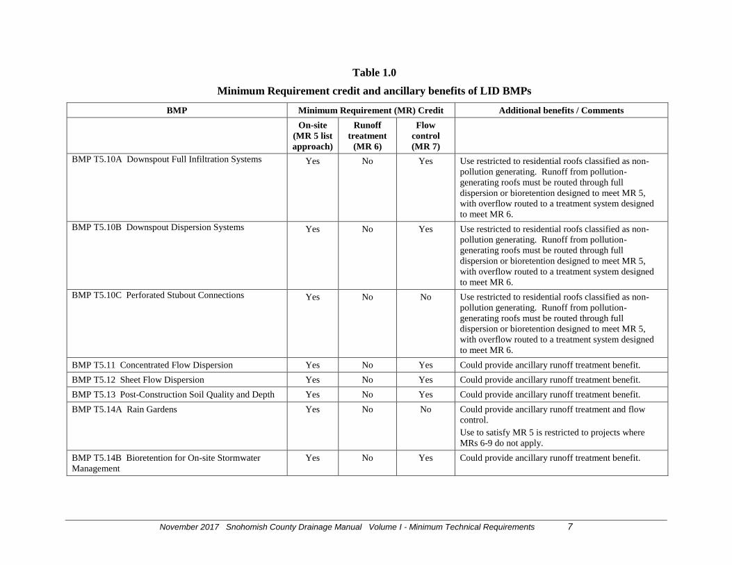
Table 1.0
Minimum Requirement credit and ancillary benefits of LID BMPs
BMP Minimum Requirement (MR) Credit Additional benefits / Comments
On-site
(MR 5 list
approach)
Runoff
treatment
(MR 6)
Flow
control
(MR 7)
BMP T5.10A Downspout Full Infiltration Systems Yes No Yes Use restricted to residential roofs classified as non-
pollution generating. Runoff from pollution-
generating roofs must be routed through full
dispersion or bioretention designed to meet MR 5,
with overflow routed to a treatment system designed
to meet MR 6.
BMP T5.10B Downspout Dispersion Systems Yes No Yes Use restricted to residential roofs classified as non-
pollution generating. Runoff from pollution-
generating roofs must be routed through full
dispersion or bioretention designed to meet MR 5,
with overflow routed to a treatment system designed
to meet MR 6.
BMP T5.10C Perforated Stubout Connections Yes No No Use restricted to residential roofs classified as non-
pollution generating. Runoff from pollution-
generating roofs must be routed through full
dispersion or bioretention designed to meet MR 5,
with overflow routed to a treatment system designed
to meet MR 6.
BMP T5.11 Concentrated Flow Dispersion Yes No Yes Could provide ancillary runoff treatment benefit.
BMP T5.12 Sheet Flow Dispersion Yes No Yes Could provide ancillary runoff treatment benefit.
BMP T5.13 Post-Construction Soil Quality and Depth Yes No Yes Could provide ancillary runoff treatment benefit.
BMP T5.14A Rain Gardens Yes No No Could provide ancillary runoff treatment and flow
control.
Use to satisfy MR 5 is restricted to projects where
MRs 6-9 do not apply.
BMP T5.14B Bioretention for On-site Stormwater
Management
Yes No Yes Could provide ancillary runoff treatment benefit.

November 2017 Snohomish County Drainage Manual Volume I - Minimum Technical Requirements 8
Table 1.0, continued
Minimum Requirement credit and ancillary benefits of LID BMPs
BMP Minimum Requirement (MR) Credit Additional benefits / Comments
BMP T7.30 Bioretention (without underdrain) Yes Yes Yes
BMP T7.30 Bioretention (with underdrain) No Yes Yes If the underdrain is elevated within a base course of
gravel, the bioretention facility will also provide some
modest flow reduction benefit that will help achieve
MR 7.
BMP T7.30 Bioretention (with underdrain and liner) No Yes No Could provide ancillary flow control benefit.
BMP T5.15 Permeable Pavement (without underdrain) Yes Yes Yes Additional treatment medium required under
pavement if native soil does not provide treatment and
pavement system is intended as treatment method.
BMP T5.15 Permeable Pavement (with underdrain
elevated within base course)
Yes No Yes Could provide ancillary runoff treatment benefit.
BMP T5.15 Permeable Pavement (with underdrain at or
near bottom of base course)
No No Yes Could provide ancillary runoff treatment benefit.
Flow control benefit applies to MR 5 compliance if
hydrologic performance standard approach is used.
BMP T5.30 Full Dispersion Yes Yes Yes
BMP T5.16: Tree Retention and Tree Planting No No Yes Flow control benefit applies to MR 5 compliance if
hydrologic performance standard approach is used.
BMP T5.17: Vegetated Roofs No No Yes Feasibility of this BMP is not dependent on soil
permeability or adequate depth to groundwater.
Flow control benefit applies to MR 5 compliance if
hydrologic performance standard approach is used.
BMP T5.18: Reverse Slope Sidewalks No No Yes Flow control benefit applies to MR 5 compliance if
hydrologic performance standard approach is used.
BMP T5.19: Minimal Excavation Foundations No No Yes Flow control benefit applies to MR 5 compliance if
hydrologic performance standard approach is used.

November 2017 Snohomish County Drainage Manual Volume I - Minimum Technical Requirements 9
Table 1.0, continued
Minimum Requirement credit and ancillary benefits of LID BMPs
BMP Minimum Requirement (MR) Credit Additional benefits / Comments
BMP T5.20: Rainwater Harvesting No No Yes Feasibility of this BMP is not dependent on soil
permeability or adequate depth to groundwater.
Flow control benefit also applies to MR 5 compliance
if hydrologic performance standard approach is used.
BMP T5.40: Preserving Natural Vegetation No No No Use of this BMP inherently reduces the amount of
mitigation needed to meet these requirements of MRs
5, 6, and 7.
“Preserve natural vegetation (especially forested
areas) as much as possible” is one of the design
principles required in preparation of the Stormwater
Site Plan to meet MR 1, as described in Volume I
Chapter 3 of this manual.
BMP T5.41: Better Site Design No No No No credit for compliance with MRs 5, 6, or 7,
although use of this BMP inherently reduces the
amount of mitigation needed to meet these
requirements.
The first three design guidelines in BMP T5.41 are
required principles in developing the Stormwater Site
Plan in accordance with Volume I, Chapter 3 of this
manual.

November 2017 Snohomish County Drainage Manual Volume I - Minimum Technical Requirements 10
1.6 Relationship of this Manual to Federal and State Regulatory
Requirements
1.6.1 Introduction
This section describes some of the federal and state regulations and permits that may apply to a
project depending on the nature of the project and site characteristics. Snohomish County does
not have a direct role in implementing these regulations or permits, but county staff may be able
to assist members of the public in determining the applicable regulations or permits apply and
providing contact information for the appropriate regulatory agencies. Snohomish County has
attempted to tailor its regulatory and permit requirements to match those of similar federal and
state regulations and permits.
For some projects, the Joint Aquatic Resources Permit Application (JARPA) may streamline the
environmental permitting process. As noted in the following sections, several of the permits
described in this section are included in the JARPA, so they can be covered under a single permit
application. Refer to the Access Washington e-permitting website for more information.
1.6.2 More Stringent Measures
Federal and state agencies may impose additional or more stringent BMPs to meet state water
quality standards or other established natural resource or drainage objectives, such as those
established in Total Maximum Daily Loads (TMDLs) and pursuant Water Cleanup Plans.
1.6.3 Retrofitting
This Manual is not a retrofit manual, but it can be helpful in identifying options for retrofitting
BMPs in areas or sites with existing development. Retrofitting stormwater BMPs into existing
developed areas may be necessary to meet federal Clean Water Act and state Water Pollution
Control Act (Chapter 90.48 RCW) requirements. In retrofit situations there frequently are site
constraints that make the strict application of BMPs difficult. In these instances, the BMPs
presented here can be modified using best professional judgment to provide reasonable
improvements in stormwater management.
1.6.4 NPDES Industrial Stormwater General Permit
Many businesses in Snohomish County are subject to the NPDES Industrial Stormwater General
Permit. Information about this permit may be obtained on the Washington State Department of
Ecology.
This permit requires preparation and implementation of a Stormwater Pollution Prevention Plan.
The BMPs in Volume IV of this manual should be adequate for compliance with the industrial
stormwater permit, but operators of businesses subject to that permit should verify requirements
of that permit with Ecology.
1.6.5 NPDES Construction Stormwater General Permit
Construction sites that disturb one acre or more and discharge stormwater from the project site to
surface water are regulated by the NPDES Construction Stormwater General Permit.

November 2017 Snohomish County Drainage Manual Volume I - Minimum Technical Requirements 11
Information about this permit may be obtained from the Washington State Department of
Ecology.
As with the industrial stormwater permit discussed in Section 1.6.4 above, the BMPs in this
manual should be adequate for compliance with the construction stormwater permit, but
operators of projects subject to that permit should verify requirements of that permit with
Ecology.
1.6.6 Endangered Species Act
With the listing of multiple species of salmon as threatened or endangered across much of
Washington State, and the probability of more listings in the future, implementation of the
requirements of the Endangered Species Act may have a dramatic effect on urban stormwater
management. Provisions of the Endangered Species Act that may apply directly to stormwater
management include the Section 4(d) rules, Section 7 consultations, and Section 10 Habitat
Conservation Plans (HCPs), which can affect the regulations of local governments and in some
cases can be imposed on individual projects directly.
1.6.7 Section 401 Water Quality Certifications
For projects that require a fill or dredge permit under Section 404 of the Clean Water Act,
Ecology must certify to the U.S. Army Corps of Engineers that the proposed project will not
violate water quality standards. In order to make such a determination, Ecology may do a more
specific review of the potential impacts of a stormwater discharge from the construction phase of
the project and from the completed project. As a result of that review, Ecology may condition its
certification to require:
Application of the minimum requirements and BMPs in the latest version of its Stormwater
Management manual; or
Application of more stringent requirements.
1.6.8 Hydraulic Project Approvals (HPAs)
Under Chapter 77.55 RCW, the Hydraulics Act, the Washington State Department of Fish and
Wildlife (DFW) has the authority to require actions when stormwater discharges related to a
project would change the natural flow or bed of state waters. The implementing mechanism is
the issuance of a Hydraulics Project Approval (HPA). In exercising this authority, DFW may
require:
Compliance with the provisions of the latest version of Ecology's Stormwater Management
Manual; or
Application of more stringent requirements that DFW determines are necessary to meet their
statutory obligations to protect fish and wildlife.
1.6.9 Aquatic Lands Use Authorizations
The Department of Natural Resources (DNR), as the steward of public aquatic lands, may
require a stormwater outfall to have a valid use authorization, and to avoid or mitigate resource
impacts. Through its use authorizations, which are issued under authority of Chapters 79.90
through 96 RCW, and in accordance with Chapter 332-30 WAC, DNR may require:

November 2017 Snohomish County Drainage Manual Volume I - Minimum Technical Requirements 12
Compliance with the provisions of the latest version of Ecology's Stormwater Management
Manual; or
Application of more stringent requirements that they determine are necessary to meet their
statutory obligations to protect the quality of the state’s aquatic lands.

November 2017 Snohomish County Drainage Manual Volume I - Minimum Technical Requirements 13
1.6.10 Underground Injection Control Authorizations
The Underground Injection Control (UIC) regulations of Chapter 173-218 WAC apply to
stormwater infiltration systems, although those regulations contain exemptions for various kinds
of stormwater infiltration systems. These regulations are implemented by the Washington State
Department of Ecology, and Snohomish County recommends that the applicant contact that
department for project-specific determinations about UIC regulation applicability.

November 2017 Snohomish County Drainage Manual Volume I - Minimum Technical Requirements 14
Chapter 2 - Minimum Requirements for New Development
and Redevelopment
Chapter 30.63A SCC sets forth nine Minimum Requirements for new development and
redevelopment projects. Some projects are exempt or excepted from some of these
requirements, as set forth in Chapter 30.63A SCC Part 200.
The Minimum Requirements are:
1) preparation of a stormwater site plan
2) stormwater pollution prevention plan (SWPPP)
3) water pollution source control for new development or redevelopment activities
4) preservation of natural drainage systems or outfalls and provision of off-site mitigation
5) on-site stormwater management
6) runoff treatment
7) flow control requirements for new development or redevelopment
8) stormwater discharges to wetlands
9) inspection, operation and maintenance requirements
Depending on the type and size of the proposed project, different combinations of these
minimum requirements apply.
2.1 [Reserved]
2.2 Exemptions and exceptions
Chapter 30.63A SCC Part 200 sets forth exemptions from Minimum Requirements for some land
disturbing activities and types of development projects. Some projects and activities are exempt
from all Minimum Requirements, and others are exempt from selected portions of the Minimum
Requirements and other related requirements of Chapter 30.63A SCC. The 2016 revisions to
Chapter 30.63A include an exception from specific drainage requirements for certain projects
that do not drain to the County’s storm sewer system. People who are applying to Snohomish
County for a land development permit or drainage plan approval should carefully read the
referenced code sections to determine the applicable Minimum Requirements.
Supplemental information regarding exemptions for road maintenance activities
The following road maintenance practices are considered redevelopment, and therefore are not
categorically exempt from Minimum Requirements. The extent to which the manual applies is
explained for each circumstance.
Removing and replacing a paved surface to base course or lower, or repairing the roadway
base. If impervious surfaces are not expanded, Minimum Requirements #1 - #5 apply.
Where appropriate, project proponents are encouraged to look for opportunities to use
permeable and porous pavements.

November 2017 Snohomish County Drainage Manual Volume I - Minimum Technical Requirements 15
Extending the pavement edge without increasing the size of the road prism, or paving
graveled shoulders. These activities are considered new impervious surfaces and are subject
to the minimum requirements that are triggered when the thresholds identified for new or
redevelopment projects are met.
Resurfacing by upgrading from dirt to gravel, asphalt, or concrete; upgrading from gravel to
asphalt, or concrete; or upgrading from a bituminous surface treatment (“chip seal”) to
asphalt or concrete. These activities are considered new impervious surfaces and are subject
to the minimum requirements that are triggered when the thresholds identified for new or
redevelopment projects are met.
2.3 [Reserved]
2.4 Applicability of the Minimum Requirements
SCC 30.63A.300 and SCC30.63A.310 set forth the applicability of the Minimum Requirements
to different types of development and redevelopment projects. For reference, these code sections
are included as follows, with corresponding decision flow charts in Figure 1.1 for new
development, Figure 1.2 for redevelopment, and Figure 1.3 for road-related projects. In the
event of conflict between these flow charts and the code language, the code language shall take
precedence. NOTE: the requirements of SCC 30.63A.310(5) applies only to public road
redevelopment projects, and does not apply to private road projects.
SCC 30.63A.300 Drainage review thresholds and requirements for new development.
(1) Regardless of the new development thresholds established below in SCC 30.63A.300(2)
and (3), all new development shall be required to comply with minimum requirement 2
(SCC 30.63A.445 and 30.63A.450), unless minimum requirement 2 is not required for an
exempted activity pursuant to SCC 30.63A.200. In addition, new development shall
comply with any other applicable additional requirement specified in part 700 of this
chapter.
(2) Unless an exception under SCC 30.63A.210 applies, new development projects shall
comply with minimum requirements 1 through 5 (SCC 30.63A.400 through
30.63A.525) for the new and replaced hard surfaces and the land disturbed if the new
development will:
(a) Result in or add 2,000 square feet or greater of new, replaced or new plus replaced
hard surface area; or
(b) Cause land disturbing activity of 7,000 square feet or greater.
(3) Unless an exception under SCC 30.63A.210 applies, new development projects shall
comply with all minimum requirements 1 through 9 (SCC 30.63A.400 through
30.63A.605) for the new and replaced hard surfaces and converted vegetation areas if the
new development will:
(a) Result in or add 5,000 square feet or more of new plus replaced hard surface area;
(b) Convert three-quarters of an acre or more of vegetation to lawn or landscaped areas; or
(c) Convert 2.5 acres or more of native vegetation to pasture.

November 2017 Snohomish County Drainage Manual Volume I - Minimum Technical Requirements 16
SCC 30.63A.310 Minimum drainage review thresholds and requirements for
redevelopment.
(1) Regardless of the redevelopment thresholds established below in SCC 30.63A.310(2) and
(3) all redevelopment shall comply with minimum requirement 2 (SCC 30.63A.445 and
SCC 30.63A.450) unless minimum requirement 2 is not required for an exempted activity
pursuant to SCC 30.63A.200. In addition, redevelopment shall comply with any other
applicable redevelopment requirement specified in part 700 of this chapter.
(2) Unless an exception under SCC 30.63A.210 applies, redevelopment projects shall comply
with minimum requirements 1 through 5 (SCC 30.63A.400 through 30.63A.525) for the new
and replaced hard surfaces and the land disturbed if the redevelopment will:
(a) Result in or add 2,000 square feet or greater of new, replaced or the total of new
plus replaced hard surfaces; or
(b) Cause 7,000 square feet or more of land disturbing activity.
(3) Unless an exception under SCC 30.63A.210 applies, redevelopment projects shall comply
with minimum requirements 1 through 9 (SCC 30.63A.400 through 30.63A.605) for the new
hard surfaces and converted vegetation areas if the redevelopment will:
(a) Result in or add 5,000 square feet or more of new hard surface area;
(b) Convert three-quarters of an acre or more of vegetation to lawn or landscaped areas; or
(c) Convert 2.5 acres or more of native vegetation to pasture.
(4) The director may allow the minimum requirements to be met for an equivalent area of flow
and pollution characteristics within the same site. For public road projects, the equivalent
area does not have to be within the project limits, but must drain to the same receiving
water.
(5) In addition to the requirements in SCC 30.63A.310(1) through (4), for road-related
redevelopment projects, runoff from the replaced and new hard surfaces (including
pavement, shoulders, curbs and sidewalks) and the converted vegetation areas shall meet
minimum requirements 1 through 9 (SCC 30.63A.400 through 30.63A.605) if the new hard
surfaces total 5,000 square feet or more and total 50 percent or more of the existing hard
surfaces within the project limits. The project limits shall be defined by the length of the
project and the width of the right-of-way.
(6) In addition to the requirements in SCC 30.63A.310(1) through (4), all redevelopment
projects, except road-related projects covered by SCC 30.63A.310(5), shall comply with
minimum requirements 1 through 9 (SCC 30.63A.400 through 30.63A.605) for the new
plus replaced hard surfaces and converted vegetation areas when:
(a) The total of the new plus replaced hard surfaces totals 5,000 square feet or more; and
(b) The value of proposed improvements including interior improvements exceeds 50
percent of the assessed value of the existing site improvements.

November 2017 Snohomish County Drainage Manual Volume I - Minimum Technical Requirements 17
Figure 1.1 Minimum Requirements (MR's) for New Development Projects
MR's 1 - 5 apply to new
and replaced hard surface
and all disturbed land.
NOTE: if SCC
30.63A.210 applies, there
are reduced requirements
for MR 1 and MR 5 Yes
Does the project result in or add 5,000 square feet
or more of new plus replaced hard surface, OR
convert ¾ acres or more of vegetation to lawn or
landscaped areas, OR
convert 2.5 acres or more of native vegetation to
pasture?
MR's 1 - 9 apply to new and replaced hard
surface and converted vegetation areas.
NOTE: if SCC 30.63A.210 applies, there are
reduced requirements for MR 1, MR 5, and
MR 9
No
No
Start Here
Yes MR 2 applies to the project
Does the project result in or add 2,000 square feet or
more of new plus replaced hard surface, OR
include 7,000 square feet or more of land disturbing
activity?
No
Yes
MR 2 applies to project.
Is project exempt from all MR's except
MR 2 per SCC 30.63A.200?
Is project exempt from all MR's per
SCC 30.63A.200? No requirements of
Chapter 30.63A SCC apply
Yes
Does the existing site have 35% or more existing
impervious surface OR
does the project otherwise meet the definition of
redevelopment in Chapter 30.91R SCC?
No
Go to Redevelopment flow
chart in Figure 1.2
No
Yes
November 2017 Snohomish County Drainage Manual Volume I - Minimum Technical Requirements 18
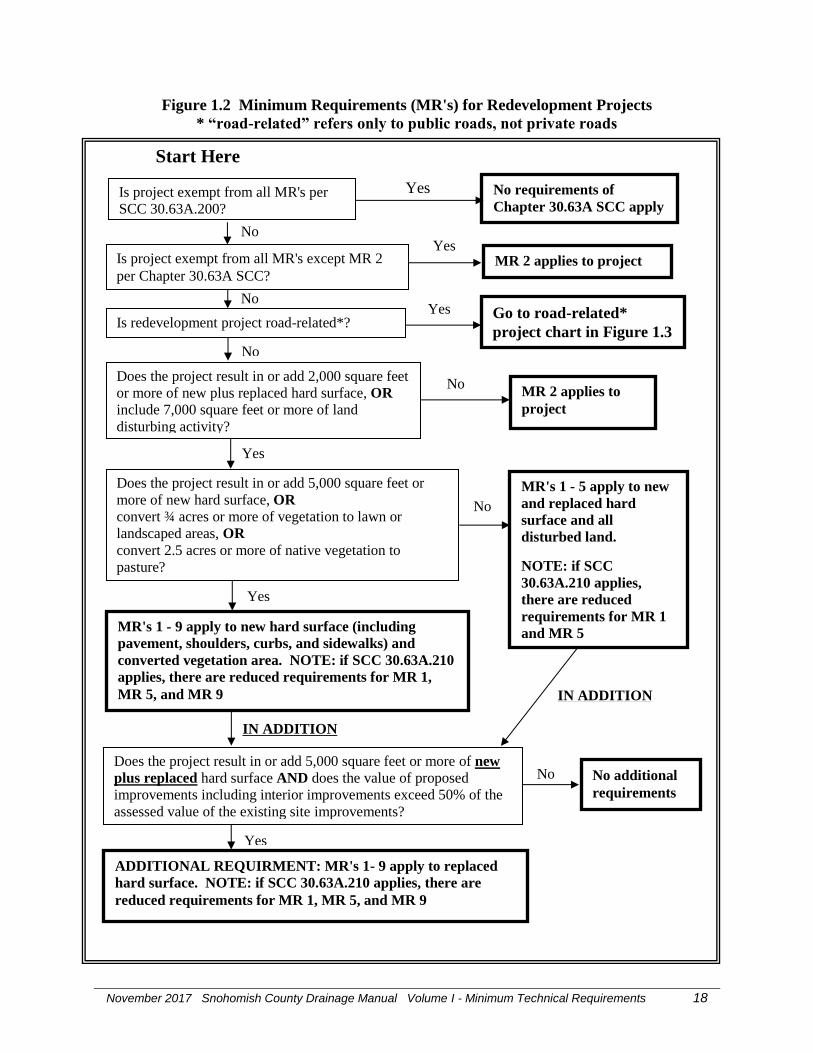
Figure 1.2 Minimum Requirements (MR's) for Redevelopment Projects
* “road-related” refers only to public roads, not private roads
MR's 1 - 5 apply to new
and replaced hard
surface and all
disturbed land.
NOTE: if SCC
30.63A.210 applies,
there are reduced
requirements for MR 1
and MR 5
No
Does the project result in or add 5,000 square feet or
more of new hard surface, OR
convert ¾ acres or more of vegetation to lawn or
landscaped areas, OR
convert 2.5 acres or more of native vegetation to
pasture?
ADDITIONAL REQUIRMENT: MR's 1- 9 apply to replaced
hard surface. NOTE: if SCC 30.63A.210 applies, there are
reduced requirements for MR 1, MR 5, and MR 9
Yes
No
Start Here
No
Yes MR 2 applies to project
Does the project result in or add 2,000 square feet
or more of new plus replaced hard surface, OR
include 7,000 square feet or more of land
disturbing activity?
No
Yes
MR 2 applies to
project
Is project exempt from all MR's except MR 2
per Chapter 30.63A SCC?
Is project exempt from all MR's per
SCC 30.63A.200?
No requirements of
Chapter 30.63A SCC apply
Yes
Is redevelopment project road-related*? Go to road-related*
project chart in Figure 1.3
Yes
Does the project result in or add 5,000 square feet or more of new
plus replaced hard surface AND does the value of proposed
improvements including interior improvements exceed 50% of the
assessed value of the existing site improvements?
No additional
requirements
Yes
No
MR's 1 - 9 apply to new hard surface (including
pavement, shoulders, curbs, and sidewalks) and
converted vegetation area. NOTE: if SCC 30.63A.210
applies, there are reduced requirements for MR 1,
MR 5, and MR 9
IN ADDITION
IN ADDITION
No

November 2017 Snohomish County Drainage Manual Volume I - Minimum Technical Requirements 19
Figure 1.3 Minimum Requirements (MR's) for Road-related* Redevelopment Projects
* “road-related” refers only to public roads, not private roads
ADDITIONAL REQUIRMENT: MR's 1- 9
apply to replaced hard surface.
IN ADDITION
Does the new hard surface total 5,000 square feet or more
AND total fifty percent or more of the existing hard
surface within the project limits as defined by the length of
the project and the width of the right-of-way?
Start Here - From Road-related* projects question in Figure 1.2
Does the project result in or add 2,000 square feet or
more of new, replaced or new plus replaced hard
surface, OR
include 7,000 square feet or more of land disturbing
activity?
No
Yes
MR 2 applies to
project
Yes
Does the project result in or add 5,000 square feet or
more of new hard surface, OR
convert ¾ acres or more of vegetation to lawn or
landscaped areas, OR
convert 2.5 acres or more of native vegetation to
pasture?
No
MR's 1 - 5 apply to new
and replaced hard
surface and all
disturbed land.
MR's 1 - 9 apply to new hard surface and
converted vegetation area.
Yes
No additional
requirements
No

November 2017 Snohomish County Drainage Manual Volume I - Minimum Technical Requirements 20
2.5 Minimum Requirements
Chapter 30.63A SCC Parts 400 through 600 and the remaining sections of this chapter establish
Minimum Requirements for development and redevelopment projects.
2.5.1 Minimum Requirement 1: Preparation of Stormwater Site Plans
Chapter 3 contains the requirements for preparing Stormwater Site Plans.
2.5.2 Minimum Requirement 2: Stormwater Pollution Prevention Plans (SWPPPs)
Volume II, Chapter 3 contains the requirements for development and implementation of
Stormwater Pollution Prevention Plans (SWPPPs).
2.5.3 Minimum Requirement 3: Source Control of Pollution
SCC 30.63A.515 contains requirements for water pollution source control for new development
or redevelopment activities.
2.5.4 Minimum Requirement 4: Preservation of Natural Drainage Systems and Outfalls
SCC 30.63A.520 contains requirements for preservation of natural drainage systems or outfalls
for all new development and redevelopment activities
2.5.5 Minimum Requirement 5: On-site Stormwater Management
SCC 30.63A.525 requires implementation of on-site stormwater BMPs in accordance with the
following project thresholds, standards, and lists to infiltrate, disperse, and retain stormwater
runoff on-site to the extent feasible. NOTE: The requirements of Section 2.5.5 do not apply to
projects that qualify for exceptions under SCC 30.63A.210. Applicants for those projects should
read that code section carefully to determine applicable requirements.
Applicability
Projects that are exempt from Minimum Requirement 7 as set forth in Section 2.5.7 of this
chapter do not have to achieve the LID performance standard, nor consider bioretention, rain
gardens, permeable pavement, and full dispersion if using List #1 or List #2. However, those
projects must implement the following BMPs if feasible:
BMP T5.13 Post-Construction Soil Quality and Depth; and
BMP T5.10A Downspout Full Infiltration Systems, BMP T5.10B Downspout Dispersion
Systems, or BMP T5.10C Perforated Stub-out Connections; and
BMP T5.11 Concentrated Flow Dispersion or BMP T5.12 Sheet Flow Dispersion.
Project thresholds
Projects triggering only Minimum Requirements #1 through #5 shall either:
Use On-site Stormwater Management BMPs from List #1 for all surfaces within each type of
surface in List #1; or

November 2017 Snohomish County Drainage Manual Volume I - Minimum Technical Requirements 21
Demonstrate compliance with the LID Performance Standard. Projects selecting this option
cannot use Rain Gardens. They may choose to use Bioretention BMPs as described in this
manual.
Projects triggering Minimum Requirements 1 through 9 must meet the requirements in Table 1.1.
Table 1.1
On-site Stormwater Management Requirements for
Projects Triggering Minimum Requirements 1 -9
UGA = Urban Growth Area as designated under Chapter 36.70A RCW
Project Type and Location Requirement
New development on any parcel inside the
UGA, or new development outside the
UGA on a parcel less than 5 acres
Low Impact Development Performance
Standard and BMP T5.13; or List #2
(applicant option).
New development outside the UGA on a
parcel of 5 acres or larger
Low Impact Development Performance
Standard and BMP T5.13.
Redevelopment on any parcel inside the
UGA, or redevelopment outside the UGA
on a parcel less than 5 acres
Low Impact Development Performance
Standard and BMP T5.13; or List #2
(applicant option).
Redevelopment outside the UGA on a
parcel of 5 acres or larger
Low Impact Development Performance
Standard and BMP T5.13.
Low impact development performance standard
If required for the project or selected as the option for compliance with Minimum Requirement
5, stormwater discharges shall match developed discharge durations to pre-developed durations
for the range of pre-developed discharge rates from 8% of the 2-year peak flow to 50% of the 2-
year peak flow. Refer to the Standard Flow Control Requirement section in Chapter 2.5.7
(Minimum Requirement 7) for information about the assignment of the pre-developed condition.
Projects that must also provide flow control in accordance with Minimum Requirement 7 shall
match flow durations between 8% of the 2-year flow through the full 50-year flow.
List #1: On-site Stormwater Management BMPs for Projects Triggering Minimum
Requirements 1 through 5
For each surface, consider the BMPs in the order listed for that type of surface. Use the first
BMP that is considered feasible. Feasibility shall be determined according to specific criteria set
forth for each BMP as described in Volumes III and V of this manual, and based in part on the
information in the Soils Report prepared as part of the required Stormwater Site Plan described
Chapter 3 of this volume. If a BMP is determined to be feasible for a surface, no other on-site
stormwater management BMP is necessary for that surface. An on-site stormwater management
BMP shall not be required for a surface if it is determined that no BMP is feasible for that

November 2017 Snohomish County Drainage Manual Volume I - Minimum Technical Requirements 22
surface. In addition, Snohomish County may remove or reduce the requirement for a BMP if its
implementation will conflict with any of the following:
Historic Preservation Laws and Archaeology Laws as listed at
http://www.dahp.wa.gov/learn-and-research/preservation-laws;
Federal Superfund or Washington State Model Toxics Control Act;
Federal Aviation Administration requirements for airports;
Americans with Disabilities Act;
special zoning district design criteria adopted and being implemented pursuant to a
community planning process;
Public health and safety standards;
Transportation regulations to maintain the option for future expansion or multi-modal use of
public rights-of-way;
Tree species protection standards in Chapter 30.62A SCC;
Regulations related to critical aquifer recharge areas, including wellhead protection areas, set
forth in Chapter 30.62C SCC.
BMPs for lawn and landscaped areas:
1. Post-Construction Soil Quality and Depth in accordance with BMP T5.13 in Volume V,
Chapter 5 of this manual.
BMPs for roofs:
1. Full Dispersion in accordance with BMP T5.30 in Volume V, Chapter 5 of this manual,
or Downspout Full Infiltration Systems in accordance with BMP T5.10A in Volume III,
Chapter 3 of this manual.
2. Rain Gardens in accordance with BMP T5.14A in Volume V, Chapter 5 of this manual,
or Bioretention in accordance with BMP T7.30 in Volume V, Chapter 7 of this manual.
3. Downspout Dispersion Systems in accordance with BMP T5.10B in Volume III, Chapter
3 of this manual.
4. Perforated Stub-out Connections in accordance with BMP T5.10C in Volume III, Chapter
3 of this manual.
BMPs for other hard surfaces:
1. Full Dispersion in accordance with BMP T5.30 in Volume V, Chapter 5 of this manual.
2. Permeable pavement in accordance with BMP T5.15 in Volume V, Chapter 5 of this
manual, or Rain Gardens in accordance with BMP T5.14A in Volume V, Chapter 5 of
this manual, or Bioretention in accordance with BMP T7.30 in Volume V, Chapter 7 of
this manual. NOTE: This is not a requirement to pave these surfaces. Where pavement is
proposed, it must be permeable to the extent feasible unless full dispersion is employed.
3. Sheet Flow Dispersion in accordance with BMP T5.12, or Concentrated Flow Dispersion
in accordance with BMP T5.11 in Volume V, Chapter 5 of this manual.

November 2017 Snohomish County Drainage Manual Volume I - Minimum Technical Requirements 23
List #2: On-site Stormwater Management BMPs for Projects Triggering Minimum
Requirements 1 through 9
For each surface, consider the BMPs in the order listed for that type of surface. Use the first
BMP that is considered feasible. Feasibility shall be determined according to specific criteria set
forth for each BMP as described in Volumes III and V of this manual, and based in part on the
information in the Soils Report prepared as part of the required Stormwater Site Plan described
Chapter 3 of this volume. If a BMP is determined to be feasible for a surface, no other on-site
stormwater management BMP is necessary for that surface. An on-site stormwater management
BMP shall not be required for a surface if it is determined that no BMP is feasible for that
surface. In addition, Snohomish County may remove or reduce the requirement for a BMP if its
implementation will conflict with any of the following:
Historic Preservation Laws and Archaeology Laws as listed at
http://www.dahp.wa.gov/learn-and-research/preservation-laws;
Federal Superfund or Washington State Model Toxics Control Act;
Federal Aviation Administration requirements for airports;
Americans with Disabilities Act;
special zoning district design criteria adopted and being implemented pursuant to a
community planning process;
Public health and safety standards;
Transportation regulations to maintain the option for future expansion or multi-modal use of
public rights-of-way; or
Tree species protection standards in Chapter 30.62A SCC.
Lawn and landscaped areas:
1. Post-Construction Soil Quality and Depth in accordance with BMP T5.13 in Volume V,
Chapter 5 of this manual
Roofs:
1. Full Dispersion in accordance with BMP T5.30 in Volume V, Chapter 5 of this manual,
or, for single-family residential roofs and commercial roofs determined by Snohomish
County to have similar runoff pollution characteristics to single-family residential roofs,
Downspout Full Infiltration Systems in accordance with BMP T5.10A in Volume III,
Chapter 3 of this manual
2. Bioretention in accordance with Volume V, Chapter 7 of this manual.
3. For single-family residential roofs and commercial roofs determined by Snohomish
County to have similar runoff pollution characteristics to single-family residential roofs,
Downspout Dispersion Systems in accordance with BMP T5.10B in Volume III, Chapter
3 of this manual
4. For single-family residential roofs and commercial roofs determined by Snohomish
County to have similar runoff pollution characteristics to single-family residential roofs,

November 2017 Snohomish County Drainage Manual Volume I - Minimum Technical Requirements 24
Perforated Stub-out Connections in accordance with BMP T5.10C in Volume III, Chapter
3 of this manual.
Other Hard Surfaces:
1. Full Dispersion in accordance with BMP T5.30 in Volume V, Chapter 5 of this manual.
2. Permeable pavement in accordance with BMP T5.15 in Volume V, Chapter 5 of this
manual. NOTE: This is not a requirement to pave these surfaces. Where pavement is
proposed, it must be permeable to the extent feasible unless full dispersion is employed.
3. Bioretention in accordance with Volume V, Chapter 7 of this manual.
4. Sheet Flow Dispersion in accordance with BMP T5.12, or Concentrated Flow Dispersion
in accordance with BMP T5.11 in Volume V, Chapter 5 of this manual.
Additional Guidance:
As noted in Section 1.5.5 of this volume, the BMPs presented in this section as providing
compliance with Minimum Requirement 5 using the list approach are a subset of a larger suite of
BMPs in this manual that are often referred to as “low impact development” (LID) BMPs. Some
of this larger suite of BMPs may be used to comply with Minimum Requirement 6 (Runoff
Treatment) or Minimum Requirement 7 (Flow Control). In addition, some of these BMPs may
provide ancillary treatment or flow control benefits even if they do not specifically contribute to
compliance with Minimum Requirements 6 or 7. Table 1.0, presented in Section 1.5.5 of this
volume, summarizes the uses and ancillary benefits of all LID BMPs contained in the Snohomish
County Drainage Manual. Detailed information for BMPs T5.10A, T5.10B, and T5.10C is
presented in Volume III, Chapter 3 of this manual; detailed information for all other BMPs in
Table 1.0 is presented in Volume V, Chapter 5.
2.5.6 Minimum Requirement 6: Runoff Treatment
Stormwater treatment facilities shall be provided for each threshold discharge area in which the
hard and pervious surfaces subject to this minimum requirement (see SCC 30.63A.300 through
30.63A.310) meet the following criteria:
the total of pollution-generating hard surface (PGHS) in the threshold discharge area is 5,000
square feet or more; or
the total of pollution-generating pervious surfaces (PGPS) in the threshold discharge area,
excluding permeable pavement, and from which stormwater will be discharged in a natural or
man-made conveyance system from the site, is three-quarters (3/4) of an acre or more.
Stormwater from multiple threshold discharge areas can be treated in a single stormwater facility
designed on the basis of the combined flows.
If stormwater treatment is required, use the procedures set forth in Volume I, Chapter 4, Section
4.2, Step 5 of this manual to determine the specific type of stormwater treatment facility required
for the project. Design requirements for specific stormwater treatment facilities are set forth in
Volume V of this manual. Volume V, Chapter 4, Section 4.1 provides requirements for design
storm volumes and flow rates.

November 2017 Snohomish County Drainage Manual Volume I - Minimum Technical Requirements 25
2.5.7 Minimum Requirement 7: Flow Control
Flow control is required as set forth below. If the discharge is to a stream that leads to a wetland,
or to a wetland that has an outflow to a stream, both Minimum Requirement #7 and Minimum
Requirement #8 apply.
Thresholds for requiring flow control
The requirements of this section apply to projects that discharge stormwater directly or indirectly
through a conveyance system into a fresh water system.
Unless excepted in this section, flow control shall be provided for applicable threshold discharge
areas of projects as determined by the requirements of Chapter 2 of this volume.
Flow control shall be provided for projects that meet any of the following thresholds:
the total of effective impervious surfaces is 10,000 square feet or more in a threshold
discharge area;
three-quarters of an acre or more of native vegetation is converted to lawn or landscape and
surface water is discharged from the site into a conveyance system or receiving waters;
2.5 acres or more of native vegetation are converted to pasture in a threshold discharge area
and surface water is discharged from the site into a conveyance system or receiving waters;
or
a combination of hard surfaces and converted pervious surfaces cause a 0.1 cubic feet per
second (cfs) or greater increase in the 100-year flow frequency from a threshold discharge
area as estimated using the Western Washington Hydrology Model or other model approved
by the Washington State Department of Ecology and Snohomish County, and one-hour time
steps (or a 0.15 cfs increase or greater using 15-minute time steps). The 0.10 cfs (one-hour
time steps) or 0.15 cfs (15-minute time steps) increase should be a comparison of the post-
project runoff to the existing condition runoff. NOTE: For the purpose of applying the 0.10
cfs or 0.15 cfs thresholds, the existing condition shall be the pre-project land cover, with the
condition that Snohomish County may require the use of land cover documented for the site
at an earlier date in accordance with the requirements of SCC 30.63A.845.
That portion of any project in which the above thresholds are not exceeded in a threshold
discharge area shall include on-site stormwater management BMPs in accordance with minimum
requirement 5 pursuant to SCC 30.63A.525.
Exceptions for flow control requirement
Flow control is not required for projects that discharge directly or indirectly through a municipal
separate storm sewer system to a water listed in Volume I, Appendix I-E of this manual subject
to the following restrictions:
Any direct discharge shall not result in the diversion of drainage from any lake, wetland or
stream classified as Type 1, 2, 3, or 4 in the State of Washington Interim Water Typing
System, or Type "S", "F", or "Np" in the Permanent Water Typing System, or from any
Category I, II, or III wetland;

November 2017 Snohomish County Drainage Manual Volume I - Minimum Technical Requirements 26
Flow splitting devices or drainage BMPs shall be applied to route natural runoff volumes
from the project site to any downstream lake, Type 5 or "Ns" stream or Category IV wetland
as follows:
o Design of flow splitting devices or drainage BMPs will be based on continuous
hydrologic modeling analysis. The design will assure that flows delivered to Type 5 or
Ns stream reaches or lakes will approximate, but in no case exceed, durations ranging
from 50 percent of the 2-year to the 50-year peak flow;
o Flow splitting devices or drainage BMPs that deliver flow to Category IV wetlands shall
be designed using continuous hydrologic modeling to preserve pre-project wetland
hydrologic conditions unless specifically waived or exempted by regulatory agencies
with permitting jurisdiction;
The project site must be drained by a conveyance system that is comprised entirely of
manmade conveyance elements (e.g., pipes, ditches, and outfall protection) and extends to
the ordinary high water mark of the exempt receiving water;
The conveyance system between the project site and the exempt receiving water shall have
sufficient hydraulic capacity to convey discharges from future build-out conditions (under
current zoning) of the site, and the existing condition from non-project areas from which
runoff is or will be collected; and
Any erodible elements of the manmade conveyance system must be adequately stabilized to
prevent erosion under the conditions noted in the bullet above.
Requirements for flow control
All runoff from hard surfaces and converted vegetation areas shall be infiltrated if feasible as
determined in Volume III Chapter III of this manual.
If infiltration is infeasible, stormwater flow control facilities shall be designed and constructed in
accordance with Volume III Chapter 3 of this manual so that stormwater discharges match
developed discharge durations to pre-developed durations for the range of pre-developed
discharge rates from 50 percent of the two-year peak flow up to the full 50-year peak flow. The
pre-developed condition shall be matched to the fully-forested condition (soils and vegetation) to
which the Western Washington Hydrologic Model (WWHM) is calibrated, unless
reasonable, historic information is provided that indicates the site was prairie prior to Euro-
American settlement; or
The drainage area of the immediate stream and all subsequent downstream basins have had at
least 40% total impervious area since 1985, as shown in the map in Appendix I-G of this
volume. In this case, the pre-developed condition to be matched shall be the existing land
cover condition. Where basin-specific studies determine a stream channel to be unstable,
even though the above criterion is met, the pre-developed condition assumption shall be the
“historic” land cover condition, or a land cover condition commensurate with achieving a
target flow regime identified by an approved basin study.
For project sites with multiple discharge points, a threshold discharge area analysis shall be
required to determine whether multiple flow control and treatment facilities are required to
provide flow control.

November 2017 Snohomish County Drainage Manual Volume I - Minimum Technical Requirements 27
When a site has a closed depression that will be altered or modified, applicants shall perform a
closed depression analysis and design flow control facilities in accordance with Volume III,
Chapter 2.4 of this manual.
The volume of stormwater ponded in a parking lot may be considered as part of the required
storage volume for flow control if all of the following requirements are met:
ponding is limited to a 0.5 foot elevation at the curb line;
no ponding is allowed in the emergency or drive lanes during a 100-year storm event;
discharges from the project site must meet the flow control standard applicable to the project
in accordance with Volume III, Chapter 3 of this manual; and
the proposal complies with all other applicable code requirements and regulations.
2.5.8 Minimum Requirement 8: Wetlands Protection
See Volume I, Appendix I-D of this manual. If the discharge is to a stream that leads to a
wetland, or to a wetland that has an outflow to a stream, both Minimum Requirement #8 and
Minimum Requirement 7 apply.
2.5.9 Minimum Requirement 9: Operation and Maintenance
SCC 30.63A.575 through SCC 30.63A.605 contain requirements for inspection, operation and
maintenance of stormwater facilities and BMPs. Maintenance standards and additional specific
requirements are contained in Volume V, Chapter 4 of this manual. In addition to the
requirements in Chapter 30.63A SCC, Chapter 7.54 SCC requires owners and operators of
drainage facilities to inspect and maintain them in accordance with the standards set forth in
Volume V.

November 2017 Snohomish County Drainage Manual Volume I - Minimum Technical Requirements 28
Chapter 3 - Preparation of Stormwater Site Plans
When minimum requirement 1 applies to a project pursuant to Part 300 of Chapter 30.63A SCC,
the applicant shall prepare a stormwater site plan consistent with the requirements described
below. A stormwater site plan is a comprehensive report containing all of the technical
information and analysis necessary for the evaluation of a proposed new development or
redevelopment project for compliance with the requirements of Chapter 30.63A SCC.
Prior to any land disturbing activity, the applicant shall submit the completed stormwater site
plan. Chapters 2 and 4 of this volume shall be used to determine the minimum requirements
applicable to the project. Volumes II through V of this manual shall be used during the selection
of BMPs. A Stormwater Pollution Prevention Plan (SWPPP) developed in accordance with the
requirements of Volume II, Chapter 3 shall be included in the Stormwater Site Plan.
The following types of stormwater site planning work shall be performed by or under the
direction of a professional engineer licensed in Washington State:
Stormwater site plans that involve engineering calculations;
Design of stormwater treatment or flow control facilities;
Design of structural source control BMPs;
Design of drainage conveyance systems; and
Design of stormwater facilities using low impact development (LID) best management
practices (BMPs).
Chapters 3.1 through 3.7 describe the steps used to develop the stormwater site plan. The level
of detail needed for each step may depend upon the nature and size of the project as explained in
the description of the individual steps.
Interspersed throughout this chapter are principles derived from the first three design guidelines
from BMP T5.41: Better Site Design from Volume V of this manual. Those design guidelines
are to define the development envelope and protected area; to minimize directly connected
impervious areas; and to maximize permeability. BMP T5.41 includes two other design
guidelines that, while not incorporated into this chapter, are highly encouraged to be considered
by the site designer. Those guidelines are: (1) maximize choices for mobility by designing
developments to promote alternatives to automobile use; and (2) use drainage as a design
element by applying stormwater management techniques early in site plan development.
3.1 Site Analysis
The applicant will gather and analyze information about the site as described below. This
information and analysis will serve as the basis for determining site-related constraints on the
project and appropriate BMPs for the project. Further, the site analysis will determine how to
integrate low impact site design into the planning and design process where feasible.
The site analysis shall include at a minimum, the following information for projects required to
meet Minimum Requirements 1-5.

November 2017 Snohomish County Drainage Manual Volume I - Minimum Technical Requirements 29
Boundary survey
A boundary survey of the site prepared by a registered land surveyor that shows the following:
the location and square footage of existing public or private development, hard surfaces, and
setbacks to the boundary lines for any new or existing buildings or structures;
elevations of the building site and structure at a contour interval consistent with the design
requirements of the site;
the setbacks to the property lines for any proposed grading activity, the setbacks from a
property line or structure to any proposed drainage facility, the separations to any well,
wellhead protection area, on-site sewerage system or other utility, or separations to any
critical area other than aquifer recharge areas, or frequently flooded areas; and
the location of any easements of record that encumber the property and that would affect site
development.
The boundary survey requirement may be waived for certain projects at the discretion of the
County.
Topographic map
A topographic map that locates all major or minor hydrologic features such as rivers, streams,
wetlands and their buffers based on their critical area classification, drainage courses, ditches
(public or private), closed depressions or natural stormwater storage areas, seeps or springs. The
map shall show the contour intervals for the site consistent with Volume I, Chapter 3 of this
manual.
Utility infrastructure map
Provide the county with a map of all utility infrastructure existing or proposed within 200 feet of
the subject site. The utilities shown shall reflect either the record drawing, providing copies of
these at site plan submittal or field surveyed location of the utilities, water, sewer, storm
drainage, power, cable, gas, telephone and any other franchised utility or private utility, well, or
on-site sewerage system and referenced to the property boundaries or right of way centerline.
Vegetation map
Provide a map of the existing vegetation, trees to be retained and areas where native growth and
native soils shall be retained on-site in an undisturbed fashion. A landscape architect, arborist,
qualified biologist or applicant shall identify any forest areas on site and prepare a plan to protect
those areas. The preserved forested areas shall be protected within all new development and
redevelopment areas where feasible as a native growth protection area (NGPA) or if part of a
critical area within a critical area protection area (CAPA). These areas shall be shown on the site
plan protected in a separate tract. If the trees are to be retained and protected on an individual lot
it shall be done via a recorded easement or covenant.
Soils report
The applicant shall prepare a soils report prepared by a licensed professional engineer, geologist,
hydrogeologist, engineering geologist or on-site sewerage designer, registered in the State of

November 2017 Snohomish County Drainage Manual Volume I - Minimum Technical Requirements 30
Washington. The report shall contain the following information:
Identification and characterization of soils on-site using soil surveys, soil test pits, borings or
by soils tests;
Map showing the location of each soil test pit or boring, with detailed soils logs and soils
descriptions, depth to the seasonal high water table or impermeable layer, mottling and
presence of soils stratification, if any;
Grain size distribution;
Cation exchange capacity;
Percent of clay content; and
Initial saturated hydraulic conductivity (Ksat, initial).
Test requirements for soil analyses and Ksat, initial are found in Volume III, Chapter 3 of this
manual: Chapters 3.3.5 and 3.3.6 contain test requirements for infiltration systems intended to
meet Minimum Requirement 7, and Chapter 3.3.10 contains test requirements for permeable
pavement and bioretention systems that are intended to meet Minimum Requirement 5.
NOTE: the information from the tests above is required to determine feasibility of bioretention
and permeable pavement. If either of these BMPs must be considered for the project in
accordance with Minimum Requirement 5, the soil testing described above must be performed at
the following locations and spatial frequency, unless the licensed professional determines that
soil or groundwater conditions are sufficiently uniform on the site to allow omitting some tests
without compromising proper function of BMPs at locations not tested:
Projects to which only Minimum Requirements 1-5 apply: Perform one set of tests.
Multi-lot residential developments: Perform one set of tests on each proposed lot.
Commercial developments: Perform one set of tests per every 5,000 square feet of project
site.
Linear projects (e.g. roadways): Perform one set of tests per every 200 lineal feet of project,
and within each section of the project having significant differences in subsurface
characteristics.
The County may require the testing for seasonal high groundwater table or saturated hydraulic
conductivity test to be performed during the wet season.
The applicant may use prior property land survey maps, topographic survey data, prior
engineering designs for stormwater, soils reports, geotechnical or geologic reports prepared
covering the site, utility maps obtained from the utility companies covering the site and other
available data obtained through research to assist in the site analysis to integrate low impact
design into the stormwater site plan where feasible, to meet Minimum Requirements 1-5.
Site analysis and summary of existing conditions
The applicant shall collect, analyze and document information on the existing site conditions,
including topography, drainage patterns, soils, depth to groundwater or impermeable layer,
ground cover, presence of any critical areas, adjacent areas, existing development, existing

November 2017 Snohomish County Drainage Manual Volume I - Minimum Technical Requirements 31
stormwater facilities, and adjacent on- and off-site utility facilities. Data shall be analyzed to
determine site limitations including:
areas with high potential for erosion and sediment deposition (based upon soil properties,
slope, etc.);
locations of critical areas;
locations of tree retention, tree replacement, and landscaping required pursuant to Title 30
SCC, if applicable;
required or existing open space areas, tracts or easements; and
locations where on-site stormwater management BMPS are feasible for the particular type of
new development or redevelopment being proposed.
Areas of site limitation shall be delineated on the stormwater site plan. Critical areas shall be
shown on a critical area site plan pursuant to chapter 30.62A SCC which shall be recorded with
the County Auditor.
3.2 Preliminary Development Layout
Based upon the site analysis described in Chapter 3.1, the applicant shall prepare a preliminary
development layout that locates the proposed buildings, roads, parking lots, landscaping areas,
on-site stormwater management BMPs, and buffers for the proposed development. The
following design principles shall be used:
fit development to the terrain to minimize land disturbance and the amount of grading
activity where feasible;
confine construction activities to the smallest area possible, and away from critical areas;
preserve natural vegetation (especially forested areas) as much as possible;
on sites with a mix of soil types, locate impervious areas over less permeable soil (e.g., till),
and limit development over more porous soils (e.g., outwash);
cluster buildings together;
minimize impervious surface areas; and
maintain and utilize natural drainage patterns.
The preliminary development layout shall be used to identify threshold discharge areas. For
each threshold discharge area, the applicant shall determine the applicable stormwater
treatment and flow control BMPs, in accordance with Minimum Requirements 6, 7 and 8. The
preliminary development layout shall be used to prepare the drawings and maps required for the
stormwater site plan.
3.3 Off-site (Upstream and Downstream) Analysis
The applicant shall prepare a general off-site analysis report comprising a downstream analysis
and an upstream analysis. The off-site analysis shall assess existing and potential problems
related to off-site water quality, stream channel erosion, slope stability, conveyance system
capacity, and drainage impacts associated with the new development or redevelopment project.

November 2017 Snohomish County Drainage Manual Volume I - Minimum Technical Requirements 32
The analyses shall be qualitative unless the County determines that a quantitative analysis is
needed, or if a quantitative analysis is required as described below.
The applicant shall physically inspect the existing onsite and offsite drainage systems of the
study area for each discharge location for existing or potential problems and drainage features.
An initial inspection and investigation should include:
Investigate problems reported or observed during the resource review;
Locate existing or potential constrictions or capacity deficiencies in the drainage system;
Identify existing or potential flooding problems;
Identify existing or potential overtopping, scouring, bank sloughing, or sedimentation;
Identify significant destruction of aquatic habitat (e.g., siltation or stream incision);
Collect qualitative data on features such as land use, impervious surface, topography, soils,
presence of streams, and wetlands;
Collect information on pipe sizes, channel characteristics, and drainage structures;
Verify tributary drainage areas;
Contact local governments, neighboring property owners, and residents about drainage
problems; and
Note date and weather at time of inspection.
The off-site analysis report shall contain a map of the study area showing study area boundaries,
property lines and site boundaries; topography (at a minimum equivalent to USGS 1:24000
Quadrangle map), downstream flowpath, and potential/existing problems. Records to be
reviewed in the preparation of the off-site analysis include available basin plans, ground water
management area plans, drainage studies, FEMA flood insurance rate maps, wetlands inventory
maps, critical areas maps, stream habitat reports, and salmon distribution reports available from
Washington State.
The report shall contain the location, physical description, problems, and field observations of
each drainage system component, and shall describe existing or potential problems (e.g., ponding
water, erosion) as follows:
Magnitude of or damage caused by the problem;
General frequency and duration;
Return frequency of storm or flow when the problem occurs (may require quantitative
analysis);
Current mitigation of the problem; and
Whether the project is likely to aggravate the problem or create a new one.
Upon review of this analysis, the director may require mitigation measures deemed adequate for
the problems, or a quantitative analysis, depending upon the presence of existing or predicted
flooding, erosion, or water quality problems, and on the proposed drainage facilities for the
project.

November 2017 Snohomish County Drainage Manual Volume I - Minimum Technical Requirements 33
The quantitative analysis should provide information on the severity and frequency of an existing
problem or the likelihood of creating a new problem. It should evaluate proposed mitigation
intended to avoid aggravation of the existing problem and to avoid creation of a new problem.
Downstream analysis
The downstream analysis shall assess the area downstream of the subject property for the entire
flow path from the project site to the nearest surface receiving water or up to one quarter mile,
whichever is less.

November 2017 Snohomish County Drainage Manual Volume I - Minimum Technical Requirements 34
The downstream analysis shall:
evaluate potential downstream drainage impacts as well as the adequacy of the downstream
drainage facilities to accommodate flows from the development activity and all other
upstream sources identified in the contributing threshold discharge area or areas;
provide a narrative of the downstream conditions and a computation of the adequacy of
downstream conveyance systems required under SCC 30.63A.730;
include a summary of a visual inspection of the condition of the downstream drainage
system, whenever possible, and photographic documentation to verify that it will function in
accordance with the downstream analysis; and
provide documentation of drainage problems identified in the Snohomish County Drainage
Needs Report (DNR) or equivalent studies, and in the Snohomish County Department of
Public Works Surface Water Management drainage complaint database.
If the downstream analysis indicates that flooding of a building, structure, road, critical area, lake
or fishery resource has the potential to occur within the area of analysis, the County may require
further evaluation of the potential impacts of the new development activity to the downstream
area beyond the area initially analyzed.
Upstream analysis
The upstream analysis shall assess the area upstream from the project site, which drains onto or
through the site. The analysis shall evaluate potential drainage impacts that may occur upstream
as a result of the project, and calculate the area of land and drainage flow to the site.
Mitigation Report
If the downstream analysis or the upstream analysis finds that the proposed new development or
redevelopment project may cause off-site drainage impacts, the applicant shall submit a
mitigation report that proposes mitigation of those impacts.
For the purposes of this site analysis, off-site drainage impacts are defined as the following:
when upstream runoff from peak flow in a 100-year storm event would cause impacts
upstream including flooding of a building, structure, road, critical area, lake or fishery
resource; or
when downstream runoff causes a 0.1 cubic feet per second or greater increase in the 100-
year flow frequency from a threshold discharge area as estimated using the Western
Washington Hydrology Model or other model approved by the Washington State Department
of Ecology and Snohomish County, or causes flooding of a building, structure, road, critical
area, lake or fishery resource.
Mitigation measured shall be selected using the following sequence: avoid impacts, minimize
impacts, rectify impacts, compensate for impacts. If the selection of any single mitigation
preference be determined inadequate by the County, a combination of two or more mitigation
approaches shall be required.
As noted above, the County may require the applicant to perform a quantitative analysis when
the qualitative analysis required by this chapter finds that the proposed new development or

November 2017 Snohomish County Drainage Manual Volume I - Minimum Technical Requirements 35
redevelopment project may cause significant adverse impacts. When a quantitative analysis is
required, it shall be used in developing the mitigation required by this chapter.
When a new development project or a redevelopment project will be developed in phases, a
mitigation plan shall be identified for each project phase, based on the drainage impacts
associated with each phase.
In addition to the requirements above, and in accordance with minimum requirement 6, an off-
site treatment analysis from the project site to the nearest surface receiving water or up to one
quarter mile, whichever is less, and a mitigation report shall be required for projects that:
add 5,000 square feet or more of new hard surface;
convert three-quarters of an acre of pervious surfaces to lawn or landscaped areas; or
convert 2.5 acres of forested area to pasture.
3.4 Determination of Applicable Minimum Requirements
The applicant shall determine the applicable minimum requirements for new development and
redevelopment pursuant to the requirements set forth in SCC 30.63A.300 and 30.63A.310, and in
accordance with the information in Chapter 2 of this volume.
3.5 Preparation of Permanent Stormwater Control Plan
The applicant shall prepare a permanent stormwater control plan. Stormwater control BMPs and
facilities that will serve the project site in its developed condition shall be selected using the
process outlined in Chapter 4 of this volume. In preparing a stormwater site plan, the applicant
shall consider how to reduce or minimize the need for constructed stormwater facilities by
minimizing proposed impervious surfaces and minimizing land disturbing activities, grading and
creation of hard surfaces when feasible and preserving overstory vegetation and tree canopies
where feasible. The final BMPs and facilities which are selected by the applicant shall be
depicted on the permanent stormwater control plan.
The permanent stormwater plan shall include the following:
if flow control facilities are required to comply with Minimum Requirement 7 or Minimum
Requirement 8, a description of the existing site hydrology, including a list of assumptions
and site parameters used in analyzing the predeveloped site hydrology, shall be submitted
with the plan and shall be reflected in the stormwater calculations;
the acreage, soil types, and land cover used to determine the pre-developed flow
characteristics, along with basin maps, for each subbasin affected by the project. The pre-
developed condition shall be a forested land cover unless historic information is provided that
indicates the site was prairie prior to settlement; and
a topographic map to determine basin boundaries that shows the following:
o delineation and acreage of upstream areas contributing runoff to the site
o flow control facility locations;
o outfall locations

November 2017 Snohomish County Drainage Manual Volume I - Minimum Technical Requirements 36
o overflow route;
o all natural streams and drainage features, including the direction of flow, acreage of areas
contributing drainage, and the limits of land disturbing activity; and
o each basin within or flowing through the site and model input parameters for each basin.
All stormwater site plan narratives shall describe the site hydrology and include a table showing
the totals of hard surfaces, pollution-generating hard surfaces, and pollution-generating pervious
surfaces for each threshold discharge area for which on-site stormwater management BMPs are
the sole stormwater management approach. The calculations will be used to verify that the
thresholds for application of treatment, flow control facilities and wetland protection pursuant to
Minimum Requirements 6, 7 and 8 are not exceeded. The site plan narrative shall also describe
any proposed credits that will be proposed for any permeable surfaces and/or tree retention
within the flow control analysis as part of Minimum Requirement 7 consistent with the
guidelines established in Volume III, Chapter 2 of this manual.
The permanent stormwater control plan for development activities requiring treatment and flow
control facilities pursuant to Minimum Requirements 6, 7 and 8 shall include the following
information:
narrative, mathematical and graphic presentations of model input parameters selected for the
developed site conditions, including acreage, soil types, land covers, tree coverage, road
layout, and all drainage facilities and easements;
developed basin areas, threshold discharge areas, and flow which are cross-referenced to
computer printouts or calculation sheets. Developed basin flows shall be listed and tabulated
in the documentation;
any documents used to determine the developed site hydrology. The same basin identification
used for the pre-developed site hydrology shall be used whenever possible. If the boundaries
of a basin are modified by the project proposal, they shall be clearly shown on a map and the
basin identification shall be modified to indicate the change;
finished grade topographic maps;
grading documentation to demonstrate that the design incorporated the minimum grading
necessary for the new development or redevelopment activity;
finished floor elevations, when required by the director, if they are needed to address
topographical or existing infrastructure constraints;
if treatment facilities are required or proposed, a listing of the water quality menus used
according to Volume V, Chapter 3 of this manual shall be provided to describe the
permanent stormwater control plan performance standards and goals. If flow control
facilities are proposed, confirmation shall be provided that the flow control standard is
achieved using the flow duration standards in Volume III of this manual;
documentation regarding flow control systems, including:
o drawings of flow control facilities and their appurtenances showing basic measurements
necessary to calculate the storage volumes available in live and dead storage, all

November 2017 Snohomish County Drainage Manual Volume I - Minimum Technical Requirements 37
orifice/restrictor sizes and head relationships, control structure/restrictor placement, and
placement on the site; and
o a hydrologic analysis including computer printouts, calculations, equations, references,
storage/volume tables, graphs as necessary to show results and the methodology used to
determine the storage facility volumes. Where the Western Washington Hydrology
Model (WWHM) or other runoff model approved by the Washington State Department of
Ecology is used, its documentation files shall be included;
documentation regarding stormwater treatment systems, including:
o a drawing of the proposed treatment facilities and any structural source control BMPs. The
drawing must show overall measurements and dimensions, placement on the site and
location of inflow, bypass, and discharge systems; and
o hydrologic model output documents and all related calculations, equations, references,
and graphs necessary to show that the facilities are designed consistent with the
requirements and design criteria of Volume V of this manual;
documentation regarding permanent stormwater control plan conveyance systems including:
o An analysis of any existing conveyance systems and the analysis and design of the
proposed stormwater conveyance system for the project. This information shall be
presented in a clear, concise manner that can be easily followed, checked, and verified;
and
o Clear labeling of all pipes, culverts, catch basins, channels, swales, and other stormwater
conveyance appurtenances that correspond directly to engineered stormwater control
plans; and
a description of all proposed on-site stormwater management BMPs for the new development
or redevelopment activity.
3.6 Preparation of Stormwater Pollution Prevention Plan (SWPPP)
The applicant shall prepare a SWPPP that meets the requirements of Volume II, Chapter 3.
3.7 Completion of Stormwater Site Plan.
Using the information described above in this chapter, the applicant shall prepare a stormwater
site plan that includes the following documents and information:
A project overview narrative that provides a general description of the project, pre-developed
and developed conditions of the site, site area and size of the improvements, and the pre- and
post-developed stormwater runoff conditions. The overview should summarize difficult site
parameters, the natural drainage system, and drainage to and from adjacent properties,
including bypass flows;
A vicinity map that clearly locates the property, identifies all roads bordering the site, shows
the route of stormwater off-site to the natural receiving waters, and shows significant
geographic features and critical areas (streams, wetlands, lakes, slopes greater than 33
percent where seeps are present as well as a geologic contact, etc.);

November 2017 Snohomish County Drainage Manual Volume I - Minimum Technical Requirements 38
Stormwater site planning sheets which display the:
o Acreage and boundaries of all drainage basins;
o Existing stormwater drainage to and from the site to the stream or one quarter mile off-
site, whichever is nearer to the site;
o Routes of existing drainage courses, construction pipes, ditches and future flows at all
discharge points;
o Length of travel from the farthest upstream end of a proposed storm drainage system to
any
o proposed flow control and treatment facility;
o Significant geographical features;
o Critical areas; and
o Soils within the project site;
Existing conditions summary;
Any areas of site limitation;
Off-site analysis (upstream and downstream) and mitigation report;
Drainage design, including the basis on which feasibility or infeasibility of on-site
stormwater management BMP’s was determined;
SWPPP prepared pursuant to Volume II Chapter 3;
Permanent stormwater control plan;
Special reports, studies and maps conducted to prepare the stormwater site plan (e.g., soil
testing, critical areas reports and delineations);
A list of other necessary permits and approvals as required by other regulatory agencies if those
permits or approvals include conditions that affect the stormwater site plan or contain more
restrictive drainage-related requirements;
An operation and maintenance manual for each flow control and treatment facility. The
manual should contain a description of the facility. The manual must identify and describe
the maintenance tasks and the frequency of each task meeting the standards established in
Volume V, Chapter 4 . A maintenance activity log shall be provided that indicates what
maintenance actions will be taken, by whom and when, pursuant to Chapter 7.54 SCC; and
Documentation to establish the appropriate security device amount when required under
Chapter 30.84 SCC.

November 2017 Snohomish County Drainage Manual Volume I - Minimum Technical Requirements 39
Chapter 4 - BMP and Facility Selection Process for
Permanent Stormwater Control Plans
4.1 Purpose
This chapter describes how to select stormwater control BMPs and facilities that will serve the
project site in its developed condition.
4.2 BMP and Facility Selection Process
Step 1: Determine and Read the Applicable Minimum Requirements set forth in
Snohomish County code.
SCC 30.63A.300 through SCC 30.63A.310 set forth the Minimum Requirements applicable to
various kinds of projects.
Step 2: Select Source Control BMPs
Note: skip this step for single-family residential development projects.
Refer to Volume IV of this manual. If the project involves construction of areas or facilities to
conduct any of the activities described in Volume IV, Chapter 5, the applicable structural source
control BMPs described in that section must be constructed as part of the project.
The project may have additional source control responsibilities as a result of area-specific
pollution control plans (e.g., watershed or basin plans, water clean-up plans, groundwater
management plans, and lakes management plans).
Step 3: Identify Discharge Areas and Applicable Requirements for Treatment, Flow
Control, and Wetlands Protection
Using the following procedures, identify the threshold discharge areas on the project site, and,
for each threshold discharge area, the applicable requirements for stormwater treatment, flow
control, and wetlands protection. These determinations shall be made using the definitions of the
following terms found in the Glossary of this volume: effective impervious surface, impervious
surface, hard surface, pollution-generating impervious surface (PGIS), pollution-generating hard
surface, pollution-generating pervious surface (PGPS), converted vegetation areas, and threshold
discharge area.
Step 3a: Identify threshold discharge areas and their characteristics
Identify the threshold discharge areas for the project site, and for each threshold discharge area,
determine the following characteristics:
Total area in square feet (s.f.)
area (s.f.) of pollution-generating hard surfaces (including pollution-generating permeable
pavements)
area (s.f.) of pollution-generating pervious surfaces (not including permeable pavements)
area (s.f.) of effective impervious surface

November 2017 Snohomish County Drainage Manual Volume I - Minimum Technical Requirements 40
area (s.f.) of converted vegetation areas in each threshold discharge area
whether the water discharged from the threshold discharge area drains to a wetland.
Step 3b: Determine whether stormwater treatment is required
For each threshold discharge area, stormwater treatment is required if either of the following is
true:
the amount of pollution-generating hard surfaces is 5,000 square feet or more; or
the total of pollution-generating pervious surfaces (PGPS) in the threshold discharge area,
excluding permeable pavement, and from which stormwater will be discharged in a natural or
man-made conveyance system from the site, is three-quarters (3/4) of an acre or more.
If stormwater treatment is required, use the procedures in Step 5 to select an appropriate
stormwater treatment facility. Note that stormwater from multiple threshold discharge areas can
be treated in a single stormwater facility designed on the basis of the combined flows.
Step 3c: Determine whether flow control is needed per area-based criteria
Unless excepted as stated below, for each threshold discharge area, stormwater flow control is
required if any one of the following criteria is true:
the total of effective impervious surfaces is 10,000 square feet or more;
three-quarters of an acre (32,670 s.f.) or more of native vegetation is converted to lawn or
landscape and surface water is discharged from the site into a conveyance system or
receiving waters; or
2.5 acres (108,900 s.f.) or more of native vegetation are converted to pasture and surface
water is discharged from the site into a conveyance system or receiving waters.
If stormwater flow control is required, use the procedures in Step 4 to select an appropriate
stormwater flow control facility. If the water discharged from the threshold discharge area
drains to a wetland, the flow control facility must meet the wetland protection requirements set
forth in Appendix I-D of this volume.
Exception for flow control requirement:
Flow control is not required for projects that discharge directly or indirectly through a municipal
separate storm sewer system to a water listed in Volume I, Appendix I-E of this manual subject
to the following restrictions:
Any direct discharge shall not result in the diversion of drainage from any lake, wetland or
stream classified as Type 1, 2, 3, or 4 in the State of Washington Interim Water Typing
System, or Type "S", "F", or "Np" in the Permanent Water Typing System, or from any
Category I, II, or III wetland;
Flow splitting devices or drainage BMPs shall be applied to route natural runoff volumes
from the project site to any downstream lake, Type 5 or "Ns" stream or Category IV wetland
as follows:
o Design of flow splitting devices or drainage BMPs will be based on continuous
hydrologic modeling analysis. The design will assure that flows delivered to Type 5 or

November 2017 Snohomish County Drainage Manual Volume I - Minimum Technical Requirements 41
Ns stream reaches or lakes will approximate, but in no case exceed, durations ranging
from 50 percent of the 2-year to the 50-year peak flow;
o Flow splitting devices or drainage BMPs that deliver flow to Category IV wetlands shall
be designed using continuous hydrologic modeling to preserve pre-project wetland
hydrologic conditions unless specifically waived or exempted by regulatory agencies
with permitting jurisdiction;
The project site must be drained by a conveyance system that is comprised entirely of
manmade conveyance elements (e.g., pipes, ditches, and outfall protection) and extends to
the ordinary high water mark of the exempt receiving water;
The conveyance system between the project site and the exempt receiving water shall have
sufficient hydraulic capacity to convey discharges from future build-out conditions (under
current zoning) of the site, and the existing condition from non-project areas from which
runoff is or will be collected; and
Any erodible elements of the manmade conveyance system must be adequately stabilized to
prevent erosion under the conditions noted in the bullet above.
Step 3d: Determine whether flow control is needed per flow-based criterion
Unless excepted as stated in Step 3c, for each threshold discharge area, stormwater flow control
is required if a combination of hard surfaces and converted pervious surfaces cause a 0.1 cubic
feet per second (cfs) or greater increase in the 100-year flow frequency from a threshold
discharge area as estimated using the Western Washington Hydrology Model or other model
approved by the Washington State Department of Ecology and Snohomish County, and one-hour
time steps (or a 0.15 cfs increase or greater using 15-minute time steps). The 0.10 cfs (one-hour
time steps) or 0.15 cfs (15-minute time steps) increase should be a comparison of the post-project
runoff to the existing condition runoff. NOTE: For the purpose of applying the 0.10 cfs or 0.15
cfs thresholds, the existing condition shall be the pre-project land cover, with the condition that
Snohomish County may require the use of land cover documented for the site at an earlier date in
accordance with the requirements of SCC 30.63A.845.
If stormwater flow control is required, use the procedures in Step 4 to select an appropriate
stormwater flow control facility. If the water discharged from the threshold discharge area
drains to a wetland, the flow control facility must meet the wetland protection requirements set
forth in Appendix I-D of this volume.
Step 4: Select Flow Control Facility
For each threshold discharge area in which stormwater flow control is required per Step 3 above,
select an appropriate flow control system using the following procedure. The requirements set
forth in Volume III, Chapter 3 shall be used to size and design the selected facilities. If the
discharge is to a stream that leads to a wetland, or to a wetland that has an outflow to a stream,
both the facility shall meet the requirements of both Minimum Requirement #7 (flow control)
and Minimum Requirement #8 (wetlands protection).
As noted in Section 2.5.5 of this volume, most of the on-site stormwater management or low
impact development (LID) BMPs contained in this manual provide flow control modeling credit
towards compliance with Minimum Requirement 7 – Flow Control. Specific attention is called

November 2017 Snohomish County Drainage Manual Volume I - Minimum Technical Requirements 42
to BMPs T5.17 (Vegetated Roofs), T.5.18 (Reverse Slope Sidewalks), T5.19 (Minimal
Excavation Foundations), and T5.20 (Rainwater Harvesting), which do not factor into
compliance with Minimum Requirement 5 – On-site Stormwater Management, but which
provide flow control modeling credit. Further, BMPs T5.17 (Vegetated Roofs) and T5.20
(Rainwater Harvesting) can be used on sites where infiltration is infeasible due to soil infiltration
capacity or depth to groundwater. LID BMPs are required as directed by this Manual. In
recognition of the fact that LID BMPs work to manage stormwater pollution and runoff,
Snohomish County encourages their use beyond what is required by this Manual. Information
on BMPs T5.17 – T5.20 is found in Volume V, Chapter 5 of this Manual.
Step 4a: Determine whether stormwater infiltration can be used.
There are two possible options for infiltration.
The first option is to infiltrate through rapidly draining soils that meet the site characterization
and Site Suitability Criteria set forth in Volume III, Chapter 3 of this manual for providing flow
control, but do not meet Site Suitability Criterion (SSC) 6 – Soil Physical and Chemical
Suitability for treatment. If the site is suitable for flow control using infiltration but SSC 6 is not
met, flow control can be accomplished using infiltration provided the requirements for treatment
set forth in Step 5 below are met. The infiltration facility must provide adequate volume such
that the flow duration standard of Minimum Requirement 7 will be achieved.
The second option is to infiltrate through soils that meet the site characterization and site
suitability criteria in Volume III, Chapter 3. The facility would be designed to meet the
requirements for treatment and flow control.
If infiltration facilities for flow control are planned, the flow control requirement has been met;
proceed to Step 5. If infiltration facilities are not planned, proceed to Step 4b.
Step 4b: Use the Western Washington Hydrology Model to size a detention facility.
Refer to Volume III, Chapter 2, for an explanation of the use of the Western Washington
Hydrology Model. Note that reducing the level of site disturbance reduces the size of the
required flow control facility.
Step 5: Select Stormwater Treatment Facilities
For each threshold discharge area in which stormwater treatment is required per Step 3 above,
select an appropriate treatment system using the following procedure. The requirements set forth
in Volume III, Chapter 3 and Volume V shall be used to size and design the selected facilities.
Volume V, Chapter 12 of this manual includes information about stormwater treatment BMPs to
which the Washington State Department of Ecology has given a use-level designation for
pretreatment, oil, phosphorous, enhanced, or basic treatment. Snohomish County will approve the
use of the subset of those BMPs to which Ecology has given a General Use-Level Designation
(GULD).
NOTE: Only basic treatment is required for landscaped areas of industrial, commercial, and
multi-family project sites, and parking lots of industrial and commercial project sites, dedicated
solely to parking of employees’ private vehicles, which do not involve any other pollution-
generating sources (e.g., industrial activities, customer parking, storage of erodible or leachable
material, wastes or chemicals).

November 2017 Snohomish County Drainage Manual Volume I - Minimum Technical Requirements 43
Step 5a: Determine the receiving waters and pollutants of concern based on offsite analysis.
Determine the natural receiving waters (e.g., ground water, wetland, lake, stream, salt water) for
the stormwater drainage from the project site. If the discharge is to the Snohomish County storm
drainage system, the receiving waters for the drainage system must be determined.
November 2017 Snohomish County Drainage Manual Volume I - Minimum Technical Requirements 44
Step 5b: Determine if an oil control facility is required
Oil control facilities are required for projects that have “high-use sites.” High-use sites are those
that typically generate high concentrations of oil due to high traffic turnover or the frequent
transfer of oil. High-use sites include:
An area of a commercial or industrial site subject to an expected average daily traffic (ADT)
count equal to or greater than 100 vehicles per 1,000 square feet of gross building area.
Note: Snohomish County will consider fueling stations, with or without small convenience
stores, to be a high-use site unless the applicant demonstrates, to the County’s satisfaction
and through the stormwater site planning process, that the ADT threshold will not be met.
An area of a commercial or industrial site subject to petroleum storage and transfer in excess
of 1,500 gallons per year, not including routinely delivered heating oil.
An area of a commercial or industrial site subject to parking, storage or maintenance of 25 or
more vehicles that are over 10 tons gross weight (trucks, buses, trains, heavy equipment,
etc.).
A road intersection with a measured ADT count of 25,000 vehicles or more on the main
roadway and 15,000 vehicles or more on any intersecting roadway, excluding projects
proposing primarily pedestrian or bicycle use improvements.
The traffic count can be estimated using information from “Trip Generation,” published by the
Institute of Transportation Engineers, or from a traffic study prepared by a professional engineer
or transportation specialist with experience in traffic estimation.

November 2017 Snohomish County Drainage Manual Volume I - Minimum Technical Requirements 45
Figure 1.4 Treatment Facility Selection Flow Chart
Step 5a: Determine receiving
waters and pollutants of concern
through off-site analysis
Step 5b: Determine if an Oil
Control Facility is required
Select Oil Control
Facility
API Separator
CP Separator
Linear Sand Filter
Step 5c: Determine if
infiltration for pollution is
practicable
Select Pretreatment:
Presettling Basin
Any Basic treatment BMP
AND
Select Infiltration
Infiltration Basin
Infiltration Trench
Bioretention
Step 5d: Determine if
Phosphorus Control is required
Select Phosphorus Control Facility
Large Sand Filter
Large Wetpond
Two Facility Treatment Train Step 5e: Determine if Enhanced
Treatment is required
Select Enhanced Treatment
Facility (see note 1)
Large Sand Filter
Treatment wetland
Compost-Amended Filter Strip
Two facility Treatment Train
Bioretention
WSDOT Media Filter Drain
Step 5f: Select Basic Treatment
Facility
Biofiltration Swale
Infiltration Treatment
Filter Strip
Basic Wetpond
Wet Vault
Treatment Wetlands
Combined Detention Wetpool
Sand Filter
Bioretention
WSDOT Media Filter Drain
Yes
Yes
To step 5b
No
Yes
Yes
To step 5c
No
No

November 2017 Snohomish County Drainage Manual Volume I - Minimum Technical Requirements 46
Some land use types require the use of a spill control (SC-type) oil/water separator. Those
situations are described in Volume IV and are separate from this treatment requirement. While a
number of activities may be required to use spill control (SC-type) separators, only a few will
necessitate American Petroleum Institute (API) or coalescing plate (CP)-type separators for
treatment. The following urban land uses are likely to have areas that fall within the definition of
“high-use sites” or have sufficient quantities of free oil present that can be treated by an API or
CP-type oil/water separator.
Industrial Machinery and Equipment, and Railroad Equipment Maintenance
Log Storage and Sorting Yards
Aircraft Maintenance Areas
Railroad Yards
Fueling Stations
Vehicle Maintenance and Repair
Construction Businesses (paving, heavy equipment storage and maintenance, storage of
petroleum products)
Oil control facilities are to be placed upstream of other stormwater facilities and as close as is
feasible to the oil source. For high-use sites located within a larger commercial center, only the
impervious surface associated with the high-use portion of the site is subject to treatment
requirements. If common parking for multiple businesses is provided, treatment shall be applied
to the number of parking stalls required for the high-use business only. However, if the
treatment collection area also receives runoff from other areas, the treatment facility must be
sized to treat all water passing through it.
High-use roadway intersections shall treat lanes where vehicles accumulate during the signal
cycle, including left and right turn lanes and through lanes, from the beginning of the left turn
pocket. If no left turn pocket exists, the treatable area shall begin at a distance equal to three car
lengths from the stop line. If runoff from the intersection drains to more than two collection
areas that do not combine within the intersection, treatment may be limited to any two of the
collection areas.
If an oil control facility is required, select one of the options below.
API-Type Oil/Water Separator – See Volume V, Chapter 11
Coalescing Plate Oil/Water Separator – See Volume V, Chapter 11
Linear Sand Filter – See Volume V, Chapter 8
Any BMP for which Ecology has issued a General Use Level Designation for oil control
The linear sand filter is used in the basic, enhanced, and phosphorus treatment menus also. If
used to satisfy one of those treatment requirements, the same facility shall not also be used to
satisfy the oil control requirement unless quarterly maintenance is assured.
November 2017 Snohomish County Drainage Manual Volume I - Minimum Technical Requirements 47
Step 5c: Determine whether infiltration for pollutant removal is practicable
If the evaluation in Step 4a determines the site is unsuitable to provide flow control using
infiltration, the site is also unsuitable for stormwater treatment using infiltration. If so, proceed
to Step 5d.
If the site is suitable for flow control using infiltration, determine whether native soils are
suitable for treating stormwater by infiltration in accordance with Site Suitability Criterion SSC-
6 in Volume III, Chapter 3.3.7. Infiltration treatment facilities must be preceded by a
pretreatment facility (see Volume V, Chapter 6), which may be a presettling basin, an oil control
facility, or a basic treatment facility. If an oil/water separator is used for pretreatment, more
frequent facility inspections may be necessary to determine when accumulated solids exceed the
sediment depth at which maintenance is required (See Volume V, Chapter 4).
If infiltration treatment is practicable, select an infiltration facility and an appropriate
pretreatment facility.
If infiltration treatment is not practicable, proceed to Step 5d.
Step 5d: Determine if a phosphorus control facility is required.
Control of phosphorus in new development or redevelopment is required prior to:
surface discharge to waters reported under section 305(b) of the Clean Water Act and
designated as not supporting beneficial uses due to phosphorus;
surface discharge to water bodies those waters listed in Washington State's Nonpoint Source
Assessment required under section 319(a) of the Clean Water Act because of nutrient
concentrations;
surface discharge to wetlands categorized as Category I or Category II by the Washington
State Wetland Rating System of Western Washington; or
stormwater infiltrated within one-quarter mile of a phosphorus-sensitive receiving water or a
tributary to that water in soils that do not meet the soil suitability criteria for infiltration
treatment in Chapter 3 of Volume III.
If phosphorus control is not required, proceed to Step 5e. If phosphorus control is required,
select one of the facilities below.
Large sand filter
Large wetpond
Treatment train for phosphorus removal – see Table 1.2
Any other treatment system for which the Washington State Department of Ecology has
issued a General Use Level Designation for phosphorus treatment.
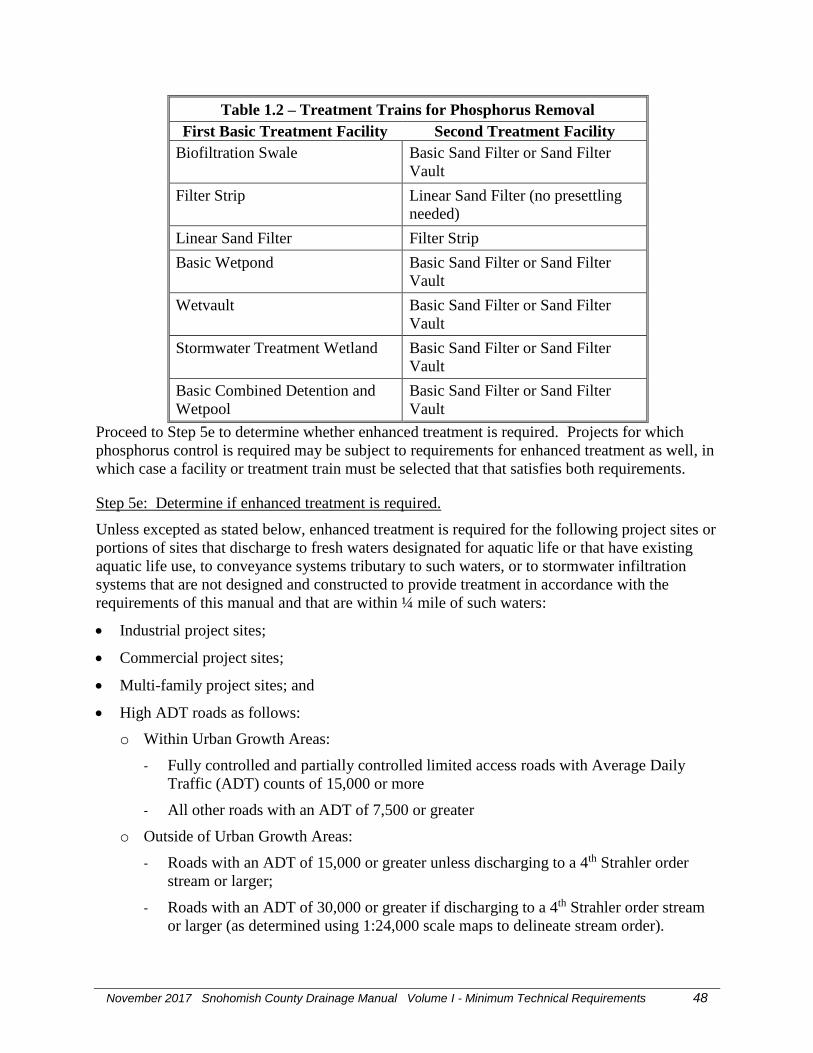
November 2017 Snohomish County Drainage Manual Volume I - Minimum Technical Requirements 48
Table 1.2 – Treatment Trains for Phosphorus Removal
First Basic Treatment Facility Second Treatment Facility
Biofiltration Swale Basic Sand Filter or Sand Filter
Vault
Filter Strip Linear Sand Filter (no presettling
needed)
Linear Sand Filter Filter Strip
Basic Wetpond Basic Sand Filter or Sand Filter
Vault
Wetvault Basic Sand Filter or Sand Filter
Vault
Stormwater Treatment Wetland Basic Sand Filter or Sand Filter
Vault
Basic Combined Detention and
Wetpool
Basic Sand Filter or Sand Filter
Vault
Proceed to Step 5e to determine whether enhanced treatment is required. Projects for which
phosphorus control is required may be subject to requirements for enhanced treatment as well, in
which case a facility or treatment train must be selected that that satisfies both requirements.
Step 5e: Determine if enhanced treatment is required.
Unless excepted as stated below, enhanced treatment is required for the following project sites or
portions of sites that discharge to fresh waters designated for aquatic life or that have existing
aquatic life use, to conveyance systems tributary to such waters, or to stormwater infiltration
systems that are not designed and constructed to provide treatment in accordance with the
requirements of this manual and that are within ¼ mile of such waters:
Industrial project sites;
Commercial project sites;
Multi-family project sites; and
High ADT roads as follows:
o Within Urban Growth Areas:
- Fully controlled and partially controlled limited access roads with Average Daily
Traffic (ADT) counts of 15,000 or more
- All other roads with an ADT of 7,500 or greater
o Outside of Urban Growth Areas:
- Roads with an ADT of 15,000 or greater unless discharging to a 4th Strahler order
stream or larger;
- Roads with an ADT of 30,000 or greater if discharging to a 4th Strahler order stream
or larger (as determined using 1:24,000 scale maps to delineate stream order).

November 2017 Snohomish County Drainage Manual Volume I - Minimum Technical Requirements 49
Exceptions
For threshold discharge areas with more than one land use or activity, the enhanced treatment
requirement shall apply to a threshold discharge area if 50 percent or more of the total runoff
within that threshold discharge area is subject to the enhanced treatment requirements set forth
above.
Projects or portions of projects meeting the descriptions above do not need enhanced treatment if
the stormwater discharges directly or indirectly through a municipal storm sewer system to a
water body listed in Volume I, Appendix I-C
If enhanced treatment is required, select one of the treatment systems below.
Large sand filter
Stormwater treatment wetland
Compost-amended filter strip
Bioretention
WSDOT media filter drain - see the 2014 Washington State Department of Transportation
Highway Runoff Manual for design and construction requirements.
Treatment train for dissolved metals removal – See Table 1.3
Any other treatment system for which the Washington State Department of Ecology has
issued a General Use Level Designation for enhanced treatment.

November 2017 Snohomish County Drainage Manual Volume I - Minimum Technical Requirements 50
Table 1.3 – Treatment Trains for Dissolved Metals Removal
First Basic Treatment Facility Second Treatment Facility
Biofiltration Swale Basic Sand Filter or Sand Filter Vault or Media
Filter(1)
Filter Strip Linear Sand Filter with no presettling cell
needed
Linear Sand Filter Filter Strip
Basic Wetpond Basic Sand Filter or Sand Filter Vault or Media
Filter(1)
Wetvault Basic Sand Filter or Sand Filter Vault or Media
Filter(1)
Basic Combined
Detention/Wetpool
Basic Sand Filter or Sand Filter Vault or Media
Filter(1)
Basic Sand Filter or Sand Filter
Vault with a presettling cell if
the filter isn’t preceded by a
detention facility
Media Filter(1)
(1) Media must be approved by Ecology for enhanced treatment. See Volume V, Chapter 12.
If Enhanced Treatment does not apply to the site, proceed to Step 5f.
Step 5f: Select a Basic Treatment Facility.
The Basic Treatment Menu applies to project sites for which treatment is required but which do
not trigger the requirements for oil control, phosphorus control, or enhanced treatment listed in
the step above. For developments with a mix of land use types, the basic treatment requirement
shall apply when the runoff from the areas subject to the basic treatment requirement compose
50% or more of the total runoff within a threshold discharge area.
If basic treatment is required, select one of the following treatment systems:
Infiltration treatment
Sand filter
Biofiltration swale
Filter strip
Basic wetpond
Wetvault – allowed only for commercial, industrial, or road projects if there are space
limitations. Combined detention/wetvaults are allowed; see Volume V, Chapter 10.3.
Stormwater treatment wetland
Combined detention and wetpool facilities
Bioretention

November 2017 Snohomish County Drainage Manual Volume I - Minimum Technical Requirements 51
WSDOT media filter drain – see the 2014 Washington State Department of Transportation
Highway Runoff Manual for design and construction requirements.
Any other treatment system for which the Washington State Department of Ecology has
issued a General Use Level Designation for basic treatment.
Step 6: [Reserved]
Step 7: Complete Development of Permanent Stormwater Control Plan
SCC 30.63A.400 sets forth requirements for development of a permanent stormwater control
plan. The design and location of the BMPs and facilities on the site must be determined using
the requirements in Volumes III, IV, and V.

November 2017 Snohomish County Drainage Manual Volume I - Minimum Technical Requirements 52
Appendix I-A - RESERVED

November 2017 Snohomish County Drainage Manual Volume I - Minimum Technical Requirements 53
Appendix I-B - RESERVED

November 2017 Snohomish County Drainage Manual Volume I - Minimum Technical Requirements 54
Appendix I-C
Basic Treatment Receiving Waters
Stormwater discharges to the following receiving waters require only basic stormwater treatment
All Salt Waterbodies
Rivers Basic Treatment Applies Below This Location
Sauk Clear Creek
Skagit Cascade River
Skykomish Beckler River
Snohomish Snoqualmie River
Snoqualmie Middle and North Fork Confluence
Stillaguamish North and South Fork Confluence
North Fork Stillaguamish Boulder River
South Fork Stillaguamish Canyon Creek
Suiattle Darrington
Note: The initial criteria for this list are rivers whose mean annual flow exceeds 1,000 cfs, and
lakes whose surface area exceeds 300 acres. Additional waters do not have to meet these
criteria, but should have sufficient background dilution capacity to accommodate dissolved
metals additions from build-out conditions in the watershed under the latest Comprehensive
Land Use Plan and zoning regulations.

November 2017 Snohomish County Drainage Manual Volume I - Minimum Technical Requirements 55
Appendix I-D
Wetlands and Stormwater Management
SCC 30.63A.570 requires use of the following criteria and methods for determining whether a
wetland can be used as a stormwater flow control or treatment facility, and the requirements that
must be met if such use is allowed.
A. Wetlands that shall not be used as stormwater treatment and flow control facilities,
and requirements for discharging stormwater to such wetlands.
A wetland shall not be used as a stormwater treatment or flow control facility if:
The wetland is a Category I or Category II wetland as determined by the Washington State
Wetland Rating System of Western Washington (Washington State Department of Ecology,
2006); OR
The wetland provides habitat for threatened or endangered species.
Stormwater from a development project shall not be discharged to a wetland meeting any of the
criteria above unless ALL of the following criteria are met:
Stormwater flow control is provided for the discharge in accordance with SCC 30.63A.550;
Stormwater treatment is provided for the discharge in accordance with SCC 30.63A.530;
AND
Both of the following criteria are met:
o Criterion 1: using the 2012 Western Washington Hydrology Model (WWHM 2012) or an
equivalent continuous simulation hydrologic model and a minimum 50-year precipitation
record, the average daily influent runoff volume into the wetland for pre-project
conditions shall not deviate from the average daily influent runoff volume into the
wetland for post-project conditions by more than 20%. See section I.C.3 below for
details; AND
o Criterion 2: using the 2012 Western Washington Hydrology Model (WWHM 2012) or an
equivalent continuous simulation hydrologic model and a minimum 50-year precipitation
record, the average monthly influent runoff volume into the wetland for pre-project
conditions shall not deviate from the average monthly influent runoff volume into the
wetland for post-project conditions by more than 15%. See section I.C.3 below for
details.
NOTE: the term “pre-project conditions” means the conditions existing on the site before the
proposed project. It does not mean “predevelopment conditions” as that term is used elsewhere
in this manual.
B. Wetlands that can be physically or hydrologically altered to provide stormwater
treatment or flow control, and requirements for stormwater discharges to such
wetlands.

November 2017 Snohomish County Drainage Manual Volume I - Minimum Technical Requirements 56
A wetland can be physically or hydrologically altered to provide stormwater treatment or flow
control BMP/facility if ALL of the following criteria are met:
The wetland is classified in Category IV as determined by the Washington State Wetland
Rating System of Western (Washington State Department of Ecology, 2006) or is classified
in Category III of that rating system with a habitat score of 19 points or less;
The applicant demonstrates to the satisfaction of Snohomish County that there will be no net
loss of functions and values of the wetland as a result of the structural or hydrologic
modifications done to provide control of runoff and water quality;
The wetland does not contain a breeding population of any native amphibian species;
The wetland lies in the natural routing of the runoff, and the discharge follows the natural
routing; and
At least one of the following conditions is met and all relevant actions in Table I.D-1 are
taken:
o The wetland contains ditches that can be filled or drain tiles that can be broken or
blocked;
o The wetland contains fill that can be removed to increase surface storage in a manner that
has a positive effect on water quality or habitat;
o The wetland is drained by a culvert that can be raised to increase surface storage in a
manner that has a positive effect on water quality or habitat;
o The wetland is in a floodplain, is protected from overbank flooding by a dike, and the
dike can be breached.
Table I.D-1 Actions to Improve Hydrologic Functions and Water Quality in Wetlands
Condition Action(s)
Ditches can be filled or drain tiles can be
broken or blocked
Break or block drain tiles
Fill ditches to surface elevation; do not lean
depressions that can channel water
Fill can be removed Remove fill using equipment with a ground
pressure less than 2 lb/ square inch
Culvert invert(s) can be raised to increase
surface storage
Raise culvert inverts
Dike(s) can be breached Breach dike(s) so as to reduce velocity of
influent flood water during flood events and
to reduce erosion on dike edges

November 2017 Snohomish County Drainage Manual Volume I - Minimum Technical Requirements 57
If the wetland inlet will be modified, use a diffuse flow method, (e.g. BMP C206 Level Spreader
Swale, Volume II, and BMP T5.10B Downspout Dispersion Systems, Volume III) to discharge
water into the wetland in order to prevent flow channelization.
C. Methods for determining compliance with criteria set forth in Section A
Use the following procedure for determining compliance with Criterion 1 (variance in average
daily influent volume).
1. Calculate the daily runoff volume for each calendar day (e.g., April 1) in the precipitation
record for both pre-project and post-project conditions. Volumes shall be calculated at
the inflow to the wetland or the upslope edge where surface runoff, interflow, and ground
water enter.
2. For each calendar day, calculate the multi-year average of the daily runoff volume values
for both pre-project and post-project conditions. This calculation will yield two values
(pre-project and post-project) for each calendar day.
3. For each calendar day average, compare the pre-project and post-project values. The
criterion is satisfied if each post-project calendar day average deviates no more than 20%
from the corresponding pre-project value.
Use the following algorithm for determining compliance with Criterion 2 (variance in average
monthly influent volume).
1. Calculate the monthly runoff volume for each calendar month (e.g., April) in the
precipitation record for both pre-project and post-project conditions. Volumes shall be
calculated at the inflow to the wetland or the upslope edge where surface runoff,
interflow, and ground water enter.
2. For each calendar month, calculate the multi-year average of the monthly runoff volume
values for both pre-project and post-project conditions. This calculation will yield two
values (pre-project and post-project) for each calendar month.
3. For each calendar month average, compare the pre-project and post-project values. The
criterion is satisfied if each post-project calendar month average deviates no more than
15% from the corresponding pre-project value.
D. WWHM Modeling Information and Instructions
Assume the flow components feeding the wetland under pre-project and post-project scenarios
are the sum of the surface, interflow, and ground water flows from the project site. Assign the
wetland a point of compliance #1 (POC) number such as POC1 downstream of the project area.
For the pre-project scenario, connect all flow components to the wetland/POC1
Pre-project Total Flows to POC1 = Surface + Interflow + Ground water
• Post-project scenario - Identify flows to the wetland/POC1.
a) Impervious surfaces send flows to wetland via (1)- surface flow.
WWHM sub-flows to POC1 = Surface flow (+ Interflow default set in WWHM)
b) Pervious surfaces send flows to wetland via (1)- surface, (2)- interflow, and (3)- ground.

November 2017 Snohomish County Drainage Manual Volume I - Minimum Technical Requirements 58
WWHM sub-flows to POC1 = Surface + Interflow + Ground water
c) Infiltrating facilities send flows to wetland via ground water, and surface overflows.
(1) Ground water - Connect infiltrated water (Outlet 2) to ground water component of the area
between facility and wetland. Use Lateral Basin downstream of the infiltrating facility and
connect Outlet 2 to the ground water component of the Lateral Basin. If this area is the same area
modeled in Step (b) above, use the Lateral Basin element in Step (b).
WWHM sub-flows to POC1 = infiltrated flows
(2) Surface Overflow – Connect the surface flow (Outlet 1) to wetland/POC1
WWHM sub-flows to POC1 = facility surface flows (Outlet 1)
Post-project Total Flows to POC1 = Sum of flows in (a), (b), and (c).
The following strategies may reduce the volume of surface flows if the limits stated above are
exceeded:
• Reducing of the level of development by reducing the amount of impervious surface and/or
increasing the retention of natural forest cover.
• Increasing infiltration through the use of LID BMPs.
• Increasing storage capacity for surface runoff.
• Using selective runoff bypass around the wetland. Bypassed flow must still comply with other
applicable stormwater requirements.
E. Additional Guidance Information
The following information may be useful but is not explicitly required by Snohomish County
code.
Retain areas of native vegetation connecting the wetland and its buffers with nearby
wetlands and other areas of contiguous vegetation
Retain shrub or woody debris as nesting sites for ground-nesting birds and downed logs
and stumps for winter wren habitat.
Retain snags as habitat for cavity-nesting bird species.
Retain shrubs in and around the wetland for protective cover. If cover is insufficient to
protect against domestic pet predation, consider planting native bushes such as rose
species in the buffer.
Avoid compaction of soil and introduction of exotic or invasive plants during work in a
wetland.
If human entry is desired, establish paths that permit people to observe the wetland with
minimum disturbance to the birds.
See the 2014 Ecology Stormwater Management Manual for Western Washington Volume I
Appendix I-D for information about native and recommended wetland plant species.

November 2017 Snohomish County Drainage Manual Volume I - Minimum Technical Requirements 59
Appendix I-E
Surface Waters Exempt From Flow Control Requirements
Stormwater discharges subject to the flow control requirements of Minimum Requirement 7 per
SCC 30.63A.550 are exempt from these requirements if they are discharged to the following
water bodies, provided that the discharges meet the conditions set forth in this appendix.
Snohomish County Surface Waters Exempt From Flow Control Requirements
Water Body Upstream Point/Reach for Exemption
(if applicable)
Sauk River Downstream of confluence of South Fork and North Fork
Sauk River, North Fork North Fork Sauk River at Bedal Campground
Skykomish River Downstream of South Fork
Skykomish River, South Fork Downstream of confluence of Tye and Foss Rivers
Snohomish River Downstream of confluence of Snoqualmie and Skykomish Rivers
Snoqualmie River Downstream of confluence of the Middle Fork
Snoqualmie River, Middle Fork Downstream of confluence with Rainy Creek
Stillaguamish River Downstream of confluence of North and South Fork
Stillaguamish River, North Fork 7.7 highway miles west of Darrington on SR530, downstream of confluence with French Creek.
Stillaguamish River, South Fork 7 Downstream of confluence of Cranberry Creek and South Fork
Suiattle River Downstream of confluence with Milk Creek
Sultan River 0.4 miles upstream of SR2
Conditions for exemption
All of the following conditions must be met for discharges to be exempt from Minimum
Requirement 7:
Direct discharge to the exempt receiving water does not result in the diversion of drainage
from any perennial stream classified as Types 1, 2, 3, or 4 in the State of Washington Interim
Water Typing System, or Types “S”, “F”, or “Np” in the Permanent Water Typing System,
or from any category I, II, or III wetland.
Flow splitting devices or drainage BMP’s are applied to route natural runoff volumes from
the project site to any downstream Type 5 stream or category IV wetland as follows:
o Design of flow splitting devices or drainage BMP’s will be based on continuous
hydrologic modeling analysis. The design will assure that flows delivered to Type 5
stream reaches will approximate, but in no case exceed, durations ranging from 50% of
the 2-year to the 50-year peak flow.
o Flow splitting devices or drainage BMP’s that deliver flow to category IV wetlands will
also be designed using continuous hydrologic modeling to preserve pre-project wetland

November 2017 Snohomish County Drainage Manual Volume I - Minimum Technical Requirements 60
hydrologic conditions unless specifically waived or exempted by regulatory agencies
with permitting jurisdiction.
The project site must be drained by a conveyance system that is composed entirely of
manmade conveyance elements (e.g., pipes, ditches, outfall protection) and extends to the
ordinary high water line of the exempt receiving water.
The conveyance system between the project site and the exempt receiving water shall have a
hydraulic capacity sufficient to convey discharges from future build-out conditions (under
current zoning) of the site, and the existing condition from non-project areas from which
runoff is or will be collected.
Any erodible elements of the manmade conveyance system must be adequately stabilized to
prevent erosion under the conditions noted above.

November 2017 Snohomish County Drainage Manual Volume I - Minimum Technical Requirements 61
Appendix I-F
Stormwater Pollution Prevention Plan (SWPPP) Submittal
Requirements for Small Projects Pursuant to
SCC 30.63A.810
Introduction
This appendix provides requirements for selecting best management practices (BMPs) for
Stormwater Pollution Prevention Plans (SWPPPs) for small projects that meet the criteria set
forth in SCC 30.63A.810. If required, applicants shall use the small project SWPPP drainage
review forms provided by Snohomish County Department of Planning and Development
Services.
These projects are required to comply with Minimum Requirement 2 - Stormwater Pollution
Prevention, and a key criterion of these projects is that they do not require the stamp of a
licensed civil engineer. Consequently, the applicant must be able to meet these requirements by
using the erosion control BMPs listed in this appendix. The BMPs listed in this appendix do not
require an engineer's stamp.
Note that SWPPP element 13 requires protection of BMPs required to meet Minimum
Requirement 5. Projects meeting the criteria of SCC 30.63A.810 are by definition those to
which only Minimum Requirement 2 applies, so SWPPP element 13 is not discussed below.
The following sections contain a review of the twelve applicable elements of Minimum
Requirement 2 and the erosion control BMPs allowable for small projects to meet these
requirements, and the required sequence of BMP implementation
Applicable elements of Minimum Requirement 2 and allowable erosion control BMPs
The elements of Minimum Requirement 2 applicable to small projects as defined in SCC
30.63A.810 are:
1. Mark clearing limits
2. Establish construction access
3. Control flow rates
4. Install sediment controls
5. Stabilize soils
6. Protect slopes
7. Protect drain inlets
8. Stabilize channels and outlets
9. Control pollutants
10. Control dewatering
11. Maintain BMPs

November 2017 Snohomish County Drainage Manual Volume I - Minimum Technical Requirements 62
12. Manage the project
The measures used to meet these twelve elements must be described or shown in drawing form
in the Stormwater Pollution Prevention Plan (SWPPP). For details on how these elements are
implemented on larger projects, see SCC 30.63A.450 and Volume II, Chapter 3.
SWPPP element 1: preserve vegetation/mark clearing limits
Minimize removal of existing trees and disturbance and compaction of native soils, except as
needed for building purposes. The duff layer, native top soil, and natural vegetation shall be
retained in an undisturbed state to the maximum degree practicable. Plan and implement proper
clearing and grading of the site. Clear only the areas needed, thus keeping exposed areas to a
minimum. Phase clearing so that only those areas that are actively being worked are uncovered.
Soil shall be managed in a manner that does not permanently compact or deteriorate the final soil
and landscape system. If disturbance and/or compaction occur the impact must be corrected at
the end of the construction activity. This shall include restoration of soil depth, soil quality,
permeability, and percent organic matter. Construction practices must not cause damage to or
compromise the design of permanent landscape or infiltration areas.
Prior to beginning land disturbing activities, delineate or mark the following areas and features
on the site:
(a) Clearing limits;
(b) All critical areas, and their setbacks and buffers;
(c) Erosion or landslide hazard areas and their setbacks and buffers;
(d) Existing and proposed easements;
(e) Required landscaping, and tree retention and replacement areas;
(f) Other areas on the site required to be preserved or protected including, but
not limited to, drainage courses.
Relevant BMPs:
BMP C101: Preserving Natural Vegetation
BMP C102: Buffer Zones
BMP C103: High Visibility Plastic or Metal Fence
SWPPP element 2: establish construction access
Construction vehicle ingress and egress shall be limited to one route if possible. A stabilized
construction entrance or other equivalent BMP shall be installed to prevent sediment transport
onto roads.
Streets shall be cleaned at the end of each day during dry weather and more frequently during
wet weather. Street washing is only allowed after sediment is removed by shoveling or pick-up
sweeping and transported to a controlled disposal area. Street wash wastewater shall be
controlled by pumping it back on site or otherwise preventing its discharge into systems tributary
to the waters of the state or waters that would otherwise require enhanced treatment.
November 2017 Snohomish County Drainage Manual Volume I - Minimum Technical Requirements 63
Relevant BMPs:
BMP C105: Stabilized Construction Entrance
BMP C107: Construction Road/Parking Area Stabilization
SWPPP element 3: control flow rates
Small projects shall meet this requirement by appropriate use of BMPs related to SWPPP
element 4.
SWPPP element 4: install sediment controls
Remove sediment from construction site runoff by using appropriate sediment removal BMPs.
Runoff from fully stabilized areas may be discharged without a sediment removal BMP.
Relevant BMPs:
BMP C231: Brush Barrier
BMP C232: Gravel Filter Berm
BMP C233: Silt Fence
BMP C234: Vegetated Strip
BMP C235: Wattles
SWPPP element 5: stabilize soils
Exposed and unworked soils and soil stockpiles shall be stabilized. Soil stockpiles shall be
located away from storm drain inlets, drainage channels and other waters.
The time period of soil exposure allowed depends on the season. No soils shall remain exposed
and unworked for more than seven days during the dry season, May 1 through September 30, or
two days during the wet season, October 1 through April 30, unless the County places other
restrictions on the project.
Locate excavated basement soil a reasonable distance behind the curb, such as in the backyard or
side yard area. This will increase the distance eroded soil must travel to reach the storm sewer
system. Soil piles should be covered until the soil is either used or removed. Piles should be
situated so that sediment does not run into the street or adjoining yards. Backfill basement walls
as soon as possible and rough grade the lot. This will eliminate large soil mounds, which are
highly erodible, and prepares the lot for temporary cover, which will further reduce erosion
potential
Remove excess soil from the site as soon as possible after backfilling. This will eliminate any
sediment loss from surplus fill.
If a lot has a soil bank higher than the curb, a trench or berm should be installed moving the bank
several feet behind the curb. This will reduce the occurrence of gully and rill erosion while
providing a storage and settling area for stormwater.

November 2017 Snohomish County Drainage Manual Volume I - Minimum Technical Requirements 64
Relevant BMPs:
BMP C120: Temporary and Permanent Seeding NOTE: small projects shall only use
methods in BMP C120 that do not require engineering.
BMP C121: Mulching
BMP C122: Blankets NOTE: small projects shall only use methods in BMP C122 that do
not require engineering.
BMP C123: Plastic Covering NOTE: small projects shall only use methods in BMP C123
that do not require engineering.
BMP C124: Sodding
BMP C125: Topsoiling / Composting
BMP C140: Dust Control
SWPPP Element 6: protect slopes
NOTE: Cut and fill slopes may require engineering, pursuant to SCC 30.63B.110, SCC
30.63B.130, SCC 30.63B.200. In addition, most of the BMPs related to this SWPPP element
require engineering. If cut or fill slopes are proposed, the applicant should verify that the
project meets the small project criteria.
Cut and fill slopes shall be designed and constructed in a manner that will minimize erosion and
comply with the County’s critical area regulations. Cut and fill slopes shall be protected from
erosive flows and concentrated flows until permanent cover and drainage conveyance systems
are in place. Excavated material shall be placed on the uphill side of trenches, consistent with
safety and space considerations.
Relevant BMPs:
BMP C120: Temporary and Permanent Seeding. NOTE: small projects shall only use
methods in BMP C120 that do not require engineering.
BMP C208: Triangular Silt Dike NOTE: small projects shall only use methods in BMP
C208 that do not require engineering.
SWPPP element 7: protect permanent drain inlets.
All permanent storm drain inlets require protection from sediment and silt-laden water.
Permanent storm drain inlets operable on the site during construction shall be protected so that
stormwater runoff does not enter the conveyance system without first being filtered or treated to
remove sediment. Inlet protection devices shall be cleaned or removed and replaced when
sediment has filled one-third of the available storage or as specified by the product manufacturer.
They may be removed once the site is stabilized.
Relevant BMPs:
BMP C220: Storm Drain Inlet Protection
November 2017 Snohomish County Drainage Manual Volume I - Minimum Technical Requirements 65
SWPPP element 8: stabilize channels and outlets
NOTE: Design and construction of stormwater conveyance systems requires an engineer per
SCC 30.63A.400(3)(d). In addition, the BMPs related to this SWPPP element require
engineering. The channel and outlet stabilization measures proposed herein are intended for
protection of preexisting drainage systems on the project site, and the project applicant should
verify with the County that the project meets the small project criteria.
Temporary and permanent conveyance systems shall be stabilized to prevent erosion during and
after construction. Stabilization, including armoring material, adequate to prevent erosion of
outlets, adjacent stream banks, slopes and downstream reaches shall be provided at the outlets of
all conveyance systems.
Relevant BMPs:
BMP C202: Channel Lining NOTE: small projects shall only use methods in BMP C202
that do not require engineering.
BMP C209: Outlet Protection NOTE: small projects shall only use methods in BMP C209
that do not require engineering.
SWPPP element 9: control pollutants
Appropriate pollution source control measures shall be implemented in areas of: construction
equipment maintenance or fueling; handling or storage of waste materials, construction debris,
fertilizers, chemicals; and other activities that may contribute pollutants to stormwater. The
following specific requirements apply:
Cover, containment, and protection from vandalism shall be provided for all chemicals,
liquid products, petroleum products, and other materials that have the potential to pose a
threat to human health or the environment.
On-site fueling tanks shall include secondary containment.
Maintenance, fueling and repair of heavy equipment and vehicles shall be conducted using
spill prevention and control measures consistent with Volume IV, Chapters 2 and 3.
Contaminated surfaces shall be cleaned immediately following any spill incident.
Application of fertilizers and pesticides shall be conducted in a manner and at application
rates that will not result in loss of chemical to stormwater runoff. Manufacturers’ label
requirements for application rates and procedures shall be followed
BMPs shall be used to prevent contamination of stormwater runoff by pH modifying sources.
These sources include, but are not limited to, bulk cement, cement kiln dust, fly ash, new
concrete washing approved treatment, curing waters, waste streams generated from concrete
grinding and sawing, exposed aggregate processes, dewatering concrete vaults, concrete
pumping and mixer washout waters.
Relevant BMPs:
BMP C151: Concrete Handling NOTE: small projects shall only use methods in BMP C151
that do not require engineering

November 2017 Snohomish County Drainage Manual Volume I - Minimum Technical Requirements 66
BMP C152: Sawcutting and Surfacing Pollution Prevention
BMP C 153: Material Storage, Delivery, and Containment
See also Volume IV of this manual
SWWP element 10: control dewatering
NOTE: Many of the BMPs related to this SWPPP element require engineering; however most
small projects stormwater runoff will be dispersed on site to natural vegetation, to a containment
vessel or sewer system with permission of the utility company. In these cases, this BMP may not
be applicable. The project applicant should verify with the County that the project meets the
small project criteria.
Turbid or contaminated dewatering water shall be handled separately from stormwater, and shall
be collected for off-site disposal in a legal manner, or discharged to a sanitary sewer contingent
on local sewer district approval. Uncontaminated or clean water from dewatering systems for
trenches, vaults and foundations may be disposed by on-site infiltration or use of a catch basin
insert or with outfall to a ditch or swale for small volumes of dewatering water.
Relevant BMPs
BMP C220 - Storm Drain Inlet Protection
SWPPP element 11: maintain best management practices.
BMPs shall be inspected and maintained during construction and removed within 30 days after
the County determines that the site is stabilized, provided that temporary BMPs may be removed
when they are no longer needed.
SWPPP element 12: manage the project.
The SWPPP shall be fully implemented at all times and modified whenever there is a change in
design, construction, operation, or maintenance at the construction site that has or could have a
significant effect on the discharge of pollutants to waters of the state.
Sequence of BMP Implementation
1) Delineate or mark the following areas and features on the site:
(a) Clearing limits;
(b) Critical areas and their buffers;
(c) Erosion or landslide hazard areas and their setbacks;
(d) Easements;
(e) Required landscaping, and tree retention and replacement areas;
(f) Other areas on the site required to be preserved or protected including, but not
limited to, drainage courses.
2) Install stabilized construction entrance and parking area stabilization.
3) Protect existing drainage systems on site.

November 2017 Snohomish County Drainage Manual Volume I - Minimum Technical Requirements 67
4) Establish areas for storage and handling of polluted materials at which pollution source
control BMPs will be implemented.
5) Install sediment controls.
6) Implement stabilization measures for disturbed areas, slopes, and material stockpiles.
7) Maintain BMPs until final site stabilization.

November 2017 Snohomish County Drainage Manual Volume I - Minimum Technical Requirements 68
Appendix I-G
Area of Snohomish County with 40% or more impervious
area as of 1985
Source: 2014 Ecology Stormwater Management Manual for Western Washington

November 2017 Snohomish County Drainage Manual Volume I - Minimum Technical Requirements 69
Glossary and Notations
The following terms are provided for reference and use with this manual. They shall be
superseded by any other definitions for these terms adopted by Snohomish County Code or
Snohomish County EDDS.
AASHTO
classification The official classification of soil materials and soil aggregate mixtures
for highway construction, used by the American Association of State
Highway and Transportation Officials.
Absorption The penetration of a substance into or through another, such as the
dissolving of a soluble gas in a liquid.
Adjacent steep
slope A slope with a gradient of 15 percent or steeper within five hundred
feet of the site.
Adsorption The adhesion of a substance to the surface of a solid or liquid; often
used to extract pollutants by causing them to be attached to such
adsorbents as activated carbon or silica gel. Hydrophobic, or water-
repulsing adsorbents, are used to extract oil from waterways when oil
spills occur. Heavy metals such as zinc and lead often adsorb onto
sediment particles.
Aeration The process of being supplied or impregnated with air. In waste
treatment, the process used to foster biological and chemical
purification. In soils, the process by which air in the soil is
replenished by air from the atmosphere. In a well aerated soil, the soil
air is similar in composition to the atmosphere above the soil. Poorly
aerated soils usually contain a much higher percentage of carbon
dioxide and a correspondingly lower percentage of oxygen.
Aerobic Living or active only in the presence of free (dissolved or molecular)
oxygen.
Aerobic bacteria Bacteria that require the presence of free oxygen for their metabolic
processes.
Aggressive plant
species Opportunistic species of inferior biological value that tend to
out-compete more desirable forms and become dominant; applied to
native species in this manual.

November 2017 Snohomish County Drainage Manual Volume I - Minimum Technical Requirements 70
Algae Primitive plants, many microscopic, containing chlorophyll and
forming the base of the food chain in aquatic environments. Some
species may create a nuisance when environmental conditions are
suitable for prolific growth.
Algal bloom Proliferation of living algae on the surface of lakes, streams or ponds;
often stimulated by phosphate over-enrichment. Algal blooms reduce
the oxygen available to other aquatic organisms.
American public
works association
(APWA) The Washington State Chapter of the American Public Works
Association.
Anadromous Fish that grow to maturity in the ocean and return to rivers for
spawning.
Anaerobic Living or active in the absence of oxygen.
Anaerobic bacteria Bacteria that do not require the presence of free or dissolved oxygen
for metabolism.
Annual flood The highest peak discharge on average which can be expected in any
given year.
Antecedent
moisture conditions The degree of wetness of a watershed or within the soil at the
beginning of a storm.
Anti-seep collar A device constructed around a pipe or other conduit and placed
through a dam, levee, or dike for the purpose of reducing seepage
losses and piping failures.
Anti-vortex device A facility placed at the entrance to a pipe conduit structure such as a
drop inlet spillway or hood inlet spillway to prevent air from entering
the structure when the pipe is flowing full.
Applicant The person who has applied for a development permit or approval.
Appurtenances Machinery, appliances, or auxiliary structures attached to a main
structure, but not considered an integral part thereof, for the purpose of
enabling it to function.
Aquifer A geologic stratum containing ground water that can be withdrawn and
used for human purposes.
Arterial A transportation facility designated as an arterial in an UGA plan or
the comprehensive plan.

November 2017 Snohomish County Drainage Manual Volume I - Minimum Technical Requirements 71
As-built drawings Engineering plans which have been revised to reflect all changes to the
plans which occurred during construction.
As-graded The extent of surface conditions on completion of grading.
BSBL See Building set back line.
Background A description of pollutant levels arising from natural sources, and not
because of man's immediate activities.
Background
water quality See Chapter 30.91B.010 SCC. "Background water quality" means
the concentrations of chemical, physical, biological, or radiological
constituents, or other characteristics in or of groundwater at a
particular point in time and upgradient of an activity that have not been
affected by that activity.
Backwater Water upstream from an obstruction which is deeper than it would
normally be without the obstruction.
Baffle A device to check, deflect, or regulate flow.
Bankfull discharge A flow condition where streamflow completely fills the stream
channel up to the top of the bank. In undisturbed watersheds, the
discharge conditions occur on average every 1.5 to 2 years and
controls the shape and form of natural channels.
Base flood See SCC 30.91B.020.The flood having a one percent chance of being
equaled or exceeded in any given year.
Base flood elevation The water surface elevation of the base flood. It shall be referenced to
the National Geodetic Vertical Datum of 1929 (NGVD).
Baseline sample A sample collected during dry-weather flow (i.e., it does not consist of
runoff from a specific precipitation event).

November 2017 Snohomish County Drainage Manual Volume I - Minimum Technical Requirements 72
Basin plan A plan that assesses, evaluates, and proposes solutions to existing and
potential future impacts to the beneficial uses of, and the physical,
chemical, and biological properties of waters of the state within a
basin. Basins typically range in size from 1 to 50 square miles. A
plan should include but not be limited to recommendations for:
Stormwater requirements for new development and
redevelopment;
Capital improvement projects;
Land Use management through identification and protection of
critical areas, comprehensive land use and transportation plans,
zoning regulations, site development standards, and conservation
areas;
Source control activities including public education and
involvement, and business programs;
Other targeted stormwater programs and activities, such as
maintenance, inspections and enforcement;
Monitoring; and
An implementation schedule and funding strategy.
A plan that is “adopted and implemented” must have the following
characteristics:
It must be adopted by legislative or regulatory action of
jurisdictions with responsibilities under the plan;
Ordinances, regulations, programs, and procedures recommended
by the plan should be in effect or on schedule to be in effect; and,
An implementation schedule and funding strategy that are in
progress.
Bearing capacity The maximum load that a material can support before failing.
Bedrock The more or less solid rock in place either on or beneath the surface of
the earth. It may be soft, medium, or hard and have a smooth or
irregular surface.
Bench A relatively level step excavated into earth material on which fill is to
be placed.
Berm A constructed barrier of compacted earth, rock, or gravel. In a
stormwater facility, a berm may serve as a vertical divider typically
built up from the bottom.

November 2017 Snohomish County Drainage Manual Volume I - Minimum Technical Requirements 73
Best management
practices (BMPs) See SCC 30.91B.080. The schedules of activities, prohibitions of
practices, maintenance procedures, and structural and/or managerial
practices, that when used singly or in combination, prevent or reduce
the release of pollutants and other adverse impacts to waters of
Washington State.
Biochemical oxygen
demand (BOD) An indirect measure of the concentration of biologically degradable
materials present in organic wastes. The amount of free oxygen
utilized by aerobic organisms when allowed to attack the organic
material in an aerobically maintained environment at a specified
temperature (20C) for a specific time period (5 days), and thus stated
as BOD5. It is expressed in milligrams of oxygen utilized per liter of
liquid waste volume (mg/l) or in milligrams of oxygen per kilogram of
waste solution (mg/kg = ppm = parts per million parts). Also called
biological oxygen demand.
Biodegradable Capable of being readily broken down by biological means, especially
by microbial action. Microbial action includes the combined effect of
bacteria, fungus, flagellates, amoebae, ciliates, and nematodes.
Degradation can be rapid or may take many years depending upon
such factors as available oxygen and moisture.
Bioengineering The combination of biological, mechanical, and ecological concepts
(and methods) to control erosion and stabilize soil through the use of
vegetation or in combination with construction materials.
Biofilter A designed treatment facility using a combined soil and vegetation
system for filtration, infiltration, adsorption, and biological uptake of
pollutants in stormwater when runoff flows over and through.
Vegetation growing in these facilities acts as both a physical filter
which causes gravity settling of particulates by regulating velocity of
flow, and also as a biological sink when direct uptake of dissolved
pollutants occurs. The former mechanism is probably the most
important in western Washington where the period of major runoff
coincides with the period of lowest biological activity.
Biofiltration See SCC 30.91B.130.The process of reducing pollutant
concentrations in water by filtering through biological materials.
Biological control A method of controlling pest organisms by means of introduced or
naturally occurring predatory organisms, sterilization, the use of
inhibiting hormones, or other means, rather than by mechanical or
chemical means.

November 2017 Snohomish County Drainage Manual Volume I - Minimum Technical Requirements 74
Biological
magnification The increasing concentration of a substance along succeeding steps in
a food chain. Also called biomagnification.
Biosolids Municipal sewage sludge that is a primarily organic, semisolid product
resulting from the wastewater treatment process, that can be
beneficially recycled and meets all applicable requirements under
Chapter 173-308 WAC. Biosolids includes a material derived from
biosolids, and septic tank sludge, also known as septage, that can be
beneficially recycled and meets all applicable requirements under
Chapter 173-308 WAC. For the purposes of Chapter 173-308 WAC,
semisolid products include biosolids or products derived from
biosolids ranging in character from mostly liquid to fully dried solids.
Bollard See SCC 30.91B.175. A rigid post, permanent or removable, used as a
traffic control device to limit vehicle access. Bollards are usually
installed in a line with sufficient space between them to allow
permitted access, such as bicycles and pedestrians, but not motor
vehicles. Removable bollards are used when access may be required
for special-purpose vehicles but not general traffic.
Bond A surety bond, cash deposit or escrow account, assignment of savings,
irrevocable letter of credit or other means acceptable to or required by
the manager to guarantee that work is completed in compliance with
the project's drainage plan and in compliance with all local
government requirements.
Borrow area A source of earth fill material used in the construction of
embankments or other earth fill structures.
Buffer The zone contiguous with a critical area that is required for the
continued maintenance, function, and structural stability of the critical
area. The critical functions of a riparian buffer (those associated with
an aquatic system) include shading, input of organic debris and coarse
sediments, uptake of nutrients, stabilization of banks, interception of
fine sediments, overflow during high water events, protection from
disturbance by humans and domestic animals, maintenance of wildlife
habitat, and room for variation of aquatic system boundaries over time
due to hydrologic or climatic effects. The critical functions of
terrestrial buffers include protection of slope stability, attenuation of
surface water flows from stormwater runoff and precipitation, and
erosion control.
CIP See Capital Improvement Project.

November 2017 Snohomish County Drainage Manual Volume I - Minimum Technical Requirements 75
Capital improvement
project or program
(CIP) A project prioritized and scheduled as a part of an overall construction
program or, the actual construction program.
Catch basin A chamber or well, usually built at the curb line of a street, for the
admission of surface water to a sewer or subdrain, having at its base a
sediment sump designed to retain grit and detritus below the point of
overflow.
Catchline The point where a severe slope intercepts a different, more gentle
slope.
Catchment Surface drainage area.
Cation exchange
capacity (CEC) The amount of exchangeable cations that a soil can absorb at pH 7.0.
Certified erosion
and sediment
control lead
(CESCL) An individual who has current certification through an approved
erosion and sediment control training program that meets the
minimum training standards established by the Department of Ecology
(see BMP C160 in the Drainage Manual). A CESCL is knowledgeable
in the principles and practices of erosion and sediment control. The
CESCL must have the skills to assess site conditions and construction
activities that could impact the quality of stormwater and, the
effectiveness of erosion and sediment control measures used to control
the quality of stormwater discharges.
Channel A feature that conveys surface water and is open to the air.
Channel,
constructed Channels or ditches constructed (or reconstructed natural channels) to
convey surface water.
Channel, natural Streams, creeks, or swales that convey surface/ground water and have
existed long enough to establish a stable route and/or biological
community.
Channel stabilization Erosion prevention and stabilization of velocity distribution in a
channel using vegetation, jetties, drops, revetments, and/or other
measures.
Channel storage Water temporarily stored in channels while enroute to an outlet.

November 2017 Snohomish County Drainage Manual Volume I - Minimum Technical Requirements 76
Channelization Alteration of a stream channel by widening, deepening, straightening,
cleaning, or paving certain areas to change flow characteristics.
Check dam Small dam constructed in a gully or other small watercourse to
decrease the streamflow velocity, minimize channel scour, and
promote deposition of sediment
Chemical oxygen
demand (COD) A measure of the amount of oxygen required to oxidize organic and
oxidizable inorganic compounds in water. The COD test, like the
BOD test, is used to determine the degree of pollution in water.
Civil engineer See SCC 30.91C.090. A professional engineer licensed by the state of
Washington to practice in the field of civil engineering.
Civil engineering See SCC 30.91C.100.The application of the knowledge of the forces
of nature, principles of mechanics and the properties of materials to the
evaluation, design and construction of civil works.
Clay lens A naturally occurring, localized area of clay which acts as an
impermeable layer to runoff infiltration.
Clearing See SCC 30.91C.112. The destruction or surface removal of
vegetation by cutting, pruning, limbing, topping, relocating manually
or mechanically, application of herbicides or pesticides or other
chemical methods, or any application of hazardous or toxic substance
that has the effect of destroying or removing the vegetation.
Closed depression An area which is low-lying and either has no, or such a limited,
surface water outlet that during storm events the area acts as a
retention basin.
Cohesion The capacity of a soil to resist shearing stress, exclusive of functional
resistance.
Coliform bacteria Microorganisms common in the intestinal tracts of man and other
warm-blooded animals; all the aerobic and facultative anaerobic,
gram-negative, nonspore-forming, rod-shaped bacteria which ferment
lactose with gas formation within 48 hours at 35C. Used as an
indicator of bacterial pollution.
Common plan of
development or sale A site where multiple separate and distinct construction activities may
be taking place at different times on different schedules and/or by
different contractors, but still under a single plan. Examples include: 1)
phase projects and projects with multiple filings or lots, even if the
separate phases or filings/lots will be constructed under separate
contract or by separate owners (e.g., a development where lots are sold

November 2017 Snohomish County Drainage Manual Volume I - Minimum Technical Requirements 77
to separate builders); 2) a development plan that may be phased over
multiple years, but is still under a consistent plan for long-term
development; 3) projects in a contiguous area that may be unrelated
but still under the same contract, such as construction of a building
extension and a new parking lot at the same facility; and 4) linear
projects such as roads, pipelines, or utilities. If the project is part of a
common plan of development or sale, the disturbed area of the entire
plan must be used in determine permit requirements.
Compaction The densification, settlement, or packing of soil in such a way that
permeability of the soil is reduced. Compaction effectively shifts the
performance of a hydrologic group to a lower permeability hydrologic
group. For example, a group B hydrologic soil can be compacted and
be effectively converted to a group C hydrologic soil in the way it
performs in regard to runoff.
Compaction may also refer to the densification of a fill by mechanical
means.
Compensatory
storage New excavated storage volume equivalent to the flood storage
capacity eliminated by filling or grading within the flood fringe.
Equivalent shall mean that the storage removed shall be replaced by
equal volume between corresponding one-foot contour intervals that
are hydraulically connected to the floodway through their entire depth.
Compost Organic material that has undergone biological degradation and
transformation under controlled conditions designed to promote
aerobic decomposition at a solid waste facility in compliance with the
requirements of Chapter 173-350 WAC, or biosolids composted in
compliance with Chapter 173-308 WAC. Composting is a form of
organic material recycling. Natural decay of organic solid waste under
uncontrolled conditions does not result in composted material.
Comprehensive
planning Planning that takes into account all aspects of water, air, and land
resources and their uses and limits.
Conservation district A public organization created under state enabling law as a special-
purpose district to develop and carry out a program of soil, water, and
related resource conservation, use, and development within its
boundaries, usually a subdivision of state government with a local
governing body and always with limited authority. Often called a soil
conservation district or a soil and water conservation district.
Constructed wetland Those wetlands intentionally created on sites that are not wetlands for
the primary purpose of wastewater or stormwater treatment and

November 2017 Snohomish County Drainage Manual Volume I - Minimum Technical Requirements 78
managed as such. Constructed wetlands are normally considered as
part of the stormwater collection and treatment system.
Construction
stormwater pollution
prevention plan A document that describes the potential for pollution problems on a
construction project and explains and illustrates the measures to be
taken on the construction site to control those problems.
Contour An imaginary line on the surface of the earth connecting points of the
same elevation.
Converted vegetation
areas The surfaces on a project site where native vegetation, pasture,
scrub/shrub, or unmaintained non-native vegetation (e.g., Himalayan
blackberry, scotch broom) are converted to lawn or landscaped areas,
or where native vegetation is converted to pasture.
Conveyance A mechanism for transporting water from one point to another,
including pipes, ditches, and channels.
Conveyance system See SCC 30.91C.300. A system of drainage facilities, natural, or
artificial which collects, contains and conducts the flow of storm water
runoff. The elements of a natural conveyance system include, but are
not limited to, swales, wetlands, drainage courses, streams, and rivers.
The elements of an artificial conveyance system include, but are not
limited to, gutters, ditches, pipes, constructed open channels and
detention facilities.
Cover crop A close-growing crop grown primarily for the purpose of protecting
and improving soil between periods of permanent vegetation.
Created wetland Means those wetlands intentionally created from nonwetland sites to
produce or replace natural wetland habitat (e.g., compensatory
mitigation projects).
Critical area See SCC 30.91C.340. Critical area means the following areas:
(1) Wetlands;
(2) Areas with a critical recharging effect on aquifers used for potable
water, including:
(a) Sole source aquifers,
(b) Group A well head protection areas, and
(c) Critical aquifer recharge areas;
(3) Fish and wildlife habitat conservation areas, including:

November 2017 Snohomish County Drainage Manual Volume I - Minimum Technical Requirements 79
(a) Streams,
(b) Lakes,
(c) Marine waters, and
(d) Primary association areas for critical species;
(4) Frequently flooded areas; and
(5) Geologically hazardous areas, including:
(a) Erosion hazard areas,
(b) Landslide hazard areas,
(c) Seismic hazard areas,
(d) Mine hazard areas,
(e) Volcanic hazard areas, and
(f) Tsunami hazard areas.
Critical drainage
area An area with such severe flooding, drainage and/or erosion/sedimentation
conditions that the area has been formally adopted as a Critical Drainage
Area by rule under the procedures specified in an ordinance.
Critical reach The point in a receiving stream below a discharge point at which the
lowest dissolved oxygen level is reached and stream recovery begins.
Culvert Pipe or concrete box structure that drains open channels, swales or
ditches under a roadway or embankment. Typically with no catch
basins or manholes along its length.
Cut Portion of land surface or area from which earth has been removed or
will be removed by excavating; the depth below original ground
surface to excavated surface.
Cut-and-fill Process of earth moving by excavating part of an area and using the
excavated material for adjacent embankments or fill areas.
Cut slope A slope formed by excavating overlying material to connect the
original ground surface with a lower ground surface created by the
excavation. A cut slope is distinguished from a bermed slope, which is
constructed by importing soil to create the slope.
DNS See Determination of Nonsignificance.
Dead storage The volume available in a depression in the ground below any
conveyance system, or surface drainage pathway, or outlet invert
elevation that could allow the discharge of surface and stormwater
runoff.

November 2017 Snohomish County Drainage Manual Volume I - Minimum Technical Requirements 80
Dedication of land Refers to setting aside a portion of a property for a specific use or
function.
Degradation (Biological or chemical) The breakdown of complex organic or other
chemical compounds into simpler substances, usually less harmful
than the original compound, as with the degradation of a persistent
pesticide. (Geological) Wearing down by erosion. (Water) The
lowering of the water quality of a watercourse by an increase in the
pollutant loading.
Degraded (disturbed)
wetland (community) A wetland (community) in which the vegetation, soils, and/or
hydrology have been adversely altered, resulting in lost or reduced
functions and values; generally, implies topographic isolation;
hydrologic alterations such as hydroperiod alteration (increased or
decreased quantity of water), diking, channelization, and/or outlet
modification; soils alterations such as presence of fill, soil removal,
and/or compaction; accumulation of toxicants in the biotic or abiotic
components of the wetland; and/or low plant species richness with
dominance by invasive weedy species.
Denitrification The biochemical reduction of nitrates or nitrites in the soil or organic
deposits to ammonia or free nitrogen.
Depression storage The amount of precipitation that is trapped in depressions on the
surface of the ground.
Design engineer The professional civil engineer licensed in the State of Washington
who prepares the analysis, design, and engineering plans for an
applicant's permit or approval submittal.
Design storm See SCC 30.91D.160. A rainfall event of a size approved by the
director, used for the purpose of sizing and designing drainage
facilities, stated in terms of a recurrence interval and a time period
over which the rainfall amount is measured or analyzed (i.e., a 2-year,
24-hour storm).
Detention See SCC 30.91D.170.The temporary storage of storm water runoff to
control peak discharge rates and allow settling of storm water
sediment.
Detention facility See SCC 30.91D.180. An open or closed drainage facility, such as a
pond or tank, that temporarily stores storm water runoff and releases it
at a slower rate than it is collected by the drainage facility. The facility
includes the flow control structure, the inlet and outlet pipes, and all
maintenance access points.

November 2017 Snohomish County Drainage Manual Volume I - Minimum Technical Requirements 81
Detention time The theoretical time required to displace the contents of a stormwater
treatment facility at a given rate of discharge (volume divided by rate
of discharge).
Determination of
nonsignificance See SCC 30.91D.300.The written decision by the responsible official
of the lead agency that a proposal is not likely to have a significant
adverse environmental impact, and therefore an EIS is not required.
See WAC 197-11-734.
Development Means new development, redevelopment, or both. See definitions for
each.
Discharge See SCC 30.91D.287.Runoff leaving a new development or
redevelopment via overland flow, built conveyance systems, or
infiltration facilities. A hydraulic rate of flow, specifically fluid flow; a
volume of fluid passing a point per unit of time, commonly expressed
as cubic feet per second, cubic meters per second, gallons per minute,
gallons per day, or millions of gallons per day.
Dispersion Release of surface and stormwater runoff from a drainage facility
system such that the flow spreads over a wide area and is located so as
not to allow flow to concentrate anywhere upstream of a drainage
channel with erodible underlying granular soils.
Ditch A long narrow excavation dug in the earth for drainage with its top
width less than 10 feet at design flow.
Divide, drainage The boundary between one drainage basin and another.
Drain A buried pipe or other conduit (closed drain). A ditch (open drain) for
carrying off surplus surface water or ground water.
(To) Drain To provide channels, such as open ditches or closed drains, so that
excess water can be removed by surface flow or by internal flow. To
lose water (from the soil) by percolation.
Drainage See SCC 30.91D.350. The collection, conveyance, containment, or
discharge of storm water runoff
Drainage basin See SCC 30.91D.360. A geographic and hydrologic area of a
watershed or drainage catchment area.
Drainage channel A drainage pathway with a well-defined bed and banks indicating
frequent conveyance of surface and stormwater runoff.
Drainage course A pathway for watershed drainage characterized by wet soil
vegetation; often intermittent in flow.

November 2017 Snohomish County Drainage Manual Volume I - Minimum Technical Requirements 82
Drainage easement A legal encumbrance that is placed against a property's title to reserve
specified privileges for the users and beneficiaries of the drainage
facilities contained within the boundaries of the easement.
Drainage facility See SCC 30.91D.370. A system of collecting, conveying and storing
storm water runoff. Drainage facilities include, but are not limited to,
all storm water conveyance systems and containment facilities
including pipelines, channels, dikes, ditches, closed depressions,
infiltration facilities, retention facilities, detention facilities, storm
water treatment facilities, erosion and sedimentation control facilities,
and other drainage structures and appurtenances, both natural and
artificial.
Drainage impacts See SCC 30.91D.380. The adverse impacts from changes to existing
water quantity, rate or quality; water storage, retention and detention
capacity, or water conveyance ability caused by a development
activity; and may include, but are not limited to, flooding, erosion,
sedimentation, scouring, bank sloughing, groundwater discharges to
aquifer recharge areas, and adverse impacts to wetlands, fish and
wildlife habitat conservation areas and geologically hazardous areas.
Drainage pathway The route that surface and stormwater runoff follows downslope as it
leaves any part of the site.
Drainage review An evaluation by Plan Approving Authority staff of a proposed
project's compliance with the drainage requirements in this manual or
its technical equivalent.
Drainage, soil As a natural condition of the soil, soil drainage refers to the frequency
and duration of periods when the soil is free of saturation; for example,
in well-drained soils the water is removed readily but not rapidly; in
poorly drained soils the root zone is waterlogged for long periods
unless artificially drained, and the roots of ordinary crop plants cannot
get enough oxygen; in excessively drained soils the water is removed
so completely that most crop plants suffer from lack of water. Strictly
speaking, excessively drained soils are a result of excessive runoff due
to steep slopes or low available water-holding capacity due to small
amounts of silt and clay in the soil material. The following classes are
used to express soil drainage:
Well drained - Excess water drains away rapidly and no mottling
occurs within 36 inches of the surface.
Moderately well drained - Water is removed from the soil
somewhat slowly, resulting in small but significant periods of
wetness. Mottling occurs between 18 and 36 inches.

November 2017 Snohomish County Drainage Manual Volume I - Minimum Technical Requirements 83
Somewhat poorly drained - Water is removed from the soil slowly
enough to keep it wet for significant periods but not all of the time.
Mottling occurs between 8 and 18 inches.
Poorly drained - Water is removed so slowly that the soil is wet for
a large part of the time. Mottling occurs between 0 and 8 inches.
Very poorly drained - Water is removed so slowly that the water
table remains at or near the surface for the greater part of the time.
There may also be periods of surface ponding. The soil has a black
to gray surface layer with mottles up to the surface.
Drawdown Lowering of the water surface (in open channel flow), water table or
piezometric surface (in ground water flow) resulting from a
withdrawal of water.
Drop-inlet spillway Overall structure in which the water drops through a vertical riser
connected to a discharge conduit.
Drop spillway Overall structure in which the water drops over a vertical wall onto an
apron at a lower elevation.
Drop structure A structure for dropping water to a lower level and dissipating its
surplus energy; a fall. A drop may be vertical or inclined.
Dry weather flow The combination of groundwater seepage and allowed non-stormwater
flows found in storm sewers during dry weather.. Also that flow in
streams during the dry season.
EIS See Environmental Impact Statement.
ESC Erosion and Sediment Control (Plan).
Earth material See SCC 30.91E.020. Any rock, natural soil or fill or any combination
thereof.
Easement See SCC 30.91E.030. A right granted by a property owner to
specifically named parties or to the public for the use of certain land
for specified purposes. Where appropriate to the context, "easement"
may also refer to the land covered by the grant. This may include
access, pedestrian paths, bicycle paths, utility easements, drainage,
native growth protection areas, resource protection areas, critical area
protection areas, or open space.

November 2017 Snohomish County Drainage Manual Volume I - Minimum Technical Requirements 84
Effective
impervious surface Those impervious surfaces that are connected via sheet flow or
discrete conveyance to a drainage system. Impervious surfaces are
considered ineffective if: (1) the runoff is dispersed through at least
one hundred feet of native vegetation in accordance with BMP T5.30 –
Full Dispersion in Volume V, Chapter 5 of this manual; (2) residential
roof runoff is infiltrated in accordance with Downspout Full
Infiltration Systems in BMP 5.10A Volume III, Chapter 3 of this
manual; or (3) approved continuous runoff modeling methods indicate
that the entire runoff file is infiltrated.
Embankment A structure of earth, gravel, or similar material raised to form a pond
bank or foundation for a road.
Emergent plants Aquatic plants that are rooted in the sediment but whose leaves are at
or above the water surface. These wetland plants often have high
habitat value for wildlife and waterfowl, and can aid in pollutant
uptake.
Emergency spillway A vegetated earth channel used to safely convey flood discharges in
excess of the capacity of the principal spillway.
Emerging
technology Treatment technologies that have not been evaluated with approved
protocols, but for which preliminary data indicate that they may
provide a necessary function(s) in a stormwater treatment system.
Emerging technologies need additional evaluation to define design
criteria to achieve, or to contribute to achieving, state performance
goals, and to define the limits of their use.
Energy dissipator Any means by which the total energy of flowing water is reduced. In
stormwater design, they are usually mechanisms that reduce velocity
prior to, or at, discharge from an outfall in order to prevent erosion.
They include rock splash pads, drop manholes, concrete stilling basins
or baffles, and check dams.
Energy gradient The slope of the specific energy line (i.e., the sum of the potential and
velocity heads).

November 2017 Snohomish County Drainage Manual Volume I - Minimum Technical Requirements 85
Engineered soil/
landscape system This is a self-sustaining soil and plant system that simultaneously
supports plant growth, soil microbes, water infiltration, nutrient and
pollutant adsorption, sediment and pollutant biofiltration, water
interflow, and pollution decomposition. The system shall be protected
from compaction and erosion. The system shall be planted and/or
mulched as part of the installation.
The engineered soil/plant system shall have the following
characteristics:
a. Be protected from compaction and erosion.
b. Have a plant system to support a sustained soil quality.
c. Possess permeability characteristics of not less than 6.0, 2.0,
and 0.6 inches/hour for hydrologic soil groups A, B, and C,
respectively (per ASTM D 3385). D is less than 0.6
inches/hour.
d. Possess minimum percent organic matter of 12, 14, 16, and 18
percent (dry-weight basis) for hydrologic soil groups A, B, C,
and D, respectively (per ASTM D 2974).
Engineering
geology The application of geologic knowledge and principles in the
investigation and evaluation of naturally occurring rock and soil for
use in the design of civil works.
Engineering plan A plan prepared and stamped by a professional civil engineer.
Enhancement To raise value, desirability, or attractiveness of an environment
associated with surface water.
Environmental
impact statement
(EIS) A document that discusses the likely significant adverse impacts of a
proposal, ways to lessen the impacts, and alternatives to the proposal.
They are required by the national and state environmental policy acts
when projects are determined to have significant environmental
impact.
Erodible
granular soils Soil materials that are easily eroded and transported by running water,
typically fine or medium grained sand with minor gravel, silt, or clay
content. Such soils are commonly described as Everett or Indianola
series soil types in the SCS classification. Also included are any soils
showing examples of existing severe stream channel incision as
indicated by unvegetated streambanks standing over two feet high
above the base of the channel.

November 2017 Snohomish County Drainage Manual Volume I - Minimum Technical Requirements 86
Erosion See SCC 30.91E.150. The removal and loss of soil by the action of
water, ice, or wind.
Erosion classes
(soil survey) A grouping of erosion conditions based on the degree of erosion or on
characteristic patterns. Applied to accelerated erosion, not to normal,
natural, or geological erosion. Four erosion classes are recognized for
water erosion and three for wind erosion.
Erosion and
sedimentation
control Any temporary or permanent measures taken to reduce erosion;
control siltation and sedimentation; and ensure that sediment-laden
water does not leave the site.
Erosion and
sediment control
facility A type of drainage facility designed to hold water for a period of time
to allow sediment contained in the surface and stormwater runoff
directed to the facility to settle out so as to improve the quality of the
runoff.
Escarpment A steep face or a ridge of high land.
Estuarine wetland Generally, an eelgrass bed; salt marsh; or rocky, sandflat, or mudflat
intertidal area where fresh and salt water mix. (Specifically, a tidal
wetland with salinity greater than 0.5 parts per thousand, usually semi-
enclosed by land but with partially obstructed or sporadic access to the
open ocean).
Estuary An area where fresh water meets salt water, or where the tide meets
the river current (e.g., bays, mouths of rivers, salt marshes and
lagoons). Estuaries serve as nurseries and spawning and feeding
grounds for large groups of marine life and provide shelter and food
for birds and wildlife.
Eutrophication Refers to the process where nutrient over-enrichment of water leads to
excessive growth of aquatic plants, especially algae.
Evapotranspiration The collective term for the processes of evaporation and plant
transpiration by which water is returned to the atmosphere.
Excavation See SCC 30.91E.220. The mechanical removal of earth material.
Exfiltration The downward movement of runoff through the bottom of an
infiltration BMP into the soil layer or the downward movement of
water through soil.

November 2017 Snohomish County Drainage Manual Volume I - Minimum Technical Requirements 87
FIRM See Flood Insurance Rate Map.
Fertilizer Any material or mixture used to supply one or more of the essential
plant nutrient elements.
Fill See SCC 30.91F.210. A deposit of earth material placed by
mechanical means.
Filter fabric A woven or nonwoven, water-permeable material generally made of
synthetic products such as polypropylene and used in stormwater
management and erosion and sediment control applications to trap
sediment or prevent the clogging of aggregates by fine soil particles.
Filter fabric fence A temporary sediment barrier consisting of a filter fabric stretched
across and attached to supporting posts and entrenched. The filter
fence is constructed of stakes and synthetic filter fabric with a rigid
wire fence backing where necessary for support. Also commonly
referred to in the Washington Department of Transportation standard
specifications as “construction geotextile for temporary silt fences.”
Filter strip A grassy area with gentle slopes that treats stormwater runoff from
adjacent paved areas before it concentrates into a discrete channel.
Flocculation The process by which suspended colloidal or very fine particles are
assembled into larger masses or floccules which eventually settle out
of suspension. This process occurs naturally but can also be caused
through the use of such chemicals as alum.
Flood or flooding See SCC 30.91F.360. A general and temporary condition of partial or
complete inundation of normally dry land areas from the overflow of
inland or tidal waters or the unusual and rapid accumulation of runoff
of surface waters from any source.
Flood control Methods or facilities for reducing flood flows and the extent of
flooding.
Flood control
project A structural system installed to protect land and improvements from
floods by the construction of dikes, river embankments, channels, or
dams.
Flood frequency The frequency with which the flood of interest may be expected to
occur at a site in any average interval of years. Frequency analysis
defines the "n-year flood" as being the flood that will, over a long
period of time, be equaled or exceeded on the average once every "n"
years.

November 2017 Snohomish County Drainage Manual Volume I - Minimum Technical Requirements 88
Flood fringe That portion of the floodplain outside of the floodway which is
covered by floodwaters during the base flood; it is generally associated
with slower moving or standing water rather than rapidly flowing
water.
Flood hazard areas Those areas subject to inundation by the base flood. Includes, but is
not limited to streams, lakes, wetlands, and closed depressions.
Flood insurance
rate map See SCC 30.91F.390. The official map on which the federal insurance
administration has delineated both the areas of special flood hazards
and the risk premium zones applicable to the community
Flood insurance
study See SCC 30.91F.400. The official report provided by the federal
insurance administration that includes flood profiles, the flood
boundary-floodway map, and the water surface elevation of the base
flood.
Flood peak The highest value of the stage or discharge attained by a flood; thus,
peak stage or peak discharge.
Floodplain See SCC 30.91F.410. A land area adjoining a river, stream,
watercourse, ocean, bay, or lake which is likely to be flooded. The
extent of the floodplain may vary with the frequency of flooding being
considered. The floodplain typically consists of the floodway and the
floodway fringe. (See figure 30.91F.410 for illustration)
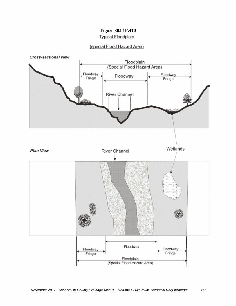
November 2017 Snohomish County Drainage Manual Volume I - Minimum Technical Requirements 89
Figure 30.91F.410

November 2017 Snohomish County Drainage Manual Volume I - Minimum Technical Requirements 90
Floodproofing See SCC 30.91F.420. Any combination of structural and nonstructural
additions, changes or adjustments to properties and structures which
reduce or eliminate flood damages to lands, water and sanitary
facilities, structures and contents of buildings.
Flood protection
elevation The base flood elevation or higher as defined by the local government.
Flood protection
facility Any levee, berm, wall, enclosure, raise bank, revetment, constructed
bank stabilization, or armoring, that is commonly recognized by the
community as providing significant protection to a property from
inundation by flood waters.
Flood routing An analytical technique used to compute the effects of system storage
dynamics on the shape and movement of flow represented by a
hydrograph.
Flood stage The stage at which overflow of the natural banks of a stream begins.
Floodway See SCC 30.91F.430. The regular channel of a river, stream, or other
watercourse, plus the adjacent land areas that must be reserved in order
to discharge the base flood without cumulatively increasing the water
surface elevation more than one foot. (See figure 30.91F.410 for
illustration) .
Floodway fringe See SCC 30.91F.440.That portion of a floodplain which is inundated
by floodwaters but is not within a defined floodway. Floodway fringes
serve as temporary storage areas for floodwaters. (See figure
30.91F.410 for illustration)
Flow control facility A drainage facility designed to mitigate the impacts of increased
surface and stormwater runoff flow rates generated by development.
Flow control facilities are designed either to hold water for a
considerable length of time and then release it by evaporation, plant
transpiration, and/or infiltration into the ground, or to hold runoff for a
short period of time, releasing it to the conveyance system at a
controlled rate.
Flow duration The aggregate time that peak flows are at or above a particular flow
rate of interest. For example, the amount of time that peak flows are at
or above 50% of the 2-year peak flow rate for a period of record.
Flow frequency The inverse of the probability that the flow will be equaled or
exceeded in any given year (the exceedance probability). For
example, if the exceedance probability is 0.01 or 1 in 100, that flow is
referred to as the 100-year flow.

November 2017 Snohomish County Drainage Manual Volume I - Minimum Technical Requirements 91
Flow path The route that stormwater runoff follows between two points of
interest.
Forebay An easily maintained, extra storage area provided near an inlet of a
BMP to trap incoming sediments before they accumulate in a pond or
wetland BMP.
Forest management
activities See SCC 30.91F.470.The growing and harvesting of trees, including
all forest practices associated with continued management of forest
lands for forest products and excluding those practices associated with
the conversion of forest land to a non-forest use unless such lands are
reforested to acceptable stocking levels as defined by WAC 222-34.
Sludge utilization shall not be considered a forest management activity
under this chapter. For purposes of this definition, the meaning of
forest practices and forest lands shall be as defined in chapter 76.09
RCW.
Forest practice Any activity conducted on or directly pertaining to forest land and
relating to growing, harvesting, or processing timber, including but not
limited to:
a. Road and trail construction.
b. Harvesting, final and intermediate.
c. Precommercial thinning.
d. Reforestation.
e. Fertilization.
f. Prevention and suppression of diseases and insects.
g. Salvage of trees.
h. Brush control.
Forested
communities
(wetlands) In general terms, communities (wetlands) characterized by woody
vegetation that is greater than or equal to 6 meters in height; in this
manual the term applies to such communities (wetlands) that represent
a significant amount of tree cover consisting of species that offer
wildlife habitat and other values and advance the performance of
wetland functions overall.
Freeboard The vertical distance between the highest design water surface
elevation and the elevation of the crest of the facility. For example, in
pond design, freeboard is the vertical distance between the emergency
overflow water surface and the top of the pond embankment.

November 2017 Snohomish County Drainage Manual Volume I - Minimum Technical Requirements 92
Frequently flooded
areas The 100-year floodplain designations of the Federal Emergency
Management Agency and the National Flood Insurance Program or as
defined by the local government.
Frost-heave The upward movement of soil surface due to the expansion of water
stored between particles in the first few feet of the soil profile as it
freezes. May cause surface fracturing of asphalt or concrete.
Frequency of storm
(design storm
frequency) The anticipated period in years that will elapse, based on average
probability of storms in the design region, before a storm of a given
intensity and/or total volume will recur; thus a 10-year storm can be
expected to occur on the average once every 10 years. Sewers
designed to handle flows that occur under such storm conditions would
be expected to be surcharged by any storms of greater amount or
intensity.
Fully controlled
limited access
highway A highway where the right of owner or occupants of abutting land or
other persons to access, light, air, or view in connection with the
highway is controlled to give preference to through traffic by
providing access connections with selected public roads only, and by
prohibiting crossings or direct private driveway connections at grade.
(See WAC 468-58-010)
Functions The ecological (physical, chemical, and biological) processes or
attributes of a wetland without regard for their importance to society
(see also values). Wetland functions include food chain support,
provision of ecosystem diversity and fish and wildlife habitat,
floodflow alteration, ground water recharge and discharge, water
quality improvement, and soil stabilization.
Gabion A rectangular or cylindrical wire mesh cage (a chicken wire basket)
filled with rock and used as a protecting agent, revetment, etc., against
erosion. Soft gabions, often used in streambank stabilization, are
made of geotextiles filled with dirt, in between which cuttings are
placed.
Gage or gauge Device for registering precipitation, water level, discharge, velocity,
pressure, temperature, etc. Also, a measure of the thickness of metal;
e.g., diameter of wire, wall thickness of steel pipe.
Gaging station A selected section of a stream channel equipped with a gage, recorder,
or other facilities for determining stream discharge.

November 2017 Snohomish County Drainage Manual Volume I - Minimum Technical Requirements 93
Geologist See SCC 30.91G.030. A person who has received a degree in geology
from an accredited college or university, or a person who has
equivalent educational training and substantial experience as a
practicing geologist.
Geologic hazard
areas See SCC 30.91G.020. Areas that because of their susceptibility to
erosion, sliding, earthquake, or other geologic events, may not be
suited to the siting of commercial, residential, or industrial
development consistent with public health or safety concerns.
Geologically hazardous areas include erosion hazard areas, landslide
hazard areas, seismic hazard areas and mine hazard areas as defined in
Chapter 30.91 SCC.
Geometrics The mathematical relationships between points, lines, angles, and
surfaces used to measure and identify areas of land.
Geotechnical
professional civil
engineer A practicing, geotechnical/civil engineer licensed as a professional
Civil Engineer with the State of Washington who has at least four
years of professional employment as a geotechnical engineer in
responsible charge, including experience with landslide evaluation.
Geotechnical
engineer See SCC 30.91G.040. A licensed civil engineer experienced and
knowledgeable in the theory of soil mechanics, geology and
geotechnical engineering.
Geotechnical
engineering See SCC 30.91G.050.The application of geologic knowledge and
principles in the investigation and evaluation of naturally occurring
rock and soil for use in the design of civil works projects.
"Geotechnical engineering" also means the application of soils
mechanics in the investigation, evaluation and design of civil works
involving the use of earth materials and the inspection or testing
thereof.
Grade See SCC 30.91G.070.The elevation of the ground surface.
(1) "Existing grade" means the elevation of the ground surface prior to
development activity.
(2) "Rough grade" means the stage at which the elevation of the
ground surface approximately conforms to the approved plan.
(3) "Finish grade" means the final elevation of the ground surface
which conforms to the approved grading plan.

November 2017 Snohomish County Drainage Manual Volume I - Minimum Technical Requirements 94
(To) Grade To finish the surface of a canal bed, roadbed, top of embankment or
bottom of excavation.
Gradient terrace An earth embankment or a ridge-and-channel constructed with suitable
spacing and an acceptable grade to reduce erosion damage by
intercepting surface runoff and conducting it to a stable outlet at a
stable nonerosive velocity.
Grassed waterway A natural or constructed waterway, usually broad and shallow, covered
with erosion-resistant grasses, used to conduct surface water from an
area at a reduced flow rate. See also biofilter.
Groundwater See SCC 30.91G.100. The portion of water contained in
interconnected pores or fractures in a saturated zone or stratum located
beneath the surface of the earth or below a surface water body.
Ground water
recharge Inflow to a ground water reservoir.
Ground water table The free surface of the ground water, that surface subject to
atmospheric pressure under the ground, generally rising and falling
with the season, the rate of withdrawal, the rate of restoration, and
other conditions. It is seldom static.
Gully A channel caused by the concentrated flow of surface and stormwater
runoff over unprotected erodible land.
Habitat The specific area or environment in which a particular type of plant or
animal lives. An organism's habitat must provide all of the basic
requirements for life and should be protected from harmful biological,
chemical, and physical alterations.
Hardpan A cemented or compacted and often clay-like layer of soil that is
impenetrable by roots. Also known as glacial till.
Hard surface An impervious surface, a permeable pavement, or a vegetated roof.
Harmful pollutant A substance that has adverse effects to an organism including
immediate death, chronic poisoning, impaired reproduction, cancer or
other effects.
Head (hydraulics) The height of water above any plane of reference. The energy, either
kinetic or potential, possessed by each unit weight of a liquid,
expressed as the vertical height through which a unit weight would
have to fall to release the average energy possessed. Used in various
compound terms such as pressure head, velocity head, and head loss.

November 2017 Snohomish County Drainage Manual Volume I - Minimum Technical Requirements 95
Head loss Energy loss due to friction, eddies, changes in velocity, or direction of
flow.
Heavy metals Metals of high specific gravity, present in municipal and industrial
wastes, that pose long-term environmental hazards. Such metals
include cadmium, chromium, cobalt, copper, lead, mercury, nickel,
and zinc.
High-use site High-use sites are those that typically generate high concentrations of
oil due to high traffic turnover or the frequent transfer of oil. High-use
sites include:
An area of a commercial or industrial site subject to an expected
average daily traffic (ADT) count equal to or greater than 100
vehicles per 1,000 square feet of gross building area;
An area of a commercial or industrial site subject to petroleum
storage and transfer in excess of 1,500 gallons per year, not
including routinely delivered heating oil;
An area of a commercial or industrial site subject to parking,
storage or maintenance of 25 or more vehicles that are over 10 tons
gross weight (trucks, buses, trains, heavy equipment, etc.);
A road intersection with a measured ADT count of 25,000 vehicles
or more on the main roadway and 15,000 vehicles or more on any
intersecting roadway, excluding projects proposing primarily
pedestrian or bicycle use improvements.
Hog fuel See wood-based mulch.
Horton overland
flow A runoff process whereby the rainfall rate exceeds the infiltration rate,
so that the precipitation that does not infiltrate flows downhill over the
soil surface.
Hydrological
simulation
program-fortran
(HSPF) A continuous simulation hydrologic model that transforms an
uninterrupted rainfall record into a concurrent series of runoff or flow
data by means of a set of mathematical algorithms which represent the
rainfall-runoff process at some conceptual level.
Humus Organic matter in or on a soil, composed of partly or fully decomposed
bits of plant tissue or from animal manure.

November 2017 Snohomish County Drainage Manual Volume I - Minimum Technical Requirements 96
Hydraulic
conductivity The quality of saturated soil that enables water or air to move through
it. Also known as permeability coefficient
Hydraulic gradient Slope of the potential head relative to a fixed datum.
Hydrodynamics Means the dynamic energy, force, or motion of fluids as affected by
the physical forces acting upon those fluids.
Hydrograph A graph of runoff rate, inflow rate or discharge rate, past a specific
point over time.
Hydrologic cycle The circuit of water movement from the atmosphere to the earth and
return to the atmosphere through various stages or processes as
precipitation, interception, runoff, infiltration, percolation, storage,
evaporation, and transpiration.

November 2017 Snohomish County Drainage Manual Volume I - Minimum Technical Requirements 97
Hydrologic soil
groups A soil characteristic classification system defined by the U.S. Soil
Conservation Service in which a soil may be categorized into one of
four soil groups (A, B, C, or D) based upon infiltration rate and other
properties.
Type A: Low runoff potential. Soils having high infiltration rates, even
when thoroughly wetted, and consisting chiefly of deep, well drained
to excessively drained sands or gravels. These soils have a high rate of
water transmission.
Type B: Moderately low runoff potential. Soils having moderate
infiltration rates when thoroughly wetted, and consisting chiefly of
moderately fine to moderately coarse textures. These soils have a
moderate rate of water transmission.
Type C: Moderately high runoff potential. Soils having slow infiltration
rates when thoroughly wetted, and consisting chiefly of soils with a
layer that impedes downward movement of water, or soils with
moderately fine to fine textures. These soils have a slow rate of water
transmission.
Type D: High runoff potential. Soils having very slow infiltration rates
when thoroughly wetted, and consisting chiefly of clay soils with a
high swelling potential, soils with a permanent high water table, soils
with a hardpan, till, or clay layer at or near the surface, soils with a
compacted subgrade at or near the surface, and shallow soils or nearly
impervious material. These soils have a very slow rate of water
transmission.1
1 Vladimir Novotny and Harvey Olem. Water Quality Prevention,
Identification, and Management of Diffuse Pollution, Van Nostrand
Reinhold: New York, 1994, p. 109.
Hydrology The science of the behavior of water in the atmosphere, on the surface
of the earth, and underground.
Hydroperiod A seasonal occurrence of flooding and/or soil saturation; it
encompasses depth, frequency, duration, and seasonal pattern of
inundation.
Hyetograph A graph of percentages of total precipitation for a series of time steps
representing the total time in which precipitation occurs.

November 2017 Snohomish County Drainage Manual Volume I - Minimum Technical Requirements 98
Illicit discharge All non-stormwater discharges to stormwater drainage systems that
cause or contribute to a violation of state water quality, sediment
quality or ground water quality standards, including but not limited to
sanitary sewer connections, industrial process water, interior floor
drains, car washing, and greywater systems.
Impact basin A device used to dissipate the energy of flowing water. Generally
constructed of concrete in the form of a partially depressed or partially
submerged vessel, it may utilize baffles to dissipate velocities.
Impervious A surface which cannot be easily penetrated. For instance, rain does
not readily penetrate paved surfaces.
Impervious surface An unvegetated area that either prevents or retards the entry of water
into the soil mantle as compared to infiltration under natural conditions
prior to development. An unvegetated area which causes water to run
off the surface in greater quantities or at an increased rate of flow from
the flow that was present under natural conditions, prior to
development. Common impervious surfaces include, but are not
limited to, roofs, walkways, patios, driveways, parking lots, storage
areas, concrete or asphalt paving, graveled areas and roads, packed
earthen materials, surfaces covered by oil, macadam, asphalt treated
base material (ATB), bituminous surface treatment (BST), chip seal,
seal coat or emulsified asphalt and cutback asphalt cement, and other
surfaces which similarly impede the natural infiltration of stormwater.
Open, uncovered retention and detention facilities shall not be
considered impervious surfaces for purposes of determining whether
the thresholds for applying minimum stormwater management
requirements are exceeded pursuant to Chapter 30.63A SCC.
However, open, uncovered retention and detention facilities shall be
considered impervious surfaces for purposes of runoff modeling.
Impoundment A natural or man-made containment for surface water.
Improvement Streets (with or without curbs or gutters), sidewalks, crosswalks,
parking lots, water mains, sanitary and storm sewers, drainage
facilities, street trees and other appropriate items.

November 2017 Snohomish County Drainage Manual Volume I - Minimum Technical Requirements 99
Industrial activities Material handling, transportation, or storage; manufacturing;
maintenance; treatment; or disposal. Areas with industrial activities
include plant yards, access roads and rail lines used by carriers of raw
materials, manufactured products, waste material, or by-products;
material handling sites; refuse sites; sites used for the application or
disposal of process waste waters; sites used for the storage and
maintenance of material handling equipment; sites used for residual
treatment, storage, or disposal; shipping and receiving areas;
manufacturing buildings; storage areas for raw materials, and
intermediate and finished products; and areas where industrial activity
has taken place in the past and significant materials remain and are
exposed to stormwater.
Infiltration The hydrologic process of storm water runoff soaking into the subsoil,
commonly referred to as percolation
Infiltration facility
(or system) A drainage facility designed to use the hydrologic process of surface
and stormwater runoff soaking into the ground, commonly referred to
as a percolation, to dispose of surface and stormwater runoff.
Infiltration rate The rate, usually expressed in inches/hour, at which water moves
downward (percolates) through the soil profile. Short-term infiltration
rates may be inferred from soil analysis or texture or derived from
field measurements. Long-term infiltration rates are affected by
variability in soils and subsurface conditions at the site, the
effectiveness of pretreatment or influent control, and the degree of
long-term maintenance of the infiltration facility.
Ingress/egress The points of access to and from a property.
Inlet A form of connection between surface of the ground and a drain or
sewer for the admission of surface and stormwater runoff.
Insecticide A substance, usually chemical, that is used to kill insects.
Interception
(hydraulics) The process by which precipitation is caught and held by foliage,
twigs, and branches of trees, shrubs, and other vegetation. Often used
for "interception loss" or the amount of water evaporated from the
precipitation intercepted.

November 2017 Snohomish County Drainage Manual Volume I - Minimum Technical Requirements 100
Interflow That portion of rainfall that infiltrates into the soil and moves laterally
through the upper soil horizons until intercepted by a stream channel
or until it returns to the surface, for example, in a roadside ditch,
wetland, spring or seep. Interflow is a function of the soil system
depth, permeability, and water-holding capacity.
Intermittent stream A stream or portion of a stream that flows only in direct response to
precipitation. It receives little or no water from springs and no long-
continued supply from melting snow or other sources. It is dry for a
large part of the year, ordinarily more than three months.
Invasive weedy
plant species Opportunistic species of inferior biological value that tend to
out-compete more desirable forms and become dominant; applied to
non-native species in this manual.
Invert The lowest point on the inside of a sewer or other conduit.
Invert elevation The vertical elevation of a pipe or orifice in a pond that defines the
water level.
Isopluvial map A map with lines representing constant depth of total precipitation for
a given return frequency.
Lag time The interval between the center of mass of the storm precipitation and
the peak flow of the resultant runoff.

November 2017 Snohomish County Drainage Manual Volume I - Minimum Technical Requirements 101
Lake See SCC 30.91L.010. A body of freshwater that:
(1) Occurs in a depression of land or expanded part of a stream,
including reservoirs;
(2) Is greater than 6.6 feet (2 meters) in depth at the deepest point at
ordinary low water;
(3) Has less than 30% coverage by trees, shrubs, or persistent
emergent vegetation; and.
(4) Has an ocean-derived salinity of less than 0.5 parts per thousand
(ppt).
A lake is bounded by the ordinary high water mark, or, where a stream
enters the lake, the extension of the elevation of the lake's ordinary
high water mark within the stream. Lakes formed by a dam on a
stream or river are bounded by a contour approximating the normal
spillway elevation or normal pool elevation.
Lakes do not include artificial water bodies including, but not limited
to, lakes constructed for irrigation or detention, wastewater treatment
facilities, farm ponds, recreational or fishing ponds or other landscape
ponds, unless they contain naturally occurring salmonids. Naturally
occurring means that the salmonids have migrated into the lake via a
connection to another water body containing salmonids and are not
artificially introduced into the lake.
Land disturbing
activity Any activity that will result in movement of earth or a change in the
existing soil cover or the existing soil topography (both vegetative and
non-vegetative), including the creation and/or replacement of
impervious surfaces. Land disturbing activities include, but are not
limited to, clearing, filling, excavation, and grading. Land disturbing
activities do not include agricultural plowing and tilling exempt from
stormwater regulations pursuant to SCC 30.63A.200. Compaction that
is associated with stabilization of structures and road construction also
is a land disturbing activity. Vegetation and drainage facility
maintenance practices are not land disturbing activities, provided that
the maintenance is performed according to standards adopted by
Snohomish County.
Landslide See SCC 30.91L.030. Downslope movement of a mass of soil, rock,
snow or ice including, but not limited to, rock falls, slumps, mud
flows, debris flows, torrents, earth flows and snow avalanches.

November 2017 Snohomish County Drainage Manual Volume I - Minimum Technical Requirements 102
Landslide hazard
areas See SCC 30.91L.040. Areas potentially subject to mass earth
movement based on a combination of geologic, topographic, and
hydrologic factors, with a vertical height of 10 feet or more. These
include the following:
(1) Areas of historic landslides as evidenced by landslide deposits,
avalanche tracks, and areas susceptible to basal undercutting by
streams, rivers or waves;
(2) Areas with slopes steeper than 33 percent which intersect geologic
contacts with a relatively permeable sediment overlying a
relatively impermeable sediment or bedrock, and which contain
springs or ground water seeps; or
(3) Areas located in a canyon or an active alluvial fan, susceptible to
inundation by debris flows or catastrophic flooding.
Leachable materials Those substances that, when exposed to rainfall, measurably alter the
physical or chemical characteristics of the rainfall runoff. Examples
include erodible soils, uncovered process wastes, manure, fertilizers,
oil substances, ashes, kiln dust, and garbage dumpster leakage.
Leachate Liquid that has percolated through soil and contains substances in
solution or suspension.
Leaching Removal of the more soluble materials from the soil by percolating
waters.
Legume A member of the legume or pulse family, Leguminosae, one of the
most important and widely distributed plant families. The fruit is a
"legume" or pod. Includes many valuable food and forage species,
such as peas, beans, clovers, alfalfas, sweet clovers, and vetches.
Practically all legumes are nitrogen-fixing plants.
Level pool routing The basic technique of storage routing used for sizing and analyzing
detention storage and determining water levels for ponding water
bodies. The level pool routing technique is based on the continuity
equation: Inflow – Outflow = Change in storage.
Level spreader A temporary ESC device used to spread out stormwater runoff
uniformly over the ground surface as sheet flow (i.e., not through
channels). The purpose of level spreaders is to prevent concentrated,
erosive flows from occurring, and to enhance infiltration.
Local government Any county, city, town, or special purpose district having its own
incorporated government for local affairs.

November 2017 Snohomish County Drainage Manual Volume I - Minimum Technical Requirements 103
Low flow channel An incised or paved channel from inlet to outlet in a dry basin which is
designed to carry low runoff flows and/or baseflow, directly to the
outlet without detention.
Low impact
development A stormwater management and land development strategy that strives
to mimic pre-disturbance hydrologic processes of infiltration,
filtration, storage, evaporation and transpiration by emphasizing
conservation, use of on-site natural features, site planning, and
distributed stormwater management practices that are integrated into a
project design.
Low impact development BMPs Distributed stormwater management practices, integrated into a project
design, that emphasize pre-disturbance hydrologic processes of
filtration, storage, evaporation, infiltration and transpiration. Low
impact development BMPs include, but are not limited to,
bioretention/rain gardens, permeable pavements, roof downspout
controls, dispersion, soil quality and depth, minimal excavation
foundations, vegetated roofs, and water re-use.
Low permeability liner A layer of compacted till, compacted clay, concrete, or a
geomembrane.
MDNS A Mitigated Determination of Nonsignificance (See DNS and
Mitigation).
Maintenance Activities conducted on currently serviceable structures, facilities and
equipment that involve no expansion or use beyond that previously
existing and result in no significant adverse hydrologic impact. It
includes those usual activities taken to prevent a decline, lapse or
cessation in the use of structures and systems. Those usual activities
may include replacement of dysfunctional facilities, including cases
where any permit requires replacing an existing structure with a
different type structure, as long as the functioning characteristics of the
original structure are not changed. Maintenance does not include
expansion in physical dimension, capacity or use.

November 2017 Snohomish County Drainage Manual Volume I - Minimum Technical Requirements 104
Manning's equation An equation used to predict the velocity of water flow in an open
channel or pipelines:
V = 1.486R2/3S1/2
n
where:
V is the mean velocity of flow in feet per second
R is the hydraulic radius in feet
S is the slope of the energy gradient or, for assumed uniform flow, the
slope of the channel in feet per foot; and
n is Manning's roughness coefficient or retardance factor of the
channel lining.
Mass wasting The movement of large volumes of earth material downslope.
Master drainage plan A comprehensive drainage control plan intended to prevent significant
adverse impacts to the natural and manmade drainage system, both on
and off-site.
Mean annual water
level fluctuation Derived as follows:
(1) Measure the maximum water level (e.g., with a crest stage gage,
Reinelt and Horner 1990) and the existing water level at the time
of the site visit (e.g., with a staff gage) on at least eight occasions
spread through a year.
(2) Take the difference of the maximum and existing water level on
each occasion and divide by the number of occasions.
Mean depth Average depth; cross-sectional area of a stream or channel divided by
its surface or top width.
Mean velocity The average velocity of a stream flowing in a channel or conduit at a
given cross-section or in a given reach. It is equal to the discharge
divided by the cross-sectional area of the reach.
Measuring weir A shaped notch through which water flows are measured. Common
shapes are rectangular, trapezoidal, and triangular.
Mechanical analysis The analytical procedure by which soil particles are separated to
determine the particle size distribution.
Mechanical practices Soil and water conservation practices that primarily change the surface
of the land or that store, convey, regulate, or dispose of runoff water
without excessive erosion.

November 2017 Snohomish County Drainage Manual Volume I - Minimum Technical Requirements 105
Metals Elements, such as mercury, lead, nickel, zinc and cadmium, which are
of environmental concern because they do not degrade over time.
Although many are necessary nutrients, they are sometimes magnified
in the food chain, and they can be toxic to life in high enough
concentrations. They are also referred to as heavy metals.
Microbes The lower trophic levels of the soil food web. They are normally
considered to include bacteria, fungi, flagellates, amoebae, ciliates,
and nematodes. These in turn support the higher trophic levels, such
as mites and earthworms. Together they are the basic life forms that
are necessary for plant growth. Soil microbes also function to
bioremediate pollutants such as petroleum, nutrients, and pathogens.
Mitigation See SCC 30.91M.120. "Mitigation" means:
(1) Avoiding the impact altogether by not taking a certain action or
parts of an action;
(2) Minimizing impact by limiting the degree or magnitude of the
action and its implementation, by using appropriate technology, or by
taking affirmative steps to avoid or reduce impacts;
(3) Rectifying the impact by repairing, rehabilitating or restoring the
affected environment;
(4) Reducing or eliminating the impact over time by preservation and
maintenance operations during the life of the action;
(5) Compensating for the impact by replacing, enhancing, or providing
substitute resources or environments; or
(6) Monitoring the impact and taking appropriate corrective measures.
Modification,
modified (wetland) A wetland whose physical, hydrological, or water quality
characteristics have been purposefully altered for a management
purpose, such as by dredging, filling, forebay construction, and inlet or
outlet control.
Monitor To systematically and repeatedly measure something in order to track
changes.
Monitoring The collection of data by various methods for the purposes of
understanding natural systems and features, evaluating the impacts of
development proposals on such systems, and assessing the
performance of mitigation measures imposed as conditions of
development.
Mulch A layer of organic material or aggregate applied to the surface of soil.
Organic mulch may be composed of chipped site vegetation, compost,
hydromulch, wood-based or wood straw, wood strand, or straw.

November 2017 Snohomish County Drainage Manual Volume I - Minimum Technical Requirements 106
NGPE See Native Growth Protection Easement.
NGVD National Geodetic Vertical Datum.
NPDES The National Pollutant Discharge Elimination System as established
by the Federal Clean Water Act.
National pollutant
discharge
elimination
system (NPDES) The part of the federal Clean Water Act, which requires point source
dischargers to obtain permits. These permits are referred to as NPDES
permits and, in Washington State, are administered by the Washington
State Department of Ecology.
Native growth
protection easement
(NGPE) An easement granted for the protection of native vegetation within a
critical area or its associated buffer. The NGPE shall be recorded on
the appropriate documents of title and filed with the County Records
Division.
Native vegetation Vegetation comprised of plant species, other than noxious weeds, that
are indigenous to the coastal region of the Pacific Northwest and
which reasonably could have been expected to naturally occur on the
site. Examples include trees such as Douglas fir, Western Hemlock,
Western Red Cedar, Alder, Big-leaf Maple, and Vine Maple; shrubs
such as willow, elderberry, salmonberry and salal; and herbaceous
plants such as sword fern, foam flower, and fireweed.
Natural location Means the location of those channels, swales, and other non-manmade
conveyance systems as defined by the first documented topographic
contours existing for the subject property, either from maps or
photographs, or such other means as appropriate. In the case of
outwash soils with relatively flat terrain, no natural location of surface
discharge may exist.
New development The following land disturbing activities: Class IV - general forest
practices that are conversions from timber land to other uses; structural
development, including construction or installation of a building or
other structure; creation of hard surfaces; and subdivisions, short
subdivisions, residential condominiums, single-family detached units
(SFDU), residential condominiums, planned residential developments
(PRD) and binding site plans. Projects meeting the definition of
redevelopment shall not be considered new development.

November 2017 Snohomish County Drainage Manual Volume I - Minimum Technical Requirements 107
Nitrate (NO3) A form of nitrogen which is an essential nutrient to plants. It can
cause algal blooms in water if all other nutrients are present in
sufficient quantities. It is a product of bacterial oxidation of other
forms of nitrogen, from the atmosphere during electrical storms and
from fertilizer manufacturing.
Nitrification The biochemical oxidation process by which ammonia is changed first
to nitrites and then to nitrates by bacterial action, consuming oxygen in
the water.
Nitrogen, available Usually ammonium, nitrite, and nitrate ions, and certain simple amines
available for plant growth. A small fraction of organic or total
nitrogen in the soil is available at any time.
Nonpoint source
Pollution Pollution that enters a waterbody from diffuse origins on the watershed
and does not result from discernible, confined, or discrete
conveyances.
Normal depth The depth of uniform flow. This is a unique depth of flow for any
combination of channel characteristics and flow conditions. Normal
depth is calculated using Manning's Equation.
NRCS method See SCS Method.
Nutrients Essential chemicals needed by plants or animals for growth.
Excessive amounts of nutrients can lead to degradation of water
quality and algal blooms. Some nutrients can be toxic at high
concentrations.
Off-line facilities Water quality treatment facilities to which stormwater runoff is
restricted to some maximum flow rate or volume by a flow-splitter.
Off-site Any area lying upstream of the site that drains onto the site and any
area lying downstream of the site to which the site drains.
Off-system storage Facilities for holding or retaining excess flows over and above the
carrying capacity of the stormwater conveyance system, in chambers,
tanks, lagoons, ponds, or other basins that are not a part of the
subsurface sewer system.
Oil/water separator A vault, usually underground, designed to provide a quiescent
environment to separate oil from water.

November 2017 Snohomish County Drainage Manual Volume I - Minimum Technical Requirements 108
On-line facilities Water quality treatment facilities which receive all of the stormwater
runoff from a drainage area. Flows above the water quality design
flow rate or volume are passed through at a lower percent removal
efficiency.
On-site The entire property that includes the proposed development.
On-site stormwater
management BMPs Site development techniques that serve to infiltrate, disperse, and
retain stormwater runoff on-site.
Operational BMPs Operational BMPs are a type of Source Control BMP. They are
schedules of activities, prohibition of practices, and other managerial
practices to prevent or reduce pollutants from entering stormwater.
Operational BMPs include formation of a pollution prevention team,
good housekeeping, preventive maintenance procedures, spill
prevention and clean-up, employee training, inspections of pollutant
sources and BMPs, and record keeping. They can also include process
changes, raw material/product changes, and recycling wastes.

November 2017 Snohomish County Drainage Manual Volume I - Minimum Technical Requirements 109
Ordinary high
water mark See SCC 30.91O.030. On all lakes, streams and tidal waters, is the
mark that will be found by examining the beds and banks and
ascertaining where the presence and action of waters are so common
and usual, and so long continued in all ordinary years, as to mark upon
the soil a character distinct from that of the abutting upland, with
respect to vegetation. The following criteria clarify this mark on tidal
waters, lakes, and streams:
(1) Tidal waters.
(a) in high energy environments where the action of waves or
currents is sufficient to prevent vegetation establishment below
mean higher high tide, the ordinary high water mark is coincident
with the line of vegetation. Where there is no vegetative cover for
less than one hundred feet parallel to the shoreline, the ordinary
high water mark is the average tidal elevation of the adjacent lines
of vegetation. Where the ordinary high water mark cannot be
found, it is the elevation of mean higher high tide.
(b) in low energy saltwater environments where the action of
waves and currents is not sufficient to prevent vegetation
establishment below mean higher high tide, the ordinary high
water mark is coincident with the landward limit of hydrophytic
salt tolerant vegetation. "Salt tolerant vegetation" means vegetation
which is tolerant of interstitial soil salinities greater than or equal
to 0.5 parts per thousand (ppt);
(c) In low energy freshwater environments where the action of the
water is not sufficient to prevent vegetation establishment below
the mean higher high tide, use the mean higher high tide elevation
or one or more the following indicators: landward limits of drift
logs or other drift deposits, presence of hydrophytic plants,
presence of hydric soils, soil surface changes from algae, or
sediment deposition areas to areas where the soils show no sign of
depositional processes from water;
(2) Lakes. Where the ordinary high water mark cannot be found, it
shall be the line of mean high water;
(3) Streams. Where the ordinary high water mark cannot be found, it
shall be the line of mean high water. For braided streams, the
ordinary high water mark is found on the banks forming the outer
limits of the depression within which the braiding occurs.

November 2017 Snohomish County Drainage Manual Volume I - Minimum Technical Requirements 110
Organic matter Organic matter as decomposed animal or vegetable matter. It is
measured by ASTM D 2974. Organic matter is an important reservoir
of carbon and a dynamic component of soil and the carbon cycle. It
improves soil and plant efficiency by improving soil physical
properties including drainage, aeration, and other structural
characteristics. It contains the nutrients, microbes, and higher-form
soil food web organisms necessary for plant growth. The maturity of
organic matter is a measure of its beneficial properties. Raw organic
matter can release water-soluble nutrients (similar to chemical
fertilizer). Beneficial organic matter has undergone a humification
process either naturally in the environment or through a composting
process.
Orifice An opening with closed perimeter, usually sharp-edged, and of regular
form in a plate, wall, or partition through which water may flow,
generally used for the purpose of measurement or control of water.
Outlet Point of water disposal from a stream, river, lake, tidewater, or
artificial drain.
Outlet channel A waterway constructed or altered primarily to carry water from man-
made structures, such as terraces, tile lines, and diversions.
Outwash soils Soils formed from highly permeable sands and gravels.
Overflow A pipeline or conduit device, together with an outlet pipe, that
provides for the discharge of portions of combined sewer flows into
receiving waters or other points of disposal, after a regular device has
allowed the portion of the flow which can be handled by interceptor
sewer lines and pumping and treatment facilities to be carried by and
to such water pollution control structures.
Overflow rate Detention basin release rate divided by the surface area of the basin. It
can be thought of as an average flow rate through the basin.
Overtopping To flow over the limits of a containment or conveyance element.
Partially controlled
limited access
highway A highway where the right of owner or occupants of abutting land or
other persons to access, light, air, or view in connection with the
highway is controlled to give preference to through traffic to a degree
that, in addition to access connections with selected public roads, there
may be some crossings and some private driveway connections at
grade. (See WAC 468-58-010)
Particle size The effective diameter of a particle as measured by sedimentation,
sieving, or micrometric methods.
November 2017 Snohomish County Drainage Manual Volume I - Minimum Technical Requirements 111
Peak discharge See SCC 30.91P.120. The maximum instantaneous rate of storm
water runoff in cubic feet per second (cfs) or cubic meters per second
(cms) determined for the design storm.
Peak-shaving Controlling post-development peak discharge rates to pre-development
levels by providing temporary detention in a BMP.
Percolation The movement of water through soil.
Percolation rate The rate, often expressed in minutes/inch, at which clear water,
maintained at a relatively constant depth, will seep out of a
standardized test hole that has been previously saturated. The term
percolation rate is often used synonymously with infiltration rate
(short-term infiltration rate).
Permanent stormwater
control (PSC) plan A plan which includes permanent BMPs for the control of pollution
from stormwater runoff after construction and/or land disturbing
activity has been completed
Permeable soils Soil materials with a sufficiently rapid infiltration rate so as to greatly
reduce or eliminate surface and stormwater runoff. These soils are
generally classified as SCS hydrologic soil types A and B.
Person See SCC 30.91P.160. An individual, partnership, corporation,
association, organization, cooperative, public or municipal
corporation, or agency of the state or local governmental unit, or an
agent or representative thereof.
Perviousness Related to the size and continuity of void spaces in soils; related to a
soil's infiltration rate.
Pervious surface A surface material that allows stormwater to infiltrate into the ground.
Examples include lawn, landscape, pasture, native vegetation areas,
and permeable pavements.
Pesticide A general term used to describe any substance - usually chemical -
used to destroy or control organisms; includes herbicides, insecticides,
algicides, fungicides, and others. Many of these substances are
manufactured and are not naturally found in the environment. Others,
such as pyrethrum, are natural toxins that are extracted from plants and
animals.
pH A measure of the alkalinity or acidity of a substance which is
conducted by measuring the concentration of hydrogen ions in the
substance. A pH of 7.0 indicates neutral water. A 6.5 reading is
slightly acid.

November 2017 Snohomish County Drainage Manual Volume I - Minimum Technical Requirements 112
Physiographic Characteristics of the natural physical environment (including hills).
Plan approval
authority The Plan Approval Authority is defined as that department within a
local government that has been delegated authority to approve
stormwater site plans.
Planned unit
development (PUD) A special classification authorized in some zoning ordinances, where a
unit of land under control of a single developer may be used for a
variety of uses and densities, subject to review and approval by the
local governing body. The locations of the zones are usually decided
on a case-by-case basis.
Plat A map or representation of a subdivision showing the division of a
tract or parcel of land into lots, blocks, streets, or other divisions and
dedications. (NOTE: See also SCC 30.91P.220 - "Plat, final," SCC
30.91P.230 - "Plat, final short," and SCC 30.91P.240 -"Plat,
preliminary."
Plunge pool A device used to dissipate the energy of flowing water that may be
constructed or made by the action of flowing. These facilities may be
protected by various lining materials.
Point discharge The release of collected and/or concentrated surface and stormwater
runoff from a pipe, culvert, or channel.
Point of compliance The location at which compliance with a discharge performance
standard or a receiving water quality standard is measured.
Pollution Contamination or other alteration of the physical, chemical, or
biological properties, of waters of the state, including change in
temperature, taste, color, turbidity, or odor of the waters, or such
discharge of any liquid, gaseous, solid, radioactive or other substance
into any waters of the state as will or is likely to create a nuisance or
render such waters harmful, detrimental or injurious to the public
health, safety or welfare, or to domestic, commercial, industrial,
agricultural, recreational, or other legitimate beneficial uses, or to
livestock, wild animals, birds, fish or other aquatic life.
Pollution generating
hard surface Those hard surfaces considered to be a significant source of pollutants
in stormwater runoff. See the listing of surfaces under pollution-
generating impervious surface.

November 2017 Snohomish County Drainage Manual Volume I - Minimum Technical Requirements 113
Pollution generating
impervious
surface Those impervious surfaces considered to be a significant source of
pollutants in stormwater runoff. Such surfaces include those which are
regularly subject to: vehicular use, industrial activities, or storage of
erodible or leachable materials, wastes, or chemicals, and which
receive direct rainfall or the run-on or blow-in of rainfall. Erodible or
leachable materials, wastes, or chemicals are those substances which,
when exposed to rainfall, measurably alter the physical or chemical
characteristics of the rainfall runoff and are PGIS. Examples include,
but are not limited to, erodible soils that are stockpiled, uncovered
process wastes, manure, fertilizers, oily substances, ashes, kiln dust,
and garbage dumpster leakage. Metal roofs are also considered PGIS
unless they are coated with an inert, non-leachable material such as
baked-on enamel coating. The following surfaces are considered
regularly-used by motor vehicles: roads, unvegetated road shoulders,
bike lanes within the traveled lane of a roadway, driveways, parking
lots, unfenced fire lanes, vehicular equipment storage yards, and
airport runways. A surface, whether paved or not, shall be considered
subject to vehicular use if it is regularly used by motor vehicles. The
following surfaces are not considered to be regularly-used surfaces by
motor vehicles: paved bicycle pathways separated from and not
subject to drainage from roads for motor vehicles, fenced fire lanes,
and infrequently used maintenance access roads.
Pollution-generating
pervious surfaces Any non-impervious surface subject to vehicular use, industrial
activities, or storage of erodible or leachable materials, wastes or
chemicals, and that receive direct rainfall or run-on or blow-in of
rainfall, use of pesticides and fertilizers, or loss of soil. Typical PGPS
include permeable pavement subject to vehicular use, lawns and
landscaped areas including: golf courses, parks, cemeteries, and sports
fields (natural and artificial turf).
Predeveloped
condition A fully-forested condition (soils and vegetation) to which an Ecology-
approved continuous runoff hydrologic model is calibrated, unless
reasonable, historic information is provided that indicates the site was
prairie prior to Euro-American settlement.
Prediction For the purposes of this document an expected outcome based on the
results of hydrologic modeling and/or the judgment of a trained
professional civil engineer or geologist.
Pretreatment The removal of material such as solids, grit, grease, and scum from
flows prior to physical, biological, or physical treatment processes to
improve treatability. Pretreatment may include screening, grit

November 2017 Snohomish County Drainage Manual Volume I - Minimum Technical Requirements 114
removal, settling, oil/water separation, or application of a Basic
Treatment BMP prior to infiltration.
Priority peat systems Unique, irreplaceable fens that can exhibit water pH in a wide range
from highly acidic to alkaline, including fens typified by Sphagnum
species, Ledum groenlandicum (Labrador tea), Drosera rotundifolia
(sundew), and Vaccinium oxycoccos (bog cranberry); marl fens;
estuarine peat deposits; and other moss peat systems with relatively
diverse, undisturbed flora and fauna. Bog is the common name for
peat systems having the Sphagnum association described, but this term
applies strictly only to systems that receive water income from
precipitation exclusively.
Professional civil
engineer A person registered with the state of Washington as a professional
engineer in civil engineering.
Project Any proposed action to alter or develop a site. The proposed action of
a permit application or an approval, which requires drainage review.
Project site That portion of a property, properties, or right of way subject to land
disturbing activities, new hard surfaces, or replaced hard surfaces.
Project proponent Any individual, person, partnership, corporation, association,
organization, cooperative, public or municipal corporation, or agency
of the state or local governmental unit, or an agent or representative
thereof proposing a development activity or project permit.
Properly functioning
soil system (PFSS) Equivalent to engineered soil/landscape system. This can also be a
natural system that has not been disturbed or modified.
Public regional
stormwater
management facility See SCC 30.91P.400. A retention or detention facility serving more
than one site and constructed or owned by a public agency.
Puget sound basin Puget Sound south of Admiralty Inlet (including Hood Canal and
Saratoga Passage); the waters north to the Canadian border, including
portions of the Strait of Georgia; the Strait of Juan de Fuca south of the
Canadian border; and all the lands draining into these waters as
mapped in Water Resources Inventory Areas numbers 1 through 19,
set forth in WAC 173-500-040.
R/D See Retention/detention facility.

November 2017 Snohomish County Drainage Manual Volume I - Minimum Technical Requirements 115
Rare, threatened, or
endangered species Plant or animal species that are regional relatively uncommon, are
nearing endangered status, or whose existence is in immediate
jeopardy and is usually restricted to highly specific habitats.
Threatened and endangered species are officially listed by federal and
state authorities, whereas rare species are unofficial species of concern
that fit the above definitions.
Rational method A means of computing storm drainage flow rates (Q) by use of the
formula Q = CIA, where C is a coefficient describing the physical
drainage area, I is the rainfall intensity and A is the area. This method
is no longer used in the technical manual.
Reach A length of channel with uniform characteristics.
Receiving water
body/receiving waters Naturally and/or reconstructed naturally occurring surface water bodies,
such as creeks, streams, rivers, lakes, wetlands, estuaries, and marine
waters, or groundwater.
Recharge The addition of water to the zone of saturation (i.e., an aquifer).
Recommended
BMPs As used in Volume IV, recommended BMPs are those BMPs that are
not expected to be mandatory by local governments at new
development and redevelopment sites. However, they may improve
pollutant control efficiency, and may provide a more comprehensive
and environmentally effective stormwater management program.
Redevelopment The following activities that take place on a site that already has 35
percent or more existing hard surface coverage: the creation of new
hard surface(s); structural development including construction,
installation, expansion or replacement of a building footprint or other
structure; replacement of existing hard surface that is not maintenance;
and land disturbing activity.
Regional An action (here, for stormwater management purposes) that involves
more than one discrete property.
Regional detention
facility See 30.91P.400 "Public regional storm water management facility
(public regional facility)".
Release rate The computed peak rate of surface and stormwater runoff from a site.

November 2017 Snohomish County Drainage Manual Volume I - Minimum Technical Requirements 116
Replaced hard surface For structures, the removal and replacement of hard surfaces down to the
foundation. For other hard surfaces, the removal down to bare soil or
base course and replacement.
Replaced impervious
surface For structures, the removal and replacement of impervious surfaces
down to the foundation. For other impervious surfaces, the removal
down to bare soil or base course and replacement.
Residential density The number of dwelling units per unit of surface area. Net density
includes only occupied land. Gross density includes unoccupied
portions of residential areas, such as roads and open space.
Restoration Actions performed to reestablish wetland functional characteristics and
processes that have been lost by alterations, activities, or catastrophic
events in an area that no longer meets the definition of a wetland.
Retention The process of collecting and holding surface and stormwater runoff
with no surface outflow.
Retention facility See SCC 30.91R.170. An open or closed facility, such as a pond or
tank, that stores storm water runoff without release except by means of
evaporation, plant transpiration or infiltration into the ground. The
facility includes the flow control structure, the infiltration system, the
inlet and outlet pipes, and all maintenance access points.
Retrofitting The renovation of an existing structure or facility to meet changed
conditions or to improve performance.
Return frequency A statistical term for the average time of expected interval that an
event of some kind will equal or exceed given conditions (e.g., a
stormwater flow that occurs every 2 years).
Rhizome A modified plant stem that grows horizontally underground.
Riffles Fast sections of a stream where shallow water races over stones and
gravel. Riffles usually support a wider variety of bottom organisms
than other stream sections.
Rill A small intermittent watercourse with steep sides, usually only a few
inches deep. Often rills are caused by an increase in surface water
flow when soil is cleared of vegetation.
Riprap A facing layer or protective mound of rocks placed to prevent erosion
or sloughing of a structure or embankment due to flow of surface and
stormwater runoff.
Riparian Pertaining to the banks of streams, wetlands, lakes, or tidewater.

November 2017 Snohomish County Drainage Manual Volume I - Minimum Technical Requirements 117
Riser A vertical pipe extending from the bottom of a pond BMP that is used
to control the discharge rate from a BMP for a specified design storm.
Road, private See SCC 30.91R.230. A privately maintained easement or parcel
created to provide vehicle access from a public road to one or more
lots, and where appropriate, may include pedestrian, equestrian and
bicycle facilities. Limits may include the outside edge of sidewalks, or
curbs and gutters, planter strips, paths, walkways, or side ditches,
including the appertaining shoulder and all slopes, ditches, channels,
waterways, and other features necessary for proper drainage and
structural stability within the easement or parcel.
Rodenticide A substance used to destroy rodents.
Runoff See SCC 30.91R.252. Water originating from rainfall and other
precipitation that is found in drainage facilities, rivers, streams,
springs, seeps, ponds, lakes and wetlands as well as shallow
groundwater. It includes the portion of rainfall or other precipitation
that becomes surface flow and interflow.
SCS Soil Conservation Service (now the Natural Resources Conservation
Service), U.S. Department of Agriculture
SCS method A single-event hydrologic analysis technique for estimating runoff
based on the Curve Number method. The Curve Numbers are
published by NRCS in Urban Hydrology for Small Watersheds, 55 TR,
June 1976. With the change in name to the Natural Resource
Conservation Service, the method may be referred to as the NRCS
Method.
SEPA See State Environmental Policy Act.
Salmonid See SCC 30.91S.010 A member of the fish family salmonidae
including chinook, coho, chum, sockeye, and pink salmon; rainbow,
steelhead, searun cutthroat, cutthroat trout, brown and bull trout; brook
and Dolly Varden char; kokanee and whitefish.
Sand filter A man-made depression or basin with a layer of sand that treats
stormwater as it percolates through the sand and is discharged via a
central collector pipe.
Saturation point In soils, the point at which a soil or an aquifer will no longer absorb
any amount of water without losing an equal amount.
Scour Erosion of channel banks due to excessive velocity of the flow of
surface and stormwater runoff.
November 2017 Snohomish County Drainage Manual Volume I - Minimum Technical Requirements 118
Sediment Fragmented material that originates from weathering and erosion of
rocks or unconsolidated deposits, and is transported by, suspended in,
or deposited by water.
Sedimentation The depositing or formation of sediment.
Sensitive emergent
vegetation
communities Assemblages of erect, rooted, herbaceous vegetation, excluding
mosses and lichens, at least some of whose members have relatively
narrow ranges of environmental requirements, such as hydroperiod,
nutrition, temperature, and light. Examples include fen species such as
sundew and, as well as a number of species of Carex (sedges).
Sensitive life stages Stages during which organisms have limited mobility or alternatives in
securing the necessities of life, especially including reproduction,
rearing, and migration periods.
Sensitive scrub-shrub
vegetation
communities Assemblages of woody vegetation less than 6 meters in height, at least
some of whose members have relatively narrow ranges of
environmental requirements, such as hydroperiod, nutrition,
temperature, and light. Examples include fen species such as Labrador
tea, bog laurel, and cranberry.
Settleable solids Those suspended solids in stormwater that separate by settling when
the stormwater is held in a quiescent condition for a specified time.
Sheet erosion The relatively uniform removal of soil from an area without the
development of conspicuous water channels.
Sheet flow Runoff that flows over the ground surface as a thin, even layer, not
concentrated in a channel.
Shoreline
development The proposed project as regulated by the Shoreline Management Act.
Usually the construction over water or within a shoreline zone
(generally 200 feet landward of the water) of structures such as
buildings, piers, bulkheads, and breakwaters, including environmental
alterations such as dredging and filling, or any project which interferes
with public navigational rights on the surface waters.
Short circuiting The passage of runoff through a BMP in less than the design treatment
time.

November 2017 Snohomish County Drainage Manual Volume I - Minimum Technical Requirements 119
Siltation The process by which a river, lake, or other waterbody becomes
clogged with sediment. Silt can clog gravel beds and prevent
successful salmon spawning.
Site The area defined by the legal boundaries of a parcel or parcels of land
that is (are) subject to new development or redevelopment including
contiguous improvements in the right of way. For road projects, the
length of the project site and right-of-way boundaries define the site.
Slope An inclined ground surface, the inclination of which is expressed as a
ratio of horizontal distance to vertical distance or as a percentage of
rise over run (vertical over horizontal distance. (See figure 30.91S.400
for illustrations) Average slope is determined for the site by using the
time of concentration line as the horizontal length and the vertical
difference along said line. Slope is the vertical difference divided by
the horizontal length expressed as a percentage. The overall site risk is
based on the highest risk slope being disturbed with an area of 5,000
square feet or more.
Sloughing The sliding of overlying material. It is the same effect as caving, but it
usually occurs when the bank or an underlying stratum is saturated or
scoured.
Soil See SCC 30.91S.460. The naturally occurring, unconsolidated mineral
and organic material deposits overlying bedrock.
Soil group,
hydrologic A classification of soils by the Soil Conservation Service into four
runoff potential groups. The groups range from A soils, which are
very permeable and produce little or no runoff, to D soils, which are
not very permeable and produce much more runoff.
Soil horizon A layer of soil, approximately parallel to the surface, which has
distinct characteristics produced by soil-forming factors.
Soil profile A vertical section of the soil from the surface through all horizons,
including C horizons.
Soil structure The relation of particles or groups of particles which impart to the
whole soil a characteristic manner of breaking; some types are crumb
structure, block structure, platy structure, and columnar structure.
Soil permeability The ease with which gases, liquids, or plant roots penetrate or pass
through a layer of soil.
Soil stabilization The use of measures such as rock lining, vegetation or other
engineering structures to prevent the movement of soil when loads are
applied to the soil.

November 2017 Snohomish County Drainage Manual Volume I - Minimum Technical Requirements 120
Soil texture class The relative proportion, by weight, of particle sizes, based on the
USDA system, of individual soil grains less than 2 mm equivalent
diameter in a mass of soil. The basic texture classes in the
approximate order of increasing proportions of fine particles include:
sand, loamy sand, sandy loam, loam, silt loam, silt, clay loam, sandy
clay, silty clay, and clay.
Sorption The physical or chemical binding of pollutants to sediment or organic
particles.
Source control
best management
practice Structures, equipment, supplies or operations intended to prevent
pollutants from coming into contact with stormwater through physical
separation of areas or careful management of activities that are sources
of pollutants.
Spill control device A Tee section or turn down elbow designed to retain a limited volume
of pollutant that floats on water, such as oil or antifreeze. Spill control
devices are passive and must be cleaned-out for the spilled pollutant to
actually be removed.
Spillway A passage such as a paved apron or channel for surplus water over or
around a dam or similar obstruction. An open or closed channel, or
both, used to convey excess water from a reservoir. It may contain
gates, either manually or automatically controlled, to regulate the
discharge of excess water.
State environmental
policy act (SEPA)
RCW 43.21C The Washington State law intended to minimize environmental
damage. SEPA requires that state agencies and local governments
consider environmental factors when making decisions on activities,
such as development proposals over a certain size and comprehensive
plans. As part of this process, environmental documents are prepared
and opportunities for public comment are provided.

November 2017 Snohomish County Drainage Manual Volume I - Minimum Technical Requirements 121
Steep slope Slopes of 40 percent gradient or steeper within a vertical elevation
change of at least ten feet. A slope is delineated by establishing its toe
and top, and is measured by averaging the inclination over at least ten
feet of vertical relief. For the purpose of this definition:
The toe of a slope is a distinct topographic break in slope that
separates slopes inclined at less than 40% from slopes 40% or steeper.
Where no distinct break exists, the toe of a steep slope is the lower-
most limit of the area where the ground surface drops ten feet or more
vertically within a horizontal distance of 25 feet; AND
The top of a slope is a distinct topographic break in slope that
separates slopes inclined at less than 40% from slopes 40% or steeper.
Where no distinct break exists, the top of a steep slope is the upper-
most limit of the area where the ground surface drops ten feet or more
vertically within a horizontal distance of 25 feet.
Storage routing A method to account for the attenuation of peak flows passing through
a detention facility or other storage feature.
Storm drains The enclosed conduits that transport surface and stormwater runoff
toward points of discharge (sometimes called storm sewers).
Storm frequency The time interval between major storms of predetermined intensity and
volumes of runoff for which storm sewers and other structures are
designed and constructed to handle hydraulically without surcharging
and backflooding, e.g., a 2-year, 10-year or 100-year storm.
Storm sewer A sewer that carries stormwater and surface water, street wash and
other wash waters or drainage, but excludes sewage and industrial
wastes. Also called a storm drain.
Stormwater That portion of precipitation that does not naturally percolate into the
ground or evaporate, but flows via overland flow, interflow, pipes and
other features of a stormwater drainage system into a defined surface
waterbody, or a constructed infiltration facility.
Stormwater drainage
system Constructed and natural features which function together as a system
to collect, convey, channel, hold, inhibit, retain, detain, infiltrate,
divert, treat or filter stormwater.
Stormwater facility A system of collecting, conveying, and storing stormwater runoff.
Stormwater facilities include, but are not limited to, all stormwater
conveyance systems and containment facilities including pipelines,
channels, dikes, ditches, closed depressions, stormwater flow control
facilities, stormwater treatment facilities, erosion and sedimentation

November 2017 Snohomish County Drainage Manual Volume I - Minimum Technical Requirements 122
control facilities, and other drainage structures and appurtenances,
both natural and artificial.
Stormwater site plan The comprehensive report containing all of the technical information
and analysis necessary for regulatory agencies to evaluate a proposed
new development or redevelopment project for compliance with
stormwater requirements. Contents of the Stormwater Site Plan will
vary with the type and size of the project, and individual site
characteristics. It includes a Stormwater Pollution Prevention Plan
(SWPPP) and a Permanent Stormwater Control Plan (PSC Plan).
Guidance on preparing a Stormwater Site Plan is contained in Chapter
3 of Volume I.
Strahler stream order See SCC 30.91S.637. The hierarchical ordering of streams based on
the degree of branching. A first-order stream is an unforked or
unbranched stream. Two first-order streams flow together to form a
second-order stream, two second-order streams combine to make a
third-order stream, etc. (Strahler 1957). This ordering method starts at
zero at each terminal segment, and proceeds towards the root stream.
Each time a bifurcation node is encountered, if both daughter branches
have the same order, then the order is increased by one, otherwise the
largest order is used.
Stream gaging The quantitative determination of stream flow using gages, current
meters, weirs, or other measuring instruments at selected locations.
See Gaging station.
Streambanks The usual boundaries, not the flood boundaries, of a stream channel.
Right and left banks are named facing downstream.
Stream See SCC 30.91S.640. Those areas where naturally occurring surface
waters flow sufficiently to produce a defined channel or bed which
demonstrates evidence of the passage of water including, but not
limited to, bedrock channels, gravel beds, sand and silt beds and
defined-channel swales. A defined channel or bed means a water
course that is scoured by water or contains deposits of mineral
alluvium. The channel or bed need not contain water during the entire
year. Streams do not include water courses which were created entirely
by artificial means, such as irrigation ditches, canals, roadside ditches
or storm or surface water run-off features, unless the artificially
created water course contains salmonids or conveys a stream that was
naturally occurring prior to the construction of the artificially created
water course.
Structure A catchbasin or manhole in reference to a storm drainage system.

November 2017 Snohomish County Drainage Manual Volume I - Minimum Technical Requirements 123
Structural source
control BMPs Physical, structural, or mechanical devices or facilities that are
intended to prevent pollutants from entering stormwater. Structural
source control BMPs typically include:
Enclosing and/or covering the pollutant source (building or other
enclosure, a roof over storage and working areas, temporary tarp,
etc.).
Segregating the pollutant source to prevent run-on of stormwater,
and to direct only contaminated stormwater to appropriate treatment
BMPs.
Stub-out A short length of pipe provided for future connection to a storm
drainage system.
Subbasin A drainage area that drains to a water-course or waterbody named and
noted on common maps and which is contained within a basin.
Subcatchment A subdivision of a drainage basin (generally determined by
topography and pipe network configuration).
Subdrain A pervious backfilled trench containing stone or a pipe for intercepting
ground water or seepage.
Subgrade A layer of stone or soil used as the underlying base for a BMP.
Subsoil The B horizons of soils with distinct profiles. In soils with weak
profile development, the subsoil can be defined as the soil below the
plowed soil (or its equivalent of surface soil), in which roots normally
grow. Although a common term, it cannot be defined accurately. It
has been carried over from early days when "soil" was conceived only
as the plowed soil and that under it as the "subsoil."
Substrate The natural soil base underlying a BMP.
Surcharge The flow condition occurring in closed conduits when the hydraulic
grade line is above the crown of the sewer.
Surface water See SCC 30.91S.760. Waters that flow over the land surface and
frequently interact with groundwater.
Surface and
stormwater Water originating from rainfall and other precipitation that is found in
drainage facilities, rivers, streams, springs, seeps, ponds, lakes, and
wetlands as well as shallow ground water.

November 2017 Snohomish County Drainage Manual Volume I - Minimum Technical Requirements 124
Surface and stormwater
management
system Drainage facilities and any other natural features that collect, store,
control, treat and/or convey surface and stormwater.
Suspended solids Organic or inorganic particles that are suspended in and carried by the
water. The term includes sand, mud, and clay particles (and associated
pollutants) as well as solids in stormwater.
Swale A shallow drainage conveyance with relatively gentle side slopes,
generally with flow depths less than one foot.
Terrace An embankment or combination of an embankment and channel across
a slope to control erosion by diverting or storing surface runoff instead
of permitting it to flow uninterrupted down the slope.
Threshold discharge
area An onsite area draining to a single natural discharge location or
multiple natural discharge locations that combine within one-quarter
mile downstream as determined by the shortest flowpath. See figure
below.

November 2017 Snohomish County Drainage Manual Volume I - Minimum Technical Requirements 125
Tightline A continuous length of pipe that conveys water from one point to
another (typically down a steep slope) with no inlets or collection
points in between.
Tile, Drain Pipe made of burned clay, concrete, or similar material, in short
lengths, usually laid with open joints to collect and carry excess water
from the soil.
Tile drainage Land drainage by means of a series of tile lines laid at a specified
depth and grade.
Till A layer of poorly sorted soil deposited by glacial action that generally
has very low infiltration rates.
Time of
concentration The time period necessary for surface runoff to reach the outlet of a
subbasin from the hydraulically most remote point in the tributary
drainage area.
Timber See SCC 30.91T.254. Forest trees, standing or down, of a commercial
species, including Christmas trees. Timber does not include Christmas
trees that are cultivated by agricultural methods, as that term is defined
in RCW 84.33.035.
Topography General term to include characteristics of the ground surface such as
plains, hills, mountains, degree of relief, steepness of slopes, and other
physiographic features.
Topsoil Topsoil shall be per ASTM D5268 standard specification, and water
permeability shall be 0.6 inches per hour or greater. Organic matter
shall have not more than 10 percent of nutrients in mineralized water-
soluble forms. Topsoil shall not have phytotoxic characteristics.
Total dissolved
solids The dissolved salt loading in surface and subsurface waters.
Total petroleum
hydrocarbons
(TPH) TPH-Gx: The qualitative and quantitative method (extended) for
volatile (“gasoline”) petroleum products in water; and TPH-Dx: The
qualitative and quantitative method (extended) for semi-volatile
(“diesel”) petroleum products in water.
Total solids The solids in water, sewage, or other liquids, including the dissolved,
filterable, and nonfilterable solids. The residue left when the moisture
is evaporated and the remainder is dried at a specified temperature,
usually 130C.

November 2017 Snohomish County Drainage Manual Volume I - Minimum Technical Requirements 126
Total suspended
solids That portion of the solids carried by stormwater that can be captured
on a standard glass filter.
Toxic Poisonous, carcinogenic, or otherwise directly harmful to life.
Tract A legally created parcel of property designated for special
nonresidential and noncommercial uses.
Trash rack A structural device used to prevent debris from entering a spillway or
other hydraulic structure.
Travel time The estimated time for surface water to flow between two points of
interest.
Treatment BMP A BMP that is intended to remove pollutants from stormwater. A few
examples of treatment BMPs are Wetponds, oil/water separators,
biofiltration swales, and constructed wetlands.
Treatment liner A layer of soil that is designed to slow the rate of infiltration and
provide sufficient pollutant removal so as to protect groundwater
quality.
Treatment train A combination of two or more treatment facilities connected in series.
Turbidity Dispersion or scattering of light in a liquid, caused by suspended solids
and other factors; commonly used as a measure of suspended solids in
a liquid.
Underdrain Plastic pipes with holes drilled through the top, installed on the bottom
of an infiltration BMP, which are used to collect and remove excess
runoff.
Undisturbed buffer A zone where development activity shall not occur, including logging,
and/or the construction of utility trenches, roads, and/or surface and
stormwater facilities.
Undisturbed low
gradient uplands Forested land, sufficiently large and flat to infiltrate surface and storm
runoff without allowing the concentration of water on the surface of
the ground.
Unstable slopes Those sloping areas of land which have in the past exhibited, are
currently exhibiting, or will likely in the future exhibit, mass
movement of earth.
Unusual biological

November 2017 Snohomish County Drainage Manual Volume I - Minimum Technical Requirements 127
community types Assemblages of interacting organisms that are relatively uncommon
regionally.
Urbanized area Areas designated and identified by the U.S. Bureau of Census
according to the following criteria: an incorporated place and densely
settled surrounding area that together have a maximum population of
50,000.
U.S. EPA The United States Environmental Protection Agency.
Values Wetland processes or attributes that are valuable or beneficial to
society (also see Functions). Wetland values include support of
commercial and sport fish and wildlife species, protection of life and
property from flooding, recreation, education, and aesthetic
enhancement of human communities.
Vegetation All organic plant life growing on the surface of the earth.
Vegetation or
effective cover Ground that has natural permanent growth sufficient to resist erosion
during normal winter rainstorm events.
Vehicular use Regular use of an impervious or pervious surface by motor vehicles.
The following are subject to regular vehicular use: roads, un-vegetated
road shoulders, bike lanes within the traveled lane of a roadway,
driveways, parking lots, unrestricted access fire lanes, vehicular
equipment storage yards, and airport runways.
The following are not considered subject to regular vehicular use:
paved bicycle pathways separated from and not subject to drainage
from roads for motor vehicles, restricted access fire lanes, and
infrequently used maintenance access roads.
Waterbody Surface waters including rivers, streams, lakes, marine waters,
estuaries, and wetlands.
Water quality See SCC 30.91W.025. The chemical, physical, and biological
characteristics of water, usually with respect to its suitability for a
particular purpose.
Water quality design
storm The 24-hour rainfall amount with a 6-month return frequency.
Commonly referred to as the 6-month, 24-hour storm.
Water quality

November 2017 Snohomish County Drainage Manual Volume I - Minimum Technical Requirements 128
standards Minimum requirements of purity of water for various uses; for
example, water for agricultural use in irrigation systems should not
exceed specific levels of sodium bicarbonate, pH, total dissolved salts,
etc. In Washington, the Department of Ecology sets water quality
standards.
Watershed A geographic region within which water drains into a particular river,
stream, or body of water. Watersheds can be as large as those
identified and numbered by the State of Washington Water Resource
Inventory Areas (WRIAs) as defined in Chapter 173-500 WAC.
Water table The upper surface or top of the saturated portion of the soil or bedrock
layer, indicates the uppermost extent of ground water.
Weir Device for measuring or regulating the flow of water.
Weir notch The opening in a weir for the passage of water.
Wetland An area that is inundated or saturated by surface or ground water at a
frequency and duration sufficient to support, and that under normal
circumstances does support, a prevalence of vegetation typically
adapted for life in saturated soil conditions. Wetlands generally
include, but are not limited to swamps, marshes, bogs, and similar
areas, as well as artificial wetlands intentionally created from non-
wetland areas to mitigate for conversion of wetlands, as permitted by
the county. Wetlands do not include those artificial wetlands
intentionally created from non-wetland sites, including, but not limited
to irrigation and drainage ditches, grass-lined biofiltration swales,
canals, detention facilities, wastewater treatment facilities, farm ponds
and landscaping amenities, or those wetlands created after July 1,
1990, that were unintentionally created as a result of the construction
of a road, street, or highway. The detailed methodology for wetland
delineation is contained in Washington State Wetlands Identification
and Delineation Manual Washington State Department of Ecology,
Publication #96-94, March 1997.
Wetland edge Delineation of the wetland edge shall be based on the U.S. Army
Corps of Engineers Wetlands Delineation Manual, Technical
Report Y-87-1, U.S. Army Engineers Waterways Experiment Station,
Vicksburg, Miss. (1987)
Wetponds and
Wetvaults Drainage facilities for water quality treatment that contain permanent
pools of water that are filled during the initial runoff from a storm
event. They are designed to optimize water quality by providing
retention time in order to settle out particles of fine sediment to which

November 2017 Snohomish County Drainage Manual Volume I - Minimum Technical Requirements 129
pollutants such as heavy metals absorb, and to allow biologic activity
to occur that metabolizes nutrients and organic pollutants.
Wetpool A pond or constructed wetland that stores runoff temporarily and
whose normal discharge location is elevated so as to maintain a
permanent pool of water between storm events.
Zoning See SCC 30.91Z.030. The process by which the county legally
controls the use of property and physical configuration of development
upon tracts of land within its jurisdiction by establishing zones and
adopting the zoning map. Zoning is an official control that implements
the comprehensive plan and is enacted for the protection of the public
health, safety and welfare.


