Appendix A: Crowe Valley Conservation Authority Records and Communications
Appendix B: NHIC Records
Appendix C: Land Information Ontario Mapping
Appendix D: Field Notes
Kawartha Biogas Water Bodies Assessment Report
1
1.0 INTRODUCTION
The Water Bodies Assessment Report is required by the Ministry of Environment (MOE) to
satisfy part of the requirements for a Renewable Energy Approval (REA) under Ontario
Regulation 359/09 Renewable Energy Approvals Under Part V.0.1 Of The Environmental
Protection Act (O.Reg 359/09). O.Reg. 359/09 requires a Water Bodies Assessment Report for
all classes of bio-energy facilities which includes the following:
Records Review to determine if water bodies are present on or within 120 metres of the
project location, or within 300 metres of a lake trout lake. Records that relate to water
bodies and that are maintained by the municipal, provincial and federal agencies must be
searched and reviewed;
Site Investigation of all lands within 120 metres of the project location to determine if
additional water bodies exist that may not be present on the records reviewed, and to
confirm water bodies that were identified in the records review. If a lake trout lake is
identified within 300 metres of the project location, additional investigated areas will be
conducted; and
Identification of potential negative environmental impacts that may occur as a result of
the construction, operation or decommissioning of the proposed project to any water
body identified. Mitigation measures, monitoring plans and contingency measures
would be applied to all identified potential negative impacts.
1.1 Definition of Water Body
A water body is defined under O.Reg. 359/09 as:
"water body" includes a lake, a permanent stream, an intermittent steam and a seepage
area but does not include:
a) grassed waterways,
b) temporary channels for surface drainage, such as furrows or shallow channels that
can be tilled and driven through,
c) rock chutes and spillways,
d) roadside ditches that do not contain a permanent or intermittent stream,
e) temporarily ponded areas that are normally farmed,
Kawartha Biogas Water Bodies Assessment Report
2
f) dugout ponds, or
g) artificial bodies of water intended for storage, treatment or recirculation of runoff for
farm animal yards, manure storage facilities and sites and outdoor confinement
areas.
1.2 Project Overview
purEnergy Inc. will construct and operate an anaerobic digestion facility known as "Kawartha
Biogas" for the production of 9.8 megawatts of green electricity that will be sold to the Ontario
Power Authority under a Feed-In-Tariff (FIT), contract reference number FIT-FPZXS2N. The
proposed facility will receive and process organic material for the creation of biogas used to
make green electricity.
The location of the project site is approximately 4.5 hectares in size and is legally described as
Part Lot 6, Concession VI in the former geographic Township of Belmont, now amalgamated to
the Municipality of Havelock-Belmont-Methuen, in the County of Peterborough, Ontario.
Figure 1 of this report (following text) shows the site location.
Since the early 1920's, the project site has been used as a staging area for rock piles associated
with quarry mining activities directly north of the site. The site is located in a mixed land use
setting including industrial (Kawartha Ethanol) directly west of the site, Aggregate Extraction
(Drain Bros. Excavating Quarry and Crushing Plant) directly north of the facility and rural
residential, farming and commercial along Highway #7.
Details regarding the construction, operation and decommission of the proposed facility were
provided under separate cover under the REA application requirements.
Kawartha Biogas Water Bodies Assessment Report
3
2.0 Records Review
O.Reg. 359/09, Section 30 requires that all Class 3 Anaerobic Digestion (Biogas) Facilities
conduct a records review in order to document all water bodies on and within at least 120 metres
of the project site, and any lake trout lake that is at or above development lake capacity within
300 metres of the project site boundary. In order to fulfill this requirement, the following records
have been reviewed:
Historical Records
National Aerial Photographs 1929 – 1995.
Historical site records from previous site owners.
Municipal Records
Township of Havelock-Belmont-Methuen Official Plan, Office Consolidation,
January 2004.
Conservation Authority Records
Crowe Valley Conservation Authority, Generic Regulation 159/06 Development,
Interference with Wetlands and Alterations to Shorelines and Watercourses
Mapping, and floodplain mapping.
Provincial Records
Natural Heritage Information Centre (NHIC), digital database maintained by the
MNR in Ontario.
Publications produced by the Ministry of Natural Resources.
Land Information Ontario, digital database maintained by the MRN in Ontario.
Protected Areas.
Federal Records
No known federal records were identified pertaining to the site.
Kawartha Biogas Water Bodies Assessment Report
4
2.1 Historical Records
Based on a review of historical aerial photographs for the site and surrounding lands, and a
review of local historical information, the project site and surround lands consisted of the
following:
Date Reference Project Site Adjacent Lands within 120 metres
1929 Aerial Photograph
- National Air
Photo Library
(NAPL)
The site contains a
series of roadways
used for access to
the quarry north of
the site.
North: Quarry operations are visible on
the aerial photograph followed by a large
treed area inferred to be Plato Creek
Wetland;
East: A network of roadways surrounded
by farmland;
South: Farmland followed by a homestead
abutting the north side of Highway 7;
West: Farmland followed by patches of
wooded areas.
1948 Aerial Photograph
- NAPL
The site appears to
be used in support of
the continued quarry
operations
(roadway/stock piles
of aggregate
materials) and
farmland.
North: Quarry operations expand both
north and northwest of the site. Stockpiles
of what is inferred to be aggregate
materials are visible;
East: Stockpiles of aggregate materials are
visible followed by farmland;
South: Farmland with some areas along
the access road containing what is inferred
to be stockpiles of aggregate materials;
West: Internal access roads and a storage
yard to the newly developed quarry
operations are visible.
1960 News Article by
3M Canada
"Local History"
Unknown 3M opens a plant directly west of the
Project site for producing ceramic-coated
roofing granules.
1963 Aerial Photograph
- NAPL
Further development
on the site is visible
and includes a
railway line, a
network of roadways
and stock piles of
aggregate materials.
North: A large facility inferred to be the
3M plant is visible. Quarry operations
expand north, northwest and east of the
site. A large portion of the treed area now
part of the Plato Creek Wetland has been
removed. Stockpiles of aggregate
materials are visible at several locations
north of the site;
East: A significant expansion of the
quarry operations is visible with a network
of roadways developed;
South: South of the Project site remains as
farmland with little change;
West: Quarry operations continue west of
Kawartha Biogas Water Bodies Assessment Report
5
Date Reference Project Site Adjacent Lands within 120 metres
the site and a small building is visible.
Several stockpiles of materials are visible.
1976 Aerial Photograph
- NAPL
No significant
changes to the site
since 1963 are
apparent.
North: Quarry operations are further
developed north of the 3M plant;
East: Quarry operations continue to
expand both east and southeast of the site;
South: South of the Project site remains as
farmland with the homestead abutting
Highway 7 no longer present;
West: No significant changes were noted
west of the site since 1963.
1987 Aerial Photograph
- NAPL
The site appears to
be a network of
roadways in support
of the quarry
operations.
North: No significant changes since 1976
are apparent;
East: Quarry operations continue to
expand both east and southeast of the site;
South: Farming activities appear to have
ceased with this land being left fallow or
becoming part of the quarry operations;
West: Quarry operations to the west
appear to have ceased and lands appear to
have been left fallow.
1995 Aerial Photograph
- NAPL
No significant
changes to the site
were apparent. The
site continues to be
used in support of
quarry operations.
North: Quarry operations expand to the
north of the site;
East: Quarry operations continue to
expand east of the site;
South: No significant changes since 1987
were noted south of the site;
West: A new building was noted. The
previously farmed land area appears to be
covered with trees (planted with Scots
Pine).
The site and surrounding lands have a long history of development in support of quarry
operations. The site has been used since at least 1929 (based on aerial photographs) for
quarrying operations including a stockpiling area and a series of internal roadways that provided
access to the quarry. No water bodies have been present on the site since at least 1929 to present
day. The site was purchased by the Drain Brothers Excavating Ltd. in 2006 for the continued
quarry mining activities and, in 2007, for the production of ethanol (west of the proposed project
site).
Kawartha Biogas Water Bodies Assessment Report
6
2.2 Township of Havelock-Belmont-Methuen Official Plan
The site is located within the municipal planning area governed by the Township of Havelock-
Belmont-Methuen in the county of Peterborough. Based upon a review of the Township of
Havelock-Belmont-Methuen Official Plan, Office Consolidation, January 2004 and discussions
with planning department staff, the site is located on an aggregate resources area [Schedule A1:
Land Use and Transportation Plan]. This designation is associated with the active quarry located
directly north and east of the site. Based upon the Official Plan's permitted uses for the site,
Section 3.3 states:
The Aggregate Resource classification of land shall mean that the predominant use of
land in areas so designated shall be for the extraction and storage of aggregate. The
development and control of the use of such lands shall be governed by the following
criteria. The uses permitted shall be limited to the extraction and storage of aggregate.
Open space, forestry and agricultural uses, including barns, silos, drive sheds and
dwellings accessory to agriculture shall be permitted where such uses do not preclude or
hinder future extraction. In addition, ancillary uses to aggregate extraction such as
aggregate crushing screening and washing as well as asphalt plants, ready-mix concrete
plants and aggregate transfer stations and/or any other aggregate processing operation
also may be permitted.
Two areas identified as Environmental Protection are located north (Plato Creek Wetland
Complex) and south (Blairton Station Wetland) of the site that are associated with the Plato
Creek Wetland Complex. Plato Creek is located more than 550 metres northeast of the proposed
project site. Plato Creek Wetland Complex is located approximately 246 metres northwest of the
site. Blairton Station Wetland is located approximately 280 metres southeast of the site. The
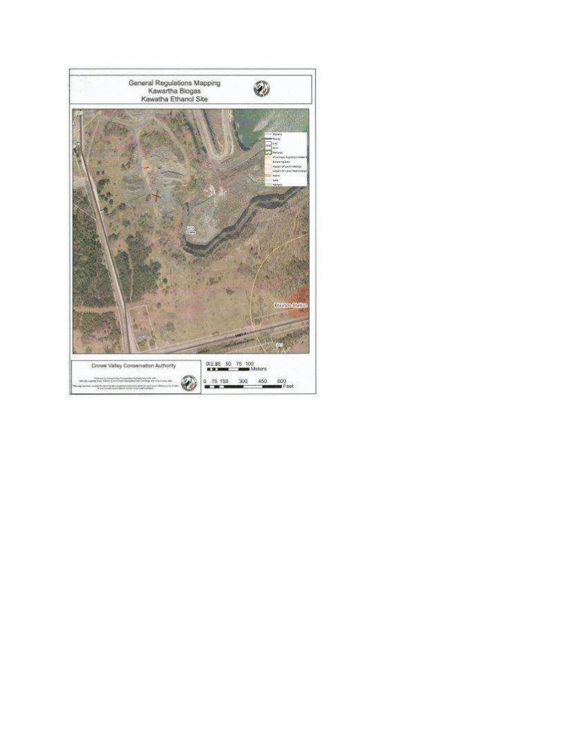
locations of these features in relation to the proposed project site are shown on Figure 2.
According to Section 3.1 of the Official Plan, Environmental Protection areas include:
… lands which may pose a threat to the life and property because of inherent
physiographic characteristics such as flood susceptibility, erosion, organic soils,
unstable slopes or other similar physical limitations. The Environmental Protection
designation also includes a sub-designation which identifies areas of particular
environmental sensitivity which should be protected and preserved. Such lands are
described as Environmentally Sensitive Areas and include lands identified to have
significant biological, geological, zoological or other important natural features. Uses
permitted on Environmental Protection lands shall be limited to agriculture,
conservation, forestry, logging, wildlife areas, public and private parks, golf courses or
other outdoor recreational activities. The uses permitted will depend on the particular
physical constraints of any given site.
Kawartha Biogas Water Bodies Assessment Report
7
2.3 Conversation Authority Records
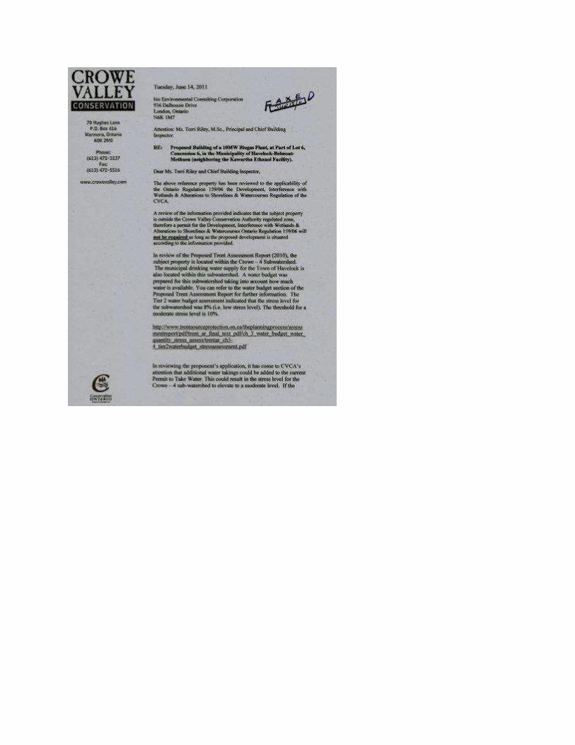
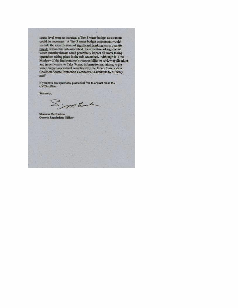
The Project site is located within the jurisdiction of the Crowe Valley Conservation Authority.
Based on discussions and written communications with the Crowe Valley Conservation
Authority staff, the site is not located within regulated lands and, therefore, a permit is not
required by the proponent under the Conservation Authority Act, Generic Regulation 159/06
Development, Interference with Wetlands and Alterations to Shorelines and Watercourses.
Written communications and regulated mapping provided by Crowe Valley Conservation
Authority is provided under Appendix A.
2.4 Natural Heritage Information Centre
The Ministry of Natural Resources (MNR) maintains an on-line spatial database of natural
heritage features and species known to occur within the Province of Ontario. The Natural
Heritage Information Centre (NHIC) was accessed on May 16, 2011 in order to determine if any
known water bodies were located on or adjacent to the Project site.
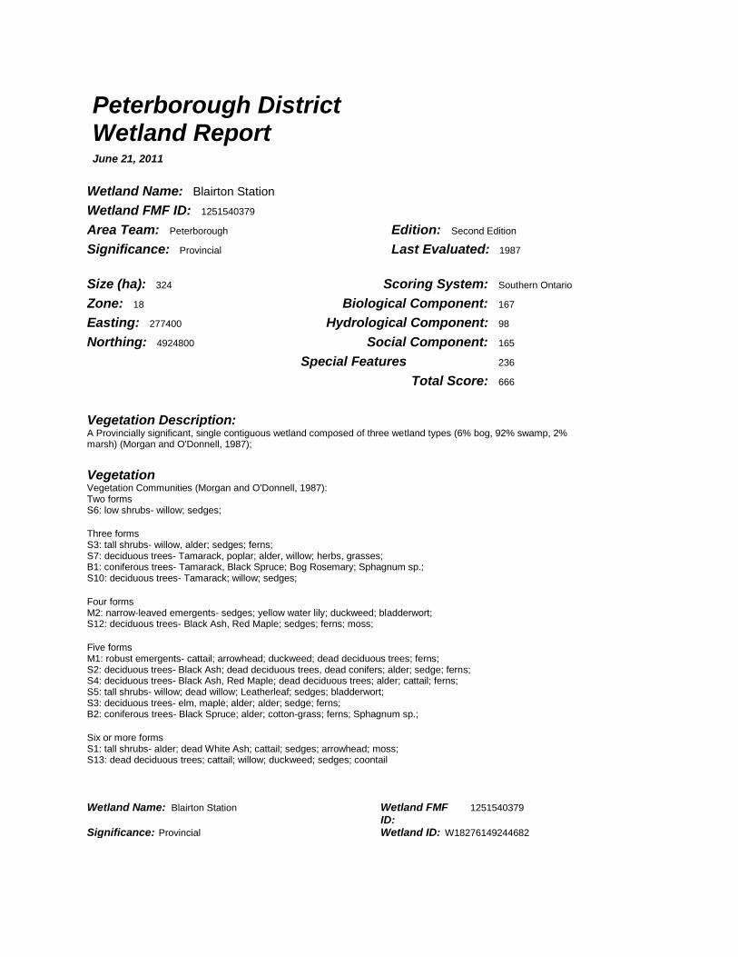
No records for the site were found. There are two provincially significant wetlands within the
vicinity of the proposed project site. At the closest distance, the Plato Creek Wetland Complex
boundary as delineated by the MNR is located approximately 232 metres northwest of the project
site. This wetland complex is comprised of three individual wetlands that contain two wetland
types; 97% swamp and 3% marsh. The Blairton Station Wetland is located approximately 266
metres southeast of the site. The Blairton Station wetland is one contiguous wetland composed
of three wetland types including 92% swamp, 6% bog and 2% marsh. Additional information
regarding both the Plato Creek Wetland Complex and the Blairton Station Wetland is located in
Appendix B.
No water bodies were identified on or within 120 metres of the project site.
2.5 Ministry of Natural Resource
The MNR has published documents relating to the location of known lake trout lakes.
Documents reviewed as part of the Water Assessment Report include:
The Distribution and Characteristics of Ontario Lake Trout Lakes (MNR, 1976); and
Inland Ontario Lakes Designated for Lake Trout Management (MNR, 2006).
Kawartha Biogas Water Bodies Assessment Report
8
Nine lake trout lakes were identified in the regional area of Havelock, Ontario in the MRN's
Inland Ontario Lakes Designated for Lake Trout Management. These nine lakes are not located
on or within 300 metres of the project site.
2.5 Land Information Ontario
The MNR maintains a spatial database under Land Information Ontario (LIO) in the province of
Ontario that allows the public to access geographic data. Regional geographic data was searched
as part of the records review including natural features, topography, provincial parks,
conservation areas, aquatic features, and hazard areas. LIO shows wooded areas and two
wetlands located within the vicinity of the site. LIO mapping is provided in Appendix C of this
report. No water bodies were identified on or within 120 metres of the project site.
2.6 Protected Areas
The Project site is not located within any areas protected under the Provincial Plans and Policies
including the Greenbelt Area, Niagara Escarpment Plan Area, the Oak Ridges Moraine Area or
the Lake Simcoe Watershed Plan Area. No provincial or federal parks, lakes or shorelines are
located on or within 300 metres of the proposed project site.
2.7 Federal Records
No known federal records pertaining to the site were identified.
2.8 Records Review Summary
Based upon the records reviewed, as presented in this report, no water bodies are located on or
within 120 metres of the proposed project site, and no lake trout lakes are located within 300
metres of the proposed project site. Figure 3 shows the area of the site and natural features
located within 300 of metres of the site.
Kawartha Biogas Water Bodies Assessment Report
9
3.0 SITE INVESTIGATION
Under Section 31 of O.Reg. 359/09, a site investigation is required for the purpose of
determining:
Whether the results of the analysis summarized in the report prepared under subsection
30(2) [Records reviewed] are correct or require correction, and identifying any required
corrections;
Whether any additional water bodies exist, other than those identified in the records
review;
The boundaries, located within 120 metres of the project location, of any water body that
was identified in the records review or the site investigation; and
The distance from the project location to the boundaries determined under clause (c).
3.1 Site Observations
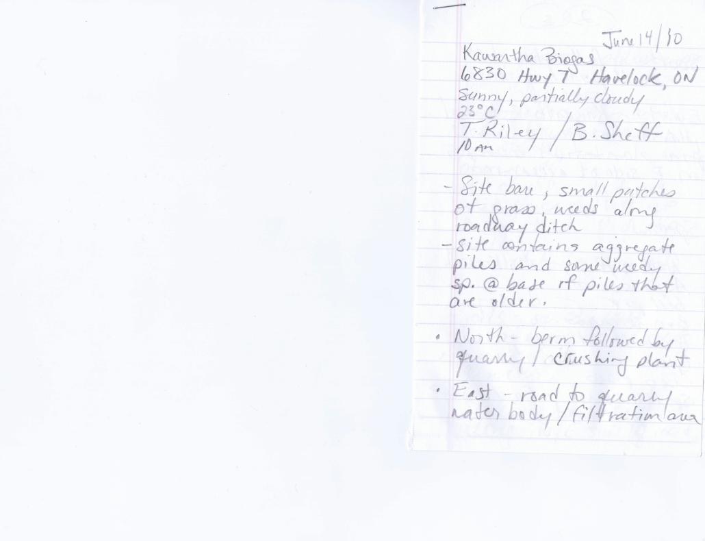
An investigation of the site was conducted on June 14, 2011 between 10:00 am – 4:00 pm. in
order to verify the records that were reviewed as part of the Water Assessment and Natural
Heritage Assessment Reports. The temperature was 23 degrees Celsius with sunny skies and a
light breeze. The site investigation included a reconnaissance of the site and adjacent lands
within 120 metres of the site boundary. Field notes are provided in Appendix D.
At the time of the site visit, the site was relatively flat with several stock piles of crushed rock,
boulders and sand, and a series of internal roadways. There were miscellaneous piles of debris
located along the southwestern portion of the site. The majority of the site was void of
vegetation with pockets of herbaceous plants primarily along the eastern edge of the site adjacent
to the internal access roadway. No water bodies or seepage areas were observed on the site.
Lands within 120 metres of the project site location included the following:
North: A Precambrian metabasaltic rock (basalt) quarry including ponds and a filtration
area consisting of mainly crushed rock and rock rubble, and a crushing plant are located
to the north and east of the site. This active quarry abuts the north and west side of the
project site. The quarry pond contains water used for the neighbouring Kawartha
Ethanol facility located directly west of the project site. Process water is pumped from
the quarry and return water is pumped back to the quarry. Hydrogeological
investigations for the site and surrounding areas show that the quarry is not hydraulically
connected to Plato Creek Wetland Complex or Plato Creek. The hydrogeological
Kawartha Biogas Water Bodies Assessment Report
10
investigation has been provided under separate cover in the Design and Operations
Report submitted as part of the REA application.
The Provincially Significant Plato Creek Wetland Complex is located approximately 232
metres north of the project site. Plato Creek is located within the wetland greater than
500 metres north of the project site.
East: Quarry operations are located to the east of the project site followed by a wooded
area.
South: The area south of the project site contains areas of exposed bedrock, scattered
trees and some herbaceous vegetation (gasses) followed by the control access building
and gate into the site off of Highway #7. Ontario Hydro has a sub-station located north
of Highway 7.
West: The gravel access road and former railway is located directly west of the project
site followed by Kawartha Ethanol, a large industrial facility that produces fuel grade
ethanol. Southwest of the site, west of the access road is a Scot's Pine plantation. The
access roadway contains a shallow ditch that was dry at the time of the site walkover.
This ditch was reported to be dry most of the year with the exception of spring freshet
when the ground is thawing.
No water bodies or seepage areas were observed within 120 metres of the project site. No lakes
are present within 300 metres of the site boundary.
Kawartha Biogas Water Bodies Assessment Report
11
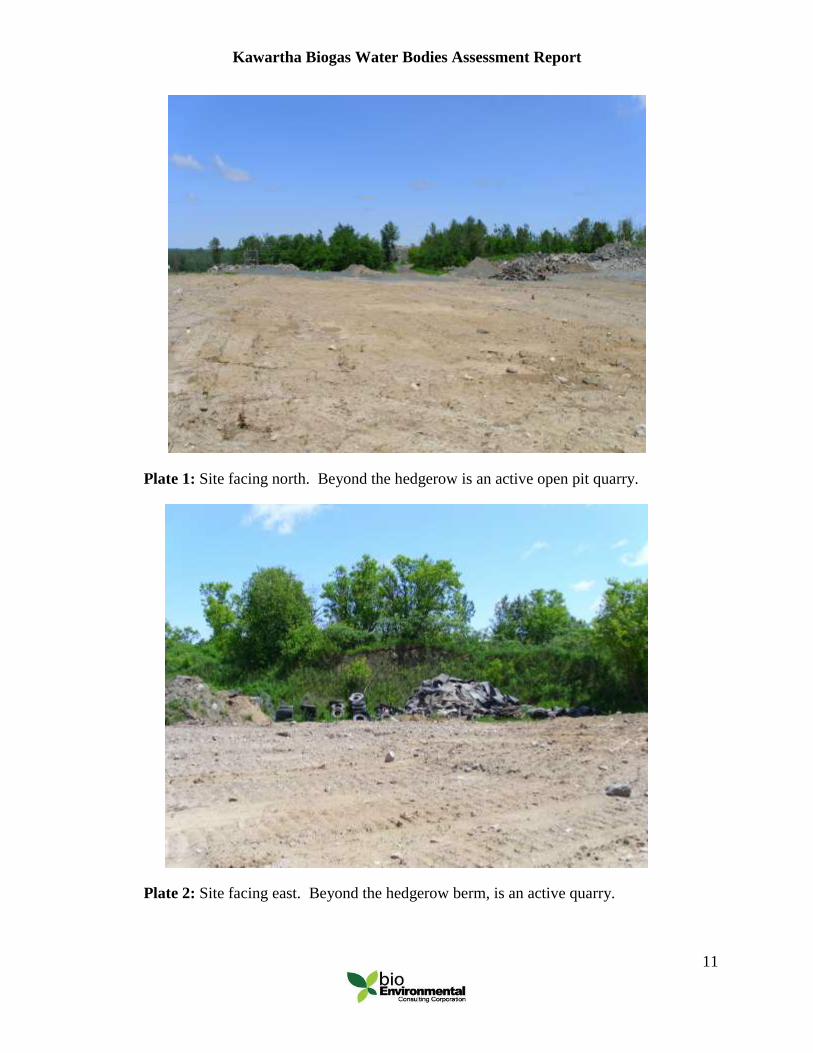
Plate 1: Site facing north. Beyond the hedgerow is an active open pit quarry.
Plate 2: Site facing east. Beyond the hedgerow berm, is an active quarry.
Kawartha Biogas Water Bodies Assessment Report
12
Plate 3: Eastern edge of the site showing the abutting quarry.
Plate 4: Site facing south.
Kawartha Biogas Water Bodies Assessment Report
13
Plate 5: Site facing west (towards Kawartha Ethanol).
3.1.1 Statement of Qualifications
The reconnaissance was conducted by Ms. Terri Riley. Ms. Riley has more than 15 years of
experience working in biological sciences, primarily in southwestern Ontario and in the central
interior of British Columbia. Ms. Riley obtained a Master of Science in Biology/Physical
Geography from Carleton University with a focus on the spread and germination of invasive
floral species in eastern Ontario. Ms. Riley successfully completed the Ecological Land
Classification Course in Lindsay, Ontario in 2008.
Kawartha Biogas Water Bodies Assessment Report
14
4.0 REPORT SUMMARY
The Water Bodies Assessment Report was prepared in accordance with the guidelines provided
under Sections 29, 30 and 31 of Ontario Regulation 359/09 required for the submission of
Renewable Energy Approval application.
A review of municipal, provincial and federal records were reviewed in order to identify any
water bodies on or within 120 metres and any lake trout lakes present within 300 meters of the
site project location. A water body, defined by O.Reg. 359/09 includes a lake, a permanent
stream, an intermittent steam and a seepage area.
Records examined in this report included the following:
National Aerial Photographs 1929 – 1995;
Historical site records from previous site owners;
Township of Havelock-Belmont-Methuen Official Plan, Office Consolidation,
January 2004;
Crowe Valley Conservation Authority, Generic Regulation 159/06 Development,
Interference with Wetlands and Alterations to Shorelines and Watercourses
Mapping, and floodplain mapping;
Natural Heritage Information Centre (NHIC), digital database maintained by the
MNR in Ontario;
Publications produced by the Ministry of Natural Resources;
Land Information Ontario, digital database maintained by the MRN in Ontario;
Protected Areas; and
No known federal records were identified pertaining to the site.
The records reviewed did not identify any water bodies on or within 120 metres of the project
site. A site reconnaissance was conducted to confirm the accuracy of the records and to identify
any water bodies on the site or with 120 metres of the site that may be present. No water bodies
were discovered as part of the site investigation work. No lake trout fish lakes were identified
within 300 metres of the project site.
Kawartha Biogas Water Bodies Assessment Report
15
Due to the absence of water bodies and lake trout lakes on or adjacent to the site, no known
impacts to water bodies or lake trout lakes are known to occur as a result of the construction,
operation or decommissioning of the proposed Kawartha Biogas facility.
Yours Truly,
bioEnvironmental Consulting Corporation
Original Signed
Terri Riley, M.Sc.
Kawartha Biogas Water Bodies Assessment Report
APPENDIX A
CROWE VALLEY CONSERVATION AUTHORITY MAPPING AND
COMMUNICATIONS
Kawartha Biogas Water Bodies Assessment Report
APPENDIX B
NHIC RECORDS
Peterborough District Wetland Report June 21, 2011
Wetland Name: Blairton Station
Wetland FMF ID: 1251540379
Area Team: Peterborough Edition: Second Edition
Significance: Provincial Last Evaluated: 1987
Size (ha): 324 Scoring System: Southern Ontario
Zone: 18 Biological Component: 167
Easting: 277400 Hydrological Component: 98
Northing: 4924800 Social Component: 165
Special Features 236
Total Score: 666
Vegetation Description: A Provincially significant, single contiguous wetland composed of three wetland types (6% bog, 92% swamp, 2% marsh) (Morgan and O'Donnell, 1987);
Vegetation Vegetation Communities (Morgan and O'Donnell, 1987): Two forms S6: low shrubs- willow; sedges; Three forms S3: tall shrubs- willow, alder; sedges; ferns; S7: deciduous trees- Tamarack, poplar; alder, willow; herbs, grasses; B1: coniferous trees- Tamarack, Black Spruce; Bog Rosemary; Sphagnum sp.; S10: deciduous trees- Tamarack; willow; sedges; Four forms M2: narrow-leaved emergents- sedges; yellow water lily; duckweed; bladderwort; S12: deciduous trees- Black Ash, Red Maple; sedges; ferns; moss; Five forms M1: robust emergents- cattail; arrowhead; duckweed; dead deciduous trees; ferns; S2: deciduous trees- Black Ash; dead deciduous trees, dead conifers; alder; sedge; ferns; S4: deciduous trees- Black Ash, Red Maple; dead deciduous trees; alder; cattail; ferns; S5: tall shrubs- willow; dead willow; Leatherleaf; sedges; bladderwort; S3: deciduous trees- elm, maple; alder; alder; sedge; ferns; B2: coniferous trees- Black Spruce; alder; cotton-grass; ferns; Sphagnum sp.; Six or more forms S1: tall shrubs- alder; dead White Ash; cattail; sedges; arrowhead; moss; S13: dead deciduous trees; cattail; willow; duckweed; sedges; coontail
Peterborough District Wetland Report July 21, 2011
Wetland Name: Plato Creek Headwater Complex Wetland FMF ID: 1251540197 Area Team: Peterborough Edition: Second Edition Significance: Provincial Last Evaluated: 1987
Size (ha): 339.2 Scoring System: Southern Ontario Zone: 18 Biological Component: 185 Easting: 268100 Hydrological Component: 148 Northing: 4924200 Social Component: 159 Special Features 160 Total Score: 652
Vegetation Description: A Provincially significant wetland complex, made up of three individual wetlands, composed of two wetland types (97% swamp and 3% marsh) (Reid and Ronda, 1987).
Vegetation Vegetation Communities (Reid and Ronda, 1987): One form M2: robust emergents- cattails; Two forms S1: narrow-leaved emergents- sedges; cedar, willow; S18: coniferous trees- cedar; jewelweed, grasses, horsetail; S24: dead shrubs- alder; Chara sp.; S39: tall shrubs- willow, Tamarack, White Elm; cattail; S41: herbs- sedge, ferns; willow, spirea; M3: robust emergents- cattails; dead alder; Three forms S3: dead conifers- cedar; Red-osier Dogwood, willow; sedge; S7: deciduous trees- Black Ash, Silver Maple; Black Ash; grasses, ferns; S9: tall shrubs- Black Ash, cedar; cedar, Red-osier Dogwood; grasses, joe-pye weed; S12: coniferous trees- cedar; Balsam Fir, Hemlock, Canada Yew; sarsaparilla, Marsh Fern, grass; S13: tall shrubs- Tamarack; Red-osier Dogwood; sedge, Marsh Fern; S15: dead conifers- cedar; willow; sedge; S19: dead conifers- cedar; willow; sedge, grass; S26: dead conifers- cedar; sedge; cattail; S32: tall shrubs- cedar, White Elm, Black Ash; Balsam Poplar; ferns, grasses, joe-pye weed; S33: dead deciduous trees- Black Ash, White Elm; Black Ash, White Elm shrubs; bur-marigold, water parsnip; S35: tall shrubs- alder, White Elm; Red-osier Dogwood; ferns, grasses, joe-pye weed; S37: dead deciduous trees- White Elm, Black Ash; White Elm, Black Ash; cattails; M1: robust emergents- cattails; willow; Purple Loosestrife, grass; Four forms Wetland Name: Plato Creek Headwater Complex Wetland FMF 1251540197 ID: Significance: Provincial Wetland ID: W18266674924532
S4: tall shrubs- Black Ash, cedar; dead Black Ash, White Elm; Black Ash, Red-osier Dogwood; grasses, joe-pye weed; S11: tall shrubs- Balsam Fir, Black Ash; White Birch; Red-osier Dogwood; horsetail, ferns, joe-pye weed, grasses; S14: tall shrubs- willow; cattails; sedges; jewelweed; S16: deciduous trees- Balsam Poplar, Black Ash, White Elm; willow, Red-osier Dogwood; sedges; Chara spp.; S17: dead conifers- cedar; cedar, willow; cattails; Chara spp.; S20: tall shrubs- alder, willow; dead alder; Chara spp.; Marsh Fern; S21: coniferous trees- Tamarack, White Spruce, cedar; dead White Elm; Black Ash, White Elm, willow; grasses, horsetail, ferns; S22: tall shrubs- alder, willow; willow; sedges; boneset, joe-pye weed; S23: coniferous trees- cedar; dead cedar; alder; ferns, joe-pye weed, grass; W1: robust emergents- cattail; dead willow; sedge; Elodea sp., Chara spp.; S25: narrow-leaved emergents- sedges; cattail, burreed; cedar, willow; Chara spp.; S28: dead deciduous trees- Black Ash, Silver Maple; White Elm; Red-osier Dogwood, Mountain Maple; grasses, ferns; S29: deciduous trees- Black Ash, Balsam Poplar; cedar; Balsam Fir, Black Ash, Mountain Maple; grasses, ferns; S30: dead deciduous trees- Balsam Poplar; Black Ash, White Elm, cedar; Red-osier Dogwood; grasses, Marsh Fern; S34: deciduous trees- Black Ash, White Birch, White Elm, Balsam Poplar; alder, Black Ash; Red-osier Dogwood; grasses, ferns, joe-pye weed; S36: tall shrubs- Black Ash, White Elm, Willow, alder; White Elm, Black Ash; Tamarack; grasses, ferns; S42: tall shrubs- willow, White Elm, Black Ash; dead White Elm, Black Ash; Spirea spp.; grasses, ferns; S44: deciduous trees- Silver Maple, Black Ash; Black Ash, White Elm, Mountain Maple, Silver Maple; Red-osier Dogwood; ferns, grasses; Five forms S2: coniferous trees- cedar, White Spruce; dead cedar; dead Black Ash; S5: dead shrubs- cedar, alder; Black Ash, Silver Maple; Red-osier Dogwood; sedges, ferns; algae; S27: deciduous trees- White Elm, Black Ash, Silver Maple, Balsam Poplar; cedar; cedar, Black Ash, Silver Maple; Red- osier Dogwood; ferns, grasses; S31: tall shrubs- White Elm, Black Ash, cedar, Balsam Fir; cedar; Balsam Poplar; grasses, ferns, Goldthread; moss; S38: tall shrubs- alder; dead alder; sedges; duckweed; arrowhead; S40: tall shrubs- Tamarack, White Elm, Balsam Poplar, cedar; Tamarack; White Elm; dead White Elm, Black Ash; sedges, ferns; S43: dead deciduous trees- Silver Maple, White Elm; Black Ash; Black Ash, White Elm; Red-osier Dogwood; sedges, grasses, ferns; Six forms
Land Formation: Soils (Reid and Ronda, 1987): 55% clays, loams or silts; 45% organic; Site Type (Reid and Ronda, 1987): 10)% palustrine (permanent or intermittent outflow);
Land Uses:
Offsite Information:
Threats to
Biological Diversity: Breeding or Feeding Habitat for a Provincially Significant Animal Species (Reid and Ronda, 1987); Red-shouldered Hawk (field obsv.);