15
Weather2020 Forecast School Learning Weather Forecasting From 1 Day to 200 Days Into The Future By Gary Lezak
| Date post: | 19-Aug-2015 |
| Category: |
Science |
| Upload: | gary-lezak |
| View: | 788 times |
| Download: | 0 times |
Weather2020 Forecast School
Learning Weather ForecastingFrom 1 Day to 200 Days Into The Future
By Gary Lezak

Introduction
Meteorologist Gary Lezak will introduce us to meteorology. Gary received his Bachelor of Science Meteorology degree in 1985 from the University of Oklahoma. He has been rated one of the most accurate weather forecasters in the nation and he is going to be providing some insight into weather forecasting both short and long range using the Lezak Recurring Cycle (LRC). This is breakthrough technology that is now being used around the world in the 1Weather app and on Weather2020.com.
This introduction into weather forecasting will begin with an understanding of the troposphere. We will then take you through one of the most important and visual parts of weather forecasting, the clouds, storm systems, and surface analysis. By the end of this educational series you should have enough knowledge to strengthen your weather forecasting skills.
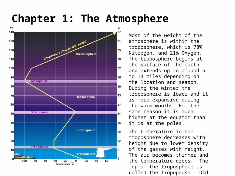
Chapter 1: The AtmosphereMost of the weight of the atmosphere is within the troposphere, which is 78% Nitrogen, and 21% Oxygen. The troposphere begins at the surface of the earth and extends up to around 5 to 13 miles depending on the location and season. During the winter the troposphere is lower and it is more expansive during the warm months. For the same reason it is much higher at the equator than it is at the poles.
The temperature in the troposphere decreases with height due to lower density of the gasses with height. The air becomes thinner and the temperature drops. The top of the troposphere is called the tropopause. Did you know that you have visually experienced the top of troposphere many times in your life?

The cumulonimbus cloud, you can see here, showcases the entire troposphere. In the troposphere the temperatures cool with height. When a cumulus cloud is growing, water vapor is condensing into cloud droplets and heat is released in this condensation process. The heat allows the air within the rising cloud to be warmer than the surrounding environment and the air will continue to rise and the cloud grows. There is an upper limit, however, to how high the cloud can grow. Once the cloud hits the stratosphere, where the air begins warming again, the cloud is forced to stop growing and this can be seen in every thunderstorm that forms. The anvil spreads out, the top of the thunderstorm, and this shows that where the top of the troposphere is located. So, when it is raining, we are literally seeing the effects of the cumulonimbus cloud from the ground all the way up to the bottom of the stratosphere.
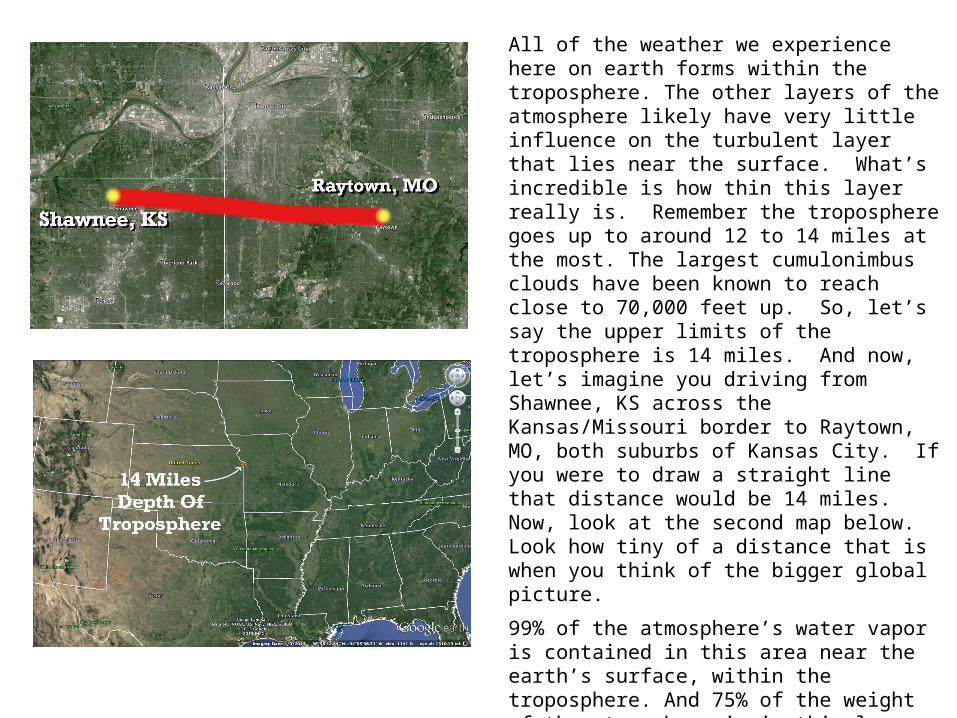
All of the weather we experience here on earth forms within the troposphere. The other layers of the atmosphere likely have very little influence on the turbulent layer that lies near the surface. What’s incredible is how thin this layer really is. Remember the troposphere goes up to around 12 to 14 miles at the most. The largest cumulonimbus clouds have been known to reach close to 70,000 feet up. So, let’s say the upper limits of the troposphere is 14 miles. And now, let’s imagine you driving from Shawnee, KS across the Kansas/Missouri border to Raytown, MO, both suburbs of Kansas City. If you were to draw a straight line that distance would be 14 miles. Now, look at the second map below. Look how tiny of a distance that is when you think of the bigger global picture.
99% of the atmosphere’s water vapor is contained in this area near the earth’s surface, within the troposphere. And 75% of the weight of the atmosphere is in this layer.
The next time you look up at the sky, try to think of the troposphere, and what is happening in this layer. This is just one of the basic topics that we need to learn to become a great weather forecaster.

This diagram comes from http://scied.ucar.edu/shortcontent/troposphere-overview. This shows what is happening within the troposphere and what happens above the tropopause. The Ozone layer is up in the stratosphere, and the amount of solar radiation that reaches the surface of the earth is affected, but the weather we experience on earth is driven by what happens within the lowest layer, the troposphere. The process of developing clouds and precipitation can be quite violent and we will be discussing this turbulence in the cloud series.

Clouds are the basics of weather forecasting. Getting a good understanding of the cloud types, being able to identify them in the sky, and understand at least a little bit in how they form will help you become a better weather forecaster.
In this chapter we will go over the process of how clouds form and we will begin testing our skills by just looking up at the sky. The cloud chart here shows all of the basic cloud types and the levels that you are most likely to experience these.
Chapter 2: Clouds
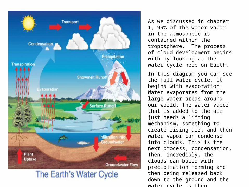
As we discussed in chapter 1, 99% of the water vapor in the atmosphere is contained within the troposphere. The process of cloud development begins with by looking at the water cycle here on Earth.
In this diagram you can see the full water cycle. It begins with evaporation. Water evaporates from the large water areas around our world. The water vapor that is added to the air just needs a lifting mechanism, something to create rising air, and then water vapor can condense into clouds. This is the next process, condensation. Then, incredibly, the clouds can build with precipitation forming and then being released back down to the ground and the water cycle is then completed by the runoff of the rain and melted snow back into the ground and bodies of water.
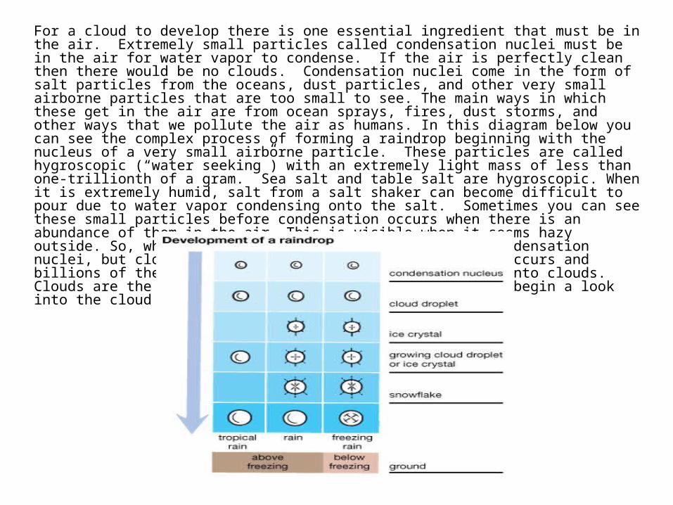
For a cloud to develop there is one essential ingredient that must be in the air. Extremely small particles called condensation nuclei must be in the air for water vapor to condense. If the air is perfectly clean then there would be no clouds. Condensation nuclei come in the form of salt particles from the oceans, dust particles, and other very small airborne particles that are too small to see. The main ways in which these get in the air are from ocean sprays, fires, dust storms, and other ways that we pollute the air as humans. In this diagram below you can see the complex process of forming a raindrop beginning with the nucleus of a very small airborne particle. These particles are called hygroscopic (“water seeking”) with an extremely light mass of less than one-trillionth of a gram. Sea salt and table salt are hygroscopic. When it is extremely humid, salt from a salt shaker can become difficult to pour due to water vapor condensing onto the salt. Sometimes you can see these small particles before condensation occurs when there is an abundance of them in the air. This is visible when it seems hazy outside. So, what is a cloud. Yes, it begins with the condensation nuclei, but clouds are really visible when condensation occurs and billions of these small particles come together to form into clouds. Clouds are the basics of weather forecasting and we will begin a look into the cloud types in the next section.
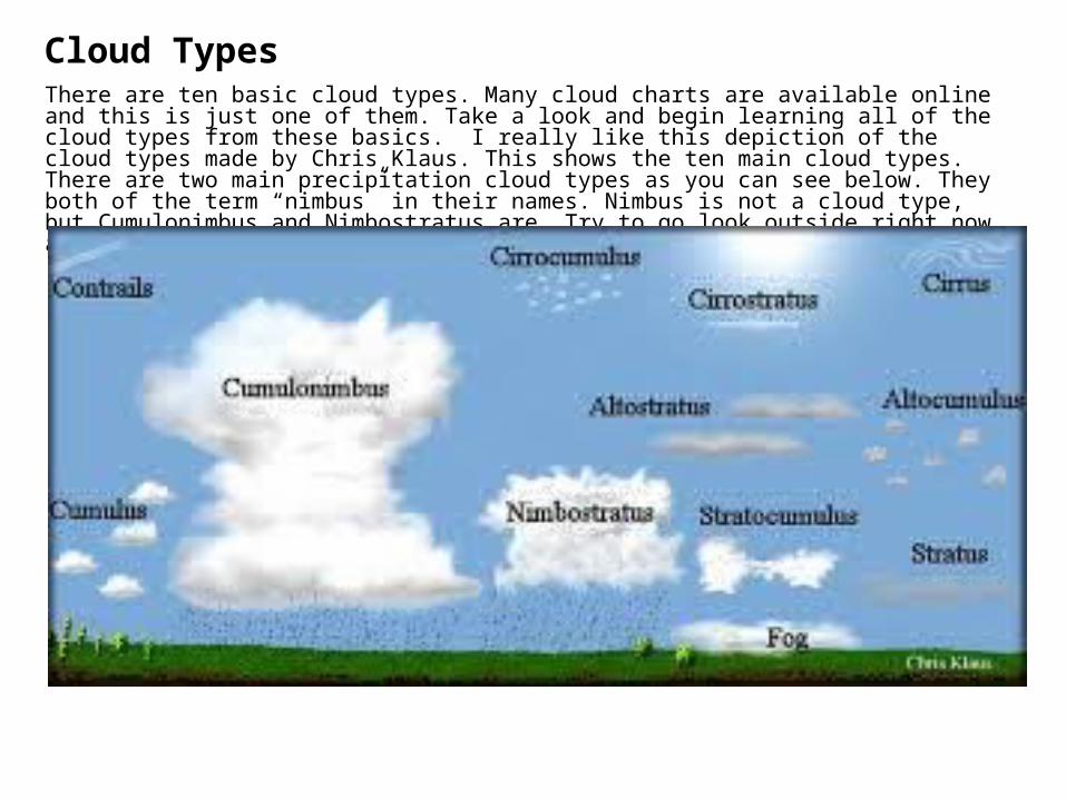
There are ten basic cloud types. Many cloud charts are available online and this is just one of them. Take a look and begin learning all of the cloud types from these basics. I really like this depiction of the cloud types made by Chris Klaus. This shows the ten main cloud types. There are two main precipitation cloud types as you can see below. They both of the term “nimbus” in their names. Nimbus is not a cloud type, but Cumulonimbus and Nimbostratus are. Try to go look outside right now and identify what types of clouds are in the sky today.
Cloud Types

The cloud types are usually described in three main layers: Low, middle, and high. The low clouds are considered the “stratus” group. The middle clouds begin with the prefix “alto”. The high clouds begin with the prefix “cirro”. The middle cloud group can be a bit confusing when you consider that we are using the term “alto” to begin each of these cloud types. Alto comes from the Latin word Altus which means high, and yet this is not the high cloud, it is the middle cloud that is usually 8,000 feet to 12,000 feet up above ground level.
The ten main cloud types are below:• Low clouds: Stratus, Stratocumulus, Nimbostratus• Middle clouds: Altocumulus, Altostratus• High clouds: Cirrus, Cirrostratus, Cirrocumulus• Varying bases: Cumulus Cumulonimbus
These are the ten basic cloud types. We will go through the descriptions of each cloud type soon. The cloud that is on the ground is called fog, but it is really just a stratus cloud on the ground. Did you know that there are actually two types of clouds that can be found on the ground? Tornadoes often have a condensation funnel that touches the ground, but we know this is not a stratus cloud.
The two types of clouds that can be found on the ground. The stratus cloud and the tornado.

Here is a picture I took in August of 2015 near Kansas City. What types of clouds can you see here? And, you can see another feature that is apparent as well. Can you see the virga? Virga is precipitation that is falling that does not reach the ground. If it evaporates before reaching the ground it is called virga. These clouds are altocumulus and altostratus. The smooth ones that are spread out over the sky are the altostratus and the more bumpy looking clouds are atlocumulus. This is a middle cloud layer. The virga is visible in the middl of the screen just above this parking lot.
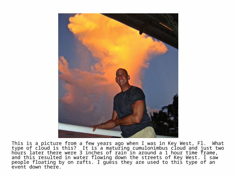
This is a picture from a few years ago when I was in Key West, Fl. What type of cloud is this? It is a maturing cumulonimbus cloud and just two hours later there were 3 inches of rain in around a 1 hour time frame, and this resulted in water flowing down the streets of Key West. I saw people floating by on rafts. I guess they are used to this type of an event down there.
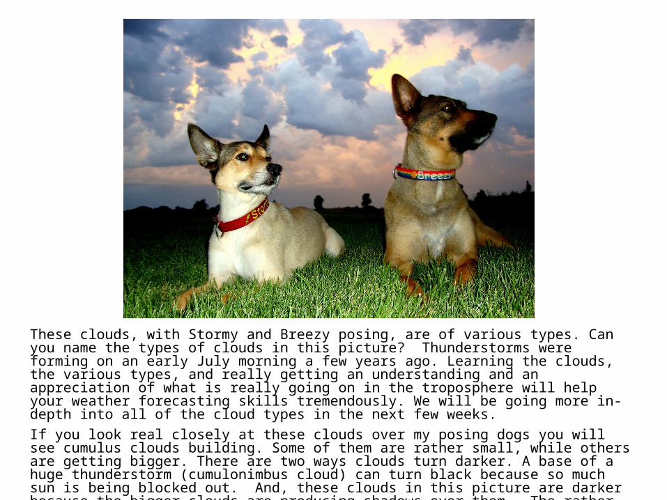
These clouds, with Stormy and Breezy posing, are of various types. Can you name the types of clouds in this picture? Thunderstorms were forming on an early July morning a few years ago. Learning the clouds, the various types, and really getting an understanding and an appreciation of what is really going on in the troposphere will help your weather forecasting skills tremendously. We will be going more in-depth into all of the cloud types in the next few weeks.
If you look real closely at these clouds over my posing dogs you will see cumulus clouds building. Some of them are rather small, while others are getting bigger. There are two ways clouds turn darker. A base of a huge thunderstorm (cumulonimbus cloud) can turn black because so much sun is being blocked out. And, these clouds in this picture are darker because the bigger clouds are producing shadows over them. The rather bright clouds above them are actually cumulonimbus clouds that have already fully formed.
We will be continuing chapter 2: Clouds in next week’s Weather School. Remember, this is really one of the most important concepts to learn if you want to try to forecast the weather.


