Intergovernmental Oceanographic Commission Reports of Meetings of Experts and Equivalent Bodies Working Group on Tsunamis and Other Hazards Related to Sea-Level Warning and Mitigation Systems (TOWS-WG) Inter-ICG Task Team 1 on Sea Level Monitoring for Tsunami First Meeting Seattle, USA 29 November–1 December 2010 UNESCO
Transcript
Intergovernmental Oceanographic Commission Reports of Meetings of Experts and Equivalent Bodies
Working Group on Tsunamis and Other Hazards Related to Sea-Level Warning and Mitigation Systems (TOWS-WG) Inter-ICG Task Team 1 on Sea Level Monitoring for Tsunami
First Meeting Seattle, USA 29 November–1 December 2010
UNESCO
UNESCO 2011
Intergovernmental Oceanographic Commission Reports of Meetings of Experts and Equivalent Bodies
Working Group on Tsunamis and Other Hazards Related to Sea-Level Warning and Mitigation Systems (TOWS-WG) Inter-ICG Task Team 1 on Sea Level Monitoring for Tsunami
First Meeting Seattle, USA 29 November–1 December 2010
1.1 WORKING GROUP ON TSUNAMI AND OTHER HAZARDS RELATED TO SEA-LEVEL WARNING AND MITIGATION SYSTEMS (TOWS-WG).............................................................. 1
1.2 INTER-ICG TASK TEAM ON SEA LEVEL FOR TSUNAMI....................................... 1
2. SEA LEVEL DATA REQUIREMENTS FOR TSUNAMI WARNINGS................................................................................................. 2
II. WMO BUFR/CREX TEMPLATES FOR REPORTING TIME SERIES OF TIDE DATA
III. WMO BUFR/CREX TEMPLATES FOR TSUNAMETER DATA AND DART BUOY SYSTEM MESSAGES
IOC/TOWS-WG/TT1-I/3
1. INTRODUCTION
1.1 WORKING GROUP ON TSUNAMI AND OTHER HAZARDS RELATED TO SEA-LEVEL WARNING AND MITIGATION SYSTEMS (TOWS-WG)
IOC Resolution XXIV-14, based on findings of the ad hoc Working Group, approved a proposal for the establishment of a permanent global Working group on Tsunami and other hazards related to Sea-level Warning and Mitigation Systems (TOWS-WG). It comprises representatives of all relevant IOC subsidiary bodies and those from UN sister agencies, like ISDR and WMO, as well as representatives of relevant stakeholders.
IOC charged its Working Group on Tsunamis and Other Hazards Related to Sea-Level Warning and Mitigation Systems (TOWS-WG) to review the governance and organization of the Intergovernmental Coordination Group (ICG) of all Tsunami Warning & Mitigation Systems to ensure common operation explore synergy effects and mainstream in particular the upstream activities, i.e. detection and verification, into existing ocean observing systems.
The IOC Assembly at its 25th Session adopted Resolution XXV-13 in 2009, which decided
to establish the following Task Teams:
Inter-ICG Task Team on Sea Level for Tsunami
Inter-ICG Task Team on Disaster Management and Preparedness
Inter-ICG Task Team on Tsunami Watch Operations
The establishment of these task teams was to meet the need for and the benefit from enhanced coordination, common requirements, and exchange knowledge and information among the ICGs.
1.2 INTER-ICG TASK TEAM ON SEA LEVEL FOR TSUNAMI
Terms-of-Reference: (i) Develop requirements for tsunami warning system sea-level data, and all characteristics of
the data stream including networks and network design, for the information of relevant technical implementation groups, such as Global Sea Level Observing System (GLOSS) and International tsunameter Partnership (ITP) of the Data Buoy Cooperation Panel (DBCP), the ICG working groups and national sea level authorities;
(ii) Review the provision and availability of sea-level data as they pertain to tsunami warning systems and provide advice, as appropriate, to GLOSS, ITP and the ICGs;
(iii) Provide a focus for sea-level issues amongst ICGs;
(iv) Provide a report to TOWS-WG in advance of its 3rd Meeting, in 2010 (now 4th Meeting Feb/March 2011).
Membership of TOWS-WG Task Team 1 on Sea Level for Tsunami:
Rick Bailey (PTWS/Australia) (Chair)
Allison Allen (CARIBE-EWS/USA)
David Farrell (CARIBE-EWS/Barbados)
Begoña Perez (NEAMTWS/Spain)
Ronan Créach (NEAMTWS/France)
Parluhutan Manurang (IOTWS/Indonesia)
Atma (IOTWS/India)
Simon Holgate (GLOSS/UK)
Secretariat – Thorkild Aarup (IOC)
IOC/TOWS-WG/TT1-I/3 Page 2 Objectives: (i) Develop guidelines on sea level monitoring requirements for operational groups (GLOSS
and ITP) to provide ongoing support for tsunami warning systems.
(ii) Identify principles and supporting pillars to underpinning the Guidelines.
Core Reference Material:
ICG Implementation Plans
ICG WG reports
ICG/IOTWS RTWP Implementation Plan
IOC Manual & Guides 14: Manual on Sea Level Measurements & Interpretation Vol 4
OCEANOBS 09 Paper “Tsunami Resilient Communities”
ICG Member State national reports and guides
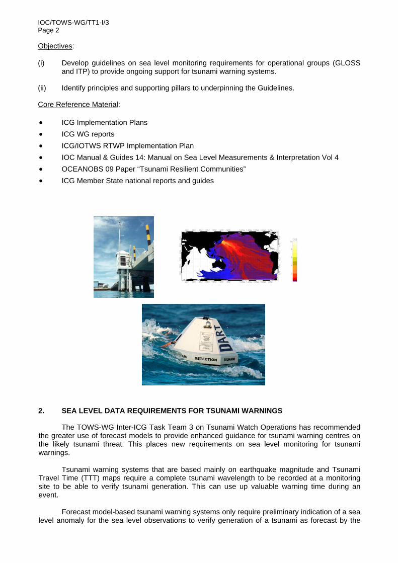
2. SEA LEVEL DATA REQUIREMENTS FOR TSUNAMI WARNINGS
The TOWS-WG Inter-ICG Task Team 3 on Tsunami Watch Operations has recommended the greater use of forecast models to provide enhanced guidance for tsunami warning centres on the likely tsunami threat. This places new requirements on sea level monitoring for tsunami warnings.
Tsunami warning systems that are based mainly on earthquake magnitude and Tsunami
Travel Time (TTT) maps require a complete tsunami wavelength to be recorded at a monitoring site to be able to verify tsunami generation. This can use up valuable warning time during an event.
Forecast model-based tsunami warning systems only require preliminary indication of a sea
level anomaly for the sea level observations to verify generation of a tsunami as forecast by the
IOC/TOWS-WG/TT1-I/3 Page 3
models. A measure of the full wavelength can subsequently be utilised by data assimilation or visual comparison techniques to validate or modify the initial tsunami threat forecast.
Given the forecast model requirements, the physical nature of tsunami waves, the different
scales of tsunami effects, the timing and the practical requirements for issuing warnings, the following basic requirements were developed for tsunami warnings:
Core Data Requirements:
Sampling
Coastal tide gauge = <1 min Deep ocean tsunameter = 15 sec
Accuracy
Coastal tide gauge = +/-10 cm (+/- 1 cm for multipurpose) Deep ocean tsunameter = +/- 1 mm
Transmission frequency (relative to distance/travel time from source)
= < 1 min (local tsunami) for < 15 min TTT = < 5 mins for < 1hr TTT or 100km distance from tsunami source = <15 mins for > 1 hr TTT or 100km distance from tsunami source
where TTT = Tsunami Travel Time Internal latency = <2-3 mins
3. SEA LEVEL NETWORK REQUIREMENTS
The following principles should be considered when designing and implementing sea level monitoring networks in support of tsunami warning systems: Scientifically designed Utilise optimal design methodologies to minimise tsunami verification time, maximise
warning time and resource utilisation
Must be ocean basin specific, recognising the different tsunami sources and warning time imperatives.
Combination of coastal and deep-ocean monitoring Coastal tide gauges can be used to verify generation of a tsunami. They provide
information on the local response to a tsunami generated by a source close-by or far-field. They can also be used to monitor when the tsunami threat has passed.
The local response signal from coastal tide gauges, however, is difficult to use to verify offshore tsunami wave characteristics required for tsunami forecast verification. Hence the requirement and implementation of more deep ocean tsunameters in recent years.
Deep ocean tsunami detection buoys, commonly referred to as “tsunameters”, provide best information on open ocean tsunami wave characteristics, as the signal has not been conditioned by shallow water bathymetry. The tsunameter sea level information is therefore the most appropriate information for comparison to, or assimilation in numerical tsunami models to forecast wave heights and basin wide propagation characteristics.
IOC/TOWS-WG/TT1-I/3 Page 4 Enable verification of tsunami generation at locations close to source Warning timeliness dictates a requirement for sea-level measurement sites to be located as
close to the source of the seismic event as possible. Delays in monitoring the progress of the wave, due to the wave travelling over shallow water or the choking of harbours, also needs to be avoided. It is important to note that the locations should not be so close to the source that the station could be destroyed by the initiating quake.
Monitor progress of tsunami propagation across an ocean basin The warning service needs regular detection of the tsunami as it progresses to refine their
warnings and provide the most accurate predictions of impacts.
One of the most important uses of the sea-level data forecast model verification and data assimilation.
Inverse modelling of the sea-level data can also be used to verify calculations of the seismic source.
Enable verification of tsunami impacts The warning service also requires sites for verification of the impact of a tsunami and post-
analysis of the event. These observations are critical to the improvement of the warning service. While the tsunami models are amazingly accurate, there is a lack of detailed bathymetry along the coastline. Therefore, coastal observations are required to facilitate correlation of deep water observations to onshore impacts.
Provide continuity of observations The need for prompt availability of data leads to a further requirement for accessibility to
communications systems and ease of access for maintenance. For example, if the location is very remote, taking days to reach, then the likelihood of rapid return to service after a failure is compromised.
Built-in redundancies in monitoring sites can help allow for potential station downtime, which otherwise may have compromised the warning system capability (warning imperative). This is especially the case for deep-ocean tsunameters.
Provide Free and Timely Data Access
The warning services require a constant flow of reliable and timely data. While tsunami
events may be rare, it is essential that the data is available and in good order whenever required. This places high demands on the data collection platforms and communications for a near 100 percent availability of data.
The warning centres need high frequency data, ideally at 1 second intervals. Such data demands reliable data transmissions. Therefore reliable and economic communications need to be available at sensor locations
4. OCEAN BASIN STATUS
The individual requirements, network design and status of implementation of sea level monitoring networks for each ocean basin can be found in the respective ICG Implementation Plans (see http://www.ioc-tsunami.org/).
The following is a summary of the sampling requirements for each individual ocean basin
according to the respective ICGs:
Deep Ocean Tsunameters
IOTWS PTWS NEAMS-TWS
CARIBE-EWS
Coastal Tide
Gauges Non–event
Event
Sampling <1 min <1 min <=1 min (HF if closer to zones)
<= 1 min 15 secs - 1 min
15 sec/ 15 min averages
15 sec/ 1 min averages
Transmission 5 min (<1hr or 100km)
5 min (<1hr or 100km)
1 min (<1hr or 100km)
<15 mins (l<less if <1hr)
5 – 15 mins
< 6 hours
<=5 min
Internal Latency
< 2 min < 2 min < 2 min < 2 min < 2 min < 3 min < 3 min
Accuracy +/-10cm +/-10cm
+/- 10cm +/-10cm +/- 10cm +/- 1mm +/- 1mm
The indicative status of transmission frequency of existing real time stations under the four
tsunami warning systems (includes both stations that transmit via the WMO Global telecommunication System or via the Internet), as sourced through the IOC Sea Level Monitoring Site during May 2011 (see http://www.ioc-sealevelmonitoring.org/map.php), is shown below for each basin: Legend: Data transmission interval
> 60 min
15-60 min
6-15 min
<= 6min
Figure 1. Indian Ocean Tsunami Warning & Mitigation System (IOTWS)
More data needs to be available at the recommended <=1min transmission interval from monitoring sites close to Indonesian and Makran subduction (source) zones.
Figure 2. Pacific Tsunami Warning & Mitigation System (PTWS)
Data is generally available at the recommended <=1min transmission interval from monitoring sites close to subduction (source) zones, except for NW Pacific and parts of SE Pacific.
Figure 3. Caribbean Tsunami Warning & Mitigation System (CARIBE-EWS)
Data is generally available at the recommended <=1min transmission interval from monitoring sites close to subduction (source) zones.
IOC/TOWS-WG/TT1-I/3 Page 7
Figure 4. North East Atlantic & Mediterranean Tsunami Warning & Mitigation System (NEAMS-TWS)
Figure 5. Global deep ocean tsunameter array
There are other tsunameters deployed in the Indian Ocean, which are presently not exchan
The siting of sea level monitoring stations for tsunamis should take into consideration the following “pillars” (also see IOC Manual & Guides, 14 Vol. IV (SC-2006/WS/38) for general sea level station siting advice):
Contribution to a network which is providing protection to all communities and infrastructure;
Where possible be mutually beneficial and provide data useful to near neighbours;
As close as practical to the source of a tsunami, but no closer than 15 minutes;
If possible facing the source of the threat;
Together providing a continuous update of the progress of the wave both across the oceans and along the coast;
Take into account historical observations of tsunamis where available for the location;
Sufficiently representative and have the bathymetry that allows detection of a 4 cm wave1 as it propagates toward land;
Chosen to have minimum sources of nonlinear interference with the wave, e.g. seiching effects;
Have exposure to the open ocean, but ensuring measurements from coastal tide gauges are not contaminated by local wave climate;
Chosen to provide verification data of first landfall, at expected extreme inundation locations and near significant infrastructure and population centres,
Selected to provide a level of redundancy that ensures an effective data availability of 99.8 per cent (for early warning) during an event;
Accessible for maintenance in a reasonable time;
Serviced by a reliable communication service;
Takes appropriate advantage of existing infrastructure;
Chosen if possible with a variety of other sea-level data users requirements in mind;
Taking appropriate advantage of existing sea-level monitoring infrastructure, but not allowing the warning service to become totally dependent on other sources of data with other priorities and operational regimes;
The forecast models require data with the minimum of perturbation by local bathymetry. Deep ocean sites are therefore preferable; however this is not always practical. Therefore the chosen locations for coastal tide gauges should minimise the local response and effects of harbours, cliffs, reefs and the like;
Provided with detailed metadata for each site to enable warning centres to determine suitability and credibility of observations in warning analysis.
1 Tsunami waves propagate following the rules of a shallow water wave. This means that the wave height (Hs) in shallow water (hs) is related to its wave height (Hd) in deep water (hd) by the following formula. Hs = Hd(hd/hs)
0.25.
IOC/TOWS-WG/TT1-I/3 Page 9
6. INSTRUMENTATION
See IOC Manual & Guides, 14, Vol. IV, Manual on sea Level measurements and Interpretation for description of the different technologies and recommended procedures for sea level monitoring in general (including but not limited to monitoring of tsunamis).
Instrumentation must be robust in design to sustain possible impact of a tsunami. Consideration should be given to higher redundancy of coastal sea level monitoring stations in close proximity to tsunami sources to allow for higher potential for damage;
Redundancy of power supply (batteries, solar panels) should be included. Stations should be able to run for a minimum of 48 hrs without external power.
The sea level station shall function independently of other equipment that may be installed in the vicinity (i.e. meteorological or other oceanographic equipment).
The proposed station should have sufficient built in redundancy to function under conditions that can be expected in the region. Without being prescriptive, it is expected that a typical station configuration will consist of a primary tide gauge, one or two under water pressure sensors (secondary tide gauges), data logger, DCP geostationary satellite transmitter, modem, battery backup, solar panel, cables, mountings.
Redundant data transmission channels (e.g. Internet or alternative (i.e. via Inmarsat BGAN or similar), as well as via dial-in modem access) should be implemented where possible. The redundant transmission can either be connected directly to the DCP/Data logger for the primary water level sensors, or it can be a separate transmission unit connected to a second water level sensor. DCP timing should be continuously controlled via GPS or Internet, especially important for satellite transmission.
The dynamic measuring range of sea level monitoring stations must take into account the potential range of tsunami wave amplitudes for any given location.
Measurement time should be GMT with at least +/- 1 min accuracy, and if possible GPS controlled.
Sensors must be periodically calibrated in accordance with the accuracy required.
7. DATA EXCHANGE AND ARCHIVAL/FORMATS
Member States are encouraged to exchange their sea level data with the tsunami warning centres according to the UNESCO/IOC Oceanographic Data Exchange Policy and the Mauritius Declaration adopted at the intergovernmental coordination meeting held at Grand Baie, 14–16 April 2005 (IOC Workshop Report, 198—SC.2005/WS/40) to openly share and exchange tsunami-relevant real-time observational data.
Sea level stations that are part of the tsunami warning system should freely and timely exchange their data through the GTS.
For each sensor at the station site, observations shall be transmitted on the GTS in real-time using the WMO CREX formats for sea level data (see Appendices I and II).
Data can be put on the GTS via a DCP transmitter from the tide gauge or tsunameter to selected centres that have the ability to push the data onto the GTS (e.g. IOC Sea Level Station Monitoring Facility, National Meteorological Services, National Data Buoy Centre (NDBC) of NOAA, etc.)
British Oceanographic Data Centre (BODC) and University of Hawaii Sea Level Center under the auspices of GLOSS and National Geophysical Data Centre (NGDC) of NOAA will be responsible for long-term archive arrangement of high-frequency coastal and deep-ocean sea level data, not excluding the role of national and regional archive centres
Metadata must be included when archiving the data.
IOC/TOWS-WG/TT1-I/3 Page 10
8. REAL-TIME MONITORING
Automatic alerting of events (implementation of tsunami detection algorithms) for coastal and deep ocean sensors should be implemented where possible. This will help detect and warn for tsunamis not necessarily generated by earthquake subduction zones, such as submarine landslides, meteorites, etc.
24/7 support is required for real-time sea level monitoring systems and visualization tools.
9. QUALITY ASSURANCE
It is preferable not to have data quality control in real-time, to avoid accidental flagging or filtering of real events.
Only qualified personnel should receive and interpret sea level signals for tsunami watch/warning.
For data archiving existing well proved standard quality control procedures should be applied for flagging spikes, filling gaps, datum changes, etc. Data should be flagged and not deleted, to ensure real events are not removed.
QC-controlled data should be archived for research applications.
New instrumentation should be fully evaluated against existing instrumentation with know performance and characteristics.
10. PERFORMANCE MONITORING
Network performance: a data base of network status, including existing and planned stations, must be maintained quarterly and available to tsunami warning centres.
Station performance: latency, continuity and accuracy of reported data should be monitored continuously for each station:
• Automatic notification of performance problems should be sent for manual inspection of the data
KPI (Key Performance Indicators):
Sampling
Reporting
Frequency
Average delay for the last 24 hours
Observations percentage for the last 24 hours and for the last 7 days (minimum 95 %)
Continuity (stations repaired within two weeks)
Percentage of bad data (less than 1 %)
An operational unit should be given the responsibility for monitoring global sea level network performance on a routine basis.
Tsunami warning centres must routinely evaluate the impact/value of independent sea level observations on development of tsunami threat guidance during events, providing feedback to the sea level monitoring operators.
IOC/TOWS-WG/TT1-I/3 Annex I
ANNEX I
AGENDA
1. JOINT OPENING AND SESSION ORGANIZATION 2. REVIEW TORS AND AGENDA 3. STATUS PRESENTATIONS FROM THE ICG REPRESENTATIVES 4. BEST PRACTICES IN SEA LEVEL MONITORING FOR TSUNAMI WARNINGS 5. GUIDELINES AND PROCESS FOR VERIFYING THE STATUS
AND PERFORMANCE OF TSUNAMI SEA LEVEL MONITORING SYSTEMS 6. CROSS-CUTTING ISSUES RELATED TO OTHER TASK TEAMS OF TOWS-WG 7. DISCUSSION ON WORK PLAN TO COMPLETE TASK 8. JOINT MEETING WITH THE TT2 AND TT3
IOC/TOWS-WG/TT1-I/3 Annex II
ANNEX II
WMO BUFR/CREX TEMPLATES FOR REPORTING TIME SERIES OF TIDE DATA
The design of any new templates for tidal elevations is focused in meeting the flexibility of a minimum number of cohesive common descriptors which can be grouped together while avoiding a long common sequence that requires a higher bandwidth for data transmission. Locations of sea level stations can be very remote and the data communication cost for transmitting high resolution data, e.g. 1-minute data for storm surge or tsunami warning purposes can be very expensive. The following common sequences can be used for reporting sea level tide data for single and multiple sensors with the options of reporting ancillary meteorological data. Items in red are new descriptors suggested for review and incorporation in the WMO Manual on Codes.
3 06 011 Sequence for representation of tide station identification, method of transmission, time the message is transmitted and reference time for reports in a time series
3 01 021 0 05 001 Latitude (high accuracy) 0 06 001 Longitude (high accuracy) 0 01 075 Tide station alphanumeric ID (5 characters) 0 02 147 Method of transmission to collection centre 3 01 011 0 04 001 Year (Time the message is transmitted to the collection centre) 0 04 002 Month 0 04 003 Day 3 01 013 0 04 004 Hour 0 04 005 Minute 0 04 006 Second
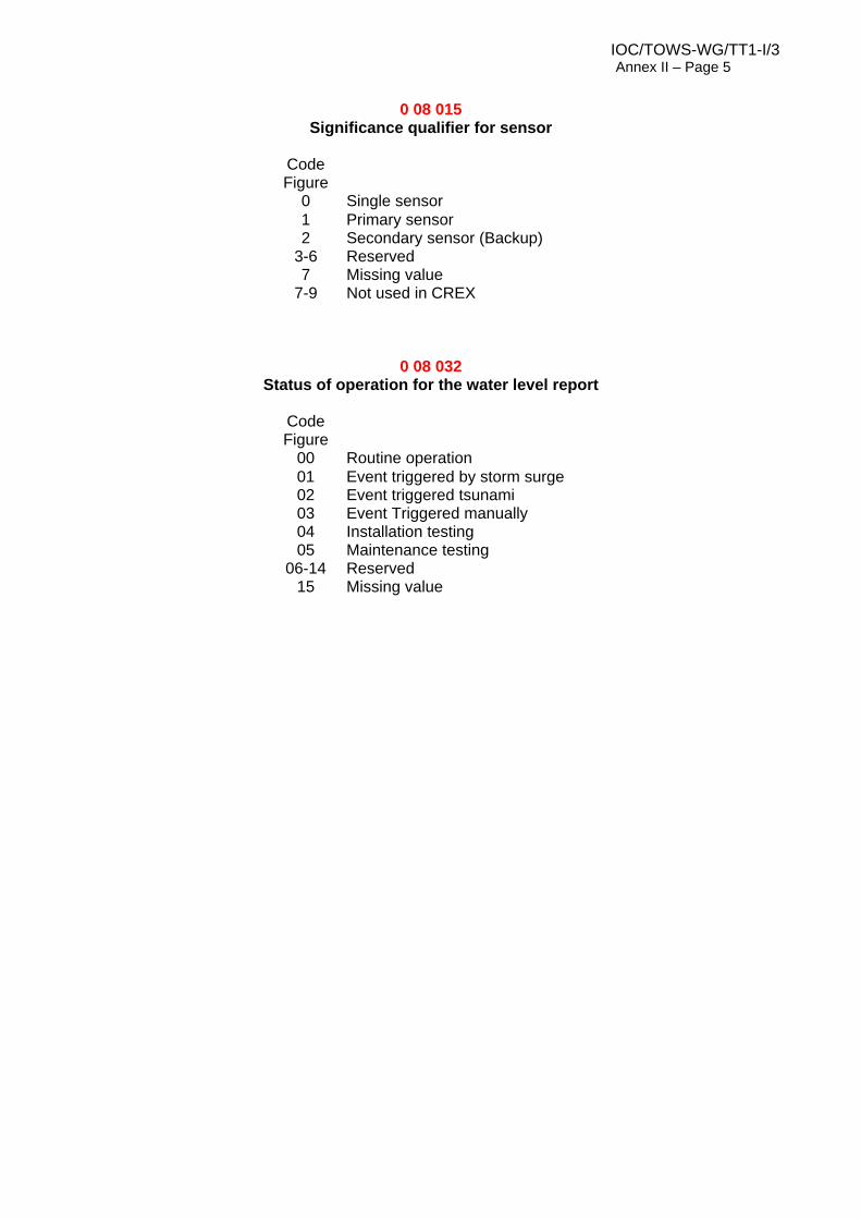
3 06 012 Sequence for representation of sensor type, significance qualifier for sensor and status of operation
0 02 007 Type of sensor for water level measuring instrument 0 08 015 significance qualifier for sensor 0 08 032 Status of operation 3 06 029 0 25 170 Sampling interval (seconds) 0 25 171 Sample averaging period (seconds) 0 25 172 Number of samples
3 06 029 Sequence for representation of sampling information for water levels in the time series report
0 25 170 Sampling interval (seconds) 0 25 171 Sample averaging period (seconds) 0 25 172 Number of samples
3 06 013 Sequence for representation of water level and residual in the time series
3 06 012 sensor type, significance qualifier for sensor and status of operation 3 01 011 0 04 001 Year ) 0 04 002 Month ) 0 04 003 Day ) Reference date/time for the time series
IOC/TOWS-WG/TT1-I/3 Annex II – Page 2
3 06 013 Sequence for representation of water level and residual in the time series
3 01 013 0 04 004 Hour ) 0 04 005 Minute ) 0 04 006 Second) 0 22 120 Tide station automated water level check 0 22 121 Tide station manual water level check 0 04 015 Time increment added to reset the reference time 0 04 065 Time increment added to each data value in the time series 1 02 000 Delayed replication of 2 descriptors 0 31 001 Delayed replication factor 0 22 038 Tidal elevation with respect to local chart datum 0 22 040 Meteorological residual tidal elevation (surge or offset)
3 06 014 Sequence for representation of water level in the time series, similar to 306013 but with no residual
3 06 012 Sensor type, significance qualifier for sensor and status of operation 3 01 011 0 04 001 Year ) 0 04 002 Month ) 0 04 003 Day ) Reference date/time for the time series 3 01 013 0 04 004 Hour ) 0 04 005 Minute ) 0 04 006 Second) 0 22 120 Tide station automated water level check 0 22 121 Tide station manual water level check 0 04 015 Time increment added to reset the reference time 0 04 065 Time increment added to each data value in the time series 1 01 000 Delayed replication of 1 descriptor 0 31 001 Delayed replication factor 0 22 038 Tidal elevation with respect to local chart datum
3 06 016 Sequence for representation of ancillary meteorological data associated with water level data
3 01 011 0 04 001 Year ) 0 04 002 Month ) 0 04 003 Day ) Reference date/time for the time series 3 01 013 0 04 004 Hour ) 0 04 005 Minute ) 0 04 006 Second) 0 10 004 Station level pressure 0 10 050 Mean sea level pressure 3 02 032 0 07 032 Temperature and humidity data 0 12 101 Dry bulb temperature 0 12 103 Dew point temperature 0 13 003 Relative humidity
IOC/TOWS-WG/TT1-I/3 Annex II – Page 3
3 06 016 Sequence for representation of ancillary meteorological data associated with water level data
0 07 032 Height of sensor above local ground 0 02 002 Type of instrument for wind measurement 0 08 021 Time significance = 2 (time averaged) 0 04 025 Time period, e.g. = 1 for 1-minute, = 10 for 10-minute 0 11 001 Wind direction 0 11 002 Wind speed 0 04 025 Time period in minutes 0 11 043 Maximum wind gust direction 0 11 041 Maximum wind gust speed 0 25 026 AWS battery voltage 0 12 060 AWS enclosure internal temperature
Practical use of the new templates: Using the proposed BUFR/CREX templates 306011, 306012, 306013, 306014, 306016 and 306029 some practical implementations can be encoded as follows in CREX:
Single sensor with no ancillary meteorological data:
Stations with two sensors can choose to add a fixed replication descriptor or a delayed replication descriptor. The following example is an example of fixed replication of two sensors:
0 02 007 Type of sensor for water level measuring instrument
Code table
0 0 4 Code table
0 2
0 02 147 Method of transmission to collection centre
Code table
0 0 7 Code table
0 2
0 08 015 Significant qualifier for sensor Code table
0 0 3 Code table
0 1
0 08 032 Status of operation Code table
0 0 4 Code table
0 2
0 12 060 AWS enclosure internal temperature K 1 0 12 °C 1 3 0 25 170 sampling interval (time) Second 0 0 10 Second 0 4 0 25 171 sample averaging period Second 0 0 10 Second 0 4 0 25 172 Number of samples Numeri
c 0 0 10 Numeric 0 4
IOC/TOWS-WG/TT1-I/3 Annex III
ANNEX III
WMO BUFR/CREX TEMPLATES FOR TSUNAMETER DATA
AND DART BUOY SYSTEM MESSAGES DATA DESCRIPTORS FOR VARIOUS DEEP-OCEAN TSUNAMETER SYSTEM MESSAGES (DART BUOYS) The common and specific items required for the various types of tsunameter system messages are described as follows. Descriptors in red are not available in the WMO Manual on Codes. Item Description Available/ Possible
Descriptors Common items for all tsunameter system messages 306027 Station ID 5-digit buoy / platform ID e.g. 23401, 55401 0 01 005 Platform transmitter ID
New code table required for type / manufacturer of deep-ocean tsunameters 0 02 047
Time transmitted to the ground systems
Year, month, day hour, minute, second when the standard hourly reports are transmitted. The day, hour and minute are used in the abbreviated header label (YYGGgg)
3 01 011 3 01 013
Specific Items for Tsunameter Surface Buoy Position Daily Report 306028 Report observation time
Reference time for the values reported in the time series – year, month, day, hour, minute, second
3 01 011 3 01 013
Latitude and longitude (high accuracy)
Latitude and longitude up to 5 decimals 3 01 021
IOC/TOWS-WG/TT1-I/3 Annex III – Page 2
Item Description Available/ Possible Descriptors
Common Items for Standard Hourly and Tsunami Event Reports 306029 Water column height sampling interval (seconds)
Time interval in which water column height samples are integrated and reported, e.g. for the PMEL DART II systems, standard hourly reports are 15-sec samples reporting every 15 minutes at HH+15, 30, 45 and 60 minutes so sampling interval is 900 sec (15 minutes) Tsunami event first and second reports are 15-sec, other reports are 1-minute samples of 4 15-sec average values so sampling intervals are 15 sec and 60 sec respectively Extended tsunami event reports are 1-minute samples of 4 15-sec average values so sampling interval is 15 sec
New descriptor required 0 25 170
Water column height sample averaging period (seconds)
For the PMEL DART II systems, the sample averaging period is 15 sec for the standard hourly reports, 15 sec for the tsunami event first and second reports, 60 sec for the other reports, 60 sec for the extended event reports
New descriptor required 0 25 171
Number of samples
For averaged samples the number of samples collected during the sampling period
New descriptor required 0 25 172
Specific Items for Standard Hourly Reports 306030 (normally six hourly messages of four 15-second observations at 15-minute intervals are reported in one transmission block) Delayed replication
Usually six replications of hourly reports but it may be less if tsunami event occurs or more if transmission blocks are interrupted
1 11 000
Quality information for message status
Code table 1 – character indicator 0=Message intact 1=Message corrupt
Code table 0 33 002 Quality Information
Report observation time
Reference time for the values reported in the time series – year, month, day, hour, minute, second
3 01 011 3 01 013
Battery voltage BPR CPU voltage, normal range is 13.9 to 17.9 volts
0 25 025
Battery voltage Acoustic modem DSP voltage, normal range is 4.0 to 4.3 volts
0 25 025
Battery voltage (large value)
Acoustic modem voltage, normal range is 34 to 48 volts
0 25 026
BPR transmission count
Number of transmission attempts to deliver BPR data
New descriptor required 0 22 185
Time increment to each data value in the time series
The time increment in minutes to be added to each data values in the time series to determine the time stamp of each report
0 04 065
Fixed replication Replicate 1 descriptor 4 times 1 01 004 Water column height
Fixed replications 4 times of water column heights in mm at HH+15 ,H+30 ,H+45 and H+60
New descriptor required 0 22 182
IOC/TOWS-WG/TT1-I/3 Annex III – Page 3
Item Description Available/ Possible
Descriptors Specific Items for Tsunami Event Reports 306031 Tsunami event report message ID
2-digit sequence number allocated to the report for each tsunami event
New descriptor required 0 01 053
Common Items for Tsunami Event Reports and Extended Tsunami Event Reports 306031 Quality information for message status
Time of tsunami Time when tsunami is detected according to the tsunami trigger algorithm.
3 01 011 3 01 013
Reference time for the time series
Reference time for the time series. This is the first data value time stamp for the for the DARTII systems tsunami event data messages.
3 01 011 3 01 013
BPR transmission count
Number of transmission attempts to deliver BPR data.
New descriptor required 0 22 185
Water column height
Water column height reference value (m), for restoring the actual value from the deviations.
New descriptor required 0 22 182
Time increment to reset the reference time
Time increment in seconds to be added to the reference time before the time series processing.
0 04 016
Time increment to each data value in the time series
The time increment in seconds to be added to each data values in the time series to determine the time stamp of each report.
0 04 066
Delayed replication
Delayed replication of 1 descriptor of water column height deviations 3 replications for the first Tsunami event report 15 replications for all other Tsunami event reports 119 replications for Extended tsunami event reports.
1 01 000
Water column height deviation from the reference value
Water column height deviation from the reference value, Deviation = Actual value – Reference value
New descriptor required 0 22 184
IOC/TOWS-WG/TT1-I/3 Annex III – Page 4 BUFR/CREX TEMPLATE FOR TSUNAMETER DATA AND DART BUOY SYSTEM MESSAGES
Items in red are new descriptors suggested for review and incorporation in the WMO Manual on Codes.
3 06 027 Sequence for representation of DART buoy identification, transmitter ID, type of tsunameter and the time the message is transmitted to the ground system
0 01 005 Buoy/platform identifier 0 01 052 Platform transmitter identifier 0 02 047 Deep-ocean tsunameter platform type/manufacturer 3 01 011 0 04 001 Year (Time the message is transmitted to the ground system) 0 04 002 Month 0 04 003 Day 3 01 013 0 04 004 Hour 0 04 005 Minute 0 04 006 Second
3 06 028 Sequence for representation of time of observation and DART buoy position daily report
3 06 029 Sequence for representation of tsunameter sampling information for water column heights in the time series report
0 25 170 Sampling interval (seconds) 0 25 171 Sample averaging period (seconds) 0 25 172 Number of samples
3 06 030 Sequence for representation of DART buoy standard hourly report
3 06 027 Buoy ID, transmitter ID, platform type, message transmission time 3 06 029 Tsunameter sampling information
1 11 000 Delayed replication of 11 descriptors 0 31 001 Delayed replication factor 0 33 002 Quality information (for message status) 3 01 011 0 04 001 Year ) 0 04 002 Month ) 0 04 003 Day ) Reference date/time for the time series 3 01 013 0 04 004 Hour )
IOC/TOWS-WG/TT1-I/3 Annex III – Page 5
3 06 030 Sequence for representation of DART buoy standard hourly report
0 04 005 Minute ) 0 04 006 Second) 0 25 025 Battery voltage for BPR CPU 0 25 025 Battery voltage for acoustic modem DSP 0 25 026 Battery voltage for Acoustic modem 0 22 185 BPR transmission count 0 04 015 Time increment added to reset the reference time 0 04 065 Time increment added to each data value in the time series 1 01 004 Replicate 1 descriptor 4 times 0 22 182 Water column height
3 06 031 Sequence for representation of DART buoy tsunami event reports and extended tsunami event reports
3 06 027 Buoy ID, transmitter ID, platform type, message transmission time 3 06 029 Tsunameter sampling information 0 01 053 Tsunameter report sequence number triggered by a tsunami event 0 33 002 Quality information (for message status) 3 01 011 0 04 001 Year ) 0 04 002 Month ) 0 04 003 Day ) Time when tsunami is detected 3 01 013 0 04 004 Hour ) 0 04 005 Minute ) 0 04 006 Second) 3 01 011 0 04 001 Year ) 0 04 002 Month ) 0 04 003 Day ) Reference date/time for the time series 3 01 013 0 04 004 Hour ) 0 04 005 Minute ) 0 04 006 Second) 0 22 185 BPR transmission count
0 22 182 Water column height reference for determination of actual value reported in the time series
0 04 016 Time increment added to reset the reference time
0 04 066 Time increment added to each data value in the time series
1 01 000 Delayed replication of 1 descriptor 0 31 001 Delayed replication factor 0 22 184 Water column height deviation from the reference value
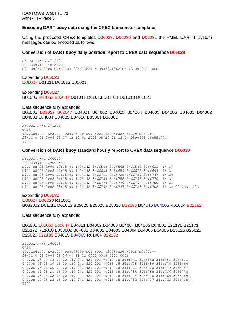
IOC/TOWS-WG/TT1-I/3 Annex III – Page 6 Encoding DART buoy data using the CREX tsunameter template: Using the proposed CREX templates D06028, D06030 and D06031 the PMEL DART II system messages can be encoded as follows: Conversion of DART buoy daily position report to CREX data sequence D06028 SZIO01 KWNB 271219 ^^DD23401S 240121901 D$0 08/27/2008 01:13:04 0854.4827 N 08833.1062 E* 13 00-0NN 00E Expanding D06028 D06027 D01011 D01013 D01021 Expanding D06027 B01005 B01052 B02047 D01011 D01013 D01011 D01013 D01021 Data sequence fully expanded B01005 B01052 B02047 B04001 B04002 B04003 B04004 B04005 B04006 B04001 B04002 B04003 B04004 B04005 B04006 B05001 B06001 SZIO02 KWNB 271219 CREX++ T0002061400 A031007 P00008000 U00 S001 Y20080827 H1219 D06028++ 23401 0 01 2008 08 27 12 19 01 2008 08 27 01 13 04 0890805 08855177++ 7777
Additional table entries in Common Code Table C-13 for the tsunameter data sequence: Regulation 95.3.1.2 for CREX Edition 2 requires a six-digit table indicator (nnnmmm) preceded by the letter A. The first three digits (nnn) define the data category referred to in CREX Table A. The next 3 digits (mmm) indicates the sub-category of the data from Common Code Table C-13.
Tsunameter data belong to ‘Oceanographic Data’ in the Data Category, code figure=031 for (nnn) but there is no code figure in the International Data Sub-category for ‘Tsunameter data’. Code figure=007 for (mmm) is proposed. Additional Code Tables and BUFR/CREX Table B entries for the tsunameter data sequence:
Additional BUFR/CREX Table B entries for the DART buoy templates
BUFR CREX
TABLE REFERENCE F X Y
TABLE ELEMENT NAME
UNIT
SCAL
E
REFERENCE VALUE
DATA WIDTH (Bits)
UNIT
SCAL
E
DATA WIDTH
(Characters)
0 01 053 Tsunameter report sequence number triggered by a tsunami event
Numeric 0 0 7 Numeric
0 2
0 02 047 Deep-ocean tsunameter type Code table
0 0 7 Code table
0 2
0 01 052 Platform transmitter ID Code table
0 0 3 Code table
0 1
0 25 170 sampling interval (time) Second 0 0 10 Second 0 4 0 25 171 sample averaging period Second 0 0 10 Second 0 4 0 25 172 Number of samples Numeric 0 0 10 Numeri
c 0 4
0 22 182 Water column height (see Note 9) m 3 0 23 m 3 7 0 22 184 Water column height deviation from the
0 04 066 Short time increment Second 0 -128 8 Second 0 2 Footnote for BUFR TABLE B Class 22 – Oceanographic elements Notes: (9) The maximum deployment depth of deep-ocean tsunameters such as the PMEL Deep-Ocean Assessment and Reporting of Tsunamis (DATT II) is about 6000 m.
In this Series, entitled
Reports of Meetings of Experts and Equivalent Bodies, which was initiated in 1984 and which is published in English only, unless otherwise specified, the reports of the following meetings have already been issued:
1. Third Meeting of the Central Editorial Board for the Geological/Geophysical Atlases of the Atlantic and Pacific Oceans
2. Fourth Meeting of the Central Editorial Board for the Geological/Geophysical Atlases of the Atlantic and Pacific Oceans S. Fourth Session of the Joint IOC-WMO-CPPS Working Group on the Investigations of 'El Niño' (Also printed in Spanish)
4. First Session of the IOC-FAO Guiding Group of Experts on the Programme of Ocean Science in Relation to Living Resources
5. First Session of the IOC-UN(OETB) Guiding Group of Experts on the Programme of Ocean Science in Relation to Non-Living Resources
6. First Session of the Editorial Board for the International Bathymetric Chart of the Mediterranean and Overlay Sheets
7. First Session of the Joint CCOP(SOPAC)-IOC Working Group on South Pacific Tectonics and Resources
8. First Session of the IODE Group of Experts on Marine Information Management
9. Tenth Session of the Joint CCOP-IOC Working Group on Post-IDOE Studies in East Asian Tectonics and Resources
10. Sixth Session of the IOC-UNEP Group of Experts on Methods, Standards and Intercalibration
11. First Session of the IOC Consultative Group on Ocean Mapping (Also printed in French and Spanish)
12. Joint 100-WMO Meeting for Implementation of IGOSS XBT Ships-of-Opportunity Programmes
13. Second Session of the Joint CCOP/SOPAC-IOC Working Group on South Pacific Tectonics and Resources
14. Third Session of the Group of Experts on Format Development
15. Eleventh Session of the Joint CCOP-IOC Working Group on Post-IDOE Studies of South-East Asian Tectonics and Resources
16. Second Session of the IOC Editorial Board for the International Bathymetric Chart of the Mediterranean and Overlay Sheets
17. Seventh Session of the IOC-UNEP Group of Experts on Methods, Standards and lntercalibration
18. Second Session of the IOC Group of Experts on Effects of Pollutants
19. Primera Reunión del Comité Editorial de la COI para la Carta Batimétrica lnternacional del Mar Caribe y Parte del Océano Pacífico frente a Centroamérica (Spanish only)
20. Third Session of the Joint CCOP/SOPAC-IOC Working Group on South Pacific Tectonics and Resources
21. Twelfth Session of the Joint CCOP-IOC Working Group on Post-IDOE Studies of South-East Asian Tectonics and Resources
22. Second Session of the IODE Group of Experts on Marine Information Management
23. First Session of the IOC Group of Experts on Marine Geology and Geophysics in the Western Pacific
24. Second Session of the IOC-UN(OETB) Guiding Group of Experts on the Programme of Ocean Science in Relation to Non-Living Resources (Also printed in French and Spanish)
25. Third Session of the IOC Group of Experts on Effects of Pollutants
26. Eighth Session of the IOC-UNEP Group of Experts on Methods, Standards and lntercalibration
27. Eleventh Session of the Joint IOC-IHO Guiding Committee for the General Bathymetric Chart of the Oceans (Also printed in French)
28. Second Session of the IOC-FAO Guiding Group of Experts on the Programme of Ocean Science in Relation to Living Resources
29. First Session of the IOC-IAEA-UNEP Group of Experts on Standards and Reference Materials
30. First Session of the IOCARIBE Group of Experts on Recruitment in Tropical Coastal Demersal Communities (Also printed in Spanish)
31. Second IOC-WMO Meeting for Implementation of IGOSS XBT Ship-of-Opportunity Programmes
32. Thirteenth Session of the Joint CCOP-IOC Working Group on Post-IDOE Studies of East Asia Tectonics and Resources
33. Second Session of the IOC Task Team on the Global Sea-Level Observing System
34. Third Session of the IOC Editorial Board for the International Bathymetric Chart of the Mediterranean and Overlay Sheets
35. Fourth Session of the IOC-UNEP-IMO Group of Experts on Effects of Pollutants
36. First Consultative Meeting on RNODCs and Climate Data Services
37. Second Joint IOC-WMO Meeting of Experts on IGOSS-IODE Data Flow
38. Fourth Session of the Joint CCOP/SOPAC-IOC Working Group on South Pacific Tectonics and Resources
39. Fourth Session of the IODE Group of Experts on Technical Aspects of Data Exchange
40. Fourteenth Session of the Joint CCOP-IOC Working Group on Post-IDOE Studies of East Asian Tectonics and Resources
41. Third Session of the IOC Consultative Group on Ocean Mapping
42. Sixth Session of the Joint IOC-WMO-CCPS Working Group on the Investigations of 'El Niño' (Also printed in Spanish)
43. First Session of the IOC Editorial Board for the International Bathymetric Chart of the Western Indian Ocean
44. Third Session of the IOC-UN(OALOS) Guiding Group of Experts on the Programme of Ocean Science in Relation to Non-Living Resources
45. Ninth Session of the IOC-UNEP Group of Experts on Methods, Standards and lntercalibration
46. Second Session of the IOC Editorial Board for the International Bathymetric Chart of the Caribbean Sea and the Gulf of Mexico
47. Cancelled
48. Twelfth Session of the Joint IOC-IHO Guiding Committee for the General Bathymetric Chart of the Oceans
49. Fifteenth Session of the Joint CCOP-IOC Working Group on Post-IDOE Studies of East Asian Tectonics and Resources
50. Third Joint IOC-WMO Meeting for Implementation of IGOSS XBT Ship-of-Opportunity Programmes
51. First Session of the IOC Group of Experts on the Global Sea-Level Observing System
52. Fourth Session of the IOC Editorial Board for the International Bathymetric Chart of the Mediterranean
53. First Session of the IOC Editorial Board for the International Chart of the Central Eastern Atlantic (Also printed in French)
54. Third Session of the IOC Editorial Board for the International Bathymetric Chart of the Caribbean Sea and the Gulf of Mexico (Also printed in Spanish)
55. Fifth Session of the IOC-UNEP-IMO Group of Experts on Effects of Pollutants
56. Second Session of the IOC Editorial Board for the International Bathymetric Chart of the Western Indian Ocean
57. First Meeting of the IOC ad hoc Group of Experts on Ocean Mapping in the WESTPAC Area
58. Fourth Session of the IOC Consultative Group on Ocean Mapping
59. Second Session of the IOC-WMO/IGOSS Group of Experts on Operations and Technical Applications
2
60. Second Session of the IOC Group of Experts on the Global Sea-Level Observing System
61. UNEP-IOC-WMO Meeting of Experts on Long-Term Global Monitoring System of Coastal and Near-Shore Phenomena Related to Climate Change
62. Third Session of the IOC-FAO Group of Experts on the Programme of Ocean Science in Relation to Living Resources
63. Second Session of the IOC-IAEA-UNEP Group of Experts on Standards and Reference Materials
64. Joint Meeting of the Group of Experts on Pollutants and the Group of Experts on Methods, Standards and Intercalibration
65. First Meeting of the Working Group on Oceanographic Co-operation in the ROPME Sea Area
66. Fifth Session of the Editorial Board for the International Bathymetric and its Geological/Geophysical Series
67. Thirteenth Session of the IOC-IHO Joint Guiding Committee for the General Bathymetric Chart of the Oceans (Also printed in French)
68. International Meeting of Scientific and Technical Experts on Climate Change and Oceans
69. UNEP-IOC-WMO-IUCN Meeting of Experts on a Long-Term Global Monitoring System
70. Fourth Joint IOC-WMO Meeting for Implementation of IGOSS XBT Ship-of-Opportunity Programmes
71. ROPME-IOC Meeting of the Steering Committee on Oceanographic Co-operation in the ROPME Sea Area
72. Seventh Session of the Joint IOC-WMO-CPPS Working Group on the Investigations of 'El Niño' (Spanish only)
73. Fourth Session of the IOC Editorial Board for the International Bathymetric Chart of the Caribbean Sea and the Gulf of Mexico (Also printed in Spanish)
74. UNEP-IOC-ASPEI Global Task Team on the Implications of Climate Change on Coral Reefs
75. Third Session of the IODE Group of Experts on Marine Information Management
76. Fifth Session of the IODE Group of Experts on Technical Aspects of Data Exchange
77. ROPME-IOC Meeting of the Steering Committee for the Integrated Project Plan for the Coastal and Marine Environment of the ROPME Sea Area
78. Third Session of the IOC Group of Experts on the Global Sea-level Observing System
79. Third Session of the IOC-IAEA-UNEP Group of Experts on Standards and Reference Materials
80. Fourteenth Session of the Joint IOC-IHO Guiding Committee for the General Bathymetric Chart of the Oceans
81. Fifth Joint IOG-WMO Meeting for Implementation of IGOSS XBT Ship-of-Opportunity Programmes
82. Second Meeting of the UNEP-IOC-ASPEI Global Task Team on the Implications of climate Change on Coral Reefs
83. Seventh Session of the JSC Ocean Observing System Development Panel
84. Fourth Session of the IODE Group of Experts on Marine Information Management
85. Sixth Session of the IOC Editorial Board for the International Bathymetric chart of the Mediterranean and its Geological/Geophysical Series
86. Fourth Session of the Joint IOC-JGOFS Panel on Carbon Dioxide
87. First Session of the IOC Editorial Board for the International Bathymetric Chart of the Western Pacific
88. Eighth Session of the JSC Ocean Observing System Development Panel
89. Ninth Session of the JSC Ocean Observing System Development Panel
90. Sixth Session of the IODE Group of Experts on Technical Aspects of Data Exchange
91. First Session of the IOC-FAO Group of Experts on OSLR for the IOCINCWIO Region
92. Fifth Session of the Joint IOC-JGOFS CO, Advisory Panel Meeting
93. Tenth Session of the JSC Ocean Observing System Development Panel
94. First Session of the Joint CMM-IGOSS-IODE Sub-group on Ocean Satellites and Remote Sensing
95. Third Session of the IOC Editorial Board for the International Chart of the Western Indian Ocean
96. Fourth Session of the IOC Group of Experts on the Global Sea Level Observing System
97. Joint Meeting of GEMSI and GEEP Core Groups
98. First Session of the Joint Scientific and Technical Committee for Global Ocean Observing System
99. Second International Meeting of Scientific and Technical Experts on Climate Change and the Oceans
100. First Meeting of the Officers of the Editorial Board for the International Bathymetric Chart of the Western Pacific
101. Fifth Session of the IOC Editorial Board for the International Bathymetric Chart of the Caribbean Sea and the Gulf of Mexico
102. Second Session of the Joint Scientific and Technical Committee for Global Ocean Observing System
103. Fifteenth Session of the Joint IOC-IHO Committee for the General Bathymetric Chart of the Oceans
104. Fifth Session of the IOC Consultative Group on Ocean Mapping
105. Fifth Session of the IODE Group of Experts on Marine Information Management
106. IOC-NOAA Ad hoc Consultation on Marine Biodiversity
107. Sixth Joint IOC-WMO Meeting for Implementation of IGOSS XBT Ship-of-Opportunity Programmes
108. Third Session of the Health of the Oceans (HOTO) Panel of the Joint Scientific and Technical Committee for GLOSS
109. Second Session of the Strategy Subcommittee (SSC) of the IOC-WMO-UNEP Intergovernmental Committee for the Global Ocean Observing System
110. Third Session of the Joint Scientific and Technical Committee for Global Ocean Observing System
111. First Session of the Joint GCOS-GOOS-WCRP Ocean Observations Panel for Climate
112. Sixth Session of the Joint IOC-JGOFS C02 Advisory Panel Meeting
113. First Meeting of the IOC/WESTPAC Co-ordinating Committee for the North-East Asian Regional - Global Ocean Observing System (NEAR-GOOS)
114. Eighth Session of the Joint IOC-WMO-CPPS Working Group on the Investigations of "El Niño" (Spanish only)
115. Second Session of the IOC Editorial Board of the International Bathymetric Chart of the Central Eastern Atlantic (Also printed in French)
116. Tenth Session of the Officers Committee for the Joint IOC-IHO General Bathymetric Chart of the Oceans (GEBCO), USA, 1996
117. IOC Group of Experts on the Global Sea Level Observing System (GLOSS), Fifth Session, USA, 1997
118. Joint Scientific Technical Committee for Global Ocean Observing System (J-GOOS), Fourth Session, USA, 1997
199 First Session of the Joint 100-WMO IGOSS Ship-of-Opportunity Programme Implementation Panel, South Africa, 1997
120. Report of Ocean Climate Time-Series Workshop, Joint GCOS-GOOS-WCRP Ocean Observations Panel for Climate, USA, 1997
121. IOC/WESTPAC Co-ordinating Committee for the North-East Asian Regional Global Ocean Observing System (NEAR-GOOS), Second Session, Thailand, 1997
3
122. First Session of the IOC-IUCN-NOAA Ad hoc Consultative Meeting on Large Marine Ecosystems (LME), France, 1997
123. Second Session of the Joint GCOS-GOOS-WCRP Ocean Observations Panel for Climate (OOPC), South Africa, 1997
124. Sixth Session of the IOC Editorial Board for the International Bathymetric Chart of the Caribbean Sea and the Gulf of Mexico, Colombia, 1996 (also printed in Spanish)
125. Seventh Session of the IODE Group of Experts on Technical Aspects of Data Exchange, Ireland, 1997
126. IOC-WMO-UNEP-ICSU Coastal Panel of the Global Ocean Observing System (GOOS), First Session, France, 1997
127. Second Session of the IOC-IUCN-NOAA Consultative Meeting on Large Marine Ecosystems (LME), France, 1998
128. Sixth Session of the IOC Consultative Group on Ocean Mapping (CGOM), Monaco, 1997
129. Sixth Session of the Tropical Atmosphere - Ocean Array (TAO) Implementation Panel, United Kingdom, 1997
130. First Session of the IOC-WMO-UNEP-ICSU Steering Committee of the Global Ocean Observing System (GOOS), France, 1998
131. Fourth Session of the Health of the Oceans (HOTO) Panel of the Global Ocean Observing System (GOOS), Singapore, 1997
132. Sixteenth Session of the Joint IOC-IHO Guiding Committee for the General Bathymetric Chart of the Oceans (GEBCO), United Kingdom, 1997
133. First Session of the IOC-WMO-UNEP-ICSU-FAO Living Marine Resources Panel of the Global Ocean Observing System (GOOS), France, 1998
134. Fourth Session of the IOC Editorial Board for the International Bathymetric Chart of the Western Indian Ocean (IOC/EB-IBCWIO-IW3), South Africa, 1997
135. Third Session of the Joint GCOS-GOOS-WCRP Ocean Observations Panel for Climate (OOPC), France, 1998
136. Seventh Session of the Joint IOC-JGOFS C02 Advisory Panel Meeting, Germany, 1997
137. Implementation of Global Ocean Observations for GOOS/GCOS, First Session, Australia, 1998
138. Implementation of Global Ocean Observations for GOOS/GCOS, Second Session, France, 1998
139. Second Session of the IOC-WMO-UNEP-ICSU Coastal Panel of the Global Ocean Observing System (GOOS), Brazil, 1998
140. Third Session of IOC/WESTPAC Co-ordinating Committee for the North-East Asian Regional - Global Ocean Observing System (NEAR-GOOS), China, 1998
141. Ninth Session of the Joint IOC-WMO-CPPS Working Group on the Investigations of 'El Niño', Ecuador, 1998 (Spanish only)
142. Seventh Session of the IOC Editorial Board for the International Bathymetric Chart of the Mediterranean and its Geological/Geophysical Series, Croatia, 1998
143. Seventh Session of the Tropical Atmosphere-Ocean Array (TAO) Implementation Panel, Abidjan, Côte d'lvoire, 1998
144. Sixth Session of the IODE Group of Experts on Marine Information Management (GEMIM), USA, 1999
145. Second Session of the IOC-WMO-UNEP-ICSU Steering Committee of the Global Ocean Observing System (GOOS), China, 1999
146. Third Session of the IOC-WMO-UNEP-ICSU Coastal Panel of the Global Ocean Observing System (GOOS), Ghana, 1999
147. Fourth Session of the GCOS-GOOS-WCRP Ocean Observations Panel for Climate (OOPC); Fourth Session of the WCRP CLIVAR Upper Ocean Panel (UOP); Special Joint Session of OOPC and UOP, USA, 1999
148. Second Session of the IOC-WMO-UNEP-ICSU-FAO Living Marine Resources Panel of the Global Ocean Observing System (GOOS), France, 1999
149. Eighth Session of the Joint IOC-JGOFS CO2 Advisory Panel Meeting, Japan, 1999
150. Fourth Session of the IOC/WESTPAC Co-ordinating Committee for the North-East Asian Regional – Global Ocean Observing System (NEAR-GOOS), Japan, 1999
151. Seventh Session of the IOC Consultative Group on Ocean Mapping (CGOM), Monaco, 1999
152. Sixth Session of the IOC Group of Experts on the Global Sea level Observing System (GLOSS), France, 1999
153. Seventeenth Session of the Joint IOC-IHO Guiding Committee for the General Bathymetric Chart of the Oceans (GEBCO), Canada, 1999
154. Comité Editorial de la COI para la Carta Batimétrica Internacional del Mar Caribe y el Golfo de Mexico (IBCCA), Septima Reunión, Mexico, 1998
IOC Editorial Board for the International Bathymetric Chart of the Caribbean Sea and the Gulf of Mexico (IBCCA), Seventh Session, Mexico, 1998
155. Initial Global Ocean Observing System (GOOS) Commitments Meeting, IOC-WMO-UNEP-ICSU/Impl-III/3, France, 1999
156. First Session of the ad hoc Advisory Group for IOCARIBE-GOOS, Venezuela, 1999 (also printed in Spanish and French)
157. Fourth Session of the IOC-WMO-UNEP-ICSU Coastal Panel of the Global Ocean Observing System (GOOS), China, 1999
158. Eighth Session of the IOC Editorial Board for the International Bathymetric Chart of the Mediterranean and its Geological/Geophysical Series, Russian Federation, 1999
159. Third Session of the IOC-WMO-UNEP-ICSU-FAO Living Marine Resources Panel of the Global Ocean Observing System (GOOS), Chile, 1999
160. Fourth Session of the IOC-WMO-UNEP-ICSU-FAO Living Marine Resources Panel of the Global Ocean Observing System (GOOS). Hawaii, 2000
161. Eighth Session of the IODE Group of Experts on Technical Aspects of Data Exchange, USA, 2000
162. Third Session of the IOC-IUCN-NOAA Consultative Meeting on Large Marine Ecosystems (LME), France, 2000
163. Fifth Session of the IOC-WMO-UNEP-ICSU Coastal Panel of the Global Ocean Observing System (GOOS), Poland, 2000
164. Third Session of the IOC-WMO-UNEP-ICSU Steering Committee of the Global Ocean Observing System (GOOS), France, 2000
165. Second Session of the ad hoc Advisory Group for IOCARIBE-GOOS, Cuba, 2000 (also printed in Spanish and French)
166. First Session of the Coastal Ocean Observations Panel, Costa Rica, 2000
167. First GOOS Users' Forum, 2000
168. Seventh Session of the Group of Experts on the Global Sea Level Observing System, Honolulu, 2001
169. First Session of the Advisory Body of Experts on the Law of the Sea (ABE-LOS), France, 2001 (also printed in French)
170. Fourth Session of the IOC-WMO-UNEP-ICSU Steering Committee of the Global Ocean Observing System, Chile, 2001
171. First Session of the IOC-SCOR Ocean CO2 Advisory Panel, France, 2000
172. Fifth Session of the GCOS-GOOS-WCRP Ocean Observations Panel for Climate (OOPC), Norway, 2000 (electronic copy only)
173. Third Session of the ad hoc Advisory Group for IOCARIBE-GOOS, USA, 2001 (also printed in Spanish and French)
174. Second Session of the Coastal Ocean Observations Panel and GOOS Users' Forum, Italy, 2001
175. Second Session of the Black Sea GOOS Workshop, Georgia, 2001
176. Fifth Session of the IOC/WESTPAC Co-ordinating Committee for the North-East Asian Regional – Global Ocean Observing System (NEAR-GOOS), Republic of Korea, 2000
177. Second Session of the Advisory Body of Experts on the Law of the Sea (IOC/ABE-LOS), Morocco, 2002 (also printed in French)
178. Sixth Session of the Joint GCOS-GOOS-WCRP Ocean Observations Panel for Climate (OOPC), Australia, 2001 (electronic copy only)
179. Cancelled
4
180. Second Session of the IOC-SCOR Ocean CO2 Advisory Panel, Honolulu, Hawaii, U.S.A, 2002 (electronic copy only)
181. IOC Workshop on the Establishment of SEAGOOS in the Wider Southeast Asian Region, Seoul, Republic of Korea, 2001 (SEAGOOS preparatory workshop) (electronic copy only)
182. First Session of the IODE Steering Group for the Resource Kit, USA, 19–21 March 2001
183. Fourth Session of the IOC-IUCN-NOAA Consultative Meeting on Large Marine Ecosystems (LMEs), France, 2002
184. Seventh Session of the IODE Group of Experts on Marine Information Management (GEMIM), France, 2002 (electronic copy only)
185. Sixth Session of IOC/WESTPAC Coordinating Committee for the North-East Asian Regional - Global Ocean Observing System (NEAR-GOOS), Republic of Korea, 2001 (electronic copy only)
186. First Session of the Global Ocean Observing System (GOOS) Capacity Building Panel, Switzerland, 2002 (electronic copy only)
187. Fourth Session of the ad hoc Advisory Group for IOCARIBE-GOOS, 2002, Mexico (also printed in French and Spanish)
188. Fifth Session of the IOC Editorial Board for the International Bathymetric Chart of the Western Indian Ocean (IBCWIO), Mauritius, 2000
189. Third session of the Editorial Board for the International Bathymetric Chart of the Western Pacific, Chine, 2000
190. Third Session of the Coastal Ocean Observations Panel and GOOS Users' Forum, Vietnam, 2002
191. Eighth Session of the IOC Consultative Group on Ocean Mapping, Russian Federation, 2001
192. Third Session of the Advisory Body of Experts on the Law of the Sea (IOC/ABE-LOS), Lisbon, 2003 (also printed in French)
193. Extraordinary Session of the Joint IOC-WMO-CPPS Working Group on the Investigations of 'El Niño', Chile, 1999 (Spanish only; electronic copy only)
194. Fifth Session of the IOC-WMO-UNEP-ICSU Steering Committee of the Global Ocean Observing System, France, 2002
195. Sixth Session of the IOC-WMO-UNEP-ICSU Steering Committee of the Global Ocean Observing System, South Africa, 2003
196. Fourth Session of the Coastal Ocean Observations Panel, South Africa, 2002 (electronic copy only)
197. First Session of the JCOMM/IODE Expert Team On Data Management Practices, Belgium, 2003 (also JCOMM Meeting Report No. 25)
198. Fifth Session of the IOC-IUCN-NOAA Consultative Meeting on Large Marine Ecosystems (LMEs), Paris, 2003
199. Ninth Session of the IOC Consultative Group on Ocean Mapping, Monaco, 2003 (Recommendations in English, French, Russian and Spanish included)
200. Eighth Session of the IOC Group of Experts on the Global Sea level Observing System (GLOSS), France, 2003 (electronic copy only)
201. Fourth Session of the Advisory Body of Experts on the Law of the Sea (IOC/ABE-LOS), Greece, 2004 (also printed in French)
202. Sixth Session of the IOC-IUCN-NOAA Consultative Meeting on Large Marine Ecosystems (LMEs), Paris, 2004 (electronic copy only)
203. Fifth Session of the Advisory Body of Experts on the Law of the Sea (IOC/ABE-LOS), Argentina, 2005 (also printed in French)
204. Ninth Session of the IOC Group of Experts on the Global Sea level Observing System (GLOSS), France, 2005 (electronic copy only)
205. Eighth Session of the IOC/WESTPAC Co-ordinating Committee for the North-East Asian Regional – Global Ocean Observing System (NEAR-GOOS), China, 2003 (electronic copy only)
206. Sixth Meeting of the Advisory Body of Experts on the Law of the Sea (IOC/ABE-LOS), Spain, 2006 (also printed in French)
207. Third Session of the Regional Forum of the Global Ocean Observing System, South Africa, 2006 (electronic copy only)
208. Seventh Session of the IOC-UNEP-IUCN-NOAA Consultative Meeting on Large Marine Ecosystems (LMEs), Paris, 2005 (electronic copy only)
209. Eighth Session of the IOC-UNEP-IUCN-NOAA Consultative Meeting on Large Marine Ecosystems (LMEs), Paris, 2006 (electronic copy only)
210. Seventh Meeting of the IOC Advisory Body of Experts on the Law of the Sea (IOC/ABE-LOS), Gabon, 2007 (bilingual English/French)
211. First Meeting of the IOC Working Group on the Future of IOC, Paris, 2008 (Executive Summary in English, French, Russian and Spanish included)
212. First meeting of the Working Group on Tsunamis and Other Hazards Related to Sea-Level Warning and Mitigation Systems (TOWS-WG), Paris, 3–4 April 2008 (Executive Summary in English, French, Russian and Spanish included)
213. First Session of the Panel for Integrated Coastal Observation (PICO-I), Paris, 10–11 April 2008 (electronic copy only)
214. Tenth Session of the IOC Group of Experts on the Global Sea level Observing System (GLOSS), Paris, 6–8 June 2007 (electronic copy only)
215. Eighth Meeting of the IOC Advisory Body of Experts on the Law of the Sea (IOC/ABE-LOS), Paris, 21–25 April 2008 (bilingual English/French)
216. Fourth Session of the Global Ocean Observing System (GOOS) Regional Alliances Forum (GRF), Guayaquil, Ecuador, 25–27 November 2008 (electronic copy only)
217. Second Session of the Working Group on Tsunamis and Other Hazards Related to Sea-Level Warning and Mitigation Systems (TOWS-WG), Paris, 27 March 2009 (Executive Summary in English, French, Russian and Spanish included)
218. Ninth Meeting of the IOC Advisory Body of Experts on the Law of the Sea (IOC/ABE-LOS), Paris, 30 March–3 April 2009 (bilingual English/French)
219. First Session of the IOC-SCOR International Ocean Carbon Coordination Project (IOCCP) Scientific Steering Group (also IOCCP Reports, 3), Broomfield, Colorado, U.S.A., 1 October 2005 (electronic copy only)
220. Second Session of the IOC-SCOR International Ocean Carbon Coordination Project (IOCCP) Scientific Steering Group (also IOCCP Reports, 6), Paris, France, 20 April 2007 (electronic copy only)
221. Third Session of the IOC-SCOR International Ocean Carbon Coordination Project (IOCCP) Scientific Steering Group (also IOCCP Reports, 10), Villefranche-sur-mer, France, 3–4 October 2008 (electronic copy only)
222. Fourth Session of the IOC-SCOR International Ocean Carbon Coordination Project (IOCCP) Scientific Steering Group (also IOCCP Reports, 15), Jena, Germany, 14 September 2009 (electronic copy only)
223. First Meeting of the joint IOC-ICES Study Group on Nutrient Standards (SGONS) (also IOCCP Reports, 20), Paris, France, 23–24 March 2010 (Executive Summary in E, F, R, S included)
224. Third Session of the Working Group on Tsunamis and Other Hazards Related to Sea-Level Warning and Mitigation Systems (TOWS-WG), Lisbon, Portugal, 5–6 May 2010 (Executive Summary in English, French, Russian and Spanish included)
225. Eleventh Session of the IOC Group of Experts on the Global Sea level Observing System (GLOSS), Paris, 13–15 May 2009 (electronic copy only)
226. Second Session of the Panel for Integrated Coastal Observation (PICO-II), Paris, 24–26 February 2009 (electronic copy only)
227. First meeting of the Task Team on Seismic Data Exchange in the South West Pacific of the ICG/PTWS Regional Working Group for the Southwest Pacific, Port Vila, Vanuatu, 19–20 October 2009 (electronic copy only)
228. Fourth Session of the Working Group on Tsunamis and Other Hazards Related to Sea-Level Warning and Mitigation Systems (TOWS-WG), Paris, France, 20–21 March 2011 (Executive Summary in English, French, Russian and Spanish included)
229. Second Session of the IODE Steering Group for Ocean Teacher (SG-OT), Miami, Florida, 11–15 April 2011
230. First Meeting of the Inter-ICG Task Team 1 on Sea Level Monitoring for Tsunami (Working Group on Tsunamis and Other Hazards Related to Sea-Level Warning and Mitigation Systems (TOWS-WG), Seattle, USA, 29 November–1 December 2010