32
U.S. Department of the Interior Bureau of Land Management

National HistoricTrails Interpretive
Center
Historic Trails Youth Activity Guide
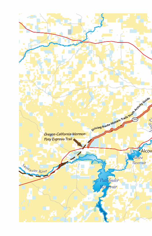
County Route 308-319
Would You Rather...?
U.S. Department of the InteriorBureau of Land ManagementU.S. Department of the InteriorBureau of Land Management

How This Activity Guide WorksThe driver is using the County Road 308 - 319 driver's guide to Independence Rock from Casper. The vehicle’s odometer must be set at 0.0 miles immediately after leaving Highway 220 (from Casper) towards Bessemer Bend. Refer to the driving guide for more great information about each site.
Keep in mind there is a “Would You Rather?” question to consider at each site. Think about your life now. Think about a child’s life on the trail over 150 years ago. Use the photographs, diary quotes, and what you learned to answer the final question:
Would you rather...Be a child of today on a road trip with your family?
or
be a child in a wagon train traveling west in 1849?
In each section you will find this symbol:
This symbol represents something you should find at the site. Then using your cell phone, a family member’s cell phone, a tablet, or whatever you choose, take a photo and send it to a friend or relative or make a photo album. Included is a suggested message to go with the photo you took. This will be a fun way to document your trip and to keep the people you care about informed of your fun times!
1

Safety Tips for You• Your first stop is near a river. Please be careful around the water.
• Many of your stops will be along a county road. Pay close attention to possible traffic that may be heading your way.
• Drink plenty of water.• Use sunscreen and bug spray. The mosquitoes and ticks think you taste good!
• Stay in the areas mentioned in the guide. Several stops are close to private land.
• Watch where you step! Rattlesnakes live in the area. Note: All the diary entries you’ll be reading
are from REAL people.
2
Designed and Created by Jo SchillerTeacher on the Public Lands Program
Graphics and Layout by Isabel DuncanBLM Intern
BLM/WY/GI-18/006+1220

3
The Bureau of Land Management (BLM) is a federal government agency that takes care of more than 245 million acres of public land. Most of these lands are in the western part of the United States. These lands belong to your family, your friends, and you!
For over 10,000 years, these western high plains were inhabited by the first Wyomingites... the Plains Indians. These native people survived on the land by using natural Wyoming resources available to them.
In the 1800’s, explorers, fur trappers, and missionaries came to this area. The history you’re about to learn took place less than 200 years ago... just a tiny sliver of time when it comes to the history of the area. You will learn about people who came through Wyoming starting in the mid-1800’s, on their way west to Oregon, California, and Utah.
This activity guide will introduce you to lands that were traveled by over half a million pioneers. We’ll be focusing on the historic trail passages that came through the area: the Oregon, California, and Mormon Trails, and the Pony Express routes.
You will be thinking about what life was like for a child, like you, on a wagon train heading west. You can work on the activities on your own, but feel free to have an adult join you. Who knows, maybe they’ll learn something too!

4
Is Harriet excited for the upcoming journey west? Do you see some mistakes in the way she wrote this diary entry?
–Letter of Harriet Augusta Stewart, age 15, 1854
We are all pleased with the idea of going to oregon. I want to go see the curiosities and git gold for sewing & to see the buffalo and to hear the wolves howl.
Did you know?Did you find mistakes in Harriet’s diary above? We often see writing mistakes in pioneer diaries because children
then did not spend as much time in school as you do now. You are probably more educated than were most of
the pioneers!
Way to go, genius!

5
Bessemer Bend2.3 Miles on the Odometer
The North Platte was a wild and swift mountain river before modern-day dams controlled its flow. When emigrants crossed, the river was 300 yards wide in places with a heavy current and dangerous banks.
People, animals, and wagons were sometimes swept away. This last crossing of the North Platte was one of the most dangerous spots on the trail.
–Sallie Hester, 1849
. . .There we had a great deal of trouble swimming our cattle across taking our wagon to pieces, unloading and replacing our traps. A number of accidents happened here. A lady and four children were drowned through the carelessness of those in charge.
Would you rather…Cross the river using the bridges you see?
or
walk and swim (ford) the river with your wagon, family members, supplies, and livestock?

6
Can you see the reason this was named Bessemer BEND?
Take a photo of the North Platte River. You could include the message, “Before modern-day dams, the North Platte was over three football fields wide!”
Many Rivers to Follow to the WestPeople moving west used rivers as a source of water and food. The rivers also provided a landmark to follow, much like a map. Leaving the comfort of the river must have been scary. See if you can wade right in and figure out these rivers’ names.
For each river, circle every other letter (beginning with the second one) to discover the rivers followed by the pioneers.
This river enters eastern Wyoming. It was wide, shallow, and dirty.
A N E O E R K T J H W P E L G A Q T C T W E
This river was named because the water was refreshing and tasted good after the pioneers traveled through a
very dry area.A S A W M E A E P T A W S A X T L E Z R

7
–Major Osbourne Cross, 1849
In crossing the river yesterday we were so unfortunate as to have two men drowned. One of them wishing to get something from the opposite side, rode his horse into the river, and being fully equipped for the march, no sooner reached deep water than both man and horse went down.
Note: This is your last chance for a bathroom break until you reach Independence Rock. Use the
outhouse before you hit the trail.

8
This ragged ridge of rock was often described in emigrant diaries, not only because it was an imposing sight, but also because of how hard it was to cross the hogback with wagons. If you use your imagination, you can also visualize pioneers struggling to get their wagon trains over this rough area.
–Sir Richard Burton, 1860
. . .We descended a steep hill, and were shown the Devil’s Backbone. It is a jagged, broken ridge of huge sandstone boulders, titled up edgeways, and running in a line over the crest of a long roll of land… like the vertebrae of some great sea-serpent.
Avenue of Rocks(a.k.a. Devil’s Backbone)
13.9 Miles on the Odometer
Would you rather…Ride in a wagon going down the hill?
orwalk beside the wagon going down the hill?

9
–Catherine Sager, 1844
The hem of my dress caught an axe-handle, precipitating me under the wheels, both of which passed over me, badly crushing the left leg. . . That accident confined me to the wagon for the remainder of the journey.
–Charley True, 1859
Suddenly, I turned at my mother’s terrified call to see the rear forward wheel passing over the leg of my four year old sister Carro, who had fallen out of the wagon. By acting promptly I dragged her from the pathway of the hind wheel, which would have passed over her head, killing her or leaving her in a condition far worse than death.
On the east side of the road, you can find many covered wagon swales going down the hill towards a fence. A swale is the dip left when thousands of wagons traveled over the land. Take a photo of
a swale with the caption, “Traveling down hill with a covered wagon was not easy.”
Why do you think this area is nicknamed “Devil’s Backbone”?

10
1
2
3
4
5
6
7
8
9
10
11
12
13
14
15
112
14
15
13
7
4
9
11
10
5
62
8
3
Label the Parts of the Wagon. You’ll find answers in back.
Did you know?A pioneer’s day often started around 3 a.m. In order to beat the prairie heat, the wagon train was headed west by the time the sun came up each day. It was common to set up camp at the end of the day by 3 p.m., when it became too hot to travel. This gave the children lots of
time to play and explore their new campsite.
1
2
3
4
5
6
7
8
9
10
11
12
13
14
15

11

12
Can you take a photo like this? Include this caption: “The first good water was found in this spot called Willow Springs after pioneers traveled many miles with no water that was safe to drink.”
–Sir Richard Burton, 1860
. . .We came to Willow Springs where the water is as pure and cold as you would wish it. Here we have halted with the sun pouring upon us with a burning heat, but we have a fine, cool breeze and not unpleasant. . .
Willow Springs22.3 Miles on the Odometer
Would you rather…Camp in a BLM campground?
orset up and camp for the night at Willow Springs?
Here pioneers enjoyed the first “good water” since leaving the North Platte River. This was a popular place to camp for emigrants. You will see a Pony Express marker at this site. During the short life of the Pony Express (1860-1861), Willow Springs had a relay station for riders
13
Evenings on the trail were often spent writing journals. Today, we know so much about the life of children on the historic trails because of the pioneer diaries. Write about your adventures today. Include a sketch of something cool you’ve seen.

14
Your friend,
Dear Journal,
Date:

15
What is the weather like today at Prospect Hill? Can you imagine a thunderstorm rolling in? There aren’t too many places to hide from the rain, wind, and lightning.
–Sarah Wiseman, 8 years old, 1882
When we felt it was safe to shoot a gun, we had antelope or deer, making quite a change from the regular bacon, but it did not take a second call to get us there to eat bacon with sand gritting in our teeth all the time, too hungry and tired to care.
Prospect Hill(a.k.a. Ryan’s Hill)
23.8 Miles on the Odometer
Would you rather…Eat a fast food cheeseburger and fries?
oreat fast food. . . the fastest North American mammal,
the Pronghorn antelope?
After leaving Willow Springs, pioneer families toiled up the 400-foot Prospect Hill. As you can see, emigrants could view the great prospect of mountains on the horizon. At this site, you have a great view of a rolling plain with different types of prairie plants. If you’re lucky, you may also see a variety of Wyoming animals.

16
PRAIRIEDOGGBDWN
USODGWANSWRHOTG
GAVUQLURSHULAYR
BTUROGLUSIGKRKN
SMOEAGLETBBLDHI
EEEUOKPKAFSBEJO
VSUENDGSRKFWTED
EIERRWOBUEOWNNO
ZRIDOOWNOTTOCOF
MHGSECLCWRSOILR
DKSOGESANBATDBP
HHAYBTAMFEARHFH
ZUGCNTAAYKFIOAP
WESABRLQCYLNEVR
GREPINUJNVEWZHA
Find the Hidden WordsBISONBUFFALO GRASSCOTTONWOODCOYOTEDEEREAGLEGRAMA GRASSGROUND SQUIRREL
HORNED TOADJUNIPERMEADOWLARKPRAIRIE DOGPRONGHORNRATTLESNAKESAGEBRUSHSAGE GROUSE
WILLOW

17
–Joseph Warren Wood, 1849
Buffalo chips also begin to be seen. They are dried very hard & appear considerable like the excrements of cattle from which they are distinguished by their superior hardness when scratched by the nail and by their being bluish white color after long exposure to the weather. As soon as we collect enough we are going to cook with them to see how it goes. I have been somewhat particular in describing them for since the term has been admitted into fashionable circles they have become our object of interest. They will be our only dependence for fuel for several hundred miles & to us at least they are so great a matter of convenience that we forget their origin.
Find a beautiful or interesting plant, animal, or rock and take a picture of it. Add a description of the area in which you found this item.

18
1870 2016
What similarities and differences do you see in the photos above?
Independence Rock46.6 Miles on the Odometer
Would you rather…Play a video game on your tablet?
or
play pioneer games with children from your wagon train?
This is one of the most famous landmarks on the historic trails. Pioneer families tried to reach this spot by July 4th, Independence Day, in order to complete their journey west before winter. This is about the halfway point on the Oregon Trail. Hundreds of travelers carved their names on the large, granite, turtle-shaped rock.
View atop Independence Rock

19
Did you know?
Emigrant children’s toys and games were simple and few. Though a child might be allowed to bring a
treasured toy on the journey, such things often got left behind. Therefore, many playthings on the frontier were
homemade. Something as simple as a rock or stick might work as a toy or game piece.
Find and take a photo of a signature on Independence Rock from the month of July. Why was July an important month for this pioneer? Add your answer as a caption for a photo.
–Francis Ward, age 17, 1843
Frank and a number of young friends are amusing themselves with the “Mansions of Happiness,” and judging from their merry laugh, I should think they were enjoying it very much indeed.
–Martin Luther Ensign, age 16, 1847
Went to Independence Rock on the Sweetwater River. Camped here and had a dance on the rock, it being flat on top and large enough for a cotillion.

20
Girls played with homemade rag-dolls and sometimes stick dolls. Games included I-Spy, hunt-the-thimble, hide-and-seek, ring-around-the-rosey, red rover, leapfrog, blind man’s bluff, jump rope, marbles, and various ball games. They also played sitting games such as checkers, dominoes, and cards. Maybe you’ve played some of these games yourself!
–Virginia Reed, age 12, 1846
My Dear Cousin. . . We celebrated the 4 of July on plat at bever criek. Pa treated the company and we all had some leminade. . .We are all doing Well and in hye sperits.

21
Remember our first “Would you rather” question?
Now you need to weigh the pros and cons. Would you like to be a child on a wagon trail traveling west in 1849? List some “for” and “against” ideas you learned to help you decide.
Well? Which is it? Discuss your answer with a family member or friend.
For traveling west? Against traveling west?

22
Break the Code at the RockDecode the message by finding each substitute letter or symbol.
A B C D E F G H I J K L M
J N Z
N O P Q R S T U V W X Y Z
X P K
T I S C A S AI
S S S A NA I
T I S S I N I N N A
TA N T A A
TS T NA A AI T

23
You’ve completed the Historic Trails Youth Activity Guide!
Way to go, partner!
Show what you know!Complete the puzzle using the clues shown on the next page.1
6
8
9
10
7
4 5
3
2

24
Across
5. The last crossing of the North Platte.6. A beautiful sight as the prospect of mountains west is seen.7. This trail was traveled by pioneers wanting religious freedom.8. Communication method that required a system of poles and wires to send messages.9. This trail was traveled by pioneers wanting to gain farmland.10. Mail delivery system that used horses and relay stations.
Down
1. This trail was traveled by people wanting to strike it richby finding gold.2. Pioneers wanted to make it here by July 4th.3. Also known as the “Devil’s Backbone”.4. Site of first good water after a tough day.

25
How’d You Do?
T H I S R O C K L I K EWAS A
M E S S A G E B O A R D F O R P I O N E E R S
S I G N I N G T H E I R N A M E S
M E A N T T H E Y HAD MADE
I T A L M O S T H A L F W A Y O R E G O NT O
Wagon parts answer key
1 Bolster
2 Hound
3 Axle
4 Bow
5 Water barrel
6 Break block
7 Jockey box
8 Reach
9 Cover
10 Brake lever
11 Wagon bed
12 Felly rim
13 Tire
14 Spoke
15 Hub

26
PRAIRIEDOGGBDWN
USODGWANSWRHOTG
GAVUQLURSHULAYR
BTUROGLUSIGKRKN
SMOEAGLETBBLDHI
EEEUOKPKAFSBEJO
VSUENDGSRKFWTED
EIERRWOBUEOWNNO
ZRIDOOWNOTTOCOF
MHGSECLCWRSOILR
DKSOGESANBATDBP
HHAYBTAMFEARHFH
ZUGCNTAAYKFIOAP
WESABRLQCYLNEVR
GREPINUJNVEWZHA
P R O S P E C T
T E L E G R A
O R E G O
P O N Y E X P R E S
M R M N
B S S M E R B E N D
H
NIA
LOWSPRINGS
AVENUEOFROCKS
H I L L
INDEPENDENCEROCK
1
6
8
9
10
7
4 5
3
2CALIFO
WI

Notes

BLM Junior Ranger Certificate
National Historic Trails Interpretive Center
As a Bureau of Land Management Junior Ranger, I promise to:
• Do all I can to help preserve and protectthe natural and cultural resources onour public lands
• Be aware of how my actions can affectother living things and the evidence ofour past
• Keep learning about the importance ofnature and our heritage
• Share what I have learned with others
Junior Ranger signature Date


National Historic Trails Interpretive Center1501 N. Poplar StreetCasper, WY 82601(307) 261-7780National Historic Trails Interpretive Center1501 N. Poplar StreetCasper, WY 82601(307) 261-7780


