Application of neoichnological studies to behavioural and taphonomic interpretationof fossil bird-like tracks from lacustrine settings: The Late Triassic–Early Jurassic?Santo Domingo Formation, Argentina
Jorge F. Genise a, Ricardo N. Melchor b,⁎, Miguel Archangelsky c, Luis O. Bala d,Roberto Straneck e, Silvina de Valais a
a CONICET - Museo Paleontológico Egidio Feruglio, Av. Fontana 140, 9100 Trelew, Chubut, Argentinab CONICET - Universidad Nacional de La Pampa, Av. Uruguay 151, 6300 Santa Rosa, La Pampa, Argentinac CONICET - LIESA, Universidad Nacional de la Patagonia “San Juan Bosco”, Sede Esquel, Sarmiento 849, 9200 Esquel, Chubut, Argentinad CONICET - CENPAT - Boulevard Alte. Brown 2825, Puerto Madryn, Chubut, Argentinae Museo Argentino de Ciencias Naturales, Av. Ángel Gallardo 470, 1405 Buenos Aires, Argentina
is to apply neoichnological observations to the behavioural and taphonomicinterpretation of a Late Triassic–Early Jurassic track surface from the Santo Domingo Formation (Argentina)containing hundreds of bird-like tracks and trackways. In addition, the factors affecting the formation andpreservation of bird tracks in lacustrine settings are particularly addressed. The 5.5 m2 fossil track surfacecontains different types of trace fossils: the avian ichnotaxa Gruipeda dominguensis (the most abundant),bird-like tracks with elongated hallux impressions, small epichnial rounded pits, and invertebrate traces(Skolithos, Taenidium). The modern environmental analogue chosen for the neoichnological studies was acoastal freshwater pond (the Bajo de los Huesos, Chubut, Argentina) seasonally occupied by sandpipers(Calidris bairdii and Calidris fuscicollis; Charadriiformes). The comparison between the fossil succession andthe modern example suggests that they share lithology and sedimentary structures and that sedimentaryprocesses and local palaeoenvironment were fairly similar and do not bias ichnological comparisons. Fieldobservations allowed to distinguish twenty one behaviours that produced distinct traces and four modernfootprint types (1 to 4) related to specific substrate conditions. In particular, the preferential formation of birdtracks parallel to the waterline, also confirmed by studies on droppings and invertebrate fauna of the pond,and other associated sedimentary features (ripple marks, wrinkle marks, mud drape thickness) and tracefossils were important for recognition of the shoreline in the fossil example. These observations also allowedus to distinguish the adjacent deeper and shallower parts of the fossil pond and can be applicable to othersimilar case studies. Contrasting sediment properties and footprint types, some relationships and constraintson the formation and preservation of modern footprints are proposed; although these are very complexprocesses that will require further studies. Five of the behaviours recognised in the modern pond wereinferred from the sixteen trackways distinguished on the fossil track surface, including walking, walking witha zig-zag path, short runs, probing, and landing with legs directed forward (possible trace of flight). Therecognition of traces of flight (Volichnia), probing marks, and tracks showing morphology similar to modernshorebirds (G. dominguensis), strongly suggest an avian affinity for the producers of the fossil tracks and, inconsequence, the Santo Domingo track site would be younger than supposed.
Avian-like footprints pre-dating the oldest evidence of birds wererecorded recently in the Late Triassic–Early Jurassic Santo DomingoFormation of Argentina (Melchor et al., 2002) and formerly in LateTriassic–Early Jurassic rocks of South Africa (Ellenberger, 1972). The
producers of these trace fossils remain unknown but, in any case, theyshow theropodian affinities suggested by bipedal trackways com-posed of tetradactyl footprints. The Santo Domingo track site containsone original track surface several square meters wide that reveals afootprint morphology and density very similar to those produced bymodern birds feeding along ponds, which may be the result of eithertrue avian behaviour or convergence. Hence, the general objective ofthis contribution is to analyze the palaeobiology of the theropodianproducers of the Santo Domingo track site as reflected by their tracksand trackways, and particularly, of those reflecting possible avian
behaviours. Among the track-producing behaviours, those ascribed toVolichnia or traces of flight (Müller, 1962) are the most critical ones,considering that their presence in the fossil track assemblage woulddemonstrate that the producers would have flight capacity, andconsequently, bird affinities. On the contrary, its absencemight indicatethat the trace makers would have been theropods to some extentconvergent with birds. Such convergence in behaviour and footanatomy, probably reflecting an adaptation towalking in soft substrates(e.g. Barruel, 1973; Bang and Dahlström, 1975), would have beenfavouredby the exploitation of ephemeral ponds as food resource rich ininvertebrate prey during the Late Triassic–Early Jurassic.
Traces of biological activity result from the interaction of particularbehaviours, substrates, and other physical properties of the environ-ment (e.g., salinity, oxygenation, temperature, current intensity andtypes, water turbidity). Neoichnological studies allow understandingof how the resulting traces originated by particular combinations ofthose components. Once this two-way relationship is established,trace fossils similar to modern ones can be utilized to extractbehavioural, substrate, and palaeoenvironmental data. However,studies on the preservational and behavioural meaning of vertebratetracks are scarce, although initiated in the beginnings of vertebrateichnology by Reverend William Buckland (Sarjeant, 1974). Somestudies focused on the process of fossil track formation and preserva-tion, and identification of the producer, mainly through experimentaldevices and frequently using modern analogues (e.g., Padian andOlsen, 1984; Farlow, 1989; Gatesy et al., 1999; Manning, 2004 [andreferences therein]; Milàn, 2006; Milàn and Bromley, 2006). Otherinvestigations employed detailed observations of track formation,track survivorship, areal distribution and sediment properties in salinelacustrine settings to evaluate the palaeobiological (including beha-vioural) information that can be extracted from fossil tracks andtrackways (Cohen et al., 1991, 1993; Scott et al., 2007). A few studiesapplied modern observations to understand substrate and palaeoen-vironmental signatures in a definite fossil example (Laporte andBehrensmeyer, 1980; Gatesy et al., 1999; Ashley and Liutkus, 2002).
In this study, several distinctive modern shorebird behaviours aredistinguished using field observations and applied to the ethologicand taphonomic interpretation of the fossil track surface of the SantoDomingo Formation. Studies were carried out at Bajo de los Huesoslocality (Chubut, Argentina), on modern analogues (i.e. Coombs,
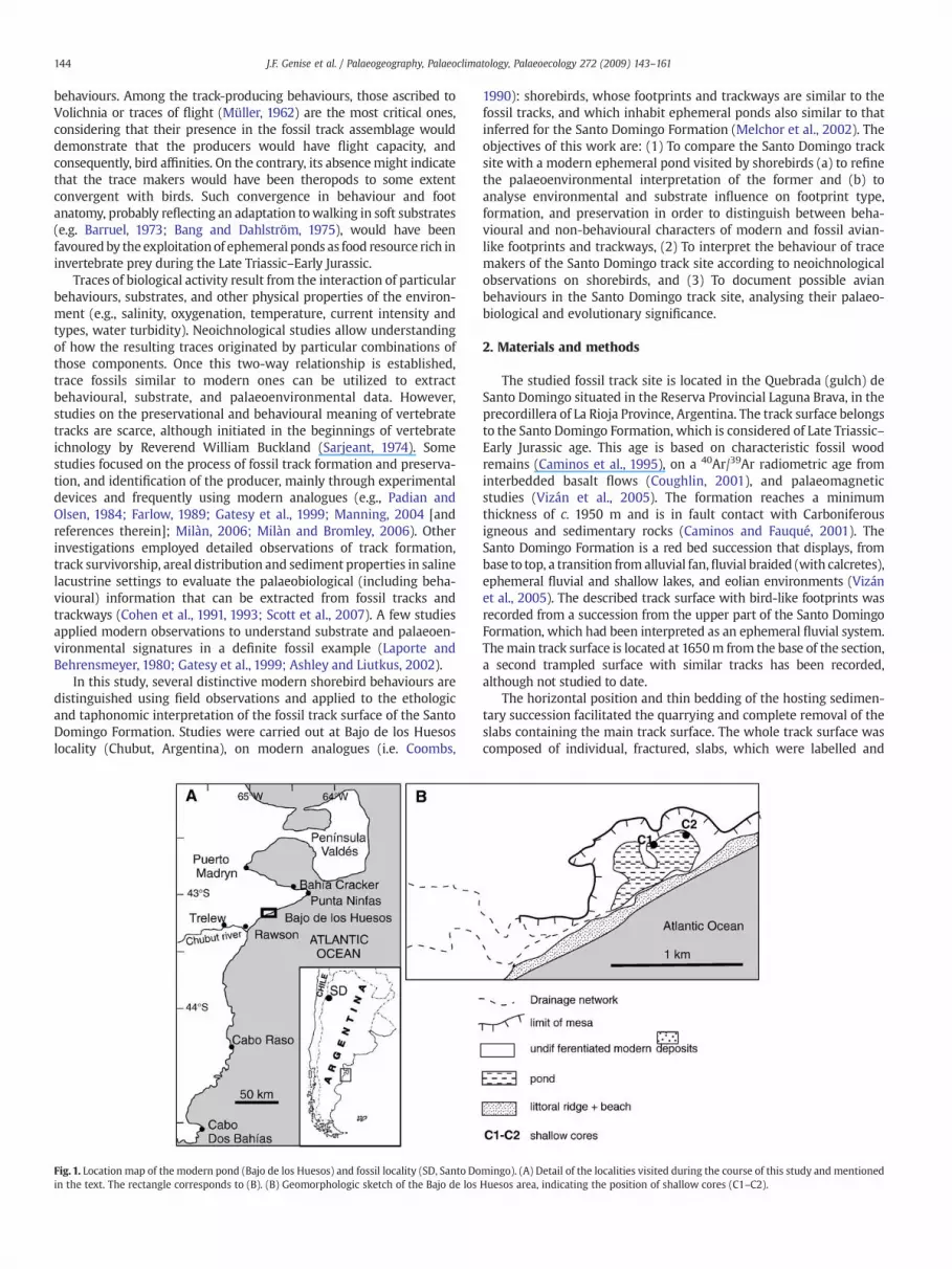
Fig. 1. Location map of the modern pond (Bajo de los Huesos) and fossil locality (SD, Santo Doin the text. The rectangle corresponds to (B). (B) Geomorphologic sketch of the Bajo de los
1990): shorebirds, whose footprints and trackways are similar to thefossil tracks, and which inhabit ephemeral ponds also similar to thatinferred for the Santo Domingo Formation (Melchor et al., 2002). Theobjectives of this work are: (1) To compare the Santo Domingo tracksite with a modern ephemeral pond visited by shorebirds (a) to refinethe palaeoenvironmental interpretation of the former and (b) toanalyse environmental and substrate influence on footprint type,formation, and preservation in order to distinguish between beha-vioural and non-behavioural characters of modern and fossil avian-like footprints and trackways, (2) To interpret the behaviour of tracemakers of the Santo Domingo track site according to neoichnologicalobservations on shorebirds, and (3) To document possible avianbehaviours in the Santo Domingo track site, analysing their palaeo-biological and evolutionary significance.
2. Materials and methods
The studied fossil track site is located in the Quebrada (gulch) deSanto Domingo situated in the Reserva Provincial Laguna Brava, in theprecordillera of La Rioja Province, Argentina. The track surface belongsto the Santo Domingo Formation, which is considered of Late Triassic–Early Jurassic age. This age is based on characteristic fossil woodremains (Caminos et al., 1995), on a 40Ar/39Ar radiometric age frominterbedded basalt flows (Coughlin, 2001), and palaeomagneticstudies (Vizán et al., 2005). The formation reaches a minimumthickness of c. 1950 m and is in fault contact with Carboniferousigneous and sedimentary rocks (Caminos and Fauqué, 2001). TheSanto Domingo Formation is a red bed succession that displays, frombase to top, a transition from alluvial fan,fluvial braided (with calcretes),ephemeral fluvial and shallow lakes, and eolian environments (Vizánet al., 2005). The described track surface with bird-like footprints wasrecorded from a succession from the upper part of the Santo DomingoFormation, which had been interpreted as an ephemeral fluvial system.Themain track surface is located at 1650m from the base of the section,a second trampled surface with similar tracks has been recorded,although not studied to date.
The horizontal position and thin bedding of the hosting sedimen-tary succession facilitated the quarrying and complete removal of theslabs containing the main track surface. The whole track surface wascomposed of individual, fractured, slabs, which were labelled and
mingo). (A) Detail of the localities visited during the course of this study and mentionedHuesos area, indicating the position of shallow cores (C1–C2).
photographed in the field. The slabs containing the track surface werere-assembled in the laboratory for photographic documentation,moulding in plastic and casting. Fossil tracks and trackways werestudied using the original rock slabs, the complete plastic cast of thetrack surface, and close up pictures of both, originals and casts. Inorder to identify a trackway, a minimum of three consecutive andalternate footprints were recognised. The different types of tracescomparable with the modern ones were marked using chalk ofdifferent colour in the cast. The original track surface is housed at theAgencia de Cultura de La Rioja, Colección de Icnología, La Rioja,Argentina (LAR-Ic 5) and a complete plastic cast is kept at the MuseoPaleontológico ‘Egidio Feruglio’, Colección de Icnología, Chubut,Argentina (MPEF-IC 227).
The study on modern shorebirds and their traces started with apreliminary selection of possible study areas among ephemeral pondsthat could show comparable tracks and located near our researchcentre at Trelew City, Chubut, Argentina, to facilitate protractedobservations. The selected area is included in a xeromorphic shrub-land region with sparse and low vegetation, and about 200 mm ofannual precipitation. Such general semi-arid setting is also inferred forthe studied Triassic succession (Melchor et al., 2002, 2006) reducingthe possible influence of contrasting environmental settings in furthercomparisons. The selection of shorebirds as modern analogues wasmade, after preliminary field work and bibliographic research, basedon the similarity of size, shape, and density of the selected moderntracks with the fossil example. Different localities (Península Valdés,Puerto Madryn, Bahía Cracker, Punta Ninfas, Bajo de los Huesos,Laguna Negra at Rawson city, Cabo Raso and Cabo dos Bahías; Fig. 1A)and bird species (Actitis macularia, Calidris bairdii, Calidris fuscicollis,Charadrius falklandicus, Himantopus melanurus, Tringa flavipes, andVanellus chilensis) were observed preliminarily while searching formodern analogues The selectedmodern environment and tracemaker
Fig. 2. The Bajo de los Huesos pond. (A) A few Calidris bairdii individuals foraging inwater (Octbairdii in shallowwater. (C) Four C. bairdii feeding inwet exposed playas, although always closThe birds are about 0.15 m tall. The ruler in foreground in (D) is 0.2 m long (arrowed).
analogues were a temporary pond located at Bajo de los Huesos(43°09′14″ S; 64°46′13″ W) about 45 km northeast of Trelew city(Chubut province, Argentina) and the shorebirds C. bairdii and C.fuscicollis (Charadriiformes). These migratory shorebirds visited thepond for a few weeks (about 6–8 weeks, depending on the yearconsidered) during the spring season and their tracks were the mostsimilar in shape, size and density to the fossil ones. Both species ofCalidris are difficult to distinguish in the field particularly whenlarge, mixed flocks are present. For this reason, therefore behaviouraland ichnological observations correspond equally to both species.These species undertake great annual migrations, travelling from thenorthern hemisphere breeding areas to the southern hemisphere.Each migration involves the respective spring and summer seasons.Despite the large number of bird species observed at the Bajo de losHuesos, interactions with species of Calidris were very few and scarcefootprints of birds other than Calidris species and C. falklandicus wereobserved. Bajo de los Huesos is part of a chain of small depressionslocated at the seaside that are seasonally filled with water. Thedepressions are separated from a steep gradient beach by a littoralgravely ridge about 5 m high and 80 m wide (Fig. 2A). This littoralridge acts as a dam for rainwater draining a small continental area,thus filling the depression. The landward boundary is composed bylow mesas (Fig. 1B). In addition, sea water can flood these depressionsduring exceptionally high tides or storms. The annual precipitation inthe region is distributed throughout the year (average of 11 mm to28 mm per month), with a slight increase during the end of theautumn and winter (May to August). These months also coincideswith the maximum average relative humidity (62 to 69%) (ServicioMeteorológico Nacional, Argentina; for Trelew city, 1981–1990period). During the coldest months (June to August) the hydrologicalbalance is positive, because of the low temperatures (averagetemperature ranging from 6 to 8 °C during June to August, 2003)
ober 10, 2003). The background is the gravely littoral ridge (arrow). (B). A small flock of C.e to thewater. (D) Extensivewet playas during the last days of 2003 season (October 29).
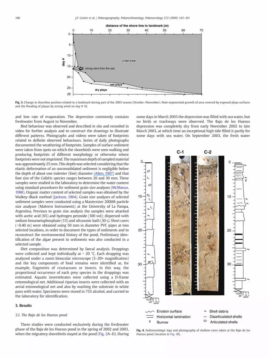
Fig. 3. Change in shoreline position related to a landmark during part of the 2003 season (October–November). Note exponential growth of area covered by exposed playa surfacesand the flooding of playas by strong wind on day # 16.
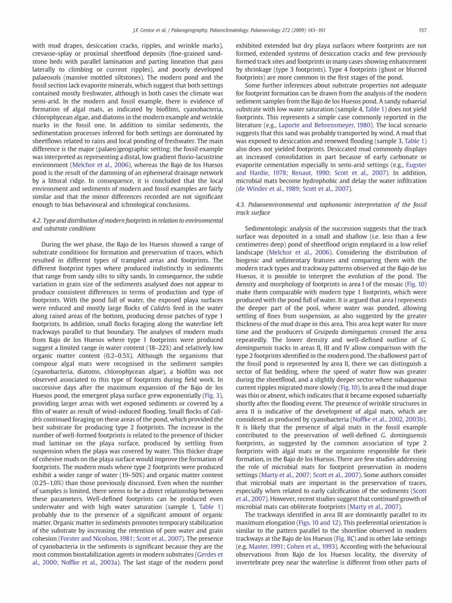
Fig. 4. Sedimentologic logs and photography of shallow cores taken at the Bajo de losHuesos pond (location in Fig. 1B).
and low rate of evaporation. The depression commonly containsfreshwater from August to November.
Bird behaviour was observed and described in situ and recorded invideo for further analysis and to construct the drawings to illustratedifferent patterns. Photographs and videos were taken of footprintsrelated to definite observed behaviours. Series of daily photographsdocumented the weathering of footprints. Samples of surface sedimentwere taken from spots on which the shorebirds were seen walking andproducing footprints of different morphology or otherwise wherefootprintswerenot imprinted. Themaximumdepthof sampledmaterialwas approximately 25mm. This depthwas selected considering that theelastic deformation of an unconsolidated sediment is negligible belowthe depth of about one indenter (foot) diameter (Allen, 1997) and thatfoot size of the Calidris species ranges between 20 and 30 mm. Thesesamples were studied in the laboratory to determine the water contentusing standard procedures for sediment grain size analyses (McManus,1988). Organic matter content of selected samples was obtained by theWalkey–Black method (Jackson, 1964). Grain size analyses of selectedsediment samples were conducted using a Mastersizer 2000® particlesize analyzer (Malvern Instruments) at the University of La Pampa,Argentina. Previous to grain size analysis the samples were attackedwith acetic acid (6%) and hydrogen peroxide (100 vol); dispersed withsodium hexametaphosphate (1%) and ultrasonic bath (30 s). Short cores(b0.40 m) were obtained using 50 mm in diameter PVC pipes at twoselected locations, in order to document the types of sediments and toreconstruct the environmental history of the pond. Preliminary iden-tification of the algae present in sediments was also conducted in aselected sample.
Diet composition was determined by faecal analysis. Droppingswere collected and kept individually at − 20 °C. Each dropping wasanalyzed under a zoom binocular microscope (5–20× magnification)and the key components of food remains were identified as, forexample, fragments of crustaceans or insects. In this way, theproportional occurrence of each prey species in the droppings wasestimated. Aquatic invertebrates were collected using a D-frameentomological net. Additional riparian insects were collected with anaerial entomological net and also by washing the substrate in whitepans with water. Specimens were stored in 75% alcohol, and carried tothe laboratory for identification.
3. Results
3.1. The Bajo de los Huesos pond
These studies were conducted exclusively during the freshwaterphase of the Bajo de los Huesos pond in the spring of 2002 and 2003,when the migratory shorebirds stayed at the pond (Fig. 2A–D). During
some days in March 2003 the depressionwas filled with seawater, butno birds or trackways were observed. The Bajo de los Huesosdepression was completely dry from early November 2002 to lateMarch 2003, at which time an exceptional high tide filled it partly forsome days with sea water. On September 2003, the fresh water
occupied an area approximately 100 m wide and 600 m long parallelto the coast, whereas the maximum depth was about 0.50 m. Thewhole depression is about 1000 m long and 500 wide and issurrounded and partially divided by fine-grained sand of aeolianorigin (Fig. 1B). The extension of the playas around the water body,where the footprints are imprinted, increased exponentially fromOctober to November. However, changes in the direction and speed ofwind could introduce significant variations in the exposed/submergedcondition of different sectors of the playa. Completely dry, meter-scalezones of the playa showing desiccation cracks and footprints could becovered with water in few minutes because of a strong wind blowingfrom the sea. During the day, the exact outline of thewater bodymightchange several times because of the changing wind direction. Inaddition, some of the pond water flowing over old desiccation crackswas lost by infiltration.
With a constant rate of water loss by evaporation the growth ofplayas was exponential throughout the season. On October 6, 2003, alandmark was put in place on the pond shoreline opposite to thelittoral ridge to check its displacement during the next 28 days. Fig. 3displays the variation in the position of the shoreline and theprogressive increase in the area covered by dry playa sediments. Onday # 16 a strong wind pushed the water back up to the original
Fig. 5. Four morphological footprints types distinguished in this study. (A), (B) Type 1 footpfootprint showing thin digits and pad impressions. Note also rain drop imprints. (D), (E). Tycracks in (D). Most of the tracks in (E) are psi-shaped footprints resulting fromwidening of dformed later with footprints that did not experienced marked desiccation. (F), (G) Type 4Displays roughly rhomboidal marks and (G) shows irregular dark marks produced by disruptwas taken at Cabo Raso. Ruler is 20 cm long, scale is 5 cm long and pen is 14 cm long.
landmark, flooding an area that previously was subaerially exposed.During the last days of observation, the rate of change of the position ofshoreline and the width of the wet playa increased markedly (Fig. 2D).
The surface of the playa at Bajo de los Huesos is commonly coveredby a mud drape. The sediments of the depression are mostly sand andmud with contrasting features in the two obtained cores (Fig. 4),which were separated about 500 m (Fig. 1B). Core C-1 is characterizedby a dominance of massive silts with shell debris and articulated shellsof marine bivalves and subordinate fine-grained massive sands withhighly fragmented shell debris. Core C-2 contains coarser-grainedsediments and shows a dominance of fine-to medium-grained sands,commonly with horizontal lamination, and sparse fragmented shelldebris (associated to the coarser sediments). Many sand beds in coreC-2 display a basal erosive surface, shell debris, a fining-upwardtendency and (in one case) invertebrate burrows in the top. Mudpartings are common between sand beds.
3.2. Type, formation, and preservation of footprints
3.2.1. Type of footprintsFour types of footprints from Calidris species were recognized,
according to their aspect shortly after production (Fig. 5). The first type
rints (thin impressions, high overprinting). Note colour enhancement in (B). (C) Type 2pe 3 footprints. Note widening of digit impressions and incipient growth of shrinkageigit impressions and crack growth (black arrow). The white arrows indicate a trackwayfootprints conforming trackways inferred by the alternate arrangement of marks. (F)ion of underlying organic mud. All figures are from Bajo de los Huesos, except (F), which
Table 1Summary of water saturation, organic matter content, median grain size andclassification for selected sediment samples from the Bajo de los Huesos pond.Samples are organised after footprint types defined in this study
of footprints is characterized by thin and poorly defined digitimpressions. These footprints are produced underwater and are therule in densely trampled areas produced by large flocks (Fig. 5A). Apreservational variant of this type is due to contrast enhancement bychanges in colour of sediments after subaerial exposure, probably dueto greater loss of water of the sediment outside of the footprints (Fig.5B). The second type is characterized also by thin digit impressions,but in this case their outlines are very well-defined and can have padimpressions (Fig. 5C). Probably these footprints are the best-suited forstudying anatomical features of producers. They appear in sites withfew trackways or in track patches with low density produced in wet,subaerially exposed sediments and can survive flooding induced bywind stress under a film of water. The third type occurs when type 2footprints are exposed subaerially for some time. The shrinking ofmoist sediments during desiccation first produces an enhancement ofthe footprint visibility and enlargement of size, whose digits appearwider, best defined, and deeper impressed (Fig. 5D). These footprints,even when very useful to infer behaviour and when they look as thebest preserved ones, do not reliably reflect the anatomy of theproducer. This type corresponds to incipient psi-shaped cracks (Fig.5E), which act as nucleation sites for desiccation cracks (e.g. Master,1991; Martin, 2005). When the process of desiccation continues thefootprints become increasingly distorted by crack growth and finallyare difficult to recognize. The fourth type is composed by tracksproduced under water in a very soupy substrate (ghost or blurredfootprints), in which the digit impressions cannot be distinguished.These footprints result in indistinct marks arranged with an alternatepattern typical of trackways (Fig. 5F). At Cabo Raso, trackways of Actitismacularia looked like dark coloured marks arranged with an alternatepattern, because of the removal and exposure of an underlying layer ofa dark, organic-rich mud (Fig. 5G).
3.2.2. Formation of footprintsThe four types of footprints record those cases inwhich the contact
of the feet with the sediment produced a recognizablemark. However,in many cases, walking shorebirds left no trace at all, even when theywalked very close to others that left traces and even when, to thenaked eye, sediments looked moist and plastic enough to producetraces. Without further analyses it was not possible to distinguishdifferences between sediments that produced and failed to formfootprints. Slightly elevated and depressed patches in the playashowed different potential for producing footprints. Field observa-tions on texture, moisture, subaerial or subaqueous nature offootprints, and presence of algal mats were recorded in order toexplain differences in the production of footprints. When thedesiccation of the pond progressed, dense track sites showing poorlydefined tracks formed previously underwater were replaced by siteswith single or few well-formed trackways.
A sampling of productive and non-productive sediments, forfurther analysis in laboratory, showed some differences for theparameters measured (Table 1). The grain size of sediments is fairlyuniform, irrespective of the footprint type and, in most cases, of theformation or absence of footprints. The analysed samples can beclassified as silty sands and sandy silts (Shepard, 1954). The samplesfor type 1 footprints (samples 13, 14, 15) display a relatively narrowrange of moisture content (18–22%) and organic matter content (0.2–0.5%); a single analysed sample is classified as a silty sand (Table 1).Type 2 footprints (samples 1, 8, 16, 17, 18) reflect more variable watersaturation (19–50%) and organic matter content (0.25–1.0%), includingsilty sands and sandy silts (Table 1). The sample with lowest watercontent (sample 18) also shows the lowest organic matter content,and those with higher water content (samples 1 and 8) also show thegreater organic matter content. A sample where type 4 footprintswere produced (sample 7) has a higher water saturation (85%) andorganic matter content (1.8%). The substrate where type 3 footprintswere seen was not sampled because it represents a mud with lower
water content than typical for formation of type 2 footprints.Footprints were not produced in a range of substrate conditions,including subaerially exposed mud with 44% of water (sample 2),flooded desiccated mud with 28% of water (sample 3) and a fine-grained sand with 9% water and 0.3% organic matter content (sample4). The footprints associated with sample 5 are morphologically akinto those of type 4 (although the gross footprint outline is stillrecognizable) and the sediment also displays a high water (48%) andorganic matter content (1.4%). The presence of algal mats wasrecognised in the field (sample 6), associated with well-definedfootprints. However, other sediment samples also contain remains ofcyanobacteria (Anabaena sp., Calothrix sp., Microcoleus sp., Nostoc sp.,Oscillatoria sp., Phormidium sp.), diatoms (Cymbella sp., Fragilaria sp.)and freshwater chlorophycean algae (Scenedesmus armatus, S. quad-ricauda, Schroederia setigera) (S. Álvarez and G. Bazán, pers. comm.,2004).
3.2.3. Preservation of footprintsImmediately after their production, the footprints suffer different
taphonomic processes. If not covered by a new layer of sediment,footprints were weathered by different agents, mainly desiccation, tobecome unrecognizable and finally disappear within 2 to 6 days.Different field observations in selected groups of footprints werecarried out to follow the early taphonomic processes (Fig. 6). After 24h,a sample of Type 2 footprints produced under a film of water (Fig. 6A)showed wet freshly exposed sediments and the footprints were stillwithout any apparent morphologic changes (Fig. 6B). After 70 h theenhancement process by desiccation took place, and the footprints,still inwet sediment, appeared as better impressed, showingwider anddeeper digit marks. Some of the digits showed cracks inside or arising
Fig. 6. The effect of desiccation on the preservation of modern footprints. (A)–(E) Sequence of photographs showing progressive desiccation of a playa surface with Calidris footprints.(A) Recently formed underwater footprints (the better defined footprints are arrowed). (B) Twenty four hours later. Note crack formation on the left andwell-formed footprints on theright (arrows). (C) Seventy hours after formation, the only recognizable footprints remain on the right side. (D) Seventy four hours after original impression. Intense crack propagationandmud curling. (E) Ninety four hours after formation. Complete destruction of the original playa surface due to curling of the surface mud drape and possible wind action. Arrows inB to C indicate the position of the same footprint. In addition, the stick on the left of figures B to E was kept in the same position. (F) Crack propagation in other footprints (arrows),24 h after formation. Pen is 14 cm long. Ruler is 20 cm long.
from them, which would correspond to an advanced Type 3 footprint(Fig. 6C). About 74 h after their formation the desiccation processadvanced quickly developing cracks that completely obscured thefootprints (Fig. 6D). After 94 h of continued desiccation and crackgrowth, the muddy upper lamina of sediment curled and becameseparated in individual pieces. At this stage, all evidence of previousfootprints was lost (Fig. 6E). The complete weathering process of thisfootprint took 4 days. In other cases, type 3 footprints (enhancedfootprints) gave rise to a system of larger and deeper desiccation cracks,which can be preserved for a longer period as recorded in the literaturefor saline mudflats (Master, 1991). Other observed footprint samples,revealed different rates of weathering. A footprint produced in moistsediment (type 1) showed the first signals of widening and cracking intoes (type 3 footprint) only after 20min, and 24 h later the footprintwasstill recognizable with long cracks arising from toes (Fig. 6F). Anothertype 1 footprint produced near the latter and under similar conditionsshowedwidened toes and an incipient crack in the extreme of two toes
after 1 h, and a well developed system of cracks 2 h later. After 24 h thefootprint was hardly recognizable within the crack system.
Other weathering agents are represented by rain and thesuccessive subaerial and subaqueous exposure driven by evaporationand flooding of playas by wind action that could erase or modifyfootprints within minutes after their production. This effect wasalready reported by Laporte and Behrensmeyer (1980), Cohen et al.(1991, 1993) and Scott et al. (2007).
3.3. Behaviour of species of Calidris
3.3.1. General behaviour and feeding behaviourIn the Bajo de los Huesos, during the spring of 2002 and 2003,
Calidris bairdii was the last bird observed inhabiting the pond at theend of the season, and in 2003, it was also one of the first birds to arrive(Fig. 2A–C). In other examined localities, single or few individuals ofthis migratory species were seen during the spring along the Chubut
seacoast. The number of individuals in the Bajo de los Huesos rangedfrom amaximumof three hundred onOctober 24, 2003, to one the lastday of the season (November 3, 2003). On various other days werecorded from 40 to 86 individuals, whereas most days the number ofindividuals ranged from about 10 to 20. In large flocks, vocalization andinteractions between individuals were frequent, whereas in thesmaller ones, no vocalizations or interactions were recorded. Com-monly the water level was below the ankle joint, or in some casesabove it, but never touching the bird's body (Fig. 2B). Individuals inlarge flocks had no preferential direction of movement on calm days,whereas in windy ones, they walked commonly facing the wind. Thenearby flight or vocalization of birds of prey produced the immobiliza-tion of the flocks of Calidris or their sudden flight.
Fig. 7. Diagrams showing the 21 behaviours with ichnological meaning identified in Calidris anwere notobserved. (A)Walking. (B) Standing. (C) Hopping andflapping. (D)Walkingwith a zigRunningoff at other birds. (K) Driving awayby facing off. (L) Run and “U” turn. (M)High angle lwith legs directed forward. (R) Simple take-off. (S) Take-off and flapping. (T) Run and flappin
Large flocks, mostly composed of Calidris bairdii and Calidrisfuscicollis, were observed feeding in the shallowest parts of the pond,sometimes divided in two or three groups. Usually, small flocks of fewindividuals detached from a large one, and flew to the waterline tofeed (Fig. 2B and C). This preference for feeding in the waterline wasalso confirmed with the data from analysis of bird droppings andinvertebrate fauna from the pond (see below). Those feeding at thewaterline, commonly walked parallel to it. The latter behaviour wasalso observed in Calidris falklandicus. In a particularly cold and windyday (October 9, 2003), only three individuals were recorded at thepond, whereas a flock of about 15 were feeding on ground in thenearby vegetated dunes. The overall decrease in water depththroughout the spring resulted in more extended playas (Fig. 2D);
d the resulting trackway. The traces produced by complete rotation and resting (G and I)-zag path. (E) Short run. (F) Lateral run. (G) Complete rotation. (H) Probing. (I) Resting. (J)anding. (N) Landingwith a run. (O) Lateral landing. (P) Landingwith hopping. (Q) Landingg. (U) Take-off with hopping.
shorebirds spending more time feeding on exposed playas than in thewater; and an abrupt decrease in number of shorebirds during the lastdays before complete desiccation of the pond.Whenwater in the pondwas scarce, during the last days of the season, small flocks wereobserved feeding on dry and wet sectors of the playa, searching forprey particularly along the desiccation cracks. The search for prey wasmostly done visually, only in rare occasions some individuals wereobserved searching prey by tactile probing in moist sediment alongthe waterline.
The diet of species of Calidriswas studied by means of the analysisof their droppings and by the study of the invertebrate fauna of thepond, because it was impossible to observe directly the small prey or
the bird's success in hunting them. The invertebrate fauna collectedduring October 2003 was composed of crustaceans and insects. Thecrustaceans were Anostraca (Branchinecta sp.), Notostraca (Lepidurussp.), Cladocera (Anomopoda), Copepoda (Calanoida) and undeter-mined Ostracoda. The insects were Coleoptera such as Tropisternussetiger (Hydrophilidae), Rhantus signatus, Lancetes angusticollis andLancetes waterhousei (Dytiscidae); Diptera, such as larvae of Tipulidaeand Chironomidae, and adults of Ephydridae and Bibionidae; andCollembola. The distribution of these taxa in relation to the waterlineof the pond showed significant differences. The Notostraca, werefound only in the deepest part of the pond, at about 100 m from thecoast. The Anostraca, Cladocera, Copepoda and L. waterhousei were
found from the centre of the pond to the waterline, whereas theOstracoda and the remaining Coleoptera were absent at the centre ofthe pond. The Diptera and Collembola were typical inhabitants of thewaterline, inhabiting the playa up to 1.5 m of the waterline in all casesand up to 0.20 m under water in the case of Chironomidae larvae andCollembola. All the crustaceans lay eggs capable of resisting the dryphase of the pond, whereas the coleopterans may arrive at the pond
Fig. 8. Selected examples of Calidris behaviour that produced tracks. (A) Two nearly paralleposition indicated by arrows (# 2). (B) Walking trackway with a zig-zag pattern (# 4) with twwalking trackways roughly parallel to the waterline. The centre and upper right of the imagrandom pattern and also occasional arrangement in an arc (arrows). (E) Three consecutive foproduced by landing with a run (# 14). (F) Trace left by landing with legs directed forward (associated with long hallux drag marks (arrows) followed by two consecutive footprints lackrepresent 1 cm.
by dispersal flights, and are able to develop rather quickly inephemeral ponds. The life cycle of Diptera for this pond is unknown.The collected material shows that some invertebrates inhabit thewhole pond (Anostraca, some Cladocera, Copepoda and the Coleop-tera L. waterhousei), others avoid the deepest part of it (Ostracoda andmost Coleoptera), whereas others basically inhabit the waterline andup to 1.50 m from the shore (Diptera and Collembola).
l walking trackways (# 1) with a couple or paired footprint resulting from a standingo pairs of footprints resulting from hopping. (C) Margin of the pond showing abundante is covered by water. (D) Tracks and double probing marks (# 8), showing a dominantotprints showing low divarication and lack of sole marks (arrowed). This trackway was# 17). From right to left the two first components are slightly distorted tracks (1 and 2)ing sole mark (3 and 4). Ruler is 20 cm long, pen is 14 cm long, and scale divisions in (D)
The diet of Calidris bairdii and Calidris fuscicollis was analyzed bystudying the contents of 30 droppings of individuals of these species.The most important item was Daphnia sp. (Cladocera), which waspresent in 93% of the droppings, each one containing 1 to 11individuals. The second item were adults of Ephydridae (Diptera),which appear in 33% of the droppings, each containing 1 to 4individuals. Other dipterans, despite their abundance in the pond,were not recorded in faeces. The third item was probably a terrestrialcoleopteran, which was not recorded during the field work. It waspresent in 17% of the droppings. The fourth and fifth items, anundetermined coleopteran and a copepod respectively, were onlypresent in three droppings.
The most abundant remains found in the faeces were Cladoceraand Ephydridae, the latter only present near the waterline, showingthat at least one third of the birds feed near the waterline at sometime, and confirming the data obtained by direct observations.
3.3.2. Particular behaviours of Calidris producing tracesDuring fieldwork, 21 trace-producing behaviours with ichnological
significance were identified. In most cases the traces were found afterexamination of the place in which the particular behaviour wasdisplayed, in other cases, the traces were found without seeing thebehaviour that produced them. In still other cases,mostly for behavioursobserved in large flocks feeding in water, the resulting traces could beinferred, because of the low potential of forming and preserving tracesunder water, and the impossibility of identifying individual traces atdense track sites. In the following paragraphs, the observed behavioursand recorded and inferred tracks and trackways are described andillustrated (Figs. 7 and 8); distinguishing between common behavioursof individuals, behaviour inflocks, andbehaviours associatedwithflight.Video records of part of the described behaviours are available asSupplementary online material (Appendix A). The observed Calidristracks commonly range in length from 22 to 38 mm (allowing for theimprint of the hallux) and are slightly wider than long.
Fig. 9. Detailed sedimentary log of the succession of the Santo Domingo Formation contaModified from Melchor et al. (2006).
3.3.2.1. Usual behaviours independent of flock density.
1) Walking. This behaviour results in a straight or slightly curvedtrackway (Figs. 7A and 8A and C). The pace angulation commonlyranges from 160° to 180°, the stride length ranges from 120 to280 mm, the tracks display a 0° to − 28° (inward) rotation withrelation to themidline, and the average divarication between digitsII–IV is 125°.
2) Standing. It results in paired footprints, commonly showing a smallinward rotation (Figs. 7B and 8A).
3) Hopping aided by flapping. Occasionally, the birds hop with thetwo legs aided by flapping leaving a series of paired footprints(Figs. 7C and 8B).
4) Walkingwith a zig-zagpath.Whilewalking, the bird directs the bodyto one side and to the other alternatively looking for prey. It results ina trackway with more than two changes in direction (Fig. 7D).
5) Short run. In most cases the runs are short and finish in probing inthe same direction of the run. In Calidris falklandicus it wascommon to observe successive, more or less long, runs parallel tothe waterline finishing in probing with the body oriented towardthe waterline. It results in a straight trackway showing a markedincrease or decrease of stride length (depending upon thepreserved trackway portion); up to 2.75 larger than the smallerstride length in a particular trackway (Fig. 7E).
6) Lateral run. Probably disturbed by strong wind, some individualsperform short lateral runs. It results in a lateral row of footprints(Fig. 7F).
7) Complete rotation. The bird turns 360° in a small circle, sometimespecking. It would result in a trackway describing a small circle(Fig. 7G).
8) Probing. In most cases, the observed species peck in water afterdetecting prey visually. However, in a single day traces of probingwere observed in moist sediments close to the waterline. Rows ofholes are arranged in a line or an arc 50 to 60 mm long near the
ining the fossil track surface with abundant Gruipeda dominguensis tracks (LAR-Ic 5).
trackways (Figs. 7H and 8D). In some cases double holes of differentsize indicate that they were made with the beak open.
9) Resting. Laid downwith the body touching the ground and the legsdirected forward (Fig. 7I).
3.3.2.2. Behaviours in large flocks.
10) Running off other individual from behind. Sometimes, in largeflocks, one individual drives away another with a short run frombehind, which results in a short run by both birds. In some casesthe run is aided by flapping and in others there is a short flight.The trace of this agonistic behaviour was not observed but itwould result in two consecutive short trackways with aprogressive increase in stride length (Fig. 7J).
11) Driving away by face off behaviour. In large flocks, one individualruns at another, the latter turns back facing the former, and afterthat takes two steps laterally and walks or runs backwards(Fig. 7K). The trace of this agonistic behaviour was not observed.
12) Run and U-turn. A long run is finished in a U-turn and a slowwalking and pecking along the line of the previous run. It wasobserved in individuals within large flocks, feeding in water.
Fig. 10. Original mosaic of slabs quarried from the Santo Domingo Formation (LAR-Ic 5). Torientation (arranged according with their original position in the field). Areas I to IV (defineshown. The central missing area corresponds with an intensely deformed sector that could ntoward the upper right corner.
Probably the run stirs the sediment in the bottom of the pondwith potential prey, which can be caught while the walking. Thetrace was not observed, but can be inferred as distinctive due tothe U-turn (Fig. 7L).
3.3.2.3. Behaviours associated with flight (Volichnia).
13) High angle landing. In the simplest case, the bird approachesnearly vertically the ground and both feet touch the substrate atthe same time softly aided by hovering. The wings are completelyseparated from the body. The resultant trackway begins with apair of footprints and continues with a walking pattern, probablyexhibiting a larger pace length than usual for walking (Fig. 7M).
14) Landing with a run. The bird approaches the ground at an acuteangle. The landing results in a short run in which the anteriordigits touch the substrate first. The corresponding trace shows atrackway whose first footprint is composed of the marks of threetoes, shorter and with a lower divarication angle than usual. Thesole is not marked. Such a footprint indicates that the weight ofbody is partially supported by wings and it can be distinguishedfrom other similar tracks produced by substrate differences
he figure shows the start of each identified trackway, and a rose diagram with theird on the basis of the type of footprints and associated sedimentary structures) are alsoot be recovered. Undulations on the left also are due to tectonism. Note that the north is
Fig. 11. Representative trace fossils from the track surface and inferred behaviours. (A)Part of the mosaic with Gruipeda dominguensis showing trackway # 2 (footprints 1 to 8)with a zig-zag path. Trackways # 3 and 4 display a walking behaviour with a straightcourse. The black arrow indicates the point of encounter between trackways # 2 and 4.(B) Part of trackway # 1 of G. dominguensis (white arrows) showing a progressivedecrease in stride length. Interpreted as reflecting a short run. (C) Bird-like footprintswith elongated hallux imprint (black arrow) associated to abundant G. dominguensistracks. The white arrow indicates the drag mark of the hallux. These tracesare consecutive and suggest landing with legs directed forward. (D), (E) SparseG. dominguensis tracks and small epichnial rounded pits (circled), which are interpretedas probingmarks. Note rippled surface in (E). (B), (D) and (E) are photos from themosaicLAR-Ic 5; (A) and (C) belong the resin replica of that mosaic MPEF-IC 227. Scale divisionsare 1 cm.
because of the lower angle of digit divarication, which indicatesthat the foot is not completely pressed against the substrate(Figs. 7N and 8E).
15) Lateral landing. The approach to the ground is vertical. Thelanding results in a short lateral run. The trace would result in alateral row of footprints followed by a commonwalking trackway(Fig. 7O). This trackway can be difficult to distinguish from thoseof a lateral run (# 6).
16) Landing with hopping. The landing result in a series of two orthree jumps with both legs together. This would result in a seriesof two or three paired footprints followed by a common walkingtrackway (Fig. 7P).
17) Landing with legs directed forward. The bird approaches theground at a low angle and the hallux touches the substrate first.Landing is carried out at an acute angle with both legs directedforward (Figs. 7Q and 8F). The corresponding trace observed inmoist sediments is composed of two parallel grooves, thin andshallow in one extreme and wide and deep in the other,sometimes accompanied by partial or full footprint, which arefollowed by a normal walking trackway. The placement of thetracks with drag marks is not always side by side in a lineperpendicular to the midline. In some cases, the wider tip of thegrooves is associated with the beginning of a trackway. Similargrooves with trackways were observed after the landing of Anassp., in which the grooves were produced by the hallux.
18) Simple take-off. Take-off may occur with both feet togetherplaced as in a standing position immediately after a walk. Thetrace is a trackway abruptly ending with two footprints side byside (Fig. 7R). The footprints at the end of the sequence showwellmarked soles and crescent marks, and are commonly deeper thanthe previous tracks. Sometimes traces of landing and taking offmay be present in the same trackway.
19) Taking off with flapping. Similar to landing traces, taking offtraces may be indicated by a trackway composed of footprintswith three toes and low angle of digit divarication (Fig. 7S). Theycan be distinguished from landing traces by a progressivereduction in the proportion of impressed digits and the absenceof a normal trackway in the direction of progression. The feet arenot completely pressed against the substrate because the bodyweight is partly supported by the incipient flight.
20) Run aided by flapping. A short run aided by flapping. The weightof the body is not translated to the feet, so even though they touchthe substrate, they are not pressed against it. It results intrackways composed of tridactyl footprints, with low angle ofdigit divarication (i.e. in the range 60–70°) and lacking the solemark (Fig. 7T).
21) Take-off with hopping. The take-off is preceded by two or threehops. This results in a walking trackway that finishes with two orthree consecutive pairs of footprints (Fig. 7U).
3.4. The fossil track surface
The stratigraphic section containing the track surface is a 50 mthick interval dominated by fine-grained sandstones and siltstones(facies association A of Melchor et al., 2006). This interval includesribbon channel sandstones of limited lateral extent with multistoreyinfill (fining-upward, fine-grained trough cross-bedded sandstone)and the associated finer-grained floodplain deposits (Fig. 9). The lattercomprises laminated siltstones with mud drapes, desiccation cracks,ripples, and wrinkle marks; fine-grained sandstone beds with parallellamination and parting lineation that pass laterally to climbing orcurrent ripples; and massive mottled siltstones (Fig. 9).
The track surface is represented by a mosaic of slabs measuringabout 5.5 m2, showing variable density and quality of preservation offootprints (Fig. 10). This mosaic includes both natural moulds andcasts (i.e. part and counterpart when available) of footprints preserved
in siltstone slabs commonly covered by a thin clay drape. Thethickness of the siltstone lamina composing the mosaic ranges from30 mm in the centre to 4 mm in the marginal area of the mosaic. Thischange in thickness is accompanied by a different thickness of the claydrape on the top of the laminae, which is thicker (2 mm) in the centreof the mosaic and decreases in thickness to zero in the marginal area.Most of the traces recognised in the mosaic are bird-like footprintsassigned to a single ichnospecies, Gruipeda dominguensis de Valais andMelchor (2008) (Fig. 11A and B). The associated trace fossils are “bird-like footprints with elongated hallux impressions” (Fig. 11C), smallepichnial rounded pits (Fig. 11D and E), Palaeophycus tubularis, Sko-lithos linearis and Taenidium barretti (Melchor et al., 2006; de Valaisand Melchor, 2008). Gruipeda dominguensis includes tridactyl ortetradactyl footprints with three digits directed forward and larger (IIto IV) and the fourth or hallux (I), directed backward and short. Thetracks (that average 34 mm long and 33 mm wide) are arranged inbipedal trackways commonly displaying a positive rotation in relationto the midline, a pace angulation of about 170°, and an average stridelength of 170 mm. Webbing was not observed (de Valais and Melchor,
Fig.12. Drawing on part of themosaic of Fig.10 highlighting the footprints that compose the trackways identified in areas II and III. Bird-like tracks with elongated hallux imprints arearrowed.
2008). Due to high degree of overprinting, the identification ofindividual trackways was aided by the anisodactyl character of thetracks. Evenwhen the hallux imprint is missing, digit IV is longer thandigit II and curved and the II–III angle is a few degrees larger than theIII–IV angle (Fig. 11A). In “bird-like footprints with elongated halluximpressions” (de Valais andMelchor, 2008) the general morphology issimilar to G. dominguensis; however, the impression of the halluxis up to four and a half times longer than the average length in G.dominguensis tracks. In these traces, a minor widening of theimpressions of digits II and IV was also observed. One of thespecimens includes a right-left pair with the typical arrangement ina trackway and separated 151 mm (Fig. 11C). There is also an isolatedfootprint of similar characteristics.
Small epichnial rounded pits (Melchor et al., 2006) are circular tooval holes, commonly paired, preserved as negative epichnia (Fig. 11Dand E). In each pair of pits, one is smaller (1.6–4.4 mm) than the other(3–5 mm) and they are in contact or separated by up to 4.8 mm. Mostpaired pits display a raised margin that usually only cover one third ofthe perimeter. They appear on the bedding surface in large number(up to 2000 pits/m2).
Considering the distribution of trace fossils and sedimentarystructures, it is possible to distinguish four areas with transitionalboundaries in the mosaic (Fig. 10). A central area (area I) showing hightrack density (up to 520 footprints/m2) with Gruipeda dominguensisfootprints moderately to poorly preserved. Digit impressions are wide(up to 7 mm) and the depth of footprints is the largest measured(about 2–3 mm deep). In this area, no single trackway wasdistinguished due to dense overprinting. Area II occupies a marginalposition and contains shallow and well-defined G. dominguensisfootprints showing distinct pad and claw impressions, and thin digitimprints, in addition to current ripples andwrinklemarks. The densityof footprints is low (maximum value about 190 footprints/m2) andsome tracks display inverted relief. Most of the G. dominguensisfootprints in area II can be assigned to definite trackways withconfidence. The orientation of ripple crests suggests transport towardN 115° (Fig. 10). Area III is located between the former ones andcontains most of the identified trackways. It is characterized by well-defined G. dominguensis footprints, presence of bird-like footprintswith elongated hallux impression and absence of sedimentarystructures. The orientation of trackways is both parallel andperpendicular to the boundary with adjacent areas I and II (Fig. 12).
Area IV shows moderately-preserved footprints with density similarto that of area III, abundant small epichnial rounded pits, invertebratetraces (Palaeophycus, Skolithos and Taenidium) and current ripples. Noclear spatial relation between G. dominguensis trackways andepichnial pits was recognised.
4. Discussion
4.1. Environmental and substrate comparisons
To extract behavioural inferences from trace fossils, it is necessaryto distinguish as much as possible the influence of environment andsubstrate in their production and to differentiate preservation fromtrue behavioural components. Accordingly, the comparison betweentracks of the Triassic–Jurassic mosaic and the Bajo de los Huesos pondhas a methodological objective: to evaluate the possible influence ofenvironment and sediments on the type, formation, and preservationof the fossil footprints and morphology of trackways. In addition thiscomparison also has a palaeoenvironmental objective: to refine theenvironmental and substrate inferences on the Triassic–Jurassic pondat the time of footprint production.
The dominant lithology and sedimentary structures in both coresfrom the Bajo de los Huesos are laminated silt to fine-grained sand,which are similar to those of the interval containing the fossilfootprints (Figs. 4 and 9). In particular, the grain size of core C-1sediments is closer to those of the fossil example, whereas thepresence of common mud drapes in core C-2 sediments is also sharedwith the Santo Domingo section. The lithological differences betweenboth modern cores suggest that sedimentation in core C-2 was ofhigher energy, probably related to sheet flooding during rains or, morerarely, to washover by marine waters during storms. These highenergy events were punctuated by periods of lower energy sedimen-tation in the pond, probably related to subaqueous settling of fine-grained sediments during the spring. The greater proportion of mud,absence of laminated sands and presence of articulated or unbrokenbivalve shells, suggest sedimentation under lower energy conditionsat the location of core C-1 (Fig. 4). This feature can be linked to itslocation in a small “embayment” protected from the fluvial currentscoming from the west (Fig. 1B). The section containing the fossilfootprints (Fig. 9) can be interpreted essentially as the deposits ofshallow ponds that were frequently desiccated (laminated siltstones
with mud drapes, desiccation cracks, ripples, and wrinkle marks),crevasse-splay or proximal sheetflood deposits (fine-grained sand-stone beds with parallel lamination and parting lineation that passlaterally to climbing or current ripples), and poorly developedpalaeosols (massive mottled siltstones). The modern pond and thefossil section lack evaporite minerals, which suggest that both settingscontained mostly freshwater, although in both cases the climate wassemi-arid. In the modern and fossil example, there is evidence offormation of algal mats, as indicated by biofilms, cyanobacteria,chlorophycean algae, and diatoms in themodern example andwrinklemarks in the fossil one. In addition to similar sediments, thesedimentation processes inferred for both settings are dominated bysheetflows related to rains and local ponding of freshwater. The maindifference is the major (palaeo)geographic setting: the fossil examplewas interpreted as representing a distal, low gradient fluvio-lacustrineenvironment (Melchor et al., 2006), whereas the Bajo de los Huesospond is the result of the damming of an ephemeral drainage networkby a littoral ridge. In consequence, it is concluded that the localenvironment and sediments of modern and fossil examples are fairlysimilar and that the minor differences recorded are not significantenough to bias behavioural and ichnological conclusions.
4.2. Type and distribution ofmodern footprints in relation to environmentaland substrate conditions
During the wet phase, the Bajo de los Huesos showed a range ofsubstrate conditions for formation and preservation of traces, whichresulted in different types of trampled areas and footprints. Thedifferent footprint types where produced indistinctly in sedimentsthat range from sandy silts to silty sands. In consequence, the subtlevariation in grain size of the sediments analysed does not appear toproduce consistent differences in terms of production and type offootprints. With the pond full of water, the exposed playa surfaceswere reduced and mostly large flocks of Calidris feed in the wateralong raised areas of the bottom, producing dense patches of type 1footprints. In addition, small flocks foraging along the waterline lefttrackways parallel to that boundary. The analyses of modern mudsfrom Bajo de los Huesos where type 1 footprints were producedsuggest a limited range in water content (18–22%) and relatively loworganic matter content (0.2–0.5%). Although the organisms thatcompose algal mats were recognised in the sediment samples(cyanobacteria, diatoms, chlorophycean algae), a biofilm was notobserved associated to this type of footprints during field work. Insuccessive days after the maximum expansion of the Bajo de losHuesos pond, the emergent playa surface grew exponentially (Fig. 3),providing larger areas with wet exposed sediments or covered by afilm of water as result of wind-induced flooding. Small flocks of Cali-dris continued foraging on these areas of the pond, which provided thebest substrate for producing type 2 footprints. The increase in thenumber of well-formed footprints is related to the presence of thickermud laminae on the playa surface, produced by settling fromsuspension when the playa was covered by water. This thicker drapeof cohesivemuds on the playa surfacewould improve the formation offootprints. The modern muds where type 2 footprints were producedexhibit a wider range of water (19–50%) and organic matter content(0.25–1.0%) than those previously discussed. Even when the numberof samples is limited, there seems to be a direct relationship betweenthese parameters. Well-defined footprints can be produced evenunderwater and with high water saturation (sample 1, Table 1)probably due to the presence of a significant amount of organicmatter. Organicmatter in sediments promotes temporary stabilizationof the substrate by increasing the retention of pore water and graincohesion (Forster and Nicolson, 1981; Scott et al., 2007). The presenceof cyanobacteria in the sediments is significant because they are themost common biostabilization agents in modern substrates (Gerdes etal., 2000; Noffke et al., 2003a). The last stage of the modern pond
exhibited extended but dry playa surfaces where footprints are notformed, extended systems of desiccation cracks and few previouslyformed track sites and footprints inmany cases showing enhancementby shrinkage (type 3 footprints). Type 4 footprints (ghost or blurredfootprints) are more common in the first stages of the pond.
Some further inferences about substrate properties not adequatefor footprint formation can be drawn from the analysis of the modernsediment samples from the Bajo de los Huesos pond. A sandy subaerialsubstrate with low water saturation (sample 4, Table 1) does not yieldfootprints. This represents a simple case commonly reported in theliterature (e.g., Laporte and Behrensmeyer, 1980). The local scenariosuggests that this sand was probably transported by wind. A mud thatwas exposed to desiccation and renewed flooding (sample 3, Table 1)also does not yielded footprints. Desiccated mud commonly displaysan increased consolidation in part because of early carbonate orevaporite cementation especially in semi-arid settings (e.g., Eugsterand Hardie, 1978; Renaut, 1990; Scott et al., 2007). In addition,microbial mats become hydrophobic and delay the water infiltration(de Winder et al., 1989; Scott et al., 2007).
4.3. Palaeoenvironmental and taphonomic interpretation of the fossiltrack surface
Sedimentologic analysis of the succession suggests that the tracksurface was deposited in a small and shallow (i.e. less than a fewcentimetres deep) pond of sheetflood origin emplaced in a low relieflandscape (Melchor et al., 2006). Considering the distribution ofbiogenic and sedimentary features and comparing them with themodern track types and trackway patterns observed at the Bajo de losHuesos, it is possible to interpret the evolution of the pond. Thedensity and morphology of footprints in area I of the mosaic (Fig. 10)make them comparable with modern type 1 footprints, which wereproducedwith the pond full of water. It is argued that area I representsthe deeper part of the pool, where water was ponded, allowingsettling of fines from suspension, as also suggested by the greaterthickness of the mud drape in this area. This area kept water for moretime and the producers of Gruipeda dominguensis crossed the arearepeatedly. The lower density and well-defined outline of G.dominguensis tracks in areas II, III and IV allow comparison with thetype 2 footprints identified in themodern pond. The shallowest part ofthe fossil pond is represented by area II, there we can distinguish asector of flat bedding, where the speed of water flow was greaterduring the sheetflood, and a slightly deeper sector where subaqueouscurrent ripplesmigratedmore slowly (Fig.10). In area II themud drapewas thin or absent, which indicates that it became exposed subaeriallyshortly after the flooding event. The presence of wrinkle structures inarea II is indicative of the development of algal mats, which areconsidered as produced by cyanobacteria (Noffke et al., 2002, 2003b).It is likely that the presence of algal mats in the fossil examplecontributed to the preservation of well-defined G. dominguensisfootprints, as suggested by the common association of type 2footprints with algal mats or the organisms responsible for theirformation, in the Bajo de los Huesos. There are few studies addressingthe role of microbial mats for footprint preservation in modernsettings (Marty et al., 2007; Scott et al., 2007). Some authors considerthat microbial mats are important in the preservation of traces,especially when related to early calcification of the sediments (Scottet al., 2007). However, recent studies suggest that continued growth ofmicrobial mats can obliterate footprints (Marty et al., 2007).
The trackways identified in area III are dominantly parallel to itsmaximum elongation (Figs. 10 and 12). This preferential orientation issimilar to the pattern parallel to the shoreline observed in moderntrackways at the Bajo de los Huesos (Fig. 8C) and in other lake settings(e.g. Master, 1991; Cohen et al., 1993). According with the behaviouralobservations from Bajo de los Huesos locality, the diversity ofinvertebrate prey near the waterline is different from other parts of
the pond, resulting in the preference of shorebirds for this zone. Inconsequence, area III corresponds to the shoreline of the fossil pond.The absence of type 3 footprints (enhanced by shrinkage) andmudcracks in the track surface suggests burial before significantdesiccation. Observations at Bajo de los Huesos suggest that type 3footprints may appear between 20 min and 70 h after footprintformation, depending on whether they were formed subaerially orunder water, respectively. Although shrinkage cracks are controlled bymany additional factors (including clay mineralogy, grain size, andrate of water loss; Allen, 1982, p. 550), neoichnological observationssuggest that the lifetime of the fossil pond did not exceeded a few days(probably no more than 3 days). This aspect was critical for thepreservation of the fossil track surface because continued desiccationwould had destroyed the surface in a few days, as indicated byobservations at Bajo de los Huesos. Area IV seems to have a similardepth rank to area II (as indicated by the presence of current ripples)and is laterally equivalent to area III (Fig. 10), which may suggest thatthat area also represented the waterline for some time. However, thepresence of small epichnial rounded pits and invertebrate trace fossilsare distinctive and will be interpreted on the basis of behaviouralobservations in the Bajo de los Huesos in the next section.
Considering the comparison of the types of tracks preserved themost probable scenario for the fossil track surface is a pond thatsuffered hours to a few days of evaporation after the initial sheetflood-ing event, supporting small groups of trace makers feeding therein.
4.4. The behaviour of Santo Domingo trace makers
Five of the twenty one behaviours described from the Bajo de losHuesos can be identified with certainty in the fossil example.They include walking (# 1), walking with zig-zag path (# 4), shortruns (# 5), probing (# 8) and landing with the legs directed forward(# 17) (Fig. 11). A total of 16 trackways were identified in the mosaic ofslabs from the fossil track surface, they are referred to in the textaccording their distribution among the different behaviours ofmodern sandpipers from the Bajo de los Huesos.
Walking is the most common behaviour (as it is in the modernanalysed example), which is represented by twelve trackways (3, 4, 5,6, 7, 8, 9, 10, 11, 12, 14, and 16). The resulting trackways display aslightly curved path, the pace length ranges from 75 to 95 mm and thepace angulation is in the range 160–180° (average 170°). Walking witha zig-zag path (# 4) can be inferred in trackways # 2 and 13 (Fig. 12).Trackway # 2 is composed of 7 footprints and displays fourconsecutive changes in direction in the range of 50°, describing azig-zag pattern. A similar track pattern was illustrated by Elbroch andMarks (2001, p. 106) for a spotted sandpiper and a dunlin (p. 109).Trackway # 13 (five footprints) displays three different directions ofmovement. Two trackways represent a change in the stride lengthand, in consequence, are interpreted as variants of short runs(behaviour # 5). In particular, trackway # 1 (Fig. 12) exhibits aprogressive decrease in stride length from 241 mm to 102 mm (8footprints), although the pace angulation remains high and averages176°. This trackway is interpreted as a short run followed by a stop. Asimilar trackway of a piping plover was illustrated by Elbroch andMarks (2001, p. 102). Trackway # 15 (8 footprints) display aprogressive increase in stride length, from 161 to 192 mm in thefirst four tracks, followed by the remaining footprints with a pacelength in the range 126–131 mm (Fig. 12). This trackway is interpretedas a short run followed by a return to a normal walking pattern. Inconsequence, both trackways suggest changes in stride length duringruns between 1.5 and 2.3 times the walking stride, which is inagreement with the estimation of running strides in modern pipingplovers up to 2.1 longer than those of walking strides (D. Boretos, inElbroch and Marks, 2001, p. 103).
The probing behaviour (# 8) is represented by small epichnialrounded pits associated with Gruipeda dominguensis footprints, and
invertebrate traces in area IV (Figs. 10 and 11D and E). These pairedpits were considered as possible pecking or probing marks (Melchoret al., 2006) due to the strong resemblance to modern and fossil birdpecking marks (e.g. Swennen and van der Baan, 1959; Erickson, 1967;Frey and Pemberton, 1986, 1987; Brown et al., 1987; Yang et al., 1995;Elbroch and Marks, 2001). It was not possible to associate the probingmarks with a definite trackway, although there are numerous nearbyfootprints. In addition, the associationwith the only invertebrate tracefossils recorded in the fossil track surface, and the lateral equivalencewith area III, contributes support to the idea that this area representsthe shoreline. Records of modern probing tracks of plovers, sander-lings, and sandpipers from the literature suggest significant differ-ences within the probe feeding pattern, which is related to the speedof progression of each bird species. In plovers, which are very fast,probe feeding is not concentrated but spread along a thin line.Sanderlings are slower and typically leave a regular pattern of doubleor single holes along a curved path. Sandpipers walk slowly andproduce a higher density of probes per pace than the other mentionedbird species. Sandpiper holes are frequently double, both as result of adouble probe strategy (Elbroch and Marks, 2001, p. 266–267) and ofprobing with the bill open, as those observed at Bajo de los Huesospond. Each hole in the small epichnial rounded pits is of different size(Fig. 11D and E), as those commonly observed at Bajo de los Huesospond (Fig. 8D). In consequence, it is likely that they were made withthe bill open.
Other behaviour that can be inferred by comparison withobservations of modern sandpipers presented herein is low anglelanding with legs directed forward (# 17). In particular a pair ofbird-like footprints with elongated hallux marks is fairly distinctive(Fig. 11C). A key feature in these fossil footprints is the markedelongation of the hallux mark and, also the enlargement of theimpression of digits II and IV, as those observed at the modern pond(Fig. 8F). They are considered as possible drag marks produced bythe rear of the feet when landing. In consequence, these traces canbe ascribed to Volichnia, which is an ethological category originallycreated by Müller (1962, 1978) to include traces of landing, jumpingand take-off in insects. This category has been mostly employed todesignate arthropod traces by Walter (1978, 1983) and morerecently by Mayoral (2001), Braddy and Briggs (2002); Lucas et al.(2005); and Minter et al. (2007). The description of fossil flighttraces attributed to vertebrates, despite the use of Volichnia, hasbeen sparse. Exceptions are the work by Abbassi (2005), whodescribed Miocene bird take-off traces, and Billon-Bruyat et al.(2004), whom presented purported Jurassic pterosaur landingtraces. Description of modern flying traces is rare (Bang andDahlström, 1975; Elbroch and Marks, 2001). Bang and Dahlström(1975, p. 76) reported wing marks in snow when taking off. Elbrochand Marks (2001) illustrated and described the take-off in akilldeer's trackway in sand, as two final tracks, deeper and clearerfrom the rest (p. 103). The deeper final footprints of a trackway are akey feature which was also observed in the simple take-offbehaviour (# 18) during this study. These authors also described(p. 150) a typical take-off pattern in modern plover trackways,which needs to run in order to lift from the ground. The progressivereduction in the proportion of impressed digits is characteristic ofthis mode of take-off and is similar to the take-off with flappingbehaviour described herein (Fig. 7S, # 19).
Among the modern behaviours recognised in the fossil tracksurface, those corresponding to probing and landing with the legsdirected forward are particularly significant because they wouldindicate a distinct avian affinity for the producer of Gruipedadominguensis footprints. We are not aware of any record of Triassicto Middle Jurassic beaked theropods or indication of a peckingbehaviour by theropods. Different Late Jurassic to Cretaceoustheropod groups bear a beak (e.g. Xu et al., 1999, 2001; Clark et al.,2002) and were potentially capable of pecking. In consequence, we
cannot reject the possibility that the small epichnial rounded pitswere produced by non-avian theropods.
4.5. Palaeobiological and evolutionary significance of the Santo Domingotrack surface
The Late Triassic–Early Jurassic age for the Santo DomingoFormation based on fossil wood remains (Caminos et al., 1995), aradiometric age (Coughlin, 2001), and palaeomagnetic studies (Vizánet al., 2005), is difficult to reconcile with the avian-like footprintsrecovered from the unit (Melchor et al., 2002) according with theknown body fossil record of birds, which would have started in theLate Jurassic (Ostrom, 1979). In order to complete this brief analysis, itis necessary to remark that other avian-like footprints were alsorecorded for Late Triassic–Early Jurassic rocks of South Africa(Ellenberger, 1972; Lockley et al., 1992). In consequence, the problemof Triassic–Jurassic avian-like footprints is not restricted to the case ofthe Santo Domingo Formation. Well-dated bird tracks have beenrecognised since the Early Cretaceous. In particular, the discoveriesfrom East Asia are remarkable, including bird tracks from earlyBerriasian beds from China and a variety of bird footprints types fromthe Early Cretaceous of China and South Korea (Lockley et al., 1992;Lim et al., 2000; Kim et al., 2006; Zhang et al., 2006; Lockley et al.,2006, 2007). Berriasian bird tracks have also been reported from Spain(Fuentes Vidarte, 1996) and Canada (McCrea et al., 2001).
The purpose of the behavioural and ichnological analysis accom-plished herein is to contribute to this scenario by dealing with theidentity of possible trace makers and their behaviour. In a firstapproach to the interpretation of the Late Triassic–Early Jurassic tracksurface of the Santo Domingo Formation, it was suggested that thepossible producers of these tracks were an unknown group of smalltheropods with some avian characters (Melchor et al., 2002). Thispossible convergence could be explained in terms of adaptation toforaging in temporary ponds with a diverse invertebrate fauna, assuggested by the associated invertebrate trace fossils (Melchor et al.,2006) and the known fossil record for the Triassic–Jurassic ofArgentina. Freshwater invertebrates recorded for the Triassic–Jurassicof Argentina include crustaceans (Conchostraca and Ostracoda),insects (Trichoptera, Odonata, Plecoptera, Coleoptera, Diptera, andHemiptera) and molluscs (Bivalvia) (e.g., Gallego and Martins Neto,1999, 2001; Gallego, 2001). This fauna would be a potential source offood in temporary ponds such as those of the Santo DomingoFormation, even when for that unit there are no known records ofinvertebrate body fossils. This available feeding resource would havestrongly favoured the presence of predators, such as small theropods.In particular, long toes are considered an adaptation to walk onunstable substrates (Barruel, 1973, p.17; Bang and Dahlström, 1975,p. 75) as those visited by the producers of Gruipeda dominguensis. Ingame birds, shorebirds and those with semi-palmate feet (Charadrii-formes, Galliformes, and Gruiformes) the footprint usually lacks themark of the hallux, which is absent, greatly reduced or raised abovethe level of the other toes (Elbroch and Marks, 2001 p. 25). Thereduction or absence of a hallux is common in some birds that areadapted to walking (Elbroch and Marks, 2001, p. 31), although thereare also birds that walk and have a prominent hallux. Both anatomicalfeatures are present in the fossil example. Specialized feeding ontemporary ponds, require from modern birds a high migratorycapacity aided by flight, to survive during dry periods. This factwould support the hypothesis of a producer with flight capacity forthe Santo Domingo track site. However, alternative feeding strategiesduring the dry phase of the temporary ponds, such as feeding in lowvegetated or bare dry soil, as done by the modern shorebirds studiedherein, may be another possibility for putative Triassic–Jurassic non-avian theropods producers of the footprints.
The hypothesis of theropods with flight capacity (i.e. true birds) asproducers of the Santo Domingo footprints is suggested by the new
neoichnological observations on shorebirds at the Bajo de los Huesospond presented herein. In particular, the flight capacity of the Triassic–Jurassic producers is strongly suggested by the record of landingtraces. The presence of probing marks is also indicative of typical birdbehaviour and the morphology of Gruipeda dominguensis is identicalto modern anisodactyl shorebird footprints. This ichnological evi-dence would indicate a younger age for the Santo Domingo Formationthan currently accepted.
5. Conclusions
The following conclusions on the modern example were useful forinterpreting the fossil material:
1. Twenty one behaviours potentially producing traces were recog-nized in the studied species of Calidris, including nine of themrelated to flight capacity and two more, such as probing or pecking,also typically related to birds. In addition, individuals usually fed byvisual probing in shallow water along the shore, resulting in densearrays of tracks roughly parallel to the shoreline. A preference forfeeding near thewaterline is also reflected in the common presencein Calidris faeces of those invertebrates (crustacean and insects)found preferentially near the shoreline.
2. Although footprint formation is a complex phenomenon, somerelationships can be suggested between sediment properties and theresultant footprint types. The limited variation of grain size (sandysilts and silty sands) and no preferred occurrence of footprint typeswith a definite grain size, suggest that its influence is minimal in thestudied examples. Type 1 footprints (dense arrays of thin and poorlydefined digit impressions) seem to occur in sediments with lowwater (b20%) and organic matter content (b0.5%). Type 2 footprints(well-defined, lacking shrinkage features) probably require greaterwater (20–50%) and/or organic matter content (0.25–1.0%). Type 4footprints (blurred footprints) are related to high water (N50%) andorganic matter content (1.8%). Footprints are not produced in fine-grained sand with low water (9%) and organic content (0.3%) and inrecently flooded desiccated mud.
In accordance with the previous conclusions based on the modernexample, the following conclusions on the fossil track site could beobtained from the comparisons and analyses:
3. The distribution of trace fossils and sedimentary structures in thefossil surface allows us to distinguish four areas, which can beinterpreted using the observations from themodern example. AreaI displays high track density (type 1 footprints), a conspicuousmuddrape and absence of ripples, which is interpreted as reflectingintense trampling in a subaqueous sector of the pond. Presence ofwell-defined tracks and definite trackways of Gruipeda domin-guensis akin to type 2 footprints in areas II and III (locatedmarginalto area I) suggest mostly subaerial exposure of wet sediments atthe margins of the pond. The dominantly parallel orientation oftrackways in area III is characteristic of the shoreline, as inferredfrom neoichnological observations. Absence of type 3 footprintsand desiccation cracks is indicative of limited exposure andshrinkage of mud in the fossil pond. Neoichnological observationssuggest that this timewas nomore than a few days (possibly about3 days if the Bajo de los Huesos observations apply).
4. Five of the twenty one behaviours described for Calidris speciescan be identified with certainty among the 16 trackways distin-guished in the fossil track surface. These behaviours includewalking (the most common); short runs; probing, probably usingthe double peck technique (small epichnial rounded pits), andprobable low angle landing (footprints with elongated halluximpressions). The most significant are those that indicate flightcapacity and probing behaviour for the producers of Gruipedadominguensis tracks.
5. The presence of flight trace fossils (Volichnia), i.e. footprints withelongated hallux impressions that are interpreted as representinglow angle landing, associated with probing marks and a similarmorphology of Gruipeda dominguensis with tracks of modernshorebirds, strongly suggest an avian affinity for the producers ofthe fossil tracks. This ichnological evidence is supported bydetailed neoichnological observations at the Bajo de los Huesospond, and cast doubts about the currently accepted Late Triassic–Early Jurassic age of the hosting Santo Domingo Formation, whichwould be probably younger if it has to match the known bodyfossil record of birds.
Acknowledgements
Financial support for this work was obtained from the AgenciaNacional de Promoción Científica y Técnica (grants PICT 6156 and13286) to Jorge F. Genise and from the Universidad Nacional de LaPampa (Facultad de Ciencias Exactas y Naturales) to Ricardo N.Melchor. Figs. 7 and 10 are the result of the patience, skill and art ofDaniel Speranza. Susana Álvarez and Graciela Bazán identified thealgae and diatoms in the modern sediment samples. Authors thankOscar Fratessi, Carlos Teixeira and Patricia Rojas who kindly allowedus the access the Bajo de los Huesos pond. Personnel from the MuseoPaleontológico Egidio Feruglio collaborated during the quarrying ofthe fossil surface (Raúl Vacca, Maximiliano Iberlucea), carefullyassembled the slabs in the laboratory (Mariano Caffa, GimenaCándido, Patricia Navarro, and Rosario Romero) and replicated thesurface with resin (Maximiliano Iberlucea). Fabian Gonzáles andJorge Rodríguez also colaborated during fieldwork. Benito RoggioCompany offered comfortable lodging during fieldwork at Quebradade Santo Domingo. This is scientific contribution number 34 fromLIESA (Laboratorio de Investigaciones en Ecología y SistemáticaAnimal, Universidad Nacional de la Patagonia San Juan Bosco,Argentina).
Appendix A. Supplementary data
Supplementary data associated with this article can be found, inthe online version, at doi:10.1016/j.palaeo.2008.08.014.
References
Abbassi, N., 2005. Miocene bird track and take off imprints in the Upper Red Formation,western Mushampa, northwest Zanjan, Iran. Journal of Sciences, University ofTehran 31, 1–20.
Allen, J.R.L., 1982. Sedimentary Structures — Their Character and Physical Basis.Developments in Sedimentology 30, vol. II. Elsevier, Amsterdam.
Allen, J.R.L., 1997. Subfossil mammalian tracks (Flandrian) in the Severn Estuary, S.W.Britain: mechanics of formation, preservation and distribution. Transactions of theRoyal Society, London B 352, 481–518.
Ashley, G.M., Liutkus, C.M., 2002. Tracks, trails and trampling by large vertebrates in a riftvalley paleo-wetland, lowermost Bed II, Olduvai Gorge, Tanzania. Ichnos 9, 23–32.
Bang, P., Dahlström, P., 1975. Huellas y señales de los animales de Europa. EdicionesOmega S.A., Barcelona.
Barruel, P., 1973. Birds of the World. Oxford University Press, New York.Billon-Bruyat, J.-P., Mazin, J.-M., Padian, K., 2004. How pterosaurs landed: the first
evidence from footprints. Journal of Vertebrate Paleontology 24, 39A.Braddy, S.J., Briggs, D.E.G., 2002. New Lower Permian nonmarine arthropod trace fossils
from New Mexico and South Africa. Journal of Paleontology 76, 546–557.Brown, R., Ferguson, J., Lawrence, M., Lees, D., 1987. Tracks & Signs of the Birds of Britain
and Europe. Christopher Helm Ltd., Kent.Caminos, R., Fauqué, L., 2001. Geologic sheet 2969-II Tinogasta (1:250,000). Servicio
Geológico Minero Argentino, Buenos Aires.Caminos, R., Zamuner, A., Limarino, C., Fauqué, L., 1995. Triásico superior fosilífero en la
Precordillera Riojana. Revista de la Asociación Geológica Argentina 50, 262–265.Clark, J.M., Norell, M.A.,Makovicky, P.J., 2002. Cladistic approaches to the relationships of
birds to other theropod dinosaurs. In: Chiappe, L.M., Witmer, L.M. (Eds.), MesozoicBirds. Above the Head of Dinosaurs. University of California Press, pp. 31–61.
Cohen, A.S., Lockley, M.G., Halfpenny, J., Michel, A., 1991. Modern vertebrate tracktaphonomy at Lake Manyara, Tanzania. Palaios 6, 371–389.
Cohen, A.S., Halfpenny, J., Lockley, M.G., Michel, E., 1993. Modern vertebrate tracks fromLake Manyara, Tanzania and their paleobiological implications. Paleobiology 19,433–458.
Coombs Jr., W.P., 1990. Behavior patterns of dinosaurs. In: Weishampel, D.B., Dobson, P.,Osmolska, H. (Eds.), The Dinosauria. University of California Press, pp. 32–42.
Coughlin, T.J., 2001. Linked orogen-oblique fault zones in the central Argentine Andes:the basis of a new model for Andean orogenesis and metallogenesis. PhD thesis,University of Queensland, Brisbane.
de Valais, S., Melchor, R.N., 2008. Ichnotaxonomy of bird-like footprints: an examplefrom the Late Triassic–Early Jurassic of northwest Argentina. Journal of VertebratePaleontology 28, 145–159.
de Winder, B., Pluis, J., de Reus, L., Mur, L.R., 1989. Characterization of a cyanobacterial,algal crust in the coastal dunes of the Netherlands. In: Cohen, Y., Rosenberg, E.(Eds.), Microbial Mats: Physiological Ecology of Benthic Microbial Communities.American Society for Microbiology, Washington, D.C., pp. 77–83.
Elbroch, M., Marks, E., 2001. Bird Tracks & Sign. Stackpole Books, Pennsylvania.Ellenberger, P., 1972. Contribution à la classification des pistes de Vertébrés du Trias: Les
types du Stormberg d'Afrique du Sud. Palaeovertebrata, Memoire Extraordinaire,Montpellier. 104 pp.
Erickson, B.R., 1967. Fossil bird tracks from Utah. Museum Observer, Science Museum ofMinesotta 5, 140–146.
Eugster, H.P., Hardie, L.A., 1978. Saline lakes. In: Lerman, A. (Ed.), Lakes: Chemistry,Geology, Physics. Springer-Verlag, Berlin, pp. 237–294.
Farlow, J.O.,1989.Ostrich footprints and trackways: implications fordinosaur ichnology. In:Gillette, D.A., Lockley, M.G. (Eds.), Dinosaur Tracks and Traces. Cambridge UniversityPress, Cambridge, pp. 243–248.
Forster, S.M., Nicolson, T.H., 1981. Microbial aggregation of sand in a maritime dunesuccession. Soil Biology and Biochemistry 13, 205–208.
Frey, R.W., Pemberton, S.G., 1986. Vertebrate Lebensspuren in intertidal and supratidalenvironments, Holocene barrier islands, Georgia. Senckenbergiana Maritima 18,45–95.
Frey, R.W., Pemberton, S.G., 1987. The Psilonichnus ichnocoenose, and its relationship toadjacent marine and nonmarine ichnocoenoses along the Georgia coast. Bulletin ofCanadian Petroleum Geology 35, 333–357.
Fuentes Vidarte, C., 1996. Primeras huellas de aves en el Weald de Soria (España). Nuevoicnogénero, Archeornithipus y nueva icnoespecie A. meijidei. Estudios Geológicos52, 63–75.
Gallego, O., 2001. Conchostracofauna sudamericana del Paleozoico y Mesozoico: estadoactual del conocimiento. Parte I: Argentina y Chile. Acta Geologica Leopoldensia 24,311–328.
Gallego, O., Martins Neto, R., 1999. La entomofauna mesozoica de la Argentina: estadoactual del conocimiento. Revista de la Sociedad Entomologica Argentina 58, 86–94.
Gallego, O., Martins Neto, R., 2001. Comunidades de invertebrados continentales. In:Artabe, A., Morel, E., Zamuner, A. (Eds.), El Sistema Triásico en la Argentina. FundaciónMuseo de La Plata, La Plata, pp. 132–134.
Gatesy, S.M., Middleton, K.M., Jenkins, F.A., Shubin, N.H., 1999. Three-dimensionalpreservation of foot movements in Triassic theropod dinosaurs. Nature 339,141–144.
Gerdes, G., Klenke, T.H., Noffke, N., 2000. Microbial signatures in peritidal siliciclasticsediments: a catalogue. Sedimentology 47, 279–308.
Jackson, M.L., 1964. Análisis químico de suelos. Omega, Barcelona.Kim, J.Y., Kim, S.H., Kim, K.S., Lockley, M.G., 2006. The oldest record of webbed bird and
pterosaur tracks from South Korea (Cretaceous Haman Formation, Changseon andSinsu Islands): more evidence of high avian diversity in East Asia. CretaceousResearch 27, 56–69.
Laporte, L.F., Behrensmeyer, A.K., 1980. Tracks and substrate reworking by terrestrialvertebrates in Quaternary sediments of Kenya. Journal of Sedimentary Petrology 50,1337–1346.
Lim, J.D., Zhou, Z., Martin, L.D., Baek, K.-S., Yang, S.-Y., 2000. The oldest known tracks ofweb-footed birds from the Lower Cretaceous of South Korea. Naturwissenschaften87, 256–259.
Lockley, M.G., Yang, S.-Y., Matsukawa, M., Fleming, F., Lim, S.-K., 1992. The track record ofMesozoic birds: evidence and implications. Philosophical Transactions of the RoyalSociety of London B 336, 113–134.
Lockley, M.G., Matsukawa, M., Ohira, H., Li, J., Wright, J., White, D., Chen, P., 2006. Birdtracks from Liaoning Province, China: new insights into avian evolution during theJurassic–Cretaceous transition. Cretaceous Research 27, 33–43.
Lockley, M.G., Li, R., Harris, J.D., Matsukawa, M., Liu, M., 2007. Earliest zygodactyl birdfeet: evidence from Early Cretaceous roadrunner-like tracks. Naturwissenschaften94, 657–665.
Lucas, S.G., Minter, N.J., Spielmann, J.A., Hunt, A.P., Braddy, S.J., 2005. Early Permianichnofossils assemblage from the Fra Cristóbal Mountains, southern New Mexico.In: Lucas, S.G., Zeigler, K.E., Spielmann, J.A. (Eds.), The Permian of CentralNew Mexico. New Mexico Museum of Natural History and Science Bulletin, vol. 31,pp. 140–150.
Manning, P.L., 2004. A new approach to the analysis and interpretation of tracks:examples from the dinosaurian. In: McIlroy, D. (Ed.), The Application of Ichnology toPalaeoenvironmental and Stratigraphic Analysis. Special Publications, vol. 228.Geological Society, London, pp. 93–123.
Martin, A.J., 2005. Avian tracks as initiators of mudcracks: models for similar effects ofnon-avian theropods? Journal of Vertebrate Paleontology 25, 89A (Supplement toNo. 3).
Marty, D., Strasser, A., Meyer, C.A., 2007. Formation and preservation of humanfootprints in present-day microbial mats of tidal flat environments (Bahamas,Belize, Egypt, Tunisia): implications for the study of fossil footprints. 5th Meeting ofthe European Association of Vertebrate Palaeontologists and 12th EuropeanWorkshop of Vertebrate Palaeontology, Abstracts volume, pp. 45–46.
Master, S., 1991. Bird footprints as nucleation sites for subaerial desiccation cracks in asaline mudflat, Pretoria Salt Pan. South African Journal of Geology 94, 249–252.
Mayoral, E., 2001. Pistas fósiles de artrópodos. Boletín de la Sociedad EntomológicaAragonesa 28, 13–33.
McCrea, R.T., Lockley, M.G., Currie, P.J., Sarjeant, W.A.S., Pemberton, S.G., 2001. Avianfootprint occurrences from the Mesozoic of western Canada. Journal of VertebratePaleontology 21, 79A.
McManus, J., 1988. Grain size determination and interpretation. In: Tucker, M. (Ed.),Techniques in Sedimentology. Blackwell Scientific Publications, Oxford, pp. 63–85.
Melchor, R.N., de Valais, S., Genise, J.F., 2002. The oldest bird-like fossil footprints.Nature 417, 936–938.
Melchor, R.N., Bedatou, E., de Valais, S., Genise, J.F., 2006. Lithofacies distribution ofinvertebrate and vertebrate trace-fossil assemblages in an Early Mesozoicephemeral fluvio-lacustrine system from Argentina: implications for the Scoyeniaichnofacies. Palaeogeography, Palaeoclimatology, Palaeoecology 239, 253–285.
Milàn, J., 2006. Variations in the morphology of emu (Dromaius novaehollandiae) tracks,due to differences in walking pattern and substrate consistency: ichnotaxonomicalimplications. Palaeontology 49, 405–420.
Milàn, J., Bromley, R.G., 2006. True tracks, undertracks and eroded tracks, experimentalwork with tetrapod tracks in laboratory and field. Palaeogeography, Palaeoclima-tology, Palaeoecology 231, 253–264.
Minter, N.J., Braddy, S.J., Davis, R.B., 2007. Between a rock and a hard place: arthropodtrackways and ichnotaxonomy. Lethaia 40, 365–375.
Müller, A.H., 1962. Zur Ichnologie, Taxiologie und Ökologie fossiler Tiere, Teil 1. FreibergerForschungsheft C151, 5–49.
Müller, A.H., 1978. Lehrbuch der Paläozoologie. Band II. Invertebraten. Teil 3. GustavFischer Verlag, Jena.
Noffke, N., Knoll, A.H., Grotzinger, J.P., 2002. Sedimentary controls on the formation andpreservation of microbial mats in siliciclastic deposits: a case study from the UpperNeoproterozoic Nama Group, Namibia. Palaios 17, 533–544.
Noffke, N., Gerdes, G., Klenke, T.H., 2003a. Benthic cyanobacteria and their influence onthe sedimentary dynamics of peritidal depositional systems (siliciclastic, evaporiticsalty, and evaporitic carbonatic). Earth Science Reviews 62, 163–176.
Noffke, N., Hazen, R., Nhelko, N., 2003b. Earth's earliest microbial mats in a siliciclasticmarine environment (2.9 Ga Mozaan Group, South Africa). Geology 31, 673–676.
Ostrom, J.H., 1979. Bird flight, how did it begin? American Scientist 67, 46–56.Padian, K., Olsen, P.E., 1984. Footprints of the Komodo Monitor and the trackways of
fossil reptiles. Copeia 3, 662–671.
Renaut, R.W., 1990. Recent carbonate sedimentation and brine evolution in the salinelake basins of the Cariboo Plateau, British Columbia, Canada. Hydrobiologia 197,67–81.
Sarjeant, W.A.S., 1974. A history and bibliography of the study of fossil vertebratefootprints in the British Isles. Palaeogeography, Palaeoclimatology, Palaeoecology16, 265–378.
Scott, J.J., Renaut, R.W., Owen, R.B., Sarjeant, W.A.S., 2007. Biogenic activity, traceformation, and trace taphonomy in the marginal sediments of saline, alkaline LakeBogoria, Kenya Rift Valley. In: Bromley, R., Buatois, L.A., Mángano, M.G., Genise, J.F.,Melchor, R.N. (Eds.), Sediment-organism interactions: a multifaceted ichnology.SEPM Special Publication, vol. 88, pp. 311–332.
Shepard, F.P., 1954. Nomenclature based on sand-silt–clay ratios. Journal SedimentaryPetrology 24, 151–158.
Swennen, C., van der Baan, G., 1959. Tracking birds on tidal flats and beaches. BritishBirds 48, 15–18.
Vizán, H., Geuna, S., Melchor, R.N., Bellosi, E.S., Genise, J.F., 2005. Preliminarypaleomagnetic data from the Sato Domingo Formation (La Rioja, NW Argentina):geochronologic and tectonic implications. 16 Congreso Geológico Argentino Actas,pp. 223–226.
Walter, H., 1978. Zur Paläontologie der Hornburger Schichten (Rotliegendes) unterbesonderer Berücksichtiung der Aufschlüsse von Rothenschirmbach und Sittichen-bach (DDR). Freiberger Forschungsheft C334, 163–175.
Walter, H., 1983. Zur Taxonomie, Ökologie und Biostratigraphie der Ichnia limnisch-terrestrischer Arthropoden des mitteleuropäischen Jungpaläozoikums. FreibergerForschungsheft C 382, 146–193.
Xu, X., Wang, X.-L., Wu, X.-C., 1999. A dromaeosaurid dinosaur with a filamentousintegument from the Yixian Formation of China. Nature 401, 262–266.
Xu, X., Zhao, X., Clark, J.M., 2001. A new therizinosaur from the Lower Jurassic lowerLufeng Formation of Yunnan, China. Journal of Vertebrate Paleontology 21, 477–483.
Yang, S.-Y., Lockley, M.G., Greben, R., Erickson, B.R., Lim, S.-K.,1995. Flamingo and duck-likebird tracks from the Late Cretaceous and Early Tertiary: evidence and implications.Ichnos 4, 21–34.
Zhang, J., Li, D., Li, M., Lockley, M.G., Bai, Z., 2006. Diverse dinosaur-, pterosaur-, andbird-track assemblages from the Hakou Formation, Lower Cretaceous of GansuProvince, northwest China. Cretaceous Research 27, 44–55.