Page 1
International Journal of Science and Technology Volume 3 No. 5, May, 2014
IJST © 2014– IJST Publications UK. All rights reserved. 285
Calcareous Nannofossil Biostratigraphy of XY-1 Field,Offshore Western
Niger Delta, Nigeria
S. O. Obaje1, E. A. Okosun2, P. I. Olasehinde2 & E. E. Udensi3
1Nigerian Geological Survey Agency, P.M.B. 1423, Fate, Ilorin, Kwara State, Nigeria 2Department of Geology, Federal University of Technology, P.M.B. 65, Minna, Nigeria. 3Department of Physics, Federal University of Technology, P.M.B. 65, Minna, Nigeria.
ABSTRACT
The scope and objectives of the research study involved the following: the identification of calcareous nannofossils and their abundance
in the strata penetrated in the wells, calcareous nannofossil biozonation of the wells intervals, determination of the ages of the studied
well depth intervals and the correlation of the five wells in the study area. The area of study is located in the offshore XY-1 Field of
the offshore western Niger Delta area of Nigeria. Niger Delta lies between latitudes 4° and 6° N and longitudes 3° and 9° E in the
south-south geo-political region of Nigeria. A total of 1,100 ditch cutting samples were collected from five wells at the industry
standard of 9.14 m depth intervals. The pipette and smear laboratory technique was used for the calcareous nannofossils preparation.
The identified calcareous nannofossil assemblages were used for biostratigraphic interpretation. Three calcareous nannofossil biozones
were identified and they are Calcidiscus premacintyrei (Zone NN6-NN7), Catinaster coalitus (Zone NN8) and Discoaster hamatus
(Zone NN9). The biozones were used for the correlation of the five wells. These biozones are indicative of Middle to Late Miocene
age for the well depth intervals. The biostratigraphic interpretation of these wells is useful for mapping subsurface horizons in the
offshore western Niger Delta area of Nigeria.
Keywords: Calcareous nannofossils, biostratigraphy, XY-1 Field, offshore western Niger Delta, Nigeria
1. INTRODUCTION
The study area is located in the offshore western Niger Delta
area, Nigeria (Figure 1). The Niger Delta is situated in the Gulf
of Guinea on the west coast of Central Africa. It lies between
latitudes 4° and 6° N and longitudes 3° and 9° E in southern
Nigeria [9]. The Delta is situated at the intersection of the
Benue Trough and the South Atlantic Ocean where a triple
junction developed during the separation of South America and
Africa in the Late Jurassic [13].
The aim of the research was to identify and analyze the
abundance of calcareous nannofossils in the strata penetrated
by the studied wells and to use the data to zone, date, and
correlate the wells.
2. GEOLOGICAL SETTING
Three formations have been recognized in the subsurface of the
onshore and offshore Niger Delta [6], [10], [12], [1], [7], [11].
These are the Akata, Agbada and Benin Formations. These
formations were deposited in marine, transitional and
continental environments, respectively; together they form a
thick, overall progradational passive-margin wedge [5]. The
Akata Formation, the basal unit, is composed mainly of marine
shales believed to be the main source rock within the basin.
The Agbada Formation is made up of alternating sandstone,
siltstone and shale sequences that constitute the petroleum
reservoirs of the basin and it is Eocene to Pliocene in age. The
topmost unit called the Benin Formation largely consists of
non-marine sands with shaly intercalations [5].
3. METHODS OF STUDY
3.1 Calcareous Nannofossils: Pipette and
Smear Method
The five wells are denoted by TMB- 1, 2, 4, 5 & 6 and they
have 226, 212, 222, 216 and 224 ditch cutting samples,
respectively, totalling 1,100 samples that were collected at the
Page 2
International Journal of Science and Technology (IJST) – Volume 3 No. 5, May, 2014
IJST © 2014– IJST Publications UK. All rights reserved. 286
industry standard of 9.14 m sampling intervals for analysis for
calcareous nannofossils. The pipette and smear technique was
used for calcareous nannofossils preparation. The unwashed
ditch cuttings were slightly rinsed to remove drilling mud.
Absolute care was taken at all stages of the sample preparation
to avoid contamination. About 25 grams of each sample were
required but 10 grams were utilized. They were broken down
by soaking and swirling in distilled water. Addition of a small
quantity of sodium hexametaphoshate (calgon) helped in the
dispersion of the clays and ensured even distribution of the
particles in the final mount. Drops of the suspensions taken
from the beakers using pipette were carefully placed on glass
cover slips (22 mm x 22 mm). Few drops of distilled water
were added to dilute the suspensions, which were then dried on
a hot plate. Two blobs of Norland optical adhesive (Refractive
Index = 1.56) were placed on glass slips with the samples
inverted over the glass slides until the adhesive was completely
spread evenly, resulting in clean mounts. The mounts were
cured over ultraviolet light for 30-45 minutes. The glass slides
were then made ready for inspection under the microscope.
The statistical data were recorded using the StrataBugs
software. The complete nannopaleontological data were
plotted in colour using the StrataBugs software at 1:5,000 scale
with depth in Y-axis and the identified taxa in X-axis for each
well. The StrataBugs software plotted charts were interpreted
using the first and last downhole occurrences of diagnostic
taxa, the assemblages, ratio of taxa occurrence, and taxon
quantitative distribution within the stratigraphic interval.
4. RESULTS AND DISCUSSION
4.1 Calcareous Nannofossil Biozones
Twenty-six species of calcareous nannofossil assemblages
were found at different depths in the five wells studied. The
first occurrences (referred to as the last downhole occurrences)
and the last occurrences (referred to as the first downhole
occurrences) of selected marker species were used to delineate
the biozones. In this study, the standard nannoplankton
zonation scheme of Martini [8] was utilized. Martini [8] used
Nannoplankton Neogene (NN) and numbers to identify zones.
In the five wells studied, three biozones were recognized and
they are equivalent to NN6-NN7, NN8 and NN9 Zones of
Martini [8]. The calcareous nannofossil biozones recognized
indicated Middle to Late Miocene age (Figures 2-7).
Photomicrographs of marker species used for the biozones are
shown in Figure 8.
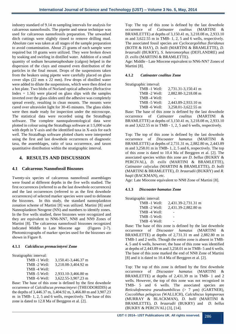
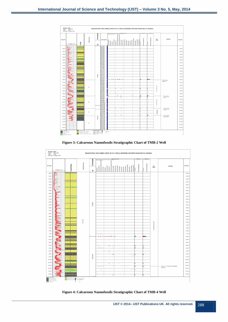
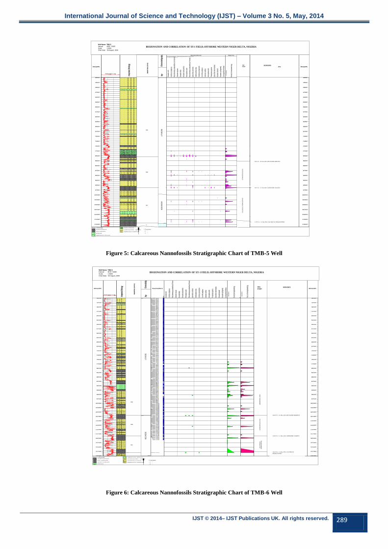
4.1.1 Calcidiscus premacintyrei Zone
Stratigraphic interval:
TMB -1 Well: 3,150.41-3,446.37 m
TMB -2 Well: 3,218.08-3,404.92 m
TMB -4 Well: -
TMB -5 Well: 2,933.10-3,466.80 m
TMB -6 Well: 3,622.55-3,907.23 m
Base: The base of this zone is defined by the first downhole
occurrence of Calcidiscus premacintyrei (THEODORIDIS) at
the depths of 3,446.37 m, 3,404.92 m, 3,466.80 m and 3,907.23
m in TMB- 1, 2, 5 and 6 wells, respectively. The base of this
zone is dated to 12.8 Ma of Berggren et al. [2].
Top: The top of this zone is defined by the last downhole
occurrence of Catinaster coalitus (MARTINI &
BRAMLETTE) at depths of 3,150.41 m, 3,218.08 m, 2,933.10
m and 3,622.55 m in TMB- 1, 2, 5 and 6 wells, respectively.
The associated fossil species are Cyclocargolithus floridanus
(ROTH & HAY), D. bolli (MARTINI & BRAMLETTE), D.
braarudii (BUKRY), S. heteromorphus (DEFLANDRE) and
D. exilis (MARTINI & BRAMLETTE).
Age: Middle - Late Miocene equivalent to NN6-NN7 Zones of
Martini [8].
4.1.2 Catinaster coalitus Zone
Stratigraphic interval:
TMB -1 Well: 2,731.31-3,150.41 m
TMB -2 Well: 2,882.80-3,218.08 m
TMB -4 Well: -
TMB -5 Well: 2,443.89-2,933.10 m
TMB -6 Well: 3,258.01-3,622.55 m
Base: The base of this zone is defined by the last downhole
occurrence of Catinaster coalitus (MARTINI &
BRAMLETTE) at depths of 3,150.41 m, 3,218.08 m, 2,933.10
m and 3,622.55 m in TMB - 1, 2, 5 and 6 wells, respectively.
Top: The top of this zone is defined by the last downhole
occurrence of Discoaster hamatus (MARTINI &
BRAMLETTE) at depths of 2,731.31 m, 2,882.80 m, 2,443.89
m and 3,258.01 m in TMB- 1, 2, 5 and 6, respectively. The top
of this zone is dated to 10.4 Ma of Berggren et al. [2]. The
associated species within this zone are D. bellus (BUKRY &
PERCIVAL), D. exilis (MARTINI & BRAMLETTE),
Catinaster calyculus (MARTINI & BRAMLETTE), D. bolli
(MARTINI & BRAMLETTE), D. braarudii (BUKRY) and R.
haqii (BACKMAN), etc.
Age: Late Miocene equivalent to NN8 Zone of Martini [8].
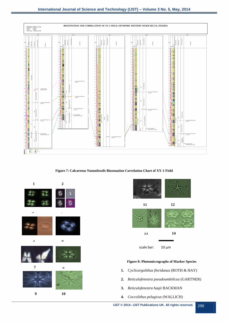
4.1.3 Discoaster hamatus Zone
Stratigraphic interval:
TMB -1 Well: 2,431.39-2,731.31 m
TMB -2 Well: 2,431.39-2,882.80 m
TMB -4 Well: -
TMB -5 Well: -
TMB -6 Well: -
Base: The base of this zone is defined by the last downhole
occurrence of Discoaster hamatus (MARTINI &
BRAMLETTE) at depths of 2,731.31 m and 2,882.80 m in
TMB-1 and 2 wells. Though the entire zone is absent in TMB-
4, 5 and 6 wells, however, the base of this zone was identified
at depths of 2,443.89 m and 3,258.01 m in TMB- 5 and 6 wells.
The base of this zone marked the end of NN8 Zone of Martini
[8] and it is dated to 10.4 Ma of Berggren et al. [2].
Top: The top of this zone is defined by the first downhole
occurrence of Discoaster hamatus (MARTINI &
BRAMLETTE) at depths of 2,431.39 m in TMB- 1 and 2
wells. However, the top of this zone was not recognized in
TMB- 5 and 6 wells. The associated species are
Reticulofenestra pseudoumbilicus (> 7 µm) (GARTNER),
Coccolithus pelagicus (WALLICH), Calcidiscus leptoporous
(MURRAY & BLACKMAN), D. bolli (MARTINI &
BRAMLETTE), D. braarudii (BUKRY) and D. bellus
(BUKRY & PERCIVAL) [3], [14].
Page 3
International Journal of Science and Technology (IJST) – Volume 3 No. 5, May, 2014
IJST © 2014– IJST Publications UK. All rights reserved. 287
Age: Late Miocene and equivalent to the Discoaster hamatus
(NN9) Zone of Martini [8].
Remarks: The diagnostic species for this zone is Discoaster
hamatus (MARTINI & BRAMLETTE).
4.2 Correlation of XY-1 Field
4.2.1 Calcareous Nannofossil Biozones
Correlation
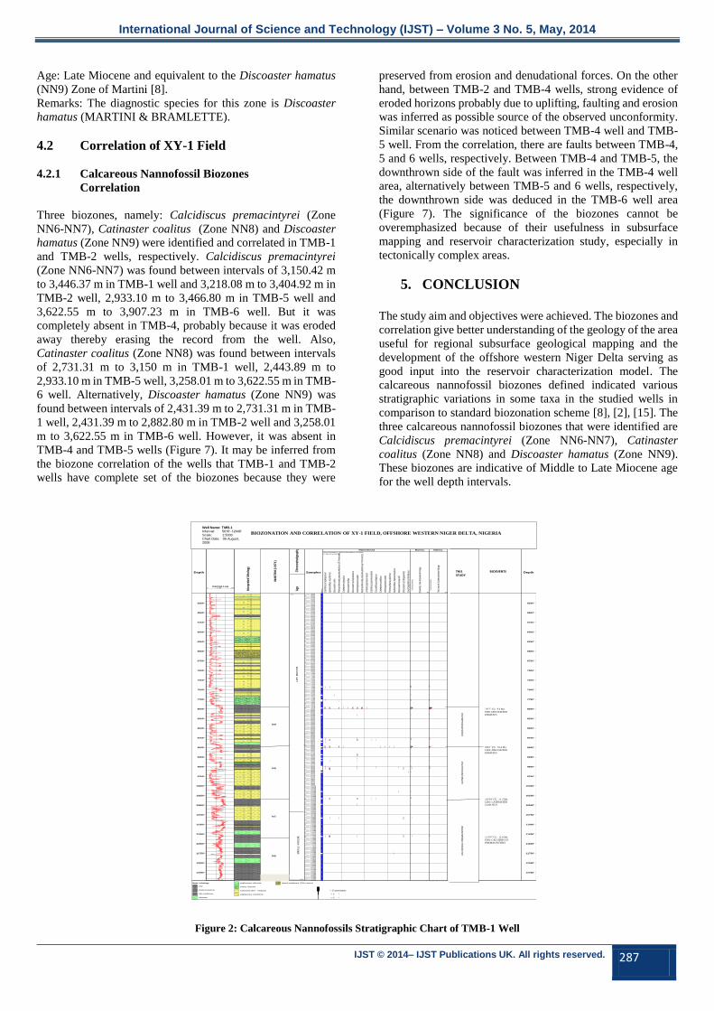
Three biozones, namely: Calcidiscus premacintyrei (Zone
NN6-NN7), Catinaster coalitus (Zone NN8) and Discoaster
hamatus (Zone NN9) were identified and correlated in TMB-1
and TMB-2 wells, respectively. Calcidiscus premacintyrei
(Zone NN6-NN7) was found between intervals of 3,150.42 m
to 3,446.37 m in TMB-1 well and 3,218.08 m to 3,404.92 m in
TMB-2 well, 2,933.10 m to 3,466.80 m in TMB-5 well and
3,622.55 m to 3,907.23 m in TMB-6 well. But it was
completely absent in TMB-4, probably because it was eroded
away thereby erasing the record from the well. Also,
Catinaster coalitus (Zone NN8) was found between intervals
of 2,731.31 m to 3,150 m in TMB-1 well, 2,443.89 m to
2,933.10 m in TMB-5 well, 3,258.01 m to 3,622.55 m in TMB-
6 well. Alternatively, Discoaster hamatus (Zone NN9) was
found between intervals of 2,431.39 m to 2,731.31 m in TMB-
1 well, 2,431.39 m to 2,882.80 m in TMB-2 well and 3,258.01
m to 3,622.55 m in TMB-6 well. However, it was absent in
TMB-4 and TMB-5 wells (Figure 7). It may be inferred from
the biozone correlation of the wells that TMB-1 and TMB-2
wells have complete set of the biozones because they were
preserved from erosion and denudational forces. On the other
hand, between TMB-2 and TMB-4 wells, strong evidence of
eroded horizons probably due to uplifting, faulting and erosion
was inferred as possible source of the observed unconformity.
Similar scenario was noticed between TMB-4 well and TMB-
5 well. From the correlation, there are faults between TMB-4,
5 and 6 wells, respectively. Between TMB-4 and TMB-5, the
downthrown side of the fault was inferred in the TMB-4 well
area, alternatively between TMB-5 and 6 wells, respectively,
the downthrown side was deduced in the TMB-6 well area
(Figure 7). The significance of the biozones cannot be
overemphasized because of their usefulness in subsurface
mapping and reservoir characterization study, especially in
tectonically complex areas.
5. CONCLUSION
The study aim and objectives were achieved. The biozones and
correlation give better understanding of the geology of the area
useful for regional subsurface geological mapping and the
development of the offshore western Niger Delta serving as
good input into the reservoir characterization model. The
calcareous nannofossil biozones defined indicated various
stratigraphic variations in some taxa in the studied wells in
comparison to standard biozonation scheme [8], [2], [15]. The
three calcareous nannofossil biozones that were identified are
Calcidiscus premacintyrei (Zone NN6-NN7), Catinaster
coalitus (Zone NN8) and Discoaster hamatus (Zone NN9).
These biozones are indicative of Middle to Late Miocene age
for the well depth intervals.
Depth
5250'
5500'
5750'
6000'
6250'
6500'
6750'
7000'
7250'
7500'
7750'
8000'
8250'
8500'
8750'
9000'
9250'
9500'
9750'
10000'
10250'
10500'
10750'
11000'
11250'
11500'
11750'
12000'
12250'
Gamma Log(API)0 150
Inte
rpre
ted
litho
logy
Deep Laterolog(ohm m/m)0.2 2000
Chr
onos
trat
igra
phy
5010
Late
Mio
cene
8930
12440
Mid
dle
Mio
cene
Age
Samples
Barr
en
50305060509051205150518052105240527053005330536053905420545054805510554055705600563056605690572057505780581058405870590059305960599060206050608061106140617062006230626063206350638064106440647065006530656065906620665066806710674067706800683068606890692069506980704071007130716071907220725073107340737074007430744474907520755075807610764076707700773077607790782078507880791079407970797880008030806080908120815081808210824082708300833083608390842084508480851085408570863086608661869087208750878088108840887089008930896089628990902090509080911091409170920092309260929093209380941094409470950095309560959096209650968097109740977098009830986098909920995099801001010040100701010010130101601019010220102501028010310103361034010370104001043010460104901052010550105801061010640106701070010730107601082010850108801091010940109701100011030110601109011120111501118011210112401127011300113081133011360113901142011450114801151011540115701160011630116601169011720117501178011810118401187011900119301196011990120201205012080121101214012170122001223012260122901232012350123801241012440
Semi-quantitative, (Default Abundance Scheme)
In-Situ occurrences
Cal
cidi
scus
lept
opor
ous
Sph
enol
ithus
mor
iform
is
Dis
coas
ter e
xilis
Ret
icul
ofen
estra
pse
udou
mbi
licus
(5-7
mic
rons
)
Cat
inas
ter c
alyc
ulus
Dis
coas
ter b
ellu
s
Dis
coas
ter q
uinq
uera
mus
Hel
icos
phae
ra c
arte
ri
Ret
icul
ofen
estra
pse
udou
mbi
licus
(>7m
icro
ns)
Um
bilic
osph
aera
rotu
la
Cal
cidi
scus
pre
mac
inty
rei
Coc
colit
hus
pela
gicu
s
Cat
inas
ter c
oalit
hus
Hel
icos
phae
ra s
talis
Pon
tosp
haer
a ja
poni
ca
Sph
enol
ithus
het
erom
orph
us
Dis
coas
ter b
raar
udii
Dis
coas
ter s
p (fr
agm
ents
)
Cyc
licar
golit
hus
florid
anus
Nannofossil
Div
ersi
ty: N
anno
pala
eont
olog
y
80
In-S
itu o
ccur
renc
es
2
1
1
1
9
1
2
5
1
8
1
1
1
2
2
2
4
1
1
1
5
1
3
4
1
Nanno.
Tota
l cou
nt: N
anno
pala
eont
olog
y
150
In-S
itu o
ccur
renc
es
2
1
1
1
24
1
2
7
1
11
1
3
1
2
2
2
91
1
1
7
1
3
9
1
Nanno.
Well Name : TOMBOY-1Operator : OBAJE SOLOMON
Well Code : TOMBOY-1
Interval : 5010' - 12440'
Scale : 1:5000
Chart date: 07 August 2008 Project
Chart
: BIOSTRAT
: TOM-1NANNO
8930.00' CU : Acme: Discoaster bollii, Discoasterhamatus (10.4Ma)
BIOEVENTS Depth
5250'
5500'
5750'
6000'
6250'
6500'
6750'
7000'
7250'
7500'
7750'
8000'
8250'
8500'
8750'
9000'
9250'
9500'
9750'
10000'
10250'
10500'
10750'
11000'
11250'
11500'
11750'
12000'
12250'
Base Lithology
clay
shale/mudstone
silty mudstone
siltstone
argillaceous siltstone
sandy siltstone
sandstone (fine - medium)
argillaceous sandstone
mixed sandstone (70% coarse)
BIOZONATION AND CORRELATION OF XY-1 FIELD, OFFSHORE WESTERN NIGER DELTA, NIGERIA
Well Name: TMB-1
Interval: 5010’-12440’
Scale: 1:5000
Chart Date: 06 August,
2008
11307’ CU: 12.8 Ma
FDO: CALCIDISCUS
PREMACINTYREI
10336’ CU: 11.5 Ma
LDO: CATINASTER
COALITUS
8961’ CU: 10.4 Ma
LDO: DISCOASTER
HAMATUS
7977’ CU: 9.5 Ma
FDO: DISCOASTER
HAMATUS
DIS
COA
STER
HA
MA
TUS
CATI
NA
STER
CO
ALI
TUS
CALC
IDIS
CUS
PRE
MA
CIN
TYRE
I
THIS STUDY
BIOEVENTS
NN6
NN7
NN8
NN9
MID
DLE
MIO
CEN
ELA
TE M
IOCE
NE
> 15 specimens
> 5 “
< 5 “
MA
RTI
NI (
1971
)
Figure 2: Calcareous Nannofossils Stratigraphic Chart of TMB-1 Well
Page 4
International Journal of Science and Technology (IJST) – Volume 3 No. 5, May, 2014
IJST © 2014– IJST Publications UK. All rights reserved. 288
Depth
5250'
5500'
5750'
6000'
6250'
6500'
6750'
7000'
7250'
7500'
7750'
8000'
8250'
8500'
8750'
9000'
9250'
9500'
9750'
10000'
10250'
10500'
10750'
11000'
11250'
11500'
11750'
12000'
12250'
Gamma Log(API)0 150
Litho
logy
Deep Induction(ohm m/m)0.2 2000
Chro
nostr
atigr
aphy
5010
Late
Mioc
ene
10310
12440
Midd
le Mi
ocen
eAg
e
Samples
Barre
n
503050605090512051505180521052405270530053305360539054205450548055105540557056005630566056905720575057805810584058705900593059605990602060506080611061406170620062306260632063506380641064406470650065306560659066206650668067106740677068006830686068906920695069807040710071307160719072207250731073407370740074307490752075507580761076407670770077307760779078207850788079107940797079788000803080608090812081508180821082408270830083308360839084208450848085108540857086308660869087208750878088108840887089008930896089909020905090809110914091709200923092609290932093809410944094599470950095309560959096209650968097109740977098009830986098909920995099801001010040100701010010130101601019010220102501028010310103401037010400104301046010490105201055010559105801061010640106701070010730107601082010850108801091010940109701100011030110601109011120111501117111180112101124011270113001133011360113901142011450114801151011540115701160011630116601169011720117501178011810118401187011900119301196011990120201205012080121101214012170122001223012260122901232012350123801241012440
Semi-quantitative, (Default Abundance Scheme)
In-Situ occurrences
Calci
discu
s lep
toporo
us
Catin
aster
calyc
ulus
Disc
oaste
r bell
us
Disc
oaste
r quin
quera
mus
Helic
osph
aera
carte
ri
Retic
ulofen
estra
pseu
doum
bilicu
s (5-7
micro
ns)
Retic
ulofen
estra
pseu
doum
bilicu
s(>7m
icron
s)
Sphe
nolith
us m
orifor
mis
Umbil
icosp
haera
rotul
a
Calci
discu
s prem
acint
yrei
Cocc
olithu
s pela
gicus
Catin
aster
coali
thus
Helic
osph
aera
stalis
Ponto
spha
era ja
ponic
a
Sphe
nolith
us he
terom
orphu
s
Disc
oaste
r braa
rudii
Disc
oaste
r sp (
fragm
ents)
Cycli
cargo
lithus
florid
anus
Nannofossil
Dive
rsity:
Nan
nopa
laeon
tolog
y
50
In-Sit
u occ
urren
ces
9
1
2
5
1
1
1
1
2
8
2
2
41
1
1
1
5
3
4
1
Nanno.
Total
coun
t: Nan
nopa
laeon
tolog
y
100
In-Sit
u occ
urren
ces
43
1
2
7
1
1
3
1
2
21
2
2
91
1
1
1
7
3
18
1
Nanno.
BIOEVENTS Depth
5250'
5500'
5750'
6000'
6250'
6500'
6750'
7000'
7250'
7500'
7750'
8000'
8250'
8500'
8750'
9000'
9250'
9500'
9750'
10000'
10250'
10500'
10750'
11000'
11250'
11500'
11750'
12000'
12250'
Well Name : TOMBOY-2Operator : OBAJE SOLOMON
Well Code : TOMBOY-2
Lat/Long : 52°31' 25.01"N 2° 2' 3.00"E
Interval : 5010' - 12440'
Scale : 1:5000
TOMBOY-2Chart date: 07 August 2008 Project
Chart
: BIOSTRAT
: TOMBOY-2 NANNO
Base Lithology
shale/mudstone
silty mudstone
siltstone
argillaceous siltstone
sandy siltstone
sandstone (fine - medium)
argillaceous sandstone
mixed sandstone (70% coarse)
IGD Boundary KeyPossible
Probable
Confident
Unconformable
? ?Unconformable
f Fault
?f ?Fault
> 15 specimens
> 5 “
< 5 “
BIOZONATION AND CORRELATION OF XY-1 FIELD, OFFSHORE WESTERN NIGER DELTA, NIGERIA Well Name: TMB-2
Interval: 5010’-12440’
Scale: 1:5000
Chart Date: 06 August, 2008
BIOEVENTS
10558’ CU: 11.5 Ma
LDO: CATINASTER
COALITUS
9458’ CU: 10.4 Ma
LDO: DISCOASTER
HAMATUS
7977’ CU: 9.5 Ma
FDO: DISCOASTER
HAMATUS
DIS
CO
AST
ER H
AM
ATU
SC
ATI
NA
STER
CO
ALI
TUS
CA
LCID
ISC
US
P
REM
AC
INTY
REI
THIS STUDY
MA
RTI
NI (
19
71
)
NN6
NN7
NN8
NN9
11171’ CU: 12.8 Ma
FDO: CALCIDISCUS
PREMACINTYREI
Figure 3: Calcareous Nannofossils Stratigraphic Chart of TMB-2 Well
Depth
2500'
2750'
3000'
3250'
3500'
3750'
4000'
4250'
4500'
4750'
5000'
5250'
5500'
5750'
6000'
6250'
6500'
6750'
7000'
7250'
7500'
7750'
8000'
8250'
8500'
8750'
9000'
9250'
9500'
9750'
10000'
10250'
10500'
10750'
11000'
11250'
Gamma Log(API)0 150
Interp
reted
litho
logy
Deep Laterolog(ohm m/m)0.2 2000
Chron
ostra
tigrap
hy
2400
LATE
MIOC
ENE
7984
11460
MIDD
LE M
IOCEN
EAg
e
Semi-quantitative, (Default Abundance Scheme)
In-Situ occurrences
Disco
aster
exilis
Calcid
iscus
lepto
porou
s
Reticu
lofen
estra
pseu
doum
bilicu
s (5-7
micro
ns)
Catin
aster
calyc
ulus
Disco
aster
bellu
s
Disco
aster
quinq
ueram
us
Helico
spha
era ca
rteri
Reticu
lofen
estra
pseu
doum
bilicu
s(>7m
icron
s)
Sphe
nolith
us m
orifor
mis
Umbil
icosp
haera
rotul
a
Calcid
iscus
prem
acint
yrei
Cocco
lithus
pelag
icus
Catin
aster
coali
thus
Helico
spha
era sta
lis
Ponto
spha
era ja
ponic
a
Sphe
nolith
us he
terom
orphu
s
Disco
aster
braa
rudii
Disco
aster
sp (fr
agme
nts)
Cyclic
argoli
thus fl
orida
nus
Nannofossil
Divers
ity: Na
nnop
alaeo
ntolog
y
50
In-Sit
u occu
rrenc
es
1
1
1
99
1
2
5
1
8
1
1
1
2
2
2
41
1
1
5
1
8
3
4
Nanno.
Total
coun
t: Nan
nopa
laeon
tolog
y
80
In-Sit
u occu
rrenc
es
1
1
1
2438
1
2
7
1
11
1
3
1
2
2
2
91
1
1
7
1
11
3
9
Nanno.
Well Name : TOMBOY-4Operator : OBAJE SOLOMON
Well Code : TOMBOY-4
Interval : 2400' - 11460'
Scale : 1:5000
Chart date: 07 August 2008 Project
Chart
: BIOSTRAT
: TOM-4NANNO
BIOEVENTS Depth
2500'
2750'
3000'
3250'
3500'
3750'
4000'
4250'
4500'
4750'
5000'
5250'
5500'
5750'
6000'
6250'
6500'
6750'
7000'
7250'
7500'
7750'
8000'
8250'
8500'
8750'
9000'
9250'
9500'
9750'
10000'
10250'
10500'
10750'
11000'
11250'
Base Lithology
shale/mudstone
silty mudstone
sandy mudstone
siltstone
argillaceous siltstone
sandstone (fine - medium)
argillaceous sandstone
BIOZONATION AND CORRELATION OF XY-1 FIELD, OFFSHORE WESTERN NIGER DELTA, NIGERIA Well Name: TMB-4
Interval: 2400’-11460’
Scale: 1:5000
Chart Date: 06 August, 2008
> 15 specimens
> 5 “
< 5 “
NN
7-N
N9
BIOEVENTSTHIS STUDY
10561’ CU: 11.5 Ma LDO: CATINASTER
COALITUS
UN
IDE
NT
IFIE
D
ZO
NE
MA
RT
INI
(19
71
)
Figure 4: Calcareous Nannofossils Stratigraphic Chart of TMB-4 Well
Page 5
International Journal of Science and Technology (IJST) – Volume 3 No. 5, May, 2014
IJST © 2014– IJST Publications UK. All rights reserved. 289
Depth
4000'
4250'
4500'
4750'
5000'
5250'
5500'
5750'
6000'
6250'
6500'
6750'
7000'
7250'
7500'
7750'
8000'
8250'
8500'
8750'
9000'
9250'
9500'
9750'
10000'
10250'
10500'
10750'
11000'
11250'
11500'
Gamma Log(API)0 150
Inter
prete
d lith
ology
Deep Laterolog(ohm m/m)0.2 2000
Chro
nostr
atigr
aphy
4000
LATE
MIO
CENE
9623
11460
MIDD
LE M
IOCE
NEAg
e
Semi-quantitative, (Default Abundance Scheme)
In-Situ occurrences
Disc
oaste
r exil
is
Calci
discu
s lep
toporo
us
Retic
ulofen
estra
pseu
doum
bilicu
s (5-7
micro
ns)
Catin
aster
calyc
ulus
Disc
oaste
r bell
us
Disc
oaste
r quin
quera
mus
Helic
osph
aera
carte
ri
Retic
ulofen
estra
pseu
doum
bilicu
s(>7m
icron
s)
Sphe
nolith
us m
orifor
mis
Umbil
icosp
haera
rotul
a
Calci
discu
s prem
acint
yrei
Cocc
olithu
s pela
gicus
Catin
aster
coali
thus
Helic
osph
aera
stalis
Ponto
spha
era ja
ponic
a
Sphe
nolith
us he
terom
orphu
s
Disc
oaste
r braa
rudii
Disc
oaste
r sp (
fragm
ents)
Cycli
cargo
lithus
florid
anus
Nannofossil
Dive
rsity:
Nan
nopa
laeon
tolog
y
8
In-Sit
u occ
urren
ces
1
11
9
9
1
25
1
8
1
1
1
2
22
41
81
1
5
1
3
4
5
Nanno.
Total
coun
t: Nan
nopa
laeon
tolog
y
20
In-Sit
u occ
urren
ces
1
1
1
24
50
1
27
1
11
1
3
1
2
22
91
321
1
7
1
3
9
7
Nanno.
Well Name : TOMBOY-5Operator : OBAJE SOLOMON
Well Code : TOMBOY-5
Interval : 4000' - 11600'
Scale : 1:5000
Chart date: 07 August 2008 Project
Chart
: BIOSTRAT
: TOM-5 NANNO
7933.14' CU : ? 10.35 Ma SB
8018.21' CU : ? 10.4 Ma MFS
9547.08' CU : ? 10.6 Ma SB
9623.36' CU : ? 11.5 Ma MFS
11113.91' CU : ? 12.1 Ma SB
11374.51' CU : ? 12.8 Ma MFS
Comments Depth
4000'
4250'
4500'
4750'
5000'
5250'
5500'
5750'
6000'
6250'
6500'
6750'
7000'
7250'
7500'
7750'
8000'
8250'
8500'
8750'
9000'
9250'
9500'
9750'
10000'
10250'
10500'
10750'
11000'
11250'
11500'
Base Lithology
shale/mudstone
silty mudstone
siltstone
argillaceous siltstone
sandy siltstone
sandstone (fine - medium)
argillaceous sandstone
BIOZONATION AND CORRELATION OF XY-1 FIELD, OFFSHORE WESTERN NIGER DELTA, NIGERIA Well Name: TMB-5
Interval: 4000’-11600’
Scale: 1:5000
Chart Date: 06 August, 2008
11374’ CU: 12.8 Ma FDO: CALCIDISCUS PREMACINTYREI
9623’ CU: 11.5 Ma LDO: CATINASTER COALITUS
8018’ CU: 10.4 Ma LDO: DISCOASTER HAMATUS
CA
TIN
AST
ER C
OA
LITU
SC
ALC
IDIS
CU
S P
REM
AC
INTY
REI
THIS STUDY
BIOEVENTS
NN6
NN7
NN8
NN9
MA
RTI
NI (
19
71
)
> 15 specimens
> 5 “
< 5 “
Figure 5: Calcareous Nannofossils Stratigraphic Chart of TMB-5 Well
Depth
4000'
4250'
4500'
4750'
5000'
5250'
5500'
5750'
6000'
6250'
6500'
6750'
7000'
7250'
7500'
7750'
8000'
8250'
8500'
8750'
9000'
9250'
9500'
9750'
10000'
10250'
10500'
10750'
11000'
11250'
11500'
11750'
12000'
12250'
12500'
12750'
13000'
Gamma Log(API)0 150 Int
erpret
ed lit
holog
y
Deep Induction(ohm m/m)0.2 2000
Chron
ostra
tigrap
hy
4000
LATE
MIOC
ENE
10689
13000
MIDDL
E MIOC
ENE
Age
Samples
Barre
n
40104040407041004130416041904220425042804310434043704400443044604490452045504580461046404670470047304760479048204850488049104940497050005030506050905120515051805210524052705300533053605390542054505480551055405570560056305660569057205750578058105840587059005930596059906020605060806110614061706200623062606320635063806410644064706500653065606590662066506680671067406770680068306860689069206950698070407100713071607190722072507310734073707400743074447490752075507580761076407670770077307760779078207850788079107940797079788000803080608090812081508180821082408270830083308360839084208450848085108540857086308660866186908720875087808810884088708900893089608962899090209050908091109140917092009230926092909320938094109440947095009530956095909620965096809710974097709800983098609890992099509980100101004010070101001013010160101901022010250102801031010336103401037010400104301046010490105201055010580106101064010670106891070010730107601082010850108801091010940109701100011030110601109011120111501118011210112401127011300113081133011360113901142011450114801151011540115701160011630116601169011720117501178011810118401187011885119001193011960
12819
Semi-quantitative, (Default Abundance Scheme)
In-Situ occurrences
Discoa
ster e
xilis
Calcid
iscus
leptop
orous
Reticu
lofene
stra ps
eudo
umbili
cus (5
-7micro
ns)
Catina
ster ca
lyculu
s
Discoa
ster b
ellus
Discoa
ster q
uinqu
eramu
s
Helico
sphae
ra car
teri
Reticu
lofene
stra ps
eudo
umbili
cus(>7
micron
s)
Sphe
nolith
us mo
riform
is
Umbili
cosph
aera
rotula
Calcid
iscus
prema
cintyre
i
Cocco
lithus
pelag
icus
Catina
ster co
alithu
s
Helico
sphae
ra sta
lis
Ponto
sphae
ra jap
onica
Sphe
nolith
us he
terom
orphu
s
Discoa
ster b
raarud
ii
Discoa
ster sp
(frag
ments
)
Cyclic
argolit
hus fl
orida
nus
Nannofossil
Divers
ity: Na
nnop
alaeo
ntolog
y
10
In-Sit
u occu
rrence
s
1
11
9
1
25
1
8
1
1
1
2
22
41
1
1
5
1
9
3
4
1
8
5
Nanno.
Total
count:
Nann
opala
eonto
logy
10
In-Sit
u occu
rrence
s
1
11
24
1
27
1
11
1
3
1
2
22
91
1
1
7
1
34
3
9
1
11
18
Nanno.
Well Name : TOMBOY-6Operator : OBAJE SOLOMON
Well Code : TOMBOY-6
Interval : 4000' - 13000'
Scale : 1:5000
Chart date: 07 August 2008 Project
Chart
: BIOSTRAT
: TOM- 6 NANNO
BIOEVENTS Depth
4000'
4250'
4500'
4750'
5000'
5250'
5500'
5750'
6000'
6250'
6500'
6750'
7000'
7250'
7500'
7750'
8000'
8250'
8500'
8750'
9000'
9250'
9500'
9750'
10000'
10250'
10500'
10750'
11000'
11250'
11500'
11750'
12000'
12250'
12500'
12750'
13000'
Base Lithology
shale/mudstone
silty mudstone
sandy mudstone
siltstone
argillaceous siltstone
sandstone (fine - medium)
sandstone (coarse)
argillaceous sandstone
> 15 specimens
> 5 “
< 5 “
NN7
NN8
NN9
MA
RTI
NI (
19
71
)
12819’ CU: 12.8 Ma FDO: CALCIDISCUS
PREMACINTYREI
11885’ CU: 11.5 Ma LDO: CATINASTER COALITUS
10689’ CU: 10.4 Ma LDO: DISCOASTER HAMATUS}
CA
TIN
AST
ER C
OA
LITU
SC
ALC
IDIS
CU
S
PR
EMA
CIN
TYR
EI
THIS STUDY
BIOEVENTS
BIOZONATION AND CORRELATION OF XY-1 FIELD, OFFSHORE WESTERN NIGER DELTA, NIGERIA Well Name: TMB-6
Interval: 4010’-13000’
Scale: 1:5000
Chart Date: 06 August, 2008
UN
IDEN
TIFI
ED Z
ON
E
Figure 6: Calcareous Nannofossils Stratigraphic Chart of TMB-6 Well
Page 6
International Journal of Science and Technology (IJST) – Volume 3 No. 5, May, 2014
IJST © 2014– IJST Publications UK. All rights reserved. 290
Depth
5250'
5500'
5750'
6000'
6250'
6500'
6750'
7000'
7250'
7500'
7750'
8000'
8250'
8500'
8750'
9000'
9250'
9500'
9750'
10000'
10250'
10500'
10750'
11000'
11250'
11500'
11750'
12000'
12250'
Gamma Log(API)0 150
Lit
ho
log
y
Deep Laterolog(ohm m/m)0.2 2000
Lit
ho
stra
tig
rap
hy
5010
Be
nin
Fo
rma
tio
n
7444
12440
Ag
ba
da
Fo
rm
atio
nF
orm
atio
n
Se
qu
en
ce
5010
PG
C
7444
HS
T
7978
TS
T
8661
HS
T
8962
TS
T
9994
HS
T
10336
TS
T
10871
HS
T
11308
12440
TS
T
Div
ers
ity: M
icro
pa
lae
on
tolo
gy
60
In-S
itu o
ccurren
ces
5
6
4
12
16
5
9
7
7
6
10
8
12
7
15
9
5
8
13
3
4
7
4
4
15
5
8
8
26
7
2
2
1
1
1
4
252
4
1
11
5
6
7
3
4
201
2
4
3
5
28
2525
32
29
3
9
2
32
3
1
8
1
10
5
9
16
13
5
8
3
2
10
514
10
10
5
1
2
249
1
2
1
4
4
4
3
3
186
7
10
16
6
9
10
3
26
8
8
13
19
18
11
10
9
11
97
423
12
8
2
1
8
5
4
4
2
Micro.
To
tal co
un
t: M
icrop
ala
eo
nto
log
y
80
In-S
itu o
ccurren
ces
8
6
5
21
41
5
12
10
18
13
17
17
44
12
46
17
7
23
27
7
5
12
5
4
35
5
28
16
130
14
3
3
1
1
2
4
1012
12
3
30
13
11
7
3
5
1221
3
8
3
7
64
150105
117
116
3
13
2
137
4
1
11
1
18
7
19
32
28
7
13
3
8
13
524
12
32
5
1
2
14112
1
3
2
7
4
4
6
6
458
18
13
24
9
15
16
3
168
11
9
25
56
43
21
14
11
18
23104
6121
16
2
1
15
10
4
4
2
Micro. *1
*2
Non M
arin
e
Div
ers
ity: N
an
nop
ala
eo
nto
log
y
15
In-S
itu o
ccurren
ces
3
21
111
4
54
86
61
82
1
3
1
2
1
11
9
1
25
1
8
1
1
1
2
22
41
1
1
5
1
3
4
1
Nanno.
To
tal co
un
t: N
an
no
pa
lae
on
tolo
gy
10
In-S
itu o
ccurren
ces
5
21
111
5
65
98
61
112
1
4
1
2
1
11
24
1
27
1
11
1
3
1
2
22
91
1
1
7
1
3
9
1
Nanno.
Events
7444' 8.5Ma SB
7977' 9.5Ma MFS
8660' 10.35Ma SB
8961' 10.4Ma MFS
9994' 10.6Ma SB
10336' 11.5Ma MFS
10871' 12.1Ma SB
11307' 12.8Ma MFS
Depth
5250'
5500'
5750'
6000'
6250'
6500'
6750'
7000'
7250'
7500'
7750'
8000'
8250'
8500'
8750'
9000'
9250'
9500'
9750'
10000'
10250'
10500'
10750'
11000'
11250'
11500'
11750'
12000'
12250'
Gamma Log(API)0 150
Lit
ho
log
y
Deep Induction(ohm m/m)0.2 2000
Lit
ho
stra
tig
rap
hy
5010
Be
nin
Fo
rma
tio
n
7940
12440
Ag
ba
da
Fo
rm
atio
nF
orm
atio
n
Se
qu
en
ce
5010
PG
C
HST7978
TS
T
8108
PG
C
HST
TST9543
PG
C
10358
HS
T
10559
TS
T
HST11171
TS
T
11293
12440
HS
T
Div
ers
ity: M
icro
pa
lae
on
tolo
gy
20
In-S
itu o
ccurren
ces
4
5
6
4
12
16
5
9
7
7
6
10
8
12
7
15
9
5
8
13
3
4
7
4
4
15
5
8
8
26
7
2
2
1
1
1
4
2
4
1
11
5
6
7
3
2912
1
2
4
3
5
14
6
6
11
3
9
2
3
1
8
1
2510
526
9
16
13
5
8
3
2
10
5
10
10
5
1
2
914
1
2
1
164
4
4
3
3
6
7
10
1614
626
9
10
253
8
8
13
19
18
11
10
9
11
9
8
11
6
6
6
3
6
5
Micro.
To
tal co
un
t: M
icrop
ala
eo
nto
log
y
40
In-S
itu o
ccurren
ces
4
8
6
5
21
23
5
12
10
18
13
17
17
21
12
27
17
7
23
27
7
5
12
5
4
24
5
28
16
37
14
3
3
1
1
2
4
2
12
3
30
13
11
7
3
7344
1
3
8
3
7
21
16
16
39
3
13
2
4
1
11
1
6518
7130
19
32
28
7
13
3
8
13
5
12
32
5
1
2
1224
1
3
2
327
4
4
6
6
8
18
13
2417
997
15
16
563
11
9
25
56
43
21
14
11
18
23
8
17
7
11
11
5
10
9
Micro. Palaeoenvironment
Default
Non M
arin
e
Transitio
nal
Inner
Neritic
Mid
dle
N
eritic
Div
ers
ity: N
an
nop
ala
eo
nto
log
y
8
In-S
itu o
ccurren
ces
3
21
111
4
74
89
61
82
1
3
12
1
11
9
1
25
1
1
1
1
2
8
22
41
1
1
1
5
3
4
1
Nanno.
To
tal co
un
t: N
an
no
pa
lae
on
tolo
gy
15
In-S
itu o
ccurren
ces
5
21
111
10
127
1924
91
112
1
4
12
1
11
43
1
27
1
1
3
1
2
21
22
91
1
1
1
7
3
18
1
Nanno.
Events
7940' 8.5Ma SB7977' 9.5Ma MFS
9367' 10.35Ma SB
9458' 10.4Ma MFS
10358' 10.6Ma SB
10558' 11.5Ma MFS
11112' 12.1Ma SB
11171' 12.8Ma MFS
11292' 13.1Ma SB
Depth
2500'
2750'
3000'
3250'
3500'
3750'
4000'
4250'
4500'
4750'
5000'
5250'
5500'
5750'
6000'
6250'
6500'
6750'
7000'
7250'
7500'
7750'
8000'
8250'
8500'
8750'
9000'
9250'
9500'
9750'
10000'
10250'
10500'
10750'
11000'
11250'
Gamma Log(API)0 150
Lit
ho
log
y
Deep Laterolog(ohm m/m)0.2 2000
Lit
ho
stra
tig
rap
hy
2400
Be
nin
Fo
rma
tio
n7461
11460
Ag
ba
da
Fo
rm
atio
nF
orm
atio
n
Se
qu
en
ce
2400
LO
WS
TA
ND
PR
OG
RA
DIN
G C
OM
PL
EX
7461
HS
T
7984
TS
T
8951
LO
WS
TA
ND
PR
OG
RA
DIN
G C
OM
PL
EX
10359
HS
T
10562
TS
T
HST11170
11460
TS
T
Div
ers
ity: M
icro
pa
lae
on
tolo
gy
25
In-S
itu o
ccurren
ces
12
8
10
5
7
4
10
8
9
9
7
5
7
4
5
6
4
5
12
11
8
9
7
5
9
9
4
14
16
13
8
7
3
3
2
5
3
1
9
10
13
10
2
5
6
4
12
16
5
9
7
7
6
10
8
12
7
15
9
5
8
13
3
4
7
4
4
15
5
8
8
26
7
2
2
1
1
1
425
17
4
1
11
5
6
7
3
420
121
2
4
3
5
28
2525
32
29
3
9
232
3
1
8
1
10
5
9
16
13
5
8
3
2
10
514
10
10
5
1
224
925
1
2
1
264
4
4
3
318
6
7
10
16
614
9
10
326
8
8
Micro.
To
tal co
un
t: M
icrop
ala
eo
nto
log
y
20
In-S
itu o
ccurren
ces
21
16
18
6
15
5
18
16
17
17
15
6
10
8
9
11
4
9
21
19
16
13
15
9
17
17
4
24
33
36
8
10
3
4
2
6
3
1
14
19
24
17
3
8
6
5
21
41
5
12
10
18
13
17
17
44
12
46
17
7
23
27
7
5
12
5
4
35
5
28
16
130
14
3
3
1
1
2
410135
12
3
30
13
11
7
3
512244
1
3
8
3
7
64
150105
117
116
3
13
2137
4
1
11
1
18
7
19
32
28
7
13
3
8
13
524
12
32
5
1
2141
1265
1
3
2130
7
4
4
6
645
8
18
13
24
924
15
16
3168
11
9
Micro. Palaeoenvironment
Default
Non M
arin
e
Transitio
nal
Inner
Neritic
Mid
dle
N
eritic
Div
ers
ity: N
an
nop
ala
eo
nto
log
y
15
In-S
itu o
ccurren
ces
1
1
3
21
111
4
54
86
61
82
1
3
1
2
1
11
99
1
25
1
8
1
1
1
2
22
41
1
1
5
1
8
3
4
Nanno.
To
tal co
un
t: N
an
no
pa
lae
on
tolo
gy
20
In-S
itu o
ccurren
ces
3
1
5
21
1
1
1
5
65
98
61
1121
4
1
2
1
1
1
2438
1
27
1
11
1
3
1
2
22
91
1
1
7
1
11
3
9
Nanno.
Events
7460' 10.35Ma SB
7983' 10.4Ma MFS
10359' 10.6Ma SB
10561' 11.5Ma MFS
11170' 12.1Ma SB
Depth
4000'
4250'
4500'
4750'
5000'
5250'
5500'
5750'
6000'
6250'
6500'
6750'
7000'
7250'
7500'
7750'
8000'
8250'
8500'
8750'
9000'
9250'
9500'
9750'
10000'
10250'
10500'
10750'
11000'
11250'
11500'
Gamma Log(API)0 150
Lit
ho
log
y
Deep Laterolog(ohm m/m)0.2 2000
Lit
ho
stra
tig
rap
hy
4000
BE
NIN
FO
RM
AT
ION
7462
11600
AG
BA
DA
FO
RM
AT
ION
Fo
rm
atio
n
Se
qu
en
ce
4000
LO
WS
TA
ND
PR
OG
RA
DIN
G C
OM
PL
EX
HST8018
TS
T
8469
LO
WS
TA
ND
PR
OG
RA
DIN
G C
OM
PL
EX
HST
TST9703
LO
WS
TA
ND
PR
OG
RA
DIN
G C
OM
PL
EX
11114
HS
T
11375
11600
TS
T
To
tal co
un
t: M
icrop
ala
eo
nto
log
y
40
In-S
itu o
ccurren
ces
24
33
36
8
10
3
4
2
6
3
1
14
19
24
17
3
8
6
5
21
41
5
12
10
18
13
17
17
44
12
46
17
7
23
27
7
5
12
5
4
35
5
28
16
130
14
3
3
1
1
2
4101
2
12
3
30
13
11
7
310
5122
1
44
3
8
3
7
64
150105
117
116
3
13
2
137
4
1
11
1
18
7
1922
3228
327
13
3
8
13
524
12
32
5
1
2
14112
1
3
2
7
4
4
6
645
8
18
13
24
159
15
16
3168
1117
9
25
56
43
Micro.
Div
ers
ity: M
icro
pa
lae
on
tolo
gy
15
In-S
itu o
ccurren
ces
14
16
13
8
7
3
3
2
5
3
1
9
10
13
10
2
5
6
4
12
16
5
9
7
7
6
10
8
12
7
15
9
5
8
13
3
4
7
4
4
15
5
8
8
26
7
2
2
1
1
1
425
2
4
1
11
5
6
7
39
420
112
2
4
3
5
28
2525
32
29
3
9
232
3
1
8
1
10
5
913
1613
165
8
3
2
10
514
10
10
5
1
2
249
1
2
1
4
4
4
3
318
6
7
10
16
136
9
10
326
814
8
13
19
18
Micro. Palaeoenvironment
Default
Non M
arin
e
Transitio
nal
Inner
Neritic
Mid
dle
N
eritic
Div
ers
ity: N
an
nop
ala
eo
nto
log
y
20
In-S
itu o
ccurren
ces
1
1
3
21
1
1
1
4
54
86
61
821
3
1
2
1
1
1
9
9
1
25
1
8
1
1
1
2
22
41
81
1
5
1
3
4
5
Nanno.
To
tal co
un
t: N
an
no
pa
lae
on
tolo
gy
25
In-S
itu o
ccurren
ces
3
1
5
21
1
1
1
5
65
98
61
1121
4
1
2
1
1
1
24
50
1
27
1
11
1
3
1
2
22
91
321
1
7
1
3
9
7
Nanno.
Events
7933' 10.35 Ma SB
8018' 10.4 Ma MFS
9547' 10.6Ma SB
9623' 11.5Ma MFS
11113' 12.1Ma SB
11374' 12.8Ma MFS
Depth
4000'
4250'
4500'
4750'
5000'
5250'
5500'
5750'
6000'
6250'
6500'
6750'
7000'
7250'
7500'
7750'
8000'
8250'
8500'
8750'
9000'
9250'
9500'
9750'
10000'
10250'
10500'
10750'
11000'
11250'
11500'
11750'
12000'
12250'
12500'
12750'
13000'
Gamma Log(API)0 150
Lit
ho
log
y
Deep Induction(ohm m/m)0.2 2000
Lit
ho
stra
tig
rap
hy
4000
Be
nin
Fo
rma
tio
n
7560
13000
Ag
ba
da
Fo
rm
atio
nF
orm
atio
n
Se
qu
en
ce
4000
Lo
wsta
nd P
rog
rad
ing
Co
mp
lex
8717
HS
T
10689
TS
T
10884
Lo
wsta
nd P
rog
rad
ing
Co
mp
lex
HST11885
TS
T
12615
HS
T
12819
13000
TS
T
Samples
Barre
n
4040
4100
4160
4220
4280
4340
4400
4460
4520
4580
4640
4700
4760
4820
4880
4940
500050105060
5120
5180
5240
5300
5360
5420
5480
5540
5600
5660
5720
5780
5840
5900
5960
6020
6080
6140
6200
6260
6320
6380
6440
6500
6560
6680
6740
6800
6860
6920
6980
7040
7100
7160
7220
7280
7340
740074447460
7520
7580
7640
7700
7760
7820
7880
794079788000
8060
8120
8180
8240
8420
8480
8540
8600
86608661
8720
8780
8840
8900
89608962
9020
9080
9140
9260
9320
9380
9440
9500
9560
9620
96739680
9740
9800
9860
9920
9980999410040
10100
10160
10220
10280
1033610340
10400
10460
10520
10580
106401068910700
10760
108201087110880
10940
11000
11060
11120
11180
11240
113001130811360
11420
11480
11540
11600
11660
11720
1178011787118401188511900
11960
12020
12080
12140
12200
12260
12320
12380
12440
12500
12560
1261512620
12680
12740
128001281912860
12920
Div
ers
ity: M
icro
pa
lae
on
tolo
gy
20
In-S
itu o
ccurren
ces
14
16
13
8
7
3
3
2
5
3
1
9
10
13
10
2
5
6
4
12
16
5
9
7
7
6
10
8
12
7
15
9
5
8
13
3
4
7
4
4
15
5
8
8
26
7
2
2
1
1
1
425
2
4
1
11
5
6
7
3
420
1
2
4
3
5
28
2525
32
29
3
9
232
3
1
8
1
10
5
9
16
13
255
8
3
2
10
514
10
10
5
1
2
249
1
2
1
4
412
4
3
318
6
7
10
16
6
9
10
326
8
8
13
19
18
11
10
920
1126
9
23
7
8
7
2
3
8
6
6
7
2
57
8
6
316
4
8
Micro.
To
tal co
un
t: M
icrop
ala
eo
nto
log
y
50
In-S
itu o
ccurren
ces
24
33
36
8
10
3
4
2
6
3
1
14
19
24
17
3
8
6
5
21
41
5
12
10
18
13
17
17
44
12
46
17
7
23
27
7
5
12
5
4
35
5
28
16
130
14
3
3
1
1
2
4101
2
12
3
30
13
11
7
3
5122
1
3
8
3
7
64
150105
117
116
3
13
2
137
4
1
11
1
18
7
19
32
28
687
13
3
8
13
524
12
32
5
1
2
14112
1
3
2
7
444
4
6
645
8
18
13
24
9
15
16
3168
11
9
25
56
43
21
14
1140
1898
23
61
15
16
15
2
3
16
13
7
8
2
815
16
11
332
4
16
Micro. Palaeoenvironment
Default
Non M
arin
e
Transitio
nal
Inner
Neritic
Mid
dle
N
eritic
Samples
Barre
n
40104040407041004130416041904220425042804310434043704400443044604490452045504580461046404670470047304760479048204850488049104940497050005030506050905120515051805210524052705300533053605390542054505480551055405570560056305660569057205750578058105840587059005930596059906020605060806110614061706200623062606320635063806410644064706500653065606590662066506680671067406770680068306860689069206950698070407100713071607190722072507310734073707400743074447490752075507580761076407670770077307760779078207850788079107940797079788000803080608090812081508180821082408270830083308360839084208450848085108540857086308660866186908720875087808810884088708900893089608962899090209050908091109140917092009230926092909320938094109440947095009530956095909620965096809710974097709800983098609890992099509980100101004010070101001013010160101901022010250102801031010336103401037010400104301046010490105201055010580106101064010670106891070010730107601082010850108801091010940109701100011030110601109011120111501118011210112401127011300113081133011360113901142011450114801151011540115701160011630116601169011720117501178011810118401187011885119001193011960
12819
Div
ers
ity: N
an
nop
ala
eo
nto
log
y
10
In-S
itu o
ccurren
ces
1
1
3
21
111
4
54
86
61
82
1
3
1
2
1
11
9
1
25
1
8
1
1
1
2
22
41
1
1
5
1
9
3
4
1
8
5
Nanno.
To
tal co
un
t: N
an
no
pa
lae
on
tolo
gy
12
In-S
itu o
ccurren
ces
3
1
5
21
111
5
65
98
61
112
1
4
1
2
1
11
24
1
27
1
11
1
3
1
2
22
91
1
1
7
1
34
3
9
1
11
18
Nanno.
Events
9673' 10.35 Ma SB
10689' 10.4 Ma MFS
11786' 10.6Ma SB
11885' 11.5Ma MFS
12615' 12.1Ma SB
12819' 12.8Ma MFS
Depth
4000'
4250'
4500'
4750'
5000'
5250'
5500'
5750'
6000'
6250'
6500'
6750'
7000'
7250'
7500'
7750'
8000'
8250'
8500'
8750'
9000'
9250'
9500'
9750'
10000'
10250'
10500'
10750'
11000'
11250'
11500'
11750'
12000'
12250'
12500'
12750'
13000'
Well Name : TOMBOY-1Operator : TOMBOY
Well Code : TOMBOY-1
Lat/Long : 52°31' 25.01"N 2° 2' 3.00"E
Interval Various
Scale Various
Chart date: 28 January 2003 Project
Chart
: BIOSTRAT
: TOMBOY-CORRELATION
TOMBOY-1 TOMBOY-2 TOMBOY-4 TOMBOY-5 TOMBOY-6
Base Lithology
clay
shale/mudstone
silty mudstone
sandy mudstone
siltstone
argillaceous siltstone
sandy siltstone
sandstone (fine - medium)
sandstone (coarse)
argillaceous sandstone
mixed sandstone (70% coarse)
Text Keys*1 Palaeoenvironment
*2 Default
CH
RO
NO
(AG
E)
MA
RTI
NI (
19
71
)
THIS
STU
DY
BIO
ZON
E
BIO
EVEN
TS
BIOZONATION AND CORRELATION OF XY-1 FIELD, OFFSHORE WESTERN NIGER DELTA, NIGERIA Well Names: TMB-1, 2, 5 & 6
Interval: Various
Scale: 1:5000
Chart Date: 06 August, 2008LA
TE M
IOC
ENE
MID
DLE
MIO
CEN
E
NN
9N
N8
NN
7N
N6
DIS
CO
AST
ER H
AM
ATU
SC
ATI
NA
STER
CO
ALI
TUS
CA
LCID
ISC
US
PR
EMA
CIN
TYR
EI
FDO: DISCOASTER HAMATUS (9.5 Ma)
LDO: DISCOASTER HAMATUS (10.4 Ma)
LDO: CATINASTER COALITUS (11.5 Ma)
FDO: CALCIDISCUS PREMACINTYREI (12.8 Ma)
LATE
MIO
CEN
E
FDO: DISCOASTER HAMATUS (9.5 Ma)
MID
DLE
MIO
CEN
E
LDO: DISCOASTER HAMATUS (10.4 Ma)
FDO: CALCIDISCUS PREMACINTYREI (12.8 Ma)
LDO: CATINASTER COALITUS (11.5 Ma)
CA
LCID
ISC
US
PR
EMA
CIN
TYR
EIC
ATI
NA
STER
CO
ALI
TUS
DIS
CO
AST
ER H
AM
ATU
S
NN
9N
N8
NN
7N
N6
CH
RO
NO
(AG
E)
MA
RTI
NI (
19
71
)
THIS
STU
DY
BIO
ZON
E
BIO
EVEN
TS
Lith
olo
gy
CH
RO
NO
(AG
E)
MA
RTI
NI (
19
71
)
THIS
STU
DY
BIO
ZON
E
BIO
EVEN
TS
LDO: CATINASTER COALITUS (11.5 Ma)
NN
7-N
N9
UN
IDEN
TIFI
ED Z
ON
E
MID
DLE
–LA
TE M
IOC
ENE
CH
RO
NO
(AG
E)
MA
RTI
NI (
19
71
)
THIS
STU
DY
BIO
ZON
E
BIO
EVEN
TS
LDO: DISCOASTER HAMATUS (10.4 Ma)
FDO: CALCIDISCUS PREMACINTYREI (12.8 Ma)
LDO: CATINASTER COALITUS (11.5 Ma)
CA
LCID
ISC
US
PR
EMA
CIN
TYR
EIC
ATI
NA
STER
CO
ALI
TUS
NN
9N
N8
NN
7
MID
DLE
MIO
CEN
E
CH
RO
NO
(AG
E)
MA
RTI
NI (
19
71
)
THIS
STU
DY
BIO
ZON
E
BIO
EVEN
TS
LDO: DISCOASTER HAMATUS (10.4 Ma)
FDO: CALCIDISCUS PREMACINTYREI (12.8 Ma)
LDO: CATINASTER COALITUS (11.5 Ma)
CA
LCID
ISC
US
PR
EMA
CIN
TYR
EIC
ATI
NA
STER
CO
ALI
TUS
NN
9N
N8
NN
7
MID
DLE
MIO
CEN
E
UN
IDEN
TIFI
ED Z
ON
E
NN
6
LATE
MIO
CEN
E
UN
IDEN
TIFI
ED Z
ON
E
NN
6
LATE
MIO
CEN
E
Figure 7: Calcareous Nannofossils Biozonation Correlation Chart of XY-1 Field
1 2
3 4
5 6
7 8
9 10
11 12
13 14
scale bar: 10 µm
1. Cyclicargolithus floridanus (ROTH & HAY)
2. Reticulofenestra pseudoumbilicus (GARTNER)
3. Reticulofenestra haqii BACKMAN
4. Coccolithus pelagicus (WALLICH)
Figure 8: Photomicrographs of Marker Species
Page 7
International Journal of Science and Technology (IJST) – Volume 3 No. 5, May, 2014
IJST © 2014– IJST Publications UK. All rights reserved. 291
5. Calcidiscus leptoporus (MURRAY AND
BLACKMAN)
6. Calcidiscus premacintyrei THEODORIDIS
7. Sphenolithus heteromorphus DEFLANDRE
8. Discoaster bollii MARTINI & BRAMLETTE
9. Discoaster exilis MARTINI AND BRAMLETTE
10. Discoaster braarudii BUKRY
11. Discoaster bellus BUKRY AND
PERCIVAL
12. Discoaster hamatus MARTINI &
BRAMLETTE
13. Catinaster calyculus MARTINI &
BRAMLETTE
14. Catinaster coalitus MARTINI &
BRAMLETTE
REFERENCES
[1]. Avbovbo, A. A., 1978. Tertiary lithostratigraphy of Niger
Delta, AAPG Geol. Notes, pp. 296-300.
[2]. Berggren, W. A., Kent, D. V. and Avan Couvering, J. A.,
1985. The Neogene: Part 2, Neogene geochronology and
chronostratigraphy. In: Snelling, N.J. (Ed.), The
Chronology of Geological Record, Geological Society
Memoir, 10: 211-260.
[3]. Bolli, H. M. and Saunders, J. B. and Perch-Nielsen, K.,
1987. Planktonic stratigraphy. (Cambridge Earth
Sciences Series), Cambridge University Press, 599 pp.
[4]. Doust, H. & Omatsola, E., 1990. Niger Delta. In: Edwards,
J.D. & Santogrossi, P.A. (Eds.), Divergent/passive
margin basins, American Association of Petroleum
Geologists Memoir 48: 201-239.
[5]. Esan, A. O., 2002. High resolution sequence stratigraphic
and reservoir characterization studies of D-07, D-08 and
E-01 sands, Block 2 Meren Field, Offshore, Niger Delta,
Publ. M.S. Geology Thesis, Texas A & M University,
Texas, USA, 115 pp.
[6]. Frankl, E. J and Cordy, E. A., 1967. The Niger Delta oil
province recent development onshore and offshore: 7th
World Petroleum Congress Proceedings, Mexico City, IB:
195-209.
[7]. Knox, G. J. and Omatsola, E. M., 1989. Development of
the Cenozoic Niger delta in terms of the “escalator
regression” model and impact on hydrocarbon
distribution, in W.J.M. van der Linden et al., eds., 1987,
Proceedings, KNGMG Symposium on Coastal Lowlands,
Geology, Geotechnology: Dordrecht, Kluwer Academic
Publishers, 181-202.
[8]. Martini, E., 1971. Standard Tertiary and Quaternary
calcareous nannoplankton zonation, in Proceedings of the
Second Nannoplanktonic Conference, Roma, 1970, (ed.
Farinacci, A.), Edizioni Technoscienza, Rome, 2: 739-
785.
[9]. Ojo, E. A., Fadiya, L. S. and Ehinola, O. A., 2009.
Biozonation and correlation of BDX-1 and BDX-2 wells
of deep offshore Niger Delta using calcareous
nannofossils. Search and Discovery Article (AAPG)
50194:8. Availaible at
http://www.searchanddiscovery.com/documents/2009/50
194ojo/images/ojo.pdf.
[10]. Short, K. C. and Stäuble, A. J., 1967. Outline of geology
of Niger Delta. American Association of Petroleum
Geologists Bulletin 5 (51):761-779.
[11]. Tuttle, L. W. M., Charpentier, R. R. and Brownfield, E.
M., 1999. The Niger Delta Petroleum System: Niger Delta
Province, Nigeria Cameroon, and Equatorial Guinea,
Africa. U.S. Geological Survey Open-File Report 99-50-
H, Denver, Colorado, 70 pp.
[12]. Weber, K. J. and Daukoru, E., 1975. Petroleum geology of
the Niger Delta: Proceedings of the 9th World Petroleum
Congress, Tokyo, 2: 202-221.
[13]. Whiteman, A. (1982): Nigeria- its petroleum geology,
resources and potential: London, Graham and Trotman,
394 pp.
[14]. Bown, P. R. (1999): Calcareous nannofossil
biostratigraphy, Kluwer Academic Publs., Dor
Drecht, The Netherlands, 315 pp.
[15]. Haq, B. U., Hardenbol, J. and Vail, P. R. (1988): Mesozoic
and Cenozoic chronostratigraphy and cycles of sea-level
changes. In: Wilgus, C. K. et al. (Eds.), Sea-level change:
an integrated approach, Soc. Econ. Paleontologists and
Mineralogists Spec. Publ. no. 42, pp. 71–108.