____________________________________________________________________________________________ *Corresponding author: E-mail: [email protected]; Advances in Research 2(12): 696-711, 2014, Article no. AIR.2014.12.001 SCIENCEDOMAIN international www.sciencedomain.org Calcareous Nannofossil Biostratigraphic Analysis of Well ‘ K-2’, Deep Offshore Niger Delta, Nigeria Sanuade Oluseun Adetola 1* 1 Earth Science Department, King Fahd University of Petroleum and Minerals, Dhahran 31261, Saudi Arabia. Author’s contribution Author SOA designed the study, performed the analysis and interpretation of the samples and also prepared the manuscript. Received 12 th May 2014 Accepted 14 th June 2014 Published 5 th July 2014 ABSTRACT A study on the calcareous nannofossil biostratigraphy has been carried out on sequences within the interval 1640m-1980m of well ‘K-2’ located in the deep offshore of Niger Delta, Nigeria. Lithologic description of the samples was done using a stereo-binocular microscope. Thirty-four slides of samples were prepared and studied for their calcareous nannofossil contents using Olympus Light Microscope in both plane-polarized and cross-polarized light. The lithostratigraphic descriptions on the samples showed the abundance of shale and mudstone/siltstone with minor amount of thin intercalated units of sand bed. Seventeen calcareous nannofossil species were identified and used to predict the biostratigraphic deductions such as zonation, dating and a tentative sequence stratigraphic framework. With the aid of a standard zonation schemes, two major nannofossil zones (NN 19 and NN 18) were identified. These zones belongs to Pleistocene and Pliocene ages respectively. Two major zones of Gephyrocapsa carribeanica and Gephyroca psaparallela were identified for the studied well on the basis of the index taxa and fossil assemblage recorded. The insufficient amount of nannofossils in the lower part of the well precluded a definite zonation and made the zone to be indeterminable. One Condensed Section believed to be associated with 2.0Ma Maximum Flooding Surfaces was recognized. Original Research Article
Advances in Research2(12): 696-711, 2014, Article no. AIR.2014.12.001
SCIENCEDOMAIN internationalwww.sciencedomain.org
Calcareous Nannofossil BiostratigraphicAnalysis of Well ‘K-2’, Deep Offshore Niger
Delta, Nigeria
Sanuade Oluseun Adetola1*
1Earth Science Department, King Fahd University of Petroleum and Minerals,Dhahran 31261, Saudi Arabia.
Author’s contribution
Author SOA designed the study, performed the analysis and interpretation of the samplesand also prepared the manuscript.
Received 12th May 2014Accepted 14th June 2014
Published 5th July 2014
ABSTRACT
A study on the calcareous nannofossil biostratigraphy has been carried out on sequenceswithin the interval 1640m-1980m of well ‘K-2’ located in the deep offshore of Niger Delta,Nigeria.Lithologic description of the samples was done using a stereo-binocular microscope.Thirty-four slides of samples were prepared and studied for their calcareous nannofossilcontents using Olympus Light Microscope in both plane-polarized and cross-polarizedlight.The lithostratigraphic descriptions on the samples showed the abundance of shale andmudstone/siltstone with minor amount of thin intercalated units of sand bed. Seventeencalcareous nannofossil species were identified and used to predict the biostratigraphicdeductions such as zonation, dating and a tentative sequence stratigraphic framework.With the aid of a standard zonation schemes, two major nannofossil zones (NN 19 andNN 18) were identified. These zones belongs to Pleistocene and Pliocene agesrespectively. Two major zones of Gephyrocapsa carribeanica and Gephyrocapsaparallela were identified for the studied well on the basis of the index taxa and fossilassemblage recorded. The insufficient amount of nannofossils in the lower part of thewell precluded a definite zonation and made the zone to be indeterminable. OneCondensed Section believed to be associated with 2.0Ma Maximum Flooding Surfaceswas recognized.
Original Research Article
Sanuade; AIR, Article no. AIR.2014.12.001
697
Keywords: Biostratigraphy; Gephyrocapsa carribeanica; Gephyrocapsa parallela; condensedsection; maximum flooding surfaces.
1. INTRODUCTION
The focus on the Tertiary Niger Delta basin by various workers gained prominence followingits discovery as a petroleum laden basin in the 1950’s by Shell BP. Since then, Nigeria hasbeen rated as the sixth largest oil producing country in the world with a proven ultimatereserve of about thirty four billion barrels of oil and two hundred and sixty trillion cubic feet ofgas [1].
However, about 90% of the twenty six billion barrels recoverable oil reserve earlier estimatedfor the Niger Delta by [2] is said to be from the onshore areas of Niger Delta. This couldhave been due to the extensive exploration activities, which concentrates on the onshoreareas of the Niger Delta compared to offshore regions.
Presently, attention has been directed to the offshore regions and so far prospects havebeen encouraging. The advancement in deep-water drilling technology and variousexploration techniques have aided this development.
More recently, the integration of biostratigraphy with other methods like geophysics, well logreserve, sequence stratigraphy, have contributed immensely to hydrocarbon exploration inthe offshore Niger Delta.
However, based on the biostratigraphy, three major fossil groups are focused on. These areforaminifera, pollen and spores and nannofossils. These three have proven very useful andcomplementary to each other but the use of nannofossils is becoming increasingly importantbecause of the following:
a) They are planktonic, abundant, evolve rapidly and largely cosmopolitan.b) They can be studied from minute rock chips because of their small size. This found
application in hydrocarbon exploration and development, and scientific drilling.
Calcareous nannofossils therefore are defined as all calcareous fossils that are smaller than30 microns (µm). They are exclusively marine fossils of great importance in deep waterexploration and they have been used in various ways to assist in operational situation in thewell site during drilling which include achieving a straight-forward age monitoring of wellswhere stratigraphy is uncertain and also in confirmation of terminal depth where there iscommitment to drill to deposit of specific age and in coring point selection to mention a few.This means that a pragmatic approach to nannofossil biostratigraphy is required. Manyresearchers have worked on the calcareous nannofossils [3,4,5,6,7,8].
1.1 Location of the Study Area
Ditch cutting samples were obtained from well ‘K–2’ in the offshore deep-water Nigeria. Thesamples were given out by one of the deep water operators. The name and the exactlocation of the well were not made available for proprietary reasons.
Sanuade; AIR, Article no. AIR.2014.12.001
698
However, the Nigeria deep-water region is believed to be roughly between water depth of600m on the inboard side and 200m in the outboard side for an area of approximately48,500Km2 (Fig. 1) [9].
Fig. 1. Map showing the acreage of study area
The samples were obtained at 10m interval. This study covers an interval of 1640m to1980m comprising thirty-four samples in all.
1.2 Objectives of the Study
The main objectives of the study are:
To identify the calcareous nannofossil species in the strata penetrated by the well and toidentify new nannofossil species in the analyzed sequence (if any). Other objectives include.
To establish the lithostratigraphic sequence of the section (same as the one below,so delete this)
To establish the lithostratigraphic sequence of the section. To determine the age of the strata penetrated by the well. To determine a tentative sequence stratigraphic framework for the section.
1.3 Geology of the Niger Delta
The Niger Delta is one of the basins in West Africa formed as a result of basement tectonicsrelated to crustal divergence and translation during the Cretaceous continental rifting ofGondwanaland. The Niger Delta is a thick prism of clastic sediments which has progradeddown the Benue Trough into the Gulf of Guinea since Early Tertiary. These sediments began
Sanuade; AIR, Article no. AIR.2014.12.001
699
to reach the continental slope by Late Eocene time and subsequent progradation hasprogressively enlarged the continental margin to its present position [2].
The results of numerous studies [1,2,9] of Tertiary Niger Delta indicate that the Deltaconsists of a thick sedimentary prism of about 12km. The overall succession in ascendingorder consists of over pressure continuous marine shales (Akata Formation) withinterbedded thin bed of siltstone interpreted as slope channel fills. These are overlain by aparalic sequence of shales and sands (Agbada Formation) and thick continental sands andgravels at the top (Benin Formation).
2. MATERIALS AND METHODS
Materials used for this study were ditch cutting samples. The well is code-named as well ‘K-2’ for confidential reasons. These samples were supplied by one of the major Niger Deltadeep-water operators.
Thirty-four samples were obtained at depth within the intervals of 1640-1980m andanalyzed.They were packed in small polythene bags which bear the name of the well and samplingdepth. The bags were arranged serially in a tray in laboratory for lithologic description andsample processing for calcareous nannofossil analyses.
2.1 Lithologic Description
The lithologic description of the samples was done using a stereo-binocular microscope. Alithostratigraphic column for the well was then constructed based on the lithologic descriptionof the samples and lithostratigraphic units penetrated by the well were delineated.
2.2 Preparation
Thirty four samples were processed for their calcareous nannofossil content according thestandard preparation technique of [10]. The technique involves:
(i) Taking a fresh inner portion of the sample provided and spreading over a cover slip(22mmx40mm) of a glass slide (25.4mmx76mm).
(ii) Adding a few drop of distilled water and making a thick sediment suspension withthe help of a flat– sided toothpick.
(iii) Smearing the suspension thinly across the surface of the cover-slip using atoothpick, and drying rapidly on a hot-plate at a temperature of about 60-70°C forfew minutes.
(iv) Labeling a glass microscope slide, and affixing the coverslip (smear-side down)using a few drops of Norland optical adhesive mounting medium.
(v) Placing this under an ultraviolet light for about forty five minutes.
2.3Identification of Calcareous Nannofossils
The prepared slides were studied for their calcareous nannofossils content under a highpower Olympus Light Microscope in plane-polarized and cross-polarized light.
The abundance and diversity of the assemblages were made by consulting the works of [11]and [12].
Sanuade; AIR, Article no. AIR.2014.12.001
700
2.4 Sequence Stratigraphy
The basic procedure of sequence stratigraphic interpretation according to [13] involves thefollowing steps:
(i) Lithology to be interpreted from log character (gamma ray and sonic ray and ditchcuttings).
(ii) Deduction of depositional environment from Foraminifera data and characters.(iii) Interpretation of condensed section from faunal abundance and diversity peaks.(iv) Determination of sequence boundaries and system tracts from log character.(v) Age dating of well sequence from biostratigraphic data.
3. RESULTS AND DISCUSSION
3.1 Lithostratigraphy of Well ‘K-2’
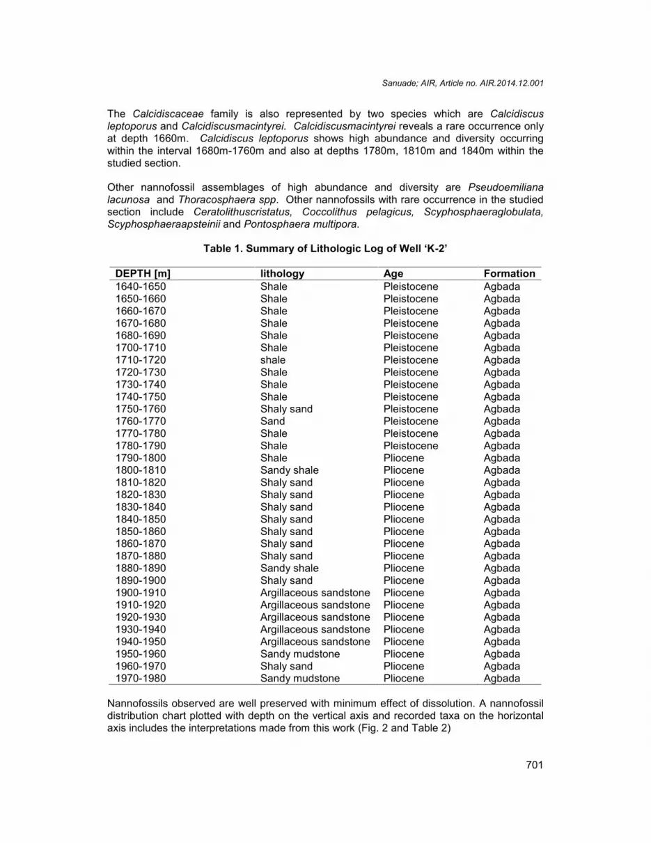
The samples analyzed in this well from intervals 1640m to 1980m have been found to havesimilar lithology. The sequences in the well correspond to the lower units of the Agbadaparalic facies described by [14]. Most of the lithofacies are composed of shale and siltstonemudstone with thin intercalated units of sand beds. This is revealed in the lithologicdescription of ditch cutting samples. A summary of the lithologic log is given in Table 1.
The shales and mudstones are mostly grey to dark grey and black in colour. The sandsrange from coarsed to fine grained, angular to rounded and poor to well sorted. Accessoryminerals occurring in high abundances include ferruginous materials and pyrite. Common tofew occurrences of glauconite, mica flakes and carbonates are found within certain intervalsof the studied sections.
3.2 Calcareous Nannofossils
The result shows highly abundant and diverse calcareous nannofossils. A total of seventeennannofossils species comprising mainly of coccoliths, placoliths and nannoliths wereidentified. Of these, Gephyrocapsa carribeanica is the most abundant. Helicosphaera carterioccur almost throughout the entire analyzed section. Influxes of Gephyrocapsacarrribeanica were noticed within interval 1660-1680m and at depth 1720m and 1790m.Gephyrocapsa oceanica also occurs in high abundance within the upper part of the studiedsection.
The family Noelaerhabdacea is represented by the genera Gephyrocapsa andReticulofenestra with predominant species Reticulofenestra productella mainly at depth1670m. Three species of genus Gephyrocapsa namely Gephyrocapsa carribeanica,Gephyrocapsa oceanica and Gephyrocapsa parallela are all in abundance within the studiedsection. These Gephyrocapsa species are important stratigraphically and are commonlyemployed as zonal markers. They are also of chronostratigraphic value in the Neogeneandused to delineate the two major zones proposed for the studied section of well ‘K-2’.
Helicosphaera carteri and Helicosphaera selli are the well represented species of thefamilyHelicosphaera in the studied section. Helicosphaera carteri are very abundant anddiverse while Helicosphaera selli shows a rare occurrence in the studied section.
Sanuade; AIR, Article no. AIR.2014.12.001
701
The Calcidiscaceae family is also represented by two species which are Calcidiscusleptoporus and Calcidiscusmacintyrei. Calcidiscusmacintyrei reveals a rare occurrence onlyat depth 1660m. Calcidiscus leptoporus shows high abundance and diversity occurringwithin the interval 1680m-1760m and also at depths 1780m, 1810m and 1840m within thestudied section.
Other nannofossil assemblages of high abundance and diversity are Pseudoemilianalacunosa and Thoracosphaera spp. Other nannofossils with rare occurrence in the studiedsection include Ceratolithuscristatus, Coccolithus pelagicus, Scyphosphaeraglobulata,Scyphosphaeraapsteinii and Pontosphaera multipora.
Nannofossils observed are well preserved with minimum effect of dissolution. A nannofossildistribution chart plotted with depth on the vertical axis and recorded taxa on the horizontalaxis includes the interpretations made from this work (Fig. 2 and Table 2)
Sanuade; AIR, Article no. AIR.2014.12.001
702
Fig. 2. Calcareous nannofossil distribution chart of well ‘K-2’
Sanuade; AIR, Article no. AIR.2014.12.001
702
Fig. 2. Calcareous nannofossil distribution chart of well ‘K-2’
Sanuade; AIR, Article no. AIR.2014.12.001
702
Fig. 2. Calcareous nannofossil distribution chart of well ‘K-2’
Sanuade; AIR, Article no. AIR.2014.12.001
703
Table 2. Calcareous nannofossil zones recognized in well ‘K-2’
Depth(m) Epoch Age (ma) Zones[15] Zones[16] Established Zones (well ‘K-2’) Bio-events
The stratigraphic interval studied in well ‘K-2’ has been sub-divided into biostratigraphiczones on the basis of their calcareous nannofossils. The well section was zoned using theglobally recognized calcareous nannofossil zonation scheme of [15] and [16]. [15] zoneswere tagged NN zones (Neogene Nannofossils). [16] established his zones based on theindex taxa.
Two major zones belonging to Pleistocene and Pliocene ages were established in thestudied section of well ‘K-2’ as shown in the table above. These are the NN19 and NN18zones of [15].
3.4 Zonal Description
3.4.1 Pseudoemiliana lacunosa zone
Stratigraphic interval: 1640 – 1790mAge: PleistoceneNannofossilzone: NN 19Top: The top of this zone is believed to be shallower than the first sample analysed.Base: The base of this zone is marked by the base of Gephyrocapsa carribeanica at depth1790m.
Description: Zone NN 19 is otherwise known as Pseudoemiliana lacunosa zone accordingto [15] and it is divided into four sub-zones which are Pseudoemiliana lacunosa Zone, smallGephyrocapsa Zone, Helicosphaera selli Zone and Calcidiscusmacintyrei Zone by [16]. Thesub-zone that fall within the studied well is Calcidiscusmacintyrei zone. This zone ischaracterized by abundant and diverse nannofossil assemblage at the upper half. The lowerhalf is characterized by a slight reduction in fossil diversity and abundance. Index taxarecognized in the section which are in abundance include Gephyrocapsa carribeanica,Gephyrocapsa oceanica, Gephyrocapsa parallela, Calcidiscus macintyre I andPseudoemiliana lacunosa. Other nannofossils in the zone include Helicosphaeracarteri,Thoracosphaera spp., Calcidiscus leptoporus, Reticulofenestra spp., Coccolithus. pelagicusand Ceratholithuscristatus.
3.4.2 Zone NN 18
Stratigraphic Interval: 1790 –1980mAge: PlioceneDescription: This interval is marked by rare occurrences of nannofossils. This precludes adefinite zonation of the interval. However the interval has been assigned Zone NN18 basedon the stratigraphic position below the positively recognized zone NN 19 above. Some ofthe nannofossil species in this zone are Helicosphaera carteri, Coccolithus pelagicus,Helicosphaera selli, Calcidiscus leptoporus and Pontosphaeramultipora. These assemblagescomprises mainly of long range, non-age diagnostic species. However, [16] zonationscheme is not applicable to this age.
Sanuade; AIR, Article no. AIR.2014.12.001
705
3.5 Zonation Based on this Study
Two major zones were erected for the studied section of well ‘K–2’. No subzones weredelineated.
The erected zones are:
(i) Gephyrocapsa carribeanica zone(ii) Gephyrocapsa parallela zone(iii) Intervals 1790-1990m has been designated indeterminate zone based on lack of
index taxa.
3.5.1 Zonal description
3.5.1.1 Gephyrocapsa parallela zone
Stratigraphic interval: 1640–1690mAge: PleistoceneNannofossil zone: Gephyrocapsa parallelaTop: The top of the zone is probably shallower than the first analyzed sample.Base: The base of this zone is marked by the base of Gephyrocapsa parallela at depth1690m.Description: This zone is marked by abundant and diverse occurrence of nannofossilassemblages. The top is probably shallower than the first analyzed sample in the studiedsection of well ‘K–2’. It has been observed that Gephyrocapsa parallela occurs shallower inthis study than observed by earlier authors who placed the base of Gephyrocapsa parallelaat a relatively younger age. The base of Gephyrocapsa parallela was used by [16] todelineate his younger subzone (Pseudoemiliana lacunosa ) of the NN19 zone earliersubdivided by [15]. Other index taxa found in this zone include Gephyrocapsa carribeanica,Gephyrocapsa oceanica and Pseudoemiliana lacunosa . Other nannofossil species in thiszone include Helicosphaera carteri, Calcidiscusmacintyrei, Pseudoemiliana lacunosa,Coccolithus pelagicus, Helicosphaeraselli and Reticulofenestra productella.
3.5.1.2 Gephyrocapsa carribeanica zone
Stratigraphic interval: 1690 – 1790mAge: PleistoceneNannofossil zone: Gephyrocapsa carribeanicaTop: The top of the zone is marked by the base of Gephyrocapsa parallela at depth 1690m.Base: The base of the zone is marked by the base of Gephyrocapsa carribeanica.Description: This zone is characterized by fairly abundant and diverse nannofossilassemblage. This interval is delineated based on the continuous occurrence ofGephyrocapsa carribeanica within the section. Other index taxa occurring in high abundancewithin this zone include Gephyrocapsa oceanica, Gephyrocapsa parallela andPseudoemiliana lacunosa. Other nannofossils in common but few abundance within thiszone include Helicosphaera carteri, Calcidiscusmacintyrei, Thoracospharea spp.,Ceratolithuscristatus, Coccolithus pelagicus, Helicosphaera selli, Reticulofenestraproductella, Calcidiscus leptoporus, Scyphosphaera globulata and Scyphosphaeraap steinii.
Sanuade; AIR, Article no. AIR.2014.12.001
706
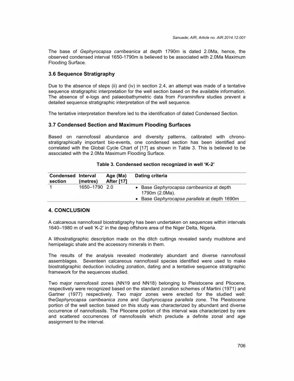
The base of Gephyrocapsa carribeanica at depth 1790m is dated 2.0Ma, hence, theobserved condensed interval 1650-1790m is believed to be associated with 2.0Ma MaximumFlooding Surface.
3.6 Sequence Stratigraphy
Due to the absence of steps (ii) and (iv) in section 2.4, an attempt was made of a tentativesequence stratigraphic interpretation for the well section based on the available information.The absence of e-logs and palaeobathymetric data from Foraminifera studies prevent adetailed sequence stratigraphic interpretation of the well sequence.
The tentative interpretation therefore led to the identification of dated Condensed Section.
3.7 Condensed Section and Maximum Flooding Surfaces
Based on nannofossil abundance and diversity patterns, calibrated with chrono-stratigraphically important bio-events, one condensed section has been identified andcorrelated with the Global Cycle Chart of [17] as shown in Table 3. This is believed to beassociated with the 2.0Ma Maximum Flooding Surface.
Table 3. Condensed section recognized in well ‘K-2’
Condensedsection
Interval(metres)
Age (Ma)After [17]
Dating criteria
1 1650–1790 2.0 Base Gephyrocapsa carribeanica at depth1790m (2.0Ma).
Base Gephyrocapsa parallela at depth 1690m
4. CONCLUSION
A calcareous nannofossil biostratigraphy has been undertaken on sequences within intervals1640–1980 m of well ‘K-2’ in the deep offshore area of the Niger Delta, Nigeria.
A lithostratigraphic description made on the ditch cuttings revealed sandy mudstone andhemipelagic shale and the accessory minerals in them.
The results of the analysis revealed moderately abundant and diverse nannofossilassemblages. Seventeen calcareous nannofossil species identified were used to makebiostratigraphic deduction including zonation, dating and a tentative sequence stratigraphicframework for the sequences studied.
Two major nannofossil zones (NN19 and NN18) belonging to Pleistocene and Pliocene,respectively were recognized based on the standard zonation schemes of Martini (1971) andGartner (1977) respectively. Two major zones were erected for the studied well:theGephyrocapsa carribeanica zone and Gephyrocapsa parallela zone. The Pleistoceneportion of the well section based on this study was characterized by abundant and diverseoccurrence of nannofossils. The Pliocene portion of this interval was characterized by rareand scattered occurrences of nannofossils which preclude a definite zonal and ageassignment to the interval.
Sanuade; AIR, Article no. AIR.2014.12.001
707
Nannofossil abundance and diversity patterns calibrated with chrono-stratigraphicallyimportant bio-events enhanced the identification of only one condensed section correlated tothe Global Cycle Chart of Haq et al. [17]. This is thought to be associated with the 2.0MaMaximum Flooding Surface.
It is recommended that a local nannofossil zonation scheme be erected for the Niger DeltaPleistocene age.
ACKNOWLEDGEMENTS
The author wish to thank Dr. S. L. Fadiya of Crystal Age Limited, Ikorodu, Lagos for histechnical assistance in the preparation and analysis of samples.
COMPETING INTERESTS
Author has declared that no competing interests exist
REFERENCES
1. Reijers TJA, Petters SW, Nwajide CS. The Niger Delta basin. In: Reijers TJA. (ed.);Selected chapters in Geology-Sedimentary Geology and Sequence Stratigraphy inNigeria and three case studies and a field guide. Shell Petroleum Development andCompany, Warri, Nigeria. 1996;105-114.
2. Doust H, Omatsola E. Niger Delta. In: Edwards JD and Santogrossi PA. (eds.),Divergent/Passive Margin Basins, AAPG Memoir, U.S.A. 1989;48:201-238.
3. Erba E. Nannofossils and Mesozoic oceanic anoxic events. Marine Micropaleontology.2004;52:85–106.
4. Raffi I, Backman J, Pälike H. Changes in calcareous nannofossil assemblages acrossthe Paleocene/Eocene transition from the paleo-equatorial Pacific Ocean.Palaeogeography, Palaeoclimatology, Palaeoecology. 2005;226(1–2):93-126.
5. Zachos JC, Kroon D, Blum P. Proceedings ODP, Initital Reports 208, College Station,TX (Ocean Drilling Program); 2004.
6. Di Stefano E, Sprovieri R, Scarantino S. Chronology of biostratigraphic events at thebase of the Pliocene. Paleo pelagos. 1996;6:401-414.
7. Brown PR. Paleogene calcareous nannofossils from the Kilwa and Lindi areas ofcoastal Tanzania (Tanzania Drilling Project 2003-4). Journal of NannoplanktonResearch. 2005;27:21-95.
8. Vulc A, Silye L. Preliminary data on biostratigraphy and paleoecology of calcareousnannofossils and foraminifera in Cepari Quarry (North-Eastern Transylvania,Romania). Acta Palaentological Romanie. 2005;5:493-501.
9. Sawyer RK, Connolly DL, Fontenot R, Ogilvie F, Pichon AG. Deepwater Nigeria OPL-213: Prospect generation using integrated technologies. Nigerian Association ofPetroleum Explorationists Bulletin, Nigeria. 2002;16(1):1-21.
11. Perch-Nielsen K. Cenozoic Calcareous nannofossil. In: Bolli, H. M., Saunders, J. B.and Perch-Nielsen K. (eds.), Plankton Stratigraphy, Cambridge Earth Sciences Series,Cambridge University Press. 1985;427-554.
Sanuade; AIR, Article no. AIR.2014.12.001
708
12. Fadiya SL. Foraminifera and Calcareous Nannofossil biostratigraphy and well logsequence stratigraphic analysis of Opolo-5 and Opolo-9 wells, Niger Delta. Unpub.M.Sc. Thesis, Department of Geology, Obafemi Awolowo University, Ile-Ife, AbstractPublished–American Association of Petroleum Geologists Bulletin.1999;149:82(11):2162.
13. Short KC, Stauble AJ. Outline of the Geology of Niger Delta. American Association ofPetroleum Geologists Bulletin. 1967;51:761-779.
14. Martini E. Standard Tertiary and Quaternary Calcareous Nannoplankton Zonation. In:Farinacci (eds.), Proceedings II Planktonic Conference, Roma. 1971;2:739-785.
15. Gartner S. Correlation of Neogene Planktonic foraminifera and Calcareous nannofossilzones. Transactions of the Gulf Coast Association of Geological Societies.1977:19:585-599.
16. Vail PR, Mitchum RM, Todd RG, Widmier JM, Thompson S, Sangree JB, Bubb JN,Hakleid WG. Seismic Stratigraphy and global changes in sea level. Part 2. In:Seismic Stratigraphy-Application to Hydrocarbon explorationm (ed. By C. E. Payton).American Association of Petroleum Geologists, Tulsa, Memoir. 1977;26:49-62.
17. Haq BU, Hardenbol J, Vail PR. Chronology of fluctuating sea levels since the Triassic.Science. 1987:235:1156-1157.
18. Kamptner E. Untersuchungen uber den Feinban der Coccoli then. Archiv furProtistenkunde. 1954;100:1-90
19. Boudreaux JE, Hay WW. Calcareous Nannoplankton and biostratigraphy of the LatePliocene-Pleistocene-Recent sediments in the Submarex Cores. Revista Espanola deMicropalaeontologia. 1967;1:249-292.
20. Hay WW, Beaudry FM. Calcareous Nannofossils: Leg 15, Deep Sea Drilling Project.In: Edgar, NT., Saunders. JB, et al (eds.). Initial Reports of the Deep Sea DrillingProject; 15, Washington DC. 1973;625-685.
21. Bukry D, Bramlette MN. Some new and Stratigraphically useful Calcareousnannofossils of the Cenozoic. Tulane studies in Geology and Palaeontology.1969a;7:131-142.
22. Bukry D, Percival SF. New Tertiary Calcareous Nannofossils. Tulane Studies inGeology and Palaeontology. 1971;8:123-146.
23. Gallagher LT. Calcareous Nannofossil Biozonation of the Tertiary of the North SeaBasin. Newsletters on Stratigraphy. 1989;22:21-44.