Observatories and Research Facilities for EU ropean S eismology Volume 4, no 2 September 2002 Orfeus Newsletter Coordinated seismic experiment in the Azores Graça Silveira 1 , Suzan van der Lee 2 , Eleonore Stutzmann 3 , Luis Matias 1 , David James 4 , Peter Burkett 4 , Miguel Miranda 1 , Luis Mendes Victor 1 , João Luis Gaspar 5 , Luisa Senos 6 , Sean Solomon 4 , Jean-Paul Montagner 3 and Domenico Giardini 2 1 Centro de Geofísica da Universidade de Lisboa, Edifício C8 Campo Grande, 1749-016 LISBOA 2 Institute of Geophysics, ETH Honggerberg, CH-8046 Zurich 3 Institut de Physique du Globe de Paris, 4, place Jussieu, 75252 PARIS CEDEX 05 4 Depart. of Terrestrial Magnetism, Carnegie Inst. of Washington, 5241 Broad Branch RD. NW, WASHINGTON DC 20015 5 Centro de Vulcanologia da Univ. dos Açores, R. Mãe de Deus, 9501-801 Ponta Delgada, Açores 6 Instituto de Meteorologia, Rua C ao Aeroporto, 1700 LISBOA Abstract - Introduction - COSEA Experiment - Data assembly and distribution Scientific Purposes - References Abstract Memorandum of Understanding COSEA is devoted to coordinate the efforts of Portuguese, French, American and Swiss scientific institutions for the deployment, operation and maintenance of a temporary broadband seismic experiment in the Azores Islands and for the collection, distribution and scientific exploitation of data. In collaboration with other running projects, this experiment has three goals: (1) study of the Azores plume: its structure, its origin at depth and its interaction with the Mid-Atlantic Ridge; (2) investigation of the structure and deep interactions of the plate boundaries between Eurasia, Africa and North America; (3) at a local scale, monitoring of seismic and volcanic activity for a better determination of hazard by combining broadband data with existing volcano and earthquake surveillance networks. Introduction The Azores archipelago occupies a lateral branch of the Mid-Atlantic ridge near the triple junction of 3 large tectonic plates, the North American, the Eurasian and the African plates. McKenzie (1972) considers the lateral branch as a transform fault but the tectonics and seismic activity suggest that the boundary between the Eurasian and the African plates may be a Leaky Transform (Madeira et al., 1990). The tectonic setting is even more complex due to the existence of the Azores hotspot, whose origin at depth (core-mantle boundary, transition zone or asthenosphere) is still controversial. The most recent tomographic model available so far for the Atlantic Ocean (Silveira et al., 1998, Silveira and Stutzmann, submitted) has reached the lateral resolution limit considering the current distribution of earthquakes and
Transcript
Observatories and Research Facilities for EUropean SeismologyVolume 4, no 2 September 2002 Orfeus Newsletter
Coordinated seismic experiment in the Azores
Graça Silveira1, Suzan van der Lee2, Eleonore Stutzmann3, Luis Matias1, DavidJames4, Peter Burkett4, Miguel Miranda1, Luis Mendes Victor1, João Luis Gaspar5,
Luisa Senos6, Sean Solomon4, Jean-Paul Montagner3 and Domenico Giardini21Centro de Geofísica da Universidade de Lisboa, Edifício C8 Campo Grande, 1749-016 LISBOA 2Institute of Geophysics, ETH Honggerberg, CH-8046 Zurich 3Institut de Physique du Globe de Paris, 4, place Jussieu, 75252 PARIS CEDEX 05 4Depart. of Terrestrial Magnetism, Carnegie Inst. of Washington, 5241 Broad Branch RD. NW,WASHINGTON DC 20015 5Centro de Vulcanologia da Univ. dos Açores, R. Mãe de Deus, 9501-801 Ponta Delgada, Açores 6Instituto de Meteorologia, Rua C ao Aeroporto, 1700 LISBOA
Abstract - Introduction - COSEA Experiment - Data assembly and distribution Scientific Purposes - References
Abstract
Memorandum of Understanding COSEA is devoted to coordinate the efforts ofPortuguese, French, American and Swiss scientific institutions for the deployment,operation and maintenance of a temporary broadband seismic experiment in theAzores Islands and for the collection, distribution and scientific exploitation of data. In collaboration with other running projects, this experiment has three goals: (1)study of the Azores plume: its structure, its origin at depth and its interaction with theMid-Atlantic Ridge; (2) investigation of the structure and deep interactions of theplate boundaries between Eurasia, Africa and North America; (3) at a local scale,monitoring of seismic and volcanic activity for a better determination of hazard bycombining broadband data with existing volcano and earthquake surveillancenetworks.
Introduction
The Azores archipelago occupies a lateral branch of the Mid-Atlantic ridge near thetriple junction of 3 large tectonic plates, the North American, the Eurasian and theAfrican plates. McKenzie (1972) considers the lateral branch as a transform fault butthe tectonics and seismic activity suggest that the boundary between the Eurasianand the African plates may be a Leaky Transform (Madeira et al., 1990). Thetectonic setting is even more complex due to the existence of the Azores hotspot,whose origin at depth (core-mantle boundary, transition zone or asthenosphere) isstill controversial. The most recent tomographic model available so far for theAtlantic Ocean (Silveira et al., 1998, Silveira and Stutzmann, submitted) has reachedthe lateral resolution limit considering the current distribution of earthquakes and
stations in the Atlantic. Their model shows a low velocity anomaly beneath theAzores but the resolution is too weak to constrain the plume shape at depth.International efforts have been concentrated on the Mid-Atlantic Ridge, but for theAzores Archipelago itself, the relationship between the (large-scale) mantleprocesses, the (mesoscale) crustal structure and the volcanic and seismic activity isnot well understood. Several Broadband stations have been installed in the Atlantic area (e.g. BORG inIceland, TBT in Canaries, ASCN in Ascens\343o) during the last few years, but thesource-receiver geometry distribution is still insufficient to get a good azimuthalcoverage of the wave paths beneath the Azores. One permanent VBB 3-componentstation has been installed in the Azores archipelago in 1997, the IRIS-GSN CMLAstation of S\343o Miguel island which is co-operated by IM. The data will beavailable through internet at IRIS DMC. The COSEA experiment has been startedfor the purpose of better understanding the Azores area at different scales.
COSEA Experiment
The COSEA memorandum was established between the following internationalpartners:
Centro de Geofísica da Universidade de Lisboa (CGUL)University of the Azores (UA)Institut of Meteorology of Portugal (IM)Federal Institute of Technology, Zurich (ETHZ)Institut de Physique du Globe de Paris (IPGP)Department of Terrestrial Magnetism. Carnegie Inst, of Washington (DTM)
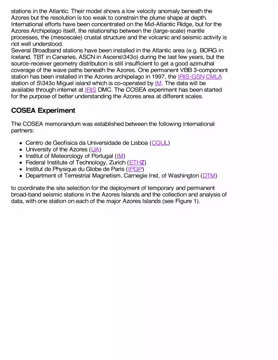
to coordinate the site selection for the deployment of temporary and permanentbroad-band seismic stations in the Azores Islands and the collection and analysis ofdata, with one station on each of the major Azores Islands (see Figure 1).
Figure 1. Geographical distribution of the COSEA VBB seismic stations.
COSEA has coordinated three individual experiments:
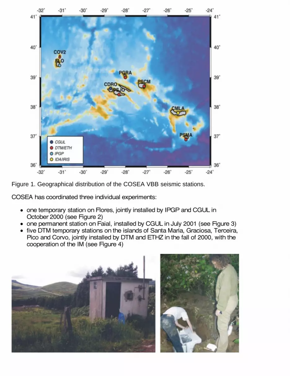
one temporary station on Flores, jointly installed by IPGP and CGUL inOctober 2000 (see Figure 2)one permanent station on Faial, installed by CGUL in July 2001 (see Figure 3)five DTM temporary stations on the islands of Santa Maria, Graciosa, Terceira,Pico and Corvo, jointly installed by DTM and ETHZ in the fall of 2000, with thecooperation of the IM (see Figure 4)
Figure 2. Deployment of the FLO (Flores) VBB seismic station; left - shelter used forthe TITAN 3NT data aquisition system; right - preparing the STS 2 thermalinsulation.
Figure 3. Deployment of the CDRO (Faial) VBB seismic station; left - digging thesensor vault; middle - installing the STS 2 in the concrete pier; right - preparing theTITAN-3NT acquisition parameters.
Figure 4. Left and middle - deployment of the PSCM (Terceira) VBB seismic station;right - PSJO (Pico) VBB seismic station after deplyment.
A first phase of data collection will run for a minimum one year, with the possibility ofrenewal for a second year, corresponding to the deployment period of theDTM/ETHZ experiment; a second phase of scientific investigation will last for aminimum of two years beyond the end of the data collection period. All stations areequipped with broadband digital equipment, with 24-bit ADC electronics andbroadband (STS-2) sensors.
Data assembly and distribution
Data from the COSEA experiment will be pre-processed by each partner and thendeposited at the IRIS DMC Temporary Networks following their formatspecifications. The IRIS DMC will provide restricted access to the complete data setto all partners and to collaborating European data centers (but also with restrictedaccess to the COSEA partners). Two years after the end of the field experiment, thedata will be made available to the worldwide scientific community. The specific datato be jointly assembled (channels, events, continuous wave forms) have beendefined by the scientific teams depending upon the scientific goals to be reached.Figure 5 shows an example of the an earthquake near Coast of Peru, recorded atCDRO seismic station.
Figure 5. Earthquake of 7th July 2001 near coast of Peru earthquake recorded atCDRO (Faial). Both channels MH (1.25 sps) and BH (20 sps) are presented.
Scientific Purposes
The COSEA project has three scientific and monotoring goals: (1) study of theAzores plume: its structure, its origin at depth and its interaction with the Mid-AtlanticRidge; (2) investigation of the structure and deep interactions of the plateboundaries between Eurasia, Africa and North America; (3) at a local scale,monitoring of seismic and volcanic activity for a better determination of hazard bycombining broadband data with existing volcano and earthquake surveillancenetworks. Regarding the determination of the deep origin and structure of the Azores plumeand its interaction with the Mid Atlantic Ridge, data collected from the permanentVBB stations and from the temporary VBB station will be processed using surfaceand body techniques. Fundamental and higher-mode surface wave tomography willalso be used with earthquakes from the Mid-Atlantic ridge and from along theEurasia-Africa plate boundary in order to image the uppermost-mantle structure inthe region of the latter plate boundary. This study will be complemented with other running projets at the CGUL. Using datafrom both VBB temporary network and from the local short period SIVISA network,we wish to study the seismicity pattern of the Azores islands in terms of: 1) crustalseismic anisotropy; 2) source mechanisms and 3) seismic strain rate.
ReferencesMadeira, J. and A. Ribeiro. Geodynamic models for the Azores triple junction; a contributionfrom tectonics, in: G. Boillot and J.M. Fontbote (editors), Alpine evolution of Iberia and itscontinental margins, Tectonophysics, 184 (3-4), 405-415, 1990.
McKenzie, D. Active tectonics of the Mediterranean region. Geophys. J. R. Astron. Soc., 30,109-185, 1972.Silveira, G., Eleonore Stutzmann, Daphn\351-Anne Griot, J.P. Montagner and L. MendesVictor. Anisotropic Tomography of the Atlantic Ocean from Rayleigh Surface Waves, Phys.Earth Planet. Int., 106, 257-273, 1998.Silveira, G., Eleonore Stutzmann. Anisotropic Tomography of the Atlantic Ocean, Phys. EarthPlanet. Int., (in press).