443
City of San Marcos, Texas LAND DEVELOPMENT CODE
| Date post: | 28-Feb-2023 |
| Category: |
Documents |
| Upload: | khangminh22 |
| View: | 0 times |
| Download: | 0 times |

City of San Marcos, TexasLAND DEVELOPMENT CODE

ii
iii
ContentsChapter 1. General ........................................................... 1:1
ARTICLE 1: INTRODUCTION 1:2
ARTICLE 2: APPLICABILITY AND COMPLIANCE 1:3
ARTICLE 3: COMPREHENSIVE PLANNING 1:4
ARTICLE 4: TERMS AND PROVISIONS 1:5
ARTICLE 5: NONCONFORMITIES 1:6
Chapter 2. Development Procedures ........................ 2:1ARTICLE 1: DEVELOPMENT APPLICATIONS 2:2
ARTICLE 2: AUTHORITY OF DECISION MAKERS 2:5
ARTICLE 3: UNIVERSAL PROCEDURES 2:10
ARTICLE 4: GENERAL LEGISLATIVE PROCEDURES 2:18
ARTICLE 5: ZONING PROCEDURES 2:28
ARTICLE 6: WATERSHED PROTECTION PLANS 2:39
ARTICLE 7: SITE PERMIT 2:43
ARTICLE 8: RELIEF PROCEDURES 2:48
Chapter 3. Subdivisions ................................................ 3:1ARTICLE 1: PROVISIONS APPLICABLE TO ALL PLATTING PROCEDURES 3:2
ARTICLE 2: PLAT APPLICATIONS 3:6
ARTICLE 3: REVISIONS TO RECORDED PLATS 3:12
ARTICLE 4: CONSTRUCTION MANAGEMENT 3:17
ARTICLE 5: ADEQUATE PUBLIC FACILITIES 3:20
ARTICLE 6: BLOCKS, LOTS, ACCESS 3:27
ARTICLE 7: NEW STREETS 3:34
ARTICLE 8: EXISTING STREETS 3:54
ARTICLE 9: STORMWATER COLLECTION AND DRAINAGE SYSTEMS 3:59
ARTICLE 10: PARKS AND OPEN SPACE 3:62
Chapter 4. Zoning Regulations ................................... 4:1ARTICLE 1: GENERAL PROVISIONS AND ESTABLISHMENT OF DISTRICTS 4:2
ARTICLE 2: BUILDING TYPES 4:14
ARTICLE 3: GENERAL TO ALL 4:19
ARTICLE 4: ZONING DISTRICTS 4:38
ARTICLE 5: OVERLAY DISTRICTS 4:123
Chapter 5. Use Regulations ......................................... 5:1ARTICLE 1: ALLOWABLE USES 5:2
Chapter 6. Environmental regulations ................... 6:1ARTICLE 1: STORMWATER MANAGEMENT 6:2
ARTICLE 2: ENHANCED PROTECTION ZONES 6:8
ARTICLE 3: DEVELOPMENT RELATED TO THE EDWARDS AQUIFER 6:12
ARTICLE 4: TREE AND HABITAT PROTECTION 6:14
Chapter 7. Supplemental Development Standards 7:1ARTICLE 1: PARKING 7:2
ARTICLE 2: LANDSCAPING AND SCREENING 7:13
ARTICLE 3: SIGN PERMITS 7:24
ARTICLE 4: PUBLIC HEALTH RELATED PERFORMANCE STANDARDS 7:44
ARTICLE 5: LIGHTING AND GLARE STANDARDS 7:46
ARTICLE 6: MANUFACTURED HOME AND TINY HOME VILLAGE 7:50
Chapter 8. Definitions ................................................... 8:1ARTICLE 1: DEFINED TERMS 8:2
Chapter 9. Legacy Districts ......................................... 9:1ARTICLE 1: DEVELOPMENT STANDARDS 9:2
ARTICLE 2: ZONING DISTRICTS 9:3
ARTICLE 3: USE REGULATIONS 9:13
ARTICLE 4: SUPPLEMENTAL STANDARDS 9:24
iv
TablesChapter 1. General ........................................................... 1:1
Chapter 2. Development Procedures ........................ 2:1TABLE 2.1 DEVELOPMENT APPLICATIONS, DECISION AUTHORITY, AND NOTICE REQUIREMENTS TABLE 2:3
TABLE 2.2 PERMIT EXPIRATIONS AND EXTENSIONS 2:15
TABLE 2.3 DETERMINATION OF INTENSITY 2:30
Chapter 3. Subdivisions ................................................ 3:1TABLE 3.1 BLOCK PERIMETERS 3:27
TABLE 3.2 DRIVEWAY DIMENSIONS 3:32
TABLE 3.3 CALCULATION OF POPULATION 3:63
TABLE 3.4 PARKLAND TYPES 3:66
Chapter 4. Zoning Regulations ................................... 4:1TABLE 4.1 COMPREHENSIVE PLAN / DISTRICT TRANSLATION 4:3
TABLE 4.2 CONVENTIONAL RESIDENTIAL DISTRICTS 4:5
TABLE 4.3 NEIGHBORHOOD DENSITY DISTRICTS 4:6
TABLE 4.4 NEIGHBORHOOD DENSITY DISTRICT / EXISTING ZONING TRANSLATION TABLE 4:8
TABLE 4.5 CHARACTER DISTRICTS 4:9
TABLE 4.6 CHARACTER DISTRICT / EXISTING ZONING TRANSLATION TABLE 4:10
TABLE 4.7 SPECIAL DISTRICTS 4:11
TABLE 4.8 LEGACY DISTRICTS 4:12
TABLE 4.9 DESIGNATION WITHIN FORMER SMARTCODE DISTRICTS 4:12
TABLE 4.10 BUILDING TYPES ALLOWED BY DISTRICT 4:17
TABLE 4.11 DENSITY BONUS 4:22
TABLE 4.12 CONVENTIONAL RESIDENTIAL DISTRICTS 4:38
TABLE 4.13 CHARACTER DISTRICTS 4:62
TABLE 4.14 PLANNING AREA DISTRICT ALLOCATION 4:76
TABLE 4.15 SPECIAL DISTRICTS SUMMARY 4:82
Chapter 5. Use Regulations ......................................... 5:1TABLE 5.1 LAND USE MATRIX 5:4
Chapter 6. Environmental regulations ................... 6:1TABLE 6.1 WATER QUALITY VOLUME AND TREATMENT LEVEL TABLE 6:7
TABLE 6.2 IMPERVIOUS COVER ON SLOPES OUTSIDE THE EDWARDS AQUIFER 6:10
TABLE 6.3 IMPERVIOUS COVER ON SLOPES INSIDE THE EDWARDS AQUIFER 6:11
TABLE 6.4 IMPERVIOUS COVER LIMITS WITHIN THE EDWARDS AQUIFER RECHARGE ZONE 6:14
TABLE 6.5 TREE CLASSIFICATIONS 6:15
TABLE 6.6 TREE MITIGATION REQUIREMENTS 6:16
TABLE 6.7 TREE CREDITS 6:17
Chapter 7. Supplemental Development Standards 7:1TABLE 7.1 GENERAL MINIMUM PARKING REQUIREMENTS 7:3
TABLE 7.2 MINIMUM MIXED USE PARKING REQUIREMENTS 7:5
TABLE 7.3 PARKING OCCUPANCY TABLE 7:6
TABLE 7.4 REMOTE PARKING DISTANCE REQUIREMENTS 7:7
TABLE 7.5 STANDARD VEHICLE PARKING SPACES - DIMENSIONAL STANDARDS 7:10
TABLE 7.6 COMPACT VEHICLE PARKING SPACES - DIMENSIONAL STANDARDS 7:10
TRANSITIONAL PROTECTIVE YARD TABLE 7:14
TABLE 7.7 TYPE A AND B PROTECTIVE YARD STANDARDS 7:15
TABLE 7.8 TYPE C AND D PROTECTIVE YARD STANDARDS 7:15
TABLE 7.9 REQUIRED LANDSCAPING 7:16
TABLE 7.10 ENVIRONMENTAL PERFORMANCE ZONES 7:48
TABLE 7.11 SPECIFIC USE EXCEPTIONS 7:49
Chapter 8. Definitions ................................................... 8:1
Chapter 9. Legacy Districts ......................................... 9:1
v
FiguresChapter 1. General ........................................................... 1:1
Chapter 2. Development Procedures ........................ 2:1FIGURE 2.1 HISTORIC DISTRICT APPLICABILITY 2:34
Chapter 3. Subdivisions ................................................ 3:1FIGURE 3.1 RESIDENTIAL BLOCK 3:28
FIGURE 3.2 COMMERCIAL BLOCK 3:28
FIGURE 3.3 BLOCK WITH DEAD-ENDS 3:28
FIGURE 3.4 EXTENDED BLOCK 3:28
FIGURE 3.5 SPLIT CIVIC BLOCK 3:28
FIGURE 3.8 EYEBROW 3:29
FIGURE 3.6 NATURAL OBSTRUCTION 3:29
FIGURE 3.7 MEASUREMENT OF DEAD-END STREET LENGTH 3:29
FIGURE 3.9 LOOP LANE 3:30
FIGURE 3.10 SUBDIVISION ACCESS 3:31
FIGURE 3.11 MEASUREMENT OF STREETS 3:34
Chapter 4. Zoning Regulations ................................... 4:1FIGURE 4.1 PREFERRED SCENARIO MAP 4:4
FIGURE 4.2 SINGLE FAMILY PRESERVATION BUFFER 4:7
FIGURE 4.3 MEASURING SITES AND LOTS 4:21
FIGURE 4.4 LOT LAYERS 4:23
FIGURE 4.5 BUILDING SETBACKS 4:24
FIGURE 4.6 MEASURING BUILD-TO ZONE 4:25
FIGURE 4.7 BUILD-TO ZONE ADDITIONS 4:26
FIGURE 4.8 BUILD-TO ZONE NEW BUILDINGS 4:26
FIGURE 4.9 MEASURING HEIGHT 4:27
FIGURE 4.10 AVERAGE GRADE 4:27
FIGURE 4.11 STORIES BELOW GRADE 4:27
FIGURE 4.12 MEASURING GROUND FLOOR ELEVATION 4:28
FIGURE 4.13 MEASURING STORY HEIGHT 4:28
FIGURE 4.14 VARIED UPPER FLOOR MASSING 4:29
FIGURE 4.15 BLANK WALL AREA 4:31
FIGURE 4.16 PRIMARY MATERIAL CHANGES 4:37
FIGURE 4.17 SETBACK AVERAGING INTERIOR LOT 4:60
FIGURE 4.18 SETBACK AVERAGING CORNER LOT 4:60
FIGURE 4.19 SETBACK PLANES 4:61
FIGURE 4.20 STANDARD PEDESTRIAN SHED 4:77
FIGURE 4.21 LINEAR PEDESTRIAN SHED 4:77
FIGURE 4.22 NEIGHBORHOOD TRANSITION - MAXIMUM LOT WIDTH 4:79
FIGURE 4.23 CONTEXTUAL HEIGHT STEP DOWN MAP 4:80
FIGURE 4.24 CONTEXTUAL HEIGHT STEP DOWN - ABUTTING PROPERTY 4:81
FIGURE 4.25 CONTEXTUAL HEIGHT STEP DOWN - ACROSS STREET 4:81
FIGURE 4.26 HISTORIC DISTRICTS MAP 4:124
FIGURE 4.27 HISTORIC LANDMARKS MAP 4:125
Chapter 5. Use Regulations ......................................... 5:1FIGURE 5.1 ACCESSORY DWELLING UNITS 5:9
FIGURE 5.3 DOWNTOWN CBA BOUNDARY 5:21
FIGURE 5.2 DRIVE-THRU LOCATION 5:11
Chapter 6. Environmental regulations ................... 6:1
Chapter 7. Supplemental Development Standards 7:1FIGURE 7.1 SEMI-FLUSH GARAGE 7:8
FIGURE 7.2 RECESSED GARAGE 7:8
FIGURE 7.3 SIDE-LOADED GARAGE 7:8
FIGURE 7.4 DETACHED GARAGE 7:8
FIGURE 7.5 ALLEY-LOADED GARAGE 7:8
FIGURE 7.6 PARKING SPACE AND PARKING AISLE DIMENSIONS 7:10
FIGURE 7.7 PARKING LOT LANDSCAPING 7:11
FIGURE 7.8 LANDSCAPING STRIP WITH SHRUBS 7:12
FIGURE 7.9 LANDSCAPING STRIP WITH BERM 7:12
FIGURE 7.10 LANDSCAPE STRIP WITH A FENCE OR WALL 7:12
FIGURE 7.11 LANDSCAPE STRIP WITH GRADE CHANGE 7:12
FIGURE 7.12 TYPE A AND B PROTECTIVE YARDS 7:15
FIGURE 7.13 TYPE C AND D PROTECTIVE YARDS 7:15
FIGURE 7.14 LOCATION OF PROTECTIVE YARD 7:15
FIGURE 7.15 GRADE CHANGES IN PROTECTIVE YARDS 7:16
FIGURE 7.16 SERVICE AREA SCREENING 7:19
FIGURE 7.17 ROOF MOUNTED UTILITY SCREENING 7:19
FIGURE 7.18 WALL-MOUNTED UTILITY SCREENING 7:20
FIGURE 7.19 GROUND-MOUNTED UTILITY SCREENING 7:20
FIGURE 7.20 FENCE AND WALL LOCATION STANDARDS 7:22
FIGURE 7.21 METHOD OF MEASURING A POLE SIGN 7:30
FIGURE 7.22 MONUMENT SIGN MEASUREMENT 7:30
FIGURE 7.23 ENVIRONMENTAL PERFORMANCE ZONES MAP 7:48
Chapter 8. Definitions ................................................... 8:1
Chapter 9. Legacy Districts ......................................... 9:1

vi
1:1
1CH
APTER
1:1Amended: September 1, 2020 San Marcos Development Code
General
ChaPTER 1. GENERaL
article 1: INTRODUCTION .................................................. 1:2DIVISION 1: REFERENCE; AUTHORITY; CONSISTENCY; EFFECTIVE DATE 1:2
DIVISION 2: PURPOSE AND INTENT 1:2
article 2: aPPLICaBILITY aND COMPLIaNCE ................. 1:3DIVISION 1: APPLICABILITY 1:3
article 3: COMPREhENSIVE PLaNNING .......................... 1:4DIVISION 1: COMPREHENSIVE PLAN AUTHORIZED 1:4
article 4: TERMS aND PROVISIONS ................................. 1:5DIVISION 1: GENERAL 1:5
DIVISION 2: EFFECT OF MAPS, TABLES, AND ILLUSTRATIONS 1:5
DIVISION 3: MINIMUM REQUIREMENTS 1:5
DIVISION 4: DEFINITIONS 1:5
DIVISION 5: TRANSITIONAL PROVISIONS 1:5
DIVISION 6: SEVERABILITY 1:6
article 5: Nonconformities .......................................... 1:6DIVISION 1: GENERAL 1:6
DIVISION 2: TERMINATION OF NONCONFORMING RIGHTS 1:9
1:2
General1
CHAP
TER
San Marcos Development Code Amended: September 1, 2020
article 1: INTRODUCTION
DIVISION 1: REFERENCE; AUTHORITY; CONSISTENCY; EFFECTIVE DATE
Section 1.1.1.1Official Name
This Subpart B of the San Marcos, Texas, City Code, as may be amended, shall be officially known and cited as the “Land Development Code of San Marcos, Texas”. It may be referred to as the “Development Code” or herein simply, “this Development Code.”
Section 1.1.1.2Authority
This Development Code is adopted pursuant to the statutory authority conferred by and pursuant to the Texas Local Government Code, as amended, and pursuant to and in accordance with the City’s Comprehensive Plan entitled “Vision San Marcos - A River Runs Through Us,” adopted April 16, 2013, as amended (“Comprehensive Plan”). This Development Code implements the Comprehensive Plan.
Section 1.1.1.3Consistency with Comprehensive Plan
The City Council has determined that this Development Code is consistent with the Comprehensive Plan.
Section 1.1.1.4Effective Date
This Development Code, as may be amended, shall take effect on April 17, 2018.
(Ord. 2020-60, 9-1-20; Ord. No. 2019-45, 12-17-19)
Section 1.1.1.5Amendment & Restatement of Previous Land Development Code and Smartcode
As of the effective date, this Development Code shall supersede, amend and restate in its entirety the Land Development Code previously adopted as Subpart B on December 13, 2004, as amended, and the San Marcos Smartcode previously adopted as Subpart C, of the San Marcos, Texas, City Code on May 3, 2011, as amended.
DIVISION 2: PURPOSE AND INTENT
Section 1.1.2.1General
This Development Code was adopted for the purposes of promoting the public health, safety, morals and general welfare, and protecting and preserving places and areas of environmental, historical, cultural and/or architectural importance and significance within the city limits.
Section 1.1.2.2Zoning Districts
The districts established under and pursuant to this Development Code have been designed to lessen the congestion in the streets, to secure safety from fire, panic and other dangers, to ensure adequate light and air, to prevent the overcrowding of land and thus avoid undue concentration of population, and to facilitate the adequate provision of transportation, water supply, wastewater treatment, schools, parks and other public requirements, and are established with reasonable consideration for, among other things, the character of each district and its suitability for the particular uses specified, conserving the value of buildings and environmentally sensitive features, and encouraging the most appropriate use of land throughout the City.
1:3
1CH
APTER
1:3Amended: September 1, 2020 San Marcos Development Code
General
article 2: aPPLICaBILITY aND COMPLIaNCE
DIVISION 1: APPLICABILITY
Section 1.2.1.1Applicability
This Development Code, shall apply to all development, improvements, land, structures, construction, substantial modifications, uses, and buildings and lots, public and private, within the City and its Extraterritorial Jurisdiction. All such development, improvements, land, structures, construction, substantial modifications, uses, and buildings and lots existing on the effective date hereof or constructed or commenced hereafter, and all relocations or demolitions of any of the same occurring hereafter, shall be subject to this Development Code and all plans approved hereunder.
Section 1.2.1.2Regulations Applicable to the Extraterritorial Jurisdiction
A. Regulations and authority. The following regulatory standards shall govern development in the City’s extraterritorial jurisdiction and shall be applied in deciding development applications in the extraterritorial jurisdiction:
1. Standards governing annexation and development agreements, on the authority of and pursuant to Tex. Loc. Gov’t Code chs. 43 and 212, subchapter G;
2. Policies and standards governing utility extensions;
3. Policies and maps of the adopted Comprehensive Plan and interpretive rules, on the authority of and pursuant to Tex. Loc. Gov’t Code ch. 213;
4. Environmental standards, on the authority of and pursuant to Tex. Loc. Gov’t Code ch. 401 and Texas Water Code chs. 16 and 26;
5. Development standards in Chapter 3 when applied through platting procedures, on the authority of and pursuant to Tex. Loc. Gov’t Code ch. 212 and ch. 242;
6. Development standards, when made applicable to the extraterritorial jurisdiction by this Land Development Code, on the authority of and pursuant to Tex. Loc. Gov’t Code ch. 216;
7. Public facilities standards and park fees in Chapter 3, when applied through platting procedures, on the authority of and pursuant to Tex. Loc. Gov’t Code ch. 212 and ch. 242;
8. Impact fees for water, wastewater and drainage facilities, on the authority of and pursuant to Tex. Loc. Gov’t Code ch. 395;
9. Land use, zoning and development standards otherwise applicable only within city limits, when applied through development agreements, on the authority of and pursuant to Tex. Loc. Gov’t Code chs. 43 and 212, subchapter G; and
10. All procedures required to apply the standards to developments in the extraterritorial jurisdiction under the same authority and pursuant to Texas laws authorizing the application of substantive standards to such development proposals.
B. Incorporation of statutory authorization. Each and every authorization to regulate development in the City’s extraterritorial jurisdiction contained in Texas statutes, as may be enacted or amended from time to time, and which are identified generically in subsection (a) and implemented by this Land Development Code hereby is adopted and incorporated herein.
Section 1.2.1.3Relationship to & Conflict with Other Laws, etc
The provisions of this Development Code shall take precedence over those of other codes, ordinances, regulations, and standards that may be in conflict with this chapter, except the City Health and Safety Codes and applicable State and Federal law.
Section 1.2.1.4Conflict with Private Easements, Agreements, or Covenants
This Development Code is not intended to abrogate, annul, or otherwise interfere with any private easement, agreement, covenant, restriction or other private legal relationship including but not limited to homeowners association or property owners association relationships. The City shall have no obligation to enforce private agreements, easements, covenants or restrictions to which the City is not a party.
1:4
General1
CHAP
TER
San Marcos Development Code Amended: September 1, 2020
Section 1.2.1.5Compliance With Development Code
Except for non-conformances allowed pursuant to Section 1.5.1.1, all land, development, improvements, construction, structures, buildings, lots and appurtenances located or built within the City or the Extraterritorial Jurisdiction, as applicable, of the City shall be made, constructed, occupied, used, erected, altered, removed, placed, demolished and/or converted in conformance with the applicable provisions, standards and requirements of this Development Code.
All plans, applications and submissions required under this Development Code must comply with the applicable provisions, standards and requirements of this Development Code.
Section 1.2.1.6 Amendment of Development Code
This Development Code may be amended in accordance with the
procedures in Section 2.4.1.1.
article 3: COMPREhENSIVE PLaNNING
DIVISION 1: COMPREHENSIVE PLAN AUTHORIZED
Section 1.3.1.1City Comprehensive Plan Created
The City shall, from time to time, prepare or have prepared for the City a Comprehensive Plan and amendments thereto in accordance with the Texas Local Government Code. Such Comprehensive Plan(s) and amendment(s) shall be subject to approval by the City Council. The city clerk and planning and development services department will keep a copy of this comprehensive plan on file for public inspection.
Section 1.3.1.2Implementation
A. The Director of Planning and Development Services is authorized and directed to implement the policies of the Comprehensive Plan through the activities described therein. Implementation tools and strategies within Vision San Marcos: A River Runs Through Us are found throughout the plan and include, but are not limited to:
1. Preferred Scenario Map.
2. Land Use Intensity Matrix.
3. Land Use Suitability Map.
4. 2035 Vision, Goals and Objectives.
5. Introduction Section - How to Use This Plan.
6. All Plan Element Sections.
7. Process for Updating the Plan Section.
8. Five Year Action Items Section.
9. All adopted updates to the plan, figures and addendum.
1:5
1CH
APTER
1:5Amended: September 1, 2020 San Marcos Development Code
General
article 4: TERMS aND PROVISIONS
DIVISION 1: GENERAL
Section 1.4.1.1Shall; Should; Must; May
Provisions of this Chapter are activated by “shall” or “will” or “must” when required; “should” when recommended; and “may” when optional.
Section 1.4.1.2 Conflict of Numerical & Graphical Metrics
Where in conflict, numerical metrics shall take precedence over graphic metrics.
DIVISION 2: EFFECT OF MAPS, TABLES, AND ILLUSTRATIONS
Section 1.4.2.1Maps & Tables Integral
Maps, tables, and the standards in this Development Code are an integral part hereof.
Section 1.4.2.2Diagrams, Images, & Illustrations
Diagrams, photographs and illustrations in tables are provided to provide guidance in implementing any associated written provi-sions and to indicate the general character or placement of and/or reference to the various elements shown thereon and shall have regulatory force and effect to that extent.
Section 1.4.2.3 “Illustration” & “Illustrative” Items
All depictions entitled “Illustration” or denoted as “Illustrative” are provided for purposes of explaining any associated written provi-sions and are regulatory to that extent.
DIVISION 3: MINIMUM REQUIREMENTS
Section 1.4.3.1Minimum Requirements
Unless otherwise provided, the standards of this Development Code are minimum requirements.
DIVISION 4: DEFINITIONS
Section 1.4.4.1Definitions
Terms used throughout this Development Code are defined in Chapter 8 “Definitions” or elsewhere in this Development Code. Such definitions are integral to this Development Code. When used in this Development Code, unless otherwise specifically provided, or unless clearly required by the context, the words and phrases used in this Development Code shall have the meanings given to them.
All other terms shall be accorded their commonly accepted meanings. For purposes of determining the common accepted meaning of any term, reference may be made to the latest edition of Webster’s Dictionary; or for words used in combination, or where Webster’s Dictionary does not define a word, reference may be made to A Planners Dictionary, published by the American Planning Association or The New Illustrated Book of Development Definitions, published by Rutgers University or Definitions published and utilized by the International Code Council.
For purposes of this Development Code, in the event of any conflict between the definitions in this Development Code and definitions provided by other codes, ordinances, regulations or laws, the definitions of this Development Code shall take precedence over any such conflicting definitions.
DIVISION 5: TRANSITIONAL PROVISIONS
Section 1.4.5.1Continued Violation
Any violation of the San Marcos Code of Ordinances which existed prior to the effective date of this Development Code shall continue to be a violation under this Development Code and be subject to penalties and enforcement under this Development Code unless the use, development, construction, or other activity complies with the provisions of this Development Code. If the prior violation is no longer a violation under this Development Code no new enforcement action shall be initiated as to such prior violation but any enforcement action initiated before the effective date of this Development Code, including the collection of any fines or penalties, may be pursued to conclusion.
1:6
General1
CHAP
TER
San Marcos Development Code Amended: September 1, 2020
DIVISION 6: SEVERABILITY
Section 1.4.6.1Severability
If any Court of competent jurisdiction rules any provision of this Development Code invalid, that ruling shall not affect any provision not specifically included in the judgment. If any Court of competent jurisdiction rules invalid the application of any provision of this Development Code to a particular property, building, structure, Improvement, development, or use, that ruling shall not affect the application of the Development Code provisions to any property, building, other structure, or use not specifically included in the judgment.
The provisions of this Development Code are hereby declared to be valid and enforceable, notwithstanding inadvertent and/or clerical error(s); such error(s) as may exist shall not affect the validity or intent of the associated provisions, nor that of the remainder of the Development Code provisions hereunder.
article 5: Nonconformities
DIVISION 1: GENERAL
Section 1.5.1.1Intent of Provisions
A. Purpose. The purpose of this article is to establish provisions for the allowance and potential alteration of uses, lots and/or structures which do not conform to currently applicable zoning standards or regulations, but which were in conformance with standards in place at the time of their inception, and have been rendered nonconforming due to a change in the applicable standards and regulations.
1. Nonconformities occur in three (3) general categories: lots, structures, or uses, or combinations thereof.
B. Intent. It is the declared intent of this section that any modification to nonconforming uses and structures result in greater conformance with this Development Code such that nonconforming uses and structures eventually come into full compliance with this Development Code.
C. Incompatible Uses. Notwithstanding anything to the contrary, nonconforming uses are hereby declared incompatible with the permitted uses in the districts involved.
Section 1.5.1.2Establishment of Legal Nonconforming Status
A. Existence. For purposes of interpretation of Section 1.5.1.2, any uses, structures and/or lots which in whole or part are not in conformance with current zoning standards shall be considered as follows:
1. Legal Nonconforming. Those uses, structures or lots which in whole or part are not in conformance with current zoning standards, but were legally established at a prior date at which time they were in conformance with applicable standards. Such uses, structures or lots may be maintained or potentially altered subject to the provisions of this Section.
2. Illegal Status. Those uses, structures or lots which in whole or part are not in conformance with current zoning standards and were not in conformance with applicable standards at the time of their inception shall not be
1:7
1CH
APTER
1:7Amended: September 1, 2020 San Marcos Development Code
General
considered nonconforming, but shall be considered illegal uses, structures, or lots and shall not be approved for any alteration or expansion, and shall undertake necessary remedial measures to reach conformance with current standards, or be discontinued.
B. Time of Adoption. Any use, platted lot, and/or structure that is a lawful use at the time of the adoption of any amendment to this Development Code but by such amendment is placed in a district wherein such use, platted lot, and/or structure is not otherwise permitted shall be deemed legal nonconforming.
C. Annexation. If a use, platted lot and/or structure was in existence at the time of annexation to the City and has since been in regular and continuous use, it shall be deemed legal nonconforming.
Section 1.5.1.3Burden of Demonstration
The burden of establishing that any nonconformity is a legal nonconformity as defined in this subsection shall be borne by the owner or proponent of such nonconformity.
Section 1.5.1.4Continuing Lawful Use of Property
A. Abandonment of Nonconforming Use. If a nonconforming use on a particular parcel of land ceases operations for a continuous period of more than six (6) months, then such nonconforming use shall be deemed to be permanently abandoned. Any nonconforming use which does not involve a permanent type of structure or operation and which is moved from the premises shall be considered to have been abandoned.
B. Reinstatement of Nonconforming Use Rights. An owner and/or operator of a nonconforming use that has been deemed permanently abandoned pursuant to Section 1.5.1.4(A) above, may request that the nonconforming rights to the use be reinstated pursuant to Section 1.5.1.10.
C. Prohibited Expansion or Reoccupation. A nonconforming use shall not be expanded, reoccupied with another nonconforming use, or increased as of the effective date of this Development code except as provided in Section 1.5.1.6.
Section 1.5.1.5Changing Uses and Nonconforming Rights
A. Nonconforming Use to Conforming Use. Any nonconforming use may be changed to a conforming use, and once such change is made, the use shall not be changed back to a nonconforming use.
B. Nonconforming Use to Another Nonconforming Use. A nonconforming use may not be changed to another nonconforming use.
C. Conforming Use in a Nonconforming Structure. Where a conforming use is located in a nonconforming structure, the use may be changed to another conforming use as outlined in Section 1.5.1.6 below.
Section 1.5.1.6Nonconforming Uses
An expansion of a nonconforming use is allowed in accordance with the following.
A. Nonconforming Use Expansion in Existing Building. A nonconforming use located within a building may be extended throughout the existing building, provided.
1. No structural alteration, except as provided in Section 1.5.1.7, may be made on or in the building except those required by law to preserve such building in a structurally sound condition.
2. The number of dwelling units or rooms in a nonconforming residential use shall not be increased so as to exceed the number of dwelling units or rooms existing at the time said use became a nonconforming use.
B. Nonconforming Use Prohibited from Expansion beyond Existing Building. Nonconforming use within a building shall not be extended to occupy any land outside the building except where the rights are fully or partially re-instated by the ZBOA under Section 1.5.1.9.
C. Off-Street Loading and Parking. Nonconforming use of land or building shall not be enlarged, increased, or extended to occupy a greater area of land than was occupied at the time the land became a nonconforming use, except to provide off-street loading or off-street parking space when the additional parking complies with Section 7.1.1.1.
1:8
General1
CHAP
TER
San Marcos Development Code Amended: September 1, 2020
Section 1.5.1.7Nonconforming Principle Structures
A. Enlargement. Any nonconforming structure used for a conforming use may be enlarged or altered; provided, however, that no enlargement, maintenance, repair or alteration shall either create an additional nonconformity or increase the degree of the existing nonconformity of all or any part of such structure.
B. Non-Conforming Build-To Requirements. Principle structures that do not meet the build-to requirements of the zoning district are subject to Section 4.3.3.3.
C. Reuse of Abandoned or Vacant Buildings by Conforming Uses Allowed. Buildings or structures which have been vacant or abandoned for more than six (6) months and do not meet the current area regulations or development standards shall be allowed to be re-occupied by a conforming use.
D. Restoration of Nonconforming Structures
1. Total Destruction. If a nonconforming structure is destroyed by fire, the elements, or other cause, it may not be rebuilt except to conform to the provisions of this Development Code unless the rights are fully or partially re-instated by the ZBOA under Section 1.5.1.9.
2. Partial Destruction. In the event that a nonconforming structure that is devoted in whole or in part to a conforming use is damaged or destroyed, by any means other than voluntary demolition, to the extent of 50% or less the replacement cost of the structure immediately prior to such damage, such structure may be repaired and reconstructed and used for the same purposes and degree as it was before the damage or destruction, provided that such repair or reconstruction is commenced with a valid building permit within 12 months of the date of such damage or destruction unless the rights are fully or partially re-instated by the ZBOA under Section 1.5.1.9.
E. Relocation. No nonconforming structure shall be relocated in whole or in part to any other location on the same or any other lot unless the entire structure conforms to the regulations of the district to which such structure is relocated.
Section 1.5.1.8Completion of Structures
Nothing herein contained shall require any change in the plans, construction, or designated use of the following:
A. Building in the Approval Process. A building or structure for which a complete application for a building permit was accepted by the Chief Building Official on or before the effective date of this Development Code or applicable amendments thereto, provided however, that such building permit shall comply with all applicable ordinances in effect on the date such application was filed.
Section 1.5.1.9Reinstatement of Nonconforming Rights
A. Applicability. A property owner may apply to the ZBOA for a change in the status of a nonconforming use or nonconforming structure for the following matters:
1. Resumption of a nonconforming use previously abandoned;
2. Expansion of the land area of a nonconforming use;
3. Expansion of the gross floor area of a nonconforming structure beyond 25%;
4. Reconstruction of a nonconforming structure that has been destroyed;
B. Effect. If the ZBOA grants the application for a change in nonconforming status, modifications made in the nonconforming use, structure or lot that are consistent with the approved application shall enjoy the same status and shall be subject to the same limitations as the original nonconformity under this Development Code.
C. Application Requirements
1. Who May Apply. An application for a change in nonconforming status may be filed by a property owner or the applicant for any administrative or quasi-judicial development application.
2. An application for a change in nonconforming status shall be prepared in accordance with Section 2.8.2.1.
D. An application for a change in nonconforming status shall contain a detailed written statement of the reasons why the nonconforming rights should be reinstated
1:9
1CH
APTER
1:9Amended: September 1, 2020 San Marcos Development Code
General
Section 1.5.1.10Approval Process
A. Responsible Official Action
1. Upon receipt of an application for a change in nonconforming status, the Responsible Official shall transmit the application to the Zoning Board of Adjustments for processing and determination in accordance with this Section.
2. The Responsible Official shall provide personal notification of the public hearing before the ZBOA in accordance with Section 2.3.2.1.
3. The Responsible Official shall conduct a public hearing in accordance with Section 2.3.3.1.
B. Zoning Board of Adjustments Action
1. The ZBOA shall grant, grant subject to conditions or deny the request for a change in nonconforming status.
C. Burden of Proof. The applicant bears the burden of proof to demonstrate that an application for a change in nonconforming status should be granted.
D. Criteria for approval. In deciding the application, the ZBOA shall consider the following criteria.
1. The proposed change in nonconforming status results in greater conformance with the Comprehensive Plan.
2. The proposed change in nonconforming status results in greater conformance with this Development Code such that the nonconforming use or structure can eventually come into full compliance with this Development Code.
3. The degree of the proposed request is the minimum amount necessary.
4. Granting the application shall not result in greater harm to adjacent and neighboring land uses than the original nonconformity.
DIVISION 2: TERMINATION OF NONCONFORMING RIGHTS
Section 1.5.2.1Amortization of Nonconforming Uses
A. Purpose. The purpose of amortizing a nonconforming use is to terminate the rights of a non-conforming use or structure after the owner’s actual investment in the use or structure has been realized.
B. Initiation of Compliance Case. Only the City Council, by majority vote, may request that the Zoning Board of Adjustments (ZBOA) consider establishing a compliance date for a nonconforming use.
C. Public Hearing Process. Upon receiving a request under Section 1.5.2.1 from the City Council, staff shall schedule the first public hearing before the ZBOA. The ZBOA may establish a compliance date only after holding two separate hearings.
1. First Public Hearing. The ZBOA shall hold a public hearing to determine whether continued operation of the nonconforming use will have an adverse effect on nearby properties. If, based on the evidence presented at the public hearing, the ZBOA determines that continued operation of the use will have an adverse effect on nearby properties, it shall schedule a second public hearing to establish a compliance date for the nonconforming use; otherwise, it shall not. In determining whether the continued operation will have an adverse effect on nearby properties, the ZBOA shall consider the following factors:
a. The Comprehensive Plan.
b. The character of the surrounding neighborhood.
c. The degree of incompatibility of the use with the zoning district in which it is located.
d. The manner in which the use is being conducted.
e. The hours of operation of the use.
f. The extent to which continued operation of the use may threaten public health or safety.
g. The environmental impacts of the use’s operation, including but not limited to the impacts of noise, glare, dust, and odor.
1:10
General1
CHAP
TER
San Marcos Development Code Amended: September 1, 2020
h. The extent to which public disturbances and nuisances may be created or perpetuated by continued operation of the use.
i. The extent to which traffic or parking problems may be created or perpetuated by continued operation of the use.
j. Any other factors relevant to the issue of whether continued operation of the use will adversely affect nearby properties.
k. Notwithstanding anything to the contrary, the ZBOA cannot amortize the following uses unless it finds that the use is a nuisance and/or that the use presents a risk of imminent destruction of property or injury to persons:
1. The use was already legally operating on the date the annexation proceedings were initiated for the property; or
2. The use was not already operating on the effective date of annexation, but was planned for the property before the 90th day before the effective date of annexation, and
A. One or more licenses, certificates, permits, approvals, or other form of authorization by a governmental entity were required by law for the planned land use; and
B. A completed application for the initial authorization was filed with the governmental entity before the date the annexation proceedings were instituted. For the purpose of this section, a completed application is filed if the application includes all documents and other information designated as required by the governmental entity in a written notice to the applicant. For the purposes of this section, the date the annexation proceedings were instituted means the date the City Council approves the ordinance annexing the property.
2. Second Public Hearing. If the ZBOA has determined in the first public hearing that the nonconforming use has an adverse effect on nearby properties, it shall hold a second public hearing to set a date for compliance. The ZBOA shall, in accordance with the law, provide a compliance date for the nonconforming use under a plan whereby the owner’s actual investment in the use before the time that the use became nonconforming can be amortized within a definite time period. The following factors must be considered by the ZBOA in determining a reasonable amortization period:
a. The owner’s capital investment in structures, fixed equipment, and other assets (excluding inventory and other assets that may be feasibly transferred to another site) on the property before the time the use became nonconforming.
b. Any costs that are directly attributable to the establishment of a compliance date, including demolition expenses, relocation expenses, termination of leases, and discharge of mortgages.
c. Any return on investment since inception of the use, including net income and depreciation.
d. The anticipated annual recovery of investment, including net income and depreciation.
e. A reasonable wind-up period for the nonconforming use.
3. If the ZBOA, at the first public hearing, requests financial documentation and/or records from the owner relating to the factors listed directly above, the owner shall provide said documents and/or records at least thirty (30) days before the second public hearing. If the owner does not provide said documentation, the ZBOA is authorized to make its determination of a compliance date based upon any reasonably available public records as well as public testimony at the hearing. Failure by owner to provide the requested financial documents and records shall not prevent the ZBOA from setting a compliance date.
1:11
1CH
APTER
1:11Amended: September 1, 2020 San Marcos Development Code
General
D. Ceasing Operations. If the ZBOA establishes a compliance date for a nonconforming use, the use must cease operations on that date and it may not operate thereafter unless it becomes a conforming use.
E. Definitions. For purposes of this subsection, “owner” means the owner of the nonconforming use at the time of the ZBOA’s determination of a compliance date for the nonconforming use.
F. Finality of Decisions
1. Decisions that Cannot be Immediately Appealed. A decision by the ZBOA that the continued operation of a nonconforming use will have an adverse effect on neighboring property and the ZBOA’s decision to schedule a second public hearing to establish a compliance date are not final decisions and cannot be immediately appealed.
2. Decision to Deny a Request to Establish a Compliance Date. A decision by the ZBOA to deny a request to establish a compliance date is final unless appealed to state court within ten (10) calendar days in accordance with Chapter 211 of the Local Government Code.
3. Decision Setting a Compliance Date. A decision by the ZBOA setting a compliance date is final unless appealed to state court within ten (10) calendar days in accordance with Chapter 211 of the Local Government Code.

1:12
General1
CHAP
TER
San Marcos Development Code Amended: September 1, 2020
2:1
2CH
APTER
Development Procedures
2:1Amended: September 1, 2020 San Marcos Development Code
ChaPTER 2. DEVELOPMENT PROCEDURESarticle 1: DEVELOPMENT aPPLICaTIONS ........................2:2
DIVISION 1: CLASSIFICATION OF DEVELOPMENT APPLICATIONS 2:2
DIVISION 2: SEQUENCE OF DEVELOPMENT APPLICATIONS 2:5
article 2: aUThORITY OF DECISION MaKERS .................2:5DIVISION 1: GENERAL PROVISIONS 2:5
DIVISION 2: CITY STAFF 2:6
DIVISION 3: PLANNING AND ZONING COMMISSION 2:8
DIVISION 4: CITY COUNCIL 2:8
DIVISION 5: ZONING BOARD OF ADJUSTMENTS (ZBOA) 2:9
DIVISION 6: HISTORIC PRESERVATION COMMISSION 2:10
article 3: UNIVERSaL PROCEDURES ............................. 2:10DIVISION 1: APPLICATION PROCEDURES 2:10
DIVISION 2: NOTICE REQUIREMENTS 2:12
DIVISION 3: PUBLIC HEARINGS 2:14
DIVISION 4: POST-DECISION PROCEDURES 2:14
DIVISION 5: EXPIRATION AND EXTENSION 2:14
DIVISION 6: INSPECTIONS 2:16
DIVISION 7: ENFORCEMENT AND REVOCATION OF PERMITS 2:16
article 4: GENERaL LEGISLaTIVE PROCEDURES ........... 2:18DIVISION 1: DEVELOPMENT CODE TEXT AMENDMENTS 2:18
DIVISION 2: COMPREHENSIVE PLAN MAP AMENDMENTS 2:20
DIVISION 3: DEVELOPMENT AGREEMENTS 2:22
DIVISION 4: APPLICATION FOR UTILITY EXTENSION 2:25
DIVISION 5: APPLICATION FOR WAIVER OR MODIFICATION OF DEVELOPMENT STANDARDS AS AN ECONOMIC DEVELOPMENT INCENTIVE 2:26
article 5: ZONING PROCEDURES ....................................2:28DIVISION 1: APPLICATION FOR ZONING MAP AMENDMENT 2:28
DIVISION 2: APPLICATION FOR OVERLAY DISTRICT 2:31
DIVISION 3: APPLICATION FOR AN EXISTING NEIGHBORHOOD REGULATING PLAN 2:31
DIVISION 4: APPLICATION FOR HISTORIC DISTRICT OR HISTORIC LANDMARK 2:33
DIVISION 5: CERTIFICATES OF APPROPRIATENESS 2:34
DIVISION 6: ADMINISTRATIVE CERTIFICATES OF APPROPRIATENESS 2:37
DIVISION 7: REGULATING PLAN 2:38
article 6: WaTERShED PROTECTION PLaNS .................2:39DIVISION 1: APPROVAL AND APPLICATION PROCESS 2:39
article 7: SITE PERMIT ...................................................2:43DIVISION 1: APPROVAL AND APPLICATION PROCESS 2:43
DIVISION 2: COMMON SIGNAGE PLAN 2:44
DIVISION 3: CONSTRUCTION PERMITS 2:45
DIVISION 4: DEMOLITION REVIEW FOR HISTORIC AGE RESOURCES 2:46
article 8: RELIEF PROCEDURES .....................................2:48DIVISION 1: APPEALS 2:48
DIVISION 2: VARIANCES 2:49
DIVISION 3: CONDITIONAL USE PERMIT 2:51
DIVISION 4: ALTERNATIVE COMPLIANCE 2:55
DIVISION 5: ADMINISTRATIVE ADJUSTMENTS 2:57
2:2
Development Procedures2
CHAP
TER
2:2 San Marcos Development Code Amended: September 1, 2020
article 1: DEVELOPMENT aPPLICaTIONS
DIVISION 1: CLASSIFICATION OF DEVELOPMENT APPLICATIONS
Section 2.1.1.1Classification of Applications & Decisions; Rules Governing Decision-Making
For purposes of this development code, development applications are classified either as legislative, quasi-judicial or administrative decisions.
A. Legislative Decisions. Legislative decisions are those which:
1. Establish or change the city’s policies and rules governing the use or development of land;
2. Are finally decided by the city council;
3. Are characterized by exercise of broad discretion;
4. May involve fact finding and imposition of conditions;
5. Cannot be delegated, and;
6. Are not subject to appeal or deviation.
B. Quasi-Judicial Decisions. Quasi-Judicial decisions are those which:
1. Apply general standards contained in the city’s established policies and rules governing land development to specific development proposals;
2. Require the exercise of considerable discretion;
3. May involve fact-finding or the imposition of conditions, and;
4. May be subject to appeal or deviation.
C. Administrative decisions. Administrative decisions are those which:
1. Apply specific standards contained in the city’s established policies and rules governing land development to specific development proposals;
2. Shall be delegated to city staff persons or to an appointed board or commission for initial or final decision;
3. May require the exercise of limited discretion;
4. Shall not be prefaced by a public hearing, and;
5. May be subject to appeal or deviation.
D. Rules Governing Decisions
1. The final decision-maker in an appeal of a quasi-judicial or administrative decision shall not substitute its judgment for that of the official who has made such decision; instead such final decision-maker shall decide only if such decision was incorrect.
2. An amended or revised development application shall be of the same classification as the initial application and shall be subject to the same level of discretion as was the initial application.
3. An appointed board or commission shall be deemed to act in the same capacity as the city council when making a recommendation on a decision to be finally decided by the city council.
4. An applicant shall bear the burden of demonstrating that a request for approval of a development application meets the criteria for approval for that type of application.
5. An appellant bears the burden of demonstrating that a decision should be reversed or modified upon appeal.
2:3
2CH
APTER
Development Procedures
2:3Amended: September 1, 2020 San Marcos Development Code
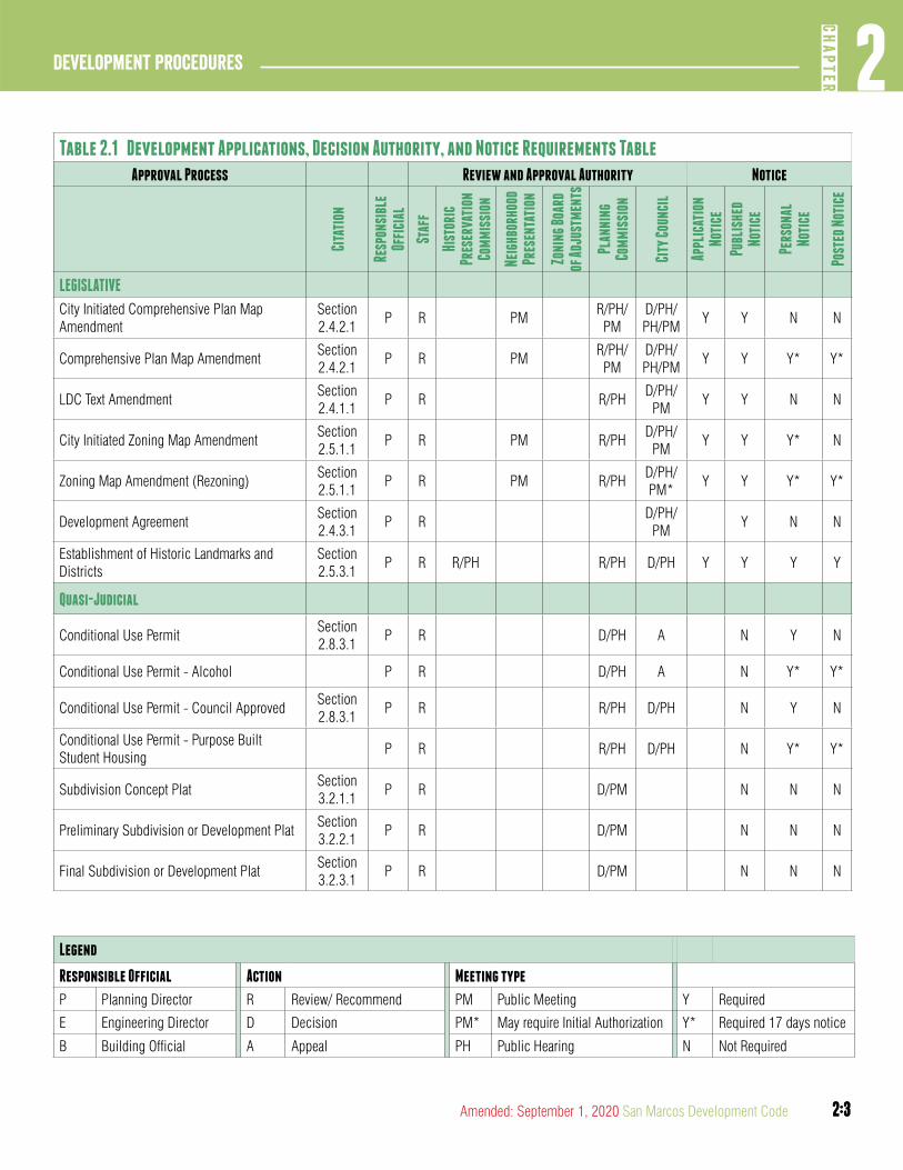
Table 2.1 Development Applications, Decision Authority, and Notice Requirements TableApproval Process Review and Approval Authority Notice
Cita
tion
Resp
onsi
ble
Offi
cial
Staf
f
Hist
oric
Pr
eser
vati
on
Com
mis
sion
Neig
hbor
hood
Pr
esen
tati
on
Zoni
ng B
oard
of
Adju
stm
ents
Plan
ning
Co
mm
issi
on
City
Cou
ncil
Appl
icat
ion
Noti
ce
Publ
ishe
d No
tice
Pers
onal
No
tice
Post
ed N
otic
e
LEGISLATIVE
City Initiated Comprehensive Plan Map Amendment
Section 2.4.2.1
P R PMR/PH/PM
D/PH/PH/PM
Y Y N N
Comprehensive Plan Map AmendmentSection 2.4.2.1
P R PMR/PH/PM
D/PH/PH/PM
Y Y Y* Y*
LDC Text AmendmentSection 2.4.1.1
P R R/PHD/PH/
PMY Y N N
City Initiated Zoning Map Amendment Section 2.5.1.1
P R PM R/PHD/PH/
PMY Y Y* N
Zoning Map Amendment (Rezoning)Section 2.5.1.1
P R PM R/PHD/PH/PM*
Y Y Y* Y*
Development AgreementSection 2.4.3.1
P RD/PH/
PMY N N
Establishment of Historic Landmarks and Districts
Section 2.5.3.1
P R R/PH R/PH D/PH Y Y Y Y
Quasi-Judicial
Conditional Use PermitSection 2.8.3.1
P R D/PH A N Y N
Conditional Use Permit - Alcohol P R D/PH A N Y* Y*
Conditional Use Permit - Council ApprovedSection 2.8.3.1
P R R/PH D/PH N Y N
Conditional Use Permit - Purpose Built Student Housing
P R R/PH D/PH N Y* Y*
Subdivision Concept PlatSection 3.2.1.1
P R D/PM N N N
Preliminary Subdivision or Development PlatSection 3.2.2.1
P R D/PM N N N
Final Subdivision or Development PlatSection 3.2.3.1
P R D/PM N N N
Legend
Responsible Official Action Meeting type
P Planning Director R Review/ Recommend PM Public Meeting Y Required
E Engineering Director D Decision PM* May require Initial Authorization Y* Required 17 days notice
B Building Official A Appeal PH Public Hearing N Not Required
2:4
Development Procedures2
CHAP
TER
2:4 San Marcos Development Code Amended: September 1, 2020
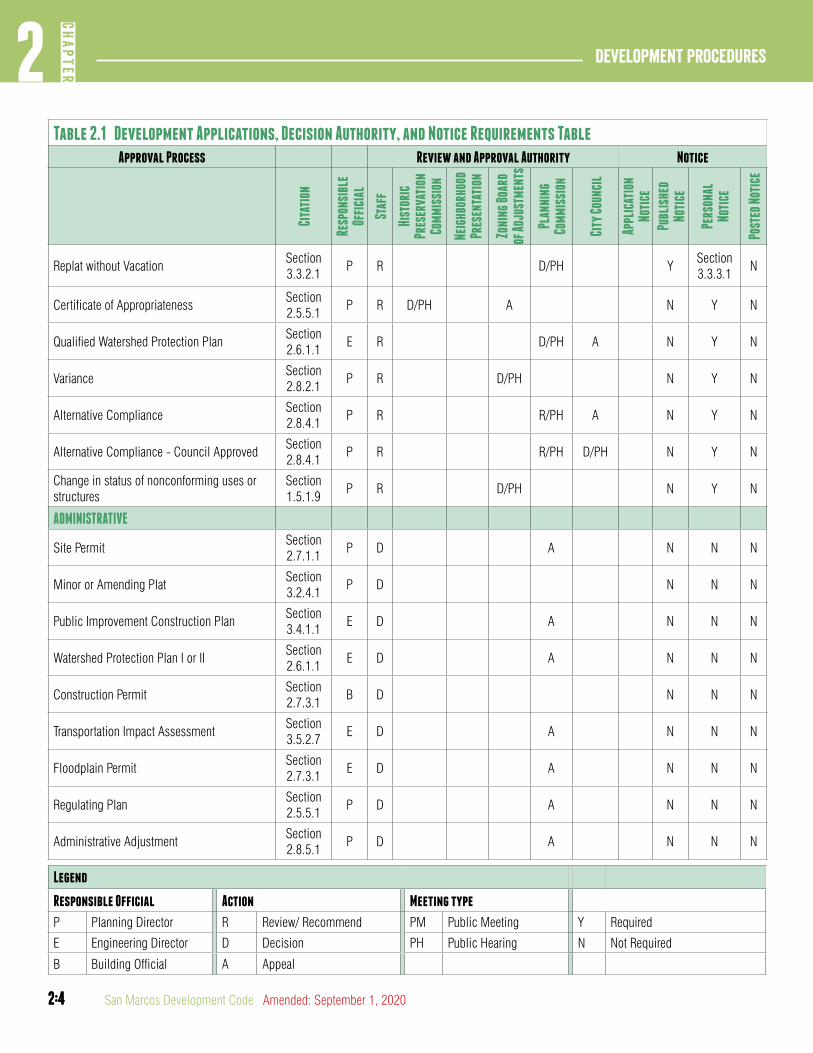
Table 2.1 Development Applications, Decision Authority, and Notice Requirements TableApproval Process Review and Approval Authority Notice
Cita
tion
Resp
onsi
ble
Offi
cial
Staf
f
Hist
oric
Pr
eser
vati
on
Com
mis
sion
Neig
hbor
hood
Pr
esen
tati
on
Zoni
ng B
oard
of
Adju
stm
ents
Plan
ning
Co
mm
issi
on
City
Cou
ncil
Appl
icat
ion
Noti
ce
Publ
ishe
d No
tice
Pers
onal
No
tice
Post
ed N
otic
e
Replat without VacationSection 3.3.2.1
P R D/PH YSection 3.3.3.1
N
Certificate of AppropriatenessSection 2.5.5.1
P R D/PH A N Y N
Qualified Watershed Protection PlanSection 2.6.1.1
E R D/PH A N Y N
VarianceSection 2.8.2.1
P R D/PH N Y N
Alternative ComplianceSection 2.8.4.1
P R R/PH A N Y N
Alternative Compliance - Council ApprovedSection 2.8.4.1
P R R/PH D/PH N Y N
Change in status of nonconforming uses or structures
Section 1.5.1.9
P R D/PH N Y N
ADMINISTRATIVE
Site PermitSection 2.7.1.1
P D A N N N
Minor or Amending PlatSection 3.2.4.1
P D N N N
Public Improvement Construction PlanSection 3.4.1.1
E D A N N N
Watershed Protection Plan I or IISection 2.6.1.1
E D A N N N
Construction PermitSection 2.7.3.1
B D N N N
Transportation Impact AssessmentSection 3.5.2.7
E D A N N N
Floodplain PermitSection 2.7.3.1
E D A N N N
Regulating PlanSection 2.5.5.1
P D A N N N
Administrative AdjustmentSection 2.8.5.1
P D A N N N
Legend
Responsible Official Action Meeting type
P Planning Director R Review/ Recommend PM Public Meeting Y Required
E Engineering Director D Decision PH Public Hearing N Not Required
B Building Official A Appeal
2:5
2CH
APTER
Development Procedures
2:5Amended: September 1, 2020 San Marcos Development Code
DIVISION 2: SEQUENCE OF DEVELOPMENT APPLICATIONS
Section 2.1.2.1General Rules for Priority
Where more than one development application is required by this development code in order to initiate or continue development of land, the requests or applications shall be decided in the following general sequence:
A. Applications classified as legislative shall be first decided and determined prior to all other applications.
B. Applications classified as quasi-judicial shall be decided prior to applications classified as administrative.
C. Applications within a class which are assigned priority under this Development Code shall be decided prior to subordinate applications.
Section 2.1.2.2Specific Rules of Priority
A. Applications of Mixed Classification. A property owner may submit development applications of different priority classifications simultaneously unless otherwise written in this development code. Action on accompanying applications shall be as follows:
1. Denial of a legislative application shall be deemed a denial of any pending quasi-judicial or administrative applications, or subordinate applications for the same land, on the date the legislative application is denied.
2. Denial of a quasi-judicial application shall be deemed a denial of any pending administrative or subordinate quasi-judicial applications for the same land on the date the quasi-judicial application is denied.
3. Subordinate applications shall not be approved subject to approval of priority applications.
4. Any subordinate application that must be decided within a time certain under this development code and that is not accompanied by an express waiver of such time limitation pending decision on the priority application shall be deemed incomplete and shall not be further processed.
B. Subordinate Applications. Approval of any subordinate application shall be consistent with the terms and conditions of approval of all priority applications.
article 2: aUThORITY OF DECISION MaKERS
DIVISION 1: GENERAL PROVISIONS
Section 2.2.1.1Source of Authority
Authority under this development code shall be vested in and delegated to the officials and decision-makers designated in this Chapter 2, Article 2 and under the city’s charter, the constitution and laws of the State of Texas and the city code. This authority shall be deemed supplemental to any other authority lawfully conferred upon the officials and decision-makers. The omission of a citation in this development code to any authority conferred upon the officials and decision-makers under the city’s charter, the constitution or laws of the State of Texas or the city code shall not be construed as limiting the actions of such officials and decision-makers taken in accordance with and in reliance upon such authority.
Section 2.2.1.2Implied Authority
The officials and decision-makers shall have all implied authority necessary to carry out the duties and responsibilities expressly delegated by this development code to the extent the implied authority is not in conflict with the expressly delegated authority.
Section 2.2.1.3Limitation on Authority
A. City Policy. It is the policy of the city that the standards and procedures applicable to development of property within the city limits and within the city’s extraterritorial jurisdiction are as stated in this development code, notwithstanding any representation by any city official summarizing, paraphrasing or otherwise interpreting such standards to the contrary, whether generally or as applied to development of specific property.
B. Representations Concerning Future Action on Application. No city official, whether an employee of the city or a member of an appointed board or commission, or a member of the governing body of the city, shall have the authority to make representations to a property owner concerning the likelihood of an outcome of that official’s decision or the decision of an appointed board or commission or the city council, on any development application that has yet to be filed or is pending before the city for decision. An official may, however, upon request of a person, convey information concerning that official’s position on a pending application in accordance with procedures established in this Chapter 2. No person is
2:6
Development Procedures2
CHAP
TER
2:6 San Marcos Development Code Amended: September 1, 2020
entitled to rely upon any representation made by an official in contravention of this subsection, and each and every such representation shall be deemed in violation of the policy of the city, and is not binding on the city in any respect. No subsequent decision of the city shall be deemed a ratification of any representation made in contravention of this subsection.
C. Representations Concerning Future Amendments. No city official, whether an employee of the city or a member of an appointed board or commission, or a member of the city council, shall have the authority to make binding representations to any person concerning the likelihood that a change in any legislative classification or a change in the text of this development code as applied to a specific tract of land shall be granted, or that an existing legislative classification or text provision shall remain in effect, or that any application for relief shall be granted. No person is entitled to rely upon any representation made by an official in contravention of this subsection, and each and every such representation shall be deemed in violation of the policy of the city, and is not binding on the city in any respect. No subsequent decision of the city shall be deemed a ratification of any representation made in contravention of this subsection.
D. Effect of Comprehensive Plan, Ordinance or Development Standard on Liability Claims. The city’s approval of a development application under the standards and procedures of this development code does not guarantee or assure that development of the property in accordance with the standards shall prevent, minimize or mitigate harm to adjoining property. A person who undertakes development activities shall not rely on the city’s approval of a development application as ensuring that the development activities shall not result in harm to adjoining property. The regulations contained in this development code constitute an exercise of the city’s governmental authority, and approval of a development application shall not give rise to any liability on the part of the city or its officers, agents and employees, nor shall an approval release the applicant from any liability for harm arising out of development of the property under applicable law.
E. No Waivers. Except as expressly provided for in this development code, no official, board, commission of the city, or the city council, shall have authority to waive or vary any requirement or standard for a development application. Any attempted waiver of a requirement or standard for a
development application in contravention of this subsection shall hereby be deemed null and void, and, upon discovery, shall be grounds for revocation of a permit or approval, or reconsideration of a legislative decision.
Section 2.2.1.4Conflict in Authority
A. Internal Inconsistency. Whenever one or more provisions of this development code are in apparent conflict, the provisions shall be construed, if possible, so that effect is given to each. If the conflict is between a general provision and a specific provision, and the conflict is irreconcilable, the specific provision shall prevail as an exception to the general provision, unless the general provision is the later enactment and the manifest intent is that the general provision should prevail.
B. Incomplete Provisions. Whenever a specific standard or procedure of this development code is incomplete when applied in isolation to a development application or development activity, such standard shall be supplemented by any general or specific provision of this development code, the city code, or the city charter in order to give effect to the incomplete provision.
DIVISION 2: CITY STAFF
Section 2.2.2.1Administrator; Responsible Official; Determining Authority
A. Administrator. The administrator of this development code is the director of planning and development services. As such, the administrator shall be responsible for taking the following actions with regard to development applications in addition to all other responsibilities assigned under this development code:
1. Accepting the application for filing;
2. Processing the application;
3. Coordinating any comments from other city departments concerning the application, and;
4. Taking all other actions necessary for administration of the provisions of this development code with respect to all development applications which are not otherwise assigned to a responsible official with respect to a development application.
2:7
2CH
APTER
Development Procedures
2:7Amended: September 1, 2020 San Marcos Development Code
B. Responsible Official. The responsible official with respect to a development application is the responsible official designated under Table 2.1. In each case, the responsible official shall be responsible for taking the following actions with regard to the development application:
1. Seeking advice of other city departments;
2. Initially deciding the application, where so authorized;
3. Determining a request for exemption other than an exemption required to be granted by the planning and zoning commission, the City Council or the Zoning Board of Adjustment;
4. Preparing reports to and advising any board, commission or the City Council that has responsibility for making recommendations on or deciding the application;
5. Promulgating additional or modified policies, standards and administrative rules for adoption by the City Council that apply to the application;
6. Initiating enforcement actions concerning compliance with the standards applicable to the application and the conditions imposed thereon;
7. Taking all other actions necessary for administration of the provisions of this development code with respect to the application, and;
8. Delegating the official’s authority as responsible official to subordinate officials, who shall thereupon be deemed the responsible official for purpose of carrying out the delegated duties.
C. Approval Authority. The approval authority with respect to a development application is the approval authority designated under Table 2.1. In each case, the approval authority shall make all decisions and determinations whether to approve, approve with conditions, or deny the development application.
Section 2.2.2.2Director of Planning and Development Services
A. Responsible Official. The Director or Planning and Development Services is the responsible official for the types of development applications and relief applications indicated in Table 2.1.
B. Determining Authority. The director of planning and development services is the determining authority for the types of development applications indicated in Table 2.1.
C. Administrative Adjustments. The director of planning and development services is hereby authorized to approve administrative adjustments as provided in Section 2.8.5.1.
Section 2.2.2.3Engineering Director
A. Responsible Official. The engineering director is the responsible official for the types of development applications and relief applications indicated in Table 2.1.
B. Determining Authority. The engineering director is the determining authority for certain types of development applications and relief applications identified in Table 2.1.
C. Floodplain Administrator. The engineering director is the floodplain administrator for the city and shall carry out the duties and responsibilities indicated in Chapter 39 of the city code.
D. Administrative Adjustments. The engineering director is hereby authorized to approve administrative adjustments as provided in Section 2.8.5.1.
Section 2.2.2.4Building Official
A. Determining Authority. The building official is the responsible official for certain types of development applications and relief applications identified in Table 2.1.
Section 2.2.2.5City Manager and Other City Officials
A. The city manager, city attorney and any other officials delegated responsibilities under this development code are authorized to take all actions necessary to carry out their responsibilities in accordance with the requirements and limitations prescribed herein.
2:8
Development Procedures2
CHAP
TER
2:8 San Marcos Development Code Amended: September 1, 2020
DIVISION 3: PLANNING AND ZONING COMMISSION
Section 2.2.3.1Structure of Commission
The members of the planning and zoning commission are appointed by the council in accordance with Section 2.091 of the city’s code of general ordinances.
Section 2.2.3.2Review Authority
A. The planning and zoning commission shall act as an advisory body, final or initial decision maker, and as an authority for deciding appellate and relief applications as indicated in Table 2.1.
B. Advisory Board. The planning commission shall act as an advisory body to the city council and, in that capacity, shall review, prepare reports upon and make recommendations concerning approval, conditional approval or denial of legislative decisions as authorized by this development code regarding:
1. The city’s capital improvements program;
2. All matters related to the physical growth and development of the city as assigned by city council; and
3. The types of development applications summarized in Table 2.1.
C. Quasi-Judicial Applications. The planning and zoning commission shall finally decide or initially decide, subject to appeal to the city council, the types of applications identified in Table 2.1 in accordance with the procedures and standards that apply to the petition or development application.
D. Appellate Authority. The planning and zoning commission shall finally decide appeals and applications for relief on the development applications and relief applications identified in Table 2.1.
DIVISION 4: CITY COUNCIL
Section 2.2.4.1Authority for Amendments to Development Code
The city council may from time to time amend, supplement or change by ordinance the text of this development code on its own initiative or upon application for a text amendment.
Section 2.2.4.2Review Authority
The city council shall finally decide all types of development applications, appeals, or petitions for relief authorized under this development code Table 2.1.
A. Super-Majority Vote. Development applications where a super majority vote is required by this development code shall not become effective except by the favorable vote of six members of the City Council under the following circumstances:
1. When the planning and zoning commission recommends denial of the application.
2. When a written protest against the application is signed by the owners of 20 percent or more of either:
a. The area of the subject property; or
b. The land adjoining the subject property; or
c. The land within 200 feet of the subject property; or
d. The land within 400 feet of the subject property.
3. In computing the percentage of land area, the area of streets and alleys shall be included in the computation. For purposes of this subsection, the following shall apply:
a. The written protest of any one owner of land owned by two or more persons shall be presumed to be the protest of all such owners;
b. The written protest must be submitted to the city clerk at least five business days before the date of the meeting at which the proposed change is to be considered;
c. A person who wishes to withdraw a signature from a written protest must submit a signed, written request for the withdrawal to the city clerk by the deadline for
2:9
2CH
APTER
Development Procedures
2:9Amended: September 1, 2020 San Marcos Development Code
submitting a written protest. A signature may not be otherwise withdrawn; and
d. An application may not be modified to change the boundaries of the subject property after a written protest application requiring a super-majority vote of the city council has been submitted.
B. Effect on Planning and Zoning Commission Decisions. The authority of the city council to hear appeals and applications for relief in specific instances described in this Section 2.2.4.1 shall not be construed to divest the planning and zoning commission of its final approval authority over subdivision plats and development plats.
DIVISION 5: ZONING BOARD OF ADJUSTMENTS (ZBOA)
Section 2.2.5.1Structure of Board
The members of the zoning board of adjustments are appointed by the council in accordance with the city’s code of general ordinances.
Section 2.2.5.2Review Authority
The Zoning Board of Adjustments shall act as a final decision maker or authority in deciding appellate or relief requests in accordance with Table 2.1 of this development code.
Section 2.2.5.3Rules Governing Proceedings
A. Vote required for decisions. The concurring vote of four members of the ZBOA is necessary to reverse an order, requirement, decision or determination of any administrative official, or to decide in favor of the applicant on a matter upon which the ZBOA is required to pass under this development code, or to authorize a variance from the terms of a provision of this development code.
B. Quorum. A quorum shall consist of four members of the ZBOA.
C. Limitation on Authority. The authority delegated to the ZBOA under this development code shall not be construed to affect any of the following:
1. Any legislative decision;
2. Approval of a conditional use permit;
3. Approval of a request for alternative compliance;
4. Authorization of a use not authorized in the district in which the applicant’s property is located, except to the extent necessary to decide a variance or an application for a change in status of a nonconformity.
Section 2.2.5.4Appeals
A. Procedure for Appeal. Upon receiving a notice of appeal of a matter for which appeal to the ZBOA is authorized under this development code, the responsible official shall immediately transmit to the ZBOA all papers constituting the record of the action that is appealed. An appeal stays all proceedings in furtherance of the action that is appealed unless the official from whom the appeal is taken certifies in writing to the ZBOA facts supporting the official’s opinion that a stay would cause imminent peril to life or property. In that case, the proceedings may be stayed only by a restraining order granted by the ZBOA or a court of record on application, after notice to the official, if due cause is shown.
B. Appeals of Board Decisions. Appeals of any decision of the ZBOA may be taken to a state district court, county court, or county court-at-law by filing a verified petition stating that the decision of the ZBOA is illegal in whole or in part and specifying the grounds of the illegality. The petition must be filed within ten days after the date the decision being appealed is filed with the department of Planning and Development Services and shall proceed in accordance with the rules and procedures of the court to which the appeal is taken.
Section 2.2.5.5Public Hearing
Personal notice of hearing before the ZBOA is required on all appli-cations, appeals and relief applications in accordance with Table 2.1.
2:10
Development Procedures2
CHAP
TER
2:10 San Marcos Development Code Amended: September 1, 2020
DIVISION 6: HISTORIC PRESERVATION COMMISSION
Section 2.2.6.1Structure of Commission
The members of the historic preservation commission are appointed by the council in accordance with the city’s code of general ordinances.
Section 2.2.6.2Review Authority
A. The historic preservation commission shall act as an advisory body to the city council and as a final or initial decision maker in deciding certificates of appropriateness.
B. Initiation of Application. The historic preservation commission may initiate an application for the establishment or expansion of historic districts and historic landmarks.
C. The historic preservation commission shall review, prepare reports upon and make recommendations concerning approval, conditional approval or denial of an application for the establishment or expansion of historic districts and historic landmarks.
article 3: UNIVERSaL PROCEDURES
DIVISION 1: APPLICATION PROCEDURES
Section 2.3.1.1Application Processing
This Article 3 is applicable to all applications required or submitted pursuant to this development code. Applications, petitions and re-quests initiated by the City Council, any city board or commission or city staff, however, are exempt from the requirements below except for the requirements pertaining to neighborhood presentations under subsections E, F and G of Division 1.
A. Who May Initiate Application
1. The City Council, the Planning and Zoning Commission or the Responsible Official may initiate an application for legislative review.
2. Any person, firm, corporation or agency may initiate any legislative decision or any development application provided they are the owner or the owner’s designated agent of the subject property. If the applicant is a designated agent, the application shall include a written statement from the property owner authorizing the agent to file the application on the owner’s behalf.
3. The historic preservation commission may initiate applications for the establishment or amendment of historic districts or historic landmarks.
B. Sufficiency of Application for Filing. The responsible official shall accept for filing every application that is deemed complete and gives the responsible official fair notice of the project and the nature of the decision, permit or approval sought.
C. Completeness Determination. Every application accepted by the responsible official for filing shall be subject to a determination of completeness by the responsible official no later than the tenth (10) business day after the application is submitted. If no official determination is made the application is deemed complete and the review period begins on the date the application is submitted.
1. The responsible official is not required to review an application unless it is complete.
2:11
2CH
APTER
Development Procedures
2:11Amended: September 1, 2020 San Marcos Development Code
2. The presumption is that an application is complete if all of the information required in this development code, technical manuals or the city’s application forms is provided. However, it is recognized that each application is unique, and more or less information may be required according to the specifics of a particular case. The applicant may rely on the responsible official to determine whether more or less information has to be submitted.
3. The charging or collection of fees and the processing of an application shall not constitute a determination of completeness.
4. The application shall not be considered filed until the Responsible Official has determined it complete.
(Ord. No. 2019-45, 12-17-19)
D. Pre-Development Meeting. An applicant is required to request a pre-development meeting with the Responsible Official prior to filing an application. The Responsible Official shall have the authority to waive the pre-development meeting, if such application does not warrant a meeting, or if alternative measures have been taken to address concerns and/or questions that may arise out of the application. No application shall be accepted for filing at a pre-development meeting. A pre-development meeting does not trigger any grandfathering or vested rights or commence a review period.
(Ord. No. 2020-60, 9-1-2020)
E. Neighborhood Presentation Meeting. The purpose of a neighborhood presentation meeting is to begin the discussion about the proposal and is not a forum for final decisions or the acceptance of formal comments concerning public support or opposition.
F. Neighborhood presentation meetings are required for requests located in Existing Neighborhood areas only when required by Table 2.1 of this development code.
G. When a neighborhood presentation meeting is required:
1. An applicant or authorized representative must schedule and facilitate a minimum of one neighborhood presentation meeting to discuss the proposed application.
2. Within 12 days of application submittal the Responsible Official shall send electronic notification of the meeting to all parties requesting notification of a submitted application within that region and post the meeting date and location on the City’s website.
3. The Responsible Official shall be present to take notes and report the number of participants included in the neighborhood presentation meeting in any subsequent staff reports. Meeting decorum should follow protocol as stated in section 2.045(h) of the City Code.
4. The neighborhood presentation meeting shall be held on or in close proximity to the area of the request.
5. The neighborhood presentation meeting shall be held 20-28 days prior to the Planning and Zoning Commission meeting.
(Ord. No. 2018-42, 11-07-18)
H. Application Fees. Filing fees have been established to help defray the cost of processing applications. The current fee schedule is prepared and adopted by the City Council as an appendix to this development code and is available on-line on the city’s website.
1. An application is not considered complete until all fees are paid in full.
2. The fee schedule may be amended from time to time by resolution of the city council.
3. The following entities shall be exempt from all fees prescribed under this development code except that no exemption from or waiver of impact fees shall be permitted except as provided under Chapter 86 of the City’s General Code of Ordinances of this development code:
a. Non-profit organizations receiving funds from the city through the city’s community development block grant or human services program;
b. The city when using city employees on a construction project of the city;
c. Contractors hired by the city to work on construction projects of the city;
2:12
Development Procedures2
CHAP
TER
2:12 San Marcos Development Code Amended: September 1, 2020
d. San Marcos Reinvestment Corporation and San Marcos Habitat for Humanity when building new affordable single-family residential dwellings;
e. The Housing Authority of the City of San Marcos, for construction projects on property it owns, for low-income housing or administrative offices; and
f. Any taxing unit as defined under Section 1.04(11) of the Texas Tax Code for construction projects having a permitted value of $1,000.00 or less.
I. Modification of Applications. The applicant may modify any application following its filing and prior to the expiration of the period during which the city is required to act on the application.
1. Submittal of a modified application shall extend the time for deciding the application for a period equal to the time specified in this Development Code to decide the original application.
J. Application Review. Following the determination that an application is complete, the responsible official shall:
1. Circulate the application for review by city departments or external agencies as applicable and compile the comments and recommendations;
2. Forward the application for review to any advisory body and the final decision-maker, and prepare a report to such body; and
3. Prepare required notices and schedule the application for decision within the time and in the manner required by this Development Code.
K. Action by Advisory Body. In the absence of a recommendation from an advisory body by a majority vote on a proposed application, the advisory body shall be presumed conclusively to have recommended that the application be considered by the city council with no recommendation from the advisory body.
L. Decision. The decision-maker for the application shall approve, approve with conditions or deny the application.
M. Conditions. Where applicable the initial or final decision-maker may attach such conditions to the approval of an application as are reasonably necessary to assure compliance with this Development Code.
DIVISION 2: NOTICE REQUIREMENTS
Section 2.3.2.1General Notice Requirements
For public notice and hearing requirements see Table 2.1
A. Published Notice. Whenever published notice is required under state law, the City Charter, or this Development Code, the Responsible Official shall cause notice to be published in a newspaper of general circulation in the City at least 16 days before the date set for the required hearing.
1. The notice shall set forth the:
a. Date, time, and location of the hearing;
b. Purpose of the hearing; and
c. Identification of the subject property if the decision concerns an individual tract or parcel of land.
B. Personal Notice. Whenever personal notice of a public hearing is required by state law, the City Charter, or this Development Code, the responsible official shall cause notice to be sent by regular mail at least 11 days prior to the hearing date unless a longer time period is identified in this development code.
C. Comprehensive plan map amendments initiated by a property owner, any zoning map amendment, and a conditional use permit allowing the on premise consumption of alcohol or purpose built student housing require that the responsible official send notice by regular mail at least 17 days prior to the hearing date.
D. Whenever personal notice is required by this development code notice shall be sent to the following addresses:
a. Each owner of real property located within four hundred (400) feet of the exterior boundary of the property in question and any other persons deemed by the responsible official or decision-maker to be affected by the application;
b. Council of Neighborhood Associations (CONA) representative and president;
c. Neighborhood Commission representative and president;

2:13
2CH
APTER
Development Procedures
2:13Amended: September 1, 2020 San Marcos Development Code
d. Any other registered neighborhood organization representing the area in which the subject property is located;
e. The applicant and/or property owner; and
f. The appellant if an appeal.
1. The notice shall set forth the
a. Name of the applicant;
b. Date, time, and location of the hearing;
c. Purpose of the hearing;
d. Identification of the subject property; and
e. The name of the appellant if an appeal.
2. Notice shall be sent to each owner indicated on the most recently approved municipal tax roll for land inside the city limits, and, when required by state law, land in the extraterritorial jurisdiction.
3. For recently annexed land that is not included on the most recently approved municipal or county tax roll, notice may be given by published notice.
4. Notice may be served by depositing the notice, properly addressed and first class postage prepaid, in the United States mail.
E. Posted Notice. Whenever this Development Code requires that notice of a public hearing be posted on land, the responsible official shall cause notification signs stating the purpose and dates of the hearing to be placed on the subject property at least 11 days before the first public hearing unless a longer time period is identified in this development code.
F. Comprehensive plan map amendments or zoning map amendments initiated by a property owner, and a conditional use permit allowing the on premise consumption of alcohol or purpose built student housing require that the responsible official send post notice at least 17 days prior to the hearing date.
1. A minimum of one 2’ x 2’ sign shall be placed on each street frontage. Property with multiple street frontages shall have the requisite sign on each street. Signs shall be
placed in a visible, unobstructed location near the front property line.
2. Signs shall utilize a minimum of 6” lettering to state the purpose of the request and all public hearing dates.
3. The notification signs shall be left in place until final action is taken or the request is withdrawn.
4. It shall be the responsibility of the applicant to periodically check sign locations to verify that signs remain in place and have not been vandalized or removed. The applicant shall immediately notify the responsible official of any missing or defective signs.
5. It is unlawful for a person to alter any notification sign, or to remove it while the case is pending; however, any removal or alteration that is beyond the control of the applicant shall not constitute a failure to meet notification requirements.
G. Notice of Application. Whenever notice of an application is required by this development code under Table 2.1, the Responsible Official shall send electronic notification:
1. To all parties requesting notification of an application submitted within the region;
2. Before the 12th day after an application is determined complete.
(Ord. No. 2019-45, 12-17-19)
H. Notification Following Decision. Within ten (10) business days of determination on a development application, written notification of the action shall be sent to the applicant, stating the action taken and including any conditions imposed or basis for denial if applicable.
I. Notification of Appeal or Revocation. If no public hearing was held prior to approval of the development application, personal notice of revocation or appeal shall be given only to the holder of the permit.
J. Special Notice. Whenever this Development Code requires, or the City Council prescribes, that notice of a public hearing be given that differs from the requirements of this Section, the Responsible Official shall cause such notice to be given in the manner otherwise required or prescribed.

2:14
Development Procedures2
CHAP
TER
2:14 San Marcos Development Code Amended: September 1, 2020
DIVISION 3: PUBLIC HEARINGS
Section 2.3.3.1Public Hearings
A. Setting of the Hearing. When the responsible official determines that a development application is complete and that a public hearing is required by this Development Code, the official shall consult with the secretary of the body required to conduct the hearing and shall select a place and a time certain for the hearing, and shall cause notice of such hearing to be prepared and made under Section 2.3.2.1. The time set for the hearing shall conform to the time periods required by this Development Code.
B. Conduct of Hearing. The public hearing shall be conducted in accordance with the rules and procedures adopted by the body conducting the hearing. During the hearing the following may occur: presentation & recommendation from staff, presentation by the applicant, public testimony. Any person may appear at the public hearing and submit evidence, either individually or as a representative of an organization. Each person who appears at a public hearing shall state his or her name, and if appearing on behalf of an organization, state the name of the organization for the record.
C. Record of Proceedings. The body conducting the hearing shall record the proceedings by any appropriate means.
D. Continuance of Proceedings. The body conducting the hearing may, on its own motion or at the request of any person, for good cause, continue the hearing to a fixed date, time and place. No notice shall be required if a hearing is continued. If a public hearing is closed, no further public testimony shall be taken.
E. Additional Rules. The body conducting the hearing may adopt rules of procedure to limit the number of applications for development approval which may be considered per meeting and the time for each presentation, and may apply such additional rules to govern the public hearing which are not inconsistent with this Section.
DIVISION 4: POST-DECISION PROCEDURES
Section 2.3.4.1Post-Decision Procedures
A. Re-Application Following Denial. Whenever any development application, with the exception of any plat application, is denied at a public hearing for failure to meet the substantive requirements of this Development Code, a development application for all or a part of the same property shall not be accepted for filing for a period of six months from the date of denial unless the subsequent application involves a proposal that is materially different from the previously denied proposal. City staff may accept an application for processing, but the application is not deemed accepted for filing until considered by the decision-maker under Section 2.3.4.1A(1).
1. The decision-maker on the first application shall resolve any questions concerning the similarity of the second application.
2. Non-compliance with this Section 2.3.4.1(a) shall be grounds for denial of the application.
3. The decision-maker may, at its option, waive the six-month waiting period if, after due consideration of the matter at a scheduled and posted meeting, it is determined that denial of the request was based upon erroneous or omitted information, or if substantial new information pertaining to the request is discovered.
B. Amendments and Revisions. Unless another method is expressly provided by this Development Code, any request to amend or revise an approved development application shall be considered a new application, which must be decided in accordance with the procedures governing the original application and the standards in effect at the time such new application is filed with the City.
DIVISION 5: EXPIRATION AND EXTENSION
Section 2.3.5.1Expiration and Extension of Approvals
A. Time of Expiration. An application, or permit approved under this code may lapse if certain actions related to the approved application are not taken within a specified time period as set forth in this Development Code or the conditions of the specific approval. Section 2.3.5.3 provides a summary of the expiration
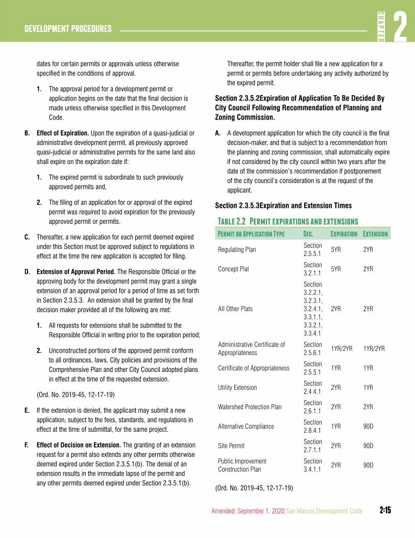
2:15
2CH
APTER
Development Procedures
2:15Amended: September 1, 2020 San Marcos Development Code
dates for certain permits or approvals unless otherwise specified in the conditions of approval.
1. The approval period for a development permit or application begins on the date that the final decision is made unless otherwise specified in this Development Code.
B. Effect of Expiration. Upon the expiration of a quasi-judicial or administrative development permit, all previously approved quasi-judicial or administrative permits for the same land also shall expire on the expiration date if:
1. The expired permit is subordinate to such previously approved permits and,
2. The filing of an application for or approval of the expired permit was required to avoid expiration for the previously approved permit or permits.
C. Thereafter, a new application for each permit deemed expired under this Section must be approved subject to regulations in effect at the time the new application is accepted for filing.
D. Extension of Approval Period. The Responsible Official or the approving body for the development permit may grant a single extension of an approval period for a period of time as set forth in Section 2.3.5.3. An extension shall be granted by the final decision maker provided all of the following are met:
1. All requests for extensions shall be submitted to the Responsible Official in writing prior to the expiration period;
2. Unconstructed portions of the approved permit conform to all ordinances, laws, City policies and provisions of the Comprehensive Plan and other City Council adopted plans in effect at the time of the requested extension.
(Ord. No. 2019-45, 12-17-19)
E. If the extension is denied, the applicant may submit a new application, subject to the fees, standards, and regulations in effect at the time of submittal, for the same project.
F. Effect of Decision on Extension. The granting of an extension request for a permit also extends any other permits otherwise deemed expired under Section 2.3.5.1(b). The denial of an extension results in the immediate lapse of the permit and any other permits deemed expired under Section 2.3.5.1(b).
Thereafter, the permit holder shall file a new application for a permit or permits before undertaking any activity authorized by the expired permit.
Section 2.3.5.2Expiration of Application To Be Decided By City Council Following Recommendation of Planning and Zoning Commission.
A. A development application for which the city council is the final decision-maker, and that is subject to a recommendation from the planning and zoning commission, shall automatically expire if not considered by the city council within two years after the date of the commission’s recommendation if postponement of the city council’s consideration is at the request of the applicant.
Section 2.3.5.3Expiration and Extension Times
Table 2.2 Permit expirations and extensions
Permit or Application Type Sec. Expiration Extension
Regulating PlanSection 2.5.5.1
5YR 2YR
Concept PlatSection 3.2.1.1
5YR 2YR
All Other Plats
Section 3.2.2.1, 3.2.3.1, 3.2.4.1, 3.3.1.1, 3.3.2.1, 3.3.4.1
2YR 2YR
Administrative Certificate of Appropriateness
Section 2.5.6.1
1YR/2YR 1YR/2YR
Certificate of AppropriatenessSection 2.5.5.1
1YR 1YR
Utility ExtensionSection 2.4.4.1
2YR 1YR
Watershed Protection PlanSection 2.6.1.1
2YR 2YR
Alternative ComplianceSection 2.8.4.1
1YR 90D
Site PermitSection 2.7.1.1
2YR 90D
Public Improvement Construction Plan
Section 3.4.1.1
2YR 90D
(Ord. No. 2019-45, 12-17-19)
2:16
Development Procedures2
CHAP
TER
2:16 San Marcos Development Code Amended: September 1, 2020
DIVISION 6: INSPECTIONS
Section 2.3.6.1Inspection Procedures
Whenever a development application approved under this Development Code authorizes development or construction of a structure, building or impervious surface, or authorizes installation of public or other improvements to serve a proposed development, or otherwise authorizes disturbance of the surface or subsurface of the land, the following procedures shall be followed during the development process:
A. Right of Entry. The owner of the land subject to the approved development application shall, as a condition of the approval, be deemed to have authorized city inspectors to enter onto the land during reasonable hours for the purpose of determining compliance with the terms, conditions and requirements of the application. If a city inspector is refused entry, the Responsible Official may obtain judicial authorization for the entry, may initiate the process for suspension or revocation of the approved application by the decision-maker for the application, or may exercise any other remedy provided by this Development Code or under other law.
B. Regular Inspections. The City shall make inspections of the land or premises during development and construction to ensure full compliance with all terms, conditions and requirements of the approved development application. The applicant shall designate one person, with a current address, email, and phone, to whom notice shall be given, and from whom information can be obtained, under this Section 2.3.6.1.
C. Authorized Inspectors. Employees of the City allowed by applicable law are authorized to issue municipal court citations for violations of this Development Code.
DIVISION 7: ENFORCEMENT AND REVOCATION OF PERMITS
Section 2.3.7.1Enforcement Procedures and Revocation of Permits
A. Enforcement Activities. Enforcement activities include informal contacts with individuals to advise them of requirements, the issuance of verbal warnings, written warnings, municipal court citations, formal court action, and billing and collection. Employees of the City of San Marcos are authorized to enforce
this Development Code and any development application approved and any development permits issued hereunder, including without limitation, issuing municipal court citations for violations of this Development Code.
B. Right to Enter. The Responsible Official shall have the right to enter upon any premises, at any reasonable time, for the purpose of making inspections of buildings or premises that may be necessary to carry out the duties in the enforcement of this Development Code. Submittal of any application for a development permit that authorizes development or construction of structures or improvements shall be construed as a grant of authority to the Responsible Official to enter on land subject to the application.
C. General Remedies. If any building or structure is erected, constructed, reconstructed, altered, repaired, converted, or maintained, or any building, structure, or land is used or developed in violation of this Development Code or any development application approved or development permit issued thereunder, in addition to other remedies, the City may institute any appropriate action or proceedings to prevent or abate such activity. Appropriate action or proceedings include without limitation termination of utility services (water, gas, electric); revocation of permits, licenses, or bonds; stop work orders and institution of legal action in a court of competent jurisdiction.
Section 2.3.7.2Stop Work Orders
A. Stop Work Orders. Whenever any construction or development activity is being done contrary to any terms, conditions or requirements of an approved development application, development permit, or this Development Code, the Responsible Official or the official’s authorized representative may order the work stopped by notice in writing, served on the property owner or authorized agent.
B. Stop Work Order Procedures. Notice shall be given before the order shall be effective, except when the order should be effective immediately to protect and preserve the public health, safety, or general welfare.
1. Such notice may be given in person, by certified mail return receipt, or by posting on the applicable property.
2:17
2CH
APTER
Development Procedures
2:17Amended: September 1, 2020 San Marcos Development Code
C. Effect of Stop Work Order. Any person thereafter shall cease and desist from further development or construction activity which is material to the alleged noncompliance, until corrected by compliance and authorized by the Responsible Official to proceed with the work. This prohibition shall extend throughout any appeal period.
Section 2.3.7.3Court Actions
A. Municipal Court Actions. The City Attorney is authorized to prosecute violations of this Development Code in the municipal court where jurisdiction lies for the action.
B. Civil Court Actions. The City Attorney is authorized to file and prosecute an action at law or in equity, where permitted under the laws of Texas, in a court of competent jurisdiction to enforce the provisions of this Development Code. The initiation of one form of enforcement action by the City Attorney shall not preclude the City Attorney from initiating any other form of enforcement action.
Section 2.3.7.4Fines and Penalties
Unless expressly stated otherwise in this Code for specific offense, the culpable mental state for violating this Code shall be recklessness.
A. Life Safety Fines. A person who violates any provision of this Development Code pertaining to fire safety, zoning or public health and sanitation, including dumping of refuse, shall be punished, upon conviction, by a fine not to exceed $2,000.00.
B. Other Development Code Fines. A person who violates any other provision of this Development Code shall be punished, upon conviction, by a fine not to exceed $500.00.
C. The owner or owners of any building or premises or part thereof, where anything in violation of this Division shall be placed or shall exist, any architect, builder, contractor, agent, persons or corporation employed in connection therewith, and who may have assisted in the commission of any such violation, shall be guilty of a separate offense and upon conviction shall be fined as herein provided.
D. This Section 2.3.7.2 does not apply to enforcement of an ordinance in the City’s Extraterritorial Jurisdiction.
E. Separate Offenses. Each day that a violation continues shall be deemed a separate offense under Section 2.3.7.1.
Section 2.3.7.5Revocation Proceedings.
A. If the Responsible Official determines, based on inspection or investigation by the City, that there are reasonable grounds for revocation of an approved development application or development permit, the official shall set a hearing before the original decision-maker, or if the decision was made by the official or another Responsible Official or other city staff, set the hearing before the board or commission to which appeal may be taken from such decision under this Development Code. If the City Council was the original decision-maker, the Council may, but shall not be required to, refer the proposed revocation to the Planning and Zoning Commission for its report and recommendation prior to such hearing. Circumstances that warrant revocation of an approved development application shall include but not be limited to the following:
1. A material mistake was made in approving the development application or development permit;
2. Approval of the development application or development permit was procured on the basis of material misrepresentations or fraud on the part of the applicant or its agents;
3. Development activities being undertaken on the land subject to the development permit are not in conformity with terms thereof;
4. Any use authorized by the development permit or approved development application is in violation of a condition of approval.
B. The applicant and any interested parties shall be given notice of the hearing in the manner provided in Section 2.3.2.1. The public hearing shall be conducted in accordance with the procedures described in Section 2.3.3.1.
C. In rendering its decision whether to revoke the approved application, the decision-maker shall determine whether the activity authorized under the original approved application complies with the terms, conditions and requirements of such approval. The decision-maker may revoke the application, affirm it, or affirm it with attached conditions that assure that the terms, conditions and requirements of the application shall be met.
2:18
Development Procedures2
CHAP
TER
2:18 San Marcos Development Code Amended: September 1, 2020
D. A decision to revoke a development permit or an approved development application shall become final ten days after the date notice of the decision was given, unless appealed. After the effective date, it shall be unlawful to undertake or perform any activity that was previously authorized by the development permit or approved development application without applying for and obtaining approval of a new development application for the activity.
E. Appeal from the decision to revoke the development permit or approved development application shall be to the City Council, unless the decision to revoke was made by the City Council in which case appeal is to the Zoning Board of Adjustments.
F. This Division does not apply to construction permits issued under the requirements of Chapter 14 of the City Code.
article 4: GENERaL LEGISLaTIVE PROCEDURES
DIVISION 1: DEVELOPMENT CODE TEXT AMENDMENTS
Unless otherwise limited by this Development Code, an application for amending this Development Code may be initiated by the City Council, the Planning and Zoning Commission, a board, commission or advisory body, an ad hoc advisory body appointed by the Council, the Responsible Official on behalf of the City, any citizen or owner of land within the city limits, or any citizen or owner of land within the City’s Extraterritorial Jurisdiction (for a regulation that applies to the ETJ).
Section 2.4.1.1Applicability
A. Amendments. The City Council may, from time to time amend, supplement, or change the text of this Development Code.
Section 2.4.1.2Application Requirements
A. An application for a text amendment to the Development Code shall be submitted in accordance with the universal application procedures in Section 2.3.1.1.
B. An application for a text amendment requires initial authorization by the City Council.
C. Text amendments initiated, requested, or directed by the City Council do not require initial authorization
D. The City Council shall consider the initial authorization of a text amendment and may reject the petition or direct further consideration of the application for text amendment in accordance with Section 2.4.1.3.
E. Except for amendments initiated on behalf of the City Council, the application to amend the text of this Development Code shall state with particularity the nature of the amendment and the reason for the amendment.
F. The City Council may establish rules governing times for submission and consideration of text amendments.
(Ord. No. 2020-60, 9-1-2020)
2:19
2CH
APTER
Development Procedures
2:19Amended: September 1, 2020 San Marcos Development Code
Section 2.4.1.3Approval Process
A. Responsible Official Action.
1. The Responsible Official shall provide a report and recommendation to the City Council when the Council considers authorizing a public hearing on a text amendment.
2. Upon authorization, the Responsible Official shall:
a. Review the application for a text amendment in accordance with Section 2.4.1.4 and provide a report and recommendation to the Planning and Zoning Commission.
b. Provide web notice of the application in accordance with Section 2.3.2.1(d).
c. Provide published notice of a public hearing before the City Council.
B. Advisory Body Action. Where required by this Development Code, the City Charter, or other applicable law, the City Council shall consider the recommendation of any other advisory body prescribed by this Development Code, concerning the proposed amendment. Where action is required of the advisory body on a proposed amendment, the advisory body also shall conduct a public hearing.
C. Planning and Zoning Commission Action.
1. The Planning and Zoning Commission shall hold a public hearing on the text amendment in accordance with Section 2.3.3.1. The Planning and Zoning Commission shall make a recommendation regarding the text amendment to the City Council. The Planning and Zoning Commission may recommend approval, approval with conditions, or denial of the text amendment to this Development Code.
D. City Council Action.
1. The City Council shall cause published notice of the amendment to be published in accordance with Section 2.3.2.1 and conduct a public hearing on a proposed amendment to this Development Code in accordance with Section 2.3.3.1.
2. Before taking final action on a text amendment, the City Council may consider the recommendations of the Planning Commission and any other advisory bodies, the Responsible Official, and comments made at the public hearing.
3. The City Council shall approve, approve as revised, deny, send the proposed text amendment back to an advisory body or the Responsible Official for additional consideration.
4. All enactments, amendments and changes must be in the form of an ordinance. Copies of adopted city ordinances shall be kept on file at the office of the City Clerk.
Section 2.4.1.4Criteria for Approval
A. The following lists of criteria are not all-inclusive. Review and recommendations on text amendments to this Development Code should consider whether:
1. The proposed text amendment corrects an error or meets the challenge of some changing condition, trend or fact;
2. The proposed text amendment is in response to changes in state law;
3. The proposed text amendment is generally consistent with the Comprehensive Plan and other adopted plans;
4. The proposed text amendment does not conflict with any specific policy or action item of the Comprehensive Plan;
5. The proposed text amendment is generally consistent with the stated purpose and intent of this Development Code;
6. The proposed text amendment constitutes a benefit to the City as a whole and is not solely for the good or benefit of a particular landowner or owners at a particular point in time;
7. The proposed text amendment is not tied solely to a particular tract or development proposal.
8. The proposed text amendment significantly impacts the natural environment, including air, water, noise, stormwater management, wildlife and vegetation; and
9. The proposed text amendment significantly impacts existing conforming development patterns, standards or zoning regulations.
2:20
Development Procedures2
CHAP
TER
2:20 San Marcos Development Code Amended: September 1, 2020
DIVISION 2: COMPREHENSIVE PLAN MAP AMENDMENTS
Section 2.4.2.1Applicability and Effect
A. Applicability. The process for a Comprehensive Plan map amendment applies to other associated City Master Plans and the maps thereof including:
1. Preferred Scenario Map;
2. Thoroughfare Plan Map; and
3. Greenways Plan.
B. Effect. Approved comprehensive plan map amendments shall authorize the approval of subsequent development applications consistent with the amendment.
C. Use of Preferred Scenario Map. The Preferred Scenario Map of the City’s Comprehensive Plan shall be used to determine whether a request for a zoning map amendment may be considered by the City Council, based on Section 4.1.1.6.
Section 2.4.2.2Application Requirements
A. An application for a Comprehensive Plan map amendment shall be submitted in accordance with the universal application procedures in Section 2.3.1.1.
B. Consideration of Preferred Scenario Map amendments that meet either of the conditions below shall be limited to twice per year as determined by the Responsible Official.
1. Any modification to the Existing Neighborhood designation on the Preferred Scenario Map.
2. Any request for a medium or high intensity zone designation.
C. A request for amendment of the Preferred Scenario Map submitted by a property owner must be accompanied by an application for a consistent zoning amendment for land within the city limits, or by a subdivision concept plat, for land within the ETJ.
Section 2.4.2.3Approval Process
A. Responsible Official Action
1. Upon submission, the Responsible Official shall schedule the following informational meetings:
a. A neighborhood presentation meeting in accordance with Section 2.3.1.1(E).
b. An informational meeting with members of the Neighborhood Commission;
c. An informational meeting with members of the Planning and Zoning Commission, and;
d. An informational meeting with the City Council prior to the first City Council public hearing.
2. The Responsible Official shall provide notice of the application in accordance with Section 2.3.2.1.
3. The Responsible Official shall provide posted notice and personal notice in accordance with Section 2.3.2.1 for a public hearing before the Planning and Zoning Commission except for City Initiated changes where Notice shall be provided in accordance with Table 2.1.
4. The Responsible Official shall also provide published notice of two (2) public hearings before the City Council in accordance with Section 2.3.2.1.
5. The Responsible Official shall review the application for a Comprehensive Plan amendment in accordance with the criteria in Section 2.4.2.4 and provide a report to the Planning and Zoning Commission.
6. The Responsible Official shall also provide a report and any recommendations from the Planning and Zoning Commission to the City Council when the City Council considers the proposed amendment to a Comprehensive Plan Map.
(Ord. No. 2019-45, 12-17-19)
2:21
2CH
APTER
Development Procedures
2:21Amended: September 1, 2020 San Marcos Development Code
B. Planning and Zoning Commission Action.
1. The Planning and Zoning Commission shall hold a public hearing on the application in accordance Section 2.3.3.1.
2. The Planning and Zoning Commission shall make a recommendation regarding the proposed Comprehensive Plan amendment(s) to the City Council. The Planning and Zoning Commission may recommend approval, approval with conditions, or denial of the application for a Comprehensive Plan amendment.
3. A recommendation for approval from the Planning and Zonign Commission requires an affirmative vote of six (6) members of the Planning and Zoning Commission.
(Ord. No. 2019-60, 9-1-20)
C. City Council Action.
1. Before taking final action on a proposed Comprehensive Plan amendment, the City Council shall hold two (2) public hearings where they may consider the recommendations of the Planning Commission, Responsible Official and any comments made during the public hearings.
2. The Council may review the application in light of the criteria in Section 2.4.2.4.
3. An application for a Comprehensive Plan amendment is subject to a super majority vote of the City Council when applicable in accordance with Section 2.2.4.2.
4. The approval of a Comprehensive Plan amendment requires an affirmative vote of five (5) members of the City Council.
5. After the public hearing is closed, the Council may approve, reject or modify the requested amendments by adoption of an ordinance.
(Ord. No. 2019-60, 9-1-20)
Section 2.4.2.4Criteria for Approval
A. The following list of criteria for review and recommendations regarding a proposed Comprehensive Plan amendment are not all-inclusive. Review and recommendations of proposed Comprehensive Plan amendments should consider whether:
1. The proposed amendment is consistent with other policies of the Comprehensive Plan;
2. The proposed amendment is consistent with any adopted small area plan or neighborhood character study for the area.
3. The proposed amendment promotes the orderly and efficient growth and development of the community and furthers the public health, safety and general welfare of the City;
4. The proposed amendment corrects an error or meets the challenge of some changing condition, trend, or fact;
5. The proposed amendment constitutes a substantial benefit to the City as a whole and is not solely for the good or benefit of a particular landowner or owners at a particular point in time; and
6. The proposed amendment will impact:
a. Adjacent properties;
b. Existing or future land use patterns;
c. Existing or planned public services and facilities;
d. Existing or planned transportation networks or greenways; and
e. The natural environment, including the quality and quantity of water and other natural resources, flooding, and wildlife management.
2:22
Development Procedures2
CHAP
TER
2:22 San Marcos Development Code Amended: September 1, 2020
DIVISION 3: DEVELOPMENT AGREEMENTS
Section 2.4.3.1Purpose, Applicability and Effect
A. Purpose. The purpose of an application for approval of a development agreement is to determine whether the City wishes to authorize by binding contract a plan of development for land located in the City’s Extraterritorial Jurisdiction, to prescribe land uses, environmental standards, development standards and public facilities standards governing development of the land for the term of the agreement, to provide for delivery of public facilities to the property, and to provide for annexation of the property to the City.
B. The purpose of a development agreement is to enable development of land in the City’s Extraterritorial Jurisdiction to occur at densities or intensities of use that require public water and wastewater services and that are to be governed by standards applicable to development inside the city limits.
C. The purpose of the agreement also shall be to provide for development outside the city limits that is compatible with development inside the city limits in anticipation of eventual annexation of the land subject to the agreement into the City.
D. Applicability. A development agreement shall be approved only for land located in the Extraterritorial Jurisdiction of the City and shall be used where either of the following is applicable:
1. It is likely that the property subject to the agreement shall remain in the Extraterritorial Jurisdiction for a period exceeding five years and the property owner seeks to pursue development prior to annexation at urban level residential densities or intensities of use.
2. The City proposes to annex a property within the ETJ that is appraised for ad valorem tax purposes as land for agricultural, wildlife management, or timber use. A development agreement, consistent with the provisions of the Local Government Code, shall be offered.
E. Effect. Approval of a development agreement puts into effect the regulations governing the use and development of the land subject to the agreement, authorizes provision of city services in accordance with the agreement, and authorizes the property owner to apply for subordinate development permits. An executed development agreement shall be binding on the property owner, the City and their respective successors-in-interest and assigns for the term of the agreement.
Section 2.4.3.2Application Requirements
A. An application for a development agreement shall be submitted in accordance with the universal application procedures in Section 2.3.1.1.
B. An application for a development agreement shall include without limitation a statement of the preferred scenario map area of the property applicable to the development agreement and that the requested development agreement is consistent with the comprehensive plan as contemplated in Section 4.1.1.6.
C. A development agreement application requires initial authorization by the City Council.
D. The City Council shall consider the initial authorization of a development agreement and may reject the application or direct further consideration and negotiation of the development agreement in accordance with Section 2.4.3.6.
E. A development agreement at a minimum shall contain the following provisions, which shall be drafted to the satisfaction of the City Attorney:
1. A legal description of the land subject to the agreement;
2. A description of the proposed development, identifying each land use authorized, including the density or intensity of such use, and including incorporation by reference of a land use plan prepared in accordance with Section 2.4.3.3;
3. The proposed schedule of development where a project will be phased;
4. Proposed base districts for the property following annexation to the City;
5. A complete list of all development standards that shall be applied to the property, referenced to the standards in this Development Code, through the agreement, together with a list of standards in the Code that do not apply to the development;
6. A complete list of all development application procedures that shall be applied to the property, referenced to the articles and divisions of this Development Code, through the agreement, together with a list of procedures in the code that do not apply to the development;

2:23
2CH
APTER
Development Procedures
2:23Amended: September 1, 2020 San Marcos Development Code
7. A list of special standards applicable to development of the property that normally do not apply to development of land within the City or its Extraterritorial Jurisdiction;
8. A schedule for providing public facilities and services to the development that identifies the service provider and the approximate dates within which service shall be provided for each phase of the development;
9. Identification of the means and provisions for financing each public service required to support development of the property, including but not limited to impact fees, contributions in aid of construction, dedication of rights-of-way for public improvements, and construction of such improvements;
10. A schedule for annexing the property to the City, together with any guarantees of immunity from annexation, identifying the period during which the property may not be annexed;
11. The term of the agreement and provisions for extension, if any, which shall not exceed 30 years;
12. Provisions for enforcement of the agreement by the City;
13. Provisions for amending the agreement;
14. Provisions for recording the agreement. The agreement shall be recorded in each county in which some of the land subject to the agreement is located; and
15. Provisions assuring that the agreement shall bind successors-in-interest to the parties.
Section 2.4.3.3Land Use Plan
A. Purpose. The purpose of the land use plan that is to be incorporated into the development agreement is to graphically depict the proposed locations of authorized uses for the land subject to the agreement, and to define prospective zoning district boundaries, acreages, and development standards for such areas.
B. Relationship to Conceptual Plan. The land use plan shall be consistent with the text of the development agreement.
C. Consistency With Land Use Plan. Subsequent development applications shall be consistent with the land use plan.
D. Phasing and Development Standards. Unless expressly provided to the contrary in the annexation agreement, only the initial phase of development shall be authorized while the property is located outside the city limits. Development that occurs outside city limits pursuant to the development agreement and land use plan shall be subject to the use limitations and standards in the zoning referenced in the land use plan.
E. Zoning Upon Annexation. Following annexation of the land to the City, the zoning classifications for the property shall be compatible with those designated in the development agreement, and consistent with the Comprehensive Plan.
Section 2.4.3.4City Services
In approving the development agreement and land use plan, the City Council shall decide the method by which city services shall be provided to serve development of the property subject to the agreement, and should resolve all issues pertaining to extension of water and wastewater facilities.
Section 2.4.3.5Approval Process
A. Responsible Official Action.
1. The Responsible Official shall provide a report and recommendation to the City Council when the Council considers initial authorization of a development agreement.
2. Upon authorization by City Council, the Responsible Official shall circulate the draft agreement prepared in accordance with Section 2.4.3.2 among city departments, the City Manager, and any Council sub-committee members for review.
3. Review of the development agreement shall consider the criteria in Section 2.4.3.6.
4. The Responsible Official shall cause published notice of the public hearing in accordance with Section 2.3.2.1.
5. The Responsible Official shall consolidate comments and recommendations in a report to the City Council.
2:24
Development Procedures2
CHAP
TER
2:24 San Marcos Development Code Amended: September 1, 2020
B. City Council Action
1. During the initial authorization the City Council may appoint a committee of its members for purposes of reviewing and facilitating negotiations with the property owner.
2. The Council may accept, accept with modifications, or reject the proposed development agreement, and may approve, conditionally approve or deny the land use plan consistent with its decision on the development agreement.
3. If the Council accepts the agreement, it shall approve the agreement by resolution that authorizes the City Manager to execute the agreement on behalf of the City following execution by the property owner.
4. If the development agreement is approved by City Council and executed by the property owner, the Responsible Official shall record the approved development agreement at the developer’s expense in the real property records of each county in which land subject to the agreement is located.
5. The land use plan for the property shall be approved as an exhibit to the development agreement and shall conform to the requirements of Section 2.4.3.3 of this Development Code. Thereafter, development applications for the land subject to the development agreement shall be consistent with the land use plan and shall be processed in accordance with the provisions in the agreement.
6. Unless a different time is specified in the resolution, the property owner shall accept the development agreement and land use plan and execute the agreement within ten (10) business days of the date the resolution is adopted. If the agreement is not accepted and executed by the property owner within such period, the Council’s acceptance of the agreement shall be deemed withdrawn.
Section 2.4.3.6Criteria for Approval
A. The following list of criteria for review and recommendations regarding a proposed development agreement are not all-inclusive. Review and recommendations of proposed development agreements should consider whether:
1. Development of the property under the proposed agreement and land use plan implement the policies of the Comprehensive Plan;
2. Extension of public facilities and services to the property under the agreement do not compromise the City’s ability to timely provide adequate public facilities to property inside the City;
3. Extension of public facilities and services to the property under the agreement do not degrade environmental resources;
4. Water quality impacts arising from the proposed development are mitigated by measures provided in the development agreement;
5. The agreement furthers the creation or expansion of other utility providers to the City’s detriment;
6. The agreement authorizes the application of the City’s zoning and development standards to the uses proposed, which otherwise could not be applied to the proposed development;
7. The agreement authorizes the City to recoup the costs of Capital Improvements provided to the development while it remains in the Extraterritorial Jurisdiction;
8. The schedule of annexation proposed in the agreement furthers the City’s policies on expansion and growth of the City;
9. The agreement does not creates future barriers to annexation of land contiguous to the area subject to the agreement;
10. The agreement does not promote economic development that undermines or inhibits economic development within the city center or other economic centers of the community; and
11. The proposed agreement furthers the public health, safety and general welfare.
2:25
2CH
APTER
Development Procedures
2:25Amended: September 1, 2020 San Marcos Development Code
Section 2.4.3.7Expiration, Extension, Amendment and Termination of Agreement
A. Expiration. The development agreement shall expire on the date that its term ends. The conceptual plan of development governing development of the property shall expire on that date, except for any land that is subject to an approved or pending development application that remains in effect for the property.
B. Extension. The development agreement and land use plan may be extended for additional periods under the terms of the agreement. Extension of development applications on land subject to the agreement shall be in accordance with this development code, or as provided in the agreement.
C. Amendment. The development agreement and land use plan may be amended from time to time under the procedure for approval of an application for a development agreement.
D. Termination. The development agreement and land use plan may be terminated for breach of the agreement or other reasons in accordance with its terms.
DIVISION 4: APPLICATION FOR UTILITY EXTENSION
Section 2.4.4.1Purpose, Applicability, Effect, Universal Procedures
A. Purpose. The purpose of an application for approval of a utility extension shall be to determine whether the City wishes to authorize extension of water or wastewater facilities to provide services to a development located outside the city limits.
B. Applicability. Approval of a utility extension shall be required where:
1. A property owner seeks water or wastewater services from the City for a proposed project that shall be located outside the city limits at the time of the proposed extension and subsequent development, or
2. A property owner seeks wastewater service from the City but not water service.
C. Effect. Approval of an application for a utility extension authorizes:
1. The City to annex the property;
2. The applicant to submit development applications consistent with the capacity of the facilities to be extended; and
3. The applicant to construct extensions of the facilities in accordance with the terms of the approved application and construction plans.
Section 2.4.4.2Application Requirements
A. The universal procedures in Section 2.3.1.1 shall be applicable to applications for utility extension except as otherwise provided in this Division 4.
B. An application for a utility extension shall include without limitation a statement of the preferred scenario map area of the property applicable to the utility extension and that the requested utility extension is consistent with the comprehensive plan as contemplated in Section 4.1.1.6. If the applicant’s property is not contiguous to the city limits, the application must be accompanied by a written request for annexation of an area meeting the requirements of the Texas Local Government Code from each property owner, or, for public right-of-way, the entity having jurisdiction over the right-of-way, along the
intended route of the utility extension.
Section 2.4.4.3Approval Process
A. Responsible Official Action
1. The Responsible Official shall review the application for a utility extension in accordance with the criteria in Section 2.4.4.4 and shall provide a report and recommendation to the City Council for consideration.
B. City Council Action
1. The City Council shall evaluate the application on the basis of the staff report and the criteria listed in Section 2.4.4.4.
2. The City Council may either grant, grant subject to conditions, or deny the application.

2:26
Development Procedures2
CHAP
TER
2:26 San Marcos Development Code Amended: September 1, 2020
3. The City Council may attach conditions that assure that the approval criteria shall be implemented, including but not limited to conditions related to the scope of the development to be served, the timing of annexation, the timing of utility improvements or extensions needed to provide adequate capacity to the development to be served, and provisions for financing the extensions.
Section 2.4.4.4Criteria for Approval
A. In deciding the application for approval of a utility extension, the Council shall consider:
1. Whether the location of the proposed development to be served by the extension is consistent with the Comprehensive Plan;
2. Whether the extension is proposed to be constructed in accordance with the TCSS, the provisions of Chapter 86 of the City Code, and all other applicable City regulations and standards;
3. Whether it is feasible to annex the property, and any intervening property which is needed for utility rights-of-way, to the City in a timely manner;
4. Whether the utility extension would compromise the City’s ability to timely provide adequate water or wastewater facilities to property inside the City;
5. Whether the utility extension shall lead to premature development that cannot be served efficiently and timely by roadway, drainage or park facilities;
6. Whether the utility extension is financially feasible given the proposed means of financing the extension;
7. Whether the utility extension shall lead to significant degradation of water quality or other environmental resources, either from construction of the water or wastewater improvements, development of applicant’s land, or development of other land that may be served through the extended facilities; and
8. Whether the applicant proposes to extend wastewater facilities without utilizing city water facilities.
Section 2.4.4.5Expiration and Extension
A. Expiration. If a plat application (of any type) has not been approved for the property to be served by a utility extension within two years from the date of approval of the application for utility extension by the City Council, the approved application for a utility extension shall expire in accordance with Section 2.3.5.3.
1. If progress is made towards completion of the project associated with the utility extension during the two-year period, but after the progress is made, no further progress is made towards completion of the project associated with the utility extension for a period of two years, the approved application for a utility extension shall expire.
2. In the event a plat application (of any type) subsequently expires or is revoked, the approved utility extension application shall likewise expire.
B. Extension. The City Council may extend the time of expiration for or reinstate an approved utility extension application, in accordance with the procedures in Section 2.3.5.1.
DIVISION 5: APPLICATION FOR WAIVER OR MODIFICATION OF DEVELOPMENT STANDARDS AS AN ECONOMIC DEVELOPMENT INCENTIVE
Section 2.4.5.1Purpose, Applicability and Effect
A. Purpose. The purpose of a request for waiver of development standards is to determine whether the City wishes to authorize, as part of the approval of a request for economic development incentives, alternative standards or criteria for approval for development applications related to a specific project within the city limits or extraterritorial jurisdiction, in order to support and implement the City’s adopted economic development program.
B. Applicability. A waiver or modification of development standards may be approved only for projects approved by the City Council under the city’s economic incentives policy.
1. A waiver or modification may not be granted pursuant to this Division 5 for a waiver or modification of the environmental standards in Chapter 6 of this Development Code.

2:27
2CH
APTER
Development Procedures
2:27Amended: September 1, 2020 San Marcos Development Code
C. Effect. Approval of a waiver or modification of development standards authorizes the applicant to submit applications for subordinate development permits for the specific project under the modified criteria set forth in the economic development incentives agreement.
1. Upon approval of a waiver or modification of development standards, applications shall be consistent with the specific project described in the economic development incentives agreement and shall be processed in accordance with the provisions of this Development Code as waived or modified by the agreement.
Section 2.4.5.2Application Requirements
A. A request for waiver or modification of development standards shall accompany an application for city economic development incentives and shall identify:
1. The nature of the project;
2. The specific portions of this Development Code to be modified or waived; and
3. The benefit of these actions to the City.
Section 2.4.5.3Approval Process
A. Responsible Official Action
1. The City Manager shall cause a city departmental review of the requested incentives and creation of a report consolidating comments and recommendations, which shall be delivered to the City Council prior to its consideration of the request.
B. City Council Action
1. The City Council may request review and recommendation of the request for modifications or waivers by the Planning and Zoning Commission or other appointed bodies.
2. The Council may grant a waiver or modification of standards at a public meeting.
3. The approved economic development incentives agreement shall specify all applicable deviations from this adopted Development Code.
4. Approval by the City Council authorizes the City Manager to execute the agreement.
5. If the agreement is not accepted and executed by the property owner within a period specified by the City Council in its approval, the Council’s approval of the agreement shall be deemed withdrawn.
Section 2.4.5.4Criteria for Approval
A. In deciding the application the Council shall consider whether:
1. Failure to grant the waiver or modification shall have a material adverse impact to the City’s ability to attract a significant economic development project to the City;
2. The request supports and implements the city’s economic development program;
3. The nature of the use or project being incentivized is such that the requested waiver or modification of development standards is necessary to support or implement the City’s adopted economic incentives policy;
4. The requested waiver or modification of development standards is the minimum necessary in order to support and implement the City’s adopted economic development program;
5. Granting the request is consistent with the adopted Comprehensive Plan; and
6. The request furthers the public health, safety and general welfare.

2:28
Development Procedures2
CHAP
TER
2:28 San Marcos Development Code Amended: September 1, 2020
article 5: ZONING PROCEDURES
DIVISION 1: APPLICATION FOR ZONING MAP AMENDMENT
The property owner or the owner’s authorized agent, the Planning and Development Services Director, the Planning and Zoning Commission, or the City Council on its own motion, may initiate an application for a zoning map amendment.
Section 2.5.1.1Purpose, Applicability and Effect
A. Purpose. The purpose of an application for a zoning map amendment is to establish the initial zoning district classification of land, or to authorize a use of land, or to change the zoning district classification of land.
B. Applicability. The requirements of this division do not apply to land outside of the city limits. The requirements of this division do apply to land annexed to the City upon the effective date of the annexation.
C. Effect. Enactment of an ordinance approving an application for a zoning map amendment results in a change in zoning district classification for the property, and the use of the land thereafter is subject to all requirements of the new zoning district. Approval of an application for a zoning map amendment authorizes the property owner to establish any use authorized in the new zoning district, subject to the standards and requirements applicable within the zoning district, upon obtaining approval of all development applications required by this Development Code.
Section 2.5.1.2Application Requirements
A. An application for a zoning map amendment shall be submitted in accordance with the universal application procedures in Section 2.3.1.1 except as otherwise provided in this Article 5.
B. An application for zoning map amendment to any Neighborhood Density District described in Section 4.1.2.4 requires the approval of an existing neighborhood regulating plan overlay district described under Section 2.5.3.1.
C. A landowner or agent seeking approval of an application for a zoning map amendment shall pay or otherwise satisfy all delinquent taxes, paving assessments, impact fees, or any
other delinquent debts or obligations for the property to be rezoned at the time the application is submitted.
D. An application for a zoning map amendment shall include without limitation a statement of the preferred scenario map area of the property proposed to be re-zoned and that the requested zoning map amendment is consistent with the comprehensive plan as contemplated in Section 4.1.1.6.
E. An application for a zoning map amendment shall not be approved unless the following petitions, where applicable to the application, have been approved and remain in effect:
1. Any petition for a comprehensive plan amendment,
2. Any petition for a text amendment to this Development Code.
F. Waiting Periods for Certain Amendments
1. A request to change the zoning district designation for a tract of land shall not be considered by the Planning and Zoning Commission or the City Council within one year of any of the following:
a. A City Council vote to deny the same requested change for all or any portion of the parcel;
b. Withdrawal of the same requested change by the applicant after the City Council meeting at which the change is to be considered has been called to order; or
c. A modification to the boundary of the same requested change by the applicant after the Planning and Zoning Commission has voted on the matter.
2. The one-year waiting period may be waived if the Planning and Zoning Commission and City Council each determine that there has been a substantial change in conditions surrounding the parcel since the initial request, and agree to reconsider the change by a three-fourths vote of the members present and voting.
Section 2.5.1.3Approval Process
A. Responsible Official Action
1. Upon acceptance of an application for a zoning map amendment, the Responsible Official shall schedule a
2:29
2CH
APTER
Development Procedures
2:29Amended: September 1, 2020 San Marcos Development Code
neighborhood presentation meeting in accordance with Section 2.3.1.1.
2. Upon acceptance of an application for a zoning map amendment the Responsible Official shall provide a notice of application in accordance with Section 2.3.2.1.
3. The Responsible Official shall provide posted notice and personal notice of all required public hearings at least 17 days before the hearing in accordance with Section 2.3.2.1 except for City Initiated changes where notice shall be provided in accordance with Table 2.1.
4. The Responsible Official shall review an application for zoning map amendment in accordance with the criteria in Section 2.5.1.4 and provide a report and recommendation to the Planning and Zoning Commission. The report shall include guidance from public safety agencies regarding the ability to serve the subject property.
5. The Responsible Official shall also provide a report and any recommendations from the Planning and Zoning Commission to the City Council when the City Council considers the proposed zoning map amendment.
B. Planning and Zoning Commission Action.
1. The Planning and Zoning Commission shall hold a public hearing on the application in accordance with Section 2.3.3.1.
2. The Planning and Zoning Commission shall make a recommendation regarding the application for a zoning map amendment to the City Council.
3. The Planning and Zoning Commission may recommend approval or denial of the application for a zoning map amendment or, subject to consent of the owner, such other less intense zoning district classification.
4. The Planning and Zoning Commission may, on its own motion, or at the applicant’s request, defer its recommendation or decision and table the request to a date certain that is not more than ninety (90) calendar days from the date of the public hearing, to consider other information or proposed modifications to the request
which may have a direct bearing on the recommendation or decision.
5. If the Planning and Zoning Commission elects to table the request, the tabling shall specifically state the meeting date at which the request shall reappear on the Planning and Zoning Commission agenda, and further notice in the newspaper, to the property owner, and to surrounding property owners shall not be required.
(Ord. No. 2020-60, 9-1-2020)
C. City Council Action
1. The City Council shall consider an application for a zoning map amendment at its public hearing no sooner than seven days after the date of the Planning and Zoning Commission’s recommendation.
2. The City Council should consider the criteria in Section 2.5.1.4 and may vote to approve or deny the specific proposed zoning map amendment or, subject to consent of the owner, such other less intense zoning district classification.
3. A decision of the City Council reclassifying land to a different zoning district shall be in the form of an ordinance that amends the City’s official zoning map.
4. A zoning map amendment is subject to a super majority vote of the City Council when applicable in accordance with Section 2.2.4.2.
5. The City Council may, on its own motion, or at the applicant’s request, defer its recommendation or decision and table the request for not more than ninety (90) calendar days from the date of the public hearing, to consider other information or proposed modifications to the request which may have a direct bearing on the recommendation or decision.
6. If the City Council elects to table the request, the tabling shall specifically state the meeting date at which the request shall reappear on the City Council agenda, and further notice in the newspaper, to the property owner, and to surrounding property owners shall not be required.
(Ord. No. 2020-60, 9-1-2020)
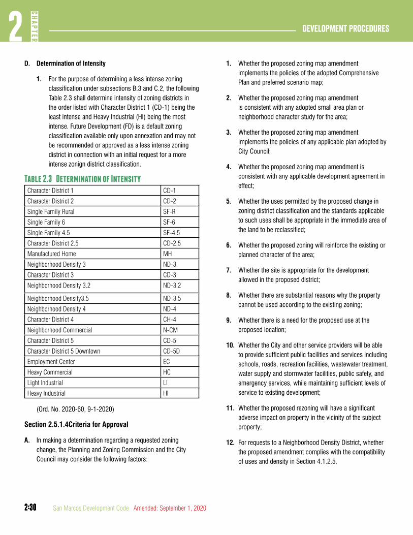
2:30
Development Procedures2
CHAP
TER
2:30 San Marcos Development Code Amended: September 1, 2020
D. Determination of Intensity
1. For the purpose of determining a less intense zoning classification under subsections B.3 and C.2, the following Table 2.3 shall determine intensity of zoning districts in the order listed with Character District 1 (CD-1) being the least intense and Heavy Industrial (HI) being the most intense. Future Development (FD) is a default zoning classification available only upon annexation and may not be recommended or approved as a less intense zoning district in connection with an initial request for a more intense zonign district classification.
Table 2.3 Determination of IntensityCharacter District 1 CD-1
Character District 2 CD-2
Single Family Rural SF-R
Single Family 6 SF-6
Single Family 4.5 SF-4.5
Character District 2.5 CD-2.5
Manufactured Home MH
Neighborhood Density 3 ND-3
Character District 3 CD-3
Neighborhood Density 3.2 ND-3.2
Neighborhood Density3.5 ND-3.5
Neighborhood Density 4 ND-4
Character District 4 CH-4
Neighborhood Commercial N-CM
Character District 5 CD-5
Character District 5 Downtown CD-5D
Employment Center EC
Heavy Commercial HC
Light Industrial LI
Heavy Industrial HI
(Ord. No. 2020-60, 9-1-2020)
Section 2.5.1.4Criteria for Approval
A. In making a determination regarding a requested zoning change, the Planning and Zoning Commission and the City Council may consider the following factors:
1. Whether the proposed zoning map amendment implements the policies of the adopted Comprehensive Plan and preferred scenario map;
2. Whether the proposed zoning map amendment is consistent with any adopted small area plan or neighborhood character study for the area;
3. Whether the proposed zoning map amendment implements the policies of any applicable plan adopted by City Council;
4. Whether the proposed zoning map amendment is consistent with any applicable development agreement in effect;
5. Whether the uses permitted by the proposed change in zoning district classification and the standards applicable to such uses shall be appropriate in the immediate area of the land to be reclassified;
6. Whether the proposed zoning will reinforce the existing or planned character of the area;
7. Whether the site is appropriate for the development allowed in the proposed district;
8. Whether there are substantial reasons why the property cannot be used according to the existing zoning;
9. Whether there is a need for the proposed use at the proposed location;
10. Whether the City and other service providers will be able to provide sufficient public facilities and services including schools, roads, recreation facilities, wastewater treatment, water supply and stormwater facilities, public safety, and emergency services, while maintaining sufficient levels of service to existing development;
11. Whether the proposed rezoning will have a significant adverse impact on property in the vicinity of the subject property;
12. For requests to a Neighborhood Density District, whether the proposed amendment complies with the compatibility of uses and density in Section 4.1.2.5.

2:31
2CH
APTER
Development Procedures
2:31Amended: September 1, 2020 San Marcos Development Code
13. The impact the proposed amendment has with regard to the natural environment, including the quality and quantity of water and other natural resources, flooding, and wildlife management; and
14. Any other factors which shall substantially affect the public health, safety, morals, or general welfare.
(Ord. No. 2020-60, 9-1-2020)
DIVISION 2: APPLICATION FOR OVERLAY DISTRICT
Section 2.5.2.1Purposes and Effect
A. Purpose. An overlay district is a district for which there are established regulations that combine with the regulations of an underlying base district. The purposes of an overlay district shall be to prohibit uses otherwise allowed in the base district, to establish additional or different conditions for uses, or to authorize special uses, together with standards for such uses, not otherwise allowed in the base district.
B. Effect. Adoption of an overlay district does not repeal the base district, and all regulations in the base district shall remain applicable to the uses allowed in the overlay district, except as expressly modified by the regulations for the overlay district. In addition, any special standards set forth in the adopting ordinance shall apply to all development within the overlay district.
Section 2.5.2.2Establishment of Overlay Districts
A. Creation. An overlay district, other than an existing neighborhood regulating plan, shall be established as an amendment to the text of the zoning regulations in Chapter 4 and Chapter 5 of this Land Development Code in accordance with procedures in Section 2.4.1.1. Overlay zoning districts shall also be established on the Zoning Map in accordance with the procedures governing petitions for zoning map amendments in Section 2.5.1.1.
B. Enacting Ordinance. In creating an overlay district other than an existing neighborhood regulating plan, the City Council shall specify the following standards:
1. The intent and purpose of the district;
2. The types of base districts with which the overlay district may be combined;
3. Uses allowed by the overlay district which are not allowed in the base district and standards and conditions applicable to such uses;
4. Uses otherwise permitted within the base district, which are prohibited, limited or restricted within the overlay district, and the standards and conditions constituting such limitations or restriction;
5. Standards to be applied in the overlay which are intended to supersede conflicting standards in the base district; and
6. Special standards to be applied in the overlay district.
DIVISION 3: APPLICATION FOR AN EXISTING NEIGHBORHOOD REGULATING PLAN
Section 2.5.3.1Purpose, Applicability and Effect
A. Purpose. The purpose of an existing neighborhood regulating plan shall be to authorize a special overlay zoning district to ensure compatibility of the development with the surrounding neighborhood.
B. Applicability. An approved existing neighborhood regulating plan shall be required for any property owner requested zoning map amendment to any of the Neighborhood Density Districts described under Section 4.1.2.4
C. Effect. Approval of an existing neighborhood regulating plan authorizes the approval or issuance of subsequent requests and permits for the property subject to the regulating plan.
Section 2.5.3.2Application Requirements
A. An application for approval of an existing neighborhood regulating plan shall be submitted in accordance with the universal application procedures in Section 2.3.1.1 except as otherwise provided in this Division.
(Ord. No. 2019-45, 12-17-19)

2:32
Development Procedures2
CHAP
TER
2:32 San Marcos Development Code Amended: September 1, 2020
B. Existing neighborhood regulating plans shall consist of one or more maps including the following elements where applicable:
1. The location of proposed base zoning districts;
2. The location and number of proposed lots.
3. The location of existing zoning districts surrounding the subject property;
4. The type, location, and number of units of all proposed building types under Section 4.4.6.1;
5. The type, location, and number of units of all existing building types surrounding the subject property;
6. The location of any required and proposed transitional protective yards under Section 7.2.2.1;
7. The location of any required or proposed residential infill compatibility standard under Section 4.4.2.5;
8. The location and type of all required and proposed street types under Section 3.7.1.1;
9. The location of all proposed parking in accordance with Section 7.1.1.1;
10. The location and type of all proposed and existing streestcape types under Section 3.8.1.1; and
11. The location and type of all proposed and existing parkland under Section 3.10.1.1.
Section 2.5.3.3Approval Process
A. The approval process for an existing neighborhood regulating plan follows the procedures established for approval of a zoning map amendment under Section 2.5.1.3.
Section 2.5.3.4Criteria for Approval
A. The following criteria shall be used to determine whether the application for an existing neighborhood regulating plan shall be approved, conditionally approved or denied:
1. The proposed regulating plan conforms with the compatibility of uses and density standards in Section 4.1.2.5.
2. The existing neighborhood regulating plan is consistent with all applicable standards and requirements of the base zoning district and this development code;
3. The existing neighborhood regulating plan is consistent with any adopted small area plan or neighborhood character study for the area.
4. The proposed provision and configuration of roads, electric, water, wastewater, drainage and park facilities conform to the Comprehensive Plan and any approved City Master Plans or Capital Improvement Plans;
Section 2.5.3.5Amendments
A. The Responsible Official may permit the applicant to make minor amendments to the existing neighborhood regulating plan without the necessity of amending the ordinance that established the existing neighborhood regulating plan.
B. If the Director determines that proposed amendments substantially impact the nature of the approval, whether individually or cumulatively, the Director will deny the request for approval of the modifications and provide the applicant with the opportunity to revise the proposed amendments to bring them into compliance with the existing neighborhood regulating plan.
C. If an applicant wishes to make any amendments other than minor amendments approved by the Responsible Official, the amendments will be submitted for review and approval as a revised existing neighborhood regulating plan.
D. Minor amendments shall be as follows:
1. Corrections in spelling, distances and other labeling that do not affect the overall development concept;
2. Changes in building position or layout that are less than ten feet or ten percent of the total building project or area; and
3. Changes in proposed property lines as long as the original total project acreage is not exceeded, and the area of any base zoning district is not changed by more than five percent.
4. Changes in parking layouts as long as the general original design is maintained.
2:33
2CH
APTER
Development Procedures
2:33Amended: September 1, 2020 San Marcos Development Code
DIVISION 4: APPLICATION FOR HISTORIC DISTRICT OR HISTORIC LANDMARK
Section 2.5.4.1Establishment and Expansion of Local Historic Districts or Historic Landmarks
A. General Procedures for Local Historic District. Except as provided in this Section, an application to establish or expand a Historic District (HD) shall be processed and decided in accordance with the procedures governing an application for an overlay district under Section 2.5.2.2.
B. General Procedures for Historic Landmarks. Except as provided in this Section, an application to establish a Historic Landmark shall be processed and decided in accordance with the procedures governing an application for a Zoning Map amendment under Section 2.5.1.1.
Section 2.5.4.2Historic Preservation Commission Action.
Before considering a request for the establishment of a Historic District or Landmark, the Historic Preservation Commission shall carry out the following activities:
A. The Historic Preservation Commission shall cause a report to be prepared for the commission’s final review and approval that:
1. Identifies the historic significance of the exteriors of buildings, structures, features, sites, objects and surroundings in the area of the proposed district or landmark;
2. Reflects the current characteristics of the area of the proposed new Historic District or Landmark.
B. After final approval of the report concerning the area subject to the request, the Historic Preservation Commission shall hold a public hearing on the request for the establishment of the proposed Historic District or Landmark. The report shall be presented at the public hearing.
C. Personal notice and published notice of the public hearing shall be given in accordance with Section 2.3.2.1.
D. After the public hearing the Historic Preservation Commission shall:
1. Formulate a recommendation regarding the establishment of a historic district or landmark for the area subject to the request; and
2. Forward the recommendation and report to the Planning and Zoning Commission for consideration.
Section 2.5.4.3Planning and Zoning Commission Action
A. The Planning and Zoning Commission shall schedule a public hearing on the establishment of a Historic District or Landmark upon receiving the final report and recommendations of the Historic Preservation Commission.
B. The Planning and Zoning Commission shall take into consideration the report and recommendations of the Historic Preservation Commission at a public hearing.
C. The Planning and Zoning Commission shall recommend approval, approval with conditions, or denial of the establishment or expansion of a Historic District or Landmark.
D. Subsequent to the Planning and Zoning Commission’s action, the final report, including the proposed ordinance and the recommendations of both commissions, shall be forwarded to the City Council for action.
Section 2.5.4.4City Council Action
A. Upon receipt of the final report and the recommendations of the Historic Preservation Commission and the Planning and Zoning Commission, the City Council shall take action on the application.
B. Upon approval, the ordinance establishing or expanding a Historic District shall provide for a suitable sign or marker on or near any part of the applicable property indicating that the property has been so designated, and shall set forth any restrictions on development or utilization of the Historic District or Landmark.
C. One copy of the ordinance shall be filed in the office of the County Clerk of the county in which the property is located.
D. Notification of Designation. Upon adoption of the ordinance, personal notice of the designation of the Historic District or Landmark shall be given in accordance with Section 2.3.2.1(b); provided that such notice is required to be given only to owners of property within the Historic District or Landmark.

2:34
Development Procedures2
CHAP
TER
2:34 San Marcos Development Code Amended: September 1, 2020
Section 2.5.4.5Criteria for Approval
In making a determination or recommendation regarding the establishment or expansion of a Historic District or Landmark the following factors should be considered:
A. Historical, architectural and cultural significance of the site(s);
B. Suitability for preservation or restoration;
C. Educational value; and
D. Satisfaction of criteria established for inclusion of the site(s)
and/or district in the National Register of Historic Places.
DIVISION 5: CERTIFICATES OF APPROPRIATENESS
Section 2.5.5.1Purpose, Applicability, Exceptions and Effect
A. Purpose. The purpose of a certificate of appropriateness is to assure that construction, alteration, restoration, relocation, or demolition of a structure, or alterations to the site or appurtenances in a Historic District or at a Historic Landmark is congruous with the historical, architectural or cultural aspects of the district or landmark. Furthermore, the purpose of a certificate of appropriateness is to make certain that historic structures, streets and neighborhoods are preserved and protected.
B. Applicability. A certificate of appropriateness is required for portions of buildings and sites visible from adjacent public rights-of-way, streets or alleys as defined by Section 2.5.5.1(D) prior to undertaking any of the following activities in a local Historic District or at a local Historic Landmark:
Figure 2.1 historic District applicability
2:35
2CH
APTER
Development Procedures
2:35Amended: September 1, 2020 San Marcos Development Code
1. Construction and reconstruction, including fences and walls;
2. Alteration, additions, restoration and rehabilitation;
3. Relocation;
4. Signage;
5. Construction or reconstruction of a parking lot;
6. Construction or reconstruction of an appurtenance;
7. Demolition; and
8. Establishment or alteration of lighting, furniture and seating plans, and/or awnings and umbrellas within public right-of-ways.
C. Exceptions. A certificate of appropriateness is not required for the following activities:
1. Changes in color to a structure’s exterior, unless the structure is located in the Downtown Historic District. Painting of structures in the Downtown Historic District shall be subject to Section 4.5.2.1(J);
2. Interior arrangements for structures in a local Historic District or at a local Historic Landmark;
3. Ordinary maintenance or repair of any exterior feature that does not involve a change in:
a. Design,
b. Material, or
c. Outer appearance.
4. With the written approval of the Responsible Official, construction, reconstruction, alteration, restoration or demolition of any feature which the Building Official or other city department director shall certify is required for the public safety because of an unsafe or dangerous condition.
(Ord. No. 2019-45, 12-17-19)
D. The provisions of this Division 4 apply only to the following areas within the boundaries of each Historic District or Historic Landmark:
1. The lot area between the property line and the facade of any existing building or structure;
2. 25% of the depth of the lot area adjacent to the public right-of-way for vacant lots;
3. The first 50% of the depth of any existing principal building from the facade adjacent to a public right-of-way;
4. Any addition to a building or structure that projects beyond an existing building’s front or side wall and roof plane envelope regardless of distance from the public right-of-way;
5. The entirety of any new principal building construction on a vacant lot;
6. The entirety of any new accessory building construction located in whole or in part in areas Section 2.5.5.1(D)1-3
7. The entirety of any Historic Landmark and its designated boundary area.
E. Effect. Approval of a Certificate of Appropriateness authorizes the applicant to apply for permits allowing construction, alteration, restoration, relocation, or demolition of a structure, or alterations to the site or appurtenances, in a Historic District or at a local Historic Landmark.
Section 2.5.5.2Application Requirements
A. An application for a certificate of appropriateness shall be submitted in accordance with Section 2.3.1.1 except as otherwise provided in this Division 5.
B. A certificate of appropriateness must be approved prior to the issuance of a building permit or any other permit that authorizes construction, alteration, restoration, relocation, or demolition of a structure, or alterations to the site or appurtenances in the local Historic District or at a local Historic Landmark.
2:36
Development Procedures2
CHAP
TER
2:36 San Marcos Development Code Amended: September 1, 2020
Section 2.5.5.3Approval Process
A. Responsible Official Action
1. The Responsible Official shall review the application for a certificate of appropriateness in accordance with the criteria in Section 2.5.5.4 and provide a report and recommendation to the Historic Preservation Commission.
2. The responsible official shall schedule a public hearing and prepare personal notice before the public hearing in accordance with Section 2.3.2.1.
B. Historic Preservation Commission Action
1. The Historic Preservation Commission shall conduct a public hearing concerning the application in accordance with Section 2.3.3.1
2. The Historic Preservation Commission shall approve, approve with conditions or deny the application for a certificate of appropriateness after consideration of the request during the public hearing.
3. If the Historic Preservation Commission determines that a certificate of appropriateness should not be issued, or should be issued subject to conditions, it shall place upon its records the reasons for its determination.
4. The Historic Preservation Commission shall render its decision on the request within forty-five (45) days of the date the application is deemed complete and adequate for review, subject to the supplemental options available under Section 2.5.5.3(c).
Section 2.5.5.4Criteria for Approval
The following criteria shall be used to determine whether the application for a certificate of appropriateness shall be approved, conditionally approved or denied:
A. Consideration of the effect of the activity on historical, architectural or cultural character of the Historic District or Historic Landmark;
B. For Historic Districts, compliance with the Historic District regulations;
C. Whether the property owner would suffer extreme hardship, not including loss of profit, unless the certificate of appropriateness is issued; and
D. The construction and repair standards and guidelines cited in Section 4.5.2.1.
Section 2.5.5.5Appeals
A. General Procedure. An applicant or other interested person within the four-hundred foot (400’) personal notification area may appeal a final decision of the Historic Preservation Commission on an application for a certificate of appropriateness to the Zoning Board of Adjustments within ten days of the Historic Preservation Commission’s action on the application, except for appeals pertaining to property owned by the City of San Marcos. Appeals pertaining to property owned by the City of San Marcos shall be made to the City Council within ten days of the Historic Preservation Commission’s action on the application. The appellate body shall decide the appeal in accordance with Section 2.8.1.1.
B. Supplemental Procedure. In considering the appeal, the appellate body shall:
1. Review the record of the proceeding from which an appeal is sought;
2. Receive an overview of the case from the Responsible Official, including previous recommendations from city staff and the decision of the Historic Preservation Commission;
3. Hear arguments from the party appealing the decision of the Historic Preservation Commission; and
4. Remand the matter back to the Historic Preservation Commission when relevant testimony and newly-acquired evidence is presented that was not previously presented at the time of the hearing before the Historic Preservation Commission.
2:37
2CH
APTER
Development Procedures
2:37Amended: September 1, 2020 San Marcos Development Code
C. Criteria on Appeal
1. The appellate body shall apply the substantial evidence test as established under Texas law to the decision of the Historic Preservation Commission;
2. The burden of proof before the Zoning Board of Adjustments shall be on the appealing party, who must establish that the record reflects the lack of substantial evidence in support of the decision of the Historic Preservation Commission;
3. The appellate body may not substitute its judgment for the judgment of the Historic Preservation Commission on the weight of the evidence.
(Ord. No. 2020-60, 9-1-2020)
Section 2.5.5.6Expiration and Extension
A. Time of Expiration. A certificate of appropriateness shall expire one year from the date it is issued if the proposed activity has not commenced, or two years from the date the certificate is issued, if the proposed activity has not been completed.
B. Extension. A certificate of appropriateness may be extended by the Historic Preservation Commission for a period not to exceed one year from the date required for commencement and two years from the date required for completion of the activity authorized by the certificate.
DIVISION 6: ADMINISTRATIVE CERTIFICATES OF APPROPRIATENESS
Section 2.5.6.1Purpose, Applicability, and Effect
A. Purpose. The purpose of an administrative certificate of appropriateness is to allow the Responsible Official to administratively approve certain applications for the painting of a structure located within the Downtown Historic District. Furthermore, the purpose of an administrative certificate of appropriateness is to make certain these buildings are preserved and protected.
B. Applicability. An administrative certificate of appropriateness is required for the painting of structures located within the Downtown Historic District.
C. Effect. Approval of an administrative certificate of appropriateness authorizes the applicant to paint a structure located within the Downtown Historic District.
Section 2.5.6.2Application Requirements
A. An application for approval of an administrative certificate of appropriateness shall be submitted in accordance with the universal application procedures in Section 2.3.1.1, except as otherwise provided in this Division 6.
B. An administrative certificate of appropriateness must be approved prior to the painting of structures located within the Downtown Historic District.
Section 2.5.6.3Approval Process
A. Responsible Official Action.
1. The Responsible Official shall approve, approve with conditions, or deny an administrative certificate of appropriateness based on the criteria in Section 2.5.6.4.
2. Should the Responsible Official be unable to approve the request, the Responsible Official may forward the request to the Historic Preservation Commission for review and final action at the next available meeting in accordance with Section 2.5.5.1.
Section 2.5.6.4Criteria for Administrative Approval
The following shall be used to determine whether the application for an administrative certificate of appropriateness shall be approved, conditionally approved, or denied.
A. Masonry that has not been previously painted shall not be painted;
B. The proposed paint color shall be selected from an exterior, historic paint palette from any major paint manufacturer;
C. The proposed paint color shall be appropriate to the time period of the structure; and
D. Consideration of the effect of the paint on the material of the building.
2:38
Development Procedures2
CHAP
TER
2:38 San Marcos Development Code Amended: September 1, 2020
Section 2.5.6.5Expiration and Extension
A. Time of Expiration. An administrative certificate of appropriateness shall expire one year from the date it is issued if the proposed activity has not commenced, or two years from the date the certificate is issued, if the prposed activity has not been completed.
B. Extension. An administrative certificate of appropriateness may be extended by the Responsible Official for a period not to exceed one year from the date required for commencement and two years from the date required for completion of the activity authorized by the certificate.
(This Division was approved by Ord. No. 2019-45, 12-17-19)
DIVISION 7: REGULATING PLAN
Section 2.5.7.1Purpose, Applicability and Effect
A. Purpose. The purpose of a regulating plan shall be to designate Character Districts, streets, parkland, and any special requirements for any area zoned Planning Area District and to regulate development within the same Planning Area District.
B. Applicability. An approved regulating plan shall be required prior to any development, re-development, improvement or construction, or substantial modification of or on any property within a Planning Area District, and as a condition to submission, consideration, or approval of any other development application or permit.
C. Effect. Approval of a regulating plan authorizes the approval or issuance of subsequent requests and permits for the property subject to the regulating plan.
Section 2.5.7.2Application Requirements
A. An application for approval of a regulating plan shall be submitted in accordance with the universal application procedures in Section 2.3.1.1 except as otherwise provided in this Division 5.
B. An application for a regulating plan shall not be approved unless the following applications and development permits, where applicable, have been approved and remain in effect for the land included in the regulating plan:
1. All legislative approvals needed to authorize the proposed uses for the land;
2. Any requests for relief identified in Section 2.8.1.1;
3. A watershed protection plan (phase 1), and;
4. A transportation plan.
C. Regulating plans shall consist of one or more maps showing the following for each pedestrian shed in the Planning Area District, in compliance with the standards described in Section 4.4.3.7:
1. Character District Allocation;
2. Parkland;
2:39
2CH
APTER
Development Procedures
2:39Amended: September 1, 2020 San Marcos Development Code
3. Street Network; and
4. Special Requirements, if any.
Section 2.5.7.3Approval Process
A. Responsible Official Action. The Responsible Official shall approve, approve with conditions, or deny a regulating plan based on the criteria in Section 2.5.6.4.
Section 2.5.7.4Criteria for Approval
A. The following criteria shall be used to determine whether the application for a regulating plan shall be approved, conditionally approved or denied:
1. The regulating plan is consistent with all applicable standards and requirements in Section 4.4.3.7, and any prior approvals listed in Section 2.5.6.2;
2. The proposed provision and configuration of roads, electric, water, wastewater, drainage and park facilities conform to the Comprehensive Plan and any approved City Master Plans or Capital Improvement Plans;
3. The proposed provision and configuration of roads, water, electric, wastewater, drainage and park facilities, and easements and rights-of-way are determined to be adequate to serve each phase of the development in accordance with Section 3.5.1.1.
4. The schedule of development is feasible and prudent, and assures that the proposed development shall progress to completion within the time limits proposed; and
5. The location, size and sequence of the phases of development as required in Section 4.4.3.7 proposed assures orderly and efficient development of the land subject to the regulating plan.
Section 2.5.7.5Appeals
The applicant or other interested person within the notification area may appeal a decision on an application for approval of a regulating plan to the Planning and Zoning Commission in accordance with Section 2.8.1.1.
article 6: WaTERShED PROTECTION PLaNS
DIVISION 1: APPROVAL AND APPLICATION PROCESS
Section 2.6.1.1Purpose, Applicability, Exceptions and Effect
A. Purpose of a Watershed Protection Plan Phase 1 or Qualified Watershed Protection Plan Phase 1. The purpose of a watershed protection plan phase 1 or a qualified watershed protection plan phase 1 shall be to apply all Federal, State and Local environmental and flood control standards to a conceptual development design by establishing terms and conditions for approval of development applications and entitlements.
B. Purpose of a Watershed Protection Plan Phase 2 or Qualified Watershed Protection Plan Phase 2. The purpose of a watershed protection plan phase 2 or a qualified watershed protection plan phase 2 is to assure that the standards and conditions imposed under the conceptual development design and any additional specific standards applicable to the approval of construction permits shall be met at the time of development of the property.
C. General Applicability. A watershed protection plan or a qualified watershed protection plan is required within the city limits and within the city’s extraterritorial jurisdiction.
D. Applicability of a Qualified Watershed Protection Plan 1 or 2. A qualified watershed protection plan is required when any of the following requests are made for developments greater than forty (40) acres:
1. A request for an increase in impervious cover requiring a mitigation plan;
2. A request for reclamation of land in the 100-year floodplain or within a water quality zone or buffer zone; or
3. The development of twenty (20) acres or more of land within the 100-year floodplain.
(Ord. No. 2020-60, 9-1-2020)
E. Exceptions. A watershed protection plan or a qualified watershed protection plan is not required for:
2:40
Development Procedures2
CHAP
TER
2:40 San Marcos Development Code Amended: September 1, 2020
1. Any land that is expressly exempted from the environmental standards contained in Chapter 6, of this Development Code.
2. The construction of a single family home where a plat is not required by Section 3.1.1.1.
F. Effect.
1. Approval of a watershed protection plan or a qualified watershed protection plan entitles the applicant to seek approval of subsequent development applications.
2. The approval or conditional approval of a watershed protection plan (phase 1 and phase 2) or qualified watershed protection plan shall constitute conditions of approval of any subordinate development applications for the land subject to such plan, and such development applications must be consistent with such plan.
3. The following elements shall be incorporated within any subordinate development application consistent with the approved or conditionally approved watershed protection plan (phase 1 and phase 2) or qualified watershed protection plan:
a. Demarcation of all water quality zones and buffer zones for the property subject to the development application;
b. Location of impervious cover allocated to the property, including areas of intensified impervious cover, subject to the development application, or to be allocated among lots or tracts into which the property is to be divided;
c. For land in the Edwards Aquifer Recharge or Transition Zones, identification of all sensitive features and demarcation of all sensitive feature protection zones for the property subject to the development application;
d. The contours of any land authorized for reclamation; and
e. The location of LID practices that replace impervious cover or mitigate water quality from runoff of impervious cover.
G. Modification of Previously Approved Plans. The property owner shall submit a modified watershed protection plan (phase 1 or phase 2, as applicable) or qualified watershed protection plan for approval where the following activities are proposed:
1. Any change in the nature or character of the development from that covered by the approved plan, or any change that would significantly impact the ability of the approved plan to preserve water quality; and
2. Any development on land previously identified as undeveloped in the approved plan.
Section 2.6.1.2Application Requirements
A. Phased Plans. An application for a watershed protection plan may be prepared and acted upon by the City in two phases.
1. A watershed protection plan (phase 1) shall be prepared prior to approval of a conceptual development plan and prior to any development applications where no specific plan of development is portrayed.
2. A watershed protection plan (phase 2) shall be prepared prior to approval of the first development application that portrays a specific plan of development but at no time later than a development application or permit authorizing land disturbance including:
a. Final subdivision or development plat;
b. Minor subdivision plat or replat, if the land is located in any of the following areas:
1. Edwards Aquifer Recharge Zone, Transition Zone, and Contributing Zone within the Transition Zone;
2. A floodplain, water quality, or buffer zone;
3. The San Marcos river protection zone; or
4. San Marcos river corridor.
c. Public improvement construction plan; or
d. Site development permit.

2:41
2CH
APTER
Development Procedures
2:41Amended: September 1, 2020 San Marcos Development Code
3. An applicant may elect to submit a watershed protection plan (phase 2) in lieu of a watershed protection plan (phase 1).
4. The watershed protection plan (phase 2) shall be consistent with the watershed protection plan (phase 1).
(Ord. No. 2019-45, 12-17-19)
B. An application for a phase 2 watershed protection plan or phase 2 qualified watershed protection plan requires proof of compliance with the City’s flood prevention ordinance Chapter 39, all federal regulations pertaining to the protection and mitigation based on proposed modifications of a floodplain constituting wetlands or waters of the United States protected under Section 404 of the Clean Water Act.
C. An application for a watershed protection plan phase 1 or 2 or a qualified watershed protection plan shall be submitted in accordance with the universal application procedures in Section 2.3.1.1 except as otherwise provided in this Article 5.
D. A watershed protection plan or a qualified watershed protection plan shall include all land contiguous to and in the same ownership with the land subject to the plat application or site permit.
E. An application for a watershed protection plan phase 2 may be applied for and approved as an element of a comprehensive site permit or public improvement construction plan when the land is not located in any of the following zones:
1. Edwards Aquifer Recharge Zone;
2. A floodplain, water quality, or buffer zone;
3. The San Marcos river protection zone; or
4. San Marcos river corridor.
Section 2.6.1.3Approval Process
A. Responsible Official Action. The Engineering Director is the Responsible Official for watershed protection plans and qualified watershed protection plans.
1. The Responsible Official shall initially decide an application for a watershed protection plan phase 1 or 2 based on the criteria in Section 2.6.1.4.
2. The Responsible Official may attach such conditions to approval of a watershed protection plan phase 1 or 2 as are necessary to assure that the plan meets water quality standards, based on the recommendation of the Engineering Director, a qualified geologist, or a Texas-licensed professional engineer.
B. Responsible Officials Action with regards to a Qualified Watershed Protection Plan Phase 1 or 2
1. The Responsible Official shall review the application and schedule an informative meeting with the Planning and Zoning Commission prior to providing approval.
(Ord. No. 2020-60, 9-1-2020)
Section 2.6.1.4Criteria for Approval
The following criteria shall be used to determine whether the appli-cation for a watershed protection plan or a qualified watershed pro-tection plan shall be approved, approved with conditions, or denied.
A. Edwards Aquifer Zones - Factors. Where land subject to the plan lies in whole or in part within the Edwards Aquifer recharge or transition zones:
1. Whether the plan is consistent with approved legislative applications for the land subject to the plan;
2. Whether the plan meets the standards in Chapter 6 (except as to the components of a mitigation plan for a qualified watershed protection plan that vary from Chapter 6) and Chapter 3, Article 9;
3. Whether any proposed mitigation plan or enhanced geological assessment offsets the impacts to water quality resulting from increased development within a buffer zone;
4. Whether any proposed increase of impervious cover is warranted beyond that otherwise allowed by right for the land within the plan area; and
5. Whether the plan is consistent with any proposed clustering or development transfers outside the plan area.
(Ord. No. 2020-60, 9-1-2020)
B. Other Water Quality Zones - Factors. Where land subject to the plan lies in whole or in part within a floodplain, water

2:42
Development Procedures2
CHAP
TER
2:42 San Marcos Development Code Amended: September 1, 2020
quality, or buffer zone located outside the Edwards Aquifer recharge or transition zones:
1. Whether the plan is consistent with approved legislative applications for the land subject to the plan;
2. Whether the plan meets the standards in Chapter 6 (except as to the components of a mitigation plan for a qualified watershed protection plan that vary from Chapter 6) and Chapter 3, Article 9;
3. Whether any proposed mitigation plan offsets the impacts to water quality resulting from increased development within a buffer zone or reclamation of water quality and / or buffer zone; and
4. Whether the plan is consistent with any proposed clustering or development transfers outside the plan area.
(Ord. No. 2020-60, 9-1-2020)
C. Reclaimed Land - Factors. For developments where reclamation of land within the 100-year floodplain is proposed:
1. Whether the reclamation concept plat (which is an element of watershed protection plans and qualified watershed protection plans when reclamation is proposed) is consistent with approved legislative applications for the land subject to the plan, including expressly any master drainage plan elements applicable to the land;
2. Whether the reclamation concept plat meets the general standards in Chapter 6 (except as to the components of a mitigation plan for a qualified watershed protection plan that vary from Chapter 6), Chapter 3, Article 9, and the City’s Flood Damage Prevention Ordinance;
3. Whether any adverse impacts have been appropriately mitigated.
(Ord. No. 2020-60, 9-1-2020)
D. Conditions. The applicable decision-maker or the City Council on appeal may attach such conditions to approval of a qualified watershed protection plan or either phase of a watershed protection plan as are necessary to assure that the plan meets water quality standards, based on the recommendation of the Responsible Official, a qualified geologist, or a Texas-licensed
professional engineer. Conditions may include a requirement to prepare or modify a mitigation plan.
E. No watershed protection plan or qualified watershed protection plan shall be approved or approved with conditions unless proper documentation is submitted to the Responsible Official indicating that all applicable federal, state, and local permits, approvals, and clearances have first been obtained including any required floodplain permit under Chapter 39 of the City Code.
Section 2.6.1.5Appeals and Expiration
A. Appeal
1. The applicant for either phase of a watershed protection plan or any interested person within the notification area may appeal the decision of the Responsible Official to the Planning and Zoning Commission.
2. For a qualified watershed protection plan, the decision of the Planning and Zoning Commission may be appealed to the City Council, in accordance with Section 2.8.1.1.
B. Expiration. A watershed protection plan (phase 1 and/or phase 2), is expired in accordance with Section 2.3.5.3 if an active permit for development of the land is not in place within two (2) years of the date of approval of either phase of the plan.

2:43
2CH
APTER
Development Procedures
2:43Amended: September 1, 2020 San Marcos Development Code
article 7: SITE PERMIT
DIVISION 1: APPROVAL AND APPLICATION PROCESS
Section 2.7.1.1Purpose, Applicability, Exceptions and Effect
A. Purpose. The purpose of a site permit shall be to apply the standards contained in this Development Code to a specific development. A site permit assures that preparatory development and construction activities on the development site shall meet city standards prior to soil disturbance, development, construction, demolition or placement of a structure on the tract, parcel or lot.
B. Applicability. Approval of a site permit is required prior to any non-exempt development of land within the city limits or within the city’s extraterritorial jurisdiction.
C. A site permit is required for all development meeting any of the criteria listed below.
1. Existing non-residential and multifamily uses that are proposing to add greater than five thousand (5,000) square feet of impervious cover.
2. Existing non-residential and multifamily uses that expand more than fifty (50) percent of the building’s originally constructed floor area.
3. All non-residential and multi-family development located partially or completely on a lot within any of the following sensitive environmental regions:
a. Over the Edwards Aquifer Recharge Zone, Transition Zone, and Contributing Zone within the Transition Zone;
b. An identified floodplain, water quality or buffer zone;
c. The San Marcos river protection zone;
d. The San Marcos river corridor; or
e. Wetlands or other jurisdictional water.
(Ord. No. 2019-45, 12-17-19)
D. All other development shall require submission of a small site permit with the applicable construction permit application
demonstrating compliance with the requirements of this Development Code.
E. Non-exempt development activities that do not meet the criteria above and do not require a construction permit shall require submission of a small site permit demonstrating compliance with any applicable standards.
F. Exemptions. The requirement to have a site permit does not apply in whole or in part to the following activities or land uses:
1. Clearing that is necessary only for surveying purposes.
2. Agricultural uses. Documentation is required.
3. Other activities which are exempted from site permit requirements pursuant to this Development Code.
(Ord. No. 2019-45, 12-17-19)
G. Effect. Approval of a site permit authorizes site preparatory activities other than construction or placement of a structure on the land, subject to the terms of the permit and for the duration of the permit. Approval of a site permit also authorizes the issuance of a construction permit.
Section 2.7.1.2Application Requirements
A. An application for a site permit shall be submitted in accordance with the universal application procedures in Section 2.3.1.1 except as otherwise provided in this Article 7.
B. A site permit required under Section 2.7.1.1 shall be sealed by an engineer licensed in the State of Texas.
C. A small site permit shall be prepared in accordance with the universal application procedures in Section 2.3.1.1 but shall not require a licensed engineer.
D. Fiscal Security. Fiscal security shall be applicable for all sites where no building permit is associated with the project.
1. Prior to the site permit being issued, the City shall collect from the property owner sufficient fiscal security to provide for the permanent stabilization of areas of soil disturbance associated with the development and construction activities to be permitted. The required security shall be in the amount of 125% of the permanent stabilization cost estimate approved by the Responsible

2:44
Development Procedures2
CHAP
TER
2:44 San Marcos Development Code Amended: September 1, 2020
Official. The security shall be in the form of one of the following:
a. A cash escrow with the City;
b. An irrevocable letter of credit drawn upon a state or national bank that has a regular business office in the State of Texas that authorizes the City to draw upon the letter of credit by presenting to the issuer only a sight draft and a certificate signed by an authorized representative of the City attesting to the City’s right to draw funds under the letter of credit;
2. Provision of this security in no way relieves the permittee from responsibility for completing permanent stabilization measures in accordance with the approved site plan. The security will be returned to the permittee following site final inspection approval and issuance of the certificate of occupancy or certificate of acceptance. In the event the permittee fails to complete required site-wide permanent stabilization, the security will be utilized to accomplish permanent stabilization of the site.
Section 2.7.1.3Processing of Application and Decision
A. Responsible Official Action. The Responsible Official shall approve, approve with conditions, or deny a site permit subject to appeal as provided in Section 2.8.1.1.
Section 2.7.1.4Criteria for Approval
A. Criteria. The following criteria shall be used to determine whether the site permit application shall be approved, approved with conditions, or denied:
1. The site plan is consistent with all prior approvals;
2. All standards of this Development Code, as applicable, have been and remain satisfied including:
a. All standards applicable to the district in which the property is located;
b. Standards applicable to a water quality protection plan;
c. Special dimensional and design standards applicable within an overlay district to which the use is subject;
d. Conditional use permit (CUP) requirements;
e. Any standards imposed as conditions for approval of a variance or alternative compliance; and
f. Must be served adequately by essential public facilities and services per Chapter 3, Article 5.
(Ord. No. 2019-45, 12-17-19)
Section 2.7.1.5Appeals and Relief Procedures
A. Appeal. The applicant for a site permit may appeal the decision of the initial decision-makers to the Planning and Zoning Commission in accordance with Section 2.8.1.1.
Section 2.7.1.6Expiration and Extension
A. A site permit is subject to the expiration and extension requirements in Section 2.3.5.1.
Section 2.7.1.7Completion and Acceptance
A. Prior to Occupancy. All improvements required by the site permit must be completed in accordance with applicable regulations and standards prior to the issuance of a certificate of occupancy for the last building on the site.
B. If the construction of any improvement is to be deferred until after the issuance of a temporary certificate of occupancy, the property owner shall first provide sufficient security to the City in the form of a cash escrow to ensure completion of the improvements.
C. Prior to Final Acceptance. The property owner shall submit an engineer’s letter of concurrence certifying that all stormwater detention and water quality management facilities are in conformance with the approved plans and specifications before the City may finally accept such facilities.
DIVISION 2: COMMON SIGNAGE PLAN
Section 2.7.2.1Applicability and Effect
A. Applicability. Prior to the issuance of a sign permit for one or more buildings or businesses on the same lot or parcel of land, a common signage plan approved by the Responsible Official in accordance with the requirements of this section may be submitted.
2:45
2CH
APTER
Development Procedures
2:45Amended: September 1, 2020 San Marcos Development Code
B. Effect. Approval of a common signage plan authorizes the submittal of a sign permit in conformance with the common signage plan.
Section 2.7.2.2Application Requirements
A. An application for a common signage plan shall be submitted in accordance with the universal application procedure in Section 2.3.1.1.
Section 2.7.2.3Responsible Official Action
A. The Responsible Official shall review the proposed application against the requirements in Section 7.3.1.1 and other applicable technical requirements of the City.
B. Following review, the Responsible Official shall approve, approve with conditions that bring the application into conformance with this Development Code and other applicable technical requirements of the City or deny the application.
C. If the application is disapproved, the reasons for such disapproval shall be stated in writing and provided to the applicant, specifying the provisions with which the application does not comply. A revised application may be submitted to the Responsible Official for further consideration.
D. An appeal of the Responsible Official’s action may be filed with the Planning and Zoning Commission in accordance with Section 2.8.1.1.
Section 2.7.2.4Enforcement of an Approved Plan
A. It shall be the responsibility of the applicant to enforce the terms of the common signage plan and a current copy of such plan, including any amendments, must be kept on file by the Responsible Official.
Section 2.7.2.5Existing Signs Not Conforming to Common Signage Plan
A. All signs not conforming to the proposed common signage plan shall be required to comply at the time of application for a new sign permit.
DIVISION 3: CONSTRUCTION PERMITS
Section 2.7.3.1Purpose, Applicability, Exceptions and Effect
A. Purpose. Approval of a construction permit confirms that the application conforms to all requirements of this Development Code pertaining to the construction of the proposed structure.
B. General Applicability. A construction permit is required prior to the construction, demolition, alteration or placement of a structure on a lot, tract or parcel.
1. Applicability related to Building Permits. An application for a building permit is required within the city limits, or in the city’s extraterritorial jurisdiction when provided for in a development agreement or when tying into the City’s water, wastewater or electric utility.
2. Applicability related to Certificates of Occupancy. A certificate of occupancy must be obtained prior to habitation, occupation, or use of any structure, within the city limits, or in the city’s extraterritorial jurisdiction when provided for in a development agreement.
3. Applicability to Demolition Permits for Historic Age Resources. All applications for demolition of a building shall be subject to review in accordance with Division 4 of this Article for a determination whether historic age resources are affected before the application may be approved and a permit issued.
C. Effect. Approval of a construction permit authorizes the property owner to construct, demolish, alter or place the structure on the lot, tract or parcel in accordance with the terms of the permit.
1. Approval of a certificate of occupancy authorizes habitation, occupancy, or use of the structure, in accordance with the terms of the certificate.
(Ord. No. 2019-41, 11-19-19)
Section 2.7.3.2Application Requirements
A. General Requirements. An application for a construction permit shall be submitted in accordance with the universal application procedures in Section 2.3.1.1.
2:46
Development Procedures2
CHAP
TER
2:46 San Marcos Development Code Amended: September 1, 2020
B. An application for a construction permit shall demonstrate compliance with the provisions of this Development Code and
City Code.
Section 2.7.3.3Approval Process
A. Responsible Official Action. The Responsible Official shall approve, approve with conditions, or deny a construction permit based on the standards included in this Development Code and City Code subject to appeal as provided in Section 2.8.1.1.
Section 2.7.3.4Criteria for Approval
A. The Responsible Official shall apply the following criteria in deciding the application for a construction permit:
1. The application generally conforms to all prior approved development applications for the property and any applicable deviation granted from the standards otherwise applicable to the permit;
2. The structure and the location of the structure on the property is in accordance with all prior approved development applications;
3. The proposed plan for construction, demolition, alteration or placement conforms to the building code and other applicable construction codes adopted by the City;
4. Full payment of any applicable impact fees payable under City Code Chapter 86;
5. Where a change of use in an existing structure is proposed, the use conforms to the use regulations governing the property;
6. The structure, following inspection by the Building Official, was built in conformity with all applicable standards and requirements of this Development Code, all standards and requirements of each applicable development application and any granted deviation, and the building code, as incorporated in the City Code of Ordinances, as may be modified from time to time.
7. All outstanding permit requirements have been addressed.
8. When the property lies within a special flood zone, the structure is in compliance with Chapter 39 and FEMA standards as applicable.
Section 2.7.3.5Expiration and Extension and Revocation
A. Expiration. A construction permit expires in accordance with Codes adopted under Chapter 14 of the City Code.
B. Extension and Reinstatement. A construction permit may be extended in accordance with the Codes adopted under Chapter 14 of the City Code.
C. Revocation of Permit. The Responsible Official may institute proceedings to revoke a construction permit under Section 2.3.7.5.
DIVISION 4: DEMOLITION REVIEW FOR HISTORIC AGE RESOURCES
Section 2.7.4.1Purpose, Applicability, Exceptions, and Effect
A. Purpose. The purpose of this process is to provide criteria to prevent or minimize unnecessary damage to the quality and character of the city’s historic resources by requiring the review of any request for demolition of a building meeting the criteria in this Division to enable a determination of its historic significance, and to provide the public, other interested preservation-based organizations, and city staff an opportunity to work with the property owner on alternative solutions to demolition where possible.
B. 90-Day Review Period for Certain Buildings. A demolition permit shall not be issued until at least 90 days after the date of filing of a complete application for the demolition of any building or part thereof:
1. located inside the My Historic SMTX historic resources survey (the “Historic Resources Survey”) boundaries, as amended or supplemented, evaluated therein as a high or medium preservation priority; or
2. located outside the Historic Resources Survey boundaries, as amended or supplemented, that is listed on the National Register of Historic Places (NRHP), a Recorded Texas Historic Landmark (RTHL), or at least 80 years of age.
2:47
2CH
APTER
Development Procedures
2:47Amended: September 1, 2020 San Marcos Development Code
3. No building, nor any part thereof, subject to this Section maybe demolished or removed unless a permit authorizing such demolition or removal has been issued by the city.
C. Exceptions. This Section does not apply to:
1. the demolition of a building, or part thereof, within a local historic district or that is a local historic landmark and for which a certificate of appropriateness for demolition is required; or
2. the demolition of a building, or part thereof, the condition of which is determined by the Chief Building Official or the Fire Marshal to be an imminent threat to public safety; or
3. the demolition of a building, or part thereof, identified in the Historic Resources Survey as not historically significant; or
4. the demolition of a building, or part thereof, located on a property identified in the Historic Resources Survey that is not at least 50 years old or older.
(Ord. No. 2019-41, 11-19-19)
Section 2.7.4.2Application Requirements
A. An application to demolish a building, or part thereof, subject to this Division shall conform to the requirements for a construction permit and shall be submitted in accordance with the universal application procedures in Section 2.3.1.1, subject to the requirements of this Division.
(Ord. No. 2019-41, 11-19-19)
Section 2.7.4.3Process
A. Responsible Official Action
1. The responsible official shall complete the review of the application, and determine if the application concerns a building, or part thereof, subject to Section 2.7.4.1(B)
2. If the application is determined by the responsible official to concern a building subject to Section 2.7.4.1(B), the responsible official shall schedule a meeting and public hearing before the Historic Preservation Commission under Subsection (B). The responsible official shall send notice of the request for demolition and of the public hearing within 20 days of the complete application being submitted to the following:
a. San Marcos Daily Record (published notice) in accordance with Section 2.3.2.1(A);
b. The owners of real property Owners within 400 feet of the lot or tract of land subject to the request (mailed notice) in accordance with Section 2.3.2.1(B);
c. Historic Preservation Commission (E- Notice);
d. Planning and Zoning Commission (E-Notice);
e. Neighborhood Commission (E-Notice);
f. President of the Heritage Association (E- Notice);
g. Hays County Historical Commission (E- Notice);
h. Neighborhood Commission (E- Notice);
i. President of the Council of Neighborhood Associations (“CONA”) (ENotice);
j. Certified Local Government Coordinator with the Texas Historical Commission (E-Notice);
k. Executive Director of Preservation Texas (E-Notice); and
l. Any interested persons signed up to receive Notice of Application under Section 2.3.2.1 (E-Notice).
2:48
Development Procedures2
CHAP
TER
2:48 San Marcos Development Code Amended: September 1, 2020
B. Historic Preservation Commission Action
1. The Historic Preservation Commission shall hold a public hearing to consider the demolition delay period and allow the discussion of alternatives to demolition and methods for the potential preservation of historic character.
2. The Historic Preservation Commission shall consider the criteria for eligibility in accordance with Section 2.5.4.5 and the potential for preservation of historic character when determining the demolition delay period.
a. If the building, or part thereof, is not initially determined to be historically significant, the demolition permit shall be issued following the Commission’s determination without further notice, subject to the requirements of other applicable ordinances.
b. If the building is determined to be historically significant, and there is potential for the preservation of historic character then the Commission may extend delaying the issuance of the demolition permit to allow all potentially interested parties to take whatever steps deemedappropriate to accomplish the preservation of the building. The delay may be extended for good cause by the Commission for an additional 90 days but in no event shall the total extension be for more than 180 days.
(Ord. No. 2019-41, 11-19-19)
Section 2.7.4.4Violation and Penalties
A. It is a violation of this Division to demolish or remove a building subject to this Division, or part of or addition to such building, without having been issued a permit from the city specifically authorizing the demolition or removal. A person who violates this ordinance shall be subject to a fine of $2,000.00. A culpable mental state is not required to establish a violation of this ordinance.
B. In addition to the assessment of any criminal penalties, the city may pursue any remedies available at law or in equity, including injunctive relief, to enforce the provisions of this ordinance.
(Ord. No. 2019-41, 11-19-19)
article 8: RELIEF PROCEDURES
DIVISION 1: APPEALS
Section 2.8.1.1Purpose, Applicability and Effect
A. Purpose. The purpose of an appeal is to contest a final quasi-judicial or administrative decision on a development application based upon alleged misapplication of the criteria for approval of the application.
1. An appeal shall not be used as a means of amending, varying or otherwise modifying the standards of this Development Code that apply to the development application.
B. Applicability. A final administrative decision on a development application authorized by this Development Code, may be appealed to the board or commission designated in this Development Code, where no board is designated appeals are decided by the Zoning Board of Adjustments.
1. A final quasi-judicial decision on a development application may be appealed only if expressly provided for in the regulations establishing the procedure by which the decision was made.
2. No appeal shall be taken from a legislative decision authorized under this Development Code.
C. Effect. The granting of an appeal supersedes the decision from which appeal was taken, and results in approval, conditional approval or denial of the development application for which approval was sought.
Section 2.8.1.2Application Requirements
A. Who May Appeal. The applicant and any owner of property within the area for personal notice, if applicable, may appeal a final decision on a development application to the appellate body designated by this Development Code, if any.
B. The appeal shall contain a written statement of the reasons why the final decision is erroneous.
C. The appeal shall be accompanied by the fee established by the City Council.
2:49
2CH
APTER
Development Procedures
2:49Amended: September 1, 2020 San Marcos Development Code
D. An appeal by an applicant shall be accompanied by a copy of the development application on which the initial decision was rendered.
E. Time for Filing Appeal. A written appeal must be filed with the Responsible Official within ten (10) working days from the final decision on the development application.
Section 2.8.1.3Approval Process
A. Responsible Official Action
1. Upon receipt of a written appeal, the Responsible Official shall compile all documents constituting the record of the decision on appeal and transmit the record to the appellate body.
2. The Responsible Official shall provide notice of the appeal under Section 2.3.2.1 and conduct a public hearing in accordance with Section 2.3.3.1.
3. Notification of decision on the appeal shall be provided to the appellant and the applicant in accordance with Section 2.3.2.1.
B. Stay of Proceedings. Receipt of a written appeal of a decision on a development application stays all proceedings of the City in furtherance of the decision from which appeal is taken, including without limitation acceptance, processing or issuance of any subordinate development applications, and any development activities authorized by initial approval of the development application.
1. The stay shall be lifted only if the Responsible Official certifies in writing to the appellate body that a stay would cause imminent peril to life or property.
2. Thereafter, the stay may be reinstated only by order of the appellate body or a court of record, on application, after notice to the Responsible Official, for due cause shown.
C. Appellate Body Action
1. The initial public hearing on the appeal shall be held within twenty-five (25) working days after the filing of the appeal with the Responsible Official, unless a different time is prescribed by the provisions of this Chapter.
2. Decision on Appeal. The appellate body shall decide the appeal within thirty (30) working days of the close of the public hearing. The appellate body shall affirm, reverse or modify the decision from which the appeal was taken.
Section 2.8.1.4Criteria
A. The appellate body shall apply the same criteria that govern the decision on the development application under the provisions of this Chapter 2 unless otherwise stated in this Development Code.
Section 2.8.1.5Expiration and Extension
A. For purposes of determining expiration or extension periods under this Development Code, the date of the appellate body’s granting of relief on an appeal is the date on which the development application is deemed approved.
DIVISION 2: VARIANCES
Section 2.8.2.1Purpose, Applicability and Effect
A. Purpose. The purpose of a variance application is to vary one or more standards applicable to a development application, subject to the limitations set forth in this section or elsewhere in this Development Code.
1. A variance application shall not be used as a means of amending the text of this Development Code or of changing a zoning district, or other legislative classification of the property for which the variance is sought.
2. A variance application shall not be used as a means to contest the applicability of a standard to a development application, an exemption determination, or a decision on a development application.
3. Variance applications shall be decided by the Zoning Board of Adjustments. A variance application may not be used to vary standards applicable to an application for a legislative decision.
B. Applicability. A variance application may be filed to modify any standard other than a use standard which is applicable to an administrative or quasi-judicial development application, unless otherwise specified by this Development Code.

2:50
Development Procedures2
CHAP
TER
2:50 San Marcos Development Code Amended: September 1, 2020
C. Effect. The granting of a variance application in whole or in part authorizes the applicant to submit a development application that complies with the standard as varied or modified, and authorizes the decision-maker to evaluate the application using the varied standard, for the duration of the variance.
Section 2.8.2.2 Application Requirements
A. Who May Apply. A variance application may be filed by a property owner or the applicant for any administrative or quasi-judicial development application.
B. A variance application shall be prepared in accordance with Section 2.3.1.1.
C. The variance application shall contain a detailed written statement of the reasons why the standards requested to be varied should not be applied.
D. The variance application shall be accompanied by the fee established by the City Council.
E. A variance application shall be accompanied by illustrations or other documents showing the effect of the requested variance on development to be proposed in the application.
F. Time for Filing Application. A variance application must be filed prior to filing of the development application for which the variance is requested.
Section 2.8.2.3Approval Process
A. Responsible Official Action
1. Upon receipt of a variance application, the Responsible Official shall transmit the application to the Zoning Board of Adjustments for processing and determination in accordance with Section 2.3.1.1
2. The Responsible Official shall provide personal notification of the public hearing before the Zoning Board of Adjustments in accordance with Section 2.3.2.1.
3. The Responsible Official shall provide a report and analysis on the criteria in Section 2.8.2.4 to the Zoning Board of Adjustments.
4. The Responsible Official shall conduct a public hearing in accordance with Section 2.3.3.1.
5. The Responsible Official shall notify the applicant of the decision on the variance application in the manner provided in Section 2.3.2.1 of this Development Code.
B. Zoning Board of Adjustments Action
1. The Zoning Board of Adjustments shall hold a public hearing and grant, grant subject to conditions or deny the request for one or more variances.
C. Burden of Proof. The applicant bears the burden of proof to demonstrate that a variance to the standards applicable to a development application should be granted.
Section 2.8.2.4Criteria for Approval
A. In making its decision on the variance application, the Zoning Board of Adjustments shall apply the following criteria:
1. There are special circumstances or conditions arising from the physical surroundings, shape, topography or other feature affecting the land subject to the variance application, such that the strict application of the provisions of this Development Code to the development application would create an unnecessary hardship or inequity upon or for the applicant, as distinguished from a mere economic impact, an inconvenience, frustration of objectives in developing the land, not permitting the highest and best use for the land, or depriving the applicant of the reasonable and beneficial use of the land;
2. The circumstances causing the hardship do not similarly affect all or most properties in the vicinity of or similarly classified as the applicant’s land;
3. The variance is necessary for the preservation and enjoyment of a substantial property right of the applicant;
4. Granting the variance application shall not be detrimental to the public health, safety or welfare, or injurious to other property within the area;
5. Granting the variance application shall not have the effect of preventing the orderly use and enjoyment of other land within the area in accordance with the provisions of this Development Code, or adversely affect the rights of owners or residents of surrounding property;
2:51
2CH
APTER
Development Procedures
2:51Amended: September 1, 2020 San Marcos Development Code
6. Granting the variance application is consistent with any special criteria applicable to varying particular standards, as set forth in Chapters 3 through 7 of this Development Code;
7. The hardship or inequity suffered by applicant is not caused wholly or in substantial part by the applicant;
8. The request for a variance is not based exclusively on the applicant’s desire for increased financial gain from the property, or to reduce an existing financial hardship, and;
9. The degree of variance requested is the minimum amount necessary to meet the needs of the applicant and to satisfy the standards in this Section.
Section 2.8.2.5Expiration and Extension
A. Expiration on Failure to File Application. Where the decision-makers for the variance application and the development application are different, a variance to a standard applicable to the development application shall expire within ninety (90) days of the date the variance application is granted, unless the property owner or applicant files the development application with the City in accordance with this Development Code within such period. The decision-maker may extend the time for filing the development application for good cause shown, but in any event, the expiration date for the variance shall not be extended beyond one year from the date the variance application was granted.
B. Effect of Permit Expiration or Extension. Variances granted in relation to a development application shall remain in effect for the period the development permit is in effect, and shall expire upon expiration of the development permit. Extension of the development permit also shall result in extension of the variance.
C. Effect of Application Denial. Denial of the development application in conjunction with which a variance application was granted or processed shall result in expiration of the variance.
DIVISION 3: CONDITIONAL USE PERMIT
Section 2.8.3.1Purpose, Applicability, Exceptions and Effect
A. Purpose. The purpose of a conditional use permit is to allow the establishment of uses which may be suitable only in certain locations in a zoning district or only when subject to standards and conditions that assure compatibility with adjoining uses.
1. Conditional uses are those uses which are generally compatible with the permitted land uses in a given zoning district, but which require individual review of their proposed location, design and configuration, and the imposition of conditions in order to ensure the appropriateness of the use at a particular location within a given zoning district.
B. Applicability. A conditional use permit is required to use or develop property within the city limits for any use designated as a “conditional” use in Sec. 5.1.1.2 of this Development Code for the zoning district in which the property is located.
C. Effect.
1. Approval of a conditional use permit authorizes the use or development of the property in accordance with the conditions of the permit.
2. Approval of a conditional use permit shall be deemed to authorize only the particular use for which the permit is issued and shall apply only to the property for which the permit is issued (i.e., it is not personal to the applicant).
3. No conditional use shall be enlarged, extended, increased in intensity or relocated unless an application is approved for a new conditional use permit in accordance with the procedures set forth in this Section. Initiation or development of the use shall not be authorized until the applicant has secured all the permits and approvals required by this Development Code.
4. Any conditional use shall require compliance with all conditions of such conditional use permit, all conditions generally applicable to conditional uses under this Development Code, and all conditions applicable to the specific conditional use under this Development Code.

2:52
Development Procedures2
CHAP
TER
2:52 San Marcos Development Code Amended: September 1, 2020
Section 2.8.3.2Application Requirements
A. A Conditional Use Permit application shall be prepared in accordance with Section 2.3.1.1
Section 2.8.3.3Approval Process
A. Responsible Official Action
1. The Responsible Official shall provide personal notice of a public hearing in accordance with Section 2.3.2.1 and Table 2.1.
2. The Responsible Official shall provide posted notice of a public hearing in accordance with Section 2.3.2.1 and Table 2.1 for a CUP related to the on-premise consumption of alcohol or a CUP related to purpose built student housing.
B. Planning and Zoning Commission Action. Conditional use permits shall be decided by the Planning and Zoning Commission, subject to appeal to City Council, unless otherwise stated in this Development Code.
1. The Planning and Zoning Commission shall conduct a public hearing on the application in accordance with Section 2.3.3.1.
2. The Planning and Zoning Commission shall determine whether to approve, approve with conditions or modifications, or deny the permit.
3. The Planning and Zoning Commission may require modifications in the proposed use and attach conditions to the conditional use permit deemed necessary to mitigate adverse effects of the proposed use and to carry out the spirit and intent of this Section.
C. City Council Action. Conditional use permits expressly determined by this code to be decided by the City Council shall first receive a recommendation by the Planning and Zoning Commission then follow the procedure below:
1. The City Council shall conduct a public hearing on the application in accordance with Article 3, Division 3 of this Chapter 2.
2. The City Council shall decide whether to approve, approve with conditions or modifications, or deny the permit.
3. The City Council may require modifications in the proposed use and attach conditions to the conditional use permit deemed necessary to mitigate adverse effects of the proposed use and to carry out the spirit and intent of this Section.
D. Conditions Listed in Permit. Each approved conditional use permit shall list all applicable conditions.
Section 2.8.3.4Criteria for Approval
A. When considering an application for a conditional use permit, the Planning and Zoning Commission or City Council shall evaluate the impact of the proposed conditional use on and its compatibility with surrounding properties and residential areas to ensure the appropriateness of the use at the particular location, and shall consider the extent to which:
1. The proposed use at the specified location is consistent with the policies embodied in the adopted Comprehensive Plan;
2. The proposed use is consistent with any adopted small area plan or neighborhood character study for the area.
3. The proposed use is consistent with the general purpose and intent of the applicable zoning district regulations;
4. The proposed use is compatible with and preserves the character and integrity of adjacent developments and neighborhoods, and includes Improvements either on-site or within the public rights-of-way to mitigate development related adverse impacts, such as traffic, noise, odors, visual nuisances, drainage or other similar adverse effects to adjacent development and neighborhoods;
5. The proposed use does not generate pedestrian and vehicular traffic which shall be hazardous or conflict with the existing and anticipated traffic in the neighborhood;
6. The proposed use incorporates roadway adjustments, traffic control devices or mechanisms, and access restrictions to control traffic flow or divert traffic as may be needed to reduce or eliminate development generated traffic on neighborhood streets;
7. The proposed use incorporates features to minimize adverse effects, including visual impacts, of the proposed conditional use on adjacent properties; and
2:53
2CH
APTER
Development Procedures
2:53Amended: September 1, 2020 San Marcos Development Code
8. The proposed use meets the standards for the applicable district, or to the extent variations from such standards have been requested, that such variations are necessary to render the use compatible with adjoining development and the neighborhood.
Section 2.8.3.5Duration; Expiration; Suspension; Violation; Revocation
A. Duration.
1. A conditional use permit shall remain in effect until it expires, is suspended, or is revoked in accordance with Section 2.3.7.5A(1 - 4) as supplemented by Section 2.8.3.5.
2. Conditional Use Permits granted for on-premises consumption of alcoholic beverages shall remain in effect no longer than three years, or until the license or permit is canceled, revoked, or allowed to expire, or until one of the following conditions occurs, after which the dispensing of alcoholic beverages for on-premises consumption requires issuance of a new Conditional Use Permit:
a. The State TABC license or permit is reissued under a different [license or] permit holder’s name.
b. The Conditional Use Permit is forfeited, suspended, or revoked in accordance with Section 2.3.7.1.
c. There is a significant change in the name of the establishment, or any physical or operational change in the business that increases off-site impacts to surrounding properties.
(Ord. No. 2020-60, 9-1-2020)
B. Expiration. A Conditional use permit shall expire if:
1. A construction permit, if any, for the conditional use has not been approved within one year of the date of approval of the permit;
2. The construction permit subsequently expires;
3. The conditional use has been discontinued for a period exceeding six months; or
4. A termination date attached to the conditional use permit has passed.
C. Suspension. In accordance with the authority granted to municipalities by the state, the City shall have the right to immediately suspend the conditional use permit for any property where the premises are determined to be an immediate hazard to the health and safety of any person or an immediate danger to any adjacent property. The suspension shall be for a period not to exceed 24 hours or until the danger or hazard is removed.
D. Violation. It is unlawful for any person to violate or to cause or permit to be violated any terms or conditions of a conditional use permit or upon which a conditional use permit was issued or renewed. For purposes hereof, the term “person”shall include the permit holder, the owner or a manager of the permit holder, and any office of the permit holder.
E. Revocation. The revocation of a Conditional Use Permit shall follow the revocation procedures established in Section 2.3.7.5.
Section 2.8.3.6Appeals
A. The applicant may appeal the decision of the Planning and Zoning Commission to grant or deny a permit in accordance with Section 2.8.1.1.
B. Any tenant or property owner within the personal notification area may appeal the decision of the Planning and Zoning Commission to grant a permit in accordance with Section 2.8.1.1.
C. The Council shall apply the criteria in Section 2.8.3.4 in deciding whether the Planning and Zoning Commission’s action should be upheld, modified or reversed.
D. A super-majority vote in accordance with Section 2.2.4.2 shall be required to reverse a decision of the Planning and Zoning Commission.
(Ord. No. 2020-60, 9-1-2020)
2:54
Development Procedures2
CHAP
TER
2:54 San Marcos Development Code Amended: September 1, 2020
Section 2.8.3.7Procedures Specific to Conditional Use Permits for On-Premise Sale of Alcohol
A. Administrative Approval. The Responsible Official may administratively approve a renewal or modification of an existing conditional use permit under the conditions below. Otherwise the application shall be considered by the Planning and Zoning Commission in accordance with this section.
1. Where a new State TABC license or permit is required for a currently licensed or permitted establishment due to a change in the name of the permit holder, the name of the business, or the ownership of the business.
2. Where remodeling occurs which does not involve the expansion of the existing business.
3. For renewal of a restaurant permit where the applicant demonstrates that they are in good standing with all requirements under this Development Code and any other statute and has not been assessed any violation values under this section.
B. The Conditional Use Permit shall be issued only to and for the benefit of the holder of an alcoholic beverage license or permit issued by the state for the place of business and premises for which the conditional use permit is requested.
C. Variance from the distance requirements For On-Premises Alcoholic Beverage Consumption. Certain businesses applying for a conditional use permit for on-premises alcoholic beverage consumption may seek a variance from the distance requirements set forth in Section 5.1.5.5, if the business meets all of the following:
1. Bars and package stores are not eligible for this variance.
2. The business seeking the variance is a restaurant that agrees to limit its operation characteristics such that the restaurant shall maintain its business in a manner to insure that its gross revenue from the sale of alcohol shall be less than twenty-five (25) percent of the total gross revenue of the business.
3. There is a distance of a least two hundred (200) feet from the primary entrance of the applicant business to the primary entrance of the church or school measured using a straight line.
4. The business seeking the variance shall comply with all aspects of the conditional use permit process.
5. All conditional use permits for the on-site alcoholic beverage consumption that include a distance variance shall be, for the life of the permit, subject to annual renewal. Variances are non-transferable and separate from the conditional use permit. Any hearing concerning a renewal shall be conducted by the commission who shall have authority to grant or deny the renewal.
D. Procedure.
1. For each neighboring church or school that is within the distances of the proposed restaurant, as described in and measured in accordance with Section 5.1.5.5, the proposed restaurant shall present a letter describing the operation characteristics of the restaurant and shall obtain a statement signed by the governing officer of the board of any such church or school stating that the church or school does not oppose the granting of the distance variance based on the operation characteristics stated in the letter.
2. The business must agree, in writing, to restrict its operation characteristics as set forth in the request to the church or school, as may have been set forth in the request to the church or school. These operating characteristics shall be included in the conditional use permit.
3. The business shall agree to file an annual report, due forty-five (45) days before the hearing on the annual conditional use permit renewal, setting forth the gross sales of the business and the gross sales derived from the sale of alcoholic beverages.
E. Hearing.
1. The Planning and Zoning Commission shall hold a hearing to consider the applicant’s request for variance.
2. All property owners within two hundred (200) feet shall be notified and, in addition, all public and private schools and churches within three hundred (300) feet shall be notified.
3. At the conclusion of the hearing on the initial application for a variance, the Planning and Zoning Commission shall
2:55
2CH
APTER
Development Procedures
2:55Amended: September 1, 2020 San Marcos Development Code
rule on the request for a variance. If the Planning and Zoning Commission denies the applicant’s request for a variance they shall include findings of fact to show that the location or the restaurant:
a. Is not in the best interest of the public;
b. Would constitute waste or inefficient use of land or other resources;
c. Creates an undue hardship on the surrounding properties;
d. Does not serve its intended purpose;
e. Is not effective or necessary: or
f. Any other reason the Planning and Zoning Commission finds after consideration of the health, safety, and welfare of the public and the equities of the situation.
DIVISION 4: ALTERNATIVE COMPLIANCE
Section 2.8.4.1Purpose, Applicability, Exceptions and Effect
A. Purpose. The purpose of a request for alternative compliance is to allow the modification of certain development standards where the modification is compatible and consistent with the character and intent of the applicable district and where the modification shall not substantially and adversely affect the adjacent property or the use thereof.
1. Alternative compliance requires individual review in order to ensure the appropriateness of the standard, as modified, within a given district.
B. Applicability. Alternative compliance may be requested and granted only for those standards with respect to which this Development Code specifically provides may be the subject of alternative compliance.
C. Effect. Approval of alternative compliance and all other required development permits authorizes the development of the property in accordance with standards, as modified by the alternative compliance, and other development permits.
1. Approval of an alternative compliance request shall be deemed to authorize the requested modified standard
only with respect to the particular standard, situation and circumstance for which it is granted and shall apply only to the property for which it is granted (i.e., it is not personal to the applicant).
2. No alternative compliance may be enlarged, extended, increased in intensity or relocated unless a new alternative compliance is granted in accordance with this Section.
3. Initiation of development based upon any alternative compliance shall not be authorized until the applicant has secured all other permits and approvals required by this Development Code.
Section 2.8.4.2Application Requirements
A. An application for approval of alternative compliance shall be prepared in accordance with Section 2.3.1.1.
Section 2.8.4.3Approval Process
A. Responsible Official Action
1. The Responsible Official shall schedule a public hearing before the Planning and Zoning Commission on the application for alternative compliance, and shall cause personal notice to be given in accordance with Section 2.3.2.1.
B. Planning and Zoning Commission Action. Alternative compliance requests shall be decided by the Planning and Zoning Commission, subject to appeal to City Council, unless otherwise stated in this Development Code.
1. The Planning and Zoning Commission shall conduct a public hearing on the application in accordance with Section 2.3.3.1.
2. The Planning and Zoning Commission shall be the initial decision-maker, on whether to approve, approve with conditions or modifications, or deny the application.
3. Conditions. The Planning and Zoning Commission may require such modifications to the proposed alternative compliance request and attach such conditions deemed necessary to mitigate adverse effects of the proposed alternative compliance and to carry out the spirit and intent of this Section.
2:56
Development Procedures2
CHAP
TER
2:56 San Marcos Development Code Amended: September 1, 2020
C. City Council Action. Alternative compliance requests expressly determined by this Code to be decided by the City Council shall first receive a recommendation by the Planning and Zoning Commission then follow the procedure below.
1. The City Council shall conduct a public hearing on the application in accordance with Section 2.3.3.1.
2. The City Council shall decide whether to approve, approve with conditions or modifications, or deny the application.
3. Conditions. The City Council may require such modifications to the proposed alternative compliance request and attach such conditions deemed necessary to mitigate adverse effects of the proposed alternative compliance and to carry out the spirit and intent of this Section.
Section 2.8.4.4Criteria for Approval
A. Factors. When considering an application for alternative compliance, the Planning and Zoning Commission or City Council where applicable shall evaluate the impact of the proposed alternative compliance on and its compatibility with surrounding properties to ensure the appropriateness of the requested alternative compliance for the particular location, and shall consider the extent to which:
1. The request is consistent with the policies embodied in the adopted Comprehensive Plan;
2. The request is consistent with the general purpose, intent and character of the development regulations applicable to the property;
3. There are special circumstances or conditions arising from the physical surroundings, shape, topography or other features affecting the subject property;
4. The request is detrimental to the public health, safety or welfare, or injurious to other property within the area;
5. The request either:
a. Does not have an adverse impact upon adjacent property or neighborhoods, including but not limited to, parking, traffic, noise, odors, visual nuisances, and drainage; or
b. Includes Improvements either on-site or within the public rights-of-way to mitigate any such adverse impacts.
6. The request shall not have the effect of preventing the orderly use and enjoyment of other property within the area in accordance with the provisions of this Development Code, or adversely affect the rights of owners or residents of adjacent property or neighborhoods;
7. The request shall not result in any incompatibility of the development to which it relates with, or the character and integrity of, adjacent property or neighborhoods; and
8. The request meets the standards for the applicable zoning district, or to the extent deviations from such standards have been requested, that such deviations are necessary to render the subject development or Improvement compatible with adjacent development or the neighborhood.
Section 2.8.4.5Expiration and Revocation
A. Time of Expiration. An approved alternative compliance shall expire if:
1. A building permit, if any, utilizing the alternative compliance has not been applied for of approved within one year of the date of approval of the alternative compliance;
2. The building permit or application subsequently expires;
3. The subject development, improvement or construction or use thereof has been discontinued for a period exceeding six months; or
4. A termination date attached to the alternative compliance has passed.
B. Revocation. Alternative compliance may be revoked by the decision maker for failure to comply with any standard, requirement or condition thereof in accordance with the procedures in Section 2.3.7.5.
2:57
2CH
APTER
Development Procedures
2:57Amended: September 1, 2020 San Marcos Development Code
Section 2.8.4.6Appeals
The applicant or other person within the personal notification area may appeal the decision of the Planning and Zoning Commission to grant or deny an alternative compliance request to the City Council in accordance with Section 2.8.1.1. The Council shall apply the criteria Section 2.8.4.4 in deciding whether the Planning and Zoning Commission’s action should be upheld, modified or reversed. A three-fourths vote of all of the members of the City Council shall be necessary to reverse a decision of the Planning and Zoning Commission to deny a request for alternative compliance.
DIVISION 5: ADMINISTRATIVE ADJUSTMENTS
The applicable decision-maker for an administrative application is hereby authorized to approve administrative adjustments for certain standards in this Development Code.
Section 2.8.5.1Purpose, Applicability and Effect
A. Purpose. The purpose of an administrative adjustment application is to vary one or more dimensional standards or requirements applicable to a development application, subject to the limitations set forth in this Section or elsewhere in this Development Code.
1. An administrative adjustment application shall not be used as a means of amending the text of this Development Code or of changing a district or legislative classification of the property for which the administrative adjustment is sought.
2. An administrative adjustment application shall not be used as a means to contest the applicability of a standard or requirement to a development application, an exemption determination, or a decision on a development application.
B. Applicability. An administrative adjustment application may be filed under the following circumstances:
1. Standards with respect to which this Development Code specifically provides may be the subject of an administrative adjustment; or
2. Modification of up to 10% of any dimensional standard or requirement of this Development Code.
C. An administrative adjustment may not be requested or granted for any of the following standards or requirements:
1. Use
2. Signs
3. Parking
4. Density
5. Stormwater
D. Effect. The granting of an administrative adjustment in whole or in part authorizes the applicant to submit a development application which complies with the standard as adjusted, and authorizes the decision-maker to evaluate the related development application using the adjusted standard, for the duration of the administrative adjustment.
Section 2.8.5.2Application Requirements
A. Who May File Application. An administrative adjustment application may be filed by a property owner or the applicant for the applicable administrative development application to which the administrative adjustment application relates.
B. Form of Application. An administrative adjustment application shall be prepared in accordance with the universal application standards in Section 2.3.1.1.
C. Time for Filing Application. An administrative adjustment application must be filed with the development application for which an applicable standard is requested to be modified.
Section 2.8.5.3Approval Process
A. Responsible Official Action. Upon receipt of an administrative adjustment application, the Responsible Official shall transmit the application to the decision-maker for processing and determination in accordance with this Section.
B. Burden of Proof. The applicant bears the burden of proof to demonstrate that an administrative adjustment of the standards applicable to a development application should be granted.
C. Decision on Application. The Responsible Official shall grant, grant subject to conditions, or deny the request for one or more administrative adjustments. The decision on the administrative
2:58
Development Procedures2
CHAP
TER
2:58 San Marcos Development Code Amended: September 1, 2020
adjustment shall be made at the same time as the decision is made on the related development application.
D. Denial of an Administrative Adjustment. The denial of an administrative adjustment authorizes the applicant to file the request for approval with the Planning and Zoning Commission under the alternative compliance Section 2.8.4.3.
E. Notification of Decision on Application. The applicant shall be notified of the decision on the administrative adjustment application along with the decision on the related development application in the manner provided in Section 2.3.4.1 of this Development Code.
Section 2.8.5.4Criteria for Approval
A. Criteria. In deciding the administrative adjustment application, the decision-maker shall apply the following criteria:
1. The requested administrative adjustment is justified by the purposes and intent of this Development Code;
2. The requested administrative adjustment is consistent with the policies embodied in the adopted Comprehensive Plan;
3. The requested administrative adjustment is consistent with the general purpose, intent and character of the applicable development regulations and district;
4. When taken with the requested administrative adjustment, the related development application meets all other applicable standards and requirements of this Development Code; and
5. The degree of adjustment requested is the minimum amount necessary to meet the needs of applicant and to satisfy the standards in this Section.
Section 2.8.5.5Expiration and Extension
An administrative adjustment shall expire simultaneously with the expiration of the development application to which the administrative adjustment relates and shall be automatically extended or vacated, as applicable, upon extension or vacation of such related development application.
Denial of the development application to which an application for administrative adjustment relates shall constitute denial of the requested administrative adjustment.
Section 2.8.5.6Appeal
Any applicant that is denied a request for an administrative adjustment may appeal the denial to the Planning and Zoning Commission under Section 2.8.1.1.
3:1
3CH
APTER
Subdivisions
3:1Amended: September 1, 2020 San Marcos Development Code
ChaPTER 3. SUBDIVISIONS
article 1: Provisions applicable to all Platting Procedures .......................................................................3:2
DIVISION 1: GENERAL PLATTING PROCEDURES 3:2
DIVISION 2: CERTIFICATIONS 3:6
DIVISION 3: RELIEF PROCEDURES 3:6
article 2: Plat applications ........................................3:6DIVISION 1: SUBDIVISION CONCEPT PLAT 3:6
DIVISION 2: PRELIMINARY SUBDIVISION OR DEVELOPMENT PLAT 3:8
DIVISION 3: FINAL SUBDIVISION OR DEVELOPMENT PLAT 3:9
DIVISION 4: MINOR SUBDIVISION OR DEVELOPMENT PLAT 3:11
article 3: REVISIONS TO RECORDED PLaTS .................. 3:12DIVISION 1: GENERAL REQUIREMENTS FOR PLAT REVISIONS 3:12
DIVISION 2: REPLATS WITHOUT VACATION 3:12
DIVISION 3: SPECIAL REPLAT REQUIREMENTS 3:13
DIVISION 4: AMENDING PLATS 3:13
DIVISION 5: WAIVER TO ALLOW BUILDING ACROSS LOT LINE 3:15
DIVISION 6: PLAT VACATION 3:15
article 4: Construction management.....................3:17DIVISION 1: PUBLIC IMPROVEMENT CONSTRUCTION PLANS 3:17
DIVISION 2: SUBDIVISION IMPROVEMENT AGREEMENT 3:17
DIVISION 3: INSPECTION AND ACCEPTANCE OF PUBLIC IMPROVEMENTS 3:19
article 5: adequate Public Facilities ......................3:20DIVISION 1: IN GENERAL 3:20
DIVISION 2: DETERMINATION OF ADEQUATE PUBLIC FACILITIES 3:20
DIVISION 3: WATER 3:24
DIVISION 4: WASTEWATER 3:26
article 6: Blocks, Lots, access .................................3:27DIVISION 1: IN GENERAL 3:27
DIVISION 2: BLOCKS 3:27
DIVISION 3: LOTS 3:30
DIVISION 4: ACCESS 3:31
DIVISION 5: ALTERNATIVE COMPLIANCE 3:33
article 7: New Streets ................................................3:34DIVISION 1: GENERAL PROVISIONS 3:34
DIVISION 2: STREET TYPES 3:35
article 8: Existing Streets ........................................3:54DIVISION 1: GENERAL PROVISIONS 3:54
article 9: STORMWaTER Collection aND DRaINaGE systems ............................................................................3:59
DIVISION 1: IN GENERAL 3:59
article 10: Parks and open space .............................3:62DIVISION 1: IN GENERAL 3:62
DIVISION 2: PARKLAND TYPES 3:66
3:2
Subdivisions3
CHAP
TER
3:2 San Marcos Development Code Amended: September 1, 2020
article 1: Provisions applicable to all Platting Procedures
DIVISION 1: GENERAL PLATTING PROCEDURES
Section 3.1.1.1Authority, Purpose, Applicability, Exemptions
A. Authority. The procedures of this Chapter 3 are authorized under the authority of Tex. Loc. Gov’t Code Ch. 212 and the City’s charter. The provisions of this Chapter 3 expressly extend to all areas inside the city limits and throughout the city’s extraterritorial jurisdiction.
B. Purpose. The provisions of this Chapter 3 are intended to implement the following specific objectives by assuring compliance of land divisions and development with certain environmental standards contained in Chapter 6, the subdivision requirements and standards contained in this Chapter, and other standards and requirements of this Development Code prior to site preparatory activities on individual lots, tracts or parcels:
1. Promote the development and the utilization of land in a manner that assures an attractive and high quality community environment in accordance with the Comprehensive Plan and this Development Code;
2. Guide and assist property owners and applicants in the correct procedures to be followed, and to inform them of the standards which shall be required;
3. Protect the public interest by imposing standards for the provision, location, design, class and type of streets, walkways (sidewalks), alleys, trails, bicycle accommodations, greenway connections, utilities and essential public services;
4. Assist orderly, efficient and coordinated development within the city’s limits and its extraterritorial jurisdiction;
5. Provide neighborhood conservation and prevent the development of slums and blight;
6. Integrate the development of various tracts of land into the existing community, and coordinate the future development of adjoining tracts;
7. Provide that the cost of improvements to minimum standards which primarily benefit the tract of land being developed be borne by the owners or developers of the tract, and that the cost of Improvements to minimum standards which primarily benefit the whole community be borne by the whole community as contained in this Article;
8. Ensure the most efficient and beneficial provision of public facilities and services for each tract being subdivided;
9. Provide for compatible relationships between land uses and buildings; provide for the circulation of traffic throughout the municipality, having particular regard to the avoidance of congestion in the streets and highways; provide for pedestrian circulation that is appropriate for the various uses of land and buildings; provide for bicycle accommodations; provide for transit accommodations; and provide the proper location and width of streets;
10. Prevent pollution of the air, streams, bodies of water, and aquifers; assure the adequacy of drainage facilities; safeguard both surface and groundwater supplies; bolster the health of natural resources and area biodiversity; protect endangered or threatened plant and animal life; and encourage the wise use and management of natural resources throughout the municipality in order to preserve the integrity, stability and beauty of the community and the value of the land;
11. Preserve the natural beauty and topography of the municipality, and ensure development that is appropriate with regard to these natural features;
12. Establish adequate and accurate records of land subdivision;
13. Ensure that public or private facilities are available and shall have sufficient capacity to serve proposed and future developments and citizens within the City and its extraterritorial jurisdiction;
14. Protect and provide for the public health, safety and general welfare of the community;
15. Provide for adequate light, air and privacy; secure safety from fire, flood and other danger; and prevent overcrowding of the land and undue congestion of population;
3:3
3CH
APTER
Subdivisions
3:3Amended: September 1, 2020 San Marcos Development Code
16. Protect the character and the social and economic stability of all parts of the community, and encourage the orderly and beneficial development of all parts of the community;
17. Protect and conserve the value of land throughout the community and the value of buildings and improvements upon the land, and minimize conflicts among the uses of land and buildings;
18. Encourage walkability, mixed use, the development and redevelopment of residential areas that meet a wide range of income levels;
19. Guide public and private policy and action in providing equitable access to sustainable, effective transportation systems, public utilities, and other public amenities and facilities; and
20. Encourage the development of a stable, prospering economic environment.
C. Applicability. The provisions of this Chapter 3 apply to any non-exempt division or development of land within the corporate boundaries of the City and within its extraterritorial jurisdiction.
D. Exceptions. A recorded subdivision or development plat is required prior to the issuance of a construction permit with the following exceptions:
1. Permits for accessory buildings not connected to wastewater service.
2. Permits for repair or remodeling of an existing structure which involves no increase in square footage.
3. Demolition permits, or permits for removal of a structure from a parcel or tract.
4. Permits for new construction or expansion, if all the following criteria are met:
a. The current boundaries of the property existed in the same configuration on March 10, 1975; and
b. The Responsible Officials, or their designees, have determined there is no need for additional easements or right-of-way dedication.
5. Exceptions for Infill Development. For the purposes of this Chapter, infill development is property located in an Existing Neighborhood, Downtown, or Midtown Comprehensive Planning area. Exceptions to platting in these areas are for:
a. Construction of a single-family dwelling and related accessory structures and development activities if:
1. The current boundaries of the property existed in the same configuration since April 17, 2018.
b. Permits for the expansion of existing buildings up to a maximum of 50% of the original floor area if:
1. The Responsible Officials, or their designees, have determined there is no need for additional easements or right-of-way dedication.
(Ord. No. 2019-45, 12-17-19)
Section 3.1.1.2Types of Plats
This Chapter 3 adopts procedures authorized in subchapters A and B of Tex. Loc. Gov’t Code Ch. 212.
A. Subdivision Plats. Approval of a final subdivision plat or a minor subdivision plat must be obtained prior to any non-exempt land division.
B. Development Plats. Approval of a final development plat must be obtained prior to development of any tract or parcel for which no subdivision plat is required.
Section 3.1.1.3Exemptions from Certain Types of Plats
A. Subdivision Exemptions. The following land divisions are exempt from the requirements of this Chapter that apply to subdivision plats:
1. For the sale, inheritance, or gift of land by metes and bounds of tracts upon which no improvements, development, subdivision or alteration is intended;
2. Use of existing cemeteries complying with all state and local laws and regulations;
3. A division of land created by order of a court of competent jurisdiction;
3:4
Subdivisions3
CHAP
TER
3:4 San Marcos Development Code Amended: September 1, 2020
4. A division of land that results in the creation of two or more parcels, each of which is greater than five acres inside the city limits, or each of which is greater than ten acres within the City’s extraterritorial jurisdiction, when each parcel has direct access to an existing public street, and no dedication of public facilities is required under this Development Code in connection with the division;
5. Creation of a remainder tract; and
6. Acquisition of land for governmental purposes by dedication, condemnation, or easement.
B. Development Plat Exemptions. The following development activities are exempt from the requirements of this Chapter that apply to Development Plats:
1. Any development activity associated with a subdivision plat that conforms to the requirements set forth in Section 3.2.2.1 or Section 3.2.3.1;
2. Sale, inheritance, or gift of land by metes and bounds of tracts upon which no improvements, development, subdivision or alteration is intended;
3. Use of existing cemeteries complying with all State and local laws and regulations;
4. Bona fide agricultural activities; and
5. Construction of agricultural accessory structures and related development activities.
Section 3.1.1.4 Approval Process
A. Application Requirements. All plat applications shall be prepared by the property owner or its authorized agent in accordance with the universal procedures in Section 2.3.1.1 except as otherwise provided herein.
B. Time for Decision. All plat applications shall be acted upon within thirty (30) days from the official filing date unless a waiver is submitted in accordance with Section 3.1.1.4(C) below.
C. Waiver Requests. An applicant may request in writing a waiver of the 30 day decision timeline. The waiver request shall contain a statement of the reasons for the waiver and the time for which a waiver is sought. Where the Planning and Zoning Commission is the final decision-maker, no waiver shall be granted for a period less than the Commission’s next regularly scheduled meeting. Waiver requests which have not been received by the responsible official on or before the fourth calendar day prior to the Planning and Zoning Commission meeting at which action is to be taken on the plat application shall be deemed statutorily denied and action shall be taken on the plat application at such meeting as scheduled.
D. Action on the Waiver Request. The Responsible Official shall take action on the waiver request within the thirty (30) day period for acting on the plat.
E. Plat Application for Extraterritorial Jurisdiction. Where the land to be platted lies within the extraterritorial jurisdiction of the City in a county with which the City has an interlocal agreement under Tex. Loc. Gov’t Code Ch. 242, the approval process shall be in accordance with the appropriate interlocal agreement.
F. If the City has not received a decision from the county on matters pertaining to the plat application which are to be determined by the county under the interlocal agreement, the application for plat approval shall be statutorily denied, unless a waiver is submitted in accordance with Section 3.1.1.4(C) above.
Section 3.1.1.5Stages of Plat Approval
A. Subdivision Plats. A subdivision plat may be approved in three stages where applicable:
1. Subdivision concept plat;
2. Preliminary subdivision plat; and
3. Final subdivision plat.
B. Development Plats. A development plat may be approved in two stages:
1. Preliminary development plat; and
2. Final development plat.
3:5
3CH
APTER
Subdivisions
3:5Amended: September 1, 2020 San Marcos Development Code
C. Final Subdivision Plat in Lieu of Preliminary Subdivision Plat. An applicant may submit a final subdivision plat in lieu of a preliminary subdivision plat, provided that:
1. All criteria for approval for both the preliminary subdivision plat application and the final subdivision plat application shall be applied to the final subdivision plat application.
2. A subdivision improvement agreement is filed for any public improvement construction plans that may be required for a final subdivision plat application.
D. Final Development Plat in Lieu of Preliminary Development Plat. An applicant may submit a final development plat in lieu of a preliminary development plat, provided that:
1. All criteria for approval for both the preliminary development plat application and the final development plat application shall be applied to the final development plat application
2. A subdivision improvement agreement is filed for any public improvement construction plans required for a final development plat application.
Section 3.1.1.6Remainder Tracts
A. Status of Remainder Tracts. A remainder tract shall not be considered to be a lot or tract of the subdivision. Approval of a subdivision plat shall not constitute approval of development on a remainder tract.
B. Information on Remainder Tracts. Information accompanying a subdivision plat application for remainder tracts shall be deemed to be an aid to the Planning and Zoning Commission in taking action on the plat application and may be used to determine whether development of the land subject to the plat shall be adequately served by public facilities and services and is otherwise in compliance with this Development Code, taking into account the development of the property as a whole.
C. Information concerning remainder tracts, including topography, drainage, and existing and planned public improvements, may be considered in formulating conditions to approve the plat application. Based upon such information, the Planning and Zoning Commission may require that additional or less land be included in the subdivision plat in order to satisfy the standards applicable to the plat application.
D. A watershed protection plan (phase 1 or phase 2, as applicable) shall not be required for remainder tracts.
Section 3.1.1.7Easements
A. Platted easements and easements by separate instrument shall be provided in the locations and dimensions required by the City in order to:
1. Allow for adequate storm drainage facilities;
2. Allow for proper installation of water, electric, and sewer lines, whether immediately proposed or necessary for adequate service in the future;
3. Allow for cross-access between properties;
4. Allow for adequate transit facilities and access;
5. Allow for adequate pedestrian and bicycle access;
6. Allow for adequate right-of way for street types;
7. Allow for adequate public access; and
8. Allow for adequate slope for roadway construction.
B. Easement widths shall be specified by the City as necessary to accommodate existing and future needs as well as construction, inspection and maintenance, and repair of facilities. For drainage easements, the widths should be sufficient to accommodate areas anticipated to be inundated by stormwater. Electric overhead and underground easements shall be designed based on San Marcos Utilities (SMEU) Service Standards manual.
(Ord. No. 2019-45, 12-17-19)
3:6
Subdivisions3
CHAP
TER
3:6 San Marcos Development Code Amended: September 1, 2020
DIVISION 2: CERTIFICATIONS
Section 3.1.2.1Certification of Reasons for Denial
A written summary of the reasons for denial of a plat application shall be provided by the Responsible Official to the applicant. For purposes of this Section 3.1.2.1, conditional approval of a plat application shall not be considered a denial.
Section 3.1.2.2Certifications Regarding Exemption
The Responsible Official, upon written application of a property owner, a utility provider, or the City Council, shall certify in writing whether a plat is required under this Chapter 3 or whether an exemption under Section 3.1.1.3 applies to a proposed development for the land. The Responsible Official shall notify the applicant of the determination within twenty (20) days of the date the application is received, or within ten days of the date of the decision, whichever is earlier, in the manner provided in Section 2.3.2.1. The applicant may appeal the Responsible Official’s decision in the manner provided in Section 2.8.1.1.
DIVISION 3: RELIEF PROCEDURES
Section 3.1.3.1Alternative Compliance
The applicant may file an application for alternative compliance to specific standards identified in this Chapter applicable to a subdivision plat or a development plat, in accordance with Section 2.8.4.1. The application for alternative compliance shall be decided by the Planning and Zoning Commission in conjunction with the application for approval of the plat.
article 2: Plat applications
DIVISION 1: SUBDIVISION CONCEPT PLAT
Section 3.2.1.1Purpose, Applicability, and Effect
A. Purpose. The purpose of a subdivision concept plat shall be to delineate the sequence and timing of development within a proposed subdivision, where the tract to be developed is part of a larger parcel of land owned or controlled by the applicant, in order to determine compliance with the Comprehensive Plan and the availability and capacity of public improvements needed for the subdivision and the larger parcel.
B. Applicability. Approval of a subdivision concept plat must be obtained for any division of land where:
1. The proposed development is to occur in phases and
2. The tract to be subdivided is twenty (20) or more acres
C. Exceptions. A Concept Plat is not required where the subdivider elects to submit a Preliminary Subdivision Plat.
D. If the land subject to the subdivision concept plat is part of a larger parcel, the remaining land shall be shown as a remainder tract, but shall not be included within the official boundaries of the subdivision concept plat.
E. A subdivision concept plat application may be approved concurrently under the administrative regulating plan process for a Planning Area district in accordance with Section 4.4.3.7.
F. Effect. Approval of a subdivision concept plat authorizes:
1. Subsequent subdivision applications.
2. That all plats approved thereafter for the same land shall be consistent with the subdivision concept plat for so long as the subdivision concept plat remains in effect.
(Ord. No. 2020-60, 9-1-2020)
Section 3.2.1.2Application Requirements
A. An application for a subdivision concept plat shall be submitted in accordance with the universal application procedures in Section 2.3.1.1 except as otherwise provided in this Chapter 3.
3:7
3CH
APTER
Subdivisions
3:7Amended: September 1, 2020 San Marcos Development Code
B. An application for a subdivision concept plat shall not be approved unless the following applications and development permits, where applicable, have been approved and remain in effect for the land included in the subdivision concept plat:
1. All legislative approvals needed to authorize the proposed uses for the land.
2. A watershed protection plan (phase 1).
3. A transportation plan.
Section 3.2.1.3 Approval Process
A. Responsible Official Action.
1. The Responsible Official shall review the application for a concept plat in accordance with the criteria in Section 3.2.1.4 and provide a report and recommendation to the Planning and Zoning Commission.
B. Planning and Zoning Commission Action.
1. The Planning and Zoning Commission shall decide whether to approve, approve with conditions, or statutorily deny the subdivision concept plat application.
2. The conditions may relate to, among other matters, compliance with the Comprehensive Plan, and the availability and capacity of public improvements.
3. The Planning and Zoning Commission may condition approval on exclusion of land from the subdivision concept plat or adjustments in the proposed sequence or timing in the proposed phases of the development.
Section 3.2.1.4Criteria for Approval
A. The following criteria shall be used to determine whether an application for a subdivision concept plat shall be approved, approved with conditions, or statutorily denied:
1. The subdivision concept plat is consistent with all applicable standards and requirements for the property, and any prior approvals listed in Section 3.2.1.2;
2. The proposed provision and configuration of roads, electric, water, wastewater, drainage and park facilities conform to the Comprehensive Plan and any approved City Master Plans or Capital Improvement Plans;
3. The proposed provision and configuration of roads, water, electric, wastewater, drainage and park facilities, and easements and rights-of-way are determined to be adequate to serve each phase of the development in accordance with Section 3.5.1.1;
4. The schedule of development is feasible and prudent, and assures that the proposed development shall progress to completion within the time limits proposed;
5. The location, size and sequence of the phases of development proposed assures orderly and efficient development of the land subject to the subdivision concept plat; and
6. Where the proposed development is located in whole or in part in the extraterritorial jurisdiction of the City and is subject to an interlocal agreement under Tex. Loc. Gov’t Code Ch. 242, the proposed subdivision concept plat meets any county standards to be applied under the agreement.
Section 3.2.1.5Modifications to an Approved Subdivision Concept Plat
A. Administrative Adjustment. After approval of a subdivision concept plat the responsible official may approve an administrative adjustment for minor variations in an approved subdivision concept plat that:
1. Do not increase the intensity, density, or number of units, by more than 10%; and
2. Do not negatively impact the adequate provision of public facilities.
Section 3.2.1.6Expiration and Extension
A. Expiration
1. Expiration of the subdivision concept plat shall be governed by the phasing schedule approved by the Planning and Zoning Commission as part of the concept plat.
2. Failure to make progress as defined by Texas Local Government Code Chapter 245 towards completion of each phase of the subdivision in accordance with the approved phasing schedule shall result in the expiration of
3:8
Subdivisions3
CHAP
TER
3:8 San Marcos Development Code Amended: September 1, 2020
the subdivision concept plat in accordance with Section 2.3.5.1.
B. Extensions
1. The expiration date for any phase of the development may be extended by the Planning and Zoning Commission under Section 2.3.5.1. Extension of the expiration date for the phase extends the expiration date for the subdivision concept plat for a like period.
2. A subdivision concept plat is not subject to reinstatement following expiration.
DIVISION 2: PRELIMINARY SUBDIVISION OR DEVELOPMENT PLAT
Section 3.2.2.1Purpose, Applicability, Exceptions and Effect
A. Purpose. The purpose of a preliminary subdivision or development plat shall be to determine the general layout of the subdivision, the adequacy of public facilities needed to serve the intended development and the overall compliance of the land division with applicable requirements of this Development Code.
B. Applicability. A preliminary subdivision or development plat is required for developments where:
1. Public infrastructure is required and the developer has elected not to file a subdivision improvement agreement.
C. Effect. Approval of a preliminary subdivision or development plat shall authorize the installation of public improvements upon approval of public improvement construction plans under Section 3.4.1.1.
D. Approval of a preliminary subdivision or development plat shall also authorize the subdivider to seek approval of a final subdivision or development plat for the land subject to acceptance of the public infrastructure.
Section 3.2.2.2Application Requirements
A. An application for a preliminary subdivision or development plat shall be submitted in accordance with the universal application procedures in Section 2.3.1.1. except as otherwise provided in this Chapter 3.
B. An application for a preliminary subdivision or development plat shall not be approved unless the following applications and development permits, where applicable, have been approved and remain in effect for the land included in the preliminary subdivision or development plat:
1. All legislative approvals needed to authorize the proposed uses for the land.
2. A concept plat.
3. A regulating plan.
4. A watershed protection plan (phase 1 or 2).
5. A transportation impact assessment.
Section 3.2.2.3Approval Process
A. Responsible Official Action. The Responsible Official shall review the application for a preliminary subdivision or development plat in accordance with the criteria in Section 3.2.2.4 and provide a report and recommendation to the Planning and Zoning Commission.
B. Planning and Zoning Commission Action. The Planning and Zoning Commission shall decide whether to approve, approve with conditions, or statutorily deny the preliminary subdivision or development plat application. The action of the Commission shall be noted and the reasons for the action shall be entered in the minutes of the Commission.
Section 3.2.2.4Criteria for Approval
A. Criteria. The following criteria shall be used to determine whether the application for a preliminary subdivision plat or development plat shall be approved, approved with conditions, or denied:
1. If no subdivision concept plat has been approved the criteria in Section 3.2.1.4 shall apply;
2. The plat conforms to all prior approvals or phasing plans for the development;
3. The proposed provision and configuration of roads, water, wastewater, drainage and park facilities, and easements and rights-of-way are adequate to serve the subdivision and meet applicable standards of this Development Code; and
3:9
3CH
APTER
Subdivisions
3:9Amended: September 1, 2020 San Marcos Development Code
4. The plat meets any county standards to be applied under an interlocal agreement between the City and a County under Tex. Loc. Gov’t Code Ch. 242, where the proposed development is located in whole or in part in the extraterritorial jurisdiction of the City and in the County.
Section 3.2.2.5Modifications to an Approved Preliminary Subdivision or Development Plat
A. Administrative Adjustment. After approval of a preliminary subdivision or development plat, the responsible official may approve an administrative adjustment for minor variations in an approved preliminary subdivision or development plat that:
1. Do not increase the intensity, density, or number of units, by more than 10%.
2. Do not negatively impact the adequate provision of public facilities.
3. Is a minor adjustments resulting from the installation of public infrastructure as determined by the responsible official.
Section 3.2.2.6Expiration and Extension
A. Expiration. The approval of a preliminary subdivision plat application shall remain in effect for a period of two years from the date the application was approved or conditionally approved by the Planning and Zoning Commission in accordance with Section 2.3.5.1.
B. Extension. A preliminary plat may be extended in accordance
with Section 2.3.5.1.
DIVISION 3: FINAL SUBDIVISION OR DEVELOPMENT PLAT
Section 3.2.3.1Purpose, Applicability, Exceptions, and Effect
A. Purpose. The purpose of a final subdivision plat or a final development plat is to assure that the division or development of the land subject to the plat is consistent with all standards of this Development Code pertaining to the adequacy of public facilities, that public Improvements to serve the subdivision or development have been installed and accepted by the City or that provision for such installation has been made. It also serves to assure that all other requirements and conditions
have been satisfied or provided for to allow the plat to be recorded, and to assure that the subdivision or development meets all other standards of this Development Code to enable initiation of site preparation activities for any lot or tract subject to the plat.
B. Applicability. Approval of a final subdivision plat or a final development plat must be obtained:
1. Prior to any non-exempt division of land.
2. Prior to the issuance of any construction permit in accordance with Section 2.7.3.1.
C. Exceptions. A final subdivision plat or final development plat application under this Article shall not be required for any land division that may be approved through the minor plat procedures of Section 3.2.4.1.
D. Effect. Approval of a final subdivision or development plat authorizes:
1. The subdivider to install any improvements in public rights-of-way under approved public improvement construction plans and a subdivision improvement agreement, where required;
2. The Responsible Official to record the plat upon completion and acceptance of public improvements or posting of security; and
3. Approval of subsequent development applications upon recordation of the final subdivision or development plat.
Section 3.2.3.2Application Requirements
A. An application for a final subdivision or development plat shall be submitted in accordance with the universal application procedures in Section 2.3.1.1 except as otherwise provided in this Chapter 3.
B. An application for a final subdivision or development plat shall not be approved unless the following applications and development permits, where applicable, have been approved:
1. All legislative approvals needed to authorize the proposed uses for the land.
2. A concept plat.
3:10
Subdivisions3
CHAP
TER
3:10 San Marcos Development Code Amended: September 1, 2020
3. A preliminary plat.
4. A watershed protection plan (phase 2).
5. A transportation impact assessment.
C. Title Requirements. The applicant shall furnish with the initial application to the City and prior to recordation:
1. Any changes to a current title commitment or title policy issued by a title insurance company authorized to do business in Texas; or
2. A title opinion letter from an attorney licensed to practice in Texas,
D. The certification shall identify all persons having an interest in the property subject to the plat, including lien holders.
E. The applicant shall submit a written agreement executed by each lien holder consenting to the platting of the property and to the dedications and covenants that may be contained in the plat.
F. The title commitment, policy, or opinion letter and such consent agreement shall be subject to review and approval by the City Attorney.
Section 3.2.3.3Approval Process
A. Responsible Official Action. The Responsible Official shall review the application for a final subdivision or development plat in accordance with the criteria in Section 3.2.3.4 and provide a report and recommendation to the Planning and Zoning Commission.
B. Planning and Zoning Commission Action. The Planning and Zoning Commission shall decide whether to approve, approve with conditions, or statutorily deny the final subdivision or development plat application.
C. The action of the Commission shall be noted and the reasons for the action shall be entered in the minutes of the Commission.
D. Plat Recordation. After approval of the final subdivision plat or final development plat, the Responsible Official shall record the final subdivision plat or final development plat with the county clerk of the county in which the land is located upon
the subdivider’s or developer’s performance of one of the following:
1. Completion and acceptance of the required improvements prior to recordation; or
2. Filing of security in lieu of completing construction in accordance with Section 3.4.2.3.
E. Upon receipt of a complete record plat, the Responsible Official shall procure the signature of the chair of the Planning and Zoning Commission on the plat and shall promptly cause the plat to be recorded.
Section 3.2.3.4Criteria for Approval
A. The following criteria shall be used to determine whether the application for a final subdivision plat or a final development plat shall be approved, approved with conditions, or statutorily denied:
1. If no preliminary subdivision or development plat has been approved the criteria in Section 3.2.2.4 shall apply;
2. The final subdivision plat or final development plat, as applicable, conforms to the approved preliminary subdivision plat or preliminary development plat, except for minor changes authorized under Section 3.2.3.5;
3. Where public improvements have been installed, the improvements conform to the approved public improvement construction plans and have been approved for acceptance by the Responsible Official;
4. Where the Planning and Zoning Commission has authorized public improvements to be deferred, the subdivision improvement agreement and surety have been executed and submitted by the property owner in accordance with Section 3.4.2.1;
5. The final layout of the subdivision or development meets all standards for adequacy of public facilities in accordance with Section 3.5.1.1; and
6. The plat meets any County standards to be applied under an interlocal agreement between the City and a County under Tex. Loc. Gov’t Code Ch. 242, where the proposed development is located in whole or in part in the extraterritorial jurisdiction of the City and in the county.
3:11
3CH
APTER
Subdivisions
3:11Amended: September 1, 2020 San Marcos Development Code
Section 3.2.3.5Modifications to an Approved Final Subdivision or Development Plat
A. Administrative Adjustment. After approval of a final subdivision or development plat, the Responsible Official may approve an administrative adjustment for minor variations in an approved final subdivision or development plat that:
1. Do not increase the intensity, density, or number of units, by more than 10%.
2. Do not negatively impact the adequate provision of public facilities.
3. Constitute other minor adjustments resulting from the installation of public infrastructure as determined by the responsible official.
B. After Recordation. If the approved final subdivision plat or final development plat has been recorded, revisions may only be approved under Section 3.3.4.1.
Section 3.2.3.6Expiration and Extension
A. Expiration. Approval of a final subdivision or development plat shall expire if the plat is not submitted for recordation within two (2) years of the date of approval or conditional approval by the Planning and Zoning Commission.
B. Extension. A final plat may be extended in accordance with Section 2.3.5.1.
DIVISION 4: MINOR SUBDIVISION OR DEVELOPMENT PLAT
Section 3.2.4.1Purpose, Applicability, and Effect
A. Purpose. The purpose of a minor subdivision or development plat is to simplify divisions of land under certain circumstances by authorizing administrative approval of a plat.
B. Applicability. An application for approval of a minor subdivision plat may be filed only when all of the following circumstances apply:
1. The proposed division results in four or fewer lots;
2. The construction or extension of a street, thoroughfare, or alley is not required to meet the requirements of this Development Code; and
3. The plat does not require the extension of any municipal facilities to serve any lot within the subdivision.
C. Effect. Approval of a minor subdivision plat authorizes the
Responsible Official to record the plat.
Section 3.2.4.2Application Requirements
A. An application for a minor subdivision or development plat shall be submitted in accordance with the universal application procedures in Section 2.3.1.1 except as otherwise provided in this Chapter 3.
B. An application for a minor subdivision or development plat shall not be approved unless the following applications and development permits, where applicable, have been approved.
1. All legislative approvals needed to authorize the proposed uses for the land.
2. A watershed protection plan (phase2).
3. A transportation impact assessment.
Section 3.2.4.3Approval Process
A. Responsible Official Action. The Responsible Official shall review the application for a minor subdivision or development plat in accordance with the criteria in Section 3.2.4.4 and shall approve, approve with conditions or statutorily deny the application subject to appeal.
B. Plat Recordation. After approval of the minor subdivision or development plat, the Responsible Official shall sign and record the plat with the county clerk of the county in which the land is located.
Section 3.2.4.4Criteria for Approval
A. The Responsible Official, or the Planning and Zoning Commission on appeal, shall decide whether to approve, conditionally approve or statutorily deny the minor subdivision plat application based upon the following criteria:
1. The minor subdivision plat is consistent with all zoning requirements for the property, all other requirements of this Development Code that apply to the plat, and any approved development agreement;
3:12
Subdivisions3
CHAP
TER
3:12 San Marcos Development Code Amended: September 1, 2020
2. The minor subdivision plat conforms to the approved watershed protection plan (phase 2);
3. All lots to be created by the plat are already adequately served by all required city utilities and services; and
4. The plat does not require the extension of any municipal facilities to serve any lot within the subdivision.
Section 3.2.4.5Expiration and Extension
A. Expiration. Approval of a minor subdivision or development plat shall expire if the plat is not submitted for recordation within two (2) years of the date of approval or conditional approval by the Responsible Official or Planning and Zoning Commission on appeal.
B. Extension. A minor subdivision or development plat may be extended in accordance with Section 2.3.5.1.
(Ord. No. 2019-45, 12-17-19)
article 3: REVISIONS TO RECORDED PLaTS
DIVISION 1: GENERAL REQUIREMENTS FOR PLAT REVISIONS
Section 3.3.1.1Applicability and Terminology
The procedures in this Article 3 shall apply only if a property owner seeks to change any portion of a plat that has been filed of record with the county or a recorded covenant or restriction applicable to such plat. The term “replat” includes changes to a recorded plat, restriction or covenant, whether the change is effected by vacating the recorded plat and approval of a new plat application, replatting without vacation, or approving an amended plat.
Section 3.3.1.2Application Requirements
An application for a replat shall be submitted in accordance with the universal application procedures in Section 2.3.1.1. Except as otherwise provided in this Chapter 3.
Section 3.3.1.3Approval Process
Except as expressly stated otherwise in this Article 3, any change to a recorded plat or a recorded covenant or restriction applicable to such plat shall be subject to approval by the Planning and Zoning Commission under requirements and procedures for approval of a final subdivision plat application under Section 3.2.3.1.
Section 3.3.1.4Construction Management
If a replat requires construction of additional improvements, the provisions of Section 3.4.1.1 shall apply.
Section 3.3.1.5Recording
The replat shall be filed with the Responsible Official for recording.
DIVISION 2: REPLATS WITHOUT VACATION
Section 3.3.2.1Applicability
A replat of all or a portion of a recorded plat may be approved with-out vacation of the recorded plat if:
A. The replat is signed and acknowledged by only the owners of the property being replatted; and
3:13
3CH
APTER
Subdivisions
3:13Amended: September 1, 2020 San Marcos Development Code
B. The replat does not propose to amend or remove any covenants or restrictions previously incorporated in the recorded plat.
Section 3.3.2.2Notice and Hearing
Published notice of the public hearing on the replat application shall be given in accordance with Section 2.3.2.1. The hearing shall be conducted by the Planning and Zoning Commission in accordance with Section 2.3.3.1.
Section 3.3.2.3Partial Replat Application
Any replat which adds or deletes lots must include the original subdivision and lot boundaries. If a replat is submitted for only a portion of a previously platted subdivision, the replat must reference the previous subdivision name and recording information, and must state on the replat the specific lots which have changed along with a detailed “purpose for replat” statement.
Section 3.3.2.4Criteria for Approval
The replat of the subdivision shall meet all approval criteria for a final subdivision plat Section 3.2.3.4.
Section 3.3.2.5Effect
Upon approval of the application, the replat may be recorded and is controlling over the previously recorded plat for the portion related.
Section 3.3.2.6Expiration and Extension
A. Expiration. Approval of replat without vacation shall expire if the plat is not submitted for recordation within two (2) years of the date of approval or conditional approval by the Planning and Zoning Commission.
Extension. A replat may be extended in accordance with Sec-tion 2.3.5.1.
(Ord. No. 2019-45, 12-17-19)
DIVISION 3: SPECIAL REPLAT REQUIREMENTS
Section 3.3.3.1Applicability
In addition to compliance with the requirements of Division 2 above, a replat without vacation of the preceding plat must conform to the requirements of this Division 3 if:
A. During the preceding five years, any of the area to be replatted was limited by an interim or permanent zoning classification to residential use for not more than two residential units per lot; or
B. Any lot in the preceding plat was limited by deed restrictions to residential use for not more than two residential units per lot.
Section 3.3.3.2Exception
The requirements of this Division 3 shall not apply to any approval of a replat application for a portion of a recorded plat if all of the proposed area sought to be replatted was designated or reserved for usage other than for single-family or duplex residential usage. Such designation must be noted on the recorded plat or in the legally recorded restriction applicable to such plat.
Section 3.3.3.3Notice and Hearing
Published and personal notice of the public hearing on the replat application shall be given in accordance with Section 2.3.2.1. The hearing shall be conducted by the Planning and Zoning Commission in accordance with Section 2.3.3.1.
Section 3.3.3.4Protest
If the replat application is accompanied by a variance application and is protested in accordance with this Section, approval of the replat shall require the affirmative vote of at least three-fourths of the members of the Planning and Zoning Commission present at the meeting. For a legal protest, written instruments signed by the owners of at least twenty (20) percent of the area of the lots or land immediately adjoining the area covered by the replat application and extending two hundred (200) feet from that area, but within the original subdivision, must be filed with the commission prior to the close of the public hearing. In computing the percentage of land area under this section, the area of streets, thoroughfares and alleys shall be included.
DIVISION 4: AMENDING PLATS
Section 3.3.4.1Purpose, Applicability, and Effect
A. Purpose. The purpose of an amending plat shall be to provide an expeditious means of making minor revisions to a recorded plat consistent with provisions of state law.
3:14
Subdivisions3
CHAP
TER
3:14 San Marcos Development Code Amended: September 1, 2020
B. Applicability. The procedures for amending plats shall apply only if the purpose of the amending plat is for one or more of the following and no other purpose:
1. Correct an error in a course or distance shown on the preceding plat;
2. Add a course or distance that was omitted on the preceding plat;
3. Correct an error in a real property description shown on the preceding plat;
4. Indicate monuments set after the death, disability, or retirement from practice of the engineer or surveyor responsible for setting monuments;
5. Show the location or character of a monument that has been changed in location or character or that is shown incorrectly as to location or character on the preceding plat;
6. Correct any other type of scrivener or clerical error or omission previously approved by the municipal authority responsible for approving plats, including lot numbers, acreage, street names, and identification of adjacent recorded plats;
7. Correct an error in courses and distances of lot lines between two adjacent lots;
8. Relocate a lot line to eliminate an inadvertent encroachment of a building or other improvement on a lot line or easement;
9. Relocate one or more lot lines between one or more adjacent lots if the amendment does not increase the number of lots;
10. Make necessary changes to the preceding recorded plat to create six or fewer lots in the subdivision or a part of the subdivision covered by the preceding plat;
11. Replat one or more lots fronting on an existing street if:
a. The owners of all those lots join in the application for amending the plat;
b. The amendment does not attempt to remove recorded covenants or restrictions;
c. The amendment does not increase the number of lots; and
d. The amendment does not create or require the creation of a new street or make necessary the extension of municipal facilities.
12. Allow for modification, abandonment or addition of an easement with the written consent of entities to which the easement is dedicated.
C. Effect. An amending plat may be recorded and is controlling over the recorded plat without vacation of the previously recorded plat.
Section 3.3.4.2Application Requirements
A. An application for approval of an amending plat shall be prepared in accordance with Section 2.3.1.1 and this Chapter 3.
Section 3.3.4.3Approval Process
A. The Responsible Official shall review an application for amending plat in accordance with the criteria in Section 3.3.4.4 and either approve, approve with conditions, or deny the application for an amending plat.
Section 3.3.4.4Criteria for Approval
A. The Responsible Official shall decide whether to approve, conditionally approve or deny the amending plat application based upon the following criteria:
1. The amending plat makes only those changes to the recorded plat that are allowed under Section 3.3.4.1.
Section 3.3.4.5Expiration and Extension
A. Expiration. Approval of an amending plat shall expire if the plat is not submitted for recordation within two (2) years of the date of approval or conditional approval.
B. Extension. An amending plat may be extended in accordance with Section 2.3.5.1.
(Ord. No. 2019-45, 12-17-19)
3:15
3CH
APTER
Subdivisions
3:15Amended: September 1, 2020 San Marcos Development Code
DIVISION 5: WAIVER TO ALLOW BUILDING ACROSS LOT LINE
Section 3.3.5.1Purpose, Applicability, and Effect
A. Purpose. The purpose of a waiver to allow building across a lot line shall be to provide an expeditious means of developing over a middle lot line between two adjacent lots under the same ownership.
B. Applicability. The procedures for a waiver to allow building across a lot line shall apply only for the purpose of accommodating a single structure or building over a single lot line between two contiguous legally conforming lots.
C. Effect. Upon approval by the Responsible Official, the waiver may be recorded and is controlling over the recorded plat until such time as the structure or building requiring the waiver is destroyed or demolished.
Section 3.3.5.2Application Requirements
A. An application for waiver to allow building across a lot line shall be prepared in accordance with Section 3.3.5.1.
Section 3.3.5.3Approval Process
A. The Responsible Official shall either approve, approve with conditions, or deny the application for a waiver based on the criteria in Section 3.3.5.4.
Section 3.3.5.4Criteria for Approval
The Responsible Official shall decide whether to approve, conditionally approve, or deny the requested waiver based on the following criteria:
A. The combined area and dimensions of the two contiguous lots must meet all dimensional standards for a single lot under this Development Code;
B. Both lots must be under the same ownership;
C. Both lots must be legally platted whole lots within an existing subdivision;
D. The waiver shall not attempt to remove or modify recorded covenants or restrictions or easements; and
E. The waiver to allow building across a lot line shall not require the dedication of any additional right-of-way or easements.
Section 3.3.5.5Expiration and Extension
A. Expiration. A waiver to allow building across a lot line shall expire automatically if:
1. Development of the lot does not occur within two years of the recordation of the waiver.
2. The structure built under the waiver is either demolished or destroyed.
B. Recording. Upon expiration of the waiver, an instrument evidencing such expiration and rescinding the waiver shall be filed at the county of record. However, failure to file such instrument shall not extend the term of the waiver and the City may take any action available at law or in equity to enforce its ordinances or applicable laws, rules or standards that would apply to the Lots in the absence of the waiver under this Division 5.
C. Extension. A waiver to allow building across a lot line may be extended in accordance with Section 2.3.5.1.
(Ord. No. 2019-45, 12-17-19)
DIVISION 6: PLAT VACATION
Section 3.3.6.1Purpose
A. Purpose. The purpose of a plat vacation is to provide an expeditious means of vacating a recorded plat in its entirety, consistent with provisions of State law.
Section 3.3.6.2Application Requirements
A. Initiation of a Plat Vacation
1. By Property Owner. The property owner of the tract covered by a plat may submit an application to vacate the plat at any time before any lot in the plat is sold.
2. By All Lot Owners. If lots in the plat have been sold, an application to vacate the plat must be submitted by all the owners of lots in the plat.
3. City Council. The City Council may initiate a plat vacation on its own motion if it determines that the plat should be vacated in the interest of and to protect the public’s health, safety and welfare; and:
3:16
Subdivisions3
CHAP
TER
3:16 San Marcos Development Code Amended: September 1, 2020
a. No lots within the approved plat have been sold within five (5) years following the date that the final plat was approved by the City; or
b. The property owner has breached an improvement agreement, and the City is unable to obtain funds with which to complete construction of public improvements, except that the vacation shall apply only to lots owned by the property owner or its successor; or
c. The plat has been of record for more than five (5) years, and the City Council determines that the further sale of lots within the subdivision or addition presents a threat to public health, safety and welfare, except that the vacation shall apply only to lots owned by the property owner or its successors.
Section 3.3.6.3Approval Process
A. Responsible Official Action
1. Published notice of the public hearing on the plat vacation application shall be given in accordance with Section 2.3.2.1. The hearing shall be conducted by the Planning and Zoning Commission in accordance with Section 2.3.3.1.
2. The Responsible Official shall review the application and recommend approval, approval with conditions, or denial of the application.
B. Planning and Zoning Commission Action.
1. The Planning and Zoning Commission, at its discretion, shall have the right to retain all or specific portions of road rights-of-way or easements shown on the plat being considered for vacation. However, the Planning and Zoning Commission shall consider plat vacation upon satisfactory conveyance of easements and/or rights-of-way in a separate legal document using forms provided by the City Attorney’s office.
2. The Planning and Zoning Commission shall approve, approve with conditions or statutorily deny an application for a plat vacation.
Section 3.3.6.4Effective Date of Plat Vacation
A. The plat is vacated when a signed, acknowledged instrument declaring the plat vacated is approved and recorded in the manner prescribed for the original plat. On the execution and recording of the vacating instrument, the vacated plat shall have no further effect.
3:17
3CH
APTER
Subdivisions
3:17Amended: September 1, 2020 San Marcos Development Code
article 4: Construction management
DIVISION 1: PUBLIC IMPROVEMENT CONSTRUCTION PLANS
Section 3.4.1.1Purpose, Applicability and Effect
A. Purpose. The purpose of public improvement construction plans is to assure that public improvements required to be installed in order to serve a subdivision or a development are constructed in accordance with all standards of this Development Code and any applicable technical manuals.
B. Applicability. An approved public improvements construction plan application is required prior to construction of any improvements that will be dedicated to the City
C. Effect. Approval of public improvement construction plans authorizes the property owner to install public improvements in existing or proposed rights-of-way and easements offered for dedication to the public under an approved preliminary or final subdivision or development plat, or under an approved site permit.
Section 3.4.1.2Application Requirements
An application for approval of public improvement construction plans shall be prepared in accordance with Section 2.3.1.1.
Section 3.4.1.3Approval Process
A. Responsible Official Action. The Responsible Official shall approve, approve subject to modifications, or reject the public improvement construction plans based on the criteria in Section 3.4.1.4 and subject to appeal to the Planning and Zoning Commission.
Section 3.4.1.4Criteria for Approval
The Responsible Official, shall render a decision on the public improvement construction plans in accordance with the following criteria:
A. The plans are consistent with the approved preliminary subdivision plat or approved preliminary development plat, or the proposed final subdivision plat or proposed final development plat;
B. The plans conform to the approved watershed protection plan (phase 2) where applicable;
C. The plans conform to the environmental standards, development standards, and standards for adequate public facilities contained in this Development Code; and
D. The plans conform to the specifications contained in the City’s adopted technical manuals, standards and guidelines.
Section 3.4.1.5Expiration
A. Expiration. Public improvement construction plans shall expire two years from the date of approval if no progress has been made towards completion of the project as defined by the Texas Local Government Code Chapter 245.
DIVISION 2: SUBDIVISION IMPROVEMENT AGREEMENT
Section 3.4.2.1Obligations under Agreement
Whenever public improvements to serve the development are deferred until after final subdivision plat or final development plat recordation, the property owner shall enter into a subdivision improvement agreement by which the owner covenants to complete all required public improvements, including residential lot improvements for drainage or erosion control, and common area or parkland improvements, no later than two years following the date upon which the final subdivision plat or final development plat is approved and recorded. The agreement shall be subject to review and approval by the City Attorney, and shall be approved and executed by the City Manager with approval of the final subdivision plat or final development plat. Upon execution, the agreement shall be filed in the applicable county of record and shall contain the following provisions:
1. Covenants to complete the improvements;
2. Covenants to warranty the improvements for a period of one year following acceptance by the City;
3. Covenants to provide security in a form authorized under Section 3.4.2.3 for maintenance in the amount of twenty (20) percent of the costs of the improvements for such period;
4. Provisions for participation in the costs of the improvements by the City, if authorization has been obtained from the City Council, and a performance bond for such improvements from the contractor, with the City as a co-obligee;
3:18
Subdivisions3
CHAP
TER
3:18 San Marcos Development Code Amended: September 1, 2020
5. Provisions for securing the obligations of the agreement consistent with Section 3.4.3.1 below; and
6. Such other terms and conditions as are agreed to by the property owner and City, or as may be required by this Development Code.
Section 3.4.2.2Covenants to Run with the Land
The subdivision improvement agreement shall provide that the covenants contained in the agreement run with the land and bind all successors, heirs and assignees of the property owner. All existing lienholders shall be required to execute the agreement or provide written consent to the covenants contained in the agreement. The City shall deliver a release to bona fide third party purchasers of individual lots when all required public improvements have been accepted by the City.
Section 3.4.2.3Security For Completion of Improvements
Whenever the obligation to install public improvements to serve a subdivision or development is deferred until after recordation of the final subdivision plat or final development plat, the property owner shall provide sufficient security to ensure completion of the required public improvements. The security shall be in the form of one of the following:
A. A cash escrow with the City;
B. An irrevocable letter of credit drawn upon a state or national bank that has a regular business office in the State of Texas that (A) is of a term sufficient to cover the completion, maintenance and warranty periods, but not less than two years and (B) authorizes the City to draw upon the letter of credit by presenting to the issuer only a sight draft and a certificate signed by an authorized representative of the City attesting to the City’s right to draw funds under the letter of credit;
C. A construction funding agreement under which funds for the construction of the required improvements are escrowed in Texas with an office of a state or national bank, under which (A) the City has the irrevocable right to withdraw funds, and (B) the subdivider may be permitted to draw funds to make payments towards the construction of the improvements as progress is verified;
D. A first and prior lien on the property;
E. A performance bond submitted to the City by a surety company holding a license to do business in the State of Texas and providing a date for completion of the required public improvements.
Section 3.4.2.4Amount and Acceptability
The security shall be issued in the amount of one hundred twenty five (125%) percent of the cost estimate approved by the Responsible Official for all public improvements associated with the subdivision. The security shall be subject to the approval of the City Attorney.
Section 3.4.2.5Security for Construction in Extraterritorial Jurisdiction
Where the land to be platted lies within the extraterritorial jurisdiction of the City, the security shall be in a form and contain such terms as are consistent with the interlocal agreement between the City and the county in which the land is located. In cases where the requirements governing the form and terms of the security are defined in such an agreement, they shall supersede any conflicting provisions of this code.
Section 3.4.2.6Partial Release
If, in the opinion of the Responsible Official, the public improvements have commenced in good faith, a partial release for construction may be issued. A lot must have permanent street access installed to it prior to this release.
Section 3.4.2.7Remedies
In addition to all other remedies authorized where a subdivision improvement agreement has been executed and security has been posted and required public Improvements have not been installed in accordance with the terms of the agreement, the City may:
A. Declare the agreement to be in default and require that all the public Improvements be installed regardless of the extent of completion of the development at the time the agreement is declared to be in default;
B. Obtain funds under the security instrument provided and complete the improvements itself or through a third party; or
C. Assign its right to receive funds under the security instrument to any third party, including a subsequent owner of the development, in exchange for the subsequent owner’s
3:19
3CH
APTER
Subdivisions
3:19Amended: September 1, 2020 San Marcos Development Code
agreement and posting of security to complete the public improvements serving the tract.
DIVISION 3: INSPECTION AND ACCEPTANCE OF PUBLIC IMPROVEMENTS
Section 3.4.3.1Inspections
A. Inspection shall be in accordance with Section 2.3.6.1.
Section 3.4.3.2Acceptance of Improvements
A. The Responsible Official shall accept the improvements on behalf of the City upon receipt of a close out package including:
1. A covenant to warranty the required public improvements for a period of one year following acceptance by the City of all required public improvements;
2. A maintenance bond in the amount of twenty (20) percent of the costs of the improvements for such period; and
3. A detailed “as-built” record drawing in conformance with the technical manual, recorded copies of any easements not shown on the plat, and any other information necessary to establish that the public improvements have been built in accordance with the approved construction plans.
B. Acceptance of the improvements shall mean that the property owner has transferred all rights to all the public improvements to the City for use and maintenance.
C. The Responsible Official may accept dedication of a portion of the required public improvements, provided adequate surety has been given for the completion of all of other improvements.
D. Upon acceptance of the required public improvements, the Responsible Official shall issue a certificate to the property owner stating that all required public improvements have been satisfactorily completed.
Section 3.4.3.3Disclaimer
A. Approval or recordation of a preliminary or final subdivision plat or final development plat shall not constitute acceptance of any of the public improvements required to serve the subdivision or development. No public improvements shall be accepted for dedication by the City except in accordance with this Section.
Section 3.4.3.4Acceptance of Improvements for Land in Extraterritorial Jurisdiction
A. Where the facilities to be constructed under the subdivision improvement agreement are located within the City’s extraterritorial jurisdiction, and are to be dedicated to the county in which the land is located, the Responsible Official shall inform the county that the public improvements have been constructed in accordance with approved public improvement construction plans, and are ready for acceptance by the county.
3:20
Subdivisions3
CHAP
TER
3:20 San Marcos Development Code Amended: September 1, 2020
article 5: adequate Public Facilities
DIVISION 1: IN GENERAL
Section 3.5.1.1Applicability
A. Land proposed for development in the City and in the City’s extraterritorial jurisdiction must be served adequately by essential public facilities and services, including water, wastewater, roadway, transit, bicycle, pedestrian, drainage, open space, greenways and parkland facilities.
B. Land shall not be approved for platting under Section 3.1.1.1 or site development under Section 2.7.1.1 unless and until adequate public facilities as defined in this Chapter 3 and according to the established levels of service exist, or provision has been made for the facilities, whether the facilities are to be located within the property being developed or off-site.
C. Public facilities shall be considered sufficient where it is demonstrated to have available capacity to accommodate the service demand generated by the proposed development, as well as other approved developments, the Comprehensive Plan and other adopted master plans for public facilities and services, and applicable capital improvement plans.
Section 3.5.1.2Dedication and Construction Requirements
A. Support for New Development.
1. New development must be supported by adequate levels of public facilities and services.
2. It is necessary and desirable to provide for dedication of rights-of-way and easements for capital improvements to support new development at the earliest stage of the development process.
3. Requirements for dedication and construction of capital improvements to serve a proposed new development should be attached as conditions of approval of any development application that contains a specific layout of the development.
B. Essential Nexus. There is an essential nexus between the demand on public facilities systems created by a new development and the requirement to dedicate rights-of-way
and easements and to construct capital improvements to offset such impacts.
C. Mitigation of Development Impacts; Fair Share. The City desires to assure both that development impacts are mitigated through contributions of rights-of-way, easements and construction of capital improvements, and that a development project contribute its fair share of such costs.
D. Relief from Obligations. In order to achieve proportionality between the demands created by a proposed development on public facilities and the obligation to provide adequate public facilities the following options are available:
1. The City may participate in the costs of capital improvements in accordance with Section 3.5.2.11
2. The City may credit or offset the obligations against payment of impact fees in accordance with Chapter 86 of the City Code of Ordinances.
3. The City Council may consider the findings in this Section 3.5.1.2 and decide to relieve the property owner of some or part of the obligations in response to a request for relief.
4. The City may also request reservation of rights-of-way in accordance with Section 3.5.1.3.
Section 3.5.1.3Reservation of Public Land
A. Where a proposed thoroughfare, transit facility, park, greenway, open space, school, fire station or other public use shown in the Comprehensive Plan or other adopted city plan is located in whole or in part in a development where the proposed improvements do not serve the proposed development, the Responsible Official shall require the reservation of the land for future use.
DIVISION 2: DETERMINATION OF ADEQUATE PUBLIC FACILITIES
Section 3.5.2.1Initial Provision for Dedication or Construction.
A. The City shall require an initial demonstration that a proposed development shall be adequately served by public facilities and services at the time for approval of the first development application that portrays a specific plan of development but at no time shall the determination be made after the approval of a
3:21
3CH
APTER
Subdivisions
3:21Amended: September 1, 2020 San Marcos Development Code
subdivision or development plat under Section 3.1.1.1 or a site development permit under Section 2.7.1.1.
B. Deferral of Obligation. Once an obligation has been determined, the obligation to dedicate rights-of-way for or to construct one or more capital improvements to serve a new development may be deferred until approval of a subordinate development permit.
C. Responsibilities of the Developer. The following actions shall be demonstrated by the developer with regard to the provision of adequate public facilities related to the approval of a permit or application under Section 3.1.1.1 or Section 2.7.1.1.
1. Phasing of development or improvements in order to ensure the provision of adequate public facilities;
2. Extensions of public facilities and roadways (including any necessary on-site and off-site facilities) to connect to existing public facilities;
3. Improvements to existing facilities required to accommodate increased traffic demand from proposed land uses;
4. Providing and/or procuring all necessary property interests, including rights-of-way and easements, for the facilities (whether on-site or off-site);
5. Providing proof to the City of adequate public facilities;
6. Making provisions for future expansion of the public facilities as needed to serve future developments, subject to the City’s oversize participation policies, if applicable;
7. Making provisions for the dedication of public facilities identified in the Comprehensive Plan and other city master plans in accordance with Section 3.5.1.1;
8. Providing for all operations and maintenance of the public facilities, or providing proof that a separate entity will be responsible for the operations and maintenance of the facilities;
9. Providing all fiscal security required for the construction of the public facilities;
10. Obtaining approvals from the applicable public and private utility providers other than the City; and
11. Complying with all requirements of the utility providers, including the City.
Section 3.5.2.2Water
A. All lots, tracts or parcels on which development is proposed shall be connected to a public water system which has capacity to provide water for domestic use and emergency purposes, including adequate fire protection.
B. Adequate water facilities shall be measured in accordance with the current rules and regulations for public water systems of the TCEQ, and the fire fighting standards of the Texas Board of Insurance, the standards of this Chapter 3 and the standards and specifications of the City in Chapter 86 of the City Code of Ordinances.
Section 3.5.2.3Wastewater
A. All lots, tracts or parcels on which development is proposed shall be served by an approved means of wastewater collection and treatment as determined by Chapter 86 of the City Code of Ordinances.
B. The adequate provision of wastewater services shall be measured in accordance with this Chapter 3 and Chapter 86 of the City Code of Ordinances.
Section 3.5.2.4Electric
A. The installation of new electrical distribution infrastructure shall be installed underground in accordance with Chapter 86 of the City Code of Ordinances.
Section 3.5.2.5Right of Way
A. The City shall require dedication, construction or reservation of the right-of-way under Section 3.5.1.2 along a street, greenway or thoroughfare designated in the Comprehensive Plan, Transportation Master Plan, Thoroughfare Plan, Parks Master Plan, Greenways Plan, Bicycle Plan, an approved regulating plan, or an established capital improvement project to protect a designated transportation corridor from development.
1. The Responsible Official shall determine the alignment of right-of-way based upon the applicable plan and additional construction criteria including grade, curvature, floodplain or drainage, property ownership, connections to existing roads and infrastructure and other site constraints.
3:22
Subdivisions3
CHAP
TER
3:22 San Marcos Development Code Amended: September 1, 2020
Section 3.5.2.6Public Transit Facilities
A. Intent. The intent is to promote public transportation access and ensure that site design considers convenience and comfort factors for residents accessing the facilities.
B. Access points and shelter locations for current and future public transit facilities must be included in developments that could generate high volumes of transit use where a new route is warranted or that are along existing or proposed transit routes.
C. Where a transit facility is required, the following design considerations shall be applied:
1. Uninterrupted pedestrian paths, composed of an all-weather surface, or similar innovative material, shall be provided to connect transit stops with all adjacent sidewalks or pedestrian paths;
2. Lighting shall be provided along pedestrian walkway connections and adjacent to transit stop facilities; and
3. Seating for multiple people, signage and shade (structured or landscaping) shall be provided at all transit stops.
Section 3.5.2.7New streets
A. Required street capacity shall be measured based on the methodology of the Highway Capacity Manual.
B. The adequacy of the road network shall be demonstrated by preparation and submission of a transportation plan, transportation impact assessment or transportation impact assessment when applicable as determined by this Chapter 3 and the Responsible Official.
Section 3.5.2.8Vehicular Impact on Existing Streets.
A. The vehicular impact of proposed development on existing streets shall be measured by AM and PM peak trips based on the methodology of the Highway Capacity Manual.
B. A traffic impact analyses shall be required under the following conditions for non residential streets:
1. The creation of 200 or more dwelling units;
2. A development generating 2,000 or more trips per day; and/or
3. A development involving avenues, boulevards, and commercial streets not appearing on the City’s adopted Thoroughfare Plan.
(Ord. No. 2019-45, 12-17-19)
C. The vehicular impact of a proposed development on existing residential streets shall be demonstrated by a transportation impact assessment prepared in accordance with Section 2.3.1.1 under the following conditions:
1. The proposed addition of more than 300 vehicle trips per day to the existing traffic volumes.
D. Where a transportation impact assessment demonstrates a degradation of overall intersection level of service below the existing intersection operating level or where the existing intersection is operating at a level of service F, the proposed site permit or subdivision may be approved provided that a traffic mitigation plan is submitted.
E. The traffic mitigation plan shall identify capital projects and phasing strategies that would bring the development impact to within a reasonable and adequate level as determined by the Responsible Official. This plan may identify improvements undertaken by the private sector, the public sector or both. Factors to be considered by the Responsible Official include whether:
1. The cost of the mitigation measures exceed the value of the proposed development;
2. Transportation demand strategies including multi-modal improvements are included; and
3. Alternative access strategies are evaluated and considered such as new street connections.
F. Pedestrian, and Streetscape Improvements.
1. Pedestrian and streetscape Improvements are required and determined adequate when the proposed development meets the requirements of the new streets under Section 3.7.1.1 or existing streets under Section 3.8.1.1.
Section 3.5.2.9Stormwater Facilities
A. Drainage. The minimum configuration of any stormwater facility shall accommodate potential runoff from the entire
3:23
3CH
APTER
Subdivisions
3:23Amended: September 1, 2020 San Marcos Development Code
upstream drainage area under developed conditions and shall be designed to prevent overloading the capacity of the downstream drainage system as determined by the Responsible Official and in accordance with Section 3.9.1.1 and the City’s adopted stormwater technical manual.
B. The City may require the phasing of development, the use of control methods such as retention or detention, the construction of off-site drainage improvements, and/or payment of stormwater connection fees in order to mitigate the impacts of the proposed development.
Section 3.5.2.10Other Facilities
A. Parkland. Where a proposed park, open space, or greenway shown in the Comprehensive Plan or other adopted City Master Plan is located in whole or in part in a development, the City shall require the dedication of land in accordance with Section 3.10.1.1.
Section 3.5.2.11City Facilities Participation
A. City Facilities Oversize Participation
1. The developer shall, at the request of the Responsible Official, dedicate rights-of-way and easements, and construct roadway, drainage, wastewater, water and other public facilities, of a size greater than the City’s minimum standards or the size needed to serve the area being developed, whichever is greater. In connection with the request, the City shall enter into an agreement with the developer under which the City reimburses the developer for the increase in the cost of the facilities within one year after the date the construction plans for the facilities are approved, or within sixty (60) days after the construction has been completed, whichever is later. The agreement will be subject to approval by the City Attorney and City Manager, and if the amount of the reimbursement exceeds the City Manager’s authority to approve by the City Council.
2. Determination of Reimbursement Amount. Before a developer is entitled to reimbursement under this section, the developer shall furnish the Responsible Official with a construction cost estimate for the facilities prepared by the developer’s engineer, or a signed copy of the construction contractor’s bid for construction of the facilities. The cost
estimate or the bid must clearly delineate the difference in cost between the facilities the developer is required to install and the oversize facilities requested by the City. The amount of the reimbursement shall be subject to review and approval by the Responsible Official.
B. Escrow Policies and Procedures
1. Request for Escrow. Whenever this Development Code requires a property owner to construct a street, road or thoroughfare, or other type of public improvement, the property owner may petition the City to construct the improvement at a later time, in exchange for deposit of escrow as established below, if unusual circumstances exist, such as a timing issue due to pending improvements by another agency such as TXDOT or the county, that would present undue hardships or that would impede public infrastructure coordination or timing. If more than one street, road or thoroughfare must be constructed in order to meet adequacy requirements for roadways, the Responsible Official may prioritize roadways for which escrow is to be accepted and require the deposit of all funds attributable to the development in escrow accounts for one or more of the affected roadways. The Responsible Official shall review the particular circumstances involved and may require a transportation impact assessment. The Responsible Official shall determine whether or not provision of escrow deposits will be acceptable in lieu of the property owner’s obligation to construct the street or thoroughfare.
2. Escrow Deposit with the City. Whenever the City Council agrees to accept escrow deposits in lieu of construction by the property owner, the property owner shall deposit in escrow with the City an amount equal to the owner’s share of the costs of design, construction, permits, reviews and approvals, inspections, any additional land acquisition, and an appropriate (and realistic) inflation factor to ensure that the actual “future dollar” costs will be covered when actual construction occurs in the future. This amount shall be reviewed and approved by the Responsible Official, and shall be paid prior to recording of the final plat. The obligations and responsibilities of the property owner shall become those of the property owner’s transferees, successors and assigns; and the liability therefore shall be joint and several.
3:24
Subdivisions3
CHAP
TER
3:24 San Marcos Development Code Amended: September 1, 2020
a. Determination of escrow amount. The amount of the escrow shall be determined by using comparable “turnkey” costs for construction of the improvements (including design, permits, reviews and approvals, inspections and any additional land acquisition that may be needed). The determination of the escrow amount shall be made as of the time the escrow is due hereunder, and shall be subject to the review and approval of the Responsible Official.
b. Termination of escrow. Escrows, or portions of escrowed amounts, which have been placed with the City under this Section and which have been held for a period of ten years from the date of such payment or agreement, in the event that the City has not authorized the preparation of plans and specifications for construction of such roadway facilities for which the escrow was made, shall, upon written request, be returned to the property owner or applicant who originally paid the escrow amount, along with one-half of its accrued interest. Such return does not remove any obligations of the property owner for construction of the required facilities if a building permit has not been issued on the subject Lot(s) or if application for a new building permit(s) is made.
c. Refund. If any street, road, highway or thoroughfare for which escrow is deposited is constructed by a party other than the City, or is reconstructed by another governmental authority at no cost to the City, the escrowed funds and accrued interest shall be refunded to the property owner or applicant who originally paid the escrow amount upon written request and after completion and acceptance of the public improvements. In the event that a portion of the cost is borne by the City and the other portion of the cost by another party or governmental authority, the difference between the property owner’s actual proportionate cost and the escrowed funds, including accrued interest, if any, shall be refunded after completion and acceptance of the improvements.
d. Interest limitation. If money is refunded within six months of deposit, only the principal will be refunded. Monies returned after this date will be refunded with one-half of its accrued interest.
DIVISION 3: WATER
Section 3.5.3.1Facilities
A. Alternative Water Sources. Where a development is served by the City water system an alternative water source may be used, subject to City approval and the obtaining of all appropriate permits from the U.S. Army Corps of Engineers, TCEQ, and any other applicable agency. A well is prohibited for the purposes of potable water or irrigation uses. The design and construction of water system improvements and alternative water sources shall comply with the following standards:
1. Design and construction of a water source on the site shall be in accordance with applicable regulations of the TCEQ.
2. Design and construction of water service from the City shall be in accordance with the standards in the City’s TCSS Manual.
3. Design and construction of a fire protection and suppression system shall be in accordance with the standards in the TCSS Manual, and in accordance with the City’s Fire Department and Fire Code (also see Chapter 86 of the City Code of Ordinances for cross-connection control and backflow prevention).
B. Line Extensions and Connections.
1. Extension of water lines shall be made along the entire frontage of the subdivision or development plat adjacent to a street or thoroughfare. If the subdivision is not adjacent to a thoroughfare, the extension of utilities shall be accomplished in such a manner as to allow future connections to said utilities by new subdivisions. If new subdivisions will never be constructed beyond a developing subdivision due to physical constraints, the Responsible Official may waive the requirement for adjacent utility line construction at the time of final plat approval and prior to construction of the subdivision.
2. Pro rata fees under Ch. 86 of the City Code may be applicable to line extensions.
3. Connections to existing water lines shall be made in accordance with Chapter 86 of the City Code of Ordinances.
3:25
3CH
APTER
Subdivisions
3:25Amended: September 1, 2020 San Marcos Development Code
C. Compliance with Other Regulations. Installation, operations and maintenance of utilities not specifically referenced herein shall comply with regulations of TCEQ, and with any other applicable State and local rules and regulations, whichever is the most stringent requirement.
D. Individual Wells.
1. No City Service to Property with Wells. The provision of water or wastewater supply or service to a new or existing development served by individual wells, whether such wells are for irrigation or any other potable or nonpotable uses, is prohibited. No owner or developer of property having one or more water wells may connect from such property to a city water or wastewater system unless such owner or developer first abandons the water well or wells on the property under applicable water well abandonment laws and regulations.
2. Other Wells Within the ETJ. Individual wells on property within the ETJ that is not served by the city water or wastewater system shall be subject to approval by the county health official, and this approval shall be documented by the health official’s signature on the water system statement on the plat. The developer must submit with the plat application a certificate from a professional engineer registered in this state or a geoscientist licensed to practice in this state verifying the adequacy of the proposed source of well supply prior to plat approval.
3. Compliance with Other Regulations. Installation, operations and maintenance of individual wells that are not otherwise prohibited under subsection (a), shall comply with city standards, regulations of TCEQ, any other applicable State rules and regulations, and applicable regulations of groundwater conservation districts. In the event of conflict among these regulations, whichever is the most stringent shall apply.
4. The prohibition of a well or wells in this section does not apply to:
a. Texas State University properties being served by the Texas State University Public Water System, or
b. Existing wells that were permitted and serving properties already connected to the city water or wastewater systems prior to July 1, 2014.
E. Central Water Systems
1. Design and Construction. All water facilities within a subdivision shall be designed and constructed to city standards and to all State laws, policies, standards, rules and regulations for an approved public water system, including those covering the preparation, submittal and approval of plans and specifications for water systems and acceptable operating practices, and in conformance with all laws, policies, standards and rules and regulations for establishing the fire insurance key rate of the standard city. The entire water system may not meet these standards, but the part that serves the subdivision must meet these standards in order to be approved by the City.
2. Other Water Systems. For water systems other than the City system, the following apply:
a. If the water system that will serve a proposed development is not to be a part of the city water system, the developer must submit with the application for approval of the preliminary plat proof of compliance with fire fighting standards of the Texas Board of Insurance and a current letter from TCEQ certifying that the public water system that will serve the subdivision is in compliance with TCEQ rules and regulations. For a development in the ETJ, the developer must obtain the approval and signature of the county health official on the water system statement on the plat before the Planning and Zoning Commission approves the plat. The owner or manager of the water system shall sign the water system statement on the plat, which indicates that the subdivision will be served by a water system meeting the city standards before the Commission approves the plat. Plans and specifications for the subdivision’s water system that will be built to serve the subdivision shall be submitted as part of the subdivision’s construction plans.
3:26
Subdivisions3
CHAP
TER
3:26 San Marcos Development Code Amended: September 1, 2020
b. The developer must submit a letter from TCEQ verifying that the public water system proposed to serve the development holds a current, valid certificate of convenience and necessity (CCN) for the area proposed for development. The letter must be accompanied by a map showing the boundaries of the water system CCN in the vicinity of the development.
3. Standards May Be Met Upon Annexation. If a water system cannot meet the standards of this Chapter, at the Planning and Zoning Commission’s discretion, the subdivision may be approved, if arrangements have been made for an approved water system that will meet city standards to serve the subdivision upon annexation by the City. This shall be arranged by means of a mutually acceptable contract with the City, unless a contract with another entity ensures compliance with the technical requirements of this Chapter, as determined by the City Attorney.
DIVISION 4: WASTEWATER
Section 3.5.4.1Facilities
A. The City System. Establishment of a private wastewater utility district within the City or within the City’s extraterritorial jurisdiction is prohibited (see Chapter 70).
B. Centralized Wastewater System
1. Design Requirements. Where wastewater is to be provided through a centralized system, the developer shall install adequate facilities, subject to the standards and specifications of the City and state design criteria for wastewater systems.
C. Line Extensions and Connections.
1. Extension of wastewater lines shall be made along the entire subdivision or development plat adjacent to a street, thoroughfare or within an easement. If the subdivision is not adjacent to a thoroughfare, the extension of utilities shall be accomplished in such a manner as to allow future connections to said utilities by new subdivisions. If new subdivisions will never be constructed beyond a developing subdivision due to physical constraints,
the Responsible Official may waive the requirement for adjacent utility line construction at the time of final plat approval and prior to construction of the subdivision.
2. Connections to existing wastewater lines shall be made in accordance with Chapter 86 of the City Code of Ordinances.
D. Existing System. Where insufficient capacity exits downstream of a proposed connection, the replacement and upsizing of existing facilities to a point of sufficient capacity is required of the developer. The installation of a parallel main is prohibited.
E. Future Extension of Lines. Pipe stub-outs shall be located in manholes to facilitate the future extension of wastewater lines. The Responsible Official will determine the location and size of the stub-outs.
Section 3.5.4.2On-Site Sewage Facilities
A. Adoption of Procedures. The on-site sewage facility rules are adopted, and shall conform to Chapter 86 of the City Code of Ordinances and all state regulations.
B. Rule Conflicts. Where this Division or other provisions of this Development Code are more stringent than the on-site sewage facility rules, the local regulations take precedence over the corresponding provisions of the rules.
C. Penalties. The City will enforce these rules as provided in V.T.C.A., Health and Safety Code, Sections 306.091, Criminal Penalties, 366.092, Injunction or Civil Suit, 366.0921, Civil Penalty, and by any other remedies provided by State Law.
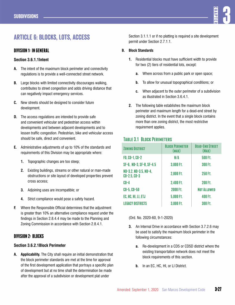
3:27
3CH
APTER
Subdivisions
3:27Amended: September 1, 2020 San Marcos Development Code
article 6: Blocks, Lots, access
DIVISION 1: IN GENERAL
Section 3.6.1.1Intent
A. The intent of the maximum block perimeter and connectivity regulations is to provide a well-connected street network.
B. Large blocks with limited connectivity discourages walking, contributes to street congestion and adds driving distance that can negatively impact emergency services.
C. New streets should be designed to consider future development.
D. The access regulations are intended to provide safe and convenient vehicular and pedestrian access within developments and between adjacent developments and to lessen traffic congestion. Pedestrian, bike and vehicular access should be safe, direct and convenient.
E. Administrative adjustments of up to 10% of the standards and requirements of this Division may be appropriate where:
1. Topographic changes are too steep;
2. Existing buildings, streams or other natural or man-made obstructions or site layout of developed properties prevent cross access;
3. Adjoining uses are incompatible; or
4. Strict compliance would pose a safety hazard.
F. Where the Responsible Official determines that the adjustment is greater than 10% an alternative compliance request under the findings in Section 2.8.4.4 may be made to the Planning and Zoning Commission in accordance with Section 2.8.4.1.
DIVISION 2: BLOCKS
Section 3.6.2.1Block Perimeter
A. Applicability. The City shall require an initial demonstration that the block perimeter standards are met at the time for approval of the first development application that portrays a specific plan of development but at no time shall the determination be made after the approval of a subdivision or development plat under
Section 3.1.1.1 or if no platting is required a site development permit under Section 2.7.1.1.
B. Block Standards
1. Residential blocks must have sufficient width to provide for two (2) tiers of residential lots, except:
a. Where across from a public park or open space;
b. To allow for unusual topographical conditions; or
c. When adjacent to the outer perimeter of a subdivision as illustrated in Section 3.6.4.1.
2. The following table establishes the maximum block perimeter and maximum length for a dead-end street by zoning district. In the event that a single block contains more than one zoning district, the most restrictive requirement applies.
Table 3.1 Block Perimeters
Zoning DistrictBlock Perimeter
(max)Dead-End Street
(Max)
FD, CD-1, CD-2 N/A 500 Ft.
SF-6, ND-3, SF-R, SF-4.5 3,000 Ft. 300 Ft.
ND-3.2. ND-3.5, ND-4, CD-2.5, CD-3
2,800 Ft. 250 Ft.
CD-4 2,400 Ft. 200 Ft.
CD-5, CD-5D 2000 Ft. Not Allowed
EC, HC, HI, LI, ETJ 5,000 Ft. 400 Ft.
LEGACY DISTRICTS 3,000 Ft. 300 Ft.
(Ord. No. 2020-60, 9-1-2020)
3. An Internal Drive in accordance with Section 3.7.2.6 may be used to satisfy the maximum block perimeter in the following circumstances:
a. Re-development in a CD5 or CD5D district where the existing transportation network does not meet the block requirements of this section.
b. In an EC, HC, HI, or LI District.
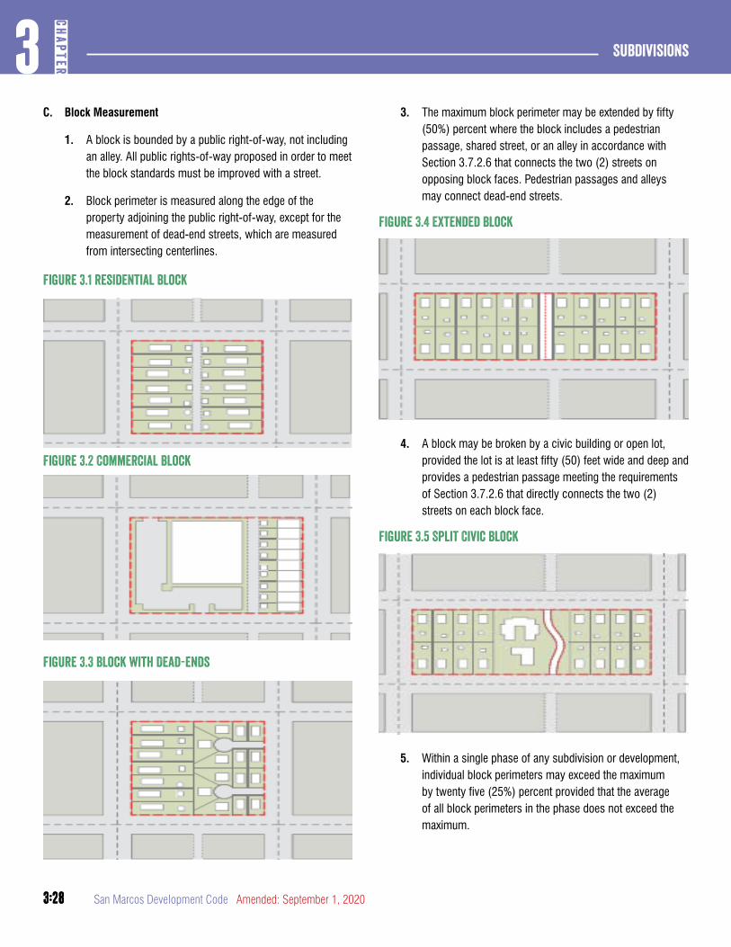
3:28
Subdivisions3
CHAP
TER
3:28 San Marcos Development Code Amended: September 1, 2020
C. Block Measurement
1. A block is bounded by a public right-of-way, not including an alley. All public rights-of-way proposed in order to meet the block standards must be improved with a street.
2. Block perimeter is measured along the edge of the property adjoining the public right-of-way, except for the measurement of dead-end streets, which are measured from intersecting centerlines.
Figure 3.1 Residential Block
Figure 3.2 Commercial Block
Figure 3.3 Block with Dead-ends
3. The maximum block perimeter may be extended by fifty (50%) percent where the block includes a pedestrian passage, shared street, or an alley in accordance with Section 3.7.2.6 that connects the two (2) streets on opposing block faces. Pedestrian passages and alleys may connect dead-end streets.
Figure 3.4 Extended Block
4. A block may be broken by a civic building or open lot, provided the lot is at least fifty (50) feet wide and deep and provides a pedestrian passage meeting the requirements of Section 3.7.2.6 that directly connects the two (2) streets on each block face.
Figure 3.5 Split Civic Block
5. Within a single phase of any subdivision or development, individual block perimeters may exceed the maximum by twenty five (25%) percent provided that the average of all block perimeters in the phase does not exceed the maximum.
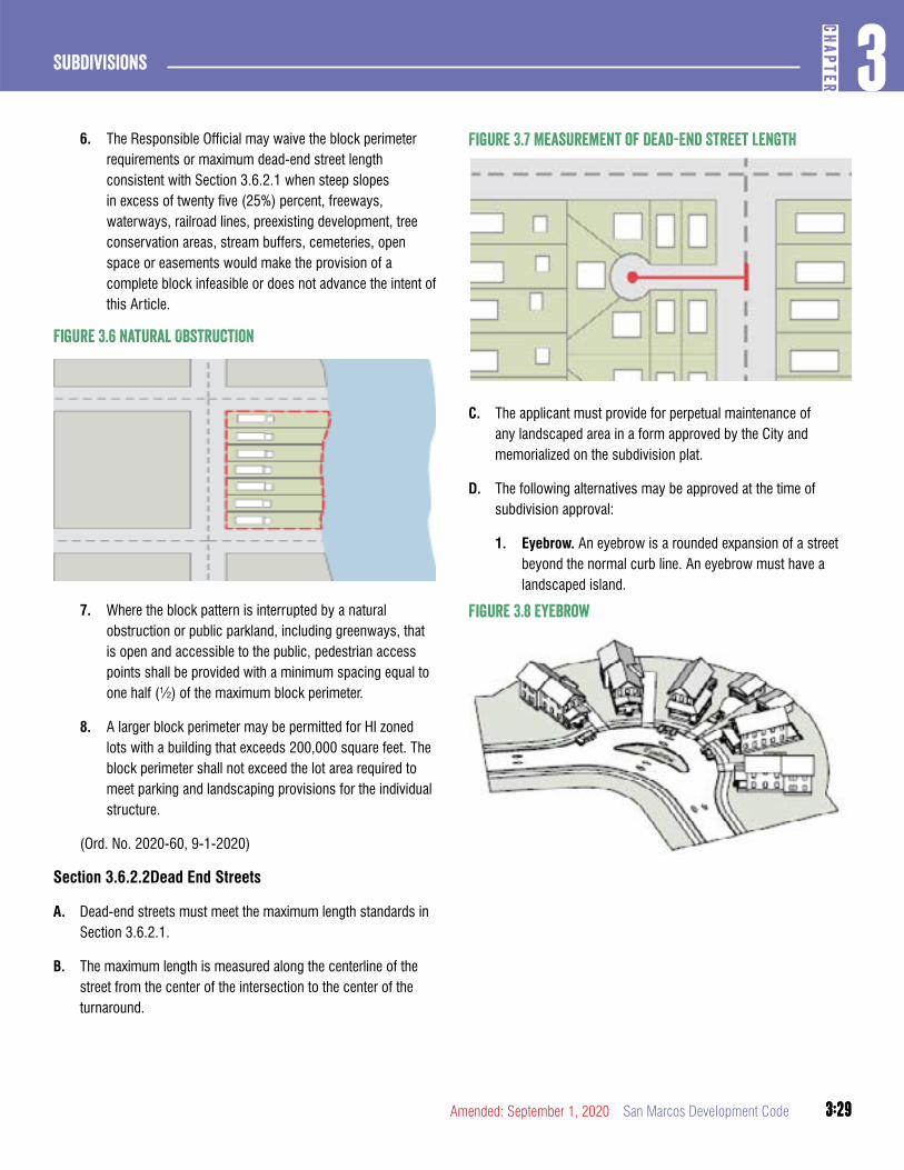
3:29
3CH
APTER
Subdivisions
3:29Amended: September 1, 2020 San Marcos Development Code
6. The Responsible Official may waive the block perimeter requirements or maximum dead-end street length consistent with Section 3.6.2.1 when steep slopes in excess of twenty five (25%) percent, freeways, waterways, railroad lines, preexisting development, tree conservation areas, stream buffers, cemeteries, open space or easements would make the provision of a complete block infeasible or does not advance the intent of this Article.
Figure 3.6 Natural Obstruction
7. Where the block pattern is interrupted by a natural obstruction or public parkland, including greenways, that is open and accessible to the public, pedestrian access points shall be provided with a minimum spacing equal to one half (½) of the maximum block perimeter.
8. A larger block perimeter may be permitted for HI zoned lots with a building that exceeds 200,000 square feet. The block perimeter shall not exceed the lot area required to meet parking and landscaping provisions for the individual structure.
(Ord. No. 2020-60, 9-1-2020)
Section 3.6.2.2Dead End Streets
A. Dead-end streets must meet the maximum length standards in Section 3.6.2.1.
B. The maximum length is measured along the centerline of the street from the center of the intersection to the center of the turnaround.
Figure 3.7 Measurement of Dead-End Street Length
C. The applicant must provide for perpetual maintenance of any landscaped area in a form approved by the City and memorialized on the subdivision plat.
D. The following alternatives may be approved at the time of subdivision approval:
1. Eyebrow. An eyebrow is a rounded expansion of a street beyond the normal curb line. An eyebrow must have a landscaped island.
Figure 3.8 Eyebrow
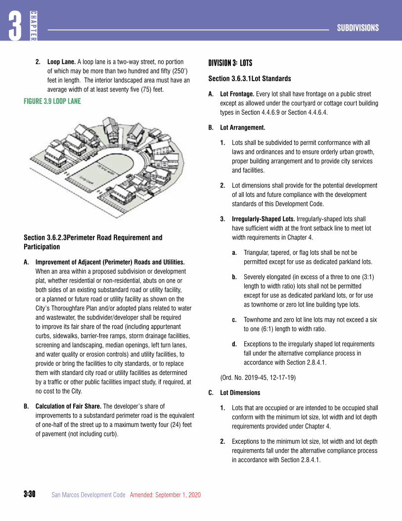
3:30
Subdivisions3
CHAP
TER
3:30 San Marcos Development Code Amended: September 1, 2020
2. Loop Lane. A loop lane is a two-way street, no portion of which may be more than two hundred and fifty (250’) feet in length. The interior landscaped area must have an average width of at least seventy five (75) feet.
Figure 3.9 Loop Lane
Section 3.6.2.3Perimeter Road Requirement and Participation
A. Improvement of Adjacent (Perimeter) Roads and Utilities. When an area within a proposed subdivision or development plat, whether residential or non-residential, abuts on one or both sides of an existing substandard road or utility facility, or a planned or future road or utility facility as shown on the City’s Thoroughfare Plan and/or adopted plans related to water and wastewater, the subdivider/developer shall be required to improve its fair share of the road (including appurtenant curbs, sidewalks, barrier-free ramps, storm drainage facilities, screening and landscaping, median openings, left turn lanes, and water quality or erosion controls) and utility facilities, to provide or bring the facilities to city standards, or to replace them with standard city road or utility facilities as determined by a traffic or other public facilities impact study, if required, at no cost to the City.
B. Calculation of Fair Share. The developer’s share of improvements to a substandard perimeter road is the equivalent of one-half of the street up to a maximum twenty four (24) feet of pavement (not including curb).
DIVISION 3: LOTS
Section 3.6.3.1Lot Standards
A. Lot Frontage. Every lot shall have frontage on a public street except as allowed under the courtyard or cottage court building types in Section 4.4.6.9 or Section 4.4.6.4.
B. Lot Arrangement.
1. Lots shall be subdivided to permit conformance with all laws and ordinances and to ensure orderly urban growth, proper building arrangement and to provide city services and facilities.
2. Lot dimensions shall provide for the potential development of all lots and future compliance with the development standards of this Development Code.
3. Irregularly-Shaped Lots. Irregularly-shaped lots shall have sufficient width at the front setback line to meet lot width requirements in Chapter 4.
a. Triangular, tapered, or flag lots shall be not be permitted except for use as dedicated parkland lots.
b. Severely elongated (in excess of a three to one (3:1) length to width ratio) lots shall not be permitted except for use as dedicated parkland lots, or for use as townhome or zero lot line building type lots.
c. Townhome and zero lot line lots may not exceed a six to one (6:1) length to width ratio.
d. Exceptions to the irregularly shaped lot requirements fall under the alternative compliance process in accordance with Section 2.8.4.1.
(Ord. No. 2019-45, 12-17-19)
C. Lot Dimensions
1. Lots that are occupied or are intended to be occupied shall conform with the minimum lot size, lot width and lot depth requirements provided under Chapter 4.
2. Exceptions to the minimum lot size, lot width and lot depth requirements fall under the alternative compliance process in accordance with Section 2.8.4.1.
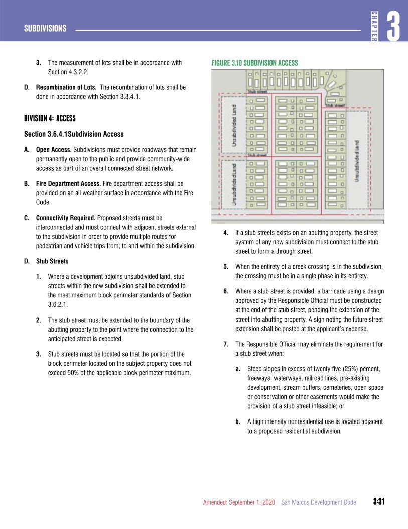
3:31
3CH
APTER
Subdivisions
3:31Amended: September 1, 2020 San Marcos Development Code
3. The measurement of lots shall be in accordance with Section 4.3.2.2.
D. Recombination of Lots. The recombination of lots shall be done in accordance with Section 3.3.4.1.
DIVISION 4: ACCESS
Section 3.6.4.1Subdivision Access
A. Open Access. Subdivisions must provide roadways that remain permanently open to the public and provide community-wide access as part of an overall connected street network.
B. Fire Department Access. Fire department access shall be provided on an all weather surface in accordance with the Fire Code.
C. Connectivity Required. Proposed streets must be interconnected and must connect with adjacent streets external to the subdivision in order to provide multiple routes for pedestrian and vehicle trips from, to and within the subdivision.
D. Stub Streets
1. Where a development adjoins unsubdivided land, stub streets within the new subdivision shall be extended to the meet maximum block perimeter standards of Section 3.6.2.1.
2. The stub street must be extended to the boundary of the abutting property to the point where the connection to the anticipated street is expected.
3. Stub streets must be located so that the portion of the block perimeter located on the subject property does not exceed 50% of the applicable block perimeter maximum.
Figure 3.10 Subdivision access
4. If a stub streets exists on an abutting property, the street system of any new subdivision must connect to the stub street to form a through street.
5. When the entirety of a creek crossing is in the subdivision, the crossing must be in a single phase in its entirety.
6. Where a stub street is provided, a barricade using a design approved by the Responsible Official must be constructed at the end of the stub street, pending the extension of the street into abutting property. A sign noting the future street extension shall be posted at the applicant’s expense.
7. The Responsible Official may eliminate the requirement for a stub street when:
a. Steep slopes in excess of twenty five (25%) percent, freeways, waterways, railroad lines, pre-existing development, stream buffers, cemeteries, open space or conservation or other easements would make the provision of a stub street infeasible; or
b. A high intensity nonresidential use is located adjacent to a proposed residential subdivision.
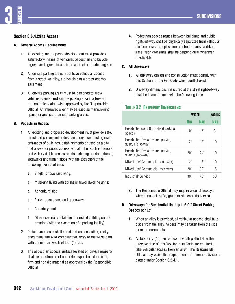
3:32
Subdivisions3
CHAP
TER
3:32 San Marcos Development Code Amended: September 1, 2020
Section 3.6.4.2Site Access
A. General Access Requirements
1. All existing and proposed development must provide a satisfactory means of vehicular, pedestrian and bicycle ingress and egress to and from a street or an abutting site.
2. All on-site parking areas must have vehicular access from a street, an alley, a drive aisle or a cross-access easement.
3. All on-site parking areas must be designed to allow vehicles to enter and exit the parking area in a forward motion, unless otherwise approved by the Responsible Official. An improved alley may be used as maneuvering space for access to on-site parking areas.
B. Pedestrian Access
1. All existing and proposed development must provide safe, direct and convenient pedestrian access connecting main entrances of buildings, establishments or uses on a site that allows for public access with all other such entrances and with available access points including parking, streets, sidewalks and transit stops with the exception of the following exempted uses:
a. Single- or two-unit living;
b. Multi-unit living with six (6) or fewer dwelling units;
c. Agricultural use;
d. Parks, open space and greenways;
e. Cemetery; and
f. Other uses not containing a principal building on the premise (with the exception of a parking facility).
2. Pedestrian access shall consist of an accessible, easily-discernible and ADA compliant walkway or multi-use path with a minimum width of four (4) feet.
3. The pedestrian access surface located on private property shall be constructed of concrete, asphalt or other fixed, firm and nonslip material as approved by the Responsible Official.
4. Pedestrian access routes between buildings and public rights-of-way shall be physically separated from vehicular surface areas, except where required to cross a drive aisle; such crossings shall be perpendicular wherever practicable.
C. All Driveways
1. All driveway design and construction must comply with this Section, or the Fire Code when conflict exists.
2. Driveway dimensions measured at the street right-of-way shall be in accordance with the following table:
Table 3.2 Driveway Dimensions
Width Radius
Min Max Max
Residential up to 6 off-street parking spaces
10’ 18’ 5’
Residential 7+ off -street parking spaces (one-way)
12’ 16’ 10’
Residential 7+ off -street parking spaces (two-way)
20’ 24’ 10’
Mixed Use/ Commercial (one-way) 12’ 18’ 10’
Mixed Use/ Commercial (two-way) 20’ 32’ 15’
Industrial/ Service 30’ 40’ 30’
3. The Responsible Official may require wider driveways where unusual traffic, grade or site conditions exist.
D. Driveways for Residential Use Up to 6 Off-Street Parking Spaces per Lot
1. When an alley is provided, all vehicular access shall take place from the alley. Access may be taken from the side street on corner lots.
2. All lots forty (40) feet or less in width platted after the effective date of this Development Code are required to take vehicular access from an alley. The Responsible Official may waive this requirement for minor subdivisions platted under Section 3.2.4.1.
3:33
3CH
APTER
Subdivisions
3:33Amended: September 1, 2020 San Marcos Development Code
3. No residential lot may have more than two (2) driveways on the same street. Multiple driveways that service one (1) lot may be no closer than forty (40) feet to each other.
4. Non-alley loaded driveways may intersect a street no closer than twenty (20) feet from the intersection of two (2) street rights-of-way.
5. Driveways must be located a minimum of three and one half (3.5) feet from the side lot line. However, a driveway may be located on the lot line closer than three and one half (3.5) feet if it is shared with an adjacent lot.
6. Parking and driveway areas shall not constitute more than forty (40%) percent of the area between the front building line and the front property line.
E. Driveways for Nonresidential, Mixed Use and Residential Greater than 6 Off-Street Spaces
1. If on-site parking areas can be accessed from an improved alley, access from the alley is required and new curb cuts along the public right-of-way are not allowed.
2. Driveways are allowed based on the property frontage of any street. Additional driveways require approval from the Responsible Official.
3. Driveways accessing up to eighty (80) foot wide street rights-of-way must be spaced two hundred (200) feet apart centerline to centerline and driveways accessing more than an eighty (80) foot wide street right-of-way must be spaced three hundred (300) feet apart centerline to centerline.
4. A driveway serving any non-residential use or multi-unit living shall not be permitted to access neighborhood yield or neighborhood local streets unless the proposed access point is the lesser of three hundred (300) feet from an avenue, boulevard or parkway, or the intersection of another public street.
5. Offers of cross-access shall be prohibited where a proposed nonresidential use or multi-unit living may potentially obtain access from a neighborhood or residential street, unless the resulting access meets the provisions of subsection 4 above.
6. Driveways may intersect a street no closer than fifty (50) feet from the intersection of two (2) street rights-of-way, not including an alley.
7. Nothing in this section shall prevent all site access to any property.
F. Cross-Access
1. All lots abutting a street other than a neighborhood street or neighborhood yield street where no alley is available shall comply with the following standards:
a. Internal vehicular circulation areas shall be designed and installed to allow for cross-access between abutting lots;
b. When an abutting owner refuses in writing to allow construction of the internal vehicular circulation on their property, a stub for future cross-access shall be provided as close as possible to the common property line.
c. When cross-access is waived by the Responsible Official in accordance with Section 3.6.1.1 bicycle and pedestrian connections shall be provided between abutting properties except where there is a natural drainage feature greater than fifteen (15) feet across.
DIVISION 5: ALTERNATIVE COMPLIANCE
Section 3.6.5.1Alternative Compliance
A. Alternative Compliance Findings. The Planning and Zoning Commission may in accordance with Section 2.8.4.1 approve an alternative compliance request to this Article 6, subject to all the following findings:
1. The approved design adjustment meets the intent of this Article;
2. The approved design adjustment conforms with the Comprehensive Plan and adopted City plans;
3. The approved design adjustment does not increase congestion or compromise safety;
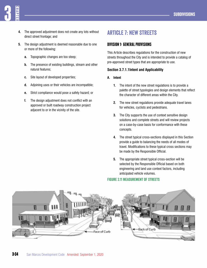
3:34
Subdivisions3
CHAP
TER
3:34 San Marcos Development Code Amended: September 1, 2020
4. The approved adjustment does not create any lots without direct street frontage; and
5. The design adjustment is deemed reasonable due to one or more of the following:
a. Topographic changes are too steep;
b. The presence of existing buildings, stream and other natural features;
c. Site layout of developed properties;
d. Adjoining uses or their vehicles are incompatible;
e. Strict compliance would pose a safety hazard; or
f. The design adjustment does not conflict with an approved or built roadway construction project adjacent to or in the vicinity of the site.
article 7: New Streets
DIVISION 1: GENERAL PROVISIONS
This Article describes regulations for the construction of new streets throughout the City and is intended to provide a catalog of pre-approved street types that are appropriate to use.
Section 3.7.1.1Intent and Applicability
A. Intent
1. The intent of the new street regulations is to provide a palette of street typologies and design elements that reflect the character of different areas within the City.
2. The new street regulations provide adequate travel lanes for vehicles, cyclists and pedestrians.
3. The City supports the use of context sensitive design solutions and complete streets and will review projects on a case-by-case basis for conformance with these concepts.
4. The street typical cross-sections displayed in this Section provide a guide to balancing the needs of all modes of travel. Modifications to these typical cross sections may be made by the Responsible Official.
5. The appropriate street typical cross-section will be selected by the Responsible Official based on both engineering and land use context factors, including anticipated vehicle volumes.
Figure 3.11 Measurement of Streets
3:35
3CH
APTER
Subdivisions
3:35Amended: September 1, 2020 San Marcos Development Code
6. Administrative design adjustments approved by the Responsible Official pursuant to Section 3.6.1.1 may be appropriate when an existing building would impede roadway expansion; when transitioning from a different street section; or where strict compliance with this Development Code would pose a safety hazard.
B. Applicability
1. When a preliminary plat, final plat or site permit proposes the construction of a new street, the requirements of this Article apply.
2. Sidewalks, streets and street trees must be installed and constructed in accordance with this Article.
3. Existing streets may remain serving existing development in their current configuration; however, they shall not be extended or substantially rebuilt except in conformance with this Article (see also Section 3.8.1.5 Existing Streets)
Section 3.7.1.2Street Right-of-Way Width
A. Street right-of-way width for Thoroughfare Plan streets must be dedicated as specified in the Transportation Master Plan. Alignments may be adjusted as approved by the Responsible Official.
B. Applicants must dedicate sufficient right-of-way to the City for streets and sidewalks. Typical street right-of way widths are illustrated in this Section.
C. A median may be added to the street cross-sections by increasing the right-of-way width. A median should be 18 feet in width in order to provide for landscaping and turn lanes. In no case will a median less than 8 feet in width be considered.
D. The Responsible Official may require turn lanes, and additional right-of-way beyond that shown in the applicable street typical cross-section to accommodate these lanes when warranted.
Section 3.7.1.3Measurement of Streets and Streetscapes
A. Face of Curb. All measurements of parking spaces and lane widths are taken from the face of curb and are inclusive of the gutter.
B. Pavement Markings. All measurements of parking spaces and lane widths are made to the center of pavement markings.
Section 3.7.1.4Standards
A. Tree Planting. All trees planted in accordance with this Article must be shade trees that meet the design, type and installation requirements of Sections 7.2.4.1, 7.2.4.2, and Appendix D of the San Marcos Design Manual.
B. Stormwater. Whenever funding is available and site conditions allow, rights-of-way may be designed to infiltrate stormwater, either through porous pavement treatments, curb cuts, or by directing stormwater into bioretention cells. Plants used in a bioretention cell must be comprised of species that require low maintenance and can tolerate frequent inundation as well as periods of drought.
C. Street Lighting. Street lights are required at all intersections and must meet IESNA Standards.
DIVISION 2: STREET TYPES
Unless modified by the Responsible Official, all new or extended streets must meet the requirements of the following street types.
Section 3.7.2.1Street Types
A. Conservation Corridors
1. Sensitive Area Parkway
2. Sensitive Area Residential Street
B. Conventional Corridors
1. Boulevard
2. Avenue
3. Industrial Street
C. Mixed Use Corridors
1. Multi-Way Boulevard
2. Avenue
3. Street
3:36
Subdivisions3
CHAP
TER
3:36 San Marcos Development Code Amended: September 1, 2020
D. Neighborhood Streets
1. Neighborhood Queuing Street
2. Neighborhood Street; Limited Parking
E. Accessways and Alleyways
1. Rural/ Park Road
2. Shared Street
3. Pedestrian Passage
4. Internal Drive
5. Rear Alley and Rear Lane
6. Multiuse Greenway
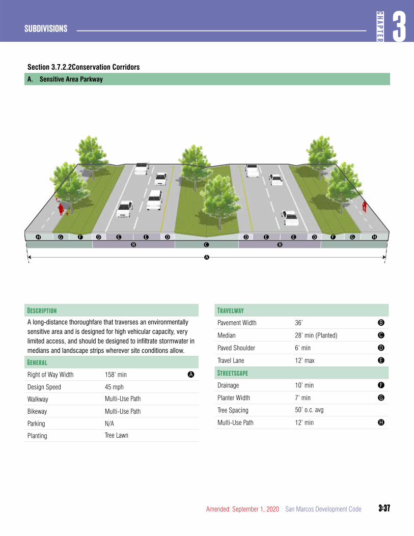
3:37
3CH
APTER
Subdivisions
3:37Amended: September 1, 2020 San Marcos Development Code
Section 3.7.2.2Conservation Corridors
A. Sensitive Area Parkway
Travelway
Pavement Width 36’ B
Median 28’ min (Planted) C
Paved Shoulder 6’ min D
Travel Lane 12’ max E
Streetscape
Drainage 10’ min F
Planter Width 7’ min G
Tree Spacing 50’ o.c. avg
Multi-Use Path 12’ min H
Description
A long-distance thoroughfare that traverses an environmentally sensitive area and is designed for high vehicular capacity, very limited access, and should be designed to infiltrate stormwater in medians and landscape strips wherever site conditions allow.
General
Right of Way Width 158’ min A
Design Speed 45 mph
Walkway Multi-Use Path
Bikeway Multi-Use Path
Parking N/A
Planting Tree Lawn
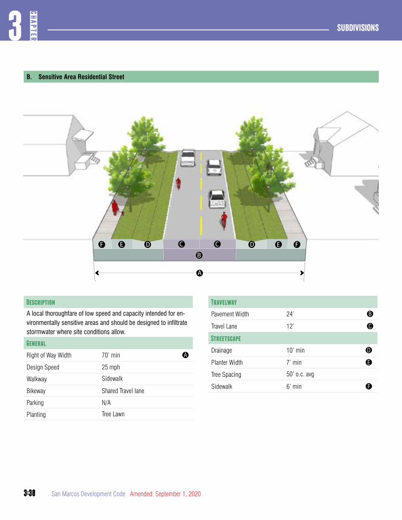
3:38
Subdivisions3
CHAP
TER
3:38 San Marcos Development Code Amended: September 1, 2020
B. Sensitive Area Residential Street
Travelway
Pavement Width 24’ B
Travel Lane 12’ C
Streetscape
Drainage 10’ min D
Planter Width 7’ min E
Tree Spacing 50’ o.c. avg
Sidewalk 6’ min F
Description
A local thoroughfare of low speed and capacity intended for en-vironmentally sensitive areas and should be designed to infiltrate stormwater where site conditions allow.
General
Right of Way Width 70’ min A
Design Speed 25 mph
Walkway Sidewalk
Bikeway Shared Travel lane
Parking N/A
Planting Tree Lawn
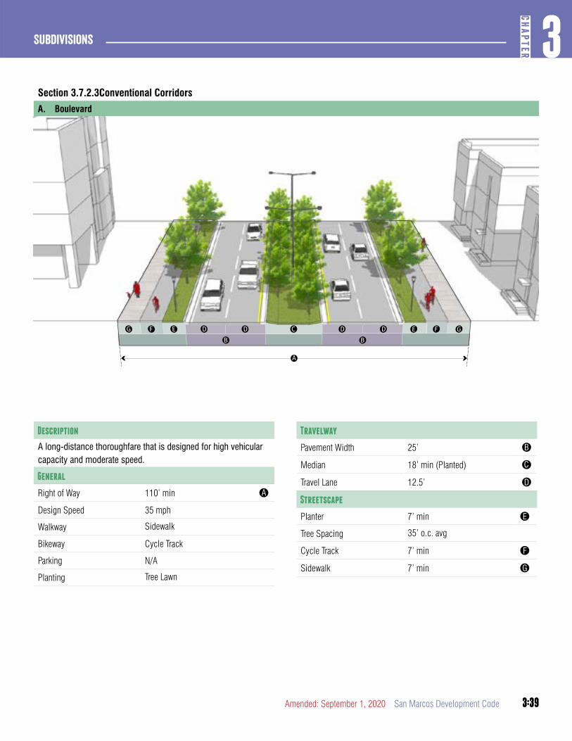
3:39
3CH
APTER
Subdivisions
3:39Amended: September 1, 2020 San Marcos Development Code
Section 3.7.2.3Conventional Corridors
A. Boulevard
Description
A long-distance thoroughfare that is designed for high vehicular capacity and moderate speed.
General
Right of Way 110’ min A
Design Speed 35 mph
Walkway Sidewalk
Bikeway Cycle Track
Parking N/A
Planting Tree Lawn
Travelway
Pavement Width 25’ B
Median 18’ min (Planted) C
Travel Lane 12.5’ D
Streetscape
Planter 7’ min E
Tree Spacing 35’ o.c. avg
Cycle Track 7’ min F
Sidewalk 7’ min G
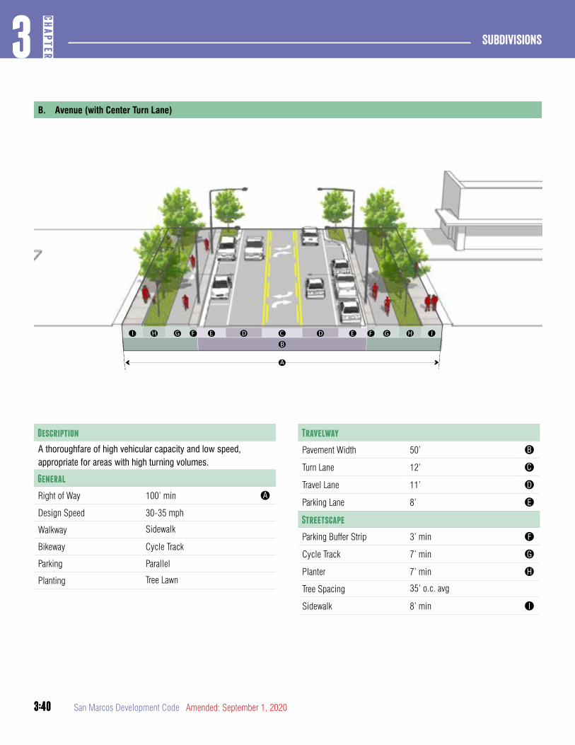
3:40
Subdivisions3
CHAP
TER
3:40 San Marcos Development Code Amended: September 1, 2020
B. Avenue (with Center Turn Lane)
Travelway
Pavement Width 50’ B
Turn Lane 12’ C
Travel Lane 11’ D
Parking Lane 8’ E
Streetscape
Parking Buffer Strip 3’ min F
Cycle Track 7’ min G
Planter 7’ min H
Tree Spacing 35’ o.c. avg
Sidewalk 8’ min I
Description
A thoroughfare of high vehicular capacity and low speed, appropriate for areas with high turning volumes.
General
Right of Way 100’ min A
Design Speed 30-35 mph
Walkway Sidewalk
Bikeway Cycle Track
Parking Parallel
Planting Tree Lawn
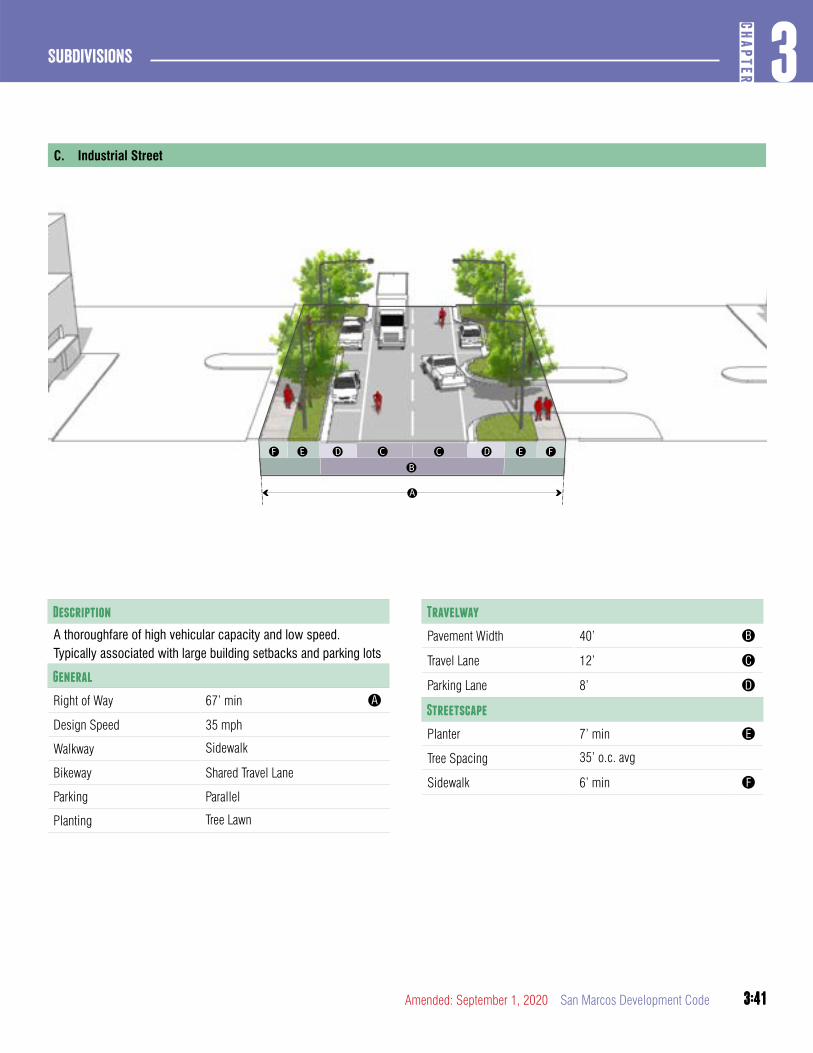
3:41
3CH
APTER
Subdivisions
3:41Amended: September 1, 2020 San Marcos Development Code
C. Industrial Street
Travelway
Pavement Width 40’ B
Travel Lane 12’ C
Parking Lane 8’ D
Streetscape
Planter 7’ min E
Tree Spacing 35’ o.c. avg
Sidewalk 6’ min F
Description
A thoroughfare of high vehicular capacity and low speed. Typically associated with large building setbacks and parking lots
General
Right of Way 67’ min A
Design Speed 35 mph
Walkway Sidewalk
Bikeway Shared Travel Lane
Parking Parallel
Planting Tree Lawn
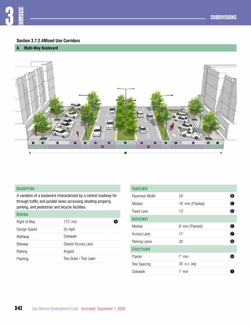
3:42
Subdivisions3
CHAP
TER
3:42 San Marcos Development Code Amended: September 1, 2020
Section 3.7.2.4Mixed Use Corridors
A. Multi-Way Boulevard
Travelway
Pavement Width 24’ B
Median 18’ min (Planted) C
Travel Lane 12’ D
Accessway
Median 8’ min (Planted) E
Access Lane 11’ F
Parking Lanes 20’ G
Streetscape
Planter 7’ min H
Tree Spacing 35’ o.c. avg
Sidewalk 7’ min I
Description
A variation of a boulevard characterized by a central roadway for through traffic and parallel lanes accessing abutting property, parking, and pedestrian and bicycle facilities.
General
Right of Way 173’ min A
Design Speed 55 mph
Walkway Sidewalk
Bikeway Shared Access Lane
Parking Angled
Planting Tree Grate / Tree Lawn
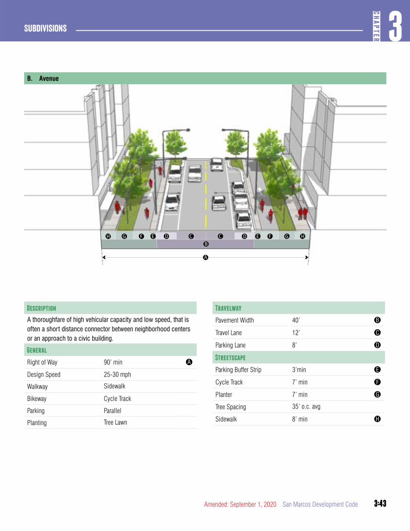
3:43
3CH
APTER
Subdivisions
3:43Amended: September 1, 2020 San Marcos Development Code
B. Avenue
Travelway
Pavement Width 40’ B
Travel Lane 12’ C
Parking Lane 8’ D
Streetscape
Parking Buffer Strip 3’min E
Cycle Track 7’ min F
Planter 7’ min G
Tree Spacing 35’ o.c. avg
Sidewalk 8’ min H
Description
A thoroughfare of high vehicular capacity and low speed, that is often a short distance connector between neighborhood centers or an approach to a civic building.
General
Right of Way 90’ min A
Design Speed 25-30 mph
Walkway Sidewalk
Bikeway Cycle Track
Parking Parallel
Planting Tree Lawn
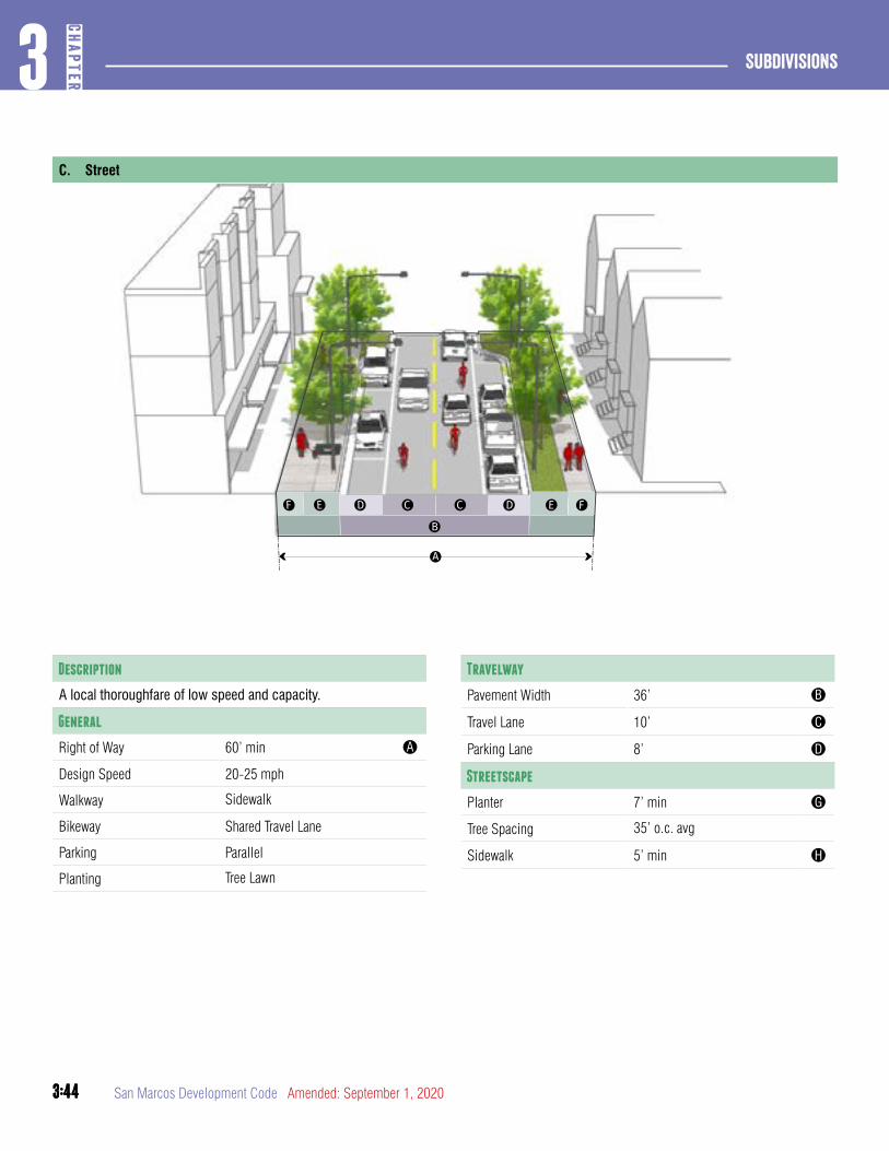
3:44
Subdivisions3
CHAP
TER
3:44 San Marcos Development Code Amended: September 1, 2020
C. Street
Travelway
Pavement Width 36’ B
Travel Lane 10’ C
Parking Lane 8’ D
Streetscape
Planter 7’ min G
Tree Spacing 35’ o.c. avg
Sidewalk 5’ min H
Description
A local thoroughfare of low speed and capacity.
General
Right of Way 60’ min A
Design Speed 20-25 mph
Walkway Sidewalk
Bikeway Shared Travel Lane
Parking Parallel
Planting Tree Lawn

3:45
3CH
APTER
Subdivisions
3:45Amended: September 1, 2020 San Marcos Development Code
Section 3.7.2.5Neighborhood Streets
A. Neighborhood Queuing Street
Description
A local thoroughfare of low speed and capacity.
General
Right of Way 54’ min A
Design Speed 20-25 mph
Walkway Sidewalk
Bikeway Shared Travel Lane
Parking Parallel
Planting Tree Lawn
Travelway
Pavement Width 30’ B
Queuing Lane 14’ C
Parking Lane 8’ D
Streetscape
Planter 7’ min E
Tree Spacing 35’ o.c. avg
Sidewalk 5’ min F
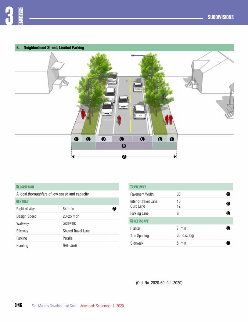
3:46
Subdivisions3
CHAP
TER
3:46 San Marcos Development Code Amended: September 1, 2020
B. Neighborhood Street; Limited Parking
Description
A local thoroughfare of low speed and capacity.
General
Right of Way 54’ min A
Design Speed 20-25 mph
Walkway Sidewalk
Bikeway Shared Travel Lane
Parking Parallel
Planting Tree Lawn
Travelway
Pavement Width 30’ B
Interior Travel LaneCurb Lane
10’12’
C
Parking Lane 8’ D
Streetscape
Planter 7’ min E
Tree Spacing 35’ o.c. avg
Sidewalk 5’ min F
(Ord. No. 2020-60, 9-1-2020)
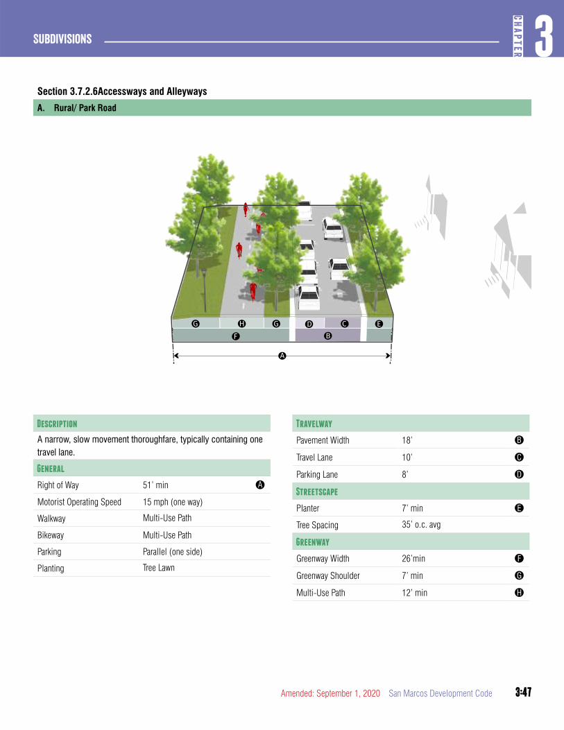
3:47
3CH
APTER
Subdivisions
3:47Amended: September 1, 2020 San Marcos Development Code
Section 3.7.2.6Accessways and Alleyways
A. Rural/ Park Road
Description
A narrow, slow movement thoroughfare, typically containing one travel lane.
General
Right of Way 51’ min A
Motorist Operating Speed 15 mph (one way)
Walkway Multi-Use Path
Bikeway Multi-Use Path
Parking Parallel (one side)
Planting Tree Lawn
Travelway
Pavement Width 18’ B
Travel Lane 10’ C
Parking Lane 8’ D
Streetscape
Planter 7’ min E
Tree Spacing 35’ o.c. avg
Greenway
Greenway Width 26’min F
Greenway Shoulder 7’ min G
Multi-Use Path 12’ min H
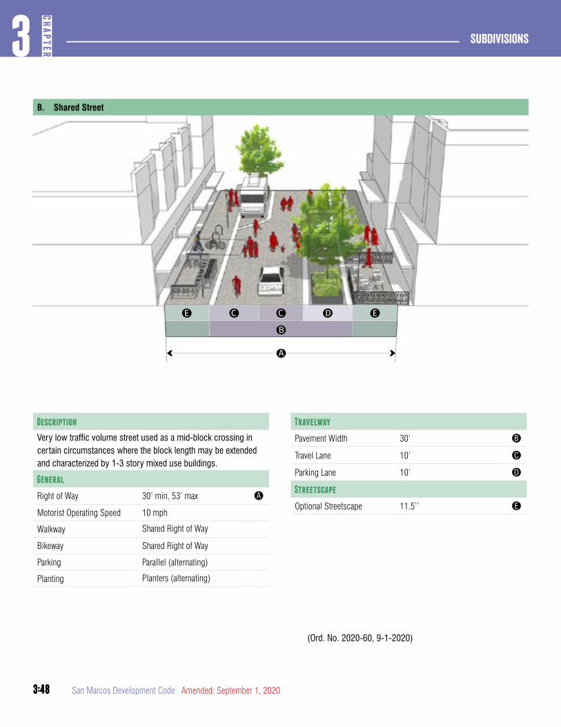
3:48
Subdivisions3
CHAP
TER
3:48 San Marcos Development Code Amended: September 1, 2020
Travelway
Pavement Width 30’ B
Travel Lane 10’ C
Parking Lane 10’ D
Streetscape
Optional Streetscape 11.5’’ E
(Ord. No. 2020-60, 9-1-2020)
B. Shared Street
Description
Very low traffic volume street used as a mid-block crossing in certain circumstances where the block length may be extended and characterized by 1-3 story mixed use buildings.
General
Right of Way 30’ min, 53’ max A
Motorist Operating Speed 10 mph
Walkway Shared Right of Way
Bikeway Shared Right of Way
Parking Parallel (alternating)
Planting Planters (alternating)
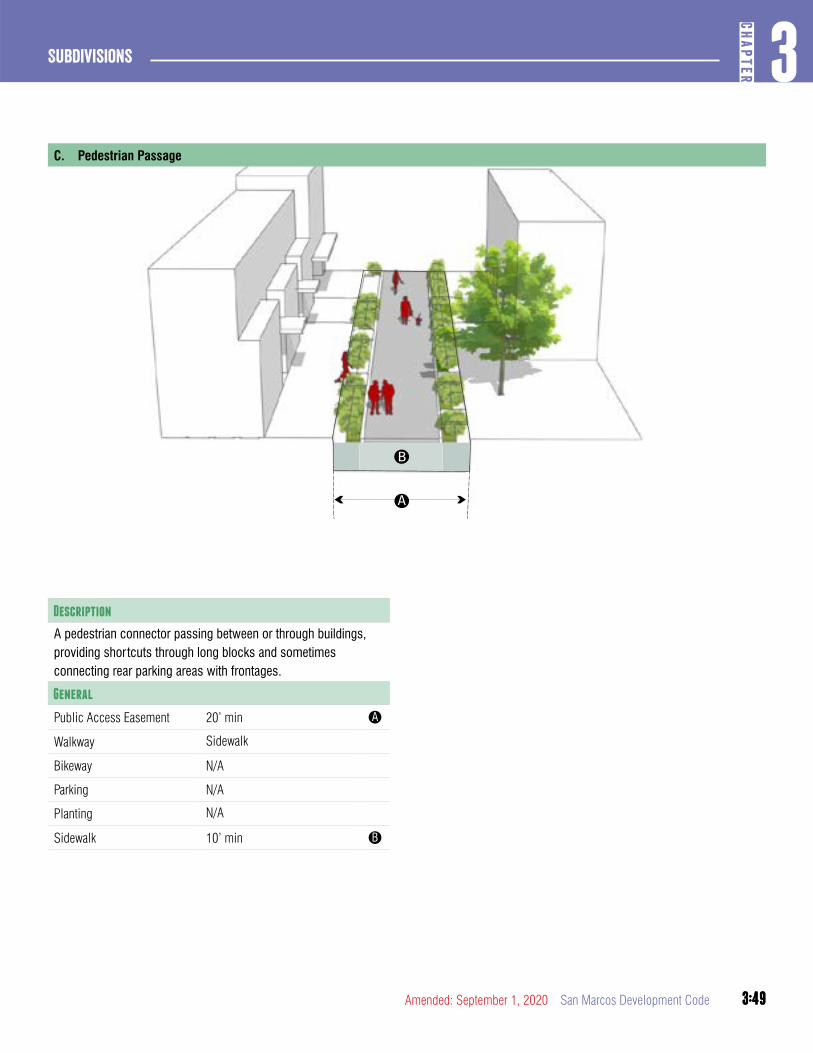
3:49
3CH
APTER
Subdivisions
3:49Amended: September 1, 2020 San Marcos Development Code
C. Pedestrian Passage
Description
A pedestrian connector passing between or through buildings, providing shortcuts through long blocks and sometimes connecting rear parking areas with frontages.
General
Public Access Easement 20’ min A
Walkway Sidewalk
Bikeway N/A
Parking N/A
Planting N/A
Sidewalk 10’ min B
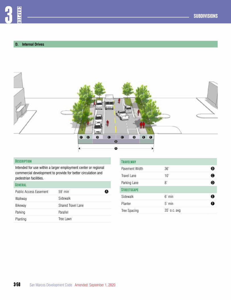
3:50
Subdivisions3
CHAP
TER
3:50 San Marcos Development Code Amended: September 1, 2020
Travelway
Pavement Width 36’ B
Travel Lane 10’ C
Parking Lane 8’ D
Streetscape
Sidewalk 6’ min E
Planter 5’ min F
Tree Spacing 35’ o.c. avg
D. Internal Drives
Description
Intended for use within a larger employment center or regional commercial development to provide for better circulation and pedestrian facilities.
General
Public Access Easement 59’ min A
Walkway Sidewalk
Bikeway Shared Travel Lane
Parking Parallel
Planting Tree Lawn
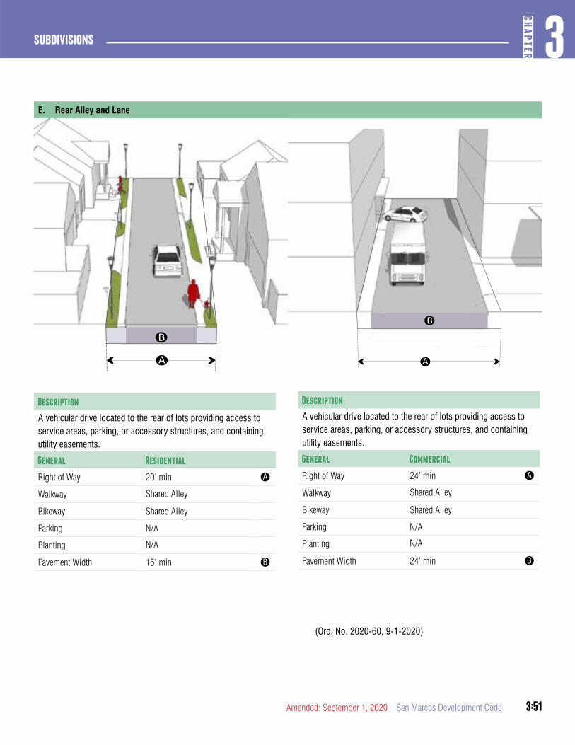
3:51
3CH
APTER
Subdivisions
3:51Amended: September 1, 2020 San Marcos Development Code
E. Rear Alley and Lane
Description
A vehicular drive located to the rear of lots providing access to service areas, parking, or accessory structures, and containing utility easements.
General Residential
Right of Way 20’ min A
Walkway Shared Alley
Bikeway Shared Alley
Parking N/A
Planting N/A
Pavement Width 15’ min B
Description
A vehicular drive located to the rear of lots providing access to service areas, parking, or accessory structures, and containing utility easements.
General Commercial
Right of Way 24’ min A
Walkway Shared Alley
Bikeway Shared Alley
Parking N/A
Planting N/A
Pavement Width 24’ min B
(Ord. No. 2020-60, 9-1-2020)
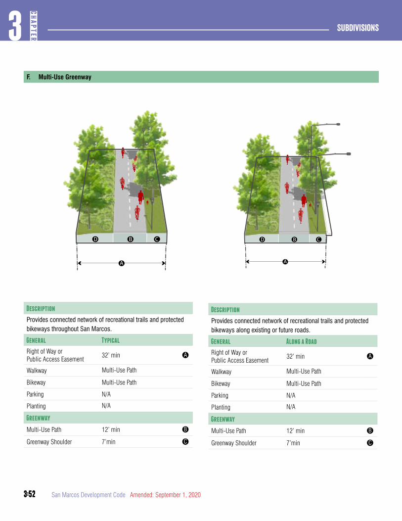
3:52
Subdivisions3
CHAP
TER
3:52 San Marcos Development Code Amended: September 1, 2020
Description
Provides connected network of recreational trails and protected bikeways throughout San Marcos.
General Typical
Right of Way orPublic Access Easement
32’ min A
Walkway Multi-Use Path
Bikeway Multi-Use Path
Parking N/A
Planting N/A
Greenway
Multi-Use Path 12’ min B
Greenway Shoulder 7’min C
F. Multi-Use Greenway
Description
Provides connected network of recreational trails and protected bikeways along existing or future roads.
General Along a Road
Right of Way orPublic Access Easement
32’ min A
Walkway Multi-Use Path
Bikeway Multi-Use Path
Parking N/A
Planting N/A
Greenway
Multi-Use Path 12’ min B
Greenway Shoulder 7’min C

3:53
3CH
APTER
Subdivisions
3:53Amended: September 1, 2020 San Marcos Development Code
article 8: Existing Streets
DIVISION 1: GENERAL PROVISIONS
This Article describes regulations for the construction of street improvements and streetscapes for existing streets throughout the City. It is intended to address when street and streetscape improve-ments are appropriate through the application of the pre-approved street types in this chapter. The City has an approved Design Manual which provides further details for streetscapes in the downtown and midtown intensity zones.
Section 3.8.1.1Applicability and Intent
A. Intent
1. The intent of the existing street regulations is to provide the application of the streetscapes to existing streets to reflect the character and context of areas in the City.
2. The existing street regulations provide adequate travel lanes for vehicles, cyclists and pedestrians.
3. Administrative design adjustments approved by the Responsible Official pursuant to Section 3.6.1.1 may be appropriate when an existing building would impede expansion, when transitioning from a different street section or where strict compliance with this Development Code and the Street Design Manual would pose a safety hazard.
B. General Applicability
1. Any new development activity and any addition or repair subject to the requirements of Section 3.1.1.1 and Section 2.7.1.1 must meet street type and streetscape standards of this Article for existing streets abutting the subject property.
2. The streetscape types of Section 3.8.1.5 shall be applied based on the zoning or use of the subject property.
3. Unless otherwise specifically provided, no permit for the construction, reconstruction, extension, repair or alteration of any building, structure or use of land and no building or land or any part of any building or land, may be occupied or used until the streetscape requirements of this Article have been met.
4. Gated public streets shall not be permitted.
5. Administrative design adjustments approved by the Responsible Official pursuant to Section 3.6.1.1 may be appropriate when an existing building would impede roadway expansion; when transitioning from a different street section; or where strict compliance with this Development Code and the Street Design Manual would pose a safety hazard.
C. Applicability for Additions and Repairs
1. A building or site may be renovated or repaired without meeting the streetscape standards, provided there is no increase in gross floor area or improved site area.
2. When a building or site is increased in gross floor area or improved site area cumulatively by more than ten (10%) percent, the streetscape provisions of this Article must be met.
D. Change in Use Exempt. A change in use does not trigger application of the streetscape requirements of this Article.
Section 3.8.1.2Standards
A. Tree Planting
1. Unless otherwise noted below, all trees planted in accordance with this Article must be shade trees.
2. Where overhead utilities exist, one (1) understory tree shall be planted every twenty (20) feet on center, on average.
3. All required street trees must meet the design, type, and installation requirements of Sections 7.2.4.1, 7.2.4.2, and Appendix D of the San Marcos Design Manual.
B. Fee-in-Lieu
1. A cash fee for the installation of all or part of the sidewalk required under Article 8 may be accepted in lieu of construction by the Responsible Official based on the criteria included in this Section.
2. The fee in lieu shall be set by resolution of the City Council based on the average cost of construction of sidewalks.

3:54
Subdivisions3
CHAP
TER
3:54 San Marcos Development Code Amended: September 1, 2020
3. The Responsible Official shall consider the following criteria when evaluating a request for fee-in-lieu of construction:
a. Proximity to the nearest existing sidewalk;
b. Proximity to public facilities, such as public or private schools, libraries and other government buildings;
c. The percentage of the block face that would be improved with the construction of the streetscape improvements.
d. Whether any public sidewalk improvements are planned or contemplated in the area; and
e. Any other information deemed appropriate in the professional judgment of the Responsible Official.
4. Sidewalk Benefit Areas. The City shall establish a separate sidewalk account. The funds in the account shall be earmarked solely for the development of sidewalks either in the Comprehensive Plan Area in which the lot is located, or for regional sidewalk connectivity that will benefit all of the citizens of San Marcos. The City shall expend cash contributions within ten years of the date any such contribution is made.
Section 3.8.1.3Nonconforming Streetscapes
A. Where a streetscape along an existing street is constrained by an existing building, the Responsible Official may adjust the streetscape standards to the minimum extent necessary to accommodate the existing area between the face of the building and back of curb.
B. The standards shall be modified in the following order:
1. Reduce or eliminate the planting area.
2. If necessary, replace large canopy trees with small trees that are more appropriate for the reduced area. If the planting zone is eliminated, create a bumpout to provide for tree planting.
3. Reduce the sidewalk to the minimum width necessary to accommodate ADA accessibility.
Section 3.8.1.4Administrative Adjustment Findings
A. The Responsible Official may in accordance with Section 3.6.1.1 approve an existing street design adjustment, subject to all of the following findings:
1. The approved adjustment meets the intent of this Article;
2. The approved adjustment conforms with the Comprehensive Plan and adopted City plans;
3. The approved adjustment does not increase congestion or compromise safety;
4. The approved adjustment does not create additional maintenance responsibilities for the City; and
5. The approved adjustment has been designed and certified by a Professional Engineer.
Section 3.8.1.5Streetscape Types
The required streetscape type is determined by the zoning district or building type. Additional design specifications for streetscape improvements can be found in the Design Manual.

3:55
3CH
APTER
Subdivisions
3:55Amended: September 1, 2020 San Marcos Development Code
Section 3.8.1.6Main Street
Applicability CD5, CD5D
Streetscape width (max) A 35’
Streetscape ElementsB Sidewalk (min): 10’C Planting/ Lighting/ Furniture Zone (min): 7’
Planting Type Tree Grate
Tree Spacing 35’ o.c. avg
Section 3.8.1.7Conventional
ApplicabilityND4, CD4, EC, HC, LI, HI; and all other multi-family or non residential uses.
Streetscape width (max) A 65’
Streetscape Elements
B Building Setback: VariesC Utility Placement: 5’D Maintenance Strip: 2’E Sidewalk (min): 6’F Planting Area (min): 7’
Planting Type Tree Lawn
Tree Spacing 40’ o.c. avg

3:56
Subdivisions3
CHAP
TER
3:56 San Marcos Development Code Amended: September 1, 2020
Section 3.8.1.8Mixed Use
Applicability N-CM
Streetscape width (max) A 35’
Streetscape Elements B Sidewalk (min): 8’C Planting Area (min): 7’
Planting Type Tree Grate; Lawn
Tree Spacing 35’ o.c. avg
Section 3.8.1.9Multi-Way
Applicability Highway Overlay District
Streetscape width (max) A 65’
Streetscape Elements
B Sidewallk (min): 10’C Planting area (min): 7’D Parking: 20’E Access Lane: 11’F Median (min): 11’
Planting Type Tree grate / Lawn
Tree Spacing 35’ o.c. avg

3:57
3CH
APTER
Subdivisions
3:57Amended: September 1, 2020 San Marcos Development Code
Section 3.8.1.10Residential
ApplicabilityAll Single Family Detached, Cottage Court, Single Family Attached, and Two Family Uses.
Streetscape Elements
A Building Setback: variesB Utility Placement: 5’C Maintenance Strip (min): 2’D Sidewalk (min): 5’E Planting Area (min): 7’
Planting Type Tree Lawn
Tree Spacing 40’ o.c.

3:58
Subdivisions3
CHAP
TER
3:58 San Marcos Development Code Amended: September 1, 2020
This responsibility includes the storm water flowing onto the property by any other developed property as well as the drainage naturally flowing through the property by reason of topography.
D. Design Based on Maximum Build-Out Configuration. Drainage improvements shall accommodate runoff from the upstream drainage area in its anticipated maximum “build-out” condition, and shall be designed to prevent overloading the capacity of the downstream drainage system. The City may require the phasing of development, the use of control methods such as retention or detention, or the construction of off-site drainage improvements in order to mitigate the impact of the proposed development.
E. Design Storm Event. All drainage facilities (including streets, curbs, gutters, storm drains, ditches, creeks, detention ponds, etc.) shall be designed to intercept and transport runoff from a twenty five (25) year frequency storm. The drainage system shall be designed to convey those flows greater than a twenty five (25) year frequency, up to and including a one hundred (100) year frequency storm within defined rights-of-way or drainage easements.
F. Detention or Retention Required. Drainage facilities shall be designed and constructed so that the rate of runoff from a site after construction shall be equal to or less than the runoff prior to construction for the two (2), ten (10), twenty five (25), and one hundred (100) year storm frequencies.
1. The timing of the hydrograph released from the detention facility must be checked against the timing of the flow rate in the first open watercourse to prevent any increase in the peak flow rate in the receiving watercourse. For detention basins constructed in-line on an existing watercourse, the creation of the basin shall not increase flood elevations in the channel upstream of the new development boundaries.
2. Computation of the rate of runoff shall be based on an assumption of a contributing drainage area or watershed fully developed in accordance with the Stormwater Technical Manual.
3. Low impact development practices can be used to reduce peak flow rates to reduce or eliminate detention requirements when designed in accordance with the Stormwater Technical Manual criteria.
article 9: STORMWaTER Collection aND DRaINaGE systems
DIVISION 1: IN GENERAL
Section 3.9.1.1Flood Control Requirements
A. Flood Damage Prevention Ordinance. Developments and improvements in or near a FEMA floodplain shall meet the requirements of the Chapter 39 of the City’s Code of Ordinances.
B. Site Stormwater Management. The following two items should be considered during the design process:
1. Diversion of storm water away from the natural watercourse will not be allowed, except within the property boundaries controlled by the developer under the following conditions:
a. The storm water is returned to its natural flowing watercourse prior to leaving the developer’s property,
b. For watersheds greater than twenty (20) acres, a timing analysis of the existing and diverted hydrograph must be performed to confirm that the peak flow rate has not been increased at the point that it reenters the watercourse, as a result of the diversion.
2. All developments shall provide adequate drainage outfall at the lower end of the site into an existing street, alley, drainage, easements or right-of-way, or to the centerline of an existing natural drain. Where a proposed street, storm drain, or open channel does not discharge into a natural low or into an existing adequate drainage easement, then facilities and drainage easements of adequate width — to contain the design discharge — shall be constructed and dedicated.
3. Developments cannot increase the water surface elevation off-site unless contained within a dedicated drainage easement or right-of-way.
C. Responsibility to Accept Storm Water. The owner or developer of property to be developed shall be responsible for the conveyance of all storm water flowing through the property.

3:59
3CH
APTER
Subdivisions
3:59Amended: September 1, 2020 San Marcos Development Code
4. Detention pond bottoms must be vegetated.
G. Waiver of Detention/Retention.
1. Detention/retention may be waived for the following if no adverse impacts are demonstrated through drainage analysis and a payment-in-lieu is made into the stormwater management fund in accordance with Section 6.1.1.3.
a. Non-residential small site permits,
b. Developments within High Intensity Zones, and
c. Plats of four (4) lots or less where the lots subdivided from the parent parcel do not exceed 0.5 acres each, are restricted by zoning or deed to 60% impervious cover or less, and are served by an existing street. An exemption is not allowed for the submittal of a series of plats of four (4) lots or less with the intention of producing a tract that is greater than four (4) lots.
2. Detention/Retention may be waived in High Intensity Zones if no adverse impacts are demonstrated through drainage analysis and a payment-in-lieu is made into the stormwater management fund in accordance with Section 6.1.1.3.
(Ord. No. 2020-60, 9-1-2020)
H. Street Drainage. Except for inverted crown thoroughfares, no lowering of the standard height of street crown shall be allowed for the purposes of obtaining additional hydraulic capacity. Bridges and culverts in residential streets, shall be designed for the runoff from the one hundred (100) year frequency flow based on a fully developed watershed. shall not produce a headwater depth at the roadway greater than either twelve (12) inches above the roadway crown or any top of upstream curb elevation, whichever is lower. For bridges and culverts in streets other than residential areas, the one hundred (100) year headwater depth is limited to six (6) inches. Storm drain system shall be designed to meet the criteria listed in the Stormwater Technical Manual.
I. Minimize Cut and Fill. The layout of the street network, lots and building sites shall minimize the amount of cut and fill on slopes in accordance with the standards for cut and fill set forth in Section 6.1.2.2.
J. Permit Required. No person, individual, partnership, firm or corporation shall deepen, widen, fill, reclaim, reroute or change the course or location of any existing ditch, channel, stream or drainage without first obtaining a site permit and permits from applicable agencies (such as FEMA or the U.S. Army Corps of Engineers) having jurisdiction. The Responsible Official may, at his or her discretion, require preparation and submission of a FEMA or flood study for a proposed development if there are concerns regarding storm drainage on the subject property or upstream or downstream from the subject property. The costs of such study, if required, shall be borne by the developer.
K. Conformance with the City’s Stormwater Technical Manual. All stormwater facilities, including those for low impact development, detention, retention or water quality, shall be designed by a licensed professional engineer in accordance with the City’s Stormwater Technical Manual, including requirements for location, screening and fencing not inconsistent with this Chapter and applicable ordinances. All plans submitted to the Responsible Official for approval shall include a layout of the stormwater management system together with supporting calculations for the design of the system.
Section 3.9.1.2Velocity Attenuation and Surface Drainage Channels
A. Surface Drainage Channels. Surface drainage channels constructed or altered for drainage purposes shall be designed to minimize potential erosion and to increase the bottom width to flow depth ratio as follows:
1. Channel cross sections shall be trapezoidal in configuration;
2. Side slopes of channels shall be no steeper than four horizontal to one vertical; and
3. All constructed and altered drainage channels shall be stabilized and vegetated as soon as practicable after final grading.
4. Channel velocities shall be non-erosive.
B. Additional runoff velocity attenuation strategies and techniques detailed in the City of San Marcos Stormwater Technical Manual shall be utilized.

3:60
Subdivisions3
CHAP
TER
3:60 San Marcos Development Code Amended: September 1, 2020
Section 3.9.1.3Impervious Cover Calculation and Limitations
Paved roads, sidewalks, parking areas, parking lots, buildings and other impermeable construction covering the natural land surface shall be considered impervious cover. The methods to be used to calculate the percent of impervious cover created by the development of a parcel or tract of land are described in the City Stormwater Technical Manual. Note that the area of impervious cover for a surface may be reduced based on data acceptable to the Responsible Official showing that the surface has a significant degree of permeability.
Section 3.9.1.4Erosion Prevention and Highly Erodible Soils.
Erosion prevention and restoration measures detailed in the City Stormwater Technical Manual shall be utilized to attain nature mimicking drainage objectives. Refer to the Technical Manual for a list of local soils that have a high potential for erosion based on Soil Conservation Service data.
Section 3.9.1.5Drainage Requirements During Construction
During construction, on-site drainage shall be maintained so that water surfaces are not increased upstream or downstream of the site when compared to pre-project conditions unless fully contained within a drainage easement or designated right-of-way.
Section 3.9.1.6Drainage Improvement Responsibility
A. Drainage improvements required by this Article shall be provided at the sole expense of the owner of the property to be developed, unless otherwise expressly provided to the contrary in a subdivision improvements agreement.
B. Drainage easements shall be provided to the public by the owner of property to be developed for the purposes of drainage master planning of all drainage improvements, open or enclosed, and all storm water flows to the limits of the one hundred (100) year floodplain as determined in accordance with anticipated fully-developed contributing area land use conditions and allowing continuous access for inspection, operation, maintenance and rehabilitation of all drainage improvements.
C. At the discretion of the Responsible Official, the owner of the property to be developed shall dedicate drainage improvements to the public in a right-of-way rather than a drainage easement.
D. In determining whether drainage improvements should be dedicated to the public, the Responsible Official shall take the following factors into consideration:
1. Drainage improvements associated with a single development shall remain private; and
2. Drainage improvements that serve streets or other public property or may serve multiple developments or provide regional detention/treatment shall be dedicated to the public.
E. Drainage easement and right-of-way widths shall be specified by the City as necessary for inspection and maintenance of facilities as well as to accommodate areas anticipated to be inundated by stormwater.
F. Full detention basin design may be deferred until the site development permit stage if the property owner submits a “request for detention deferral” demonstrating an understanding of the implications of such design deferral AND the following notes are placed on the subdivision plat AND supporting documentation is provided.
1. “Stormwater detention is required for this property. The engineer of record for this subdivision plat has estimated that an area of approximately ____________ acres and a volume of approximately ____________ acre feet will be required for this use. This is an estimate only and detailed analysis may reveal different requirements.”
2. “No building permit shall be issued for this platted property until a stormwater detention system design has been approved by the City of San Marcos or applicable county if in the ETJ.”

3:61
3CH
APTER
Subdivisions
3:61Amended: September 1, 2020 San Marcos Development Code
Section 3.9.1.7Drainage Improvements Maintenance Responsibility
A. Drainage improvements constructed or installed under this Article shall be maintained in accordance with the following:
1. Drainage improvements located in public rights- of-way that have been accepted by the City shall be maintained by the appropriate jurisdiction.
2. Drainage improvements located on private property with publicly dedicated easements shall be maintained by the property owner.
article 10: Parks and open space
DIVISION 1: IN GENERAL
Section 3.10.1.1Purpose, Applicability and Exceptions
A. Purpose. It is the intent of this Article 10, to require the dedication and construction of parkland, that is directly related to maintaining the existing quality of life through access to high quality parkland and open space based on the following findings:
1. Recreational areas in the form of public parklands and other open spaces are necessary for the well-being of the residents of the City.
2. A reasonable connection exists between the development of residential property and the need for additional parkland to serve new residents of the community.
3. It is necessary and desirable to provide for dedication of land for the purposes of parks and open space to support new development at the earliest stage of the development process.
4. The City of San Marcos Parks Master Plan utilizes the National Recreation and Parks Association’s guidelines for park system planning.
5. The National Recreation and Parks Association’s guidelines are that neighborhood parks have a service area between one-quarter (1/4) to one-half (1/2) mile.
6. The National Recreation and Parks Association’s guidelines for park system planning are that community parks have a service area between one-half (1/2) to three (3) miles.
7. The existing level of service for city parkland is thirty three (33) acres of parkland or open space per every one thousand (1,000) residents.
8. The construction or development of parkland and open space is more closely related to the number of users than the size of the parkland facility.
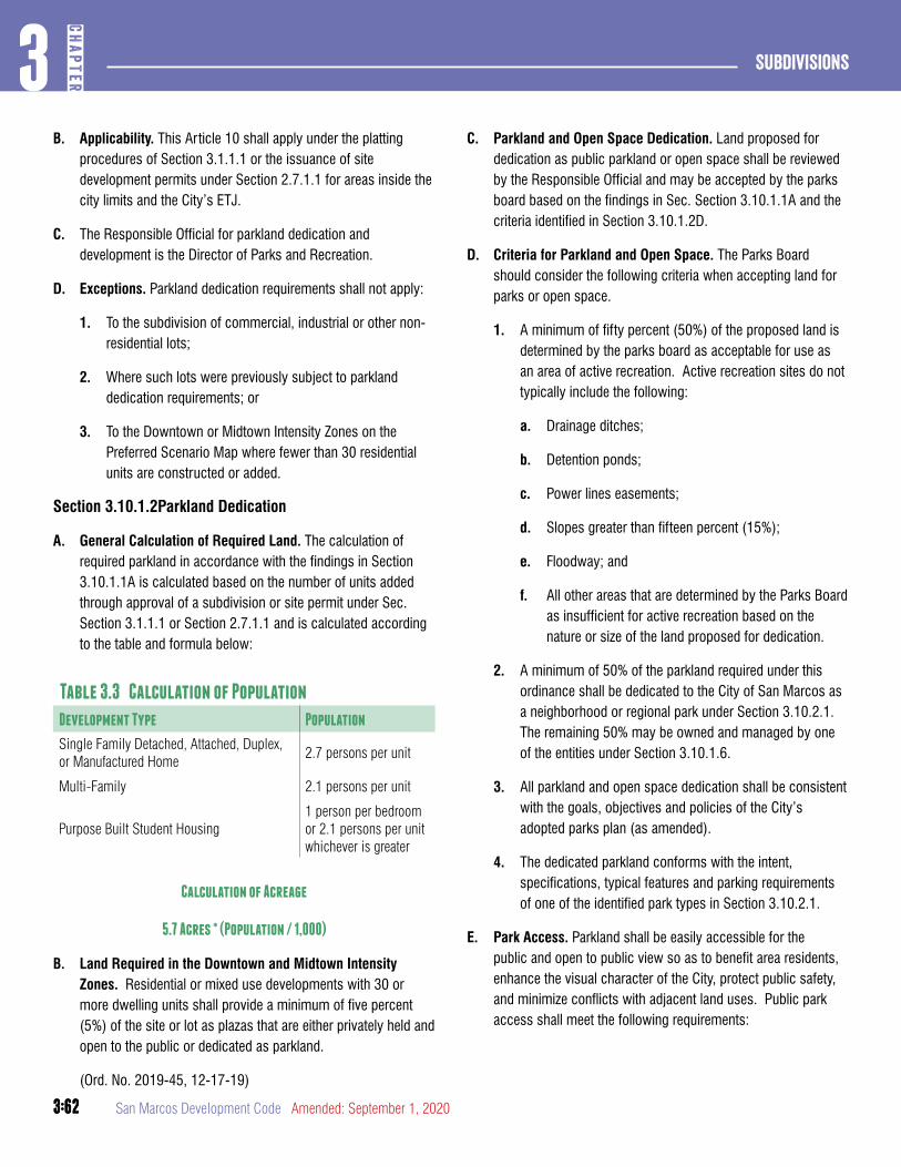
3:62
Subdivisions3
CHAP
TER
3:62 San Marcos Development Code Amended: September 1, 2020
B. Applicability. This Article 10 shall apply under the platting procedures of Section 3.1.1.1 or the issuance of site development permits under Section 2.7.1.1 for areas inside the city limits and the City’s ETJ.
C. The Responsible Official for parkland dedication and development is the Director of Parks and Recreation.
D. Exceptions. Parkland dedication requirements shall not apply:
1. To the subdivision of commercial, industrial or other non-residential lots;
2. Where such lots were previously subject to parkland dedication requirements; or
3. To the Downtown or Midtown Intensity Zones on the Preferred Scenario Map where fewer than 30 residential units are constructed or added.
Section 3.10.1.2Parkland Dedication
A. General Calculation of Required Land. The calculation of required parkland in accordance with the findings in Section 3.10.1.1A is calculated based on the number of units added through approval of a subdivision or site permit under Sec. Section 3.1.1.1 or Section 2.7.1.1 and is calculated according to the table and formula below:
Table 3.3 Calculation of Population
Development Type Population
Single Family Detached, Attached, Duplex, or Manufactured Home
2.7 persons per unit
Multi-Family 2.1 persons per unit
Purpose Built Student Housing1 person per bedroom or 2.1 persons per unit whichever is greater
Calculation of Acreage
5.7 Acres * (Population / 1,000)
B. Land Required in the Downtown and Midtown Intensity Zones. Residential or mixed use developments with 30 or more dwelling units shall provide a minimum of five percent (5%) of the site or lot as plazas that are either privately held and open to the public or dedicated as parkland.
(Ord. No. 2019-45, 12-17-19)
C. Parkland and Open Space Dedication. Land proposed for dedication as public parkland or open space shall be reviewed by the Responsible Official and may be accepted by the parks board based on the findings in Sec. Section 3.10.1.1A and the criteria identified in Section 3.10.1.2D.
D. Criteria for Parkland and Open Space. The Parks Board should consider the following criteria when accepting land for parks or open space.
1. A minimum of fifty percent (50%) of the proposed land is determined by the parks board as acceptable for use as an area of active recreation. Active recreation sites do not typically include the following:
a. Drainage ditches;
b. Detention ponds;
c. Power lines easements;
d. Slopes greater than fifteen percent (15%);
e. Floodway; and
f. All other areas that are determined by the Parks Board as insufficient for active recreation based on the nature or size of the land proposed for dedication.
2. A minimum of 50% of the parkland required under this ordinance shall be dedicated to the City of San Marcos as a neighborhood or regional park under Section 3.10.2.1. The remaining 50% may be owned and managed by one of the entities under Section 3.10.1.6.
3. All parkland and open space dedication shall be consistent with the goals, objectives and policies of the City’s adopted parks plan (as amended).
4. The dedicated parkland conforms with the intent, specifications, typical features and parking requirements of one of the identified park types in Section 3.10.2.1.
E. Park Access. Parkland shall be easily accessible for the public and open to public view so as to benefit area residents, enhance the visual character of the City, protect public safety, and minimize conflicts with adjacent land uses. Public park access shall meet the following requirements:

3:63
3CH
APTER
Subdivisions
3:63Amended: September 1, 2020 San Marcos Development Code
1. Access shall be required based on the access requirements of each park type identified in Section 3.10.2.1.
2. Access requirements shall be calculated based on the boundary of a parkland lot located adjacent to a parkway, boulevard, avenue, street or park road.
Section 3.10.1.3Fee in Lieu of Dedication.
A. A cash fee for the purchase of off-site parkland may be paid in lieu of all or part of the dedication of on-site parkland in accordance with the criteria below.
B. The cash fee in lieu of parkland dedication shall be based on the following formula:
Parkland Cost Factor x Number of Parkland Acres
C. “Parkland Cost Factor” is based on the average purchase price to the City for acquiring an acre of parkland.
D. All fees in lieu of dedication shall be paid prior to the recordation of the final plat or prior to the issuance of a site permit where a plat is not required.
E. Fees in lieu of dedication may be accepted if one of the following conditions apply:
1. If requested by the subdivider and reviewed by the Responsible Official, the Parks Board may allow the option of the payment of a fee over the dedication of land within the subdivision; or
2. Upon review and recommendation of the Responsible Official, the Parks Board determines that there is no land suitable for dedication based on the criteria in Section 3.10.1.2D.
3. The total amount of the fee-in-lieu is less than $50,000 and the Responsible Official makes a determination based on the Parks Master Plan and the findings in Section 3.10.1.1A that dedication is not desired in this location.
Section 3.10.1.4Parkland Development Fee
A. Except as provided in Section 3.10.1.1D, the developer shall bear a proportional cost of parkland improvements required for a neighborhood park.
B. The parkland development fee is set by City Council and is based on the current construction costs of a neighborhood park as demonstrated in the calculation methodology below and the findings in Section 3.10.1.1.
C. Development Offsets. The developer’s cost to provide park facilities shall offset the requirement for a parkland development fee.
1. The following improvements in a park may be credited towards parkland development:
a. Typical facilities listed in Section 3.10.2.1.
b. Site grading and preparation.
c. Landscaping.
d. One half the cost of adjacent perimeter roads in excess of 50% of the parkland lot boundary.
e. LID or green infrastructure facilities located within the development that qualify as an amenity under Section 7.2.4.1.
2. Parkland development shall be approved as part of a public improvement construction plan in accordance with Section 3.4.1.1 prior to the approval of the final plat and shall meet city park construction requirements.
3. Prior to the City’s acceptance of the parkland improvements, the subdivider shall deliver a warranty deed to the City conveying fee simple title of all parkland or open space shown on the final plat.
D. Parkland development fee:
1. For purposes of determining the development fee under Section 3.10.1.4:
Park Development Cost per Unit = Park Development Cost Factor Park facilities level of service
2. Where:
a. “Park development cost factor” is determined by the City Council based on the average cost of developing an acre of parkland
b. “Park facilities level-of-service” is:City Population
Number of Developed Parks

3:64
Subdivisions3
CHAP
TER
3:64 San Marcos Development Code Amended: September 1, 2020
c. Where “City Population” is determined by the city on an annual basis and “Number of Developed Parks” is the total number of parks developed with a recreational amenity or trail, as determined by the parks director prior to adoption of the annual fee ordinance by the City Council.
E. Permit Required for Park Site Manipulation. No individual, partnership, firm, or corporation shall deepen, widen, fill, reroute or change the course or location of any existing ditch, channel, stream or drainage way proposed for a parkland or open space without first obtaining a permit approved by the Responsible Official and any other agency having jurisdiction.
F. Parkland and Open Space Improvements. Parkland and open space improvements shall be consistent with the intended use of the parkland or open space and the overall goals, policies and objectives of the City, as stated in the Comprehensive Master Plan and the Parks Master Plan
Section 3.10.1.5Fee Payment and Expenditure
A. Parkland Benefit Areas. The City shall establish a separate parkland and open space account. The funds in the account shall be earmarked solely for the acquisition or development of parkland in accordance with Section 3.10.2.1 either in the same parkland benefit area in which the subdivision is located, or for regional parks and open space that will benefit all of the citizens of the City. The City shall expend cash contributions within ten years of the date any such contribution is made.
Section 3.10.1.6Ownership and Management
A. Ownership. Required parkland and any other common open space or area must be owned and maintained by one of the following entities:
1. City of San Marcos. Publicly dedicated parkland shall be owned and maintained by the City of San Marcos.
2. Land Conservancy or Land Trust. A bona fide land conservancy or land trust with legal authority as determined by the City Attorney may own the open space. The responsibility for maintaining the open space and any facilities may be borne by a land conservancy or land trust.
3. Homeowners’ Association. A homeowners’ association representing residents of the development may own the open space. The homeowners’ association must have lien authority to ensure the collection of dues from all members. The responsibility for maintaining the open space and any facilities is borne by the homeowners’ association.
4. Public Easement. Privately held open space shall be made permanently open to the public through an easement dedicated to the public and approved by the City Attorney.
B. Conveyance. The conveyance of parkland or other common open space shall be in accordance with the following:
1. Parkland or open space shall be conveyed to the City, land conservancy or homeowners’ association in fee simple without any encumbrances except drainage, greenway and utility easements. Title to the real property shall be conveyed upon the recordation of the plat.
2. Parkland or open space shall be designated on the final plat and included in a separate lot, or multiple lots and include the following:
a. A statement on the plat indicating the conveyance or dedication of parkland or open space; and
b. The acreage of the land included in the dedication.
C. Dissolution. If the homeowner’s association is dissolved, the open space may be offered to another entity who shall be responsible for the maintenance and upkeep of the open space. If no other offer is accepted, the open space shall be offered to the City and if accepted, deeded to the City.

3:65
3CH
APTER
Subdivisions
3:65Amended: September 1, 2020 San Marcos Development Code
DIVISION 2: PARKLAND TYPES
Section 3.10.2.1Summary
Table 3.4 Parkland Types
Regional Park Types Illustration
A. Greenways: A natural preserve available for unstructured recreation and bicycle or pedestrian transportation. Its landscape shall consist of paths and trails, meadows, rivers or streams, woodland and open shelters, all naturalistically disposed. Open space or greenways may be lineal, following the trajectories of natural corridors. The minimum width shall be 300 feet. Greenways shall be dedicated to the public.
B. Open Space: An open area, available for unstructured recreation. Open space may be spatially defined by landscaping rather than building frontages. Its landscape shall consist of lawn and trees, naturalistically disposed. The minimum size shall be 30 acres.
C. Community Park: Community Parks typically contain a specialized amenity such as athletic fields. Community parks are designed to serve the recreational needs of the entire city and may serve residents of other nearby populations. The minimum size shall be 10 acres. A community park shall be dedicated to the public.
Neighborhood Park Types Illustration
D. General Neighborhood Park: A general neighborhood park typically includes open play areas, playgrounds, courts, practiceathletic fields, and is available for civic purposes and gatherings. A general neighborhood park shall be spatially defined by streets and building frontages. The minimum size shall be 5 acres.
E. Pocket Park:An open space designed and equipped for passive or active recreation. Pocket parks include a wide array of facilities and are designed as smaller gathering spaces within a neighborhood area. A pocket park may be spatially defined by streets or building frontages. There shall be no minimum or maximum size.
F. Plaza: An open space available for civic purposes and commercial activities. A plaza shall be spatially defined by building frontages. Its landscape shall consist primarily of pavement. Trees are optional. Plazas should be located at the intersection of important streets. There shall be no minimum or maximum size.
G. Playground:An open space designed and equipped for the recreation of children. A playground should be fenced and may include an open shelter. Playgrounds shall be interspersed within residential areas and should be located within 1/2 mile of all residential units. Playgrounds may be included within other regional or neighborhood parks. There shall be no minimum or maximum size.
H. Community Garden:A grouping of garden plots available for small-scale cultivation. Community gardens should be fenced and accommodate individual storage sheds. Running water is required. Community Gardens shall be interspersed within residential areas and may be placed within a block or included within other regional or neighborhood parks. There shall be no minimum or maximum size.

3:66
Subdivisions3
CHAP
TER
3:66 San Marcos Development Code Amended: September 1, 2020
Section 3.10.2.2Greenway
Specifications
SizeMinimum width 200’ on average
Ownership and ManagementCity; Land Conservancy or Land Trust including easements
Character Passive or Active
Typical Facilities
• Passive and active recreation• Community gardens• Playgrounds and play structures• Multi-use paths• Accessory structures• Seating and signage
Parking
No on-site parking is required.
Access
Parkland boundary along public ROW 70% min.
Section 3.10.2.3Open Space
Specifications
Size 30 acres min.
Ownership and ManagementCity; Land Conservancy or Land Trust
Character Passive
Typical Facilities
• Passive recreation• Paths and trails• Accessory structures• Seating and signage
Parking
No on-site parking is required.
Access
Parkland boundary along public ROW 25% min.

3:67
3CH
APTER
Subdivisions
3:67Amended: September 1, 2020 San Marcos Development Code
Section 3.10.2.4Community Park
Specifications
Size 10 acres min.
Ownership and Management City
Character Active
Typical Facilities
• Civic buildings• Athletic fields • Accessory structures• Specialized amenities• Water features• Seating and signage
Parking
On-site parking is required based on the facilities provided (Section 7.1.2.1). On street parking adjacent to the parkland lot may be counted.
Access
Parkland boundary along public ROW 70%
Section 3.10.2.5General Neighborhood Park
Specifications
Size 5 ac min.
Ownership and Management City or HOA
Character Passive or Active
Typical Facilities
• Passive recreation• Paths• Accessory structures• Water features• Athletic fields and courts• Water features• Play structures• Garden plots• Running water• Lighting• Civic buildings• Seating and signage
Parking
On-site parking is required based on the facilities provided (Section 7.1.2.1). On street parking adjacent to the parkland lot may be counted.
Access
Parkland boundary along public ROW 70% min.

3:68
Subdivisions3
CHAP
TER
3:68 San Marcos Development Code Amended: September 1, 2020
Legend: NA = Not Applicable
Section 3.10.2.6Pocket Park
Specifications
SizeNo min.No max.
Ownership and Management HOA
Character Passive or Active
Typical Facilities
• Passive recreation• Paths• Accessory structures• Water features• Athletic fields and courts• Play structures• Running water• Lighting• Civic buildings• Seating and signage
Parking
On-site parking is required based on the facilities provided (Section 7.1.2.1). On street parking adjacent to the parkland lot may be counted.
Access
Parkland boundary along public ROW 50’ min.
Section 3.10.2.7Plazas
Specifications
SizeNo min.No max.
Ownership and ManagementCity; HOA; Private with public access easement.
Character Active
Typical Facilities
• Water features• Hardscaping• Public art• Water features• Accessory structures• Civic buildings• Seating and signage
Parking
No on-site parking is required.
Access
Parkland boundary along public ROW 50’ min.

3:69
3CH
APTER
Subdivisions
3:69Amended: September 1, 2020 San Marcos Development Code
Legend: NA = Not Applicable
Section 3.10.2.8Playground
Specifications
SizeNo min.No max.
Ownership and Management City; HOA
Character Active
Typical Facilities
• Play structures• Running water• Shade structures• Seating and signage
Parking
No on-site parking is required.
Access
Parkland boundary along public ROW 50’ min.
Section 3.10.2.9Community Garden
Specifications
SizeNo min.No max.
Ownership and Management City; HOA
Character Active
Typical Facilities
• Active recreation• Garden plots• Accessory structures• Running water
Parking
No on-site parking is required.
Access
Parkland boundary adjacent to street Not Required

3:70
Subdivisions3
CHAP
TER
3:70 San Marcos Development Code Amended: September 1, 2020

4:1
4CH
APTER
Zoning Regulations
Amended: September 1, 2020 San Marcos Development Code
ChaPTER 4. ZONING REGULaTIONS
article 1: General provisions and Establishment of Districts ............................................................................4:2
DIVISION 1: PURPOSE AND INTENT 4:2
DIVISION 2: DISTRICTS ESTABLISHED 4:5
DIVISION 3: ZONING DISTRICT MAP 4:13
DIVISION 4: ZONING UPON ANNEXATION 4:14
article 2: Building Types ............................................ 4:14DIVISION 1: BUILDING TYPES 4:14
article 3: General To all ............................................ 4:19DIVISION 1: AFFORDABLE HOUSING 4:19
DIVISION 2: MEASURING SITES AND LOTS 4:21
DIVISION 3: PLACEMENT OF BUILDINGS 4:23
DIVISION 4: BUILDING HEIGHT 4:27
DIVISION 5: ACTIVATION 4:30
article 4: Zoning Districts .........................................4:38DIVISION 1: CONVENTIONAL RESIDENTIAL DISTRICT 4:38
DIVISION 2: NEIGHBORHOOD DENSITY DISTRICTS 4:48
DIVISION 3: CHARACTER DISTRICTS 4:62
DIVISION 4: NEIGHBORHOOD TRANSITIONS 4:79
DIVISION 5: SPECIAL DISTRICTS 4:82
DIVISION 6: BUILDING TYPE STANDARDS 4:94
article 5: OVERLaY DISTRICTS .................................... 4:123DIVISION 1: ESTABLISHMENT AND PURPOSE 4:123
DIVISION 2: HISTORIC DISTRICTS 4:123
DIVISION 3: CORRIDOR OVERLAYS 4:129
DIVISION 4: CORRIDOR FRONTAGE TYPES 4:130

4:2
Zoning regulations4
CHAP
TER
San Marcos Development Code Amended: September 1, 2020
article 1: General provisions and Establishment of Districts
DIVISION 1: PURPOSE AND INTENT
Section 4.1.1.1Purpose and Intent
The zoning regulations and districts contained in this Chapter are established in accordance with the City’s adopted Comprehensive Plan, as authorized by Chapter 211 of the Texas Local Government
Code.
Section 4.1.1.2Compliance
Except for non-conformances allowed pursuant to Section 1.5.1.1, all land, development, improvements, construction, structures, buildings, lots and appurtenances located within the City shall be made, constructed, occupied, used, erected, altered, removed, placed, demolished and/or converted in conformance with the regulations prescribed for the zoning district in which the same is located and the applicable standards, requirements and other provisions of this Development Code.
Violations of these regulations shall be subject to penalties as per Section 2.3.7.1 of this Development Code.
Section 4.1.1.3Consistency with Comprehensive Plan
All requests for rezoning and development applications shall be consistent with the City’s adopted Comprehensive Plan, as amended from time to time.
Section 4.1.1.4Rules for Determining Consistency
A. A legislative development application is consistent with the City’s adopted Comprehensive Plan if the application is consistent with applicable policies in the Comprehensive Plan and applicable Comprehensive Plan maps.
1. In determining whether a legislative development application is consistent with a Comprehensive Plan map, the City shall take into consideration the policies that govern interpretation of the map, as well as location or property specific designations on the map.
2. The Preferred Scenario Map incorporated in the Comprehensive Plan is not a zoning or district map and shall not be construed as defining zoning or district
boundaries, but shall be used in making decisions regarding zoning.
B. A quasi-judicial or administrative development application is consistent with the City’s adopted Comprehensive Plan if the application conforms with regulations in this Development Code that implement the applicable policies of the Comprehensive Plan.
Section 4.1.1.5Applicable Plans, Maps and Policies
The following Comprehensive Plan elements and approved master plans and maps apply to the analysis of legislative development applications:
A. Comprehensive Plan and all addenda, as amended;
B. Water, Wastewater and Drainage Master Plans;
C. Preferred Scenario Map;
D. Transportation Master Plan and Thoroughfare Map;
E. Parks and Open Space Master Plan.
Section 4.1.1.6Comprehensive Plan Preferred Scenario
A. Comprehensive Plan Preferred Scenario Designations. To direct the intensity of, and development within, the various areas of the City, the Comprehensive Plan Preferred Scenario Map establishes the following Preferred Scenario areas:
1. Open Space/Agricultural Zone. An area which is not developed and which is generally suitable for very limited residential or agricultural uses.
2. Low Intensity Area. Low Intensity Areas are varied and diverse with respect to environmental sensitivity and development suitability of the land. They are generally made up of larger undeveloped tracts of land where the preservation of sensitive environmental areas, flood hazard areas and agricultural lands should be considered as part of any development proposal. Development in these areas should be guided by the Land Use Suitability Map of the Comprehensive Plan.
3. Existing Neighborhood Area. Established, primarily residential areas intended to maintain their existing character and to follow development and redevelopment patterns that are compatible with the existing character.
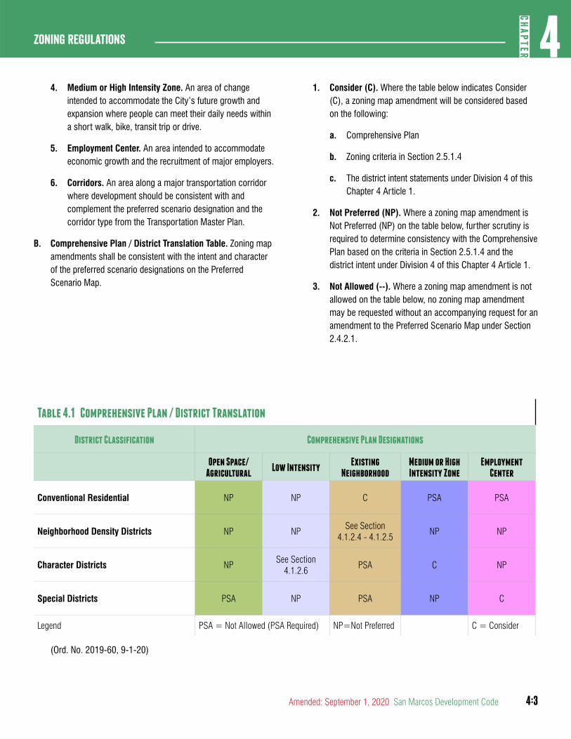
4:3
4CH
APTER
Zoning Regulations
Amended: September 1, 2020 San Marcos Development Code
4. Medium or High Intensity Zone. An area of change intended to accommodate the City’s future growth and expansion where people can meet their daily needs within a short walk, bike, transit trip or drive.
5. Employment Center. An area intended to accommodate economic growth and the recruitment of major employers.
6. Corridors. An area along a major transportation corridor where development should be consistent with and complement the preferred scenario designation and the corridor type from the Transportation Master Plan.
B. Comprehensive Plan / District Translation Table. Zoning map amendments shall be consistent with the intent and character of the preferred scenario designations on the Preferred Scenario Map.
1. Consider (C). Where the table below indicates Consider (C), a zoning map amendment will be considered based on the following:
a. Comprehensive Plan
b. Zoning criteria in Section 2.5.1.4
c. The district intent statements under Division 4 of this Chapter 4 Article 1.
2. Not Preferred (NP). Where a zoning map amendment is Not Preferred (NP) on the table below, further scrutiny is required to determine consistency with the Comprehensive Plan based on the criteria in Section 2.5.1.4 and the district intent under Division 4 of this Chapter 4 Article 1.
3. Not Allowed (--). Where a zoning map amendment is not allowed on the table below, no zoning map amendment may be requested without an accompanying request for an amendment to the Preferred Scenario Map under Section 2.4.2.1.
Table 4.1 Comprehensive Plan / District Translation
District Classification Comprehensive Plan Designations
Open Space/ Agricultural
Low Intensity Existing
NeighborhoodMedium or High Intensity Zone
EmploymentCenter
Conventional Residential NP NP C PSA PSA
Neighborhood Density Districts NP NPSee Section
4.1.2.4 - 4.1.2.5NP NP
Character Districts NPSee Section
4.1.2.6PSA C NP
Special Districts PSA NP PSA NP C
Legend PSA = Not Allowed (PSA Required) NP=Not Preferred C = Consider
(Ord. No. 2019-60, 9-1-20)
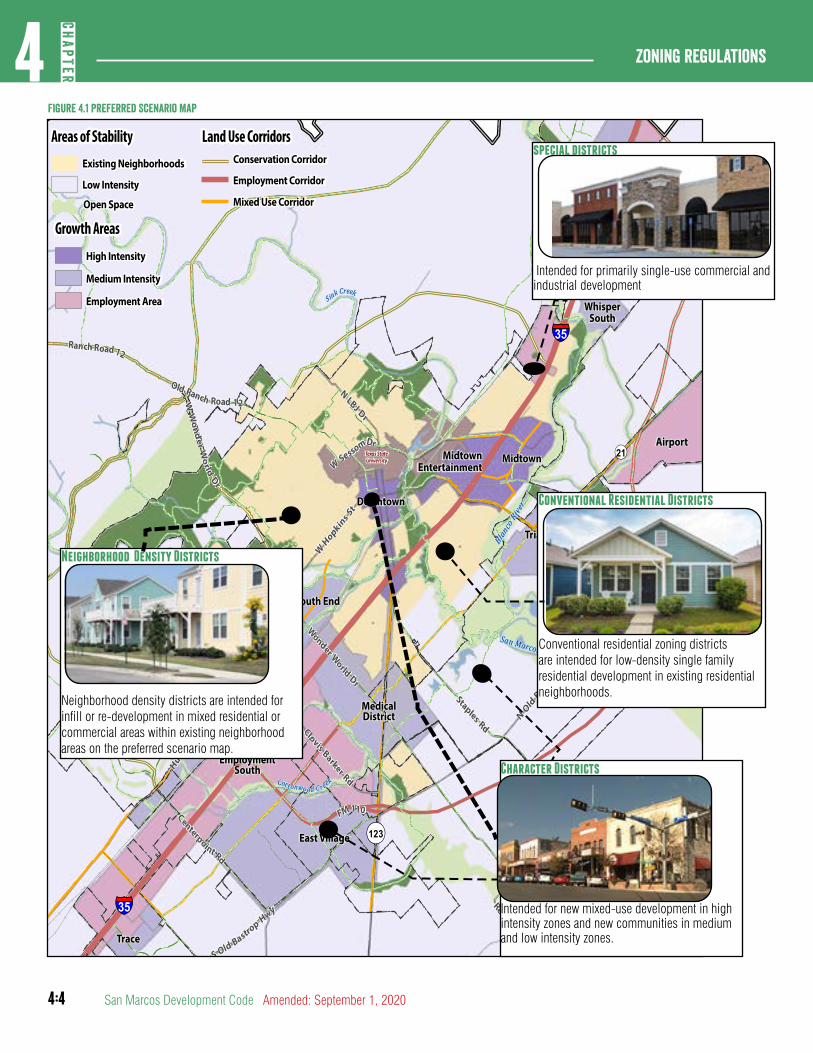
4:4
Zoning regulations4
CHAP
TER
San Marcos Development Code Amended: September 1, 2020
!
!
!
!
!!
!
!
!
!
!
!!
!
!
!
!
!
!
!
!
!
!
!
!!
!
!
!
!
!
!
!
!
!
!
!
!
!
!
!
!
!
!
!
!
!
!
!
!!
!
!
!
!
!
!
!
!
!
!
!
!!
!
!
!
!
!
!!
!
!
!
!
!
!
!
!
!
!
!
!!
!
!
!
!
!
!
!
!
!
!
!
!
!
!
!
!
!
!
!
!
!
!
!
!!
!
!
!
!
!
!
!
!
!
!
!
!
!
!
!!
!
!!
!!
!
!
!
!
!
!
!!
!
!
!
!
!
!
!
!
!
!
!
!
!
! !
!
!
!
!
!
!
!
!
!
!
!
!
!
!
!
!
!
!
!
!
!
!
!
!
!
!
!
!
!!
!
!
!
!
!
!
!
!
!
!
!
!
!
!!
!
!
!
!
!
!
!
!
!
!
!
!
!
!
!
!
!
!
!
!
!
!
!
!
!
!
!
!
!
!
!
!
!
!
!
!
!
!
!
!
!
!
!
!
!
!
!
!
!
!
!
!
!
!
!
!
!
!!
!
!
!
!
!
!
!
!
!
!
!
!
!
!!
!
!
!
!
!
!
!
!
!
!
!
!
!
!
!
!
!
!
!
!
!
!
!
!
!
!
!
!
!
!
!
!
!
!
!
!
!
!
!
!
!
!
!
!
!
!
!
!
!
!
!
!
!
!
!
!
!
!
!
!
!
!
!
!
!
!
!
!
!
!
!
!
!
!
!
!
!
!
!
!
!
!
!
!
! !
!
!
!
!
!
!
!
!
!
!
!
!
!
!
!
!
!
!
!
!
!
!
!
!
!
!
!
!
!
!
!
!
!!
!
!
!
!
!
!
!
!
!
!
!
!
!
!
!
!
!
!
!
!
!
!
!
!
!
!
!
!
!
!
!
!
!
!
!
!
!
!
!
!
!
!
!
!
!
!
!
!
!
!
!
!
!
!
!
!
!
!
!
!
!
!
!
!
!
!
!
!
!
!
!
!
!
!
!
!
!
! !
!
!
!
!
!
!
!
!
!
!
!
!
!
!
!
!
!
!
!
!
!
!
!
!
!
!
!
!
!
!
!
!
!
!
!
!
!
!
!
!
!
!
!
!!
!
!
!
!
!
!
!
!
!
!
!
!
!
!
!
!
!
!
!
!
!
!
!
!
!
!
!
!
!
!
!
!
!
!
!
!
!
!
!
!
!
!
!
!
!
!
!
!
!
!
!
!
!
!
!
!
!
!
!
!
!
!
!
!
!
!
!
!
!
!
!
!
!
!
!
!
!
!
!
!
!
!
! !
!
!
!
!
!
!
!
!!!
!
!
!
!
!
!
!
!
!
!
!
!
!
!
!
!
!!
!
!!
!
!
!
!!
!
!
!
!
!
!
!!
!
!
!
!
!!
!!
!
!
!
!
!
!
!
!
!
!
!
!
!
!
!
!
!
!
!
!!
!
!
!
!
!
!
!
!
!
!
!
!
!
!
!
!
!
!
!
!
!
!
!
!
!
!
!
!
!
!
!
!
!
!
!
!
!
!
!!
!!!
!
!
!!
!!!
!!
!
!
!
!
!
!
!
!
!
!
!
!
!
!
!
!
!
!
!
!
!
!
!
!
!
!
!
!
!
!
!!
!
!
!
!
!
!
!
!
!
!
!
!
!
!
! !!
!
! !!
!
!
!
!
!
!
!
!
!
!
!
!
!
!
!
!
!
!
!
!
!
!
!
!
!
!
!
!
!
!
!
!
!!!
!
!
!
!
!
!
!
!
!
!
!
!
!
!
!
!
!
!
!
!
!
!
!
!
!
!
!
!
!
!
!
!
!
!
!
!
!
!
!!
! !
!
!
!
!
!
!
!
!
!
!
!
!
!
!
!!
!
!
!
!
!
!
!
!
!
!
!
!
!
!
!
!
!
!
!
!
!
!
!
!
!
!
!
!
!
!
!
!
!
!
!
!
!
!
!
!
!
!
!
!
!
!
!
!
!
!
!
!
!
!
!
!
!! ! !
!
! !
!
!
!
!
!
!
!!
!
!
!
!!
!
!
!
!
!
!
!
!!
!
!
!
!
!
!
!
!
!
!!
!
!
!
!
!
!
!
!
!
!!
!
!
!
!
!
!
!
!
!!
!
!
!
!
!
!
!
!
!
!
!
!!
!!
!
!
!
!
!
!
!
!
!
!
!
!
!
!
!
!
!
!
!
!
!
!
!
!
!!
!
!!
!
!
!!
!!
!
!
!
!
!
! !
!
!
!
!
!
!
!!
!!
!
!
!
!
!
!
!
! !!
!
!
!
!
!
!
!
!
!
!
!!
!
!
!
! !
!
!
!!
!
!
!
!
!
!
!
!
!
!!
!
!
!
!
!
!
!
!
!
!
!
!
!
!
!
!
!!
!
!
!
!
!
!
!
!
!
!
!
!
!
!
!
!
!
!
!
!
!
!
!
!
!
!
!
!
!
!
!
!
! !
!
!
!
!
!
!
!
!
!
!
!
!
!
!
!
!
!
!
!
!
!
!
!
!
!
!
!
!
!
!
!
!
!
!
!
!
!
!
!
!
!
!
!
!
!
!
!
!
!
!
!
!
!
!
!
!
!
!
!
!
!
!
!
!
!
!
!
!
!
!
!
!
!
!
!
!
!
!
!
!
!
!
!
!
!
!
!
!
!
!
!
!
!
!
!
!
!
!
!!
!
!
!
!!
!
!
!
!
!
!
!
!
!
!
!
! !
!
!
!
!
! !
!
!
!
!
!
!
!
!
!
!
!
!
!
!
!
!
!
!
!
!
!
!
!
!
!
!
!
!
!!
!
!
!
!
!
!
!!
!
!
!
!
!
!
!
!
!
!
!
!
!
!
!
!
!
!
!
!!
!
!
!
!
!
!
!
!
!
!
!
!
!
!
!
!
!
!
!
!
!
!
!
!
!
!
!
!
!
!
!
!
!!
!
!
!
!
!
!
!
!
!
!
!
!
!
!
!
!
!
!
!
!
!
!
!
!
!
East Village
MedicalDistrictStar Park
South End
Las Colinas
Trace
WhisperSouth
WhisperNorth
YarringtonCommons
Airport
Triangle
Downtown
MidtownEntertainment
Midtown
EmploymentSouth
Blanc
o Riv
er
San Marcos River
TexasState
WSessomDr
Hunter Rd
N LBJ Dr
W H
opkins S
t
Staples Rd
WMcCarty
Ln
Redwood Rd
Old Ranch Road 12
Clovis Barker Rd
WW
ond
erW
orld
Dr
Wonder W
orldDr
FM110
S Old Bastrop Hwy
Ranch Road 12
NOld
Bastrop
Hw
y
Centerpoint Rd
¬«80
¬«21
¬«123
§̈¦35
§̈¦35
Cot tonwo od C r eek
Purga tory C reek
Willow Springs Creek
Sink Creek
Texas StateUniversity
Preferred Scenario2017 Update
This product is for informational purposes only and may not have been prepared for or be suitable for legal, engineering, or surveying purposes. It does notrepresent an on-the-ground survey and represents only the approximate relative location of property boundaries. Map Date: August 25, 2017
Texas Local Government Code - Sec. 213.005: "A comprehensive plan shall not constitute zoning regulations or establish zoning district boundaries."0 1 2
MilesF
Proposed & EnhancedGreenways
! ! ! ! !
Other FeaturesExtraterritorial Jurisdiction
Park or Natural Area
City Limits
Rail Road
Creek
Texas State
River
Open Space
Employment Corridor
Conservation Corridor
Mixed Use Corridor
Land Use Corridors
Growth Areas
Areas of StabilityExisting Neighborhoods
Low Intensity
High Intensity
Medium Intensity
Employment Area
Conventional Residential Districts
Conventional residential zoning districts are intended for low-density single family residential development in existing residential neighborhoods.
Neighborhood Density Districts
Neighborhood density districts are intended for infill or re-development in mixed residential or commercial areas within existing neighborhood areas on the preferred scenario map.
Character Districts
Intended for new mixed-use development in high intensity zones and new communities in medium and low intensity zones.
special districts
Intended for primarily single-use commercial and industrial development
Figure 4.1 Preferred Scenario Map
4:5
4CH
APTER
Zoning Regulations
Amended: September 1, 2020 San Marcos Development Code
DIVISION 2: DISTRICTS ESTABLISHED
Section 4.1.2.1District Classifications
A. Zoning districts are categorized into four different classifications that relate to the type of development that is anticipated by the Comprehensive Plan in each area designated on the Comprehensive Plan Map.
B. The zoning district classifications include:
1. Conventional residential zoning districts;
2. Neighborhood density zoning districts;
3. Character zoning districts; and
4. Special zoning districts.
Section 4.1.2.3Conventional Residential Zoning Districts
A. Conventional residential zoning districts are intended for low-density single family residential development.
B. Conventional residential zoning districts should be applied in existing neighborhood areas that are dominated by single family residential zoning.
Table 4.2 Conventional Residential DistrictsAbbreviated Designation
District Name District Intent Sec.
FDFuture Development District
The FD district is intended to serve as a temporary zoning district for properties that shall develop in the future, but have been newly annexed and/or are not yet ready to be developed. Characterized by primarily agricultural uses with woodlands, wetlands and scattered buildings.
Section 4.4.1.1
SF-RSingle Family Rural Residential District
The SF-R Rural Residential District is intended for the development of single family uses in larger lot subdivision in a more rural setting.
Section 4.4.1.2
SF-6 Single Family District - 6
The SF-6 district is intended to accommodate single family detached houses with a minimum lot size of 6,000 square feet. Characterized by smaller landscaped areas with moderate setbacks and more frequent pedestrian use. Uses that would substantially interfere with the residential nature of the district are not allowed.
Section 4.4.1.3
SF-4.5 Single Family District - 4.5
The SF-4.5 district is intended to accommodate single family detached houses with a minimum lot size of 4,500 square feet. Characterized by smaller landscaped areas with moderate setbacks and more frequent pedestrian use. Uses that would substantially interfere with the residential nature of the district are not allowed.
Section 4.4.1.4
Section 4.1.2.2Division of the City into Districts
A. The City is hereby divided into zones, or districts, and the boundaries of zones and districts set out herein are delineated upon the Zoning District Map of the City, which may also be cited as the “Zoning Map”, which is adopted as a part of this Development Code as fully as if the same were set forth herein in detail. The terms “zone” “zoning” “zoning district” can be used interchangeably.
B. The following zoning districts are established and applied to property as set forth on the Official Zoning Map. District intent statements are used in addition to the Comprehensive Plan to analyze the appropriateness of different zoning requests.
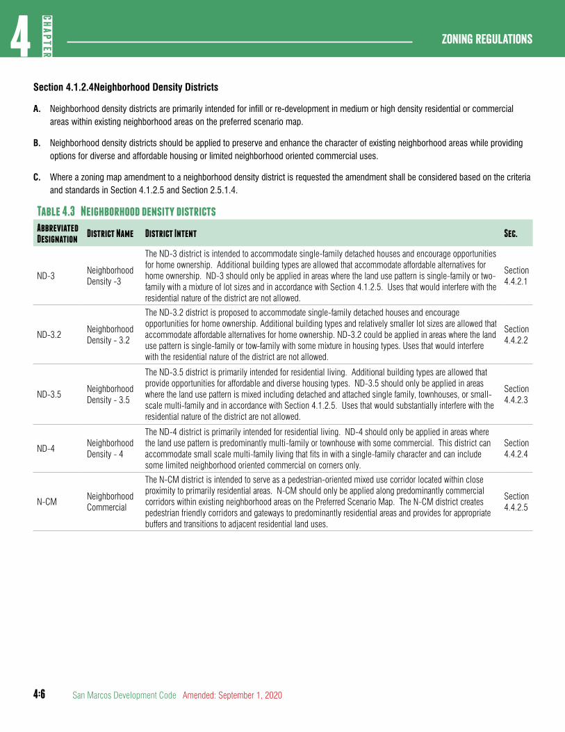
4:6
Zoning regulations4
CHAP
TER
San Marcos Development Code Amended: September 1, 2020
Section 4.1.2.4Neighborhood Density Districts
A. Neighborhood density districts are primarily intended for infill or re-development in medium or high density residential or commercial areas within existing neighborhood areas on the preferred scenario map.
B. Neighborhood density districts should be applied to preserve and enhance the character of existing neighborhood areas while providing options for diverse and affordable housing or limited neighborhood oriented commercial uses.
C. Where a zoning map amendment to a neighborhood density district is requested the amendment shall be considered based on the criteria and standards in Section 4.1.2.5 and Section 2.5.1.4.
Table 4.3 Neighborhood density districtsAbbreviated Designation
District Name District Intent Sec.
ND-3Neighborhood Density -3
The ND-3 district is intended to accommodate single-family detached houses and encourage opportunities for home ownership. Additional building types are allowed that accommodate affordable alternatives for home ownership. ND-3 should only be applied in areas where the land use pattern is single-family or two-family with a mixture of lot sizes and in accordance with Section 4.1.2.5. Uses that would interfere with the residential nature of the district are not allowed.
Section 4.4.2.1
ND-3.2Neighborhood Density - 3.2
The ND-3.2 district is proposed to accommodate single-family detached houses and encourage opportunities for home ownership. Additional building types and relatively smaller lot sizes are allowed that accommodate affordable alternatives for home ownership. ND-3.2 could be applied in areas where the land use pattern is single-family or tow-family with some mixture in housing types. Uses that would interfere with the residential nature of the district are not allowed.
Section 4.4.2.2
ND-3.5Neighborhood Density - 3.5
The ND-3.5 district is primarily intended for residential living. Additional building types are allowed that provide opportunities for affordable and diverse housing types. ND-3.5 should only be applied in areas where the land use pattern is mixed including detached and attached single family, townhouses, or small-scale multi-family and in accordance with Section 4.1.2.5. Uses that would substantially interfere with the residential nature of the district are not allowed.
Section 4.4.2.3
ND-4Neighborhood Density - 4
The ND-4 district is primarily intended for residential living. ND-4 should only be applied in areas where the land use pattern is predominantly multi-family or townhouse with some commercial. This district can accommodate small scale multi-family living that fits in with a single-family character and can include some limited neighborhood oriented commercial on corners only.
Section 4.4.2.4
N-CMNeighborhood Commercial
The N-CM district is intended to serve as a pedestrian-oriented mixed use corridor located within close proximity to primarily residential areas. N-CM should only be applied along predominantly commercial corridors within existing neighborhood areas on the Preferred Scenario Map. The N-CM district creates pedestrian friendly corridors and gateways to predominantly residential areas and provides for appropriate buffers and transitions to adjacent residential land uses.
Section 4.4.2.5
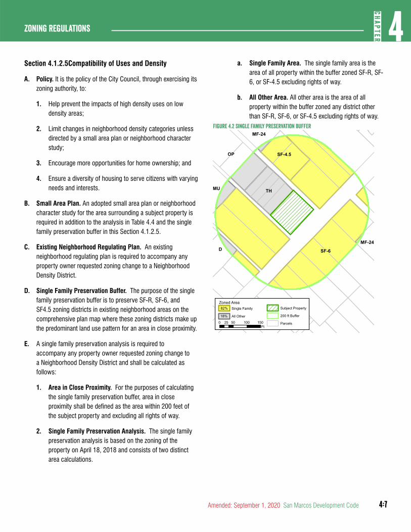
4:7
4CH
APTER
Zoning Regulations
Amended: September 1, 2020 San Marcos Development Code
a. Single Family Area. The single family area is the area of all property within the buffer zoned SF-R, SF-6, or SF-4.5 excluding rights of way.
b. All Other Area. All other area is the area of all property within the buffer zoned any district other than SF-R, SF-6, or SF-4.5 excluding rights of way.
Figure 4.2 Single Family Preservation buffer
SF-4.5SF-4.5
MF-24
MU
DMF-24
SF-6SF-6
THTH
OPOP
Parcels
Subject PropertyZoned Area
200 ft BufferAll Other18%
Single Family82%
0 50 100 15025Ft
Section 4.1.2.5Compatibility of Uses and Density
A. Policy. It is the policy of the City Council, through exercising its zoning authority, to:
1. Help prevent the impacts of high density uses on low density areas;
2. Limit changes in neighborhood density categories unless directed by a small area plan or neighborhood character study;
3. Encourage more opportunities for home ownership; and
4. Ensure a diversity of housing to serve citizens with varying needs and interests.
B. Small Area Plan. An adopted small area plan or neighborhood character study for the area surrounding a subject property is required in addition to the analysis in Table 4.4 and the single family preservation buffer in this Section 4.1.2.5.
C. Existing Neighborhood Regulating Plan. An existing neighborhood regulating plan is required to accompany any property owner requested zoning change to a Neighborhood Density District.
D. Single Family Preservation Buffer. The purpose of the single family preservation buffer is to preserve SF-R, SF-6, and SF4.5 zoning districts in existing neighborhood areas on the comprehensive plan map where these zoning districts make up the predominant land use pattern for an area in close proximity.
E. A single family preservation analysis is required to accompany any property owner requested zoning change to a Neighborhood Density District and shall be calculated as follows:
1. Area in Close Proximity. For the purposes of calculating the single family preservation buffer, area in close proximity shall be defined as the area within 200 feet of the subject property and excluding all rights of way.
2. Single Family Preservation Analysis. The single family preservation analysis is based on the zoning of the property on April 18, 2018 and consists of two distinct area calculations.
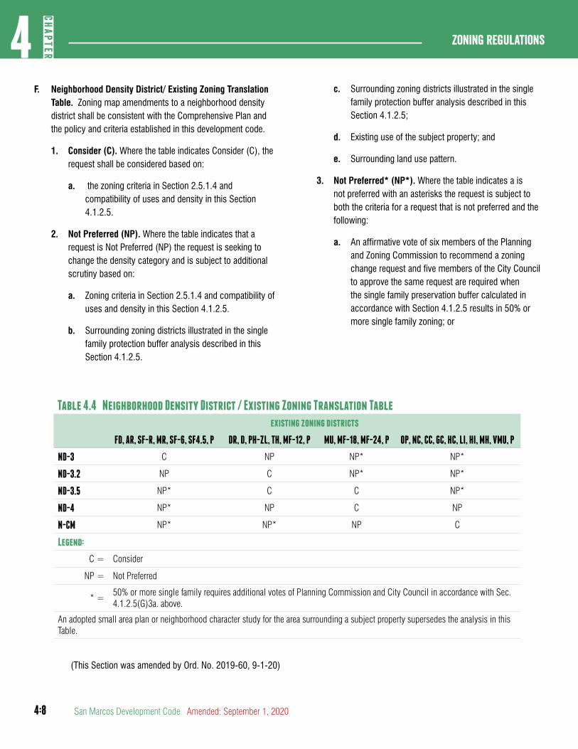
4:8
Zoning regulations4
CHAP
TER
San Marcos Development Code Amended: September 1, 2020
c. Surrounding zoning districts illustrated in the single family protection buffer analysis described in this Section 4.1.2.5;
d. Existing use of the subject property; and
e. Surrounding land use pattern.
3. Not Preferred* (NP*). Where the table indicates a is not preferred with an asterisks the request is subject to both the criteria for a request that is not preferred and the following:
a. An affirmative vote of six members of the Planning and Zoning Commission to recommend a zoning change request and five members of the City Council to approve the same request are required when the single family preservation buffer calculated in accordance with Section 4.1.2.5 results in 50% or more single family zoning; or
Table 4.4 Neighborhood Density District / Existing Zoning Translation Table
existing zoning districts
FD, AR, SF-R, MR, SF-6, SF4.5, P DR, D, PH-ZL, TH, MF-12, P MU, MF-18, MF-24, P OP, NC, CC, GC, HC, LI, HI, MH, VMU, P
ND-3 C NP NP* NP*
ND-3.2 NP C NP* NP*
ND-3.5 NP* C C NP*
ND-4 NP* NP C NP
N-CM NP* NP* NP C
Legend:
C = Consider
NP = Not Preferred
* =50% or more single family requires additional votes of Planning Commission and City Council in accordance with Sec. 4.1.2.5(G)3a. above.
An adopted small area plan or neighborhood character study for the area surrounding a subject property supersedes the analysis in this Table.
(This Section was amended by Ord. No. 2019-60, 9-1-20)
F. Neighborhood Density District/ Existing Zoning Translation Table. Zoning map amendments to a neighborhood density district shall be consistent with the Comprehensive Plan and the policy and criteria established in this development code.
1. Consider (C). Where the table indicates Consider (C), the request shall be considered based on:
a. the zoning criteria in Section 2.5.1.4 and compatibility of uses and density in this Section 4.1.2.5.
2. Not Preferred (NP). Where the table indicates that a request is Not Preferred (NP) the request is seeking to change the density category and is subject to additional scrutiny based on:
a. Zoning criteria in Section 2.5.1.4 and compatibility of uses and density in this Section 4.1.2.5.
b. Surrounding zoning districts illustrated in the single family protection buffer analysis described in this Section 4.1.2.5.
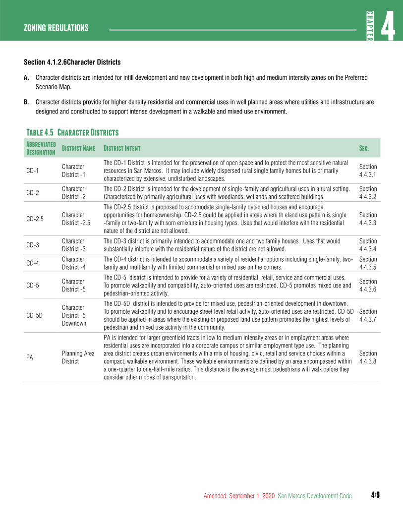
4:9
4CH
APTER
Zoning Regulations
Amended: September 1, 2020 San Marcos Development Code
Section 4.1.2.6Character Districts
A. Character districts are intended for infill development and new development in both high and medium intensity zones on the Preferred Scenario Map.
B. Character districts provide for higher density residential and commercial uses in well planned areas where utilities and infrastructure are designed and constructed to support intense development in a walkable and mixed use environment.
Table 4.5 Character DistrictsAbbreviated Designation
District Name District Intent Sec.
CD-1Character District -1
The CD-1 District is intended for the preservation of open space and to protect the most sensitive natural resources in San Marcos. It may include widely dispersed rural single family homes but is primarily characterized by extensive, undisturbed landscapes.
Section 4.4.3.1
CD-2Character District -2
The CD-2 District is intended for the development of single-family and agricultural uses in a rural setting. Characterized by primarily agricultural uses with woodlands, wetlands and scattered buildings.
Section 4.4.3.2
CD-2.5Character District -2.5
The CD-2.5 district is proposed to accomodate single-family detached houses and encourage opportunities for homeownership. CD-2.5 could be applied in areas where th eland use pattern is single -family or two-family with som emixture in housing types. Uses that would interfere with the residential nature of the district are not allowed.
Section 4.4.3.3
CD-3Character District -3
The CD-3 district is primarily intended to accommodate one and two family houses. Uses that would substantially interfere with the residential nature of the district are not allowed.
Section 4.4.3.4
CD-4Character District -4
The CD-4 district is intended to accommodate a variety of residential options including single-family, two-family and multifamily with limited commercial or mixed use on the corners.
Section 4.4.3.5
CD-5Character District -5
The CD-5 district is intended to provide for a variety of residential, retail, service and commercial uses. To promote walkability and compatibility, auto-oriented uses are restricted. CD-5 promotes mixed use and pedestrian-oriented activity.
Section 4.4.3.6
CD-5DCharacter District -5 Downtown
The CD-5D district is intended to provide for mixed use, pedestrian-oriented development in downtown. To promote walkability and to encourage street level retail activity, auto-oriented uses are restricted. CD-5D should be applied in areas where the existing or proposed land use pattern promotes the highest levels of pedestrian and mixed use activity in the community.
Section 4.4.3.7
PAPlanning Area District
PA is intended for larger greenfield tracts in low to medium intensity areas or in employment areas where residential uses are incorporated into a corporate campus or similar employment type use. The planning area district creates urban environments with a mix of housing, civic, retail and service choices within a compact, walkable environment. These walkable environments are defined by an area encompassed within a one-quarter to one-half-mile radius. This distance is the average most pedestrians will walk before they consider other modes of transportation.
Section 4.4.3.8
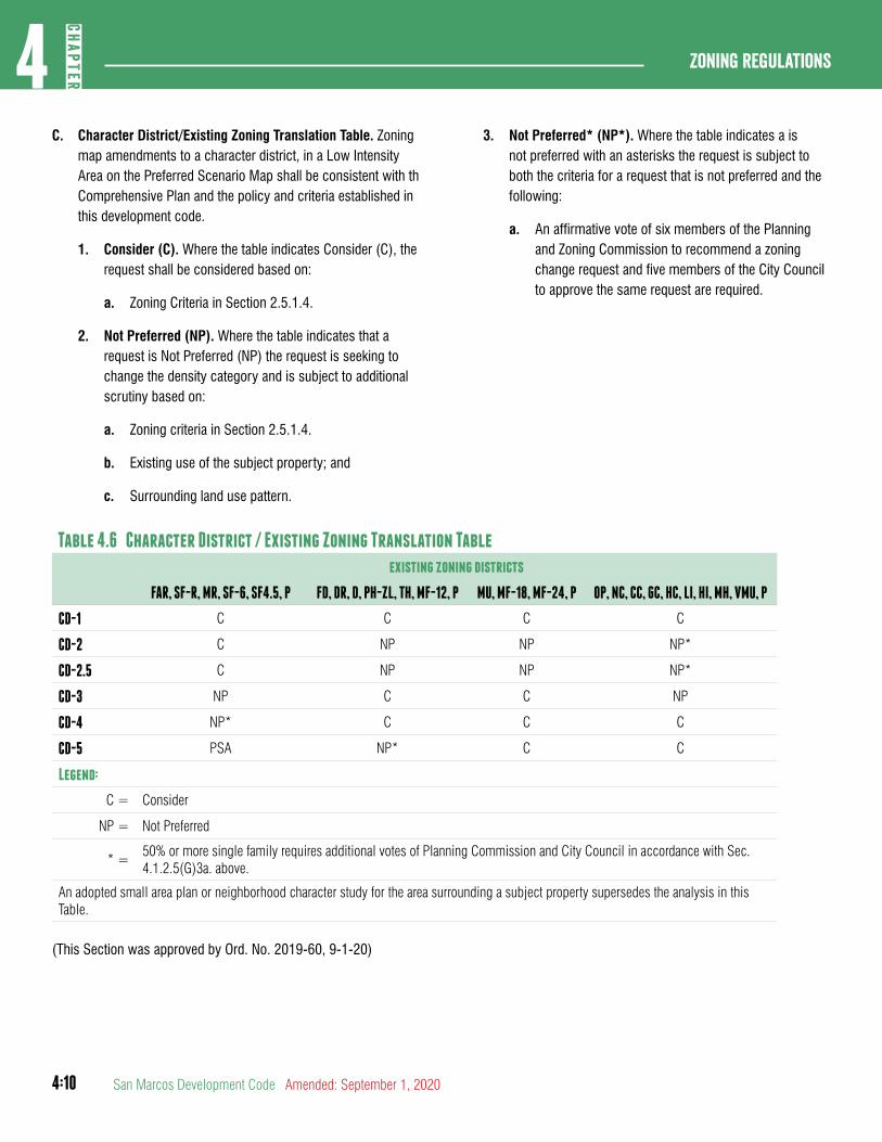
4:10
Zoning regulations4
CHAP
TER
San Marcos Development Code Amended: September 1, 2020
C. Character District/Existing Zoning Translation Table. Zoning map amendments to a character district, in a Low Intensity Area on the Preferred Scenario Map shall be consistent with th Comprehensive Plan and the policy and criteria established in this development code.
1. Consider (C). Where the table indicates Consider (C), the request shall be considered based on:
a. Zoning Criteria in Section 2.5.1.4.
2. Not Preferred (NP). Where the table indicates that a request is Not Preferred (NP) the request is seeking to change the density category and is subject to additional scrutiny based on:
a. Zoning criteria in Section 2.5.1.4.
b. Existing use of the subject property; and
c. Surrounding land use pattern.
3. Not Preferred* (NP*). Where the table indicates a is not preferred with an asterisks the request is subject to both the criteria for a request that is not preferred and the following:
a. An affirmative vote of six members of the Planning and Zoning Commission to recommend a zoning change request and five members of the City Council to approve the same request are required.
Table 4.6 Character District / Existing Zoning Translation Table
existing zoning districts
FAR, SF-R, MR, SF-6, SF4.5, P FD, DR, D, PH-ZL, TH, MF-12, P MU, MF-18, MF-24, P OP, NC, CC, GC, HC, LI, HI, MH, VMU, P
CD-1 C C C C
CD-2 C NP NP NP*
CD-2.5 C NP NP NP*
CD-3 NP C C NP
CD-4 NP* C C C
CD-5 PSA NP* C C
Legend:
C = Consider
NP = Not Preferred
* =50% or more single family requires additional votes of Planning Commission and City Council in accordance with Sec. 4.1.2.5(G)3a. above.
An adopted small area plan or neighborhood character study for the area surrounding a subject property supersedes the analysis in this Table.
(This Section was approved by Ord. No. 2019-60, 9-1-20)
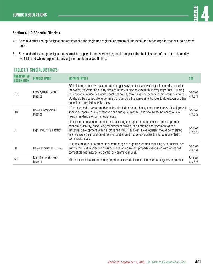
4:11
4CH
APTER
Zoning Regulations
Amended: September 1, 2020 San Marcos Development Code
Section 4.1.2.8Special Districts
A. Special district zoning designations are intended for single use regional commercial, industrial and other large format or auto-oriented uses.
B. Special district zoning designations should be applied in areas where regional transportation facilities and infrastructure is readily available and where impacts to any adjacent residential are limited.
Table 4.7 Special DistrictsAbbreviated Designation
District Name District Intent Sec
ECEmployment Center District
EC is intended to serve as a commercial gateway and to take advantage of proximity to major roadways, therefore the quality and aesthetics of new development is very important. Building type options include live work, shopfront house, mixed use and general commercial buildings. EC should be applied along commercial corridors that serve as entrances to downtown or other pedestrian-oriented activity areas.
Section 4.4.5.1
HC Heavy Commercial District
HC is intended to accommodate auto-oriented and other heavy commercial uses. Development should be operated in a relatively clean and quiet manner, and should not be obnoxious to nearby residential or commercial uses.
Section 4.4.5.2
LI Light Industrial District
LI is intended to accommodate manufacturing and light industrial uses in order to promote economic viability, encourage employment growth, and limit the encroachment of non-industrial development within established industrial areas. Development should be operated in a relatively clean and quiet manner, and should not be obnoxious to nearby residential or commercial uses.
Section 4.4.5.3
HI Heavy Industrial DistrictHI is intended to accommodate a broad range of high impact manufacturing or industrial uses that by their nature create a nuisance, and which are not properly associated with or are not compatible with nearby residential or commercial uses.
Section 4.4.5.4
MHManufactured Home District
MH is intended to implement appropriate standards for manufactured housing developments.Section 4.4.5.5
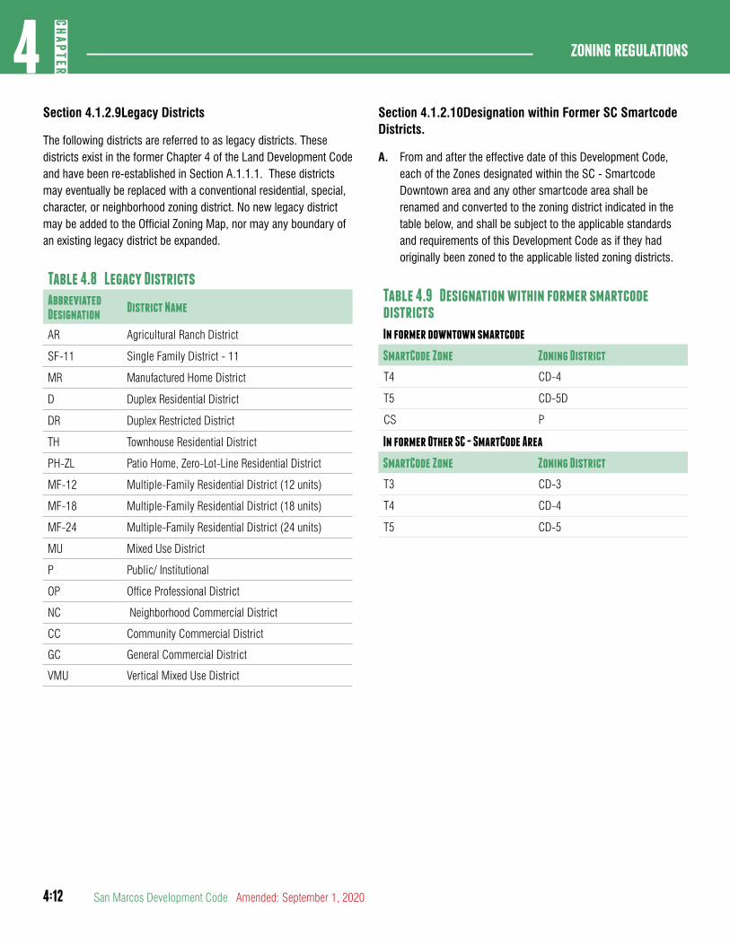
4:12
Zoning regulations4
CHAP
TER
San Marcos Development Code Amended: September 1, 2020
Section 4.1.2.10Designation within Former SC Smartcode Districts.
A. From and after the effective date of this Development Code, each of the Zones designated within the SC - Smartcode Downtown area and any other smartcode area shall be renamed and converted to the zoning district indicated in the table below, and shall be subject to the applicable standards and requirements of this Development Code as if they had originally been zoned to the applicable listed zoning districts.
Table 4.9 Designation within former smartcode districts
In former downtown smartcode
SmartCode Zone Zoning District
T4 CD-4
T5 CD-5D
CS P
In former Other SC - SmartCode Area
SmartCode Zone Zoning District
T3 CD-3
T4 CD-4
T5 CD-5
Section 4.1.2.9Legacy Districts
The following districts are referred to as legacy districts. These districts exist in the former Chapter 4 of the Land Development Code and have been re-established in Section A.1.1.1. These districts may eventually be replaced with a conventional residential, special, character, or neighborhood zoning district. No new legacy district may be added to the Official Zoning Map, nor may any boundary of an existing legacy district be expanded.
Table 4.8 Legacy DistrictsAbbreviated Designation
District Name
AR Agricultural Ranch District
SF-11 Single Family District - 11
MR Manufactured Home District
D Duplex Residential District
DR Duplex Restricted District
TH Townhouse Residential District
PH-ZL Patio Home, Zero-Lot-Line Residential District
MF-12 Multiple-Family Residential District (12 units)
MF-18 Multiple-Family Residential District (18 units)
MF-24 Multiple-Family Residential District (24 units)
MU Mixed Use District
P Public/ Institutional
OP Office Professional District
NC Neighborhood Commercial District
CC Community Commercial District
GC General Commercial District
VMU Vertical Mixed Use District
4:13
4CH
APTER
Zoning Regulations
Amended: September 1, 2020 San Marcos Development Code
DIVISION 3: ZONING DISTRICT MAP
Section 4.1.3.1The Official Zoning District Map
A. Official Map. The Zoning Map shall be maintained in the Office of the Planning and Development Services Director and labeled as “Official Zoning Map of the City of San Marcos, Texas”. In case of any question, this version of the map shall be controlling.
B. Amendment of Zoning Map. The official Zoning Map in effect may be amended from time to time upon initiative of the City or upon application by the owner of the parcel on which the zoning of which is proposed to be changed in accordance with Section 2.5.1.1.
C. Maintenance of Official Map. The map shall be used for reference and shall be maintained up-to-date by incorporating all subsequent amendments enacted by official action of the City Council. The Planning and Developments Services Director shall use all reasonable means to protect the Official Zoning Map from damage, and to ensure the accurate restoration of the map file if damage or destruction of the original file occurs.
Section 4.1.3.2Zoning and District Boundaries
A. Rules of Interpretation. The zoning and district boundary lines shown on the zoning map are usually along the centerline of streets, alleys, property lines, or extensions thereof. Where uncertainty exists as to any such boundaries, the following rules shall apply:
1. Boundaries shown as approximately following the centerlines of streets, highways or alleys shall be construed to follow the centerlines.
2. Boundaries shown as approximately following platted lot lines shall be construed as following the lot lines.
3. Boundaries shown as approximately following city limits shall be construed as following the city limits.
4. Boundaries shown as following railroad lines shall be construed to be located along the centerline of the railroad right-of-way lines.
5. Boundaries shown as following shorelines shall be construed to follow the shorelines, and in the event of change in the shoreline, shall be construed as moving with
the actual shoreline. Boundaries shown as approximately following the centerlines of streams, rivers, creeks, canals, bodies of water, or drainage ways shall be construed to follow the centerlines, and in the event of change in any such centerlines shall be construed to move with the centerlines.
6. Boundaries shown as parallel to, or extensions of, features described in subsections “1” through “5” above shall be so construed. Distances not specifically indicated on the map shall be determined by the scale of the map.
7. Whenever any street, alley or other public way is vacated by official action of the City Council, or whenever such area is franchised for building purposes, the district line adjoining each side of the street, alley or other public way shall be automatically extended to the centerline of the vacated street, alley or public way (or to the new property ownership boundary line, if it is not determined to be at the former centerline) and all areas so involved shall then and henceforth be subject to all regulations of the districts so extended.
8. The zoning or district classification applied to a tract of land adjacent to a street or thoroughfare shall extend to the centerline of the street or thoroughfare unless, as a condition of approval, it is stated that the classification shall not apply to the street or thoroughfare.
9. Where physical features on the ground are at variance with information shown on the Zoning Map, or if there arises a question as to the zone or district designation of a parcel of property and such question cannot be resolved by the application of Section 4.1.3.2(a)(1)-(8) above, then the City Council shall interpret any such zoning or district boundaries.
10. If the zoning or district designation of property is invalidated by judgment of a court of competent jurisdiction, the property shall be considered classified as “FD” (Future Development District) in the same manner as provided for newly annexed territory.
4:14
Zoning regulations4
CHAP
TER
San Marcos Development Code Amended: September 1, 2020
DIVISION 4: ZONING UPON ANNEXATION
Section 4.1.4.1Timing and Effect of Zoning After Annexation
A. As soon as practical following annexation, the Responsible Official shall, on the Responsible Official’s own or upon application by property owners of the annexed area, initiate proceedings to establish appropriate zoning on the newly annexed territory. The Responsible Official shall commence public notification and other standard procedures for zoning amendments as set forth in Section 2.3.2.1 of this Development Code. The proceedings to establish zoning may be undertaken concurrently with annexation procedures (i.e., notices and public hearings). The zoning approval and formal adoption of the ordinance establishing zoning must occur, however, after the annexation takes effect, and as a separate and distinct action by the City Council. From the time an annexation takes effect until action is completed to zone the land, the interim zoning of the land shall be considered to be Future Development (FD) District, and all zoning and development regulations of the FD zoning district shall be adhered to with respect to development and use of the land that has been newly annexed.
B. The initial zoning, whether it is interim in nature, by initiation of the landowner or by initiation of the City, must meet the requirements for notification and public hearings as set forth in Chapter 2 of this Development Code and all applicable State laws.
C. The owner of land to be annexed may submit an application for zoning the property simultaneously with submission of an application for annexation, but an annexation application may not be conditioned upon the approval of any particular zoning classification.
article 2: Building Types
DIVISION 1: BUILDING TYPES
Section 4.2.1.1Building Types Established
The following building types have been established to allow for detailed regulation of the form within each zoning district.
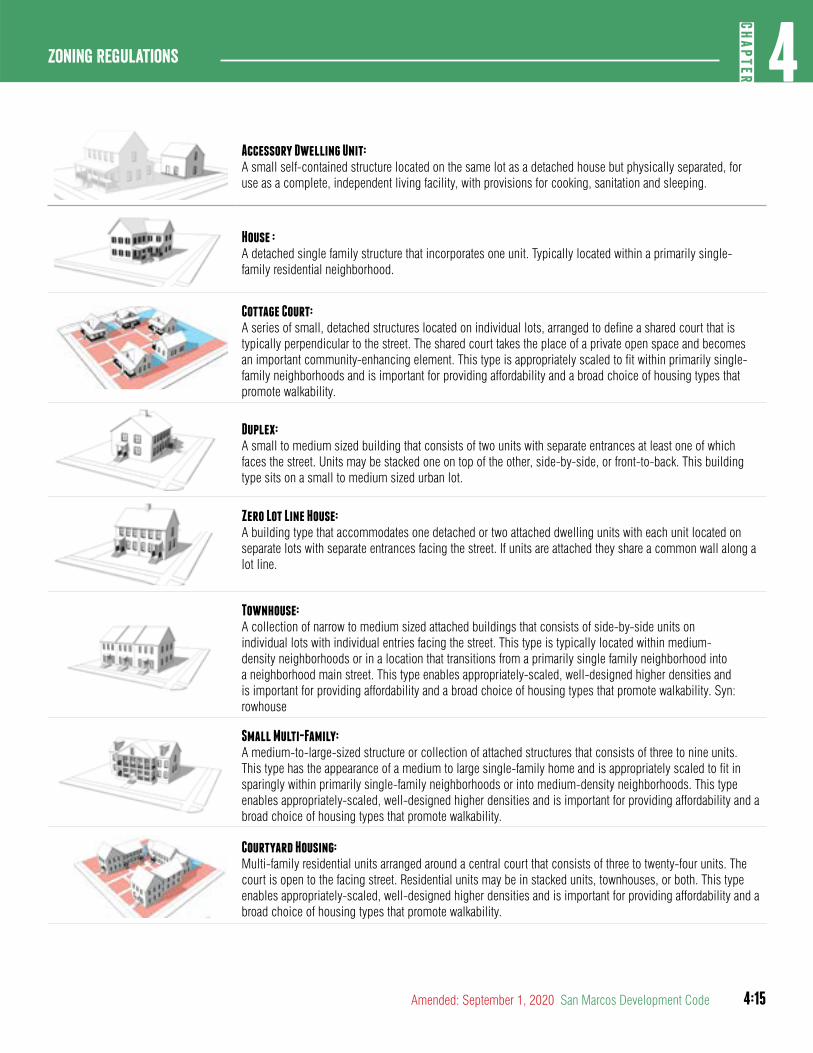
4:15
4CH
APTER
Zoning Regulations
Amended: September 1, 2020 San Marcos Development Code
Accessory Dwelling Unit: A small self-contained structure located on the same lot as a detached house but physically separated, for use as a complete, independent living facility, with provisions for cooking, sanitation and sleeping.
House :A detached single family structure that incorporates one unit. Typically located within a primarily single-family residential neighborhood.
Cottage Court: A series of small, detached structures located on individual lots, arranged to define a shared court that is typically perpendicular to the street. The shared court takes the place of a private open space and becomes an important community-enhancing element. This type is appropriately scaled to fit within primarily single-family neighborhoods and is important for providing affordability and a broad choice of housing types that promote walkability.
Duplex: A small to medium sized building that consists of two units with separate entrances at least one of which faces the street. Units may be stacked one on top of the other, side-by-side, or front-to-back. This building type sits on a small to medium sized urban lot.
Zero Lot Line House: A building type that accommodates one detached or two attached dwelling units with each unit located on separate lots with separate entrances facing the street. If units are attached they share a common wall along a lot line.
Townhouse: A collection of narrow to medium sized attached buildings that consists of side-by-side units on individual lots with individual entries facing the street. This type is typically located within medium-density neighborhoods or in a location that transitions from a primarily single family neighborhood into a neighborhood main street. This type enables appropriately-scaled, well-designed higher densities and is important for providing affordability and a broad choice of housing types that promote walkability. Syn: rowhouse
Small Multi-Family: A medium-to-large-sized structure or collection of attached structures that consists of three to nine units. This type has the appearance of a medium to large single-family home and is appropriately scaled to fit in sparingly within primarily single-family neighborhoods or into medium-density neighborhoods. This type enables appropriately-scaled, well-designed higher densities and is important for providing affordability and a broad choice of housing types that promote walkability.
Courtyard Housing: Multi-family residential units arranged around a central court that consists of three to twenty-four units. The court is open to the facing street. Residential units may be in stacked units, townhouses, or both. This type enables appropriately-scaled, well-designed higher densities and is important for providing affordability and a broad choice of housing types that promote walkability.
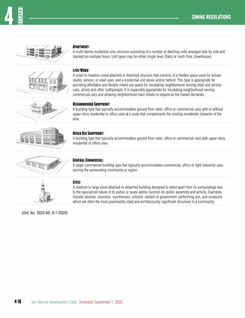
4:16
Zoning regulations4
CHAP
TER
San Marcos Development Code Amended: September 1, 2020
Apartment: A multi-family residential only structure consisting of a number of dwelling units arranged side by side and stacked on multiple floors. Unit types may be either single level (flats) or multi-floor (townhouse).
Live/Work: A small to medium-sized attached or detached structure that consists of a flexible space used for artisan, studio, service, or retail uses, and a residential unit above and/or behind. This type is appropriate for providing affordable and flexible mixed use space for incubating neighborhood-serving retail and service uses, artists and other craftspeople. It is especially appropriate for incubating neighborhood serving commercial uses and allowing neighborhood main streets to expand as the market demands.
Neighborhood Shopfront A building type that typically accommodates ground floor retail, office or commercial uses with or without upper-story residential or office uses at a scale that complements the existing residential character of the area.
Mixed Use Shopfront:A building type that typically accommodates ground floor retail, office or commercial uses with upper-story residential or office uses.
General Commercial: A larger commercial building type that typically accommodates commercial, office or light industrial uses serving the surrounding community or region.
Civic:A medium to large sized attached or detached building designed to stand apart from its surroundings due to the specialized nature of its public or quasi-public function for public assembly and activity. Examples include libraries, churches, courthouses, schools, centers of government, performing arts, and museums which are often the most prominently sited and architecturally significant structures in a community.
(Ord. No. 2020-60, 9-1-2020)

4:17
4CH
APTER
Zoning Regulations
Amended: September 1, 2020 San Marcos Development Code
Section 4.2.1.2Building Types Allowed by District
Building types are allowed by district as set forth below.
Table 4.10 Building types allowed by district
FDCD2SF-R
SF-6SF 4.5
ND3 ND3.5 ND4 N-MS CD3 CD4 CD5 CD5DHCLIHI
EC
ACCESSORY DWELLING UNIT
■ ■ ■ ■ ■ ■ ■ ■ ■ ■ -- --
House ■ ■ ■ ■ ■ -- ■ ■ -- -- -- --
Cottage Court -- -- -- ■ -- -- ■ -- -- -- -- --
Duplex -- -- -- ■ -- -- ■ ■ -- -- -- --
Zero Lot Line House
-- -- ■ ■ -- -- ■ -- -- -- -- --
Townhouse -- -- -- ■ ■ ■ -- ■ ■ ■ -- --
Small multi-family
-- -- -- ■ ■ ■ -- -- -- -- -- --
Courtyard Housing -- -- -- -- ■ -- -- ■ -- -- -- --
APARTMENT -- -- -- -- -- -- -- ■ ■ ■ -- --

4:18
Zoning regulations4
CHAP
TER
San Marcos Development Code Amended: September 1, 2020
Table 4.10 Building types allowed by district
FDCD2SF-R
SF-6SF 4.5
ND3 ND3.5 ND4 N-MS CD3 CD4 CD5 CD5DHCLIHI
EC
Live/ Work -- -- -- -- -- ■ -- ■ ■ ■ -- ■
Neighborhood SHOPFRONT -- -- -- -- ■ ■ -- ■ -- -- -- --
Mixed Use Shopfront
-- -- -- -- -- ■ -- -- ■ ■ -- ■
GENERAL Commercial
-- -- -- -- -- -- -- -- -- -- ■ ■
Civic ■ ■ ■ ■ ■ ■ ■ ■ ■ ■ ■ ■
Legend ■ =Allowed -- =Not Allowed
(Ord. No. 2020-60, 9-1-2020)

4:19
4CH
APTER
Zoning Regulations
Amended: September 1, 2020 San Marcos Development Code
article 3: General To all
DIVISION 1: AFFORDABLE HOUSING
Section 4.3.1.1Purpose and Intent
This Division implements the City’s Affordable Housing Policy, which is intended to foster the preservation and production of permanently affordable housing units. The intent of supporting affordable housing is:
A. To narrow the housing deficit for households that cannot afford market-priced rental or for-sale housing.
B. To support the local workforce and provide housing stability for residents and families allowing them to live close to their jobs and other services facilitating reduced traffic congestion, air pollution, and investments in city infrastructure.
C. To support residents and families of San Marcos contributing to and developing the local economy in the long term.
Section 4.3.1.2Definitions
A. Affordable Housing. Affordable Housing is defined as housing or shelter that is developed or re-developed for households earning no more than 80% of the median family income. In order to avoid being cost burdened, households should not spend more than 30% of their gross income on housing.
B. Workforce Housing. Workforce housing is defined as housing or shelter that is developed or re-developed for households earning no more than 140% of the median family income.
Section 4.3.1.3Applicability
A. Developments that elect to incorporate affordable or workforce housing meeting the requirements of this section are eligible for the following types of incentives:
1. Bonus density under Section 4.3.2.3.
2. Additional stories under Section 4.3.4.5.
3. Reduced parking under Section 7.1.3.2.
B. Housing Preservation. If an applicant is considering permanently preserving housing stock that had an expiring
period of affordability, they may take advantage of any incentives that are applicable to their application.
Section 4.3.1.4Standards
A. Period of Affordability. Affordable and workforce housing is required to be maintained for a period of no less than 30 years.
1. For Sale Units. The resale price of any affordable unit shall not exceed the purchase price paid by the owner of that unit during the period of affordability with the following exceptions:
a. Customary closing costs and costs of sale.
b. Costs of real estate commissions paid by the seller if a licensed real estate salesperson is employed.
c. Consideration of permanent capital improvements installed by the seller.
d. An inflation factor to be applied to the original sale price of a for-sale unit pursuant to rules established under Section 4.3.1.5.
2. Rental Units. During the period of affordability, the applicant or his or her agent shall manage and operate affordable units and shall submit an annual report identifying which units are affordable units, the monthly rent for each unit, vacancy information for each year for the prior year, monthly income for tenants of each affordable units, and other information as required, while ensuring the privacy of the tenants. The annual report shall contain information sufficient to determine whether tenants of for-rent units qualify for affordable or workforce housing.
B. Eligible Households. In the case of for-rent affordable housing units, eligible households under the affordable housing standards shall meet the following additional requirements:
1. Affordable and workforce rental units shall not be located within a complex that is designed, marketed or used for the primary purpose of housing students.
2. Affordable and workforce rental units shall be targeted to residents that are 22 years of age or older.

4:20
Zoning regulations4
CHAP
TER
San Marcos Development Code Amended: September 1, 2020
C. For all sales of for-sale affordable housing units, the parties to the transaction shall execute and record documentation including the provisions of this ordinance and shall provide at a minimum, each of the following:
1. The affordable housing unit shall be sold to and occupied by eligible households for a period of 30 years from the date of the initial certificate of occupancy.
2. The affordable housing unit shall be conveyed subject to restrictions that shall maintain the affordability of such affordable housing units for eligible households.
D. In the case of for-rent affordable housing units, the owner of the affordable housing development shall execute and record such documentation including the provisions of this ordinance and shall provide, at a minimum, each of the following:
1. The affordable housing units shall be leased to and occupied by eligible households.
2. The affordable housing units shall be leased at rent levels affordable to eligible households for a period of 30 years from the date of the initial certificate of occupancy.
3. Subleasing of affordable housing units shall not be permitted.
C. Location Efficient Areas. Affordable and workforce housing shall be located in areas meeting one of the requirements identified below:
1. The proposed development must have a bus route located within one-half mile of the development by the time 80 percent of the development is completed;
2. The proposed development has direct pedestrian access to several land uses that service residential customers, such as food sales, general retail and other key services within one-half mile; or
3. The proposed development is within one of the following comprehensive plan areas:
a. High Intensity Zone
b. Medium Intensity Zone
c. Existing Neighborhood Area
D. Dispersal of Units and Construction Phasing. The affordable units shall be distributed proportionally throughout the development, appropriately designed and integrated with the market-rate units, and, as feasible, contain the same number of bedrooms as the market rate units. Thirty percent of affordable units must be delivered in the first phase (where applicable) and the remainder of the units must be delivered proportionally based on the development build-out and phasing.
Section 4.3.1.5Enforcement; Affordability Controls
A. The Responsible Official shall promulgate rules as necessary to implement this ordinance. On an annual basis, the Responsible Official shall publish or make available household income limits and rental limits applicable to affordable units within the City as determined by the City’s Affordable Housing Policy, and determine an inflation factor to establish a resale price of an affordable unit.
B. Prior to issuing a building permit for any affordable housing development receiving an incentive under Section 4.3.1.3 the applicant shall execute any and all documents in a form approved by the City Attorney including without limitation, restrictive covenants, deed restrictions, and related instruments to ensure the continued affordability of the units under this Section 4.3.1.1.
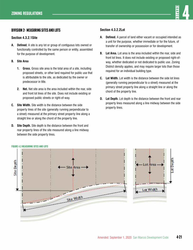
4:21
4CH
APTER
Zoning Regulations
Amended: September 1, 2020 San Marcos Development Code
DIVISION 2: MEASURING SITES AND LOTS
Section 4.3.2.1Site
A. Defined. A site is any lot or group of contiguous lots owned or functionally controlled by the same person or entity, assembled for the purpose of development.
B. Site Area
1. Gross. Gross site area is the total area of a site, including proposed streets, or other land required for public use that is attributable to the site, as dedicated by the owner or predecessor in title.
2. Net. Net site area is the area included within the rear, side and front lot lines of the site. Does not include existing or proposed public streets or right-of-way.
C. Site Width. Site width is the distance between the side property lines of the site (generally running perpendicular to a street) measured at the primary street property line along a straight line or along the chord of the property line.
D. Site Depth. Site depth is the distance between the front and rear property lines of the site measured along a line midway between the side property lines.
Figure 4.3 Measuring Sites and Lots
Section 4.3.2.2Lot
A. Defined. A parcel of land either vacant or occupied intended as a unit for the purpose, whether immediate or for the future, of transfer of ownership or possession or for development.
B. Lot Area. Lot area is the area included within the rear, side and front lot lines. It does not include existing or proposed right-of-way, whether dedicated or not dedicated to public use. Zoning District density applies, and may require larger lots than those required for an individual building type.
C. Lot Width. Lot width is the distance between the side lot lines (generally running perpendicular to a street) measured at the primary street property line along a straight line or along the chord of the property line.
D. Lot Depth. Lot depth is the distance between the front and rear property lines measured along a line midway between the side property lines.

4:22
Zoning regulations4
CHAP
TER
San Marcos Development Code Amended: September 1, 2020
Section 4.3.2.3Density
A. Residential density is expressed in units per acre and is calculated by dividing the total number of dwelling units by the gross site area.
B. Density Bonus. An applicant may be eligible for a density bonus in the following districts if at least 10 percent of the proposed units are affordable. The density bonus is an increase in residential units over the maximum residential density. A density bonus is available in the following districts:
1. Neighborhood Density Districts. Qualifying properties in an ND3.5, ND4 or N-MS district are eligible for a density bonus for for-sale units only.
2. Character District. Qualifying properties in Character districts are eligible for a density bonus for for-sale or rental units.
C. The units gained from qualifying for a density bonus can be rented or sold at market rates without affordability covenants or deed restrictions, so long as the proposed percentage of affordable units is satisfied within the development.
D. In determining the number of density bonus units to be granted pursuant to this Section, before the density bonus is added the maximum residential density for the site shall be multiplied by the percentage of density bonus listed in Table below, based on the percentage of affordable units provided for affordable or workforce housing. All density calculations resulting in fractional units shall be rounded to the next whole number. For example:
Maximum density = 100 units
Affordable Housing Units = 12 units (12 percent)
Density bonus = 24 percent (100 x .24 = 24 units)
Total units = 124 units
Table 4.11 Density BonusPercent Affordable Units
Affordable Housing Bonus
Workforce Housing Bonus
10% 20% 10%
12% 24% 12%
14% 28% 14%
16% 32% 16%
18% 38% 18%
20% or more 45% 20%
Section 4.3.2.4Impervious Cover
A. Impervious Cover. Impervious cover is the maximum area of a lot that is permitted to be covered by impervious surfaces. Impervious surface may be reduced through the use of partially permeable surfaces in accordance with Section 3.9.1.3.

4:23
4CH
APTER
Zoning Regulations
Amended: September 1, 2020 San Marcos Development Code
DIVISION 3: PLACEMENT OF BUILDINGS
Section 4.3.3.1Lot Layers
There are three (3) layers to a lot - First layer, second layer and the third layer. Double frontage lots have two (2) sets of lot layers. The second and third lot layers are combined on the secondary frontage of corner lots.Figure 4.4 Lot Layers
20 fe
et
PRIN
CIPA
L FR
ONTA
GE L
AYER
S
3rd Layer
2nd Layer
1st Layer
1st Layer
2nd & 3rd
Layer
SECONDARY FRONTAGE LAYERS
Property Line
PRINCIPAL FRONTAGE
SECONDARY FRONTAGE
A. First Layer. The first layer extends from the front property line to the building frontage.
B. Second Layer. The second layer extends 20’ back from the building frontage.
C. Third Layer. The third layer extends from the second layer to the rear lot line. The second and third layer may be combined when there is a secondary frontage.

4:24
Zoning regulations4
CHAP
TER
San Marcos Development Code Amended: September 1, 2020
Section 4.3.3.2Building Setbacks
A. Building Setbacks. There are four (4) types of setback - primary street setback, secondary street setback, side setback and rear setback. Double frontage lots are considered to have two (2) primary street setbacks.
1. Primary and secondary street setbacks are measured perpendicular from the edge of the right-of-way.
2. Side setbacks are measured perpendicular from the interior lot line.
3. Rear setbacks are measured perpendicular from the rear lot line, or where there is an alley, from the edge of the right-of-way.
Figure 4.5 Building Setbacks
B. A multiple street frontage lot must designate at least one (1) primary street. A lot may have more than one (1) primary street. The primary street will be determined based on the following criteria:
1. The street with the highest street classification;
2. The established orientation of the block;
3. The street abutting the longest face of the block;
4. The street parallel to an alley within the block; or
5. The street from which the lot takes its address.
(Ord. No. 2019-45, 12-17-19)
C. A multiple street frontage lot must designate at least one (1) principal frontage. The principal frontage is the extent of the lot or building facade abutting the designated primary street(s).
(Ord. No. 2019-45, 12-17-19)
D. Setback Encroachments. All buildings and structures must be located at or behind required setbacks, except as listed below. Underground structures covered by the ground may encroach into a required setback.
1. Building Features
a. Porches, stoops, balconies, galleries, awnings and steps as set forth in Section 4.3.5.10.
b. Building eaves, roof overhangs and light shelves may extend up to three (3) feet into the required setback.
c. Bay windows, oriels, vestibules and similar features that are less than ten (10) feet wide may extend up to four (4) feet, provided that such extension is at least two (2) feet from the vertical plane of any lot line.
d. Chimneys may encroach up to four (4) feet, provided such extension is at least two (2) feet from the vertical plane of any lot line.
e. Uncovered fire escapes or stairways may extend into a required side or rear setback, provided that such extension is at least two (2) feet from the vertical plane of any lot line.
f. Uncovered and unenclosed patios or in-ground pools may extend into a required side or rear setback, provided that such extension is at least two (2) feet from the vertical plane of any lot line.
g. Cornices, belt courses, sills, buttresses or other similar architectural features may project up to one and one-half (1½) feet into the required setback.
h. Handicap ramps may project to the extent necessary to perform their proper function.
2. Mechanical Equipment and Utility Lines. Mechanical equipment associated with residential uses, such as HVAC units, small renewable energy systems, and security lighting, may extend into a required rear or side setback.
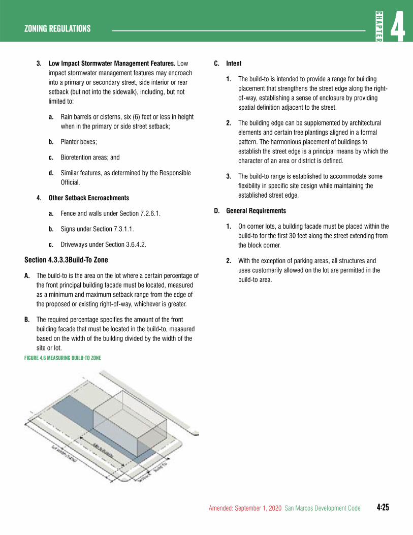
4:25
4CH
APTER
Zoning Regulations
Amended: September 1, 2020 San Marcos Development Code
3. Low Impact Stormwater Management Features. Low impact stormwater management features may encroach into a primary or secondary street, side interior or rear setback (but not into the sidewalk), including, but not limited to:
a. Rain barrels or cisterns, six (6) feet or less in height when in the primary or side street setback;
b. Planter boxes;
c. Bioretention areas; and
d. Similar features, as determined by the Responsible Official.
4. Other Setback Encroachments
a. Fence and walls under Section 7.2.6.1.
b. Signs under Section 7.3.1.1.
c. Driveways under Section 3.6.4.2.
Section 4.3.3.3Build-To Zone
A. The build-to is the area on the lot where a certain percentage of the front principal building facade must be located, measured as a minimum and maximum setback range from the edge of the proposed or existing right-of-way, whichever is greater.
B. The required percentage specifies the amount of the front building facade that must be located in the build-to, measured based on the width of the building divided by the width of the site or lot.
Figure 4.6 Measuring Build-To Zone
C. Intent
1. The build-to is intended to provide a range for building placement that strengthens the street edge along the right-of-way, establishing a sense of enclosure by providing spatial definition adjacent to the street.
2. The building edge can be supplemented by architectural elements and certain tree plantings aligned in a formal pattern. The harmonious placement of buildings to establish the street edge is a principal means by which the character of an area or district is defined.
3. The build-to range is established to accommodate some flexibility in specific site design while maintaining the established street edge.
D. General Requirements
1. On corner lots, a building facade must be placed within the build-to for the first 30 feet along the street extending from the block corner.
2. With the exception of parking areas, all structures and uses customarily allowed on the lot are permitted in the build-to area.
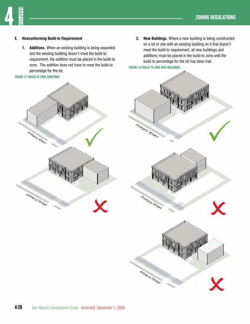
4:26
Zoning regulations4
CHAP
TER
San Marcos Development Code Amended: September 1, 2020
E. Nonconforming Build-to Requirement
1. Additions. When an existing building is being expanded and the existing building doesn’t meet the build-to requirement, the addition must be placed in the build-to zone. The addition does not have to meet the build-to percentage for the lot.
Figure 4.7 Build-To Zone additions
2. New Buildings. Where a new building is being constructed on a lot or site with an existing building on it that doesn’t meet the build-to requirement, all new buildings and additions must be placed in the build-to zone until the build-to percentage for the lot has been met.
Figure 4.8 Build-To Zone New Buildings
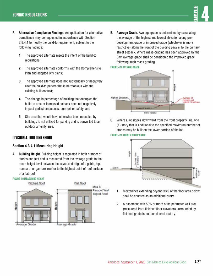
4:27
4CH
APTER
Zoning Regulations
Amended: September 1, 2020 San Marcos Development Code
F. Alternative Compliance Findings. An application for alternative compliance may be requested in accordance with Section 2.8.4.1 to modify the build-to requirement, subject to the following findings:
1. The approved alternate meets the intent of the build-to regulations;
2. The approved alternate conforms with the Comprehensive Plan and adopted City plans;
3. The approved alternate does not substantially or negatively alter the build-to pattern that is harmonious with the existing built context;
4. The change in percentage of building that occupies the build-to area or increased setback does not negatively impact pedestrian access, comfort or safety; and
5. Site area that would have otherwise been occupied by buildings is not utilized for parking and is converted to an outdoor amenity area.
DIVISION 4: BUILDING HEIGHT
Section 4.3.4.1 Measuring Height
A. Building Height. Building height is regulated in both number of stories and feet and is measured from the average grade to the mean height level between the eaves and ridge of a gable, hip, mansard, or gambrel roof or to the highest point of roof surface of a flat roof.
Figure 4.9 Measuring height
B. Average Grade. Average grade is determined by calculating the average of the highest and lowest elevation along pre-development grade or improved grade (whichever is more restrictive) along the front of the building parallel to the primary street setback. Where mass-grading has been approved by the City, average grade shall be considered the improved grade following such mass grading.
Figure 4.10 average Grade
C. Where a lot slopes downward from the front property line, one (1) story that is additional to the specified maximum number of stories may be built on the lower portion of the lot.
Figure 4.11 Stories Below Grade
1. Mezzanines extending beyond 33% of the floor area below shall be counted as an additional story.
2. A basement with 50% or more of its perimeter wall area (measured from finished floor elevation) surrounded by finished grade is not considered a story.
4:28
Zoning regulations4
CHAP
TER
San Marcos Development Code Amended: September 1, 2020
Section 4.3.4.2Ground Floor Elevation
A. Ground floor elevation is measured from the average curb level of the adjoining street, or if no curb exists, the average level of the center crown of the street to the top of the finished ground floor.
Figure 4.12 Measuring Ground Floor Elevation
Section 4.3.4.3Story Height
A. Story height is measured from the top of the finished floor to the ceiling above.
B. Minimum ground story height applies to the first 30 feet of the building measured inward from the street facing facade. At least 50% of the ground story must meet the minimum ground story height provisions.
Figure 4.13 Measuring Story height
Section 4.3.4.4Minimum Two-Story Requirements
A. Minimum two-story requirements apply to the first 30 feet of the building and may include a roof top patio where a minimum of 60% of the patio is covered.
B. A building with a single story measuring a minimum of 25 feet from finished floor to finished ceiling can satisfy the minimum two-story requirement.
C. Intent. The intent of the two-story minimum requirement is to ensure that the building scale is compatible with other structures and the relationship of the building to the public space. A minimum building height also serves to promote a mixture of uses.
D. Alternative Compliance Findings. The Planning and Zoning Commission may in accordance with Section 2.8.4.1 allow an alternative to the minimum two-story requirements, subject to the following findings:
1. The approved alternate meets the intent of the minimum two-story requirements;
2. The approved alternate conforms with the Comprehensive Plan and other adopted City Plans; and
3. The approved alternate conforms to the Downtown Design Guidelines.
Section 4.3.4.5Residential Height Compatibility Standards
A. Height Stepback. A maximum building height of thirty-five (35) feet shall apply to portions of a structure within seventy (7) feet of a single-family zoning designation (measured from the property line).
(Ord. No. 2020-60, 9-1-2020)
Section 4.3.4.6Additional Stories or Height
A. Alternative Compliance Findings. The City Council may in accordance with Section 2.8.4.1 allow additional stories in the CD-5 or up to two additional stories in CD-5D zoning districts, subject to the following considerations:
1. The project is consistent with the objectives and guidelines from the City’s Comprehensive Plan and Downtown Master Plan where applicable.
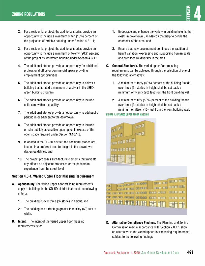
4:29
4CH
APTER
Zoning Regulations
Amended: September 1, 2020 San Marcos Development Code
2. For a residential project, the additional stories provide an opportunity to include a minimum of ten (10%) percent of the project as affordable housing under Section 4.3.1.1;
3. For a residential project, the additional stories provide an opportunity to include a minimum of twenty (20%) percent of the project as workforce housing under Section 4.3.1.1;
4. The additional stories provide an opportunity for additional professional office or commercial space providing employment opportunities;
5. The additional stories provide an opportunity to deliver a building that is rated a minimum of a silver in the LEED green building program;
6. The additional stories provide an opportunity to include child care within the facility;
7. The additional stories provide an opportunity to add public parking in or adjacent to the downtown;
8. The additional stories provide an opportunity to include on-site publicly accessible open space in excess of the open space required under Section 3.10.1.2.
9. If located in the CD-5D district, the additional stories are located in a preferred area for height in the downtown design guidelines; and
10. The project proposes architectural elements that mitigate any effects on adjacent properties or the pedestrian experience from the street level.
Section 4.3.4.7Varied Upper Floor Massing Requirement
A. Applicability. The varied upper floor massing requirements apply to buildings in the CD-5D district that meet the following criteria:
1. The building is over three (3) stories in height; and
2. The building has a frontage greater than sixty (60) feet in width.
B. Intent. The intent of the varied upper floor massing requirements is to:
1. Encourage and enhance the variety in building heights that exists in downtown San Marcos that help to define the character of the area; and
2. Ensure that new development continues the tradition of height variation, expressing and supporting human scale and architectural diversity in the area.
C. General Standards. The varied upper floor massing requirements can be achieved through the selection of one of the following alternatives:
1. A minimum of forty (40%) percent of the building facade over three (3) stories in height shall be set back a minimum of twenty (20) feet from the front building wall.
2. A minimum of fifty (50%) percent of the building facade over three (3) stories in height shall be set back a minimum of fifteen (15) feet from the front building wall.
Figure 4.14 Varied Upper Floor Massing
D. Alternative Compliance Findings. The Planning and Zoning Commission may in accordance with Section 2.8.4.1 allow an alternative to the varied upper floor massing requirements, subject to the following findings.
4:30
Zoning regulations4
CHAP
TER
San Marcos Development Code Amended: September 1, 2020
1. The approved alternate meets the intent of the varied upper floor massing requirements;
2. The approved alternate conforms with the Comprehensive Plan and other adopted City Plans; and
3. The approved alternate conforms to the Downtown Design Guidelines.
DIVISION 5: ACTIVATION
Activation standards are described here and required based on the properties zoning district or designated building type.
Section 4.3.5.1Street Facing Entrance
A. Intent
1. The street-facing entrance regulations are intended to concentrate pedestrian activity along the street edge and provide an easily identifiable and conveniently located entrance for residents, visitors, and patrons accessing a building as pedestrians from the street.
2. Access points should be located or identified in a manner visible to the pedestrian from the street and be accessible via a direct path.
B. General Requirements
1. An entrance installed after the adoption of this code providing both ingress and egress, operable to residents or customers at all times, is required to meet the street facing entrance requirements. Additional entrances from another street, pedestrian area or internal parking area are permitted.
2. The entrance spacing requirements must be met for each building, but are not applicable to adjacent buildings.
3. An angled entrance may be provided at either corner of a building along the street to meet the street-facing entrance requirements.
C. Alternative Compliance Findings. The Planning and Zoning Commission may in accordance with Section 2.8.4.1 allow a non-street-facing entrance, subject to all of the following findings.
1. The approved alternate meets the intent of the street-facing entrance regulations;
2. The approved alternate conforms with the Comprehensive Plan and adopted City plans;
3. The pedestrian access point is easily identifiable by pedestrians, customers and visitors;
4. Recessed or projecting entries or building elements have been incorporated into the design of the building to enhance visibility of the non street-facing entrance; and
5. The pedestrian route from the street, sidewalks, bus stops and other modes of transportation to the entrance is safe, convenient and direct.
Section 4.3.5.2Ground Story Transparency
A. Intent. Ground story transparency requirements are intended to lend visual interest to street-facing building facades for both pedestrians and building occupants and minimize blank wall areas. This is not applicable to residential uses.
B. General Requirements
1. The minimum percentage of windows and doors that must cover a ground story facade is measured between zero (0) and twelve (12) feet above the adjacent sidewalk.
2. Windows shall not be made opaque by non-operable window treatments (for example curtains, blinds or shades within the conditioned space are considered operable).
3. Glass shall be considered transparent where it has a transparency higher than eighty (80%) percent and external reflectance of less than fifteen (15%) percent.
C. Alternative Compliance Findings. The Planning and Zoning Commission may in accordance with Section 2.8.4.1 modify the required transparency, subject to all of the following findings:
1. The approved alternate meets the intent of the transparency requirements;
2. The approved alternate conforms with the Comprehensive Plan and adopted City plans; and
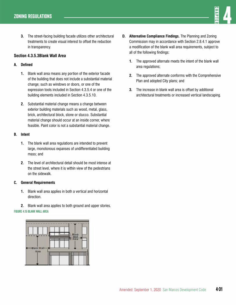
4:31
4CH
APTER
Zoning Regulations
Amended: September 1, 2020 San Marcos Development Code
3. The street-facing building facade utilizes other architectural treatments to create visual interest to offset the reduction in transparency.
Section 4.3.5.3Blank Wall Area
A. Defined
1. Blank wall area means any portion of the exterior facade of the building that does not include a substantial material change; such as windows or doors, or one of the expression tools included in Section 4.3.5.4 or one of the building elements included in Section 4.3.5.10.
2. Substantial material change means a change between exterior building materials such as wood, metal, glass, brick, architectural block, stone or stucco. Substantial material change should occur at an inside corner, where feasible. Paint color is not a substantial material change.
B. Intent
1. The blank wall area regulations are intended to prevent large, monotonous expanses of undifferentiated building mass; and
2. The level of architectural detail should be most intense at the street level, where it is within view of the pedestrians on the sidewalk.
C. General Requirements
1. Blank wall area applies in both a vertical and horizontal direction.
2. Blank wall area applies to both ground and upper stories.Figure 4.15 Blank Wall area
D. Alternative Compliance Findings. The Planning and Zoning Commission may in accordance with Section 2.8.4.1 approve a modification of the blank wall area requirements, subject to all of the following findings:
1. The approved alternate meets the intent of the blank wall area regulations;
2. The approved alternate conforms with the Comprehensive Plan and adopted City plans; and
3. The increase in blank wall area is offset by additional architectural treatments or increased vertical landscaping.
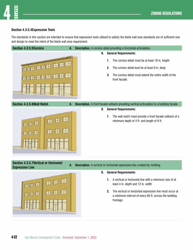
4:32
Zoning regulations4
CHAP
TER
San Marcos Development Code Amended: September 1, 2020
Section 4.3.5.4Expression Tools
The standards in this section are intended to ensure that expression tools utilized to satisfy the blank wall area standards are of sufficient size and design to meet the intent of the blank wall area requirement.
Section 4.3.5.5Cornice A. Description. A cornice detail providing a horizontal articulation.
B. General Requirements:
1. The cornice detail must be at least 18 in. height
2. The cornice detail bust be at least 6 in. deep
3. The cornice detail must extend the entire width of the front facade.
Section 4.3.5.6Wall Notch A. Description. A front facade setback providing vertical articulation to a building facade.
B. General Requirements:
1. The wall notch must provide a front facade setback of a minimum depth of 4 ft. and length of 8 ft.
Section 4.3.5.7Vertical or Horizontal Expression Line
A. Description. A vertical or horizontal expression line created by molding.
B. General Requirements:
1. A vertical or horizontal line with a minimum size of at least 4 in. depth and 12 in. width
2. The vertical or horizontal expression line must occur at a minimum interval of every 60 ft. across the building frontage.
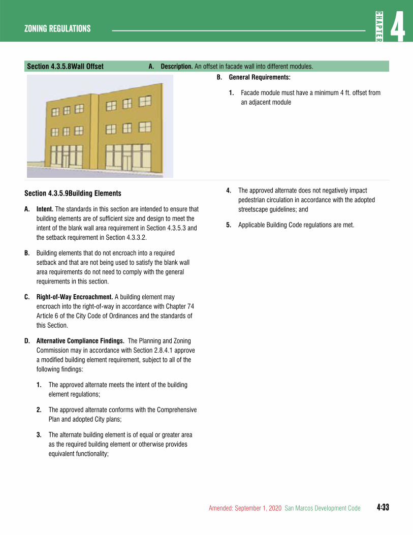
4:33
4CH
APTER
Zoning Regulations
Amended: September 1, 2020 San Marcos Development Code
Section 4.3.5.8Wall Offset A. Description. An offset in facade wall into different modules.
B. General Requirements:
1. Facade module must have a minimum 4 ft. offset from an adjacent module
Section 4.3.5.9Building Elements
A. Intent. The standards in this section are intended to ensure that building elements are of sufficient size and design to meet the intent of the blank wall area requirement in Section 4.3.5.3 and the setback requirement in Section 4.3.3.2.
B. Building elements that do not encroach into a required setback and that are not being used to satisfy the blank wall area requirements do not need to comply with the general requirements in this section.
C. Right-of-Way Encroachment. A building element may encroach into the right-of-way in accordance with Chapter 74 Article 6 of the City Code of Ordinances and the standards of this Section.
D. Alternative Compliance Findings. The Planning and Zoning Commission may in accordance with Section 2.8.4.1 approve a modified building element requirement, subject to all of the following findings:
1. The approved alternate meets the intent of the building element regulations;
2. The approved alternate conforms with the Comprehensive Plan and adopted City plans;
3. The alternate building element is of equal or greater area as the required building element or otherwise provides equivalent functionality;
4. The approved alternate does not negatively impact pedestrian circulation in accordance with the adopted streetscape guidelines; and
5. Applicable Building Code regulations are met.
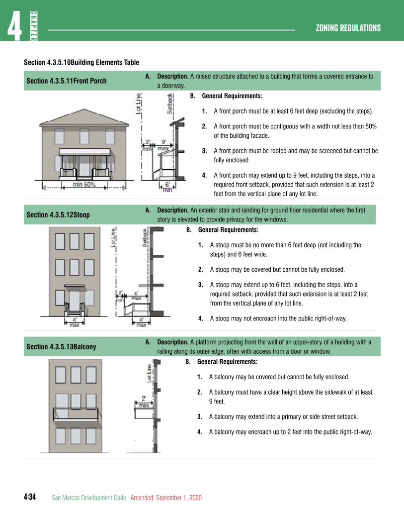
4:34
Zoning regulations4
CHAP
TER
San Marcos Development Code Amended: September 1, 2020
Section 4.3.5.10Building Elements Table
Section 4.3.5.11Front PorchA. Description. A raised structure attached to a building that forms a covered entrance to
a doorway.
B. General Requirements:
1. A front porch must be at least 6 feet deep (excluding the steps).
2. A front porch must be contiguous with a width not less than 50% of the building facade.
3. A front porch must be roofed and may be screened but cannot be fully enclosed.
4. A front porch may extend up to 9 feet, including the steps, into a required front setback, provided that such extension is at least 2 feet from the vertical plane of any lot line.
Section 4.3.5.12StoopA. Description. An exterior stair and landing for ground floor residential where the first
story is elevated to provide privacy for the windows.
B. General Requirements:
1. A stoop must be no more than 6 feet deep (not including the steps) and 6 feet wide.
2. A stoop may be covered but cannot be fully enclosed.
3. A stoop may extend up to 6 feet, including the steps, into a required setback, provided that such extension is at least 2 feet from the vertical plane of any lot line.
4. A stoop may not encroach into the public right-of-way.
Section 4.3.5.13BalconyA. Description. A platform projecting from the wall of an upper-story of a building with a
railing along its outer edge, often with access from a door or window.
2’
B. General Requirements:
1. A balcony may be covered but cannot be fully enclosed.
2. A balcony must have a clear height above the sidewalk of at least 9 feet.
3. A balcony may extend into a primary or side street setback.
4. A balcony may encroach up to 2 feet into the public right-of-way.
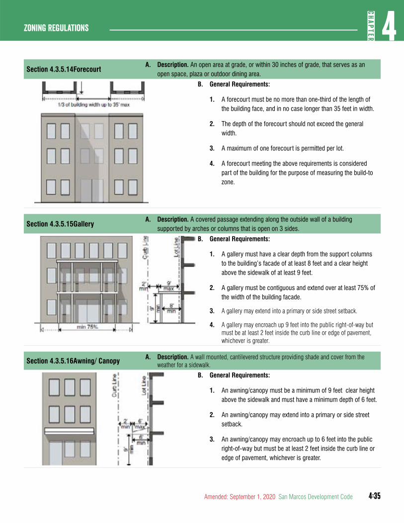
4:35
4CH
APTER
Zoning Regulations
Amended: September 1, 2020 San Marcos Development Code
Section 4.3.5.14ForecourtA. Description. An open area at grade, or within 30 inches of grade, that serves as an
open space, plaza or outdoor dining area.
B. General Requirements:
1. A forecourt must be no more than one-third of the length of the building face, and in no case longer than 35 feet in width.
2. The depth of the forecourt should not exceed the general width.
3. A maximum of one forecourt is permitted per lot.
4. A forecourt meeting the above requirements is considered part of the building for the purpose of measuring the build-to zone.
Section 4.3.5.15GalleryA. Description. A covered passage extending along the outside wall of a building
supported by arches or columns that is open on 3 sides.
B. General Requirements:
1. A gallery must have a clear depth from the support columns to the building’s facade of at least 8 feet and a clear height above the sidewalk of at least 9 feet.
2. A gallery must be contiguous and extend over at least 75% of the width of the building facade.
3. A gallery may extend into a primary or side street setback.
4. A gallery may encroach up 9 feet into the public right-of-way but must be at least 2 feet inside the curb line or edge of pavement, whichever is greater.
Section 4.3.5.16Awning/ Canopy A. Description. A wall mounted, cantilevered structure providing shade and cover from the weather for a sidewalk.
B. General Requirements:
1. An awning/canopy must be a minimum of 9 feet clear height above the sidewalk and must have a minimum depth of 6 feet.
2. An awning/canopy may extend into a primary or side street setback.
3. An awning/canopy may encroach up to 6 feet into the public right-of-way but must be at least 2 feet inside the curb line or edge of pavement, whichever is greater.
4:36
Zoning regulations4
CHAP
TER
San Marcos Development Code Amended: September 1, 2020
Section 4.3.5.17Durable Building Material Area
A. Defined. Durable building material area means any portion of the exterior facade of the building that does not include windows, doors or other void areas.
B. Applicability.
1. Primary and secondary durable building material standards apply to:
a. A program established by a state agency that requires particular standards, incentives, or financing arrangements in order to comply with requirements of a state or federal funding source or housing program;
b. A requirement for a building necessary to consider the building eligible for windstorm and hail insurance coverage;
c. An ordinance or other regulation that:
1. Regulates outdoor lighting for the purpose of reducing light pollution; and
2. Is adopted by a city that is certified as a Dark Sky Community by the International Dark-Sky Association as part of the International Dark Sky Places Program;
d. An ordinance or order that:
1. Regulates outdoor lighting; and
2. Is adopted under the authority of state law; or
e. A building located in a place or area designated for its historical, cultural, or architectural importance and significance that a city may regulate through zoning, if the city:
1. Is a certified local government under the National Historic Preservation Act; or
2. Has an applicable landmark ordinance that meets the requirements under the certified local government as determined by the Texas Historical Commission;
f. A building located in a place or area designated for its historical, cultural, or architectural importance and
significance by a city, if designated before April 1, 2019;
g. A building located in an area designated as a historical district on the National Register of Historic Places;
h. A building designated as a Recorded Texas Historic Landmark;
i. A building designated as a State Archeological Landmark or State Antiques Landmark;
j. A building listed on the National Register of Historic Places or designated as a landmark by a city;
k. A building located in a World Heritage Buffer Zone; or
l. A building located in an area designated for development, restoration, or preservation in a main street city under the main street program.
2. Where appplicable, primary and secondary materials are applied by district and building type.
3. Where appplicable, prohibited materials are prohibited in any district or for any building type.
4. Buildings in the municipal airport are exempted from durable building material standards.
(Ord. No. 2019-45, 12-17-19)
C. Intent. The intent of the durable building material area requirement is to promote quality design, aesthetic value, visual appeal and the use of durable materials. The City prefers the use of durable building materials identified in this section.
(Ord. No. 2020-60, 9-1-2020)
D. Classification of Materials.
1. Durable building materials are classified as primary materials, secondary materials, or prohibited materials and include the following:
a. Primary materials include: brick; stone; stucco; rock; marble; granite; concrete tilt wall; a combination of glass and steel framework; architectural terra cotta,
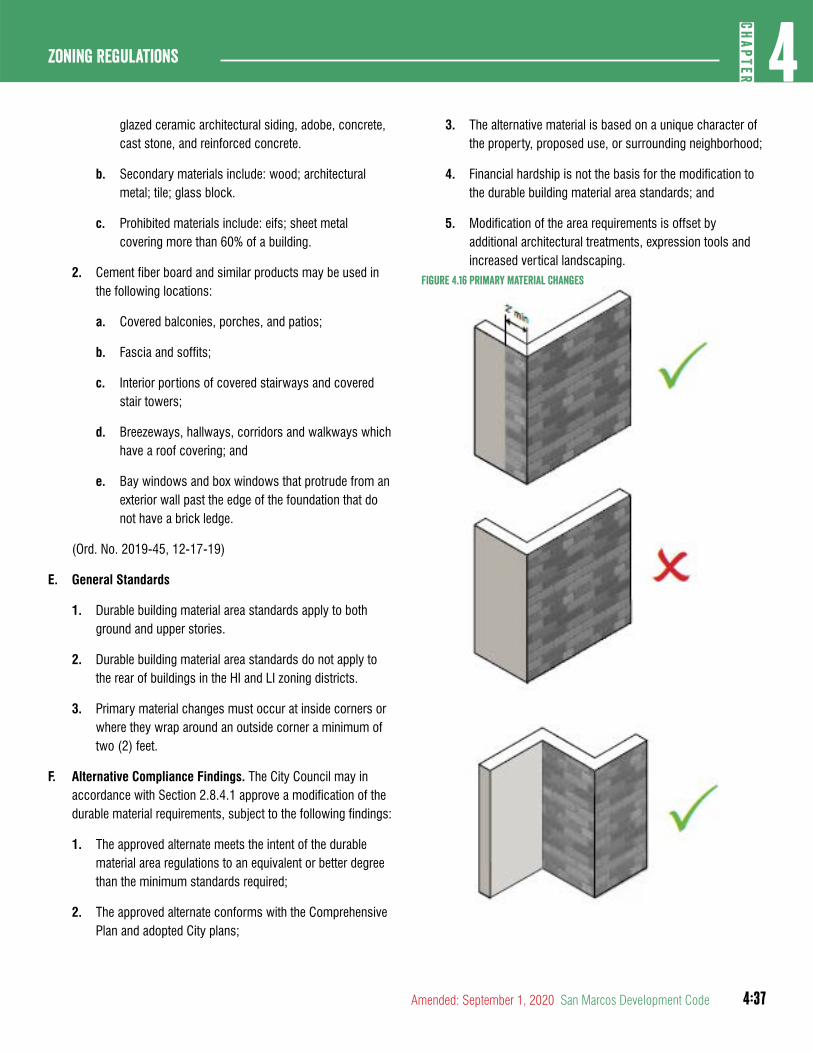
4:37
4CH
APTER
Zoning Regulations
Amended: September 1, 2020 San Marcos Development Code
glazed ceramic architectural siding, adobe, concrete, cast stone, and reinforced concrete.
b. Secondary materials include: wood; architectural metal; tile; glass block.
c. Prohibited materials include: eifs; sheet metal covering more than 60% of a building.
2. Cement fiber board and similar products may be used in the following locations:
a. Covered balconies, porches, and patios;
b. Fascia and soffits;
c. Interior portions of covered stairways and covered stair towers;
d. Breezeways, hallways, corridors and walkways which have a roof covering; and
e. Bay windows and box windows that protrude from an exterior wall past the edge of the foundation that do not have a brick ledge.
(Ord. No. 2019-45, 12-17-19)
E. General Standards
1. Durable building material area standards apply to both ground and upper stories.
2. Durable building material area standards do not apply to the rear of buildings in the HI and LI zoning districts.
3. Primary material changes must occur at inside corners or where they wrap around an outside corner a minimum of two (2) feet.
F. Alternative Compliance Findings. The City Council may in accordance with Section 2.8.4.1 approve a modification of the durable material requirements, subject to the following findings:
1. The approved alternate meets the intent of the durable material area regulations to an equivalent or better degree than the minimum standards required;
2. The approved alternate conforms with the Comprehensive Plan and adopted City plans;
3. The alternative material is based on a unique character of the property, proposed use, or surrounding neighborhood;
4. Financial hardship is not the basis for the modification to the durable building material area standards; and
5. Modification of the area requirements is offset by additional architectural treatments, expression tools and increased vertical landscaping.
Figure 4.16 Primary Material Changes
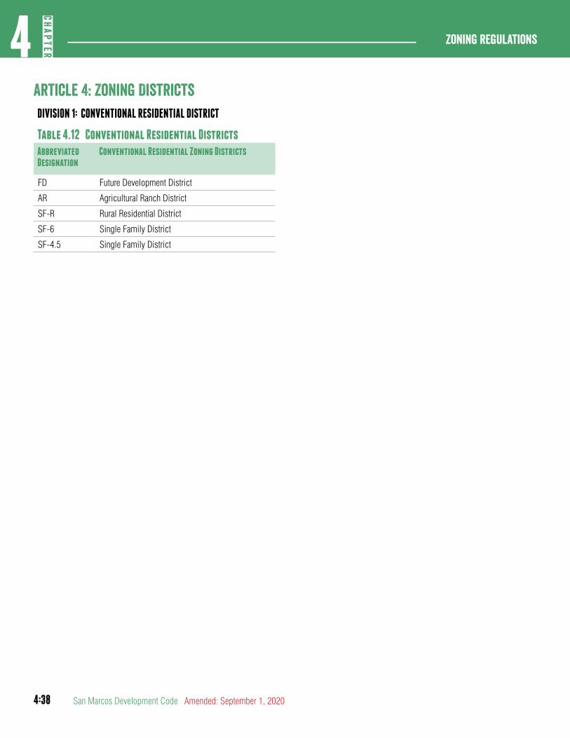
4:38
Zoning regulations4
CHAP
TER
San Marcos Development Code Amended: September 1, 2020
article 4: Zoning DistrictsDIVISION 1: CONVENTIONAL RESIDENTIAL DISTRICT
Table 4.12 Conventional Residential DistrictsAbbreviated Designation
Conventional Residential Zoning Districts
FD Future Development District
AR Agricultural Ranch District
SF-R Rural Residential District
SF-6 Single Family District
SF-4.5 Single Family District

4:39
4CH
APTER
Zoning Regulations
Amended: September 1, 2020 San Marcos Development Code
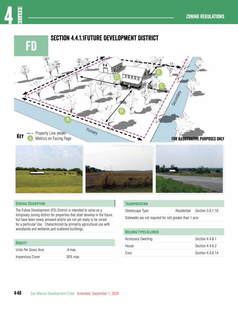
4:40
Zoning regulations4
CHAP
TER
San Marcos Development Code Amended: September 1, 2020
Primary
Seco
ndary
Property Line (ROW)Key Metrics on Facing PageA
ED
B
A
C
For illustrative purposes only
FDSection 4.4.1.1Future Development District
General Description
The Future Development (FD) District is intended to serve as a temporary zoning district for properties that shall develop in the future, but have been newly annexed and/or are not yet ready to be zoned for a particular Use. Characterized by primarily agricultural use with woodlands and wetlands and scattered buildings.
Density
Units Per Gross Acre .4 max.
Impervious Cover 30% max.
Transportation
Streetscape Type Residential Section 3.8.1.10
Sidewalks are not required for lots greater than 1 acre
Building Types Allowed
Accessory Dwelling Section 4.4.6.1
House Section 4.4.6.2
Civic Section 4.4.6.14
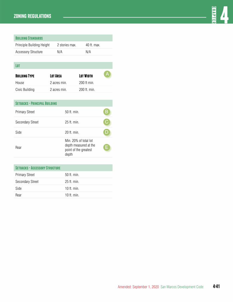
4:41
4CH
APTER
Zoning Regulations
Amended: September 1, 2020 San Marcos Development Code
Section 4.4.1.1Future Development District Building Standards
Principle Building Height 2 stories max. 40 ft. max.
Accessory Structure N/A N/A
Lot
Building Type Lot Area Lot Width A
House 2 acres min. 200 ft min.
Civic Building 2 acres min. 200 ft. min.
Setbacks - Principal Building
Primary Street 50 ft. min. B
Secondary Street 25 ft. min. C
Side 20 ft. min. D
Rear
Min. 20% of total lot depth measured at the point of the greatest depth
E
Setbacks - Accessory Structure
Primary Street 50 ft. min.
Secondary Street 25 ft. min.
Side 10 ft. min.
Rear 10 ft. min.
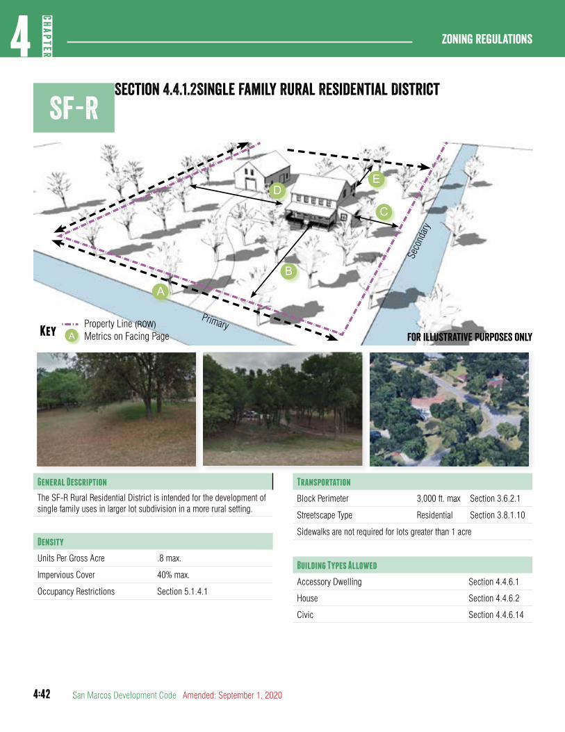
4:42
Zoning regulations4
CHAP
TER
San Marcos Development Code Amended: September 1, 2020
SF-R
Primary
Seco
ndary
Property Line (ROW)Key Metrics on Facing PageA
ED
B
A
C
For illustrative purposes only
General Description
The SF-R Rural Residential District is intended for the development of single family uses in larger lot subdivision in a more rural setting.
Density
Units Per Gross Acre .8 max.
Impervious Cover 40% max.
Occupancy Restrictions Section 5.1.4.1
Transportation
Block Perimeter 3,000 ft. max Section 3.6.2.1
Streetscape Type Residential Section 3.8.1.10
Sidewalks are not required for lots greater than 1 acre
Building Types Allowed
Accessory Dwelling Section 4.4.6.1
House Section 4.4.6.2
Civic Section 4.4.6.14
Section 4.4.1.2Single Family Rural Residential District

4:43
4CH
APTER
Zoning Regulations
Amended: September 1, 2020 San Marcos Development Code
Building Standards
Principle Building Height 2 stories max. 40 ft. max.
Accessory Structure Height N/A 30 ft. max.
Lot
Building Type Lot Area Lot Width A
House 43,560 sq. ft. min. 150 ft min.
Civic 43,560 sq. ft. min. 150 ft. min.
Setbacks - Principal Building
Primary Street 40 ft. min. B
Secondary Street 25 ft. min. C
Side 20 ft. min. D
Rear
min. 20% of total lot depth measured at the point of the greatest depth
E
Setbacks - Accessory Structure
Primary Street 50 ft. min.
Secondary Street 25 ft. min.
Side 5 ft. min.
Rear 5 ft. min.

4:44
Zoning regulations4
CHAP
TER
San Marcos Development Code Amended: September 1, 2020
SF-6Section 4.4.1.3 Single Family - 6
Section 4.4.1.4
Primary
Seco
ndary
Property Line (ROW)Key Metrics on Facing PageA For illustrative purposes only
General Description
The SF-6 district is intended to accommodate single family detached houses with a minimum lot size of 6,000 square feet. Characterized by smaller landscaped areas with moderate setbacks and more frequent pedestrian use. Uses that would substantially interfere with the residential nature of the district are not allowed.
Density
Units Per Gross Acre 5.5 max.
Impervious Cover 50% max.
Occupancy Restrictions Section 5.1.4.1
Transportation
Block Perimeter 3,000 ft. max Section 3.6.2.1
Streetscape Type Residential Section 3.8.1.10
Sidewalks are not required for lots greater than 1 acre
Building Types Allowed
Accessory Dwelling Section 4.4.6.1
House Section 4.4.6.2
Civic Section 4.4.6.14
AB
C
E
D

4:45
4CH
APTER
Zoning Regulations
Amended: September 1, 2020 San Marcos Development Code
Building Standards
Principle Building Height 2 stories max. 35 ft. max.
Accessory Structure Height N/A 24 ft. max.
Lot
Building Type Lot Area Lot Width A
House 6,000 sq. ft. min. 50 ft min.
Civic 6,000 sq. ft. min. 50 ft. min.
Setbacks - Principal Building
Primary Street 25 ft. min. B
Secondary Street 15 ft. min. C
Side 5 ft. min. D
Rear 20 ft. min. E
Setbacks - Accessory Structure
Primary Street 25 ft. min.
Secondary Street 15 ft. min.
Side 5 ft. min.
Rear 5 ft. min.

4:46
Zoning regulations4
CHAP
TER
San Marcos Development Code Amended: September 1, 2020
SF-4.5Section 4.4.1.4 Single Family - 4.5
Primary
Seco
ndary
Property Line (ROW)Key Metrics on Facing PageA For illustrative purposes only
General Description
The SF-4.5 district is intended to accommodate single family detached houses with a minimum lot size of 4,500 square feet. Characterized by smaller landscaped areas with moderate setbacks and more frequent pedestrian use. Uses that would substantially interfere with the residential nature of the district are not allowed.
Density
Units Per Gross Acre 7.5 max.
Impervious Cover 60% max.
Occupancy Restrictions Section 5.1.4.1
Transportation
Block Perimeter 3,000 ft. max. Section 3.6.2.1
Streetscape Type Residential Section 3.8.1.10
Building Types Allowed
Accessory Dwelling Section 4.4.6.1
House Section 4.4.6.2
Civic Section 4.4.6.14
AB
C
E
D

4:47
4CH
APTER
Zoning Regulations
Amended: September 1, 2020 San Marcos Development Code
Building Standards
Principle Building Height 2 stories max. 35 ft. max.
Accessory Structure Height N/A 24 ft. max.
Lot
Building Type Lot Area Lot Width A
House 4,500 sq. ft. min. 50 ft. min.
Civic 4,500 sq. ft. min. 50 ft. min.
Setbacks - Principal Building
Primary Street 20 ft. min. B
Secondary Street 15 ft. min. C
Side 5 ft. min. D
Rear 15 ft. min. E
Setbacks - Accessory Structure
Primary Street 20 ft. min.
Secondary Street 15 ft. min.
Side 5 ft. min.
Rear 5 ft. min.

4:48
Zoning regulations4
CHAP
TER
San Marcos Development Code Amended: September 1, 2020
DIVISION 2: NEIGHBORHOOD DENSITY DISTRICTS
Table 4.13 Neighborhood Density DistrictsAbbreviated Designation
District Name
ND-3 Neighborhood Density -3
ND-3.5 Neighborhood Density - 3.5
ND-3.2 Neighborhood Density - 3.2
ND-4 Neighborhood Density - 4
ND-CM Neighborhood Commercial
4:49
4CH
APTER
Zoning Regulations
Amended: September 1, 2020 San Marcos Development Code
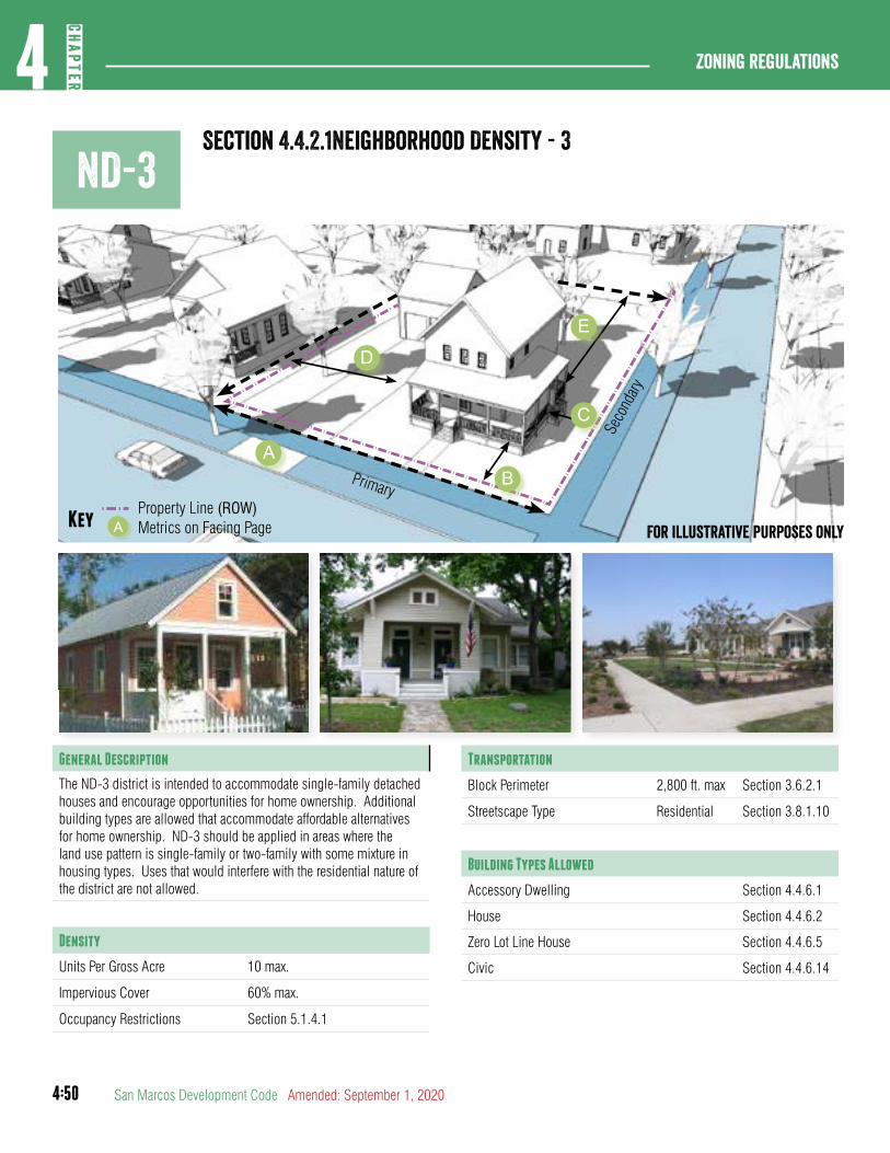
4:50
Zoning regulations4
CHAP
TER
San Marcos Development Code Amended: September 1, 2020
Primary
Seco
ndary
Property Line (ROW)Key Metrics on Facing PageA For illustrative purposes only
ND-3Section 4.4.2.1Neighborhood Density - 3
General Description
The ND-3 district is intended to accommodate single-family detached houses and encourage opportunities for home ownership. Additional building types are allowed that accommodate affordable alternatives for home ownership. ND-3 should be applied in areas where the land use pattern is single-family or two-family with some mixture in housing types. Uses that would interfere with the residential nature of the district are not allowed.
Density
Units Per Gross Acre 10 max.
Impervious Cover 60% max.
Occupancy Restrictions Section 5.1.4.1
Transportation
Block Perimeter 2,800 ft. max Section 3.6.2.1
Streetscape Type Residential Section 3.8.1.10
Building Types Allowed
Accessory Dwelling Section 4.4.6.1
House Section 4.4.6.2
Zero Lot Line House Section 4.4.6.5
Civic Section 4.4.6.14
AB
C
E
D
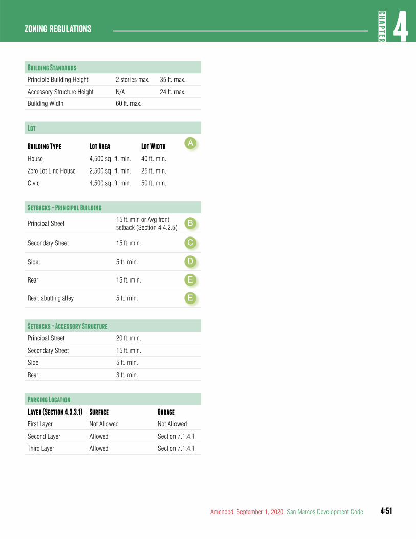
4:51
4CH
APTER
Zoning Regulations
Amended: September 1, 2020 San Marcos Development Code
Building Standards
Principle Building Height 2 stories max. 35 ft. max.
Accessory Structure Height N/A 24 ft. max.
Building Width 60 ft. max.
Lot
Building Type Lot Area Lot Width A
House 4,500 sq. ft. min. 40 ft. min.
Zero Lot Line House 2,500 sq. ft. min. 25 ft. min.
Civic 4,500 sq. ft. min. 50 ft. min.
Setbacks - Principal Building
Principal Street15 ft. min or Avg front setback (Section 4.4.2.5) B
Secondary Street 15 ft. min. C
Side 5 ft. min. D
Rear 15 ft. min. E
Rear, abutting alley 5 ft. min. E
Setbacks - Accessory Structure
Principal Street 20 ft. min.
Secondary Street 15 ft. min.
Side 5 ft. min.
Rear 3 ft. min.
Parking Location
Layer (Section 4.3.3.1) Surface Garage
First Layer Not Allowed Not Allowed
Second Layer Allowed Section 7.1.4.1
Third Layer Allowed Section 7.1.4.1
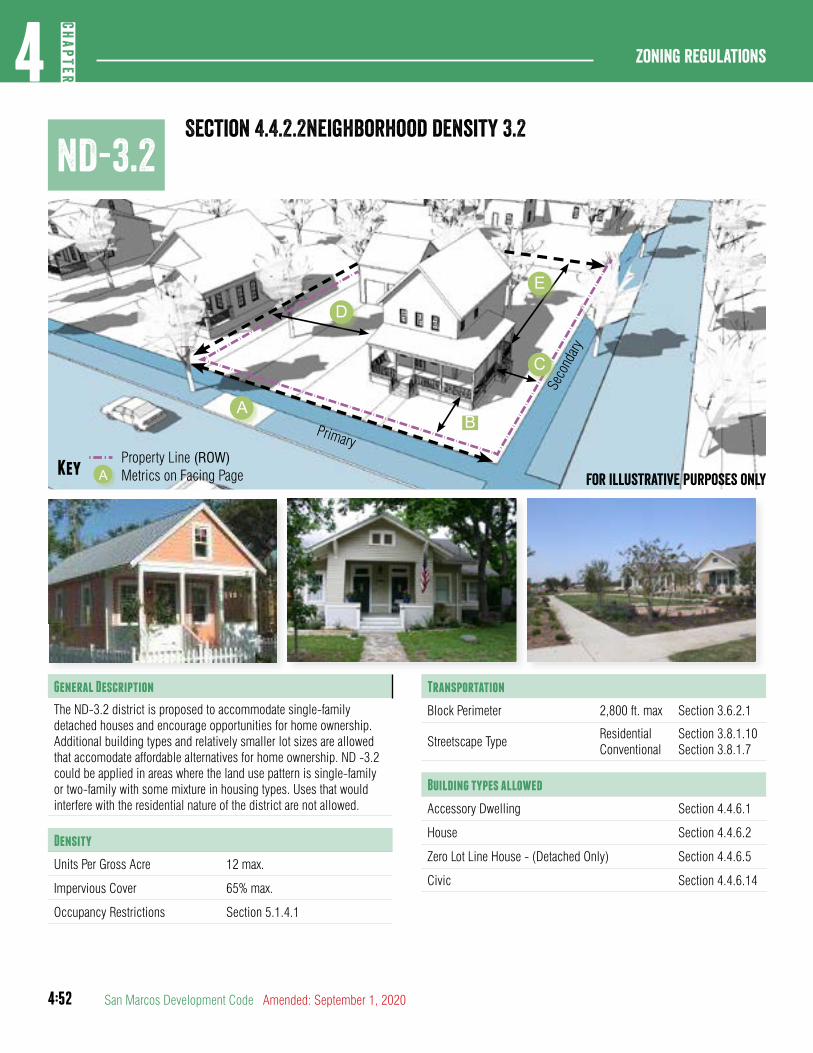
4:52
Zoning regulations4
CHAP
TER
San Marcos Development Code Amended: September 1, 2020
Section 4.4.2.2neighborhood density 3.2ND-3.2
Primary
Seco
ndary
Property Line (ROW)Key Metrics on Facing PageA For illustrative purposes only
General Description
The ND-3.2 district is proposed to accommodate single-family detached houses and encourage opportunities for home ownership. Additional building types and relatively smaller lot sizes are allowed that accomodate affordable alternatives for home ownership. ND -3.2 could be applied in areas where the land use pattern is single-family or two-family with some mixture in housing types. Uses that would interfere with the residential nature of the district are not allowed.
Density
Units Per Gross Acre 12 max.
Impervious Cover 65% max.
Occupancy Restrictions Section 5.1.4.1
Transportation
Block Perimeter 2,800 ft. max Section 3.6.2.1
Streetscape TypeResidentialConventional
Section 3.8.1.10Section 3.8.1.7
Building types allowed
Accessory Dwelling Section 4.4.6.1
House Section 4.4.6.2
Zero Lot Line House - (Detached Only) Section 4.4.6.5
Civic Section 4.4.6.14
AB
C
E
D
4:53
4CH
APTER
Zoning Regulations
Amended: September 1, 2020 San Marcos Development Code
building standards
Principle Buillding Height 2 stiries max. 35 ft. max.
Accessory Structure Height N/A 24 ft max.
Building Width 60 ft. max.
Lot
Building Type Lot Area Lot Width
House 4,500 sq. ft. min. 40 ft. min.
Zero Lot Line House 2,500 sq. ft. min. 25 ft. min.
Civic 4,500 sq. ft. min. 50 ft. min.
setbacks - principal building
Principal Street15 ft. min or Avg front setback (Section 4.4.2.5) B
Secondary Street 15 ft. min. C
Side 5 ft. min. D
Rear 15 ft. min. E
Rear, abutting alley 5 ft. min. E
setbacks - accessory structures
Principal Street 20 ft. min.
Secondary Street 15 ft. min.
Side 5 ft. min.
Rear 3 ft. min.
Parking Location
Layer (Section 4.3.3.1) Surface Garage
First Layer Not Allowed Not Allowed
Second Layer Allowed Section 7.1.4.1
Third Layer Allowed Section 7.1.4.1
(This Section was approved by Ord. No. 2020-60, 9-1-2020)
A
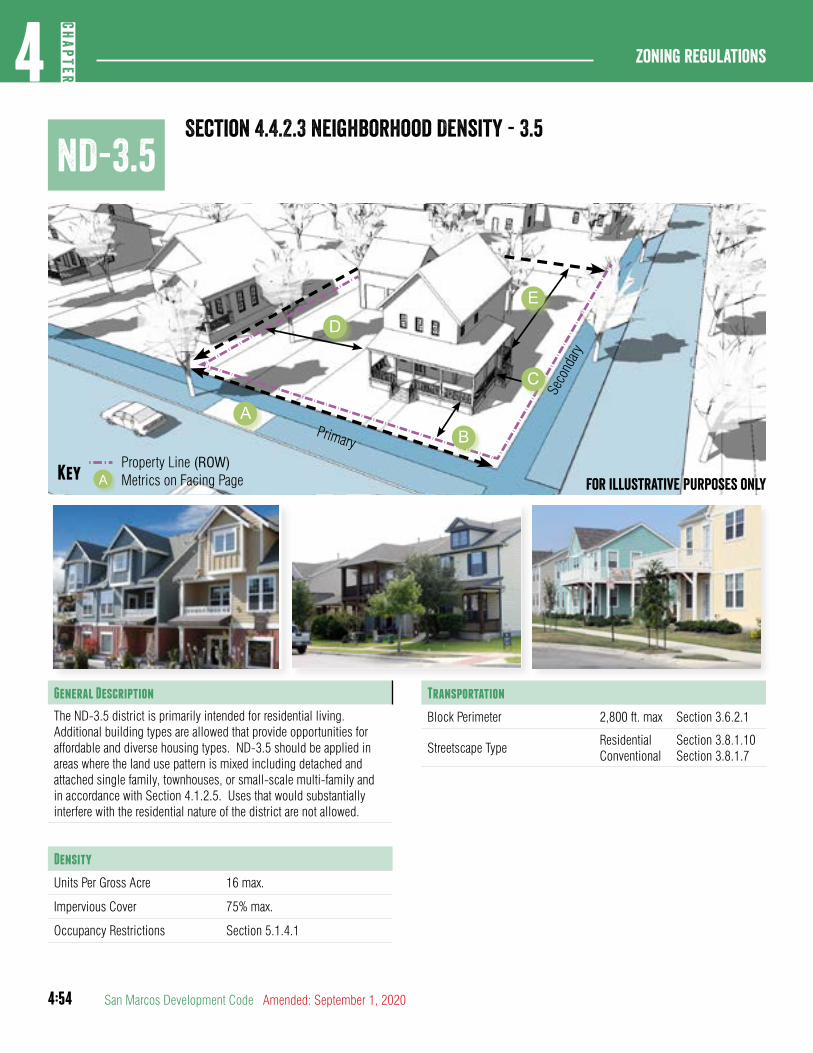
4:54
Zoning regulations4
CHAP
TER
San Marcos Development Code Amended: September 1, 2020
ND-3.5Section 4.4.2.3 Neighborhood Density - 3.5
Frontage
Seco
ndary
Fro
ntage
Property Line (ROW)Key Metrics on Facing PageA For illustrative purposes only
General Description
The ND-3.5 district is primarily intended for residential living. Additional building types are allowed that provide opportunities for affordable and diverse housing types. ND-3.5 should be applied in areas where the land use pattern is mixed including detached and attached single family, townhouses, or small-scale multi-family and in accordance with Section 4.1.2.5. Uses that would substantially interfere with the residential nature of the district are not allowed.
Density
Units Per Gross Acre 16 max.
Impervious Cover 75% max.
Occupancy Restrictions Section 5.1.4.1
Transportation
Block Perimeter 2,800 ft. max Section 3.6.2.1
Streetscape TypeResidential Conventional
Section 3.8.1.10Section 3.8.1.7
Primary
Seco
ndary
Property Line (ROW)Key Metrics on Facing PageA For illustrative purposes only
AB
C
E
D
4:55
4CH
APTER
Zoning Regulations
Amended: September 1, 2020 San Marcos Development Code
Building Types Allowed
Accessory Dwelling Section 4.4.6.1
House Section 4.4.6.2
Zero Lot Line House Section 4.4.6.5
Cottage Court Section 4.4.6.3
Duplex Section 4.4.6.4
Townhouse Section 4.4.6.6
Small Multi-Family Section 4.4.6.7
Civic Building Section 4.4.6.14
Building Standards
Principle Building Height 2 stories max. 35 ft. max.
Accessory Structure Height N/A 24 ft. max.
Building Width 60 ft. max.
Lot
Building Type Lot Area Lot Width A
House 4,500 sq. ft. min. 40 ft. min.
Zero Lot Line House 2,500 sq. ft. min. 25 ft. min.
Cottage Court 1,200 sq. ft. min. 20 ft. min.
Duplex 4,000 sq. ft. min. 40 ft. min.
Townhouse 1,500 sq. ft. min. 20 ft. min.
Small Multi-Family 6,000 sq. ft. min. 50 ft. min.
Civic Building 4,500 sq. ft. min. 50 ft. min.
Setbacks - Principal Building
Primary Street15 ft. min. or Avg front setback (Section 4.4.2.5) B
Secondary Street 15 ft. min. C
Side 5 ft. min. D
Rear 15 ft. min. E
Rear, abutting alley 5 ft. min. E
Setbacks - Accessory Structure
Primary Street 20 ft. min.
Secondary Street 15 ft. min.
Side 5 ft. min.
Rear 3 ft. min.
Parking Location
Layer (Section 4.3.3.1) Surface Garage
First Layer Not Allowed Not Allowed
Second Layer Allowed Section 7.1.4.1
Third Layer Allowed Section 7.1.4.1
4:56
Zoning regulations4
CHAP
TER
San Marcos Development Code Amended: September 1, 2020
ND-4Section 4.4.2.4 Neighborhood Density - 4
A
B C
D
E
Primary
Seco
ndary
Property Line (ROW)Key Metrics on Facing PageA For illustrative purposes only
General Description
The ND-4 district is primarily intended for residential living. ND-4 should be applied in areas where the land use pattern is a mixture of housing types that includes multi-family or townhouse with some commercial. This district can accommodate smaller scale multi-family living that fits in with a single family character and can include some limited neighborhood oriented commercial on corners only.
Density
Impervious Cover 80% max.
Occupancy Restrictions Section 5.1.4.1
Transportation
Block Perimeter 2,000 ft. max Section 3.6.2.1
Streetscape TypeResidential Conventional
Section 3.8.1.10Section 3.8.1.7
Building Types Allowed
Accessory Dwelling Section 4.4.6.1
Townhouse Section 4.4.6.6
Small Multi-Family Section 4.4.6.7
Courtyard Housing Section 4.4.6.8
Neighborhood Shopfront Section 4.4.6.11
Civic Building Section 4.4.6.14
4:57
4CH
APTER
Zoning Regulations
Amended: September 1, 2020 San Marcos Development Code
Building Standards
Principle Building Height 3 stories max. 45 ft. max.
Accessory Structure Height N/A 24 ft. max.
Lot
Building Type Lot Area Lot Width A
Townhouse 1,500 sq. ft. min. 20 ft. min.
Small Multi-Family 6,000 sq. ft. min. 50 ft. min.
Courtyard Housing 6,000 sq. ft. min. 80 ft. min.
Neighborhood Shopfront
6,000 sq. ft. min. 50 ft. min.
Civic Building 6,000 sq. ft. min. 50 ft. min.
Setbacks - Principal Building
Principal Street10 ft. min. or Avg front setback (Section 4.4.2.6) B
Secondary Street 15 ft. min. C
Side 5 ft. min. D
Rear 15 ft. min. E
Rear, abutting alley 5 ft. min. E
Setbacks - Accessory Structure
Principal Street 20 ft. min.
Secondary Street 15 ft. min.
Side 5 ft. min.
Rear 3 ft. min.
Parking Location
Layer (Section 4.3.3.1) Surface Garage
First Layer Not Allowed Not Allowed
Second Layer Allowed Section 7.1.4.1
Third Layer Allowed Section 7.1.4.1
Build-to Zone (BTZ)
Building facade in primary street 50% min.
Building facade in secondary street 25% min.
4:58
Zoning regulations4
CHAP
TER
San Marcos Development Code Amended: September 1, 2020
N-CMSection 4.4.2.5 Neighborhood - COMMERCIaL
AB C
D
E
Primary
Seco
ndary
Property Line (ROW)Key Metrics on Facing PageA For illustrative purposes only
General Description
The N-CM district is intended to serve as a pedestrian oriented mixed use corridor located within close proximity to primarily residential areas. N-CM should be applied along predominantly commercial corridors within existing neighborhood areas on the Preferred Scenario Map. The N-CM district creates pedestrian friendly corridors and gateways to residential areas and provides for appropriate buffers and transitions to adjacent residential land uses.
Density
Impervious cover 80% max.
Occupancy Restrictions Section 5.1.4.1
Transportation
Block Perimeter 2,000 ft. max. Section 3.6.2.1
Streetscape TypeMixed UseConventional
Section 3.8.1.8Section 3.8.1.7
4:59
4CH
APTER
Zoning Regulations
Amended: September 1, 2020 San Marcos Development Code
Building Types Allowed
Accessory Dwelling Unit Section 4.4.6.1
Townhouse Section 4.4.6.6
Small Multi-Family Section 4.4.6.7
Live/ Work Section 4.4.6.10
Neighborhood Shopfront Section 4.4.6.11
Mixed Use Shopfront Section 4.4.6.13
Civic Building Section 4.4.6.14
Building Standards
Principle Building Height 3 stories max. 45 ft. max.
Accessory Structure Height N/A 24 ft. max.
Lot
Building Type Lot Area Lot Width A
Townhouse 1,500 sq. ft. min. 20 ft. min.
Small Multi-Family 6,000 sq. ft. min. 50 ft. min.
Live/Work 1,100 sq. ft. min. 15 ft. min.
Neighborhood Shopfront
6,000 sq. ft. min. 50 ft. min.
Mixed Use Shopfront* 6,000 sq. ft. min. 50 ft. min.
Civic Building 6,000 sq. ft. min. 50 ft. min.
*No residential on the ground floor
Setbacks - Principal Building
Principal Street 5 ft. min./ 12 ft max. B
Secondary Street 5 ft. min./ 15 ft max. C
Side 0 ft. min. D
Rear 0 ft. min. E
Setbacks - Principal Building
Rear, abutting alley 3 ft. min. E
Setbacks - Accessory Structure
Principal Street 20 ft. min.
Secondary Street 15 ft. min.
Side 5 ft. min.
Rear 3 ft. min.
Parking Location
Layer (Section 4.3.3.1) Surface Garage
First Layer Not Allowed Not Allowed
Second Layer Allowed Not Allowed
Third Layer Allowed Allowed
Build-to Zone (BTZ)
Building Facade in primary street 70% min.
Building Facade in secondary street 30% min.
(N-MS renamed N-CM: Ord. No. 2019-45, 12-17-19)
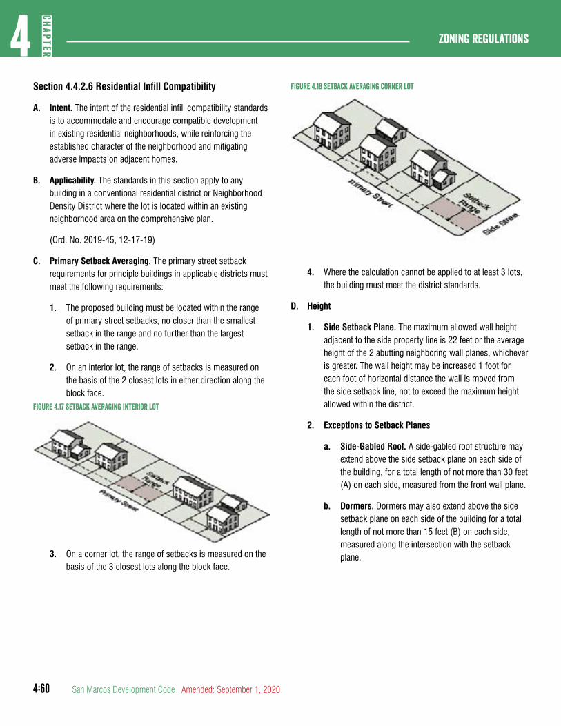
4:60
Zoning regulations4
CHAP
TER
San Marcos Development Code Amended: September 1, 2020
Section 4.4.2.6 Residential Infill Compatibility
A. Intent. The intent of the residential infill compatibility standards is to accommodate and encourage compatible development in existing residential neighborhoods, while reinforcing the established character of the neighborhood and mitigating adverse impacts on adjacent homes.
B. Applicability. The standards in this section apply to any building in a conventional residential district or Neighborhood Density District where the lot is located within an existing neighborhood area on the comprehensive plan.
(Ord. No. 2019-45, 12-17-19)
C. Primary Setback Averaging. The primary street setback requirements for principle buildings in applicable districts must meet the following requirements:
1. The proposed building must be located within the range of primary street setbacks, no closer than the smallest setback in the range and no further than the largest setback in the range.
2. On an interior lot, the range of setbacks is measured on the basis of the 2 closest lots in either direction along the block face.
Figure 4.17 Setback averaging interior lot
3. On a corner lot, the range of setbacks is measured on the basis of the 3 closest lots along the block face.
Figure 4.18 setback averaging corner lot
4. Where the calculation cannot be applied to at least 3 lots, the building must meet the district standards.
D. Height
1. Side Setback Plane. The maximum allowed wall height adjacent to the side property line is 22 feet or the average height of the 2 abutting neighboring wall planes, whichever is greater. The wall height may be increased 1 foot for each foot of horizontal distance the wall is moved from the side setback line, not to exceed the maximum height allowed within the district.
2. Exceptions to Setback Planes
a. Side-Gabled Roof. A side-gabled roof structure may extend above the side setback plane on each side of the building, for a total length of not more than 30 feet (A) on each side, measured from the front wall plane.
b. Dormers. Dormers may also extend above the side setback plane on each side of the building for a total length of not more than 15 feet (B) on each side, measured along the intersection with the setback plane.
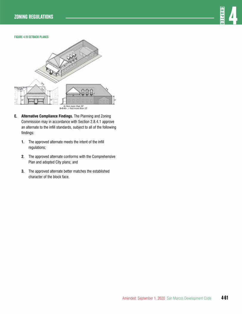
4:61
4CH
APTER
Zoning Regulations
Amended: September 1, 2020 San Marcos Development Code
Figure 4.19 Setback Planes
E. Alternative Compliance Findings. The Planning and Zoning Commission may in accordance with Section 2.8.4.1 approve an alternate to the infill standards, subject to all of the following findings:
1. The approved alternate meets the intent of the infill regulations;
2. The approved alternate conforms with the Comprehensive Plan and adopted City plans; and
3. The approved alternate better matches the established character of the block face.
4:62
Zoning regulations4
CHAP
TER
San Marcos Development Code Amended: September 1, 2020
DIVISION 3: CHARACTER DISTRICTS
Table 4.14 character districtsAbbreviated Designation
District Name
CD-1 Character District -1
CD-2 Character District -2
CD-2.5 Character District -2.5
CD-3 Character District -3
CD-4 Character District -4
CD-5 Character District -5
CD-5D Character District -5 Downtown
PA Planning Area District
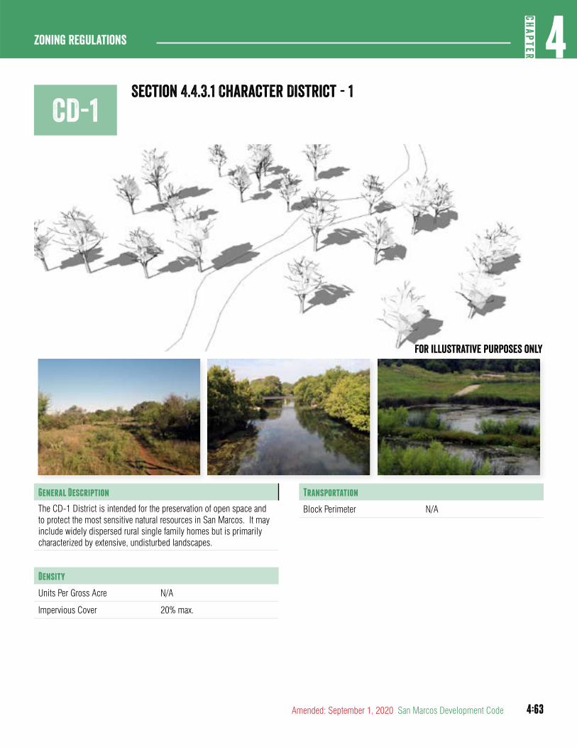
4:63
4CH
APTER
Zoning Regulations
Amended: September 1, 2020 San Marcos Development Code
CD-1Section 4.4.3.1 Character District - 1
For illustrative purposes only
General Description
The CD-1 District is intended for the preservation of open space and to protect the most sensitive natural resources in San Marcos. It may include widely dispersed rural single family homes but is primarily characterized by extensive, undisturbed landscapes.
Density
Units Per Gross Acre N/A
Impervious Cover 20% max.
Transportation
Block Perimeter N/A
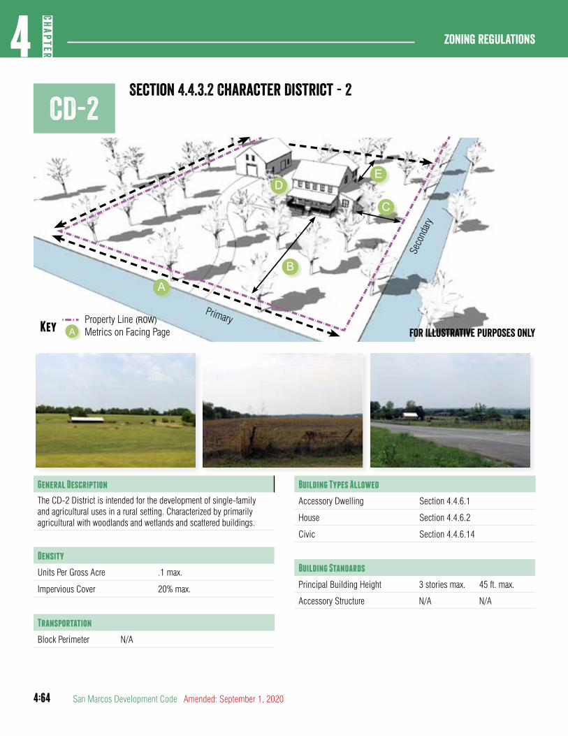
4:64
Zoning regulations4
CHAP
TER
San Marcos Development Code Amended: September 1, 2020
CD-2Section 4.4.3.2 Character District - 2
Primary
Seco
ndary
Property Line (ROW)Key Metrics on Facing PageA
ED
B
A
C
For illustrative purposes only
General Description
The CD-2 District is intended for the development of single-family and agricultural uses in a rural setting. Characterized by primarily agricultural with woodlands and wetlands and scattered buildings.
Density
Units Per Gross Acre .1 max.
Impervious Cover 20% max.
Transportation
Block Perimeter N/A
Building Types Allowed
Accessory Dwelling Section 4.4.6.1
House Section 4.4.6.2
Civic Section 4.4.6.14
Building Standards
Principal Building Height 3 stories max. 45 ft. max.
Accessory Structure N/A N/A
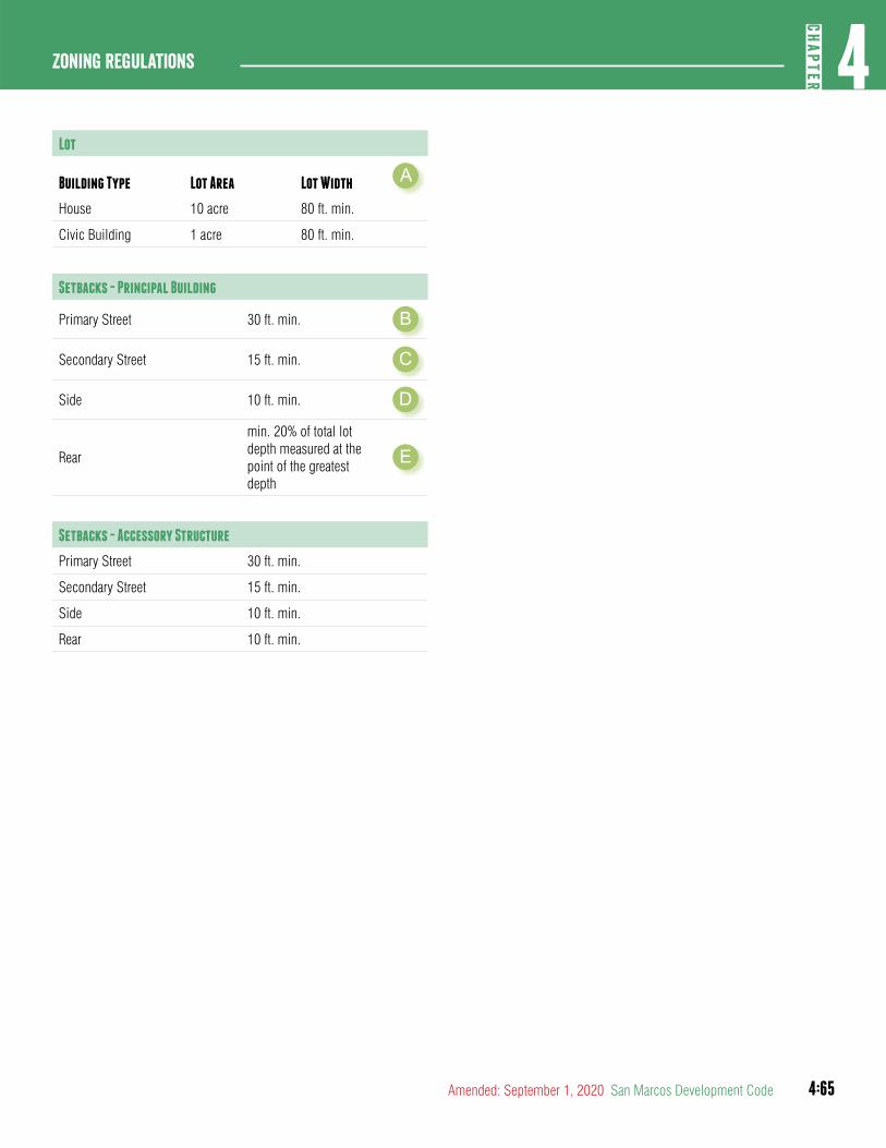
4:65
4CH
APTER
Zoning Regulations
Amended: September 1, 2020 San Marcos Development Code
Lot
Building Type Lot Area Lot Width A
House 10 acre 80 ft. min.
Civic Building 1 acre 80 ft. min.
Setbacks - Principal Building
Primary Street 30 ft. min. B
Secondary Street 15 ft. min. C
Side 10 ft. min. D
Rear
min. 20% of total lot depth measured at the point of the greatest depth
E
Setbacks - Accessory Structure
Primary Street 30 ft. min.
Secondary Street 15 ft. min.
Side 10 ft. min.
Rear 10 ft. min.
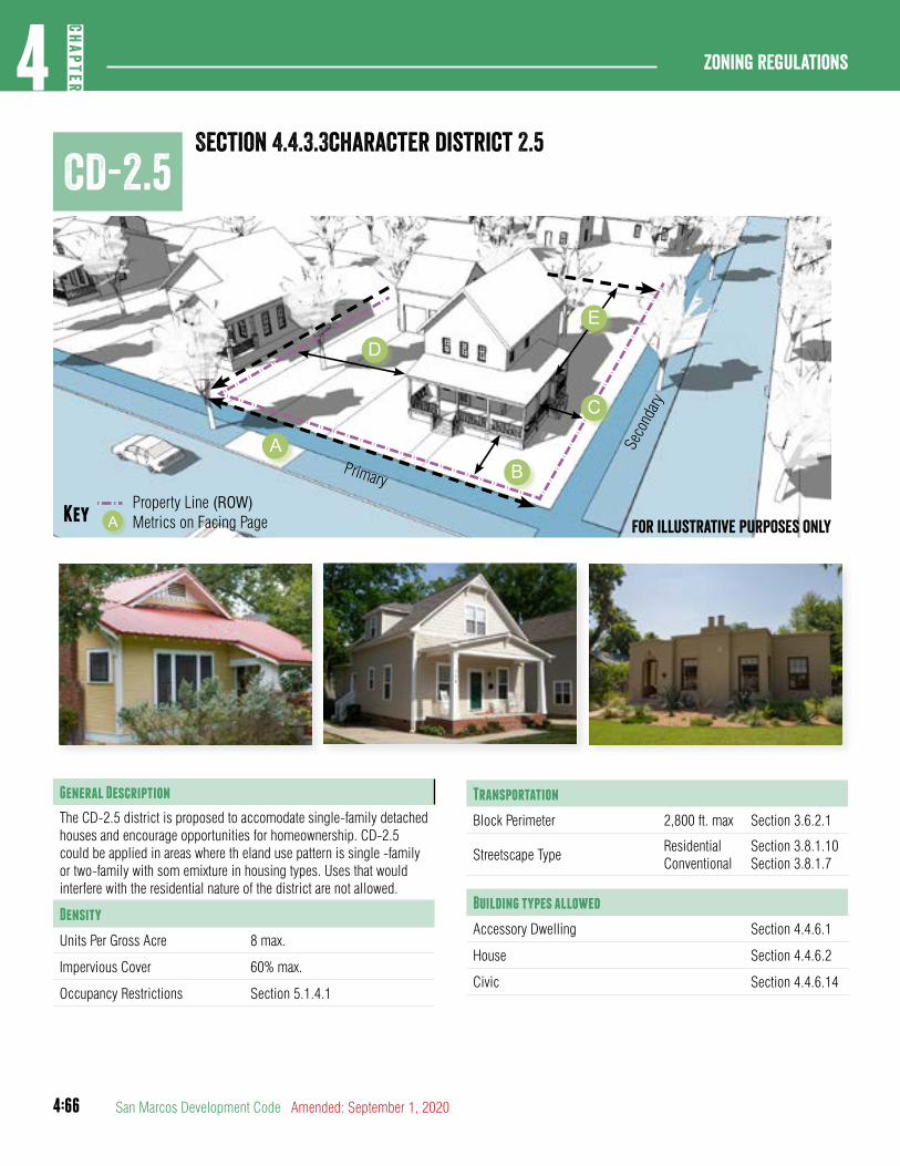
4:66
Zoning regulations4
CHAP
TER
San Marcos Development Code Amended: September 1, 2020
Section 4.4.3.3character district 2.5CD-2.5
Primary
Seco
ndary
Property Line (ROW)Key Metrics on Facing PageA For illustrative purposes only
AB
C
E
D
General Description
The CD-2.5 district is proposed to accomodate single-family detached houses and encourage opportunities for homeownership. CD-2.5 could be applied in areas where th eland use pattern is single -family or two-family with som emixture in housing types. Uses that would interfere with the residential nature of the district are not allowed.
Density
Units Per Gross Acre 8 max.
Impervious Cover 60% max.
Occupancy Restrictions Section 5.1.4.1
Transportation
Block Perimeter 2,800 ft. max Section 3.6.2.1
Streetscape TypeResidentialConventional
Section 3.8.1.10Section 3.8.1.7
Building types allowed
Accessory Dwelling Section 4.4.6.1
House Section 4.4.6.2
Civic Section 4.4.6.14
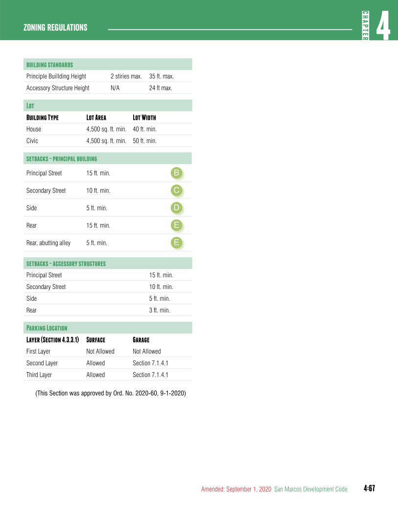
4:67
4CH
APTER
Zoning Regulations
Amended: September 1, 2020 San Marcos Development Code
building standards
Principle Buillding Height 2 stiries max. 35 ft. max.
Accessory Structure Height N/A 24 ft max.
Lot
Building Type Lot Area Lot Width
House 4,500 sq. ft. min. 40 ft. min.
Civic 4,500 sq. ft. min. 50 ft. min.
setbacks - principal building
Principal Street 15 ft. min. B
Secondary Street 10 ft. min. C
Side 5 ft. min. D
Rear 15 ft. min. E
Rear, abutting alley 5 ft. min. E
setbacks - accessory structures
Principal Street 15 ft. min.
Secondary Street 10 ft. min.
Side 5 ft. min.
Rear 3 ft. min.
Parking Location
Layer (Section 4.3.3.1) Surface Garage
First Layer Not Allowed Not Allowed
Second Layer Allowed Section 7.1.4.1
Third Layer Allowed Section 7.1.4.1
(This Section was approved by Ord. No. 2020-60, 9-1-2020)
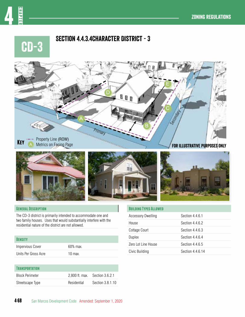
4:68
Zoning regulations4
CHAP
TER
San Marcos Development Code Amended: September 1, 2020
CD-3Section 4.4.3.4Character District - 3
Primary
Seco
ndary
Property Line (ROW)Key Metrics on Facing PageA For illustrative purposes only
General Description
The CD-3 district is primarily intended to accommodate one and two family houses. Uses that would substantially interfere with the residential nature of the district are not allowed.
Density
Impervious Cover 60% max.
Units Per Gross Acre 10 max.
Transportation
Block Perimeter 2,800 ft. max. Section 3.6.2.1
Streetscape Type Residential Section 3.8.1.10
Building Types Allowed
Accessory Dwelling Section 4.4.6.1
House Section 4.4.6.2
Cottage Court Section 4.4.6.3
Duplex Section 4.4.6.4
Zero Lot Line House Section 4.4.6.5
Civic Building Section 4.4.6.14
AB
C
E
D
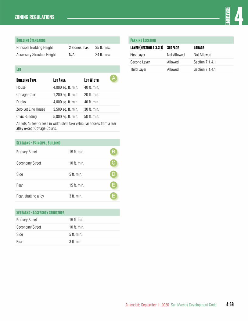
4:69
4CH
APTER
Zoning Regulations
Amended: September 1, 2020 San Marcos Development Code
Building Standards
Principle Building Height 2 stories max. 35 ft. max.
Accessory Structure Height N/A 24 ft. max.
Lot
Building Type Lot Area Lot Width A
House 4,000 sq. ft. min. 40 ft. min.
Cottage Court 1,200 sq. ft. min. 20 ft. min.
Duplex 4,000 sq. ft. min. 40 ft. min.
Zero Lot Line House 3,500 sq. ft. min. 30 ft. min.
Civic Building 5,000 sq. ft. min. 50 ft. min.
All lots 45 feet or less in width shall take vehicular access from a rear alley except Cottage Courts.
Setbacks - Principal Building
Primary Street 15 ft. min. B
Secondary Street 10 ft. min. C
Side 5 ft. min. D
Rear 15 ft. min. E
Rear, abutting alley 3 ft. min. E
Setbacks - Accessory Structure
Primary Street 15 ft. min.
Secondary Street 10 ft. min.
Side 5 ft. min.
Rear 3 ft. min.
Parking Location
Layer (Section 4.3.3.1) Surface Garage
First Layer Not Allowed Not Allowed
Second Layer Allowed Section 7.1.4.1
Third Layer Allowed Section 7.1.4.1
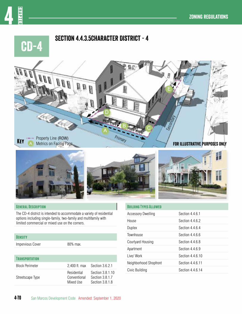
4:70
Zoning regulations4
CHAP
TER
San Marcos Development Code Amended: September 1, 2020
CD-4Section 4.4.3.5Character District - 4
AB C
D
E
Primary
Seco
ndar
y
Property Line (ROW)Key Metrics on Facing PageA For illustrative purposes only
General Description
The CD-4 district is intended to accommodate a variety of residential options including single-family, two-family and multifamily with limited commercial or mixed use on the corners.
Density
Impervious Cover 80% max.
Transportation
Block Perimeter 2,400 ft. max Section 3.6.2.1
Streetscape TypeResidentialConventional Mixed Use
Section 3.8.1.10Section 3.8.1.7Section 3.8.1.8
Building Types Allowed
Accessory Dwelling Section 4.4.6.1
House Section 4.4.6.2
Duplex Section 4.4.6.4
Townhouse Section 4.4.6.6
Courtyard Housing Section 4.4.6.8
Apartment Section 4.4.6.9
Live/ Work Section 4.4.6.10
Neighborhood Shopfront Section 4.4.6.11
Civic Building Section 4.4.6.14
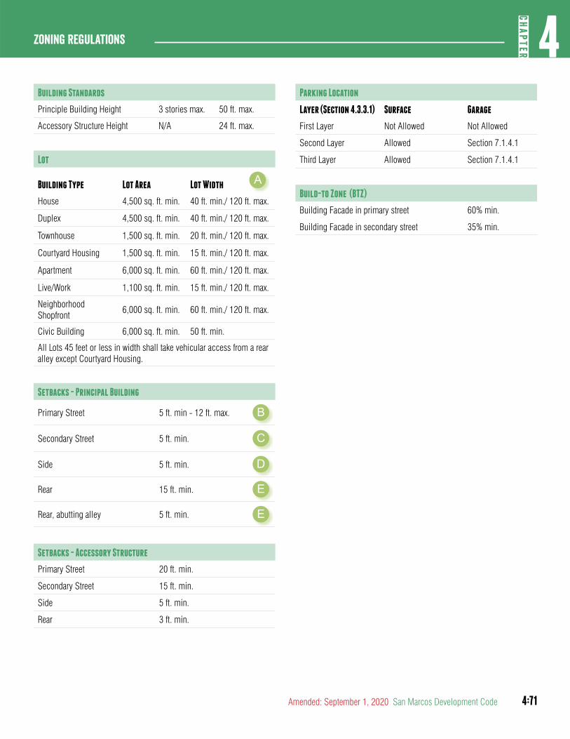
4:71
4CH
APTER
Zoning Regulations
Amended: September 1, 2020 San Marcos Development Code
Building Standards
Principle Building Height 3 stories max. 50 ft. max.
Accessory Structure Height N/A 24 ft. max.
Lot
Building Type Lot Area Lot Width A
House 4,500 sq. ft. min. 40 ft. min./ 120 ft. max.
Duplex 4,500 sq. ft. min. 40 ft. min./ 120 ft. max.
Townhouse 1,500 sq. ft. min. 20 ft. min./ 120 ft. max.
Courtyard Housing 1,500 sq. ft. min. 15 ft. min./ 120 ft. max.
Apartment 6,000 sq. ft. min. 60 ft. min./ 120 ft. max.
Live/Work 1,100 sq. ft. min. 15 ft. min./ 120 ft. max.
Neighborhood Shopfront
6,000 sq. ft. min. 60 ft. min./ 120 ft. max.
Civic Building 6,000 sq. ft. min. 50 ft. min.
All Lots 45 feet or less in width shall take vehicular access from a rear alley except Courtyard Housing.
Setbacks - Principal Building
Primary Street 5 ft. min - 12 ft. max. B
Secondary Street 5 ft. min. C
Side 5 ft. min. D
Rear 15 ft. min. E
Rear, abutting alley 5 ft. min. E
Setbacks - Accessory Structure
Primary Street 20 ft. min.
Secondary Street 15 ft. min.
Side 5 ft. min.
Rear 3 ft. min.
Parking Location
Layer (Section 4.3.3.1) Surface Garage
First Layer Not Allowed Not Allowed
Second Layer Allowed Section 7.1.4.1
Third Layer Allowed Section 7.1.4.1
Build-to Zone (BTZ)
Building Facade in primary street 60% min.
Building Facade in secondary street 35% min.
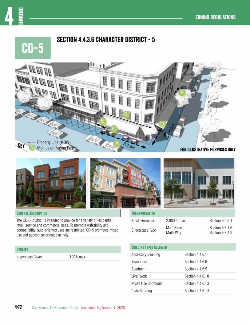
4:72
Zoning regulations4
CHAP
TER
San Marcos Development Code Amended: September 1, 2020
CD-5Section 4.4.3.6 Character District - 5
General Description
The CD-5 district is intended to provide for a variety of residential, retail, service and commercial uses. To promote walkability and compatibility, auto-oriented uses are restricted. CD-5 promotes mixed use and pedestrian-oriented activity.
Density
Impervious Cover 100% max.
Transportation
Block Perimeter 2,000 ft. max Section 3.6.2.1
Streetscape TypeMain StreetMulti-Way
Section 3.8.1.6Section 3.8.1.9
Building Types Allowed
Accessory Dwelling Section 4.4.6.1
Townhouse Section 4.4.6.6
Apartment Section 4.4.6.9
Live/ Work Section 4.4.6.10
Mixed Use Shopfront Section 4.4.6.13
Civic Building Section 4.4.6.14
Primary
Seco
ndar
y
Property Line (ROW)Key Metrics on Facing PageA
AFor illustrative purposes only
B
CDE
F
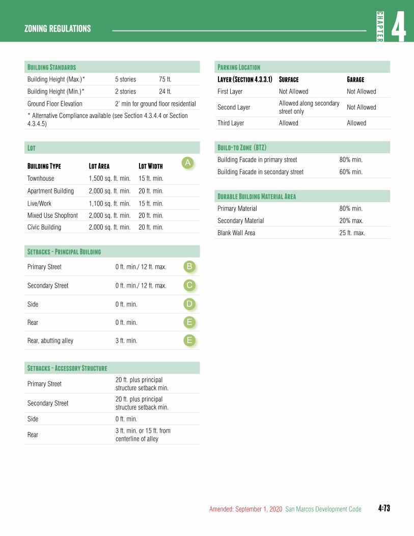
4:73
4CH
APTER
Zoning Regulations
Amended: September 1, 2020 San Marcos Development Code
Building Standards
Building Height (Max.)* 5 stories 75 ft.
Building Height (Min.)* 2 stories 24 ft.
Ground Floor Elevation 2’ min for ground floor residential
* Alternative Compliance available (see Section 4.3.4.4 or Section 4.3.4.5)
Lot
Building Type Lot Area Lot Width A
Townhouse 1,500 sq. ft. min. 15 ft. min.
Apartment Building 2,000 sq. ft. min. 20 ft. min.
Live/Work 1,100 sq. ft. min. 15 ft. min.
Mixed Use Shopfront 2,000 sq. ft. min. 20 ft. min.
Civic Building 2,000 sq. ft. min. 20 ft. min.
Setbacks - Principal Building
Primary Street 0 ft. min./ 12 ft. max. B
Secondary Street 0 ft. min./ 12 ft. max. C
Side 0 ft. min. D
Rear 0 ft. min. E
Rear, abutting alley 3 ft. min. E
Setbacks - Accessory Structure
Primary Street20 ft. plus principal structure setback min.
Secondary Street20 ft. plus principal structure setback min.
Side 0 ft. min.
Rear 3 ft. min. or 15 ft. from centerline of alley
Parking Location
Layer (Section 4.3.3.1) Surface Garage
First Layer Not Allowed Not Allowed
Second LayerAllowed along secondary street only
Not Allowed
Third Layer Allowed Allowed
Build-to Zone (BTZ)
Building Facade in primary street 80% min.
Building Facade in secondary street 60% min.
Durable Building Material Area
Primary Material 80% min.
Secondary Material 20% max.
Blank Wall Area 25 ft. max.
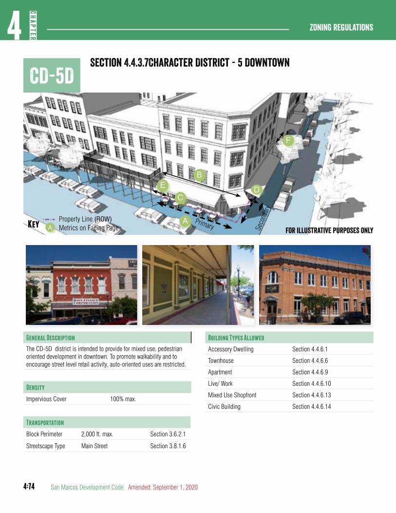
4:74
Zoning regulations4
CHAP
TER
San Marcos Development Code Amended: September 1, 2020
CD-5DSection 4.4.3.7Character District - 5 Downtown
Primary Seco
ndar
y
Property Line (ROW)Key Metrics on Facing PageA
AFor illustrative purposes only
B
CDE
F
General Description
The CD-5D district is intended to provide for mixed use, pedestrian oriented development in downtown. To promote walkability and to encourage street level retail activity, auto-oriented uses are restricted.
Density
Impervious Cover 100% max.
Transportation
Block Perimeter 2,000 ft. max. Section 3.6.2.1
Streetscape Type Main Street Section 3.8.1.6
Building Types Allowed
Accessory Dwelling Section 4.4.6.1
Townhouse Section 4.4.6.6
Apartment Section 4.4.6.9
Live/ Work Section 4.4.6.10
Mixed Use Shopfront Section 4.4.6.13
Civic Building Section 4.4.6.14
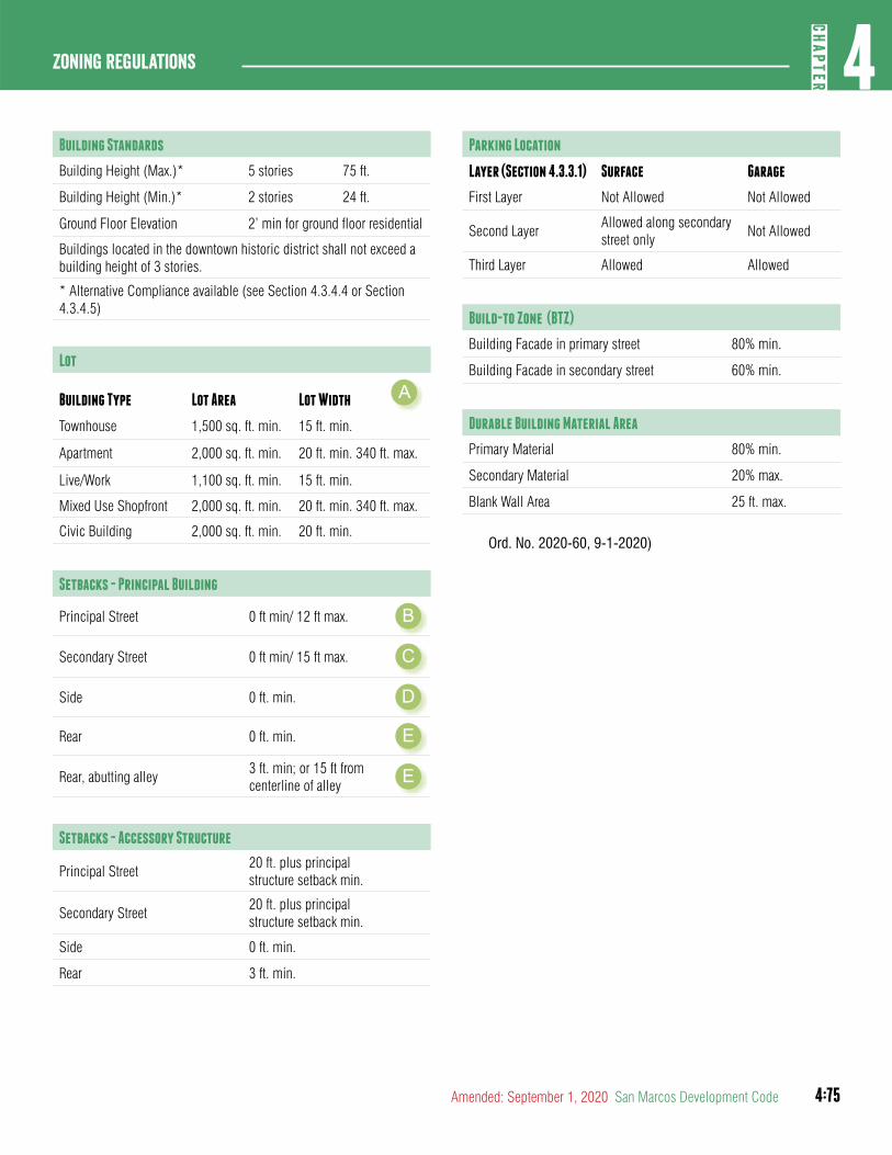
4:75
4CH
APTER
Zoning Regulations
Amended: September 1, 2020 San Marcos Development Code
Building Standards
Building Height (Max.)* 5 stories 75 ft.
Building Height (Min.)* 2 stories 24 ft.
Ground Floor Elevation 2’ min for ground floor residential
Buildings located in the downtown historic district shall not exceed a building height of 3 stories.
* Alternative Compliance available (see Section 4.3.4.4 or Section 4.3.4.5)
Lot
Building Type Lot Area Lot Width A
Townhouse 1,500 sq. ft. min. 15 ft. min.
Apartment 2,000 sq. ft. min. 20 ft. min. 340 ft. max.
Live/Work 1,100 sq. ft. min. 15 ft. min.
Mixed Use Shopfront 2,000 sq. ft. min. 20 ft. min. 340 ft. max.
Civic Building 2,000 sq. ft. min. 20 ft. min.
Setbacks - Principal Building
Principal Street 0 ft min/ 12 ft max. B
Secondary Street 0 ft min/ 15 ft max. C
Side 0 ft. min. D
Rear 0 ft. min. E
Rear, abutting alley3 ft. min; or 15 ft from centerline of alley E
Setbacks - Accessory Structure
Principal Street20 ft. plus principal structure setback min.
Secondary Street20 ft. plus principal structure setback min.
Side 0 ft. min.
Rear 3 ft. min.
Parking Location
Layer (Section 4.3.3.1) Surface Garage
First Layer Not Allowed Not Allowed
Second LayerAllowed along secondary street only
Not Allowed
Third Layer Allowed Allowed
Build-to Zone (BTZ)
Building Facade in primary street 80% min.
Building Facade in secondary street 60% min.
Durable Building Material Area
Primary Material 80% min.
Secondary Material 20% max.
Blank Wall Area 25 ft. max.
Ord. No. 2020-60, 9-1-2020)
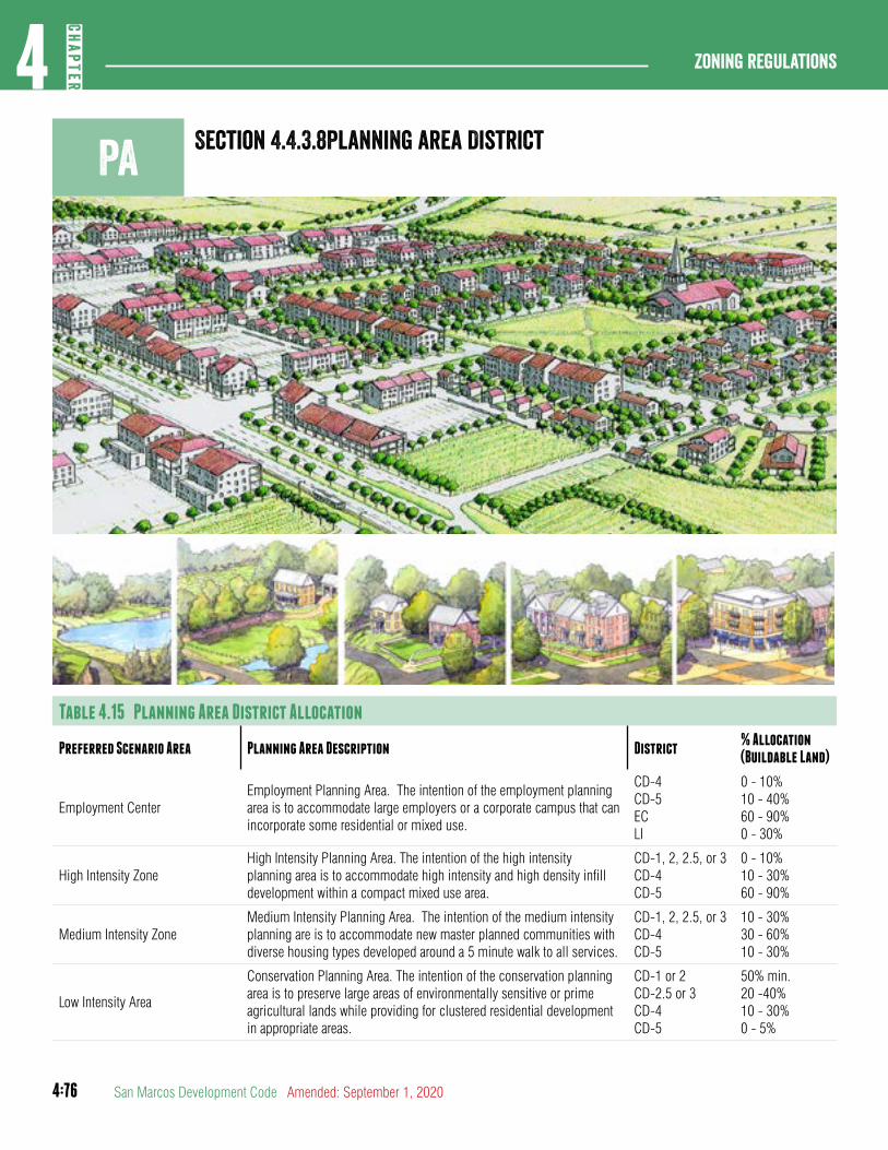
4:76
Zoning regulations4
CHAP
TER
San Marcos Development Code Amended: September 1, 2020
Section 4.4.3.8Planning area District
Table 4.15 Planning Area District Allocation
Preferred Scenario Area Planning Area Description District% Allocation (Buildable Land)
Employment CenterEmployment Planning Area. The intention of the employment planning area is to accommodate large employers or a corporate campus that can incorporate some residential or mixed use.
CD-4CD-5ECLI
0 - 10%10 - 40%60 - 90%0 - 30%
High Intensity ZoneHigh Intensity Planning Area. The intention of the high intensity planning area is to accommodate high intensity and high density infill development within a compact mixed use area.
CD-1, 2, 2.5, or 3CD-4CD-5
0 - 10%10 - 30%60 - 90%
Medium Intensity ZoneMedium Intensity Planning Area. The intention of the medium intensity planning are is to accommodate new master planned communities with diverse housing types developed around a 5 minute walk to all services.
CD-1, 2, 2.5, or 3CD-4CD-5
10 - 30%30 - 60%10 - 30%
Low Intensity Area
Conservation Planning Area. The intention of the conservation planning area is to preserve large areas of environmentally sensitive or prime agricultural lands while providing for clustered residential development in appropriate areas.
CD-1 or 2CD-2.5 or 3CD-4CD-5
50% min.20 -40%10 - 30%0 - 5%
Pa
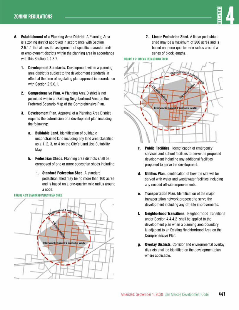
4:77
4CH
APTER
Zoning Regulations
Amended: September 1, 2020 San Marcos Development Code
A. Establishment of a Planning Area District. A Planning Area is a zoning district approved in accordance with Section 2.5.1.1 that allows the assignment of specific character and/or employment districts within the planning area in accordance with this Section 4.4.3.7.
1. Development Standards. Development within a planning area district is subject to the development standards in effect at the time of regulating plan approval in accordance with Section 2.5.6.1.
2. Comprehensive Plan. A Planning Area District is not permitted within an Existing Neighborhood Area on the Preferred Scenario Map of the Comprehensive Plan.
3. Development Plan. Approval of a Planning Area District requires the submission of a development plan including the following:
a. Buildable Land. Identification of buildable unconstrained land including any land area classified as a 1, 2, 3, or 4 on the City’s Land Use Suitability Map.
b. Pedestrian Sheds. Planning area districts shall be composed of one or more pedestrian sheds including:
1. Standard Pedestrian Shed. A standard pedestrian shed may be no more than 160 acres and is based on a one-quarter mile radius around a node.
Figure 4.20 Standard Pedestrian Shed
2. Linear Pedestrian Shed. A linear pedestrian shed may be a maximum of 200 acres and is based on a one-quarter mile radius around a series of block lengths.
Figure 4.21 Linear Pedestrian Shed
c. Public Facilities. Identification of emergency services and school facilities to serve the proposed development including any additional facilities proposed to serve the development.
d. Utilities Plan. Identification of how the site will be served with water and wastewater facilities including any needed off-site improvements.
e. Transportation Plan. Identification of the major transportation network proposed to serve the development including any off-site improvements.
f. Neighborhood Transitions. Neighborhood Transitions under Section 4.4.4.2 shall be applied to the development plan when a planning area boundary is adjacent to an Existing Neighborhood Area on the Comprehensive Plan.
g. Overlay Districts. Corridor and environmental overlay districts shall be identified on the development plan where applicable.
4:78
Zoning regulations4
CHAP
TER
San Marcos Development Code Amended: September 1, 2020
Section 4.4.3.9Regulating Plan
B. Regulating Plan Required. After City Council approval of a planning area district and prior to commencement of any development, the owner shall submit and must obtain approval of a regulating plan under Section 2.5.6.1
C. Contents of Regulating Plan. Each Regulating Plan or any amendment thereof, shall reflect the following, all in conformance with the applicable standards and requirements set forth in this Section 4.4.3.7:
1. Transportation plan, including:
a. New street designations;
b. Existing street designations;
c. Bicycle, greenway, or pedestrian passages;
d. Transit stops; and
e. Block perimeters.
2. Pedestrian sheds;
3. Parkland or civic buildings and the maintenance responsibility;
4. District allocations to regulate use and development of the planning area;
5. Vicinity map;
6. Major utilities plan;
7. Watershed protection plan phase I;
8. Phasing plan, if more than one phase is contemplated.
D. Additional Development Standards
1. Parkland Requirements. Planning area districts shall:
a. Include parkland constructed to the general neighborhood park standards in Section 3.10.2.1 within 800 ft. of the center of the pedestrian shed.
b. Include parkland designed as a playground under Section 3.10.2.1 within 1000 ft. of any residential lot.
2. Affordable Housing. Planning area districts shall:
a. Make a minimum of 10% of the units conform to the requirements for affordable housing under Section 4.3.1.1. These units are eligible to any incentives associated with the provision of affordable housing in this development code.
E. Regulating Plan Amendments. Any amendment to an approved regulating plan shall follow the same procedures required for initial approval with the following exceptions:
1. District allocations may not be amended for any area where a plat has been recorded.
2. Proposed changes to district allocations following recordation of a plat shall follow the zoning change
procedures in Section 2.5.1.1.
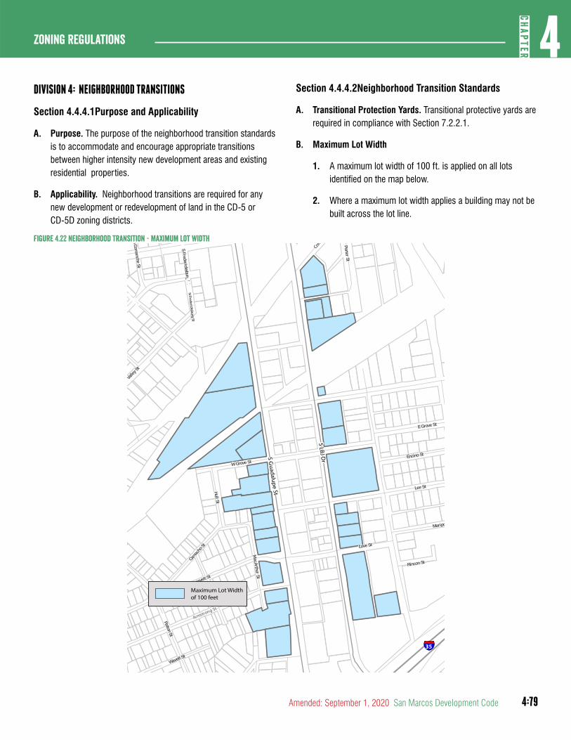
4:79
4CH
APTER
Zoning Regulations
Amended: September 1, 2020 San Marcos Development Code
DIVISION 4: NEIGHBORHOOD TRANSITIONS
Section 4.4.4.1Purpose and Applicability
A. Purpose. The purpose of the neighborhood transition standards is to accommodate and encourage appropriate transitions between higher intensity new development areas and existing residential properties.
B. Applicability. Neighborhood transitions are required for any new development or redevelopment of land in the CD-5 or CD-5D zoning districts.
Section 4.4.4.2Neighborhood Transition Standards
A. Transitional Protection Yards. Transitional protective yards are required in compliance with Section 7.2.2.1.
B. Maximum Lot Width
1. A maximum lot width of 100 ft. is applied on all lots identified on the map below.
2. Where a maximum lot width applies a building may not be built across the lot line.
Figure 4.22 Neighborhood Transition - Maximum Lot Width
Valle
y St
Wavell St
W Grove St
MacArthur
St
S Edward G arySt
SFredericksburg
St
Camac
hoSt
Armstrong St
PattonSt
Roosevelt St
SCom
ancheSt
Rodriguez St
E Grove St
Lee St
Mariposa St
Rincon St
LucianoFlores
Blvd
Love St
Hull St
PorterSt
Encino St
NFredericksburg
St
E MLK Dr
Comal S
t
Churchill St
S Guadalupe St
S LBJ Dr
§̈¦35
Maximum Lot Width of 100 feet
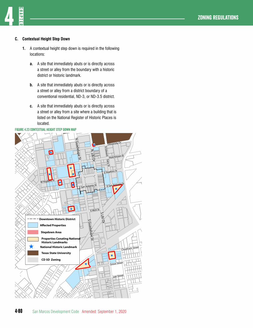
4:80
Zoning regulations4
CHAP
TER
San Marcos Development Code Amended: September 1, 2020
C. Contextual Height Step Down
1. A contextual height step down is required in the following locations:
a. A site that immediately abuts or is directly across a street or alley from the boundary with a historic district or historic landmark.
b. A site that immediately abuts or is directly across a street or alley from a district boundary of a conventional residential, ND-3, or ND-3.5 district.
c. A site that immediately abuts or is directly across a street or alley from a site where a building that is listed on the National Register of Historic Places is located.
Figure 4.23 Contextual height Step Down Map
^
^
^
^
^^
^
^
^
^
^
Cheatham Street
S LBJ Dr
S Guadalupe St
Grove Street
Lee Street
N LBJ D
r
N G
uadalupe St
University Dr
Hutchinson St
E Hopkins St
W Hopkins St
E San Antonio St
E MLK St
E San Antonio St
N Edw
ard Gary St
Downtown Historic District
A�ected Properties
Stepdown Area
^
Properties Conating NationalHistoric Landmarks
National Historic Landmark
Texas State University
CD 5D Zoning
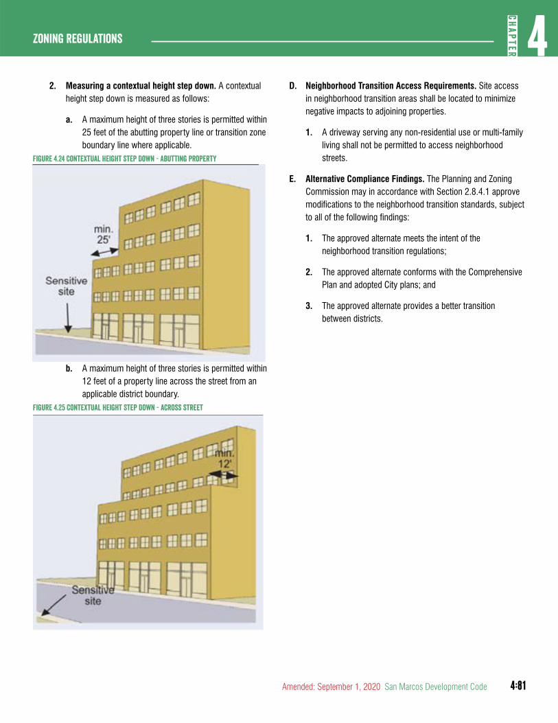
4:81
4CH
APTER
Zoning Regulations
Amended: September 1, 2020 San Marcos Development Code
2. Measuring a contextual height step down. A contextual height step down is measured as follows:
a. A maximum height of three stories is permitted within 25 feet of the abutting property line or transition zone boundary line where applicable.
Figure 4.24 Contextual height Step Down - abutting Property
b. A maximum height of three stories is permitted within 12 feet of a property line across the street from an applicable district boundary.
Figure 4.25 Contextual height Step Down - across street
D. Neighborhood Transition Access Requirements. Site access in neighborhood transition areas shall be located to minimize negative impacts to adjoining properties.
1. A driveway serving any non-residential use or multi-family living shall not be permitted to access neighborhood streets.
E. Alternative Compliance Findings. The Planning and Zoning Commission may in accordance with Section 2.8.4.1 approve modifications to the neighborhood transition standards, subject to all of the following findings:
1. The approved alternate meets the intent of the neighborhood transition regulations;
2. The approved alternate conforms with the Comprehensive Plan and adopted City plans; and
3. The approved alternate provides a better transition between districts.
4:82
Zoning regulations4
CHAP
TER
San Marcos Development Code Amended: September 1, 2020
DIVISION 5: SPECIAL DISTRICTS
Table 4.16 Special Districts summaryAbbreviated Designation
District Name
EC Employment Center District
LI Light Industrial District
HI Heavy Industrial District
MH Manufactured Home District

4:83
4CH
APTER
Zoning Regulations
Amended: September 1, 2020 San Marcos Development Code
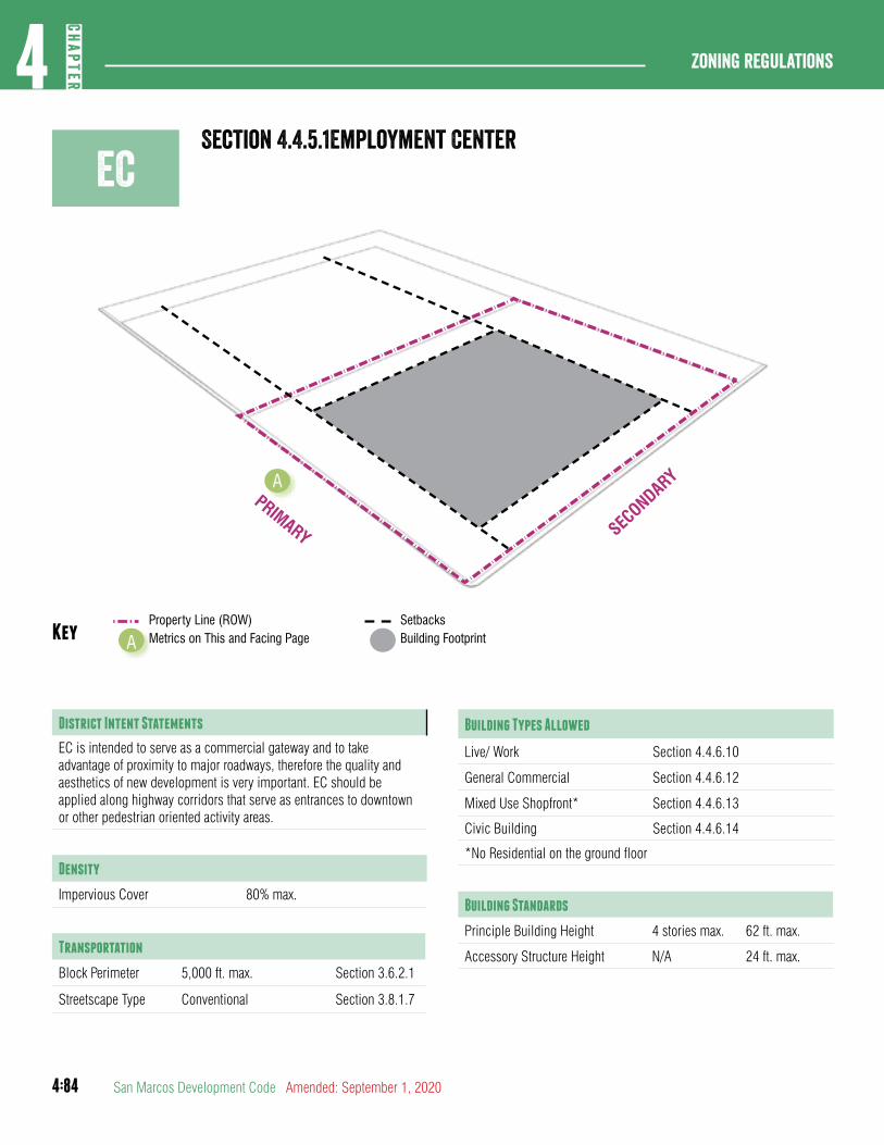
4:84
Zoning regulations4
CHAP
TER
San Marcos Development Code Amended: September 1, 2020
ECSection 4.4.5.1Employment Center
Property Line (ROW)Key Metrics on This and Facing PageA
PRIMARY
A
SetbacksBuilding Footprint
District Intent Statements
EC is intended to serve as a commercial gateway and to take advantage of proximity to major roadways, therefore the quality and aesthetics of new development is very important. EC should be applied along highway corridors that serve as entrances to downtown or other pedestrian oriented activity areas.
Density
Impervious Cover 80% max.
Transportation
Block Perimeter 5,000 ft. max. Section 3.6.2.1
Streetscape Type Conventional Section 3.8.1.7
Building Types Allowed
Live/ Work Section 4.4.6.10
General Commercial Section 4.4.6.12
Mixed Use Shopfront* Section 4.4.6.13
Civic Building Section 4.4.6.14
*No Residential on the ground floor
Building Standards
Principle Building Height 4 stories max. 62 ft. max.
Accessory Structure Height N/A 24 ft. max.
SECONDARY
4:85
4CH
APTER
Zoning Regulations
Amended: September 1, 2020 San Marcos Development Code
Lot
Building Type Lot Area Lot Width A
Live/ Work 1,100 sq ft min. 15 ft min.
General Commercial 4,000 sq ft min. 40 ft min.
Mixed Use Shopfront 4,000 sq ft min. 40 ft min.
Civic Building 4,000 sq ft min. 40 ft min.
Setbacks - Principal Building
Primary Street 10 ft min/ 20 ft max.
Secondary Street 10 ft min/ 15 ft max.
Side 5 ft. min.
Rear 20 ft. min.
Rear, abutting alley 3 ft. min.
Setbacks - Accessory Structure
Primary Street 50 ft min.
Secondary Street 20 ft. min.
Side 5 ft. min.
Rear 5 ft. min.
Parking Location
Layer (Section 4.3.3.1) Surface Garage
First Layer Not Allowed Not Allowed
Second Layer Allowed Not Allowed
Third Layer Allowed Allowed
Build-to Zone (BTZ)
Building Facade in primary street 50% min.
Building Facade in secondary street 25% min.
Durable Building Material and Blank Wall Area
Primary Material 80% min.
Secondary Material 20% max.
Blank Wall Area 35 ft. max.
4:86
Zoning regulations4
CHAP
TER
San Marcos Development Code Amended: September 1, 2020
hCSection 4.4.5.2heavy commercial
Property Line (ROW)Key Metrics on This and Facing PageA
PRIMARY
A
SetbacksBuilding Footprint
District Intent Statements
HC is intended to accommodate auto oriented and other heavy commercial uses. Development should be operated in a relatively clean and quiet manner, and should not be obnoxious to nearby residential or commercial uses.
Density
Impervious Cover 80% max.
Transportation
Block Perimeter 5,000 ft. max Section 3.6.2.1
Streetscape Type Conventional Section 3.8.1.7
Building Types Allowed
General Commercial Section 4.4.6.12
Civic Building Section 4.4.6.14
Building Standards
Principle Building Height 4 stories max. 62 ft. max.
Accessory Structure Height N/A 24 ft. max.
SECONDARY
4:87
4CH
APTER
Zoning Regulations
Amended: September 1, 2020 San Marcos Development Code
Lot
Building Type Lot Area Lot Width A
General Commercial 6,000 sq ft min 60 ft min.
Civic Building 6,000 sq ft min 60 ft min.
Setbacks - Principal Building
Primary Street 20 ft min.
Secondary Street 20 ft min.
Side 5 ft min.
Rear 20 ft min.
Setbacks - Accessory Structure
Primary Street 20 ft. min.
Secondary Street 20 ft. min.
Side 5 ft. min.
Rear 5 ft. min.
Parking Location
Layer (Section 4.3.3.1) Surface Garage
First Layer Allowed Allowed
Second Layer Allowed Allowed
Third Layer Allowed Allowed
Durable Building Material and Blank Wall Area
Primary Material 80% min.
Secondary Material 20% max.
Blank Wall Area 50 ft. max.
4:88
Zoning regulations4
CHAP
TER
San Marcos Development Code Amended: September 1, 2020
LISection 4.4.5.3Light Industrial
Property Line (ROW)Key Metrics on This and Facing PageA
PRIMARY
A
SetbacksBuilding Footprint
District Intent Statements
LI is intended to accommodate manufacturing and light industrial uses in order promote economic viability, encourage employment growth, and limit the encroachment of non-industrial development within established industrial areas. Development should be operated in a relatively clean and quiet manner, and should not be obnoxious to nearby residential or commercial uses.
Density
Impervious Cover 80% max.
Transportation
Block Perimeter 5,000 ft. max. Section 3.6.2.1
Streetscape Type Conventional Section 3.8.1.7
Building Types Allowed
General Commercial Section 4.4.6.12
Civic Building Section 4.4.6.14
Building Standards
Principle Building Height 4 stories max. 62 ft. max.
Accessory Structure Height N/A 24 ft. max.
SECONDARY
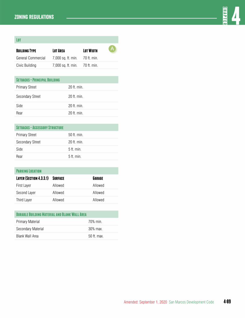
4:89
4CH
APTER
Zoning Regulations
Amended: September 1, 2020 San Marcos Development Code
Lot
Building Type Lot Area Lot Width A
General Commercial 7,000 sq. ft. min. 70 ft. min.
Civic Building 7,000 sq. ft. min. 70 ft. min.
Setbacks - Principal Building
Primary Street 20 ft. min.
Secondary Street 20 ft. min.
Side 20 ft. min.
Rear 20 ft. min.
Setbacks - Accessory Structure
Primary Street 50 ft. min.
Secondary Street 20 ft. min.
Side 5 ft. min.
Rear 5 ft. min.
Parking Location
Layer (Section 4.3.3.1) Surface Garage
First Layer Allowed Allowed
Second Layer Allowed Allowed
Third Layer Allowed Allowed
Durable Building Material and Blank Wall Area
Primary Material 70% min.
Secondary Material 30% max.
Blank Wall Area 50 ft. max.

4:90
Zoning regulations4
CHAP
TER
San Marcos Development Code Amended: September 1, 2020
Section 4.4.5.4heavy IndustrialhI
Property Line (ROW)Key Metrics on This and Facing PageA
PRIMARY
A
SetbacksBuilding Footprint
District Intent Statements
HI is intended to accommodate a broad range of high impact manufacturing or industrial uses, that by their nature create a nuisance, and which are not properly associated with or are not compatible with nearby residential or commercial uses.
Density
Impervious Cover 80% max.
Transportation
Block Perimeter 5,000 ft. max. Section 3.6.2.1
Streetscape Type Conventional Section 3.8.1.7
Building Types Allowed
General Commercial Section 4.4.6.12
Civic Building Section 4.4.6.14
Building Standards
Principle Building Height 4 stories max. 62 ft. max.
Accessory Structure Height N/A 24 ft. max.
SECONDARY
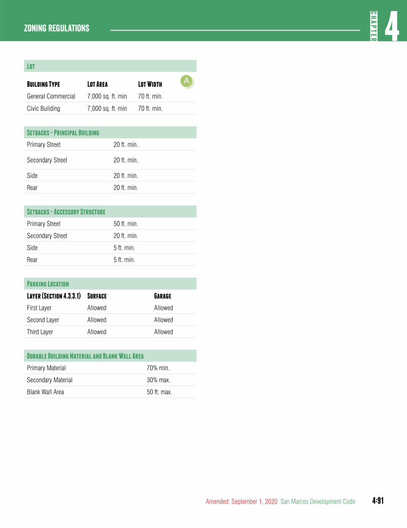
4:91
4CH
APTER
Zoning Regulations
Amended: September 1, 2020 San Marcos Development Code
Lot
Building Type Lot Area Lot Width A
General Commercial 7,000 sq. ft. min 70 ft. min.
Civic Building 7,000 sq. ft. min 70 ft. min.
Setbacks - Principal Building
Primary Street 20 ft. min.
Secondary Street 20 ft. min.
Side 20 ft. min.
Rear 20 ft. min.
Setbacks - Accessory Structure
Primary Street 50 ft. min.
Secondary Street 20 ft. min.
Side 5 ft. min.
Rear 5 ft. min.
Parking Location
Layer (Section 4.3.3.1) Surface Garage
First Layer Allowed Allowed
Second Layer Allowed Allowed
Third Layer Allowed Allowed
Durable Building Material and Blank Wall Area
Primary Material 70% min.
Secondary Material 30% max.
Blank Wall Area 50 ft. max.
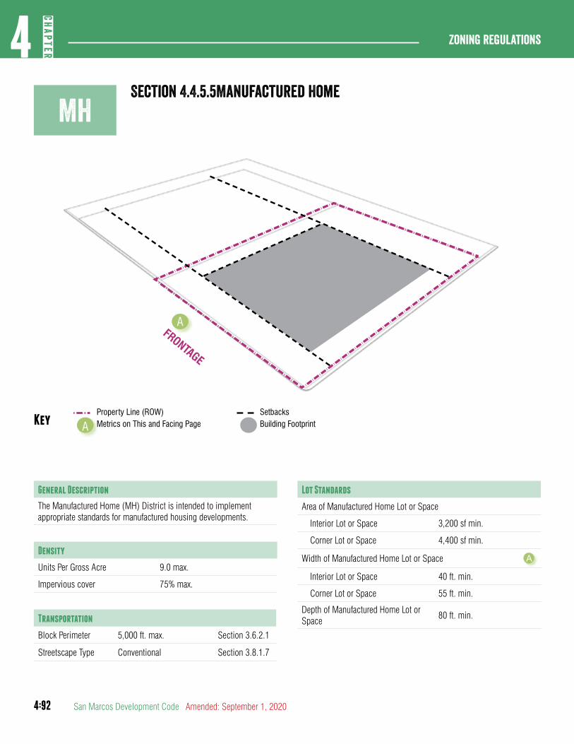
4:92
Zoning regulations4
CHAP
TER
San Marcos Development Code Amended: September 1, 2020
MhSection 4.4.5.5Manufactured home
Property Line (ROW)Key Metrics on This and Facing PageA
FRONTAGE
A
SetbacksBuilding Footprint
General Description
The Manufactured Home (MH) District is intended to implement appropriate standards for manufactured housing developments.
Density
Units Per Gross Acre 9.0 max.
Impervious cover 75% max.
Transportation
Block Perimeter 5,000 ft. max. Section 3.6.2.1
Streetscape Type Conventional Section 3.8.1.7
Lot Standards
Area of Manufactured Home Lot or Space
Interior Lot or Space 3,200 sf min.
Corner Lot or Space 4,400 sf min.
Width of Manufactured Home Lot or Space A
Interior Lot or Space 40 ft. min.
Corner Lot or Space 55 ft. min.
Depth of Manufactured Home Lot or Space
80 ft. min.
4:93
4CH
APTER
Zoning Regulations
Amended: September 1, 2020 San Marcos Development Code
Setbacks
Front Yard of Manufactured Home Lot or Space
10 ft. min; for a manufactured home park, the measurement shall be from the front line of the approved space.
Side, Interior of Manufactured Home Lot or Space
5 ft. min
Side, Corner of Manufactured Home Lot or Space
25 ft. min
Rear Yard of Manufactured Home Lot or Space
20 ft. min; for a manufactured home park, the measurement shall be from the front line of the approved space.
Building Standards
Height 2 stories max.
Additional Lot Requirements
All HUD-Code manufactured home standards
Manufactured Home Parks shall meet all requirements of Section 7.6.1.1
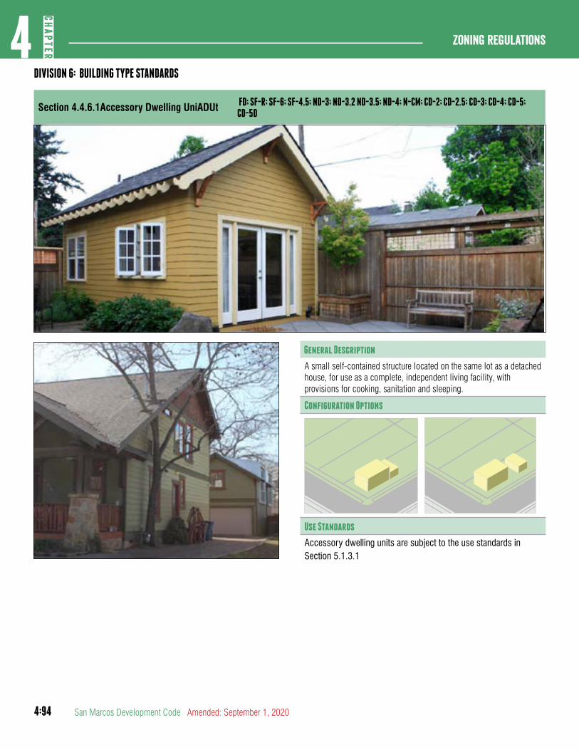
4:94
Zoning regulations4
CHAP
TER
San Marcos Development Code Amended: September 1, 2020
General Description
A small self-contained structure located on the same lot as a detached house, for use as a complete, independent living facility, with provisions for cooking, sanitation and sleeping.
Configuration Options
Use Standards
Accessory dwelling units are subject to the use standards in Section 5.1.3.1
DIVISION 6: BUILDING TYPE STANDARDS
Section 4.4.6.1Accessory Dwelling UniADUt FD; SF-R; SF-6; SF-4.5; ND-3; ND-3.2 ND-3.5; ND-4; N-CM; CD-2; CD-2.5; CD-3; CD-4; CD-5; CD-5D
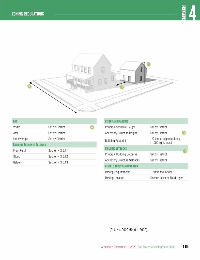
4:95
4CH
APTER
Zoning Regulations
Amended: September 1, 2020 San Marcos Development Code
Height and Massing
Principle Structure Height Set by District
Accessory Structure Height Set by District
Building Footprint1/2 the principle building (1,000 sq ft. max.)
Building Setbacks
Principle Building Setbacks Set by District
Accessory Structure Setbacks Set by District
Vehicle Access and Parking
Parking Requirements 1 Additional Space
Parking Location Second Layer or Third Layer
(Ord. No. 2020-60, 9-1-2020)
Lot
Width Set by District
Area Set by District
Lot coverage Set by District
Building Elements Allowed
Front Porch Section 4.3.5.11
Stoop Section 4.3.5.12
Balcony Section 4.3.5.13
A
A
B
C
B
C
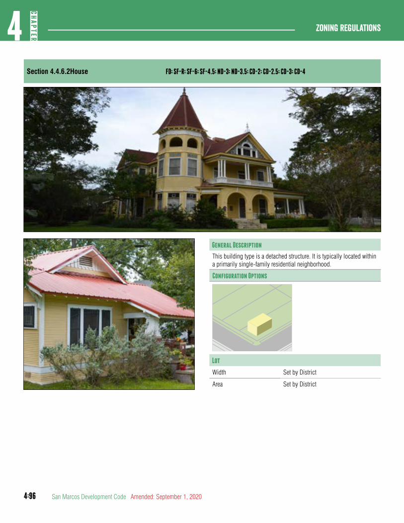
4:96
Zoning regulations4
CHAP
TER
San Marcos Development Code Amended: September 1, 2020
Section 4.4.6.2House FD; SF-R; SF-6; SF-4.5; ND-3; ND-3.5; CD-2; CD-2.5; CD-3; CD-4
General Description
This building type is a detached structure. It is typically located within a primarily single-family residential neighborhood.
Configuration Options
Lot
Width Set by District
Area Set by District
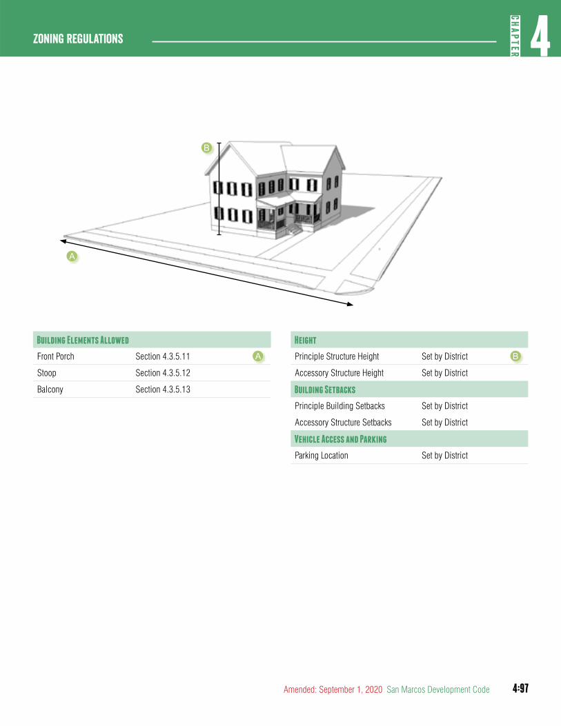
4:97
4CH
APTER
Zoning Regulations
Amended: September 1, 2020 San Marcos Development Code
Height
Principle Structure Height Set by District
Accessory Structure Height Set by District
Building Setbacks
Principle Building Setbacks Set by District
Accessory Structure Setbacks Set by District
Vehicle Access and Parking
Parking Location Set by District
Building Elements Allowed
Front Porch Section 4.3.5.11
Stoop Section 4.3.5.12
Balcony Section 4.3.5.13
A B
A
B
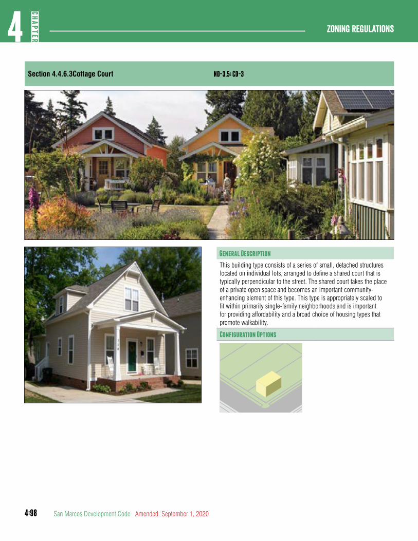
4:98
Zoning regulations4
CHAP
TER
San Marcos Development Code Amended: September 1, 2020
Section 4.4.6.3Cottage Court ND-3.5; CD-3
General Description
This building type consists of a series of small, detached structures located on individual lots, arranged to define a shared court that is typically perpendicular to the street. The shared court takes the place of a private open space and becomes an important community-enhancing element of this type. This type is appropriately scaled to fit within primarily single-family neighborhoods and is important for providing affordability and a broad choice of housing types that promote walkability.
Configuration Options
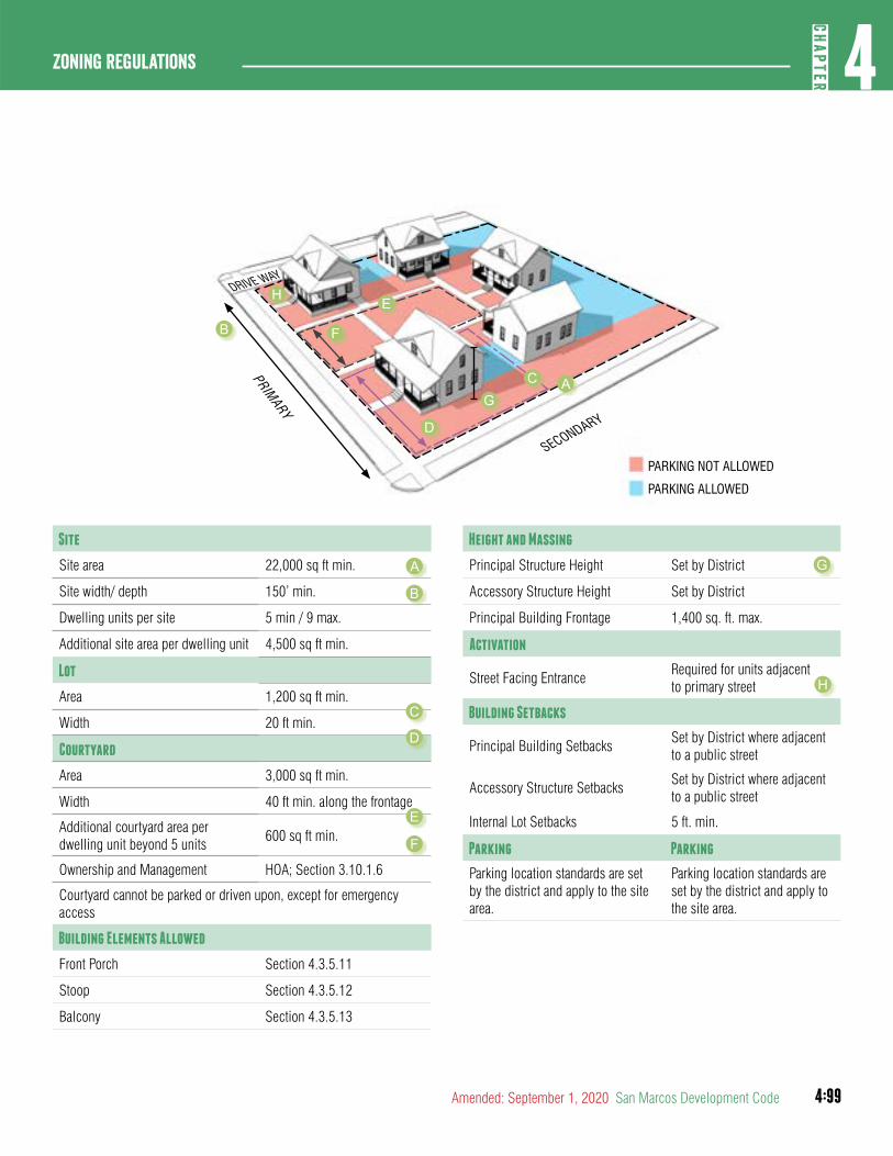
4:99
4CH
APTER
Zoning Regulations
Amended: September 1, 2020 San Marcos Development Code
Site
Site area 22,000 sq ft min.
Site width/ depth 150’ min.
Dwelling units per site 5 min / 9 max.
Additional site area per dwelling unit 4,500 sq ft min.
Lot
Area 1,200 sq ft min.
Width 20 ft min.
Courtyard
Area 3,000 sq ft min.
Width 40 ft min. along the frontage
Additional courtyard area per dwelling unit beyond 5 units
600 sq ft min.
Ownership and Management HOA; Section 3.10.1.6
Courtyard cannot be parked or driven upon, except for emergency access
Building Elements Allowed
Front Porch Section 4.3.5.11
Stoop Section 4.3.5.12
Balcony Section 4.3.5.13
Height and Massing
Principal Structure Height Set by District
Accessory Structure Height Set by District
Principal Building Frontage 1,400 sq. ft. max.
Activation
Street Facing EntranceRequired for units adjacent to primary street
Building Setbacks
Principal Building SetbacksSet by District where adjacent to a public street
Accessory Structure SetbacksSet by District where adjacent to a public street
Internal Lot Setbacks 5 ft. min.
Parking Parking
Parking location standards are set by the district and apply to the site area.
Parking location standards are set by the district and apply to the site area.
PARKING NOT ALLOWED
PARKING ALLOWED
B
G
PRIMARY
SECONDARY
DRIVE WAY
F
D
H E
AC
C
F
G
H
A
B
D
E
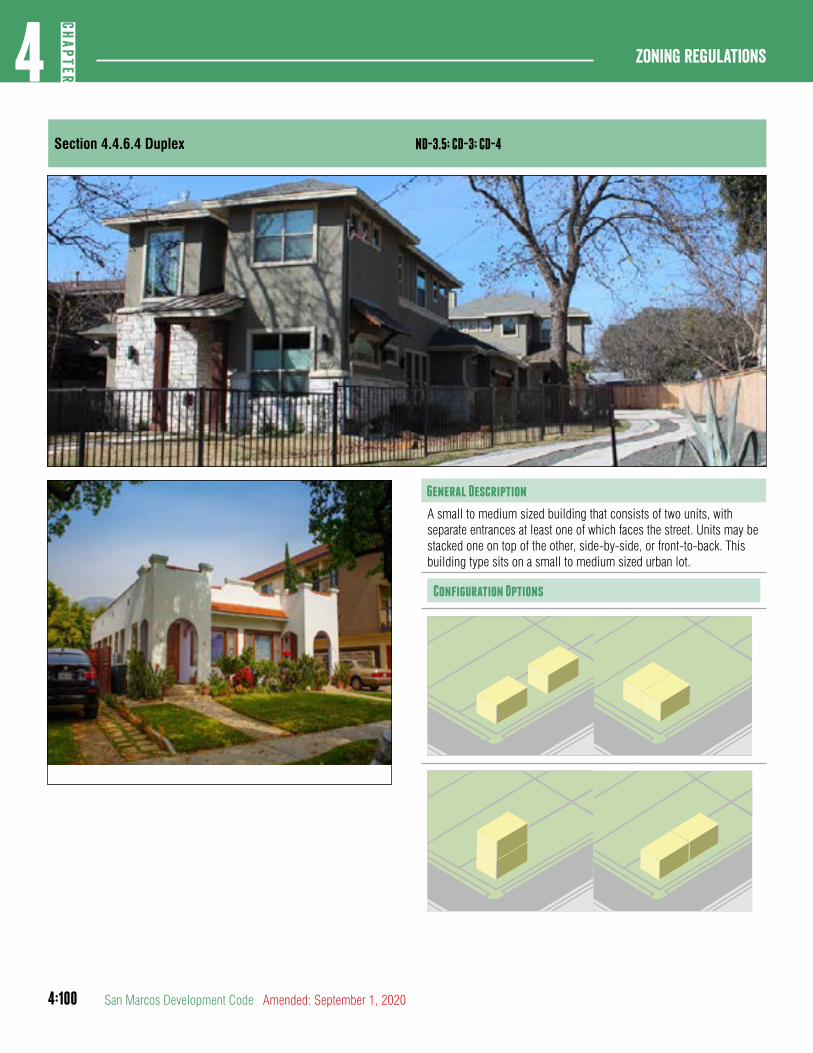
4:100
Zoning regulations4
CHAP
TER
San Marcos Development Code Amended: September 1, 2020
Section 4.4.6.4 Duplex ND-3.5; CD-3; CD-4
General Description
A small to medium sized building that consists of two units, with separate entrances at least one of which faces the street. Units may be stacked one on top of the other, side-by-side, or front-to-back. This building type sits on a small to medium sized urban lot.
Configuration Options
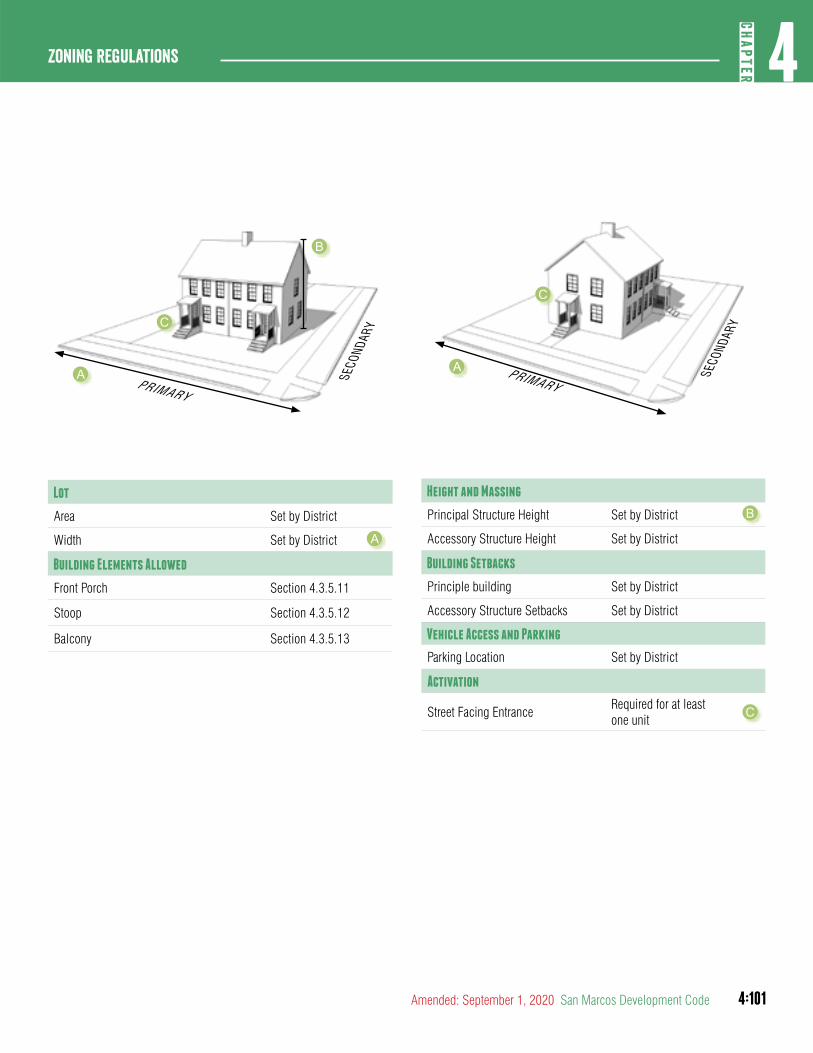
4:101
4CH
APTER
Zoning Regulations
Amended: September 1, 2020 San Marcos Development Code
Lot
Area Set by District
Width Set by District
Building Elements Allowed
Front Porch Section 4.3.5.11
Stoop Section 4.3.5.12
Balcony Section 4.3.5.13
Height and Massing
Principal Structure Height Set by District
Accessory Structure Height Set by District
Building Setbacks
Principle building Set by District
Accessory Structure Setbacks Set by District
Vehicle Access and Parking
Parking Location Set by District
Activation
Street Facing EntranceRequired for at least one unit
A
B
C
A
B
PRIMARY
SECO
NDAR
Y
C
A PRIMARY
SECO
NDAR
YC
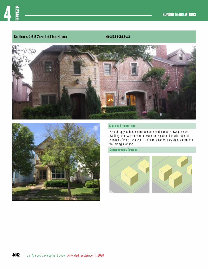
4:102
Zoning regulations4
CHAP
TER
San Marcos Development Code Amended: September 1, 2020
Section 4.4.6.5 Zero Lot Line House ND-3.5; CD-3; CD-4 3
General Description
A building type that accommodates one detached or two attached dwelling units with each unit located on separate lots with separate entrances facing the street. If units are attached they share a common wall along a lot line.
Configuration Options
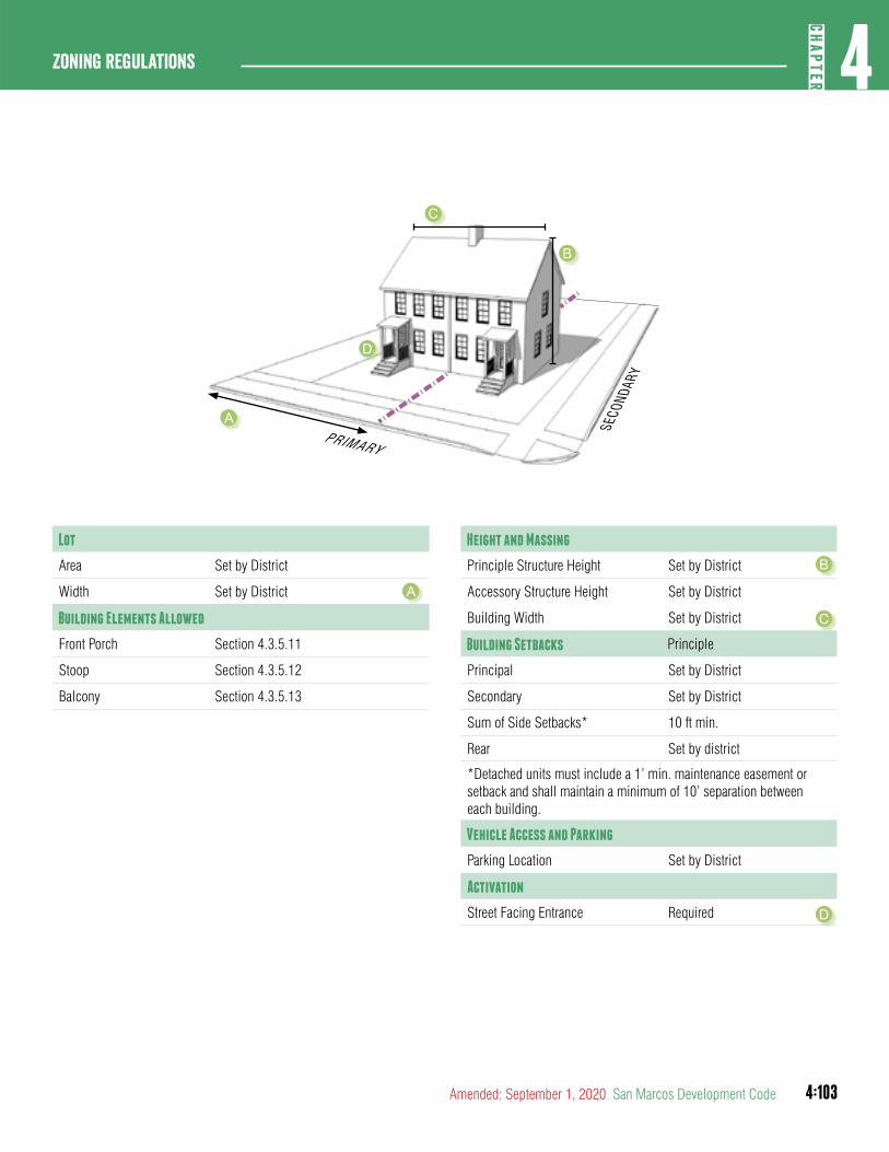
4:103
4CH
APTER
Zoning Regulations
Amended: September 1, 2020 San Marcos Development Code
Lot
Area Set by District
Width Set by District
Building Elements Allowed
Front Porch Section 4.3.5.11
Stoop Section 4.3.5.12
Balcony Section 4.3.5.13
Height and Massing
Principle Structure Height Set by District
Accessory Structure Height Set by District
Building Width Set by District
Building Setbacks Principle
Principal Set by District
Secondary Set by District
Sum of Side Setbacks* 10 ft min.
Rear Set by district
*Detached units must include a 1’ min. maintenance easement or setback and shall maintain a minimum of 10’ separation between each building.
Vehicle Access and Parking
Parking Location Set by District
Activation
Street Facing Entrance Required
A
B
C
D
A
B
C
D
PRIMARY
SECO
NDAR
Y
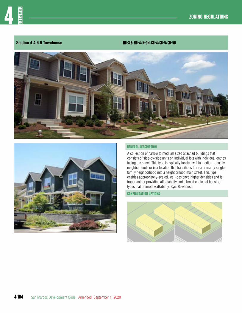
4:104
Zoning regulations4
CHAP
TER
San Marcos Development Code Amended: September 1, 2020
Section 4.4.6.6 Townhouse ND-3.5; ND-4; N-CM; CD-4; CD-5; CD-5D
General Description
A collection of narrow to medium sized attached buildings that consists of side-by-side units on individual lots with individual entries facing the street. This type is typically located within medium-density neighborhoods or in a location that transitions from a primarily single family neighborhood into a neighborhood main street. This type enables appropriately-scaled, well-designed higher densities and is important for providing affordability and a broad choice of housing types that promote walkability. Syn: Rowhouse
Configuration Options
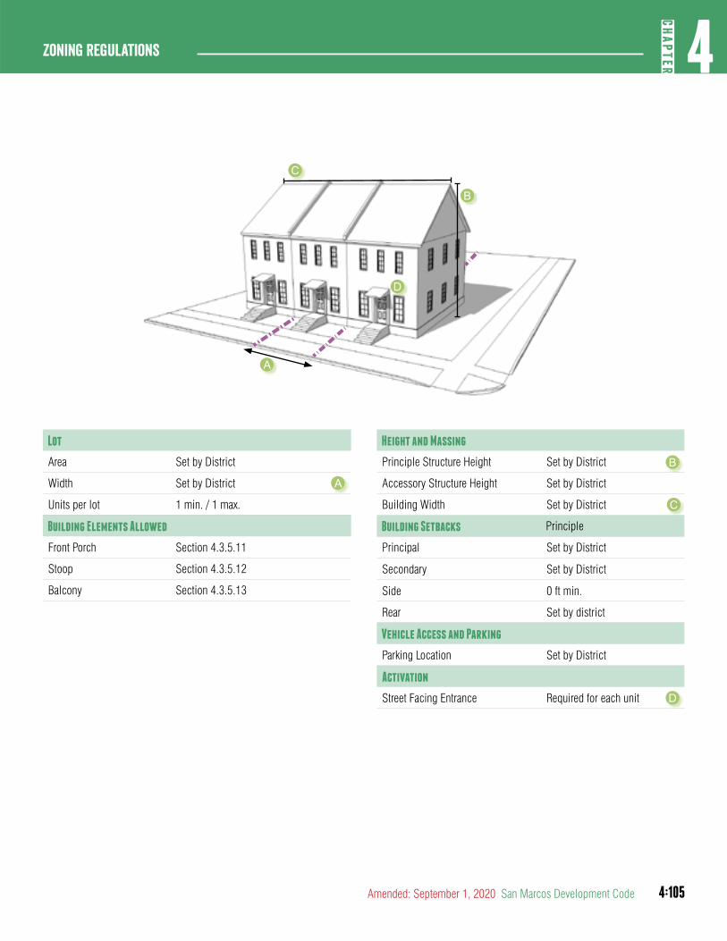
4:105
4CH
APTER
Zoning Regulations
Amended: September 1, 2020 San Marcos Development Code
Lot
Area Set by District
Width Set by District
Units per lot 1 min. / 1 max.
Building Elements Allowed
Front Porch Section 4.3.5.11
Stoop Section 4.3.5.12
Balcony Section 4.3.5.13
Height and Massing
Principle Structure Height Set by District
Accessory Structure Height Set by District
Building Width Set by District
Building Setbacks Principle
Principal Set by District
Secondary Set by District
Side 0 ft min.
Rear Set by district
Vehicle Access and Parking
Parking Location Set by District
Activation
Street Facing Entrance Required for each unit
A
B
C
D
A
B
C
D
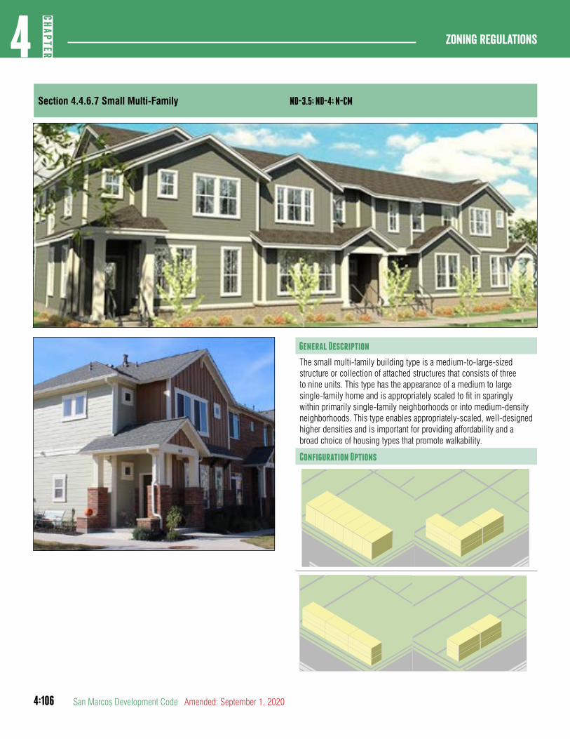
4:106
Zoning regulations4
CHAP
TER
San Marcos Development Code Amended: September 1, 2020
Section 4.4.6.7 Small Multi-Family ND-3.5; ND-4; N-CM
General Description
The small multi-family building type is a medium-to-large-sized structure or collection of attached structures that consists of three to nine units. This type has the appearance of a medium to large single-family home and is appropriately scaled to fit in sparingly within primarily single-family neighborhoods or into medium-density neighborhoods. This type enables appropriately-scaled, well-designed higher densities and is important for providing affordability and a broad choice of housing types that promote walkability.
Configuration Options
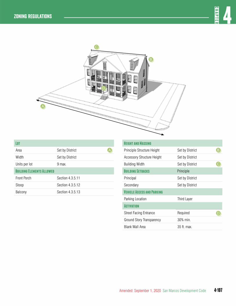
4:107
4CH
APTER
Zoning Regulations
Amended: September 1, 2020 San Marcos Development Code
Lot
Area Set by District
Width Set by District
Units per lot 9 max.
Building Elements Allowed
Front Porch Section 4.3.5.11
Stoop Section 4.3.5.12
Balcony Section 4.3.5.13
Height and Massing
Principle Structure Height Set by District
Accessory Structure Height Set by District
Building Width Set by District
Building Setbacks Principle
Principal Set by District
Secondary Set by District
Vehicle Access and Parking
Parking Location Third Layer
Activation
Street Facing Entrance Required
Ground Story Transparency 30% min.
Blank Wall Area 35 ft. max.
A B
C
D
A
B
C
D
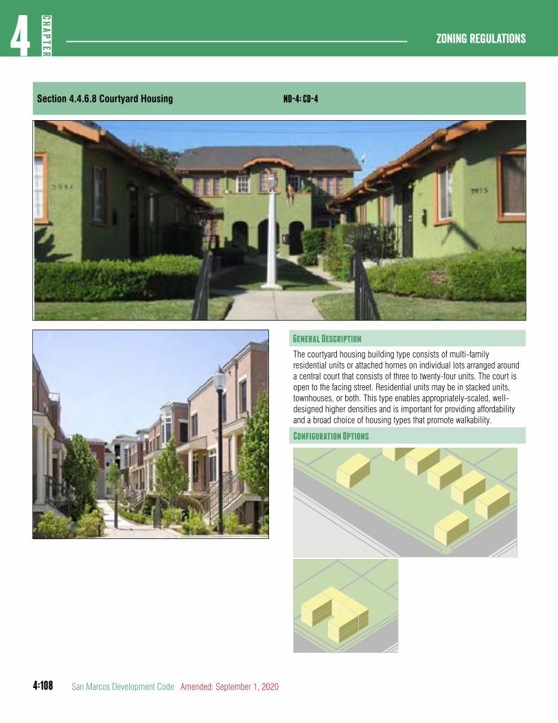
4:108
Zoning regulations4
CHAP
TER
San Marcos Development Code Amended: September 1, 2020
Section 4.4.6.8 Courtyard Housing ND-4; CD-4
General Description
The courtyard housing building type consists of multi-family residential units or attached homes on individual lots arranged around a central court that consists of three to twenty-four units. The court is open to the facing street. Residential units may be in stacked units, townhouses, or both. This type enables appropriately-scaled, well-designed higher densities and is important for providing affordability and a broad choice of housing types that promote walkability.
Configuration Options
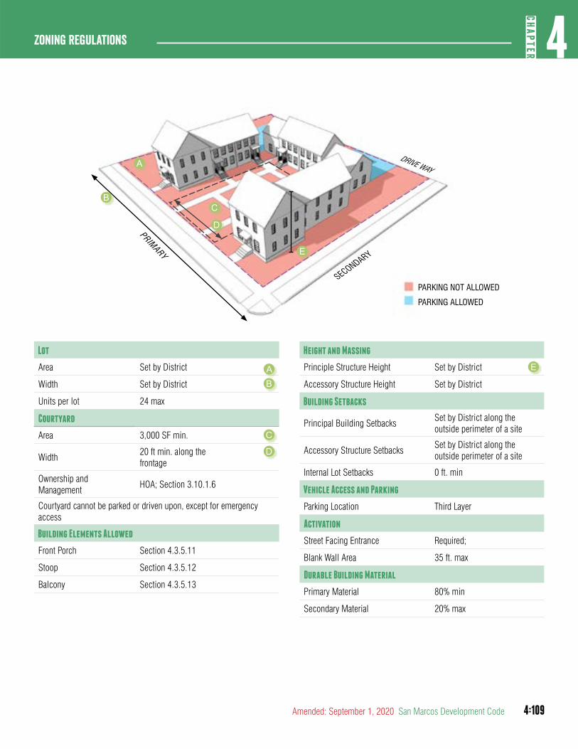
4:109
4CH
APTER
Zoning Regulations
Amended: September 1, 2020 San Marcos Development Code
Lot
Area Set by District
Width Set by District
Units per lot 24 max
Courtyard
Area 3,000 SF min.
Width 20 ft min. along the frontage
Ownership and Management
HOA; Section 3.10.1.6
Courtyard cannot be parked or driven upon, except for emergency access
Building Elements Allowed
Front Porch Section 4.3.5.11
Stoop Section 4.3.5.12
Balcony Section 4.3.5.13
Height and Massing
Principle Structure Height Set by District
Accessory Structure Height Set by District
Building Setbacks
Principal Building SetbacksSet by District along the outside perimeter of a site
Accessory Structure SetbacksSet by District along the outside perimeter of a site
Internal Lot Setbacks 0 ft. min
Vehicle Access and Parking
Parking Location Third Layer
Activation
Street Facing Entrance Required;
Blank Wall Area 35 ft. max
Durable Building Material
Primary Material 80% min
Secondary Material 20% max
B
C
E
B
D
E
A
D
PRIMARY
SECONDARY
DRIVE WAY
PARKING NOT ALLOWED
PARKING ALLOWED
A
C
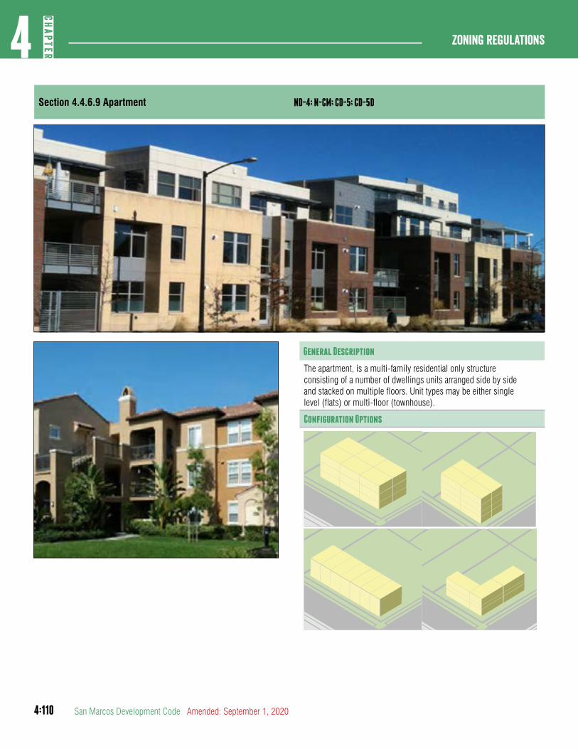
4:110
Zoning regulations4
CHAP
TER
San Marcos Development Code Amended: September 1, 2020
Section 4.4.6.9 Apartment ND-4; N-CM; CD-5; CD-5D
General Description
The apartment, is a multi-family residential only structureconsisting of a number of dwellings units arranged side by sideand stacked on multiple floors. Unit types may be either singlelevel (flats) or multi-floor (townhouse).
Configuration Options
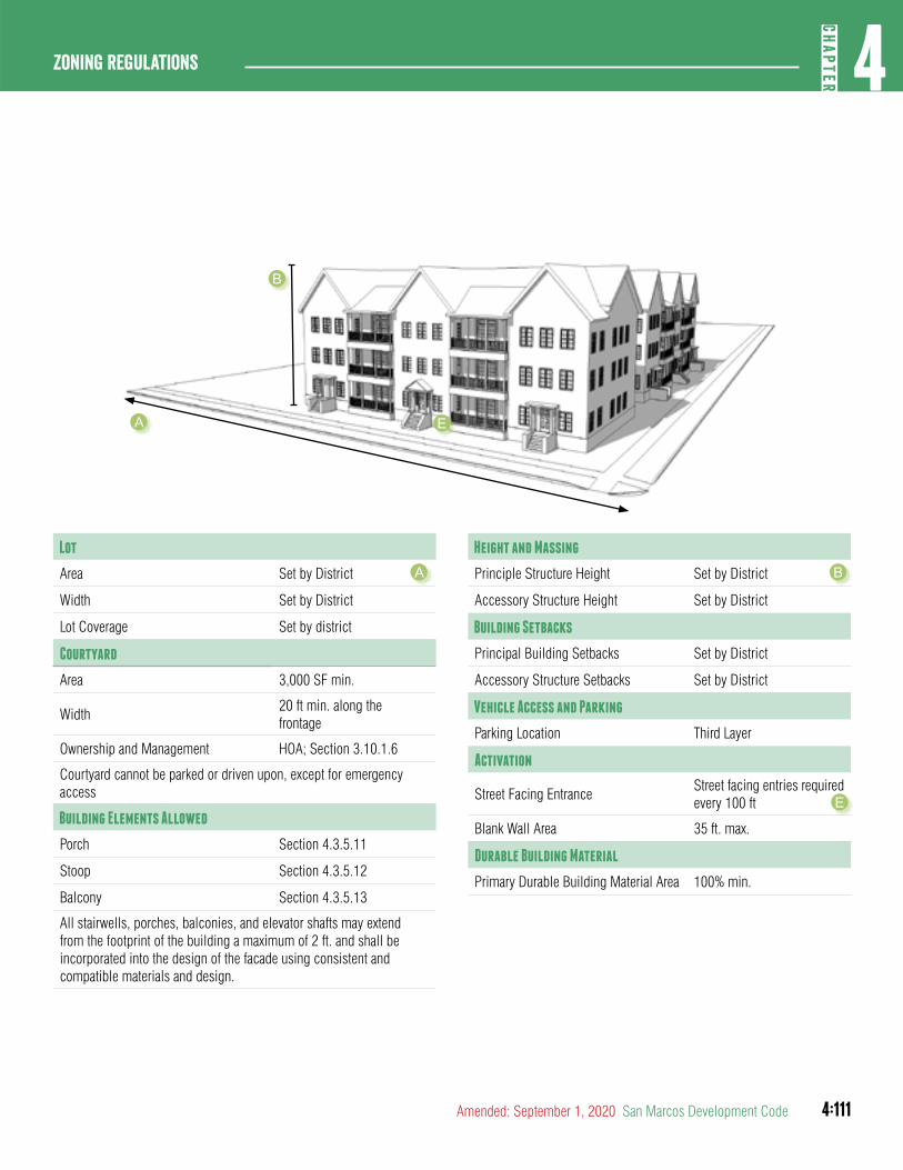
4:111
4CH
APTER
Zoning Regulations
Amended: September 1, 2020 San Marcos Development Code
Lot
Area Set by District
Width Set by District
Lot Coverage Set by district
Courtyard
Area 3,000 SF min.
Width 20 ft min. along the frontage
Ownership and Management HOA; Section 3.10.1.6
Courtyard cannot be parked or driven upon, except for emergency access
Building Elements Allowed
Porch Section 4.3.5.11
Stoop Section 4.3.5.12
Balcony Section 4.3.5.13
All stairwells, porches, balconies, and elevator shafts may extend from the footprint of the building a maximum of 2 ft. and shall be incorporated into the design of the facade using consistent and compatible materials and design.
Height and Massing
Principle Structure Height Set by District
Accessory Structure Height Set by District
Building Setbacks
Principal Building Setbacks Set by District
Accessory Structure Setbacks Set by District
Vehicle Access and Parking
Parking Location Third Layer
Activation
Street Facing EntranceStreet facing entries required every 100 ft
Blank Wall Area 35 ft. max.
Durable Building Material
Primary Durable Building Material Area 100% min.
A B
A
B
E
E
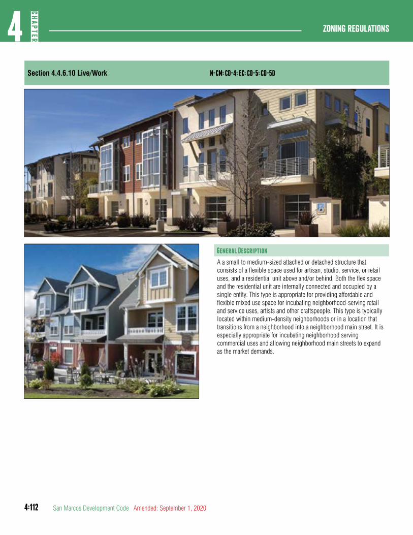
4:112
Zoning regulations4
CHAP
TER
San Marcos Development Code Amended: September 1, 2020
Section 4.4.6.10 Live/Work N-CM; CD-4; EC; CD-5; CD-5D
General Description
A a small to medium-sized attached or detached structure that consists of a flexible space used for artisan, studio, service, or retail uses, and a residential unit above and/or behind. Both the flex space and the residential unit are internally connected and occupied by a single entity. This type is appropriate for providing affordable and flexible mixed use space for incubating neighborhood-serving retail and service uses, artists and other craftspeople. This type is typically located within medium-density neighborhoods or in a location that transitions from a neighborhood into a neighborhood main street. It isespecially appropriate for incubating neighborhood serving commercial uses and allowing neighborhood main streets to expand as the market demands.
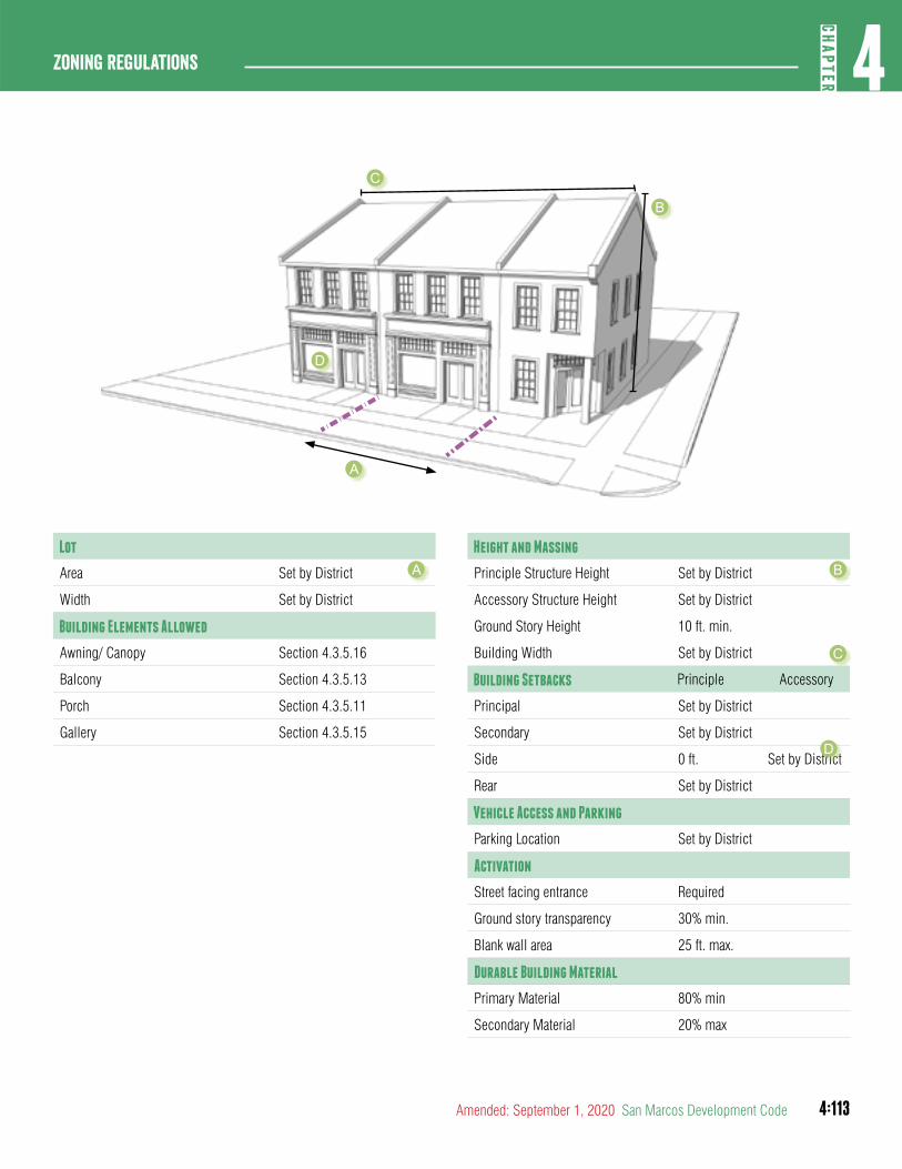
4:113
4CH
APTER
Zoning Regulations
Amended: September 1, 2020 San Marcos Development Code
Lot
Area Set by District
Width Set by District
Building Elements Allowed
Awning/ Canopy Section 4.3.5.16
Balcony Section 4.3.5.13
Porch Section 4.3.5.11
Gallery Section 4.3.5.15
Height and Massing
Principle Structure Height Set by District
Accessory Structure Height Set by District
Ground Story Height 10 ft. min.
Building Width Set by District
Building Setbacks Principle Accessory
Principal Set by District
Secondary Set by District
Side 0 ft. Set by District
Rear Set by District
Vehicle Access and Parking
Parking Location Set by District
Activation
Street facing entrance Required
Ground story transparency 30% min.
Blank wall area 25 ft. max.
Durable Building Material
Primary Material 80% min
Secondary Material 20% max
A B
C
D
A
B
C
D
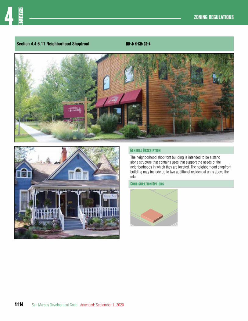
4:114
Zoning regulations4
CHAP
TER
San Marcos Development Code Amended: September 1, 2020
Section 4.4.6.11 Neighborhood Shopfront ND-4; N-CM; CD-4
General Description
The neighborhood shopfront building is intended to be a stand alone structure that contains uses that support the needs of the neighborhoods in which they are located. The neighborhood shopfront building may include up to two additional residential units above the retail.
Configuration Options
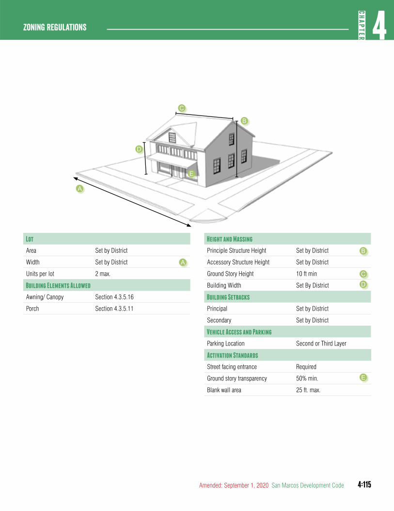
4:115
4CH
APTER
Zoning Regulations
Amended: September 1, 2020 San Marcos Development Code
Lot
Area Set by District
Width Set by District
Units per lot 2 max.
Building Elements Allowed
Awning/ Canopy Section 4.3.5.16
Porch Section 4.3.5.11
Height and Massing
Principle Structure Height Set by District
Accessory Structure Height Set by District
Ground Story Height 10 ft min
Building Width Set By District
Building Setbacks
Principal Set by District
Secondary Set by District
Vehicle Access and Parking
Parking Location Second or Third Layer
Activation Standards
Street facing entrance Required
Ground story transparency 50% min.
Blank wall area 25 ft. max.
A
B
C
D
E
A
B
C
D
E
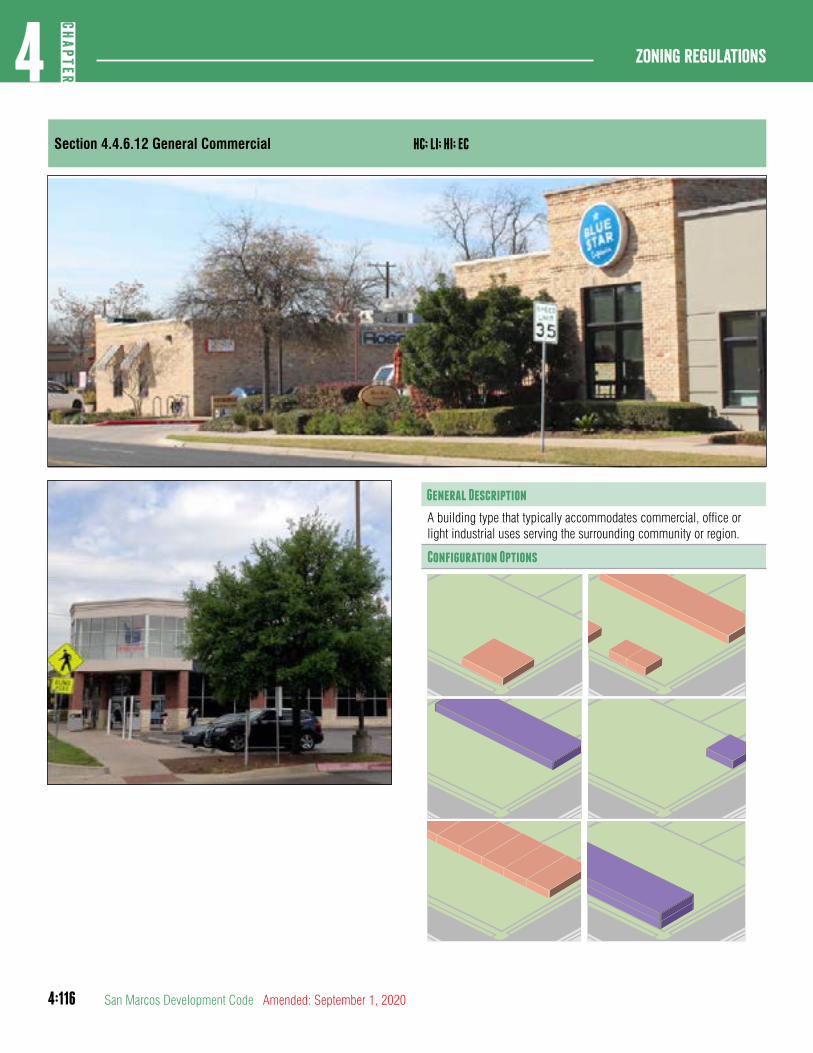
4:116
Zoning regulations4
CHAP
TER
San Marcos Development Code Amended: September 1, 2020
Section 4.4.6.12 General Commercial HC; LI; HI; EC
General Description
A building type that typically accommodates commercial, office or light industrial uses serving the surrounding community or region.
Configuration Options
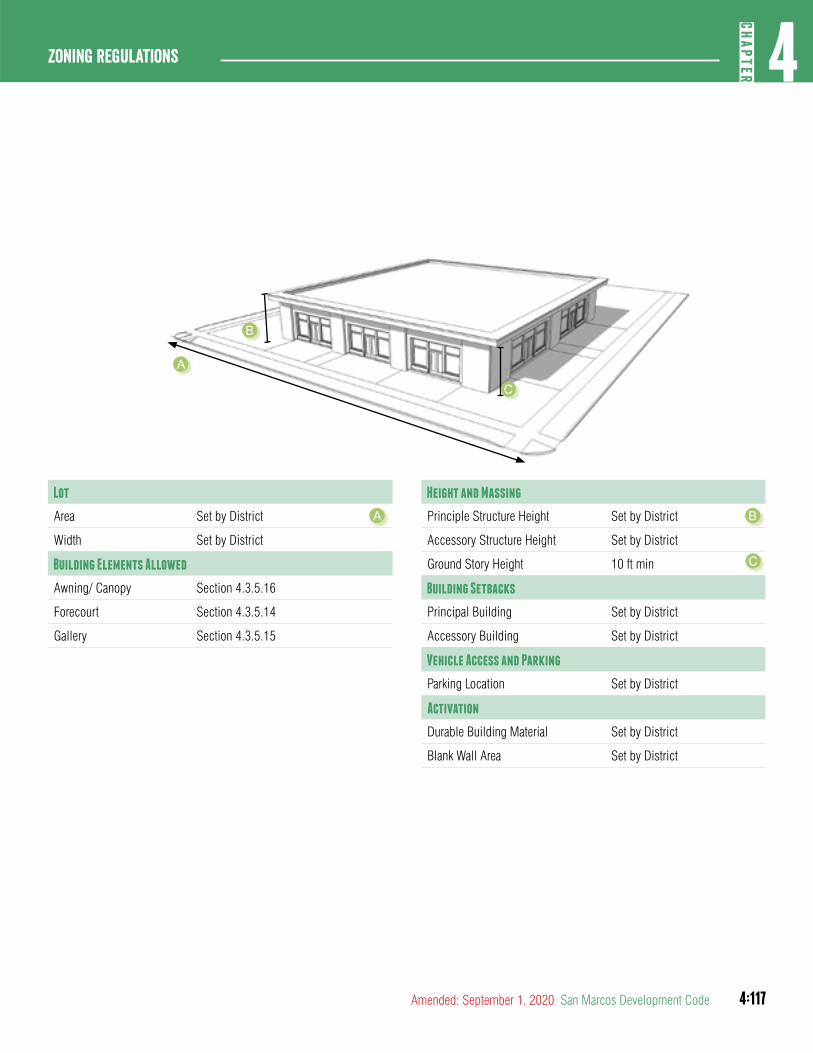
4:117
4CH
APTER
Zoning Regulations
Amended: September 1, 2020 San Marcos Development Code
Lot
Area Set by District
Width Set by District
Building Elements Allowed
Awning/ Canopy Section 4.3.5.16
Forecourt Section 4.3.5.14
Gallery Section 4.3.5.15
Height and Massing
Principle Structure Height Set by District
Accessory Structure Height Set by District
Ground Story Height 10 ft min
Building Setbacks
Principal Building Set by District
Accessory Building Set by District
Vehicle Access and Parking
Parking Location Set by District
Activation
Durable Building Material Set by District
Blank Wall Area Set by District
A B
C
A
B
C
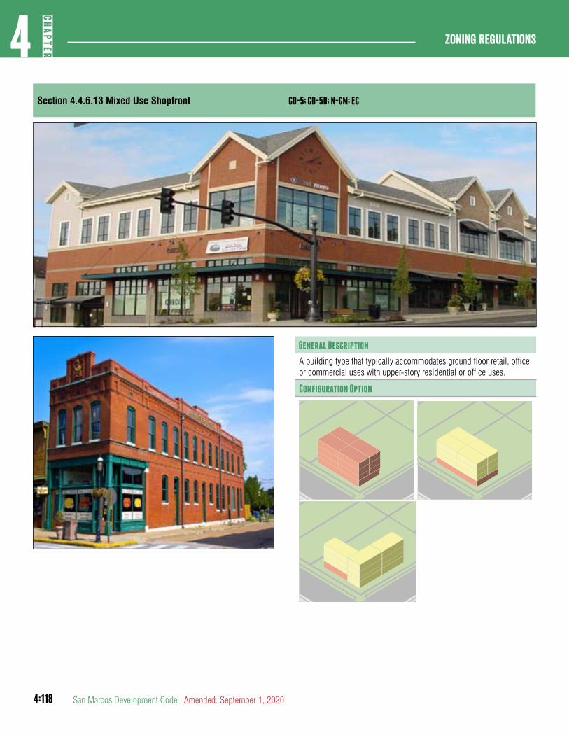
4:118
Zoning regulations4
CHAP
TER
San Marcos Development Code Amended: September 1, 2020
Section 4.4.6.13 Mixed Use Shopfront CD-5; CD-5D; N-CM; EC
General Description
A building type that typically accommodates ground floor retail, office or commercial uses with upper-story residential or office uses.
Configuration Option
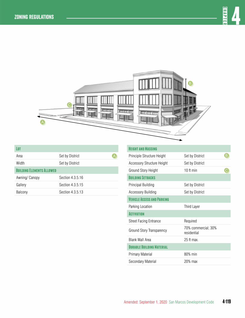
4:119
4CH
APTER
Zoning Regulations
Amended: September 1, 2020 San Marcos Development Code
Lot
Area Set by District
Width Set by District
Building Elements Allowed
Awning/ Canopy Section 4.3.5.16
Gallery Section 4.3.5.15
Balcony Section 4.3.5.13
Height and Massing
Principle Structure Height Set by District
Accessory Structure Height Set by District
Ground Story Height 10 ft min
Building Setbacks
Principal Building Set by District
Accessory Building Set by District
Vehicle Access and Parking
Parking Location Third Layer
Activation
Street Facing Entrance Required
Ground Story Transparency70% commercial; 30% residential
Blank Wall Area 25 ft max.
Durable Building Material
Primary Material 80% min
Secondary Material 20% max
A B
A
B
C
C
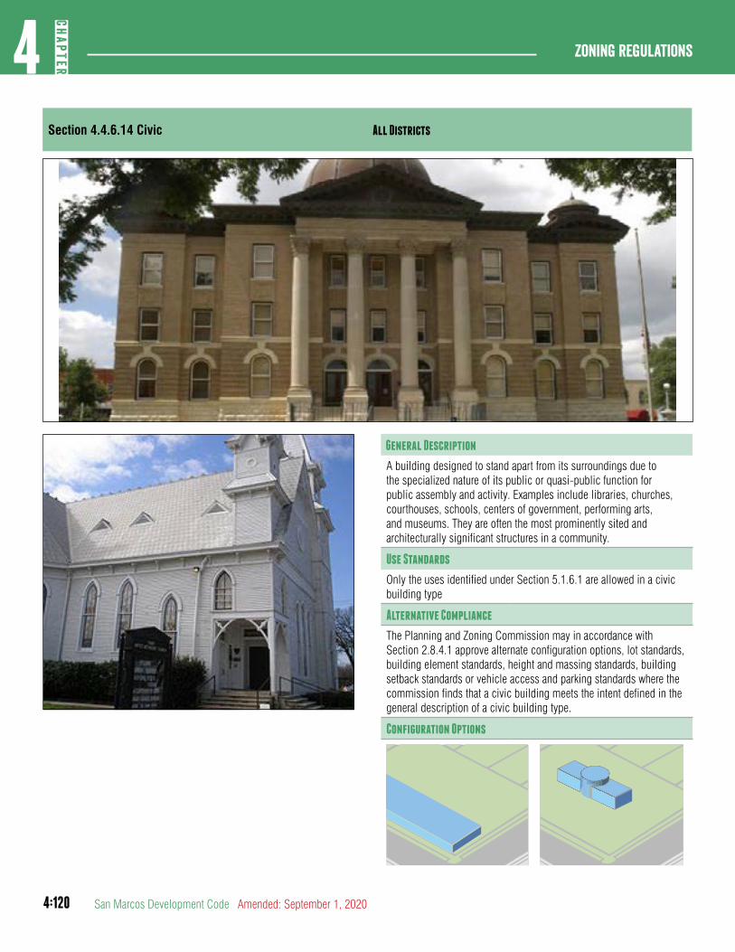
4:120
Zoning regulations4
CHAP
TER
San Marcos Development Code Amended: September 1, 2020
Section 4.4.6.14 Civic All Districts
General Description
A building designed to stand apart from its surroundings due to the specialized nature of its public or quasi-public function for public assembly and activity. Examples include libraries, churches, courthouses, schools, centers of government, performing arts, and museums. They are often the most prominently sited and architecturally significant structures in a community.
Use Standards
Only the uses identified under Section 5.1.6.1 are allowed in a civic building type
Alternative Compliance
The Planning and Zoning Commission may in accordance with Section 2.8.4.1 approve alternate configuration options, lot standards, building element standards, height and massing standards, building setback standards or vehicle access and parking standards where the commission finds that a civic building meets the intent defined in the general description of a civic building type.
Configuration Options
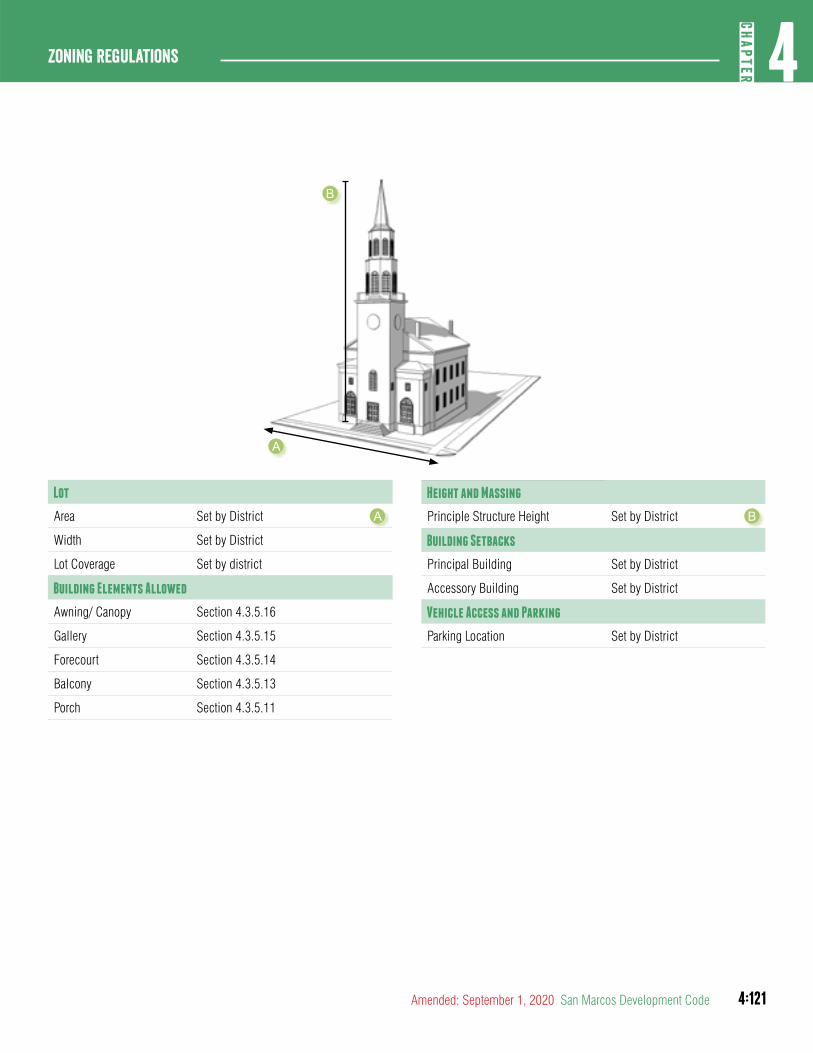
4:121
4CH
APTER
Zoning Regulations
Amended: September 1, 2020 San Marcos Development Code
Lot
Area Set by District
Width Set by District
Lot Coverage Set by district
Building Elements Allowed
Awning/ Canopy Section 4.3.5.16
Gallery Section 4.3.5.15
Forecourt Section 4.3.5.14
Balcony Section 4.3.5.13
Porch Section 4.3.5.11
Height and Massing
Principle Structure Height Set by District
Building Setbacks
Principal Building Set by District
Accessory Building Set by District
Vehicle Access and Parking
Parking Location Set by District
A B
A
B
4:122
Zoning regulations4
CHAP
TER
San Marcos Development Code Amended: September 1, 2020
article 5: OVERLaY DISTRICTS
DIVISION 1: ESTABLISHMENT AND PURPOSE
Section 4.5.1.1Purpose
An Overlay District is a district which establishes regulations to combine with the regulations of an underlying Base District. The purposes of an Overlay District are to prohibit Uses otherwise allowed in the Base District, to establish additional or different conditions for such Uses, or to authorize special Uses, together with standards for such Uses, not otherwise allowed in the base district.
Section 4.5.1.2Establishment and Expansion of Overlay Districts.
Overlay districts shall be established by ordinance and processed in accordance with Section 2.5.2.2.
DIVISION 2: HISTORIC DISTRICTS
Section 4.5.2.1Historic District
A. Purpose. The purpose of HD, Historic District is to promote the educational, cultural and economic welfare of the public and of the City by preserving, conserving, and protecting Historic Structures, Streets and neighborhoods that serve as visible reminders of the history and cultural heritage of the City, the State and the United States. Furthermore, it is the purpose of HD, Historic District to strengthen the economy of the City by stabilizing and improving property values in historic areas and to encourage new Buildings and developments that shall be compatible with the existing historic Buildings and squares.
B. Historic Districts and Historic Landmarks.
1. The following local Historic Districts are established within the City limits:
a. The Belvin Street Historic District. (1974)
b. The San Antonio Street Historic District. (1982)
c. The Downtown Historic District. (1986)
d. The Dunbar Historic District. (2003)
e. The Burleson Street Historic District. (2005)
f. The Lindsey-Rogers Historic District. (2005)
g. The Hopkins Street Historic District. (2008)
2. The following local Historic landmarks are established within the City limits:
a. The Oaks Heights Live Oak Tree located in the 500 Block of Franklin Drive (1986)
b. The Charles S. Cock House located at 400 E. Hopkins Street (2004)
c. The Merriman Cabin located at 150 C. M. Allen Parkway (2004)
d. The Dunbar School located at 801 Endicott Street (2004)
e. The Old Fish Hatchery located at 204 C. M. Allen Parkway (2004)
f. The Commemorative Air Force Hangar located at 2249 Airport Drive (2007)
g. Graham Tower located at 1921 Airport Drive (2007)
h. Old African American Baptist Church at 219 West Martin Luther King Drive (2018)
3. Designation of local Historic Landmarks shall be in accordance with Section 2.5.2.2.
(Ord. No. 2019-45, 12-17-19)
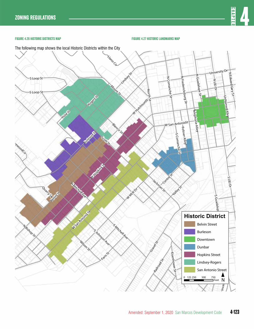
4:123
4CH
APTER
Zoning Regulations
Amended: September 1, 2020 San Marcos Development Code
Figure 4.26 historic Districts Map
The following map shows the local Historic Districts within the City
S Guadalupe St
University Dr
W San Anto
nio St
Valley St
Rogers St
Burleso
n St
Belvin St
Patton St
N Mitchell Ave
Scott St
S Johnson Ave
S LBJ Dr
WMLK Dr
Centre St
North St
N Bishop St
N LBJ D
r
W San AntonioSt
W H
opkins St
W
HutchisonSt
Grave
l St
N G
uadalupe St
Blanco St
Wilson St
Armstrong St
Moore St
Roosevelt St
Lindsey St
Feltner Alley
N Com
anche St
S Comanche St
S Mitchell Ave
N Fredericksburg St
Telephone Alley
Railr
oad
St
Jackman St
NEdw
ardGar y
StUnN
amed A
lley
Faris
St
Quarry St
Eisenhower St
S Loop St
S Loop St
Inva
sion
St
BracewoodCir
Llano Cir
Viola St
Historic DistrictBelvin Street
Burleson
Downtown
Dunbar
Hopkins Street
Lindsey-Rogers
San Antonio Street
N0 250 500 750125
Feet
Figure 4.27 historic Landmarks map
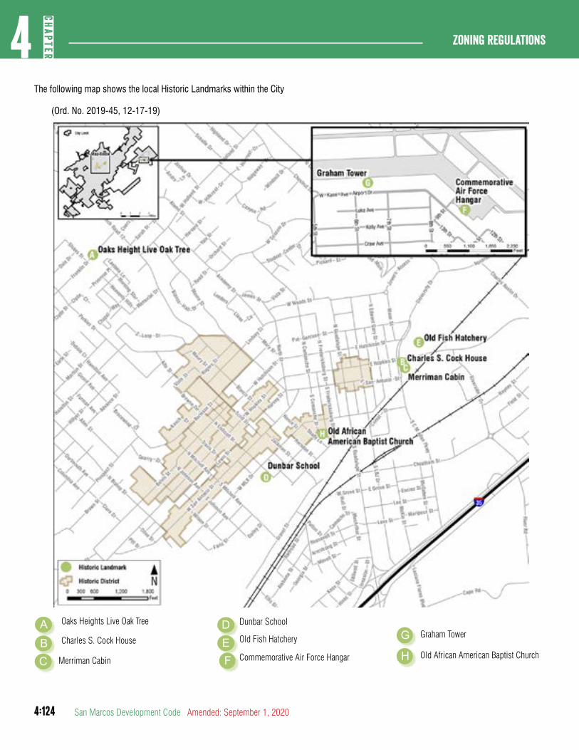
4:124
Zoning regulations4
CHAP
TER
San Marcos Development Code Amended: September 1, 2020
Dunbar School
G
F
Graham Tower
Commemorative Air Force Hangar H Old African American Baptist Church
The following map shows the local Historic Landmarks within the City
(Ord. No. 2019-45, 12-17-19)
AB
D
C
Oaks Heights Live Oak Tree
Charles S. Cock House
Merriman Cabin
E Old Fish Hatchery
4:125
4CH
APTER
Zoning Regulations
Amended: September 1, 2020 San Marcos Development Code
C. Authorized Uses. The permitted conditional and accessory uses authorized in the base district in Chapter 5 are authorized within the Historic District. Manufactured homes are not permitted in the Historic District.
D. Area, Building, and Height Requirements. The development standards as required in the base district shall apply unless modified as permitted in this Section.
E. Additional Requirements. See Chapter 6 (Environmental Regulations) and Chapter 7 (Supplemental Development Regulations) for additional requirements and standards.
F. Amendment of Regulations. The Historic Preservation Commission may from time to time recommend amendments to these regulations to the City Council as the Commission may deem necessary to effectuate the purposes of this district.
G. Investigations and Reports. The Historic Preservation Commission may make studies of matters relating to the protection, enhancement, perpetuation or use of local Historic Landmarks and Historic Districts and to the restoration of landmarks as the Commission may, from time to time, deem necessary or appropriate for the effectuation of the purposes of this district, and may submit reports and recommendations as to these matters to the City Council and other agencies of the City. In making these studies, the Commission may hold public hearings as it may deem necessary or appropriate.
H. Ordinary Maintenance Allowed.
1. Nothing in these district regulations shall be construed to prevent the ordinary maintenance or repair of any exterior feature in a local Historic District or of any local landmark that does not involve a change in design, material, or outer appearance other than color.
2. Nothing in these district regulations shall prevent the construction, reconstruction, alteration, restoration or demolition of any feature which the Building Inspector or similar official shall certify is required for the public safety because of an unsafe or dangerous condition.
I. Construction and Repair Standards.
1. New construction and existing buildings and structures and appurtenances thereof within local Historic Districts that are moved, reconstructed, materially altered or
repaired shall be visually compatible with other buildings to which they are visually related generally in terms of the following factors; provided, however, these guidelines shall apply only to those exterior portions of buildings and sites visible from adjacent public streets:
a. Height. The height of a proposed building shall be visually compatible with adjacent buildings.
b. Proportion of Building’s front Facade. The relationship of the width of a building to the height of the front elevation shall be visually compatible to the other buildings to which it is visually related.
c. Proportion of openings within the facility. The relationship of the width of the windows in a building shall be visually compatible with the other buildings to which it is visually related.
d. Rhythm of solids to voids in front Facades. The relationship of solids to voids in the front facade of a building shall be visually compatible with the other buildings to which it is visually related.
e. Rhythm of spacing of Buildings on Streets. The relationship of a building to the open area between it and adjoining buildings shall be visually compatible to the other buildings to which it is visually related.
f. Rhythm of entrance and/or porch projection. The relationship of entrances and porch projections to sidewalks of a building shall be visually compatible to the other buildings to which it is visually related.
g. Relationship of materials, texture and color. The relationship of the materials, and texture of the exterior of a building including its windows and doors, shall be visually compatible with the predominant materials used in the other buildings to which it is visually related.
h. Roof shapes. The roof shape of a building shall be visually compatible with the other buildings to which it is visually related.
4:126
Zoning regulations4
CHAP
TER
San Marcos Development Code Amended: September 1, 2020
i. Walls of continuity. Appurtenances of a building including walls, fences, and building facades shall, if necessary, form cohesive walls of enclosure along a street, to ensure visual compatibility of the building to the other buildings to which it is visually related.
j. Scale of a Building. The size of a building, the mass of a building in relation to open areas, the windows, door openings, porches and balconies shall be visually compatible with the other buildings to which it is visually related.
(Ord. No. 2019-45, 12-17-19)
2. The Historic Preservation Commission may use as general guidelines, in addition to the specific guidelines contained in this section, the Historic District Guidelines located in Appendix C of the San Marcos Design Manual, and the current Standards for Historic Preservation Projects issued by the United States Secretary of the Interior.
J. Painting of Buildings in the Downtown Historic District. Sealing or painting historically unpainted masonry creates performance issues with the material. The paint traps moisture, which compromises the face and structural integrity of the masonry. This can lead to failure of the wall. Painting of structures located in the Downtown Historic District shall be subject to the following:
1. Masonry shall be defined as Stone, Brick, Terra Cotta, Glazed Ceramic, Adobe, Mortar, Stucco, and Concrete;
2. An administrative certificate of appropriateness is required in accordance with Section 2.5.6.1;
3. This Section 4.5.2.1(J) and Section 2.5.6.1 shall apply to the painting of murals in the Downtown Historic District; and
4. All murals within the Downtown Historic District are subject to approval by the Arts Commission.
(Ord. No. 2019-45, 12-17-19)
K. Acquisition of Historic Easements. The City may acquire, by purchase, donation or condemnation, historic easements in any area within its jurisdiction wherever and to the extent that the City Council, upon the recommendation of the Historic Preservation Commission, determines that the acquisition shall
be in the public interest. For the purpose of this Section, the term “historic easement” means any easement, restriction, covenant or condition running with the land, designated to preserve, maintain or enhance all or part of the existing state of places of historic, architectural or cultural significance.
L. Alteration of Local Landmark. Alteration of a Historic Landmark shall be in accordance with Section 2.5.2.1.
M. Minimum Standards. No owner or person with an interest in real property designated as a Landmark or a property located within a District shall permit the property to fall into a serious state of disrepair so as to result in the significant deterioration of any exterior architectural feature which would, in the judgment of the Historic Preservation Commission, create a detrimental effect upon the historic character of the Landmark or District.
1. Examples of serious disrepair or significant deterioration include:
a. Deterioration of exterior walls, foundations, or other vertical support that causes leaning, sagging, splitting, listing, or buckling.
a. Deterioration of external chimneys that causes leaning, sagging, splitting, listing, or buckling.
b. Deterioration or crumbling of exterior plaster finishes, surfaces or mortars.
c. Ineffective waterproofing of exterior walls, roofs, and foundations, including broken windows or doors.
d. Defective protection or lack of weather protection for exterior wall and roof coverings, including lack of paint, or weathering due to lack of paint or other protective covering.
e. Rotting, holes, and other forms of material decay.
f. Deterioration of exterior stairs, porches, handrails, window and door frames, cornices, entablatures, wall facings, and architectural details that causes delamination, instability, loss of shape and form, or crumbling.
g. Deterioration that has a detrimental effect upon the special character of the district as a whole or the unique attributes and character of the contributing structure.
4:127
4CH
APTER
Zoning Regulations
Amended: September 1, 2020 San Marcos Development Code
h. Deterioration of any exterior feature so as to create or permit the creation of any hazardous or unsafe conditions to life, health, or other property.
N. Demolition by Neglect
1. Demolition by Neglect refers to the gradual deterioration of a property when routine or minimum maintenance is not performed. The Responsible Official and the Historic Preservation Commission shall work together in an effort to reduce Demolition by Neglect involving Landmarks or properties located within Districts within the city. A Demolition by Neglect citation as determined by the HPC may be issued against the owner of the property for failure to comply with the minimum maintenance standards by permitting the subject property to exhibit serious disrepair or significant deterioration as outlined in Section 4.4.7.1(M)(a).
2. Due to the time consuming nature of pursuing enforcement under this section, no more than one property will be under consideration during each of the following quarters (January- March, April-June, July-September, and October- December).
3. The procedure for citing a property for Demolition by Neglect shall follow Section.
a. Initial identification is made by visual inspection of the area by the Responsible Official or an HPC member or by referral from someone in the area. All referrals shall be made in writing and shall be submitted to the Responsible Official.
b. Once the initial identification is made, followed by a preliminary determination by the Responsible Official, the property owner shall be notified by US mail of the defects of the building and informed of various incentive programs that may be available for repair. The property owner shall have thirty (30) days in which to respond to the preliminary determination by submitting a stabilization proposal to Responsible Official. The stabilization proposal will be presented to the HPC at the next available meeting. If the Historic Preservation Commission approves the proposal, a Certificate of Appropriateness (if necessary) may be issued. The approval will detail the specific work
which is necessary to correct the Demolition by Neglect conditions, as well as a time period to begin and complete the work. The Responsible Official shall update the Historic Preservation Commission on the status of the property every thirty (30) days once work begins on the property.
c. If the property owner receives the letter regarding the preliminary determination, but fails to respond, a second notice shall be sent in the same manner as described above.
d. If the property owner fails to receive and/or respond to the letter regarding the preliminary determination after two (2) attempts, the matter returns to the Historic Preservation Commission for a citation hearing. The Responsible Official shall send a third notice via certified mail informing the owner of the hearing, the property is posted with a notice of the violation in accordance with the provisions of this Article, and a public hearing on the citation is scheduled.
e. At the public hearing the owner is invited to address the Historic Preservation Commission’s concerns and to show cause why a citation should not be issued. The Historic Preservation Commission may take action to approve any proposed work, defer the matter to give the owner more time either to correct the deficiencies or make a proposal for stabilization, or issue a citation to the owner of the property for failure to correct the Demolition by Neglect conditions.
f. If the owner is cited for the condition of Demolition by Neglect of the property, a stabilization proposal to the Responsible Official shall be submitted within fourteen (14) days of the decision. The property owner shall have, at the discretion of the Historic Preservation Commission, up to one (1) year to correct the defects. The Responsible Official shall update the Historic Preservation Commission on the status of the property every thirty (30) days once work begins on the property.
4:128
Zoning regulations4
CHAP
TER
San Marcos Development Code Amended: September 1, 2020
g. If the property owner does respond with a stabilization proposal, the matter is turned over to the City Attorney’s office for action in Municipal Court.
DIVISION 3: CORRIDOR OVERLAYS
Section 4.5.3.1Purpose
Corridor overlays are established in order to ensure a consistent pattern of development, scenic gateways, and efficient access management along major transportation corridors.
Section 4.5.3.2District Establishment
Corridor overlay districts shall be established as an overlay district by ordinance and processed in accordance with Section 2.5.2.1.
Section 4.5.3.3Highway Overlay District
A. Intent. The highway overlay district is intended to maintain the attractiveness of these corridors and arterials enhancing the economic value of the community by encouraging tourism and trade.
B. Purpose. The highway overlay district is established for the purpose of protecting the public investment in and lengthening the time during which major access corridors and specified principal arterials can continue to serve their functions without expansion or relocation by expediting the free flow of traffic and reducing the hazards arising from unnecessary points of ingress and egress and cluttered roadside development.
C. Driveways. The following driveway standards are applicable within all highway overlay districts.
1. If on-site parking areas can be accessed from a multi-way streetscape type in Section 3.8.1.9, a cross access agreement, an improved alley, or secondary street, access from the adjacent tract, alley or secondary street is required and new curb cuts are not allowed.
2. Driveways must be spaced three hundred (300) feet apart centerline to centerline.
3. Nothing in this section shall prevent all site access to any property.
D. Allowed Frontage Types. Development within a highway corridor overlay district must be consistent with one of the
following frontage types. Where there is a conflict between the base dimensional standards and the frontage requirements, the frontage requirements control.
1. Parkway frontage
2. Green frontage
3. Multi-Way frontage
Section 4.5.3.4Conservation Corridor Overlay District
A. Intent. The conservation corridor overlay district is intended to preserve the sensitive environmental region and natural and scenic beauty along designated conservation corridors.
B. Purpose. The conservation corridor overlay district is established for the purpose of advancing mobility options and providing looped connections around the City while managing development in these areas.
C. Driveways.
1. No new driveways are permitted within a conservation corridor overlay district.
2. Nothing in this section shall prevent all site access to any property.
D. Allowed Frontage Types. Development within a conservation corridor overlay district must be consistent with one of the following frontage types. Where there is a conflict between the base dimensional standards and the frontage requirements, the frontage requirements control.
1. Conservation frontage
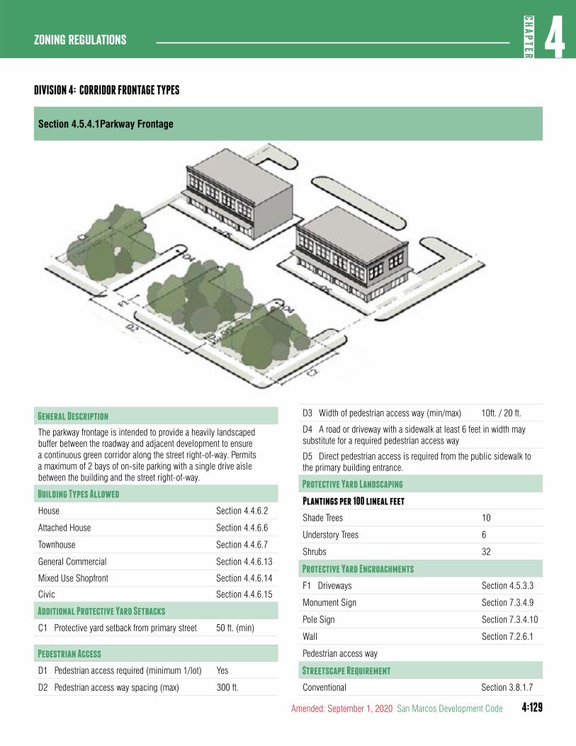
4:129
4CH
APTER
Zoning Regulations
Amended: September 1, 2020 San Marcos Development Code
DIVISION 4: CORRIDOR FRONTAGE TYPES
Section 4.5.4.1Parkway Frontage
General Description
The parkway frontage is intended to provide a heavily landscaped buffer between the roadway and adjacent development to ensure a continuous green corridor along the street right-of-way. Permits a maximum of 2 bays of on-site parking with a single drive aisle between the building and the street right-of-way.
Building Types Allowed
House Section 4.4.6.2
Attached House Section 4.4.6.6
Townhouse Section 4.4.6.7
General Commercial Section 4.4.6.13
Mixed Use Shopfront Section 4.4.6.14
Civic Section 4.4.6.15
Additional Protective Yard Setbacks
C1 Protective yard setback from primary street 50 ft. (min)
Pedestrian Access
D1 Pedestrian access required (minimum 1/lot) Yes
D2 Pedestrian access way spacing (max) 300 ft.
D3 Width of pedestrian access way (min/max) 10ft. / 20 ft.
D4 A road or driveway with a sidewalk at least 6 feet in width may substitute for a required pedestrian access way
D5 Direct pedestrian access is required from the public sidewalk to the primary building entrance.
Protective Yard Landscaping
Plantings per 100 lineal feet
Shade Trees 10
Understory Trees 6
Shrubs 32
Protective Yard Encroachments
F1 Driveways Section 4.5.3.3
Monument Sign Section 7.3.4.9
Pole Sign Section 7.3.4.10
Wall Section 7.2.6.1
Pedestrian access way
Streetscape Requirement
Conventional Section 3.8.1.7
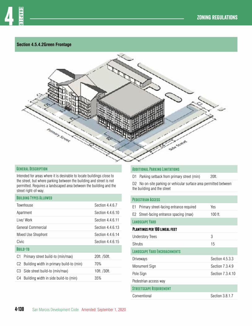
4:130
Zoning regulations4
CHAP
TER
San Marcos Development Code Amended: September 1, 2020
Section 4.5.4.2Green Frontage
Additional Parking Limitations
D1 Parking setback from primary street (min) 20ft.
D2 No on-site parking or vehicular surface area permitted between the building and the street
Pedestrian Access
E1 Primary street-facing entrance required Yes
E2 Street-facing entrance spacing (max) 100 ft.
Landscape Yard
Plantings per 100 lineal feet
Understory Trees 3
Shrubs 15
Landscape Yard Encroachments
Driveways Section 4.5.3.3
Monument Sign Section 7.3.4.9
Pole Sign Section 7.3.4.10
Pedestrian access way
Streetscape Requirement
Conventional Section 3.8.1.7
General Description
Intended for areas where it is desirable to locate buildings close to the street, but where parking between the building and street is not permitted. Requires a landscaped area between the building and the street right-of-way.
Building Types Allowed
Townhouse Section 4.4.6.7
Apartment Section 4.4.6.10
Live/ Work Section 4.4.6.11
General Commercial Section 4.4.6.13
Mixed Use Shopfront Section 4.4.6.14
Civic Section 4.4.6.15
Build-to
C1 Primary street build-to (min/max) 20ft. /50ft.
C2 Building width in primary build-to (min) 70%
C3 Side street build-to (min/max) 10ft. /30ft.
C4 Building width in side build-to (min) 35%
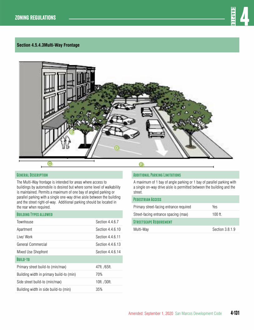
4:131
4CH
APTER
Zoning Regulations
Amended: September 1, 2020 San Marcos Development Code
Section 4.5.4.3Multi-Way Frontage
General Description
The Multi-Way frontage is intended for areas where access to buildings by automobile is desired but where some level of walkability is maintained. Permits a maximum of one bay of angled parking or parallel parking with a single one-way drive aisle between the building and the street right-of-way. Additional parking should be located in the rear when required.
Building Types allowed
Townhouse Section 4.4.6.7
Apartment Section 4.4.6.10
Live/ Work Section 4.4.6.11
General Commercial Section 4.4.6.13
Mixed Use Shopfront Section 4.4.6.14
Build-to
Primary street build-to (min/max) 47ft. /65ft.
Building width in primary build-to (min) 70%
Side street build-to (min/max) 10ft. /30ft.
Building width in side build-to (min) 35%
Additional Parking Limitations
A maximum of 1 bay of angle parking or 1 bay of parallel parking with a single on-way drive aisle is permitted between the building and the street.
Pedestrian Access
Primary street-facing entrance required Yes
Street-facing entrance spacing (max) 100 ft.
Streetscape Requirement
Multi-Way Section 3.8.1.9
C
D
E
F
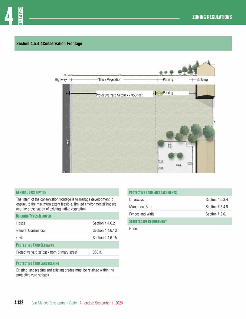
4:132
Zoning regulations4
CHAP
TER
San Marcos Development Code Amended: September 1, 2020
Section 4.5.4.4Conservation Frontage
General Description
The intent of the conservation frontage is to manage development to ensure, to the maximum extent feasible, limited environmental impact and the preservation of existing native vegetation.
Building Types Allowed
House Section 4.4.6.2
General Commercial Section 4.4.6.13
Civic Section 4.4.6.15
Protective Yard Setbacks
Protective yard setback from primary street 350 ft.
Protective Yard Landscaping
Existing landscaping and existing grades must be retained within the protective yard setback
Protective Yard Encroachments
Driveways Section 4.5.3.4
Monument Sign Section 7.3.4.9
Fences and Walls Section 7.2.6.1
Streetscape Requirement
None
Protective Yard Setback - 350 feet
Highway Native Vegetation Parking Building
ParkingC
5:1
5CH
APTER
Use Regulations
Amended: September 1, 2020 San Marcos Development Code
ChaPTER 5. USE REGULaTIONS
article 1: allowable Uses .............................................5:2DIVISION 1: INTERPRETIVE RULES AND LAND USE MATRIX 5:2
DIVISION 2: AGRICULTURAL USES 5:8
DIVISION 3: ACCESSORY AND TEMPORARY STRUCTURES AND USES 5:9
DIVISION 4: RESIDENTIAL USES 5:14
DIVISION 5: COMMERCIAL 5:18
DIVISION 6: PUBLIC AND INSTITUTIONAL USES 5:26
DIVISION 7: INDUSTRIAL USES 5:28
DIVISION 8: UNDERGROUND UTILITIES 5:28
5:2
Use Regulations5
CHAP
TER
San Marcos Development Code Amended: September 1, 2020
9. Industrial/Manufacturing and Construction.
D. Classification of New/Unlisted Uses. It is recognized that new types of land use shall arise in the future, and forms of land use not presently anticipated may seek to locate in the City. In order to provide for such changes and contingencies, a determination as to the appropriate classification and category of any new or unlisted form of land use not in Section 5.1.1.2 shall be made as follows.
1. A person, city department, the Planning and Zoning Commission, or the City Council may propose zoning amendments to regulate new and previously unlisted uses.
2. A person requesting the addition of a new or unlisted use shall submit to the Responsible Official, or his/her designee, all information necessary for the classification of the use, including but not limited to:
a. The nature of the use and whether the use involves dwelling activity, sales, services, or processing;
b. The type of product sold or produced under the use;
c. Whether the use has enclosed or open storage and the amount and nature of the storage;
d. Anticipated employment typically anticipated with the use;
e. Transportation requirements, including approximate mileage, turning radius, or driving time of the expected client or patron base;
f. The nature and type of occupancy and operation of the premises;
g. The off-street parking and loading requirements;
h. The amount of noise, odor, fumes, dust, toxic materials and vibration likely to be generated;
i. The requirements for public utilities such as water and wastewater and any special public services that may be required; and
j. Impervious surface coverage or anticipated size of building.
article 1: allowable Uses
DIVISION 1: INTERPRETIVE RULES AND LAND USE MATRIX
Section 5.1.1.1Interpretive Rules
A. Use of Land and/or Buildings. The use of land and/or buildings shall be in accordance with those listed in Section 5.1.1.2. No land or building shall hereafter be used and no building or structure shall be erected, altered, or converted other than for those uses specified in the zoning district in which it is located or for activities consistent with the nonconforming provisions of Section 1.5.1.1.
B. Key to Use Table. The key for determining uses in the Land Use Matrix is:
1. Permitted Use (P). Designates uses permitted by right in the district indicated.
2. Limited Use (L). Designates uses allowed by right that must meet use standards associated with the specific use (see right hand column for definitions/ use standards)
3. Conditional (C). Designates uses that may be permitted in the district by a conditional use permit under Section 2.8.3.1.
4. Uses Not Permitted (--). Indicates that a use is not permitted.
C. Use Chart Organization. The following use categories are listed in Section 5.1.1.2:
1. Agricultural.
2. Residential.
3. Office or Service Type.
4. Retail and Service.
5. Transportation and Auto Service.
6. Amusement and Recreational Service.
7. Institutional/Governmental.
8. Commercial and Wholesale Trade.
5:3
5CH
APTER
Use Regulations
Amended: September 1, 2020 San Marcos Development Code
3. A new and unlisted use may be interpreted by the Responsible Official as similar to a listed use if the unlisted use possesses the majority of characteristics of the listed use. Otherwise the unlisted use must be submitted to the Planning and Zoning Commission and City Council as outlined below. If the unlisted use is deemed similar to a listed use by the Responsible Official, no amendment of Section 5.1.1.2 is required.
4. When determining whether a proposed use is similar to a listed use, the Responsible Official will consider the following criteria:
a. The actual or projected characteristics of the proposed use;
b. The relative amount of site area or floor area and equipment devoted to the proposed use;
c. Relative amounts of sales;
d. The customer type;
e. The relative number of employees;
f. Hours of operation;
g. Building and site arrangement;
h. Types of vehicles used and their parking requirements;
i. The number of vehicle trips generated;
j. Signs;
k. How the proposed use is advertised;
l. The likely impact on surrounding properties; and
m. Whether the activity is likely to be found independent of the other activities on the site.
5. When a new and unlisted use cannot be interpreted by the Responsible Official as similar to an existing use, or a determination of the appropriate district cannot be readily ascertained by the Responsible Official, the following process shall be utilized.
a. The Responsible Official shall refer the question concerning any new or unlisted use to the Planning and Zoning Commission requesting a recommendation as to the zoning classification into which the use should be placed. The referral shall be accompanied by the statement of facts in Sec. 5.1.1.1D
b. The Planning and Zoning Commission shall consider the nature and described performance of the use and its compatibility with the uses permitted in the various districts, and determine the district or districts within which the use is most similar, and should be permitted and if such use shall be permitted by right or by conditional use permit.
c. The Planning and Zoning Commission shall transmit its findings and recommendations to the City Council as to the classification and category proposed for any new or unlisted use. If such recommendation is in response to an appeal, the Commission’s recommendation shall be final.
d. The City Council shall approve or disapprove the recommendation of the Planning and Zoning Commission or make such determination concerning the classification of such use as is determined appropriate based upon its findings. If approved, the new or unlisted use shall be amended in Section 5.1.1.2 according to procedures outlined in Section 2.4.1.1.
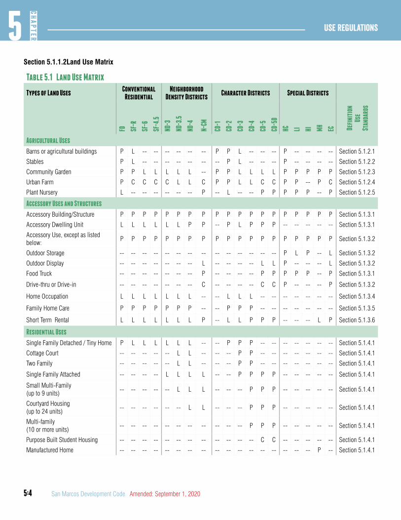
5:4
Use Regulations5
CHAP
TER
San Marcos Development Code Amended: September 1, 2020
Section 5.1.1.2Land Use Matrix
Table 5.1 Land Use Matrix
Types of Land UsesConventional
ResidentialNeighborhood
Density DistrictsCharacter Districts Special Districts
FD SF
-R
SF-6
SF-4
.5
ND-3
ND-3
.5
ND-4
N-CM
CD-1
CD-2
CD-3
CD-4
CD-5
CD-5
D
HC LI HI MH
EC Defi
niti
onUs
e St
anda
rds
Agricultural Uses
Barns or agricultural buildings P L -- -- -- -- -- -- P P L -- -- -- P -- -- -- -- Section 5.1.2.1
Stables P L -- -- -- -- -- -- -- P L -- -- -- P -- -- -- -- Section 5.1.2.2
Community Garden P P L L L L L -- P P L L L L P P P P P Section 5.1.2.3
Urban Farm P C C C C L L C P P L L C C P P -- P C Section 5.1.2.4
Plant Nursery L -- -- -- -- -- -- P -- L -- -- P P P P P -- P Section 5.1.2.5
Accessory Uses and Structures
Accessory Building/Structure P P P P P P P P P P P P P P P P P P P Section 5.1.3.1
Accessory Dwelling Unit L L L L L L P P -- P L P P P -- -- -- -- -- Section 5.1.3.1
Accessory Use, except as listed below:
P P P P P P P P P P P P P P P P P P P Section 5.1.3.2
Outdoor Storage -- -- -- -- -- -- -- -- -- -- -- -- -- -- P L P -- L Section 5.1.3.2
Outdoor Display -- -- -- -- -- -- -- L -- -- -- -- L L P -- -- -- L Section 5.1.3.2
Food Truck -- -- -- -- -- -- -- P -- -- -- -- P P P P P -- P Section 5.1.3.1
Drive-thru or Drive-in -- -- -- -- -- -- -- C -- -- -- -- C C P -- -- -- P Section 5.1.3.2
Home Occupation L L L L L L L -- -- L L L -- -- -- -- -- -- -- Section 5.1.3.4
Family Home Care P P P P P P P -- -- P P P -- -- -- -- -- -- -- Section 5.1.3.5
Short Term Rental L L L L L L L P -- L L P P P -- -- -- L P Section 5.1.3.6
Residential Uses
Single Family Detached / Tiny Home P L L L L L L -- -- P P P -- -- -- -- -- -- -- Section 5.1.4.1
Cottage Court -- -- -- -- -- L L -- -- -- P P -- -- -- -- -- -- -- Section 5.1.4.1
Two Family -- -- -- -- -- L L -- -- -- P P -- -- -- -- -- -- -- Section 5.1.4.1
Single Family Attached -- -- -- -- L L L L -- -- P P P P -- -- -- -- -- Section 5.1.4.1
Small Multi-Family(up to 9 units)
-- -- -- -- -- L L L -- -- -- P P P -- -- -- -- -- Section 5.1.4.1
Courtyard Housing(up to 24 units)
-- -- -- -- -- -- L L -- -- -- P P P -- -- -- -- -- Section 5.1.4.1
Multi-family(10 or more units)
-- -- -- -- -- -- -- -- -- -- -- P P P -- -- -- -- -- Section 5.1.4.1
Purpose Built Student Housing -- -- -- -- -- -- -- -- -- -- -- -- C C -- -- -- -- -- Section 5.1.4.1
Manufactured Home -- -- -- -- -- -- -- -- -- -- -- -- -- -- -- -- -- P -- Section 5.1.4.1
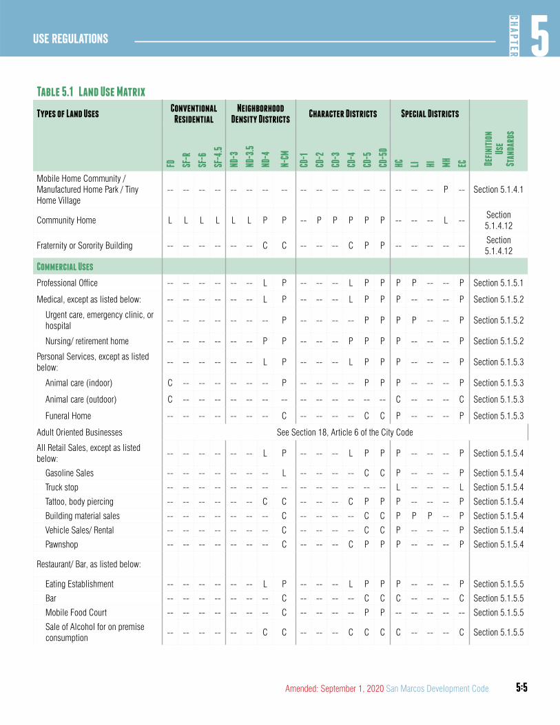
5:5
5CH
APTER
Use Regulations
Amended: September 1, 2020 San Marcos Development Code
Table 5.1 Land Use Matrix
Types of Land UsesConventional
ResidentialNeighborhood
Density DistrictsCharacter Districts Special Districts
FD SF-R
SF-6
SF-4
.5
ND-3
ND-3
.5
ND-4
N-CM
CD-1
CD-2
CD-3
CD-4
CD-5
CD-5
D
HC LI HI MH
EC Defi
niti
onUs
e St
anda
rds
Mobile Home Community / Manufactured Home Park / Tiny Home Village
-- -- -- -- -- -- -- -- -- -- -- -- -- -- -- -- -- P -- Section 5.1.4.1
Community Home L L L L L L P P -- P P P P P -- -- -- L --Section 5.1.4.12
Fraternity or Sorority Building -- -- -- -- -- -- C C -- -- -- C P P -- -- -- -- --Section 5.1.4.12
Commercial Uses
Professional Office -- -- -- -- -- -- L P -- -- -- L P P P P -- -- P Section 5.1.5.1
Medical, except as listed below: -- -- -- -- -- -- L P -- -- -- L P P P -- -- -- P Section 5.1.5.2
Urgent care, emergency clinic, or hospital
-- -- -- -- -- -- -- P -- -- -- -- P P P P -- -- P Section 5.1.5.2
Nursing/ retirement home -- -- -- -- -- -- P P -- -- -- P P P P -- -- -- P Section 5.1.5.2
Personal Services, except as listed below:
-- -- -- -- -- -- L P -- -- -- L P P P -- -- -- P Section 5.1.5.3
Animal care (indoor) C -- -- -- -- -- -- P -- -- -- -- P P P -- -- -- P Section 5.1.5.3
Animal care (outdoor) C -- -- -- -- -- -- -- -- -- -- -- -- -- C -- -- -- C Section 5.1.5.3
Funeral Home -- -- -- -- -- -- -- C -- -- -- -- C C P -- -- -- P Section 5.1.5.3
Adult Oriented Businesses See Section 18, Article 6 of the City Code
All Retail Sales, except as listed below:
-- -- -- -- -- -- L P -- -- -- L P P P -- -- -- P Section 5.1.5.4
Gasoline Sales -- -- -- -- -- -- -- L -- -- -- -- C C P -- -- -- P Section 5.1.5.4
Truck stop -- -- -- -- -- -- -- -- -- -- -- -- -- -- L -- -- -- L Section 5.1.5.4
Tattoo, body piercing -- -- -- -- -- -- C C -- -- -- C P P P -- -- -- P Section 5.1.5.4
Building material sales -- -- -- -- -- -- -- C -- -- -- -- C C P P P -- P Section 5.1.5.4
Vehicle Sales/ Rental -- -- -- -- -- -- -- C -- -- -- -- C C P -- -- -- P Section 5.1.5.4
Pawnshop -- -- -- -- -- -- -- C -- -- -- C P P P -- -- -- P Section 5.1.5.4
Restaurant/ Bar, as listed below:
Eating Establishment -- -- -- -- -- -- L P -- -- -- L P P P -- -- -- P Section 5.1.5.5
Bar -- -- -- -- -- -- -- C -- -- -- -- C C C -- -- -- C Section 5.1.5.5
Mobile Food Court -- -- -- -- -- -- -- C -- -- -- -- P P -- -- -- -- -- Section 5.1.5.5
Sale of Alcohol for on premise consumption
-- -- -- -- -- -- C C -- -- -- C C C C -- -- -- C Section 5.1.5.5
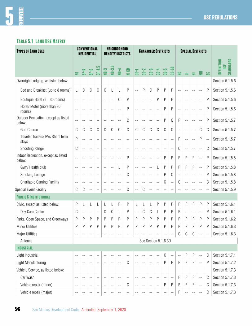
5:6
Use Regulations5
CHAP
TER
San Marcos Development Code Amended: September 1, 2020
Table 5.1 Land Use Matrix
Types of Land UsesConventional
ResidentialNeighborhood
Density DistrictsCharacter Districts Special Districts
FD SF-R
SF-6
SF-4
.5
ND-3
ND-3
.5
ND-4
N-CM
CD-1
CD-2
CD-3
CD-4
CD-5
CD-5
D
HC LI HI MH
EC Defi
niti
onUs
e St
anda
rds
Overnight Lodging, as listed below: Section 5.1.5.6
Bed and Breakfast (up to 8 rooms) L C C C C L L P -- P C P P P -- -- -- -- P Section 5.1.5.6
Boutique Hotel (9 - 30 rooms) -- -- -- -- -- -- C P -- -- -- P P P -- -- -- -- P Section 5.1.5.6
Hotel/ Motel (more than 30 rooms)
-- -- -- -- -- -- -- P -- -- -- -- P P -- -- -- -- P Section 5.1.5.6
Outdoor Recreation, except as listed below:
-- -- -- -- -- -- -- C -- -- -- -- P C P -- -- -- P Section 5.1.5.7
Golf Course C C C C C C C C C C C C C C -- -- -- C C Section 5.1.5.7
Traveler Trailers/ RVs Short Term stays
P -- -- -- -- -- -- -- -- -- -- -- -- -- P -- -- P -- Section 5.1.5.7
Shooting Range C -- -- -- -- -- -- -- -- -- -- -- -- -- C -- -- -- C Section 5.1.5.7
Indoor Recreation, except as listed below:
-- -- -- -- -- -- -- P -- -- -- -- P P P P P -- P Section 5.1.5.8
Gym/ Health club -- -- -- -- -- -- L P -- -- -- L P P P P P -- P Section 5.1.5.8
Smoking Lounge -- -- -- -- -- -- -- C -- -- -- -- P C -- -- -- -- P Section 5.1.5.8
Charitable Gaming Facility -- -- -- -- -- -- -- -- -- -- -- -- C -- C -- -- -- C Section 5.1.5.8
Special Event Facility C C -- -- -- -- -- C -- C -- -- -- -- -- -- -- -- -- Section 5.1.5.9
Public & Institutional
Civic, except as listed below: P L L L L L P P L L L P P P P P P P P Section 5.1.6.1
Day Care Center C -- -- -- C C L P -- C C L P P P -- -- -- P Section 5.1.6.1
Parks, Open Space, and Greenways P P P P P P P P P P P P P P P P P P P Section 5.1.6.2
Minor Utilities P P P P P P P P P P P P P P P P P P P Section 5.1.6.3
Major Utilities -- -- -- -- -- -- -- -- -- -- -- -- -- -- C C C -- -- Section 5.1.6.3
Antenna See Section 5.1.6.3D
Industrial
Light Industrial -- -- -- -- -- -- -- -- -- -- -- -- C -- -- P P -- C Section 5.1.7.1
Light Manufacturing -- -- -- -- -- -- -- C -- -- -- -- P P P P P -- P Section 5.1.7.2
Vehicle Service, as listed below: Section 5.1.7.3
Car Wash -- -- -- -- -- -- -- -- -- -- -- -- -- -- P P P -- C Section 5.1.7.3
Vehicle repair (minor) -- -- -- -- -- -- -- C -- -- -- -- P P P P P -- C Section 5.1.7.3
Vehicle repair (major) -- -- -- -- -- -- -- -- -- -- -- -- -- -- P -- -- -- C Section 5.1.7.3
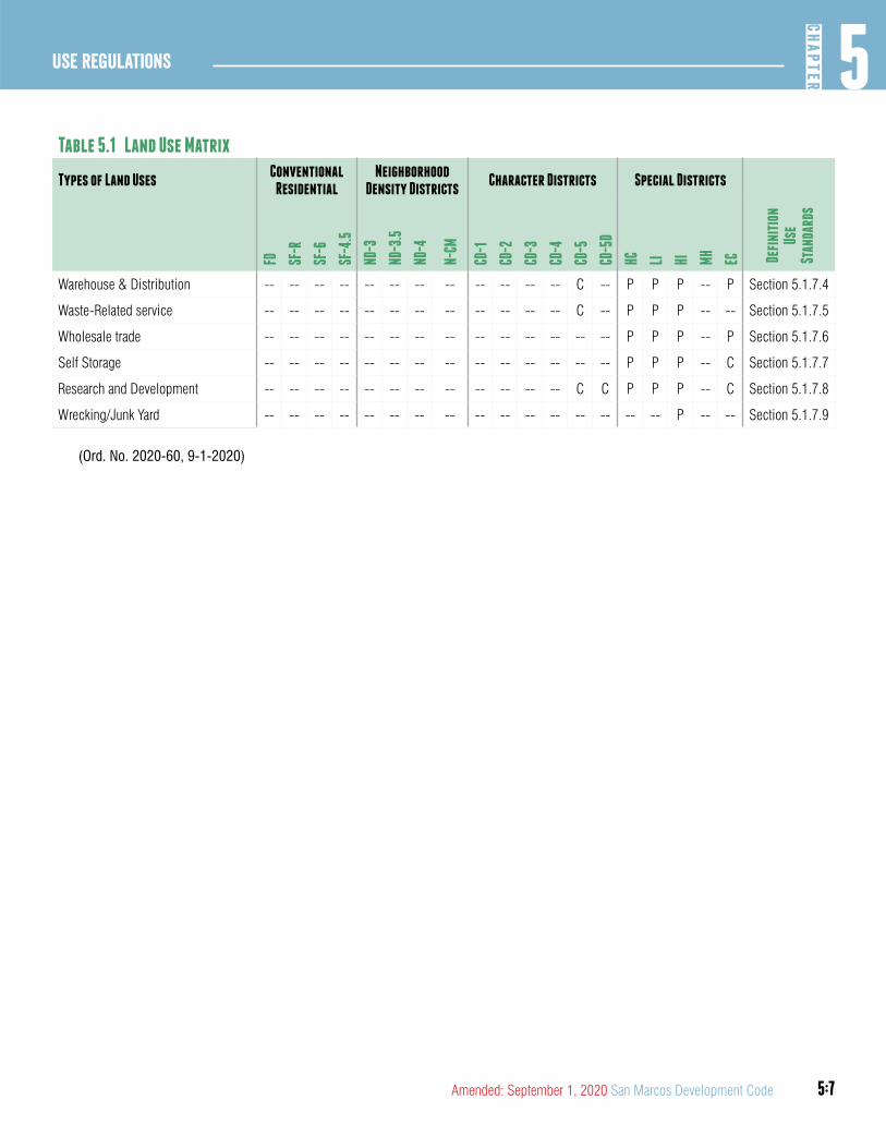
5:7
5CH
APTER
Use Regulations
Amended: September 1, 2020 San Marcos Development Code
Table 5.1 Land Use Matrix
Types of Land UsesConventional
ResidentialNeighborhood
Density DistrictsCharacter Districts Special Districts
FD SF-R
SF-6
SF-4
.5
ND-3
ND-3
.5
ND-4
N-CM
CD-1
CD-2
CD-3
CD-4
CD-5
CD-5
D
HC LI HI MH
EC Defi
niti
onUs
e St
anda
rds
Warehouse & Distribution -- -- -- -- -- -- -- -- -- -- -- -- C -- P P P -- P Section 5.1.7.4
Waste-Related service -- -- -- -- -- -- -- -- -- -- -- -- C -- P P P -- -- Section 5.1.7.5
Wholesale trade -- -- -- -- -- -- -- -- -- -- -- -- -- -- P P P -- P Section 5.1.7.6
Self Storage -- -- -- -- -- -- -- -- -- -- -- -- -- -- P P P -- C Section 5.1.7.7
Research and Development -- -- -- -- -- -- -- -- -- -- -- -- C C P P P -- C Section 5.1.7.8
Wrecking/Junk Yard -- -- -- -- -- -- -- -- -- -- -- -- -- -- -- -- P -- -- Section 5.1.7.9
(Ord. No. 2020-60, 9-1-2020)
5:8
Use Regulations5
CHAP
TER
San Marcos Development Code Amended: September 1, 2020
DIVISION 2: AGRICULTURAL USES
Section 5.1.2.1Barn or Agricultural Building
A. Defined. A structure intended for the purpose of storing farming or ranching related equipment or housing livestock and that is used by the owner, immediate family of the owner, and/or persons engaged in the pick-up or delivery of agricultural goods grown or raised on the premises. This definition shall not include a structure used as a dwelling.
B. Use Standards. Where a barn or agricultural building is allowed as a limited use, the structure shall be no more than 800 square feet in size, and shall conform to all applicable construction and design standards of the district in which it is constructed.
Section 5.1.2.2Stables
A. Defined. An area used for the purpose of keeping horses, mules or ponies
B. Use Standards. Where a stable is allowed as a limited use it may not be used for the rental of stall space or for the sale or rental of horses, mules or ponies; such a stable shall meet all provisions and requirements of the zoning district in which it is located.
Section 5.1.2.3Community Garden
A. Defined. Areas of land managed and maintained by a group of individuals to grow and harvest food crops and non-food ornamental crops, for personal or group use, consumption or donation. On-site sales may be permitted upon approval of a conditional use permit under Section 2.8.3.1. May be divided into separate plots for cultivation by one or more individuals or may be farmed collectively by members of the group, and may include common areas maintained and used by the group.
B. Use Standards. Where a community garden is allowed as a limited use, it is subject to the following:
1. A community garden must be primarily used for growing and harvesting food and ornamental crops for consumption or donation or for sale off-site;
2. Only mechanical equipment designed for household use may be used.
3. On-site sales may be permitted upon approval of a conditional use permit under Section 2.8.3.1. Sales are restricted to horticultural and agricultural products produced on the premises;
4. Detached accessory structures such as storage or utility buildings, gazebos, trellises, or greenhouses are permitted, subject to compliance with the requirements of the zoning district;
5. Where security fencing is installed, the fencing may exceed height requirements in Section 7.2.6.1 but must be of an open design and must be in compliance with any design requirements of the district; and
6. Where lighting is installed, only motion detecting fixtures are permitted. All-night lighting is prohibited.
Section 5.1.2.4Urban Farm
A. Defined. The raising and harvesting of crops, livestock and non-food ornamental crops for commercial use. An urban farm may be owned by an individual, group or organization and may include larger-scale farm equipment.
B. Use Standards. Where an urban farm is allowed as a conditional use, it may be permitted by the Planning and Zoning Commission subject to Section 2.8.3.1, and the standards below. Where an urban farm is allowed as a limited use, it is subject to the following:
1. Detached accessory structures such as storage or utility buildings, gazebos, trellises, or greenhouses are permitted, subject to compliance with the requirements of the zoning district;
2. On-site sales may be permitted upon approval of a conditional use permit under Section 2.8.3.1;
3. Where security fencing is installed, the fencing may exceed height requirements in Section 7.2.6.1 but must be of an open design and must be in compliance with the requirements of the district; and
4. Where lighting is installed, only motion detecting fixtures are permitted. All-night lighting is prohibited.
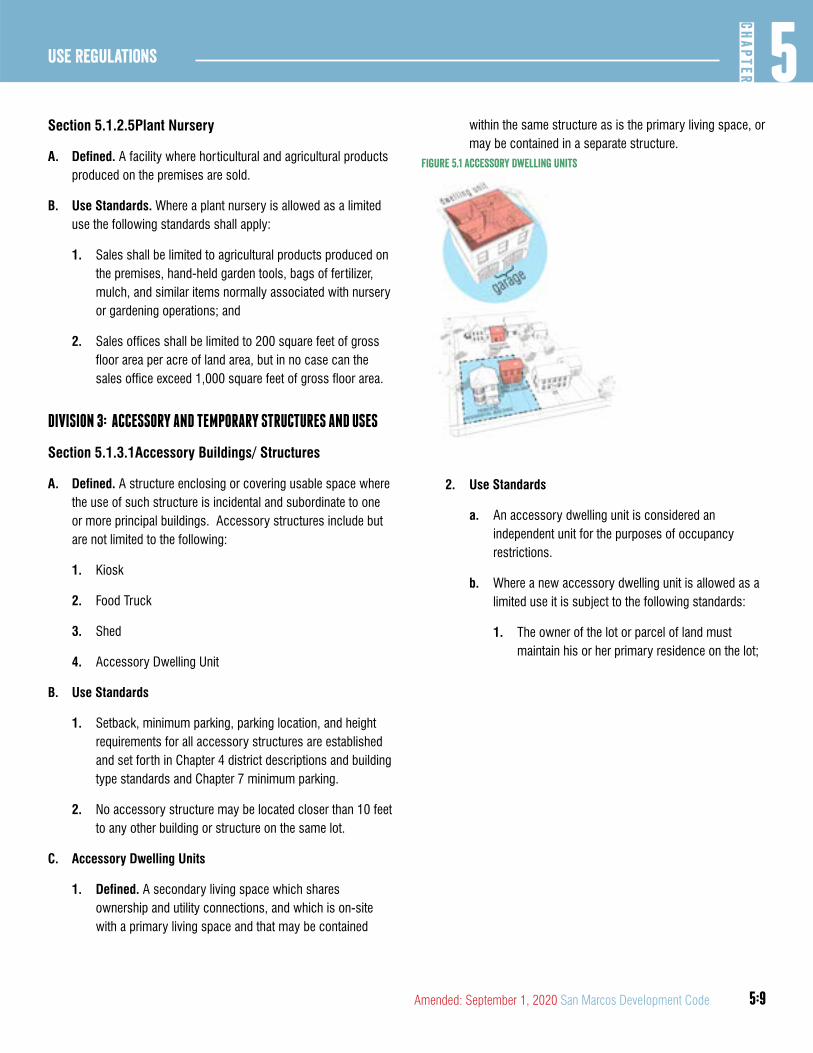
5:9
5CH
APTER
Use Regulations
Amended: September 1, 2020 San Marcos Development Code
Section 5.1.2.5Plant Nursery
A. Defined. A facility where horticultural and agricultural products produced on the premises are sold.
B. Use Standards. Where a plant nursery is allowed as a limited use the following standards shall apply:
1. Sales shall be limited to agricultural products produced on the premises, hand-held garden tools, bags of fertilizer, mulch, and similar items normally associated with nursery or gardening operations; and
2. Sales offices shall be limited to 200 square feet of gross floor area per acre of land area, but in no case can the sales office exceed 1,000 square feet of gross floor area.
DIVISION 3: ACCESSORY AND TEMPORARY STRUCTURES AND USES
Section 5.1.3.1Accessory Buildings/ Structures
A. Defined. A structure enclosing or covering usable space where the use of such structure is incidental and subordinate to one or more principal buildings. Accessory structures include but are not limited to the following:
1. Kiosk
2. Food Truck
3. Shed
4. Accessory Dwelling Unit
B. Use Standards
1. Setback, minimum parking, parking location, and height requirements for all accessory structures are established and set forth in Chapter 4 district descriptions and building type standards and Chapter 7 minimum parking.
2. No accessory structure may be located closer than 10 feet to any other building or structure on the same lot.
C. Accessory Dwelling Units
1. Defined. A secondary living space which shares ownership and utility connections, and which is on-site with a primary living space and that may be contained
within the same structure as is the primary living space, or may be contained in a separate structure.
Figure 5.1 accessory Dwelling Units
2. Use Standards
a. An accessory dwelling unit is considered an independent unit for the purposes of occupancy restrictions.
b. Where a new accessory dwelling unit is allowed as a limited use it is subject to the following standards:
1. The owner of the lot or parcel of land must maintain his or her primary residence on the lot;
5:10
Use Regulations5
CHAP
TER
San Marcos Development Code Amended: September 1, 2020
2. No more than one accessory dwelling unit may exist on a lot or parcel of land; and
3. The habitable area of the accessory dwelling unit must not exceed the lesser of 1000 square feet or one-half the number of square feet of habitable area of the principal dwelling on the lot or parcel of land.
Section 5.1.3.2Accessory Uses
A. Defined. A use that is customarily incidental, appropriate and subordinate to the principal use of land or building(s) and that is located upon the same lot therewith. Accessory uses are allowed, subject to compliance with all applicable standards and requirements of this development code. Accessory uses include but are not limited to the following:
1. Outdoor Storage.
2. Outdoor Display.
3. Drive-Thru.
4. Temporary Uses.
5. Home Occupations.
6. An accessory use not specifically listed is prohibited unless the Responsible Official determines the accessory use:
a. Is clearly incidental to and customarily found in connection with an allowed principal use;
b. Is subordinate to and serving an allowed principal use;
c. Is subordinate in area, extent and purpose to the principal use served;
d. Contributes to the comfort, convenience or needs of occupants, business or industry in the principal use served; and
e. Is located on the same lot as the principal use served.
B. Outdoor Storage
1. Defined. The keeping, displaying or storing, outside a building, of any goods, materials, merchandise or equipment on a lot or tract for more than 24 hours.
2. Use Standards.
a. All outdoor storage shall be located at least 15 feet from the public right-of-way;
b. All outdoor storage shall not be more than 12 feet in height; and
c. All outdoor storage adjacent to any district other than HI or HC shall be subject to a transitional protective yard C or D in compliance with Section 7.2.2.3.
3. Where outdoor storage is limited the following standards apply:
a. All outdoor storage shall be fully screened from view from the public right-of-way, public parking areas and abutting properties by a wall constructed in accordance with Section 7.2.6.1 or by the parking lot screening requirements as set forth in Section 7.1.4.4.
C. Outdoor Display
1. Defined. Outside temporary display of finished goods that are specifically intended for retail sale. Outdoor display as part of a properly permitted use does not apply to the outdoor sale, lease or rental of the following:
a. Motor vehicles.
b. Heavy equipment or other accessory structures.
c. Plants as part of a nursery.
2. Use Standards. Where outdoor display is a limited use the following standards apply:
a. Outdoor display must be removed and placed inside a fully-enclosed building at the end of each business day; and
b. Outdoor display may not impair the ability of pedestrians to use the sidewalk or parking areas.
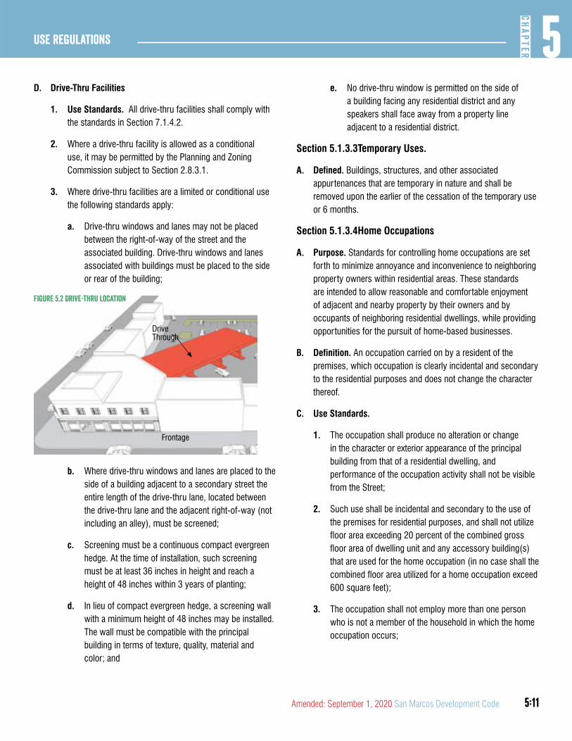
5:11
5CH
APTER
Use Regulations
Amended: September 1, 2020 San Marcos Development Code
D. Drive-Thru Facilities
1. Use Standards. All drive-thru facilities shall comply with the standards in Section 7.1.4.2.
2. Where a drive-thru facility is allowed as a conditional use, it may be permitted by the Planning and Zoning Commission subject to Section 2.8.3.1.
3. Where drive-thru facilities are a limited or conditional use the following standards apply:
a. Drive-thru windows and lanes may not be placed between the right-of-way of the street and the associated building. Drive-thru windows and lanes associated with buildings must be placed to the side or rear of the building;
Drive Through
Frontage
Figure 5.2 Drive-thru location
b. Where drive-thru windows and lanes are placed to the side of a building adjacent to a secondary street the entire length of the drive-thru lane, located between the drive-thru lane and the adjacent right-of-way (not including an alley), must be screened;
c. Screening must be a continuous compact evergreen hedge. At the time of installation, such screening must be at least 36 inches in height and reach a height of 48 inches within 3 years of planting;
d. In lieu of compact evergreen hedge, a screening wall with a minimum height of 48 inches may be installed. The wall must be compatible with the principal building in terms of texture, quality, material and color; and
e. No drive-thru window is permitted on the side of a building facing any residential district and any speakers shall face away from a property line adjacent to a residential district.
Section 5.1.3.3Temporary Uses.
A. Defined. Buildings, structures, and other associated appurtenances that are temporary in nature and shall be removed upon the earlier of the cessation of the temporary use or 6 months.
Section 5.1.3.4Home Occupations
A. Purpose. Standards for controlling home occupations are set forth to minimize annoyance and inconvenience to neighboring property owners within residential areas. These standards are intended to allow reasonable and comfortable enjoyment of adjacent and nearby property by their owners and by occupants of neighboring residential dwellings, while providing opportunities for the pursuit of home-based businesses.
B. Definition. An occupation carried on by a resident of the premises, which occupation is clearly incidental and secondary to the residential purposes and does not change the character thereof.
C. Use Standards.
1. The occupation shall produce no alteration or change in the character or exterior appearance of the principal building from that of a residential dwelling, and performance of the occupation activity shall not be visible from the Street;
2. Such use shall be incidental and secondary to the use of the premises for residential purposes, and shall not utilize floor area exceeding 20 percent of the combined gross floor area of dwelling unit and any accessory building(s) that are used for the home occupation (in no case shall the combined floor area utilized for a home occupation exceed 600 square feet);
3. The occupation shall not employ more than one person who is not a member of the household in which the home occupation occurs;
5:12
Use Regulations5
CHAP
TER
San Marcos Development Code Amended: September 1, 2020
4. Not more than one business-related vehicle shall be present at one time, and the proprietor shall provide adequate off-street parking on the property where the Use is located;
5. The operation of such an occupation shall be between the hours of 8:00 a.m. and 6:00 p.m. for outdoor activities, and between 8:00 a.m. and 10:00 p.m. for indoor activities;
6. One commercial vehicle, having a gross vehicle weight capacity of one ton or less, according to the manufacturer’s classification, may be used, or parked behind the front building line on the property, in connection with the home occupation, but the vehicle may not be parked in the street;
7. The occupation activity shall not increase vehicular traffic flow beyond what normally occurs within a residential district, and shall not require regular and frequent deliveries (more than twice per day) by large delivery trucks or vehicles with a rated capacity in excess of one and one-half tons, according to the manufacturer’s classification;
8. The home occupation use/activity shall take place primarily within the dwelling, and there shall be no outside storage, including trailers, or outside display related to the home occupation use;
9. No mechanical or electrical equipment shall be employed on the premises other than that which is customarily found in a home office environment, and that which is customarily associated with a hobby or avocation which is conducted solely for pleasure and not for profit or financial gain;
10. The home occupation shall not generate noise, vibration, glare, fumes or odors, heat or electrical interference beyond what normally occurs within a residential district;
11. The occupation shall not require the use of chemicals on the property that are obnoxious or hazardous to the welfare of the neighborhood;
12. The home occupation shall be permitted one advertising sign for the home occupation that is a maximum of two
square foot in size and is attached to the front facade such that it is flush with the facade;
13. The occupation shall not offer any commodity for sale on the premises unless the commodity is made or assembled on-site, including arts and crafts items, handmade clothing; and
14. The occupation shall not be harmful or detrimental to the health, welfare and safety of the neighborhood, nor shall it interfere with the comfortable enjoyment of life, property and recreation by residents of the area.
D. Applicability of Other Regulations. Home occupations shall also be subject to any and all other provisions of local, state and federal regulations and laws that govern such uses.
E. Allowed Home Occupations. Subject to the provisions of this division, allowed home occupations are the following:
1. Office facility of an accountant, architect, landscape architect, attorney, engineer, consultant, insurance agent, realtor, broker, or similar profession;
2. Author, artist, artisan, or sculptor;
3. Dressmaker, seamstress or tailor;
4. Music or dance teacher, or similar types of instruction, provided that instruction shall be limited to no more than two pupils at a time;
5. Individual tutoring and home schooling;
6. Office facility of a minister, rabbi, priest or other cleric;
7. Home crafts, such as rug weaving, model making, etc.;
8. Office facility of a salesman, sales or manufacturer’s representative, provided that no retail or wholesale transactions or provision of services are personally and physically made on the premises;
9. Repair shop for small electrical appliances, cameras, watches and clocks, and other small items, provided that the items can be carried by one person without using special equipment, and provided that the items are not equipped with an internal combustion engine;
5:13
5CH
APTER
Use Regulations
Amended: September 1, 2020 San Marcos Development Code
10. Food preparation establishments such as cake making, decorating or catering, provided that there is no on-Premises consumption by customers, and provided that all aspects of the business comply with all state and local health regulations;
11. Registered family homes, in compliance with applicable state laws, which are incorporated herein by reference, with no more than six children or adults;
12. Barber shop or beauty salon or manicure studio, provided that no more than one customer is served on the premises at any one time;
13. Swimming lessons and water safety instruction, provided that such instruction involves no more than two pupils at any one time; and
14. Any other use which is not prohibited under Section 5.1.3.4(f) and is approved by Administrative Adjustment.
F. Prohibited Home Occupations. Home occupations shall not, in any event, be deemed to include the following uses:
1. Animal hospitals or clinics, commercial stables having more than two horses per acre or kennels;
2. Restaurants or on-premises food or beverage, including private clubs, consumption of any kind, except for limited food or meal consumption associated with the operation of a licensed registered family home or a bed and breakfast facility;
3. Automobile, boat or trailer paint or repair shop; small engine or motorcycle repair shop; welding shop; large household appliance repair shop; or other similar type of business;
4. On-premises retail or wholesale sales of any kind where multiple customers patronize the sales business on-site, except for items that are produced entirely on the premises in conformance with this development code, and except for occasional garage sales (no more than three per calendar year);
5. Commercial clothing laundering or cleaning;
6. Mortuaries or funeral homes;
7. Trailer, vehicle, tool or equipment rentals;
8. Repair shops for any items having internal combustion engines; and
9. Any use that would be defined by the building code as an assembly, factory or industrial, hazardous, institutional or mercantile occupancy.
Section 5.1.3.5Family Home Care
A. Family Home (Adult Care in Place of Residence). A facility that regularly provides care in the caretaker’s own residence for not more than six adults at any given time. No outside employment is allowed at the facility. This facility shall conform to Chapter 42 of the Human Resources Code of the State of Texas, as amended, and in accordance with such standards as may be promulgated by the Texas Department of Human Resources.
B. Family Home (Child Care in Place Of Residence). A facility that regularly provides care in the caretaker’s own residence for not more than six children under 14 years of age, excluding the caretaker’s own children, and that provides care after school hours for not more than six additional elementary school siblings of the other children given care. However, the number of children, including the caretaker’s own, provided care at such facility shall not exceed 12 at any given time. No outside employment is allowed at the facility. This facility shall conform to Chapter 42 of the Texas Human Resources Code, as amended, and in accordance with such standards as may be promulgated by the Texas Department of Human Resources.
Section 5.1.3.6Short Term Rental
A. Defined. Short term rental means a primary residence having fewer than five bedrooms, or portion thereof, or an accessory dwelling on premisses with a primary residence that is offered for use or is used for accommodations or lodging of guests for a period of less than thirty consecutive days. A short term rental does not include a bed and breakfast.
B. Use Standards. All short term rentals shall:
1. Be clearly incidental and customary to and commonly associated with the operation of the primary residential household living use;
5:14
Use Regulations5
CHAP
TER
San Marcos Development Code Amended: September 1, 2020
2. Be operated by the person or persons maintaining the dwelling unit use as their primary residence. For purpose of this provision “person or persons” shall not include any corporation, limited liability company, partnership, firm, association, joint venture, or other similar legal entity. For purposes of this Section 5.1.3.6, the term “primary residence” shall have the meaning prescribed thereto in Chapter 34 of the City Code.
3. Hold a valid short term rental registration with the City pursuant to Chapter 34 of the City Code.
4. Not include rentals where the length of stay of any individual is 30 or more consecutive days during the calendar year; and
5. Not permit more than two adult guests per bedroom offered for accommodation or lodging of guests plus an additional 2 adults.
C. Related Provisions. Use of property for short term rentals as an accessory use is subject to compliance with provisions governing licensing and regulation of such uses under Chapter 34 of the City Code and may be suspended or revoked for non-compliance.
D. Sunset Review - Short term rental provisions. The provisions of this Chapter pertaining to hort tern rentals, including the provisions in Section 5.1.1.2, shall be reviewed by the City Council within one year of the adoption of Ordinance No. 2017-37. Those provisions are subject to amendment or repeal upon such review or at any other time. The adoption of the short term rental provisions of this Chapter shall not be construed to create any enforceable right to the continuation of short term rentals or any right to compensation for loss, damage, costs, or expenses alleged to have been incurred in reliance upon its adoption or suffered as a result of its repeal.
DIVISION 4: RESIDENTIAL USES
Section 5.1.4.1Household Living
A. Defined. Residential occupancy of a dwelling unit by a household. Household living includes the following.
1. Single family detached, cottage court, two-family, single family attached, small multi-family, courtyard housing, multi-family(10 units or more).
2. Purpose-Built Student Housing.
3. Manufactured home.
4. Mobile home community.
B. Use Standards. All household living uses within the City where the property is rented to and occupied by persons other than the property owner for a time period greater than 30 days, irrespective of whether they existed and constituted permitted non-conforming uses immediately prior to the effective date of this development code, must be registered with the City pursuant to Chapter 34, Article 7 of the City Code.
C. Proof of Occupancy. Prima facie proof of occupancy of a dwelling unit by more than two unrelated persons is established in any prosecution for violation of this section if it is shown that the same three or more vehicles with registrations to persons having different surnames and addresses were parked overnight a majority of nights in any 21-day period. This establishment of a prima facie level of proof in this subsection does not preclude a showing of “occupancy” of a dwelling unit by a person in any other manner.
D. Responsibility for Compliance with Occupancy Restrictions. The property owner and any agent of the property owner shall be legally responsible for directly or indirectly allowing, permitting, causing, or failing to prohibit the occupancy of a dwelling unit by more than two unrelated persons.
Section 5.1.4.2Single Family Detached / Tiny Home
A. Defined. One dwelling unit in a single principal structure located on one lot; may also contain an accessory unit in accordance with Section 5.1.3.2.
1. Tiny Home. A dwelling unit that is 400 square feet or less in floor area excluding lofts. Tiny Home and Tiny House shall have the same meaning.
(Ord. No. 2020-60, 9-1-2020)
B. Use Standards. Where single family detached uses are limited, occupancy is restricted to a family and up to one other person
5:15
5CH
APTER
Use Regulations
Amended: September 1, 2020 San Marcos Development Code
who is not related to any of the other family members by blood, legal adoption, marriage, or conservatorship.
Section 5.1.4.3Cottage Court
A. Defined. Up to nine lots each with one detached principle dwelling unit surrounding a common courtyard and may include common parking areas.
B. Use Standards. Where cottage courts are allowed as a limited use the following standards apply:
1. Occupancy of each unit is restricted to a family and up to one other person who is not related to any of the other family members by blood, legal adoption, marriage, or conservatorship.
Section 5.1.4.4Two-Family
A. Defined. Two dwelling units located on a single lot which may or may not be located in a single principal structure. An accessory dwelling unit on the same lot as a single family home is not considered a two family lot.
B. Use Standards. Where two-family dwelling units are allowed as a limited use the following standards apply:
1. Occupancy of each unit is restricted to a family and up to one other person who is not related to any of the other family members by blood, legal adoption, marriage, or conservatorship.
Section 5.1.4.5Single Family Attached
A. Defined. Two or more units in a single principal structure where each unit is attached vertically by a common side wall and is located on a separate lot. Units cannot be vertically mixed.
B. Use Standards. Where single family attached units are allowed as a limited use the following standards apply:
1. Occupancy of each unit is restricted to a family and up to one other person who is not related to any of the other family members by blood, legal adoption, marriage, or conservatorship.
Section 5.1.4.6Small Multi-Family (up to 9 units)
A. Defined. Three to nine dwelling units on a single lot that do not meet the definition of single family attached or cottage court above.
B. Use Standards. Where small multi-family is allowed as a limited use the following standards apply:
1. Occupancy of each unit is restricted to a family and up to one other person who is not related to any of the other family members by blood, legal adoption, marriage, or conservatorship; and
2. No more than three bedrooms are permitted to be constructed per unit.
Section 5.1.4.7Courtyard Housing (up to 24 units)
A. Defined. Up to 24 dwelling units arranged around a common courtyard and located on a single lot or up to 24 attached units arranged around a common courtyard.
B. Use Standards. Where courtyard housing is allowed as a limited use the following standards apply:
1. Occupancy of each unit is restricted to a family and up to one other person who is not related to any of the other family members by blood, legal adoption, marriage, or conservatorship; and
2. No more than three bedrooms are permitted to be constructed per unit.
Section 5.1.4.8Multi Family (10 or more units)
A. Defined. Ten or more dwelling units on a single lot.
B. Use Standards. No more than three bedrooms are permitted to be constructed per unit.
5:16
Use Regulations5
CHAP
TER
San Marcos Development Code Amended: September 1, 2020
Section 5.1.4.9Purpose-Built Student Housing
A. Defined. One or more buildings, each containing two or more living units, that are designed, marketed, or used for the primary purpose of housing college students.
B. Use Standards
1. Student Leases. Any residential dwelling lease that is executed and effective before the issuance of a certificate of occupancy by the City enabling the tenant to occupy the premises shall include a late delivery provision providing as follows:
“In the event the Leased Premises are unavailable for occupancy on or before the commencement date of this Lease, Landlord shall offer Tenant the choice of: 1) accepting temporary safe, decent, and sanitary housing, provided by Landlord, at an alternate location within the City of San Marcos, or within a seven mile radius of the Leased Premises, with Tenant remaining bound by the terms of the Lease; or 2) terminating the Lease with no financial penalty and with full reimbursement to Tenant of all deposits and pre-paid items within 10
days.”
a. Before execution of any such lease, applicant or applicant’s successor or assignee operating the purpose built student housing allowed by a conditional use permit shall, first, provide a copy of its form lease to the City for review and written approval consistent with this paragraph.
b. In the event of a late delivery, the applicant or applicant’s successor or assignee operating the purpose built student housing allowed by a conditional use permit shall, first, provide a copy of any correspondence communicating information about the late delivery and/or the student’s options for temporary housing to the City for review and written approval.
2. Where purpose built student housing is allowed as a conditional use it may be permitted by the City Council upon a recommendation by the Planning and Zoning Commission in accordance with Section 2.8.3.1. A conditional use permit request for purpose built student housing shall not become effective except by the favorable vote of three-fourths of all members of the City Council
when the P&Z recommends denial of the request and be subject to the following criteria:
a. The ability for the development to transition in the future to accommodating a more diverse population;
b. The durability, energy efficiency, and longevity of the building;
c. The location of the development in relation to alternative transportation networks to and from the university including sidewalks, bike lanes, and transit networks;
d. Mitigation of any adverse effects on adjacent property or neighborhoods; and
e. Compliance with the Comprehensive Plan, Downtown Master Plan, and any other adopted city plans or policies.
Section 5.1.4.10Manufactured Home
A. Defined. A single family unit located on a single lot and manufactured to meet the requirements of a HUD-Code Manufactured Home.
Section 5.1.4.11Mobile Home Community / Manufactured Home Park / Tiny Home Village
A. Defined. A site, lot or tract of land where two or more Mobile Homes and/or HUD-code Manufactured Homes are located.
B. Tiny Home Village. A lot where multiple tiny homes are situated on individual spaces in accordance with Section 7.6.1.
(Ord. No. 2020-60, 9-1-2020)
Section 5.1.4.12Group Living
A. Defined. Residential occupancy of a structure by not more than 6 people that does not meet the definition of household living. Generally, group living areas have a common eating area for residents. Group living includes the following:
1. Community home.
2. Fraternity or sorority.
5:17
5CH
APTER
Use Regulations
Amended: September 1, 2020 San Marcos Development Code
B. Community Home
1. Defined. A place where no more than six persons are provided room and board, as well as supervised care and rehabilitation by no more than two persons. The limitation on the number of persons applies regardless of the legal relationship of those persons to one another.
2. Use Standards. Where a community home use is limited, residents include no more than six physically or mentally impaired or handicapped persons being provided room and board, as well as supervised care and rehabilitation by no more than two persons as licensed by the Texas Department of Mental Health and Mental Retardation (also see Chapter 123 of the Texas Human Resources Code - Community Homes for Disabled Persons Location Act). The limitation on the number of persons with disabilities applies regardless of the legal relationship of those persons to one another.
C. Fraternity or Sorority House
1. Use Standards
2. All Fraternity/ Sorority Houses within the City, irrespective of whether they existed and constituted permitted Non-Conforming Uses immediately prior to the effective date of this Development Code, must be registered with the City pursuant to Chapter 34, Article 7 of the City Code.
3. The premises shall comply with all applicable building, fire, and other life safety codes. Fraternity and sorority buildings which were lawfully existing on June 22, 1992, shall not be required to comply with all current building trade codes that apply to new buildings, but shall be inspected and required to comply with minimum life safety requirements as determined by the chief building official.
4. The maximum total permitted occupancy of each enclosed building, as determined by the chief building official, shall be posted in a visible location within the building. This limit shall not be exceeded at any time within any building.
5. Outdoor litter on the premises or on public property within 200 feet of the premises resulting from social functions at the fraternity/sorority building shall be cleaned up by 10:00 a.m. on the morning following the social function.
6. Where a fraternity/ sorority house is allowed with a conditional use permit, the use of fraternity/sorority buildings and premises shall be subject to the following conditions in addition to all other use standards:
a. The organization shall notify the Planning Director within 15 days when there is a change in the name of the contact person or of the chapter president.
b. The maximum number of persons permitted at one time on the premises, including all indoor and outdoor areas, shall be determined by the Planning and Zoning Commission based upon the following considerations, but in no case shall the limit be less than the total permitted occupancy:
1. The availability of permanent restroom facilities;
2. The width of abutting streets in relation to the potential for traffic congestion and accessibility for emergency vehicles;
3. The availability of off-street and on-street parking;
4. The relationship of the property to surrounding neighborhood uses; and
5. The existence of screening or buffering elements along the property lines abutting other lots.
c. The maximum number of persons on the premises at one time shall not exceed the limit established by the Planning and Zoning Commission.
d. Social functions shall not be held or conducted during the following hours:
1. Between 11:00 p.m. and midnight on a Sunday, Monday, Tuesday, Wednesday or Thursday;
2. Between midnight and 7:00 a.m. on a Monday, Tuesday, Wednesday, Thursday or Friday; or
3. Between 1:00 a.m. and 7:00 a.m. on a Saturday or Sunday.
e. Parking of guests’ vehicles in the street, if permitted, shall not block adjacent driveways or restrict passage of any emergency vehicle.
5:18
Use Regulations5
CHAP
TER
San Marcos Development Code Amended: September 1, 2020
f. The number of off-street parking spaces available shall be adequate for the number of anticipated residents complying with Section 7.1.2.1; provided, however, that any spaces required by the Planning and Zoning Commission in addition to the minimum of one per person capacity of the permanent sleeping facilities may be located on private or university-owned property other than the site of the fraternity/sorority building if approved by the Planning and Zoning Commission as a condition of the conditional use permit. If an existing parking lots or parking area is not paved, the site plan submitted with the conditional use permit application shall be of sufficient detail and scale that it can be determined whether or not the required number of spaces could be provided according to the minimum standards if it were paved. The Planning and Zoning Commission may establish a reasonable period of time, as a condition of the conditional use permit, within which existing unpaved parking lots and parking areas shall conform to the all-weather surface and dimensional requirements. If the paved parking is not provided within the time period set by the Commission, the permit shall be automatically revoked for failure to meet this condition of the permit.
g. Activities shall not occur on the premises of the fraternity/sorority building which result in the issuance of a police citation or the arrest of any person. For penalty point assessment purposes, all citations and arrests resulting from any single incident occurring on the Premises of the fraternity/sorority building shall be treated as a single infraction. The issuance of a citation or an arrest resulting from an incident that is reported to the police by a member or representative of the resident organization shall not cause penalty points to be assessed.
h. Activities shall not occur on the premises of the fraternity/sorority building which result in the final conviction of any person for an incident which involves personal injury or death, or sexual assault.
i. Any other conditions established by the Planning and Zoning Commission in connection with the issuance of the conditional use permit for the conditional use,
which may include assessment of any number of penalty points to be assessed for violation of any one or more of such other conditions.
DIVISION 5: COMMERCIAL
Section 5.1.5.1Professional Office Use Category
A. Activities conducted in an office setting and generally focusing on business, professional or financial services. Office includes the following:
1. Business services including, but not limited to, advertising, business management consulting, data processing or collection agency.
2. Professional services including but not limited to, lawyer, accountant, bookkeeper, counselor or therapist in an office setting, engineer, architect, or sales office.
3. Financial services including but not limited to, lender, investment or brokerage house, bank, call center, bail bonds, insurance adjuster, real estate or insurance agent or mortgage agent.
4. Public utility or, city, county, state, or federal government office.
5. Trade, vocational, or business school.
B. Use Standards. Where an office use is limited it is subject to the following standards:
1. Must be located on the first floor or in a one story building at the intersection of 2 public streets;
2. The building or unit cannot exceed 4,000 square feet; and
3. Hours of operation can begin no earlier than 6AM and end not later than 11PM, including all deliveries.
Section 5.1.5.2Medical Category
A. A facility providing medical or surgical care to patients. Some facilities may offer overnight care. Medical includes the following uses.
1. Medical offices.
2. Health services.
5:19
5CH
APTER
Use Regulations
Amended: September 1, 2020 San Marcos Development Code
3. Adult day care.
4. Nursing/ convalescent home.
5. Hospital, urgent care, emergency medical services.
B. Use Standards. Where a medical use is limited it is subject to the following standards:
1. Must be located on the first floor or in a one story building at the intersection of 2 public streets;
2. The building or unit cannot exceed 4,000 square feet; and
3. Hours of operation can begin no earlier than 6AM and end not later than 11PM, including all deliveries.
Section 5.1.5.3Personal Services
A. A facility involved in providing personal or repair services to the general public. Personal service includes the following uses.
1. Repair of appliance, canvas product, clock, computer, jewelry, shoe, tools.
2. Barber/ Beauty shop.
3. Massage Therapy.
4. Physical Therapy.
5. Exterminator service.
6. Funeral home, funeral parlor, mortuary, undertaking establishment, crematorium.
7. Laundry/ dry cleaning/ washateria.
8. Copy/ print shop.
9. Animal care.
10. Taxidermist.
11. Tattoo parlor, body piercing.
12. Upholsterer, furniture repair.
B. Use Standards. Where a personal service is limited it is subject to the following standards:
1. Must be located on the first floor or in a one story building at the intersection of 2 public streets;
2. The building or unit cannot exceed 4,000 square feet; and
3. Hours of operation can begin no earlier than 6AM and end not later than 11PM, including all deliveries.
C. Animal Care (indoor). Any building or land used, designed or arranged for the care of animals without limited outdoor activity. Includes animal grooming, animal hospital, veterinary clinic, pet clinic, animal boarding, animal shelter, cattery, kennel and doggy day care.
1. Use Standards
a. No overnight outdoor activity associated with care of animals is allowed; and
b. Limited outdoor activity, including but not limited to, walking and bathing of animals, is permitted between the hours of 7AM and 8PM.
D. Animal Care (Outdoor). Any building or land used, designed or arranged for the care of animals that includes overnight outdoor activity. Includes animal grooming, animal hospital, veterinary clinic, pet clinic, animal boarding, animal shelter, cattery, kennel and doggy day care.
1. Use Standards
a. All exterior exercise areas and runs must be fenced for the safe confinement of animals; and
b. Outdoor animal service uses shall comply with the noise standards in Section 7.4.2.1.
Section 5.1.5.4Retail Sales
A. Defined. A facility involved in the sale, lease or rental of new or used products. Retail sales includes the following:
1. Business services.
2. Gasoline sales.
3. Truck Stop.
B. Use Standards. Where retail sales is a limited use the following standards shall apply:
1. Must be located on the first floor of a multi-story building or in a single story building at the intersection of 2 public streets;

5:20
Use Regulations5
CHAP
TER
San Marcos Development Code Amended: September 1, 2020
2. The building or unit cannot exceed 4,000 square feet; and
3. Hours of operation can begin no earlier than 6AM and end not later than 11PM, including all deliveries.
C. Gasoline Sales. A facility with fuel pumps that may sell vehicle fuel.
1. Use Standards. Where gasoline sales are a limited or conditional use a protective yard C/D must be established along all lot lines abutting a residential use, in accordance with Section 7.2.2.3
D. Truck Stop. A facility for the parking, refueling or minor repair of heavy load tractor-trailer trucks. These facilities may also include retail sales of food or other items, restaurant(s), restroom/showers facilities, and/or temporary sleeping quarters.
1. Use Standards. Where a truck stop is a limited use a protective yard C/D must be established along all lot lines abutting a residential use in accordance with Section 7.2.2.3.
Section 5.1.5.5Restaurant/ Bar
A. Restaurant/Bar Use Category. A facility that prepares and sells food and drink for on- or off-premise consumption. Restaurant includes the following uses.
1. Eating establishment
2. Bar
3. Mobile Food Court
4. On premise consumption of alcohol
B. Eating Establishment.
1. Defined. A facility that prepares and sells food and drink that may or may not include the sale of alcohol for on premise consumption. Eating establishments include the following uses:
a. Brewpub.
b. Coffee or tea shop.
c. Restaurant, take out or pizza delivery facility.
d. Restaurant, fast-food.
e. Restaurant, sit down.
f. Yogurt or ice cream shop.
2. Use Standards
3. Where an eating establishment is a limited use the following standards shall apply:
a. Must be located on the first floor of a multi-story building or in a single story building at the intersection of 2 public streets;
b. The building or unit cannot exceed 4,000 square feet;
c. Hours of operation can begin no earlier than 6AM and end not later than 11PM, including all deliveries; and
d. Outdoor amplified music must meet all standards for noise in Section 7.4.2.1 at all times and is not permitted in any decibel later than 8PM.
4. Where an eating establishment includes the sale of alcohol for on premise consumption the following standards shall apply:
a. Permit. The establishment must hold for the premises a valid Conditional Use Permit for the on-premise sale and consumption of alcohol issued and effective under Section 2.8.3.1, this Section 5.1.5.5E and any conditions of such permit.
b. Downtown CBA Boundary. Where an eating establishment including the sale of alcohol is located in the downtown CBA boundary the following additional standards apply:
1. Permits for an eating establishment including alcohol sales in the downtown CBA boundary are valid for three years from date of issuance. A renewal permit for a current permit holder may be administratively issued under Sec.2.8.3.7.
2. The business must have a kitchen and food storage facilities of sufficient size to enable food preparation. The kitchen must be equipped with, and must utilize, a commercial grill, griddle,

5:21
5CH
APTER
Use Regulations
Amended: September 1, 2020 San Marcos Development Code
fryer, oven, or similar heavy food preparation equipment.
3. The business must serve meals to customers during at least two meal periods each day the business is open. A meal must consist of at least one entree, such as a meat serving, a pasta dish, pizza, a sandwich or similar food in a serving that serves as a main course for a meal. At least three entrees must be available during each meal period. A meal period means a period of at least four hours.
4. The business must be used, maintained, advertised and held out to the public as a place where meals are prepared and served.
Figure 5.3 Downtown CBa Boundary
Moon St
W San AntonioSt
S Comanche St
W Hopkins St
Feltner Alley
N Edw
ard Gary St
S Fredericksburg St
Harvey St
E Hutchison St
N LBJ D
r
W MLK Dr
S Guadalupe St
W Hutchison St
University Dr
N G
uadalupe St
E MLK Dr
E Hopkins St
E San Antonio St
Kissing Alley
S LBJ Dr
Pat Garrison St
Nance St
Porter St
N Fredericksburg St
North St
Telephone Aly
N Com
anche St
SC
MAllen
Pkwy
Comal StS Edward G
ary St
NC
MAl
len
Pkw
y
Central Business Area0 200 400 600100
Feet N
5. The number of active restaurant permits in the central business area zoning district shall not exceed 25. If there are 25 active restaurant permits, any further applications for restaurant permits in the district shall be placed on a waiting list and individually referred to the commission for consideration within 45 days, in the same order as submitted, when the number of restaurant permits is less than 25.
6. The business shall be responsible for maintaining the sidewalk, gutters, parking lot, all areas within 50 feet of any exit, and all areas of the permitted property in a clean and sanitary condition, free from litter and refuse at all times.
(Ord. No. 2020-60, 9-1-2020)
C. Bar.

5:22
Use Regulations5
CHAP
TER
San Marcos Development Code Amended: September 1, 2020
1. Defined. A facility that primarily sells alcoholic beverages for on premise consumption and may include the sale of food.
2. Use Standards
a. Permit. The establishment must hold for the premises a valid Conditional Use Permit for the on-premise sale and consumption of alcohol issued and effective under Section 2.8.3.1, this Section 5.1.5.5E and any conditions of such permit.
b. Downtown CBA Boundary. In the Downtown CBA boundary the total number of bars is limited to 14. If the maximum number of active bars has been met, or may be met if any one or more pending applications are approved, any further applications in the Central Business Area shall be placed on a waiting list and individually referred to the Planning and Zoning Commission for consideration within 45 days, in the same order as submitted, when the number of permits is less than the maximum allowed.
D. Mobile Food Court
1. Definition. A parcel of land where one or more mobile food trailers congregate to offer food or beverages for sale to the public. Mobile food courts are designed as an incremental and temporary use.
2. Use Standards. Where a mobile food court is established the following standards shall apply:
a. No parking shall be located between the food trailers and the frontage
b. Building types, building standards, and building materials do not apply to mobile food trailers.
E. On Premise Consumption of Alcohol
1. Defined. An establishment that serves alcohol for on premise consumption.
2. Use Standards. Where on-premise consumption of alcohol is a conditional use the following standards apply:
a. Permit. The establishment must hold for the premises a valid conditional use permit issued and effective
under Section 2.8.3.1 and must be in compliance with all conditions of such permit.
b. Noise. The activities of the establishment selling alcoholic beverages for on-premises consumption shall not produce noise levels in excess of those described in Section 7.4.2.1 so as to not interfere with the reasonable use and enjoyment of adjacent property or public areas.
c. Protective Yard. The establishment shall be screened with a type A/B protective yard under Section 7.2.2.1.
d. Cleanliness. The business shall be responsible for maintaining the sidewalk, gutters, parking lot, all areas within 100 feet of any exit, and all areas of the permitted property in a clean and sanitary condition, free from litter and refuse at all times.
(Ord. No. 2020-60, 9-1-2020)
3. Location relative to existing land uses. The establishment must not be located:
a. Within 300 ft. of a detached single family residence located in a zoning district that only permits detached single family residences.
b. Within 300 ft. of a church, public or private school, or public hospital.
c. Within 1,000 ft. of a public school, if the Planning and Zoning Commission receives a request from the board of trustees of the applicable school district (refer to Section 38.007 of the Texas Education Code; Must meet TABC requirements for display of a Blue Handgun warning sign.
d. Within 1,000 ft. of a private school if the Planning and Zoning Commission receives a request from the governing body of the private school.
4. Measurement. The measurement of the distances regulated in this Section 5.1.5.5 shall be as follows:
a. Between a place of business where alcoholic beverages are sold and the church, public hospital, or residence shall be along the property lines of street

5:23
5CH
APTER
Use Regulations
Amended: September 1, 2020 San Marcos Development Code
fronts and from front door to front door, and in a direct line across street intersections.
b. Between a place of business where alcoholic beverages are sold and the public or private school shall be:
1. In a direct line from the property line of the place of business, and in a direct line across intersections.
2. If the permit or license holder is located on or above the fifth story of a multi-story building, in a direct line from the property line of the public or private school to the property line of the place of business, in a direct line across intersections, and vertically up the building at the property line to the base of the floor on which the permit or license holder is located.
5. If a residence, church, public or private school, or public hospital locates within 300 ft. of an establishment with a Conditional Use Permit after the permit is issued, the permitted establishment shall not be considered to be out of compliance with this Chapter.
6. Variance from Distance Requirements. Certain businesses applying for a conditional use permit for on-site alcoholic beverage consumption may seek a variance from the location requirements in accordance with Section 2.8.3.7.
Section 5.1.5.6Overnight Lodging
A. Defined. Accommodations arranged for short term stays. Overnight lodging includes the following:
1. Bed and breakfast (up to 8 rooms).
2. Boutique hotel (up to 30 rooms).
3. Hotel/motel (more than 30 rooms).
B. Bed and Breakfast (up to 8 rooms)
1. Defined. A facility where overnight accommodations not exceeding 8 rooms are provided for compensation, with or without a morning meal, and which may include an afternoon or evening meal for guests. Bed and breakfast
does not include retail uses, public bar, conference center or special event facilities.
2. Use Standards
a. The property owner or operator of all bed and breakfasts located within a special flood hazard area shall post notice advising guests of the potential hazards from flooding.
b. Where a bed and breakfast is a conditional use, the owner or operator must maintain his or her primary residence on the lot.
c. Where a bed and breakfast is a limited use, the owner or operator must maintain his or her primary residence on the property except where the property owner has received a conditional use permit in accordance with Section 2.8.3.1.
C. Boutique Hotel (up to 30 rooms)
1. Defined. A facility where overnight accommodations not exceeding 30 rooms are provided for compensation. A boutique hotel may include as accessory uses the following: full dining, public bar and retail uses.
D. Hotel/Motel (more than 30 rooms)
1. Defined. A facility where overnight accommodations with more than 30 rooms are provided for compensation. A hotel/motel may include as accessory uses the following: full dining, public bar, retail uses, special events and conference center facilities.
Section 5.1.5.7Outdoor Recreation
A. Outdoor Recreation Use Category
Uses, varying in size, providing daily or regularly scheduled recreation-oriented activities wherein any portion of the activity takes place outdoors and including, but not limited to:
1. Drive-in theater.
2. Day Camp.
3. Traveler Trailers/ RVs Short Term stays
5:24
Use Regulations5
CHAP
TER
San Marcos Development Code Amended: September 1, 2020
4. Extreme sports facility such as paintball, BMX or skateboarding.
5. Golf course.
6. Outdoor commercial activity such as batting cage, golf driving range, amusement park, miniature golf facility, water park.
7. Outdoor theater.
8. Outdoor sports or entertainment facility.
9. Shooting range.
10. Sports academy for active recreational or competitive sports.
B. Traveler Trailers/ RVs Use Standards
1. Size and Marking of Units or Sites. Each unit or site reserved for the accommodation of any recreational vehicle shall have an area of not less than 576 square feet, exclusive of driveways, and shall be at least 24 feet wide. It shall be defined clearly by proper markers at each corner, shall be level, paved, and well drained. Any area in the city limits proposed for use as a recreational vehicle park must be zoned for a district that permits the use of land for a recreation vehicle park.
2. Location. No recreational vehicle shall be placed or erected closer than five feet from the property line separating the recreational vehicle park from adjoining property, measuring from the nearest point of the recreational vehicle.
3. Drainage. All land used as a recreational vehicle park shall be located on well-drained sites of ample size, free from heavy or dense growth or brush or weeds. The land shall be free from marsh and shall be graded or storm sewered to ensure rapid drainage during and following rain.
4. Water Supply. Each site used as a recreational vehicle park shall be provided with a connection and an adequate supply of water of safe, sanitary quality, approved by the environmental health department. Where water from sources other than the municipal supply is proposed to be used, the source of the supply shall first be approved by the environmental health department.
5. Collection and Removal of Waste and Garbage; Wastewater System. Each recreational vehicle park shall be provided with safe and adequate facilities for the collection and removal of waste and garbage and shall provide a proper and acceptable wastewater system, either by connection to the city wastewater system where it is available or to a septic tank, all of which shall comply with all on-site sewage facility rules. If individual wastewater connections at each park space are not provided, then a centralized dump station for disposal of waste and garbage shall be provided.
6. Sanitary Facilities. Each recreational vehicle park upon which two or more recreational vehicles are placed and where private conveniences for each space are not provided shall provide, at locations described in Section 7.6.1.1, toilets, urinals, washbasins, slop basins, showers or baths, water faucets or spigots in accordance with the following:
a. One toilet or stool for the female sex for every ten units or fractions thereof.
b. One toilet or stool and one urinal stall for the male sex for every 20 units or fractions thereof.
c. One lavatory or washbasin for each toilet room having three toilets or fractions thereof shall be provided.
d. One shower or bathtub shall be provided for each sex for each ten units or fractions thereof.
e. All toilets, basins and showers shall be placed in properly constructed buildings located not more than 300 feet from any recreational vehicle unit served.
f. Buildings shall be well lighted at all times, day and night, well ventilated with screened openings, and constructed of moisture-proof material to permit rapid and satisfactory cleaning, scouring and washing.
g. The floors shall be of concrete or other impervious material, elevated not less than four inches above grade, and each room shall be provided with floor drains.
h. Slop sinks or basins with water supply shall be provided to serve each four units and shall be
5:25
5CH
APTER
Use Regulations
Amended: September 1, 2020 San Marcos Development Code
constructed in accordance with design, size and material approved by the health officer.
7. Toilet and Bathing Facilities. Toilet and bathing facilities shall be in separate rooms or partitioned apart in any manner as to provide privacy and promote cleanliness. Each toilet provided in a community toilet house shall be partitioned apart from any other toilet in the same room. The floor surface around the commode shall not drain onto the shower floor.
8. Materials and Cleanliness Requirements. Toilet and bathroom floors shall be of impervious white or light colored material, and shall be kept clean at all times. Shower stalls shall be of tile, plaster, cement or some other impervious material and shall be kept clean at all times.
9. Registration of Guests. Each person engaging accommodations for any recreational vehicle shall register and give the following information to the manager, operator or person in charge thereof:
a. Name
b. Residence.
c. Automobile and recreational vehicle license plate number and the state in which each is registered.
Section 5.1.5.8Indoor Recreation
A. Indoor Recreation Use Category. Commercial uses, varying in size, providing daily or regularly scheduled recreation-oriented activities wholly enclosed within an indoor setting. Indoor recreation uses may provide activities, services and instruction for the entertainment of customers or members. Uses may include, but are not limited to, the following:
1. Billiard/ Pool Facility/ Nightclub
2. Smoking Lounge
3. Charitable Gaming Facility
4. Conference/ Convention Center
5. Gym/ Health Club
6. Movie Theatre or other Theatre
7. Amusement center, game arcade, children’s amusement center.
8. Bingo parlor.
9. Bowling alley.
10. Dance, martial arts, music studio or classroom.
11. Sports academy.
12. Miniature golf facility.
13. Motor track.
14. Skating rink.
B. Gym/ Health Club
1. Defined. A facility with equipment for exercising and improving physical fitness.
2. Use Standards. Where a gym/ health club is identified as a limited use it is subject to the following standards:
a. Must be located on the first floor of a multi-story building or in a single story building at the intersection of 2 public streets;
b. The building or unit cannot exceed 4,000 square feet; and
c. Hours of operation can begin no earlier than 6AM and end not later than 11PM, including all deliveries.
Section 5.1.5.9Special Event Facility
A. Defined. A facility or hall available for special events with indoor and outdoor space that accomodates private functions such as weddings, quinceanera, and similar celebrations.
B. Use Standards. Where a special event facility is allowed as a conditional use, it may be permitted by the Planning and Zoning Commission subject to Section 2.8.3.1, and the standards below.
1. Minimum parcel size. No event center shall be located on a site of less than five acres.
5:26
Use Regulations5
CHAP
TER
San Marcos Development Code Amended: September 1, 2020
2. Transitional Protective Yard. A type D transitional protective yard as per Table 7.8 of the Development Code is required in all instances, along the entire perimeter of the property.
3. The permit holder shall not be permitted to hold a TABC license.
4. A site plan illustrating, where appropriate: location, square footage and height of existing and proposed structures, landscaping or fencing, setbacks, parking, ingress & egress, signs, etc., shall be required and approved at the time of the Conditional Use Permit.
5. A floor plan(s) illustrating fire exits, doors, rooms, indoor & outdoor seating, kitchen, bar, restroom, etc., shall be required and approved at the time of Conditional Use Permit.
6. All uses of property shall comply with Section 7.4.2.1 of this Development Code.
7. A parking buffer in accordance with Section 7.1.4.4 shall be required in all instances.
8. The single-family preservation buffer shall be calculated in accordance with Section 4.1.2.5.D. An affirmative vote of six members of Planning and Zoning Commission and five members of City Council will be required to approve the request in instances where the single-family preservation buffer calculated in accordance with Section 4.1.2.5.D results in 50% or more single family zoning.
(Ord. No. 2020-60, 9-1-2020)
DIVISION 6: PUBLIC AND INSTITUTIONAL USES
Section 5.1.6.1Civic
A. Civic Use Category. Places of public assembly that provide ongoing governmental, life safety, educational and cultural services to the general public, as well as meeting areas for religious practice. Civic includes but is not limited to the following uses:
1. Cemetery.
2. College, community college, university.
3. Civic club non-profit
4. Museum, library.
5. Public Use.
6. Places of worship including church, mosque, synagogue, temple.
7. Police, fire, EMS station.
8. School, public or private (K-12).
B. Use Standards. Where a civic use is limited the property shall be subject to a transitional protective yard A/B in compliance with Section 7.2.2.3.
C. Day Care Center. A facility providing care, protection and supervision of more than seven children or adults on a regular basis away from their primary residence. Care is typically provided to a given individual for fewer than 18 hours each day, although the facility may be open 24 hours each day.
1. Use Standards. Where a day care facility is limited the following standards apply:
a. Supervision of no more than twelve children or adults is permitted without a conditional use permit; and
b. A transitional yard A/B subject to the standards in Section 7.2.2.3 is required.
Section 5.1.6.2Parks, Open Space and Greenways
A. Parks, Open Space and Greenways Use Category. Uses focusing on natural areas consisting mostly of vegetation, passive or active outdoor recreation areas and having few structures. Parks, open space and greenways include but are not limited to the following uses.
1. Botanical garden, nature preserve, recreational trail, greenway.
2. Game preserve, wildlife management area, refuge, animal sanctuary.
3. Park, recreation field. A public park may contain civic uses such as a community center, museum or library.
4. Reservoir, control structure, water supply, water well.
5:27
5CH
APTER
Use Regulations
Amended: September 1, 2020 San Marcos Development Code
Section 5.1.6.3Utilities
A. Minor Utilities Use Category. Public or private infrastructure serving a limited area with no on-site personnel. Minor utilities include but are not limited to the following uses.
1. On-site stormwater retention or detention facility.
2. Renewable energy systems
3. Neighborhood-serving cable, telephone, gas or electric facility.
4. Water and wastewater pump station or lift station.
5. Electrical substation.
6. Utility service.
B. Major Utilities Use Category. Public or private infrastructure serving the general community and possibly having on-site personnel. Major utilities includes but is not limited to the following uses.
1. Electric or gas generation plant.
2. Communications antennas and support structures/towers.
3. Water or sanitary sewer treatment plant.
C. Communications Antennas and Support Structures/Towers
1. Use Standards.
2. These regulations apply to all commercial and amateur antennas and antenna support structures, unless exempted.
3. Exempt. Direct broadcast antennas or satellite dish antennas, multi-channel multi-point distribution (as defined by the FCC) antennas, television reception antennas, and amateur radio antennas meeting the following requirements do not require a permit unless mounted on a pole or mast that is 20 feet or more in height:
a. Antennas that are three feet or less in diameter;
b. Antennas designed to only receive television broadcasts;
c. Amateur radio antennas concealed behind or located upon or within Attics, eaves, gutters or roofing components of a building; and
d. Amateur radio ground-mounted whips and wire antennas, mounted on a pole or mast less than 20 feet in height.
e. Antennas and antenna support structures operated by public safety or other emergency service providers
4. Support structures or antennas legally installed before the effective date of this Development Code are not required to comply with this Development Code, but must meet all applicable State, Federal and local requirements, building codes and safety standards.
5. Unused or abandoned antennas or antenna support structures must be removed at the owner’s expense upon notification by the City.
D. General Requirements:
1. Antennas and antenna support structures may be considered either as a principal use or as an accessory use.
2. No commercial antenna support structure shall be closer to any residential district or existing residential dwelling than a distance equal to twice the height of the support structure.
a. Such setback/distance shall be measured as the shortest possible distance in a straight line from the structure to the closest point of the district boundary line or existing residential dwelling. Setbacks from residentially zoned property do not apply to antennas placed wholly within or mounted upon a building.
3. No amateur or commercial antenna, antenna support structure, microwave reflector/antenna, or associated foundations or support wires or appurtenances shall be located within any required setback area.
4. A building permit is required to erect or install an antenna.
5. Temporary antennas shall only be allowed in the following instances:

5:28
Use Regulations5
CHAP
TER
San Marcos Development Code Amended: September 1, 2020
a. In conjunction with a festival, carnival, rodeo or other special event/activity;
b. In case of an emergency (e.g., severe weather, etc.) or a news coverage event;
c. When needed to restore service on a temporary basis after failure of an antenna installation. The City must be notified within 72 hours of the placement of a temporary antenna. If the temporary antenna is to be needed for more than seven days, then the owner/user must apply for and acquire a permit for the temporary installation on or before the eighth day following initial placement of the antenna.
6. Co-location is greatly encouraged by the City.
a. All new antenna support structures over 50 feet in height shall be constructed to support antennas for at least two carriers, unless the structure is an alternative or stealth design, or the support structure is replacing an existing utility structure or light standard. Sufficient area for associated structures and equipment shall also be provided.
b. An antenna support structure which is modified or reconstructed in order to accommodate co-location shall be of the same type, design and height as the existing structure, and it may be moved on the same property within 50 feet of its original location if it is not moved any closer to property in any Conventional Residential Zoning District or any Neighborhood Density District (if the structure was allowed by conditional use permit, then its new location shall be within the physical/land boundaries of the conditional use permit). The original (i.e., former) support structure shall be removed from the property within 90 days following completion of the new structure.
c. Where an additional antenna is to be attached to an existing antenna support structure that already has an antenna mounted upon it, the new antenna shall comply with and be compatible with the design of the existing antenna on the collocated structure.
7. Antenna support buildings and equipment storage areas/buildings shall be screened from public view, shall meet all
applicable front, side and rear yard setback requirements, and shall be of a neutral color and use exterior finish colors and materials that are compatible with nearby Structures. They shall be screened from public view by a dense, opaque evergreen landscaped screen with an initial planting height of at least three feet, and which shall attain an ultimate height of at least six feet at maturity. A six-foot solid wall or fence may be used in lieu of the landscaped screen provided exterior finish colors and materials are compatible with nearby structures. The use of chain-link for screening is prohibited, except that wrought iron, chain link, or similar screening may be used in conjunction with a landscaped screen as specified above.
8. All commercial signs, flags, lights and attachments other than those required for emergency identification, communications operations, structural stability, or as required for flight visibility by the FAA and/or FCC shall be prohibited on any antenna or antenna support Structure.
9. In Special Districts other than MH, commercial antennas and antenna support structures are allowed as follows:
a. Commercial antenna support structures are allowed by right if they do not exceed the maximum building height allowed for the zoning district in which they are located. Structures in excess of the height allowed in the zoning district may be allowed by conditional use permit provided the structure conforms in all other aspects of the base zoning district regulations, and provided that all applicable setback requirements are satisfied. In all non-residential zoning districts, antenna support structures must meet all setback requirements, particularly from residential zoning districts.
b. A commercial antenna may be attached to a utility structure (e.g., electrical transmission/ distribution tower, elevated water storage tank, etc.) Provided that the utility structure exceeds 50 feet in height, and provided that the antenna does not extend more than ten feet above the height of the utility structure.
c. A commercial antenna may be placed wholly within any building permitted in the zoning district. A commercial antenna may also be mounted flush to the exterior of a building/structure if it is painted and/

5:29
5CH
APTER
Use Regulations
Amended: September 1, 2020 San Marcos Development Code
or disguised to integrate into the overall architectural design in accordance with established technology, and it is not readily visible/identifiable as an antenna from public roadways or from neighboring residential properties.
DIVISION 7: INDUSTRIAL USES
Section 5.1.7.1Light Industrial
A. Light Industrial Use Category. Manufacturing, assembly, repair or servicing of industrial, business, or consumer machinery, equipment, products, or by-products mainly by providing centralized services for separate retail outlets. Contractor and building maintenance services and similar uses that perform services off-site. Light industrial includes the following uses.
1. Bottling.
2. Brewery, winery.
3. Bus or rail transit vehicle maintenance or storage facility.
4. Contractors storage including janitorial and building maintenance service, exterminator, or other maintenance yard or facility, building, heating, plumbing, landscaping or electrical contractor and others who perform services off-site, but store equipment and materials or perform fabrication or similar work on-site.
5. Food and beverage products except animal slaughter, stockyards.
6. Lawn, tree or garden service.
7. Laundry, dry-cleaning, and carpet cleaning plants.
8. Leather and leather products except tanning and finishing.
9. Sheet metal, welding, machine, tool repair shop or studio.
10. Stone, clay, glass, plastic, and concrete products.
11. Woodworking, including cabinet makers and furniture manufacturing.
Section 5.1.7.2Light Manufacturing
A. Light Manufacturing Use Category. A facility conducting light manufacturing operations within a fully-enclosed building. Light manufacturing includes the following uses.
1. Clothing, textile apparel manufacturing.
2. Facilities engaged in the assembly, design, repair or testing of: analyzing or scientific measuring instruments; semiconductor and related solid state devices, including but not limited to clocks, integrated microcircuits; jewelry, medical, musical instruments, photographic or optical instruments; and timing instruments.
3. Office showroom/warehouse.
4. Printing, publishing, and lithography.
5. Production of artwork and toys, graphic design sign-making, movie production facility, photo-finishing laboratory.
6. Repair of scientific or professional instruments and electric motors.
Section 5.1.7.3Vehicle Service
A. Vehicle Service Use Category. Repair and service to passenger vehicles, light and medium trucks and other consumer motor vehicles such as motorcycles, boats and recreational vehicles. Vehicle service includes the following uses.
1. Car Wash.
2. Vehicle repair (minor).
3. Vehicle repair (major).
B. Car Wash
1. Defined. Facility with mechanical or hand-operated equipment used for cleaning, washing, polishing, or waxing of motor vehicles.
2. Use Standards. Car wash facilities located within 200 feet of a Residential District (determined by a straight line from the property line to the district boundary line) shall meet the following requirements.

5:30
Use Regulations5
CHAP
TER
San Marcos Development Code Amended: September 1, 2020
a. All washing, waxing, machine drying and related activities and operations shall be conducted entirely within an enclosed building (except for vehicular openings a maximum of 12 feet in width) with the exception of vacuuming, hand washing, hand drying and hand waxing of vehicles, the sale of items from vending machines and refuse storage and disposal.
b. No vehicular openings providing access to the enclosed building shall face the residential district. For purposes of this section, the building wall providing access shall be at an angle greater than 60 degrees from the residential district line.
c. All vacuuming and compression machines located outside of the enclosed building shall meet the noise standards of Section 7.4.2.1.
d. Operation of the establishment shall be prohibited prior to 6 AM or after 8 PM on all days of the week. The hours of operation shall be required to be posted on site at a conspicuous location and all of the establishment’s car wash equipment shall be rendered inoperable at all times other than during its hours of operation.
C. Vehicle Repair Minor
1. Defined. A facility where minor vehicle repair and service is conducted. Includes audio and alarm installation, custom accessories, quick lubrication facilities, minor scratch and dent repair, bed-liner installation and glass repair or replacement.
2. Use Standards
a. A type A/B transitional protective yard in accordance with Section 7.2.2.3 must be established along all property lines abutting a residential use.
b. The outdoor overnight storage of vehicles may be permitted in accordance with Section 5.1.3.2B.
c. Outdoor display and Storage. Operable vehicles may be parked on-site during business hours.
d. There shall be no dismantling of vehicles for salvage.
e. The storage of impounded vehicles is not permitted.
D. Vehicle Repair Major
1. Defined. A facility where general vehicle repair and service is conducted, including transmission, brake, muffler and tire shops, along with body and paint shops. Major vehicle repair does not include any use meeting the definition for minor vehicle repair.
2. Use Standards
a. A type A/B transitional protective yard in accordance with Section 7.2.2.3 must be established along all property lines abutting a residential use.
b. The outdoor overnight storage of vehicles may be permitted in accordance with Section 5.1.3.2B
c. Outdoor Display and Storage. Operable vehicles may be parked on-site during business hours.
d. There shall be no dismantling of vehicles for salvage.
e. The storage of impounded vehicles is not permitted.
Section 5.1.7.4Warehouse and Distribution
A. Warehouse and Distribution Use Category. Facilities involved in the storage or movement of goods for themselves or other firms. Goods are generally delivered to other firms or the final consumer with little on-site sales activity to customers. Warehouse and distribution includes the following uses.
1. Bulk storage, including nonflammable liquids, cold storage plants, including frozen food lockers, household moving and general freight storage, separate warehouse used by retail store such as furniture or appliance store.
2. Bus barn.
3. Commercial packing for fruits and vegetables.
4. Distribution facility, central postal facility.
5. Freight, service facility.
6. Parcel services.
7. Transfer and storage business where there are no individual storage areas or where employees are the primary movers of the goods to be stored or transferred.
5:31
5CH
APTER
Use Regulations
Amended: September 1, 2020 San Marcos Development Code
8. Trailer storage, drop off lot.
9. Truck or motor freight terminal, service facility.
10. Trucking operation.
11. Warehouse.
B. Use Standards
1. A Type A/B transitional protective yard in accordance with Section 7.2.2.3 must be established along all shared property lines, except for an adjacent warehouse and distribution use, heavy industrial use or waste-related service.
Section 5.1.7.5Waste Related Services
A. Waste-Related Service Use Category. Characterized by uses that receive solid or liquid wastes from others for transfer to another location and uses that collect sanitary wastes or that manufacture or produce goods or energy from the composting of organic material. Waste related service includes the following uses.
1. Animal waste processing.
2. Landfill.
3. Manufacture and production of goods from composting organic material.
4. Outdoor collection and storage of recyclable material.
5. Scrap Materials (indoor storage).
6. Solid or liquid waste transfer station, waste incineration.
Section 5.1.7.6Wholesale Trade
A. Wholesale Trade Use Category. Facilities involved in the sale, lease, or rent of products to industrial, institutional or commercial businesses only. The use emphasizes on-site sales or order-taking and often includes display areas. Businesses may or may not be open to the general public, but sales to the general public are not permitted. Products may be picked up on-site or delivered to the customer. Wholesale trade includes the following uses.
1. Sale or rental of machinery, equipment, heavy equipment, building materials, special trade tools, welding supplies,
machine parts, electrical supplies, plumbing supplies, janitorial supplies, restaurant equipment and store fixtures.
2. Wholesale sales of food, clothing, auto parts, building hardware and similar products.
Section 5.1.7.7Self Storage
A. Self Storage. Small individual storage units for rent or lease, restricted solely to the storage of items.
B. Use Standards. The conduct of sales, business or any other activity within the individual storage units, other than storage, shall be prohibited.
Section 5.1.7.8Research and Development
A. Research & Development Use Category. A facility focused primarily on the research and development of new products. Research and development includes the following uses.
1. Laboratories, offices and other facilities used for research and development by or for any individual, organization or concern, whether public or private.
2. Prototype production facilities that manufacture a limited amount of a product in order to fully investigate the merits of such a product.
3. Pilot plants used to test manufacturing processes planned for use in production elsewhere.
Section 5.1.7.9Wrecking/ Junk Yard
A. Defined. Any lot upon which two or more motor vehicles of any kind, which are incapable of being operated due to condition or lack of license, have been placed for the purpose of obtaining parts for recycling or resale.

5:32
Use Regulations5
CHAP
TER
San Marcos Development Code Amended: September 1, 2020
6:1
6CH
APTER
Environmental Regulations
Amended: September 1, 2020 San Marcos Development Code
ChaPTER 6. ENVIRONMENTaL REGULaTIONS
article 1: Stormwater Management ..........................6:2DIVISION 1: GENERAL 6:2
DIVISION 2: SITE PLANNING 6:4
DIVISION 3: EROSION AND SEDIMENTATION CONTROL FROM CONSTRUCTION SITES 6:6
DIVISION 4: POST-CONSTRUCTION STORMWATER PERFORMANCE STANDARDS 6:6
article 2: Enhanced Protection Zones .....................6:8DIVISION 1: GENERAL 6:8
DIVISION 2: ZONE DESIGNATION 6:8
DIVISION 3: IMPERVIOUS COVER AND DEVELOPMENT LIMITATIONS WITHIN WATER QUALITY AND BUFFER ZONES 6:10
article 3: Development related to the Edwards aquifer ............................................................................. 6:12
DIVISION 1: GENERAL 6:12
DIVISION 2: DEVELOPMENT DUTIES 6:12
DIVISION 3: SITE IMPERVIOUS COVER LIMITATIONS 6:13
article 4: Tree and habitat protection .................. 6:14DIVISION 1: GENERAL 6:14
DIVISION 2: TREE PRESERVATION AND PROTECTION DURING DEVELOPMENT 6:14

6:2
Environmental Regulations6
CHAP
TER
San Marcos Development Code Amended: September 1, 2020
article 1: Stormwater Management
DIVISION 1: GENERAL
Section 6.1.1.1Applicability, Exceptions, Authority and Findings
A. Applicability
1. The standards of this Article apply to the Development of all land within the City limits and within the City’s Extraterritorial Jurisdiction (ETJ) and are intended to apply with uniformity throughout the City’s ETJ Development including clearing or rough cutting of vegetation or grading or scarifying of the top soil.
2. New Development & Redevelopment. Any new impervious cover must comply with the environmental standards of this code. For redeveloped sites, this includes new impervious cover that replaces existing impervious cover. New impervious cover must comply regardless of whether the same amount or more existing impervious cover is removed.
3. Renovations or Repairs. An existing building or site may be repaired, maintained or modernized without providing additional environmental protections, provided there is no increase in impervious cover.
4. Increases in Impervious Cover
a. When an existing building has an increase in new impervious cover area, up to 25% cumulatively, these environmental standards shall apply to the new impervious cover only.
b. When an existing site has an increase in new impervious cover more than 25% cumulatively, both the existing impervious cover and new impervious cover must conform to the environmental standards of this code.
(Ord. No. 2019-45, 12-17-19)
B. Exceptions
1. The clearing of underbrush and the maintenance or removal of individual trees on a parcel of land where
development has already occurred; provided, however, that the clearing or removal is not for the purpose of construction.
2. The hand clearing of underbrush and the trimming of trees necessary to allow sufficient access to the property for planning and engineering purposes.
3. Agricultural activities or related maintenance.
C. Authority. The requirements of this Article are authorized under Tex. Water Code Sections 16.316 and 26.177(b).
D. Findings. The City Council makes the following findings:
1. The City Council is a trustee of the natural environment of the San Marcos River, the Edwards Aquifer, the Balcones Escarpment, portions of the Blanco River, portions of the Texas Hill Country and the related watersheds for future generations of citizens of the City and surrounding areas.
2. Development activities within the City and within its Extraterritorial Jurisdiction can result in irreparable damage to the quality of water in the San Marcos River and Edwards Aquifer.
3. Development activities within the City and within its Extraterritorial Jurisdiction can damage the Balcones Escarpment and portions of the Texas Hill Country through increased erosion, alterations to natural drainage, unregulated vegetation removal, and installation of impervious cover.
4. The San Marcos River, the Blanco River, the Edwards Aquifer, and other rivers, streams and waterways must be protected in order to preserve the health, safety and welfare of the citizens of the City and surrounding areas.
5. The continued economic growth of the City and the surrounding area is encouraged by a pleasing natural environment, protection of watersheds and groundwater, and recreational opportunities in close proximity to the City and smart development patterns that are compact and walkable.
6. The City Council desires to adopt site development rules and regulations for development within the City and within its Extraterritorial Jurisdiction for the purpose of protecting the San Marcos River, the Blanco River, the Edwards
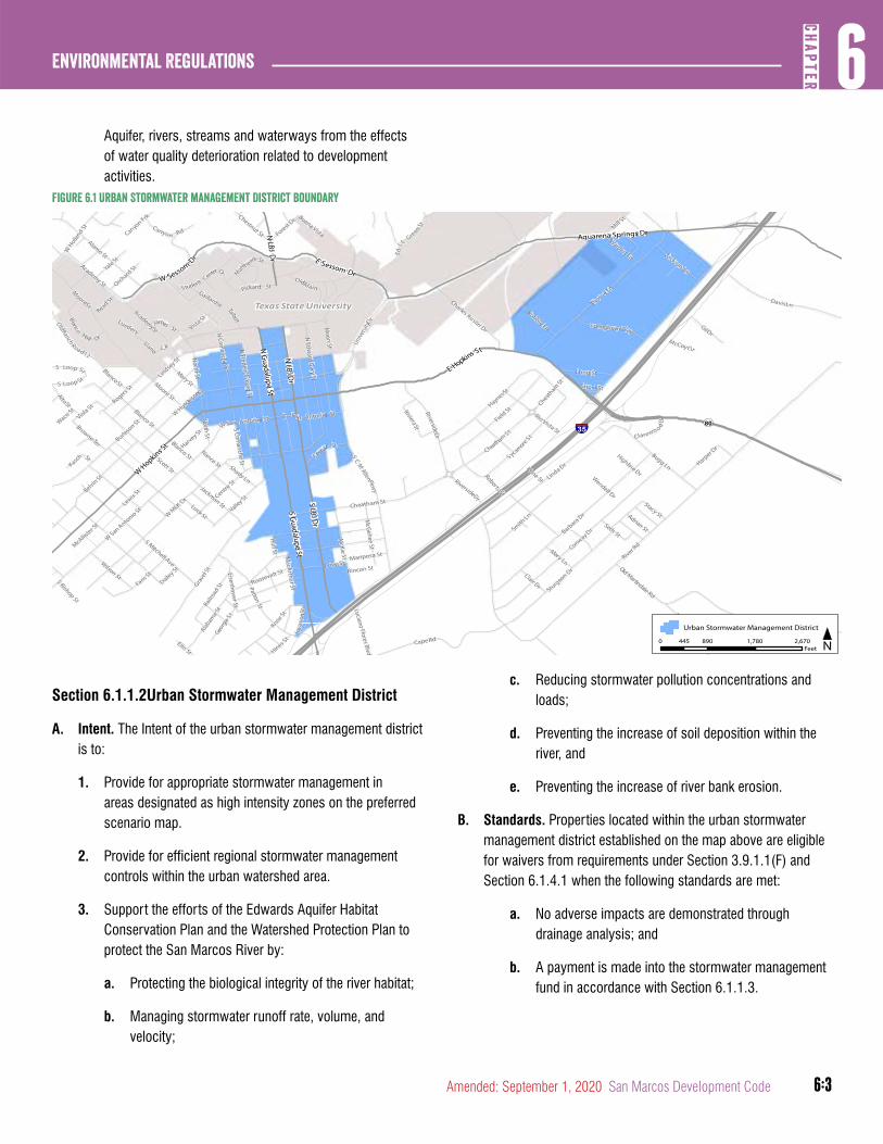
6:3
6CH
APTER
Environmental Regulations
Amended: September 1, 2020 San Marcos Development Code
Aquifer, rivers, streams and waterways from the effects of water quality deterioration related to development activities.
Figure 6.1 Urban Stormwater management District Boundary
Section 6.1.1.2Urban Stormwater Management District
A. Intent. The Intent of the urban stormwater management district is to:
1. Provide for appropriate stormwater management in areas designated as high intensity zones on the preferred scenario map.
2. Provide for efficient regional stormwater management controls within the urban watershed area.
3. Support the efforts of the Edwards Aquifer Habitat Conservation Plan and the Watershed Protection Plan to protect the San Marcos River by:
a. Protecting the biological integrity of the river habitat;
b. Managing stormwater runoff rate, volume, and velocity;
c. Reducing stormwater pollution concentrations and loads;
d. Preventing the increase of soil deposition within the river, and
e. Preventing the increase of river bank erosion.
B. Standards. Properties located within the urban stormwater management district established on the map above are eligible for waivers from requirements under Section 3.9.1.1(F) and Section 6.1.4.1 when the following standards are met:
a. No adverse impacts are demonstrated through drainage analysis; and
b. A payment is made into the stormwater management fund in accordance with Section 6.1.1.3.
Sturgeon Dr
Hines St
W San Antonio St
AcademySt
Valley St
RogersSt
Burleso
n St
McKie St
Belvin St
Patton St
RiversideDr
Chestnut St
Cheatham St
Knox St
W H
olland St
OldRanch
Road12
WMLK Dr Centre
St
Alamo St
Mill St
MacArthur St
Academy St
Highline DrWendell Dr
Ellis St
WSan Antonio St
Gaillardia
AltoSt
WHutchiso
nSt
River Rd
Kone St
Grave
l St
EdJ L
Gre
en StRio Vista St
E San Antonio St
McGehee St
Warden Ln
Blanco St
Barbara Dr
Wilson St
Moore St
Matthew
s St
Roosevelt St
Forest Dr
Lindsey S
t
Seth St
North St
Blanco St
Mariposa St
Alabam
a St
Smith Ln
MooreSt
Student CenterDr
Harvey St
Rincon St
S Comanche St
Browne Ter
S Mitchell Ave
Pickard St
Talbot
McAllister S
tS
CM
AllenPkwy
NorthSt
NCom
ancheSt
Canyon Frk
Cheatham St
Mary Ln
Clair Dr
S Bishop St
Orchard StYale St
Railro
ad St
BlancoSt
Roberts St
Georg
iaSt
HaynesStShort St
Mary St
Shady LnJackman StLuck St
Waco St
N Edward G
ary St
Lewis St
Unive
rsityD
r
N Fredericksburg St
Lueders
Love St
Comal St
Dailey St
Faris St
Nance St
Hull St
McCoyCir
Linda Dr
Conway Dr
Jackson Ln
Buena Vista
Stacy StAdrian St
Scott St
Read St
James St
Kasch St
Vista St
Moon St
CheathamSt
RiversideDr
Clarewo o dDr
GilDr
Robbie Ln
Luciano Flores Blvd
Long St
Old Martindale Rd
Harper D
r
Springtown Way
DavisLn
CapeRd
Eisenhower St
Canyon Rd
Bugg Ln
Llano Cir
OldMain
Thorpe Ln
SycamoreSt
Inva
sionS
t
Field StRivieraSt
S Loop St
S Loop St
Blanco
Hall Dr
Thompson Rd
Charles Austin Dr
Viola St
W Sessom
Dr E Sessom Dr
Aquarena Springs Dr
E Hopkins St
NLBJ
Dr
W Hopkins S
t
N Guadalupe St
S Guadalupe St
S LBJ Dr
N LBJ Dr
§̈¦35¬«80
Texas State University
Urban Stormwater Management District
0 890 1,780 2,670445Feet N
6:4
Environmental Regulations6
CHAP
TER
San Marcos Development Code Amended: September 1, 2020
C. Waiver for Property Outside of the District. Properties located outside the urban stormwater management district that are significantly constrained may be eligible for waivers from requirements under Section 3.9.1.1(F) and Section 6.1.4.1 with the approval of the Responsible Official and when the standards under Section 6.1.1.2(B) are met.
(Ord. No. 2020-60, 9-1-2020)
Section 6.1.1.3Stormwater Management Fund
A. The amount of payment into the Stormwater Management Fund is set by Council and is fixed by a resolution adopted by the City Council in included in the City’s Development Fee Schedule.
B. Payments collected by the City shall be kept separate from other revenue of the City. Funds can only be used within the same watershed where they were collected and shall be dedicated solely to the purchase of land or construction of the following:
1. Retrofit and regional water quality Best Management Practices;
2. Regional detention and floodplain storage; or
3. Projects to increase flow conveyance.
C. Any development required to implement the stormwater fee or approved alternatives shall run with the land and any subsequent modification of the parcel that requires more site or building area shall require subsequent action to satisfy the stormwater management fee requirement.
Section 6.1.1.4Compliance with City and TCEQ Rules
A. All temporary and permanent Best Management Practices (BMPs) required in the approved watershed protection plan must be constructed, operated and maintained in accordance with the standards, criteria and requirements in the Section 86.531 of the San Marcos MS4 Ordinance found in Chapter 86, Article 8, Division 2 of the San Marcos City Code, the City’s Stormwater Technical Manual, TCEQ Edwards Aquifer Protection Program rules and the TCEQ Technical Guidance on Best Management Practices, RG 348.
B. Property owners responsible for maintenance of permanent BMPs, as determined in accordance with Section 3.9.1.7, shall
maintain, repair and report on such activities in accordance with the San Marcos MS4 Ordinance, Section 86.531.
C. The development applicant shall provide the City a copy of TCEQ’s approval of the Water Pollution Abatement Plan prior to receiving a City development permit.
Section 6.1.1.5Calculation of Impervious Cover
A. Submittal of a series of applications prohibited. A person may not submit a series of applications for approval of any type of watershed protection plan for distinct sites on a single tract of property nor divide such land into smaller parcels for the purpose of increasing the impervious cover limit on the property. If the Responsible Official determines that an application involves a violation of this subsection, the Responsible Official will apply the impervious cover limitation for the entire tract of property, including those portions already developed, to the application.
B. Computation of Impervious Cover. The measurement of impervious cover shall be in accordance with Section 3.9.1.3 of this Development Code. Pervious cover credit will not be allowed for pervious pavements on the EARZ.
DIVISION 2: SITE PLANNING
Section 6.1.2.1Natural Drainage
A. Drainage Patterns. Natural drainage patterns shall be preserved whenever possible, and the loss of the pervious character of the soil should be limited in order to prevent erosion and attenuate the impact of contaminants collected and transported by stormwater. Open surface drainage through grass-lined swales is preferred. Drainage objectives can best be accomplished by leaving portions of a subdivision in an underdeveloped and natural state and located to receive runoff from the developed areas for purposes of unchannelized overland flow. The use of green streets utilizing drainage BMPs such as bioretention, pervious pavers, and bioswales shall be utilized whenever possible.
B. Storm Sewers. Construction of enclosed storm sewers and impervious channel linings are discouraged. If stormwater drainage systems and/or culverts are used, these systems shall be designed to mitigate their impact on water quality through the use of approved control strategies to control
6:5
6CH
APTER
Environmental Regulations
Amended: September 1, 2020 San Marcos Development Code
sediment, neutralize contaminants and dissipate energy by the use of multiple smaller outlets, whenever practical, by locating discharges to maximize overland flow and by any other strategies that will accomplish the objectives defined and discussed in this Article.
Section 6.1.2.2Cut and Fill Standards
The layout of the street network, lots and building sites shall min-imize the amount of cut and fill on slopes in accordance with the standards for cut and fill identified in this Section.
A. Cuts. Cuts or other excavation on a tract of land may not exceed four feet of depth, except:
1. In the CD5 or CD5D zoning districts;
2. In a street right-of-way;
3. For cuts within the perimeter of a building footprint and temporary cuts necessary during construction of a building foundation within a building footprint;
4. For utility construction or a wastewater drain field if the area is restored to natural grade; or
5. In a state permitted sanitary landfill or a sand or gravel excavation located in the Extraterritorial Jurisdiction, if:
a. The cut is not in a water quality or buffer zone;
b. The cut does not hydrologically alter for the worse a 100-year floodplain;
c. The landfill or excavation has an erosion and restoration plan approved by the City; and
d. All other applicable City Code provisions are met.
B. Fill. Fill on a tract of land may not exceed four feet in depth, except:
1. In the CD5 or CD5D zoning districts;
2. In a street right-of-way;
3. Under a foundation with sides perpendicular to the ground, or with pier and beam construction;
4. For utility construction or a wastewater drain field;
5. In a state-permitted sanitary landfill located in the Extraterritorial Jurisdiction, if:
a. The fill is derived from the landfill operation;
b. The fill is not placed in a water quality zone, buffer zone, or a 100-year floodplain;
c. The landfill operation has an erosion and restoration plan approved by the City, and
d. All other applicable City Code provisions are met.
C. Cut area surfaces and fill areas must be restored and stabilized in accordance with the City Stormwater Technical Manual.
Section 6.1.2.3Relief from Cut and Fill Standards
A. Administrative Adjustment. The Responsible Official may approve an administrative adjustment to a requirement of Section 6.1.2.2 for a water quality control or stormwater facilities, or for a cut or fill of not more than eight feet in accordance with Section 2.8.5.1 subject to the criteria below.
(Ord. No. 2019-45, 12-17-19)
B. Criteria. The following criteria are used to determine a request for relief from the cut and fill requirements.
1. The post-construction layout is integrated with natural contour lines.
2. Enhanced measures identified in the City Stormwater Technical Manual are used to manage construction and post-construction stormwater runoff quality to levels that would be the same or better quality as would result from a cut or fill of not more than four feet.
C. Alternative Compliance. An alternative compliance request for a cut or fill greater than eight feet may be approved by the City Council in accordance with Section 2.8.4.1 and subject to the Criteria in Sec Section 6.1.2.3(B)2.
Section 6.1.2.4Ecological Preservation along the San Marcos River
A. Stabilization of eroding Creek banks. Stabilization of eroding creek banks is permitted in order to protect threatened property, but only as approved by appropriate Federal and State
6:6
Environmental Regulations6
CHAP
TER
San Marcos Development Code Amended: September 1, 2020
agencies and the Responsible Official. All these projects shall be designed to stabilize existing conditions only.
B. Excavation or filling. Excavation or filling shall be allowed only in accordance with Chapter 39 of the San Marcos City Code, and the following additional requirements:
1. The excavation or filling is necessary for the purpose of structural engineering or is in the area where a structure will be completed, including a building foundation; or
2. Excavation or filling, as demonstrated and certified by a registered professional engineer, will improve the water quality of the runoff and/or stabilize an existing area of erosion and will continue the maintenance of flood and flow characteristics.
Section 6.1.2.5Steep Slopes
The restrictions on impervious cover described in the table below shall apply in addition to impervious cover maximums identified in Chapter 4.
Criteria Impervious Cover (Max)
Slopes of 15% - 25% gradient 35%
Slopes of > 25% gradient 20%
DIVISION 3: EROSION AND SEDIMENTATION CONTROL FROM CONSTRUCTION SITES
Section 6.1.3.1Erosion and Sediment Control Standards
A. The erosion and sedimentation control techniques for construction activities detailed in the San Marcos MS4 Ordinance in Chapter 86, Article 8, Division 2 of the San Marcos City Code and the City Stormwater Technical Manual shall be utilized to reduce environmental impacts from development and must be installed prior to commencing construction; be maintained during construction; and not be removed until vegetation is established and the construction area is stabilized.
B. All temporary erosion and sedimentation controls for projects within the EARZ must meet the applicable standards and requirements of the TCEQ Edwards Aquifer Protection Program,
Complying with the Edwards Aquifer Rules, Technical Guidance on Best Management Practices, RG – 348, Chapter 2.
Section 6.1.3.2Applicability
A. In addition to the projects addressed in the San Marcos MS4 Ordinance in Chapter 86, Article 8, Division 2 of the San Marcos City Code, temporary erosion and sedimentation controls are required to be installed and maintained for the following activities that are or may not be covered by any type of watershed protection plan in the Edwards Aquifer Recharge Zone, Transition Zone, Contributing Zone within the Transition Zone or San Marcos River Protection Zone:
1. The construction or expansion of one single family home or accessory structure on a legally platted lot, or on an unsubdivided tract of land at least two acres in size, for which a legal description was contained in a deed recorded before March 1, 2000.
2. The installation or maintenance of utility lines by a governmental entity.
3. Landscaping activities involving more than 5,000 square feet of area of landscape installation.
4. The resurfacing of existing paved roads, parking lots, sidewalks, or other development-related impervious surfaces.
B. Erosion and Sediment Control Monitoring. The Responsible Official will monitor stormwater discharges from these activities to evaluate the adequacy of the temporary erosion and sedimentation control measures. The Responsible Official may require the person performing the activity to use additional controls if the Responsible Official determines that the controls used by the person are inadequate to protect water quality.
DIVISION 4: POST-CONSTRUCTION STORMWATER PERFORMANCE STANDARDS
Section 6.1.4.1Stormwater Quality and Stream Protection
A. Water Quality Volume (WQV). Water Quality Volume is based on the amount of runoff produced over the developed area from the listed rainfall amount identified in Section 6.1.4.1(C).
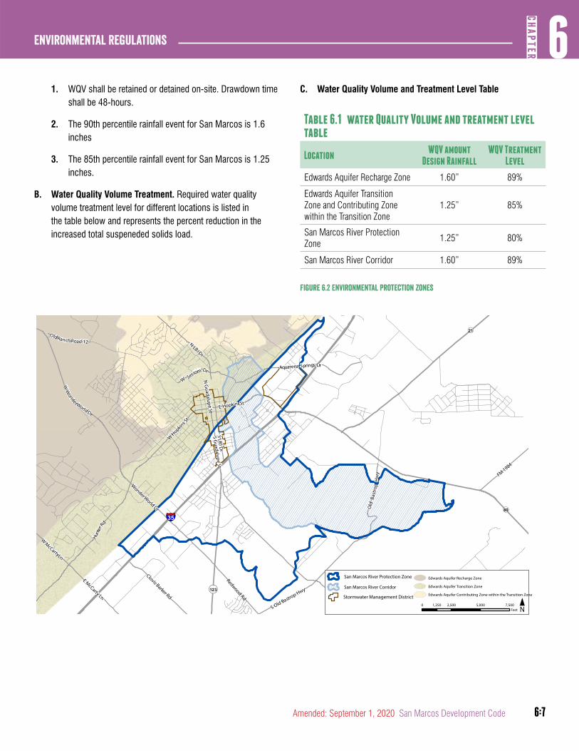
6:7
6CH
APTER
Environmental Regulations
Amended: September 1, 2020 San Marcos Development Code
1. WQV shall be retained or detained on-site. Drawdown time shall be 48-hours.
2. The 90th percentile rainfall event for San Marcos is 1.6 inches
3. The 85th percentile rainfall event for San Marcos is 1.25 inches.
B. Water Quality Volume Treatment. Required water quality volume treatment level for different locations is listed in the table below and represents the percent reduction in the increased total suspeneded solids load.
C. Water Quality Volume and Treatment Level Table
Table 6.1 water Quality Volume and treatment level table
LocationWQV amount
Design RainfallWQV Treatment
Level
Edwards Aquifer Recharge Zone 1.60” 89%
Edwards Aquifer Transition Zone and Contributing Zone within the Transition Zone
1.25” 85%
San Marcos River Protection Zone
1.25” 80%
San Marcos River Corridor 1.60” 89%
Figure 6.2 Environmental Protection zones
§̈¦35
¬«123
¬«80
¬«21
WSessom Dr
Aquarena Springs Dr
Hunt
erRd
E HopkinsSt
S Guadalupe St
N LBJ Dr
W Hopkins S
t
N G
uadalupe St
S taples Rd
WMcCartyLn
S LBJ Dr
OldRanch Road 12
Clovis Barker Rd
E McCarty Ln
Wonder World Dr
Redwood Rd
FM 1984
S Old Bastrop Hwy
WW
onderWorld Dr
Old
Bast
rop
Hw
y
San Marcos River Protection Zone
San Marcos River Corridor
0 2,500 5,000 7,5001,250Feet N
Edwards Aquifer Recharge Zone
Edwards Aquifer Transition Zone
Edwards Aquifer Contributing Zone within the Transition ZoneStormwater Management District

6:8
Environmental Regulations6
CHAP
TER
San Marcos Development Code Amended: September 1, 2020
D. Exceptions to stormwater quality and stream protection volume requirements are allowed under the following conditions provided that disconnected impervious cover and treatment through vegetative filter strips or similar means is included:
1. evelopment applications proposing solely the construction or expansion of a single family home.
2. Plats of four (4) lots or less where the lots subdivided from the parent parcel do not exceed 0.5 acres each, are restricted by zoning or deed to 65% impervious cover or less, and are served by an existing street. An exemption is not allowed for the submittal of a series of plats of four (4) lots or less with the intention of producing a tract that is greater than four (4) lots.
(Ord. No. 2020-60, 9-1-2020)
Section 6.1.4.2Flood Control
Refer to Chapter 3, Article 9: Stormwater Collection and Drainage Conveyance Systems for flood control performance standards.
article 2: Enhanced Protection Zones
DIVISION 1: GENERAL
Section 6.2.1.1Purpose, Applicability and Exceptions
A. Purpose. The purpose of the standards in this Division are to protect water quality in more sensitive areas and to prevent flood damage throughout the City and its Extraterritorial Jurisdiction.
B. Applicability. This Article applies to development affecting any waterway including the Blanco and San Marcos Rivers located within the City or its Extraterritorial Jurisdiction unless otherwise stated in this Development Code and except as follows:
C. Exceptions. This Article does not apply to the following:
1. Any waterway having a drainage basin of less than 50 acres outside the EARZ, Transition Zone, and Contributing Zone within the Transition Zone and 5 acres within the EARZ, Transition Zone, and Contributing Zone within the Transition Zone measured upstream from the proposed development;
2. The construction of barns or other accessory structures related to agricultural uses.
D. Designation required. The water quality zones and buffer zones required by this Article shall be designated when a plat is required for a development, and shall be shown on all associated watershed protection plans, plats, site permits, and building plans. Unless required by the Responsible Official to be dedicated as a flowage easement and dedicated for public maintenance, water quality zones and buffer zones shall be privately held and maintained.
DIVISION 2: ZONE DESIGNATION
Section 6.2.2.1Water Quality Zones
A. A water quality zone shall be established for each waterway. Water quality zone have been predetermined by the City for certain waterways. A map of such predetermined water quality zones is on file with the City’s Planning and Development Services Department and is available upon request. For
6:9
6CH
APTER
Environmental Regulations
Amended: September 1, 2020 San Marcos Development Code
waterways not associated with a predetermined water quality zone by the City, the following options are available:
1. FEMA-mapped Option. For any waterway with a FEMA-defined floodway, a water quality zone shall be established 100 feet in width, measured from the boundary of the defined floodway on each side of the waterway if located outside the EARZ, or as all land within a distance of 100 feet from a bank of the San Marcos River or a side channel that returns to the main channel, whichever is greater, but shall not exceed the width of the 100-year floodplain. For any waterway with a FEMA-mapped detailed study floodplain, the area of the 100-year floodplain shall be the water quality zone if located within the EARZ.
2. Waterway Centerline Offset Option
a. Sub-minor Waterways. Waterways draining five or more acres but less than 50 acres but, excluding roadside swales, shall have a minimum Water Quality Zone width of 25 feet on each side of the Waterway centerline. These are established within the EARZ, Transition Zone, and Contributing Zone within the Transition Zone only.
b. Minor Waterways. Waterways draining 50 or more acres but less than 250 acres shall have a minimum water quality zone width of 50 feet on each side of the waterway centerline.
c. Intermediate Waterways. Waterways draining 250 or more acres but less than 1000 acres shall have a minimum water quality zone width of 100 feet on each side of the waterway centerline.
d. Major Waterways. Waterways draining more than 1000 acres shall have a minimum water quality zone width of 200 feet on each side of the waterway centerline.
3. Floodplain Study Option
a. The water quality zone shall be defined as the 100-year floodplain boundary based on fully developed watershed paralleling each side of the waterway. The 100-year floodplain shall be based on modeling approaches as approved by the Responsible Official.
(Ord. No. 2020-60, 9-1-2020)
Section 6.2.2.2Buffer Zones
A. A buffer zone shall be established for each waterway. Buffer zones have been predetermined by the City for certain waterways. A map of such buffer zones is on file with the City’s Planning and Developmetn Services Department and is available upon request. For waterways not associated with a predetermined buffer zone by the City, the following options are available:
1. FEMA Mapped Option. For any waterway with a FEMA-defined floodway outside the EARZ or FEMA-mapped detailed study floodplain inside the EARZ, a buffer zone shall be established 100 feet in width, measured from the outer boundary of the water quality zone established in Section 6.2.2.1, on each side of the waterway. The combined width of the water quality zone and the buffer zone shall not exceed the width of the 100-year floodplain if located outside the EARZ.
2. Non FEMA Mapped Option. For applicable waterways that do not have floodways officially mapped by FEMA, a buffer zone shall be established 25 feet in width for sub-minor waterways, 50 feet in width for a minor waterway and 100 feet in width for intermediate and major waterways, measured from the outer boundary of the water quality zone established in Section 6.2.2.1, on each side of the waterway. The combined width of the water quality zone and buffer zone shall not exceed the width of the 100-year floodplain based on a detailed study if located outside of the EARZ.
3. San Marcos River Corridor. The buffer zone for the San Marcos River Corridor is established in the map Section 6.1.4.1.
(Ord. No. 2020-60, 9-1-2020)
Section 6.2.2.3Sensitive Feature Protection Zones
A. Sensitive Feature Protection Zones Established. A sensitive feature protection zone shall be established around each sensitive feature in the Edwards Aquifer Recharge Zone, Edwards Aquifer Transition Zone, and Contributing Zone within the Edwards Aquifer Transition Zone. Unless an applicant submits an enhanced geologic assessment of a feature in accordance with Section 6.3.2.1(D), or an enhanced
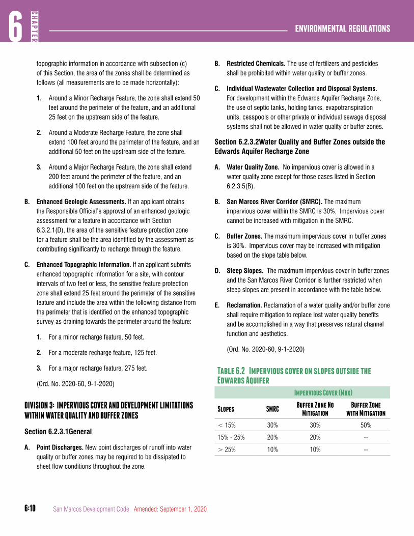
6:10
Environmental Regulations6
CHAP
TER
San Marcos Development Code Amended: September 1, 2020
topographic information in accordance with subsection (c) of this Section, the area of the zones shall be determined as follows (all measurements are to be made horizontally):
1. Around a Minor Recharge Feature, the zone shall extend 50 feet around the perimeter of the feature, and an additional 25 feet on the upstream side of the feature.
2. Around a Moderate Recharge Feature, the zone shall extend 100 feet around the perimeter of the feature, and an additional 50 feet on the upstream side of the feature.
3. Around a Major Recharge Feature, the zone shall extend 200 feet around the perimeter of the feature, and an additional 100 feet on the upstream side of the feature.
B. Enhanced Geologic Assessments. If an applicant obtains the Responsible Official’s approval of an enhanced geologic assessment for a feature in accordance with Section 6.3.2.1(D), the area of the sensitive feature protection zone for a feature shall be the area identified by the assessment as contributing significantly to recharge through the feature.
C. Enhanced Topographic Information. If an applicant submits enhanced topographic information for a site, with contour intervals of two feet or less, the sensitive feature protection zone shall extend 25 feet around the perimeter of the sensitive feature and include the area within the following distance from the perimeter that is identified on the enhanced topographic survey as draining towards the perimeter around the feature:
1. For a minor recharge feature, 50 feet.
2. For a moderate recharge feature, 125 feet.
3. For a major recharge feature, 275 feet.
(Ord. No. 2020-60, 9-1-2020)
DIVISION 3: IMPERVIOUS COVER AND DEVELOPMENT LIMITATIONS WITHIN WATER QUALITY AND BUFFER ZONES
Section 6.2.3.1General
A. Point Discharges. New point discharges of runoff into water quality or buffer zones may be required to be dissipated to sheet flow conditions throughout the zone.
B. Restricted Chemicals. The use of fertilizers and pesticides shall be prohibited within water quality or buffer zones.
C. Individual Wastewater Collection and Disposal Systems. For development within the Edwards Aquifer Recharge Zone, the use of septic tanks, holding tanks, evapotranspiration units, cesspools or other private or individual sewage disposal systems shall not be allowed in water quality or buffer zones.
Section 6.2.3.2Water Quality and Buffer Zones outside the Edwards Aquifer Recharge Zone
A. Water Quality Zone. No impervious cover is allowed in a water quality zone except for those cases listed in Section 6.2.3.5(B).
B. San Marcos River Corridor (SMRC). The maximum impervious cover within the SMRC is 30%. Impervious cover cannot be increased with mitigation in the SMRC.
C. Buffer Zones. The maximum impervious cover in buffer zones is 30%. Impervious cover may be increased with mitigation based on the slope table below.
D. Steep Slopes. The maximum impervious cover in buffer zones and the San Marcos River Corridor is further restricted when steep slopes are present in accordance with the table below.
E. Reclamation. Reclamation of a water quality and/or buffer zone shall require mitigation to replace lost water quality benefits and be accomplished in a way that preserves natural channel function and aesthetics.
(Ord. No. 2020-60, 9-1-2020)
Table 6.2 Impervious cover on slopes outside the Edwards Aquifer
Impervious Cover (Max)
Slopes SMRCBuffer Zone No
MitigationBuffer Zone
with Mitigation
< 15% 30% 30% 50%
15% - 25% 20% 20% --
> 25% 10% 10% --

6:11
6CH
APTER
Environmental Regulations
Amended: September 1, 2020 San Marcos Development Code
Section 6.2.3.3Water Quality and Buffer Zones Inside Edwards Aquifer Recharge Zone
A. Water Quality Zone. No development or impervious cover is allowed in a water quality zone within the Edwards Aquifer Recharge Zone except for those cases listed in Section 6.2.3.5(B).
B. Buffer Zones. The maximum impervious cover in buffer zones is 10%. Impervious cover may be increased with mitigation based on the slope table below.
C. Steep Slopes. The maximum impervious cover in buffer zones located within the Edwards Aquifer Recharge Zone is further restricted when steep slopes are present in accordance with the table below.
Table 6.3 Impervious cover on slopes inside the Edwards aquifer
Impervious Cover (Max)
SlopesBuffer Zone No
MitigationBuffer Zone with
Mitigation
< 20% 10% 20%
> 20% 0% 10%
Section 6.2.3.4Sensitive Feature Protection Zone
No development or impervious cover is allowed within a sensitive feature protection zone except for those cases listed in Section 6.2.3.5(C).
Section 6.2.3.5Mitigation and Exceptions
A. Mitigation. The following is permissible with adequate mitigation that replaces lost water quality benefits:
1. Impervious cover limitations may be exceeded in a buffer zone for land with a gradient of less than 15 percent outside the Edwards Aquifer Recharge Zone and 20 percent within the Edwards Aquifer Recharge Zone; and
2. Water quality and/or buffer zones may be reclaimed. Mitigation shall consist of meeting a Total Suspended Solid (TSS) removal requirement or increase in TSS removal requirement for the site or portion of the site as determined adequate by the Responsible Official.
(Ord. No. 2020-60, 9-1-2020)
B. Exceptions to impervious cover limitations in a water quality or buffer zones include:
1. Existing impervious cover in water quality or buffer zones may be replaced, subject to flood protection standards in Chapter 39 of the San Marcos City Code, but may not be increased except consistent with the limitations in this Section.
2. Arterial, residential and collector street crossings in accordance with the following:
a. For FEMA- mapped waterways, water quality and buffer zones may be crossed by arterial and collector streets that are a distance of at least 2,000 feet horizontally from the nearest adjacent crossing of the waterway by an arterial or collector street.
b. For other waterways subject to this Article, water quality zones may be crossed by arterial, collector and residential roads that are a distance of at least 1,000 feet horizontally from the nearest adjacent crossing of the waterway by an arterial, collector or residential street.
c. Any water quality or buffer zone may be crossed by one collector or residential street regardless of the distance from the nearest crossing of the waterway by an existing arterial, collector or residential street, if the crossing will provide the only access to a public road or street for a portion of the tract of land on which the new street is proposed.
3. Utility line crossings that are in compliance with all City and TCEQ requirements.
4. Fences that do not obstruct or dam surface water flows.
5. Trails and related facilities, other than buildings, for walking, running, and non-motorized biking.
C. Exceptions to impervious cover limitations in a sensitive feature protection zone include:
1. Fences that do not obstruct surface water flows.
2. Pervious trails and other facilities, other than buildings, for walking, running, or non-motorized biking. Decomposed granite is not considered a pervious trail surface.
6:12
Environmental Regulations6
CHAP
TER
San Marcos Development Code Amended: September 1, 2020
article 3: Development related to the Edwards aquifer
DIVISION 1: GENERAL
Section 6.3.1.1Applicability and Authority
A. Applicability. The standards contained in this Article 2 apply to the recharge, transition, and upland zones of the Edwards Aquifer.
B. Authority. The requirements of this Article are authorized under Tex. Water Code Sections 16.316 and 26.177(b), and Tex. Loc. Gov’t Code Ch. 212.
DIVISION 2: DEVELOPMENT DUTIES
Section 6.3.2.1Duties in Undertaking Development Over Aquifer
A. Excavations in Recharge Zone or Transition Zone.
1. When a development in the recharge zone or transition zone includes any excavation, the person performing the development must either engage a qualified geologist to inspect the excavation, or notify theResponsible Official to arrange for inspection of the excavation by city personnel. The inspection will be for the purpose of determining whether the excavation has uncovered any geologic or man made feature that presents a possible avenue for recharge to the aquifer. The inspection will be made either upon completion of the excavation, if it is in a single, defined area, or in segments, if the excavation is linear, or is in multiple locations, or is accomplished over an extended period of time. The excavation may be temporarily backfilled before inspection, but inspection must occur with the full excavation uncovered before permanent backfilling is performed. If an inspection reveals that one or more such features has been uncovered, the person performing the development must:
a. Immediately notify the Responsible Official;
b. Utilize temporary BMPs to prevent pollution from entering the aquifer through the features; and
c. Not perform any further work in the excavation until an application for an amendment to the approved watershed protection plan (phase 1, phase 2, or qualified, as applicable), for a development in the recharge zone, or an application for approval of a site permit, for a development in the transition zone, is submitted to and approved by the Responsible Official.
B. Discovery of Sensitive Feature in Recharge Zone or Transition Zone.
1. If a new sensitive feature, or any solution opening, cave, sinkhole, or similar feature, is encountered on a site in the recharge zone or transition zone during the construction process for a development, or if a previously known sensitive feature is found in the course of construction to be larger or more extensive than previously noted in the geologic assessment of the site, the holder or the holder’s designated representative must:
a. Immediately suspend all excavation and construction activities within 50 feet of the feature, measured horizontally;
b. Immediately notify the Responsible Official of the discovery; and
c. Retain a qualified geologist to inspect the feature and make a recommendation to the Responsible Official based on the relative sensitivity of the feature.
2. The Responsible Official may require, for a development in the recharge or transition zone, that the holder submit an application to amend the approved watershed protection plan or site preparation permit to adequately protect a feature encountered or found under subsection (b)(1) above. For development with an approved watershed protection plan including a geological assessment, the Responsible Official will review the available information and within two working days of notification of the feature, will decide whether to allow construction activities to resume near the feature pending the amendment, and if so, at what locations. The Responsible Official will review and approve or deny a requested amendment to watershed protection plan or site preparation permit within five working days of submission of a geologic assessment if

6:13
6CH
APTER
Environmental Regulations
Amended: September 1, 2020 San Marcos Development Code
not included with the original application. The holder may appeal a denial in accordance with Chapter 2, Article 6, Division 1.
C. Geological Assessments. All watershed protection plans (Phase 1) for developments in the recharge zone, transition zone, and contributing zone within the transition zone and site preparation permit for uses must be accompanied by a geologic assessment of the entire site prepared by a qualified geologist. The assessment must be based on 50-foot Transects across the Site, and must contain all information required for Geologic Assessments under the TCEQ Edwards Aquifer rules. The assessment must identify all sensitive features on the site, and for each sensitive feature, must state whether it is a major recharge feature, moderate recharge feature, or minor recharge feature. A waiver for a geologic assessment for sites that do not warrant an assessment within the transition zone may be obtained from the REsponsible Official if the property is located within the Geologic Assessment Exemption Zone. A map of such area is on file with the City’s Planning and Development Services Department and is available upon request.
(Ord. No. 2020-60, 9-1-2020)
D. Enhanced Geologic Assessment. A watershed protection plan (phase 2) for a development in the recharge zone may be accompanied by an enhanced geologic assessment of the site prepared by a qualified geologist. The enhanced assessment is subject to review and approval by the Responsible Official as part of the approval process for the watershed protection plan (phase 2). The enhanced assessment must meet the requirements for assessments under (c) above, and in addition, must meet the following:
1. All caves that can be entered must be entered and mapped to establish the footprint of the cave, and to identify related surface hydro-geologic features (drainage areas, sinkholes, fractures, etc.) and cultural features (existing or proposed roads, buildings, utilities, etc.). Hydro-geologic features within each cave must be mapped or noted and interpreted to delineate the drainage area for the cave, which includes surface drainage into the cave’s entrance(s), plus surface drainage into fractures, sinkholes, streambeds, or other features which appear to contribute recharge into the cave in areas beyond the cave entrance. Excavations must be conducted as part of the
effort to fully map the caves when necessary for study and mapping of otherwise inaccessible parts of the caves. Where excavation may be unsafe, such as a passage that ends in collapse and likely continues on the opposite side of the collapse, geophysical methods should be employed to determine if and where the cave continues. The geophysical methods must be of a type that has proven accurate and appropriate for the depth, size, and geologic setting of the cave. The geophysical methods should not be used to replace mapping of the cave, but to supplement them and identify areas where excavation or drilling may find the continuation of the cave to allow its further mapping and study.
2. Recharge features that cannot be entered must be excavated to more fully evaluate the hydrogeologic significance of the features, and to determine if they lead to caves. Excavations may be conducted by hand, explosive, and/or mechanized means as appropriate. Excavations will be considered complete if a cave, or bedrock with no openings, or a compact clay at least one foot thick throughout the feature’s floors and walls, is found. Where fractures or other openings in the bedrock extend indefinite distances with no fill material or loose fill material, and hydrogeologic indicators suggest the feature may lead to a cave, then geophysical methods should be employed to determine if and where a cave is present to guide further excavation and study.
Section 6.3.2.2Wastewater Collection and Disposal
A. Individual Disposal Systems. Lots overlying the Edwards Aquifer Recharge Zone that are not connected to a public wastewater system shall use sewage disposal systems that are installed in accordance with applicable state regulations.
DIVISION 3: SITE IMPERVIOUS COVER LIMITATIONS
Section 6.3.3.1Total Impervious Cover
A. Impervious Cover Limitation. The total of all impervious cover that may be developed on a site in the Recharge Zone shall not exceed the following percentages of the gross area of the site based on the size of the site on October 8, 2001. Additional impervious cover limitations apply to those areas of the

6:14
Environmental Regulations6
CHAP
TER
San Marcos Development Code Amended: September 1, 2020
development site that are located within a water quality zone, a buffer zone or a sensitive feature protection zone.
Table 6.4 Impervious cover limits within the edwards aquifer recharge zone
Size of Site Impervious Cover Limit
Up to and including three acres
40%
More than three acres and less than five acres
30%
Five acres or more 20%
Section 6.3.3.2Impervious Cover Allocation
A. Utilization of Site. Land included in water quality zones, buffer zones, and sensitive feature protection zones may be used in the calculation of the total impervious cover allowed on the site. The total allowed impervious cover on a site may be allocated by an applicant in a manner that concentrates the allowed impervious cover in one or more uplands zones on the site.
article 4: Tree and habitat protection
DIVISION 1: GENERAL
Section 6.4.1.1Purpose
The purpose of this Article is to conserve, protect and enhance existing trees and natural landscapes that are healthy and contribute to a safe and livable community, as well as to establish and maintain new trees. It is recognized that the presence of trees contributes to the overall quality of life and environment of the City. They are an integral part of healthy aquifers and river corridors, managing stormwater runoff, controlling erosion and dust, abating noise, reducing building energy costs, enhancing property values, and providing wildlife habitat.
DIVISION 2: TREE PRESERVATION AND PROTECTION DURING DEVELOPMENT
Section 6.4.2.1General Tree Preservation Requirements
A. Applicability. The provisions of this section apply to all new development within the City and not within the ETJ, including development projects undertaken by the City of San Marcos.
B. Intent
1. In the course of development the existing natural landscape character shall be preserved to the maximum extent feasible. Native oaks, elms, sycamore, bald cypress, madrone, and pecan trees are particularly to be preserved. For example, when a site contains an existing stand of trees, the developer and builder shall use best good faith efforts to preserve such trees.
2. Indiscriminate clearing or stripping of natural vegetation on a site or lot is prohibited.
C. City Approval. The removal of any protected or heritage tree for the purpose of development without City approval is expressly prohibited.
D. Tree Survey
1. To request City approval for the removal of a protected or heritage tree, submit a tree survey with the applicable development permit application. Issuance of the applicable

6:15
6CH
APTER
Environmental Regulations
Amended: September 1, 2020 San Marcos Development Code
permit constitutes approval of tree removal and shall occur prior to any action being taken to remove a tree(s) or that may damage or disturb a tree(s) or its root system in any way.
2. The tree survey required with an application for a Watershed Protection Plan, Phase 2 or a Site Permit under Section 2.6.1.1 or Section 2.7.1.1 shall include a drawing showing the species, size, location and scaled root protection zone of all protected and heritage tree(s), with an indication of those to be preserved or removed. The “Tree Preservation and Mitigation Table”, located on the City’s website, shall also be included.
3. Trees nine inches or larger shall be tagged and numbered, and numbers shall be depicted on the applicable drawing and associated table(s). The tags and associated numbers shall remain on the trees until the certificate of acceptance or certificate of occupancy is issued.
4. When submitting an application for a Watershed Protection Plan, Phase 1, under Section 2.6.1.1 an aerial photograph showing tree groupings and the location of heritage trees is required.
Section 6.4.2.2Tree Measurement.
A. Existing Tree Size and Measurement. Tree size shall be stated in inches of “Diameter at Breast Height (DBH)”. Both single-trunk and multi-trunk trees shall be measured at “breast height” which is defined as four-and-one-half feet (54 inches) above natural grade.
(Ord. No. 2019-45, 12-17-19)Figure 6.3 Measuring existing trees
B. Measurement of a Multi-Trunk Tree. The DBH of a multi-trunk tree shall be calculated by the following equation: The DBH of the largest tree trunk, plus one-half the DBH of all other tree trunks. For example, a tree that has three trunks with DBHs of 7”, 6”, and 4” would be equivalent to a 12” DBH tree.
7” + (0.5 x 6”) + (0.5 x 4”) = 12”DBH
(Ord. No. 2019-45, 12-17-19)
C. Measurement of Nursery Stock. The size of small or young trees to be planted (i.e., those with diameters of four inches or less) shall be measured at six inches above the root ball in “caliper” inches.
Figure 6.4 Measuring Nursery stock
Section 6.4.2.3Classification of Protected and Heritage Trees.
Table 6.5 tree classifications
Tree Classification DBH (Diameter at breast height)
Protected Tree 9” - 23”
Heritage Tree > 24”

6:16
Environmental Regulations6
CHAP
TER
San Marcos Development Code Amended: September 1, 2020
A. Trees of the following species with a DBH less than 12 inches are excluded from the mitigation requirements of this code:
1. Celtis occidentalis (Hackberry)
2. Juniperus ashei (Common Cedar)
3. Juniperus virginiana (Eastern Red Cedar)
4. Prosopis glandulosa (Mesquite)
5. Acacia farnesiana (Huisache)
B. Trees identified on the noxious and invasive species list of any size are excluded from the mitigation requirements of this code.
C. Trees deemed dead, in serious decline or hazardous by an ISA certified arborist, consulting arborist, and/or the City’s Urban Forester are excluded from the mitigation requirements of this code.
Section 6.4.2.4Tree Protection Standards
A. Protection of Existing Trees During Development.
1. No more than 25% of the root protection zone of trees to be preserved shall be disturbed. The root protection zone is measured as 1 foot in radius for every 1 inch in DBH of the tree. This area may overlap with a grouping of trees.
Figure 6.5 Tree Protection standards
2. All preserved trees on a demolition or construction site shall be provided protection for a minimum of 75% of their root protection zone in accordance with City of San Marcos standard design and technical specifications.
3. Tree protection fences shall be shown on submitted plans and shall be in place for City inspection before any demolition, site clearance or other site-disturbing activity commences.
4. All building materials, dirt, excavation or fill materials, chemicals, construction vehicles or equipment, debris, other materials, and vehicle parking shall be kept outside tree protection fences.
5. Tree protection fences shall remain in place until the final building and site inspections are approved and the certificate of acceptance or certificate of occupancy is issued.
(Ord. No. 2019-45, 12-17-19)
Section 6.4.2.5Tree Mitigation Requirements
Any protected or heritage tree that is removed from the site due to development must be replaced on-site as follows:
Table 6.6 Tree Mitigation Requirements
Tree Classification Mitigation Required in Diameter inches
Protected Tree 1:1 (1 Inch per inch removed)
Heritage Tree 2:1 (2 Inches per inch removed)
A. All required mitigation trees shall be provided as shade trees meeting the planting, installation, and maintenance requirements of Sections 7.2.4.1, 7.2.4.2, and Appendix D of the San Marcos Design Manual.
B. Off-Site Mitigation. The primary goal is to replant trees on a development site. With the express, written approval of the Responsible Official, however, some or all of the required mitigation trees that cannot feasibly be planted in any area of the development site can be planted in a park or other city right-of-way located within the same quadrant of the City as the development site.
(Ord. No. 2019-45, 12-17-19)
Diameter of tree at 4.5 ft. above grade is 12 inches
Root protection zone is a 12 foot radius circle. (24 ft. Diameter) Encroachments shall
occupy no more than 25% of the total area in the root protection zone

6:17
6CH
APTER
Environmental Regulations
Amended: September 1, 2020 San Marcos Development Code
C. Tree Fee-in-lieu. While the primary goal is to replant trees on a development site, when some or all of the required mitigation trees cannot feasibly be planted in any area of the development site or in a nearby park or other public property, the Responsible Official may allow the applicant to pay a fee-in-lieu of planting mitigation trees. Payment per caliper inch as set by City Council resolution for required mitigation trees shall be paid into the tree fund. The funds in this account shall be dedicated solely to tree planting and care and other tree preservation activities within the the same quadrant of the City as the development site. Refer to the fee schedule on the City’s website for the current rates.
(Ord. No. 2019-45, 12-17-19)
Section 6.4.2.6Tree Credits
A. Incentives to Retain Existing Trees. In order to encourage the preservation of trees that are already established and growing, particularly heritage trees, additional credit as outlined in the table below shall be given for healthy existing trees. To receive credit, the existing tree must be of a species included on the preferred list in the technical manual and located within the limits of construction (LOC) of the development site. Tree credits for preserving existing trees can be used to meet either the landscaping requirements for trees or the mitigation requirements for other removed trees.
Table 6.7 Tree Credits
Tree Classification Tree Credits in Diameter Inches
Protected Tree 1/2:1 (1/2 Inch per inch preserved)
Heritage Tree 1:1 (1 Inch per inch preserved)
Section 6.4.2.7Tree Preservation and Protection After Development
A. Duty of Persons for Trees on Property. It shall be the duty of the property owner to maintain all trees planted pursuant to, or preserved by, this Article in a healthy condition in accordance with the following:
1. Any person or persons owning or occupying real property on which there may be trees must ensure that such trees do not obstruct utility or telephone lines. Only city-
contracted arborists are allowed to trim trees within 12 feet of utility and telephone lines.
2. Any person or persons owning or occupying real property bordering on any street upon which property there may be trees, must prune such trees in such a manner that they will not obstruct or shade the street lights, obstruct or interfere with the passage of pedestrians on sidewalks, obstruct vision of traffic signs, or obstruct the view from any street or alley intersection. The minimum clearance of any overhanging portion thereof shall be 8 feet over sidewalks and 16 feet over all streets, except truck thoroughfares which shall require a clearance of 18 feet.
3. Any person or persons owning or occupying real property on which there may be trees that are diseased or insect-infested, must remove, spray or treat any such trees in a manner that will not infect or damage nearby public vegetation or cause harm to the community or citizens therein.
4. When trees that are subject to or protected by this Article die, are missing, or are otherwise deemed unhealthy by the City, they shall be removed and replaced by the property owner to comply with the applicable standards.
5. Any person or persons owning, occupying or controlling real property upon which tree pruning or removal occurs must advise all landscape contractors, tree services, arborists and others who remove or prune diseased trees of the need for proper disinfection of all cutting tools. All wounds to the trunk, limbs, roots, or stumps of oak trees should be sprayed with paint within 20 minutes of cut or incident with wounding or removal to prevent the spread of oak wilt. This provision applies to any person, firm, corporation, business entity, City department or private utility.
B. If the owner or occupant of such property does not perform the duties set out in subsection A above, the City may order the pruning, removal or treatment of tree(s) on private property that cause obstructions, present insect or disease problems or otherwise present a danger to public health or safety. The order shall be in writing to the owner or occupant responsible for such condition and shall be acted upon within 30 days from the time of the receipt of the order. If, after 30 days, the owner or occupant has not responded or acted to prune, remove or

6:18
Environmental Regulations6
CHAP
TER
San Marcos Development Code Amended: September 1, 2020
treat the tree(s), the City shall have the authority to enter upon the property to perform the work necessary to correct the condition and bill the owner or occupant for the actual costs incurred. In situations deemed necessary to the public health, safety, or welfare, the City may act without prior notification to the property owner or occupant.

7:1
7CH
APTER
Supplemental Development Standards
7:1Amended: September 1, 2020 San Marcos Development Code
ChaPTER 7. SUPPLEMENTaL DEVELOPMENT STaNDaRDS
article 1: Parking ............................................................ 7:2DIVISION 1: GENERAL PROVISIONS 7:2
DIVISION 2: MINIMUM PARKING REQUIREMENTS 7:3
DIVISION 3: ALTERNATE PARKING REQUIREMENTS 7:6
DIVISION 4: PARKING LOCATION AND DESIGN 7:7
article 2: Landscaping and Screening ....................7:13DIVISION 1: GENERAL LANDSCAPING REQUIREMENTS 7:13
DIVISION 2: TRANSITIONAL PROTECTIVE YARDS 7:13
DIVISION 3: INTERIOR LOT LANDSCAPING 7:16
DIVISION 4: INSTALLATION AND MAINTENANCE 7:17
DIVISION 5: SCREENING 7:19
DIVISION 6: WALLS AND FENCES 7:20
article 3: Sign Permits ................................................ 7:24DIVISION 1: GENERAL STANDARDS AND REQUIREMENTS 7:24
DIVISION 2: ADMINISTRATION 7:27
DIVISION 3: CONVENTIONAL DISTRICT SIGN STANDARDS 7:28
DIVISION 4: NEIGHBORHOOD AND CHARACTER DISTRICT SIGN STANDARDS 7:32
article 4: Public health related performance standards .......................................................................7:44
DIVISION 1: GENERAL 7:44
DIVISION 2: STANDARDS 7:44
article 5: Lighting and glare standards ...............7:46DIVISION 1: GENERAL 7:46
DIVISION 2: STANDARDS 7:47
article 6: Manufactured home and tiny home village 7:50
DIVISION 1: REGULATIONS AND REQUIREMENTS 7:50

7:2
Supplemental Development Standards7
CHAP
TER
7:2 San Marcos Development Code Amended: September 1, 2020
article 1: Parking
DIVISION 1: GENERAL PROVISIONS
Section 7.1.1.1Applicability
A. Purpose
1. To regulate and ensure the provision of parking spaces and access drives are designed for motor vehicles, bicycles and pedestrians.
2. These parking standards help to ensure that parking needs of new land uses and development are met, while ensuring parking spaces and access drives are designed and located in a manner consistent with the desired character and development patterns of the Comprehensive Plan
B. New Development & Redevelopment. Any new building must comply with the parking requirements of this Development Code.
C. Renovations or Repairs. An existing building or site may be repaired, maintained or modernized without providing additional parking, provided there is no increase in gross floor area or improved site area.
D. Additions and Increases in Floor Area
1. When an existing building, use or site is increased in gross floor area or improved site area by up to 25% cumulatively, additional parking is required for the additional floor or site area only.
2. When an existing building, use or site is increased in gross floor area or improved site area by more than 25% cumulatively, both the existing building, use or site and the additional floor or site area must conform to the parking requirements.
E. Change in Use
1. A change in use, based on the parking tables in this section, must comply with the parking requirements unless the use has the same or a lesser parking demand than the previous use.
2. Where the required number of parking spaces for a new use, according to the appropriate parking table in this section, is 125% or less of the parking spaces required for the existing use, no additional parking spaces are required.
3. Where required parking spaces for the new use exceed 125% of the required parking spaces for the existing use, additional parking is only required for the difference between the current parking spaces required and the parking spaces required for the new use.
Section 7.1.1.2Required Parking
A. Calculation of Required Parking
1. Parking shall be provided in accordance with Section 7.1.2.1 and Section 7.1.2.2 Where a use is not specifically listed or only a broad use category is shown, the Responsible Official shall categorize the use in accordance with Section 5.1.1.1(D).
2. When a lot is used for a combination of uses, the parking requirements are the sum of the requirements for each use and no parking space for one use can be included in the calculation of parking requirements for any other use, except as allowed as in Section 7.1.3.1.
3. In determining the required number of parking spaces, fractional spaces are rounded to the nearest whole number with one-half or more counted as an additional space.
Section 7.1.1.3Maximum Parking
Except for single- and two-unit living or for uses providing 10 or fewer surface parking spaces, when the surface parking provided to serve a use exceeds 150% of the required parking ratios as specified in Section 7.1.2.1, or Section 7.1.2.2 one of the following measures to mitigate the additional impervious surface must be utilized.
A. Elevated solar powered arrays shall be provided for the parking area above the maximum. The solar arrays shall be installed above a minimum of 50% of the parking area above the maximum.
B. All required interior landscaped islands, as required in Section 7.1.4.4, must have an average width of 20 feet with no dimension less than 8 feet in size. Required trees must
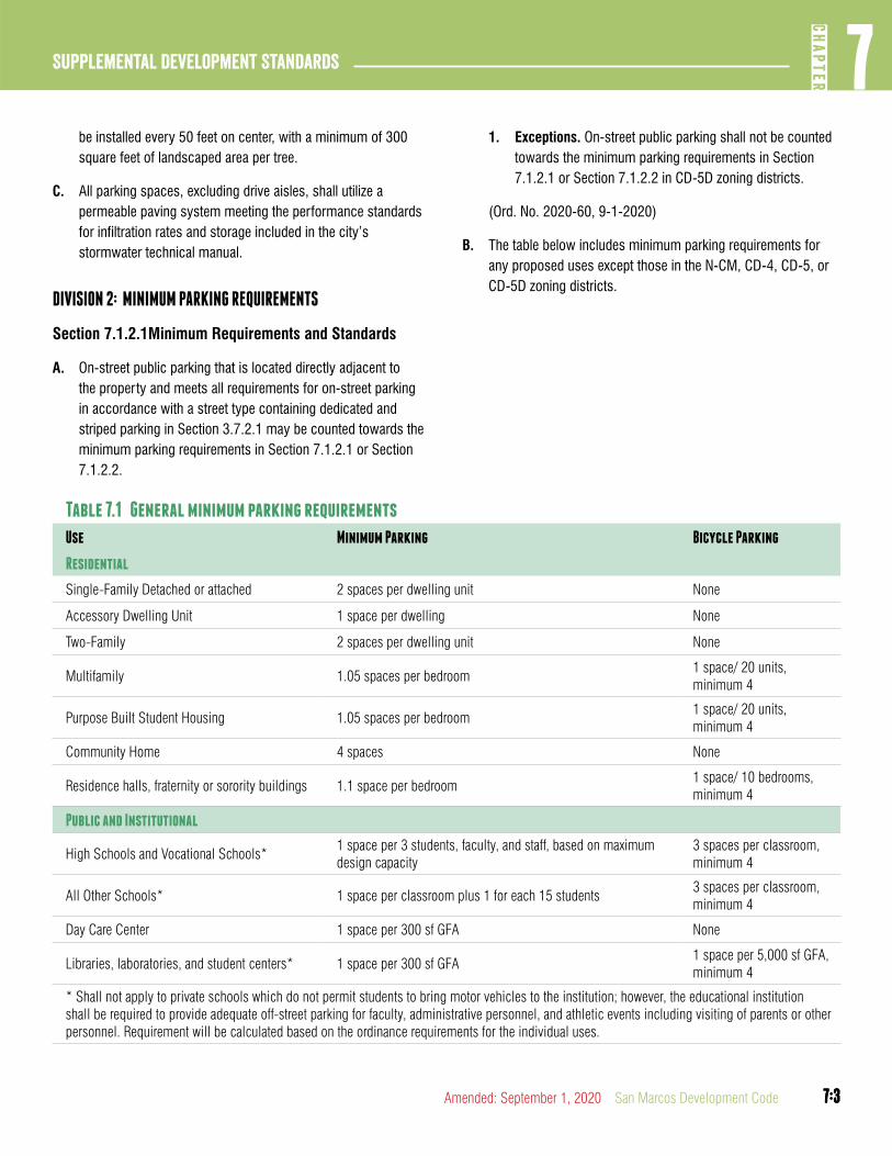
7:3
7CH
APTER
Supplemental Development Standards
7:3Amended: September 1, 2020 San Marcos Development Code
be installed every 50 feet on center, with a minimum of 300 square feet of landscaped area per tree.
C. All parking spaces, excluding drive aisles, shall utilize a permeable paving system meeting the performance standards for infiltration rates and storage included in the city’s stormwater technical manual.
DIVISION 2: MINIMUM PARKING REQUIREMENTS
Section 7.1.2.1Minimum Requirements and Standards
A. On-street public parking that is located directly adjacent to the property and meets all requirements for on-street parking in accordance with a street type containing dedicated and striped parking in Section 3.7.2.1 may be counted towards the minimum parking requirements in Section 7.1.2.1 or Section 7.1.2.2.
Table 7.1 General minimum parking requirements
Use Minimum Parking Bicycle Parking
Residential
Single-Family Detached or attached 2 spaces per dwelling unit None
Accessory Dwelling Unit 1 space per dwelling None
Two-Family 2 spaces per dwelling unit None
Multifamily 1.05 spaces per bedroom1 space/ 20 units, minimum 4
Purpose Built Student Housing 1.05 spaces per bedroom1 space/ 20 units, minimum 4
Community Home 4 spaces None
Residence halls, fraternity or sorority buildings 1.1 space per bedroom1 space/ 10 bedrooms, minimum 4
Public and Institutional
High Schools and Vocational Schools*1 space per 3 students, faculty, and staff, based on maximum design capacity
3 spaces per classroom, minimum 4
All Other Schools* 1 space per classroom plus 1 for each 15 students3 spaces per classroom, minimum 4
Day Care Center 1 space per 300 sf GFA None
Libraries, laboratories, and student centers* 1 space per 300 sf GFA1 space per 5,000 sf GFA, minimum 4
* Shall not apply to private schools which do not permit students to bring motor vehicles to the institution; however, the educational institution shall be required to provide adequate off-street parking for faculty, administrative personnel, and athletic events including visiting of parents or other personnel. Requirement will be calculated based on the ordinance requirements for the individual uses.
1. Exceptions. On-street public parking shall not be counted towards the minimum parking requirements in Section 7.1.2.1 or Section 7.1.2.2 in CD-5D zoning districts.
(Ord. No. 2020-60, 9-1-2020)
B. The table below includes minimum parking requirements for any proposed uses except those in the N-CM, CD-4, CD-5, or CD-5D zoning districts.
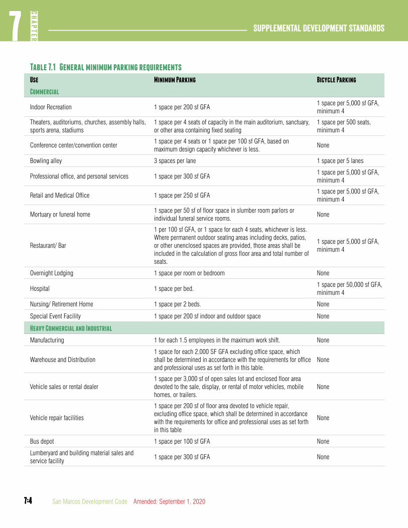
7:4
Supplemental Development Standards7
CHAP
TER
7:4 San Marcos Development Code Amended: September 1, 2020
Table 7.1 General minimum parking requirements
Use Minimum Parking Bicycle Parking
Commercial
Indoor Recreation 1 space per 200 sf GFA1 space per 5,000 sf GFA, minimum 4
Theaters, auditoriums, churches, assembly halls, sports arena, stadiums
1 space per 4 seats of capacity in the main auditorium, sanctuary, or other area containing fixed seating
1 space per 500 seats, minimum 4
Conference center/convention center1 space per 4 seats or 1 space per 100 sf GFA, based on maximum design capacity whichever is less.
None
Bowling alley 3 spaces per lane 1 space per 5 lanes
Professional office, and personal services 1 space per 300 sf GFA1 space per 5,000 sf GFA, minimum 4
Retail and Medical Office 1 space per 250 sf GFA1 space per 5,000 sf GFA, minimum 4
Mortuary or funeral home1 space per 50 sf of floor space in slumber room parlors or individual funeral service rooms.
None
Restaurant/ Bar
1 per 100 sf GFA, or 1 space for each 4 seats, whichever is less. Where permanent outdoor seating areas including decks, patios, or other unenclosed spaces are provided, those areas shall be included in the calculation of gross floor area and total number of seats.
1 space per 5,000 sf GFA, minimum 4
Overnight Lodging 1 space per room or bedroom None
Hospital 1 space per bed.1 space per 50,000 sf GFA, minimum 4
Nursing/ Retirement Home 1 space per 2 beds. None
Special Event Facility 1 space per 200 sf indoor and outdoor space None
Heavy Commercial and Industrial
Manufacturing 1 for each 1.5 employees in the maximum work shift. None
Warehouse and Distribution1 space for each 2,000 SF GFA excluding office space, which shall be determined in accordance with the requirements for office and professional uses as set forth in this table.
None
Vehicle sales or rental dealer1 space per 3,000 sf of open sales lot and enclosed floor area devoted to the sale, display, or rental of motor vehicles, mobile homes, or trailers.
None
Vehicle repair facilities
1 space per 200 sf of floor area devoted to vehicle repair, excluding office space, which shall be determined in accordance with the requirements for office and professional uses as set forth in this table
None
Bus depot 1 space per 100 sf GFA None
Lumberyard and building material sales and service facility
1 space per 300 sf GFA None
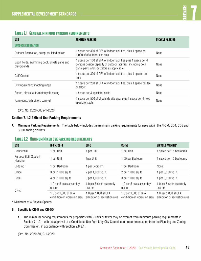
7:5
7CH
APTER
Supplemental Development Standards
7:5Amended: September 1, 2020 San Marcos Development Code
Table 7.1 General minimum parking requirements
Use Minimum Parking Bicycle Parking
Outdoor Recreation
Outdoor Recreation, except as listed below1 space per 300 sf GFA of indoor facilities, plus 1 space per 1,000 sf of outdoor use area
None
Sport fields, swimming pool, private parks and playgrounds
1 space per 100 sf GFA of indoor facilities plus 1 space per 4 persons design capacity of outdoor facilities, including both participants and spectators as applicable.
None
Golf Course1 space per 300 sf GFA of indoor facilities, plus 4 spaces per hole
None
Driving/archery/shooting range1 space per 200 sf GFA of indoor facilities, plus 1 space per tee or target
None
Rodeo, circus, auto/motorcycle racing 1 space per 3 spectator seats None
Fairground, exhibition, carnival1 space per 500 sf of outside site area, plus 1 space per 4 fixed spectator seats
None
(Ord. No. 2020-60, 9-1-2020)
Section 7.1.2.2Mixed Use Parking Requirements
A. Minimum Parking Requirements. The table below includes the minimum parking requirements for uses within the N-CM, CD4, CD5 and CD5D zoning districts.
Table 7.2 Minimum Mixed Use parking requirements
Use N-CM/CD-4 CD-5 CD-5D Bicycle Parking*
Residential 1 per Unit 1 per Unit 1 per Unit 1 space per 15 bedrooms
Purpose Built Student Housing
1 per Unit 1per Unit 1.05 per Bedroom 1 space per 15 bedrooms
Lodging 1 per Bedroom 1 per Bedroom 1 per Bedroom None
Office 3 per 1,000 sq. ft. 2 per 1,000 sq. ft. 2 per 1,000 sq. ft. 1 per 3,000 sq. ft.
Retail 4 per 1,000 sq. ft. 3 per 1,000 sq. ft. 3 per 1,000 sq. ft. 1 per 3,000 sq. ft.
Civic
1.0 per 5 seats assembly use or;
1.0 per 5 seats assembly use or;
1.0 per 5 seats assembly use or;
1.0 per 5 seats assembly use or;
1.0 per 1,000 sf GFAexhibition or recreation area
1.0 per 1,000 sf GFAexhibition or recreation area
1.0 per 1,000 sf GFAexhibition or recreation area
1.0 per 5,000 sf GFAexhibition or recreation area
* Minimum of 4 Bicycle Spaces
B. Specific to CD-5 and CD-5D
1. The minimum parking requirements for properties with 5 units or fewer may be exempt from minimum parking requirements in Section 7.1.2.1 with the approval of a Conditional Use Permit by City Council upon recommendation from the Planning and Zoning Commission, in accordance with Section 2.8.3.1.
(Ord. No. 2020-60, 9-1-2020)
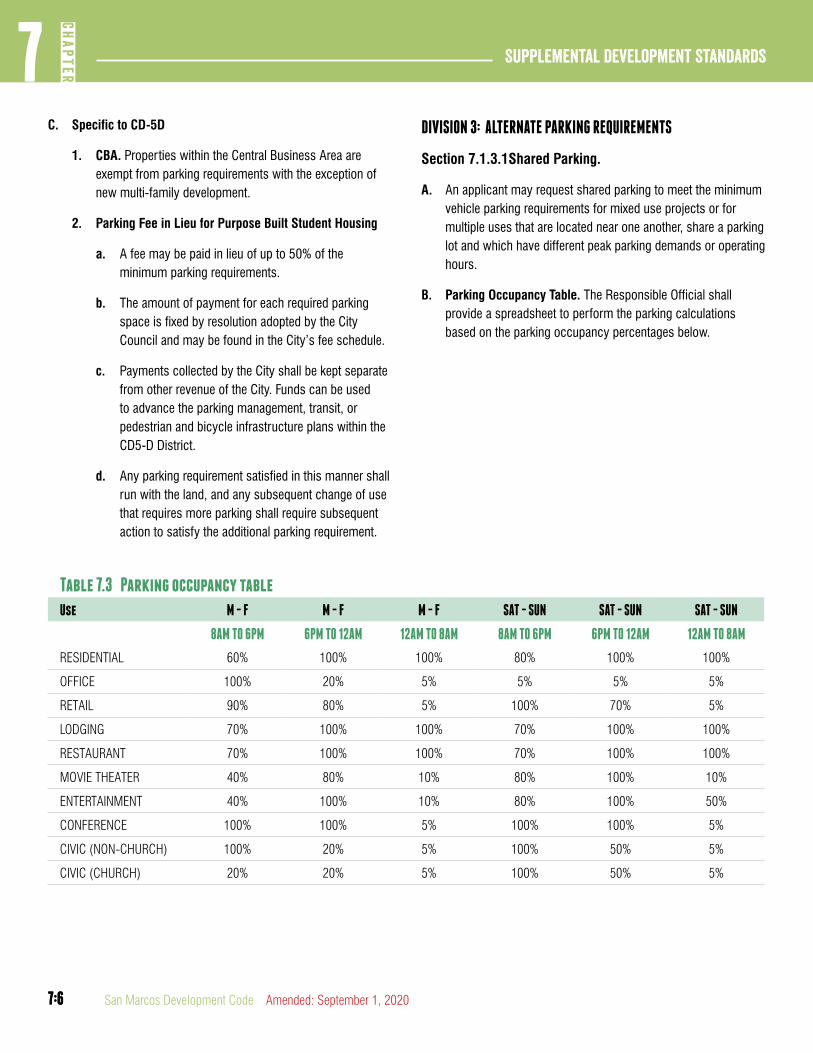
7:6
Supplemental Development Standards7
CHAP
TER
7:6 San Marcos Development Code Amended: September 1, 2020
C. Specific to CD-5D
1. CBA. Properties within the Central Business Area are exempt from parking requirements with the exception of new multi-family development.
2. Parking Fee in Lieu for Purpose Built Student Housing
a. A fee may be paid in lieu of up to 50% of the minimum parking requirements.
b. The amount of payment for each required parking space is fixed by resolution adopted by the City Council and may be found in the City’s fee schedule.
c. Payments collected by the City shall be kept separate from other revenue of the City. Funds can be used to advance the parking management, transit, or pedestrian and bicycle infrastructure plans within the CD5-D District.
d. Any parking requirement satisfied in this manner shall run with the land, and any subsequent change of use that requires more parking shall require subsequent action to satisfy the additional parking requirement.
DIVISION 3: ALTERNATE PARKING REQUIREMENTS
Section 7.1.3.1Shared Parking.
A. An applicant may request shared parking to meet the minimum vehicle parking requirements for mixed use projects or for multiple uses that are located near one another, share a parking lot and which have different peak parking demands or operating hours.
B. Parking Occupancy Table. The Responsible Official shall provide a spreadsheet to perform the parking calculations based on the parking occupancy percentages below.
Table 7.3 Parking occupancy table
Use M - F M - F M - F SAT - SUN SAT - SUN SAT - SUN
8AM TO 6PM 6PM TO 12AM 12AM TO 8AM 8AM TO 6PM 6PM TO 12AM 12AM TO 8AM
RESIDENTIAL 60% 100% 100% 80% 100% 100%
OFFICE 100% 20% 5% 5% 5% 5%
RETAIL 90% 80% 5% 100% 70% 5%
LODGING 70% 100% 100% 70% 100% 100%
RESTAURANT 70% 100% 100% 70% 100% 100%
MOVIE THEATER 40% 80% 10% 80% 100% 10%
ENTERTAINMENT 40% 100% 10% 80% 100% 50%
CONFERENCE 100% 100% 5% 100% 100% 5%
CIVIC (NON-CHURCH) 100% 20% 5% 100% 50% 5%
CIVIC (CHURCH) 20% 20% 5% 100% 50% 5%
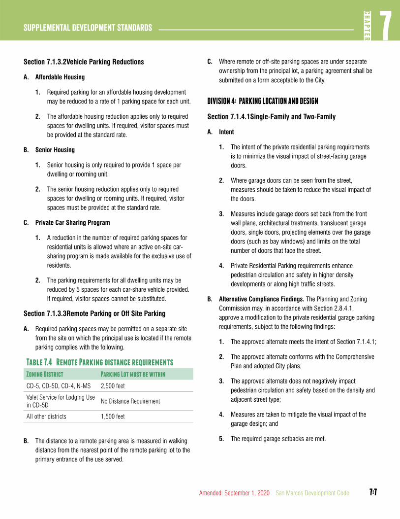
7:7
7CH
APTER
Supplemental Development Standards
7:7Amended: September 1, 2020 San Marcos Development Code
Section 7.1.3.2Vehicle Parking Reductions
A. Affordable Housing
1. Required parking for an affordable housing development may be reduced to a rate of 1 parking space for each unit.
2. The affordable housing reduction applies only to required spaces for dwelling units. If required, visitor spaces must be provided at the standard rate.
B. Senior Housing
1. Senior housing is only required to provide 1 space per dwelling or rooming unit.
2. The senior housing reduction applies only to required spaces for dwelling or rooming units. If required, visitor spaces must be provided at the standard rate.
C. Private Car Sharing Program
1. A reduction in the number of required parking spaces for residential units is allowed where an active on-site car-sharing program is made available for the exclusive use of residents.
2. The parking requirements for all dwelling units may be reduced by 5 spaces for each car-share vehicle provided. If required, visitor spaces cannot be substituted.
Section 7.1.3.3Remote Parking or Off Site Parking
A. Required parking spaces may be permitted on a separate site from the site on which the principal use is located if the remote parking complies with the following.
Table 7.4 Remote Parking distance requirements
Zoning District Parking Lot must be within
CD-5, CD-5D, CD-4, N-MS 2,500 feet
Valet Service for Lodging Use in CD-5D
No Distance Requirement
All other districts 1,500 feet
B. The distance to a remote parking area is measured in walking distance from the nearest point of the remote parking lot to the primary entrance of the use served.
C. Where remote or off-site parking spaces are under separate ownership from the principal lot, a parking agreement shall be submitted on a form acceptable to the City.
DIVISION 4: PARKING LOCATION AND DESIGN
Section 7.1.4.1Single-Family and Two-Family
A. Intent
1. The intent of the private residential parking requirements is to minimize the visual impact of street-facing garage doors.
2. Where garage doors can be seen from the street, measures should be taken to reduce the visual impact of the doors.
3. Measures include garage doors set back from the front wall plane, architectural treatments, translucent garage doors, single doors, projecting elements over the garage doors (such as bay windows) and limits on the total number of doors that face the street.
4. Private Residential Parking requirements enhance pedestrian circulation and safety in higher density developments or along high traffic streets.
B. Alternative Compliance Findings. The Planning and Zoning Commission may, in accordance with Section 2.8.4.1, approve a modification to the private residential garage parking requirements, subject to the following findings:
1. The approved alternate meets the intent of Section 7.1.4.1;
2. The approved alternate conforms with the Comprehensive Plan and adopted City plans;
3. The approved alternate does not negatively impact pedestrian circulation and safety based on the density and adjacent street type;
4. Measures are taken to mitigate the visual impact of the garage design; and
5. The required garage setbacks are met.
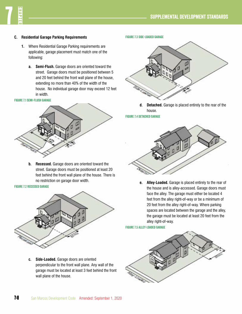
7:8
Supplemental Development Standards7
CHAP
TER
7:8 San Marcos Development Code Amended: September 1, 2020
C. Residential Garage Parking Requirements
1. Where Residential Garage Parking requirements are applicable, garage placement must match one of the following:
a. Semi-Flush. Garage doors are oriented toward the street. Garage doors must be positioned between 5 and 20 feet behind the front wall plane of the house, extending no more than 40% of the width of the house. No individual garage door may exceed 12 feet in width.
Figure 7.1 semi-flush garage
b. Recessed. Garage doors are oriented toward the street. Garage doors must be positioned at least 20 feet behind the front wall plane of the house. There is no restriction on garage door width.
Figure 7.2 Recessed Garage
c. Side-Loaded. Garage doors are oriented perpendicular to the front wall plane. Any wall of the garage must be located at least 3 feet behind the front wall plane of the house.
Figure 7.3 Side-Loaded Garage
d. Detached. Garage is placed entirely to the rear of the house.
Figure 7.4 Detached Garage
e. Alley-Loaded. Garage is placed entirely to the rear of the house and is alley-accessed. Garage doors must face the alley. The garage must either be located 4 feet from the alley right-of-way or be a minimum of 20 feet from the alley right-of-way. Where parking spaces are located between the garage and the alley, the garage must be located at least 20 feet from the alley right-of-way.
Figure 7.5 alley-Loaded Garage

7:9
7CH
APTER
Supplemental Development Standards
7:9Amended: September 1, 2020 San Marcos Development Code
D. Residential Surface Parking Requirements
1. Parking in the First Layer. Where parking is permitted in the first layer the following requirements must be met.
a. Parking in the first layer is allowed only on a hard-surfaced driveway constructed of:
1. Concrete;
2. Brick, pavers or other material approved by the responsible official;
3. Asphalt.
b. Combined parking and driveway area cannot constitute more than 40% of the front or corner yard.
c. Any parking in the first layer must be a minimum of 20 feet deep so that parked cars do not encroach on the sidewalk.
2. Tandem Parking. Tandem parking is two parking spaces where the spaces are arranged one behind the other such that the space nearest the street serves as the only access to the other space.
a. Tandem parking is allowed for single and two-family residential uses.
b. Two parking spaces in tandem must have a combined minimum dimension of 9 feet in width by 36 feet in length.
c. Both parking spaces in tandem must be assigned to the same dwelling unit except for an accessory dwelling unit.
Section 7.1.4.2Multi-Family and Non-Residential
A. Drive-thru Design and Queuing Spaces. Adequate space must be made available on-site for the stacking, storage and queuing of vehicles.
1. Vehicles using drive-thru facilities may not encroach on or interfere with the public use of streets and sidewalks by vehicles or pedestrians.
2. A restaurant with drive-thru facilities must provide at least 8 queuing spaces for vehicles when 1 drive-thru lane
exists and 6 spaces at each drive-thru when more than 1 lane exists.
3. A bank with drive-thru facilities must provide at least 3 queuing spaces per drive-thru lane.
B. Location
1. Required parking spaces must be located on the same lot they are intended to serve except where specifically allowed under Section 7.1.3.3.
2. All on-site parking must be arranged so that no vehicle is forced to back into a public street (other than an alley) or across a public sidewalk. All maneuvering shall be on-site.
3. When off-street parking facilities are located adjacent to a public alley, the width of the alley may be assumed to be a portion of the maneuvering space requirement.
C. Layout
1. Parking spaces and drive aisles must meet the required dimensional standards.
2. Up to 25% of the required parking spaces provided may be compact spaces. All compact parking spaces must be clearly and visibly striped and labeled for compact car use only.
D. Accessible Parking Spaces for Persons with Disabilities.
1. Off-Street parking spaces shall be reserved for the physically disabled in an amount not less than that required by the Americans with Disabilities Act requirements.
2. Each parking space reserved for the physically disabled shall conform to the identification requirements of the state department of licensing and regulation promulgated under State law and the design specifications enumerated in the Americans with Disabilities Act accessibility guidelines.
E. Paving of Parking Areas. All required or provided parking, including outdoor display areas for the sale or rental of vehicles, shall meet City standards and specifications for all-weather surfaces. Permeable paving systems meeting the performance standards in the city’s stormwater technical

7:10
Supplemental Development Standards7
CHAP
TER
7:10 San Marcos Development Code Amended: September 1, 2020
manual are encouraged and can be utilized to offset the site’s overall impervious cover percentage.
F. Pavement Markings. Parking lanes in parking lots must be clearly marked by paint, buttons, or other approved material, except that areas used solely for display of vehicles for sale or rental are not required to have marked parking lanes.
G. Dead Ends and Turnaround Space. No parking lot or parking area shall be designed or constructed which ends in a dead end unless turnaround space of at least nine feet in depth is provided.
H. Drainage. Parking lots shall be designed to drain to interior and perimeter landscaping islands.
I. Off-Street Parking Dimensional Table. The following tables stipulate the required parking space and parking aisle dimensions for off-street parking lots.
Table 7.5 STANDARD VEHICLE PARKING SPACES - DIMENSIONAL STANDARDS
Parking Angle (degrees)
X Stall Width (feet)
A Aisle Length Per Stall (feet)
BDepth of Stall Perpendicular to Aisle (feet)
CAisle Width (feet) D
One-Way Two-Way
0 parallel 8.0 23.0 8.0 12.0 24.0
30 9.0 18.0 16.8 11.0 22.0
45 9.0 12.7 19.1 13.0 22.0
60 9.0 10.4 20.1 18.0 23.0
90 9.0 9.0 18.0 24.0 24.0
Table 7.6 Compact VEHICLE PARKING SPACES - DIMENSIONAL STANDARDS
Parking Angle (degrees)
X Stall Width (feet)
A Aisle Length Per Stall (feet)
BDepth of Stall Perpendicular to Aisle (feet)
CAisle Width (feet) D
One-Way Two-Way
0 parallel 7.5 20.0 7.5 11.0 20.0
30 7.5 15.0 14.0 10.0 20.0
45 7.5 10.6 15.9 12.0 20.0
60 7.5 8.7 16.7 15.0 20.0
90 7.5 7.5 15.0 20.0 20.0
DA
B
C
X
Figure 7.6 parking space and parking aisle dimensions

7:11
7CH
APTER
Supplemental Development Standards
7:11Amended: September 1, 2020 San Marcos Development Code
Section 7.1.4.3Parking Lot Landscaping
A. Applicability. Parking lot landscaping is required for all off street vehicle parking areas with more than 20 spaces except in the CD5 or CD5D zoning districts. Multiple platted lots contained on a single site plan and any separate parking areas connected with drive aisles are considered a single parking area.
B. Parking lot landscaping shall be consistent with the species type and installation requirements in Sections 7.2.4.1, 7.2.4.2, and Appendix D of the San Marcos Design Manual.
C. Interior Islands
1. A landscaped interior island must be provided every 10 parking spaces. Interior islands must be distributed evenly throughout the parking area.
2. An interior island abutting a single row of parking spaces must be a minimum of 9 feet in width and 150 square feet in area. Each island must include one shade tree.
3. An interior island abutting a double row of parking spaces must be a minimum of 9 feet in width and 300 square feet in area. Each island must include 2 shade trees.
4. All rows of parking must terminate with a landscaped interior terminal island. No more than 30 parking spaces may be located between terminal islands.
Figure 7.7 Parking Lot Landscaping
DA
B
C
X
Figure 7.6 parking space and parking aisle dimensions 5. Interior islands may be consolidated or intervals may be expanded in order to preserve existing trees.
6. Interior islands must be installed below the level of the parking lot surface to allow for runoff capture and be designed to infiltrate runoff water within 24 hours.
(Ord. No. 2019-45, 12-17-19)
D. Median Islands
1. A landscape median island must be provided between every 6 rows of parking. Intervals may be expanded in order to preserve existing trees.
2. A landscape median island may serve as the location for a required pedestrian walkway in accordance with Section 3.6.4.2B.
3. A landscape median island without pedestrian walkway must be a minimum of 6 feet wide. A landscape median island with a pedestrian walkway must be a minimum of 9 feet wide.
4. Median islands may be consolidated or intervals may be expanded in order to preserve existing trees.
5. The portion of the median island not containing the pedestrian walkway must be installed below the level of the parking lot surface to allow for runoff capture, except for access to the landscape median from the parking area.

7:12
Supplemental Development Standards7
CHAP
TER
7:12 San Marcos Development Code Amended: September 1, 2020
3. Landscape Strip with Fence or Wall. A minimum 4-foot wide landscape strip with a 3-foot high fence or wall.
Figure 7.10 Landscape strip with a fence or wall
4. Landscape Strip with Grade Change. A 6-foot landscape strip with a minimum 3-foot grade drop from the public street to the parking area planted with a continuous row of shrubs.
Figure 7.11 Landscape Strip with Grade Change
Section 7.1.4.4Parking Lot Screening
A. Applicability. All off-street vehicle parking areas (of any size) abutting a public street (not including an alley) must be screened as specified below.
B. Parking lot screening shall be consistent with the species type and installation requirements in Sections 7.2.4.1, 7.2.4.2, and Appendix D of the San Marcos Design Manual.
C. Location. A required landscape strip must be located at the outer perimeter of the parking area and must be provided along the entire parking area abutting the street, excluding breaks for pedestrians, bicycles and driveways.
1. Landscape Strip with Shrubs. A minimum 10-foot wide landscape strip planted with 3-foot high continuous row of shrubs.
Figure 7.8 Landscaping strip with shrubs
2. Landscape Strip with Berm. A berm a minimum of 3 feet higher than the finished elevation of the parking area.
Figure 7.9 Landscaping strip with berm

7:13
7CH
APTER
Supplemental Development Standards
7:13Amended: September 1, 2020 San Marcos Development Code
article 2: Landscaping and Screening
DIVISION 1: GENERAL LANDSCAPING REQUIREMENTS
Section 7.2.1.1Intent
The intent of the landscaping and buffer yard regulations are to:
A. Promote attractive development and preserve or enhance the appearance and character of the surrounding area through the use of landscaping.
B. Promote native and/or adapted, drought-tolerant species to conserve water and promote local biodiversity.
C. Enhance stormwater management systems on the site.
D. Eliminate or minimize conflicts between potentially incompatible but otherwise permitted land uses on adjoining lots through buffering, which may include a combination of setbacks and visual buffers or barriers.
E. Prescribe standards for the development and maintenance of plantings, fences, and walls.
F. Ensure safe vehicular and pedestrian circulation to the building and on-site when landscaping and buffering is implemented.
Section 7.2.1.2Applicability
A. General
1. No Final Certificate of Occupancy shall be issued until landscaping has been provided in accordance with the requirements of this Development Code.
2. In instances where plantings cannot be completed prior to temporary building occupancy due to drought, weather or other conditions refer to Section 2.7.1.7.
B. New Development or Redevelopment. Any new development or redevelopment of land must fully comply with the standards and regulations of this section.
C. Renovations and Repairs. A building or site may be renovated or repaired without providing additional landscaping provided there is no increase in gross floor area or improved site area.
D. Additions and Increases in Gross Floor Area
1. When a building or site is increased in gross floor area or improved site area by up to 25%, landscaping is required for the additional floor or site area only.
2. When the gross floor area or improved site area is increased by more than 25%, both the existing use and the additional floor or site area must conform to the landscaping requirements of this LDC.
E. Change in Use. A change in use does not trigger application of this section except when there is a specific use standard requiring landscaping for the new use.
F. Landscaping and screening installed under the requirements of this article shall be consistent with the species type and installation requirements in Sections 7.2.4.1, 7.2.4.2, and Appendix D of the San Marcos Design Manual.
Section 7.2.1.3Administrative Adjustment
The Planning Director, in accordance with Section 2.8.5.1, may approve a request for administrative adjustment subject to the following findings:
A. The approved administrative alternate meets the intent of the landscaping and screening regulations;
B. The approved administrative alternate conforms with the Comprehensive Plan and adopted City plans; and
C. The approved administrative alternate is considered equal to or better than the standard.
DIVISION 2: TRANSITIONAL PROTECTIVE YARDS
Section 7.2.2.1Intent
A transitional protective yard is intended to minimize conflicts between potentially incompatible, but otherwise permitted land uses on abutting property. A transitional protective yard may be located within a required setback.

7:14
Supplemental Development Standards7
CHAP
TER
7:14 San Marcos Development Code Amended: September 1, 2020
Section 7.2.2.2Applicability
Transitional protective yards shall be required for all new development along interior side lot lines and rear lot lines. A required transitional protective yard is required as specified in the Transitional Protective Yard table below.
(Ord. No. 2019-45, 12-17-19)
Transitional Protective Yard Table
Existing Abutting District
Proposed District FD AR SF
-R
SF-1
1
SF-6
SF-4
.5
HC LI HI MH
EC CD-1
CD-2
CD-3
CD-4
CD-5
CD-5
D
ND-3
ND-3
.5
ND-4
N-M
S
FD -- -- -- -- -- -- -- -- -- -- -- -- -- -- -- -- -- -- -- -- --
AR -- -- -- -- -- -- -- -- -- -- -- -- -- -- -- -- -- -- -- -- --
SF-R -- -- -- -- -- -- -- -- -- -- -- -- -- -- -- -- -- -- -- -- --
SF-11 -- -- -- -- -- -- -- -- -- -- -- -- -- -- -- -- -- -- -- -- --
SF-6 -- -- -- -- -- -- -- -- -- -- -- -- -- -- -- -- -- -- -- -- --
SF-4.5 -- -- -- -- -- -- -- -- -- -- -- -- -- -- -- -- -- -- -- -- --
HC C/D C/D C/D C/D C/D C/D -- -- -- C/D C/D C/D C/D C/D C/D C/D C/D C/D C/D C/D C/D
LI C/D C/D C/D C/D C/D C/D -- -- -- C/D C/D C/D C/D C/D C/D C/D C/D C/D C/D C/D C/D
HI C/D C/D C/D C/D C/D C/D -- -- -- C/D C/D C/D C/D C/D C/D C/D C/D C/D C/D C/D C/D
MH C/D C/D C/D C/D C/D C/D -- -- -- -- C/D C/D C/D C/D C/D C/D C/D C/D C/D C/D C/D
EC C/D C/D C/D C/D C/D C/D -- -- -- C/D -- C/D C/DA/BC/D
A/BC/D
-- -- C/DA/BC/D
A/BC/D
--
CD-1 -- -- -- -- -- -- -- -- -- -- -- -- -- -- -- -- -- -- -- -- --
CD-2 -- -- -- -- -- -- -- -- -- -- -- -- -- -- -- -- -- -- -- -- --
CD-3 -- -- -- -- -- -- -- -- -- -- -- -- -- -- -- -- -- -- -- -- --
CD-4A/BC/D
A/BC/D
A/BC/D
A/BC/D
A/BC/D
A/BC/D
-- -- -- -- -- -- -- -- -- -- --A/BC/D
-- -- --
CD-5 C/D C/D C/D C/D C/D C/D -- -- -- -- -- -- -- -- -- -- -- C/DA/BC/D
A/BC/D
--
CD-5D C/D C/D C/D C/D C/D C/D -- -- -- -- -- -- -- -- -- -- -- C/DA/BC/D
A/BC/D
--
ND-3 -- -- -- -- -- -- -- -- -- -- -- -- -- -- -- -- -- -- -- -- --
ND-3.5A/BC/D
A/BC/D
A/BC/D
A/BC/D
A/BC/D
-- -- -- -- -- -- -- -- -- -- -- -- -- -- -- --
ND-4A/BC/D
A/BC/D
A/BC/D
A/BC/D
A/BC/D
-- -- -- -- -- -- -- -- -- -- -- --A/BC/D
-- -- --
N-MSA/BC/D
A/BC/D
A/BC/D
A/BC/D
A/BC/D
-- -- -- -- -- -- -- -- -- -- -- -- C/DA/BC/D
-- --
Key: A/B/C/D = Buffer A,B,C or D required, choice of A, B,C or D at applicant’s discretion C/D = Buffer C or D Required, choice of C or D at applicant’s discretion

7:15
7CH
APTER
Supplemental Development Standards
7:15Amended: September 1, 2020 San Marcos Development Code
Section 7.2.2.3Use Protective Yard.
A use protective yard may also be required along perimeter lot lines for specific uses in accordance with Chapter 5.
Section 7.2.2.4Protective Yard Installation Requirements
A. The tables below prescribe the minimum width, screening, and landscaping requirements for each protective yard type.
Figure 7.12 Type a and B Protective Yards
Table 7.7 Type A and B Protective Yard standardsType A Type B
Depth (min) 6 ft. 10 ft.
Fence Height (min) Not Allowed 6 ft.
Wall Height (min) 6 ft. Not Required
Shade Trees (min per 100 ft.) -- 4
Understory Trees (min per 100 ft.) 4 4
Shrubs (min per 100 ft.) -- --
Figure 7.13 Type C and D Protective Yards
Table 7.8 Type C and D Protective Yard Standards
Type C Type D
Depth (min) 20 ft. 35 ft.
Fence Height (min) Not Allowed 6 ft.
Table 7.8 Type C and D Protective Yard Standards
Type C Type D
Wall Height (min) 6 ft. Not Required
Shade Trees (min per 100 ft.) 4 6
Understory Trees (min per 100 ft.) 4 6
Shrubs (min per 100 ft.) 40 60
B. Location
1. A required protective yard must be located within the outer perimeter of the lot, parallel to and extending to the property boundary line. A required protective yard must be provided along the entire frontage immediately abutting the property line. Landscaping must be planted on the inside of the required protective yard.
Figure 7.14 Location of Protective Yard
2. A required protective yard may not be located within any portion of an existing, dedicated or reserved public right-of-way.
3. Breaks for pedestrian, bicycle, and vehicle access are allowed. Driveways or walkways must cross a protective yard at as near a perpendicular angle as practical.
4. The width of a required protective yard is calculated on the average width per 100 feet or portion of protective yard. The minimum width of the protective yard at any one point cannot be less than one-half the required width of the protective yard.
(Ord. No. 2019-45, 12-17-19)

7:16
Supplemental Development Standards7
CHAP
TER
7:16 San Marcos Development Code Amended: September 1, 2020
C. Encroachments
1. The parking of vehicles and the placement of buildings or structures except for walls, fences, and landscaping is not allowed in a required protective yard.
2. Low impact development and other similar stormwater management features are permitted in a required protective yard.
D. Grade Change. In lieu of a required wall or fence, a natural or man-made grade separation of a least 6 feet in elevation may be provided.
Figure 7.15 Grade Changes in protective yards
1. The developing property must be located at an elevation lower than the property to be screened.
2. The stabilized side slopes of the grade change may be no greater than 3:1.
E. Alternative Compliance. The Planning and Zoning commission in accordance with Section 2.8.4.1 may modify the protective yard requirements. The Planning and Zoning Commission must consider the following criteria in determining the appropriateness of alternative compliance:
1. The approved alternate meets the intent of the protective yard regulations;
2. For topographic reasons, a fence or wall or other required screening device will not screen activities from an abutting property as required by this Division;.
3. The approved alternate conforms with the Comprehensive Plan and adopted City plans; and
4. The existing topography or vegetation achieve the purpose and intent of this Division.
DIVISION 3: INTERIOR LOT LANDSCAPING
Section 7.2.3.1Required Landscape Area
A. Applicability. Required landscape area applies to special districts and legacy districts as identified in Section 4.1.2.7 and Section 4.1.2.8.
B. Landscape Area. Landscape area shall mean the area (greater than one foot in width) within the boundary of a lot or parcel that is comprised of pervious surface integrated with living plant material, including but not limited to trees, shrubs, flowers, grass, or other ground cover or native vegetation. For the purposes of meeting the requirements of this Article, undeveloped portions of the site cannot be considered landscaped area.
C. Establishment of Minimum Percentages. A minimum percentage of the total lot area shall be devoted to landscape in accordance with the following schedule.
Table 7.9 Required Landscaping
Land Use Landscape Area
Townhouses 20%
Small Multi-Family 20%
Multi-Family 20%
Courtyard Housing 20%
Purpose-Built Student Housing 20%
Office and Professional Uses 15%
Retail and Commercial 10%
Industrial or Manufacturing 10%
1. Plantings shall consist of a minimum of one tree and three five-gallon shrubs for every 1,000 square feet of the required minimum landscaping area to be planted or retained internal to the project.
2. Landscaping and vegetation installed as part of any of the following requirements may be counted towards the landscaping requirements:
a. Stormwater management feature;

7:17
7CH
APTER
Supplemental Development Standards
7:17Amended: September 1, 2020 San Marcos Development Code
b. Streetscape requirement; or
c. Protective yard.
Section 7.2.3.2Minimum Landscaping for Single-Family and Duplex Lots.
A. Applicability. Minimum landscaping requirements for single family and duplex lots apply to the following building types:
1. House;
2. Cottage;
3. Zero Lot Line House;
4. Duplex; and
5. Cottage Court (may be placed in the shared courtyard area)
B. Minimum Standards. Landscaping on single family and duplex lots may be planted on the property, in the streetscape, or a common area associated with the lot. The following landscaping requirements apply per building.
1. Two shade trees that are a minimum of two inches in caliper and six feet in height at the time of planting;
2. Additional landscaping for single-family or duplex units shall be required and shall consist of at least three out of the following four options:
a. Two understory trees, equal to at least six feet in height at the time of planting;
b. Four large evergreen shrubs, equal in size to at least a five-gallon container size shrub;
c. Eight small shrubs, equal in size to at least a three-gallon container size shrub; and
d. Solid ground cover or lawn.
C. Xeriscape Options. Homebuilders and/or developers subdividing lots and/or constructing new single-family residential homes shall offer a xeriscape option in any series of landscaping options offered to prospective home buyers.
D. Model Homes. Homebuilders and/or developers who construct one or more model homes for a designated subdivision shall
have at least one model home per subdivision landscaped according to a xeriscape design.
DIVISION 4: INSTALLATION AND MAINTENANCE
Section 7.2.4.1Installation
A. All landscape materials shall be selected and installed according to:
1. ANSI Z60.1 American Standard for Nursery Stock, most current edition;
2. ANSI A 300 –Standard Practices for Tree, Shrub and other Woody Plant Maintenance, most current edition and parts; and
3. The City of San Marcos preferred plant list.
B. Shade Trees. Shade Trees planted for credit under Section 7.2.1.1 or Section 6.4.1.1 must be a native or locally adapted species included on the preferred plant list with an expected mature height of 35 feet or greater and an expected mature crown spread of at least 30 feet or greater unless subject to an overhead power line in which case the mature height may be less.
1. All shade trees planted must have a minimum caliper of 2.5 inches measured at 6 inches from the root collar, with a minimum container size of 45 gallons and be at least 9.5 feet on slower growing trees to a maximum of 16 feet tall at time of planting.
C. Understory Trees
1. Understory trees planted to meet the landscaping requirements must be a locally adapted species with an expected mature height of at least 8 feet and an expected mature crown spread of at least 8 feet.
2. Single-stem understory trees planted to meet the landscaping requirements must have a minimum caliper of 2 inches measured from the root collar, with a minimum container size of 20 gallons and be at least 6 feet tall at time of planting.
3. Multi-stem understory trees planted to meet the landscaping requirements must be at least 6 feet tall at time of planting with a minimum container size of 20 gallons.

7:18
Supplemental Development Standards7
CHAP
TER
7:18 San Marcos Development Code Amended: September 1, 2020
1. All required landscaping areas shall be 100% irrigated by one of, or a combination of, the following methods:
a. An automatic underground irrigation system with a rain sensor and freeze sensor;
b. A drip irrigation system;
c. A hose attachment within 100 feet of all plant material, provided, however, that a hose attachment within 200 feet of all plant material in non-street yards shall be sufficient;
d. Rain water catchment system; or
e. Type 1 or 2 non-potable water.
2. All irrigation systems shall be designed and sealed in accordance with the Texas Licensed Irrigators Act and shall be professionally installed.
3. No irrigation shall be required for undisturbed natural areas or undisturbed existing trees.
L. Construction Phase.
1. The permanent vegetation should be installed on the construction site as soon as utilities are in place and final grades are achieved. Final grading and removal of vegetation shall not occur more than 30 days prior to scheduled paving.
2. Landscaping should be mulched to a depth of 2-4” and devoid of weeds and trash. Newly planted trees shall be mulched in a 4 foot radius or 8 foot diameter. The mulch will be kept 6 to 8 inches away from the tree trunk.
M. Removal of Diseased or Dangerous Trees and Vegetation.
1. A property owner may be required to treat or remove trees suffering from transmittable diseases or pests or allow the City to do so, charging the actual cost thereof to the property owner.
2. The Responsible Official may require the removal of a tree or part of a tree or any other vegetation that is within or overhanging a public right-of-way or easement if the tree or vegetation:
a. Is diseased or infested and in danger of falling;
D. Shrubs, vines and ground cover. Shrubs must be, at a minimum, a one-gallon container size at the time of planting.
E. Grass. Grass areas are encouraged to be planted in species normally grown as permanent lawns in the City, including Zoysia, Bermuda, combination of Buffalo Grass, Blue Grama, and Curly Mesquite (Habiturf) or other drought-tolerant grass.
1. Grass areas may be sodded, plugged, sprigged or seeded, except that solid sod shall be used in swales, other areas subject to erosion, or as required in a Watershed Protection Plan.
2. In new residential developments, developers and homebuilders are encouraged to offer low-water use landscape alternatives, such as Zoysia, Habiturf or buffalo grass.
F. Soils. New landscaped areas should be prepared so as to achieve a soil depth of at least six 6 inches for turf, 12 to 18 inches for perennials and shrubs, and 18-24 inches for trees. The six-inch soil depth should consist of 75% soil blended with 25% compost.
G. Architectural planters. The use of architectural planters may be permitted in fulfillment of landscape requirements.
H. Turf areas. Except in residential developments, turf areas should be limited to a maximum of 25% of the total required landscaped area.
I. Xeriscape materials. Developers and homebuilders are encouraged to plant native, adapted, and non-invasive xeriscape plants and trees in addition to using other materials to promote use of water-wise landscaping such as mulch and compost.
J. Other
1. Any approved decorative aggregate or pervious brick pavers shall qualify for landscaping credit if contained in planting areas, but no credit shall be given for concrete or other impervious surfaces.
2. Pursuant to TAC 202.007, property/home owners associations shall not restrict or prohibit turf or landscaping materials that promote water conservation.
K. Landscape irrigation.

7:19
7CH
APTER
Supplemental Development Standards
7:19Amended: September 1, 2020 San Marcos Development Code
b. Is creating a traffic hazard or sight distance hazard for traffic on a public street; or
c. Is interfering with safe and proper maintenance of the right-of-way or easement.
Section 7.2.4.2Maintenance
A. The owner of the building, or the manager or agent of the owner, shall be responsible for the maintenance of all landscape areas.
B. The areas shall be maintained so as to present a healthy, neat and orderly appearance at all times and shall be kept free of refuse and debris.
C. All planted areas shall be provided with a readily available water supply and watered sufficiently to ensure continuous healthy growth and development.
D. All trees shall be maintained in accordance with the ANSI A300 Pruning Standard and ANSI Z133.1 Safety Standards. It is encouraged that work is completed by a Certified Arborist licensed by the International Society of Arboriculture, bonded, and insured.
E. Maintenance shall include the replacement of all dead plant material needed to meet the requirements of this Article. Should a tree die or be removed for which credit has been obtained pursuant to this Land Development Code, trees sufficient to equal the area credited shall be required. A smaller tree that will have a mature crown similar to the tree removed may be substituted if the planting area or pervious cover provided for the larger tree is retained.
DIVISION 5: SCREENING
Section 7.2.5.1Service Areas
A. Trash and recycling collection and other similar service areas must be located to the side or rear of buildings. Trash and recycling collection areas must be located as far away from residential structures on neighboring properties as practical.
B. Service areas must be screened on 3 sides by a wall that matches the color and material of the building facade and is a minimum 6 feet in height. Service areas must be screened on
the 4th side by a solid gate at a minimum of 6 feet in height. The gate is optional when the dumpsters are facing an alley.
Figure 7.16 Service aRea Screening
C. The gate and wall must be maintained in good working order and must remain closed except when trash pick-ups occur.
Section 7.2.5.2Utilities
A. Roof Mounted Utility Screening
1. Roof-mounted equipment must be set back at least 10 feet from the edge of the roof and screened from ground level view from abutting property or abutting public street (not including an alley).
2. New buildings must provide a parapet wall or other architectural element that is compatible with the principal building in terms of texture, quality, material and color that fully screens roof mounted equipment from ground level view.
Figure 7.17 Roof Mounted Utility Screening
3. For buildings with no or low parapet walls, roof mounted equipment must be screened on all sides by an opaque screen compatible with the principal building in terms of texture, quality, material and color.

7:20
Supplemental Development Standards7
CHAP
TER
7:20 San Marcos Development Code Amended: September 1, 2020
greater than 50% of their original size shall be screened for their entire length as set forth in Section 7.2.5.3.
2. When amenity features are provided as set forth in Section 7.2.4.1.B, no screening of the stormwater control facility is required.
B. Amenity Provisions. Permanent stormwater retention ponds and detention basins may be supplemented with certain features which enable the facility to function as an amenity in addition to its primary function as a stormwater device. In situations where amenity features are provided consistent with these provisions, no screening of the stormwater control facility from on-site or off-site views shall be required.
C. Basic Amenity Features. To qualify as an amenity, the following basic amenity features must be provided within any stormwater control facility.
1. Integration of the permanent stormwater retention pond or detention basin into the design of public areas within the site or development through the use of appropriate placement, common building materials, textures, features or other treatments intended to lend architectural significance to the stormwater control facility. For the purposes of this section, “integration” shall mean at least two of the following 3 elements:
a. Proximate placement of the stormwater facility to the principal structure;
b. Provision of pedestrian access to the facility through installation of a delineated walk or trail from the principal structure; or
c. Utilization of similar planting materials and building materials as used in the principal structure.
DIVISION 6: WALLS AND FENCES
Section 7.2.6.1Applicability
The following requirements apply to walls and fences located out-side of a protective yard or required screening area.
B. Wall-Mounted Equipment
1. Wall-mounted equipment located on any surface that is visible from a public street (not including an alley) must be fully screened by landscaping or an opaque wall or fence that is compatible with the principal building in terms of texture, quality, material and color.
Figure 7.18 Wall-Mounted Utility Screening
2. Screening must be of a height equal to or greater than the height of the mechanical equipment being screened.
C. Ground-Mounted Equipment
1. Ground-mounted mechanical equipment that is visible from a public street (not including an alley) must be fully screened by landscaping or an opaque wall or fence that is compatible with the principal building in terms of texture, quality, material and color.
Figure 7.19 Ground-Mounted Utility Screening
2. Screening must be of a height equal to or greater than the height of the mechanical equipment being screened.
Section 7.2.5.3Stormwater Facilities
A. Applicability
1. All stormwater retention ponds and detention basins permitted, constructed or modified to a cumulative extent

7:21
7CH
APTER
Supplemental Development Standards
7:21Amended: September 1, 2020 San Marcos Development Code
Section 7.2.6.2General Requirements
A. Permit Required. No fence or wall shall be erected or constructed without a permit first having been issued by the Responsible Official.
B. Gates for Vehicular Access. Gates designed for vehicular access shall be set back from the property line a minimum of 25 feet except where access is provided to a structured parking garage.
C. Public Easements. Fences and walls crossing a public Easement shall have a gate or removable panel to allow for maintenance access to such easement. No fence within a public utility easement shall be allowed to run parallel with the easement.
D. Fences within Drainage Easements. Fences within a Drainage Easement shall be constructed in a manner to not restrict the flow of Drainage water.
E. Materials.
1. Fences may be built of wood, metal, or other materials used in private fence construction.
2. Chain link may be permitted in the rear yard. Where it can be documented that the use of chain link in the front yard is an established standard for the particular neighborhood, the responsible official may approve its use for a new fence.
3. Above-ground electrical fencing (does not include underground “virtual fencing”, which is allowed), and barbed wire fencing is prohibited as perimeter fencing except on parcels or lots of one acre or greater in size in the Future Development (FD) district, Agricultural Ranch (AR) district, Rural Residential (SF-R) district, Character District 1 (CD-1), and Character District 2 (CD-2).
4. Barbed wire, razor wire or similar security fencing features are prohibited except in a Heavy Industrial District or where:
a. The Responsible Official considers the desired fence to protect the interests of adjacent property owners and the community at large.
5. Other materials may be approved for use by the responsible official if the material is proven to be sturdy, durable, decorative and relatively maintenance-free.

7:22
Supplemental Development Standards7
CHAP
TER
7:22 San Marcos Development Code Amended: September 1, 2020
F. Height
1. A wall or fence may not exceed 6 feet in height except that a maximum of 8 feet may be permitted where:
a. A joint fencing application is made with the signature of both adjacent property owners; and
b. The Responsible Official considers the desired fence to protect the interests of adjacent property owners and the community at large.
G. Fences and Walls Adjacent to a Street, Park or Greenway
1. A fence or wall located within the first layer along a primary frontage shall be 48 inches or less in height and 50% open.
2. A fence or wall located within 20 feet from the curb a secondary frontage shall be 48 inches or less in height and 50% open.
3. A fence or wall adjacent to a public park or greenway shall be 6 feet or less in height and 50% open.
(Ord. No. 2019-45, 12-17-19)
Figure 7.20 Fence and wall Location standards
PRIN
CIPA
L FR
ON
TAG
E LA
YERS
3rd Layer
2nd Layer
1st Layer
1st Layer
2nd & 3rd
Layer
SECONDARY FRONTAGE LAYERS
PRIMARY FRONTAGE
SECON
DARY FRO
NTAGE
20 feet
Property Line
No ADU Parking
1 Additional Parking Space

7:23
7CH
APTER
Supplemental Development Standards
7:23Amended: September 1, 2020 San Marcos Development Code
Section 7.2.6.3On-Site Refuse and Recycling.
A. Applicability. This section shall apply to non residential and multi-family development.
B. Intent. The intent is to provide convenient access to dumpsters for residents to reduce littering and outside storage of refuse.
C. Standards.
1. Equal Amenities. Equal amenities shall be provided for trash and recycling.
2. Location for Multifamily. All multifamily developments shall provide both trash and recycling dumpsters located next to each other. Both shall be located within 500 feet of the entrance to each ground floor unit measured from the front entrance of the unit and along improved pedestrian paths. The Director may allow alternate facilities, such as chutes, provided that the request is determined to have met the intent of this Section.
3. Screening. All recycling and refuse enclosures shall be screened in accordance with Section 7.2.5.1.

7:24
Supplemental Development Standards7
CHAP
TER
7:24 San Marcos Development Code Amended: September 1, 2020
article 3: Sign Permits
DIVISION 1: GENERAL STANDARDS AND REQUIREMENTS
Section 7.3.1.1Purpose
The purpose of a sign permit is to authorize the display, erection, rebuilding, restructuring, expansion, relocation, or structural alteration of any on-premise or off-premise sign.
Section 7.3.1.2Applicability
A sign permit must be obtained within the city limits for on-premise and off-premise signs and for off-premise signs in the city’s extraterritorial jurisdiction.
Section 7.3.1.3Enforcement
In addition to all other applicable remedies, the City Attorney is authorized to institute appropriate action in courts of competent jurisdiction for civil remedies, including injunctive relief, to enforce this Article.
Section 7.3.1.4Exempted Signs
A. Exemptions. The following signs and activities do not require a sign permit:
1. Signs not visible from the nearest public street toward which they are oriented.
2. Temporary window displays consisting of merchandise or posters.
3. National, state or other governmental flags up to 60 square feet in area.
4. Balloons not exceeding 36 inches in greatest dimension.
5. Two on-premises directional signs up to four square feet in area and up to four feet in height may be used on each frontage. Directional signs may not contain the logo or any advertisement for the premises.
6. Unlighted letters, numbers or symbols up to 24 inches in height that form an architectural detail of a building.
7. Signs facing the interior of athletic stadiums or fields or facing the exterior of athletic stadiums or fields operated by nonprofit organizations or governmental entities.
8. Unlit signs up to 32 square feet in area, on the premises of a governmental, religious, educational or other noncommercial institution which function solely as community information signs.
9. Signs that are displayed on vehicles that are being operated or stored in the normal course of a business, such as signs indicating the name or the type of business, that are located on moving vans, delivery trucks, trailers and other commercial vehicles; but only if the primary purpose of such vehicles is not for the display of the signs thereon, and only if such vehicles are parked or stored in properly designated and paved parking spaces that are located in areas appropriate to their use as commercial or delivery vehicles, such as service areas or locations close to the business building(s) away from public traffic.
10. Signs displayed on a vehicle for the sole purpose of advertising the vehicle for sale, lease or hire.
11. Signs consisting of a plaque or historical marker commemorating a person, event, structure, or site.
12. Governmental signs.
13. Temporary signs customarily associated with a recognized national, state, local or religious holiday.
14. Signs on vending machines, gasoline pumps, drive-thru menu boards, and amusement equipment pertaining to the function of the facilities.
15. Signs carried by humans.
16. Signs displayed by aircraft in flight.
17. Unlighted attached signs up to 32 square feet in area on trailers or portable buildings containing an accessory use temporarily located on the premises, provided the signs pertain to the use of the trailer or portable building.
18. Temporary signs, except for banner signs over public rights-of-way.
19. Unlighted signs located on property used for agricultural purposes which pertain to the sale of agricultural products produced on the premises.
7:25
7CH
APTER
Supplemental Development Standards
7:25Amended: September 1, 2020 San Marcos Development Code
20. Unlighted signs or electric signs, other than CEVM signs, plugged into an existing electric outlet, in first or second story windows provided that the signs do not exceed 50 percent of the window’s size (window signs are included in the total on-premise attached sign calculation).
21. Change in the sign copy on an existing sign or the replacement of a non-structural panel or sign face within a fixed frame, other than changes that effect the status of off-premises signs or CEVM signs.
22. Painting, repainting, cleaning or other normal maintenance and repair of a sign not involving restructuring or a structural alteration.
23. Political signs less than 36 square feet in size and less than eight feet in height.
Section 7.3.1.5Prohibited Signs
A. Prohibited Signs. The following signs are prohibited:
1. Signs having any visible part that moves, swings or rotates.
2. Signs emitting odor, visible matter or audible sound.
3. Permanent portable signs (Non-permanent portable signs are regulated as temporary signs by Section 7.3.1.4 as applicable).
4. Inflatable signs and balloons greater than 36 inches in greatest dimension.
5. Pennants or streamers.
6. Signs attached to a mobile structure, such as a vehicle or trailer used as an on-premise or off-premise sign, primarily for the purpose of serving as a static display for the advertisement of the sale, storage, or distribution of a product or service.
7. Signs on benches in the public right-of-way.
8. Animated signs.
9. Signs on utility poles other than one placed by the utility provider to identify its equipment.
B. Signs on Utility Poles Prohibited. Without limitation to Section 7.3.1.5, it is unlawful for any person to attach to or cause to be attached to any utility pole within the city any advertisement, handbill, circular, poster or piece of paper.
In any prosecution charging a violation of this Section 7.3.1.5, it is presumed that the primary beneficiary of any advertise-ment, handbill, circular, poster or piece of paper attached to any public utility pole is the person who attached or caused the attachment to the pole. The term “primary beneficiary” means a person or legal entity that is intended to benefit from the advertisement, handbill, circular, poster or piece of paper.
The Responsible Official shall have the authority to remove any advertisement, handbill, circular, poster or piece of paper attached to any public utility pole within the City.
Section 7.3.1.6Location Restrictions
A. General. All signs are subject to the following general location restrictions:
1. No sign shall be maintained at any location where it may interfere with the view of or be confused with any traffic control sign or signal.
2. No sign shall be located on or project over public property, a street right-of-way, or a public utility easement, except governmental signs, subdivision identification signs, temporary banner signs and permitted signs in the CD-5 and CD-5D zoning districts.
3. All signs shall maintain a clearance of at least eight feet when located over a sidewalk and at least 12 feet when located over a driveway and shall extend no closer than 18 inches from the curb line of a thoroughfare, unless painted or mounted flat on the surface of an awning, canopy or marquee.
4. No sign, except a governmental sign shall be located within a sight triangle.
5. Only signs required in the interest of public safety may occupy a required off-street parking or loading space or obstruct any driveway or sidewalk.
6. New signs and signs being structurally altered shall maintain clearance from the public utility facilities, shall not substantially interfere with drainage and shall not be
7:26
Supplemental Development Standards7
CHAP
TER
7:26 San Marcos Development Code Amended: September 1, 2020
located in or above a utility or drainage easement. Signs shall maintain ten feet of vertical and horizontal clearance from all electrical lines.
7. Only governmental signs or temporary holiday signs may be located on the roof of any structure.
8. Lighting for signs shall not produce glare onto adjoining properties or in the eyes of motorists or pedestrians. Bare-bulb illumination is prohibited within 150 feet of any premises containing a residential use, and in other cases is limited to 25-watt bulbs at night and 33-watt bulbs during daylight hours.
9. Permanent signs on premises within a historic district shall be subject to the issuance of a certificate of appropriateness by the Historic Preservation Commission and subject to compliance with adopted sign criteria.
10. All freestanding signs shall be set back a minimum of five feet from all property lines.
B. CEVM Signs. CEVM signs are subject to the above location restrictions and additionally are prohibited within 350 feet of any residential zoned district, multifamily zoned districts, and any district zoned Neighborhood Commercial, Mixed Use, Historic, Parkland, the River Corridor, or the CBA Boundary. Measurement shall be made by straight line from the nearest boundary of the zoning district to the nearest point of the sign where the nearest point of the sign is determined by dropping a horizontal line from the nearest edge of the sign face to the ground.
Section 7.3.1.7Abandonment
A. Obsolete Sign Copy. When any sign contains information that is no longer current, the property owner shall remove the sign or the copy, cover the copy, or change the copy to current information within 30 days, except as otherwise provided in this Chapter.
B. Conformance. When an on-premises sign is nonconforming with respect to any provision of this Article and use of the premises ceases for a period of six months, the sign shall be brought into conformance by the property owner.
C. Leased Copy. When an off-premise sign has copy which is subject to a lease for a specified period and the lease is
purchased in advance, the copy may remain through the contract period if it is maintained in good condition.
Section 7.3.1.8Nonconforming Signs
A. Signs in Existence Prior to This Code. A sign existing on the effective date of this Development Code that violates this Article or any other ordinance, and a sign that comes under the jurisdiction of this Chapter due to the expansion of the City, is a legal nonconforming sign and may be continued, repaired and maintained in good condition, but may not be otherwise altered.
B. Voluntary Removal. Voluntary removal of a nonconforming sign for purposes other than maintenance shall terminate its status as a legal nonconforming sign. Replacing a sign cabinet is not considered maintenance.
C. Legal, Nonconforming Off-Premise Signs. An off-premise sign existing on July 24, 2003 that violates a spacing or location restriction in Section 7.3.3.3 Location and spacing restrictions and an existing off-premise sign that thereafter becomes in violation of a spacing or location restriction in Section 7.3.3.3 Location and spacing restrictions, is a legal nonconforming sign and may be continued, repaired and maintained in good condition, but may not be otherwise altered. A nonconforming off-premise sign shall have its legal nonconforming status terminated if the sign, or a substantial part of it, is blown down or otherwise destroyed, or dismantled for any purpose other than routine maintenance or for changing the letters, symbols, or other matter on the sign. For purposes of this Section 7.3.1.8), a sign is considered to have been destroyed only if the cost of repairing the sign is more than 50 percent of the cost of erecting a new sign of the same type, material, and dimensions at the same location.
(Ord. No. 2019-45, 12-17-19)
D. CEVM Signs in operation as of March 3, 2008. A CEVM sign in operation as of the above date shall be considered a legal nonconforming sign as to location, size and height restriction; however, said sign shall be subject to the operational standards of this Development Code as they exist or shall be amended in the future.
7:27
7CH
APTER
Supplemental Development Standards
7:27Amended: September 1, 2020 San Marcos Development Code
DIVISION 2: ADMINISTRATION
Section 7.3.2.1Permit
A. Required. It is unlawful to display, erect, rebuild, expand or relocate any sign without first filing an application and obtaining a sign permit, in accordance with this Section 2.7.3.1. Electrical permits are also required for electric signs, except those designed to be plugged into an existing electric outlet.
B. Common Sign Plan. A common sign plan may be approved in accordance with Section 2.7.2.1
Section 7.3.2.2Contractor’s License
A. Generally. Electric signs and all permanent signs involving structural requirements of the building code (as adopted and amended) shall be erected only by a sign contractor licensed by the City in accordance with this Section.
B. Application. Applications for sign contractor’s licenses shall be on forms furnished by the City. The Responsible Official shall, within five working days of the date of application for a sign contractor’s license, approve or deny the application or return it to the applicant when insufficient information has been furnished. Each license issued shall be assigned a number which will be recorded on all applications submitted by the license holder for sign permits.
C. Renewal. Sign contractor’s licenses shall expire on December 31 following the date of issuance and shall be renewed annually. New licenses issued within 60 calendar days before December 31 are exempt from renewal until the following year.
D. Fees. An initial fee and an annual renewal fee established by the City Council shall be charged for sign contractor licenses.
E. Revocation and Suspension. A sign contractor’s license may be revoked or temporarily suspended by the Responsible Official upon notice in writing to the licensee if it is found that the license was issued on the basis of information that was incorrect, or misleading, or if the contractor has violated any section of this Chapter.
F. Exemption. The following persons are not required to obtain a sign contractor’s license or bond, but shall comply with all other sections of this Chapter:
1. Persons who install, construct, paint or incorporate a sign as an integral part of the facade or structure of a permitted building, accessory structure, wall or fence;
2. Persons who install or erect a temporary sign or any sign not requiring a permit; and
3. Persons who erect a sign on the premises of a business or property under their ownership, provided the sign does not overhang public right-of-way.
Section 7.3.2.3Inspection
A. All signs or operations requiring a permit are subject to inspection by the Responsible Official
Section 7.3.2.4Removal
A. Safety Hazard. The Responsible Official or any police officer may cause to be removed and impounded any sign determined to be an immediate safety hazard.
B. Unlawfully Situated Signs. Any sign unlawfully situated in public right-of-way, on a utility pole, on public property other than right-of-way or in a required sight triangle, or any temporary sign violating the standards of this ordinance shall be removed immediately. The Responsible Official or any police officer may remove and impound the sign without notice.
C. Interference with Removal. It is unlawful for any person to interfere with employees or agents of the City who are removing a sign under this Section.
D. Impounded Signs. All impounded signs (except disposable signs) shall be stored and, upon proper identification thereof by the owner, may be redeemed upon payment of reasonable charges incurred by the City for removal, transportation, storage and administrative costs resulting from the impoundment. All signs not redeemed within 30 calendar days are subject to disposal in the manner provided by law for the disposition of abandoned property. Disposable signs, such as garage sale signs, may be disposed of immediately.
Section 7.3.2.5Construction and Maintenance
A. Compliance with Codes. All permanent signs shall comply with the City building and electrical codes.
7:28
Supplemental Development Standards7
CHAP
TER
7:28 San Marcos Development Code Amended: September 1, 2020
B. Certification Required. The design of freestanding signs over 25 feet in height above ground level shall be certified by a professional engineer for structural integrity.
C. Electric Signs. Electric signs shall have an accessible disconnect switch and shall be labeled to indicate the voltage and amperage of electrical circuits connected to the sign.
D. Maintenance Required. Signs shall be maintained in good condition, including replacement of defective or missing parts, painting and cleaning, and replacement or covering of sign faces that exhibit damage or deterioration.
E. Safety Hazard. A sign determined to be a hazard to public health and safety shall be subject to enforcement under Section 7.3.2.5 of this Article.
F. CEVM Signs. Each CEVM sign shall be certified by the manufacturer that it does not exceed the standards established by this Chapter or the Technical Manual and the sign owner or operator shall accept, construct, maintain, and operate the sign within the established standards as a condition of maintaining the sign permit.
G. Enforcement. When a sign is determined to be out of compliance, the sign’s owner or agent shall be provided 30 days to repair the sign. After the 30 days the sign is a nonconforming sign and shall be removed either by the owner or by the City at the owner’s expense. These remedies are in addition to any removal expenses, penalties, fines, or court costs the City may assess or incur as a result of the enforcement of this Development Code or other applicable regulations, and may include liens and forfeiture of any conditional use permits or other remedies available to the City.
Section 7.3.2.6Temporary Signs
A. General. Temporary signs are subject to the limitations indicated in this Section, as well as the location restrictions in Section 7.3.1.7.
B. Area Limitations. Temporary signs shall not exceed the following area limitations:
1. 96 square feet each for Premises within the highway corridor;
2. 12 square feet each for premises occupied by single- or two-family residential uses; and
3. 32 square feet each on all other premises.
C. Number of Temporary Signs Permitted on a Premises. The number of temporary signs other than political signs displayed on a premises at any given time is limited to one sign per thoroughfare frontage and a maximum of two signs per lot.
D. Permits Not Required. Permits are not required for temporary signs, except for banner signs over public rights-of-way, which shall be limited to community information signs. A completed information form is required for all temporary signs greater than 12 square feet.
E. Certificate of Appropriateness. A certificate of appropriateness is not required for a temporary sign located in the historic district.
F. Time Durations Permitted. Temporary signs are subject to the following limitations of the duration of their use:
1. For construction signs, during the period of construction.
2. For real estate signs, during the period in which the subject property is for sale or lease. This shall not apply to residential uses that have individual units for sale or lease on a continuous basis, such as multiple-family uses.
3. All other properties may have a temporary sign displayed on the property for a maximum of 90 days per calendar year.
DIVISION 3: CONVENTIONAL DISTRICT SIGN STANDARDS
This Division 3 is applicable in legacy districts and special districts
Section 7.3.3.1On-Premises Attached Signs
A. Standards. Permanent on-premises attached signs are subject to the following standards:
1. Attached signs shall not extend vertically above the highest point of the roof line above the facade. Attached signs shall not extend into a required building setback area.
2. The area of attached signs is limited according to the land use of the premises as follows:
7:29
7CH
APTER
Supplemental Development Standards
7:29Amended: September 1, 2020 San Marcos Development Code
a. Single-family, two-family and mobile home residential uses may have only those signs exempted in Section 7.3.1.4 and permitted signs advertising a home occupation authorized by Section 5.1.3.4(CEVM signs prohibited);
b. Multifamily residential uses, residential condominiums and group quarters (lodging houses and boarding houses, dormitories, fraternity and sorority houses) may have identification signs having a total aggregate area of up to 5 percent of the area of the facade on which they are located (CEVM signs prohibited);
c. Office/professional, agricultural, business park, industrial and institutional uses may have signs with a total aggregate area of up to 10 percent of the area of the facade on which they are located;
d. All other nonresidential uses may have signs, including window signs, with a total aggregate area of up to 10 percent of the area of the facade on which they are located; and
e. Premises containing two or more uses having different standards under this Section shall have the allowable area determined by the use allowing the greater area.
3. CEVM signs may be incorporated into an on-premises attached sign, however, it shall not exceed 25 per cent of the total area allowed.
Section 7.3.3.2On-Premises Freestanding Signs
A. Allowed Signs and Standards. Permanent on-premises freestanding signs are subject to the following standards:
1. The number of these signs on a premises is limited to one per street frontage. The following are not counted in this limitation:
a. Directional signs up to 12 square feet in area, provided the number of these signs does not exceed the number of driveways; and
b. Subdivision identification signs in accordance with this Section.
2. Changeable Electronic Variable Message (CEVM) Signs are limited to major and minor arterials, and state and federal highways in accordance with these regulations and other state and federal guidelines.
3. Along Wonder World Drive, Clovis Barker, McCarty Lane, SH110, Hunter Road, Centerpoint Road, Staples Road, Hwy 80, Hopkins St., Hwy123, Aquarena Springs Dr., Hwy 21 and future extensions of these roadways and other major or minor arterials, new Changeable Electronic Variable Message (CEVM) Signs are restricted to monument signs only.
4. Maximum height.
a. The maximum height (see Figure 7.1.2.3(b)(4)a.-1 (Method of Measuring a Pole Sign) and Figure 7.1.2.3(b)(4)a.-2 (Monument Sign Measurement) of any on-premises signs shall not exceed the following:
1. 42½ feet along Interstate Highway 35.
2. 30 feet along Highways 123, 21, and 80.
3. 25 feet along all other Thoroughfares.
4. Lots/businesses with thoroughfare frontage in excess of 400 linear feet may have one additional ground/monument sign per thoroughfare frontage. Ground/monument signs shall not exceed seven feet in height.
A. Frontage in this instance means each lot shall have at least 50 feet of adjacent, direct access to the thoroughfare right-of-way.
5. Changeable Electronic Variable Message (CEVM) Signs or the area of a sign containing the CEVM shall not exceed 25 feet in height.
6. Freestanding signs over four feet in height shall not be located within ten feet of any property line unless displayed on a permitted fence or wall. Signs greater than six feet in height must be reviewed by the City electric utility for proper clearance from power lines.
7. Monument Changeable Electronic Variable Message (CEVM)Signs shall not exceed seven
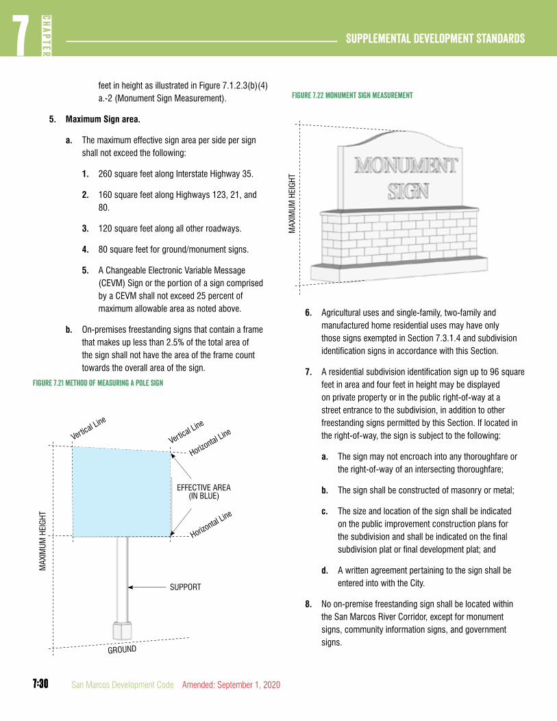
7:30
Supplemental Development Standards7
CHAP
TER
7:30 San Marcos Development Code Amended: September 1, 2020
feet in height as illustrated in Figure 7.1.2.3(b)(4)a.-2 (Monument Sign Measurement).
5. Maximum Sign area.
a. The maximum effective sign area per side per sign shall not exceed the following:
1. 260 square feet along Interstate Highway 35.
2. 160 square feet along Highways 123, 21, and 80.
3. 120 square feet along all other roadways.
4. 80 square feet for ground/monument signs.
5. A Changeable Electronic Variable Message (CEVM) Sign or the portion of a sign comprised by a CEVM shall not exceed 25 percent of maximum allowable area as noted above.
b. On-premises freestanding signs that contain a frame that makes up less than 2.5% of the total area of the sign shall not have the area of the frame count towards the overall area of the sign.
Vertical Line
MAX
IMUM
HEI
GHT
Vertical Line
Horizontal Line
Horizontal Line
EFFECTIVE AREA (IN BLUE)
SUPPORT
GROUND
Figure 7.21 method of measuring a pole sign
MAX
IMUM
HEI
GHT
Figure 7.22 monument sign measurement
6. Agricultural uses and single-family, two-family and manufactured home residential uses may have only those signs exempted in Section 7.3.1.4 and subdivision identification signs in accordance with this Section.
7. A residential subdivision identification sign up to 96 square feet in area and four feet in height may be displayed on private property or in the public right-of-way at a street entrance to the subdivision, in addition to other freestanding signs permitted by this Section. If located in the right-of-way, the sign is subject to the following:
a. The sign may not encroach into any thoroughfare or the right-of-way of an intersecting thoroughfare;
b. The sign shall be constructed of masonry or metal;
c. The size and location of the sign shall be indicated on the public improvement construction plans for the subdivision and shall be indicated on the final subdivision plat or final development plat; and
d. A written agreement pertaining to the sign shall be entered into with the City.
8. No on-premise freestanding sign shall be located within the San Marcos River Corridor, except for monument signs, community information signs, and government signs.
7:31
7CH
APTER
Supplemental Development Standards
7:31Amended: September 1, 2020 San Marcos Development Code
Section 7.3.3.3Off-Premises Signs
A. Signs in the City and ETJ. Off-premises signs within the City and within the extraterritorial jurisdiction of the City are subject to all provisions of this Section. Any requirement, standard or prohibition not specifically outlined in this Section is regulated by applicable provisions of V.T.C.A, Transportation Code Chapter 391 and regulations issued under that chapter.
B. Sign Faces. For each sign location, a maximum of two sign faces, front and back, are permitted. Multiple sign faces, whether stacked or side-by-side, at the same location and facing the same direction are prohibited. Existing signs with more than two faces may continue as nonconforming signs, subject to the provisions of Section 7.3.1.7.
C. Restructuring Permitted. Existing off-premise signs having wooden pole supports in locations where new off-premises signs are allowed may be restructured to a metal monopole support.
D. New and Restructured Sign Compliance. New and restructured signs shall comply with the following:
1. Maximum area. 480 square feet or, for restructured signs, the area of the existing sign, whichever is less.
2. Maximum height. 25 feet for signs with an area of less than 75 square feet, and 42½ feet for signs with an area of 75 square feet to 480 square feet (see illustration 6-5).
3. Setback. A minimum setback of ten feet is required from all property lines for all off-premise signs.
4. Location and spacing restrictions. New or restructured off-premise signs are permitted only along the following highways and they shall comply with the following minimum spacing requirements with respect to other off-premise signs on the same side of the street or highway, and with all applicable provisions of V.T.C.A, Transportation Code Chapter 391 and regulations issued under that chapter with respect to sign placement regulations not otherwise established in this Chapter:
a. In the highway corridor, new and restructured off-premise signs are permitted throughout the City and its extraterritorial jurisdiction, with a minimum spacing of 1,500 feet.
b. Along the following roadways, new and restructured off-premise signs are permitted in the City and its extraterritorial jurisdiction, subject to a minimum spacing of 500 feet in the city limits and 750 feet in the extraterritorial jurisdiction:
1. State Highway 123.
2. State Highway 21, and along planned future extensions.
3. State Highway 80.
4. State Highway Loop 82 from Martin Luther King Jr. Drive to IH-35.
5. RM 12 from Thorpe Lane to IH 35.
5. Animated and CEVM signs prohibited. No new or restructured sign may include an animated or CEVM sign.
E. Restrictions on New Signs.
1. This subsection applies to new off-premises signs in all areas of the City and the City’s extraterritorial jurisdiction. It is the intent of this subsection that the total number and total area of off-premises signs not be increased in areas of the City and the City’s extraterritorial jurisdiction above the total number and total area of off-premises signs that are lawfully in existence and listed on the initial registration forms filed under subsection (h) by September 30, 2003.
2. A permit will be issued to erect a new off-premises sign in a permissible location only if the applicant first removes one or more existing off-premises signs with a total area equal to or greater than the total area proposed for the new sign. If an applicant for a new off-premises sign has one or more existing nonconforming off-premises signs, the existing off-premises sign or signs removed by the applicant must be nonconforming signs. If an applicant for a permit for a new off-premises sign has no existing nonconforming signs, the existing off-premises sign or signs removed by the applicant may be any conforming off-premises signs.
3. A new off-premises sign that replaces an existing off-premises sign or signs within the highway corridor must be located in a permissible location within the highway corridor. An existing off-premises sign in a location outside
7:32
Supplemental Development Standards7
CHAP
TER
7:32 San Marcos Development Code Amended: September 1, 2020
the highway corridor may be replaced with a new off-premises sign in a permissible location within the highway corridor or outside the highway corridor.
4. A new off-premises sign in a location outside the highway corridor shall not exceed the height of the existing sign it replaces. A new off-premises sign in the highway corridor is subject to the height restrictions in subsection (d)(2) of this Section, and is not limited to the height of the existing sign it replaces.
5. New and restructured off-premises signs shall not be located on property designated as a residential or agricultural district by Chapter 4 if the property is inside the City limits, or as an open space or Low Intensity Area on the Preferred Scenario Map of the Comprehensive Plan if outside the City limits.
F. Off-Premises Signs with an Existing Principal Structure or Use. Except within the highway corridor, off-premises signs erected or restructured on premises that have an existing principal structure or use are subject to the same requirements that apply to permanent on-premises signs in the same location.
G. Changing a Sign from Off-Premises to On-Premise. The changing of an off-premises sign to an on-premises sign by a change in the copy, except for messages advertising the sign for sale or lease, and the changing of an on-premises sign to an off-premise sign requires a permit. Except within the highway corridor, changed signs shall comply with all regulations pertaining to the new use of the signs.
H. Off-Premises Sign Registration.
1. A person who owns any off-premises sign within the City or its extraterritorial jurisdiction shall file with the Director a complete listing, on a registration form provided by the Department, of all off-premises signs owned by the person as required by this subsection. An initial listing as of January 1, 2003 shall be filed by September 30, 2003. An updated listing as of January 1, 2006 and each three-year period thereafter must be filed with the Director by February 1 of the applicable year.
2. No fee is required in connection with the filing of a registration form.
3. It is unlawful for a person who owns an off-premises sign to fail to file a complete registration form in a timely manner as required by subsection (1). A separate offense is deemed to be committed for each sign owned by the person that is not properly registered, and for each day a sign owned by the person is not properly registered.
DIVISION 4: NEIGHBORHOOD AND CHARACTER DISTRICT SIGN STANDARDS
This Division 4 is applicable in all Neighborhood Density Districts and Character Districts.
Section 7.3.4.1Summary of Signs
A. Directional Signs Exempt. Directional signs are not subject to this Section.
B. Permitted Signage. No CEVM or Off-Premise Signs are permitted
C. Temporary Signs and Banners. Temporary signs and banners are permitted in accordance with Section 7.3.1.4.
D. Calculation of Size. The sign area is calculated as the largest area of the sign visible at any one time from any one point and enclosed by a rectangle, including any framing or trim, but not including any structural parts lying outside the limits of the sign and which do not form an integral part of the display. If the copy is enclosed by a box, outline or frame, area is the total area of the enclosure. If the sign consists of individual letters, numbers or symbols on a surface or having no frame, area shall be the sum of the areas of the rectangles which can encompass each portion of the copy. The area of four-side signs is considered the same as two double-faced signs.
Section 7.3.4.2Illumination
A. Specific to zones CD-1, CD-2, CD-3, ND-3, ND-3.5
1. Signage shall not be internally illuminated.
B. Specific to zones CD-4, CD-5, ND-4, N-CM
1. Signage shall be externally illuminated, except as follows:
a. Signage within the shopfront glazing may be neon or LED lit.
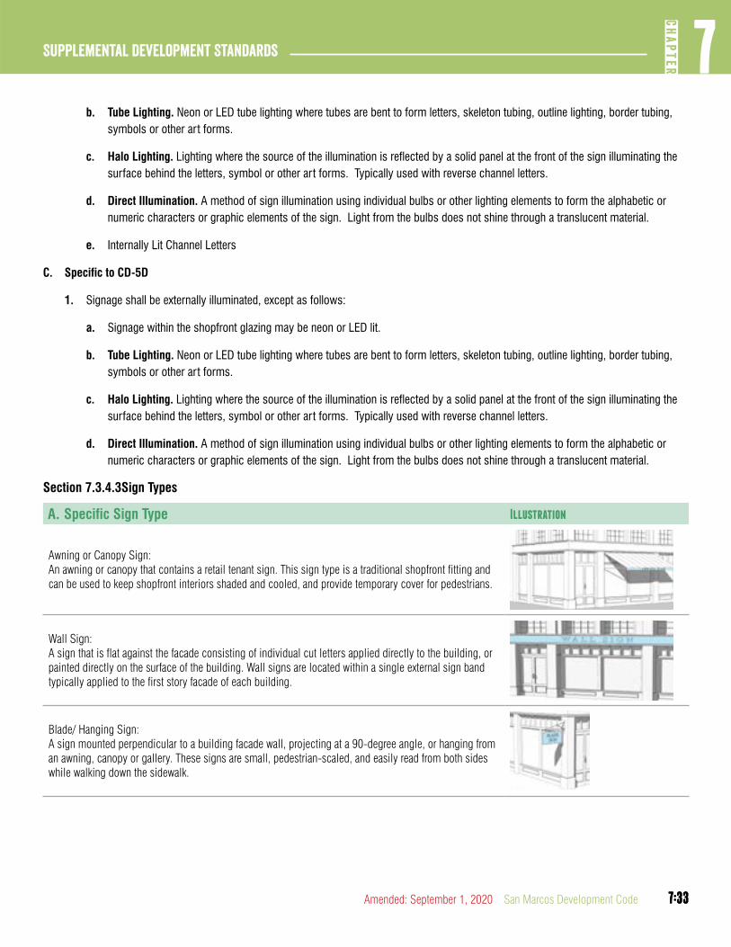
7:33
7CH
APTER
Supplemental Development Standards
7:33Amended: September 1, 2020 San Marcos Development Code
b. Tube Lighting. Neon or LED tube lighting where tubes are bent to form letters, skeleton tubing, outline lighting, border tubing, symbols or other art forms.
c. Halo Lighting. Lighting where the source of the illumination is reflected by a solid panel at the front of the sign illuminating the surface behind the letters, symbol or other art forms. Typically used with reverse channel letters.
d. Direct Illumination. A method of sign illumination using individual bulbs or other lighting elements to form the alphabetic or numeric characters or graphic elements of the sign. Light from the bulbs does not shine through a translucent material.
e. Internally Lit Channel Letters
C. Specific to CD-5D
1. Signage shall be externally illuminated, except as follows:
a. Signage within the shopfront glazing may be neon or LED lit.
b. Tube Lighting. Neon or LED tube lighting where tubes are bent to form letters, skeleton tubing, outline lighting, border tubing, symbols or other art forms.
c. Halo Lighting. Lighting where the source of the illumination is reflected by a solid panel at the front of the sign illuminating the surface behind the letters, symbol or other art forms. Typically used with reverse channel letters.
d. Direct Illumination. A method of sign illumination using individual bulbs or other lighting elements to form the alphabetic or numeric characters or graphic elements of the sign. Light from the bulbs does not shine through a translucent material.
Section 7.3.4.3Sign Types
A. Specific Sign Type Illustration
Awning or Canopy Sign:An awning or canopy that contains a retail tenant sign. This sign type is a traditional shopfront fitting and can be used to keep shopfront interiors shaded and cooled, and provide temporary cover for pedestrians.
Wall Sign: A sign that is flat against the facade consisting of individual cut letters applied directly to the building, or painted directly on the surface of the building. Wall signs are located within a single external sign band typically applied to the first story facade of each building.
Blade/ Hanging Sign: A sign mounted perpendicular to a building facade wall, projecting at a 90-degree angle, or hanging from an awning, canopy or gallery. These signs are small, pedestrian-scaled, and easily read from both sides while walking down the sidewalk.
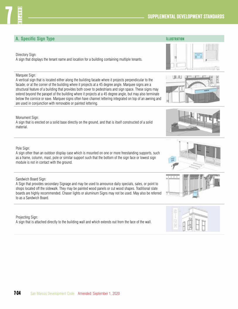
7:34
Supplemental Development Standards7
CHAP
TER
7:34 San Marcos Development Code Amended: September 1, 2020
A. Specific Sign Type Illustration
Directory Sign: A sign that displays the tenant name and location for a building containing multiple tenants.
Marquee Sign:A vertical sign that is located either along the building facade where it projects perpendicular to the facade; or at the corner of the building where it projects at a 45 degree angle. Marquee signs are a structural feature of a building that provides both cover to pedestrians and sign space. These signs may extend beyond the parapet of the building where it projects at a 45 degree angle, but may also terminate below the cornice or eave. Marquee signs often have channel lettering integrated on top of an awning and are used in conjunction with removable or painted lettering.
Monument Sign: A sign that is erected on a solid base directly on the ground, and that is itself constructed of a solid material.
Pole Sign: A sign other than an outdoor display case which is mounted on one or more freestanding supports, such as a frame, column, mast, pole or similar support such that the bottom of the sign face or lowest sign module is not in contact with the ground.
Sandwich Board Sign: A Sign that provides secondary Signage and may be used to announce daily specials, sales, or point to shops located off the sidewalk. They may be painted wood panels or cut wood shapes. Traditional slate boards are highly recommended. Chaser lights or aluminum Signs may not be used. May also be referred to as a Sandwich Board.
Projecting Sign: A sign that is attached directly to the building wall and which extends out from the face of the wall.

7:35
7CH
APTER
Supplemental Development Standards
7:35Amended: September 1, 2020 San Marcos Development Code
Section 7.3.4.4Awning or Canopy Sign
Description
An awning or canopy that contains a retail tenant sign. This sign type is a traditional shopfront fitting and can be used to keep shopfront interiors shaded and cooled, and provide temporary cover for pedestrians.
Dimensions ND-4, CD-4 N-CM, CD-5, CD-5D
Quantity (max) 1 per business 1 per business
Height (max) 2 ft 3 ft
Length (max) 10 ft 12 ft.
Requirements General to All Zones
The sign may be placed on either the vertical valance flap, the top, the sloped portion, or on a side panel of the awning or canopy.
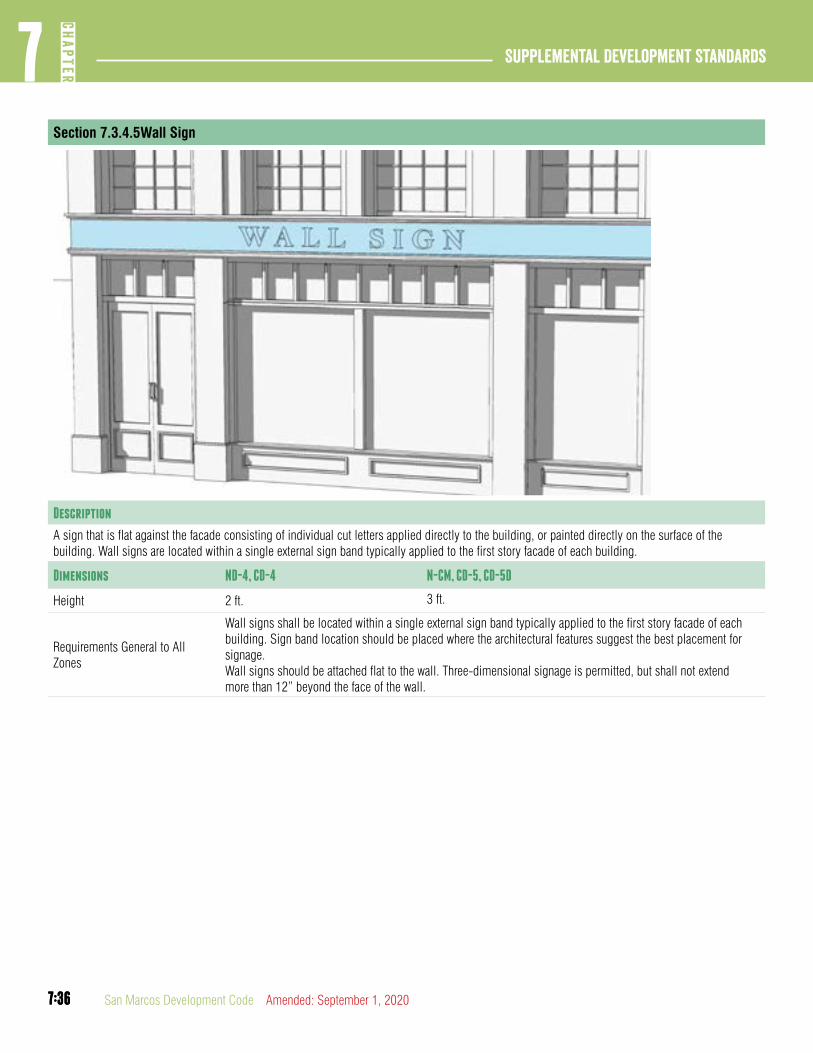
7:36
Supplemental Development Standards7
CHAP
TER
7:36 San Marcos Development Code Amended: September 1, 2020
Section 7.3.4.5Wall Sign
Description
A sign that is flat against the facade consisting of individual cut letters applied directly to the building, or painted directly on the surface of the building. Wall signs are located within a single external sign band typically applied to the first story facade of each building.
Dimensions ND-4, CD-4 N-CM, CD-5, CD-5D
Height 2 ft. 3 ft.
Requirements General to All Zones
Wall signs shall be located within a single external sign band typically applied to the first story facade of each building. Sign band location should be placed where the architectural features suggest the best placement for signage.Wall signs should be attached flat to the wall. Three-dimensional signage is permitted, but shall not extend more than 12” beyond the face of the wall.
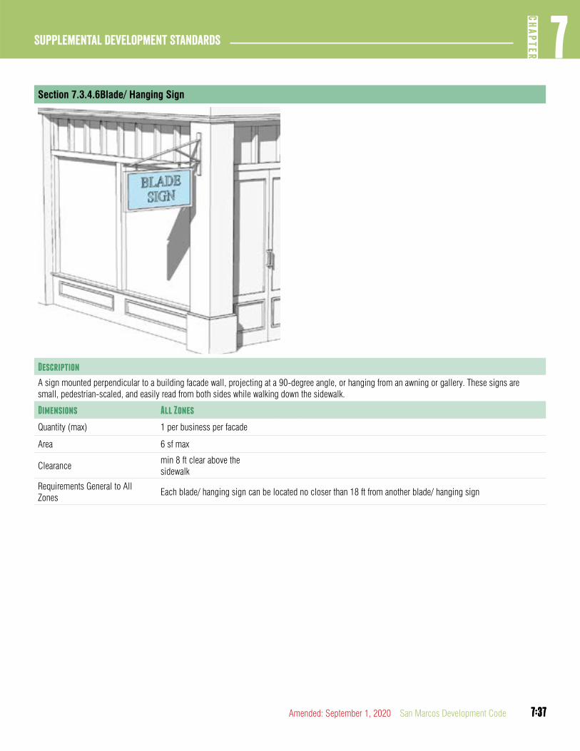
7:37
7CH
APTER
Supplemental Development Standards
7:37Amended: September 1, 2020 San Marcos Development Code
Section 7.3.4.6Blade/ Hanging Sign
Description
A sign mounted perpendicular to a building facade wall, projecting at a 90-degree angle, or hanging from an awning or gallery. These signs are small, pedestrian-scaled, and easily read from both sides while walking down the sidewalk.
Dimensions All Zones
Quantity (max) 1 per business per facade
Area 6 sf max
Clearancemin 8 ft clear above the sidewalk
Requirements General to All Zones
Each blade/ hanging sign can be located no closer than 18 ft from another blade/ hanging sign
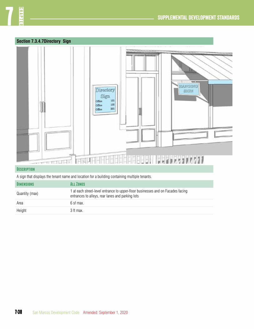
7:38
Supplemental Development Standards7
CHAP
TER
7:38 San Marcos Development Code Amended: September 1, 2020
Section 7.3.4.7Directory Sign
Description
A sign that displays the tenant name and location for a building containing multiple tenants.
Dimensions All Zones
Quantity (max)1 at each street-level entrance to upper-floor businesses and on Facades facing entrances to alleys, rear lanes and parking lots
Area 6 sf max.
Height 3 ft max.

7:39
7CH
APTER
Supplemental Development Standards
7:39Amended: September 1, 2020 San Marcos Development Code
Section 7.3.4.8Marquee Sign
Description
A vertical sign that is located either along the building facade where it projects perpendicular to the facade; or at the corner of the building where it projects at a 45 degree angle. Marquee signs are a structural feature of a building that provides both cover to pedestrians and sign space. These signs may extend beyond the parapet of the building where it projects at a 45 degree angle, but may also terminate below the cornice or eave. Marquee signs often have channel lettering integrated on top of an awning and are used in conjunction with removable or painted lettering.
Dimensions ND4, CD4 N-CM, CD5, CD5D
Quantity (max) Not Permitted 1 per Principal Frontage
Width / Height -- max 20 ft./ max 6 ft.
Depth / Projection -- min 4 ft, max 10 ft
Clearance -- min 10 ft clear above the sidewalk
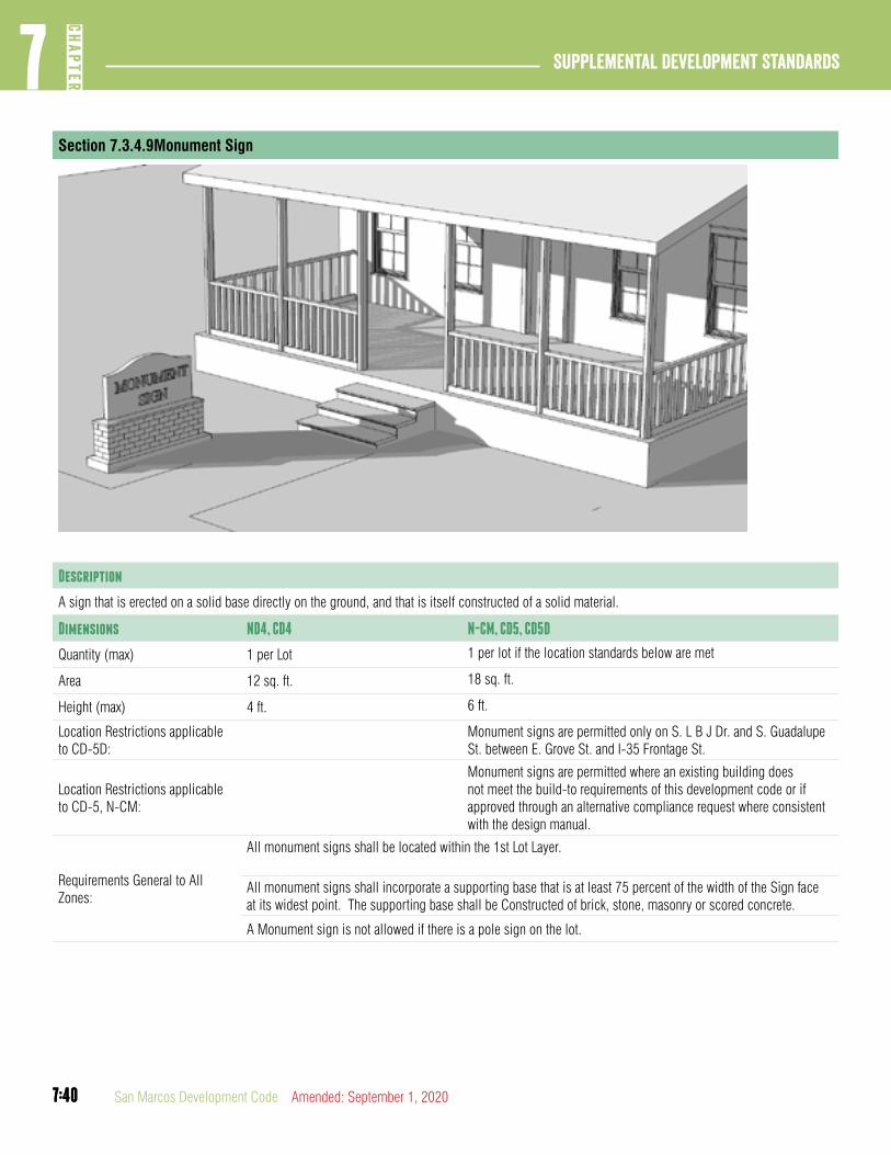
7:40
Supplemental Development Standards7
CHAP
TER
7:40 San Marcos Development Code Amended: September 1, 2020
Section 7.3.4.9Monument Sign
Description
A sign that is erected on a solid base directly on the ground, and that is itself constructed of a solid material.
Dimensions ND4, CD4 N-CM, CD5, CD5D
Quantity (max) 1 per Lot 1 per lot if the location standards below are met
Area 12 sq. ft. 18 sq. ft.
Height (max) 4 ft. 6 ft.
Location Restrictions applicable to CD-5D:
Monument signs are permitted only on S. L B J Dr. and S. Guadalupe St. between E. Grove St. and I-35 Frontage St.
Location Restrictions applicable to CD-5, N-CM:
Monument signs are permitted where an existing building does not meet the build-to requirements of this development code or if approved through an alternative compliance request where consistent with the design manual.
Requirements General to All Zones:
All monument signs shall be located within the 1st Lot Layer.
All monument signs shall incorporate a supporting base that is at least 75 percent of the width of the Sign face at its widest point. The supporting base shall be Constructed of brick, stone, masonry or scored concrete.
A Monument sign is not allowed if there is a pole sign on the lot.

7:41
7CH
APTER
Supplemental Development Standards
7:41Amended: September 1, 2020 San Marcos Development Code
Section 7.3.4.10Pole Sign
Description
A sign other than an outdoor display case which is mounted on one or more freestanding supports, such as a frame, column, mast, pole or similar support such that the bottom of the sign face or lowest sign module is not in contact with the ground.
Dimensions ND-4, CD-4 ND-4M, CD-5, CD5D
Quantity (max) 1 per lot 1 per lot
Area (max) 12 sq. ft. 18 sq. ft.
Height (max) 6 ft. 10 ft.
Location Restrictions applicable to CD-5D:
Pole signs are permitted only on S. L B J Dr. and S. Guadalupe St. between E. Grove St. and I-35 Frontage St.
Location Restrictions applicable to CD-5, N-CM:
Pole signs are permitted where an existing building does not meet the build-to requirements of this development code or if approved through an alternative compliance request where consistent with the design manual.
Requirements General to All Zones:
All pole signs shall be located within the 1st Lot Layer.
A pole Sign is not allowed if there is a monument Sign on the Lot.

7:42
Supplemental Development Standards7
CHAP
TER
7:42 San Marcos Development Code Amended: September 1, 2020
Section 7.3.4.11Sandwich Board
Description
A sign that provides secondary signage and may be used to announce daily specials, sales, or point to shops located off the sidewalk. They may be painted wood panels or cut wood shapes. Traditional slate boards are highly recommended.
Dimensions All Zones
Quantity (max) 1 per business
Area 12 Sq. ft.
Height 4 ft.
General Standards:
A sandwich board within the public right-of-way must be placed such that at least an 4 foot unobstructed sidewalk width remains.
Sandwich boards shall be designed to allow folding.
A sandwich board must have a stable base.
Sandwich boards shall be removed at the close of business each day.
A sandwich board sign must be located directly in from of the business, or street level entrance.

7:43
7CH
APTER
Supplemental Development Standards
7:43Amended: September 1, 2020 San Marcos Development Code
Section 7.3.4.12Projecting Sign
Description
A sign that is attached directly to the building wall and which extends out from the face of the wall.
Dimensions N-CM, CD-5, CD-5D Standards
Quantity (max) 1 per building facade
Area (max) 9 sq. ft.
Clearance 8 ft.
General Standards:
A projecting sign may be attached to the building facade
For single story buildings up to 16’ in height, a projecting sign may extend no more than 50% of the sign height up to a maximum of 2 feet above the parapet or roof of the structure to which it is attached. For all other building heights, a projecting sign may not extend above the parapet or roof of the structure to which it is attached

7:44
Supplemental Development Standards7
CHAP
TER
7:44 San Marcos Development Code Amended: September 1, 2020
Section 7.3.4.13Changeable Electronic Variable Message (CEVM) Signs
CEVM signs are subject to the limitations indicated in this Section, as well as the location, height and area restrictions in this Chapter. A CEVM sign shall apply with the following:
A. Not exceed a maximum brightness of 7,000 NITs in day light or 500 NITs for night use.
B. Provide for auto dimming/brightening based on natural ambient light conditions.
C. Provide and maintain a photo cell and dimmer control to assure the luminance standard is met and not exceeded.
D. Present a static display with no special effect transitions between messages.
E. Display a message for at least 60 seconds with a two second pause between messages.
F. Be constructed such that it does not face, shine, or reflect light into a Residentially classified neighborhood whether single-family, multi-family, townhouse, or mixed use where residential housing is permitted.
G. Display no more than four colors—each in a static pattern
article 4: Public health related performance standards
DIVISION 1: GENERAL
Section 7.4.1.1Purpose
All uses of property shall conform in operation, location, construction and development to all applicable:
A. The performance standards as administered by county, State or Federal agencies; and
B. Performance standards for noise, smoke, and particulate matter, odorous matter, fire, or explosive hazard material, toxic and noxious matter, vibration, and glare.
Section 7.4.1.2Requirements for Toxic Waste Disposal
All Federal and State pollution, noise, and requirements for toxic waste disposal shall be observed. See Chapter 86 of the City Code for industrial waste disposal regulations.
DIVISION 2: STANDARDS
Section 7.4.2.1Noise
A. Noise Level Maximums. No activity on the property shall produce sound:
1. In excess of 85 decibels between the hours of 10:00 a.m. and 10:00 p.m.
2. In excess of 75 decibels between the hours of 10:00 p.m. and 10:00 a.m.
B. Noise Measurements. Measurement of noise shall be made with a sound level meter using the “A” weighting network as specified by the American National Standards Institute.
1. A police officer taking a noise measurement may take the measurement from either the closets public right-of-way to the offending residence or business, or with the consent of a complainant, may take the measurement from the property line of the complainant.
2. Any sound that when measured at the nearest public right-of-way to the offending residence or business exceeds

7:45
7CH
APTER
Supplemental Development Standards
7:45Amended: September 1, 2020 San Marcos Development Code
the dB(a) levels set forth in this Section shall be prima facie evidence of sound nuisance which unreasonably disturbs, injures, or endangers the comfort, repose, health, peace, or safety of the others within the limits of the city in violation.
3. Method of sound measurement. Whenever portions of this Chapter prohibit noise over a certain decibel, limit, measurement of said noise shall be made with a decibel meter chosen by the chief of police which meets the standards prescribed by the American National Standards Institute at the time the device was purchased. The instruments shall be maintained in calibration and good working order. Calibration corrections shall be employed in meeting the response specificatons prior to every sampling of noise. Measurements recorded shall be taken so as to provide an accurate representation of the noise being measured. Noise measurements shall be a minimum of 30 seconds in duration. The microphone shall be positioned so as not to create any unnatural enhancement or diminution of the measured noise. A windscreen for the microphone shall be used. Violations will be determined based on the highest registered reading in the measurement period. All measurement levels will be inclusive of any ambient noise that exists at the time of the measurement.
C. Exemptions. The following uses and activities shall be exempt from the noise level regulations herein specified.
1. Noises emanating from construction, development and maintenance activities between the hours of 7:00 a.m. and 9:00 p.m. (daytime hours).
2. The sound produced by operating or permitting the operation of any mechanically powered saw, drill, sander, router, grinder, lawn or garden tool, lawnmower, or any other simlar device used between the hours of 7:00 a.m. and 9:00 p.m. and which device did not produce a sound of 85 dB(A) or greater when measured from the nearest residential property where the sound is being received and was used for the maintenance or upkeep of the property on which it was used.
3. The emission of any sound was for the purpose of alterting persons to the existence of an emergency, danger, or attempted crime.
4. Sound produced by an authorized emergency vehicle.
5. Sound produced by emergency work necessary to restore public utilities, or to restore property to a safe condition, or to protect persons or property from imminent danger, following a fire, accident, or natural disaster.
6. Sound produced by aircraft in flight or in operation at an airport, or railroad equipment in operation on railroad rights-of-way.
7. Sound producted by the operation of any air conditioning unit which did not produce a sound of 85 dB(A) or greater on residential property or 85 dB(A) on nonresidential property, when measured at or near 15 feet from the air conditioning unit producing the sound being measured.
(Ord. No. 2020-60, 9-1-2020)
Section 7.4.2.2Smoke and Particulate Matter
A. Standards. No operation or use shall cause, create, or allow the emission for more than three minutes in any one hour of air contaminants which at the emission point or within the bounds of the property:
1. Are of such opacity as to obscure an observer’s view to a degree equal to or greater than does smoke or contaminants in the standard prescribed by the ASTM, except when the presence of uncombined water is the only reason for failure to comply, or when such contaminants are emitted inside a building which prevents their escape into the atmosphere;
2. Exceed 0.5 pounds per acre of property within the plant site;
3. Exceed four grains of dust or particulate matter per 1,000 cubic feet of air at any boundary line of the tract on which the use is located, as a result of open storage or open processing operations, including on-site transportation movements which are the source of wind or air borne dust or other particulate matter, or operations such as paint spraying, grain handling, sand or gravel processing or storage or sand blasting.

7:46
Supplemental Development Standards7
CHAP
TER
7:46 San Marcos Development Code Amended: September 1, 2020
Section 7.4.2.3Odorous Matter
A. Odorous Matter Limited. No use shall be located or operated which involves the emission of odorous matter from a source of operation where the odorous matter is clearly detectable at the bounding property line or any point beyond the tract on which such use or operation is located.
B. General Method and Procedures. The odor threshold as herein set forth shall be determined by observation by the Responsible Official. In any case where uncertainty may arise, or where the operator or owner of an odor emitting use disagrees with the Responsible Official, or where specific measurement of odor concentration is required, the method and procedures specified by the ASTM shall be utilized.
Section 7.4.2.4Fire or Explosive Hazard Material
A. Limits on Manufacture and Storage. No use involving the manufacture or storage of compounds or products which decompose by detonation shall be permitted except that chlorates, nitrates, perchlorates, phosphorus, and similar substances and compounds in small quantities for use by industry, school laboratories, druggists or wholesalers may be permitted when approved by the City Fire Chief.
B. Storage of Flammable Liquids and Materials. The storage and use of all flammable liquids and materials such as pyroxylin plastics, nitrolose film, solvents, and petroleum products shall be permitted only when the storage or use conforms to the standards and regulations of the City Fire Prevention Code or are approved by the Fire Marshal.
Section 7.4.2.5Toxic and Noxious Matter
No operation or use shall emit a concentration of toxic or noxious matter across the bounding property line of the tract on which the operation or use is located which shall exceed ten percent of the concentration (exposure) considered as the threshold limit for an industrial worker as such standards are set forth by the Texas State Department of Health Services in “Threshold Limit Values Occupa-tional Health Regulation No. 3”.
article 5: Lighting and glare standardsDIVISION 1: GENERAL
Section 7.5.1.1Purpose
A. Standards for controlling lighting and glare are set forth to reduce hazards to motorists and annoyance and inconvenience from light trespass upon the residents, drivers, pedestrians, businesses and other elements of the community.
B. Standards are also established in order to ensure that citizens and visitors to the City are able to continue to enjoy the night sky, natural environment and traditional character of the community.
C. These standards are intended to allow reasonable enjoyment of adjacent and nearby property by their owners and occupants while requiring adequate levels of lighting of parking drives, service and pedestrian areas.
D. These standards are based on the model lighting ordinance developed by the International Dark Sky Association.
Section 7.5.1.2Applicability
A. Applicability. The standards and criteria contained within this Article 5 are deemed to be minimum standards and shall apply to all new construction subject to a site preparation permit or the replacement or modification of outdoor lighting.
B. Exemption. Property located within a single-family residential district which is used for single-family residential use is exempt from standards applied to exterior lighting.
Section 7.5.1.3Review Procedure
A. Proof of Compliance Required. Detailed drawing(s) verifying compliance with the requirements of this Article shall be submitted, in detail sufficient to show compliance, at both the time of site permit and building permit application submittal. The compliance shall be illustrated, along with calculations or specifications of how areas shown on the site permit and building permit applications shall meet the requirements for lighting and design.

7:47
7CH
APTER
Supplemental Development Standards
7:47Amended: September 1, 2020 San Marcos Development Code
B. Plan Submittal. A photometric plan shall be prepared by a lighting professional and shall include all property within the Limits of Construction. The study shall address the horizontal illuminance on the site. Each plan requires the following information:
1. A point-by-point foot-candle reading. The horizontal photometric plan grid points shall have a maximum spacing of 10 ft. between each point across the entire site and 10 ft. past the property line.
2. A foot-candle reading shall be provided under each light fixture.
3. The plan shall include the lighting templates generated by the lighting design software program to calculate the foot-candle readings. The template shall be for the fixture and lamp specified on the plans. The plan’s fixture type identification shall match the cut sheets, electrical site plans, and the lighting schedule. This information shall be provided in a summary table.
4. The plan shall identify the initial maximum, minimum, and average illuminance on the horizontal photometric plan.
5. The plan shall identify the total maintained maintenance (light loss) factor utilized.
C. Deviations from Lighting and Glare Standards. Administrative adjustments from overall lighting level standards may be approved if such administrative adjustments are in compliance with state lighting requirements.
DIVISION 2: STANDARDS
Section 7.5.2.1Overall Operational Lighting Levels
A. Environmental Performance Zones. Lighting for an individual project shall be evaluated in the context of the overall environment and the goals set for the surrounding community. For this purpose, maximum outdoor lighting averages are established for geographic areas distinguished as environmental lighting performance zones. The general relationship of properties to these zones and the maximum permissible average lighting levels are provided.
B. The following chart establishes the overall maximum permissible average illumination of properties within the associated environmental performance zone.

7:48
Supplemental Development Standards7
CHAP
TER
7:48 San Marcos Development Code Amended: September 1, 2020
Table 7.10 Environmental Performance Zones
Environmental Performance Zones DescriptionMaximum Average Light Level in
Horizontal Foot-candles
E-1 Urbanized, non-residential areas along Interstate Highways 2.0
E-2Urbanized non residential areas along certain State Highways and arterial roadways
1.5
E-3 Residentially dominated areas 1.0
E-4 Designated Open Space Areas .5
Open Space Lighting Overlay A 350 ft. buffer adjusting light levels in any zoneOne-half of applicable performance zone level
Figure 7.23 Environmental Performance Zones Map

7:49
7CH
APTER
Supplemental Development Standards
7:49Amended: September 1, 2020 San Marcos Development Code
Section 7.5.2.2Minimum Lighting Levels
A. Minimum Intensities. No lighting plan shall show point-by-point foot-candle readings less than .3 in areas utilized for travel, parking or routine use by people.
B. Light Loss Factor. The total maintained light loss factor for all horizontal photometric analyses shall not be below 0.70 fc.
Section 7.5.2.3Light Trespass
A. Maximum Light Trespass.
1. No lighting plan shall distribute light greater than .25 fc across a lot line to to adjacent private property unless all lots are included in the site permit.
2. No lighting plan shall distribute light onto a residential lot, other than light from street lights.
Section 7.5.2.4Universal Luminary Standards
A. Purpose. Specific standards for luminaries are set forth to minimize negative outcomes of commercial lighting applications.
B. Full Cut-Off Luminaries. Full cut-off fixtures are required on all outdoor lighting applications including outdoor walkways, parking lots, canopy and building/ wall mounted luminaries. This standards is also applicable to open sided parking structures and the top level of parking structures.
C. Aesthetic Lighting. Landscape and architectural lighting must use full cut off or directionally shielded luminaries aimed and controlled to substantially direct and confine light to the object intended to be illuminated.
D. Canopy Lighting. All canopies, free standing or attached, shall utilize flat lens, full cut-off fixtures.
E. Specific Use Exceptions. This table is provided to establish the uses and facilities that may utilize alternative compliance standards in a photometric lighting plan
Table 7.11 Specific Use exceptions
Specific Use Area IlluminatedMax. Avg.
Light Level
ATM As Specified by State Banking Regulations
Bank or Service Window Drive-Thru
Area around the service window used for maneuvering, ordering etc..
5 fc.
Gas Station Canopies and Approaches
Canopy area plus an additional 5 ft. 20 fc.
Canopy area plus 20 ft. for maneuvering
5 fc
Auto DealershipsA 30ft wide area around the front line or pedestal display
30 fc
Area of canopy plus 5 ft. for vehicle display or pick-up
20 fc
Outdoor Display Areas
Area of display and sale of merchandise plus 5 ft.
5 fc
Athletic Facilities General Athletic area 20 fc
Playing field plus 20 ft 50 fc
Golf Course 5 fc
F. Alternative Compliance Findings. The Planning and Zoning Commission may in accordance with Section 2.8.4.1 allow an alternative to the lighting standards subject to the following findings:
1. The property is located on the edge of an environmental performance zone;
2. The adjustment is consistent with surrounding light patterns;
3. The adjustment is based on a specific use identified in Section 7.5.2.4.
4. The adjustment does not adversely affect surrounding residential or park and open space areas; and
5. The adjustment meets the intent and purpose of the lighting standards in this Development Code.

7:50
Supplemental Development Standards7
CHAP
TER
7:50 San Marcos Development Code Amended: September 1, 2020
article 6: Manufactured home and tiny home village
DIVISION 1: REGULATIONS AND REQUIREMENTS
Section 7.6.1.11 Jurisdiction
This Article is applicable to the City limits and the Extraterritorial Jurisdiction of the City.
Section 7.6.1.2Site Design Requirements
A. Site Requirements. Any Manufactured Home Park or Tiny Home Village Constructed or Developed after the effective date of this development Code and for any extension or Addition to any existing or Manufactured Home Park shall comply with the following Site requirements:
1. Location. A Manufactured Home Park or Tiny Home Village within the City limits shall be located only on a site within the Manufactured Home (MH) District.
2. Minimum Requirements. Each Manufactured Home Park or Tiny Home Village within the City limits shall comply with all applicable standards and requirements of the MH Zoning District. Each Manufactured Home Park or Tiny Home Village within the City’s Extraterritorial Jurisdiction shall comply with all standards and requirements as if it were within the City limits and zoned within the MH District.
a. Soil and Ground Cover. Exposed ground surfaces in all parts of every Manufactured Home Park shall be paved, covered with stone or other solid material, or protected with a vegetative growth that is capable of preventing soil erosion and of eliminating dust.
b. Drainage. The ground surface in all parts of a Manufactured Home Park shall be graded and equipped to drain all surface water away from pad sites.
Section 7.6.1.3Access and Traffic Circulation and Parking
A. Block Perimeter. Manufactured home parks, and Tiny Home Villages and recreational vehicle parks shall meet the block perimeter requirements in Section 3.6.2.1.
B. Internal Streets and Signage. Internal Streets, no-parking-area Signs, and Thoroughfare name Signs in a Manufactured Home Park or Tiny Home Village shall be privately owned, built and maintained. Streets shall be designed for safe and convenient access to all spaces and to facilities for common use of the park’s residents. Internal Streets shall be kept open and free of obstruction in order that police and fire vehicles may have access to any areas of the Manufactured Home Park or Tiny Home Village.
C. Signs Prohibiting Parking Required. On all sections of Internal Streets on which parking is prohibited under this Article, the owner or agent shall Erect metal “no parking” Signs; type, size, height and location shall be approved by the Director of Public Services prior to installation.
D. Internal Street Construction and Maintenance. All Internal Streets shall be constructed and maintained by the owner or agent. All Internal Streets shall be free of cracks, holes and other hazards. Internal Streets shall be constructed on hard-surfaced, all-weather material and shall be approved by the Director of Public Services.
E. Access to Each Home or Space. An Internal Street or Common Access Route shall be provided to each Mobile Home, Manufactured Home, or Tiny Home space. This Internal Street or Common Access Route shall have a minimum width of 30 feet if off-street parking is provided in the ratio of two parking spaces for each Manufactured Home Park or Tiny Home Village space. The Internal Street shall be continuous and connect with other Internal Streets or with a public Thoroughfare or shall be provided with a cul-de-sac having a minimum diameter of 95 feet.
F. Minimum Parking Requirement. Two spaces are required for each manufactured home or Tiny Home site in accordance with the requirements for residential single family dwellings under Section 7.1.2.1.
G. Parking Space Construction. Parking Spaces shall be hard-surfaced with all-weather material, located to eliminate interference with access to Parking Lots and Parking Areas provided for other Mobile Homes, Manufactured Homes, or Tiny Home and for public parking in the Manufactured Home Park or Tiny Home Village.

7:51
7CH
APTER
Supplemental Development Standards
7:51Amended: September 1, 2020 San Marcos Development Code
H. Unobstructed Access. Internal Streets shall permit unobstructed access to within at least 200 feet of any portion of each Mobile Home, Manufactured Home, or Tiny Home. Speed bumps constructed to maintain safe speed of vehicles moving within the Manufactured Home Park or Tiny Home Village shall not be considered as obstructions. Speed bumps are to be constructed at four to one inclination, not to exceed four inches in height. Speed bumps shall be painted with fluorescent paint.
I. Intersections with Public Thoroughfares. Interior Streets shall intersect Adjoining public Thoroughfares at approximately 90 degrees with a curb line radius of 20 feet at a location which shall eliminate or minimize interference with traffic on those public Thoroughfares.
J. Common Area Parking Area Required. A minimum Parking Area of 150 square feet per Mobile Home, Manufactured Home, or Tiny Home space shall be provided in a common area for storage of boats or vehicles in excess of two per Mobile Home, Manufactured Home, or Tiny Home space and for visitors’ vehicles to minimize on-street parking and to facilitate movement of emergency vehicles into and through the park.
Section 7.6.1.4Section 7.4.1.4 Street Lighting
Street lighting within the Manufactured Home Park or Tiny Home Village shall be provided by the Developer along Internal Streets. Light standards shall have a height and spacing to ensure that an average illumination level of not less than two-tenths foot-candles shall be maintained.
Section 7.6.1.5Fire Safety Standards
A. Storage and Handling of Liquefied Petroleum Gases. In Manufactured Home Parks or Tiny Home Village in which liquefied petroleum gases are stored and dispensed, their handling and storage shall comply with requirements of the City plumbing and fire codes as applicable.
B. Storage and Handling of Flammable Liquids. In Manufactured Home Parks or Tiny Home Village in which gasoline, fuel, oil or other flammable liquids are stored or dispensed, their handling and storage shall comply with the City fire code.
C. Access for Fire Fighting. Approaches to all Mobile Homes, Manufactured Homes, and Tiny Homes shall be kept clear for fire fighting.
D. Fire Fighting Instruction. The Manufactured Home Park or Tiny Home Village owner or agent shall be responsible for instructing the owner’s staff in the use of the park’s fire protection equipment and in their specific duties if a fire occurs.
E. Water Supply Facilities for Fire Department Operation. The Manufactured Home Park or Tiny Home Village owner shall provide standard City fire hydrants located within 500 feet of all Mobile Home, Manufactured Home, or Tiny Home spaces, measured along the driveways or Internal Streets.
F. Rubbish Disposal. The Manufactured Home Park or Tiny Home Village owner or agent shall provide an adequate system of collection and safe disposal of rubbish, approved by the Planning Director.
G. Removal of Dry Brush, Leaves and Weeds. The Manufactured Home Park owner or agent shall be responsible for maintaining the entire area of the Manufactured Home Park free of dry brush, leaves and weeds.
Section 7.6.1.6Recreational Area
All Manufactured Home Parks and Tiny Home Village shall have a recreational area amounting to five percent total area of the Manu-factured Home Park or Tiny Home Village.
Section 7.6.1.7Water Supply
A. Required. An accessible, adequate, safe and potable supply of water shall be provided in each Manufactured Home Park or Tiny Home Village. Connection shall be made to the public supply of water. The public supply shall be adequate both for domestic requirements and for fire fighting requirements established by the City.
B. Water Distribution System.
1. The water supply system of the Manufactured Home Park or Tiny Home Village shall be connected by pipes to all Mobile Homes, Manufactured Homes, Tiny Homes, Buildings and other facilities requiring water.
2. All water piping, fixtures and other equipment shall be constructed and maintained in accordance with State and City regulations and requirements.

7:52
Supplemental Development Standards7
CHAP
TER
7:52 San Marcos Development Code Amended: September 1, 2020
C. Individual Connections. Individual connections shall be in accordance with requirements of the City Plumbing Code, as applicable.
Section 7.6.1.8Sewage Disposal
A. Requirements. For sewage disposal in a Manufactured Home Park or Tiny Home Village, the following shall apply:
1. Approval required. Prior to Construction or development, all proposed sewage disposal facilities shall be approved by the Environmental Health Department and Director of Water and Wastewater. The use of septic tanks for the disposal of sewage shall not be approved except when City Wastewater Facilities are not available.
2. Wastewater Lines. All Wastewater lines shall be in accordance with the City Plumbing Code, as applicable.
3. Individual Wastewater and Water Connections.
a. All materials used for Wastewater connections shall be in accordance with City Plumbing Code, as applicable.
b. Provision shall be made for plugging the Wastewater riser when no Mobile Home or Manufactured Home occupies the space. Surface Drainage shall be diverted away from the riser.
Section 7.6.1.9Electrical and Telephone Distribution System
All electrical wiring in the Manufactured Home Park or Tiny Home Village shall be in accordance with the electrical code as amended and the requirements of the electric utility provider. All telephone lines in a Manufactured Home Park or Tiny Home Village shall be installed underground.
Section 7.6.1.10Service Buildings and Other Community Service Facilities
A. Applicability. This Division 1 shall apply additionally to service Buildings, recreation Buildings and other community service facilities in a Manufactured Home Park or Tiny Home Village, including without limitation:
1. Management Offices, Repair shops and storage areas;
2. Sanitary facilities;
3. Laundry facilities;
4. Indoor recreation areas; and
5. Commercial Uses supplying essential goods or services for the benefit and convenience of park occupants.
B. Barbecue Pits, Fireplaces, Stoves and Incinerators. Cooking shelters, barbecue pits, fireplaces, wood-burning stoves and incinerators shall be located, constructed, maintained and used so as to minimize fire hazards and smoke nuisance, both on the property on which it is used and on neighboring property. No open fire shall be permitted except in facilities provided. No open fire shall be left unattended. No fuel shall be used and no material burned which emits dense smoke or objectionable odors.
Section 7.6.1.11Fuel Supply and Storage
Liquefied petroleum gas systems shall be installed only if an avail-able natural gas system is more than 1,000 feet from the Manufac-tured Home Park or Tiny Home Village. The liquefied petroleum gas systems shall be maintained in accordance with applicable codes of the City governing these systems and regulations of the State Railroad Commission pertaining thereto.
Section 7.6.1.12Register of Occupancy
A. Maintenance of a Register. The owner or agent of a Manufactured Home Park or Tiny Home Village shall maintain a register of park occupancy which shall contain the following information:
1. Name and park address of Manufactured Home Park or Tiny Home Village residents.
2. Dates of arrival and departure.
Section 7.6.1.13Skirting Required; Maintenance of Additions
Skirting shall be required for each Mobile Home or Manufactured Home in a Manufactured Home Park. Skirting and other Additions, when installed, shall be maintained in good repair.
(This Article was amended by Ord. No. 2020-60, 9-1-2020)
7:53
7CH
APTER
Supplemental Development Standards
7:53Amended: September 1, 2020 San Marcos Development Code
8:1
8CH
APTER
Definitions
8:1Amended: September 1, 2020 San Marcos Development Code
ChaPTER 8. DEFINITIONS
Article 1: Defined Terms ...............................................8:2
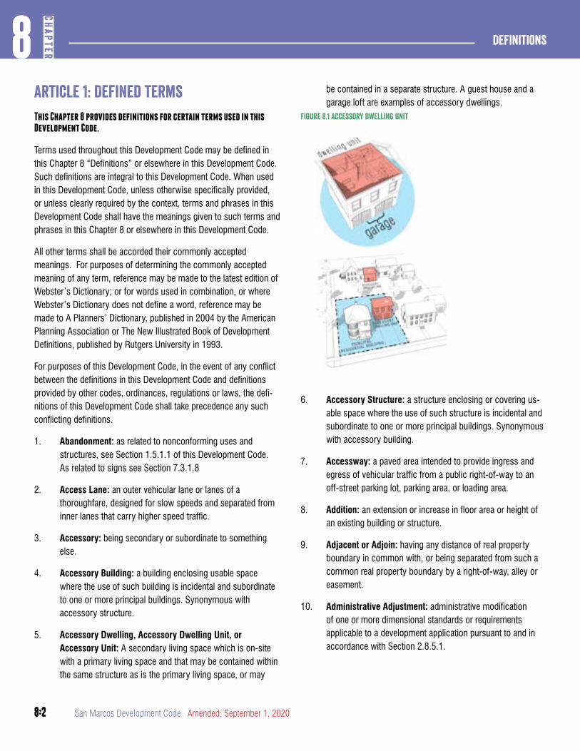
8:2
Definitions8
CHAP
TER
8:2 San Marcos Development Code Amended: September 1, 2020
article 1: Defined TermsThis Chapter 8 provides definitions for certain terms used in this Development Code.
Terms used throughout this Development Code may be defined in this Chapter 8 “Definitions” or elsewhere in this Development Code. Such definitions are integral to this Development Code. When used in this Development Code, unless otherwise specifically provided, or unless clearly required by the context, terms and phrases in this Development Code shall have the meanings given to such terms and phrases in this Chapter 8 or elsewhere in this Development Code.
All other terms shall be accorded their commonly accepted meanings. For purposes of determining the commonly accepted meaning of any term, reference may be made to the latest edition of Webster’s Dictionary; or for words used in combination, or where Webster’s Dictionary does not define a word, reference may be made to A Planners’ Dictionary, published in 2004 by the American Planning Association or The New Illustrated Book of Development Definitions, published by Rutgers University in 1993.
For purposes of this Development Code, in the event of any conflict between the definitions in this Development Code and definitions provided by other codes, ordinances, regulations or laws, the defi-nitions of this Development Code shall take precedence any such conflicting definitions.
1. Abandonment: as related to nonconforming uses and structures, see Section 1.5.1.1 of this Development Code. As related to signs see Section 7.3.1.8
2. Access Lane: an outer vehicular lane or lanes of a thoroughfare, designed for slow speeds and separated from inner lanes that carry higher speed traffic.
3. Accessory: being secondary or subordinate to something else.
4. Accessory Building: a building enclosing usable space where the use of such building is incidental and subordinate to one or more principal buildings. Synonymous with accessory structure.
5. Accessory Dwelling, Accessory Dwelling Unit, or Accessory Unit: A secondary living space which is on-site with a primary living space and that may be contained within the same structure as is the primary living space, or may
be contained in a separate structure. A guest house and a garage loft are examples of accessory dwellings.
Figure 8.1 accessory dwelling unit
6. Accessory Structure: a structure enclosing or covering us-able space where the use of such structure is incidental and subordinate to one or more principal buildings. Synonymous with accessory building.
7. Accessway: a paved area intended to provide ingress and egress of vehicular traffic from a public right-of-way to an off-street parking lot, parking area, or loading area.
8. Addition: an extension or increase in floor area or height of an existing building or structure.
9. Adjacent or Adjoin: having any distance of real property boundary in common with, or being separated from such a common real property boundary by a right-of-way, alley or easement.
10. Administrative Adjustment: administrative modification of one or more dimensional standards or requirements applicable to a development application pursuant to and in accordance with Section 2.8.5.1.
8:3
8CH
APTER
Definitions
8:3Amended: September 1, 2020 San Marcos Development Code
11. Affordable Housing: dwellings consisting of rental or for-sale units that have a rent (including utilities) or mortgage payment typically no more than 30% of the income of families earning no more than 80% of median incomes by family size for the county.
12. Agent: a person authorized by a property owner to represent the owner in the development, improvement, or management of property or in a real estate transaction. In the context of a manufactured home park, agent means any person authorized by the owner of the manufactured home park to operate or maintain the manufactured home park.
13. Agricultural Building: A structure that is designed, constructed, and used to house farm implements, livestock, or agricultural goods and that is used by the owner, immediate family of the owner, and/or persons engaged in the pick-up or delivery of agricultural goods grown or raised on the premises. This definition shall not include a structure used as a dwelling.
14. Alley: a public access easement or right-of-way, not intended to provide the primary means of access to abutting lots, which is used primarily for vehicular service access to the back or sides of properties otherwise abutting on a thoroughfare. An alley may provide the primary means of vehicular access from the thoroughfare to a garage, parking area, parking lot, or parking structure on an abutting lot.
15. Altered or Alteration: any change, modification or transformation.
16. Amending Plat: a Plat which makes minor revisions to a Recorded Plat in accordance with Chapter 3, Article 7, Division 4.
17. Amusement Devices / Arcade (Also Video Arcade): any Building, room, place or establishment of any nature or kind, and by whatever name called, where more than ten percent of the public floor area is devoted to three or more attractions that are operated for a profit, whether the same is operated in conjunction with any other business or not, including but not limited to such attractions as coin-operated pinball machines, video games, electronic games, shuffle boards, pool tables or other similar attractions. However, the term “attraction”, as used herein, shall not include musical devices, billiard tables which are not coin-operated, machines that are designed exclusively for small children, and devices designed to train persons in athletic skills or golf, tennis, baseball, archery or other similar sports.
18. Antenna, Commercial: an antenna or antenna support Structure used for the purpose of transmission, retransmission, and/or reception of radio, television, electromagnetic, or microwave signals primarily for the purpose of operating a business and/or for financial gain (e.g., commercial broadcasting, cellular/wireless telecommunications, etc.). A Satellite dish antenna that exceeds six feet in diameter shall also be considered as a Commercial Antenna.
19. Antenna, Non-Commercial or Amateur: an antenna or antenna support Structure used for the purpose of transmission, retransmission, and/or reception of radio, television, electromagnetic, or microwave signals for private or personal use and not for the purpose of operating a business and/or for financial gain. A Satellite dish antenna not exceeding six feet in diameter shall also be considered as a non-Commercial Antenna.
20. Antenna, Satellite Dish or Direct Broadcast: an apparatus constructed of solid, open mesh, bar-configured, or perforated materials of any shape/configuration that is used to receive and/or transmit radio, television or microwave signals from a terrestrial or orbitally located transmitter or transmitter relay.
21. Antenna Support Structure: any tower, mast, pole, tripod, box frame, or other Structure utilized for the purpose of supporting one or more antennas or microwave reflectors.
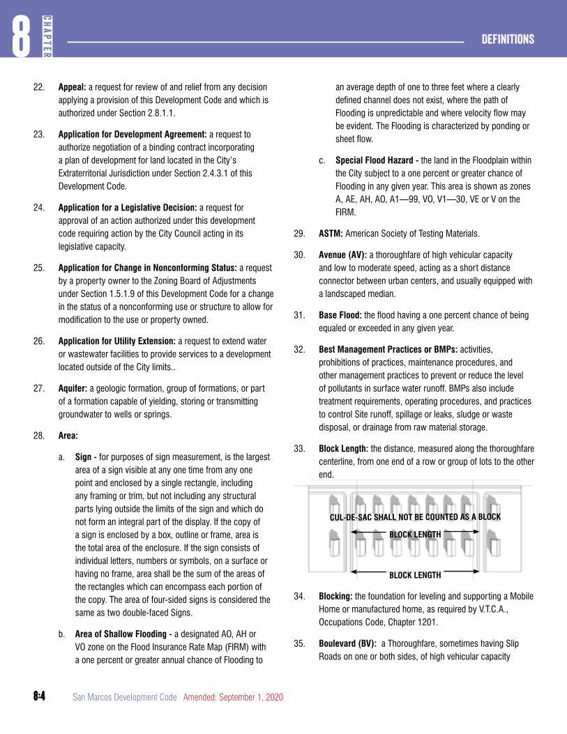
8:4
Definitions8
CHAP
TER
8:4 San Marcos Development Code Amended: September 1, 2020
22. Appeal: a request for review of and relief from any decision applying a provision of this Development Code and which is authorized under Section 2.8.1.1.
23. Application for Development Agreement: a request to authorize negotiation of a binding contract incorporating a plan of development for land located in the City’s Extraterritorial Jurisdiction under Section 2.4.3.1 of this Development Code.
24. Application for a Legislative Decision: a request for approval of an action authorized under this development code requiring action by the City Council acting in its legislative capacity.
25. Application for Change in Nonconforming Status: a request by a property owner to the Zoning Board of Adjustments under Section 1.5.1.9 of this Development Code for a change in the status of a nonconforming use or structure to allow for modification to the use or property owned.
26. Application for Utility Extension: a request to extend water or wastewater facilities to provide services to a development located outside of the City limits..
27. Aquifer: a geologic formation, group of formations, or part of a formation capable of yielding, storing or transmitting groundwater to wells or springs.
28. Area:
a. Sign - for purposes of sign measurement, is the largest area of a sign visible at any one time from any one point and enclosed by a single rectangle, including any framing or trim, but not including any structural parts lying outside the limits of the sign and which do not form an integral part of the display. If the copy of a sign is enclosed by a box, outline or frame, area is the total area of the enclosure. If the sign consists of individual letters, numbers or symbols, on a surface or having no frame, area shall be the sum of the areas of the rectangles which can encompass each portion of the copy. The area of four-sided signs is considered the same as two double-faced Signs.
b. Area of Shallow Flooding - a designated AO, AH or VO zone on the Flood Insurance Rate Map (FIRM) with a one percent or greater annual chance of Flooding to
an average depth of one to three feet where a clearly defined channel does not exist, where the path of Flooding is unpredictable and where velocity flow may be evident. The Flooding is characterized by ponding or sheet flow.
c. Special Flood Hazard - the land in the Floodplain within the City subject to a one percent or greater chance of Flooding in any given year. This area is shown as zones A, AE, AH, AO, A1—99, VO, V1—30, VE or V on the FIRM.
29. ASTM: American Society of Testing Materials.
30. Avenue (AV): a thoroughfare of high vehicular capacity and low to moderate speed, acting as a short distance connector between urban centers, and usually equipped with a landscaped median.
31. Base Flood: the flood having a one percent chance of being equaled or exceeded in any given year.
32. Best Management Practices or BMPs: activities, prohibitions of practices, maintenance procedures, and other management practices to prevent or reduce the level of pollutants in surface water runoff. BMPs also include treatment requirements, operating procedures, and practices to control Site runoff, spillage or leaks, sludge or waste disposal, or drainage from raw material storage.
33. Block Length: the distance, measured along the thoroughfare centerline, from one end of a row or group of lots to the other end.
BLOCK LENGTH
BLOCK LENGTH
CUL-DE-SAC SHALL NOT BE COUNTED AS A BLOCK
34. Blocking: the foundation for leveling and supporting a Mobile Home or manufactured home, as required by V.T.C.A., Occupations Code, Chapter 1201.
35. Boulevard (BV): a Thoroughfare, sometimes having Slip Roads on one or both sides, of high vehicular capacity
8:5
8CH
APTER
Definitions
8:5Amended: September 1, 2020 San Marcos Development Code
and moderate speed, acting as a short distance connector between urban centers, and sometimes equipped with a landscaped median.
36. Building: man-made construction completely enclosed by a roof, window, doors and solid exterior walls, and designed, built, or occupied as a shelter or enclosure for persons, animals, or property, and for the legal occupancy of which a Certificate of Occupancy approved is required, or has been issued prior to the effective date of hereof. Not synonymous with structure.
37. Building, Dangerous: a building that, due to its condition, poses a threat to the public’s health, safety, and welfare.
38. Building Element: any component or part of a Building.
39. Building, Main or Principal: a building in which the principal use of the lot on which it is situated is conducted.
40. Buffer or Bufferyard: land area used to separate a lot or parcel from another lot or parcel or a rrontage, thoroughfare, or district. Buffers may be required to include fences, walls, berms, as well as shrubs and trees. Synonymous with protective yard.
41. Buffer Zone: an area of land adjacent to a water quality zone for a waterway that serves a function of filtering contaminants from water that drains across the area.
42. Building Official: the person designated as the Building Official in the Building Code adopted in Chapter 14 of the City Code.
43. Building Permit: a permit issued by the City’s Building Official or building inspection officer under Chapter 2, Article 8, Division 2 of this Development Code.
44. Caliper: the American Association of Nurserymen standard for trunk measurement of nursery stock, as measured six inches above the ground for trees up to and including four inches caliper size, and as measured at 12 inches above the ground for larger sizes. If the Tree has been severed at less than 12 inches above the soil line, then the Caliper shall be measured across the stump.
45. CCN: a Certificate of Convenience and Necessity issued by a state agency to a utility service provider authorizing the provision of utility service in a defined geographic area.
46. Central Business Area: an area in which certain Development Standards are or are not applicable. The Central Business Area is not a zoning district, or overlay district.
47. Certificate of Appropriateness: a certificate issued under Section 2.5.5.1 of this Development Code for the construction, alteration, restoration, relocation, or demolition of a structure, or alterations to the site or appurtenances, in a Historic District or at a Historic Landmark.
48. Channelization: Alteration of the natural cross sectional area or profile of a Waterway to increase the hydraulic efficiency or carrying capacity of the Waterway.
49. Charitable Gaming Facility: any Building, Structure, establishment or facility of which up to 25 percent of the floor area is devoted to the use of any computerized video game machine owned, leased, controlled or operated by an Internal Revenue Service section 501(c)(3) tax-exempt charitable organization or an Internal Revenue Service section 501(c) tax-exempt veterans organization that, upon payment or charitable contribution, is available to play a video game or a sweepstakes authorized by the State of Texas, and which uses a video display and microprocessor in which, by chance, the player may receive, prizes, free games or credits that can be redeemed for cash.
50. City: the City of San Marcos, Texas, or any authorized person acting in its behalf.
51. City Standards: all of the City’s standards, requirements, and specifications that apply to development, together with all tables, drawings and other attachments. All City standards described or referred to in this Development Code are adopted by referenced and are a part of this Development Code in the same way as if they were set out at length herein. See also TCSS.
52. City Water System: the entire potable water distribution system of the City, including, without limitation, all pipes, facilities, valves, pumps, conduits, tanks, receptacles and fixtures and appurtenances between the water supply sources and the points of delivery, used by the City to produce, convey, deliver, measure, treat or store potable water for public consumption or use.
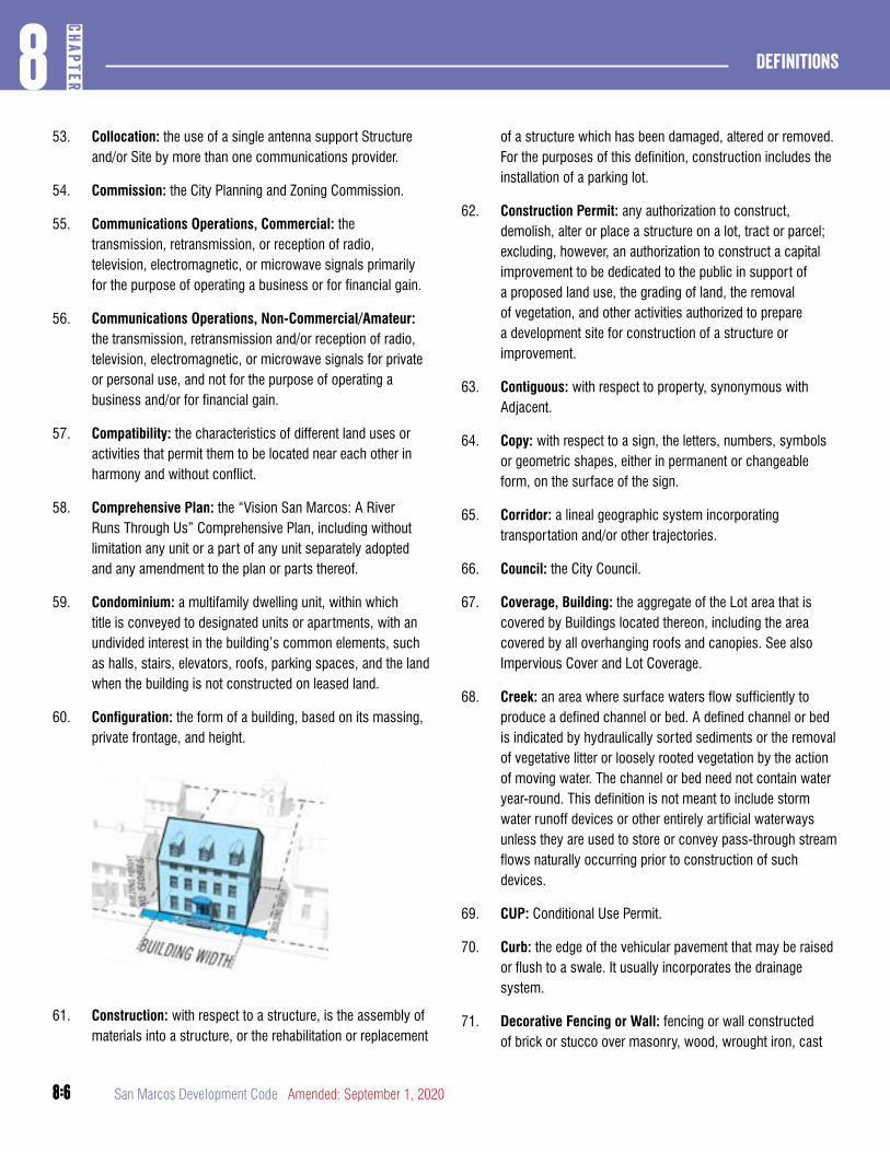
8:6
Definitions8
CHAP
TER
8:6 San Marcos Development Code Amended: September 1, 2020
53. Collocation: the use of a single antenna support Structure and/or Site by more than one communications provider.
54. Commission: the City Planning and Zoning Commission.
55. Communications Operations, Commercial: the transmission, retransmission, or reception of radio, television, electromagnetic, or microwave signals primarily for the purpose of operating a business or for financial gain.
56. Communications Operations, Non-Commercial/Amateur: the transmission, retransmission and/or reception of radio, television, electromagnetic, or microwave signals for private or personal use, and not for the purpose of operating a business and/or for financial gain.
57. Compatibility: the characteristics of different land uses or activities that permit them to be located near each other in harmony and without conflict.
58. Comprehensive Plan: the “Vision San Marcos: A River Runs Through Us” Comprehensive Plan, including without limitation any unit or a part of any unit separately adopted and any amendment to the plan or parts thereof.
59. Condominium: a multifamily dwelling unit, within which title is conveyed to designated units or apartments, with an undivided interest in the building’s common elements, such as halls, stairs, elevators, roofs, parking spaces, and the land when the building is not constructed on leased land.
60. Configuration: the form of a building, based on its massing, private frontage, and height.
61. Construction: with respect to a structure, is the assembly of materials into a structure, or the rehabilitation or replacement
of a structure which has been damaged, altered or removed. For the purposes of this definition, construction includes the installation of a parking lot.
62. Construction Permit: any authorization to construct, demolish, alter or place a structure on a lot, tract or parcel; excluding, however, an authorization to construct a capital improvement to be dedicated to the public in support of a proposed land use, the grading of land, the removal of vegetation, and other activities authorized to prepare a development site for construction of a structure or improvement.
63. Contiguous: with respect to property, synonymous with Adjacent.
64. Copy: with respect to a sign, the letters, numbers, symbols or geometric shapes, either in permanent or changeable form, on the surface of the sign.
65. Corridor: a lineal geographic system incorporating transportation and/or other trajectories.
66. Council: the City Council.
67. Coverage, Building: the aggregate of the Lot area that is covered by Buildings located thereon, including the area covered by all overhanging roofs and canopies. See also Impervious Cover and Lot Coverage.
68. Creek: an area where surface waters flow sufficiently to produce a defined channel or bed. A defined channel or bed is indicated by hydraulically sorted sediments or the removal of vegetative litter or loosely rooted vegetation by the action of moving water. The channel or bed need not contain water year-round. This definition is not meant to include storm water runoff devices or other entirely artificial waterways unless they are used to store or convey pass-through stream flows naturally occurring prior to construction of such devices.
69. CUP: Conditional Use Permit.
70. Curb: the edge of the vehicular pavement that may be raised or flush to a swale. It usually incorporates the drainage system.
71. Decorative Fencing or Wall: fencing or wall constructed of brick or stucco over masonry, wood, wrought iron, cast
8:7
8CH
APTER
Definitions
8:7Amended: September 1, 2020 San Marcos Development Code
aluminum, or other materials traditionally used in private fence construction; excluding without limitation chain link, woven wire mesh, metal panel and similar materials.
72. Design Speed: the velocity at which a thoroughfare tends to be driven without the constraints of signage or enforcement. There are four ranges of speed: Very Low: (below 20 MPH); Low: (20-25 MPH); Moderate: (25-35 MPH); High: (above 35 MPH). Lane width is determined by desired Design Speed.
73. Developed Area: that portion of a plot or parcel upon which a Building, Structure, pavement or other Improvements have been placed.
74. Developer: an individual, partnership, corporation or governmental entity undertaking the division or Improvement of land and other activities covered by this Development Code, including the preparation of a Subdivision Plat or Development Plat showing the layout of the land and the public Improvements involved therein. The term “Developer” is intended to include the term “Subdivider,” even though personnel in successive stages of a Development project may vary.
75. Development: initiation of any activities related to the subdivision or platting of land or construction of buildings or structures, construction of impervious surfaces, the installation of utilities, roadways, drainage facilities or other infrastructure; the making of improvements or any disturbance of the surface or subsurface of the land in preparation for such activities, including without limitation removal of vegetation, grading, clearing, filling, or removal of soil.
76. Development Agreement: a contract between the City and a developer which establishes with respect to property in the Extraterritorial Jurisdiction a plan of development prescribing, among other standards and requirements, land uses, environmental standards, development standards, and public facilities standards, providing for delivery of public facilities to the property, and providing for the annexation of the property to the City.
77. Development Application: either an application for a legislative decision or an application for a development permit.
78. Development Permit: a decision by the commission, board or City staff designated by this Development Code, that authorizes the holder of the permit to undertake one or more development activities or to file further applications needed to initiate or continue development activities authorized under this Development Code. The filing of a complete application for a development permit may or may not stay the City from adopting new standards applicable to the permit or any sub-ordinate permit, depending on the nature of the standards.
79. Development Standards: all regulations, standards, require-ments and restrictions that apply to Development.
80. Discharge: to deposit, conduct, drain, emit, throw, run, allow to seep or otherwise release or dispose of or to allow, permit or suffer any of these acts or omissions.
81. Drainage: bridges, catch basins, channels, conduits, creeks, culverts, detention ponds, ditches, draws, flumes, pipes, pumps, sloughs, treatment works, and appurtenances to those items, whether natural or artificial, or using force or gravity, that are used to draw off surface water from land, carry the water away, collect, store, or treat the water, or divert the water into natural or artificial waterways.
82. Driveway: a vehicular lane within a lot or parcel of land, often leading to a garage.
83. Dwelling Unit: a room or suite or set of rooms occupied and suitable for occupancy as a family residence and having a kitchen, and bath and sanitary facilities, together with appro-priate appurtenances to that occupancy.
a. Dwelling Unit Equivalent (DUE) - a density value for multiple-family dwelling units based upon the number of bedrooms in the unit. This value shall be applied to the units per acre measurement in order to meet the dwelling unit requirement.
1. Three-bedroom unit = one unit;
2. Four-bedroom unit = one and one-half units;
3. Five-bedroom unit = two units;
4. Six-bedroom unit = two units
5. Every second bedroom above the fifth bedroom = one additional unit
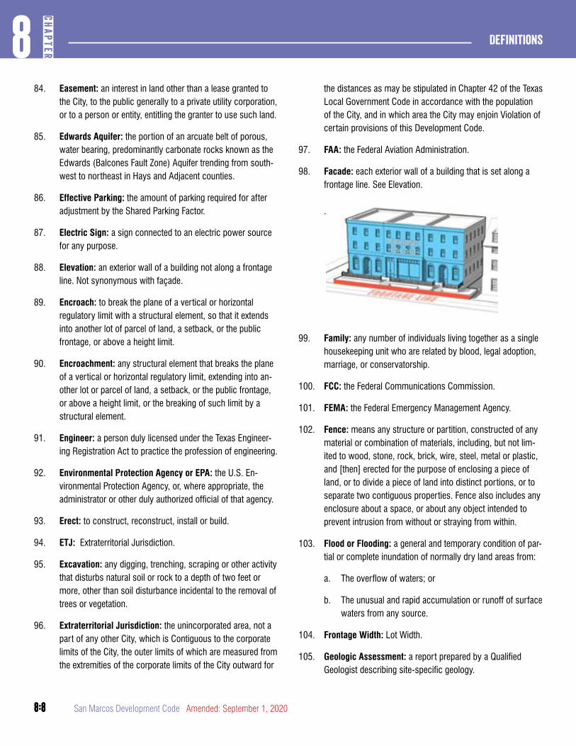
8:8
Definitions8
CHAP
TER
8:8 San Marcos Development Code Amended: September 1, 2020
84. Easement: an interest in land other than a lease granted to the City, to the public generally to a private utility corporation, or to a person or entity, entitling the granter to use such land.
85. Edwards Aquifer: the portion of an arcuate belt of porous, water bearing, predominantly carbonate rocks known as the Edwards (Balcones Fault Zone) Aquifer trending from south-west to northeast in Hays and Adjacent counties.
86. Effective Parking: the amount of parking required for after adjustment by the Shared Parking Factor.
87. Electric Sign: a sign connected to an electric power source for any purpose.
88. Elevation: an exterior wall of a building not along a frontage line. Not synonymous with façade.
89. Encroach: to break the plane of a vertical or horizontal regulatory limit with a structural element, so that it extends into another lot of parcel of land, a setback, or the public frontage, or above a height limit.
90. Encroachment: any structural element that breaks the plane of a vertical or horizontal regulatory limit, extending into an-other lot or parcel of land, a setback, or the public frontage, or above a height limit, or the breaking of such limit by a structural element.
91. Engineer: a person duly licensed under the Texas Engineer-ing Registration Act to practice the profession of engineering.
92. Environmental Protection Agency or EPA: the U.S. En-vironmental Protection Agency, or, where appropriate, the administrator or other duly authorized official of that agency.
93. Erect: to construct, reconstruct, install or build.
94. ETJ: Extraterritorial Jurisdiction.
95. Excavation: any digging, trenching, scraping or other activity that disturbs natural soil or rock to a depth of two feet or more, other than soil disturbance incidental to the removal of trees or vegetation.
96. Extraterritorial Jurisdiction: the unincorporated area, not a part of any other City, which is Contiguous to the corporate limits of the City, the outer limits of which are measured from the extremities of the corporate limits of the City outward for
the distances as may be stipulated in Chapter 42 of the Texas Local Government Code in accordance with the population of the City, and in which area the City may enjoin Violation of certain provisions of this Development Code.
97. FAA: the Federal Aviation Administration.
98. Facade: each exterior wall of a building that is set along a frontage line. See Elevation. .
99. Family: any number of individuals living together as a single housekeeping unit who are related by blood, legal adoption, marriage, or conservatorship.
100. FCC: the Federal Communications Commission.
101. FEMA: the Federal Emergency Management Agency.
102. Fence: means any structure or partition, constructed of any material or combination of materials, including, but not lim-ited to wood, stone, rock, brick, wire, steel, metal or plastic, and [then] erected for the purpose of enclosing a piece of land, or to divide a piece of land into distinct portions, or to separate two contiguous properties. Fence also includes any enclosure about a space, or about any object intended to prevent intrusion from without or straying from within.
103. Flood or Flooding: a general and temporary condition of par-tial or complete inundation of normally dry land areas from:
a. The overflow of waters; or
b. The unusual and rapid accumulation or runoff of surface waters from any source.
104. Frontage Width: Lot Width.
105. Geologic Assessment: a report prepared by a Qualified Geologist describing site-specific geology.
8:9
8CH
APTER
Definitions
8:9Amended: September 1, 2020 San Marcos Development Code
106. Geologic Feature: a feature including, but not limited to, closed depressions, sinkholes, caves, faults, fractures, bed-ding planes, interconnected vugs, reef deposits and springs.
107. Greenfield: an area that consists of open or wooded land or farmland that has not been previously developed.
108. Green Roof: a roof of a Building on which plants are grown.
109. Height, Sign: the vertical distance between the highest part of the Sign or its supporting Structure, whichever is higher, and the greatest elevation of the ground at the base of or below the Sign.
110. Historic District: an Overlay District intended to preserve and protect Historic Structures, Thoroughfares, and neigh-borhoods that serve as visible reminders of the history and cultural heritage of the City, the State and the United States.
111. Historic Landmark: a site having historical, architectural, or cultural significance which is suitable for preservation or Restoration, has educational value and satisfies the criteria established for inclusion in the National Register of Historic Places, as determined in accordance with Chapter 2, Article 5, Division 4.
112. Historic Structure: any Structure that is:
a. Listed individually in the National Register of Historical Places or preliminarily determined by the Secretary of the Interior as meeting the requirements for individual listing on the National Register; and/or
b. Certified or preliminarily determined by the Secretary of the Interior as contributing to the historical significance of a registered Historic District or a district preliminarily determined by the secretary to qualify as a registered Historic District; and/or
c. Individually listed on a local or state inventory of historic places.
113. Holder: the person who applied for and obtained approval of an application, license, or permit, or the successor-in-inter-est of such person.
114. HUD-Code Manufactured Home: a Structure, constructed on or after June 15, 1976, according to the rules of the Unit-ed States Department of Housing and Urban Development,
and V.T.C.A., Occupations Code, Chapter 1201, transportable in one or more sections, which, in the traveling mode, is eight body feet or more in width or 40 body feet or more in length, or, when Erected on site, is 320 or more square feet, and which is built on a permanent chassis and designed to be used as a dwelling with or without a permanent founda-tion when connected to the required utilities, and includes the plumbing, heating, air conditioning and electrical systems. The term does not include a Recreational Vehicle as that term is defined by this Development Code.
115. Impervious Cover: impermeable surfaces, such as pave-ment or rooftops, which prevent the infiltration of water into the soil and bedrock.
116. Improved Lot or Tract: a Lot or tract that has a Structure or other Improvement on it that causes an Impervious Coverage of the soil under the Structure or Improvement.
117. Improvement: any man-made Alteration of land, a Lot, a Building or a Structure.
118. Industrialized Home (single-Family, also called modular prefabricated Structure or Modular Home): a structure or building module, as defined under the jurisdiction and control of the Texas Department of Labor and Standards, that is transportable in one or more sections on a temporary chassis or other conveyance device, and that is designed to be installed and used by a consumer as a fixed residence on a permanent foundation system. The term includes the plumbing, heating, air-conditioning and electrical systems contained in the Structure. The term does not include Mobile Homes or HUD-Code Manufactured Homes as defined in the Texas Manufactured Housing Standards Act (V.T.C.A., Occupations Code, Chapter 1201), nor does it include a Recreational Vehicle as that term is defined by this Develop-ment Code.
119. Infill: as a noun, new development on land that had been previously developed including without limitation, greyfield and brownfield sites and cleared land within urbanized areas; as a verb, to develop such areas.
120. Interested Person: a person who is impacted by a final de-cision of the City to the extent that such impact exceeds the impact of the decision on a member of the general public. An Interested Person includes any officer or agency of the City.
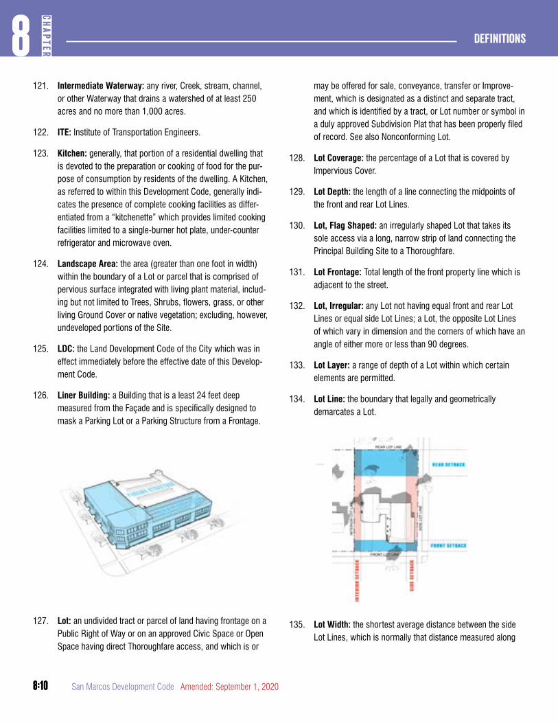
8:10
Definitions8
CHAP
TER
8:10 San Marcos Development Code Amended: September 1, 2020
121. Intermediate Waterway: any river, Creek, stream, channel, or other Waterway that drains a watershed of at least 250 acres and no more than 1,000 acres.
122. ITE: Institute of Transportation Engineers.
123. Kitchen: generally, that portion of a residential dwelling that is devoted to the preparation or cooking of food for the pur-pose of consumption by residents of the dwelling. A Kitchen, as referred to within this Development Code, generally indi-cates the presence of complete cooking facilities as differ-entiated from a “kitchenette” which provides limited cooking facilities limited to a single-burner hot plate, under-counter refrigerator and microwave oven.
124. Landscape Area: the area (greater than one foot in width) within the boundary of a Lot or parcel that is comprised of pervious surface integrated with living plant material, includ-ing but not limited to Trees, Shrubs, flowers, grass, or other living Ground Cover or native vegetation; excluding, however, undeveloped portions of the Site.
125. LDC: the Land Development Code of the City which was in effect immediately before the effective date of this Develop-ment Code.
126. Liner Building: a Building that is a least 24 feet deep measured from the Façade and is specifically designed to mask a Parking Lot or a Parking Structure from a Frontage.
127. Lot: an undivided tract or parcel of land having frontage on a Public Right of Way or on an approved Civic Space or Open Space having direct Thoroughfare access, and which is or
may be offered for sale, conveyance, transfer or Improve-ment, which is designated as a distinct and separate tract, and which is identified by a tract, or Lot number or symbol in a duly approved Subdivision Plat that has been properly filed of record. See also Nonconforming Lot.
128. Lot Coverage: the percentage of a Lot that is covered by Impervious Cover.
129. Lot Depth: the length of a line connecting the midpoints of the front and rear Lot Lines.
130. Lot, Flag Shaped: an irregularly shaped Lot that takes its sole access via a long, narrow strip of land connecting the Principal Building Site to a Thoroughfare.
131. Lot Frontage: Total length of the front property line which is adjacent to the street.
132. Lot, Irregular: any Lot not having equal front and rear Lot Lines or equal side Lot Lines; a Lot, the opposite Lot Lines of which vary in dimension and the corners of which have an angle of either more or less than 90 degrees.
133. Lot Layer: a range of depth of a Lot within which certain elements are permitted.
134. Lot Line: the boundary that legally and geometrically demarcates a Lot.
135. Lot Width: the shortest average distance between the side Lot Lines, which is normally that distance measured along
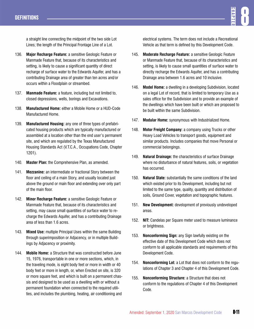
8:11
8CH
APTER
Definitions
8:11Amended: September 1, 2020 San Marcos Development Code
a straight line connecting the midpoint of the two side Lot Lines; the length of the Principal Frontage Line of a Lot.
136. Major Recharge Feature: a sensitive Geologic Feature or Manmade Feature that, because of its characteristics and setting, is likely to cause a significant quantity of direct recharge of surface water to the Edwards Aquifer, and has a contributing Drainage area of greater than ten acres and/or occurs within a Floodplain or streambed.
137. Manmade Feature: a feature, including but not limited to, closed depressions, wells, borings and Excavations.
138. Manufactured Home: either a Mobile Home or a HUD-Code Manufactured Home.
139. Manufactured Housing: any one of three types of prefabri-cated housing products which are typically manufactured or assembled at a location other than the end user’s permanent site, and which are regulated by the Texas Manufactured Housing Standards Act (V.T.C.A., Occupations Code, Chapter 1201).
140. Master Plan: the Comprehensive Plan, as amended.
141. Mezzanine: an intermediate or fractional Story between the floor and ceiling of a main Story, and usually located just above the ground or main floor and extending over only part of the main floor.
142. Minor Recharge Feature: a sensitive Geologic Feature or Manmade Feature that, because of its characteristics and setting, may cause small quantities of surface water to re-charge the Edwards Aquifer, and has a contributing Drainage area of less than 1.6 acres.
143. Mixed Use: multiple Principal Uses within the same Building through superimposition or Adjacency, or in multiple Build-ings by Adjacency or proximity.
144. Mobile Home: a Structure that was constructed before June 15, 1976, transportable in one or more sections, which, in the traveling mode, is eight body feet or more in width or 40 body feet or more in length, or, when Erected on site, is 320 or more square feet, and which is built on a permanent chas-sis and designed to be used as a dwelling with or without a permanent foundation when connected to the required utili-ties, and includes the plumbing, heating, air conditioning and
electrical systems. The term does not include a Recreational Vehicle as that term is defined by this Development Code.
145. Moderate Recharge Feature: a sensitive Geologic Feature or Manmade Feature that, because of its characteristics and setting, is likely to cause small quantities of surface water to directly recharge the Edwards Aquifer, and has a contributing Drainage area between 1.6 acres and 10 inclusive.
146. Model Home: a dwelling in a developing Subdivision, located on a legal Lot of record, that is limited to temporary Use as a sales office for the Subdivision and to provide an example of the dwellings which have been built or which are proposed to be built within the same Subdivision.
147. Modular Home: synonymous with Industrialized Home.
148. Motor Freight Company: a company using Trucks or other Heavy Load Vehicles to transport goods, equipment and similar products. Includes companies that move Personal or commercial belongings.
149. Natural Drainage: the characteristics of surface Drainage where no disturbance of natural features, soils, or vegetation has occurred.
150. Natural State: substantially the same conditions of the land which existed prior to its Development, including but not limited to the same type, quality, quantity and distribution of soils, Ground Cover, vegetation and topographic features.
151. New Development: development of previously undeveloped areas.
152. NIT: Candelas per Square meter used to measure luminance or brightness.
153. Nonconforming Sign: any Sign lawfully existing on the effective date of this Development Code which does not conform to all applicable standards and requirements of this Development Code.
154. Nonconforming Lot: a Lot that does not conform to the regu-lations of Chapter 3 and Chapter 4 of this Development Code.
155. Nonconforming Structure: a Structure that does not conform to the regulations of Chapter 4 of this Development Code.
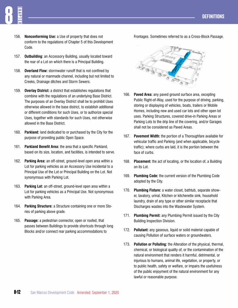
8:12
Definitions8
CHAP
TER
8:12 San Marcos Development Code Amended: September 1, 2020
156. Nonconforming Use: a Use of property that does not conform to the regulations of Chapter 5 of this Development Code.
157. Outbuilding: an Accessory Building, usually located toward the rear of a Lot on which there is a Principal Building.
158. Overland Flow: stormwater runoff that is not confined by any natural or manmade channel, including but not limited to Creeks, Drainage ditches and Storm Sewers.
159. Overlay District: a district that establishes regulations that combine with the regulations of an underlying Base District. The purposes of an Overlay District shall be to prohibit Uses otherwise allowed in the base district, to establish additional or different conditions for such Uses, or to authorize special Uses, together with standards for such Uses, not otherwise allowed in the Base District.
160. Parkland: land dedicated to or purchased by the City for the purpose of providing public Open Space.
161. Parkland Benefit Area: the area that a specific Parkland, based on its size, location, and facilities, is intended to serve.
162. Parking Area: an off-street, ground-level open area within a Lot for parking vehicles as an Accessory Use incidental to a Principal Use of the Lot or Principal Building on the Lot. Not synonymous with Parking Lot.
163. Parking Lot: an off-street, ground-level open area within a Lot for parking vehicles as a Principal Use. Not synonymous with Parking Area.
164. Parking Structure: a Structure containing one or more Sto-ries of parking above grade.
165. Passage: a pedestrian connector, open or roofed, that passes between Buildings to provide shortcuts through long Blocks and/or connect rear parking accommodations to
Frontages. Sometimes referred to as a Cross-Block Passage.
166. Paved Area: any paved ground surface area, excepting Public Right-of-Way, used for the purpose of driving, parking, storing or displaying of vehicles, boats, trailers or Mobile Homes, including new and used car lots and other open lot uses. Parking Structures, covered drive-in Parking Areas or Parking Lots to the drip line of the covering, and/or Garages shall not be considered as Paved Areas.
167. Pavement Width: the portion of a Thoroughfare available for vehicular traffic and Parking (and when applicable, bicycle traffic); where curbs are laid, it is the portion between the face of curbs.
168. Placement: the act of locating, or the location of, a Building on its Lot.
169. Plumbing Code: the current version of the Plumbing Code adopted by the City.
170. Plumbing Fixture: a water closet, bathtub, separate show-er, lavatory, urinal, Kitchen or kitchenette sink, household laundry, drain of any type or other similar receptacle that Discharges wastes into the Wastewater System.
171. Plumbing Permit: any Plumbing Permit issued by the City Building Inspection Division.
172. Pollutant: any gaseous, liquid or solid material capable of causing Pollution of surface waters or groundwaters.
173. Pollution or Polluting: the Alteration of the physical, thermal, chemical, or biological quality of, or the contamination of the natural environment that renders it harmful, detrimental, or injurious to humans, animal life, vegetation, or property, or to public health, safety or welfare, or impairs the usefulness of the public enjoyment of the natural environment for any lawful or reasonable purpose.
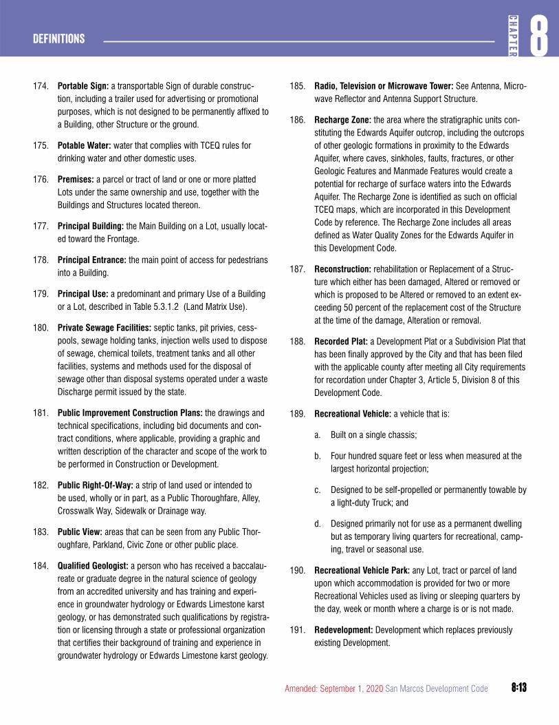
8:13
8CH
APTER
Definitions
8:13Amended: September 1, 2020 San Marcos Development Code
174. Portable Sign: a transportable Sign of durable construc-tion, including a trailer used for advertising or promotional purposes, which is not designed to be permanently affixed to a Building, other Structure or the ground.
175. Potable Water: water that complies with TCEQ rules for drinking water and other domestic uses.
176. Premises: a parcel or tract of land or one or more platted Lots under the same ownership and use, together with the Buildings and Structures located thereon.
177. Principal Building: the Main Building on a Lot, usually locat-ed toward the Frontage.
178. Principal Entrance: the main point of access for pedestrians into a Building.
179. Principal Use: a predominant and primary Use of a Building or a Lot, described in Table 5.3.1.2 (Land Matrix Use).
180. Private Sewage Facilities: septic tanks, pit privies, cess-pools, sewage holding tanks, injection wells used to dispose of sewage, chemical toilets, treatment tanks and all other facilities, systems and methods used for the disposal of sewage other than disposal systems operated under a waste Discharge permit issued by the state.
181. Public Improvement Construction Plans: the drawings and technical specifications, including bid documents and con-tract conditions, where applicable, providing a graphic and written description of the character and scope of the work to be performed in Construction or Development.
182. Public Right-Of-Way: a strip of land used or intended to be used, wholly or in part, as a Public Thoroughfare, Alley, Crosswalk Way, Sidewalk or Drainage way.
183. Public View: areas that can be seen from any Public Thor-oughfare, Parkland, Civic Zone or other public place.
184. Qualified Geologist: a person who has received a baccalau-reate or graduate degree in the natural science of geology from an accredited university and has training and experi-ence in groundwater hydrology or Edwards Limestone karst geology, or has demonstrated such qualifications by registra-tion or licensing through a state or professional organization that certifies their background of training and experience in groundwater hydrology or Edwards Limestone karst geology.
185. Radio, Television or Microwave Tower: See Antenna, Micro-wave Reflector and Antenna Support Structure.
186. Recharge Zone: the area where the stratigraphic units con-stituting the Edwards Aquifer outcrop, including the outcrops of other geologic formations in proximity to the Edwards Aquifer, where caves, sinkholes, faults, fractures, or other Geologic Features and Manmade Features would create a potential for recharge of surface waters into the Edwards Aquifer. The Recharge Zone is identified as such on official TCEQ maps, which are incorporated in this Development Code by reference. The Recharge Zone includes all areas defined as Water Quality Zones for the Edwards Aquifer in this Development Code.
187. Reconstruction: rehabilitation or Replacement of a Struc-ture which either has been damaged, Altered or removed or which is proposed to be Altered or removed to an extent ex-ceeding 50 percent of the replacement cost of the Structure at the time of the damage, Alteration or removal.
188. Recorded Plat: a Development Plat or a Subdivision Plat that has been finally approved by the City and that has been filed with the applicable county after meeting all City requirements for recordation under Chapter 3, Article 5, Division 8 of this Development Code.
189. Recreational Vehicle: a vehicle that is:
a. Built on a single chassis;
b. Four hundred square feet or less when measured at the largest horizontal projection;
c. Designed to be self-propelled or permanently towable by a light-duty Truck; and
d. Designed primarily not for use as a permanent dwelling but as temporary living quarters for recreational, camp-ing, travel or seasonal use.
190. Recreational Vehicle Park: any Lot, tract or parcel of land upon which accommodation is provided for two or more Recreational Vehicles used as living or sleeping quarters by the day, week or month where a charge is or is not made.
191. Redevelopment: Development which replaces previously existing Development.
8:14
Definitions8
CHAP
TER
8:14 San Marcos Development Code Amended: September 1, 2020
192. Redevelopment Infill: Development characterized by replacing existing Development or re-establishing formerly developed areas.
193. Remainder Tract: land that is part of a larger parcel that is not subject to a Subdivision Concept plat or Watershed Protection Plan affecting the parcel.
194. Remodeling: renovation, Alteration or Repair of an Existing Structure that is not an Addition.
195. Repair: to restore or mend to sound working condition after damage, decay or failure.
196. Replacement: the act of moving one Structure from its ex-isting location or site and replacing it with another Structure, or the act of replacing a Structure previously removed with another Structure.
197. Reserve Strip: a privately owned strip of land, normally one foot in depth, Adjacent to the Public Right-of-Way or Easement preventing the extension of the Right-of-Way or Easement without the expressed consent of the owner.
198. Residential: Use characterizing premises available for long-term human dwelling, exclusive of Lodging.
199. Responsible Official: the director of the City department who has been designated to accept a type of Development Application for filing, to review and make recommendations concerning such applications, and where authorized, to initially decide such applications, to initiate enforcement ac-tions, and to take all other actions necessary for administra-tion of the provisions of this Development Code with respect to such Development Applications. For all purposes of this Development Code, the Planning Director is the Responsible Official.
200. Restoration: for water quality regulation purposes, the estab-lishment of plants, grasses and vegetation native to a partic-ular Site for the purposes of erosion control and preservation or Restoration of biological and physical habitat; for all other purposes, to return an area, Building or other Structure to its previous condition.
201. Restructure: with respect to Signs, the replacement of structural members of a Sign for the purpose of extending the life of a Sign.
202. ROW: Right-of-Way.
RIGHT-OF-WAY
VehicularLanes
PublicFrontage
PublicFrontage
ParkingLane
ParkingLane
203. Satellite: See Antenna.
204. Screen/Screening: to shield and/or separate physically and visually any Use, activity, Building, Structure, object, or element; a Structure which provides such separation.
205. Senior Housing: means a residential complex containing multifamily, townhomes, or fouplex dwellings designated for and occupied by senior adults of ages 55 or greater. Such facilities may include a congregate meals program in a common dining area, but exclude institutional care such as medical mursing care and are distinguished from an assisted living facility as elsewhere defined. Maxium density shall be as required by the applicable zoning district; or if not designated by the zoning district, maximum density shall be 14 units per acre.
206. Sensitive Feature: a permeable Geologic Feature or Man-made Feature located on the Recharge Zone or Transition Zone where:
a. A potential for hydrologic connection between the sur-face and the aquifer exists;
b. Rapid infiltration to the subsurface may occur; and
c. The feature has a sensitivity rating, according to TCEQ rating criteria, of 25 points or more on a Geologic Assessment prepared to TCEQ standards by a Qualified Geologist.
207. Sensitive Feature Protection Zone: the area surrounding Sensitive Features where no Development or disturbance of native vegetation is allowed.
8:15
8CH
APTER
Definitions
8:15Amended: September 1, 2020 San Marcos Development Code
208. Shared Parking Factor: an accounting for parking spaces that are available to more than one Use. See Table 5.1.6.2B (Shared Parking Factor) and Section 5.1.6.2.
209. Sharrow: also known as Shared Lane Marking in the Manual of Uniform Traffic Control Devices, is a pavement marking indicating that motorists and cyclists share a travel lane. The Sharrow shall be placed so that the centers of the markings are at least 11 feet from the face of the curb, or from the edge of the pavement where there is no curb.
210. Shopfront: a Private Frontage type conventional for Retail Use, with substantial glazing and an awning, wherein the Facade is aligned close to the Frontage Line with the Building entrance at Sidewalk grade. See Table 5.2.8.11D (Private Frontage).
211. Shrub: any self-supporting woody evergreen and/or decidu-ous species.
212. Sidewalk: a paved pedestrian way generally located within Public Thoroughfare Right-of-Way but outside the roadway.
213. Sight Triangle: a triangle-shaped area Adjacent to the intersection of two Thoroughfares, formed by two lines measured a distance from 25 feet along the Curb Line of the Thoroughfares from their point of intersection and a third line connecting the two ends.
214. Sign: every device, Structure, frame, letter, figure, character, mark, plane, point, design, picture, stroke, stripe, projection, symbol, logo, trademark, or reading situated outdoors, or indoors affixed to a window, or located within 12 inches from a window facing the exterior, which is used, or intended to be used, to attract attention, convey information, identify or advertise any establishment, product, goods, or service when the same is placed in view of the off-Premises general public. The term Sign shall not include the flag or Pennant or insignia of any state, city or other political unit or of any charitable, educational, philanthropic, civic, or religious organization. The following are types of Signs:
a. Sign, Address/Postal - A Sign that consists of a numeric reference to a Structure or Thoroughfare, mounted onto the Wall of the Building.
b. Sign, Animated - any Sign that uses flashing lights, movement, changing of lighting, or any other means to
depict motion, an illusion of motion, create a special effect or scene through the use of patterns of lights, changes in color or light intensity, computerized special effects, video displays or through any other method, including holographic displays, which create a three dimensional image through projection or television screens and which the message does not include a CEVM Sign as defined below in subsection (d) or a community information Sign.
c. Sign, Attached - any Sign attached to, applied on or supported by any part of a Building or Accessory Struc-ture or moveable panels.
d. Sign, Automatic Changing - a Sign which automatically changes the Sign Copy on a preprogrammed cycle through the use of illumination.
e. Sign, Awning - An Awning that contains a Retail tenant Sign which may be painted, screen printed, or appli-queed on the Awning. This Sign type is a traditional Shopfront fitting and can be used to protect merchants’ wares and keep Shopfront interiors shaded and cooled, and provide temporary cover for pedestrians
f. Sign, Band - A Sign that is flat against the Facade consisting of individual cut letters applied directly to the Building, or painted directly on the surface of the Building. These Signs are placed directly above the main entrance and often run horizontally along the entablature of traditional Buildings. Band Signs are typically intend-ed to be seen from a distance and are often accompa-nied by additional pedestrian-scaled Signage. May also be referred to as a Wall Sign or Facade Sign.
g. Sign, Blade - A Sign mounted perpendicular to a Building Facade Wall, projecting at a 90-degree angle, made of metal or other material more than 1/2 inch in thickness, and typically hung from decorative cast or wrought iron brackets in a manner that permits it to swing slightly. These Signs are small, pedestrian scaled, and easily read from both sides. May also be referred to as a Projecting Sign.
h. Sign, Changeable Electronic Variable Message (CVEM) - a Sign that is activated electronically or by other means, whose message, content, or display,
8:16
Definitions8
CHAP
TER
8:16 San Marcos Development Code Amended: September 1, 2020
either in whole or in part, may be changed by means of electronic, computerized programming, or any other means, and which the message is in text, alpha-numeric characters, symbols, logos, or static image. There shall be no more than one message or static image displayed at any time and the message, image or background shall not change more often than once every 60 sec-onds. Monument Signs on which the sole message is the grade and price of fuel, or time and temperature or a drive through menu board are not considered CEVM Signs.
i. Sign, Community Information - any Sign which promotes items of community interest including time, temperature, date, atmospheric conditions and upcom-ing noncommercial events or charitable causes.
j. Sign, Directional - a Sign which provides directions to a destination or other wayfinding information.
k. Sign, Directory - A Sign that displays the tenant name and location for a Building containing multiple tenants
l. Sign, Freestanding - any Sign affixed to the ground or mounted on a fence or wall which is not an integral part of a Building or Accessory Structure.
m. Sign, Identification - a Sign containing the name, ad-dress and recognized symbol or logo of a Subdivision, Building or complex of Buildings containing multiple occupancies or of any nonprofit, civic, religious, edu-cational or governmental institution. Identification Signs for multiple occupancies may also contain the names, addresses and recognized symbol or logo of two or more of the individual tenants or businesses.
n. Sign, Marquee - A vertical Sign that is located either along the Building Facade where it projects perpendicu-lar to the Facade; or at the corner of the Building where it projects at a 45 degree angle. Marquee Signs are a structural feature of a Building that provides both cover to pedestrians and Sign space. These Signs may extend beyond the parapet of the Building where it projects at a 45 degree angle, but may also terminate below the cor-nice or eave. Marquee Signs often have neon lettering used in conjunction with removable or painted lettering.
o. Sign, Monument - a Sign that is Erected on a solid base directly on the ground and not supported by a pole, and that is itself constructed of a solid material.
p. Sign, Multi Business - Signs that are mounted in a yard between the Public Right-of-Way and the Build-ing Facade. Signs mounted in a yard may be placed parallel or perpendicular to the enfronting Thoroughfare. Multi-Business Signs are for Buildings in which multiple businesses are located in Mixed-Use environments that are in the process of transitioning from a suburban to an urban environment.
q. Sign, Off Premises - a Sign which does not exclusively refer to the name, location, products, persons, services or activities of or on the Premises where it is located, except for certain permitted Multiple Occupancy busi-ness centers.
r. Sign, On Premises - any Sign which relates exclusively to the name, location, products, persons, services or activities of or on the Premises where it is located.
s. Sign, Outdoor Display Case - a Sign which consists of a lockable metal or wood framed cabinet with a trans-parent window or windows, mounted onto a Building wall or free-standing support. It allows the contents, such as menus or maps, to be maintained and kept current.
t. Sign, Pole - A Sign other than an Outdoor Display Case which is mounted on one or more freestanding sup-ports, such as a frame, column, mast, pole or similar support such that the bottom of the Sign face or lowest Sign module is not in contact with the ground.
u. Sign, Sidewalk - A Sign that provides secondary Signage and may be used to announce daily specials, sales, or point to shops located off the sidewalk. They may be painted wood panels or cut wood shapes. Tra-ditional slate boards are highly recommended. Chaser lights or aluminum signs may not be used. May also be referred to as a Sandwich Board.
v. Sign, Temporary - a Sign which is displayed for a limit-ed period of time only and which is typically associated with an activity or event of limited duration.
8:17
8CH
APTER
Definitions
8:17Amended: September 1, 2020 San Marcos Development Code
w. Sign, Wall Mural - a Sign which is flat against the Facade of a Secondary Frontage. These Signs are typically painted directly on the Building and contain a combination of text and graphic elements. They are intended to be visible from a greater distance and shall be accompanied by additional Signage on the primary front Facade at the business entrance. Billboards are not considered Wall Mural and are prohibited.
x. Sign, Window Sign - Professionally painted Signs, consisting of individual letters and/or designs, applied directly on the inside of a window or door. These Signs offer a high level of craftsmanship and visibility, and are often used for small professional offices. Window Signs are often repeated on storefronts with several divided openings, however, repetition should be done with great care to ensure that the entrance to the business is clear-ly marked. Sign Band: external area of Building Facade designated for placement of horizontal Signage typically above the transom and below the second floor window.
215. Sign Permit: a City-issued permit that authorizes the display, Erection, rebuilding, expansion or relocation of any On-Prem-ises Sign or Off-Premises Sign.
216. Site: a tract of property that is the subject of Development or a Development Application.
217. Site Plan: a detailed plan showing the roads, parking, foot-prints of all Buildings, existing Trees, proposed landscaping, Parkland, Open Space, grading and Drainage, and similar features needed to verify compliance with the approved land use plan and Development standards.
218. Site Permit: a permit that is issued under Chapter 2, Article 7 of this Development Code that authorizes Site preparatory activities, other than Construction or placement of a Struc-ture on the land, under one or more Site Plans and that, upon approval, authorizes the property owner to apply for a Construction Permit.
219. SMRC: the San Marcos River Corridor.
220. Social Function: any activity on an organization’s Premises at which the number of nonmembers in attendance exceeds the number of resident members of the Fraternity or Sorority
Building, and which involves the consumption of alcoholic beverages and either of the following:
a. The use of an amplified sound system indoors or outdoors which is audible from any property line of the Premises; or
b. The occurrence of any group activity outside of en-closed Buildings.
221. Solid Waste: any garbage, refuse, sludge and other discard-ed materials, including solid, liquid, semisolid or contained gaseous material resulting from industrial, municipal, com-mercial and agricultural operations and from community and institutional activities.
222. Space: with respect to a Manufactured Home Park, a plot of ground within such Manufactured Home Park designed for the accommodation of one Manufactured Home, together with required Open Space. This term also includes the terms “Lot”, “stand” and “Site”. Space may also mean any plot or parcel of ground upon which there is Erected any accom-modation for any Recreational Vehicle or Structures of a temporary nature for living and sleeping purposes.
223. Special Flood Hazard Area: a designation by the Federal Emergency Management Agency (FEMA) that may include the V (Velocity) Zones and Coastal A Zones where Building Construction is forbidden, restricted, or contingent upon raising to the Base Flood Elevation.
224. Special Requirements: requirements made applicable to Development pursuant to Section 5.2.8.2(h) of this Develop-ment Code and/or the associated designations on a Regulat-ing Plan or other map for those provisions.
225. Start of Construction: includes substantial Improvement, and means the date the Building Permit was issued, provided the actual Start of Construction, Repair, Reconstruction, rehabilitation, Addition, placement or other Improvement was within 180 days of the permit date. The actual start means either the first placement of permanent Construction of a Structure on a Site, including the pouring of slab or footings, the installation of piles, the Construction of columns or any work beyond the state of Excavation; or the placement of a manufactured home on a foundation. Permanent Construc-tion does not include land preparation, including clearing,
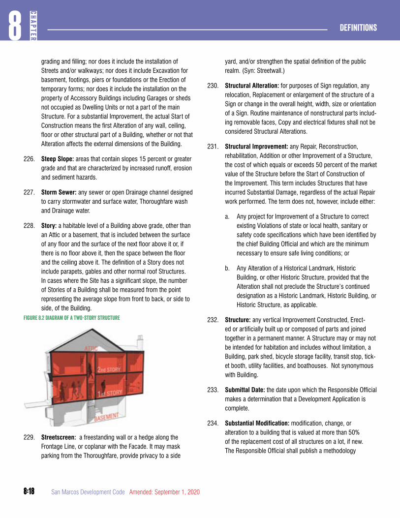
8:18
Definitions8
CHAP
TER
8:18 San Marcos Development Code Amended: September 1, 2020
grading and filling; nor does it include the installation of Streets and/or walkways; nor does it include Excavation for basement, footings, piers or foundations or the Erection of temporary forms; nor does it include the installation on the property of Accessory Buildings including Garages or sheds not occupied as Dwelling Units or not a part of the main Structure. For a substantial Improvement, the actual Start of Construction means the first Alteration of any wall, ceiling, floor or other structural part of a Building, whether or not that Alteration affects the external dimensions of the Building.
226. Steep Slope: areas that contain slopes 15 percent or greater grade and that are characterized by increased runoff, erosion and sediment hazards.
227. Storm Sewer: any sewer or open Drainage channel designed to carry stormwater and surface water, Thoroughfare wash and Drainage water.
228. Story: a habitable level of a Building above grade, other than an Attic or a basement, that is included between the surface of any floor and the surface of the next floor above it or, if there is no floor above it, then the space between the floor and the ceiling above it. The definition of a Story does not include parapets, gables and other normal roof Structures. In cases where the Site has a significant slope, the number of Stories of a Building shall be measured from the point representing the average slope from front to back, or side to side, of the Building.
Figure 8.2 Diagram of a two-story structure
229. Streetscreen: a freestanding wall or a hedge along the Frontage Line, or coplanar with the Facade. It may mask parking from the Thoroughfare, provide privacy to a side
yard, and/or strengthen the spatial definition of the public realm. (Syn: Streetwall.)
230. Structural Alteration: for purposes of Sign regulation, any relocation, Replacement or enlargement of the structure of a Sign or change in the overall height, width, size or orientation of a Sign. Routine maintenance of nonstructural parts includ-ing removable faces, Copy and electrical fixtures shall not be considered Structural Alterations.
231. Structural Improvement: any Repair, Reconstruction, rehabilitation, Addition or other Improvement of a Structure, the cost of which equals or exceeds 50 percent of the market value of the Structure before the Start of Construction of the Improvement. This term includes Structures that have incurred Substantial Damage, regardless of the actual Repair work performed. The term does not, however, include either:
a. Any project for Improvement of a Structure to correct existing Violations of state or local health, sanitary or safety code specifications which have been identified by the chief Building Official and which are the minimum necessary to ensure safe living conditions; or
b. Any Alteration of a Historical Landmark, Historic Building, or other Historic Structure, provided that the Alteration shall not preclude the Structure’s continued designation as a Historic Landmark, Historic Building, or Historic Structure, as applicable.
232. Structure: any vertical Improvement Constructed, Erect-ed or artificially built up or composed of parts and joined together in a permanent manner. A Structure may or may not be intended for habitation and includes without limitation, a Building, park shed, bicycle storage facility, transit stop, tick-et booth, utility facilities, and boathouses. Not synonymous with Building.
233. Submittal Date: the date upon which the Responsible Official makes a determination that a Development Application is complete.
234. Substantial Modification: modification, change, or alteration to a building that is valued at more than 50% of the replacement cost of all structures on a lot, if new. The Responsible Official shall publish a methodology
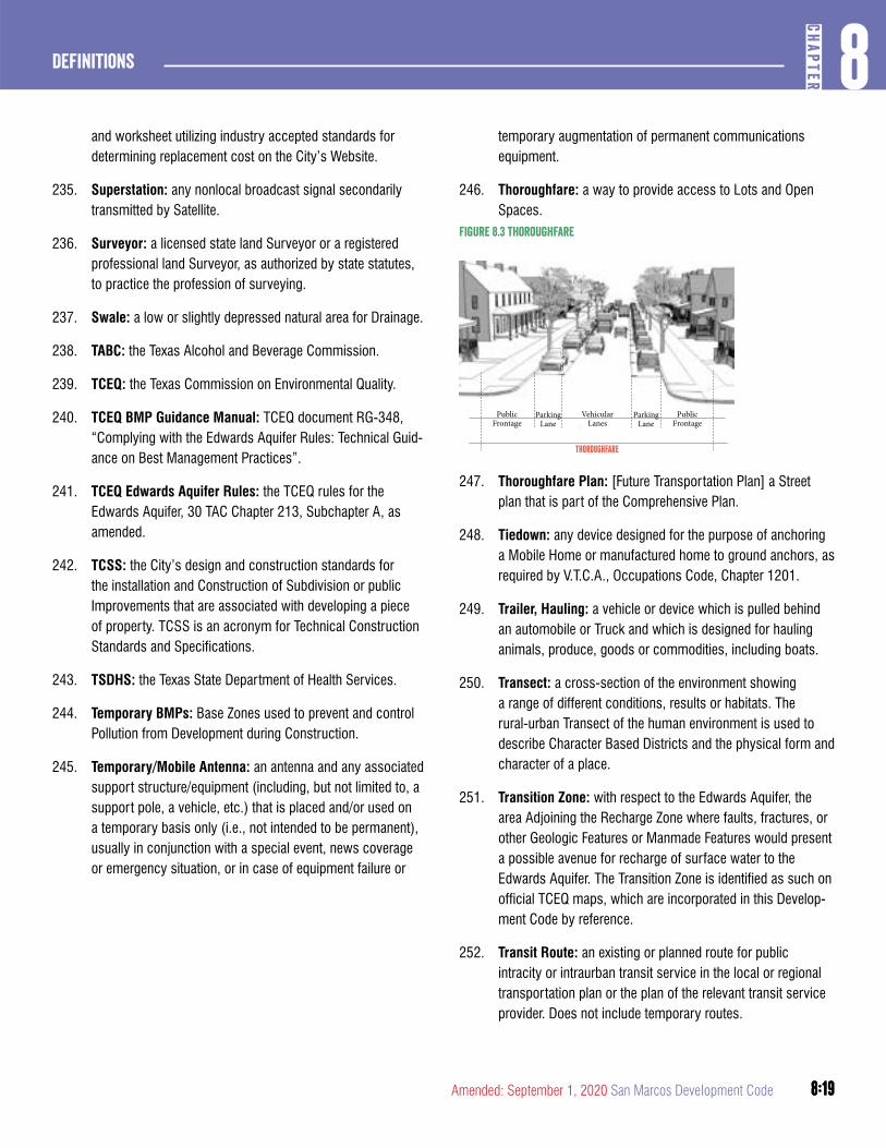
8:19
8CH
APTER
Definitions
8:19Amended: September 1, 2020 San Marcos Development Code
and worksheet utilizing industry accepted standards for determining replacement cost on the City’s Website.
235. Superstation: any nonlocal broadcast signal secondarily transmitted by Satellite.
236. Surveyor: a licensed state land Surveyor or a registered professional land Surveyor, as authorized by state statutes, to practice the profession of surveying.
237. Swale: a low or slightly depressed natural area for Drainage.
238. TABC: the Texas Alcohol and Beverage Commission.
239. TCEQ: the Texas Commission on Environmental Quality.
240. TCEQ BMP Guidance Manual: TCEQ document RG-348, “Complying with the Edwards Aquifer Rules: Technical Guid-ance on Best Management Practices”.
241. TCEQ Edwards Aquifer Rules: the TCEQ rules for the Edwards Aquifer, 30 TAC Chapter 213, Subchapter A, as amended.
242. TCSS: the City’s design and construction standards for the installation and Construction of Subdivision or public Improvements that are associated with developing a piece of property. TCSS is an acronym for Technical Construction Standards and Specifications.
243. TSDHS: the Texas State Department of Health Services.
244. Temporary BMPs: Base Zones used to prevent and control Pollution from Development during Construction.
245. Temporary/Mobile Antenna: an antenna and any associated support structure/equipment (including, but not limited to, a support pole, a vehicle, etc.) that is placed and/or used on a temporary basis only (i.e., not intended to be permanent), usually in conjunction with a special event, news coverage or emergency situation, or in case of equipment failure or
temporary augmentation of permanent communications equipment.
246. Thoroughfare: a way to provide access to Lots and Open Spaces.
Figure 8.3 thoroughfare
THOROUGHFARE
VehicularLanes
PublicFrontage
PublicFrontage
ParkingLane
ParkingLane
247. Thoroughfare Plan: [Future Transportation Plan] a Street plan that is part of the Comprehensive Plan.
248. Tiedown: any device designed for the purpose of anchoring a Mobile Home or manufactured home to ground anchors, as required by V.T.C.A., Occupations Code, Chapter 1201.
249. Trailer, Hauling: a vehicle or device which is pulled behind an automobile or Truck and which is designed for hauling animals, produce, goods or commodities, including boats.
250. Transect: a cross-section of the environment showing a range of different conditions, results or habitats. The rural-urban Transect of the human environment is used to describe Character Based Districts and the physical form and character of a place.
251. Transition Zone: with respect to the Edwards Aquifer, the area Adjoining the Recharge Zone where faults, fractures, or other Geologic Features or Manmade Features would present a possible avenue for recharge of surface water to the Edwards Aquifer. The Transition Zone is identified as such on official TCEQ maps, which are incorporated in this Develop-ment Code by reference.
252. Transit Route: an existing or planned route for public intracity or intraurban transit service in the local or regional transportation plan or the plan of the relevant transit service provider. Does not include temporary routes.
8:20
Definitions8
CHAP
TER
8:20 San Marcos Development Code Amended: September 1, 2020
253. Transportation Plan: A transportation plan illustrating new streets and existing roadways and/or highways. A trans-portation plan typicaly inlcudes the location, names and proposed cross sections identifying all right-of-way elements including vehicle, pedestrian, bicycle and transit provisions.
254. Transportation Impact Assessment: A detailed description of the existing and proposed infrastructure in the area surrounding the site for transit, pedestrians and cyclists.
255. Tree: any living, self-supporting woody plant species which normally grows to an overall minimum height of 15 feet.
256. Tributary: any Waterway, having a Drainage area of 120 acres or more, that drains directly into Purgatory Creek or Sink Creek or the Blanco River. A Tributary is measured from its confluence with the Creek or river upstream to a point at which the contributing area is less than 64 acres.
257. TXDOT: the Texas Department of Transportation.
258. Underbrush: low-growing vegetation, brush and Trees with a Caliper less than three inches.
259. Upland Zone: any area within the Recharge Zone or the Tran-sition Zone that is not part of a Water Quality Zone, Buffer Zone or Sensitive Feature Protection Zone.
260. Urbanized: generally, developed. Specific to Character Based Districts, developed at intensities higher than those of CBD-2 (Rural).
261. Use: the classification of the functions, activities, purposes, or uses accommodated by a Building or Lot or for which land or Buildings are designated, arranged, intended, occu-pied or maintained. See Table 5.3.1.2 (Land Use Matrix) and Chapter 5, Article 3, Division 6.
262. Use, Nonconforming: See Section 1.6.2.1 of this Develop-ment Code.
263. Variance: authorization from the Zoning Board of Adjust-ments to deviate from or vary one or more standards of this Development Code applicable to a Development Application that is reviewed and decided under Chapter 2, Article 10, Division 2 of this Development Code.
264. Vines: any of a group of woody or herbaceous plants which may cling by twining, by means of aerial rootlets or
by means of tendrils, or which may simply sprawl over the ground or other plants.
265. Vision San Marcos Comprehensive Plan, or simply Vision San Marcos or the Comprehensive Plan: the Comprehen-sive Plan adopted by the City entitled “Vision San Marcos – A River Runs Through Us”, as amended.
266. Violation: the failure of a person, entity, Structure, Building, Lot, Improvement, Subdivision, or other Development to fully comply with this Development Code.
267. VTCA: Vernon’s Texas Codes Annotated.
268. Wastewater: waterborne waste normally discharging from the sanitary conveniences of dwellings, hotels, office Build-ings, retail establishments, factories, and institutions that is free from storm and surface water.
269. Wastewater Service: the collection of Wastewater that requires treatment prior to its return to nature.
270. Wastewater System: a system of pipes, conduits, lift sta-tions and treatment facilities owned, controlled or subject to the jurisdiction of the City, designed to collect and transport Wastewater and industrial waste.
271. Water Facilities: any or all of the individual components of a Water System taken together.
272. Water Quality Zone: an area of land along a Minor Water-way, Intermediate Waterway, Major Waterway, or along a river, stream or Waterway in which Development is prohibit-ed or limited.
273. Water System or Central Water System: the Water Facility infrastructure for the collection, treatment, storage and distri-bution of Potable Water from the source of supply to one or more consumers.
274. Waterway: any natural or artificial channel in which a flow of water, either continuously or intermittently, occurs.
275. Watershed Protection Plan: a plan that is submitted that establishes terms and conditions for approval of applications for Plats and Site Permits relating to environmental standards in Chapter 6 of this Development Code, and that is reviewed and decided in phases under Chapter 2, Article 7 of this Development Code.
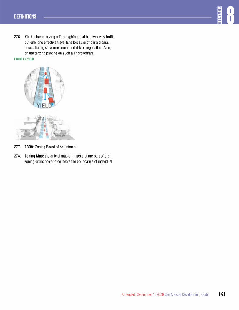
8:21
8CH
APTER
Definitions
8:21Amended: September 1, 2020 San Marcos Development Code
276. Yield: characterizing a Thoroughfare that has two-way traffic but only one effective travel lane because of parked cars, necessitating slow movement and driver negotiation. Also, characterizing parking on such a Thoroughfare.
Figure 8.4 yield
277. ZBOA: Zoning Board of Adjustment.
278. Zoning Map: the official map or maps that are part of the zoning ordinance and delineate the boundaries of individual

8:22
Definitions8
CHAP
TER
8:22 San Marcos Development Code Amended: September 1, 2020
9:1
9CH
APTER
Legacy Districts
Amended: September 1, 2020 San Marcos Development Code
ChaPTER 9. LEGaCY DISTRICTS
article 1: Development Standards ............................9:2DIVISION 1: GENERAL 9:2
article 2: Zoning Districts...........................................9:3DIVISION 1: RESIDENTIAL DISTRICTS 9:3
DIVISION 2: PUBLIC, SPECIAL AND NONRESIDENTIAL DISTRICTS 9:9
article 3: Use Regulations ......................................... 9:13DIVISION 1: INTERPRETIVE RULES AND LAND USE MATRIX 9:13
DIVISION 2: ACCESSORY BUILDINGS AND USE REGULATIONS 9:22
DIVISION 3: HOME OCCUPATIONS 9:23
DIVISION 4: REQUIREMENTS APPLICABLE TO PARTICULAR USES 9:23
article 4: Supplemental Standards ........................9:24DIVISION 1: AREA, BUILDING, AND HEIGHT REGULATIONS 9:24
DIVISION 2: EXTERIOR CONSTRUCTION AND DESIGN REQUIREMENTS 9:24
DIVISION 3: MULTIFAMILY RESIDENTIAL DESIGN STANDARDS 9:27
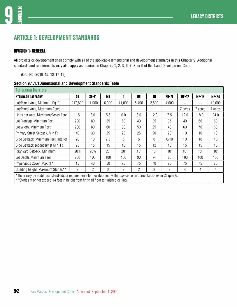
9:2
Legacy Districts9
CHAP
TER
San Marcos Development Code Amended: September 1, 2020
article 1: Development Standards
DIVISION 1: GENERAL
All projects or development shall comply with all of the applicable dimensional and development standards in this Chapter 9. Additional standards and requirements may also apply as required in Chapters 1, 2, 3, 6, 7, 8, or 9 of this Land Development Code.
(Ord. No. 2019-45, 12-17-19)
Section 9.1.1.1Dimensional and Development Standards Table
Residential Districts
Standard Category AR SF-11 MR D DR TH PH-ZL MF-12 MF-18 MF-24
Lot/Parcel Area, Minimum Sq. Ft. 217,800 11,000 6,000 11,000 5,400 2,500 4,000 -- -- 12,000
Lot/Parcel Area, Maximum Acres -- -- -- -- -- -- -- 7 acres 7 acres 7 acres
Units per Acre, Maximum/Gross Acre .15 3.0 5.5 6.0 6.0 12.0 7.5 12.0 18.0 24.0
Lot Frontage Minimum Feet 200 80 35 60 40 25 35 40 60 60
Lot Width, Minimum Feet 200 80 60 90 50 25 40 60 70 60
Primary Street Setback, Min Ft 40 30 25 25 25 20 20 10 10 10
Side Setback, Minimum Feet, Interior 20 10 7.5 5 5 0 0/10 10 10 10
Side Setback secondary st Min. Ft. 25 15 15 10 15 12 10 15 15 15
Rear Yard Setback, Minimum 20% 20% 20’ 20’ 15’ 10’ 10’ 10’ 10’ 10’
Lot Depth, Minimum Feet 200 100 100 100 90 -- 85 100 100 100
Impervious Cover, Max. %* 15 40 50 75 75 70 75 75 75 75
Building height, Maximum Stories** 2 2 2 2 2 2 2 4 4 4
*There may be additional standards or requirements for development within special environmental zones in Chapter 6.**Stories may not exceed 14 feet in height from finished floor to finished ceiling.
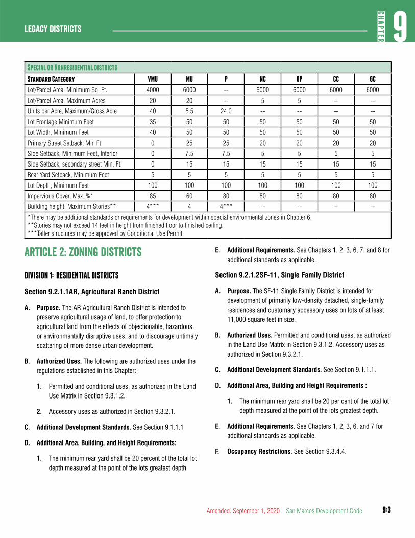
9:3
9CH
APTER
Legacy Districts
Amended: September 1, 2020 San Marcos Development Code
Special or Nonresidential districts
Standard Category VMU MU P NC OP CC GC
Lot/Parcel Area, Minimum Sq. Ft. 4000 6000 -- 6000 6000 6000 6000
Lot/Parcel Area, Maximum Acres 20 20 -- 5 5 -- --
Units per Acre, Maximum/Gross Acre 40 5.5 24.0 -- -- -- --
Lot Frontage Minimum Feet 35 50 50 50 50 50 50
Lot Width, Minimum Feet 40 50 50 50 50 50 50
Primary Street Setback, Min Ft 0 25 25 20 20 20 20
Side Setback, Minimum Feet, Interior 0 7.5 7.5 5 5 5 5
Side Setback, secondary street Min. Ft. 0 15 15 15 15 15 15
Rear Yard Setback, Minimum Feet 5 5 5 5 5 5 5
Lot Depth, Minimum Feet 100 100 100 100 100 100 100
Impervious Cover, Max. %* 85 60 80 80 80 80 80
Building height, Maximum Stories** 4*** 4 4*** -- -- -- --
*There may be additional standards or requirements for development within special environmental zones in Chapter 6.**Stories may not exceed 14 feet in height from finished floor to finished ceiling.***Taller structures may be approved by Conditional Use Permit
article 2: Zoning Districts
DIVISION 1: RESIDENTIAL DISTRICTS
Section 9.2.1.1AR, Agricultural Ranch District
A. Purpose. The AR Agricultural Ranch District is intended to preserve agricultural usage of land, to offer protection to agricultural land from the effects of objectionable, hazardous, or environmentally disruptive uses, and to discourage untimely scattering of more dense urban development.
B. Authorized Uses. The following are authorized uses under the regulations established in this Chapter:
1. Permitted and conditional uses, as authorized in the Land Use Matrix in Section 9.3.1.2.
2. Accessory uses as authorized in Section 9.3.2.1.
C. Additional Development Standards. See Section 9.1.1.1
D. Additional Area, Building, and Height Requirements:
1. The minimum rear yard shall be 20 percent of the total lot depth measured at the point of the lots greatest depth.
E. Additional Requirements. See Chapters 1, 2, 3, 6, 7, and 8 for additional standards as applicable.
Section 9.2.1.2SF-11, Single Family District
A. Purpose. The SF-11 Single Family District is intended for development of primarily low-density detached, single-family residences and customary accessory uses on lots of at least 11,000 square feet in size.
B. Authorized Uses. Permitted and conditional uses, as authorized in the Land Use Matrix in Section 9.3.1.2. Accessory uses as authorized in Section 9.3.2.1.
C. Additional Development Standards. See Section 9.1.1.1.
D. Additional Area, Building and Height Requirements :
1. The minimum rear yard shall be 20 per cent of the total lot depth measured at the point of the lots greatest depth.
E. Additional Requirements. See Chapters 1, 2, 3, 6, and 7 for additional standards as applicable.
F. Occupancy Restrictions. See Section 9.3.4.4.
9:4
Legacy Districts9
CHAP
TER
San Marcos Development Code Amended: September 1, 2020
E. Additional Requirements. See Chapters 1, 2, 3, 6, and 7 for additional standards as applicable.
F. HUD-Code Manufactured Home Standards. The installation, occupancy, and maintenance of manufactured homes in the MR manufactured home and residential district shall be subject to the following:
1. Manufactured homes shall have no outside horizontal dimension less than 14 feet, except for original extensions or subsequent additions containing less than 50 per cent of the total enclosed floor area.
2. The exterior siding material, excluding skirting, shall be nonmetallic.
3. Manufactured homes shall be of adequate quality and safe design, as certified by a label stating that the unit is constructed in conformance with the federal manufactured home construction and safety standards in effect on the date of manufacture. A manufactured home without that certification, but meeting all other requirements, may be accepted as of safe and quality construction provided it meets the following criteria:
a. All electrical materials, devices, appliances and electrical equipment are in sound and safe condition. Aluminum conductors are not acceptable.
b. All mechanical systems, including space and water heating, are in sound and safe condition.
c. All plumbing, gas piping, and wastewater systems are in sound and safe condition.
d. The unit is in sound and safe structural condition. Uncompressed finish floorings, such as carpet, greater than one-eighth inch in thickness beneath loadbearing walls which are fastened to the floor structure are not acceptable. Manufactured homes which have shown signs of fire damage are not acceptable.
e. The determination of the acceptance of any noncertified unit shall be made jointly by the Building Official and Fire Marshal.
Section 9.2.1.3MR, Manufactured Home and Residential District
A. Purpose. The MR Manufactured Home and Residential District is established to:
1. Recognize that certain areas of the City are suitable for a mixture of single-family dwelling units and HUD-Code manufactured homes, and to provide adequate space and site diversification for residential purposes designed to accommodate the peculiarities and design criteria of manufactured homes, along with single-family residences.
2. Protect against pollution, environmental hazards and other objectionable influences.
3. Provide adequate provisions for vehicular and pedestrian circulation.
4. Promote housing densities appropriate to and compatible with existing and proposed public support facilities.
5. Promote the most desirable use of land and direction of building development; promote stability of development; protect the character of the district; conserve the value of land and buildings; and protect the City’s tax base.
B. Authorized Uses. Permitted and conditional uses, as authorized in the Land Use Matrix in Section 9.3.1.2. Accessory uses as authorized in Section 9.3.2.1.
C. Additional Development Standards. See Section 9.1.1.1
D. Additional Area, Building and Height Requirements:
1. Minimum Lot Area:
a. Internal: 6,000 square feet
b. Corner: 6,900 square feet
2. Minimum Lot Width:
a. Internal: 50 feet
b. All other uses: 60 feet
3. Minimum Side Yard, Interior:
a. Single-Family Detached: Five feet
b. Mobile Homes: 7½ feet
9:5
9CH
APTER
Legacy Districts
Amended: September 1, 2020 San Marcos Development Code
4. Manufactured homes shall be installed in accordance with the following criteria:
a. The frame shall be supported by and tied to a foundation system capable of safely supporting the loads imposed as determined from the character of the soil. The minimum acceptable foundation design shall be a series of eight-inch grout-filled concrete block piers spaced no more than eight feet on center and bearing on 12-inch by 12-inch solid concrete footings. A tiedown and anchoring system separate and apart from the foundation ties shall be provided as recommended by the manufacturer, if different from the foundation ties.
b. Axle and hitch assemblies shall be removed at the time of placement on the foundation.
c. Each manufactured home shall be totally skirted with metal, masonry, pressure-treated wood, or other nondegradable material which is compatible with the design and exterior materials of the primary structure.
d. Electrical power supply shall be made from a meter installation on the manufactured home or from a permanent meter pedestal.
e. Driveways and off-street parking shall be provided in accordance with the requirements for single-family dwellings.
5. Garage and carport additions are permitted, provided they cover a paved parking area and are connected to a street by a paved drive, meet the minimum building setback requirements, and have roof and siding material that is consistent with the primary structure.
6. Patio and porch covers are permitted, provided they cover an improved patio, deck, or porch, and meet the minimum building setback requirements.
7. Living area additions are permitted, provided they meet the minimum building setback requirements, have roof and siding material that is compatible with the primary structure, and comply with the same structural standards as required of the primary structure.
Section 9.2.1.4D, Duplex Residential District
A. Purpose. The D Duplex Residential District is intended for development of single-family residences and associated uses as well as for development on larger parcels of land of low density two-family duplex units. The D Duplex Residential District is intended to replace existing DP zoned areas. D zoning is not to be applied to properties for new duplex development.
B. Authorized Uses. Permitted and conditional uses, as authorized in the Land Use Matrix in Section 9.3.1.2. Accessory uses as authorized in Section 9.3.2.1.
C. Additional Development Standards. See Section 9.1.1.1
D. Additional Area, Building and Height Requirements:
1. Minimum Lot Area:
a. Duplex, duplex condominium: 11,000 square feet
b. All other uses: 6,000 square feet
2. Minimum Lot Width:
a. Single-family dwelling, group home, two-unit townhouse: 50 feet per lot
b. All other uses: 90 feet per lot
3. Minimum Lot Frontage:
a. Single-family dwelling, group home, two-unit townhouse: 35 feet per lot
b. All other uses: 60 feet per lot
4. Minimum Side Yard, Interior:
a. Single-family dwelling, group home, two-unit townhouse: five feet
b. All other uses: Ten feet
c. No side setback required for the common wall side of two-unit townhouses
E. Additional Requirements. See Chapters 1, 2, 3, 6, and 7 for additional standards as applicable.
9:6
Legacy Districts9
CHAP
TER
San Marcos Development Code Amended: September 1, 2020
Section 9.2.1.5DR, Duplex Restricted Residential District
A. Purpose. The DR Duplex Restricted Residential District is intended for development of single-family residences and associated uses as well as for development on larger parcels of land of medium density two-family duplex units.
B. Authorized Uses. Permitted and conditional uses, as authorized in the Land Use Matrix in Section 9.3.1.2. Accessory uses as authorized in Section 9.3.2.1.
C. Additional Development Standards. See Section 9.1.1.1.
D. Additional Area, Building and Height Requirements:
1. Minimum Lot Area:
a. Duplex, duplex condominium: 5,400 square feet
b. All other uses: 4,500 square feet
2. Minimum Lot Width:
a. Single-family dwelling, group home, two-unit townhouse, patio home, industrialized home: 50 feet per lot
b. All other uses: 60 feet per lot
3. Minimum Lot Frontage:
a. Single-family dwelling, group home, two-unit townhouse, patio home, industrialized home: 35 feet per lot
b. All other uses: 40 feet per lot
4. Minimum Side Yard, Interior:
a. Single-family dwelling, group home, two-unit townhouse, patio home, industrialized home: 5 feet
b. All other uses: Ten feet
5. No side setback required for the common wall side of two-unit townhouse
E. Additional Requirements. See Chapters 1, 2, 3, 6, and 7 for additional standards as applicable.
F. Occupancy Restrictions. See Section 9.3.4.4.
Section 9.2.1.6TH, Townhouse Residential District
A. Purpose. The TH Townhouse Residential District is intended for development of single-family residences and associated uses as well as for development on larger parcels of land of two-family townhouse units.
B. Authorized Uses. Permitted and conditional uses, as authorized in the Land Use Matrix in Section 9.3.1.2. Accessory uses as authorized in Section 9.3.2.1.
C. Additional Development Standards. See Section 9.1.1.1.
D. Additional Area, Building and Height Requirements:
1. Minimum Lot Area:
a. Internal: 2,500 square feet
b. Corner: 4,000 square feet
2. Minimum Lot Width:
a. Internal: 25 feet
b. All other uses: 36 feet
3. Minimum Lot Frontage:
a. Internal: 25 feet
b. All other uses: 36 feet
4. Minimum Rear Yard. Zero feet when abutting townhouses on the rear: Ten feet when abutting an alley or service drive, or property not zoned for townhouse usage
5. Minimum Side Yard, Interior:
a. Corner. Common Wall. Zero feet
b. District Boundary. Exterior Wall: five feet
E. Additional Requirements. See Chapters 1, 2, 3, 6, and 7 for additional standards as applicable.
F. Occupancy Restrictions . See Section 9.3.4.4.
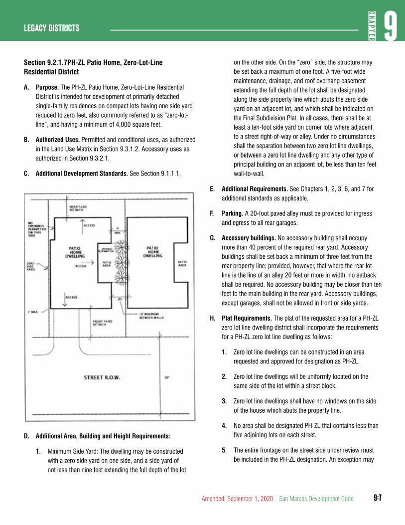
9:7
9CH
APTER
Legacy Districts
Amended: September 1, 2020 San Marcos Development Code
Section 9.2.1.7PH-ZL Patio Home, Zero-Lot-Line Residential District
A. Purpose. The PH-ZL Patio Home, Zero-Lot-Line Residential District is intended for development of primarily detached single-family residences on compact lots having one side yard reduced to zero feet, also commonly referred to as “zero-lot-line”, and having a minimum of 4,000 square feet.
B. Authorized Uses. Permitted and conditional uses, as authorized in the Land Use Matrix in Section 9.3.1.2. Accessory uses as authorized in Section 9.3.2.1.
C. Additional Development Standards. See Section 9.1.1.1.
D. Additional Area, Building and Height Requirements:
1. Minimum Side Yard: The dwelling may be constructed with a zero side yard on one side, and a side yard of not less than nine feet extending the full depth of the lot
on the other side. On the “zero” side, the structure may be set back a maximum of one foot. A five-foot wide maintenance, drainage, and roof overhang easement extending the full depth of the lot shall be designated along the side property line which abuts the zero side yard on an adjacent lot, and which shall be indicated on the Final Subdivision Plat. In all cases, there shall be at least a ten-foot side yard on corner lots where adjacent to a street right-of-way or alley. Under no circumstances shall the separation between two zero lot line dwellings, or between a zero lot line dwelling and any other type of principal building on an adjacent lot, be less than ten feet wall-to-wall.
E. Additional Requirements. See Chapters 1, 2, 3, 6, and 7 for additional standards as applicable.
F. Parking. A 20-foot paved alley must be provided for ingress and egress to all rear garages.
G. Accessory buildings. No accessory building shall occupy more than 40 percent of the required rear yard. Accessory buildings shall be set back a minimum of three feet from the rear property line; provided, however, that where the rear lot line is the line of an alley 20 feet or more in width, no setback shall be required. No accessory building may be closer than ten feet to the main building in the rear yard. Accessory buildings, except garages, shall not be allowed in front or side yards.
H. Plat Requirements. The plat of the requested area for a PH-ZL zero lot line dwelling district shall incorporate the requirements for a PH-ZL zero lot line dwelling as follows:
1. Zero lot line dwellings can be constructed in an area requested and approved for designation as PH-ZL.
2. Zero lot line dwellings will be uniformly located on the same side of the lot within a street block.
3. Zero lot line dwellings shall have no windows on the side of the house which abuts the property line.
4. No area shall be designated PH-ZL that contains less than five adjoining lots on each street.
5. The entire frontage on the street side under review must be included in the PH-ZL designation. An exception may
9:8
Legacy Districts9
CHAP
TER
San Marcos Development Code Amended: September 1, 2020
be made where an alley breaks the block on the side of the street.
I. Occupancy Restrictions . See Section 9.3.4.4.
Section 9.2.1.8MF-12, Multiple-Family Residential District
A. Purpose. The MF-12 Multiple-Family Residential District is intended for development of multiple-family, apartment residences at not more than 12 units per acre. This district should be located adjacent to a major thoroughfare and may serve as a buffer between low or medium density residential development and nonresidential development or high-traffic roadways.
B. Authorized Uses. Permitted and conditional uses, as authorized in the Land Use Matrix in Section 9.3.1.2. Accessory uses as authorized in Section 9.3.2.1.
C. Additional Development Standards. See Section 9.1.1.1 and Section 9.4.3.1.
D. Additional Area, Building and Height Requirements:
1. Minimum Lot Area:
a. 3,630 square feet per dwelling unit for the first three dwelling units, plus as much additional lot area as necessary for each dwelling unit over three so that the total gross density does not exceed 12 dwelling units per acre.
b. The minimum lot area for all other uses shall be determined by the applicable minimum lot dimensions.
2. Minimum Lot Width:
a. Duplex, group home: 45 feet
b. All other uses: 60 feet
3. Minimum Lot Frontage:
a. Duplex, group home: 40 feet
b. All other uses: 60 feet
4. Minimum Rear Yard: Ten feet; there shall be no encroachment or overhangs into this required rear yard.
5. Minimum Side Yard, Interior:
a. Duplex, group home. Five feet
b. All other uses: Ten feet
E. Additional Requirements. See Chapters 1, 2, 3, 6, and 7 for additional standards as applicable.
Section 9.2.1.9MF-18, Multiple-Family Residential District
A. Purpose. The MF-18 Multiple-Family Residential District is intended for development of multiple-family, apartment residences at not more than 18 units per acre. This district should be located adjacent to a major thoroughfare and may serve as a buffer between low or medium density residential development and nonresidential development or high-traffic roadways.
B. Authorized Uses. Permitted and conditional uses, as authorized in the Land Use Matrix Section 9.3.1.2. Accessory uses as authorized in Section 9.3.2.1.
C. Additional Development Standards. See Section 9.1.1.1 and Section 9.4.3.1.
D. Additional Area, Building and Height Requirements:
1. Minimum Lot Area:
a. 2,425 square feet per dwelling unit for the first three dwelling units, plus as much additional lot area as necessary for each dwelling unit over three so that the total gross density does not exceed 18 dwelling units per acre.
b. The minimum lot area for all other uses shall be determined by the applicable minimum lot dimensions.
2. Minimum Lot Width:
a. Duplex, group home: 45 feet
b. All other uses: 60 feet
3. Minimum Lot Frontage:
a. Duplex, group home: 40 feet
b. All other uses: 60 feet
9:9
9CH
APTER
Legacy Districts
Amended: September 1, 2020 San Marcos Development Code
4. Minimum Side Yard, Interior:
a. Duplex, group home. Five feet
b. All other uses: Ten feet
E. Additional Requirements. See Chapters 1, 2, 3, 6, and 7 for additional standards as applicable.
Section 9.2.1.10MF-24, Multi-family Residential District
A. Purpose. The MF-24 Multiple-Family Residential District is intended for development of multiple-family, apartment residences at not more than 24 units per acre. This district should be located adjacent to a major thoroughfare and may serve as a buffer between low or medium density residential development and nonresidential development or high-traffic roadways.
B. Authorized Uses. Permitted and conditional uses, as authorized in the Land Use Matrix Section 9.3.1.2. Accessory uses as authorized in Section 9.3.2.1.
C. Additional Development Standards. See Section 9.1.1.1 and Section 9.4.3.1.
D. Additional Area, Building and Height Requirements:
1. Minimum Lot Area:
a. 12,000 square feet; gross density shall not exceed 24 dwelling units per acre.
b. The minimum lot area for all other uses shall be determined by the applicable minimum lot dimensions.
2. Minimum Lot Width:
a. Duplex, group home: 45 feet
b. All other uses: 60 feet
3. Minimum Lot Frontage:
a. Duplex, group home: 45 feet
b. All other uses: 60 feet
4. Minimum Rear Yard: Ten feet; there shall be no encroachment or overhangs into this required rear yard.
5. Minimum Side Yard, Interior:
a. Duplex, group home. Five feet
b. All other uses: Ten feet
E. Additional Requirements. See Chapters 1, 2, 3, 6, and 7 for additional standards as applicable.
DIVISION 2: PUBLIC, SPECIAL AND NONRESIDENTIAL DISTRICTS
Section 9.2.2.1MU, Mixed Use District
A. Purpose. The MU, Mixed Use District, when assigned to tracts of land generally greater than one acre, is intended to provide for a mixture of retail, office, and residential uses in close proximity to enable people to live, work, and purchase necessities in a single location. On tracts of one acre or less, the MU, Mixed Use District is intended to permit small scale mixed use buildings that have residential units above retail or office uses, especially on existing residential use properties. Bed-and-breakfast establishments could also be located in this district. Additionally, pedestrian walkways and open area are desired in order to promote a pedestrian-friendly environment. It is not the purpose of this zoning district to permit or encourage properties used for single-family residences to be converted to exclusively commercial or multi-family use. The following are key concepts that should be acknowledged through development practices within Mixed Use Districts:
1. Residential uses in conjunction with nonresidential activities, possibly located above retail and office establishments;
2. All types of residential uses, including single-family homes, townhouses, and loft-style multiple-family units;
3. Central green spaces;
4. Traffic flows that enable people to move freely without the use of an automobile by emphasizing the pedestrian; and
5. Outside spaces, such as small parks, courtyards, and outdoor eating areas.
B. Authorized Uses. Permitted and conditional uses, as authorized in the Land Use Matrix Section 9.3.1.2. Accessory uses as authorized in Section 9.3.2.1.
9:10
Legacy Districts9
CHAP
TER
San Marcos Development Code Amended: September 1, 2020
C. Additional Development Standards. See Section 9.1.1.1.
D. Additional Area, Building and Height Requirements:
1. Minimum Lot Area:
a. Internal: 6,000 square feet
b. Corner: 7,500 square feet
2. Minimum Lot Width:
a. Internal: 50 feet
b. Corner: 60 feet
3. Minimum Lot Frontage:
a. Internal: 50 feet
b. Corner: 60 feet
4. Minimum Rear Yard: Five feet with an additional two feet required for each story above 24 feet, up to a maximum setback of 25 feet; there shall be no encroachment or overhangs into this required rear yard
5. Structures higher than four stories may be approved by CUP.
6. All uses shall provide connections to existing sidewalks, parks or open space.
7. Parking areas for nonresidential uses shall be screened from single-family uses with a living or solid masonry screening device.
E. Additional Requirements. See Chapters 1, 2, 3, 6, and 7 for additional standards as applicable.
Section 9.2.2.2P, Public and Institutional District
A. Purpose. The P, Public and Institutional District is intended to accommodate uses of a governmental, civic, public service, or public institutional nature, including major public facilities, state colleges and universities. The review of the location for public facilities is intended to facilitate the coordination of community services while minimizing the potential disruption of the uses of nearby properties. This district is intended for properties used, reserved, or intended to be used for a civic or public institutional purpose or for major public facilities.
B. Authorized Uses. Permitted and conditional uses, as authorized in the Land Use Matrix in Section 9.3.1.2. Accessory uses as authorized in Section 9.3.2.1.
C. Additional Development Standards. See Section 9.1.1.1.
D. Additional Area, Building and Height Requirements:
1. Minimum Lot Width:
a. Internal: 50 feet
b. Corner: 60 feet
2. Minimum Lot Frontage:
a. Internal: 50 feet
b. Corner: 60 feet
3. Minimum Rear Yard: Five feet; an additional two feet is required for each story above 24 feet, up to a maximum setback of 25 feet; there shall be no encroachment or overhangs into this required rear yard.
E. Additional Requirements. See Chapters 1, 2, 3, 6, and 7 for additional standards as applicable.
Section 9.2.2.3OP, Office Professional District
A. Purpose. The OP, Office Professional District is established to provide areas primarily for low intensity, small scale office uses and service facilities. Office uses should be compatible with residential uses, and should incorporate established landscape and buffering requirements.
B. Authorized Uses. Permitted and conditional uses, as authorized in the Land Use Matrix in Section 9.3.1.2. Accessory uses as authorized in Section 9.3.2.1.
C. Additional Development Standards. See Section 9.1.1.1.
D. Additional Area, Building and Height Requirements:
1. Minimum Lot Area:
a. Internal: 6,000 square feet
b. Corner: 7,500 square feet
2. Minimum Lot Frontage:
9:11
9CH
APTER
Legacy Districts
Amended: September 1, 2020 San Marcos Development Code
a. Internal: 50 feet
b. Corner: 60 feet
3. Minimum Rear Yard: Five feet, with an additional two feet required for each story above 24 feet, up to a maximum setback of 25 feet; there shall be no encroachment or overhangs into this required rear yard
4. Maximum Height of Structures: 30 feet or 2½ stories whichever is less.
E. Additional Requirements. See Chapters 1, 2, 3, 6, and 7 for additional standards as applicable.
Section 9.2.2.4NC, Neighborhood Commercial District
A. Purpose. The NC, Neighborhood Commercial District is established to provide low intensity office, retail and service facilities for the local neighborhood area. These uses should be compatible with residential uses in the neighborhood. Hours of business operation should be limited during the week, and businesses should generally close by 10:00 p.m. on the weekends. Businesses shall use landscaping and other buffering techniques to minimize their impact on the adjacent community. Equipment such as dumpsters and storage units shall be located away from residential uses and be screened. NC, Neighborhood Commercial District areas should generally be located on collector streets at the intersection of collector or arterial roadways and act as buffer areas for residential uses from the arterial traffic.
B. Authorized Uses. Permitted and conditional uses, as authorized in the Land Use Matrix in Section 9.3.1.2. Accessory uses as authorized in Section 9.3.2.1.
C. Additional Development Standards. See Section 9.1.1.1.
D. Additional Area, Building and Height Requirements:
1. Minimum Lot Area:
a. Internal: 6,000 square feet
b. Corner: 7,500 square feet
2. Minimum Lot Frontage:
a. Internal: 50 feet
b. Corner: 60 feet
3. Minimum Rear Yard: Five feet, with an additional two feet required for each story above 24 feet, up to a maximum setback of 25 feet; there shall be no encroachment or overhangs into this required rear yard
E. Additional Requirements. See Chapters 1, 2, 3, 6, and 7 for additional standards as applicable.
Section 9.2.2.5CC, Community Commercial
A. Purpose. The CC, Community Commercial is established to provide areas for quality larger general retail establishments and service facilities for the retail sale of goods and services. This district should generally consist of retail nodes located along or at the intersection of major collectors or thoroughfares to accommodate high traffic volumes generated by general retail uses.
B. Authorized Uses. Permitted and conditional uses, as authorized in the Land Use Matrix in Section 9.3.1.2. Accessory uses as authorized in Section 9.3.2.1.
C. Additional Development Standards. See Section 9.1.1.1.
D. Additional Area, Building and Height Requirements :
1. Minimum Lot Area:
a. Internal: 6,000 square feet
b. Corner: 7,500 square feet
2. Minimum Lot Frontage:
a. Internal: 50 feet
b. Corner: 60 feet
3. Minimum Rear Yard: Five feet, with an additional two feet required for each story above 24 feet, up to a maximum setback of 25 feet; there shall be no encroachment or overhangs into this required rear yard
E. Additional Requirements. See Chapters 1, 2, 3, 6, and 7 for additional standards as applicable.
9:12
Legacy Districts9
CHAP
TER
San Marcos Development Code Amended: September 1, 2020
Section 9.2.2.6GC, General Commercial District
A. Purpose. The GC, General Commercial District is intended to provide locations for limited (light) commercial and service-related establishments, such as wholesale product sales, automotive supply stores, veterinary services, and other similar limited commercial uses. The commercial uses within this district will have operation characteristics that are generally compatible with the CC, Community Commercial District.
B. Authorized Uses. Permitted and conditional uses, as authorized in the Land Use Matrix Section 9.3.1.2. Accessory uses as authorized in Section 9.3.2.1.
C. Additional Development Standards. See Section 9.1.1.1.
D. Additional Area, Building and Height Requirements :
1. Minimum Lot Area:
a. Internal: 6,000 square feet
b. Corner: 7,500 square feet
2. Minimum Lot Frontage:
a. Internal: 50 feet
b. Corner: 60 feet
3. Minimum Rear Yard: Five feet, with an additional two feet required for each story above 24 feet, up to a maximum setback of 25 feet; there shall be no encroachment or overhangs into this required rear yard
E. Additional Requirements. See Chapters 1, 2, 3, 6, and 7 for additional standards as applicable.
Section 9.2.2.7VMU, Vertical Mixed Use District
A. Purpose. The VMU, Vertical Mixed Use District, is intended to provide for a mixture of retail, office, and dense residential uses in close proximity to enable people to live, work, and purchase necessities in a single location. It is not the purpose of this zoning district to permit or encourage properties to be converted to exclusively commercial or multi-family use. The following are key concepts that should be acknowledged through development practices within Vertical Mixed Use Districts:
1. Residential uses in conjunction with nonresidential activities, located above retail and office establishments along street frontages;
2. All types of residential uses, including single-family homes, townhouses. and loft-style multiple-family units;
3. Traffic flows that enable people to move freely without the use of an automobile by emphasizing the pedestrian; and
4. Outside spaces, such as sidewalk cafes, small parks, courtyards, and outdoor eating areas.
B. Authorized Uses. Permitted and conditional uses, as authorized in the Land Use Matrix in Section 9.3.1.2. Accessory uses as authorized in Section 9.3.2.1.
C. Additional Development Standards. See Section 9.1.1.1.
D. Additional Area, Building and Height Requirements:
1. Minimum Rear Yard: Five feet with an additional two feet required for each story above 24 feet, up to a maximum setback of 25 feet; there shall be no encroachment or overhangs into this required rear yard.
2. Structures higher than four stories may be approved by CUP.
3. All uses shall provide connections to existing sidewalks, parks, or open space.
4. Parking areas for nonresidential uses shall be screened from single-family uses with a living or solid masonry screening device.
5. Parking shall not be located between the front facade and the front property line.
E. Additional Requirements. See Chapters 1, 2, 3, 6, and 7 for additional standards as applicable.
Section 9.2.2.8Planned Development Districts
A. General. Planned Development Districts in existence at the time of the adoption of this Code shall remain in effect until they expire subject to the provisions of the previously adopted Code.
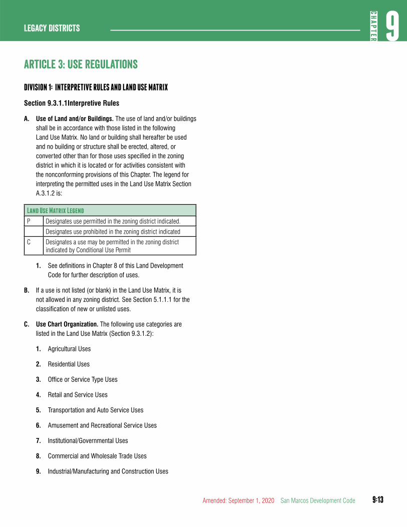
9:13
9CH
APTER
Legacy Districts
Amended: September 1, 2020 San Marcos Development Code
article 3: Use Regulations
DIVISION 1: INTERPRETIVE RULES AND LAND USE MATRIX
Section 9.3.1.1Interpretive Rules
A. Use of Land and/or Buildings. The use of land and/or buildings shall be in accordance with those listed in the following Land Use Matrix. No land or building shall hereafter be used and no building or structure shall be erected, altered, or converted other than for those uses specified in the zoning district in which it is located or for activities consistent with the nonconforming provisions of this Chapter. The legend for interpreting the permitted uses in the Land Use Matrix Section A.3.1.2 is:
Land Use Matrix Legend
P Designates use permitted in the zoning district indicated.
Designates use prohibited in the zoning district indicated
C Designates a use may be permitted in the zoning district indicated by Conditional Use Permit
1. See definitions in Chapter 8 of this Land Development Code for further description of uses.
B. If a use is not listed (or blank) in the Land Use Matrix, it is not allowed in any zoning district. See Section 5.1.1.1 for the classification of new or unlisted uses.
C. Use Chart Organization. The following use categories are listed in the Land Use Matrix (Section 9.3.1.2):
1. Agricultural Uses
2. Residential Uses
3. Office or Service Type Uses
4. Retail and Service Uses
5. Transportation and Auto Service Uses
6. Amusement and Recreational Service Uses
7. Institutional/Governmental Uses
8. Commercial and Wholesale Trade Uses
9. Industrial/Manufacturing and Construction Uses
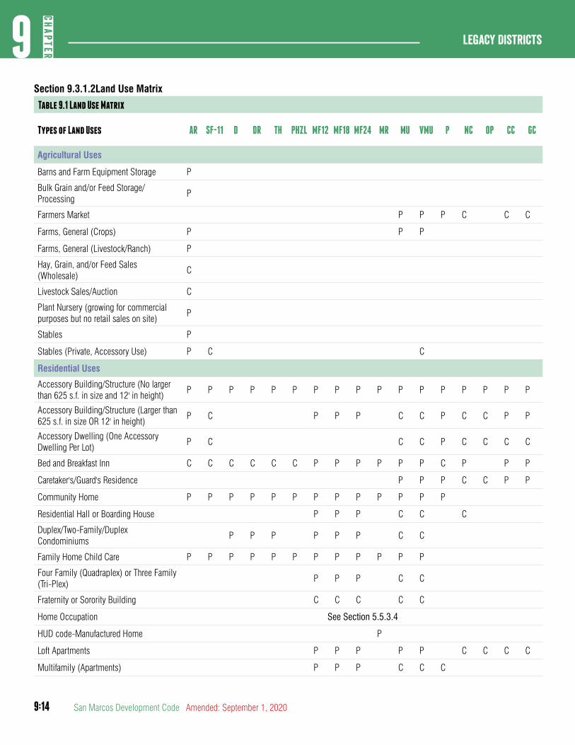
9:14
Legacy Districts9
CHAP
TER
San Marcos Development Code Amended: September 1, 2020
Section 9.3.1.2Land Use Matrix
Table 9.1 Land Use Matrix
Types of Land Uses AR SF-11 D DR TH PHZL MF12 MF18 MF24 MR MU VMU P NC OP CC GC
Agricultural Uses
Barns and Farm Equipment Storage P
Bulk Grain and/or Feed Storage/Processing
P
Farmers Market P P P C C C
Farms, General (Crops) P P P
Farms, General (Livestock/Ranch) P
Hay, Grain, and/or Feed Sales (Wholesale)
C
Livestock Sales/Auction C
Plant Nursery (growing for commercial purposes but no retail sales on site)
P
Stables P
Stables (Private, Accessory Use) P C C
Residential Uses
Accessory Building/Structure (No larger than 625 s.f. in size and 12' in height)
P P P P P P P P P P P P P P P P P
Accessory Building/Structure (Larger than 625 s.f. in size OR 12' in height)
P C P P P C C P C C P P
Accessory Dwelling (One Accessory Dwelling Per Lot)
P C C C P C C C C
Bed and Breakfast Inn C C C C C C P P P P P P C P P P
Caretaker's/Guard's Residence P P P C C P P
Community Home P P P P P P P P P P P P P
Residential Hall or Boarding House P P P C C C
Duplex/Two-Family/Duplex Condominiums
P P P P P P C C
Family Home Child Care P P P P P P P P P P P P
Four Family (Quadraplex) or Three Family (Tri-Plex)
P P P C C
Fraternity or Sorority Building C C C C C
Home Occupation See Section 5.5.3.4
HUD code-Manufactured Home P
Loft Apartments P P P P P C C C C
Multifamily (Apartments) P P P C C C

9:15
9CH
APTER
Legacy Districts
Amended: September 1, 2020 San Marcos Development Code
Table 9.1 Land Use Matrix
Types of Land Uses AR SF-11 D DR TH PHZL MF12 MF18 MF24 MR MU VMU P NC OP CC GC
Purpose Built Student Housing C C C C C
Senior Housing Community P P P P P
Single Family Detached House P P P P P P P P P P P P C C
Single Family Industrialized Home P P P P P P P P P P P P C C
Single Family Townhouse (Attached) P P P P P P P
Single Family Zero Lot Line/Patio Homes C P P P P C C
Office Service Type Uses
Armed Services Recruiting Center P P P P P P P
Bank or Savings and Loan (w/o Drive-thru) P P C P P P
Band or Savings and Loan (w Drive-thru) C C C C P P
Check Cashing Service C C P P P
Offices (Health Services) P P P P P P
Offices (Medical Office) P P P P P P
Offices (Professional) P P C P P P P
Call Service Center P P
Personal and Business Service Uses
Appliance Repair C C C P P
Artist or Artisans Studio P P P C P P P
Ambulance Service (Private) P C C P
Automobile Driving School (including Defensive Driving)
P P P C C P P
Automatic Teller Machines (ATM's) P P P P P P
Barber/Beauty College (barber or cosmetology school or college)
P C C P P
Barber/Beauty Shop, Haircutting (non-college)
P P P C P P
Bed and Breakfast (No Permanent Residence)
C P P P P P P C P P
Communication Equipment (Installation and/or Repair - No outdoor sales or storage)
C P
Dance/Drama/Music Schools (Performing Arts)
P P P P C P P
Extended Stay Hotels/Motels (Residence hotels)
C C C P
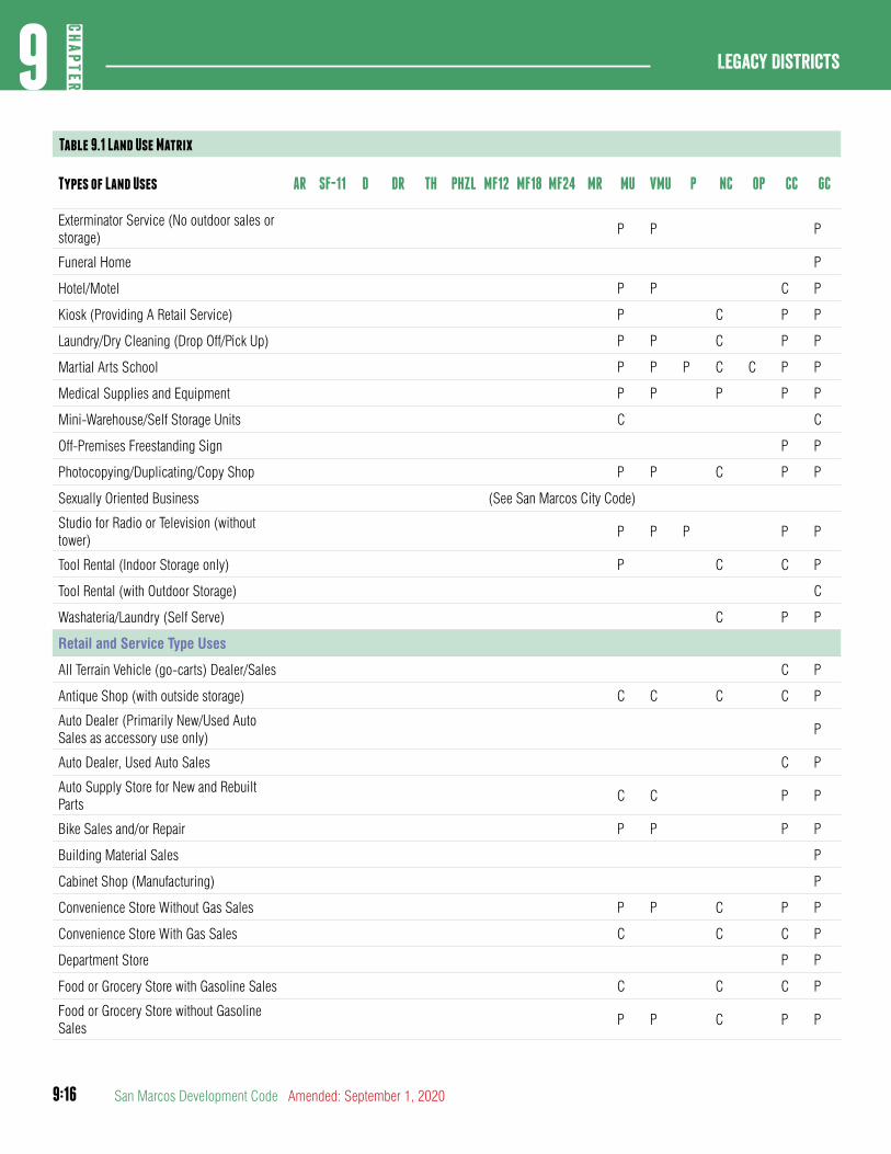
9:16
Legacy Districts9
CHAP
TER
San Marcos Development Code Amended: September 1, 2020
Table 9.1 Land Use Matrix
Types of Land Uses AR SF-11 D DR TH PHZL MF12 MF18 MF24 MR MU VMU P NC OP CC GC
Exterminator Service (No outdoor sales or storage)
P P P
Funeral Home P
Hotel/Motel P P C P
Kiosk (Providing A Retail Service) P C P P
Laundry/Dry Cleaning (Drop Off/Pick Up) P P C P P
Martial Arts School P P P C C P P
Medical Supplies and Equipment P P P P P
Mini-Warehouse/Self Storage Units C C
Off-Premises Freestanding Sign P P
Photocopying/Duplicating/Copy Shop P P C P P
Sexually Oriented Business (See San Marcos City Code)
Studio for Radio or Television (without tower)
P P P P P
Tool Rental (Indoor Storage only) P C C P
Tool Rental (with Outdoor Storage) C
Washateria/Laundry (Self Serve) C P P
Retail and Service Type Uses
All Terrain Vehicle (go-carts) Dealer/Sales C P
Antique Shop (with outside storage) C C C C P
Auto Dealer (Primarily New/Used Auto Sales as accessory use only)
P
Auto Dealer, Used Auto Sales C P
Auto Supply Store for New and Rebuilt Parts
C C P P
Bike Sales and/or Repair P P P P
Building Material Sales P
Cabinet Shop (Manufacturing) P
Convenience Store Without Gas Sales P P C P P
Convenience Store With Gas Sales C C C P
Department Store P P
Food or Grocery Store with Gasoline Sales C C C P
Food or Grocery Store without Gasoline Sales
P P C P P
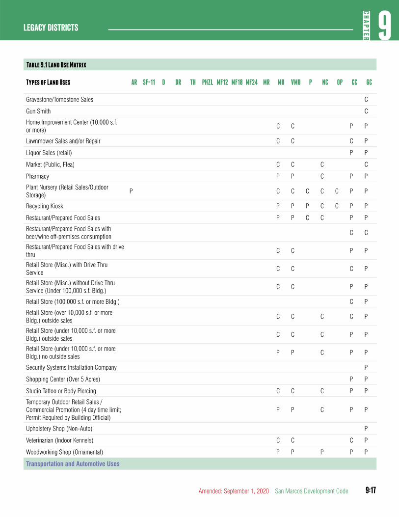
9:17
9CH
APTER
Legacy Districts
Amended: September 1, 2020 San Marcos Development Code
Table 9.1 Land Use Matrix
Types of Land Uses AR SF-11 D DR TH PHZL MF12 MF18 MF24 MR MU VMU P NC OP CC GC
Gravestone/Tombstone Sales C
Gun Smith C
Home Improvement Center (10,000 s.f. or more)
C C P P
Lawnmower Sales and/or Repair C C C P
Liquor Sales (retail) P P
Market (Public, Flea) C C C C
Pharmacy P P C P P
Plant Nursery (Retail Sales/Outdoor Storage)
P C C C C C P P
Recycling Kiosk P P P C C P P
Restaurant/Prepared Food Sales P P C C P P
Restaurant/Prepared Food Sales with beer/wine off-premises consumption
C C
Restaurant/Prepared Food Sales with drive thru
C C P P
Retail Store (Misc.) with Drive Thru Service
C C C P
Retail Store (Misc.) without Drive Thru Service (Under 100,000 s.f. Bldg.)
C C P P
Retail Store (100,000 s.f. or more Bldg.) C P
Retail Store (over 10,000 s.f. or more Bldg.) outside sales
C C C C P
Retail Store (under 10,000 s.f. or more Bldg.) outside sales
C C C P P
Retail Store (under 10,000 s.f. or more Bldg.) no outside sales
P P C P P
Security Systems Installation Company P
Shopping Center (Over 5 Acres) P P
Studio Tattoo or Body Piercing C C C P P
Temporary Outdoor Retail Sales / Commercial Promotion (4 day time limit; Permit Required by Building Official)
P P C P P
Upholstery Shop (Non-Auto) P
Veterinarian (Indoor Kennels) C C C P
Woodworking Shop (Ornamental) P P P P P
Transportation and Automotive Uses
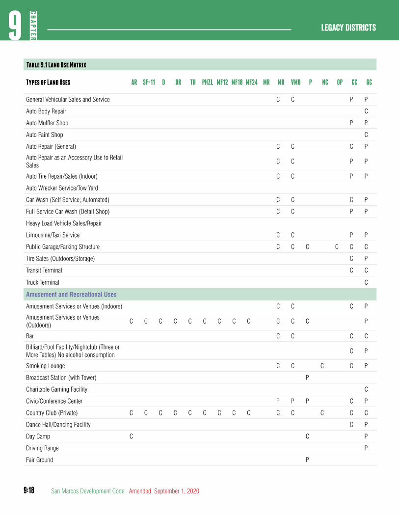
9:18
Legacy Districts9
CHAP
TER
San Marcos Development Code Amended: September 1, 2020
Table 9.1 Land Use Matrix
Types of Land Uses AR SF-11 D DR TH PHZL MF12 MF18 MF24 MR MU VMU P NC OP CC GC
General Vehicular Sales and Service C C P P
Auto Body Repair C
Auto Muffler Shop P P
Auto Paint Shop C
Auto Repair (General) C C C P
Auto Repair as an Accessory Use to Retail Sales
C C P P
Auto Tire Repair/Sales (Indoor) C C P P
Auto Wrecker Service/Tow Yard
Car Wash (Self Service; Automated) C C C P
Full Service Car Wash (Detail Shop) C C P P
Heavy Load Vehicle Sales/Repair
Limousine/Taxi Service C C P P
Public Garage/Parking Structure C C C C C C
Tire Sales (Outdoors/Storage) C P
Transit Terminal C C
Truck Terminal C
Amusement and Recreational Uses
Amusement Services or Venues (Indoors) C C C P
Amusement Services or Venues (Outdoors)
C C C C C C C C C C C C P
Bar C C C C
Billiard/Pool Facility/Nightclub (Three or More Tables) No alcohol consumption
C P
Smoking Lounge C C C C P
Broadcast Station (with Tower) P
Charitable Gaming Facility C
Civic/Conference Center P P P C P
Country Club (Private) C C C C C C C C C C C C C C
Dance Hall/Dancing Facility C P
Day Camp C C P
Driving Range P
Fair Ground P
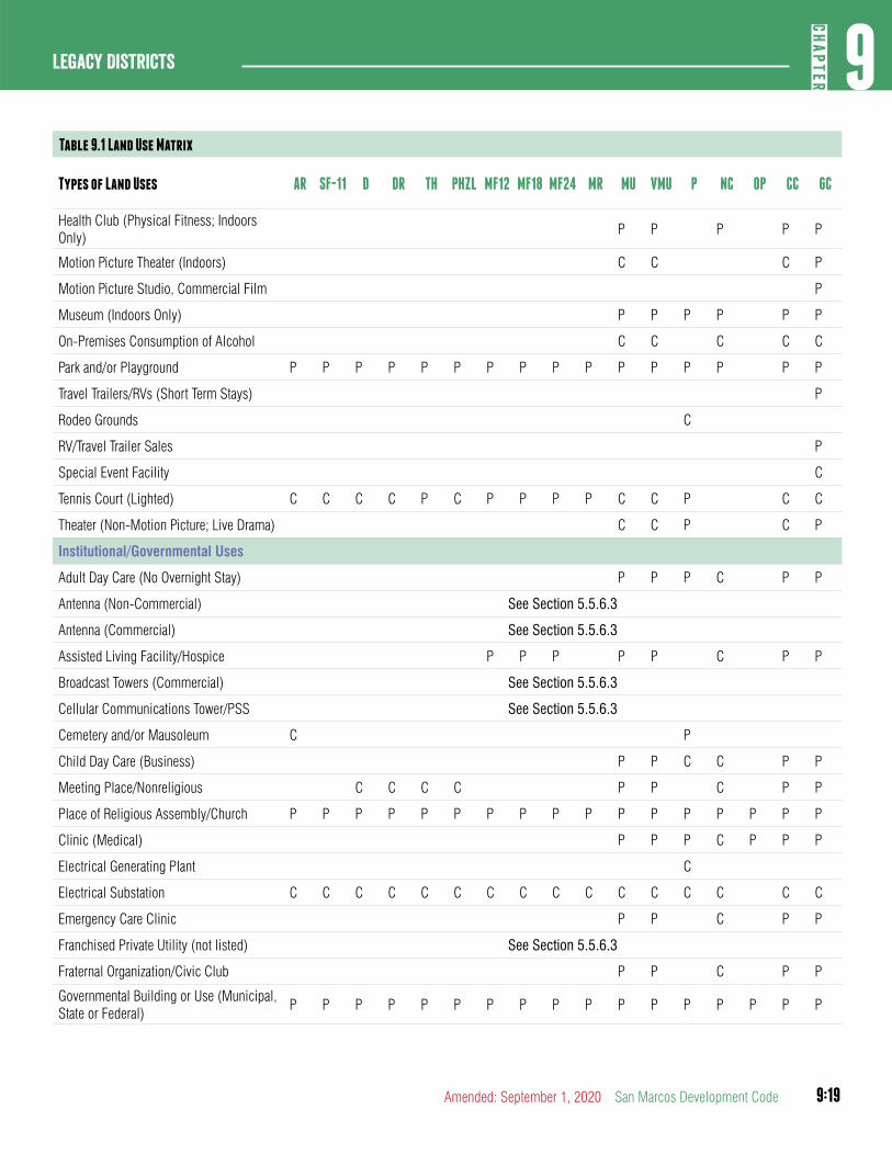
9:19
9CH
APTER
Legacy Districts
Amended: September 1, 2020 San Marcos Development Code
Table 9.1 Land Use Matrix
Types of Land Uses AR SF-11 D DR TH PHZL MF12 MF18 MF24 MR MU VMU P NC OP CC GC
Health Club (Physical Fitness; Indoors Only)
P P P P P
Motion Picture Theater (Indoors) C C C P
Motion Picture Studio, Commercial Film P
Museum (Indoors Only) P P P P P P
On-Premises Consumption of Alcohol C C C C C
Park and/or Playground P P P P P P P P P P P P P P P P
Travel Trailers/RVs (Short Term Stays) P
Rodeo Grounds C
RV/Travel Trailer Sales P
Special Event Facility C
Tennis Court (Lighted) C C C C P C P P P P C C P C C
Theater (Non-Motion Picture; Live Drama) C C P C P
Institutional/Governmental Uses
Adult Day Care (No Overnight Stay) P P P C P P
Antenna (Non-Commercial) See Section 5.5.6.3
Antenna (Commercial) See Section 5.5.6.3
Assisted Living Facility/Hospice P P P P P C P P
Broadcast Towers (Commercial) See Section 5.5.6.3
Cellular Communications Tower/PSS See Section 5.5.6.3
Cemetery and/or Mausoleum C P
Child Day Care (Business) P P C C P P
Meeting Place/Nonreligious C C C C P P C P P
Place of Religious Assembly/Church P P P P P P P P P P P P P P P P P
Clinic (Medical) P P P C P P P
Electrical Generating Plant C
Electrical Substation C C C C C C C C C C C C C C C C
Emergency Care Clinic P P C P P
Franchised Private Utility (not listed) See Section 5.5.6.3
Fraternal Organization/Civic Club P P C P P
Governmental Building or Use (Municipal, State or Federal)
P P P P P P P P P P P P P P P P P
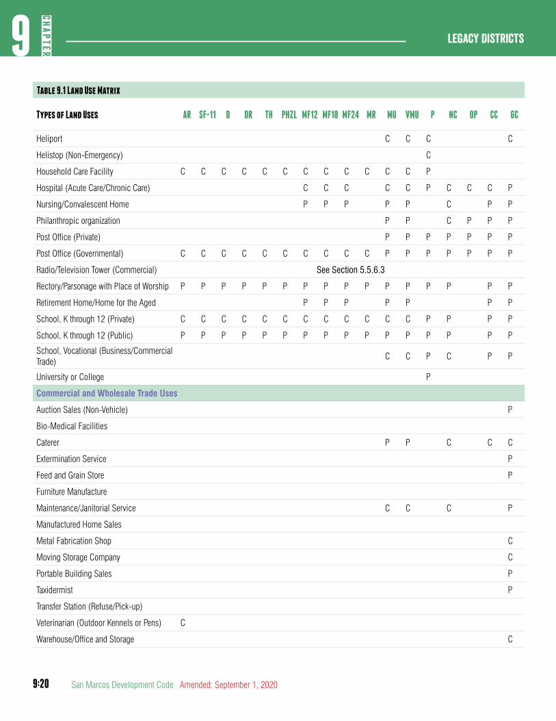
9:20
Legacy Districts9
CHAP
TER
San Marcos Development Code Amended: September 1, 2020
Table 9.1 Land Use Matrix
Types of Land Uses AR SF-11 D DR TH PHZL MF12 MF18 MF24 MR MU VMU P NC OP CC GC
Heliport C C C C
Helistop (Non-Emergency) C
Household Care Facility C C C C C C C C C C C C P
Hospital (Acute Care/Chronic Care) C C C C C P C C C P
Nursing/Convalescent Home P P P P P C P P
Philanthropic organization P P C P P P
Post Office (Private) P P P P P P P
Post Office (Governmental) C C C C C C C C C C P P P P P P P
Radio/Television Tower (Commercial) See Section 5.5.6.3
Rectory/Parsonage with Place of Worship P P P P P P P P P P P P P P P P
Retirement Home/Home for the Aged P P P P P P P
School, K through 12 (Private) C C C C C C C C C C C C P P P P
School, K through 12 (Public) P P P P P P P P P P P P P P P P
School, Vocational (Business/Commercial Trade)
C C P C P P
University or College P
Commercial and Wholesale Trade Uses
Auction Sales (Non-Vehicle) P
Bio-Medical Facilities
Caterer P P C C C
Extermination Service P
Feed and Grain Store P
Furniture Manufacture
Maintenance/Janitorial Service C C C P
Manufactured Home Sales
Metal Fabrication Shop C
Moving Storage Company C
Portable Building Sales P
Taxidermist P
Transfer Station (Refuse/Pick-up)
Veterinarian (Outdoor Kennels or Pens) C
Warehouse/Office and Storage C
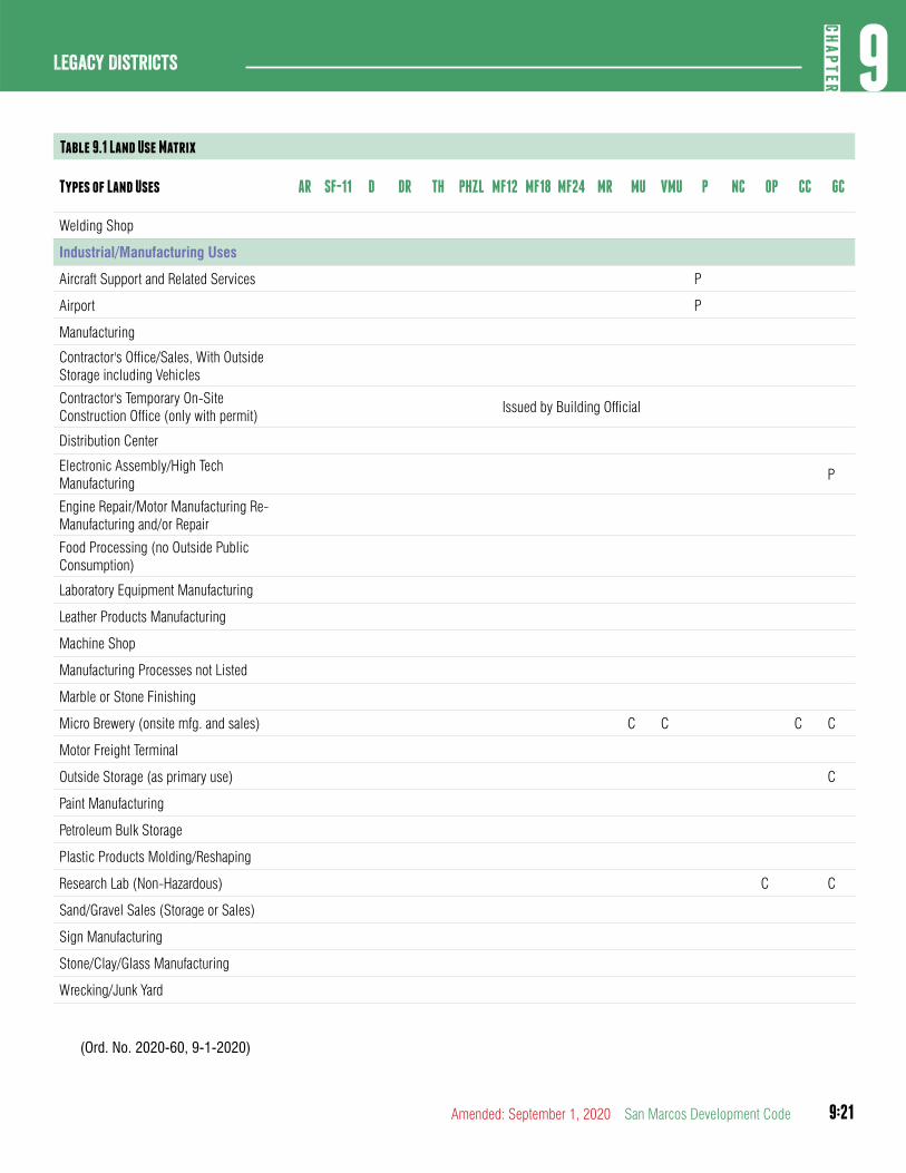
9:21
9CH
APTER
Legacy Districts
Amended: September 1, 2020 San Marcos Development Code
Table 9.1 Land Use Matrix
Types of Land Uses AR SF-11 D DR TH PHZL MF12 MF18 MF24 MR MU VMU P NC OP CC GC
Welding Shop
Industrial/Manufacturing Uses
Aircraft Support and Related Services P
Airport P
Manufacturing
Contractor's Office/Sales, With Outside Storage including Vehicles
Contractor's Temporary On-Site Construction Office (only with permit)
Issued by Building Official
Distribution Center
Electronic Assembly/High Tech Manufacturing
P
Engine Repair/Motor Manufacturing Re-Manufacturing and/or Repair
Food Processing (no Outside Public Consumption)
Laboratory Equipment Manufacturing
Leather Products Manufacturing
Machine Shop
Manufacturing Processes not Listed
Marble or Stone Finishing
Micro Brewery (onsite mfg. and sales) C C C C
Motor Freight Terminal
Outside Storage (as primary use) C
Paint Manufacturing
Petroleum Bulk Storage
Plastic Products Molding/Reshaping
Research Lab (Non-Hazardous) C C
Sand/Gravel Sales (Storage or Sales)
Sign Manufacturing
Stone/Clay/Glass Manufacturing
Wrecking/Junk Yard
(Ord. No. 2020-60, 9-1-2020)
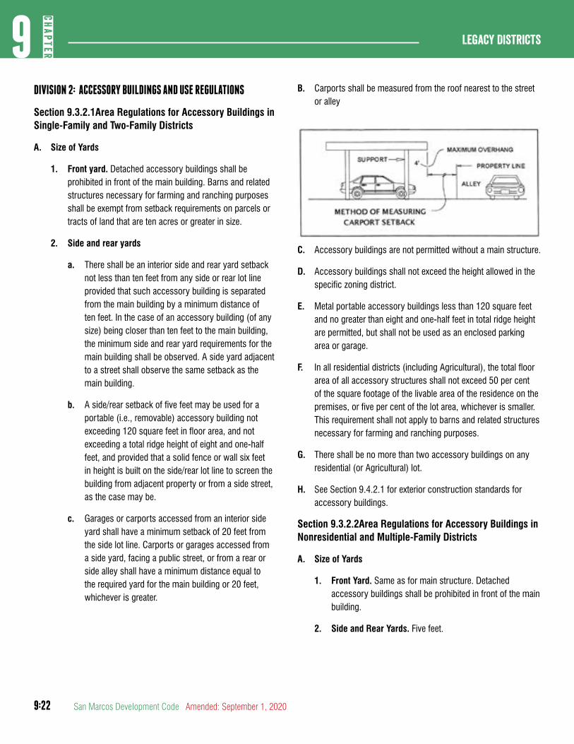
9:22
Legacy Districts9
CHAP
TER
San Marcos Development Code Amended: September 1, 2020
DIVISION 2: ACCESSORY BUILDINGS AND USE REGULATIONS
Section 9.3.2.1Area Regulations for Accessory Buildings in Single-Family and Two-Family Districts
A. Size of Yards
1. Front yard. Detached accessory buildings shall be prohibited in front of the main building. Barns and related structures necessary for farming and ranching purposes shall be exempt from setback requirements on parcels or tracts of land that are ten acres or greater in size.
2. Side and rear yards
a. There shall be an interior side and rear yard setback not less than ten feet from any side or rear lot line provided that such accessory building is separated from the main building by a minimum distance of ten feet. In the case of an accessory building (of any size) being closer than ten feet to the main building, the minimum side and rear yard requirements for the main building shall be observed. A side yard adjacent to a street shall observe the same setback as the main building.
b. A side/rear setback of five feet may be used for a portable (i.e., removable) accessory building not exceeding 120 square feet in floor area, and not exceeding a total ridge height of eight and one-half feet, and provided that a solid fence or wall six feet in height is built on the side/rear lot line to screen the building from adjacent property or from a side street, as the case may be.
c. Garages or carports accessed from an interior side yard shall have a minimum setback of 20 feet from the side lot line. Carports or garages accessed from a side yard, facing a public street, or from a rear or side alley shall have a minimum distance equal to the required yard for the main building or 20 feet, whichever is greater.
B. Carports shall be measured from the roof nearest to the street or alley
C. Accessory buildings are not permitted without a main structure.
D. Accessory buildings shall not exceed the height allowed in the specific zoning district.
E. Metal portable accessory buildings less than 120 square feet and no greater than eight and one-half feet in total ridge height are permitted, but shall not be used as an enclosed parking area or garage.
F. In all residential districts (including Agricultural), the total floor area of all accessory structures shall not exceed 50 per cent of the square footage of the livable area of the residence on the premises, or five per cent of the lot area, whichever is smaller. This requirement shall not apply to barns and related structures necessary for farming and ranching purposes.
G. There shall be no more than two accessory buildings on any residential (or Agricultural) lot.
H. See Section 9.4.2.1 for exterior construction standards for accessory buildings.
Section 9.3.2.2Area Regulations for Accessory Buildings in Nonresidential and Multiple-Family Districts
A. Size of Yards
1. Front Yard. Same as for main structure. Detached accessory buildings shall be prohibited in front of the main building.
2. Side and Rear Yards. Five feet.
9:23
9CH
APTER
Legacy Districts
Amended: September 1, 2020 San Marcos Development Code
B. Carports shall be measured from the roof nearest to the street or alley.
C. Accessory buildings are not permitted without a main structure.
D. Accessory buildings shall not exceed the height allowed in the specific zoning district.
E. Metal portable accessory buildings less than 120 square feet and no greater than eight and one-half feet in total ridge height are permitted, but only if a solid fence or wall six feet in height is built on the side/rear lot line to screen the building from adjacent property and from the view of a public street. Such metal buildings shall not be used as an enclosed parking area or garage.
F. See Section 9.4.2.1for exterior construction standards for accessory buildings.
DIVISION 3: HOME OCCUPATIONS
Section 9.3.3.1Provisions for Home Occupations
A. See Section 5.1.3.4
DIVISION 4: REQUIREMENTS APPLICABLE TO PARTICULAR USES
Section 9.3.4.1Communications Antennas and Support Structures/ Towers
A. See Section 5.1.6.3
Section 9.3.4.2Conditional Use Permits for On-Site Alcoholic Beverage Consumption
A. See Section 5.1.5.5.
Section 9.3.4.3Conditional Use Permits for Fraternity/ Sorority Buildings
A. See Section 5.1.4.12
Section 9.3.4.4Occupancy Restrictions
A. Limited Number of Unrelated Individuals. All dwelling units located in SF-11, DR, TH, PH-ZL zoning districts shall be
restricted to occupancy by a family, and up to one other person who is not related to any of the family members by blood, legal adoption, marriage, or conservatorship.
B. Prima facie proof of occupancy of a dwelling unit by more than two unrelated persons is established in any prosecution for violation of this Section if it is shown that the same three or more vehicles with registrations to persons having different surnames and addresses were parked overnight at the dwelling unit a majority of nights in any 21-day period. This establishment of a prima facie level of proof in this subsection does not preclude a showing of “occupancy” of a dwelling unit by a person in any other manner.
C. The property owner and any agent of the property owner shall be legally responsible for directly or indirectly allowing, permitting, causing, or failing to prohibit the occupancy of a dwelling unit by more than two unrelated persons.
Section 9.3.4.5Renewable Energy Systems
A. See Section 5.1.6.3
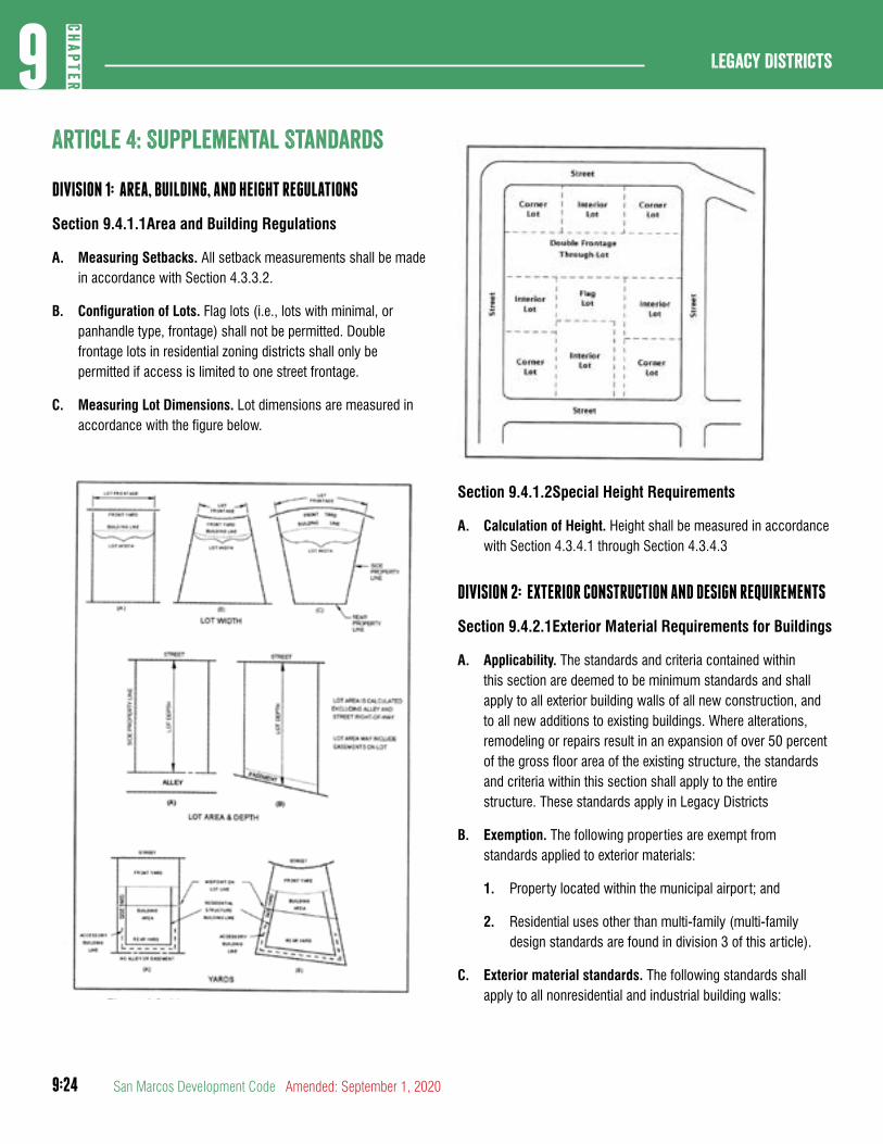
9:24
Legacy Districts9
CHAP
TER
San Marcos Development Code Amended: September 1, 2020
article 4: Supplemental Standards
DIVISION 1: AREA, BUILDING, AND HEIGHT REGULATIONS
Section 9.4.1.1Area and Building Regulations
A. Measuring Setbacks. All setback measurements shall be made in accordance with Section 4.3.3.2.
B. Configuration of Lots. Flag lots (i.e., lots with minimal, or panhandle type, frontage) shall not be permitted. Double frontage lots in residential zoning districts shall only be permitted if access is limited to one street frontage.
C. Measuring Lot Dimensions. Lot dimensions are measured in accordance with the figure below.
Section 9.4.1.2Special Height Requirements
A. Calculation of Height. Height shall be measured in accordance with Section 4.3.4.1 through Section 4.3.4.3
DIVISION 2: EXTERIOR CONSTRUCTION AND DESIGN REQUIREMENTS
Section 9.4.2.1Exterior Material Requirements for Buildings
A. Applicability. The standards and criteria contained within this section are deemed to be minimum standards and shall apply to all exterior building walls of all new construction, and to all new additions to existing buildings. Where alterations, remodeling or repairs result in an expansion of over 50 percent of the gross floor area of the existing structure, the standards and criteria within this section shall apply to the entire structure. These standards apply in Legacy Districts
B. Exemption. The following properties are exempt from standards applied to exterior materials:
1. Property located within the municipal airport; and
2. Residential uses other than multi-family (multi-family design standards are found in division 3 of this article).
C. Exterior material standards. The following standards shall apply to all nonresidential and industrial building walls:
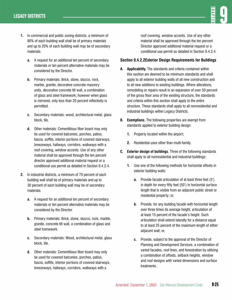
9:25
9CH
APTER
Legacy Districts
Amended: September 1, 2020 San Marcos Development Code
1. In commercial and public zoning districts, a minimum of 80% of each building wall shall be of primary materials and up to 20% of each building wall may be of secondary materials.
a. A request for an additional ten percent of secondary materials or ten percent alternative materials may be considered by the Director.
b. Primary materials: Brick, stone, stucco, rock, marble, granite, decorative concrete masonry units, decorative concrete tilt wall, a combination of glass and steel framework; however when glass is mirrored, only less than 20 percent reflectivity is permitted.
c. Secondary materials: wood, architectural metal, glass block, tile.
d. Other materials: Cementitious fiber board may only be used for covered balconies, porches, patios, fascia, soffits, interior portions of covered stairways, breezeways, hallways, corridors, walkways with a roof covering, window accents. Use of any other material shall be approved through the ten percent director approved additional material request or a conditional use permit as detailed in Section 9.4.2.4.
2. In industrial districts, a minimum of 70 percent of each building wall shall be of primary materials and up to 30 percent of each building wall may be of secondary materials.
a. A request for an additional ten percent of secondary materials or ten percent alternative materials may be considered by the Director.
b. Primary materials: Brick, stone, stucco, rock, marble, granite, concrete tilt wall, a combination of glass and steel framework.
c. Secondary materials: Wood, architectural metal, glass block, tile.
d. Other materials: Cementitious fiber board may only be used for covered balconies, porches, patios, fascia, soffits, interior portions of covered stairways, breezeways, hallways, corridors, walkways with a
roof covering, window accents. Use of any other material shall be approved through the ten percent Director approved additional material request or a conditional use permit as detailed in Section 9.4.2.4.
Section 9.4.2.2Exterior Design Requirements for Buildings
A. Applicability. The standards and criteria contained within this section are deemed to be minimum standards and shall apply to all exterior building walls of all new construction and to all new additions to existing buildings. Where alterations, remodeling or repairs result in an expansion of over 50 percent of the gross floor area of the existing structure, the standards and criteria within this section shall apply to the entire structure. These standards shall apply to all nonresidential and industrial buildings within Legacy Districts.
B. Exemptions. The following properties are exempt from standards applied to exterior building design:
1. Property located within the airport;
2. Residential uses other than multi-family.
C. Exterior design of buildings. Three of the following standards shall apply to all nonresidential and industrial buildings:
1. Use one of the following methods for horizontal offsets in exterior building walls:
a. Provide facade articulation of at least three feet (3’) in depth for every fifty feet (50’) in horizontal surface length that is visible from an adjacent public street or residential property; or,
b. Provide, for any building facade with horizontal length over three times its average height, articulation of at least 15 percent of the facade’s height. Such articulation shall extend laterally for a distance equal to at least 25 percent of the maximum length of either adjacent wall; or,
c. Provide, subject to the approval of the Director of Planning and Development Services, a combination of varied facades, roof lines, and fenestration by utilizing a combination of offsets, setback heights, window and roof designs with varied dimensions and surface treatments.
9:26
Legacy Districts9
CHAP
TER
San Marcos Development Code Amended: September 1, 2020
2. Use one of the following methods for vertical offsets in exterior building walls:
a. Provide facade articulation of at least three feet (3’) in depth for every fifty feet (50’) in height of facade; or,
b. Provide, for facades that extend laterally for a distance of greater than three times its average height, a facade height change of at least 15 percent of the height of either adjacent wall. This change of height shall extend for a distance equal to at least 25 percent of the maximum length of the adjacent walls; or,
c. Provide, subject to the approval of the Director of Planning and Development Services, a combination of varied facades, roof lines, and fenestration by utilizing a combination of offsets, setback heights, window and roof designs with varied dimensions and surface treatments.
3. Incorporate at least one of the following pedestrian scale architectural features on at least three facades:
a. Use ground level arcades and covered areas along the majority of a facade; or,
b. Use protected or recessed entryways to shop or interior walkways: or,
c. Include windows on at least 15 percent of walls facing streets, walkways and primary entries.
4. Utilize at least one of the following features on any facades without windows or doors:
a. Place smaller retail spaces (linear buildings) along the blank elevation of the larger building; or,
b. Place landscape beds a minimum if 15 feet wide capable of providing 75 percent screening (at maturity) of a minimum of 2/3 of the facade’s height: or,
c. Provide, subject to the approval of the Director of Planning and Development Services, landscaped public pedestrian spaces (courtyards, plazas, or trail heads) along the blank facade.
5. Utilize a minimum of two of the following elements, repeated at appropriate intervals either horizontally or vertically, on any facade greater than 50 feet in length:
a. Material change; or,
b. Punched windows with recessed doorways; or,
c. Balconies, turrets or towers; or,
d. Architectural details that create interest, shade and cast shadows such as offsets, molding, eaves, cornices, pillars, archways, or other appurtenances.
(Ord. No. 2019-45, 12-17-19)
Section 9.4.2.3Procedure for Review of Exterior Design and Materials
A. Drawing(s) depicting the exterior design and materials of buildings, in sufficient detail to verify compliance with the requirements of this division, shall be submitted at the time the Site Preparation Permit application is submitted, and again at the time the Building Permit application is submitted. These requirements shall be illustrated, along with calculations and/or specifications of how building envelopes shown on Site Preparation Permits will meet the requirements for materials and design.
B. If requested by the City, a sample(s) of the proposed exterior finish material(s) may be required to be submitted with the Site Preparation Permit application.
C. If the Director cannot determine compliance with design or materials requirements through the variety of mechanisms and alternatives provided in this Land Development Code, the Site Preparation Permit shall not be approved until the applicant either revises the proposed design or materials to comply with the requirements, or the applicant obtains a Conditional Use Permit for alternative design or materials under Section 9.4.2.4.
Section 9.4.2.4Procedure for Approving Alternative Exterior Designs or Materials
A. All requests for alternative exterior design or materials shall be clearly written, specifically noted, and described on the Site Preparation Permit application.
9:27
9CH
APTER
Legacy Districts
Amended: September 1, 2020 San Marcos Development Code
B. Requests for use of additional secondary or alternative materials, as described in Section 9.4.2.3 above, shall be decided by the Director.
C. Relief from a decision of the Director may be appealed to the City Council through application for a Conditional Use Permit. The CUP will be decided based on the following criteria:
1. The approved alternative meets the intent of the exterior design and materials standards to an equivalent or better degree than the minimum standards required;
2. The request conforms to the Comprehensive Plan and adopted City Plans;
3. The request is based on a unique character of the property or proposed use;
4. Financial hardship is not the basis for the request; and
5. The request is offset by additional architectural treatments and increased vertical landscaping.
DIVISION 3: MULTIFAMILY RESIDENTIAL DESIGN STANDARDS
Section 9.4.3.1Purpose and Applicability
A. The standards and criteria contained within this Article are applicable to any multifamily residential development in the following zoning districts: MF-12, MF-18, MF-24, MU, or VMU.
B. The standards in this Article are supplemental to any other applicable standards in this Code or the SmartCode and such other standards will continue to apply except to the extent of a conflict with these standards, in which event, these standards will govern.
C. The provisions of this chapter shall apply to all development meeting one (1) or more of the following thresholds:
1. All new construction requiring building permits; and/or
2. Major Redevelopment, including:
a. Additions to a building.
b. Alterations of more than 50% of the exterior elevation of any building within a three year period.
c. Any building being expanded or altered as described above shall comply with Division 1, mechanical equipment screening, pedestrian connectivity and residential compatibility and Division 2, Building Design.
Section 9.4.3.2Administrative Adjustment
A. In order to provide flexibility and creativity of project designs, departures from these design standards may be approved by Administrative Adjustment, subject to the limitations in Section 2.8.5.1 and the following criteria:
1. The strict interpretation or application of these Design Standards would be inconsistent with related provisions of the Land Development Code; or
2. The departure creates a project design that better meets the overall purpose and intent of the design standards.
B. If the Director of Development Services denies a request for a departure from these design standards, the applicant requesting the departure may file a variance petition in accordance with Chapter 2. This subsection shall not, otherwise, be construed to prevent an owner of property from seeking a variance from these standards by filing a variance petition in accordance with Chapter 2.
Section 9.4.3.3Site and Building Design Criteria
A. Block Requirements. The intent is to ensure that multifamily development is built to a scale that is compatible with surrounding areas and provides options for all modes of transportation.
1. All developments shall comply with the applicable standards set forth below, unless the decision maker determines that there is an established pattern of blocks less than seven acres in size in the surrounding area and no further street connections are necessary or that compliance with a specific element of the standard is infeasible due to unusual topographic features, existing development, safety factors or a natural area or feature. In such case, the block size must still conform to Section 3.6.1.1.
2. Block Structure. Each multi-family project shall be developed as a series of complete blocks bounded by
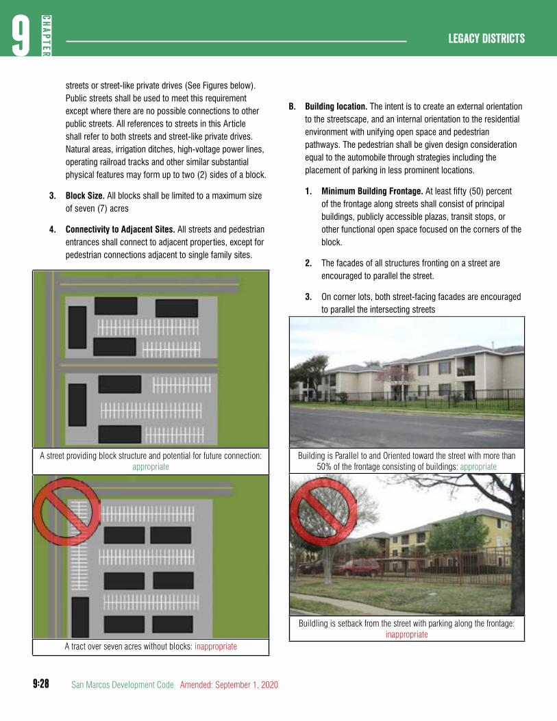
9:28
Legacy Districts9
CHAP
TER
San Marcos Development Code Amended: September 1, 2020
streets or street-like private drives (See Figures below). Public streets shall be used to meet this requirement except where there are no possible connections to other public streets. All references to streets in this Article shall refer to both streets and street-like private drives. Natural areas, irrigation ditches, high-voltage power lines, operating railroad tracks and other similar substantial physical features may form up to two (2) sides of a block.
3. Block Size. All blocks shall be limited to a maximum size of seven (7) acres
4. Connectivity to Adjacent Sites. All streets and pedestrian entrances shall connect to adjacent properties, except for pedestrian connections adjacent to single family sites.
A street providing block structure and potential for future connection: appropriate
A tract over seven acres without blocks: inappropriate
B. Building location. The intent is to create an external orientation to the streetscape, and an internal orientation to the residential environment with unifying open space and pedestrian pathways. The pedestrian shall be given design consideration equal to the automobile through strategies including the placement of parking in less prominent locations.
1. Minimum Building Frontage. At least fifty (50) percent of the frontage along streets shall consist of principal buildings, publicly accessible plazas, transit stops, or other functional open space focused on the corners of the block.
2. The facades of all structures fronting on a street are encouraged to parallel the street.
3. On corner lots, both street-facing facades are encouraged to parallel the intersecting streets
Building is Parallel to and Oriented toward the street with more than 50% of the frontage consisting of buildings: appropriate
Buildling is setback from the street with parking along the frontage: inappropriate
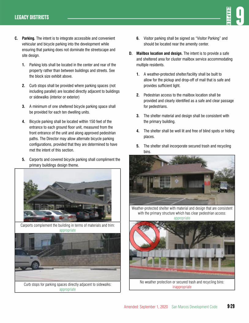
9:29
9CH
APTER
Legacy Districts
Amended: September 1, 2020 San Marcos Development Code
C. Parking. The intent is to integrate accessible and convenient vehicular and bicycle parking into the development while ensuring that parking does not dominate the streetscape and site design.
1. Parking lots shall be located in the center and rear of the property rather than between buildings and streets. See the block size exhibit above.
2. Curb stops shall be provided where parking spaces (not including parallel) are located directly adjacent to buildings or sidewalks (interior or exterior)
3. A minimum of one sheltered bicycle parking space shall be provided for each ten dwelling units.
4. Bicycle parking shall be located within 150 feet of the entrance to each ground floor unit, measured from the front entrance of the unit and along approved pedestrian paths. The Director may allow alternate bicycle parking configurations, provided that they are determined to have met the intent of this section.
5. Carports and covered bicycle parking shall compliment the primary buildings design theme.
Carports complement the building in terms of materials and trim: appropriate
Curb stops for parking spaces directly adjacent to sidewalks: appropriate
6. Visitor parking shall be signed as “Visitor Parking” and should be located near the amenity center.
D. Mailbox location and design. The intent is to provide a safe and sheltered area for cluster mailbox service accommodating multiple residents.
1. A weather-protected shelter/facility shall be built to allow for the pickup and drop-off of mail that is safe and provides sufficient light.
2. Pedestrian access to the mailbox location shall be provided and clearly identified as a safe and clear passage for pedestrians.
3. The shelter material and design shall be consistent with the primary building.
4. The shelter shall be well lit and free of blind spots or hiding places.
5. The shelter shall incorporate secured trash and recycling bins.
Weather-protected shelter with material and design that are consistent with the primary structure which has clear pedestrian access:
appropriate
No weather protection or secured trash and recycling bins: inappropriate
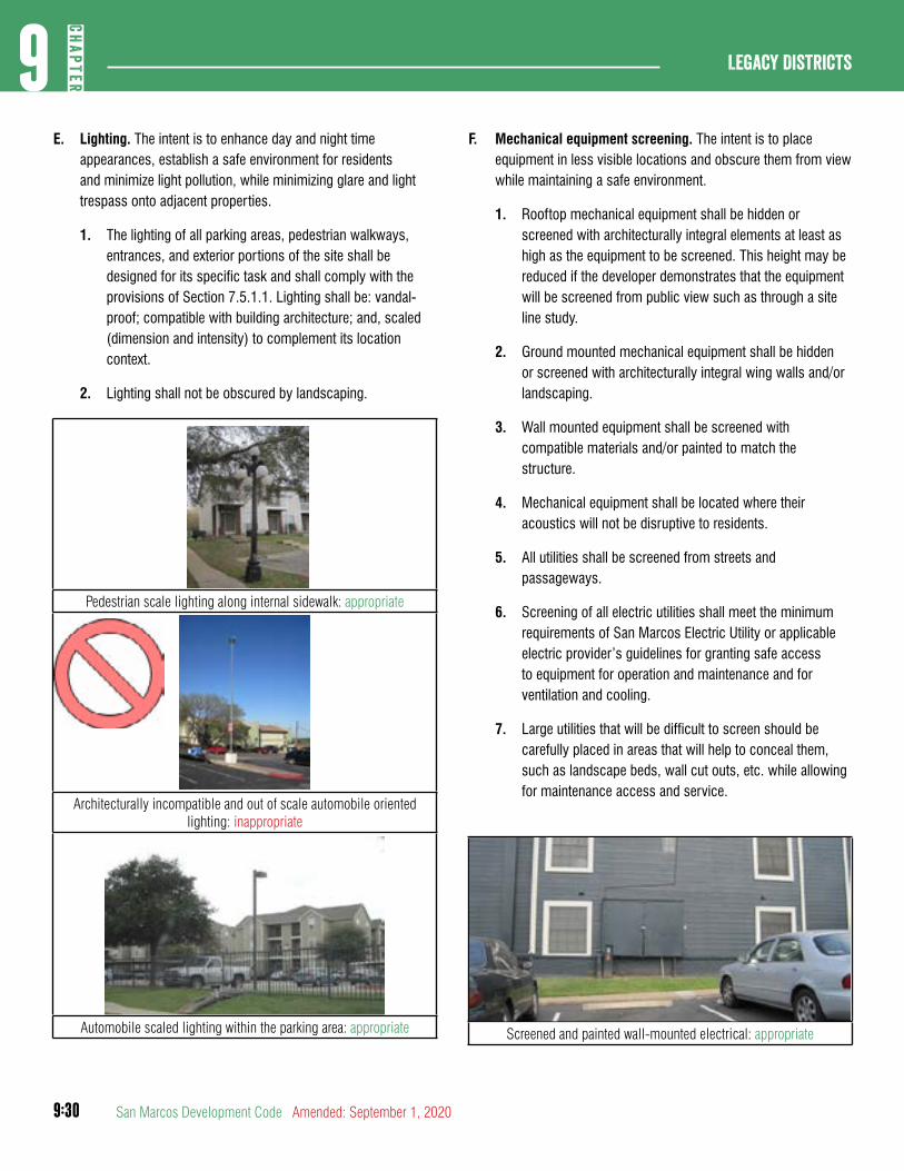
9:30
Legacy Districts9
CHAP
TER
San Marcos Development Code Amended: September 1, 2020
E. Lighting. The intent is to enhance day and night time appearances, establish a safe environment for residents and minimize light pollution, while minimizing glare and light trespass onto adjacent properties.
1. The lighting of all parking areas, pedestrian walkways, entrances, and exterior portions of the site shall be designed for its specific task and shall comply with the provisions of Section 7.5.1.1. Lighting shall be: vandal-proof; compatible with building architecture; and, scaled (dimension and intensity) to complement its location context.
2. Lighting shall not be obscured by landscaping.
Pedestrian scale lighting along internal sidewalk: appropriate
Architecturally incompatible and out of scale automobile oriented lighting: inappropriate
Automobile scaled lighting within the parking area: appropriate
F. Mechanical equipment screening. The intent is to place equipment in less visible locations and obscure them from view while maintaining a safe environment.
1. Rooftop mechanical equipment shall be hidden or screened with architecturally integral elements at least as high as the equipment to be screened. This height may be reduced if the developer demonstrates that the equipment will be screened from public view such as through a site line study.
2. Ground mounted mechanical equipment shall be hidden or screened with architecturally integral wing walls and/or landscaping.
3. Wall mounted equipment shall be screened with compatible materials and/or painted to match the structure.
4. Mechanical equipment shall be located where their acoustics will not be disruptive to residents.
5. All utilities shall be screened from streets and passageways.
6. Screening of all electric utilities shall meet the minimum requirements of San Marcos Electric Utility or applicable electric provider’s guidelines for granting safe access to equipment for operation and maintenance and for ventilation and cooling.
7. Large utilities that will be difficult to screen should be carefully placed in areas that will help to conceal them, such as landscape beds, wall cut outs, etc. while allowing for maintenance access and service.
Screened and painted wall-mounted electrical: appropriate
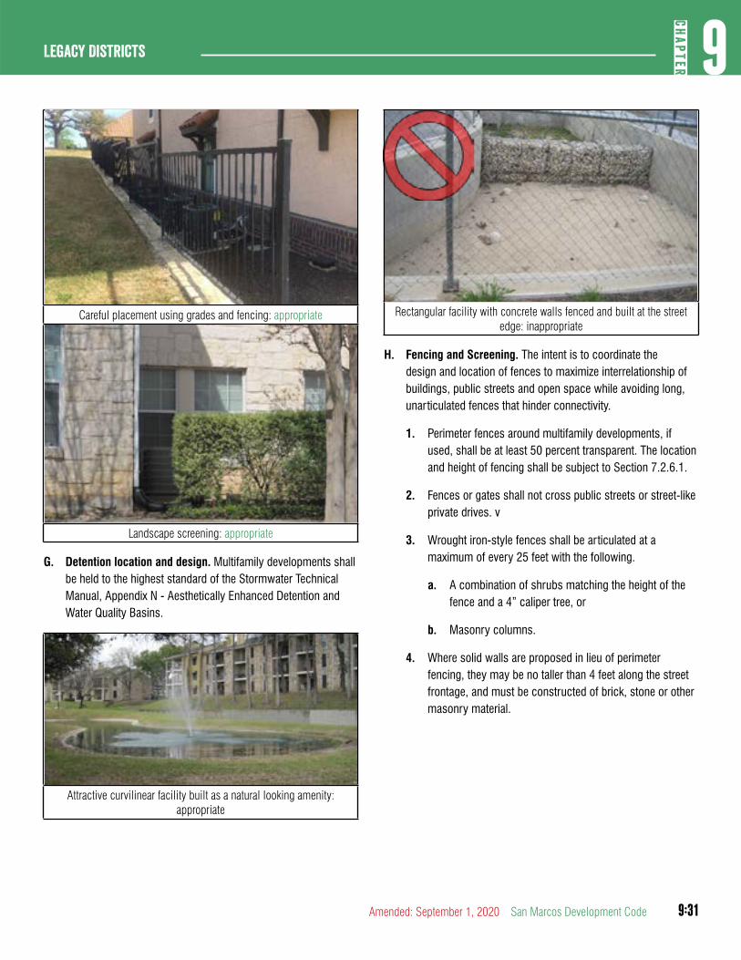
9:31
9CH
APTER
Legacy Districts
Amended: September 1, 2020 San Marcos Development Code
Careful placement using grades and fencing: appropriate
Landscape screening: appropriate
G. Detention location and design. Multifamily developments shall be held to the highest standard of the Stormwater Technical Manual, Appendix N - Aesthetically Enhanced Detention and Water Quality Basins.
Attractive curvilinear facility built as a natural looking amenity: appropriate
Rectangular facility with concrete walls fenced and built at the street edge: inappropriate
H. Fencing and Screening. The intent is to coordinate the design and location of fences to maximize interrelationship of buildings, public streets and open space while avoiding long, unarticulated fences that hinder connectivity.
1. Perimeter fences around multifamily developments, if used, shall be at least 50 percent transparent. The location and height of fencing shall be subject to Section 7.2.6.1.
2. Fences or gates shall not cross public streets or street-like private drives. v
3. Wrought iron-style fences shall be articulated at a maximum of every 25 feet with the following.
a. A combination of shrubs matching the height of the fence and a 4” caliper tree, or
b. Masonry columns.
4. Where solid walls are proposed in lieu of perimeter fencing, they may be no taller than 4 feet along the street frontage, and must be constructed of brick, stone or other masonry material.
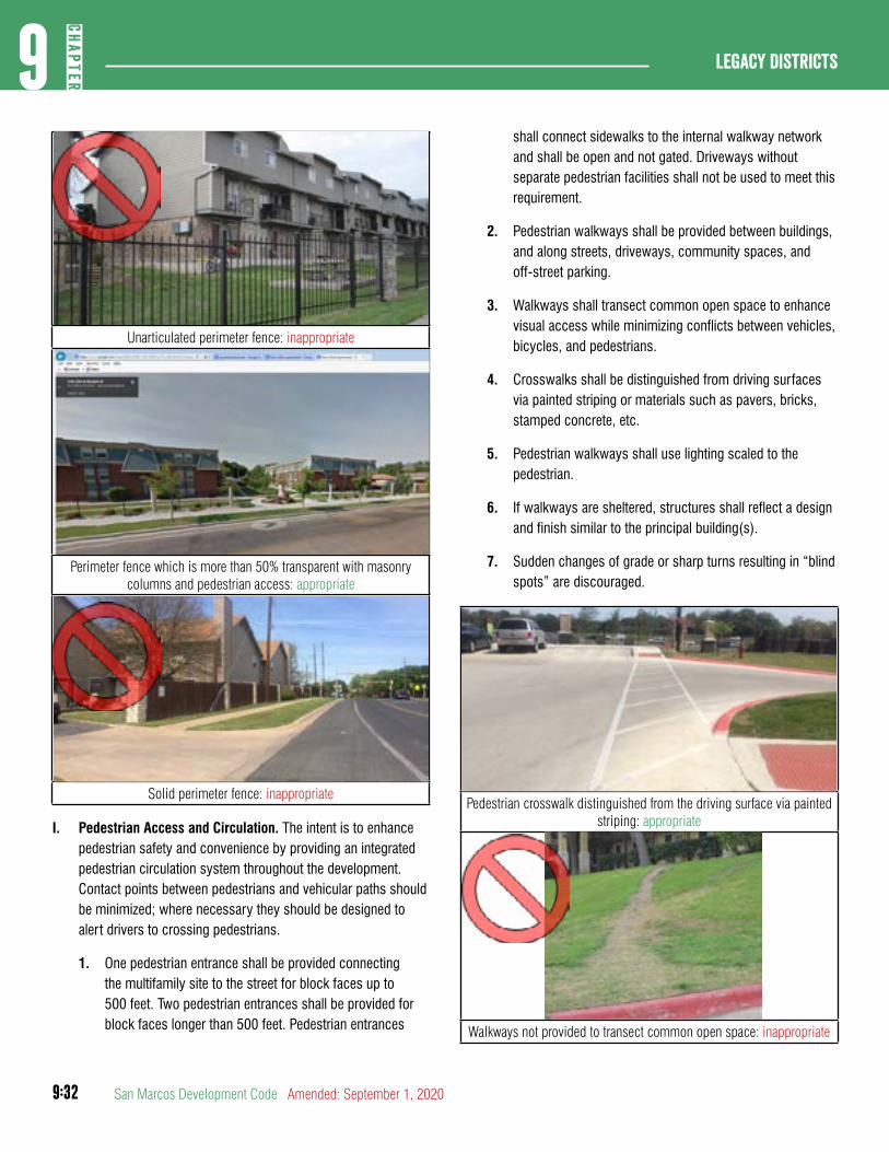
9:32
Legacy Districts9
CHAP
TER
San Marcos Development Code Amended: September 1, 2020
Unarticulated perimeter fence: inappropriate
Perimeter fence which is more than 50% transparent with masonry columns and pedestrian access: appropriate
Solid perimeter fence: inappropriate
I. Pedestrian Access and Circulation. The intent is to enhance pedestrian safety and convenience by providing an integrated pedestrian circulation system throughout the development. Contact points between pedestrians and vehicular paths should be minimized; where necessary they should be designed to alert drivers to crossing pedestrians.
1. One pedestrian entrance shall be provided connecting the multifamily site to the street for block faces up to 500 feet. Two pedestrian entrances shall be provided for block faces longer than 500 feet. Pedestrian entrances
shall connect sidewalks to the internal walkway network and shall be open and not gated. Driveways without separate pedestrian facilities shall not be used to meet this requirement.
2. Pedestrian walkways shall be provided between buildings, and along streets, driveways, community spaces, and off-street parking.
3. Walkways shall transect common open space to enhance visual access while minimizing conflicts between vehicles, bicycles, and pedestrians.
4. Crosswalks shall be distinguished from driving surfaces via painted striping or materials such as pavers, bricks, stamped concrete, etc.
5. Pedestrian walkways shall use lighting scaled to the pedestrian.
6. If walkways are sheltered, structures shall reflect a design and finish similar to the principal building(s).
7. Sudden changes of grade or sharp turns resulting in “blind spots” are discouraged.
Pedestrian crosswalk distinguished from the driving surface via painted striping: appropriate
Walkways not provided to transect common open space: inappropriate
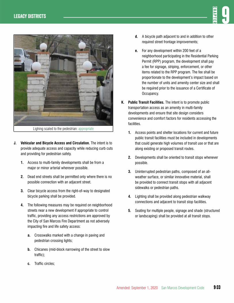
9:33
9CH
APTER
Legacy Districts
Amended: September 1, 2020 San Marcos Development Code
Lighing scaled to the pedestrian: appropriate
J. Vehicular and Bicycle Access and Circulation. The intent is to provide adequate access and capacity while reducing curb cuts and providing for pedestrian safety.
1. Access to multi-family developments shall be from a major or minor arterial wherever possible.
2. Dead end streets shall be permitted only where there is no possible connection with an adjacent street.
3. Clear bicycle access from the right-of-way to designated bicycle parking shall be provided.
4. The following measures may be required on neighborhood streets near a new development if appropriate to control traffic, providing any access restrictions are approved by the City of San Marcos Fire Department as not adversely impacting fire and life safety access:
a. Crosswalks marked with a change in paving and pedestrian crossing lights;
b. Chicanes (mid-block narrowing of the street to slow traffic);
c. Traffic circles;
d. A bicycle path adjacent to and in addition to other required street frontage improvements;
e. For any development within 200 feet of a neighborhood participating in the Residential Parking Permit (RPP) program, the development shall pay a fee for signage, striping, enforcement, or other items related to the RPP program. The fee shall be proportionate to the development’s impact based on the number of units and amenity center size and shall be required prior to the issuance of a Certificate of Occupancy.
K. Public Transit Facilities. The intent is to promote public transportation access as an amenity in multi-family developments and ensure that site design considers convenience and comfort factors for residents accessing the facilities.
1. Access points and shelter locations for current and future public transit facilities must be included in developments that could generate high volumes of transit use or that are along existing or proposed transit routes.
2. Developments shall be oriented to transit stops whenever possible.
3. Uninterrupted pedestrian paths, composed of an all-weather surface, or similar innovative material, shall be provided to connect transit stops with all adjacent sidewalks or pedestrian paths.
4. Lighting shall be provided along pedestrian walkway connections and adjacent to transit stop facilities.
5. Seating for multiple people, signage and shade (structured or landscaping) shall be provided at all transit stops.
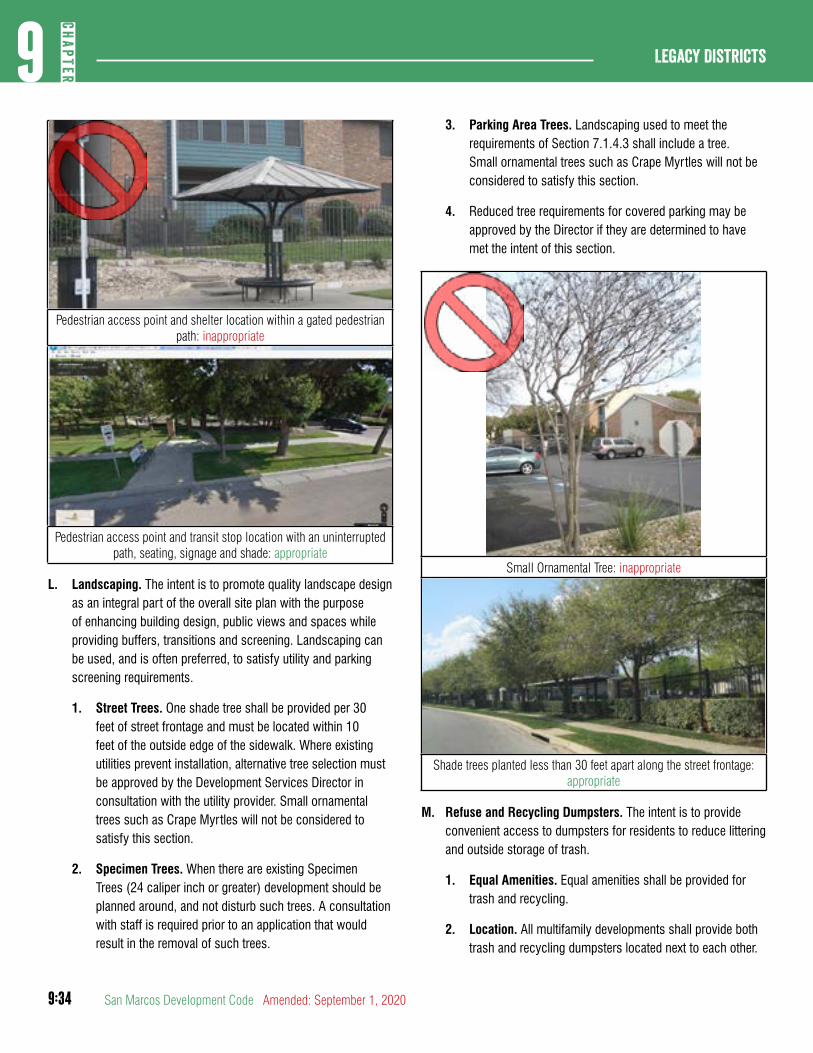
9:34
Legacy Districts9
CHAP
TER
San Marcos Development Code Amended: September 1, 2020
Pedestrian access point and shelter location within a gated pedestrian path: inappropriate
Pedestrian access point and transit stop location with an uninterrupted path, seating, signage and shade: appropriate
L. Landscaping. The intent is to promote quality landscape design as an integral part of the overall site plan with the purpose of enhancing building design, public views and spaces while providing buffers, transitions and screening. Landscaping can be used, and is often preferred, to satisfy utility and parking screening requirements.
1. Street Trees. One shade tree shall be provided per 30 feet of street frontage and must be located within 10 feet of the outside edge of the sidewalk. Where existing utilities prevent installation, alternative tree selection must be approved by the Development Services Director in consultation with the utility provider. Small ornamental trees such as Crape Myrtles will not be considered to satisfy this section.
2. Specimen Trees. When there are existing Specimen Trees (24 caliper inch or greater) development should be planned around, and not disturb such trees. A consultation with staff is required prior to an application that would result in the removal of such trees.
3. Parking Area Trees. Landscaping used to meet the requirements of Section 7.1.4.3 shall include a tree. Small ornamental trees such as Crape Myrtles will not be considered to satisfy this section.
4. Reduced tree requirements for covered parking may be approved by the Director if they are determined to have met the intent of this section.
Small Ornamental Tree: inappropriate
Shade trees planted less than 30 feet apart along the street frontage: appropriate
M. Refuse and Recycling Dumpsters. The intent is to provide convenient access to dumpsters for residents to reduce littering and outside storage of trash.
1. Equal Amenities. Equal amenities shall be provided for trash and recycling.
2. Location. All multifamily developments shall provide both trash and recycling dumpsters located next to each other.
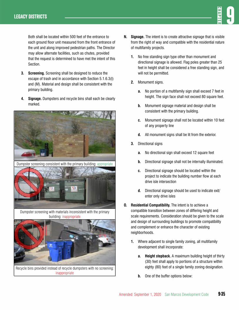
9:35
9CH
APTER
Legacy Districts
Amended: September 1, 2020 San Marcos Development Code
Both shall be located within 500 feet of the entrance to each ground floor unit measured from the front entrance of the unit and along improved pedestrian paths. The Director may allow alternate facilities, such as chutes, provided that the request is determined to have met the intent of this Section.
3. Screening. Screening shall be designed to reduce the escape of trash and in accordance with Section 5.1.6.3(I) and (M). Material and design shall be consistent with the primary building.
4. Signage. Dumpsters and recycle bins shall each be clearly marked.
Dumpster screening consistent with the primary building: appropriate
Dumpster screening with materials inconsistent with the primary building: inappropriate
Recycle bins provided instead of recycle dumpsters with no screening: inappropriate
N. Signage. The intent is to create attractive signage that is visible from the right of way and compatible with the residential nature of multifamily projects.
1. No free standing sign type other than monument and directional signage is allowed. Flag poles greater than 25 feet in height shall be considered a free standing sign, and will not be permitted.
2. Monument signs.
a. No portion of a multifamily sign shall exceed 7 feet in height. The sign face shall not exceed 80 square feet.
b. Monument signage material and design shall be consistent with the primary building.
c. Monument signage shall not be located within 10 feet of any property line
d. All monument signs shall be lit from the exterior.
3. Directional signs
a. No directional sign shall exceed 12 square feet
b. Directional signage shall not be internally illuminated.
c. Directional signage should be located within the project to indicate the building number flow at each drive isle intersection
d. Directional signage should be used to indicate exit/enter only drive isles
O. Residential Compatibility. The intent is to achieve a compatible transition between zones of differing height and scale requirements. Consideration should be given to the scale and design of surrounding buildings to promote compatibility and complement or enhance the character of existing neighborhoods.
1. Where adjacent to single family zoning, all multifamily development shall incorporate:
a. Height stepback. A maximum building height of thirty (30) feet shall apply to portions of a structure within eighty (80) feet of a single family zoning designation.
b. One of the buffer options below:
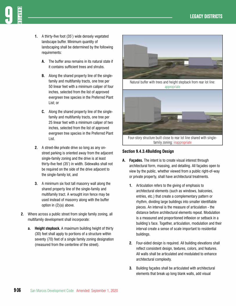
9:36
Legacy Districts9
CHAP
TER
San Marcos Development Code Amended: September 1, 2020
1. A thirty-five foot (35’) wide densely vegetated landscape buffer. Minimum quantity of landscaping shall be determined by the following requirements:
A. The buffer area remains in its natural state if it contains sufficient trees and shrubs.
B. Along the shared property line of the single-family and multifamily tracts, one tree per 50 linear feet with a minimum caliper of four inches, selected from the list of approved evergreen tree species in the Preferred Plant List; or
C. Along the shared property line of the single-family and multifamily tracts, one tree per 25 linear feet with a minimum caliper of two inches, selected from the list of approved evergreen tree species in the Preferred Plant List.
2. A street-like private drive so long as any on-street parking is oriented away from the adjacent single-family zoning and the drive is at least thirty-five feet (35’) in width. Sidewalks shall not be required on the side of the drive adjacent to the single-family lot, and
3. A minimum six foot tall masonry wall along the shared property line of the single-family and multifamily tract. A wrought iron fence may be used instead of masonry along with the buffer option in (2)(a) above.
2. Where across a public street from single family zoning, all multifamily development shall incorporate:
a. Height stepback. A maximum building height of thirty (30) feet shall apply to portions of a structure within seventy (70) feet of a single family zoning designation (measured from the centerline of the street).
Natural buffer with trees and height stepback from rear lot line: appropriate
Four-story structure built close to rear lot line shared with single-family zoning: inappropriate
Section 9.4.3.4Building Design
A. Façades. The intent is to create visual interest through architectural form, massing, and detailing. All façades open to view by the public, whether viewed from a public right-of-way or private property, shall have architectural treatments.
1. Articulation refers to the giving of emphasis to architectural elements (such as windows, balconies, entries, etc.) that create a complementary pattern or rhythm, dividing large buildings into smaller identifiable pieces. An interval is the measure of articulation - the distance before architectural elements repeat. Modulation is a measured and proportioned inflexion or setback in a building’s face. Together, articulation, modulation and their interval create a sense of scale important to residential buildings.
2. Four-sided design is required. All building elevations shall reflect consistent design, textures, colors, and features. All walls shall be articulated and modulated to enhance architectural complexity.
3. Building façades shall be articulated with architectural elements that break up long blank walls, add visual
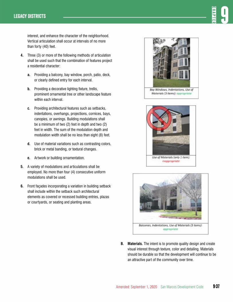
9:37
9CH
APTER
Legacy Districts
Amended: September 1, 2020 San Marcos Development Code
interest, and enhance the character of the neighborhood. Vertical articulation shall occur at intervals of no more than forty (40) feet.
4. Three (3) or more of the following methods of articulation shall be used such that the combination of features project a residential character:
a. Providing a balcony, bay window, porch, patio, deck, or clearly defined entry for each interval.
b. Providing a decorative lighting fixture, trellis, prominent ornamental tree or other landscape feature within each interval.
c. Providing architectural features such as setbacks, indentations, overhangs, projections, cornices, bays, canopies, or awnings. Building modulations shall be a minimum of two (2) feet in depth and two (2) feet in width. The sum of the modulation depth and modulation width shall be no less than eight (8) feet.
d. Use of material variations such as contrasting colors, brick or metal banding, or textural changes.
e. Artwork or building ornamentation.
5. A variety of modulations and articulations shall be employed. No more than four (4) consecutive uniform modulations shall be used.
6. Front façades incorporating a variation in building setback shall include within the setback such architectural elements as covered or recessed building entries, plazas or courtyards, or seating and planting areas.
B. Materials. The intent is to promote quality design and create visual interest through texture, color and detailing. Materials should be durable so that the development will continue to be an attractive part of the community over time.
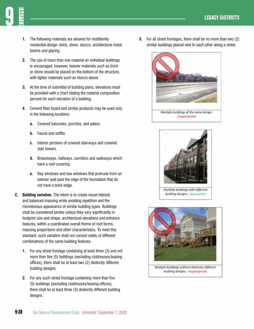
9:38
Legacy Districts9
CHAP
TER
San Marcos Development Code Amended: September 1, 2020
1. The following materials are allowed for multifamily residential design: brick, stone, stucco, architectural metal beams and glazing.
2. The use of more than one material on individual buildings is encouraged; however, heavier materials such as brick or stone should be placed on the bottom of the structure, with lighter materials such as stucco above.
3. At the time of submittal of building plans, elevations must be provided with a chart stating the material composition percent for each elevation of a building.
4. Cement fiber board and similar products may be used only in the following locations:
a. Covered balconies, porches, and patios.
b. Fascia and soffits.
c. Interior portions of covered stairways and covered stair towers.
d. Breezeways, hallways, corridors and walkways which have a roof covering.
e. Bay windows and box windows that protrude from an exterior wall past the edge of the foundation that do not have a brick ledge.
C. Building variation. The intent is to create visual interest and balanced massing while avoiding repetition and the monotonous appearance of similar building types. Buildings shall be considered similar unless they vary significantly in footprint size and shape, architectural elevations and entrance features, within a coordinated overall theme of roof forms, massing proportions and other characteristics. To meet this standard, such variation shall not consist solely of different combinations of the same building features.
1. For any street frontage containing at least three (3) and not more than five (5) buildings (excluding clubhouses/leasing offices), there shall be at least two (2) distinctly different building designs.
2. For any such street frontage containing more than five (5) buildings (excluding clubhouses/leasing offices), there shall be at least three (3) distinctly different building designs.
3. For all street frontages, there shall be no more than two (2) similar buildings placed next to each other along a street.
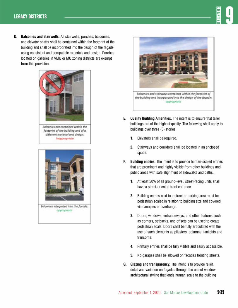
9:39
9CH
APTER
Legacy Districts
Amended: September 1, 2020 San Marcos Development Code
D. Balconies and stairwells. All stairwells, porches, balconies, and elevator shafts shall be contained within the footprint of the building and shall be incorporated into the design of the façade using consistent and compatible materials and design. Porches located on galleries in VMU or MU zoning districts are exempt from this provision.
E. Quality Building Amenities. The intent is to ensure that taller buildings are of the highest quality. The following shall apply to buildings over three (3) stories.
1. Elevators shall be required.
2. Stairways and corridors shall be located in an enclosed space.
F. Building entries. The intent is to provide human-scaled entries that are prominent and highly visible from other buildings and public areas with safe alignment of sidewalks and paths.
1. At least 50% of all ground-level, street-facing units shall have a street-oriented front entrance.
2. Building entries next to a street or parking area must be pedestrian scaled in relation to building size and covered via canopies or overhangs.
3. Doors, windows, entranceways, and other features such as corners, setbacks, and offsets can be used to create pedestrian scale. Doors shall be fully articulated with the use of such elements as pilasters, columns, fanlights and transoms.
4. Primary entries shall be fully visible and easily accessible.
5. No garages shall be allowed on facades fronting streets.
G. Glazing and transparency. The intent is to provide relief, detail and variation on façades through the use of window architectural styling that lends human scale to the building
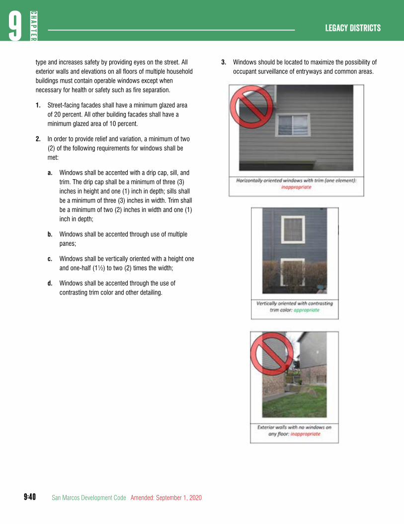
9:40
Legacy Districts9
CHAP
TER
San Marcos Development Code Amended: September 1, 2020
type and increases safety by providing eyes on the street. All exterior walls and elevations on all floors of multiple household buildings must contain operable windows except when necessary for health or safety such as fire separation.
1. Street-facing facades shall have a minimum glazed area of 20 percent. All other building facades shall have a minimum glazed area of 10 percent.
2. In order to provide relief and variation, a minimum of two (2) of the following requirements for windows shall be met:
a. Windows shall be accented with a drip cap, sill, and trim. The drip cap shall be a minimum of three (3) inches in height and one (1) inch in depth; sills shall be a minimum of three (3) inches in width. Trim shall be a minimum of two (2) inches in width and one (1) inch in depth;
b. Windows shall be accented through use of multiple panes;
c. Windows shall be vertically oriented with a height one and one-half (1½) to two (2) times the width;
d. Windows shall be accented through the use of contrasting trim color and other detailing.
3. Windows should be located to maximize the possibility of occupant surveillance of entryways and common areas.


