Runoff geochemical evolution of the hypersaline Lower Jordan Valley basin
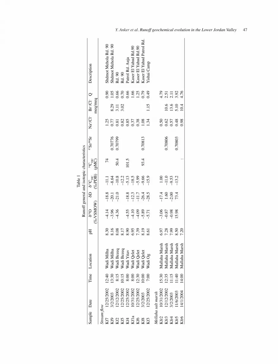
Yaakov Anker,a,b Eliahu Rosenthal,a Haim Shulman,a and Akiva Flexera aDepartment of Geophysics and Planetary Sciences, Tel Aviv University, Tel Aviv 69978, Israel
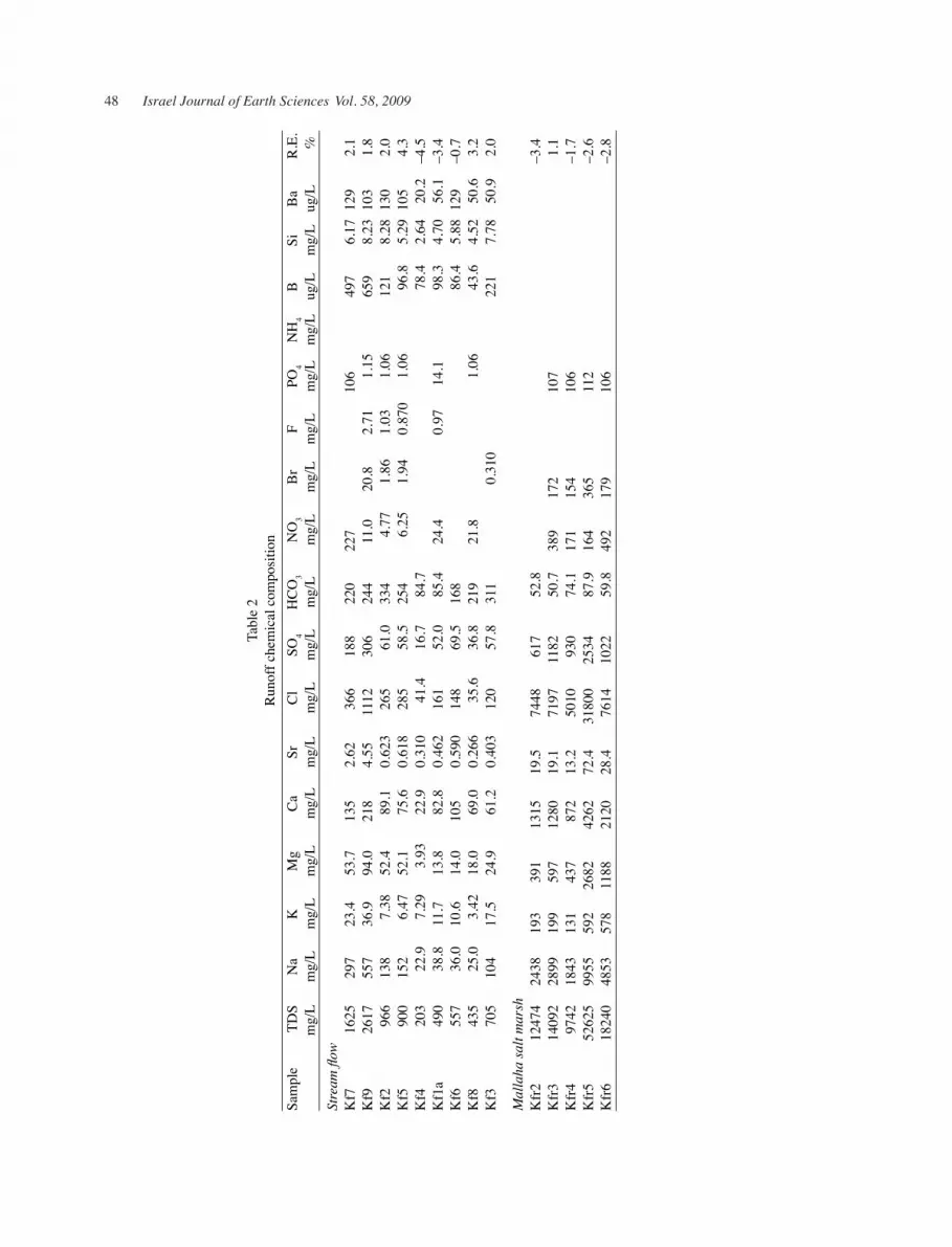
bSamaria and the Jordan Rift Regional R&D Center, Ariel University Center of Samaria, Ariel 40700, Israel
(Received 17 May 2009; accepted in revised form 27 September 2009)
AbStRAct
Anker, Y., Rosenthal, E., Shulman, H., and Flexer, A. 2009. Runoff geochemical evolution of the hypersaline Lower Jordan Valley basin. Isr. J. Earth Sci. 58: 41–61.
Geochemical modeling of a small hypersaline watershed was done based on runoff geochemical evolution study. After validation, this model may represent the regional-system. The study investigated the Lower Jordan River Valley, which is a part of the Dead Sea Rift. Runoff is generated by precipitation along mountain rims (>1000 m above the valley) and by rains within the valley. The drainage pattern is mainly from the highlands that delineate the region of study on the east and west, to the Jordan River–Dead Sea system, and through it south to the Dead Sea. Along the valley several intermediate basins were found, the most pronounced being the Mallaha salt marsh system. This local depression probably evolved through halokinetic geomor-phlogy, which is noticed also by geochemical aspects. Runoff Total Dissolved Salts (TDS) increases relative to that of rainwater by up to two orders of magnitude. This is mainly due to dissolution of salts from soil crusts. The saline runoff is usually of the Na+-chloride type with a Na+/Cl– ratio that is slightly lower than the oceanic value. Cl–/Br– ratios are lower than those expected from halite dissolution indicating that sa-linity increase might involve a repetitive dissolution of soluble salts other than halite. Runoff δ18O vs. δD values are scattered along a local evaporation line, which was calculated for rainwater that was sampled in the Lower Jordan Valley (LJV). It seems that the extremely saline nature of the sediments within the valley causes increase in salinity of fresh runoff and also of groundwater. These processes salinize a significant volume of fresh water that otherwise could have been used for various purposes.
1. INtRODUctION
The deterioration of water resources due to long peri-ods of shortage in sustainable water supply is a major problem in many arid and semiarid areas around the world. Characterized by average evaporation which is higher than precipitation, these areas manifest negative water balances. This condition causes accumulation of salts both in soils and in the unsaturated zone and their dissolution is a major reason for freshwater deteriora-
tion. Many researchers studied this issue, which occurs in arid and semi-arid regions all over the globe (Arad and Evans, 1987; Cartwright and Weaver, 2005; He et al., 2008; and many others). An essential part of such studies is the quantitative and geochemical evaluation of runoff and recharge potential.
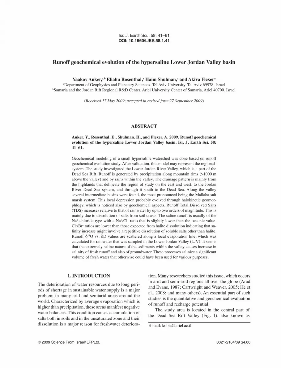
The study area is located in the central part of the Dead Sea Rift Valley (Fig. 1), also known as
42 Israel Journal of Earth Sciences Vol. 58, 2009
the Lower Jordan River Valley (Shattner, 1962). The drainage basin extends over an area of about 2000 km2 between Lake Kinneret and the Dead Sea. The Dead Sea basin is filled with clastic and lacustrine sediments, which accumulated since the Miocene (Garfunkel and Ben-Avraham, 1996) and are part of a regional aquifer complex. The distinctive geochemical character of the water in the Lower Jordan Valley (LJV) aquifer complex is probably the result of several geochemical processes. Begin et al. (1974) and Bein (1999) suggested mixing of fresh water with residual brines from the ancient Dead Sea and the Pleistocene Lisan Lake. Other options may be dissolution of soluble evaporate layers in the Dead Sea Group (Fig. 2) and runoff percolation through the salt-rich unsaturated zone (Anker et al., 2008). The study of hypersaline terrains, although developed around lagoonar (Kjerfve et al., 1996) and estuarine (Largier et al., 1997) environments, is very relevant for the LJV owing to several marine transgressions into the valley. The process described at the Nueces, Texas, hypersaline salt marshes and watershed (Alexander and Dunton, 2002) may also represent aspects within the study area.
Another observation was that fresh runoff infiltrating into the aquifer is leaching salts that were previously deposited in soil crusts, due to terminal evaporation of runoff on surface or through dispersion in the unsaturated zone (Yechieli et al., 1992; Anker, 2003). In order to differentiate between geochemical processes that operate above the surface, within the aquifer, and in between, the term “runin” was adopted for runoff after infiltration and before groundwater recharge. This term refers to transmission losses, which may be significant around arid regions, but also and primarily to the geochemical processes which occur at this stage. Nevertheless, as evaporation potential is higher than the amount of winter precipitations and as the impermeable Lisan Formation covers most of the area, runoff recharge to the LJV aquifer complex is probably negligible. Nonetheless, extreme TDS and bicarbonate alkalinity of runoff, and probably also of runin, turns this negligible recharge into a significant contributor of salts.
In addition to salts leaching from arid soils, soil crusts, and from small amount of agricultural residues, salts are also derived from evaporative bodies within the sequence of the Lisan and Samra formations, as is proposed in the subsurface of the Mallaha basin (Flexer et al., 2004) (Fig. 2). While groundwater salinization along the Dead Sea Rift is caused mainly by ancient
thermal, pressurized Ca-chloride brines (Starinsky, 1974; Rosenthal, 1988; Vengosh and Rosenthal, 1994; Guttman, 1997, 2000) or from ablation of evaporates (Flexer et al., 2000; Möller et al., 2006), highly saline runin may also be significant (Anker et al., 2008).
The climate in the northern part of the study area is semiarid with precipitation of about 200 mm/yr whereas, in the south it is arid with less than 100 mm/yr. Typical precipitation generated by extra-tropical cyclones with showers and cold fronts, reaches the region mainly during the winter months and less so during the transition seasons (Goldreich, 1994), with occasional annual snow-fall on the adjacent mountain ridges. Runoff is by occasional floods that are relatively common during winter season, from the mountain ranges bounding the basin to the east and west, and by tributaries that flow through the Jordan River and Valley to the Dead Sea.
The Jordan River has a continuous baseflow replenished from the Yarmouk River (Fig. 1), from the drainage of the Beit-Shean–Harod basin, and by small amounts of Lake Kinneret water during very rainy winters (Kronfeld and Stiller, 1997). Farber et al. (2004) concluded that water quality of the Jordan River deteriorated due to input from the diverted saline Kinneret springs, inflow of wastewater, and by discharge of shallow saline groundwater. Mass balance calculations indicate that groundwater contribution to the Jordan River base-flow is high near Lake Kinneret (20–50% of the river flow) whereas to the south, it is relatively low (10%). The southern Jordan River is much more saline in comparison to its northern part due to considerable contribution of up-flowing brine and to input of soluble salts from the hosting strata (Farber et al., 2007).
Soil types are dictated by lithological substrates, relief, and exposure (Zaidenberg and Dan, 1981). Over the adjacent western mountain slopes (both of Samaria and Jordan) limestone outcrops and brown to yellowish-brownish terra rosa soils have developed, whereas over the mountain rim and chalk outcrops, brown rendzina soils may be found. Over the eastern slopes, along the highland, brown lithosols developed, turning to yellow-orange lithosols at lower relief and dryer conditions, whereas, over marl outcrops saline marly lithosol was developed and, above the chalk, a rendzinic desert lithosol. Near the valley floor saline calcareous desert lithosols are common, inter-fingering with calcareous desert alluvial and lacustrine derivative soils within the valley plains (Zaidenberg and Dan, 1981). In the mountain slopes
Y. Anker et al. Runoff geochemical evolution in the Lower Jordan Valley 43
Fig. 1. Location map with inset (Atallah et al., 2002) showing the present plate configuration and aerial photo map (after Survey of Israel, 1997; Hall, 2000) with location of rain samplers and drainage basins monitored.
44 Israel Journal of Earth Sciences Vol. 58, 2009
of the eastern LJV, Cambisols, Vertisols, Leptosols, and Calcisols are found over the sedimentry outcrops, while sandy soils and sand dunes are developed out of weathering of crystalline and sandstone outcrops, which are almost absent on the western side of the valley. (Werz et al., 2006).
Several vegetation belts may be defined in correlation with relief: terrains above 400 m ASL are considered Mediterranean, whereas the slopes are Irno–Turanian above 300 m ASL, Saharo–Arabian above 200 m ASL ,and Sudanian–Enclave above 150 m ASL (Zaidenberg and Dan, 1981). The slopes are dominated by Querqus calliprinos–
Pistacia lenticus shrubland accompanied by other Mediterranean sclerophyll phanerophytes and chamaephytes such as Sarcopoterium spinosum, Cistus salvifolius, C. incanus, and Calycotome villosa. The transition area is characterized by S. spinosum–Phlomis brachyodon dwarf shrubland and Poa bulbosa. The valley itself is considered phytogeographic and as the region becomes more arid, Aegilops kotschyi, Eryngium creticum, and Echinops polyceras are more common. Annual species such as Mathiola aspera and Aaronsonia faktorovsky prevail in the valley, while the dwarf shrub Astragalus spinosus is common at the edges of exposed limestone
Fig. 2. Geological cross section (after Anker, 2007) based on seismic interpretation showing a possible subsurface accumula-tion of evaporated minerals.
Y. Anker et al. Runoff geochemical evolution in the Lower Jordan Valley 45
patches. Along the southern, most arid part of the study area the dominant ones are Plantago ovata and Salsola tetrandra (Zaidenberg and Dan, 1981; Davies and Fall, 2001; Pariente, 2005). In addition, soil cultivation is developed on the basis of water supply as the limiting factor, characterized by specific types of fruits, vegetables, and flowers. Several crops, such as a few species of dates, Galia melons, a few species of tomatoes, seedless watermelons, Muscat seedless table grapes, and others, were developed especially for the region (Karchi, 2006).
Along the northern border of the Dead Sea basin (Lazar, 2004) on both sides of the Jordan River, local topographic lows covered by salt marshes, and the wadis drained to these marshes, are named Mallaha (meaning—both in Arabic and in Hebrew—“saline”). East of the river, this area (Ghor el Katar, Fig. 1) is replenished from the A-Salt basin (Fig. 1) and, since 1995, runoff has been diverted to the Karama Dam system (runoff storage capacity of ~55 Mm³).While the reservoir is not exploited to its full capacity, it is used mainly as operational storage for the surrounding agricultural areas, even though it suffers from a severe salinization problem (Salameh, 2004). In the west, Wadi Mallaha drains Wadi Auja and Wadi Fasayil (Fig. 1); whereas between them operational reservoirs were built (the Tirza reservoirs) at the outlet of Wadi Fasayil. Here also, the runoff exploitation is just partly successful; nevertheless, these reservoirs were planned mainly as buffer storage for sewage and agriculture use. Moreover, since the operational reservoirs are lined with polycarbonate sheets, there is supposedly no contact with the surrounding Lisan marls. Surface water flow from these marshes to the Jordan River is rather rare and occurs only during years with precipitation exceeding the annual average.
2. SAMPLING AND EXPERIMENtAL MEtHODS
Chemical characterization of rainwater, runoff, and sediments required sequential sampling along the LJV. Runoff sampling was done as near as possible to the Jordan River and since the highest salinities were obtained in the salts marshes, samples from the Mal-laha marsh were taken as representative for runoff at its final stages before transition to the runin stage and recharge.
The hydrogeological system components were: precipitation, runoff, and soil crusts; and since surface recharge in semi-deserts and deserts might have
rather long residence time-span between the moment of infiltration to the time of groundwater recharge, the term runin was defined to represent this part of the hydrogeological cycle (Anker, 2007). Quality assessment of all chemical analyses disqualified several results from the database; and aturation indices of minerals such as calcite, aragonite, dolomite, gypsum, anhydrite, halite, and different phases of silica were calculated for all liquid solutions by using the PHREEQC software (Parkhurst and Appelo, 1999).
2.1. Solutions sampling and analysis
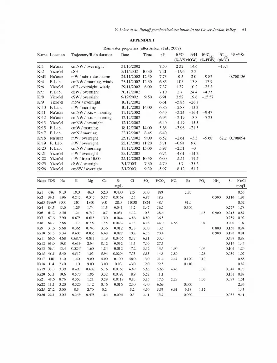
During the winters of 2002–2004 rainwater and runoff were collected along the LJV and in adjoining areas (Anker et al., 2007). Rain samplers were located in three settlements, two in the LJV itself and one ref-erence site (Yizre’el) in a more humid region in the northwestern part of the study area (Fig. 1). Rainwater samples, as well as flood-water and water from the Mallaha salt marsh were collected into 0.5 L polyeth-ylene terephthalate (PET) bottle in a way that no free air was left in the bottle. Each sample was divided among three 60 ml syringes, which were filtered on site through 0.2 micron Sartorius Minisart filters. One of the syringes, containing 1 mg of mercury chloride, was used for bicarbonate alkalinity and δ13CDIC measure-ments. The bottles were sealed and kept refrigerated until their analysis. All samples were analyzed for ma-jor ions, while several samples were also analyzed for isotopes of oxygen, hydrogen, carbon, and strontium.
The following methods and instrumentation were employed in the Geochemical Laboratories of the Hebrew University of Jerusalem, the Geological Survey of Israel in Jerusalem, and in the FZU Institute of the Karlsruhe University in Germany. Na+, K+, Mg2+, Ca2+, Sr2+, B3+, Ba2+, Si, and SO4
2– were analyzed by ICP-OES using a fully automated Perkin-Elmer Optima-3000 radial ICP system. Merck single-element ICP standards were used for the preparation of the calibration solutions and triplicate readings of each sample were measured. Calibration standards were run after every 10-sample batch, to monitor instrumental drift. Total alkalinity was measured on 10-mg samples by Gran titration (Stumm and Morgan, 1996) using 0.02 N HCl and a pH electrode. Cl–, Br–, F–, PO4
3–, and NO3– were measured by Dionex DX500
ion chromatograph. The effluent was a solution mixture of 3.5 mM Na2CO3 and 1 mM NaHCO3. All samples were measured as duplicates. After every measurement, the system was flushed with blank
46 Israel Journal of Earth Sciences Vol. 58, 2009
solution, and after every five samples, the system was recalibrated.
Strontium was separated from the solution by ion exchange (Biorad AG50X4), in a double-stage procedure of Sr2+ leaching and washing through the resin column with 2.5N hydrochloride acid. 87Sr/86Sr isotopic ratio and Sr2+ concentrations were determined by the conventional isotope-dilution technique at the Department of Isotope Geology of the Geosciences Center, Göttingen (Germany). Determinations of the Sr2+ isotopic ratios were carried out by thermal ionization mass-spectrometry on a ThermoFinnigan Triton spectrometer operating in static-mode. δ13CDIC, δ18O, and deuterium were measured with Finnigan Delta plus XL mass spectrometer (Barkan et al., 2001) at the Umweltforschungzentrum (UFZ) in Halle, Germany, and at the Hebrew University. Accelerator Mass Spectrometry (AMS) measurements of 14C activities were done at the NSF-Arizona AMS Laboratory in the University of Tucson, USA.
Results of δ18O and deuterium analysis are presented in reference to VSMOW (Vienna Standard Mean Ocean Water) (Gonfiantini, 1978), δ13CDIC results are presented in reference to PDB (Pee Dee Belemnite) standard (Gonfiantini, 1984), and 14CDIC results as pMC (Percentage Modern Carbon).
2.2. Sampling and analysis of soil crusts
Hydrological basins and other geological elements that may control hydrological parameters were defined by existing geological mapping and aerial photogra-phy. The sampling procedure included methodological sampling of soil crusts from different segments of the basin, such as wadi beds and active streams, alluvial fans, and terraces. In order to define the mineralogical composition of soil crusts, thin sections were made out of soil crust casts and mineral analysis was done by polarizing optical microscopy and, when necessary, by JEOL JXA 8600 electron probe micro analyzer (EPMA) with a Tracor Northen TN 5500/5600 EDS. The mineralogical and chemical analyses were made in the laboratories of the Hebrew University Earth Sci-ences Institute in Jerusalem.
In addition, powder XRD analyses were done with a Siemens D-500 diffractometer, using X-ray diffraction patterns with Cu–Kα radiation (λ = 0.15418 nm) at 40KV and 30 mA, of randomly oriented bulk specimens, which were collected in the 2θ range from 1° to 65° with a step size of 0.02 2θ, and a counting time of 2 s per step. After volumetric dissolution in distilled water and filtration
through Whatman 40 filters, ionic composition of the sediments was measured with Parkin Elmer 3030b AAS, standards set was run (after every triplet) for every sample. Anions were measured with Dionex DX500 ion chromatograph using the same procedure as for liquid solutions (in the laboratories of the FZU Institute of the Karlsruhe University, Germany).
3. RESULtS
Most of the results presented in Tables 1, 2, and 3 were collected during winter 2002, when the total amount of precipitation was twice as high as the annual average (Anker et al., 2007). The amount of annual precipita-tion during the following year was lower than the an-nual average, and only one major runoff event was sampled.
Rainwater was sampled at three sites (Fig. 1), the northernmost one in the semi-arid Yizre’el Valley (YV) and the other two, in the LJV Agricultural Re-search Laboratory (JVARL) and in Na’aran (Fig. 1) in an area which is considered as arid (Appendix 1).
In view of the total dissolved salts (TDS) con-centration, rainwater samples from the LJV can be generally separated into low TDS (33–84 mg/L) and high TDS (52–686 mg/L) salinity groups (Anker et al, 2007). The high salinity rainwater group is of Na-chloride type with a relative decrease in the calcium concentration (Mg2+/Ca2+ > 1, vs. Mg2+/Ca2+ < 0.5 in the low salinity group) (Table 3). High salinity rainwa-ter manifests also chloride enrichment (Fig. 3b), which is characterized by a lower than oceanic Na+/Cl– ratio, and a Br-/Cl– ratio, which is up to one order of magni-tude higher that in the low salinity rainwater (Tables 2 and 3, Fig. 4).
In The LJV rainwater δ18O values range from –3.96 to 2.7‰ at JVARL and from –3.24 to 2.52‰ at the Na’aran sampling site. At YV (Fig. 1, Appendix 1), the enriched end member is about the same (2.52‰), while the depleted one is much lower (–8,12‰). The correlation between rainwater geochemical properties with rain events duration, (at the beginning of the rainy season), revealed that there is general depletion in the isotopic values of oxygen and deuterium (Table 2). Rains in the Yizre’el Valley seem to become less saline in the course of the rainy season (Table 3). Radiocar-bon activity was measured in one rainwater sample (Appendix 1), demonstrating a relatively low value (82.2 pMC) when compared with runoff and with the atmospheric value. The average δ13C value of YV is –18.9‰ vs. –10.26‰ in the LJV.
Y. Anker et al. Runoff geochemical evolution in the Lower Jordan Valley 47
Tabl
e 1
Run
off g
ener
al a
nd is
otop
ic c
hara
cter
istic
s Sa
mpl
e D
ate
Tim
e Lo
catio
n pH
δ18
O
δD
δ13C
DIC
14
CD
IC
87Sr
/86Sr
N
a+ /Cl–
Br– /C
l– Q
D
escr
iptio
n
(‰V
SMO
W)
(‰
PDB
) (p
MC
)
m
eq/m
eq
St
ream
flow
K
f7
12/2
5/20
02
12:4
0 W
adi M
ilha
8.30
–4
.14
–18.
8 –1
1.1
74
1.
25
0.
90
Shdm
ot M
ehol
a R
d. 9
0K
f9
3/2/
2003
13
:30
Wad
i Milh
a 8.
16
–3.9
6 –2
0.1
–8.6
4
0.70
776
0.77
8.
29
1.05
Sh
dmot
Meh
ola
Rd.
90
Kf2
12
/12/
2002
8:
15
Wad
i Bez
eq
8.08
–4
.36
–21.
0 –1
0.8
50.4
0.
7079
9 0.
81
3.11
0.
66
Rd.
90
Kf5
12
/25/
2002
10
:15
Wad
i Bez
eq
8.17
–1
2.2
0.82
3.
02
0.70
R
d. 9
0 K
f4
12/2
5/20
02
8:00
W
adi Y
itav
8.90
–4
.55
–18.
8 –5
.13
101.
5
0.85
0.66
Pa
trol R
d. A
uja
Kf1
a 10
/31/
2002
8:
00
Wad
i Qel
et
6.95
–4
.10
–12.
3 –1
8.5
0.37
1.66
K
aser
El Y
ahud
Rd.
90K
f6
12/2
5/20
02
12:3
0 W
adi Q
elet
7.
39
–4.0
9 –1
1.7
–5.9
9
0.
38
1.
25
Kas
er E
l Yah
ud R
d.90
Kf8
3/
2/20
03
10:0
0 W
adi Q
elet
8.
19
–5.8
9 -2
6.4
–9.6
6 93
.4
0.70
813
1.08
0.79
K
aser
El Y
ahud
Pat
rol R
d.K
f3
12/2
5/20
02
7:00
W
adi O
g 8.
61
–5.7
1 –2
8.5
–15.
9
1.
34
1.15
0.
49
Yis
hai C
amp
Mel
laha
salt
mar
sh
Kfr
2 10
/31/
2002
15
:30
Mal
laha
Mar
sh
6.97
–3
.06
–17.
4 1.
00
0.50
4.79
K
fr3
12/1
2/20
02
12:3
5 M
alla
ha M
arsh
7.
28
–0.8
7 1.
60
–11.
0
0.70
806
0.62
10
.6
2.51
K
fr4
3/2/
2003
11
:15
Mal
laha
Mar
sh
7.99
–0
.98
–2.0
0 –9
.53
0.57
13
.6
2.11
K
fr5
11/6
/200
3 11
:40
Mal
laha
Mar
sh
8.50
15
.98
73.4
–1
3.2
0.
7080
3 0.
48
5.10
3.
92
Kfr
6 14
/1/2
004
14:0
0 M
alla
ha M
arsh
7.
20
:
0.
98
10.4
4.
76
48 Israel Journal of Earth Sciences Vol. 58, 2009
Tabl
e 2
Run
off c
hem
ical
com
posi
tion
Sam
ple
TDS
Na
K
Mg
Ca
Sr
Cl
SO4
HC
O3
NO
3 B
r F
PO4
NH
4 B
Si
B
a R
.E.
m
g/L
mg/
L m
g/L
mg/
L m
g/L
mg/
L m
g/L
mg/
L m
g/L
mg/
L m
g/L
mg/
L m
g/L
mg/
L ug
/L
mg/
L ug
/L
%St
ream
flow
Kf7
16
25
297
23.4
53
.7
135
2.62
36
6 18
8 22
0 22
7
10
6
497
6.17
129
2.
1K
f9
2617
55
7 36
.9
94.0
21
8 4.
55
1112
30
6 24
4 11
.0
20.8
2.
71
1.15
659
8.23
103
1.
8K
f2
966
138
7.38
52
.4
89.1
0.
623
265
61.0
33
4 4.
77
1.86
1.
03
1.06
121
8.28
130
2.
0K
f5
900
152
6.47
52
.1
75.6
0.
618
285
58.5
25
4 6.
25
1.94
0.
870
1.06
96.8
5.
29 1
05
4.3
Kf4
20
3 22
.9
7.29
3.
93
22.9
0.
310
41.4
16
.7
84.7
78.4
2.
64
20.2
–4
.5K
f1a
490
38.8
11
.7
13.8
82
.8
0.46
2 16
1 52
.0
85.4
24
.4
0.
97
14.1
98.3
4.
70
56.1
–3
.4K
f6
557
36.0
10
.6
14.0
10
5 0.
590
148
69.5
16
8
86.4
5.
88 1
29
–0.7
Kf8
43
5 25
.0
3.42
18
.0
69.0
0.
266
35.6
36
.8
219
21.8
1.
06
43
.6
4.52
50
.6
3.2
Kf3
70
5 10
4 17
.5
24.9
61
.2
0.40
3 12
0 57
.8
311
0.
310
22
1 7.
78
50.9
2.
0
Mal
laha
salt
mar
sh
K
fr2
1247
4 24
38
193
391
1315
19
.5
7448
61
7 52
.8
–3.4
Kfr
3 14
092
2899
19
9 59
7 12
80
19.1
71
97
1182
50
.7
389
172
10
7
1.
1K
fr4
9742
18
43
131
437
872
13.2
50
10
930
74.1
17
1 15
4
106
–1.7
Kfr
5 52
625
9955
59
2 26
82
4262
72
.4
3180
0 25
34
87.9
16
4 36
5
112
–2.6
Kfr
6 18
240
4853
57
8 11
88
2120
28
.4
7614
10
22
59.8
49
2 17
9
106
–2.8
Y. Anker et al. Runoff geochemical evolution in the Lower Jordan Valley 49
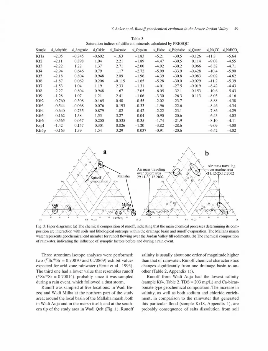
Table 3Saturation indices of different minerals calculated by PREEQC
Three strontium isotope analyses were performed: two (87Sr/86Sr = 0.70870 and 0.70869) exhibit values expected for arid zone rainwater (Herut et al., 1993). The third one had a lower value that resembles runoff (87Sr/86Sr = 0.70814), probably since it was sampled during a rain event, which followed a dust storm,
Runoff was sampled at five locations: in Wadi Be-zeq and Wadi Milha at the northern part of the study area; around the local basin of the Mallaha marsh, both in Wadi Auja and in the marsh itself; and at the south-ern tip of the study area in Wadi Qelt (Fig. 1). Runoff
salinity is usually about one order of magnitude higher than that of rainwater. Runoff chemical characteristics changes significantly from one drainage basin to an-other (Table 2, Appendix 1)).
Runoff from Wadi Auja had the lowest salinity (sample Kf4, Table 2, TDS = 203 mg/L) and Ca-bicar-bonate type geochemical composition. The increase in salinity, as well as both sodium and chloride enrich-ment, in comparison to the rainwater that generated this particular flood (sample Kr18, Appendix 1), are probably consequence of salts dissolution from soil
Fig. 3. Piper diagrams: (a) The chemical composition of runoff, indicating that the main chemical processes determining its com-position are interaction with soils and lithological outcrops within the drainage basin and runoff evaporation. The Mallaha marsh water represents geochemical end member for runoff flowing over the Jordan Valley fill sediments. (b) The chemical composition of rainwater, indicating the influence of synoptic factors before and during a rain event.
50 Israel Journal of Earth Sciences Vol. 58, 2009
crusts. δ18O and δD values (–4.55‰ and –18.8‰ respectively) are depleted in comparison to the rain that was sampled earlier that day at Na’aran (–2.61‰ and –3.3‰ respectively), which is located upstream and above Wadi Auja (Table 1, Fig. 1). Wadi Qelt is the only stream with springs and sewage-generated base flow. In order to suppress this contribution, it was sampled when rainfall-recharged river flow was higher by one order of magnitude or more than its base-flow; these results were compared with the base flow chemical properties. The chemical composition of flood water in Wadi Qelt is characterized by calcium as the main cation, and chloride, which is replaced by bicarbonate during the rainy season, as the main anion (Table 2, Fig. 3a).
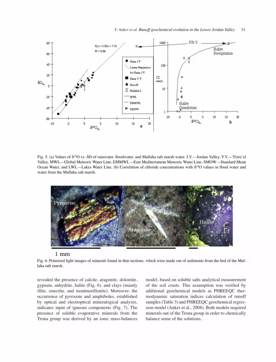
Oxygen and hydrogen isotope enrichment by evaporation is evidenced from the runoff samples distribution along the local evaporation line (Fig. 5a) and from a positive trend in correlation with chlo-ride concentrations (Fig. 5b). Wadi Milha and Wadi Bezeq, both located in the northern part of the study area (Fig. 1), carried the most saline flood water (900 and 966 mg/L in Wadi Bezeq, and 1625 and 2617 in
Wadi Milha). In both cases, sodium and chloride were prevalent; nevertheless, Cl–/Br– ratios (Table 2, Fig. 4) of about 300 in Wadi Bezeq and about 120 in Wadi Milha may indicate that these extremely high salinities are not due to dissolution of halite (Cartwright et al., 2006), but rather the result of other soluble salts dis-solution (mostly Na-bicarbonate). In Wadi Bezeq the concentration of bicarbonate is similar to that of Wadi Milha but TDS is lower, and both bicarbonate and chloride are the major anions.
The northern streams differ from those in the south also by their radiocarbon activities. While Wadi Qelt and Wadi Auja show high values (93 and 101 pMC, respectively), the samples from Wadi Bezeq and Wadi Milha had low activities (50 and 72 pMC, respec-tively).
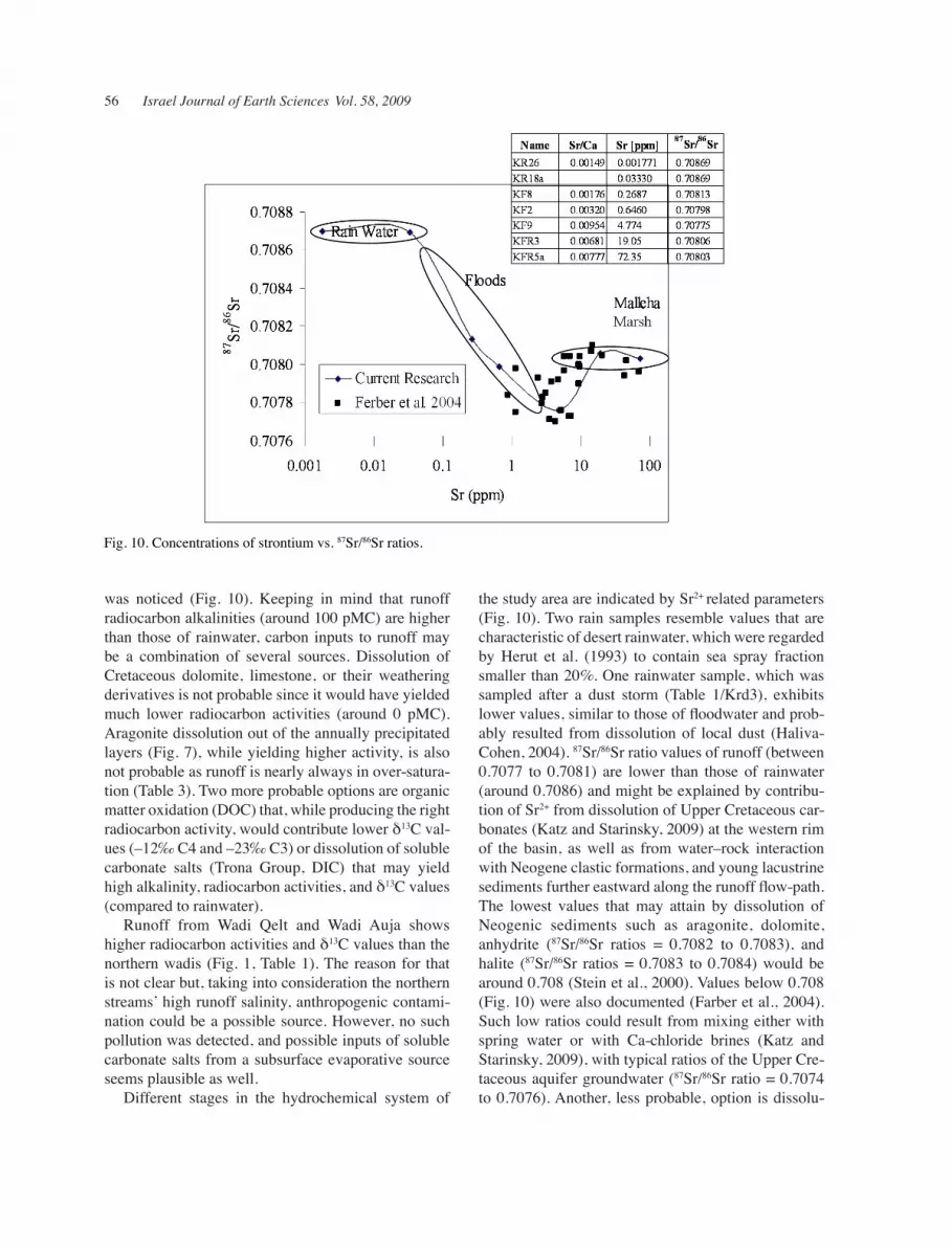
Three strontium isotope analyses were done: at Wadi Qelt (0.70813), at Wadi Bezeq (0.70799), and at Wadi Milha (0.70776). Two samples from the Mallaha marsh had values of 0.70806 and 0.70803.
The mineralogical composition of soil crusts from all parts of the study area and from the Mallaha saline marsh, which were studied through XRD analyses,
Fig. 4. Diagram showing Na+/Cl– vs. Cl–/Br– ratios (meq/meq) of rainwater floodwater and water of the Mallaha salt marsh (Kfr#) the line connecting the points of the salt marsh follows their geochemical path until almost total evaporation of the marsh (KFr6).
Y. Anker et al. Runoff geochemical evolution in the Lower Jordan Valley 51
Fig. 5. (a) Values of δ18O vs. δD of rainwater, floodwater, and Mallaha salt marsh water. J.V.—Jordan Valley, Y.V.—Yizre’el Valley, MWL—Global Meteoric Water Line, EMMWL—East Mediterranean Meteoric Water Line, SMOW—Standard Mean Ocean Water, and LWL—Lakes Water Line. (b) Correlation of chloride concentrations with δ18O values in flood water and water from the Mallaha salt marsh.
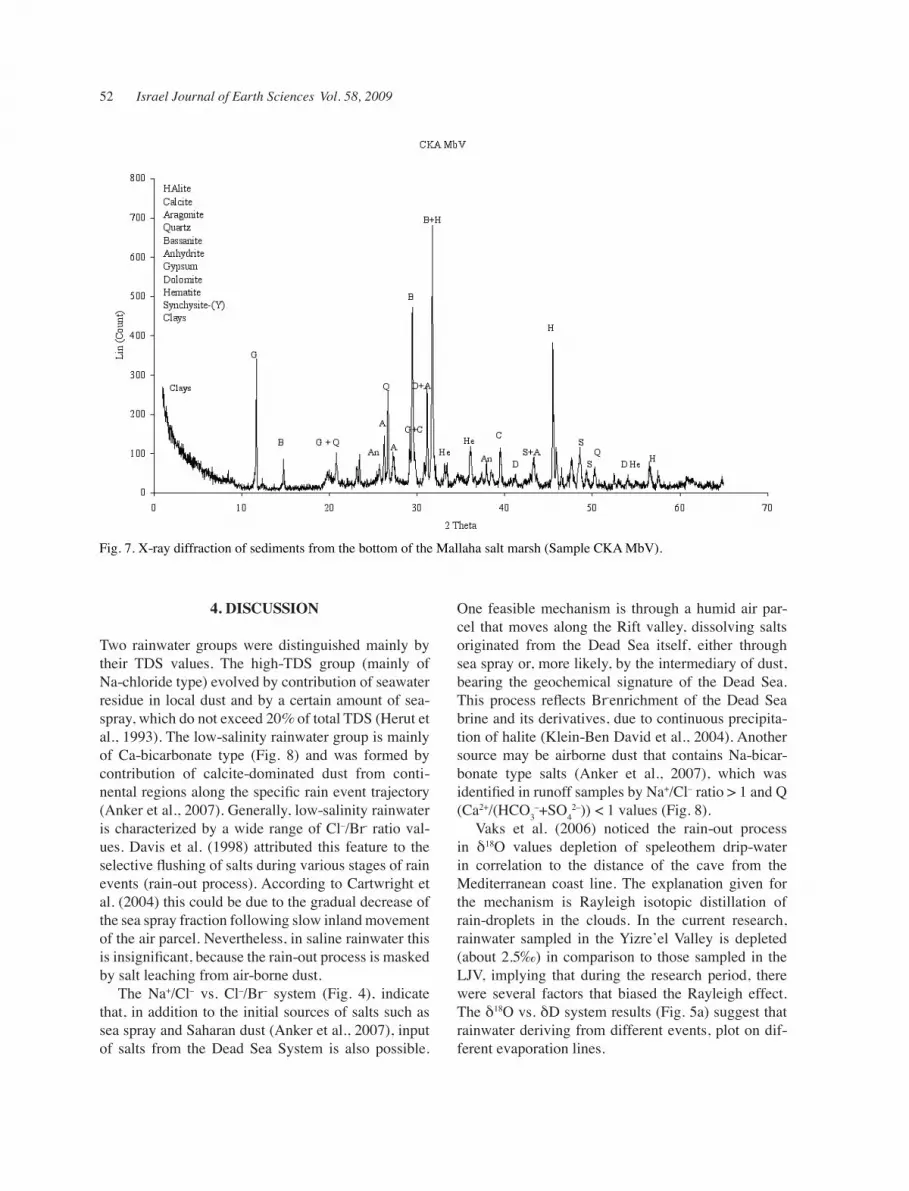
revealed the presence of calcite, aragonite, dolomite, gypsum, anhydrite, halite (Fig. 6), and clays (mainly illite, smectite, and montmorillonite). Moreover, the occurrence of pyroxene and amphiboles, established by optical and electroptical mineralogical analyses, indicates input of igneous components (Fig. 7). The presence of soluble evaporative minerals from the Trona group was derived by an ionic mass-balances
model, based on soluble salts analytical measurement of the soil crusts. This assumption was verified by additional geochemical models as PHREEQC ther-modynamic saturation indices calculation of runoff samples (Table 3) and PHREEQC geochemical regres-sion model (Anker et al., 2008). Both models required minerals out of the Trona group in order to chemically balance some of the solutions.
Fig. 6. Polarized light images of minerals found in thin sections, which were made out of sediments from the bed of the Mal-laha salt marsh.
52 Israel Journal of Earth Sciences Vol. 58, 2009
4. DIScUSSION
Two rainwater groups were distinguished mainly by their TDS values. The high-TDS group (mainly of Na-chloride type) evolved by contribution of seawater residue in local dust and by a certain amount of sea-spray, which do not exceed 20% of total TDS (Herut et al., 1993). The low-salinity rainwater group is mainly of Ca-bicarbonate type (Fig. 8) and was formed by contribution of calcite-dominated dust from conti-nental regions along the specific rain event trajectory (Anker et al., 2007). Generally, low-salinity rainwater is characterized by a wide range of Cl–/Br- ratio val-ues. Davis et al. (1998) attributed this feature to the selective flushing of salts during various stages of rain events (rain-out process). According to Cartwright et al. (2004) this could be due to the gradual decrease of the sea spray fraction following slow inland movement of the air parcel. Nevertheless, in saline rainwater this is insignificant, because the rain-out process is masked by salt leaching from air-borne dust.
The Na+/Cl– vs. Cl–/Br– system (Fig. 4), indicate that, in addition to the initial sources of salts such as sea spray and Saharan dust (Anker et al., 2007), input of salts from the Dead Sea System is also possible.
One feasible mechanism is through a humid air par-cel that moves along the Rift valley, dissolving salts originated from the Dead Sea itself, either through sea spray or, more likely, by the intermediary of dust, bearing the geochemical signature of the Dead Sea. This process reflects Br-enrichment of the Dead Sea brine and its derivatives, due to continuous precipita-tion of halite (Klein-Ben David et al., 2004). Another source may be airborne dust that contains Na-bicar-bonate type salts (Anker et al., 2007), which was identified in runoff samples by Na+/Cl– ratio > 1 and Q (Ca2+/(HCO3
–+SO42–)) < 1 values (Fig. 8).
Vaks et al. (2006) noticed the rain-out process in δ18O values depletion of speleothem drip-water in correlation to the distance of the cave from the Mediterranean coast line. The explanation given for the mechanism is Rayleigh isotopic distillation of rain-droplets in the clouds. In the current research, rainwater sampled in the Yizre’el Valley is depleted (about 2.5‰) in comparison to those sampled in the LJV, implying that during the research period, there were several factors that biased the Rayleigh effect. The δ18O vs. δD system results (Fig. 5a) suggest that rainwater deriving from different events, plot on dif-ferent evaporation lines.
Fig. 7. X-ray diffraction of sediments from the bottom of the Mallaha salt marsh (Sample CKA MbV).
Y. Anker et al. Runoff geochemical evolution in the Lower Jordan Valley 53
Regional review of stable isotopes in rainwater indicates that LJV rainwater is enriched in its oxygen and hydrogen parameters in comparison to Yizre’el Valley rainwater and rainwater from the coastal plain (Herut et al., 2000). Rainwater data is scattered along the Global (Atlantic humidity origin) and Mediter-ranean water lines and on a local water evaporation line (Fig. 5a). This enrichment was regarded by Gat et al. (2000) as typical for arid zones and is probably a result of isotopic fractionation due to rain-drop evapo-ration within the rain event. This process occurs due to high temperatures (>10 °C) and low humidity (<70%) during the rain event, causing a positive evaporation potential. Furthermore, in addition to being warmer and dryer than its adjacent highland boundaries, the LJV has an average topographical difference of about 1400 m (between 800 to 1200 m ASL, at the highlands, to about 400 m BSL at the Jordan Valley floor), which causes a difference of barometric pressure of about 150 mbar. The altitude effect (Clark and Fritz, 1997) suppresses the transfer mobility of the H2
16O molecule from gas to the aqueous phase, whereas H2
18O increas-es the above mentioned enrichment.
The δ18O vs. δD plot (Fig. 5a) shows that rainwater samples spread along the EMMWL, the MWL, and a local lake evaporation line (LWL), dependent upon the rain event trajectory path (Anker et al., 2007). An evaporation line for local lakes was calculated for rain sampled along the LJV (Fig. 5a), which, when normal-ized as meteoric evaporation water line, resembles the local meteoric water line (LMWL) which was calcu-lated by Gat and Dansgaard (1972) for rain sampled at Degania (Fig. 1). Examination of the divergence from the calculated (Fig. 5a) LMWL (R2 = 0.889), indicates that rains and runoff in the Jordan Valley are part of a local hydrogeological system. Moreover, rainwater sampled during the winter of 2004–2005 (Vaks et al., 2006) generally exhibits the same trend (LMWL), for rain events smaller than 10 mm and for larger events of tropical origin sampled at Be’er-Sheva and Arad. Be’er Sheva and Arad (Fig. 1) are located in a semi-arid zone with annual precipitation ranging between 100 and 200 mm. While Arad is considered to be at the margins of the Dead Sea Rift, Be’er Sheva is located in the northern Negev Desert. Rainwater from the vicinity of Jerusalem and Peqi’in (Bar-Matthews et
Fig. 8. Diagram showing Na+/Cl– vs. Q (Ca2+/(HCO3+SO4)) ratios (meq/meq)of rainwater floodwater and water of the Mallaha salt marsh.
54 Israel Journal of Earth Sciences Vol. 58, 2009
al., 2003) is aligned only along the EMMWL and the MWL. Ayalon et al. (1997) indicated that rain events of less than 2 mm from the Jerusalem area also tend to align along the LMWL. The Jerusalem and Peqi’in regions are considered semihumid, with precipitation of 500–600 mm in Jerusalem and 600–700 mm at Peqi’in. It seems that while the local hydrogeological system of the Jordan Valley as originally defined by isotopes (Gat and Dansgaard, 1972) is also valid for other semi-arid regions, it is not valid for the adjacent semihumid regions, with the exception of very small rain events probably related to high evaporation poten-tials (Ayalon et al., 1997).
Comparison of large runoff-generating rain events and smaller, more evaporated events reveals that run-off is generally depleted in δ18O and δD relatively to average rainwater. Hence, an entire rain event includes the preliminary enriched stages, which have a heavier load of salinity (typical of small scale rain events) ,and also the latter (both chemically and isotropically) depleted stages (Gat, 1995), which are practically ab-sent in small rain events. In addition, when comparing runoff δ18O values to those mentioned by Vaks et al. (2006) for speleothems, it correlates better than for the average rainwater. Nevertheless, runoff in general and runoff draining to the Mallaha marsh in particular exhibits a positive trend with chloride concentration (Fig. 5b), which points to enrichment as consequence of evaporation.
In several local low intensity rain events, rainwater sampled at Na’aran exhibited enrichment concurrent to increase in Cl– concentration, which may indicate evaporation during the rain events (Appendix 1). Fur-thermore, water of Wadi Auja and YV rainwater from the same date show geochemical resemblance, which may point to a common origin for these particular rain events (Anker et al., 2007).
Runoff chemical characteristics are distinctive for each drainage basin while, in all, salinity is higher than that of rainwater by one order of magnitude or more (Table 2). This increase in salinity is probably a consequence of salts dissolution rather than runoff evaporation and evapotranspiration. This is supported by δ18O vs. δD isotopic ratios, as rainwater that is less saline than runoff has generally more enriched δ18O and δD values (Fig. 5a), and significant δ18O enrich-ment was only found close to the final evaporation of the Mallaha salt marsh (Fig. 5b). This trend was per-sistent throughout the rainy season, when during most of it through increase in chloride concentration (up to about 8000 mg/L, Table 2), δ18O values remained
negative, and only above a certain threshold (dur-ing spring) was significant enrichment in δ18O noted (Fig. 5b). The mineralogical variability of soil crusts in arid zones (Fig. 6) is reflected by heterogeneity in runoff geochemistry (Fig 4), as JV runoff is mostly of Na-chloride type but Ca-chloride and Na-bicarbonate types are also common (Fig. 4).
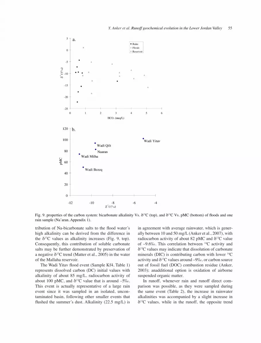
Investigation of the carbonate system elucidates the geochemical process by which rainwater becomes runoff. Three carbonate sinks were sampled: rainwa-ter, flood water, and water from the Mallaha marsh, which was sampled periodically. Similar marshes exist also east of the Jordan River (but fewer since 1995, the time of the Karama reservoir construction). This complex hydrogeological setting is composed of a semi-terminal basin that is seasonally replenished. Every few years — whenever the precipitation is about twice the annual average (as in the winter of 2002) — it spills over into the Jordan River. The interpreta-tion of seismic lines (Fig. 2) revealed that this local structural low is the result of halokinetic processes of an elongated subsurface body of evaporates (Flexer et al., 2004). Similar scenarios of salt bodies emerg-ing from the subsurface (due to differential overload of sediments with higher specific gravities located above the sedimentary evaporative sequence) were described in several locations along the Dead Sea Rift. Zak (1967) described the Mount Sedom system south of the study area while Belitzky and Mimran (1996) investigated active salt diapirism at the Zahrat El-Qurein dome on the eastern side of the LJV. In both locations local drainage basins were developed due to diapirism of the evaporative sequence, causing rapid dissolution of the soluble evaporative layers by runoff. Semi-closed basins, such as the Mallaha area, seem to have a cycle of salt dissolution and precipitation from the layers of evaporates and into the annually lami-nated sediments.
Runoff alkalinity is higher than expected from the dissolution of calcite or aragonite (Anker, 2003), since while rainwater saturation indices are always under-saturated in respect to Ca-carbonate minerals, floodwater are always oversaturated. Hence, this high alkalinity cannot be attributed to dissolution of dolo-mite, calcite, or aragonite, even when considering in-crease in CO2 due to floodwater turbulence (Table 3). This over-saturation may indicate that in many cases great portion of TDS and bicarbonate alkalinity are due to dissolution of soluble Na-bicarbonate salts, which may accumulate in arid zone soil crusts (Fig. 8) and the unsaturated zone (Anker et al., 2008). Con-
Y. Anker et al. Runoff geochemical evolution in the Lower Jordan Valley 55
tribution of Na-bicarbonate salts to the flood water’s high alkalinity can be derived from the difference in the δ13C values as alkalinity increases (Fig. 9, top). Consequently, this contribution of soluble carbonate salts may be further demonstrated by preservation of a negative δ13C trend (Matter et al., 2005) in the water of the Mallaha reservoir.
The Wadi Yitav flood event (Sample Kf4, Table 1) represents dissolved carbon (DC) initial values with alkalinity of about 85 mg/L, radiocarbon activity of about 100 pMC, and δ13C value that is around –5‰. This event is actually representative of a large rain event since it was sampled in an isolated, uncon-taminated basin, following other smaller events that flushed the summer’s dust. Alkalinity (22.5 mg/L) is
in agreement with average rainwater, which is gener-ally between 10 and 50 mg/L (Anker et al., 2007), with radiocarbon activity of about 82 pMC and δ13C value of –9.6‰. This correlation between 14C activity and δ13C values may indicate that dissolution of carbonate minerals (DIC) is contributing carbon with lower 14C activity and δ13C values around –9‰, or carbon source out of fossil fuel (DOC) combustion residue (Anker, 2003); anadditional option is oxidation of airborne suspended organic matter.
In runoff, whenever rain and runoff direct com-parison was possible, as they were sampled during the same event (Table 2), the increase in rainwater alkalinities was accompanied by a slight increase in δ13C values, while in the runoff, the opposite trend
Fig. 9. properties of the carbon system: bicarbonate alkalinity Vs. δ13C (top), and δ13C Vs. pMC (bottom) of floods and one rain sample (Na’aran, Appendix 1).
56 Israel Journal of Earth Sciences Vol. 58, 2009
was noticed (Fig. 10). Keeping in mind that runoff radiocarbon alkalinities (around 100 pMC) are higher than those of rainwater, carbon inputs to runoff may be a combination of several sources. Dissolution of Cretaceous dolomite, limestone, or their weathering derivatives is not probable since it would have yielded much lower radiocarbon activities (around 0 pMC). Aragonite dissolution out of the annually precipitated layers (Fig. 7), while yielding higher activity, is also not probable as runoff is nearly always in over-satura-tion (Table 3). Two more probable options are organic matter oxidation (DOC) that, while producing the right radiocarbon activity, would contribute lower δ13C val-ues (–12‰ C4 and –23‰ C3) or dissolution of soluble carbonate salts (Trona Group, DIC) that may yield high alkalinity, radiocarbon activities, and δ13C values (compared to rainwater).
Runoff from Wadi Qelt and Wadi Auja shows higher radiocarbon activities and δ13C values than the northern wadis (Fig. 1, Table 1). The reason for that is not clear but, taking into consideration the northern streams’ high runoff salinity, anthropogenic contami-nation could be a possible source. However, no such pollution was detected, and possible inputs of soluble carbonate salts from a subsurface evaporative source seems plausible as well.
Different stages in the hydrochemical system of
the study area are indicated by Sr2+ related parameters (Fig. 10). Two rain samples resemble values that are characteristic of desert rainwater, which were regarded by Herut et al. (1993) to contain sea spray fraction smaller than 20%. One rainwater sample, which was sampled after a dust storm (Table 1/Krd3), exhibits lower values, similar to those of floodwater and prob-ably resulted from dissolution of local dust (Haliva-Cohen, 2004). 87Sr/86Sr ratio values of runoff (between 0.7077 to 0.7081) are lower than those of rainwater (around 0.7086) and might be explained by contribu-tion of Sr2+ from dissolution of Upper Cretaceous car-bonates (Katz and Starinsky, 2009) at the western rim of the basin, as well as from water–rock interaction with Neogene clastic formations, and young lacustrine sediments further eastward along the runoff flow-path. The lowest values that may attain by dissolution of Neogenic sediments such as aragonite, dolomite, anhydrite (87Sr/86Sr ratios = 0.7082 to 0.7083), and halite (87Sr/86Sr ratios = 0.7083 to 0.7084) would be around 0.708 (Stein et al., 2000). Values below 0.708 (Fig. 10) were also documented (Farber et al., 2004). Such low ratios could result from mixing either with spring water or with Ca-chloride brines (Katz and Starinsky, 2009), with typical ratios of the Upper Cre-taceous aquifer groundwater (87Sr/86Sr ratio = 0.7074 to 0.7076). Another, less probable, option is dissolu-
Fig. 10. Concentrations of strontium vs. 87Sr/86Sr ratios.
Y. Anker et al. Runoff geochemical evolution in the Lower Jordan Valley 57
tion of dust originating from the adjacent Cretaceous formations, which may yield the same ratios.
At higher salinities and probably after the stage of carbonates precipitation, Sr2+ concentration increases and 87Sr/86Sr ratios stop decreasing and attain an oppo-site trend. The most probable reason is partial ion ex-change of Sr2+ during syngenetic (Nicholls and Loring, 1960) formation of calcite and aragonite. During this phase, Sr2+ with a 87Sr/86Sr ratio similar to that of run-off, is excluded from the system and replaced with Sr2+ originating from soluble salts (87Sr/86Sr ratio = 0.70805 to 0.70807) of the Lisan Formation, characterized by higher 87Sr/86Sr ratios (Stein et al., 1997). The steady-state near the end of the evaporation process is dem-onstrated by two high-salinity samples collected in the Mallaha marsh, with low bicarbonate alkalinities (in-dicating precipitation of aragonite) and high 87Sr/86Sr ratios (Fig. 10). This alignment around 87Sr/86Sr ratios of 0.70804–0.70806 could point to a previous stage of evaporates precipitation in the Mallaha system, since ratios are preserved through precipitation of gypsum and halite (Fig. 6). Sr2+ concentration increases further, probably as the result of dissolution of more soluble Sr2+-containing salts (Stein et al., 2000). This mecha-nism is supported by the mineralogical study that revealed the occurrence of aragonite, halite, gypsum, anhydrite, and also either authigenic or syngenetic do-lomite precipitated in the Mallaha marsh (Fig. 7). Katz and Starinsky (2009) indicated that in larger systems, such as the Lisan Lake, variations in the 87Sr/86Sr ratio are noticeable within the evaporative stage throughout dissolution of soluble salts concurrently with precipi-tation of others. At that scale, some decrease in Mg2+ concentration due to dolomitization of calcite and ara-gonite is also observed (Stein et al., 2000).
Water collected from the Mallaha marsh represents a diluted runin component formed by dissolution of salts from soil crusts during runoff, which is further concentrated by evaporation of the water in the marsh. This component, after percolating through the un-saturated zone, increases the groundwater salinity as it replenishes the aquifers. In some cases this process also involves enrichment in Mg2+. Enrichment in Mg2+ and high pH+ values were reported by Barnes et al. (1982) for water percolating through the motteld zone of Makarin in northern Jordan, which drains into the Yarmouk River. A similar bituminous mottled zone extends to the south of the study area (Burg et al., 1991) and such a process, as well as occurrence of residual seawater solutions (Starinsky, 1974; Bein, 1999), may explain Mg2+ enrichment found at Wadi
Milha and Wadi Bezeq. An additional process could be increase in Mg2+/Ca2+ ratio due to evaporation to the stage of gypsum precipitation, relatively enriching the solution with Mg2+. A general rise in Mg2+, K+, and SO4
2–concentrations is also expected during percola-tion of resultant solutes through the unsaturated zone to the aquifer, due to interaction with the surrounding rock sequence, followed by mixing with relatively fresh groundwater (Starinsky, 1974; Raab, 1998; Bein, 1999). This last process was also described in arid regions of Mexico and the United States for creation of brackish groundwater (Drever and Smith, 1978; Eugster and Jones, 1979; Hem, 1985).
5. cONcLUSIONS
It was found that the chemical fingerprint of rainwater is preserved only during the rain stage, as leaching of salts from desert soils increases runoff salinity by one order of magnitude or more. Nevertheless, oxygen and hydrogen stable isotope ratios remains constant along the runoff-generating rain event meteoric evaporation line. Furthermore, several processes common in arid regions such as evaporation, evapotranspiration, alti-tude effect, and mixture of different water types, are indicated by typical trending from the water line.
The Wadi Mallaha marsh, which seems to have evolved in a structural low formed by halokinetic processes involving dissolution of buried evaporative body, may be regarded as a natural laboratory for such case studies. The marsh is replenished yearly during the rainy season and is completely evaporated at the beginning of the hot/dry season. Moreover, overflow of its upper water layer to the Jordan River during the rare rainy winters, makes this system even more com-plex. The subsurface occurrence of the evaporative complex may also be manifested by the geochemical characteristics of the marsh water and by its morpho-logic setting. One of the runoff sources to the Wadi Mallaha marsh is Wadi Auja, which preserves the local rainwater geochemical signature. Since Wadi Auja is a relatively young and isolated hydrogeochemical sys-tem, this ongoing process of desert soil cyclic enrich-ment by salts originating from rainwater evaporation, can be noticed.
The cyclical recharge and evaporation process, studied in the marsh is characteristic for arid regions; however, in the case of the Mallaha salt marsh it is further complicated by subsidence of the valley floor, weathering, and sedimentation. The regional process of salt-recycling can be traced by geochemical con-
58 Israel Journal of Earth Sciences Vol. 58, 2009
siderations to the last marine transgression into the valley sometime during the Pliocene. Since the Lake Lisan period had ended, these salts are dissolved by meteoric water flowing into the valley and drains into intermediate basins, such as the Mallaha basin and others occurring along the Rift Valley. Sediments that accumulated in the evaporative basins are subsiding as the Dead Sea Rift does, and are being covered by new sedimentary sequences. Such buried basins were identified on seismic profiles.
In the northern part of the study area, no geophysi-cal evidence for such phenomena were found. Never-theless, occurrence of buried basins or motteld zone is suspected owing to high pH+ and TDS values, as well as low 14C activities and δ13C values that were found at Wadi Milha and Wadi Bezeq.
6. AcKNOWLEDGMENtS
Thanks are due to the Israeli Water Commission, for supporting the sampling process and water analyses, and the German Ministry of Education and Research (BMBF) and to the Israeli Ministry of Science (MOS) for supporting this research (Project Number 2WT 9179/1773). We also thank the staff of the Institute of Earth Sciences in The Hebrew University of Jerusalem for helping with the chemical and isotopic analy-ses, and to the staff of the Israeli Geological Survey analytical laboratories that repeated the analyses of the elusive samples. Thanks are also due to the staff of FZU Leipzig-Halle for helping with the stable isotopes analyses and to the staff of the Department for Applied Geology in the University of Göttingen who assisted with the strontium isotopes analyses. The staff of the Karlsruhe University, AGK assisted with the chemical and mineralogical analyses of soil samples. Thanks are also due to the workers of the Israeli Water Company Mekorot and to the workers of the Jordan Valley Ag-ricultural Research Laboratory, for their help with the water sampling. Finally, much appreciation to the two anonymous reviewers and the journal’s editor, Prof. Yehouda Enzel, for their thorough evaluation.
7. REFERENcES
Alexander, H D., Dunton, K.H. 2002, Freshwater inunda-tion effects on emergent vegetation of a hypersaline salt marsh. Estuaries 25 (6B): 1426–1435.
Anker, Y. 2003. The evolution of the carbonate system in hyper-arid environments (Central Arava area, Israel), and its implication for 14C groundwater dating. GSI report GSI/19/03, 110 pp.
Anker, Y. 2007. Hydrogeochemistry of the Central Jordan Valley. Ph.D. thesis, Tel Aviv University, 140 pp.
Anker, Y., Flexer, A., Rosenthal, E., Ganor, E. 2007. Rela-tionship between the origin of precipitation in the Jordan Rift valley and their geochemical composition, J. Geo-phys. Res. 112, D03306, doi:10.1029/2006JD007517.
Anker, Y., Rosenthal, E., Shulman, H., Flexer, A. 2008. Multi disciplinary modeling, in stratigraphy and ground-water stratigraphy of the Jordan River basin. Environ. Geol. DOI 10.1007/s00254-008-1335-8
Arad, A., Evans, R. 1987. The hydrogeology, hydrochem-istry and environmental isotopes of the Campaspe River aquifer system, north-central Victoria, Australia. J. Hy-drol. 95: 63–86.
Atallah, M., Niemi, T.M., Mustafa, H. 2002. Deformation at a strike–slip, stepover zone along the southeastern margin of the Dead Sea pullapart basin, Jordan. EGU Stephan Mueller Special Publication Series, Vol. 2, pp. 49–62.
Ayalon, A., Bar-Matthews, M., Sass, E. 1997. Rainfall–re-charge relationships within a karstic terrain in the Eastern Mediterranean semi-arid region, Israel: δ18O and δD characteristics. J. Hydrol. 207: 18–31.
Bar-Matthews, M., Ayalon, A., Gilmour, M., Matthews, A., Hawkesworth, C.J. 2003. Sea–land oxygen isotopic rela-tionships from planktonic foraminifera and speleothems in the Eastern Mediterranean region and their implication for paleorainfall during interglacial intervals. Geochim. Cosmochim. Acta 67: 3181–3199.
Barkan, E., Luz, B., Lazar, B. 2001. Dynamics of the carbon dioxide system in the Dead Sea. Geochim. Cosmochim. Acta 65: 355–368.
Barnes, I., Presser, T.S., Saines, M., Dickson, P., Van Groos, A.F.K., 1982. Geochemistry of highly basic cal-cium hydroxide groundwater in Jordan. Chem. Geol. 35: 147–154.
Begin, B.Z., Ehrlich, A., Nathan, Y. 1974, Lake Lisan—the Pleistocene precursor of the Dead Sea. GSI Bull. 63.
Bein, A. 1999. Salting processes of Lake Kinneret, and their implication on the water management policy of the lake, and of the groundwater exploitation in the region. Water and Irrigation 397: 3–12.
Belitzky, S., Mimran, Y. 1996. Active salt diapirism at the Zahrat El-Qurein dome, Lower Jordan Valley (Jordan). Isr. J. Earth Sci. 45: 11–18.
Burg, A., Starinsky, A., Bartov, Y., Kolodny, Y. 1991. Geol-ogy of the Hatrurim Formation (“Mottled Zone”) in the Hatrurim basin. Isr. J. Earth Sci. 40: 107–124.
Cartwright, I., Weaver, T.R. 2005. Hydrogeochemistry of the Goulburn Valley region of the Murray Basin, Australia: implications for flow paths and resource vulnerability. Hydrol. J. 13: 752–770.
Cartwright, I., Weaver, T.R., Fulton, S., Nichol, C., Reid, M., Cheng, X. 2004. Origins of solutes and groundwater from a dryland salinity region of the southern Murray Basin,
Y. Anker et al. Runoff geochemical evolution in the Lower Jordan Valley 59
Victoria, Australia: constraints from hydrochemistry and environmental stable isotopes. Appl. Geochem. 19: 1233–1254.
Cartwright, I., Weaver, T.R., Fifield, L.K. 2006. Cl/Br ratios and environmental isotopes as indicators of recharge variability and groundwater flow: an example from the southeast Murray Basin, Australia. Chem. Geol. DOI 10.1016/j.chemgeo. 2005.12.009.
Clark, I.D., Fritz, P. 1997. Environmental Isotopes in Hydro-geology. Lewis, New York, USA. 328p.
Davies, C.P., Fall, P.L. 2001. Modern pollen precipitation from an elevational transect in central Jordan and its relationship to vegetation. Journal of Biogeography 28: 1195–1210.
Davis, S.N., Whittemore, D.O., Fabryka-Martin, J. 1998. Uses of chloride/bromide ratios in studies of potable water. Ground Water 36: 338–351.
Drever, J., Smith., C. 1978. Cyclic wetting and drying of the soil zone an influence on the chemistry of groundwater and terrain. Am. J. Sci. 278: 1448–1454.
Eugster, H.P., Jones, B.F. 1979. Behavior of major solutes during closed basin brine evolution. Am. J. Sci. 279: 609–631.
Farber, E, Vengosh, A, Gavrieli, I, Marie, A, Bullen, T.D., Mayer, B, Holtzman R., Segal, M., Shavit, U. 2004. The origin and mechanisms of salinization of the Lower Jordan River. Geochim. Cosmochim. Acta 68 (9): 1989–2006.
Farber, E, Vengosh, A, Gavrieli, I, Marie, A, Bullen, T.D., Mayer, B, Polak, A., Shavit, U. 2007. The geochemis-try of groundwater resources in the Jordan Valley: the impact of the Rift Valley brines. Applied Geochemistry 22: 494–514.
Flexer, A., Yelin-Dror, A., Kronfeld, J., Rosenthal, E., Ben–Avraham, Z., Artsztein, P.P., Davidson., L. 2000. A Neogene salt body as a primary source of salinity in Lake Kinneret. Arch. Hydrobiol. 55: 69–85.
Flexer, A., Guttman, J., Shulman, H., Anker, Y. 2004. The hydrogeology of the lower Jordan Valley—a segment of the Dead Sea Rift. 5th International Symposium on East-ern Mediterranean Geology, Vol. 3, pp. 1498–1501.
Garfunkel, Z., Ben-Avraham, Z. 1996. The structure of the Dead Sea basin. Tectonophysics 266: 155–176.
Gat, J. 1995. The relationship between the isotopic composi-tion of precipitation, surface runoff and groundwater for semiarid and arid zones. Application of tracers in arid zone hydrology. IAHS Publ. 232, pp. 409-415.
Gat, J.R., Dansgaard, W. 1972. Stable isotope survey of the fresh water occurrences in Israel and the northern Jordan Valley Rift. J. Hydrol. 16: 177–212.
Gat, J., Mook, W. G., Meijer, A.J. 2000. Atmospheric wa-ter. In: Mook, W.G., ed. Environmental isotopes in the hydrological cycle. Principles and applications, vol. II. IAEA Publ. 111 pp.
Goldreich, Y. 1994. Urban climate studies in Israel—a re-
view. Atmos. Environ. 29 (4): 467–478.Gonfiantini, R. 1978. Standards for stable isotope measure-
ments in natural compounds. Nature 271: 534–536.Gonfiantini, R. 1984. Stable isotope reference samples
for geochemical and hydrological Iinvestigations. The International Journal of Applied Radiation and Isotopes 35 (5):426.
Guttman, J. 1997. Hydrogeology of the eastern aquifer in the Judea hills and Jordan Valley. JIPG 02WA9719 Project annual report, THAL Consulting Engineering Ltd. Re-port, IL-6440-R98. 23 pp.
Guttman, J. 2000. Hydrogeology of the eastern aquifer in the Judea Hills and Jordan Valley—final report. Mekorot no. 468.
Haliva-Cohen, A. 2004. Mineralogy, petrography and iso-topic ratios of fine-grain detritial sediments of the Dead Sea group: origin and transportation. M.Sc. Thesis, The Hebrew University, Jerusalem, 69 pp.
Hall, J.K. 2000. Orthographic satellite imagery coverage Israel and adjacent areas. GSI Pub.
He, H., Zhou, J., Zhang, W. 2008. Modelling the impacts of environmental changes on hydrological regimes in the Hei River Watershed, China. Global and Planetary Change 61 (3–4): 175–193.
Hem, J.D. 1985. Study and interpretation of the chemical characteristic of natural water. 3rd ed. USGS Water Sup-ply Paper 2274, 264 pp.
Herut, B., Starinsky, A., Katz A. 1993. Strontium in rainwa-ter from Israel: sources, isotopes and chemistry. Earth Planet. Sci. Lett. 120: 77–84 .
Herut, B., Starinsky, A., Katz, A., Rosenfeld, D. 2000. Relationship between the acidity and chemical composi-tion of rainwater and climatological conditions along a transition zone between large deserts and Mediterranean climate, Israel. Atmos. Environ. 34: 1281–1292.
Karchi, Z. 2006. High income innovative crops and optimal fertigation system: the solution for high farm income under water shortage in the Jordan Valley. In: Hambright, K.D., Ragep, F.J., Ginat, Y., eds. Water in the Middle East—cooperation and technological solutions in the Jordan Valley, Univ. of Oklahoma Press, Norman, OK, pp. 209–215.
Katz, A., Starinsky, A. 2009. Gochemical history of the Dead Sea. Aquat. Geochem. 15: 159–194.
Kjerfve, B., Schettini, C. A. F. Knoppers, B., Lessa, G., Fer-reira, H.O. 1996. Hydrology and salt balance in a large, hypersaline coastal lagoon: Lagoa de Araruama, Brazil.Estuarine, Coastal and Shelf Science 42: 701–725
Klein-BenDavid, O., Sass, E., Katz, A. 2004. The evolu-tion of marine evaporitic brines in inland basins: the Jordan–Dead Sea rift valley. Geochim Cosmochim Acta 68: 1763–1775 .
Kronfeld, J., Stiller, M. 1997. Uranium in the 3 lakes of the Jordan Rift Valley. Isr. J. Earth Sci. 46: 13–28.
hypersaline estuaries in Mediterranean-climate regions. Estuarine, Coastal and Shelf Science 45: 789–797.
Lazar, M., 2004. Tectonic processes along the northern edges of pull-apart basins in the Dead Sea rift: a case study from the northern Dead Sea. PhD. thesis, Tel Aviv University, 140 pp.
Matter, J.M., Waber, H.N., Loew, S., Matter, A. 2005. Re-charge areas and geochemical evolution of groundwater in an alluvial aquifer system in the Sultanate of Oman. Hydrogeology Journal 1–2: 203–224. DOI 10.1007/s10040-004-0425-2.
Möller, P., Rosenthal, E., Geyer, S., Flexer, A. 2006. Chemi-cal evolution of saline waters in the Jordan–Dead Sea Transform and in adjoining areas. Int. J. Earth Sci. (Geol.Rundschau) 96: 541–566, DOI 10.1007/s00531-006-0111-9.
Nicholls, G.D., Loring, D.H. 1960. Some chemical data on British carboniferous sediments and their relationship to the clay mineralogy of the these rocks. Clay Minerals 4 (24): 196–208.
Parkhurst, D.L., Appelo, C.A.J. 1999. User’s guide to PHRE-EQC (Version 2)—A computer program for speciation, batch-reaction, one-dimensional transport, and inverse geochemical calculations. U.S.Geological Survey Water-Resources Investigations Report 99-4259, 310 pp.
Pariente, S. 2005. Soil aggregation response to long- and short-term differences in rainfall amount under arid and Mediter-ranean climate conditions. Geomorphology 70: 1–11.
Raab, M. 1998. The origin of the evaporites in the Jor-dan–Dead Sea Valley in view of the evolution of brines and evaporates during seawater evaporation. GSI Rep. 1/98, 138 pp.
Rosenthal, E. 1988. Ca chloride brines at common outlets of the Bet Shean–Harod multiple aquifer system, Israel. J. Hydrol. 97: 89–106.
Salameh, E. 2004. The tragedy of the Karama Dam Project/Jordan. Acta hydrochim. Hydrobiol. 32 (3): 249−258.
Shattner, I. 1962. The Lower Jordan Valley—a study in the fluviomorphology of an arid region. Scripta Hierosolymi-tana, Magnes, Jerusalem, vol. 11. 123 pp.
Starinsky, A. 1974. Relation between Ca-Chloride brines
and sedimentary rocks in Israel. PhD. Thesis, Hebrew University, Jerusalem, 176 pp.
Stein, M., Starinsty, A., Katz, A,. Goldstein, S.L., Machlus, M., Schramm, A. 1997. Strontium isotopic, chemical, and sedimentological evidence for the evolution of Lake Lisan and the Dead Sea. Geochim. Cosmochim. Acta 18 (61): 3975–3992.
Stein, M., Starinsky, A., Agnon, A., Katz, A., Spiro, B., Zak, I. 2000. The impact of brine-rock interaction during marine evaporite formation on the isotopic Sr record in the oceans: evidence from Mt. Sedom, Israel. Geochim. Cosmochim. Acta 12 (64): 2039–2053.
Stumm W., Morgan J.J. 1996. Aquatic chemistry. Wiley, NY, 780 pp.
Survey of Israel, 1997. Topographic map of Israel 1:50,000. Survey of Israel.
Vaks, A., Bar-Matthews, M., Ayalon, A, Matthews, A., Frumkin, A., Dayan, U., Halicz, L., Almogi-Labin, A., Schilman, B. 2006. Paleoclimate and location of the border between Mediterranean climate region and the Saharo–Arabian Desert as revealed by speleothems from the northern Negev Desert, Israel. Earth Planet. Sci. Lett. 249: 384–399.
Vengosh, A., Rosenthal, E. 1994. Saline groundwater in Israel: its bearing on the water crisis in the country. J. Hydrol. 156: 389–430.
Werz, H., Hoetzl, H., Kuntz, D., Stotz, S. 2006. Protective potential of soils, groundwater vulnerability and haz-ards in the Wadi Shueib, Jordan. In: Hötzl, H., Möller, P., Rosenthal, H., eds. The water of the Jordan Valley. Springer Verlag, Berlin–Heidelberg, pp. 413–446.
Yechieli, Y., Starinsky, A., Rosenthal, E. 1992. Evolution of brackish groundwater in a typical arid region: north-ern Arava Valley, southern Israel. Appl. Geochem. 7: 361–374.
Zaidenberg, R., Dan, J. 1981. The influence of lithology re-lief and exposure on the soil and vegetation of the region of eastern Samaria. Israel Journal of Botany 30: 13-31.
Zak, I., 1967. The geology of Mount Sedom. PH.D, Hebrew University, Jerusalem, 193 pp.
Y. Anker et al. Runoff geochemical evolution in the Lower Jordan Valley 61