The Athenian Prytaneion Discovered? Author(s): Geoffrey C. R. Schmalz Source: Hesperia, Vol. 75, No. 1 (Jan. - Mar., 2006), pp. 33-81 Published by: American School of Classical Studies at Athens Stable URL: http://www.jstor.org/stable/25067975 . Accessed: 10/04/2011 15:55 Your use of the JSTOR archive indicates your acceptance of JSTOR's Terms and Conditions of Use, available at . http://www.jstor.org/page/info/about/policies/terms.jsp. JSTOR's Terms and Conditions of Use provides, in part, that unless you have obtained prior permission, you may not download an entire issue of a journal or multiple copies of articles, and you may use content in the JSTOR archive only for your personal, non-commercial use. Please contact the publisher regarding any further use of this work. Publisher contact information may be obtained at . http://www.jstor.org/action/showPublisher?publisherCode=ascsa. . Each copy of any part of a JSTOR transmission must contain the same copyright notice that appears on the screen or printed page of such transmission. JSTOR is a not-for-profit service that helps scholars, researchers, and students discover, use, and build upon a wide range of content in a trusted digital archive. We use information technology and tools to increase productivity and facilitate new forms of scholarship. For more information about JSTOR, please contact [email protected]. American School of Classical Studies at Athens is collaborating with JSTOR to digitize, preserve and extend access to Hesperia. http://www.jstor.org
Transcript
The Athenian Prytaneion Discovered?Author(s): Geoffrey C. R. SchmalzSource: Hesperia, Vol. 75, No. 1 (Jan. - Mar., 2006), pp. 33-81Published by: American School of Classical Studies at AthensStable URL: http://www.jstor.org/stable/25067975 .Accessed: 10/04/2011 15:55
Your use of the JSTOR archive indicates your acceptance of JSTOR's Terms and Conditions of Use, available at .http://www.jstor.org/page/info/about/policies/terms.jsp. JSTOR's Terms and Conditions of Use provides, in part, that unlessyou have obtained prior permission, you may not download an entire issue of a journal or multiple copies of articles, and youmay use content in the JSTOR archive only for your personal, non-commercial use.
Please contact the publisher regarding any further use of this work. Publisher contact information may be obtained at .http://www.jstor.org/action/showPublisher?publisherCode=ascsa. .
Each copy of any part of a JSTOR transmission must contain the same copyright notice that appears on the screen or printedpage of such transmission.
JSTOR is a not-for-profit service that helps scholars, researchers, and students discover, use, and build upon a wide range ofcontent in a trusted digital archive. We use information technology and tools to increase productivity and facilitate new formsof scholarship. For more information about JSTOR, please contact [email protected].
American School of Classical Studies at Athens is collaborating with JSTOR to digitize, preserve and extendaccess to Hesperia.
The author proposes that the Athenian Prytaneion, one of the city's most
important civic buildings, was located in the peristyle complex beneath Agia Aikaterini Square, near the ancient Street of the Tripods and the Monument
of Lysikrates in the modern Plaka. This thesis, which is consistent with Pausa
nias s topographical account of ancient Athens, is supported by archaeological and epigraphical evidence. The identification of the Prytaneion at the eastern
foot of the Acropolis helps to reconstruct the map of Archaic and Classical
Athens and illuminates the testimony of Herodotos and Thucydides.
The Prytaneion is the oldest and most important of the civic buildings in
ancient Athens that have remained lost to us until the present.1 For the
Athenians the Prytaneion, or town hall, the office of the city's chief official,
symbolized the foundation of Athens as a city-state, its construction form
ing an integral part of Theseus's legendary synoecism of Attica (Thuc.
2.15.2; Plut. Thes. 24.3). Like other prytaneia throughout the Greek world, the Athenian Prytaneion represented what has been termed the very "life
of the polis," housing the common hearth of the city, the "inextinguishable and immovable flame" of the goddess Hestia.2 As the ceremonial center
of Athens, the Prytaneion was the site of both public entertainment for
1.1 am greatly indebted to the
1st Ephoreia of Prehistoric and Classi
cal Antiquities, under the direction of
Theodora Kyriakou, for permission to
examine the site at Agia Aikaterini
Square and to publish the excavated
remains in the form of a state plan. I am also very grateful
to the director
of the Epigraphical Museum, Chara
lambos Kritzas, for assistance in
studying several of the inscriptions from the site and its immediate neigh borhood. In addition, I would like to
express my heartfelt thanks to a number
of scholars who have given generously of their time over the years, including
Raymond Van Dam, John Fine, and
Traianos Gagos at the University of
Michigan and Anthony Karvallis at
Ohio State University. I especially thank John Papadopoulos of the Uni
versity of California at Los Angeles, whose own interest and expertise
on
the topic is considerable. Finally, I
am very grateful to the editors and
anonymous Hesperia reviewers for their
excellent suggestions for improving this
article.
All translations are by the author
unless otherwise noted.
2. Hansen and Fischer-Hansen
1994, p. 31. For the sacred flame in
the Athenian Prytaneion, see Suda,
s.v. nponaveiov; for this passage and
its sources, see Miller 1978, p. 182, no. 264. For Athens more
generally, see Parker 1996, pp. 26-27; on the
Athenian Prytaneion itself, see most
recently Robertson 1998, pp. 298-299.
? The American School of Classical Studies at Athens
34 GEOFFREY C. R. SCHMALZ
honored citizens and a law court for homicide trials.3 In providing the
sacred fire for all public sacrifices, the shrine of Hestia in the Prytaneion served as the starting point for many of the city's religious processions, or
pompai, including the eisagoge that initiated the City Dionysia.4 The
Prytaneion, together with all of the state buildings of early Athens, stood
next to the city's original civic center, the so-called Old or Archaic Agora, which remained in use long after the foundation of the city's second agora, the Classical Agora of the Athenian democracy.5 At least for the poetically or aristocratically minded Athenian, this was the Kekropian Agora, the
"sacrifice-celebrating omphalos of the city," and the site of the venerable
Altar of Pity.6 As is the case with the Prytaneion, the location of the city's original
agora is unknown.7 Because this site apparently never received any archi
tectural or monumental embellishment, it will almost certainly remain
archaeologically invisible.8 Consequently, many of the most important
episodes or aspects of early Athenian history?such as Solon's resolute
outcry against the loss of Salamis, Peisistratos's disarmament of the Athe
nian populace, and the original setting of the Panathenaic festival?unfold
across a blank map of the city.9 An understanding of the precise where
abouts of the neighboring Prytaneion may, however, provide the best and
perhaps the only topographical clue. The discovery of the Prytaneion itself,
through the identification of a preserved site, would also be an important contribution to the archaeological record of Greek prytaneia generally, as
only three of these buildings have been identified with certainty.10 Even
more importantly, since the establishment of the Prytaneion, with its im
3. Aristotle (Ath. Pol. 3.5) refers to
the official function of the Prytaneion: ? ?? ocpxcov [eixe] to Tcpuxave?ov ("the
archon had the Prytaneion"). For pub lic xenia and si tesis in the Prytaneion,
see, respectively, Poll. 8.140 and 9.40.
For the Prytaneion as a homicide court
(Poll. 8.120) in the case where no
known defendant was available (and
as such corresponding somewhat to a
modern coroner's court), see Boege
hold's discussion in Agora XXVIII,
pp. 96,148-150; for full testimonia see
Agora III, pp. 166-174, nos. 541-571.
Miller (1978, pp. 18-19) suggests that the law court was housed in an annex
to the site.
4. For religious processions from the
Prytaneion, see Arist. Pol. 1322b26-29;
Parker 1996, pp. 26,170. For the Pry taneion and the Dionysia procession, see most recently Wilson 2000, p. 97.
The Bendis procession also started
from the Prytaneion; see Schnurr
1995b, p. 148. 5. See Ath. Pol. 3.5, where the Pry
taneion is described as being flanked by the Thesmothesion, Boukoleion, and
Basileion. The Boukoleion is recorded
as "near" the Prytaneion in Anecd. Bekk.
1.19 (499). Pollux (8.111, cf. also 9.44)
places the Basileion alongside the Bou
koleion. Plutarch (Quaest. conv. 7.9 =
Mor. 714B) speaks of the Thesmothe
sion and the Prytaneion together; cf.
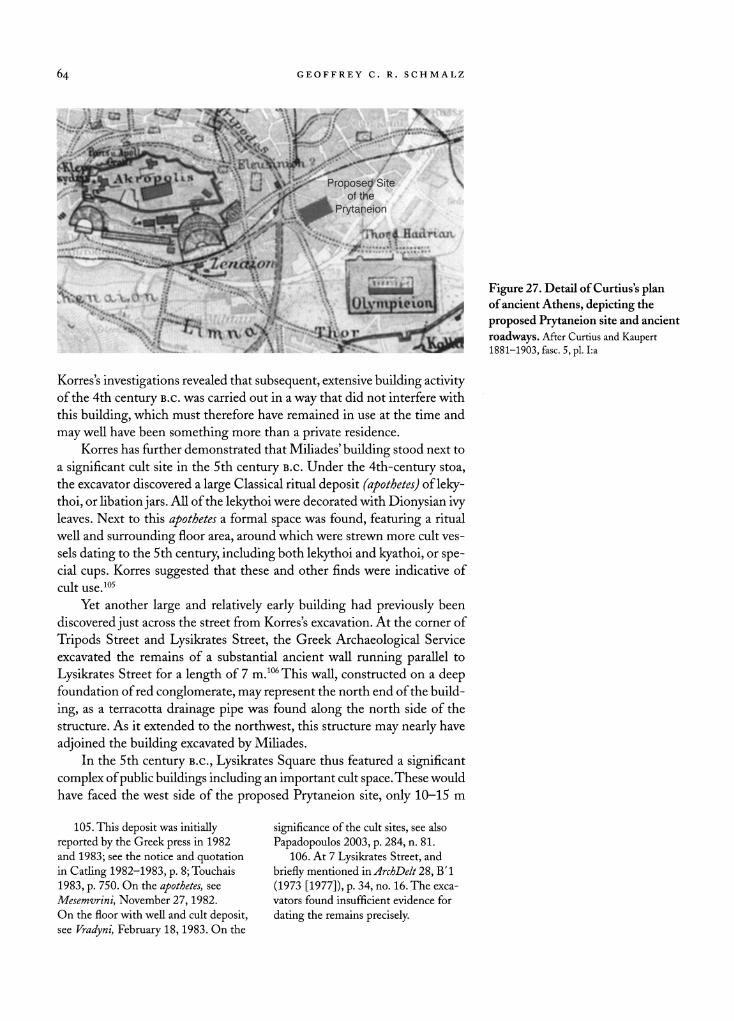
Dem. 21.85. The sources are collected
in Milchhoefer [1891] 1977, p. box, s.v.
Boukoleion, and p. xciii, s.v. Thesmoth
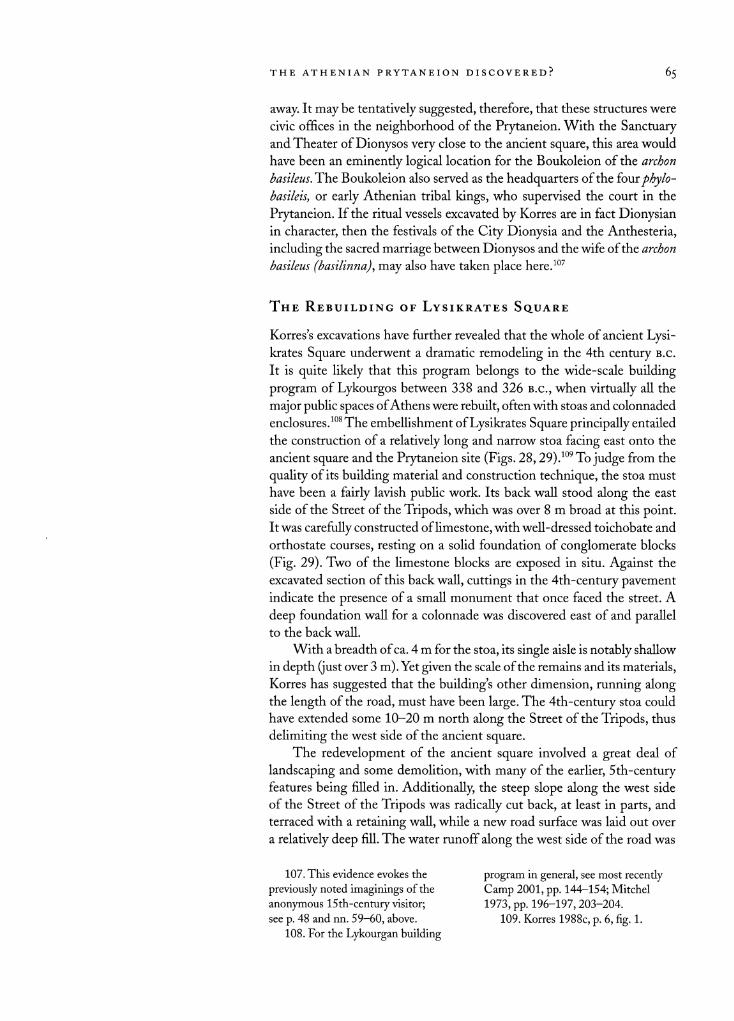
esion; see also Judeich 1931, pp. 266
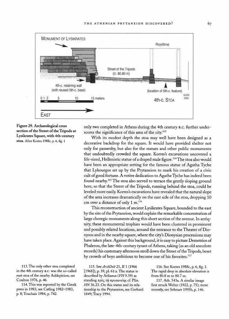
268, nn. 11,12. For recent analysis, see
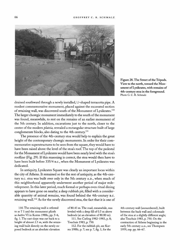
esp. Robertson 1986, pp. 159-168; also
Shear 1994, pp. 226-228; Miller 1978,
pp. 18-21,44-45; 1995, pp. 211-212;
Wycherley 1978, pp. 45-46.
6. See Schnurr 1995a on the liter
ary evidence for the so-called Archaic
Agora. For the Kekropian Agora, see
Melanthius, preserved in Plut. Cim.
4.6. On the city's omphalos, see Pind.,
fr. 75, fine 3 (Snell), aoxeo? ?uxpoc?ov
On?evx'. For the 'E^?ou Bcou?c, see S tat.
Theb. 12.481 and Lucian, Demon. 57.
7. Travlos 1960, p. 24; cf. Wycherley
1966, p. 291. 8. The statement in Plut. Cim. 4.6
that the famed painter Polygnotos
somehow decorated it under Cimon
appears to be mistaken (Robertson
1998, p. 297). This may reflect some
confusion with either the nearby Anakeion or the Theseion (cf. Har
pokration, s.v. noMyvcoxo?). Pindar's
(fr. 75, line 5 [Snell]) vision of a
TTOcv?ai?oc^ov x' e\)K??' ?yop?v
("well-adorned shining agora") is prob
ably a
poetic evocation of its rather
primitively hallowed atmosphere, as
attested in Stat. Theb. 12.491-492:
"a grove of gentle trees, marked by the
cult of the venerable, wool-entwined
laurel and the suppliant olive." This
passage is discussed by Wycherley in
Agora III, p. 73.
9. As Wycherley (1966, p. 285) notes, "early Athens still eludes us
almost completely." 10. See the most recent list in
Hansen and Fischer-Hansen 1994,
p. 31. The prytaneia of D?los, Lato,
and Olympia have been positively
identified; six others have been
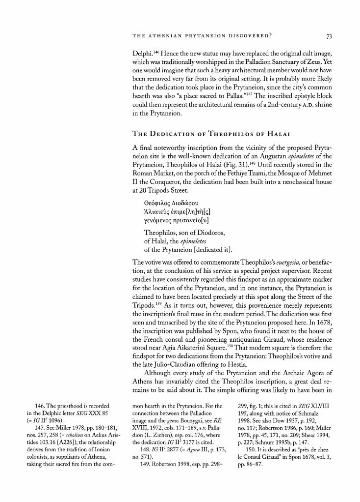
identified "with some probability,"
including, most
importantly, that of
Ephesos (Miller 1978, pp. 98-109).
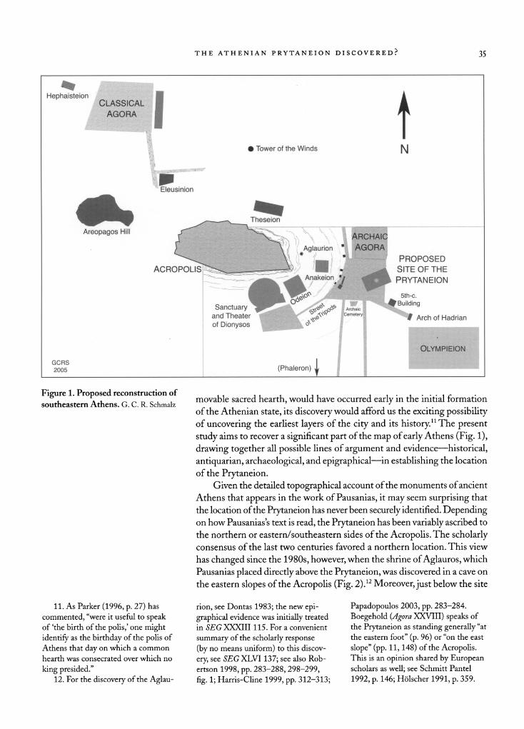
THE ATHENIAN PRYTANEION DISCOVERED? 35
Hephaisteion
AGQfiA
i ) Tower of the Winds t
N
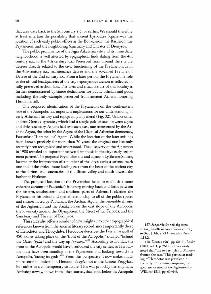
Eleusinion
Areopagos Hill
ACROPOLIS
Theseion
Sanctuary and Theater
of Dionysos
GCRS 2005 (Phaleron)
PROPOSED SITE OF THE
PRYTANEION
Figure 1. Proposed reconstruction of
southeastern Athens. G. C. R. Schmalz movable sacred hearth, would have occurred early in the initial formation
of the Athenian state, its discovery would afford us the exciting possibility of uncovering the earliest layers of the city and its history.11 The present
study aims to recover a significant part of the map of early Athens (Fig. 1),
drawing together all possible lines of argument and evidence?historical,
antiquarian, archaeological, and epigraphical?in establishing the location
of the Prytaneion. Given the detailed topographical account of the monuments of ancient
Athens that appears in the work of Pausanias, it may seem surprising that
the location of the Prytaneion has never been securely identified. Depending on how Pausanias's text is read, the Prytaneion has been variably ascribed to
the northern or eastern/southeastern sides of the Acropolis. The scholarly consensus of the last two centuries favored a northern location. This view
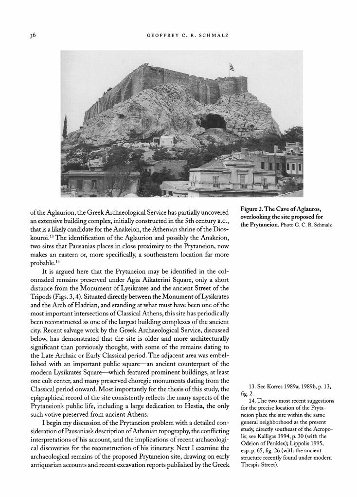
has changed since the 1980s, however, when the shrine of Aglauros, which
Pausanias placed directly above the Prytaneion, was discovered in a cave on
the eastern slopes of the Acropolis (Fig. 2).12 Moreover, just below the site
11. As Parker (1996, p. 27) has
commented, "were it useful to speak of 'the birth of the polis,'
one might
identify as the birthday of the polis of Athens that day
on which a common
hearth was consecrated over which no
king presided." 12. For the discovery of the Aglau
rion, see Dontas 1983; the new epi
graphical evidence was initially treated
in SEG XXXIII 115. For a convenient
summary of the scholarly response
(by no means uniform) to this discov
ery, see SEGXLMJ 137; see also Rob
ertson 1998, pp. 283-288,298-299,
fig. 1; Harris-Cline 1999, pp. 312-313;
Papadopoulos 2003, pp. 283-284.
Boegehold (Agora XXVIII) speaks of the Prytaneion
as standing generally "at
the eastern foot" (p. 96) or "on the east
slope" (pp. 11,148) of the Acropolis. This is an
opinion shared by European scholars as well; see Schmitt Pantel
1992, p. 146; H?lscher 1991, p. 359.
GEOFFREY C. R. SCHMALZ
^
Figure 2. The Cave of Aglauros,
overlooking the site proposed for
the Prytaneion. Photo G. C. R. Schmalz
of the Aglaurion, the Greek Archaeological Service has partially uncovered
an extensive building complex, initially constructed in the 5th century B.c.,
that is a likely candidate for the Anakeion, the Athenian shrine of the Dios
kouroi.13 The identification of the Aglaurion and possibly the Anakeion, two sites that Pausanias places in close proximity to the Prytaneion, now
makes an eastern or, more specifically,
a southeastern location far more
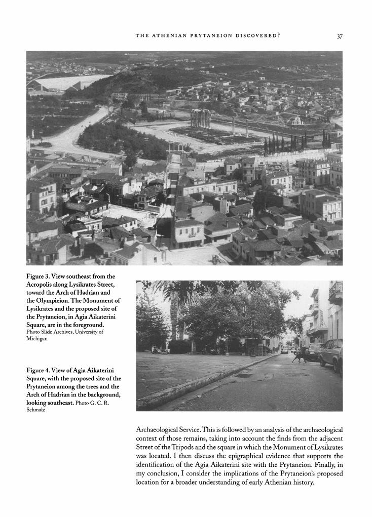
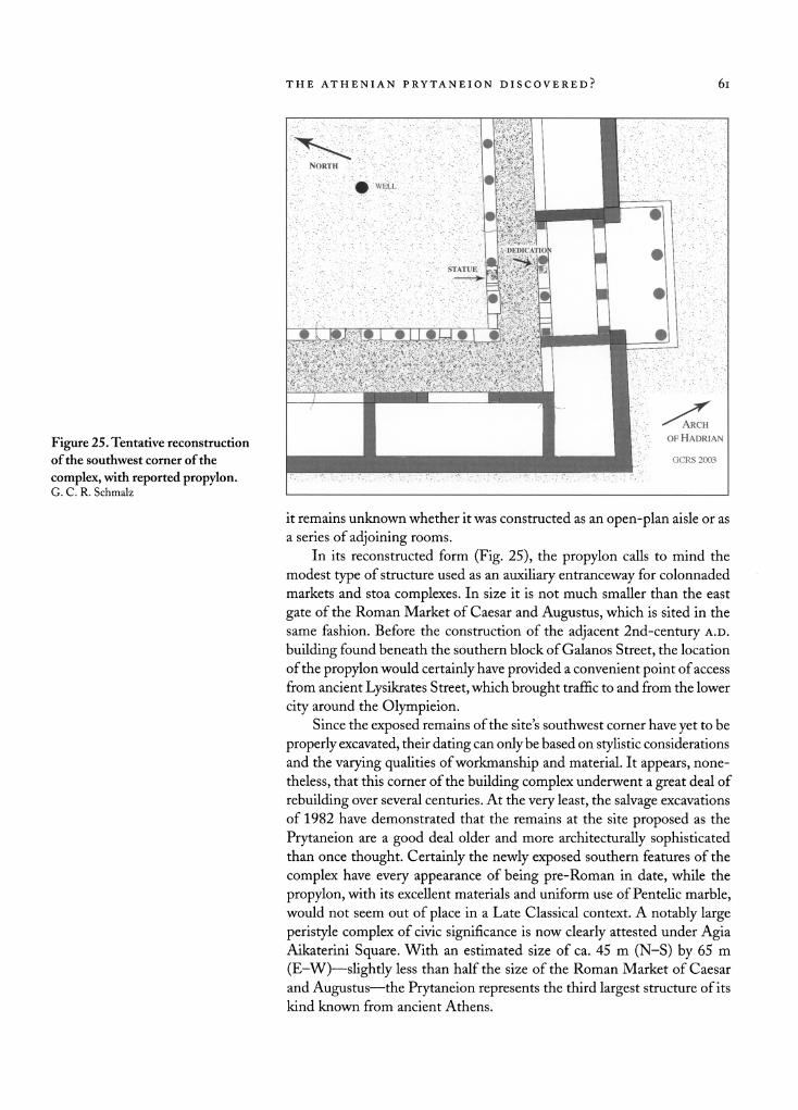
probable.14 It is argued here that the Prytaneion may be identified in the col
onnaded remains preserved under Agia Aikaterini Square, only a short
distance from the Monument of Lysikrates and the ancient Street of the
Tripods (Figs. 3,4). Situated directly between the Monument of Lysikrates and the Arch of Hadrian, and standing at what must have been one of the
most important intersections of Classical Athens, this site has periodically been reconstructed as one of the largest building complexes of the ancient
city. Recent salvage work by the Greek Archaeological Service, discussed
below, has demonstrated that the site is older and more architecturally
significant than previously thought, with some of the remains dating to
the Late Archaic or Early Classical period. The adjacent area was embel
lished with an important public square?an ancient counterpart of the
modern Lysikrates Square?which featured prominent buildings, at least
one cult center, and many preserved choregic monuments dating from the
Classical period onward. Most importantly for the thesis of this study, the
epigraphical record of the site consistently reflects the many aspects of the
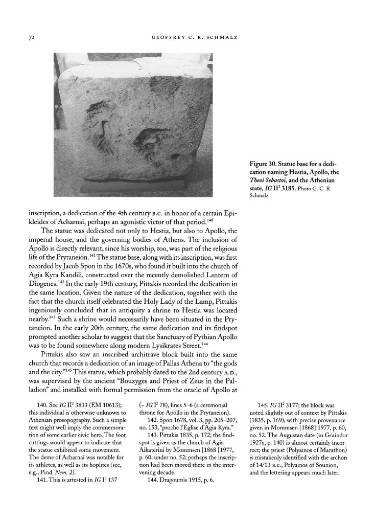
Prytaneion's public life, including a large dedication to Hestia, the only such votive preserved from ancient Athens.
I begin my discussion of the Prytaneion problem with a detailed con
sideration of Pausanias's description of Athenian topography, the conflicting
interpretations of his account, and the implications of recent archaeologi cal discoveries for the reconstruction of his itinerary. Next I examine the
archaeological remains of the proposed Prytaneion site, drawing on early
antiquarian accounts and recent excavation reports published by the Greek
13. See Korres 1989a; 1989b, p. 13,
fig. 2.
14. The two most recent suggestions for the precise location of the Pryta neion place the site within the same
general neighborhood as the present
study, directly southeast of the Acropo
lis; see Kalligas 1994, p. 30 (with the Odeion of Perikles); Lippolis 1995,
esp. p. 65, fig. 26 (with the ancient
structure recently found under modern
Thespis Street).
THE ATHENIAN PRYTANEION DISCOVERED? 37
. -JJ
/ HOI
Figure 3. View southeast from the
Acropolis along Lysikrates Street, toward the Arch of Hadrian and
the Olympieion. The Monument of
Lysikrates and the proposed site of
the Prytaneion, in Agia Aikaterini
Square, are in the foreground.
Photo Slide Archives, University of
Michigan
Figure 4. View of Agia Aikaterini
Square, with the proposed site of the
Prytaneion among the trees and the
Arch of Hadrian in the background,
looking southeast. Photo G. C. R.
Schmalz
Archaeological Service. This is followed by an analysis of the archaeological context of those remains, taking into account the finds from the adjacent Street of the Tripods and the square in which the Monument of Lysikrates
was located. I then discuss the epigraphical evidence that supports the
identification of the Agia Aikaterini site with the Prytaneion. Finally, in
my conclusion, I consider the implications of the Prytaneion's proposed location for a broader understanding of early Athenian history.
38 GEOFFREY C R. SCHMALZ
PAUSANIAS, THE PRYTANEION, AND ARCHAEOLOGICAL EVIDENCE
Pausanias provides the best and most familiar testimony for the landmarks
of ancient Athens. In the monuments and buildings of ancient Lysikrates
Square, it is easy to recognize his description of the famous Street of the
Tripods and the Prytaneion. As noted above, the proposed location of
the Prytaneion below the southeast corner of the Acropolis also accords
well with his assertion that the site stood directly beneath the shrine of
Aglauros.
Diverse interpretations of early Athenian topography have arisen,
however, on the basis of Pausanias's account and prevailing opinions about
the location of key monuments. The first mention of the Prytaneion in
Pausanias's work is preceded by a description of several other Athenian
sites including the Agora, which he introduces without any topographi cal word link to his preceding tour of the Kerameikos (Paus. 1.3.1). He
then points to the Ptolemaion, or Gymnasium of Ptolemy, as "not far"
from the Agora and "near" or "hard by" the Theseion.15 The venerable
Anakeion is introduced next; then the Aglaurion "beyond" or "behind"
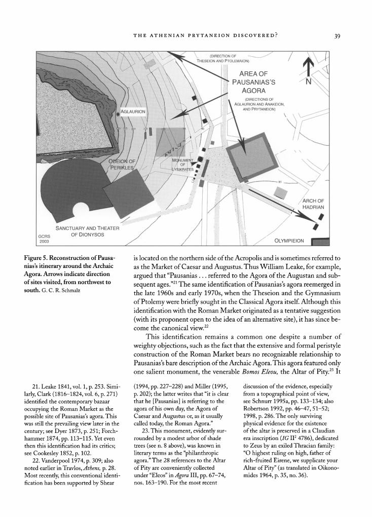
it, while the Prytaneion is said to be "near" the latter shrine (Fig. 5).16 After his first mention of the Prytaneion, Pausanias proceeds to the
lower part of the city, mentioning the Sanctuary of Serapis and the Temple of Eileithyia. From there he moves on to the Temple of Olympian Zeus and
the Ilissos valley (1.18.6,1.19.1). Following his discussion of southeastern
Athens and the Ilissos, Pausanias returns once again to the Prytaneion,
telling his readers, "From the Prytaneion there is the so-called Street of
the Tripods."17 He describes the choregic monuments found on the Street of
the Tripods and recounts the famous story of one Athenian's obsession over
a celebrated satyr statue by Praxiteles that was located there. He ends this
tale (1.20.2) by remarking that another statue of a satyr "is in the Temple of Dionysos hard by,"18 and he introduces the Sanctuary and Theater of
Dionysos immediately thereafter (1.20.3).
Location of the Theseion and the Archaic Agora
The position of the Theseion has always been a critical element in any
topographical reconstruction of Athens because Pausanias appears to place it relatively close to the Prytaneion in his progress from one site to the next.
Between the Theseion and the Anakeion sequences there is, however, as
19th-century topographers often observed, a clear syntactical break, with
none of Pausanias's characteristic word links that would indicate that the
Anakeion was necessarily located near the Theseion.19 Their proximity has,
nevertheless, often been assumed.
In turn, because the great Temple of Hephaistos overlooking the Clas
sical Agora was universally identified as the Theseion until the latter part of the 19th century, early antiquarians and topographers of Athens often
placed the Prytaneion at the northern or northeastern foot of the Acropo lis.20 Furthermore, with the testimony of Pausanias in mind, a scholarly conviction persisted that the agora visited and described by Pausanias was
actually the commercial market of the Roman period. The Roman Market
15. Paus. 1.17.2. The Ptolemaion is
said to be xf)? ?yop?t? cc7i?%ovxi o? noXx>
... 7tp?? ?? xcp yu|jvocoi(p GrjGeco? ?oxiv
iep?v.
16. Paus. 1.18.1-3. See also Papado
poulos 2003, p. 285, for an account of
Pausanias's itinerary. 17. Paus. 1.20.1: "Egxi ?? o??c ano
Ton 7ipuxav8io\) KaXou|Li8vr| Tp?Tto?e?.
18. Paus. 1.20.2: Aiov?gco 8? ?v xco
va x 7i?ir|G?ov Zaxupo? eGxi. One
recent scholar has accordingly identi
fied this nearby temple as the Temple
of Dionysos itself (Kalligas 1994, p. 28; cf. also Judeich 1931, p. 274). For the
more conventional view that this so
called temple is simply a
neighboring
choregic monument, see most recently Goette 2001, p. 98; also Wilson 2000,
p. 212.
19. See, e.g., Leake 1841, vol. 1,
p. 262. This lacuna is also observed
by Lenormant (1857, p. 116). 20. For the early historiography of
the so-called Theseion, see Wachsmuth
1863, pp. 102-103; Dyer 1873, p. 231. The Hephaisteion was first identified as the Theseion in the 1670s by Father
Babin, followed by Spon (1678, vol. 1,
pp. 188-190) and Wheler (1682,
p. 385). This traditional identification was first challenged by Ross (1838),
only to be rejected by such leading
topographers as Curtius (1843) and Wachsmuth (1863). The Hephaisteion was
finally correctly identified as such
byPervanoglu(1870).
THE ATHENIAN PRYTANEION DISCOVERED: 39
Figure 5. Reconstruction of Pausa
nias's itinerary around the Archaic
Agora. Arrows indicate direction
of sites visited, from northwest to
south. G. C. R. Schmalz
is located on the northern side of the Acropolis and is sometimes referred to
as the Market of Caesar and Augustus. Thus William Leake, for example,
argued that "Pausanias ... referred to the Agora of the Augustan and sub
sequent ages."21 The same identification of Pausanias's agora reemerged in
the late 1960s and early 1970s, when the Theseion and the Gymnasium of Ptolemy were briefly sought in the Classical Agora itself. Although this
identification with the Roman Market originated as a tentative suggestion
(with its proponent open to the idea of an alternative site), it has since be
come the canonical view.22
This identification remains a common one despite a number of
weighty objections, such as the fact that the extensive and formal peristyle construction of the Roman Market bears no recognizable relationship to
Pausanias's bare description of the Archaic Agora. This agora featured only one salient monument, the venerable Bomos Eleou, the Altar of Pity.23 It
21. Leake 1841, vol. 1, p. 253. Simi
larly, Clark (1816-1824, vol. 6, p. 271) identified the contemporary bazaar
occupying the Roman Market as the
possible site of Pausanias's agora. This
was still the prevailing view later in the
century; see Dyer 1873, p. 251; Forch
hammer 1874, pp. 113-115. Yet even
then this identification had its critics; see
Cookesley 1852, p. 102.
22. Vanderpool 1974, p. 309; also
noted earlier in Travlos, Athens, p. 28.
Most recently, this conventional identi
fication has been supported by Shear
(1994, pp. 227-228) and Miller (1995, p. 202); the latter writes that "it is clear
that he [Pausanias] is referring to the
agora of his own day, the Agora of
Caesar and Augustus or, as it usually called today, the Roman Agora."
23. This monument, evidently sur
rounded by a modest arbor of shade
trees (see n. 8 above), was known in
literary terms as the "philanthropic
agora." The 28 references to the Altar
of Pity are
conveniently collected
under "Eleos" in Agora III, pp. 67-74, nos. 163-190. For the most recent
discussion of the evidence, especially from a
topographical point of view, see Schnurr 1995a, pp. 133-134; also
Robertson 1992, pp. 46-47, 51-52;
1998, p. 286. The only surviving
physical evidence for the existence
of the altar is preserved in a Claudian
era inscription (IG II2 4786), dedicated to Zeus by
an exiled Thracian family: "O highest ruling
on high, father of
rich-fruited Eirene, we supplicate your
Altar of Pity" (as translated in Oikono
mides 1964, p. 35, no. 36).
40 GEOFFREY C. R. SCHMALZ
is also unlikely that a staunch traditionalist such as Pausanias would ever
refer to a commercial market of his own period as a true "agora."24 Thus, a number of scholars now seek the city's original agora at the eastern foot
of the Acropolis, close to the proposed site of the Prytaneion.25 Such a
location, against the east slope of the Acropolis, would certainly have been
more convenient for the residents of the early city, living (as they evidently
did) to the south and the southeast. Moreover, the adjacent hillside would
have offered a natural setting for the city's original theater and assembly area, composing the ?p%e?c. ?yopa before the theater was relocated near
the Sanctuary of Dionysos on the south slope.26
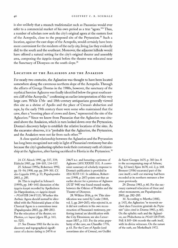
Location of the Aglaurion and the Anakeion
For nearly two centuries, the Aglaurion was thought to have been located
somewhere along the cavernous northern slope of the Acropolis. Through the efforts of George Dontas in the 1980s, however, the sanctuary of the
mythical heroine Aglauros was finally identified below the great southeast
ern cliff of the Acropolis,27 confirming an earlier interpretation of this very
large cave. While 17th- and 18th-century antiquarians generally viewed
this site as a shrine of Apollo and the place of Creusas abduction and
rape, by the early 19th century there were some who maintained that the
cave, then a "roosting place of crows and daws," represented the site of the
Aglaurion.28 Since we know from Pausanias that the Aglaurion was situ
ated above the Anakeion, which in turn looked down over the Prytaneion, Dontas's discovery helps to establish the relative locations of the sites. As
the excavator observes, it is "probable that the Aglaurion, the Prytaneion, and the Anakeion were not far from each other."29
A close spatial relationship between the Aglaurion and the Prytaneion has long been recognized not only in light of Pausanias's testimony but also
because the city's graduating ephebes took their customary oath of citizen
ship at the Aglaurion, after having sacrificed to Hestia in the Prytaneion.30
24. Cf. Alcock 1995, pp. 337, 339; Habicht 1985, pp. 104-105,134-137.
25. Schnurr 1995a; Robertson 1992,
pp. 51-54; 1998, esp. pp. 299-301. Cf.
also Lippolis 1995, p. 51; Papadopoulos 2003, p. 285.
26. This is implied in Schnurr's
(1995b, pp. 140-141) discussion of the
?pxeice ?yopa recorded by Apollodoros (in Harpokration,
s.v. ?p%e?oc ?yopa = FGrH??B 244 F113). Whether this
Archaic Agora should instead be iden
tified with the Peisistratid phase of the Classical Agora is a contentious issue
(Papadopoulos 2003, pp. 280-281). For the relocation of the theater, see
Photios, s.v. ?Kpia (Agora. Ill, p. 163,
no. 525).
27. See Dontas 1983 for the in situ
discovery and topographical signifi cance of a decree dating
to 247/6 or
246/5 b.c. and honoring a
priestess of
Aglauros (SEG XXXIII115). A conve
nient summary of scholarly response to
Dontas's publication is provided in
GXLVI 137. In addition, Robert
son (1998, p. 287) points out that an
earlier decree for a priestess of Aglauros
(IG II2 948) was found reused nearby, between the Odeion of Perikles and the
Theater of Dionysos. 28. Wilkins 1816, p. 64. This iden
tification was noted by Leake (1841,
vol. 1, pp. 264-265), who rejected it, as
it did not conform to his own recon
struction of Pausanias's testimony, pre
ferring instead an identification with
the City Eleusinion; see also Lenor
mant 1857, p. 113. For the avian popu
larity of the cave, see Chandler 1776,
p. 61. For the Cave of Apollo (and sometimes also of Creusa), see Guillet
de Saint-Georges 1675, p. 303 (no. 8
in the accompanying map of Athens;
Fig. 12 here); Spon 1678, vol. 2, p. 168.
Broneer (1936) excavated part of the
cave itself; a well-cut stairway had been
recorded at its northern entrance a few
years previously. 29. Dontas 1983, p. 60. For the nec
essary eastward relocation of these and
other monuments, see Papadopoulos
2003, pp. 282-285. 30. According to Martha (1882,
p. 145), the Aglaurion "se trouvait en
clav? dans l'enceinte g?n?rale du Pryta n?e" (also cited in Dontas 1983, p. 60).
On the ephebic oath and the Aglauri
on, see Philochorus in FGrH 328 F105. Poll. 8.105-106 records the oath itself,
with its divine witnesses. On the nature
of the oath, see Merkelbach 1972.
THE ATHENIAN PRYTANEION DISCOVERED? 41
Figure 6. Archaeological and topo
graphical reconstruction of the east
slope and foot of the Acropolis: (1) 4th-century stoa; (2) 5th-century
building; (3) choregic monuments;
(4) Anakeion; (5) remains of walls
recorded in the 19th century; (6) Lantern of Diogenes; (7) Classi
cal building. G. C. R. Schmalz
The Prytaneion may also have been involved in the deipnophoria in honor
of Aglauros.31 Accounts of ancient ritual also indicate a close proximity between the Prytaneion and the Anakeion; evidently the Anakeia festival
included a primitive theoxenia, in which the Dioskouroi were hosted in the
Prytaneion.32
As for the Anakeion itself, its remains may well have been discovered
under the upper course of modern Thespis Street, directly below the
shrine of Aglauros. In 1982 the Greek Archaeological Service uncovered
the remains of two contiguous building terraces (Fig. 6, no. 4) that date
as far back as the Classical period, with evidence for continuous use down
through Roman times. The southern limit of the complex was found to
extend for a total of more than 30 m, from the east side of Straton Street all
the way down Thespis Street to the corner of Rangavis Street (Figs. 6-8). The principal structure on the uppermost (western) terrace, constructed
with a complex series of north-south walls, features a spacious recessed
room built with well-dressed orthogonal masonry and a deep well used
over a number of centuries. Fronting onto this main space is a seemingly sizable anteroom or
porch.33
31. See Philochoros in FGrH 328 F183.
32. See Poll. 1.37. On the theoxenia,
see Ath. 4.137e; Simon 1983, p. 68;
Shapiro 1999, pp. 100-101 (with rele vant iconographie evidence). For the
physical proximity implied, see Shear
1994, p. 247, n. 20. It should be noted,
however, that the literary evidence for
celebrating the Anakes is considered
"spurious" by Robertson (1999, p. 180,
n.9).
33. For an account of the excava
tion, see Korres 1989a, 1989b; the exca
vation plan and cross section appear in
Korres 1989b, p. 13, fig. 2 (Fig. 7 here).
The well appears to have been in use
long before it was deepened sometime
in the Roman period. Sited between
the 100 and 90 m elevation marks of
the east slope of the Acropolis, each of
the two main terraces was terraced into
two sections.
42 GEOFFREY C. R. SCHMALZ
n
0.0 m 31.50 m
Acropolis East Slope
EAST
Figure 7. Elevation drawing of ter
raced complex under Thespis Street.
After Korres 1989b, p. 13, fig. 2
Figure 8. View eastward down
Thespis Street, with exposed section
of the site located in the background, below balustrade and trees (arrow). Photo G. C. R. Schmalz
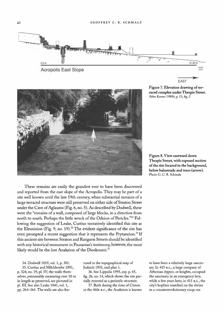
These remains are easily the grandest ever to have been discovered
and reported from the east slope of the Acropolis. They may be part of a
site well known until the late 19th century, when substantial remains of a
large terraced structure were still preserved on either side of Straton Street
under the Cave of Aglauros (Fig. 6, no. 5). As described by Dodwell, these
were the "remains of a wall, composed of large blocks, in a direction from
north to south. Perhaps the little wreck of the Odeion of Pericles."34 Fol
lowing the suggestion of Leake, Curtius tentatively identified this site as
the Eleusinion (Fig. 9, no. 19).35 The evident significance of the site has
even prompted a recent suggestion that it represents the Prytaneion.36 If
this ancient site between Straton and Rangavis Streets should be identified
with any historical monument in Pausanias's testimony, however, the most
likely would be the lost Anakeion of the Dioskouroi.37
34. Dodwell 1819, vol. 1, p. 301.
35. Curtius and Milchhoefer 1891,
p. 324, no. 19, pi. IV; the walls them
selves, presumably measuring over 10 m
in length as
preserved, are
pictured in
pi. III. See also Leake 1841, vol. 1,
pp. 264-265. The walls are also fea
tured in the topographical map of
Judeich 1931, end plan 1. 36. See Lippolis 1995, esp. p. 65,
fig. 26, no. 14, which shows the site par
tially restored as a peristyle structure.
37. Built during the time of Cimon
in the 460s b.c., the Anakeion is known
to have been a relatively large sanctu
ary. In 415 b.c., a large company of
Athenian hippeis, or
knights, occupied the sanctuary in an emergency levy,
while a few years later, in 411 b.c., the
city's hoplites marched on the shrine
in a counterrevolutionary coup; see
THE ATHENIAN PRYTANEION DISCOVERED? 43
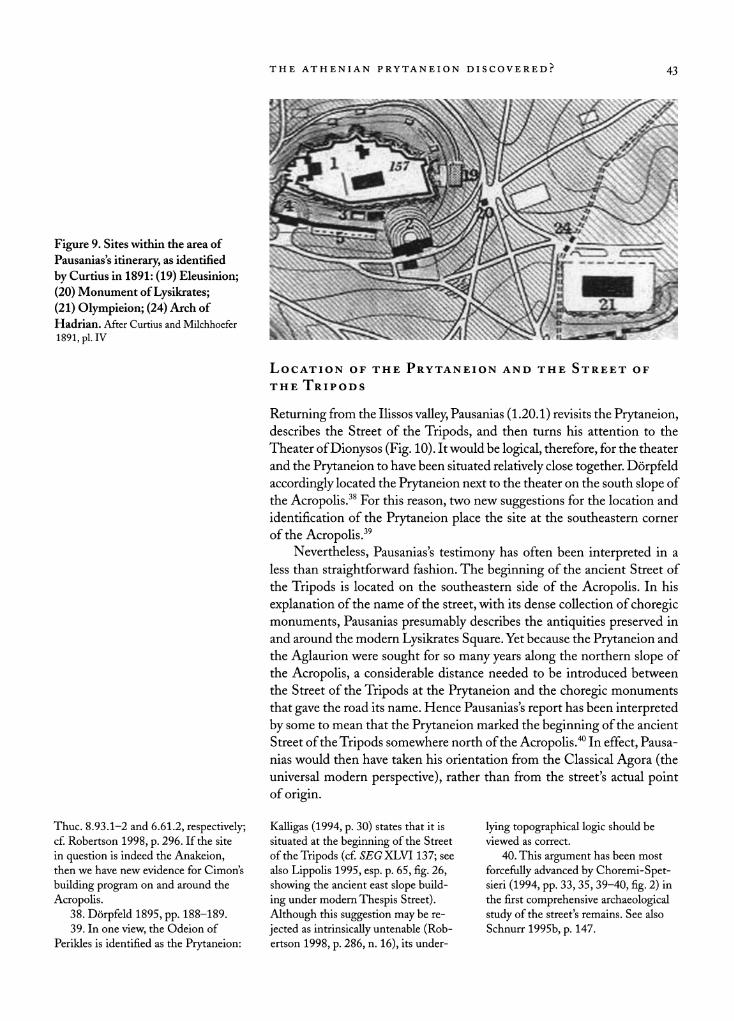
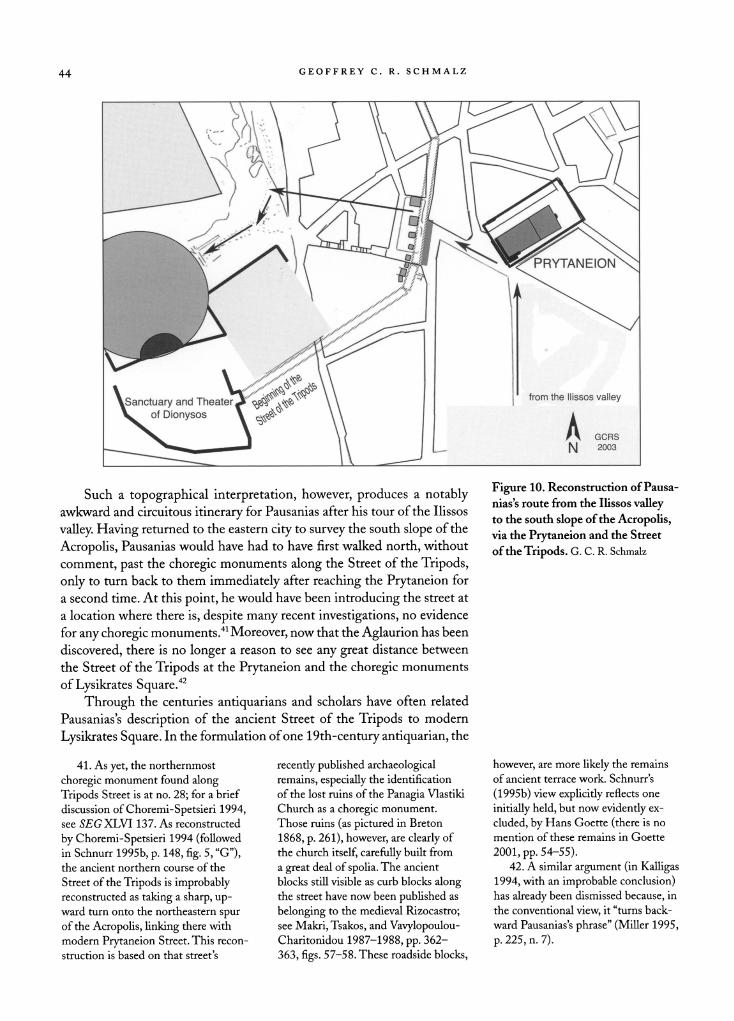
the Tripods
Returning from the Ilissos valley, Pausanias (1.20.1) revisits the Prytaneion, describes the Street of the Tripods, and then turns his attention to the
Theater of Dionysos (Fig. 10). It would be logical, therefore, for the theater
and the Prytaneion to have been situated relatively close together. D?rpfeld
accordingly located the Prytaneion next to the theater on the south slope of
the Acropolis.38 For this reason, two new suggestions for the location and
identification of the Prytaneion place the site at the southeastern corner
of the Acropolis.39 Nevertheless, Pausanias's testimony has often been interpreted in a
less than straightforward fashion. The beginning of the ancient Street of
the Tripods is located on the southeastern side of the Acropolis. In his
explanation of the name of the street, with its dense collection of choregic monuments, Pausanias presumably describes the antiquities preserved in
and around the modern Lysikrates Square. Yet because the Prytaneion and
the Aglaurion were sought for so many years along the northern slope of
the Acropolis, a considerable distance needed to be introduced between
the Street of the Tripods at the Prytaneion and the choregic monuments
that gave the road its name. Hence Pausanias's report has been interpreted
by some to mean that the Prytaneion marked the beginning of the ancient
Street of the Tripods somewhere north of the Acropolis.40 In effect, Pausa
nias would then have taken his orientation from the Classical Agora (the universal modern perspective), rather than from the street's actual point of origin.
Thuc. 8.93.1-2 and 6.61.2, respectively; cf. Robertson 1998, p. 296. If the site
in question is indeed the Anakeion,
then we have new evidence for Cimon's
building program on and around the
Acropolis. 38. D?rpfeld 1895, pp. 188-189. 39. In one view, the Odeion of
Perikles is identified as the Prytaneion:
Kalligas (1994, p. 30) states that it is situated at the beginning of the Street
of the Tripods (cf. SEGXLVl 137; see
also Lippolis 1995, esp. p. 65, fig. 26,
showing the ancient east slope build
ing under modern Thespis Street).
Although this suggestion may be re
jected as
intrinsically untenable (Rob ertson 1998, p. 286, n. 16), its under
lying topographical logic should be viewed as correct.
40. This argument has been most
forcefully advanced by Choremi-Spet sieri (1994, pp. 33, 35, 39-40, fig. 2) in the first comprehensive archaeological
study of the street's remains. See also
Schnurr 1995b, p. 147.
44 GEOFFREY C. R. SCHMALZ
XsanctuaryandTheaterJ^^^^ \\ I from the llissos valley
\^ of Dionysos \ c?^ \\ A
^V^ \ \) j M GCRS
Figure 10. Reconstruction of Pausa
nias's route from the Ilissos valley to the south slope of the Acropolis, via the Prytaneion and the Street
of the Tripods. G. C. R. Schmalz
Such a topographical interpretation, however, produces a notably awkward and circuitous itinerary for Pausanias after his tour of the Ilissos
valley. Having returned to the eastern city to survey the south slope of the
Acropolis, Pausanias would have had to have first walked north, without
comment, past the choregic monuments along the Street of the Tripods,
only to turn back to them immediately after reaching the Prytaneion for
a second time. At this point, he would have been introducing the street at
a location where there is, despite many recent investigations, no evidence
for any choregic monuments.41 Moreover, now that the Aglaurion has been
discovered, there is no longer a reason to see any great distance between
the Street of the Tripods at the Prytaneion and the choregic monuments
of Lysikrates Square.42
Through the centuries antiquarians and scholars have often related
Pausanias's description of the ancient Street of the Tripods to modern
Lysikrates Square. In the formulation of one 19th-century antiquarian, the
41. As yet, the northernmost
choregic monument found along
Tripods Street is at no. 28; for a brief
discussion of Choremi-Spetsieri 1994,
see SEGXLVl 137. As reconstructed
by Choremi-Spetsieri 1994 (followed in Schnurr 1995b, p. 148, fig. 5, "G"),
the ancient northern course of the
Street of the Tripods is improbably reconstructed as
taking a
sharp, up
ward turn onto the northeastern spur
of the Acropolis, linking there with modern Prytaneion Street. This recon
struction is based on that street's
recently published archaeological
remains, especially the identification
of the lost ruins of the Panagia Vlastiki
Church as a choregic monument.
Those ruins (as pictured in Breton
1868, p. 261), however, are clearly of
the church itself, carefully built from
a great deal of spolia. The ancient
blocks still visible as curb blocks along the street have now been published
as
belonging to the medieval Rizocastro;
see Makri, Tsakos, and Vavylopoulou Charitonidou 1987-1988, pp. 362
363, figs. 57-58. These roadside blocks,
however, are more likely the remains
of ancient terrace work. Schnurr 's
(1995b) view explicitly reflects one
initially held, but now evidently
ex
cluded, by Hans Goette (there is no
mention of these remains in Goette
2001, pp. 54-55). 42. A similar argument (in Kalligas
1994, with an improbable conclusion)
has already been dismissed because, in
the conventional view, it "turns back
ward Pausanias's phrase" (Miller 1995,
p. 225, n. 7).
THE ATHENIAN PRYTANEION DISCOVERED? 45
route of Pausanias's return to the Prytaneion went "through the street of
the tripods, between the theatre and choregic grotto."43 Yet, until recently, the same logic has rarely been applied to the location of the Prytaneion.
According to one new analysis, modern Lysikrates Square "is the most
probable beginning of the ancient Street of the Tripods, comprising the
Prytaneion and the Odeion of Perikles."44 Archaeological evidence demon
strates that the ancient street began at the eastern entrance of the Sanctuary and Theater of Dionysos (Fig. 10). Here, Manolis Korres's excavations
have revealed the initial course of the ancient street, flanked by some 15
choregic monuments built along the west and south sides of the Odeion of
Perikles. These converge upon a large hall at the southwest corner, directly
opposite the propylon.45 There is now a growing consensus that the Prytaneion was indeed lo
cated along the Street of the Tripods on the east side of the Acropolis below
the Aglaurion.46 The location of the Prytaneion here makes topographical sense, for it is only here that the front or eastern slope of the Acropolis levels off enough to permit any convenient, extensive building activity.47
Although scholars from the 19th century onward often assumed that the
Prytaneion was terraced along one of the slopes of the Acropolis, adjacent to the cave shrine of the Aglaurion, it is difficult to imagine why the early
Athenians would have elected to construct their first civic building on such
an incline. Presumably they would have preferred a more accessible and
centralized location, on the same relatively level ground occupied by their
early agora.
PROPOSED SITE OF THE PRYTANEION
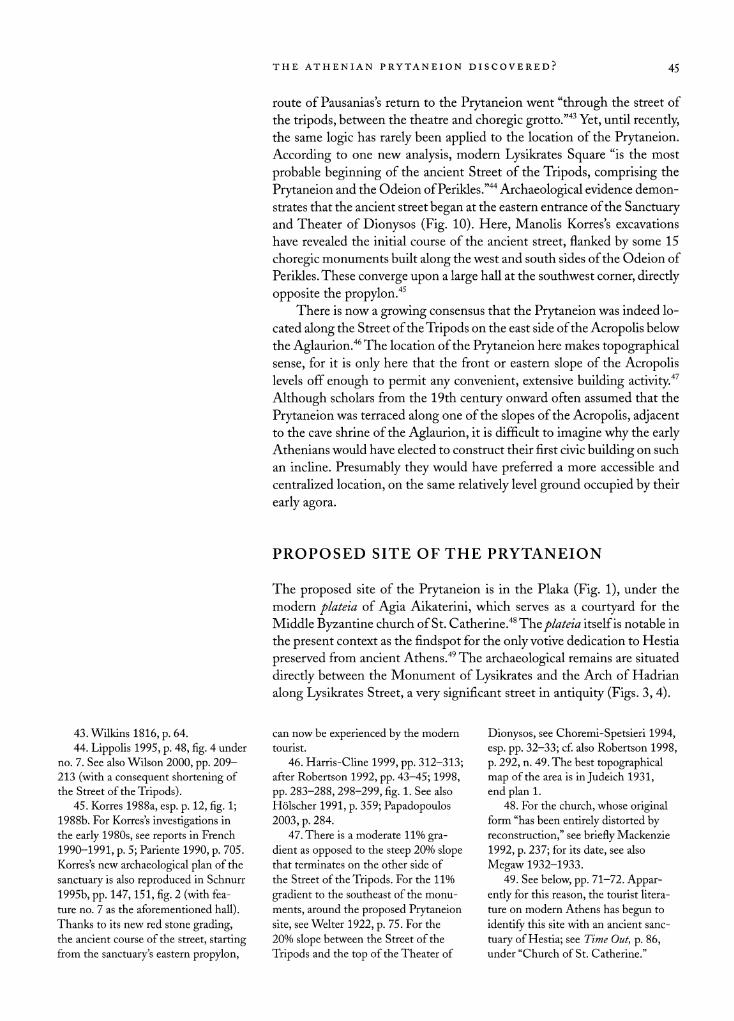
The proposed site of the Prytaneion is in the Plaka (Fig. 1), under the
modern plateia of Agia Aikaterini, which serves as a courtyard for the
Middle Byzantine church of St. Catherine.48 The plateia itself is notable in
the present context as the findspot for the only votive dedication to Hestia
preserved from ancient Athens.49 The archaeological remains are situated
directly between the Monument of Lysikrates and the Arch of Hadrian
along Lysikrates Street, a very significant street in antiquity (Figs. 3, 4).
43.Wilkinsl816,p.64. 44. Lippolis 1995, p. 48, fig. 4 under
no. 7. See also Wilson 2000, pp. 209
213 (with a consequent shortening of
the Street of the Tripods). 45. Korres 1988a, esp. p. 12, fig. 1;
1988b. For Korres's investigations in
the early 1980s, see reports in French
1990-1991, p. 5; Pariente 1990, p. 705.
Korres's new archaeological plan of the
sanctuary is also reproduced in Schnurr
1995b, pp. 147,151, fig. 2 (with fea ture no. 7 as the aforementioned hall).
Thanks to its new red stone grading, the ancient course of the street, starting from the sanctuary's eastern propylon,
can now be experienced by the modern
tourist.
46. Harris-Cline 1999, pp. 312-313;
after Robertson 1992, pp. 43-45; 1998,
pp. 283-288,298-299, fig. 1. See also
H?lscher 1991, p. 359; Papadopoulos 2003, p. 284.
47. There is a moderate 11% gra
dient as opposed
to the steep 20% slope that terminates on the other side of
the Street of the Tripods. For the 11%
gradient to the southeast of the monu
ments, around the proposed Prytaneion
site, see Welter 1922, p. 75. For the
20% slope between the Street of the
Tripods and the top of the Theater of
Dionysos, see Choremi-Spetsieri 1994,
esp. pp. 32-33; cf. also Robertson 1998,
p. 292, n. 49. The best topographical
map of the area is in Judeich 1931,
end plan 1.
48. For the church, whose original form "has been entirely distorted by
reconstruction," see briefly Mackenzie
1992, p. 237; for its date, see also
Megaw 1932-1933.
49. See below, pp. 71-72. Appar
ently for this reason, the tourist litera
ture on modern Athens has begun to
identify this site with an ancient sanc
tuary of Hestia; see Time Out, p. 86,
under "Church of St. Catherine."
46 GEOFFREY C. R. SCHMALZ
Figure 11. Exposed remains in Agia Aikaterini Square, looking southeast.
Photo G. C. R. Schmalz
The preserved section of an Ionic colonnade, forming the southwest
corner of a large peristyle complex, has served as a well-known landmark
in Athens from the time of Stuart and Revett in the 18th century (Fig. 11). Over the centuries, the site has been variously regarded as the Athenian
Basileion, Hadrian's Panhellenion, the Palladion, the Theseion, and the
Serapeion. Yet because most of the exposed remains appear to be Roman
in date, for the last hundred years the building complex has been thought to have relatively little archaeological or topographical significance. Today it is generally considered to be part of a neighboring balaneion, or bath
building, of the Late Roman period.50 Recent salvage excavations at the southwest corner of the modern
square have begun to change this view, however. An architecturally grander, and almost certainly earlier, section of the building, described by the Greek
press as a propylon, has been discovered.51 Only a small section of the
ancient complex has been excavated, but it is apparent that some of the
archaeological remains date as far back as the Archaic period. The salvage
work, described in detail below, has demonstrated that the modern square
preservesxmuch of the original dimensions of the site, making the proposed
Prytaneion site one of the larger architectural spaces in ancient Athens.
50. See Travlos, Athens, p. 181,
fig. 221, for Balaneion H: "The hypo caust of a Roman bath under Lysikra tous Street probably belongs to the
large building in front of the church of St. Aikaterini; columns of either the
peristyle or this stoa of this building
are
still standing." 51. See Catling 1982-1983, p. 8,
summarizing a report in Ta Nea, Janu
ary 14,1983.
THE ATHENIAN PRYTANEION DISCOVERED? 47
Antiquarian Interest in the Agia Aikaterini Site
Throughout the Ottoman period, the Plaka was a popular and prominent district of the city. It was the first platoma, or quarter of Athens, serving as
the center of government under the rule of the Sardar, whose palace stood
at the top of the northeast slope of the Acropolis. As in the Archaic period, the Plaka neighborhood marked the principal point of entrance into the
city, and some of the era's most notable Athenian families resided there.52
Perhaps most importantly, just across the street from the proposed site of
the Prytaneion stood the famous hospice of the Capuchin order. At its
foundation in the 17th century, this small monastic community published the first study and plan of the archaeological remains of Athens, thereby
ushering in the modern antiquarian era. Later it would offer hospitality to
such renowned antiquarians as Edward Dodwell and the influential artist
Don Battista Lusieri.53 The neighborhhood of the proposed Prytaneion site therefore served as the starting point for all the early guidebooks to
the ancient and modern city. In the first of these, a highly influential work published in 1675 by Guil
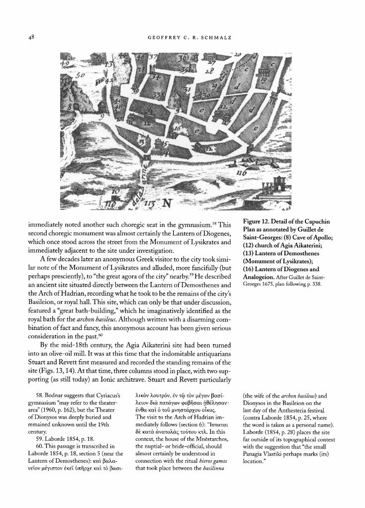
let de Saint-Georges, the Monument of Lysikrates (the so-called Lantern
of Demosthenes) was first formally identified with Pausanias's description of the ancient Street of the Tripods (Fig. 12).54 Guillet de Saint-Georges even ventured to claim that the Prytaneion must be located directly to the
east of the Monument of Lysikrates.55 This suggestion was additionally
inspired by the fact that the Street of the Tripods was then known locally as the Street of Hestia.56
Antiquarian interest in the proposed site of the Prytaneion probably
goes even further back into the 15th century. Cyriacus of Ancona appears to have been the first visitor to take notice of its remains, describing the
site as a gymnasium.57 After mentioning the "marble throne" of the Monu
ment of Lysikrates, whose dedicatory inscription he transcribed, Cyriacus
52. The palace of the Sardar was
then situated on the northeast slope of
the Acropolis, next to the Jesuit Mis
sion and the Hospice of the Calogers Medelli.The chief Christian official of
Athens, the Vecchiados Capitanakis, lived across the street from the Monu
ment of Lysikrates and the Hospice of
the Capuchins, which he supervised, and next door to the Greek Orthodox
monastery of the Calogeres. See Guillet
de Saint-Georges 1675, pp. 283-284,
298-300,333.
53. See Laborde 1854, pp. 74-76.
The Capuchin Plan of Athens (dating to ca. 1670) is preserved in the Biblio
th?que National in Paris; it is conve
niently republished in Omont 1898,
pi. XXXIX; see also Laborde 1854,
p. 78, pi. I (with discussion of its influ ence on pp. 76-79). The many subse
quent treatments of the plan include
Spon 1678, vol. 2, between pp. 416 and
417; Coronelli 1687, p. 197; Omont
1898, pp. 15-17, pis. XLII and XLI. For Lusieri's residence, see Clark 1816
1824, vol. 6, p. 205.
54. In Guillet de Saint-Georges
1675, esp. pp. 209-333. This work was
immediately followed by the visit and
similarly influential publications of
Spon (1678) and Wheler (1682). 55. Guillet de Saint-Georges 1675,
p. 300.
56. Guillet de Saint-Georges 1675, pp. 209-211. In the 18th century it came to be known as the Kandila, or
"Lamp Street," after the establishment
of a church and convent to the Holy
Lady of the Lamp, the Agia Kyra Kandili, on the site of the so-called
Lantern of Diogenes (as recorded by Dodwell 1819, vol. 1, p. 289). Presum
ably these names were inspired by the
long-held belief that the victory tripods once
surmounting the choregic monu
ments served as lighted lanterns. Yet
for all we know, there may also have
been some faint memory of the past
existence of a shrine to Hestia, perhaps
inspired by the preservation of the
ancient Hestia dedication in the exte
rior wall of the church of the Holy Lady of the Lamp. If not, the later
worship of the Hestia-like figure of
the Agia Kandili would make for a
remarkable historical irony. 57. The text of Cyriacus reads:
Ad aliam gymnasii sedem exornatam
(excerpted in Bodnar 1960, pp. 37-38; see n. 3 for an
explanation of Cyriacus's
terminology). The only other choregic monument still standing in medieval
and early modern Athens was that of
Thrasyllus, which Cyriacus afterward
visited.
48 GEOFFREY C. R. SCHMALZ
Figure 12. Detail of the Capuchin Plan as annotated by Guillet de
Saint-Georges: (8) Cave of Apollo; (12) church of Agia Aikaterini;
(13) Lantern of Demosthenes
(Monument of Lysikrates); (16) Lantern of Diogenes and
Analogeion. After Guillet de Saint
Georges 1675, plan following p. 338.
immediately noted another such choregic seat in the gymnasium.58 This
second choregic monument was almost certainly the Lantern of Diogenes, which once stood across the street from the Monument of Lysikrates and
immediately adjacent to the site under investigation. A few decades later an anonymous Greek visitor to the city took simi
lar note of the Monument of Lysikrates and alluded, more fancifully (but
perhaps presciently), to "the great agora of the city" nearby.59 He described an ancient site situated directly between the Lantern of Demosthenes and
the Arch of Hadrian, recording what he took to be the remains of the city's Basileion, or royal hall. This site, which can only be that under discussion, featured a "great bath-building," which he imaginatively identified as the
royal bath for the archon basileus. Although written with a disarming com
bination of fact and fancy, this anonymous account has been given serious
consideration in the past.60
By the mid-18th century, the Agia Aikaterini site had been turned
into an olive-oil mill. It was at this time that the indomitable antiquarians Stuart and Revett first measured and recorded the standing remains of the
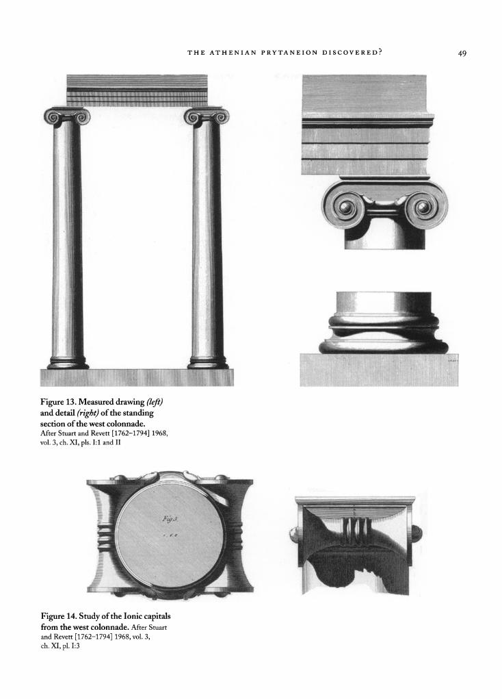
site (Figs. 13,14). At that time, three columns stood in place, with two sup
porting (as still today) an Ionic architrave. Stuart and Revett particularly
58. Bodnar suggests that Cyriacus's
gymnasium "may refer to the theater
area" (1960, p. 162), but the Theater
of Dionysos was
deeply buried and
remained unknown until the 19th
century. 59. Laborde 1854, p. 18.
60. This passage is transcribed in
Laborde 1854, p. 18, section 5 (near the
Lantern of Demosthenes): Kai ?atax ve?ov ji?yioTov ?ice? tmripxe Kai x? ?aai
connection with the ritual hieros gamos that took place between the basilinna
(the wife of the archon basileus) and
Dionysos in the Basileion on the
last day of the Anthesteria festival
(contra Laborde 1854, p. 25, where
the word is taken as a personal name).
Laborde (1854, p. 28) places the site far outside of its topographical context
with the suggestion that "the small
Panagia Vlastiki perhaps marks (its) location."
THE ATHENIAN PRYTANEION DISCOVERED? 49
Figure 13. Measured drawing (left) and detail (right) of the standing section of the west colonnade.
After Stuart and Revett [1762-1794] 1968,
vol. 3, ch. XI, pis. 1:1 and II
Figure 14. Study of the Ionic capitals from the west colonnade. After Stuart
and Revett [1762-1794] 1968, vol. 3, ch. XI, pi. 1:3
5? GEOFFREY C R. SCHMALZ
admired the elegant classicizing style of the Ionic capitals, which they com
pared closely and favorably with those of the 5th-century Ilissos Temple on the south bank of the Ilissos River. Although they could not offer any identification for the building, Stuart thought that it was "undoubtedly a
part of a considerable edifice."61
In 1835, the epigraphist Kyriakos Pittakis recorded the existence of
numerous Ionic capitals preserved in the walls of the adjacent church of
the Agia Kyra Kandili, the Holy Lady of the Lamp.62 There were so many that he believed a temple must once have stood upon the site. Most signifi
cantly, Pittakis also discovered a large dedication to Hestia. Consequently, he believed that this now-demolished church marked the proximity, in
ancient times, of the shrine of Hestia. As for the proposed site of the Pry
taneion, Pittakis noted its "numerous ruins," supposing them to represent the remains of an ancient temple, perhaps the Theseion.63
European topographers were similarly drawn to comment on the site.
In his early 19th-century plan of Athens, Ferdinand Stademann tenta
tively identified it as the Palladion, presumably because of an architectural
dedication to Athena Pallas built into the church and convent of Agia
Kyra Kandili.64 Leake believed that the exposed remains represented an
important public building of the Hellenistic period.65 For a time in the
mid-19th century the site was identified as the Temple of Hera and Zeus
Panhellenios.66
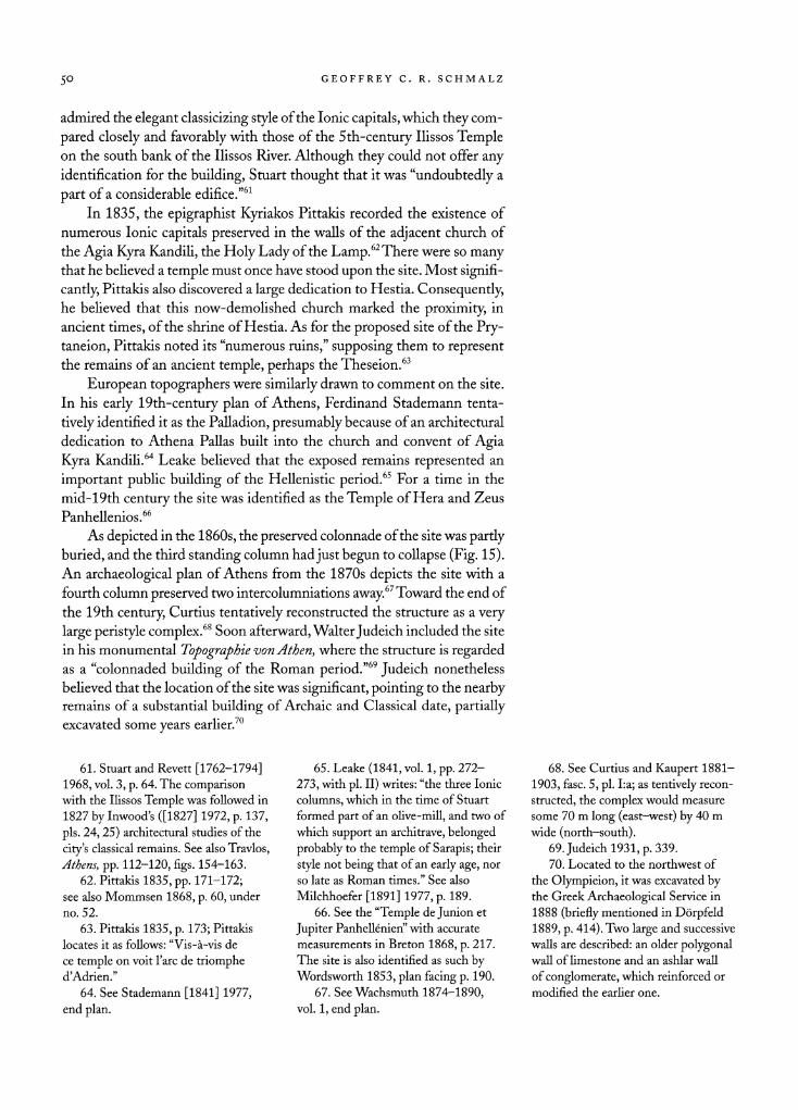
As depicted in the 1860s, the preserved colonnade of the site was partly
buried, and the third standing column had just begun to collapse (Fig. 15). An archaeological plan of Athens from the 1870s depicts the site with a
fourth column preserved two intercolumniations away.67 Toward the end of
the 19th century, Curtius tentatively reconstructed the structure as a very
large peristyle complex.68 Soon afterward, Walter Judeich included the site
in his monumental Topographie von Athen, where the structure is regarded as a "colonnaded building of the Roman period."69 Judeich nonetheless
believed that the location of the site was significant, pointing to the nearby remains of a substantial building of Archaic and Classical date, partially excavated some years earlier.70
61. Stuart and Revett [1762-1794] 1968, vol. 3, p. 64. The comparison
with the Ilissos Temple was followed in 1827 by Inwood's ([1827] 1972, p. 137,
pis. 24,25) architectural studies of the
city's classical remains. See also Travlos,
Athens, pp. 112-120, figs. 154-163.
62. Pittakis 1835, pp. 171-172; see also Mommsen 1868, p. 60, under
no. 52.
63. Pittakis 1835, p. 173; Pittakis locates it as follows: "Vis-?-vis de
ce temple
on voit l'arc de triomphe d'Adrien."
64. See Stademann [1841] 1977, end plan.
65. Leake (1841, vol. 1, pp. 272
273, with pi. II) writes: "the three Ionic
columns, which in the time of Stuart
formed part of an olive-mill, and two of
which support an architrave, belonged
probably to the temple of Sarapis; their
style not
being that of an early age, nor
so late as Roman times." See also
Milchhoefer [1891] 1977, p. 189. 66. See the "Temple de Junion et
Jupiter Panhell?nien" with accurate
measurements in Breton 1868, p. 217.
The site is also identified as such by Wordsworth 1853, plan facing p. 190.
67. See Wachsmuth 1874-1890, vol. 1, end plan.
68. See Curtius and Kaupert 1881
1903, fase. 5, pi. La; as tentively
recon
structed, the complex would measure
some 70 m long (east-west) by 40 m
wide (north-south).
69.Judeichl931,p.339. 70. Located to the northwest of
the Olympieion, it was excavated by the Greek Archaeological Service in
1888 (briefly mentioned in D?rpfeld 1889, p. 414). Two large and successive
walls are described: an older polygonal wall of limestone and an ashlar wall
of conglomerate, which reinforced or
modified the earlier one.
THE ATHENIAN PRYTANEION DISCOVERED? 51
Figure 15. Standing section of the west colonnade as it looked in the
1860s. After Breton 1868, p. 217
Standing Architecture in Agia Aikaterini Square
The best documentation of the standing architecture in Agia Aikaterini
Square continues to be the studies made by Stuart and Revett more than
two centuries ago. The surviving twin columns, Ionic architrave, and
capitals of the west colonnade (see Figs. 11, 16) are precisely drawn, and
measurements can be scaled from the drawings; the preserved colonnade, for example, stands over 5 m in height from column base to architrave, while
the interaxial spacing of the columns is a standard 2.5 m (Figs. 13,14).71 All of the architectural elements, from column base to architrave, are
notably full and well proportioned. In these characteristics, the Agia Aika
terini remains contrast with those from Roman buildings in Athens, which
typically have "pancaked" capitals with narrow volutes, pinched leafed
bolsters, and neck moldings with lean and compacted profiles.72 Moreover,
virtually all the preserved Ionic capitals from Roman Athens favor a central
egg-and-dart motif on the echinus, but the ovolo echinus on the Agia Aikaterini columns is plain. This is reminiscent of the early Attic Ionic
capital, on which the central motif was painted. Furthermore, the echinus
volute angle is ornamented not only with a conventional palmette leaf, but
71. As derived from Stuart and Re
vett's ([1762-1794] 1968, vol. 3, ch. XI,
pis. I, II) measured drawings, the eleva
tion of the surviving colonnade is 5.36 m;
the interaxial spacing is 2.50 m; the
intercolumniation is 1.72 m.The Ionic
bases measure 0.783 m in diameter at
bottom (0.575 m at top) and 0.206 m in height; the architrave-epistyle block
is 0.587 m in height and 0.53 m in
width. Keramopoulos (1911, p. 260)
gives the height of the columns as
4.35 m, rising to 4.55 m with the
column base.
72. Cf. the examples of reportedly Late Hellenistic and Roman Imperial date in Meritt 1996, pp. 169-172, nos. 22-24, and the Ionic capitals from the Roman Market in Orlandos
1967, p. 19, fig. 23. In these the overall
length-height ratio is 1:2.4, as com
pared with the more Classical, high
profile of those from the Agia Aikat
erini site, which have a ratio of 1:1.7.
The Ionic bases, though less diagnostic in date, also differ from the typically
flattened bases from Roman buildings in Athens; their diameter-height ratios
are 1:4.7 as compared with 1:4 in the
Roman examples.
52 GEOFFREY C R. SCHMALZ
Ill
'. -? flMlllfl
Figure 16. Standing section of the
west colonnade, exterior view, look
ing west. Photo G. C. R. Schmalz
also with an unusual fillet above.73 The flanking volutes of the capital are
nicely proportioned in relation to the necking element; they feature a large, raised boss for the eye of the volute, while the side bolsters are ornamented
in classical fashion with four bands of round astragals at the center. The
form and style of the Ionic capitals from Agia Aikaterini Square indicate
a particular and carefully studied classicism, as if they were closely styled after earlier models on site. While typically Augustan in their classicizing
style and general craftsmanship, they share a close affinity with Classical
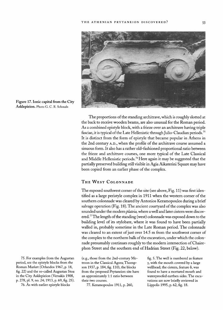
prototypes in their sculpted details and generous proportions. Elsewhere in Roman Athens, the only close parallels for these archi
tectural characteristics are to be found in the Ionic capitals from the City
Asklepieion, which probably belong to the rebuilding of the late-4th-cen
tury east stoa (Fig. 17).74 There the sculpted ornamentation is very similar
to that on the capitals from Agia Aikaterini Square, although the volute
angle is decorated with the more typical triple-leafed palmette and lacks a
fillet above. The surface of this capital is also less well finished, having been
simply roughed out with a toothed chisel. The capitals of the Asklepieion were clearly created as replicas of their 4th-century predecessors.
73. An excellent 5th-century b.c.
comparison, particularly for the single
palmette leaf, has recently been pub lished from the collection of the British
School of Athens; seeTomlinson 2000,
p. 474, no. 22 (without provenance). The unusual surmounting fillet, mean
while, finds a parallel with the Ionic
capitals from the Periklean Temple of
Athena at Sounion; see the figure in
Dinsmoor 1971, p. 48. For two repre
sentative examples of the more typical
Ionic capital of the Roman era, see Tom
linson 2000, pp. 474-475, nos. 23,24.
74. See "Chapiteaux II" in Martin
1944-1945, pp. 343-345, figs. 3-5,
pi. 27; the best-preserved capital is
characterized as belonging "aux meil
leures ?poques de l'architecture ath?
nienne." For an alternative attribution
of these capitals to the sanctuary's
Augustan stoa, see Walker 1979,
pp. 243-244. Tomlinson (2000,
pp. 474-475, no. 23) compares an Ionic
capital of "lst-2nd c. a.d." with the
Asklepieion example, although the
carved ornamentation is more elabo
rate, with the triple-leafed palmette and
central egg-and-dart motif favored in
the Roman period.
THE ATHENIAN PRYTANEION DISCOVERED? 53
Figure 17. Ionic capital from the City
Asklepieion. Photo G. C. R. Schmalz
The proportions of the standing architrave, which is roughly slotted at
the back to receive wooden beams, are also unusual for the Roman period. As a combined epistyle block, with a frieze over an architrave having triple fasciae, it is typical of the Late Hellenistic through Julio-Claudian periods.75 It is distinct from the form of epistyle that became popular in Athens in
the 2nd century A.D., when the profile of the architrave course assumed a
sinuous form. It also has a rather old-fashioned proportional ratio between
the frieze and architrave courses, one more typical of the Late Classical
and Middle Hellenistic periods.76 Here again it may be suggested that the
partially preserved building still visible in Agia Aikaterini Square may have
been copied from an earlier phase of the complex.
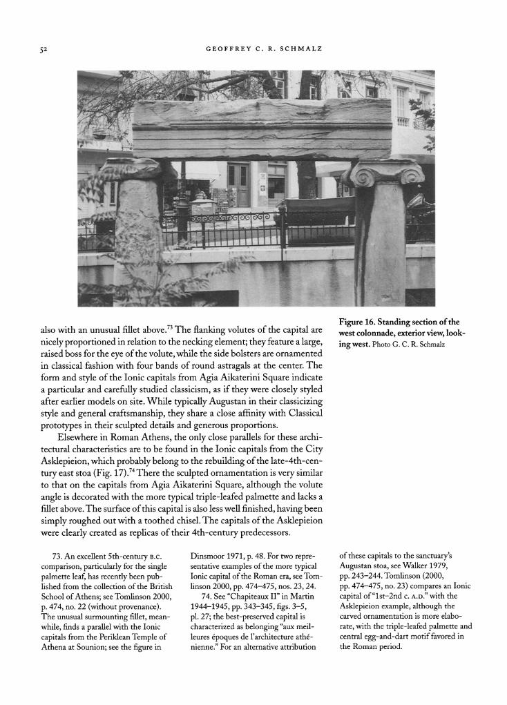
The West Colonnade
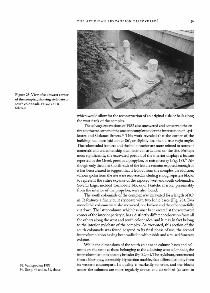
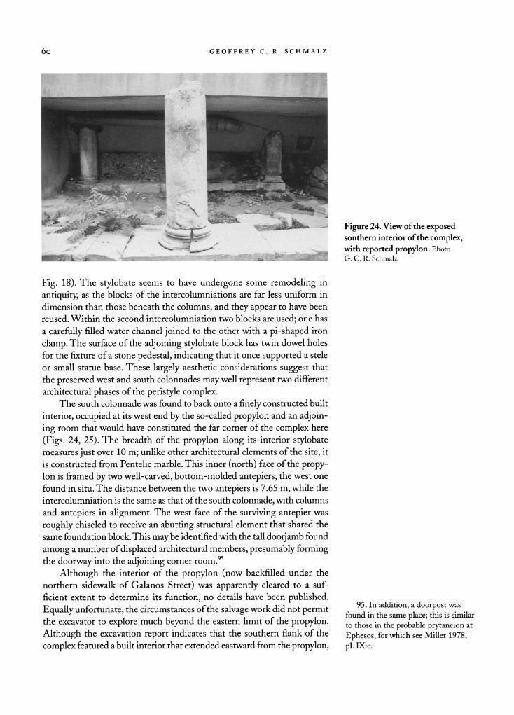
The exposed southwest corner of the site (see above, Fig. 11) was first iden
tified as a large peristyle complex in 1911 when the western corner of the
southern colonnade was cleared by Antonios Keramopoulos during a brief
salvage operation (Fig. 18). The ancient courtyard of the complex was also
sounded under the modemplateia, where a well and later cistern were discov
ered.77 The length of the standing (west) colonnade was exposed down to the
building level of its stylobate, where it was found to have been partially walled in, probably sometime in the Late Roman period. The colonnade
was cleared to an extent of just over 14.5 m from the southwest corner of
the complex to the northern balk of the excavation, under which the colon
nade presumably continues roughly to the modern intersection of Chaire
phon Street and the southern end of Hadrian Street (Fig. 22, below).
75. For examples from the Augustan
period, see the epistyle blocks from the
Roman Market (Orlandos 1967, p. 18,
fig. 22) and the so-called Augustan Stoa
in the City Asklepieion (Versakis 1908,
p. 278, pi. 9, no. 24; 1913, p. 69, fig. 25).
76. As with earlier epistyle blocks
(e.g., those from the 2nd-century Me
troon in the Classical Agora; Thomp son 1937, p. 184, fig. 110), the blocks from the proposed Prytaneion site have
an approximately 1:1 ratio between
their two courses.
77. Keramopoulos 1911, p. 260,
fig. 5. The well is numbered as feature
Y, with the mouth covered by a large
wellhead; the cistern, feature 8, was
found to have a mortared mouth and
waterproofed earthen sides. The exca
vations are now briefly reviewed in
Lippolis 1995, p. 62, fig. 18.
54 GEOFFREY C. R. SCHMALZ
ANCIENT WELL (BACKFILLED AREA)
NORTH
o CD i_ CO CO O c J5 co
O
Figure 18. State plan of the exposed southwest corner of the proposed
Prytaneion site in Agia Aikaterini
Square, as excavated in 1911 (gray area) and 1982. G. C. R. Schmalz
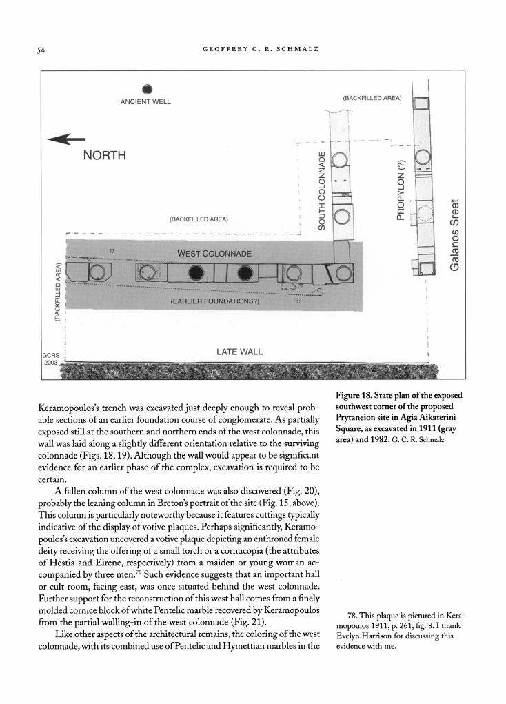
Keramopoulos's trench was excavated just deeply enough to reveal prob able sections of an earlier foundation course of conglomerate. As partially
exposed still at the southern and northern ends of the west colonnade, this
wall was laid along a slightly different orientation relative to the surviving colonnade (Figs. 18,19). Although the wall would appear to be significant evidence for an earlier phase of the complex, excavation is required to be
certain.
A fallen column of the west colonnade was also discovered (Fig. 20),
probably the leaning column in Breton's portrait of the site (Fig. 15, above). This column is particularly noteworthy because it features cuttings typically
indicative of the display of votive plaques. Perhaps significantly, Keramo
poulos's excavation uncovered a votive plaque depicting an enthroned female
deity receiving the offering of a small torch or a cornucopia (the attributes
of Hestia and Eirene, respectively) from a maiden or young woman ac
companied by three men.78 Such evidence suggests that an important hall
or cult room, facing east, was once situated behind the west colonnade.
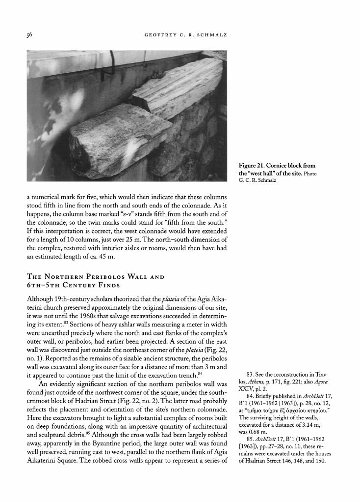
Further support for the reconstruction of this west hall comes from a finely molded cornice block of white Pentelic marble recovered by Keramopoulos from the partial walling-in of the west colonnade (Fig. 21).
Like other aspects of the architectural remains, the coloring of the west
colonnade, with its combined use of Pentelic and Hymettian marbles in the
78. This plaque is pictured in Kera
mopoulos 1911, p. 261, fig. 8.1 thank
Evelyn Harrison for discussing this
evidence with me.
THE ATHENIAN PRYTANEION DISCOVERED? 55
ww - '? 4:
'+$-f$S '
t.."^IBK
Figure 19 (left). View of the west col
onnade, with possible remains of ear
lier construction in foreground, look
ing northwest. Photo G. C. R. Schmalz
Figure 20 (right). View of the west
colonnade and aisle of the site,
looking south. Traces of fixtures for
votive plaques are visible on the dis
placed column. Photo G. C. R. Schmalz
Ionic order, is most typical of Hellenistic and Early Roman construction in
Athens. The first attested use of the twin marbles dates to the beginning of
the 4th century b.c. in the east stoa of the Asklepieion.79 In terms of work
manship, the stylobate blocks are irregularly hewn, measured, and finished.
They may thus have been converted from a prior use on the site, perhaps
having been cut down from wider step blocks of an earlier stylobate.80
Keramopoulos believed that the section of the west colonnade extending northward from the standing architrave, where the stylobate blocks take on an even more
irregular appearance, represents a second
rebuilding.81
The most direct evidence for an ancient restoration of the west colon
nade is provided by the existence of mason's marks on the top surface of its
two northernmost column bases (Fig. 18). Here the architectural members
of the colonnade seem to have been carefully reassembled after its repair or
remodeling. Both column bases were carved with a lunate epsilon, while
the southern column base is additionally marked by the Greek letter nu, which could stand for voxio? (south).82 The epsilon probably represents
79. For this and the Roman re
building, see Allen and Caskey 1911, pp. 34-39. For the original use, which
begins in the 5th century B.c. and is
well known from the 4th-century Theater of Dionysos,
see Thompson
1937, pp. 46-47; for the employment of Hymettian steps in the Hellenistic
Metroon, see also Thompson 1937,
p. 181, fig. 108. 80. Such a reuse is evident in the
east stoa of the Asklepieion; Allen
and Caskey 1911, pp. 34, 36. 81. Keramopoulos 1911, pp. 259
260.
82. On such mason's marks, see
Martin 1965, pp. 225-231; for their use
in cardinal orientation, see esp. p. 230.
56 GEOFFREY C. R. SCHMALZ
Figure 21. Cornice block from
the "west hall" of the site. Photo
G. C. R. Schmalz
a numerical mark for five, which would then indicate that these columns
stood fifth in line from the north and south ends of the colonnade. As it
happens, the column base marked "e-v" stands fifth from the south end of
the colonnade, so the twin marks could stand for "fifth from the south."
If this interpretation is correct, the west colonnade would have extended
for a length of 10 columns, just over 25 m. The north-south dimension of
the complex, restored with interior aisles or rooms, would then have had
an estimated length of ca. 45 m.
The Northern Per?bolos Wall and
6th-5th Century Finds
Although 19th-century scholars theorized that the plateia of the Agia Aika
terini church preserved approximately the original dimensions of our site, it was not until the 1960s that salvage excavations succeeded in determin
ing its extent.83 Sections of heavy ashlar walls measuring a meter in width
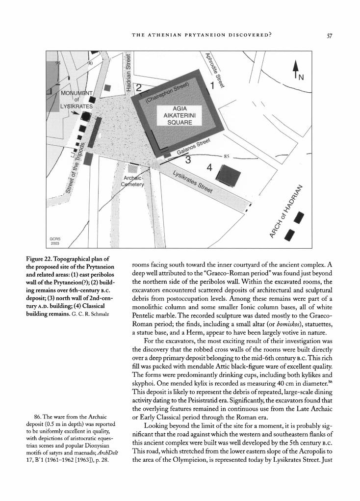
were unearthed precisely where the north and east flanks of the complex's outer wall, or per?bolos, had earlier been projected. A section of the east
wall was discovered just outside the northeast corner of the plateia (Fig. 22, no. 1). Reported as the remains of a sizable ancient structure, the per?bolos
wall was excavated along its outer face for a distance of more than 3 m and
it appeared to continue past the limit of the excavation trench.84
An evidently significant section of the northern per?bolos wall was
found just outside of the northwest corner of the square, under the south
ernmost block of Hadrian Street (Fig. 22, no. 2). The latter road probably reflects the placement and orientation of the site's northern colonnade.
Here the excavators brought to light a substantial complex of rooms built
on deep foundations, along with an impressive quantity of architectural
and sculptural debris.85 Although the cross walls had been largely robbed
away, apparently in the Byzantine period, the large outer wall was found
well preserved, running east to west, parallel to the northern flank of Agia Aikaterini Square. The robbed cross walls appear to represent a series of
83. See the reconstruction inTrav
los, Athens, p. 171, fig. 221; ?so Agora
XXIV, pi. 2.
84. Briefly published mArchDelt 17, BT (1961-1962 [1963]), p. 28, no. 12, as "i|xf|(ia to?%ox> ?? ?pxaiov Kirip?oD."
The surviving height of the walls,
excavated for a distance of 3.14 m,
was 0.68 m.
85. ArchDelt 17, BT (1961-1962 [1963]), pp. 27-28, no. 11; these re
mains were excavated under the houses
of Hadrian Street 146,148, and 150.
THE ATHENIAN PRYTANEION DISCOVERED? 57
J^^?^iC.iV'rV^^^^BI AIKATERINI 9^\ \\
/ ?; ? . Ar?ji?cV } P<cHw>\ ^^T / ?, #'
\y< \[- ^^\'^\ / ^ --""' / v-
'
^\ '
^
/ H / s ? GCRS / , / ^ ^
2003 / '
1 . |
/
Figure 22. Topographical plan of
the proposed site of the Prytaneion and related areas: (1) east per?bolos
wall of the Prytaneion(?); (2) build
ing remains over 6th-century
b.c.
deposit; (3) north wall of 2nd-cen
tury a.D. building; (4) Classical
building remains. G. C. R. Schmalz
rooms facing south toward the inner courtyard of the ancient complex. A
deep well attributed to the "Graeco-Roman period" was found just beyond the northern side of the per?bolos wall. Within the excavated rooms, the
excavators encountered scattered deposits of architectural and sculptural debris from postoccupation levels. Among these remains were part of a
monolithic column and some smaller Ionic column bases, all of white
Pentelic marble. The recorded sculpture was dated mostly to the Graeco
Roman period; the finds, including a small altar (or bomiskos), statuettes, a statue base, and a Herrn, appear to have been largely votive in nature.
For the excavators, the most exciting result of their investigation was
the discovery that the robbed cross walls of the rooms were built directly over a deep primary deposit belonging to the mid-6th century b.c. This rich
fill was packed with mendable Attic black-figure ware of excellent quality. The forms were predominantly drinking cups, including both kylikes and
skyphoi. One mended kylix is recorded as measuring 40 cm in diameter.86
This deposit is likely to represent the debris of repeated, large-scale dining
activity dating to the Peisistratid era. Significantly, the excavators found that
the overlying features remained in continuous use from the Late Archaic
or Early Classical period through the Roman era.
Looking beyond the limit of the site for a moment, it is probably sig nificant that the road against which the western and southeastern flanks of
this ancient complex were built was well developed by the 5th century b.c.
This road, which stretched from the lower eastern slope of the Acropolis to
the area of the Olympieion, is represented today by Lysikrates Street. Just
86. The ware from the Archaic
deposit (0.5 m in depth) was reported to be uniformly excellent in quality,
with depictions of aristocratic eques trian scenes and popular Dionysian
motifs of satyrs and maenads; ArchDelt
17, BT (1961-1962 [1963]), p. 28.
58 GEOFFREY C. R. SCHMALZ
one block to the east, and on the same (northern) side of the road, remains
have been uncovered of a substantially constructed building that originally dates to the Classical period (Fig. 22, no. 4).87 On the other side of the same
road, just across the street from our site, a cemetery of the 6th century b.c.
has also been discovered.88 Clearly, the urban area directly around the site
proposed for the Prytaneion had been fully developed by the 5th century b.c., with the ancient counterpart of Lysikrates Street dividing a built-up area to the north and an undeveloped patch of land, perhaps the "Field of
Famine" (Zen. 4.93), along with the cemetery, to the south.
This line of urban demarcation apparently remained more or less in
place until as late as the 2nd century A.D., when both sides of the road were
heavily redeveloped.89 Some of this later building activity has been linked
to the proposed Prytaneion site, but most of it should probably be regarded as distinct. A very large 2nd-century structure, built of well-dressed ashlar
masonry and aligned with the southern flank of Agia Aikaterini Square,
probably stands too far away (at a distance of some 10 m) to have formed part of the site, unless it represents a substantial annex (Fig. 22, no. 3).90 More
over, it was the discovery of an adjacent, Late Antique hypocaust under
Lysikrates Street that resulted in the relegation of the site to the rather
undistinguished list of the city's Roman baths.91
The South Colonnade and the "Propylon"
In 1982 the Greek Archaeological Service investigated the site proposed for
the Prytaneion once again during the course of a brief salvage campaign.92 One part of this operation entailed clearing the backfill from Keramopou los's 1911 excavation in order to expose and conserve this section of the
site (Fig. 18). A new trench reaching behind the west colonnade revealed
a parallel backing wall of substantial proportions, preserved to a height of
2.3-3.2 m. From the southwest corner of the complex the east or inner
face of the wall was exposed for a length of 15.6 m. Built from rubble
and employing a large number of reused ashlar blocks of poros limestone
(presumably from the earlier phases of the complex), this wall probably
represents a final rebuilding of the complex in the Late Antique period,
perhaps contemporary with the partial walling-in of the west colonnade.
The existence of this later backing wall may indicate that the west precinct wall of the complex was sited still further back, fully under Lysikrates Street,
87. The building was found at 15
Lysikrates Street and briefly published m ArchDelt 34, B'l (1979 [1987]),
p. 33, no. 43, with end plan; see also
a notice in Catling 1987-1988, p. 7.
88. The cemetery is noted in
ArchDelt 18, BT (1963 [1965]), p. 37, no. 17. Four well-built but very narrow
graves were found 3 m from the mod
ern sidewalk. A coin hoard dating to
the 6th century B.c. was found in one
of the graves.
89. The cemetery was evidently
built over only in the Roman period,
while the building at 15 Lysikrates Street was
substantially rebuilt in the
2nd century A.D.; see ArchDelt 18, BT
(1963 [1965]), p. 37, no. 17. Between the latter site and the proposed site of
the Prytaneion, an extensive structure
was found at 7 Lysikrates Street, ex
tending more than 7 m from the mod
ern sidewalk and built on a deep foun
dation of red conglomerate; ArchDelt
28, B'l (1973 [1977]), p. 34, no. 16. 90. The evidence for this building is
extracted from two related field reports on
neighboring excavations, under
6 Galanos Street and under Lysikrates Street just before it intersects Galanos
Street; see ArchDelt 34, BT (1979 [1987]), pp. 32-33; ArchEph 1973,
pp. 61-62, fig. 5, wall ?. The two pub
lished 2nd-century a.D. walls appear to
be sections of the same wall, measuring ca. 20 m
long. 91. See n. 50, above.
92. Vasilopoulou 1989.
Figure 23. View of southwest corner
of the complex, showing stylobate of
south colonnade. Photo G. C. R.
Schmalz
THE ATHENIAN PRYTANEION DISCOVERED? 59
I lllliillllS'l
which would allow for the reconstruction of an original aisle or halls along the west flank of the complex.
The salvage excavations of 1982 also uncovered and conserved the en
tire southwest corner of the ancient complex under the intersection of Lysi krates and Galanos Streets.93 This work revealed that the corner of the
building had been laid out at 86?, or slightly less than a true right angle. The colonnaded features and the built interior are more refined in terms of
materials and craftsmanship than later constructions on the site. Perhaps most significantly, the excavated portion of the interior displays a feature
reported in the Greek press as a propylon, or entranceway (Fig. 18).94 Al
though only the inner (north) side of the feature remains exposed, enough of
it has been cleared to suggest that it led out from the complex. In addition, various spolia from the site were recovered, including enough epistyle blocks
to represent the entire expanse of the exposed west and south colonnades.
Several large, molded toichobate blocks of Pentelic marble, presumably from the interior of the propylon, were also found.
The south colonnade of the complex was excavated for a length of 8.7
m. It features a finely built stylobate with two Ionic bases (Fig. 23). Two
monolithic columns were also recovered, one broken and the other carefully cut down. The latter column, which has since been erected at the southwest
corner of the interior peristyle, has a distinctly different coloration from all
the others along the west and south colonnades, and it may in fact belong to the interior stylobate of the complex. As excavated, this section of the
south colonnade was found adapted to its final phase of use, the second
intercolumniation having been walled in with rubble and a reused funerary column.
While the dimensions of the south colonnade column bases and col
umns are the same as those belonging to the adjoining west colonnade, the
intercolumniation is notably broader (by 0.2 m).The stylobate, constructed
from a blue-gray, ostensibly Hymettian marble, also differs distinctly from
its western counterpart. Its quality is markedly superior, and the blocks
under the columns are more regularly drawn and assembled (as seen in 93. Vasilopoulou 1989.
94. See p. 46 and n. 51, above.
6o GEOFFREY C. R. SCHMALZ
z&t&BSmti???l
es* Figure 24. View of the exposed southern interior of the complex,
with reported propylon. Photo
G. C. R. Schmalz
Fig. 18). The stylobate seems to have undergone some remodeling in
antiquity, as the blocks of the intercolumniations are far less uniform in
dimension than those beneath the columns, and they appear to have been
reused. Within the second intercolumniation two blocks are used; one has
a carefully filled water channel joined to the other with a pi-shaped iron
clamp. The surface of the adjoining stylobate block has twin dowel holes
for the fixture of a stone pedestal, indicating that it once supported a stele
or small statue base. These largely aesthetic considerations suggest that
the preserved west and south colonnades may well represent two different
architectural phases of the peristyle complex. The south colonnade was found to back onto a finely constructed built
interior, occupied at its west end by the so-called propylon and an adjoin
ing room that would have constituted the far corner of the complex here
(Figs. 24, 25). The breadth of the propylon along its interior stylobate measures just over 10 m; unlike other architectural elements of the site, it
is constructed from Pentelic marble. This inner (north) face of the propy lon is framed by two well-carved, bottom-molded antepiers, the west one
found in situ. The distance between the two antepiers is 7.65 m, while the
intercolumniation is the same as that of the south colonnade, with columns
and antepiers in alignment. The west face of the surviving antepier was
roughly chiseled to receive an abutting structural element that shared the
same foundation block. This may be identified with the tall doorjamb found
among a number of displaced architectural members, presumably forming the doorway into the adjoining corner room.95
Although the interior of the propylon (now backfilled under the
northern sidewalk of Galanos Street) was apparently cleared to a suf
ficient extent to determine its function, no details have been published.
Equally unfortunate, the circumstances of the salvage work did not permit the excavator to explore much beyond the eastern limit of the propylon.
Although the excavation report indicates that the southern flank of the
complex featured a built interior that extended eastward from the propylon,
95. In addition, a doorpost
was
found in the same place; this is similar
to those in the probable prytaneion at
Ephesos, for which see Miller 1978,
pi. LX:c.
THE ATHENIAN PRYTANEION DISCOVERED? 6l
Figure 25. Tentative reconstruction
of the southwest corner of the
complex, with reported propylon. G. C. R. Schmalz
it remains unknown whether it was constructed as an open-plan aisle or as
a series of adjoining rooms.
In its reconstructed form (Fig. 25), the propylon calls to mind the
modest type of structure used as an auxiliary entranceway for colonnaded
markets and stoa complexes. In size it is not much smaller than the east
gate of the Roman Market of Caesar and Augustus, which is sited in the
same fashion. Before the construction of the adjacent 2nd-century a.D.
building found beneath the southern block of Galanos Street, the location
of the propylon would certainly have provided a convenient point of access
from ancient Lysikrates Street, which brought traffic to and from the lower
city around the Olympieion. Since the exposed remains of the site's southwest corner have yet to be
properly excavated, their dating can only be based on stylistic considerations
and the varying qualities of workmanship and material. It appears, none
theless, that this corner of the building complex underwent a great deal of
rebuilding over several centuries. At the very least, the salvage excavations
of 1982 have demonstrated that the remains at the site proposed as the
Prytaneion are a good deal older and more architecturally sophisticated than once thought. Certainly the newly exposed southern features of the
complex have every appearance of being pre-Roman in date, while the
propylon, with its excellent materials and uniform use of Pentelic marble, would not seem out of place in a Late Classical context. A notably large
peristyle complex of civic significance is now clearly attested under Agia Aikaterini Square. With an estimated size of ca. 45 m (N-S) by 65 m
(E-W)?slightly less than half the size of the Roman Market of Caesar
and Augustus?the Prytaneion represents the third largest structure of its
kind known from ancient Athens.
62 GEOFFREY C. R. SCHMALZ
WIDER ARCHAEOLOGICAL CONTEXT
The Street of the Tripods and Lysikrates Square
In antiquity the proposed site of the Prytaneion was across from the Street
of the Tripods, sharing a moderately large square with the Monument of
Lysikrates and its choregic neighbors (as reconstructed in Fig. 26). The
modern Lysikrates Square occupies much of this area. As with the ancient
counterpart to Lysikrates Street, documented to have run from the old
section of the city to the Olympieion,96 this square was developed as early as the 5th century b.c. At that time, a substantial building already stood at
the southwest corner of the ancient plateia?1 while to its north (along the
west side of the square), a significant cult area was in regular use. Choregic monuments of relatively modest size had also begun to make their ap
pearance along the Street of the Tripods in this vicinity. It is possible, but
by no means certain, that all of these features were associated with the
administration and celebration of the nearby cult of Dionysos.
By the late 4th century b.c., the square was further embellished with a
long, rather shallow stoa, perhaps forming part of the Lykourgan building
program. Most famously, the Monument of Lysikrates, along with eight
surviving counterparts (including the lost Lantern of Diogenes), now
dominated this civic center.98 The sculpted superstructures of these monu
ments must have been sufficiently raised to be seen above the roofline of
the fronting stoa.
This square probably marked a significant intersection in antiquity. The road from the Archaic harbor at Phaleron (found under the modern
road of that name, with pavements dating as far back as the 5th century
b.c.) would have had its terminus here, meeting the Street of the Tripods and the ancient counterparts of Hadrian and Lysikrates Streets below the
front of the Acropolis.99 Indeed, anyone arriving in Archaic Athens by sea
and passing through the city's south gate would have entered the heart of
the city at this point.100 The Archaic Agora was presumably situated just
beyond. Investigations of these ancient streets (especially the Street of the
Tripods and Hadrian Street) by the Greek Archaeological Service have
96. Trivios, Athens, p. 253.
97. On this development, see Wil
son 2000, p. 209.
98. See Choremi-Spetsieri 1994,
pp. 32-34, fig. 2. Travlos, Athens, p. 567,
fig. 710, still provides the best archaeo
logical plan of the square, with the
choregic monuments numbered from
north to south. Nos. 1-4 represent the
first or northern group (with the
Monument of Lysikrates out of order
as no. 1); nos. 5-8 represent the second
or southern group. Welter (1922) was
the first to enumerate the four northern
choregic monuments, numbering them
from the south so that the Monument
of Lysikrates is no. 3. This group includes the foundations of two other
choregic monuments located one block
north of Lysikrates Square, just past
the intersection of the Street of the
Tripods and Kydathenaion Street
(at 28 and 34 Tripods Street). For the monument at 28 Tripods Street (now
the headquarters of the Hellenike
Hetaireia), see Choremi-Spetsieri 1994,
pp. 34-35, fig. 2 (giving no street ad
dresses). The first formal publication of
the existing monument foundation at
34 Tripods Street may be found in Miller 1970, pp. 223-227; see also Schnurr 1995b. The original report for
the monument at 28 Tripods Street
appeared m ArchDelt 44, B'l (1989 [1995]), pp. 18-19, fig. 2; see also
French 1989-1990, p. 5;Tomlinson
1995-1996, p. 4.
99. A new section of the Phaleron
road was recently excavated at 18 Caval
lotti Street, revealing successive pave ments from the 5th-4th centuries b.c.;
see ArchDelt 37, B'l (1982 [1989]), pp. 21-23; French 1990-1991, p. 7.
100. For the road and the south gate in general, see Travlos, Athens, pp. 160,
169-170, fig. 219 (Gate X); cf. also
Papadopoulos 1996, pp. 109,112; 2003,
pp. 285-288.
THE ATHENIAN PRYTANEION DISCOVERED?
MONUMEN OF
Lysikrates
(LOST x
V \ UNTERN OF > ?
DIOGENES) ? N
Archaic Agora
^^ h^^c
&&'?
' * \r \
-i'. ?.--*
A?
?_l^f-.?V_^
.7* fcTkt? BUILDING.
Archaic
Cemetery
Figure 26. Reconstruction of ancient
Lysikrates Square. G. C. R. Schmalz confirmed 19th-century reconstructions of the area (e.g., Fig. 27).101 Like
the Phaleron road, ancient Lysikrates Street must have formed a cardinal
line within the southeastern quarter of Athens, taking its orientation from
the visually dominant Cave of Aglauros, which overlooked the early shrines
of the Ilissos river valley. Today the Arch of Hadrian still expresses the
importance of this line, standing in monumental fashion as "an urbanistic
hinge."102
In the early 1980s the Greek Archaeological Service, under the di
rection of Korres, excavated in Lysikrates Square and established that the
upper course of the Street of the Tripods had been repeatedly repaved from
the 4th century B.c. to the 1st century A.D.103 The substantial remains of
a 5th-century B.c. building just to the south of Korres's excavation had
already been partially excavated by Ioannis Miliades in 1955. Although this ancient structure was initially regarded as a private house, its walls,
extending more than 6 m in length, were remarkably substantial (Fig. 26).104
101. For the ancient Street of the
Tripods, see
Choremi-Spetsieri 1994,
p. 33, fig. 2. Following the work of
Korres, the course of ancient Hadrian
Street has been fully plotted in this
neighborhood from the corner of Flessa
Street to Aphrodite Street; see Korres
and Skilardi 1989, fig. A (end plan). Running southward, the street veers
steadily westward 1.5-3 m from the
course of the modern street; see Korres
1989a; French 1990-1991, p. 6. For
the 19th-century reconstructions, see
Curtius and Milchhoefer 1891, p. 105,
fig. 18; Curtius and Kaupert 1881?
1903, fase. 5, pi. La.
102. Post (1998-1999, pp. 173-174; see also S?GXLVIII 238) writes, "dem isolierten Bauwerk kam also die
Funktion eines urbanistischen 'Schar
niers' zu."
103. See Korres 1988c, p. 6, fig. 1;
French 1989-1990, p. 5. According to Korres (1988c, p. 5), the successive
pavements have a total depth of 0.5 m.
104. Miliades' excavation was
never published, although it was
briefly reported by Vanderpool (1957, p. 281). See also Travlos 1960, p. 81,
n. 3; Athens, pp. 566-567, fig. 710,
no. 10; also Kazamiakes 1994, p. 43,
n. 4; Choremi-Spetsieri 1994, p. 32,
citing the "remains of a monument."
Schnurr (1995b, pp. 146-147) still
regards it as a "private house."
64 GEOFFREY C. R. SCHMALZ
Figure 27. Detail of Curtius's plan of ancient Athens, depicting the
proposed Prytaneion site and ancient
roadways. After Curtius and Kaupert
1881-1903, fase. 5, pi. La
Korres's investigations revealed that subsequent, extensive building activity of the 4th century b.c. was carried out in a way that did not interfere with
this building, which must therefore have remained in use at the time and
may well have been something more than a private residence.
Korres has further demonstrated that Miliades' building stood next to
a significant cult site in the 5th century B.c. Under the 4th-century stoa, the excavator discovered a large Classical ritual deposit (apothetes) of leky
thoi, or libation jars. All of the lekythoi were decorated with Dionysian ivy leaves. Next to this apothetes a formal space was found, featuring a ritual
well and surrounding floor area, around which were strewn more cult ves
sels dating to the 5th century, including both lekythoi and kyathoi, or spe cial cups. Korres suggested that these and other finds were indicative of
cult use.105
Yet another large and relatively early building had previously been
discovered just across the street from Korres's excavation. At the corner of
Tripods Street and Lysikrates Street, the Greek Archaeological Service
excavated the remains of a substantial ancient wall running parallel to
Lysikrates Street for a length of 7 m.106This wall, constructed on a deep foundation of red conglomerate, may represent the north end of the build
ing, as a terracotta drainage pipe was found along the north side of the
structure. As it extended to the northwest, this structure may nearly have
adjoined the building excavated by Miliades.
In the 5th century B.c., Lysikrates Square thus featured a significant
complex of public buildings including an important cult space. These would
have faced the west side of the proposed Prytaneion site, only 10-15 m
105. This deposit was initially reported by the Greek press in 1982 and 1983; see the notice and quotation in Catling 1982-1983, p. 8; Touchais
1983, p. 750. On the apothetes, see
Mesemvrini, November 27,1982.
On the floor with well and cult deposit, see
Vradyni, February 18,1983. On the
significance of the cult sites, see also
Papadopoulos 2003, p. 284, n. 81.
106. At 7 Lysikrates Street, and
briefly mentioned in ArchDelt 28, B' 1
(1973 [1977]), p. 34, no. 16. The exca
vators found insufficient evidence for
dating the remains precisely.
THE ATHENIAN PRYTANEION DISCOVERED? 65
away. It may be tentatively suggested, therefore, that these structures were
civic offices in the neighborhood of the Prytaneion. With the Sanctuary and Theater of Dionysos very close to the ancient square, this area would
have been an eminently logical location for the Boukoleion of the archon
basileus.The Boukoleion also served as the headquarters of the four phylo basileis, or early Athenian tribal kings, who supervised the court in the
Prytaneion. If the ritual vessels excavated by Korres are in fact Dionysian in character, then the festivals of the City Dionysia and the Anthesteria,
including the sacred marriage between Dionysos and the wife of the archon
basileus (basilinna), may also have taken place here.107
The Rebuilding of Lysikrates Square
Korres's excavations have further revealed that the whole of ancient Lysi krates Square underwent a dramatic remodeling in the 4th century b.c.
It is quite likely that this program belongs to the wide-scale building
program of Lykourgos between 338 and 326 b.c., when virtually all the
major public spaces of Athens were rebuilt, often with stoas and colonnaded
enclosures.108 The embellishment of Lysikrates Square principally entailed
the construction of a relatively long and narrow stoa facing east onto the
ancient square and the Prytaneion site (Figs. 28,29).109 To judge from the
quality of its building material and construction technique, the stoa must
have been a fairly lavish public work. Its back wall stood along the east
side of the Street of the Tripods, which was over 8 m broad at this point. It was carefully constructed of limestone, with well-dressed toichobate and
orthostate courses, resting on a solid foundation of conglomerate blocks
(Fig. 29). Two of the limestone blocks are exposed in situ. Against the
excavated section of this back wall, cuttings in the 4th-century pavement indicate the presence of a small monument that once faced the street. A
deep foundation wall for a colonnade was discovered east of and parallel to the back wall.
With a breadth of ca. 4 m for the stoa, its single aisle is notably shallow
in depth (just over 3 m). Yet given the scale of the remains and its materials, Korres has suggested that the building's other dimension, running along the length of the road, must have been large. The 4th-century stoa could
have extended some 10-20 m north along the Street of the Tripods, thus
delimiting the west side of the ancient square. The redevelopment of the ancient square involved a great deal of
landscaping and some demolition, with many of the earlier, 5th-century features being filled in. Additionally, the steep slope along the west side
of the Street of the Tripods was radically cut back, at least in parts, and
terraced with a retaining wall, while a new road surface was laid out over
a relatively deep fill. The water runoff along the west side of the road was
107. This evidence evokes the
previously noted imaginings of the
anonymous 15th-century visitor; see p. 48 and nn. 59-60, above.
108. For the Lykourgan building
program in general, see most recently
Camp 2001, pp. 144-154; Mitchel
1973, pp. 196-197,203-204. 109. Korres 1988c, p. 6, fig. 1.
66 GEOFFREY C . SCHMALZ
Figure 28. The Street of the Tripods. View to the north, toward the Mon
ument of Lysikrates, with remains of
4th-century stoa in the foreground.
Photo G. C. R. Schmalz
drained southward through a newly installed, U-shaped terracotta pipe. A
modest commemorative monument, placed against the excavated section
of retaining wall, was discovered south of the Monument of Lysikrates.110 The larger choregic monument immediately to the south of the monument
was found, meanwhile, to rest on the remains of an earlier monument of
the 5th century. In addition, excavations just to the north, closer to the
center of the modern plateia, revealed a rectangular structure built of large
conglomerate blocks, also dating to the 4th century.111 The presence of the 4th-century stoa would help to explain the great
height of the contemporary choregic monuments. In order for their com
memorative superstructures to be seen from the square, they would have to
have been raised above the level of the stoa's roof. The top of the pedestal for the Monument of Lysikrates would have been nearly level with the stoa's
roofline (Fig. 29). If this reasoning is correct, the stoa would then have to
have been built before 335/4 B.c., when the Monument of Lysikrates was
dedicated.
In antiquity, Lysikrates Square was clearly an important locus within
the city of Athens. It remained so for the rest of antiquity, as the 4th-cen
tury B.c. stoa was built over only in the 5th century A.D., when much of
this neighborhood apparently underwent another period of major rede
velopment. In this later period, much formal or perhaps even ritual dining
appears to have gone on nearby; a deep rubbish pit, filled with a consider
able quantity of animal remains, was found behind the 4th-century B.c.
retaining wall.112 As for the newly discovered stoa, the fact that it is one of
110. The retaining wall is referred
to as T 1 and the monument plinth as bathro VI in Korres 1988c, pp. 5-6,
fig. 1. The east slope was cut back to a
height of almost 2.5 m, with the retain
ing wall built directly on the newly
ex
posed bedrock at an absolute elevation
of 80.43 m. The road, meanwhile, was
leveled with a deep fill of 0.5 m above bedrock (at an elevation of 80.80 m).
111. See Catling 1982-1983, p. 8; Touchais 1983, p. 750.
112. For the rubbish pit, see Kor
res 1988c, p. 7; see p. 7, fig. 1, for the
4th-century wall (unnumbered), built
between the back wall and colonnade
of the stoa at a slightly different angle;
also Touchais 1983, p. 750. On the
contraction of Athens beginning in the
early 5th century a.D., see Thompson
1959, esp. pp. 66-67.
THE ATHENIAN PRYTANEION DISCOVERED? 6j
Monument of Lysikrates
01 2
4th-c. retaining wall
(with reused 5th-c. base)
5 10
Roofline
15 meters
(location of 5th-c. feature)
4th-c. Stoa
GCRS 2003
East
Figure 29. Archaeological cross
section of the Street of the Tripods at
Lysikrates Square, with 4th-century stoa. After Korres 1988c, p. 6, fig. 1
only two completed in Athens during the 4th century b.c. further under
scores the significance of this area of the city.113 With its modest depth the stoa may well have been designed as a
decorative backdrop for the square. It would have provided shelter not
only for passersby, but also for the statues and other public monuments
that undoubtedly crowded the square. Korres's excavations uncovered a
life-sized, Hellenistic statue of a draped male figure.114 The stoa also would
have been an appropriate setting for the famous statue of Agatha Tyche that Lykourgos set up by the Prytaneion to mark his creation of a civic
cult of good fortune. A votive dedication to Agathe Tyche has indeed been
found nearby.115 The stoa also served to terrace the gently sloping ground here, so that the Street of the Tripods, running behind the stoa, could be
leveled more easily. Korres's excavations have revealed that the natural slope of the area increases dramatically on the east side of the stoa, dropping 10
cm over a distance of only 1 m.116
This reconstruction of ancient Lysikrates Square, bounded to the east
by the site of the Prytaneion, would explain the remarkable concentration of
large choregic monuments along this short section of the avenue. In antiq
uity, these monumental trophies would have been clustered in prominent and possibly related locations, around the entrance to the Theater of Dio
nysos and in the nearby square, where the city's Dionysian processions may have taken place. Against this background, it is easy to picture Demetrios of
Phaleron, the late-4th-century tyrant of Athens, taking (as an old anecdote
records) his customary afternoon stroll down the Street of the Tripods, beset
by crowds of boys ambitious to become one of his favorites.117
113. The only other stoa completed
in the 4th century b.c. was the so-called
east stoa of the nearby Asklepieion; see
Coulton 1976, p. 46.
114. This was reported by the Greek
press in 1983; see Catling 1982-1983, p. 8; Touchais 1984, p. 742.
115. See ArchDelt 21, BT (1966 [1968]), p. 39, pi. 61:a. The statue is
described by Aelianus (VH9.39) as
standing npbq tco rcp-DToeveico; cf. Plin.
HN36.23. On this statue and its rela
tionship to the Prytaneion, see Gerhard
1849; Tracy 1994.
116. See Korres 1988c, p. 6, fig. 1.
The rapid drop in absolute elevation is
from 80.8 m to 80.7 m.
117. Ath. 543a. A similar image first struck Welter (1922, p. 75); more
recently, see Schnurr 1995b, p. 146.
68 GEOFFREY C. R. SCHMALZ
THE EPIGRAPHIC RECORD
Much of the epigraphic record from the vicinity of the Agia Aikaterini site
reflects directly upon the Prytaneion and its long and diverse public life.
The inscription on the Arch of Hadrian (IG II2 5185) alluding to the
"City of Theseus" is just one of a suggestive corpus of epigraphic material.
Altogether, more than 30 inscriptions, ranging in date from the 5th cen
tury b.c. to the late 4th century a.D., have been found in the immediate
neighborhood. To judge from their excellent state of preservation, most of
these inscriptions would seem to have been moved only a short distance
from their original contexts. The earliest epigraphical finds include choregic dedications and, most significantly, inscriptions concerned with the civic life
of the Prytaneion. The later material includes a series of archon lists that
may have originated in the Prytaneion and a number of statue dedications, the most important of which is a dedication to Hestia. The Late Antique
inscriptions in the corpus clearly indicate the public significance of this
area, which is one of five contemporary locations in Athens where there is
evidence for intensive dedicatory and building activity.118 Indeed, with the
destruction and demise of the Classical Agora in the late 3rd century A.D., it is likely that the political and administrative activity of Athens reverted
back to this part of the city.
Classical and Hellenistic Inscriptions from the
Prytaneion
The earliest inscriptions from ancient Lysikrates Square are choregic monuments. Two such dedications have been found here, both dating to the later 5th century B.c. One of these, built into the foundations of a
house on lower Hadrian Street once belonging to the philhellene George
Finlay, has recently been republished as part of the epigraphical collection
of the British School at Athens.119
The other extant, early inscriptions from around modern Lysikrates
Square pertain to the civic and ritual life of the Prytaneion. Significantly
enough, one 4th-century inscription, discovered intact in the first modern
excavation of the Monument of Lysikrates, appears to deal with public maintenance in the Prytaneion.120 Even more compelling is the so-called
Prytaneion Decree of the 2nd century b.c., honoring the holder of a new
office for the Prytaneion. This magistrate is praised for having given proper sacrifices to Eirene, the Goddess of Peace, whose cult image was located in
the Prytaneion, as well as offerings for "the health and safety of the council
and the people, the women and children [of the city], the allied Romans, and
friends and benefactors."121 The Prytaneion was the traditional location for
118. The corpus of inscriptions from
the area is conveniently summarized
by H. Riemann in RE Suppl. VIII, 1956, cols. 882-887 (a-t), s.v.
tr?podes. For the Late Antique examples,
see
Sironen 1994, with ?g. 2:b (end plate). 119. IG I3 959 (= IG I2 771), mis
leadingly identified as adLysicratis monumentum. The other 5th-century
choregic monument is IG I3 961
(= IG I2 669) (baudprocul a Lysicratis monumento).
120. See IG II2 608, with analysis in Osborne 1981, p. 154, n. 4. This
inscription was discovered during the
19th-century French restoration of the
Monument of Lysikrates; see Pottier
1878, p. 415, no. 1.
121. See IG II21000 and analysis in
Osborne 1981.
THE ATHENIAN PRYTANEION DISCOVERED? 69
such public observances relating to the city's allies, benefactors, and general external well-being. Similarly, public sacrifice on behalf of the Romans was
also a regular rite during the 2nd century b.c. in the prytaneion at Delphi; as one inscription reads, "They granted it to him to go into the pryta neion for the sacrifice of the Romans."122 There is also evidence that dur
ing the 2nd century b.c. Athens created a new office in the Prytaneion to
supervise the public reception of the city's friends and allies.123
The Roman Archon Lists and Related
Inscriptions
During the course of the past century, a series of well-preserved archon lists
of the Augustan and Julio-Claudian periods have been found at or near
the Monument of Lysikrates, and scholars have speculated that the corpus
may have originated in a neighboring public building.124 The most logical source would be the Prytaneion, in its venerable function as the office of
the eponymous archon. Korres's excavation of the square turned up another
example, an intact list dating to the 2nd century A.D.125
Most of the archon lists are early to mid-Augustan in date. They consist of small marble stelai commemorating the appointed members of
the city's annual board of nine archons and their functionaries. Given the
long association between the office of archon and the Prytaneion, their
significance is obvious.126 Of the six archon lists that have come to light in the immediate vicinity of Lysikrates Square, some were found at the
Monument of Lysikrates, others along Lysikrates Street by the proposed site of the Prytaneion; another list (IG II2 1717) was found on the site it
self127 Evidently, these inscriptions were not moved far from their original commemorative setting, for only this particular group of archon lists is so
well preserved. Those from the other major findspot of archon lists, the
Acropolis, are extremely fragmentary. They were probably broken up and
transported there as ready building material at a much later date.128
122. Miller 1978, p. 188, nos. 293,
296.
123. The epigraphic evidence is
presented in Vanderpool 1971, p. 441;
see also Miller 1978, p. 170, n. 203.
For the new office, charged with "the
reception of friends and allies," see
Miller 1978, p. 21, and esp. Osborne
1981, p. 156.
124. /GIF 1717-1719,1723,1727.
Dragoumis 1915, p. 6; Dow 1934,
pp. 183-184.
125. The discovery in 1983 of this archon list within the cemetery of
the Byzantine and Turkish periods is
reported in Touchais 1987, p. 525.
126. As noted above (n. 3), "the
archon had the Prytaneion" (Ath. Pol.
3.5). See also Miller 1978, pp. 44-45;
Shear 1994, p. 228; and Robertson
1998, pp. 298-299.
127. The list found in Korres's exca
vations (n. 125, above) has been dated
to ca. a.D. 125-150: Touchais 1987,
p. 525; Pariente 1990, p. 706. For the
findspots of the previously known lists
(n. 124, above), see esp. Dow 1934.
Those found ad viam Lysikratis include
IG II21717 (on the north side of the
street; see Dragoumis 1905; 1915, p. 6)
and IG II21718; IG II21719 was found ad viam Lysikratis, ubi olim odeum Peri
cas erat (on the slope above the Odeion
of Perikles, where it presumably fell
while being carted off to the Acropolis from the southeast; see Kastriotis 1914,
pp. 165-166, fig. 22). Those found
prope monumentum Lysikratis include
IG II21723 and 1727; for the latter, see Philadelpheus 1921, p. 90. From
further to the southeast comes IG II2
1721, which was found in the First
National Cemetery (Fimmen 1914).
128. Six archon lists are poorly
preserved from the Acropolis: IG II2
1720 and 1724 (Dow 1934, p. 159), /Gil21730 and 1731 (Graindor 1927b,
p. 292, no. 68), and IG II21735 and 1736. For their state of preservation, see Dow 1934, pp. 154,162,171,
figs. 4, 8, 9,13. The fragments of two
other lists were uncovered near the
Tower of the Winds; Dow 1934, p. 184. The beautifully preserved list IG II2
1722 was removed to Paris, via Istan
bul, at an early date and is now lost;
see Dow 1934, pp. 158-159, fig. 7.
7? GEOFFREY C. R. SCHMALZ
Two of the relevant local archon lists (IG II2 1717 and 1727) are so
close in workmanship, wear patterns, and provenance (by the Monument
of Lysikrates) that Sterling Dow suggested that "they were set up, as they were found, near together, in the Street of the Tripods"; he also argued that,
in view of their lack of explanatory headings, "we must infer that [their]
purpose was universally understood, or perhaps was clear from their being set up in some obvious location near a public building or monument."129
An earlier scholar had already argued from this and other epigraphical evidence that an important public building once stood on the ancient
course of Lysikrates Street.130 Thin and diminutive in size, these stelai were
clearly designed for display on a wall, and they were probably set up as a
series of such inscriptions. At least one (IG II2 1721), like a modest votive
offering, was "cut to be set in some
given aperture."131 Dow was the last
scholar to wonder why these archon lists were displayed in this locale. The
most probable answer now seems to be that as late as the Roman period, the board of archons shared an official or commemorative space in this
area, presumably centered in the Prytaneion itself.
Individual members of the Athenian board of archons are also com
memorated in the neighborhood's epigraphical record. Found together with
one of the archon lists {IG II21727) was a commemorative herm, erected
at the beginning of the 3rd century A.D. by the archon Claudius Phocas
of Marathon. It was dedicated to Agathe Tyche, whose famous image by Praxiteles stood by the Prytaneion itself.132 Additionally, the base for an
honorific statue dedicated to the archon thesmothetes M. Ulpius Flavius
Teisamenos was recovered from the church of the Agia Kyra Kandili, which
formerly stood between the Monument of Lysikrates and the proposed
Prytaneion site.
This inscribed base is especially significant, for it would appear to be the
remains of the bronze statue once awarded to Teisamenos in the Prytaneion. The statue was part of the package of honors decreed for his father, the
consular M. Ulpius Eubiotos Leuros of Gargettos, the great 3rd-century Athenian benefactor.133 Interestingly, the statue of Teisamenos remained
in place during the following centuries, being reused twice in contexts
appropriate for the Prytaneion. It was first reinscribed to honor a 4th-cen
tury archon who also held "the office of the president of the [Eleusinian]
panegyris festival" and probably enjoyed family ties to the sanctuary and
priesthoods at Eleusis.134Two other monuments relating to the priesthoods
129. Dow 1934, p. 184, n. 1, and
p. 183; cf. p. 149.
130. Dragoumis 1915, esp. p. 6 (the
Sanctuary of Pythian Apollo). 131. Dow 1934, p. 142; the inscrip
tion commemorates the archonship of
Polyainos of Sounion (14/13 b.c.). Two
distinct methods or phases
were ob
served by Dow in the fashion of their
display: the earlier stelai (e.g., IG II2
1717,1718,1720) were placed with
clamps set low on their sides, while
IG II21721 had clamps set into the
sloping roof of its crown molding;
see
Dow 1934,pp. 150 (/Gil21717), 157
(/Gil21718), 158 (/Gil21720,1721), and 183 (generally).
132. See the dedication,prope monu
mentum Lysicratis, in IG II2 3681; it was excavated by Philadelpheus (1921,
p. 91).
133. See the dedication to Teisa
menos in IG II2 3701 (EM 10512); for Eubiotos's statue in the Prytaneion, cf. Miller 1978, p. 17. On the duplicate decrees for Eubiotos, a.d. 229-231,
see Miller 1978, pp. 176-177, nos. 236,
237; see also IG II2 3697-3700. The statue bases for Teisamenos's brother,
M. Ulpius Pupienus Maximus, are also
preserved (IG II2 3702, 3703). For the
original analysis of these honorific
decrees, see Oliver 1951 (esp. p. 353, no. A.2, for the bronze statues).
134. IG II2 3692. For the corrected
date and especially for the Eleusinian
connection, see the excellent discussion
in Sironen 1994, pp. 26-28, under
no. 11.
THE ATHENIAN PRYTANEION DISCOVERED? Jl
of Eleusis were found a block away, around the Arch of Hadrian. One of
these was a dedication by a late member of the great dadouchic clan of
Roman Athens, the Lysiades/Leonides family of Melite; the other was a
commemorative herm for an early-3rd-century dadouchos.135
The second reuse of the statue for Ulpius Eubiotos represents a par
ticularly important document for Late Roman Athens. It commemorates
Plutarchos, perhaps the famous 5th-century neo-Platonist who became
scholarch of the Academy. The city awarded this statue to honor his pa
tronage of the Panathenaic festival, noting that he "rode the sacred ship and brought it near to the Temple of Athena three times, thus spending his entire fortune."136
Certain Eleusinian officials and the chief officers of the Panathenaia
were traditionally allowed privileges of maintenance in the Prytaneion. If nothing else, these dedications demonstrate that the immediate area
of Lysikrates Square remained a prominent monumental space into
late antiquity. This is further attested by the base of another important
4th-century statue preserved in the nearby church of Agia Aikaterini.
The statue was dedicated on behalf of the city to Theodoros, the popular
provincial governor under Theodosios I (a.D. 379-395). Replacing an
earlier marble statue for the official, the base reads, "You see the leader
Theodoros, who saved all the Greeks and their cities with [his] law, well
and gently administered."137 The Theodoros dedication suggests that
this quarter of the city served as the political center of Late Antique
Athens, with the site of the Prytaneion possibly representing the chief
civic building.
Dedications to the Gods: Hestia and Other
Deities
The most suggestive inscription from the site proposed for the Prytaneion is a dedication to Hestia, originally found in the now-demolished church of
the Agia Kyra Kandili and later moved to the Middle Byzantine church of
Agia Aikaterini (Fig. 30). The inscription records the dedication of a large bronze votive statue erected by a late Julio-Claudian family.138 Although it
was a private offering, it was officially sanctioned by the city epimeletes of
Athens, the chief civic official in charge of the general use of sacred spaces in the 1st century A.D. The involvement of this magistrate would there
fore seem to indicate that the statue was erected in an important public
sanctuary, most logically the Prytaneion itself.139 The monument evidently
enjoyed a long life as a votive, for the base of the statue preserves an earlier
135. See /Gil2 3613 and 3684,
respectively. Also found near the Arch
of Hadrian is the ephebic catalogue IG II2 2042, dating
to ca. a.d. 135.
136. See/Gil2 3818, shown in
Agora XXIV, pi. 47:e. For this inscrip tion as important late evidence for the
Panathenaia and the course of the
Panathenaic Ship, see
Agora XXIV,
p. 63; Nagy 1980, esp. pp. 109-111;
also Thompson 1959, p. 65. For a full
discussion of the historical context, see
Sironen 1994, pp. 26-28, no. 11, and
pp. 46-48, no. 29 (IG II2 3818). 137. IG II2 4223; see PLRE I,
p. 898, Theodoros 16. It remains in
the church, where it serves as an altar
support; Sironen 1994, pp. 31-32,
no. 15; also Keramopoulos 1911, p. 259, n. 1.
138./Gil2 3185 (EM 10613). 139. In the prytaneion
on Delos,
for example, dedications of images of
Hestia were common from the 4th
century b.c. onward; see Miller 1978,
pp. 185-187, nos. 286,287.
GEOFFREY C R . SCHMALZ
Figure 30. Statue base for a dedi
cation naming Hestia, Apollo, the
Theoi Sebastoi, and the Athenian
state, IG II2 3185. Photo G. C. R.
Schmalz
inscription, a dedication of the 4th century b.c. in honor of a certain Epi kleides of Acharnai, perhaps an agonistic victor ofthat period.140
The statue was dedicated not only to Hestia, but also to Apollo, the
imperial house, and the governing bodies of Athens. The inclusion of
Apollo is directly relevant, since his worship, too, was part of the religious life of the Prytaneion.141 The statue base, along with its inscription, was first
recorded by Jacob Spon in the 1670s, who found it built into the church of
Agia Kyra Kandili, constructed over the recently demolished Lantern of
Diogenes.142 In the early 19th century, Pittakis recorded the dedication in
the same location. Given the nature of the dedication, together with the
fact that the church itself celebrated the Holy Lady of the Lamp, Pittakis
ingeniously concluded that in antiquity a shrine to Hestia was located
nearby.143 Such a shrine would necessarily have been situated in the Pry taneion. In the early 20th century, the same dedication and its findspot
prompted another scholar to suggest that the Sanctuary of Pythian Apollo was to be found somewhere along modern Lysikrates Street.144
Pittakis also saw an inscribed architrave block built into the same
church that records a dedication of an image of Pallas Athena to "the gods and the city."145 This statue, which probably dated to the 2nd century a.D.,
was supervised by the ancient "Bouzyges and Priest of Zeus in the Pal
ladion" and installed with formal permission from the oracle of Apollo at
140. See /Gil2 3833 (EM 10613); this individual is otherwise unknown to
Athenian prosopography. Such a simple
text might well imply the commemora
tion of some earlier civic hero. The foot
cuttings would appear to indicate that
the statue exhibited some movement.
The deme of Acharnai was notable for
its athletes, as well as its hoplites (see,
e.g., Pind. Nem. 2).
141. This is attested in IG V 137
(= IG I2 78), lines 5-6 (a ceremonial throne for Apollo in the Prytaneion).
Aikaterini by Mommsen [1868 [1977, p. 60, under no. 52; perhaps the inscrip tion had been moved there in the inter
vening decade.
144. Dragoumis 1915, p. 6.
145. IG II2 3177; the block was noted slightly out of context by Pittakis
(1835, p. 169), with precise provenance
given in Mommsen [1868] 1977, p. 60, no. 52. The Augustan date (in Graindor
1927a, p. 140) is almost certainly incor
rect; the priest (Polyainos of Marathon)
is mistakenly identified with the archon
of 14/13 b.c., Polyainos of Sounion,
and the lettering appears much later.
THE ATHENIAN PRYTANEION DISCOVERED? 73
Delphi.146 Hence the new statue may have replaced the original cult image, which was traditionally worshipped in the Palladion Sanctuary of Zeus. Yet
one would imagine that such a heavy architectural member would not have
been removed very far from its original setting. It is probably more likely that the dedication took place in the Prytaneion, since the city's common
hearth was also "a place sacred to Pallas."147 The inscribed epistyle block
could then represent the architectural remains of a 2nd-century A.D. shrine
in the Prytaneion.
The Dedication of Theophilos of Halai
A final noteworthy inscription from the vicinity of the proposed Pryta neion site is the well-known dedication of an Augustan epimeletes of the
Prytaneion, Theophilos of Halai (Fig. 31).148 Until recently stored in the
Roman Market, on the porch of the Fethiye Tzami, the Mosque of Mehmet
II the Conqueror, the dedication had been built into a neoclassical house
at 20 Tripods Street.
0?O(plAO? ?lO?C?pOl)
A?aoue'?? ?mji?[Ar|]Tn[?]
yevojievo? TcpmocveioM
Theophilos, son of Diodoros, of Halai, the epimeletes of the Prytaneion [dedicated it].
The votive was offered to commemorate Theophilos's euergesia, or benefac
tion, at the conclusion of his service as special project supervisor. Recent
studies have consistently regarded this findspot as an approximate marker
for the location of the Prytaneion, and in one instance, the Prytaneion is
claimed to have been located precisely at this spot along the Street of the
Tripods.149 As it turns out, however, this provenience merely represents the inscription's final reuse in the modern period. The dedication was first
seen and transcribed by the site of the Prytaneion proposed here. In 1678, the inscription was published by Spon, who found it next to the house of
the French consul and pioneering antiquarian Giraud, whose residence
stood near Agia Aikaterini Square.150 That modern square is therefore the
findspot for two dedications from the Prytaneion: Theophilos's votive and
the late Julio-Claudian offering to Hestia.
Although every study of the Prytaneion and the Archaic Agora of
Athens has invariably cited the Theophilos inscription, a great deal re
mains to be said about it. The simple offering was likely to have been in
146. The priesthood is recorded
in the Delphic letter SEGXXX 85
(= /Gil21096). 147. See Miller 1978, pp. 180-181,
nos. 257,258 (= scholion on Aelius Aris
tides 103.16 [A226]); the relationship derives from the tradition of Ionian
colonists, as suppliants of Athena,
taking their sacred fire from the com
mon hearth in the Prytaneion. For the
connection between the Palladion
image and the genos Bouzygai, see RE
XVIII, 1972, cols. 171-189, s.v. Palla
dion (L. Ziehen), esp. col. 176, where
the dedication IG II2 3177 is cited. 148. IG 112 2877 (= Agora III, p. 173,
no. 571).
149. Robertson 1998, esp. pp. 298
299, fig. 1; this is cited in SEGXLVU1
195, along with notice of Schmalz
1998. See also Dow 1937, p. 192, no. 117; Robertson 1986, p. 160; Miller
1978, pp. 45,171, no. 209; Shear 1994,
p. 227; Schnurr 1995b, p. 147. 150. It is described as
"pr?s de chez
le Consul Giraud" in Spon 1678, vol. 3,
pp. 86-87.
74 GEOFFREY C. R. SCHMALZ
/5S5$E\c? aioa ?To
^AAIIYKKniMiEiill'" IrENO?ENOinFY I ANE?
^r^^c^ffig;
Figure 31. The Prytaneion dedica
tion by Theophilos of Halai, IG II2
2877. Photo G. C. R. Schmalz; drawing after K. S. Pittakis, ArchEph 1839, p. 170, no. 141
the form of a statuette or symbolic torch, the latter being a common type of dedication in Greek prytaneia.151 Theophilos himself was a member of
one of the most prominent families of Augustan Athens. A_fter traveling as an envoy to Delphi for the genos, or clan, of the Gephyraioi, he served
as both eponymous archon and chief magistrate (the hoplite general) in
the mid-20s b.c.152 Probably at about this same time, he undertook the
epimeleteia of the Prytaneion. This office is otherwise unattested and has
long been regarded as unusual. Although often characterized as a permanent custodial position for the maintenance of the Prytaneion,153 it more likely
represents the sponsorship and supervision of a restoration program there.
In Roman Athens an epimeleteia was generally related to the euergesia of a
specific civic project. The Market of Caesar and Augustus and the Neronian
restoration of the Metroon are two such examples.154 Like the Augustan
151. A torch is suggested by the
relatively small size of the base and the
existence of only a small dowel hole at
the center of its top. For a good
exam
ple of a comparable torch offering
from an ephebic lamp-racing victory
of the Roman period, see Pantos 1973,
pp. 176-180, no. 2, fig. 1. A much
larger example of such dedications in
prytaneia is that of the Syracusan tyrant
Dionysios the Younger in the pryta neion at Taranto, which held "as many
lighted lamps as there are
days in the
year" (Ath. 15.700d).
152. On Theophilos and his family, see most recently Lazzarini 1984,
pp. 330-337; Geagan 1992, esp. pp. 40
42 (though with some prosopographical confusion). On Theophilos
as archon, see FdD III.2, no. 62, lines 2-3, and
possibly IG II21713, Une 30, ascribed to 11/10 B.c.
(although that traditional
date would seem too late). On Theo
philos as
hoplite general, see SEG
XXVIII 94, Unes 44-48. On the
Delphic mission, see SEG XXX 85, a new edition of IG 1121096.
153. Miller 1978, pp. 36,45. More
correct, in general terms, is A. G.
Woodhead's interpretation of "a short
lived office ad hoc or ad hominem,"
noted in Traill 1978, p. 297, under lines 46-48.
154. See/Gil2 3175 for the Market's dedication, with Eukles of
Marathon as the epimeletes. For the
Metroon, with Tib. Cl. Diotimos of
Besa, see SEG XXIII12 (= IG IP
3580); see also the dedication IG II2 4174 in honor of the emperor Claudius.
THE ATHENIAN PRYTANEION DISCOVERED? 75
epimeletes Eukles of Marathon, who supervised the construction of the
Roman Market, Theophilos of Halai almost certainly helped to initiate
and oversee some major remodeling or restoration of the Prytaneion. The
nature of the dedicatory base itself indicates such a major reconstruction.
It was clearly made from a recycled stylobate block (a common practice in
this period),155 and it could well represent an earlier architectural element
of the Prytaneion, displaced by the Augustan restoration program.
Finally, Theophilos's advertised connection to the genos Gephyraioi
might be significant in the context of his epimeleteia, for the members of
this clan included the famous tyrant slayers Harmodios and Aristogeiton. Since their descendents received permanent maintenance in the Prytaneion,
perhaps Theophilos's act of euergetism was intended, at least in part, to pro mote his claim of celebrated descent. Such claims were quite characteristic
of the revival of Attic gene during the Late Hellenistic and Early Roman
periods. Theophilos's brother Diotimus served simultaneously nearby as the
"Bouzyges and the Priest of Palladian Zeus."This distinguished priesthood of the Palladion oversaw the annual plowing of the Bouzygion, a sacred
field that may well have been close to the Prytaneion.156
CONCLUSIONS AND HISTORICAL IMPLICATIONS
The grand architectural scale and prominent location of the Agia Aikaterini
site were recognized by many antiquarians of centuries past, including the
great 19th-century topographer Ernst Curtius. Even so, attempts to relate
the site to the Prytaneion and other landmarks discussed by Pausanias
were long sidelined because of the mistaken notion that the Aglaurion was
located on the north slope of the Acropolis. At last, however, with the dis
covery of the Aglaurion on the east side of the Acropolis, the archaeological and epigraphical remains from Agia Aikaterini Square may be plausibly reconsidered as evidence for the location of the Prytaneion.
The site under Agia Aikaterini Square clearly represents a significant civic building of ancient Athens and, indeed, one of the city's largest
building complexes. The archaeological finds from one section of the site
further suggest that it is one of the earliest civic buildings yet discovered
in Athens, going back to the 6th century b.c. That it remained in use
well into the Roman period, with evidence of periodic rebuilding, is also
indicative of its public importance. The surrounding neighborhood, with
its dense collection of choregic monuments and a contemporary stoa that
remained in use for almost a thousand years, was also a center of civic and
ritual activity. Korres's excavations have demonstrated that the remains in
155. The height of the block, the
only original dimension preserved, is
0.2 m. This is a fairly standard height for a
stylobate block; the anathyrosis is
preserved on the left side. Its present
width and depth (0.53 m and 0.5 m)
represent its phase of reuse. For this
salvage practice, compare the reuse of
architrave blocks from the Erechtheion
for (inter alia) the base of a statue hon
oring Queen Glaphyra of Mauretania, ca. a.D. 4; see IG II2 3437/38, newly edited in SEG XXXVII148.
156. Plut. Mor. 144b records the
existence of the field of the Bouzygion. See also n. 146 above for the priest hood. On the revival and problematic status of the Gephyraioi,
see Parker
1996, pp. 288-289; for the Tyranni
cides, Hdt. 5.57.61.
76 GEOFFREY C R. SCHMALZ
that area date back to the 5th century b.c. or earlier. We should therefore
at least entertain the possibility that ancient Lysikrates Square was the
location of such early public offices as the Boukoleion, the Basileion, the
Prytaneion, and the neighboring Sanctuary and Theater of Dionysos. The public prominence of the Agia Aikaterini site and its immediate
neighborhood is well attested by epigraphical finds dating from the 4th
century b.c. to the 4th century A.D. Preserved from around the site are
decrees directly related to the civic functioning of the Prytaneion, as in
the 4th-century b.c. maintenance decree and the so-called Prytaneion Decree of the 2nd century b.c. From a later period, the Prytaneion's role
as the official headquarters of the city's eponymous archon is reflected in
fully preserved archon lists. The civic and ritual stature of this locality is
further demonstrated by statue dedications for public officials and gods,
including the only example preserved from ancient Athens honoring Hestia herself.
The proposed identification of the Prytaneion on the southeastern
side of the Acropolis has important implications for our understanding of
early Athenian history and topography in general (Fig. 32). Unlike other
ancient Greek city-states, which had a single pole or axis between agora and civic sanctuary, Athens had two such axes, one represented by the Ar
chaic Agora, the other by the Agora of the Classical Athenian democracy, Pausanias's "Kerameikos" Agora. While the location of the later axis has
been known precisely for more than 70 years, the original one has only
recently been recognized and understood. The discovery of the Aglaurion in 1980 revealed an important eastward emphasis in the city's early settle
ment pattern. The proposed Prytaneion site and adjacent Lysikrates Square, located at the intersection of a number of the city's earliest streets, mark
one end of the critical route leading east from the heart of the ancient city to the shrines and sanctuaries of the Ilissos valley and south toward the
harbor at Phaleron.
The proposed location of the Prytaneion helps to establish a more
coherent account of Pausanias's itinerary, moving back and forth between
the eastern, southeastern, and southern parts of Athens. It clarifies the
Prytaneion's historical and spatial relationship to all of the public spaces and shrines noted by Pausanias: the Archaic Agora, the venerable shrines
of the Aglaurion and the Anakeion on the east slope of the Acropolis, the lower city around the Olympieion, the Street of the Tripods, and the
Sanctuary and Theater of Dionysos. This study also offers a number of new insights into other topographical
references known from the ancient literary record, most importantly those
of Herodotos and Thucydides. Herodotos describes the Persian assault of
480 b.c. as taking place on the "front of the Acropolis," situated "behind
the Gates (pylai) and the way up (?nodos)."157 According to Dontas, the
front of the Acropolis would have overlooked the city center, so Herodo
tos must have been standing at the Prytaneion and looking toward the
Acropolis, "facing its gods."158 From this perspective it now makes much
more sense to understand Herodotos's pylai not as the famous Propylaia, but rather as a contemporary structure. This was probably the enigmatic
Archaic gateway, known from other sources, that stood below the Acropolis
157. ?VrcpoaOe cov 7tp6 xfjc; ?tKpo
7COA-10?, O711G08 ?? TC?V 7luX8COV KOCl TT\?,
ocvo?ou (Hdt. 8.53.1); see also Paus.
1.18.2.
158. Dontas 1983, pp. 60-61. Leake
(1841, vol. 1, p. 264) had previously noted that "the two
temples of Minerva
fronted the east." This particular read
ing of Herodotos was prevalent in
the early 19th century, inspiring the
accurate location of the Aglaurion by Wilkins (1816, pp. 61-64).
THE ATHENIAN PRYTANEION DISCOVERED? 77
Figure 32. View southeast from the
Acropolis. Photo G. C. R. Schmalz
and the Aglaurion and symbolically marked the front of the citadel and its
eastward-looking temples.159 Thus, in reference to thepylai and the ?nodos, Herodotos would have been describing two adjoining landmarks on the
east slope of the Acropolis.160 From this perspective, Thucydides'famous account (2.15.3) of the early
development of Athens may also be clarified. According to Thucydides, before the synoecism of Theseus, "the polis was in essence the Acropolis and the part below it facing rather to the south."161 Thucydides can now
be understood to have referred to the city's southeastern quarter, with
159. These are Philochorus's
upropylaia of the polis" in FGrH328 FI 05, implicitly above the Anakeion in Polyaenus S trat. 1.21.2. For this
"propylon" or
"propylaia," see esp. Rob
ertson 1998, pp. 292-295; for the rele
vant sources, see also Judeich 1931,
p. 272, n. 16.
160. Such an interpretation has the
virtue of saving Herodotos from an
otherwise awkward form of topograph ical expression;
see Miller 1995, p. 236, n. 83. The lower course of Herodotos's
?nodos (Hdt. 8.53.1), more or less on
an axis with the Acropolis, may have
existed a block to the north of the
Monument of Lysikrates, preserved in
a series of broad, rock-cut steps under
the modern Thespis Street where it
meets Tripods Street (see Korres 1989a,
p. 10; 1989b, p. 13, fig. 2; French 1990
1991, p. 6). Alternatively, following the
early antiquarian view (e.g., Roque
1876, p. 168), the ancient ?nodos could
be identified with the broad pathway on the north side of the Monument of
Lysikrates; this route continued in use
until the redevelopment of the area
following the Greek War of Indepen dence. If the orientation of Thespis Street is any guide, these two courses
could well have converged farther up on
the east slope of the Acropolis, where
the proposed Anakeion site stands.
161. Thuc. 2.15.3: to ?e Tipo xou
f| ?CKp?7tOAAC T] V?V OUOOC 7tO?l? f|V,
Kai to \)7t' auxfiv rcpo? v?tov ua?aoTa
T?Tpau|i?vov.
7? GEOFFREY C R. SCHMALZ
"below the Acropolis" meaning below the "front" or east of the Acropolis and "rather to the south" meaning the southeast.
The topographical orientation of the growth of Athens stretched from
the Cave of Aglauros down the line of ancient Lysikrates Street, with its
ancient square and the site of the Prytaneion, to the sacred region of the
Olympieion and the Ilissos river valley.162 Clearly, the visually dominant
cave above the Aglaurion inspired a southeastern fine of orientation between
the Acropolis and the Ilissos river valley (see Fig. 32). This important topo
graphical axis, encompassing both ancient and modern Lysikrates Streets
and the site of the Prytaneion, was clearly marked in Roman times by the monumental Arch of Hadrian, which looks directly westward toward
the Aglaurion. Indeed, in its famous backward reference to the city of
Theseus, the Arch seems to commemorate the very locus of Thucydides'
early city.163 If the site under discussion does in fact represent the remains
of the ancient Prytaneion, then that commemoration would have had the
utmost immediacy, for the Prytaneion was the architectural and ritual
embodiment of Theseus's city.
162. See H?lscher 1991, pp. 358
361; Papadopoulos 1996, pp. 127-128.
163. Papadopoulos (2003, p. 284) also attributes a
topographical signifi cance to the Theseus inscription. See
also Post 1998-1999. The arch rests
over the remains of a small cemetery
dating to the Late Bronze Age;
see
locations 9 and 10 in Mountjoy 1995,
pp. 17-18,33-34,35-36,48,53-54.
This burial ground and, presumably, its associated settlement date to the
15th-12th centuries b.c.
REFERENCES
Agora = The Athenian Agora. Results of
Excavations Conducted by the Amer
ican School of Classical Studies at
Athens, Princeton
III = R. E. Wycherley, Literary and Epigraphical Testimonia, 1957.
XXIV = A. Frantz, Late Antiq
uity, ad. 267-700, 1988.
XXVIII = A. L. Boegehold et al., The Lawcourts at Athens: Sites,
Buildings, Equipment, Procedures, and
Testimonia, 1995.
Alcock, S. E. 1995. "Pausanias and the
Polis: Use and Abuse," in Sources for the Ancient Greek City-State (Acts of
the Copenhagen Polis Centre 2),
?d. M. H. Hansen, Copenhagen,
pp. 326-344.
Allen, G., and L. D. Caskey. 1911.
"The East Stoa in the Asclepieum at Athens," AJA 15, pp. 32-43.
Bodnar, E. W. 1960. Cyriacus ofAncona and Athens (CollLatomus 43),
Brussels.
Breton, E. 1868. Ath?nes, d?crite et
dessin?e: Suivie d'un voyage dans le
P?lopon?se, 2nd ed., Paris.
Broneer, 0.1936. "The Cave on the
East Slope of the Acropolis," Hespe ria 5, pp. 247-253.
Camp, J. M. 2001. The Archaeology of
Athens, New Haven.
Catling, H. W. 1982-1983. "Archaeol
ogy in Greece, 1982-1983," AR 29,
pp. 3-62.
-. 1987-1988. "Archaeology in
Greece, 1987-1988," AR 34,
pp. 1-85.
Chandler, R. 1776. Travels in Greece:
Or an Account of a Tour Made at the
Expense of the Society of Dilettanti,
Oxford.
Choremi-Spetsieri, A. 1994. "H O?o? tcov Tputo?cov Koci xa xopriynca
uvnjieia oTnv ocp%cx?a A0r|va," in
Coulson et al. 1994, pp. 31-42.
Clark, E. D. 1816-1824. Travels in
Various Countries of Europe, Asia, and
Africa, 11 vols., 4th ed., London.
Cookesley, W. G. 1852. Explanatory Index to the Map of Ancient Athens,
Eton.
Coronelli, P. M. 1687. An Historical and
Geographical Account of the Morea,
Negropont, and the Maritime Places,
as Far as Thessalonica, trans. R. W.
Gent, London.
Coulson, W. D. E., O. Palagia, T. L.
Shear Jr., H. A. Shapiro, and
F. J. Frost, eds. 1994. The Archaeol
ogy of Athens and Attica under the
Democracy (Oxbow Monograph 37), Oxford.
Coulton,J. J. 1976. The Architectural
Development of the Greek Stoa,
Oxford.
THE ATHENIAN PRYTANEION DISCOVERED? 79
Curtius, E. 1843. "?ber Theseion zu
Athen," AZ 6, pp. 97-106.
Curtius, E., and J. A. Kaupert, eds.
1881-1903. Karten vonAttika,
9 fascicles, Berlin.
Curtius, E., and A. Milchhoefer 1891.
Die Stadtgeschichte von Athen, mit
einer ?bersicht der Schriftquellen zur
Topographie von Athen, Berlin.
Dinsmoor, W. B., Jr. 1971. Sounion
(Keramos Guides), Athens.
Dodwell, E. 1819. A Classical and Topo
graphical Tour through Greece during the Years 1801,1805, and 1806, 2
vols., London.
Dontas, G. S. 1983. "The True Aglau
rion," Hesperia 52, pp. 48-63.
D?rpfeld, W. 1889. "Miscellen: Funde,"
AM 14, pp. 413-415.
-. 1895. "Die Ausgrabungen am
Westabhange der Akropolis II: Das Lenaion oder Dionysion in
dem Limnai,"_4M20, pp. 161-206.
Dow, S. 1934. "The Lists of Athenian
Archontes," Hesperia 3, pp. 140
190.
-. 1937. Pry ta??is: A Study of
Inscriptions Honoring the Athenian
Councillors (Hesperia Suppl. 1),
Athens.
Dragoumis, S. 1905. "Arenen ?mYpoccpfi
pcojia?Kcov xp?vcov," ArchEph 1905,
pp. 181-186.
-. 1915. "'EmYpaqnK? (ppovx?
ajiaxa," ArchEph 1915, pp. 5-8.
Dyer, T. H. 1873. Ancient Athens:Its
History, Topography, and Remains,
London.
Fimmen, D. 1914. "Eine neue attische
Archontatsliste,"_4M39, pp. 130
137.
Forchhammer, P.W. 1874. Topographie von Athen (Philologus Suppl. ULI),
G?ttingen.
French, E. B. 1989-1990. "Archaeology in Greece," AR 36, pp. 3-82.
-. 1990-1991. "Archaeology in
Greece,"^ 37, pp. 3-78.
Geagan, DJ. 1992. "A Family of Mara
thon and Social Mobility in Athens of the First Century b.c.," Phoenix
46, pp. 29-44.
Gerhard, E. 1849. " AyaGfic Tvxqc,
veco?," Philologus 4, pp. 380-384.
Goette, H. R. 2001. Athens, Attica, and
the Megarid: An Archaeological Guide,
English trans., rev. ed., London.
Graindor, P. 1927'a. Ath?nes sous Auguste
(Recueil de travaux publi?s par la
Facult? des Lettres de l'Universit?
Egyptienne 1), Cairo.
-. 1927b. "Inscriptions attiques
d'?poque romaine," BCH51,
pp. 247-328.
Guillet de Saint-Georges, G. 1675.
Ath?nes ancienne et nouvelle, et
Festatpr?sent de l'empire des Turcs,
contenant la vie du sultan Mahomet
IV, Paris.
Habicht, C. 1985. Pausanias Guide to
Ancient Greece, Berkeley.
Hansen, M. H., and T. Fischer-Han
sen, 1994. "Monumental Politi
cal Architecture in Archaic and
Classical Greek Poleis: Evidence
and Significance," in From Political
Architecture to Stephanas Byzantius:
Sources for the Greek Polis (Historia
Einzelschriften 87), ed. D. White
head, Stuttgart, pp. 23-90.
Harris-Cline, D. 1999. "Archaic Athens
and the Topography of the Kylon Affair," BSA 94, pp. 309-320.
H?lscher,T. 1991. "The City of
Athens: Space, Symbol, Structure,"
in City States in Classical Antiquity and Medieval Italy, ed. A. Molho,
K. Raaflaub, and J. Emlen, Stuttgart,
pp. 355-379.
Inwood, H. W. [1827] 1972. TheErech theion at Athens: Fragments of Athe
nian Architecture and a Few Remains
in Attica, Megara, and Epirus, repr.
London.
Judeich, W. 1931. Topographie von
Athen, 2nd ed., Munich.
Kalligas, P. G. 1994. "H rcepioxri tod
lepo? Kai tod Oe?rpou tou Aiovdgou
OTnv A0r|va," in Coulson et al. 1994,
pp. 25-30.
Kastriotis, P. 1914. "To 'Q?e?ov to?
nepiK^?ou?: 'EmYpa?pa?," ArchEph
1914, pp. 165-166.
Kazamiakes, K. N. 1994. "H O?o? tcov
Tputo?cov?TexviKa Kai KaTaoKerja
GTiKa OTOi%eioc," in Coulson et al.
1994, pp. 43-44.
Keramopoulos, A. 1911. "AOrjvcov euprj
uma,"ArchEph 1911, pp. 257-261.
Korres, M. 1988a. "?iovuoiaK? O?aTpo,"
ArchDelt 35, B'1 (1980), pp. 9-14. -. 1988b. "nepiK?eio Q?eio Kai
Ta 7i^na?ov xopnyiKa uvr|u??a,"
ArchDelt 35, B'1 (1980), pp. 14-18.
-. 1988c. "TlXaxeia AuaiKp?
tod?," ArchDelt 36, BT (1981), pp. 5-7.
-. 1989a. "O?o? 0?om8o? Kai
Eni\ievi8ox)," ArchDelt 37, B'l
(1982), pp. 9-10. -. 1989b. "O?o? Q?xsnxSoq," Arcb
Delt 38, BT (1983), pp. 10-13.
Korres, M., and D. Skilardi. 1989.
"O?o? Aopiavo?," ArchDelt 37, BT
(1982), p. 11.
Laborde, L. 1854. Ath?nes aux XVe,
XVIe, et XVIIe si?cles, Paris.
Lazzarini, M. L. 1984. "Note onoma
stiche e prosopografiche," RivFil
112, pp. 327-337.
Leake, W. M. 1841. The Topography of Athens, 2 vols., 2nd ed., London.
Lenormant, C. 1857. "M?moire sur la
mani?re de lire Pausanias, ? propos
du v?ritable emplacement de
l'Agora d'Ath?nes," M?mAcInscr 21,
pp. 95-164.
Lippolis, E. 1995. "Tra il ginnasio di Tolomeo ed il Serapeion: La rico
struzione topogr?fica di un quartiere
monumentale di Atene," Ostraka 4,
pp. 43-67.
Mackenzie, M. 1992. Turkish Athens:
The Forgotten Centuries 1456-1832,
Reading.
Makri, E., K. Tsakos, and A. Vavylo
poulou-Charitonidou. 1987-1988.
"To Pl?OKOCOTpO, GC??OfXEVa \)7t0^8?|I
IXoctoc: N?e? 7taparr|pr|0?i? kou
87iavaxpovo?i?Yr|ar|," As?riov rr\?
Xpi<jTiaviKT?c Apxaio?oyiicri?
Eraipeia? 4:14, pp. 329-366.
Martha, J. 1882. Les sacerdoces ath?niens,
Paris.
Martin, R. 1944-1945. "Chapiteaux
ioniques de l'Ascl?pieion d'Ath?
nes," BCH 68-69, pp. 340-374.
-. 1965. Manuel d'architecture
grecque, Paris.
Megaw, H. 1932-1933. "The Date of
the Hagioi Theodoroi of Athens,"
BSA 33, pp. 163-169.
Meritt, L. S. 1966. "An Imitation of the
Antique in Architectural Mould
ings," Hesperia 35, pp. 141-149.
-. 1996. "Athenian Ionic Capitals from the Athenian Agora," Hesperia
65, pp. 121-174.
Merkelbach, R. 1972. "Aglauros
(Die Religion der Epheben)," ZPE
9, pp. 277-283.
8o GEOFFREY C. R. SCHMALZ
Milchhoefer, A. [1891] 1977. Schrift quellen
zur Topographie
von Athen,
repr. in Ancient Athens, Piraeus, and
Phaleron: Literary and Epigraphi cal Testimonia on Their Topography,
Cults, Monuments, andEkistic
History, ed. A. N. Oikonomides,
Chicago.
Miller, S. G. 1970. "Old Discoveries
from Old Athens," Hesperia 39,
pp. 223-231.
-. 1978. The Prytaneion: Its
Function and Architectural Form,
Berkeley. -. 1995. "Architecture as Evi
dence for the Identity of the Early Polis," in Sources for the Ancient Greek
City-State (Acts of the Copenhagen Polis Centre 2), ?d. M. H. Hansen,
Copenhagen, pp. 201-244.
Mitchel, F. W. 1973. "Lykourgan Athens: 338-322," in Lectures in
Memory of Louise Taft Semple, 2nd
series, 1966-1970 (University of
Cincinnati Classical Studies 2),
Norman, Okla., pp. 163-214.
Mommsen, A. [1868] 1977.Athenae
christianae, repr. Chicago.
Mountjoy, P. A. 1995. Mycenaean Athens (SIMA-PB 127), Jonsered.
Nagy, B. 1980. "A Late Panathenaic
Document," AncW3, pp. 107-111.
Oikonomides, A. N. 1964. The Two
Agoras in Ancient Athens: A New
Commentary on Their History and
Development, Topography and Monu
ments, Chicago.
Oliver, J. H. 1951. "On the Athenian
Decrees for Ulpius Eubiotus," Hes
peria 20, pp. 350-354.
Omont, H. 1898. Ath?nes au XVIIe
si?cle: Dessins des sculptures du Parthe
non, Paris.
Orlandos, A. K. 1967. ""EKGeoi?
Tiepi tcov ?vaoKatpcov Bi?^io0r|Kr|c
A?piavo? Kai PcoumKfic Ayopa?,"
ArchEph 1964, pp. 6-20.
Osborne, M. J. 1981. "Entertainment in
the Prytaneion at Athens," ZPE 41,
pp. 153-170.
Pantos, P. A. 1973. "'Emypaipai Ttap?
Tr|v Ayop?v tc?v AOnvcov," ArchEph
1973, pp. 175-188.
Papadopoulos, J. K. 1996. "The Orig inal Kerameikos of Athens and
the Siting of the Classical Agora," GRBS 37, pp. 107-128.
-. 2003. Cer?micas Redivivus:
The Early Iron Age Potters' Field
in the Area of the Classical Athenian
Agora (Hesperia Suppl. 31), Princeton.
Pariente, A. 1990. "Chronique des
fouilles et d?couvertes arch?olo
giques en Gr?ce en 1989," BCH
114, pp. 703-850.
Parker, R. 1996. Athenian Religion: A History, Oxford.
Pervanoglu, P. 1870. "Das Hephaes teion in Athen," Philologus 27,
pp. 660-672.
Philadelpheus, A. 1921. " AvaoKacpfi
7iap? to AuaiKpareiov jivrifxe?ov,"
ArchEph 1921, pp. 83-97.
Pittakis, K. S. 1835. L'ancienne Ath?nes,
ou la description des antiquit?s d'Ath?nes et de ses environs, Athens.
PLREl = A. H. M. Jones, J. R. Mar
tindale, and J. Morris, eds., The
Prosopography of the Later Roman
Empire I, Cambridge 1971.
Post, A. 1998-1999. "Zum Hadrianstor
in Athen," Boreas 21-22, pp. 171
183.
Pottier, E. 1878. "Fouilles au monu
ment de Lysicrate," BCH 2,
pp. 412-418.
Robertson, N. 1986. "Solon's Axones
and Kyrbeis, and the Sixth-Century
Background," Historia 35, pp. 147
176.
-. 1992. Festivals and Legends: The Formation of Greek Cities in the
Light of Public Ritual, Toronto.
-. 1998. "The City Center of
Archaic Athens," Hesperia 67,
pp. 283-302.
-. 1999. ""Hpco? 'ETrir?yio?," ZPE
127, pp. 179-181.
Roque, P. 1876. Ath?nes d'apr?s le colonel
Leake: Ouvrage mis au courant des
d?couvertes les plus r?centes, Paris.
Ross, L. 1838. T? Qnoe?ov Kai ? vao?
ro? 'Apeco?, Athens (republished as
Das Theseion und der Tempel des
Ares in Athen, Halle 1852). Schmalz, G. C. R. 1998. "A New Pryta
neion for Augustan Athens?" AJA
102, p. 408 (abstract).
Schmitt Pantel, P. 1992. La cit? au ban
quet: Histoire des repas publics dans les
cit?s grecques (CEFR 157), Rome.
Schnurr, C. 1995a. "Die alte Agora
Athens," ZPE 105, pp. 131-138.
THE ATHENIAN PRYTANEION DISCOVERED? 8l
-. 1995b. "Zur Topographie der
Theaterst?tten und der Tripoden strasse in Athen," ZPE 105,
pp. 139-153.
Shapiro, H. A. 1999. "Cult Warfare:
The Dioskouroi between Sparta and Athens," in Ancient Greek Hero
Cult. Proceedings of the Fifth Inter
national Seminar on Ancient Greek
Cult, ed. R. H?gg, Stockholm,
pp. 99-107.
Shear, T. L., Jr. 1994. "Toovojjxyuc
t' A0TIVOC? ?7coir|G?Triv: The Agora and the Democracy," in Coulson
et al. 1994, pp. 225-248.
Simon, E. 1983. Festivals of Attica:
An Archaeological Commentary,
Madison.
Sironen, E. 1994. "Life and Adminis
tration of Late Roman Attica in the
Light of Public Inscriptions," in Post-Herulian Athens: Aspects of
Life and Culture in Athens, A.D. 267
529 (Papers and Monographs of
the Finnish Institute at Athens 1), ed. P. Castren, Helsinki, pp. 15
62.
Spon,J. 1678. Voyage d'Italie, de Dal
matie, de Gr?ce, et du Levant, fait aux
ann?es 1675 et 1676, 3 vols., Lyon.
Stademann, F. [1841] 1977. Panorama
von Athen, repr. Mainz.
Stuart, J., and N. Revett. [1762-1794]
1968. Antiquities of Athens, 3 vols.,
repr. New York.
Thompson, H. A. 1937. "Buildings on the West Side of the Agora,"
Hesperia 6, pp. 1-226.
-. 1959. "Athenian Twilight: a.D. 267-600 "JRS 49, pp. 61-72.
Time Out = Time Out: Athens (Penguin Time Out Guides), London 2004.
Tomlinson, R. A. 1995-1996. "Archae
ology in Greece," AR 42, pp. 1-47.
-. 2000. "Architectural Pieces
in Stone in the Collection of the
British School at Athens," BSA 95, pp. 473-483.
Touchais, G. 1983. "Chronique des
fouilles et d?couvertes arch?olo
giques en Gr?ce en 1982," BCH
107, pp. 745-838.
-. 1984. "Chronique des fouilles
et d?couvertes arch?ologiques en
Gr?ce en 1983," BCH 108, pp. 735 843.
-. 1987. "Chronique des fouilles
et d?couvertes arch?ologiques en
Gr?ce en 1986," BCH 111, pp. 519
583.
Tracy, S. V 1994. "IG II21195 and
Agatha Tyche in Attica," Hesperia
63, pp. 241-244.
Traill, J. S. 1978. "Greek Inscriptions from the Athenian Agora," Hesperia
47, pp. 269-331.
Travlos, J. 1960. IIoAeooo?iicr] ????i?i? tcov A6r?v?)v, ano tcov npo?oTOpiKcov
Xp?vcov ?l?xpi tcov ?pxcov ro? 19ov
a? vo?, Athens.
Travlos, Athens = J. Travlos, Pictorial
Dictionary of Ancient Athens, Lon
don 1971.
Vanderpool, E. 1957. "Newsletter from
Greece," AJA 61, pp. 281-285.
-. 1971. "An Athenian Decree in
Phocian St??s," AAA 4, pp. 439
443.
-. 1974. "The Agora' of Pau
sanias 1,17,1-2," Hesperia 43,
pp. 308-310.
Vasilopoulou, P. 1989. "ITtaxTeia Ayia?
A\KaT?pivT\<;," ArchDelt 37, B'l
(1982), p. 20.
Versakis, F. 1908. "ApxvceKTOviKa
uvn|ie?a tod ?v A0r|vai? Aok?t|
me?oD,"ArchEph 1908, pp. 254-282.
-. 1913. "Toi) A0r|vr|Giv AaK?r|
7ci8?orj oiKTiiiaTa," ArchEph 1913,
pp. 52-74.
Wachsmuth, C. 1863. "Das Theseion in
Athen," AZ 21, pp. 98-103.
-. 1874-1890. Die Stadt Athen im
Alterthum, 2 vols., Leipzig.
Walker, S. 1979. "A Sanctuary of Isis
on the South Slope of the Athenian
Acropolis," BSA 74, pp. 243-257.
Welter, G. 1922. "Die Tripodenstrasse in Athen," AM 47, pp. 72-77.