Page 1
SPECIALISSUE
The maximum age of Hawaiian terrestriallineages: geological constraints fromK�oko Seamount
David A. Clague1*, Juan C. Braga2, Davide Bassi3, Paul D. Fullagar4,
Willem Renema5 and Jody M. Webster1,6
1Monterey Bay Aquarium Research Institute,
7700 Sandholdt Road, Moss Landing, CA
95039-9644, USA, 2Departamento de
Estratigrafıa y Paleontologıa, Universidad de
Granada, Campus Fuentenueva, E-18002
Granada, Spain, 3Dipartimento di Scienze
della Terra, Universita di Ferrara, Via Saragat
1, I-44100 Ferrara, Italy, 4Department of
Geological Sciences, University of North
Carolina, Chapel Hill, NC 27599-3315, USA,5Nationaal Natuurhistorisch Museum, Leiden,
The Netherlands, 6School of Geosciences,
The University of Sydney, Sydney, NSW 2006,
Australia
*Correspondence: David A. Clague, Monterey
Bay Aquarium Research Institute, 7700
Sandholdt Road, Moss Landing, CA 95039-9644,
USA.
E-mail: [email protected]
ABSTRACT
Aim To determine if K�oko Seamount submerged below sea level before Kure
Island and Pearl and Hermes Reef formed, resulting in a period in which there
were no extant islands. A period with no islands would eliminate prior terrestrial
and shallow marine biotas that could migrate from island to island and require a
restart of colonization from distant shores to populate the younger islands of the
Hawaiian volcanic chain.
Location Emperor Seamount Chain, north-central Pacific Ocean.
Methods We estimate subsidence rates for K�oko Seamount using ages
determined from fossil large foraminifera and Sr-isotopes, and maximum
depths using palaeodepth estimates based on coralline algae. These data are
combined with palaeolatitude changes as the Pacific Plate moved northwards, sea
level variations, and sea surface temperature variations at the seamount through
time to reconstruct the time and causes of submergence.
Results Rounded carbonate clasts include three facies: zooxanthelate corals,
bioclastic packstones to rudstones, and rhodolith floatstones. Two rudstones
contain relatively deep-water, coralline algal rhodoliths and large foraminifera
indicative of Aquitanian (20.4–20 Ma) and Burdigalian (20–16 Ma) stages of the
Early Miocene, consistent with Sr-isotope ages of algae and one sample of large
foraminifera. Corals grew on K�oko Seamount from c. 50 to 27.1 ± 0.4 Ma, the
youngest Sr-isotope age of a coral sample. These shallow, warm-water coral reefs
came under increasing stress as the volcano subsided at 0.012 ± 0.003 mm yr)1,
and migrated northwards, and as global climate cooled. The summit submerged
and shallow coral reef growth ceased before 29 Ma, probably around 33 Ma. The
volcano continued its slow subsidence, and deep-water carbonates accumulated
until they too were unable to keep pace, dying out at c. 16 Ma.
Main conclusions The final submergence of the summit of K�oko Seamount by
about 33 Ma confirms that biota on older Hawaiian–Emperor Islands could not
have migrated from island to island along the entire chain to eventually colonize
the present Hawaiian Islands. There was a period between at least 33 and 29 Ma
in which no islands existed, and distant colonization had to repopulate the
younger portion of the Hawaiian chain, which began to emerge between about 29
and 23 Ma.
Keywords
Bathymetry, carbonates, Emperor Seamounts, Hawaii, island biogeography,
submergence, subsidence.
Journal of Biogeography (J. Biogeogr.) (2010) 37, 1022–1033
1022 www.blackwellpublishing.com/jbi ª 2009 Blackwell Publishing Ltddoi:10.1111/j.1365-2699.2009.02235.x
Page 2
INTRODUCTION
Age estimates of most recent common ancestors (MRCAs) of
lineages of Hawaiian organisms (summarized in Price &
Clague, 2002) show that 19 of 22 lineages originated following
the formation of Kauai. However, three important lineages are
inferred to have originated earlier: fruitflies at 26 Ma (Russo
et al., 1995), lobeliods at 13 Ma (Givnish et al., 2009) and
damselflies at 9.6 Ma (Jordan et al., 2003). These constitute
evidence of an evolutionary ‘conveyor belt’ (Carson, 1983)
prior to the formation of Kauai. However, Carson & Clague
(1995) and Clague (1996) argued, based on subsidence models,
that all previously formed islands had submerged by the time
that Kure Island formed c. 30 Ma, possibly providing a
geological explanation for why no older lineages have been
found.
The evolution of the Hawaiian–Emperor volcanic chain
(Clague & Dalrymple, 1987) is well known, as are the ages of
many volcanoes in the chain (summaries in Duncan & Keller,
2004; Sharp & Clague, 2006). In contrast, relatively little is
known of the subsidence histories or longevities of former or
extant islands. Such data are important for understanding the
sequential colonization of each new island because most
terrestrial and shallow-marine biotas originated from pre-
existing, nearby islands in the chain (Carlquist, 1995).
Clague (1996) used bathymetric data and a simple subsi-
dence model to estimate the areal extent and heights of the
islands along the chain, and estimated the life span of each
island. His model suggested that a significant barrier to
terrestrial species migration existed so that islands in the chain
younger than 30 Ma were colonized from distant shores,
because no two islands existed simultaneously from 33 to
30 Ma. K�oko Seamount, in the southern Emperor Seamounts
(Fig. 1), figures prominently in this biogeographic model of
the chain because it was large and therefore survived as an
island for longer than any of the other volcanoes older than
17 Ma. The model for K�oko Seamount indicated that it
submerged about 36.5 Ma, 14 Myr after the volcano formed at
50.4 Ma (Sharp & Clague, 2006) and at least 7 Myr before the
next large island (Kure Atoll) grew (Clague, 1996).
We present new age and palaeoenvironmental data from
some shallow-water carbonate samples from the summit of
K�oko Seamount. The facies and ages allow us to determine the
subsidence history and submergence age of the island and to
determine if the geological history of this key seamount is
consistent with the MRCA analyses of Hawaiian lineages.
GEOLOGICAL SETTING AND PREVIOUS WORK
K�oko Seamount is in the southern Emperor Seamounts, near
the bend of the Hawaiian–Emperor chain, at c. 35�20¢ N,
171�30¢ E in the northern Pacific basin (Fig. 1a). This chain
consists of at least 129 volcanoes, comprising a hotspot track
formed as the Pacific plate has moved over a mantle magma
source over the past c. 80 Myr (Wilson, 1963; Clague &
Dalrymple, 1987; Sharp & Clague, 2006). K�oko Seamount rises
from the abyssal plain at c. 5500 m to as shallow as 253 m
below sea level (Fig. 1c). It is a broadly elliptical guyot, or flat-
topped seamount, aligned in a NNW–SSE direction, with a
slightly domed summit plateau at c. 350 m depth (Davies
et al., 1972). The bathymetry suggests that the Seamount is
composed of at least three large, coalesced volcanoes
surmounted by a coral reef or bank (Fig. 1c).
The summit has been imaged using seismic reflection
profiles, which reveal a carbonate cap (Davies et al., 1972).
Using additional seismic reflection profiles, Greene et al.
(1980) interpreted the summit as having an extensive carbon-
ate cap with patch reefs and an ancient inner lagoon covering
about 650 km2. The largest reef structure was mapped in the
south-east part of the summit, upslope from our sample site,
and the lagoon was located to the north-northwest, near the
centre of the summit. Greene et al. (1980) inferred that the
base of the carbonate deposits was at 785 m depth, indicating a
thickness of about 530 m.
Deep Sea Drilling Program (DSDP) sites 308 and 309
(Shipboard Scientific Party, 1975a,b) and Ocean Drilling
Program (ODP) site 1206 (Shipboard Scientific Party, 2002)
drilled K�oko Seamount (locations shown on Fig. 1c). The
cores from sites 308 (depth 1331 m) and 1206 (depth 1557 m)
recovered shallow-water large foraminifera, coralline algae,
green algae (Halimeda), bryzoans and coral fragments that are
from NP14 or NP15 zones in the Early to Middle Eocene
(43.4–52.4 Ma; Matter & Gardner, 1975). At site 309 (depth
1454 m) a tiny fragment of cuttings included large foraminif-
era of Late Oligocene to Early Miocene (c. 28.4–16 Ma) age,
with coral fragments and coralline algae. The youngest known
carbonates, prior to this study, are at least 8 Myr younger than
the model subsidence age of 36.5 Ma from Clague (1996).
Isotopic (40Ar/39Ar) ages of shield and post-shield volcanic
cobbles dredged from the southern part of K�oko Seamount
(D43, shown in Fig. 1c) yield a best age of 50.4 ± 0.1 Ma in
the Early Eocene (Sharp & Clague, 2006). Some zooxanthelate
corals recovered with the volcanic cobbles were examined by
W. Durham at the University of California at Berkeley, who
found them to have a maximum age of Lower Tertiary, no
older than Palaeocene (quoted in Davies et al., 1972). Ar–Ar
isotopic ages on shield-stage lava flows recovered at ODP
site 1206 (Duncan & Keller, 2004) are slightly younger
(49.1 ± 0.2 Ma) than the Sharp & Clague (2006) age for
southern K�oko Seamount. The fossil samples are coeval with
or younger than the isotopic ages of the dredged volcanics and
suggest that the carbonate cap accumulated from near the time
of volcano formation at 50.4 Ma until sometime between 28.4
and 16 Ma.
Palaeomagnetic data from ODP site 1206 suggest that K�oko
Seamount formed at about 21.5� N during the Palaeocene
to Middle Eocene, a period of southward migration of the
Hawaiian hotspot (Tarduno et al., 2003). By c. 45 Ma, the
hotspot was no longer migrating southwards and was situated
at about 19� N, its present latitude.
Bioclastic sediments on Suiko (DSDP site 433 during Leg
55), Nintoku (site 432), and Ojin (site 430) seamounts to the
Geological constraints of Hawaiian lineages
Journal of Biogeography 37, 1022–1033 1023ª 2009 Blackwell Publishing Ltd
Page 3
(a)
(b)
(c)
(d)
(e)
(f)
(g)
Figure 1 Bathymetric maps of K�oko Seamount. (a) Regional map of the north-central Pacific Ocean showing the Hawaiian–Emperor
volcanic chain. The box labelled b is the extent of a closer view of the western Hawaiian Ridge shown to the right in panel (b). In panel (b),
the box labelled c is the extent of the map of K�oko Seamount shown in panel (c). These maps are based primarily on satellite altimetry
data: Geoware GMT Companion CD-R, Vol. 1, version 1.9, June 2006. The 30-s blend of observed and predicted topographic data are
gridded at about 925 m and shown with 500-m contours and a colour scale from deep blue at 6000 m to pale orange at sea level. The
locations of D43 from the Aries VII cruise, and Deep Sea Drilling and Ocean Drilling Program sites 308, 309 and 1206 are shown.
The extents of (d), (e), (f) and (g) are shown in (c) and are based on a single multibeam swathe from JAMSTEC cruise KR03-10. The data are
gridded at 50 m using MB-System software (Caress & Chayes, 2004) and are shown as slope-illuminated maps. The scale bar beneath
each letter is 1 km long. Panels (d) and (e) show the steep eastern and western break-in-slope at c. 1555 m depth and a series of ridges
and terraces above the break-in-slope that resemble coral reef structures seen around Hawaii using a colour scale from deep blue at 2500 m to
pale orange at 1250 m. Panels (f) and (g) show terrace scarps with vertical offsets up to 150 m tall using a colour scale from pale orange
for 300 m to deep blue at 1050 m.
D. A. Clague et al.
1024 Journal of Biogeography 37, 1022–1033ª 2009 Blackwell Publishing Ltd
Page 4
north of K�oko Seamount consist primarily of coralline algae
and bryozoans with ostracods, foraminifers and assorted
mollusc shell fragments typical of shallow-water, high-energy
environments (summary in Jackson et al., 1980). In the
modern north Pacific, coral–algal facies dominate below 20�latitude, and algal–bryozoan facies dominate at latitudes above
30�, with the boundary at c. 25� (Schlanger & Konishi, 1975).
The algal–bryozoan facies bank deposits on these seamounts
were used to argue for the northward migration of the Pacific
Plate during the formation of the Emperor chain (Jackson
et al., 1980). The only other carbonate bioclastic sediment
recovered from the southern Emperor Seamounts was a single
clast containing large shallow-water foraminifers of Late
Eocene age dredged from Kammu Seamount at the southern
end of the chain (N. Sachs, Smithsonian Institution, pers.
comm., quoted in Clague & Jarrard, 1973).
MATERIALS AND METHODS
Samples were collected by dredging at the south-eastern edge
of the summit plateau in August 1971, on Leg 7 of the Scripps
Institution of Oceanography’s ‘Aries’ Expedition on the
Research Vessel Thomas Washington. Dredge 43 was on
bottom over a depth interval from 827 to 628 m (Fig. 1c).
The haul recovered a wide range of volcanic cobbles, including
phonolite, trachyte, benmoreitie, mugearite, hawaiite, alkalic
basalt and tholeiitic basalt (Clague, 1987), as well as limestone
pebbles to cobbles with corroded and bioeroded surfaces
(Davies et al., 1972). Thirty-two of these carbonate samples
were cut to identify lithofacies and macrofossil components,
and thin sections were made to identify microfossils, especially
coralline red algae and benthic foraminifers. The fossil
components are listed in Table 1.
Twelve samples for 87Sr/86Sr analyses were ultrasonically
cleaned in deionized water and dried. The most pristine (lack
of obvious macroscale secondary precipitates, mud and/or
discoloration) part of each sample was selected under a
petrographic microscope, but several of the coral samples
have clear evidence of recrystallization. A 1-mm drill was
used to precisely subsample corals, coralline algae crusts and
foraminifera-rich sediments. 87Sr/86Sr measurements were
undertaken at the University of North Carolina Department
of Geological Sciences using a VG Sector 54 mass spectrom-
eter. The ratios are reported with 2r errors relative to the87Sr/86Sr ratio of 0.710250 for the carbonate standard SRM
987 (Table 2).
RESULTS
Sedimentary facies and age data
Four samples (A5, A6, A19 and A30), from 5 to 10 cm across,
are made up entirely of colony skeletons of zooxanthelate
corals: Porites and unidentifiable faviids (Fig. 2a). Samples A12
and A19 are locally encrusted by coralline algae. Only
Lithophyllum gr. pustulatum can be identified among the
coralline algae. Sample A18 is mainly a coral clast set in a
rudstone with abundant large benthic Amphistegina foramini-
fers in the matrix. Coral fragments also occur in A29, another
rudstone (Table 1). Four of five analysed corals have ages
based on Sr-isotopes ranging from 27.1 to 29.9 Ma, or from
Rupelian to Chattian stages in the Oligocene (Table 2). Sample
A30 yielded a Pleistocene age, which is considered erroneous.
Coralline algae surrounding a coral clast in A19 has an
age based on Sr-isotopes of 28.15 Ma, consistent with the
coral ages.
The bioclastic packstones and rudstones facies consist of
fragments of bryozoans, coralline algae (Fig. 2b), molluscs and
larger benthic foraminifera with a muddy matrix. Small coral
fragments, serpulids, echinoids and small benthic and plank-
tonic foraminifera can be additional, minor components
(Table 1). Many skeletal particles have dissolved, leaving voids
in the matrix, and fragments in several samples have recrys-
tallized and cannot be identified. Dissolution has preferentially
affected aragonitic skeletons. Amphistegina (Fig. 2b) is the
most abundant larger benthic foraminifer. Amphistegina can
account for more than 80% of skeletal components in a few
samples. Coralline algae are represented by encrusting and
loosely branched plants of melobesioids [Lithothamnion
(Fig. 2d) and rare Mesophyllum]. Eight of 12 packstones do
not contain coralline algae. The coarse fragments in most
rudstones are algae; those with concentric arrangement are
similar to the rhodolith floatstone facies.
The rhodolith floatstone facies comprises coralline red
algal nodules (rhodoliths) embedded in a packstone matrix
(Fig. 2c). Components in the matrix are mainly small benthic
foraminifers and bryozoan fragments. The benthic foraminif-
era Lepidocyclina (Euepidina), Neorotalia and Spiroclypeus
(Fig. 2e) occur in one sample together with rare Amphistegina
and Operculina. Rhodoliths are ellipsoidal to spherical and
up to 7 cm in maximum dimension. They are made up of
encrusting, warty and lumpy plants of Lithothamnion and
Sporolithon, and rare Lithophyllum gr. pustulatum, intergrown
with scarce laminar bryozoans (Fig. 2d).
Five samples of algal crusts from rhodoliths yielded ages
based on Sr-isotopes that range from 28.8 to 21.2 Ma, namely
from the Rupelian stage of the Oligocene to the Aquitanian
stage of the Early Miocene. A single sample of Amphistegina-
rich sediment yielded an age based on Sr-isotopes of
16.2 ± 0.2 Ma, namely the late Burdigalian stage of the Early
Miocene.
Bathymetric data
The main break-in-slope on K�oko Seamount is at c. 1555 m
(identified from a single JAMSTEC (Japan Agency for Marine-
Earth Science and Technology) SeaBeam swathe profile in
Fig. 1d–g), which implies that this much subsidence has
occurred since volcanic activity stopped repaving the shoreline
(Moore & Clague, 1992) at c. 50 Ma. This depth to the break-
in-slope is greater than that around most of the main Hawaiian
Islands (generally between 1000 and 1100 m).
Geological constraints of Hawaiian lineages
Journal of Biogeography 37, 1022–1033 1025ª 2009 Blackwell Publishing Ltd
Page 5
Tab
le1
Fac
ies
and
carb
on
ate
com
po
nen
tso
fK
� oko
Seam
ou
nt
sam
ple
s.
Sam
ple
*F
acie
sL
arge
fora
min
ifer
aB
iost
rati
grap
hic
age
Co
rall
ine
alga
eP
alae
od
epth
Oth
erco
mp
on
ents
A1
Pac
ksto
ne
Lit
hot
ham
nio
nsp
ecie
s>
20m
Bry
zoan
s,p
lan
ktic
fora
min
ifer
s
A2
Ru
dst
on
eT
wo
dif
fere
nt
Lit
hoth
amn
ion
spec
ies
>20
mC
ora
l,m
ollu
scfr
agm
ents
,b
ryo
zoan
s,p
lan
ktic
fora
min
ifer
s
A4
Ru
dst
on
eT
hre
ed
iffe
ren
tL
itho
tham
nio
nsp
ecie
s>
20m
Bry
zoan
s,se
rpu
lid
s?,
ben
thic
fora
min
ifer
s
A7
Rh
od
oli
thL
ith
oth
amn
ion
spec
ies
>20
mB
ryzo
ans,
oys
ter
frag
men
ts
A8
Rh
od
oli
thA
mph
iste
gin
a,tw
o
dif
fere
nt
Ope
rcu
lin
a,
Ope
rcu
lin
ella
Bu
rdig
alia
n
A9
Pac
ksto
ne
Am
phis
tegi
na
Mel
ob
esio
ids
ind
et.
>20
mB
ryzo
ans,
ech
ino
ids,
pla
nkt
ican
dsm
all
ben
thic
fora
min
ifer
s
A10
Ru
dst
on
eA
mph
iste
gin
aL
ith
oth
amn
ion
spec
ies
and
mel
ob
esio
ids
ind
et.
>20
mB
ryzo
ans,
pla
nkt
ican
dsm
all
ben
thic
fora
min
ifer
s
A11
Pac
ksto
ne
Am
phis
tegi
na
Bry
zoan
s
A12
Co
ral
Lit
hop
hyl
lum
gr.
pust
ula
tum
Alg
aen
ot
ind
icat
ive
Bry
zoan
s,ec
hin
oid
s,m
ollu
scs
A13
Ru
dst
on
eM
elo
bes
ioid
sin
det
.>
20m
Bry
zoan
s,sm
all
ben
thic
fora
min
ifer
s
A14
Pac
ksto
ne
Am
phis
tegi
na
Bry
zoan
s,m
ollu
scs,
smal
lb
enth
icfo
ram
inif
ers
A15
Pac
ksto
ne
Am
phis
tegi
na
Spor
olit
hon
gr.
mol
le>
50–
60m
Bry
zoan
s
A16
Pac
ksto
ne
Mo
llu
scfr
agm
ents
A17
Pac
ksto
ne
A18
Ru
dst
on
eA
mph
iste
gin
aL
arge
cora
lfr
agm
ent
A20
Rh
od
oli
thT
wo
dif
fere
nt
Spor
olit
hon
spec
ies,
Lit
hoth
amn
ion
spec
ies,
Lit
hoph
yllu
mgr
.pu
stu
latu
m
>50
–60
mSm
all
ben
thic
fora
min
ifer
s
A21
Ru
dst
on
eA
mph
iste
gin
aM
elo
bes
ioid
sin
det
.>
20m
Bry
zoan
s,ec
hin
oid
s,m
ollu
scs,
smal
lb
enth
icfo
ram
inif
ers
A22
Rh
od
oli
thL
ith
oth
amn
ion
spec
ies,
Spor
olit
hon
spec
ies,
mel
ob
esio
ids
ind
et.
>50
–60
m
A23
Rh
od
oli
thA
mph
iste
gin
a,Sp
iroc
lype
us,
Lit
hot
ham
nio
nsp
ecie
san
dm
elo
bes
ioid
sin
det
.>
20m
Bry
zoan
s,ec
hin
oid
s,m
ollu
scs,
smal
lb
enth
icfo
ram
inif
ers
Lep
idoc
ycli
na
(Eu
lepi
din
a),
Neo
rota
lid
s
Aq
uit
ania
n
A24
Pac
ksto
ne
Am
phis
tegi
na
Mo
llu
scfr
agm
ents
A25
Pac
ksto
ne
Am
phis
tegi
na
A26
Rh
od
oli
thA
mph
iste
gin
aM
elo
bes
ioid
sin
det
.>
20m
Bry
zoan
s,m
ollu
scs,
smal
lb
enth
icfo
ram
inif
ers
A27
Pac
ksto
ne
Am
phis
tegi
na
Mel
ob
esio
ids
ind
et.
>20
mB
ryzo
ans
A28
Pac
ksto
ne
Bry
zoan
s
A29
Ru
dst
on
eA
mph
iste
gin
aM
esop
hyll
um
spec
ies,
mel
ob
esio
ids
ind
et.
>20
mC
ora
l,b
ryzo
ans
A32
Rh
od
oli
thL
ith
oth
amn
ion
spec
ies,
mel
ob
esio
ids
ind
et.
>20
m
A3
isa
lim
em
ud
sto
ne
and
A31
isa
fin
eca
rbo
nat
esa
nd
sto
ne,
bo
thar
eu
nfo
ssil
ifer
ou
s.A
5,A
6,A
19an
dA
30ar
eco
rals
wit
hn
oo
ther
com
po
nen
ts.
Th
eo
ccu
rren
ceo
fco
rall
ines
,u
nle
ssre
-dep
osi
ted
do
wn
slo
pe,
ind
icat
esd
epth
so
f<
120
m.
Bio
stra
tigr
aph
icag
esar
ed
eter
min
edfr
om
larg
efo
ram
inif
era
and
pal
aeo
dep
ths
fro
mco
rall
ine
alga
e,as
dis
cuss
edin
the
text
.
*Scr
ipp
sIn
stit
uti
on
of
Oce
ano
grap
hy
Cru
ise
Ari
esV
IID
red
ge43
.
D. A. Clague et al.
1026 Journal of Biogeography 37, 1022–1033ª 2009 Blackwell Publishing Ltd
Page 6
The summit consists of a series of terraces varying from
about 60 to 125 m high (Fig. 1d–g), which is a similar height
to that of the series of terraces that surround the northern half
of Hawaii (e.g. Moore & Fornari, 1984; Moore & Clague, 1992)
and Lanai (Campbell, 1986; Faichney et al., 2009).
The present depth of the dredged carbonate samples is
725 ± 100 m. However, the youngest biogenic components
were transported downslope to the location where the
carbonate clasts were deposited, and probably formed on the
large nearly flat summit of the seamount. The present depth of
Table 2 Sr-isotopic data for carbonate
components in K�oko Seamount samples.Sample* Material analysed 87Sr/86Sr* SE (%)
Minimum
age (Ma)
Maximum
age (Ma)
Median
age (Ma)
A5 Coral 0.708034 0.0006 28.36 28.95 28.64
A6 Coral 0.707985 0.0008 29.50 30.35 29.89
A8 Foraminifera/matrix 0.708705 0.0009 16.04 16.46 16.24
A12 Coral 0.708090 0.0008 26.60 27.54 27.07
A18 Coral 0.708079 0.0007 26.99 27.86 27.44
A19 Coralline algae 0.708055 0.0007 27.79 28.45 28.15
A20 Coralline algae 0.708026 0.0008 28.49 29.20 28.84
A22 Coralline algae 0.708093 0.0007 26.53 27.40 26.97
A23 Coralline algae 0.708372 0.0009 20.98 21.42 21.22
A26 Coralline algae 0.708204 0.0008 23.68 24.23 23.96
A30 Coral 0.709168 0.0007 0.08 0.46 0.26
A32 Coralline algae 0.708116 0.0007 25.71 26.71 26.15
*87Sr/86Sr values reported relative to 0.710250 for NBS-987. Ages were determined from87Sr/86Sr using the look-up table version 4: 08/03 after Howarth & McArthur (1997) and
McArthur et al. (2001). The look-up table applies a fifth-order polynomial describing the
relationship between the 87Sr/86Sr of sea water and time. The resulting median, minimum and
maximum age estimates include the uncertainty (2r) in 87Sr/86Sr measurement as well as the
uncertainty (2r) in the calculated mean age from Howarth & McArthur (1997) and McArthur
et al. (2001).
(a) (b)
(c)
(e)
(d)
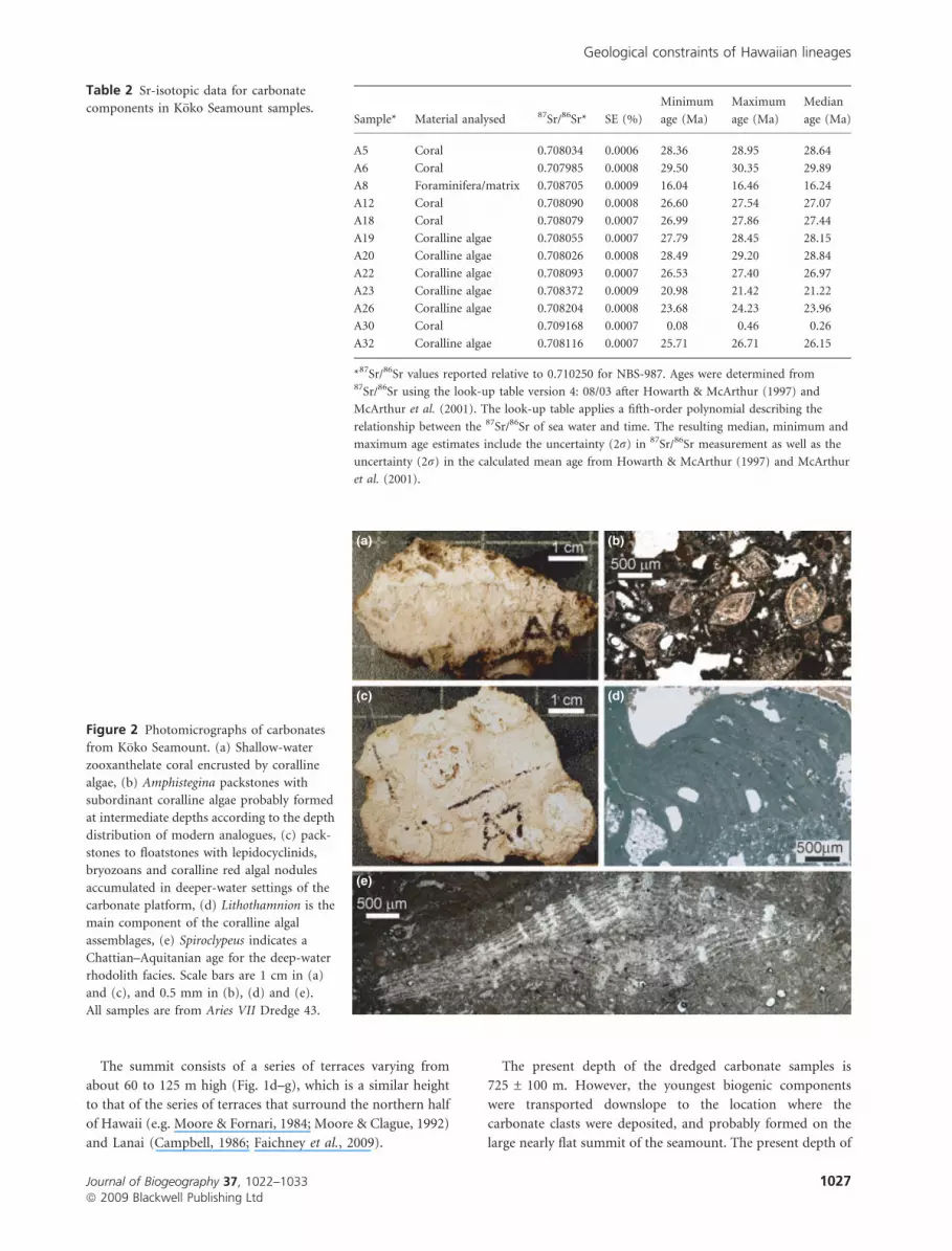
Figure 2 Photomicrographs of carbonates
from K�oko Seamount. (a) Shallow-water
zooxanthelate coral encrusted by coralline
algae, (b) Amphistegina packstones with
subordinant coralline algae probably formed
at intermediate depths according to the depth
distribution of modern analogues, (c) pack-
stones to floatstones with lepidocyclinids,
bryozoans and coralline red algal nodules
accumulated in deeper-water settings of the
carbonate platform, (d) Lithothamnion is the
main component of the coralline algal
assemblages, (e) Spiroclypeus indicates a
Chattian–Aquitanian age for the deep-water
rhodolith facies. Scale bars are 1 cm in (a)
and (c), and 0.5 mm in (b), (d) and (e).
All samples are from Aries VII Dredge 43.
Geological constraints of Hawaiian lineages
Journal of Biogeography 37, 1022–1033 1027ª 2009 Blackwell Publishing Ltd
Page 7
this flat summit is between 253 m (the shallowest depth
measured on K�oko) and 343 m (the shallowest depth nearest
the dredge site).
DISCUSSION
By integrating the bathymetry, the ages of formation of the
seamount and of the various facies of carbonate deposits, the
palaeowater depths at which the deposits formed, the latitu-
dinal motion history, sea level and ocean temperature varia-
tions during the history of the seamount, and latitudinal
variations in sea surface temperature, we can reconstruct the
history of subsidence and carbonate bank accumulation on
K�oko Seamount. The history of slow subsidence accompanied
by coral growth that could just keep pace presents the greatest
uncertainty in the discussion to follow.
Bathymetry
The series of terraces on K�oko Seamount appear to be coral
and indicate that the guyot top is covered by a series of coral
reefs that are younger towards the summit, as occurs offshore
Hawaii (Ludwig et al., 1991).
The shallowest point on the summit apparently represents a
small patch reef that continued growing after most of the
carbonate platform had drowned. In our models, we will use
the depth of the larger platform at c. 340 m, the most likely
source of debris sampled in the dredge. The rounded shape of
the clasts supports the interpretation that they have been
transported.
Ages
Sample A23 contains larger foraminifera Lepidocyclina (Eul-
epidina) of Early Oligocene (33.9–28.4 Ma) to Aquitanian (23–
20.4 Ma) age, Spiroclypeus of latest Oligocene (28.4–23 Ma) to
Aquitanian age, and Neorotalia of an Early Oligocene to
earliest Aquitanian age. The Spiroclypeus are early forms
transitional to Vlerkina, indicating the young end of the range,
namely an Aquitanian age (Lunt & Adams, 2004; Renema,
2007). Sample A8 contains Amphistegina, Operculinella and
Operculina. The frequent presence of Operculinella indicates a
Burdigalian (20.4–16 Ma) or younger age (Renema, 2007).
This sample also has an age based on Sr-isotopes of
16.15 ± 0.6 Ma, consistent with the Burdigalian foraminiferal
age.
The Sr-isotope-derived ages of 27.1 ± 0.5 to 29.9 ± 0.4 Ma
for four of the five corals and an algal coating on another coral
may represent the youngest corals on K�oko Seamount. We
interpret the single Pleistocene age to be a recrystallization age.
The oldest corals presumably began growth soon after the
volcano formed at c. 50.4 ± 0.1 Ma, during the Ypresian stage
of the Eocene (55.8–48.6 Ma, all ages based on International
Commission on Stratigraphy, 2004). These ages suggest that
K�oko Seamount was probably capped by an active shallow-
water coral reef for about 23 Myr between 50 and 27 Ma.
Ages of rhodoliths, also based on Sr-isotopes, range from
28.8 ± 0.4 to 21.2 ± 0.2 Ma, and a single sample of Amph-
istegina-rich sediment from a rhodolith facies rudstone yields
an age of 16.2 ± 0.5 Ma. The rhodolith ages overlap with the
coral ages and suggest simultaneous deposition of the two
facies at different depths, with the corals at < 20 m and the
rhodoliths downslope at < 120 m.
The palaeontological ages are within the range of Late
Oligocene or Early Miocene reported from the small sample of
drill cutting recovered at DSDP site 309, but younger than the
late Eocene (37.2–33.9 Ma) shallow-water large foraminiferal
ages reported from sites 308 and 1206. Carbonate deposition
began shortly after the volcano was constructed at 50 Ma
(Sharp & Clague, 2006) and continued in both shallow- and
deep-water settings across the bank, at least intermittently,
until c. 16.2 ± 0.5 Ma, when the relatively deep-water carbon-
ate deposition ceased.
Palaeoenvironments
Most zooxanthelate corals live in the upper 20 m (Grigg &
Epp, 1989), although they can survive to depths as great as
90 m, where they exhibit very low growth rates. The samples
do not allow us to assess whether they formed any kind of reef,
although the seismic reflection data (Greene et al., 1978, 1980)
suggest that significant, perhaps reefal, carbonate deposits exist
on the summit of K�oko Seamount. The presence of ooids near
the bottom of the sediment section above basement rocks from
site 308 (Matter & Gardner, 1975) is consistent with warm,
shallow conditions (Simone, 1981). The foraminifer Amph-
istegina, a common component in the bioclastic packstone,
rudstone and rhodolith facies, lives to depths of 100 m in
present-day Pacific benthic settings (e.g. Hohenegger, 2004;
Renema, 2006), but its depth distribution is much reduced in
north Pacific settings and it is restricted to c. 30 water depth
in Hawaii (Hallock, 1984). The thick-biconvex shape of the
Amphistegina tests in many of the K�oko samples suggests
depths shallower than 50 m (Hallock, 1987). However, down-
slope displacement of foraminiferal tests during packstone–
rudstone accumulation cannot be discounted. The presence of
coralline assemblages that are composed only of melobesioids
suggests palaeodepths of more than 20 m (Adey et al., 1982).
The abundance of bryozoans and the scarcity of corals in these
samples suggest deposition in cooler or deeper waters than the
coral facies (Schlanger & Konishi, 1975).
Coralline algal assemblages dominated by Lithothamnion
and Sporolithon occur in the Hawaiian Islands on seafloor
deeper than 50–60 m (Adey et al., 1982). The maximum
growth depth for these rhodoliths is estimated at 100–120 m,
as below these depths coralline red algae growth is limited to
very thin crusts, if it occurs at all (Braga et al., 2005).
The simplest interpretation of the carbonate facies recorded
on the top of K�oko Seamount is that they reflect a progressive
drowning of a carbonate platform, completed near the end
of the Burdigalian stage of the Early Miocene. The method of
sampling prevents any depth or stratigraphic arrangement
D. A. Clague et al.
1028 Journal of Biogeography 37, 1022–1033ª 2009 Blackwell Publishing Ltd
Page 8
of facies, but the regional context of seamount evolution allows
the interpretation that zooxanthelate corals grew on top of the
seamount soon after the volcano formed and, owing to the
continued subsidence of the seamount, were later overlaid by
bioclastic sediment rich in Amphistegina, formed at similar to
greater depths. The final, youngest deposits recorded on the
seamount are of the facies that forms in the deepest water, the
rhodolith floatstones, which accumulated on the summit of the
seamount at 60–120 m depth, before their demise in the Early
Miocene.
Subsidence
The Emperor Seamounts, like their Hawaiian Island progeny,
underwent two distinct stages of subsidence. As the volcano
was actively growing, and continuing for about 1 Myr after
eruptions became infrequent, there was a period of rapid
subsidence caused by the flexure of the lithosphere as it
isostatically adjusted to the added weight of the volcano
(summary in Moore, 1987). Once equilibrium had been
achieved, the volcanoes slowly continued to subside as the
underlying plate aged, cooled and contracted. The K�oko data
allow us to assess both of these periods of subsidence.
Using the present depth at which the carbonates probably
formed (c. 340 m), the age (27.1 Ma) and palaeodepth (20 m)
for the corals, and the age (16.2 Ma) and depth (120 m) of the
last deep-water carbonate deposition, we can calculate that the
subsidence rates of K�oko Seamount were: (1) c. 0.009 mm yr)1
from 27.1 to 16.2 Ma, (2) c. 0.014 mm yr)1 from 16.2 Ma to
present, and (3) c. 0.012 mm yr)1 over the entire last
27.1 Myr. These rates are all statistically the same and indicate
an average subsidence rate of 0.012 ± 0.003 mm yr)1. This
very slow calculated subsidence rate is consistent with rates
deduced from the thermal cooling and contraction of an old
ocean plate (Stein & Stein, 1992). At this rate, K�oko Seamount
would have subsided an average of 590 m since the volcano
attained isostatic equilibrium at c. 49 Ma.
If we subtract the post-isostatic subsidence of 590 m from
the 1555 m of total subsidence indicated by the depth of the
break-in-slope, we are left with 965 m of subsidence between
the end of volcano construction and the attainment of isostatic
equilibrium. The ocean crust beneath K�oko was younger than
that beneath Hawaii (60 vs. 90 Ma) when the volcanoes
formed (Clague & Dalrymple, 1987), so the lithosphere should
have been less rigid and the flexure resulting from loading
somewhat greater, so one could argue that the depth to the
break-in-slope should be somewhat greater than the 1000–
1100 m observed around the main Hawaiian Islands. On the
other hand, this greater flexure should also have occurred
earlier in the history of the volcano, as a weaker lithosphere
would equilibrate under the growing load of the volcano more
quickly, which might make the break-in-slope shallower than
observed around Hawaii, and consistent with our calculations.
This uncertainty in the earliest subsidence history of the
volcano and the unknown growth rate of the coral reef as a
function of time between 49 and 27 Ma obscure our under-
standing of the early subsidence history of K�oko Seamount.
The unknown growth rate of the reef will also be a factor when
we try to determine when the summit of K�oko Seamount
submerged.
Latitudinal migration of K�oko Seamount
Hotspot models (Wilson, 1963; summarized in Clague &
Dalrymple, 1987) predict that the volcanoes of the Emperor
Seamounts are being carried passively on the tectonic plate
after forming over the plume, which is now under Hawaii.
Greene et al. (1978) first used reefs on the Emperor Seamounts
to argue for northward movement of the volcanoes since their
formation. Palaeomagnetic data (summarized in Clague &
Dalrymple, 1987), confirmed by more recent data (Tarduno
et al., 2003), show that the hotspot has not always been fixed,
at least during the formation of the Emperor Seamounts. In
the first 5 Myr of its life, K�oko Seamount migrated northwards
as the hotspot migrated southwards (Tarduno et al., 2003).
During this period, the seamount moved northwards with the
plate at about 69 km Myr)1 from c. 21.5� N to c. 23� N. It
then migrated northwards at about 31 km Myr)1 from 45 Ma
until present as the Pacific plate moved west-north-west to
reach its present latitude of c. 35� N. When the youngest corals
died out at 27 Ma, K�oko Seamount was located at 27.8� N, just
south of present-day Midway Atoll (Fig. 1b). When deep-
water carbonate deposition ceased at 16.2 Ma, K�oko Seamount
was located at 30.8� N, near present-day Hancock Seamount
(Fig. 1b), nearly 450 km north-west of Midway Atoll.
Climatic conditions as K�oko Seamount subsided and
migrated northwards
At 50.4 Ma, when K�oko Seamount formed at 21.5� N,
conditions should have been tropical and coral growth rates
high because it was about the time of the Early Eocene Climatic
Optimum (Zachos et al., 2001). The presence of ooids in the
Site 309 samples (Matter & Gardner, 1975) is consistent with
this warm, shallow interpretation of conditions soon after the
seamount formed. The summit of K�oko Seamount was
subaerial at this time. Corals should have produced fringing
reefs that migrated upslope as the island continued to subside,
similar to those that surround Hawaii today (e.g. Webster
et al., 2007). The single swathe of multibeam data (Fig. 1)
supports this concept as it shows numerous terraces with steep
faces, ranging in height from c. 60 to 150 m. For the next
16 Myr, global temperatures steadily decreased, and by 34 Ma
bottom water temperatures were nearly 7 �C cooler than at the
Early Eocene Climatic Optimum (Zachos et al., 2001).
At 34 Ma, Antarctic ice sheets (the Oi-1 glaciation) began to
form for the first time in the Cenozoic, and sea level dropped
by about 55 m (Miller et al., 2008) to 70 m (Coxall et al.,
2005) as bottom ocean temperatures dropped by another
2–3 �C (Zachos et al., 2001). Following the Oi-1 glaciation,
temperatures remained cool until the Late Oligocene Warm-
ing, which began about 26 Ma. Near the end of this cool
Geological constraints of Hawaiian lineages
Journal of Biogeography 37, 1022–1033 1029ª 2009 Blackwell Publishing Ltd
Page 9
period the last shallow-water corals on K�oko Seamount
apparently died. Temperatures then remained generally warm,
with a brief glacial (the Mi-1 glaciation at about 24 Ma) until
after the youngest age (16.2 Ma) of the carbonate samples
recovered from K�oko Seamount.
Submergence of the top of K�oko Seamount
Any vestige of K�oko Island subsided below sea level sometime
before the final coral died out at 27.1 Ma. Estimating when this
occurred requires data on the growth rate of the corals and the
subsidence rate at the time. Using our estimated subsidence
rate of 0.012 mm yr)1 implies submergence of the coral cap by
c. 29 Ma, or somewhat earlier if the corals were partially
keeping up with subsidence. We suggest that the summit might
have submerged prior to 34 Ma, but then re-emerged when sea
level fell by 55–70 m (Coxall et al., 2005; Miller et al., 2008)
during the Oi-1 glaciation (Zachos et al., 2001), only to
resubmerge as sea level rose 1–1.5 Myr later, presumably at a
rate faster than the growth rate of the corals under such cool
conditions. The summit of K�oko Seamount probably sub-
merged when sea level rose rapidly at 32.5–33 Ma (Haq et al.,
1987; Miller et al., 2008), in reasonable agreement with the
simple subsidence model calculations of Clague (1996) of
36.5 Ma. This scenario would imply that corals were able to
grow at rates of about two-thirds of the subsidence rate, even
at the northerly latitude of the seamount and given the cool
climate conditions at that time.
The estimated 16.5–17 Myr life span of K�oko Seamount as a
rocky island is longer than the ages of the smallest and oldest
volcanic island remnants in the Hawaiian chain. Gardner and
La Perouse Pinnacles have interpolated ages of 15.8 and
12.9 Ma (Clague, 1996) and poorly constrained K–Ar ages of
12.3 and 12.0 Ma, respectively.
Why did the reef and then the deep-water rhodoliths
stop growing?
The carbonate bank or reef on K�oko Seamount was confronted
by a confluence of adverse trends after reef growth began
50 Ma. The seamount was moving northwards into cooler
waters as global climate was cooling (bottom waters had
cooled by 7 �C by the time of the Oi-1 glaciation at 34 Ma),
and the island subsided c. 1100 m in the first 1 Myr, and
continued to subside slowly after that.
It is difficult to explain the drowning of shallow-water
zooxanthellate coral deposits and the subsequent deposition of
deeper facies (bioclastic packstones and rhodolith floatstones)
by subsidence alone, once the initial isostatic phase of rapid
subsidence was completed. The long-term subsidence rate is
far lower than the accretion rate of shallow coral reefs
(Buddemeier & Smith, 1988; Smith & Buddemeier, 1992;
Webster et al., 2007). K�oko Seamount simply migrated north
away from a contracting belt of tropical waters where coral
reef growth took place in the Central Pacific. We estimate
that the last of the corals gave up about 27.1 Ma, having built
the estimated 530-m thick carbonate deposits on top of the
seamount during a 23-Myr period after the volcano formed.
The coral cap apparently survived, or was revived by, the Oi-1
glaciation at 34 Ma, but had died out and submerged by the
time the Late Oligocene Warming began c. 26 Ma (Zachos
et al., 2001).
After the summit had submerged below 20 m depth at
c. 27.1 Ma, the deep-water carbonate factory was established
and lasted until the Burdigalian stage of the Early Miocene,
when the combination of very low accretion and growth rates
and slow subsidence brought the summit below the deep-water
coralline algal factory. Sea level rise associated with warming at
the end of the Oligocene (Miller et al., 2008) and in the Early
Miocene (Haq et al., 1987; Abreu et al., 1998) may have
assisted in their drowning, but continued slow subsidence and
even slower deep-water coralline growth probably account for
their eventual death.
Implications for Hawaiian biogeography
The submergence of K�oko Seamount at c. 33 Ma supports the
model proposed by Clague (1996) that successive colonization
of the Emperor and Hawaiian Islands (island hopping) ceased
during the Late Eocene to Early Oligocene. K�oko Seamount is
the key to understanding the colonization of the Hawaiian
Island chain because it was so large and survived for so long as
an island. No other island was comparable in size until
Gardner Pinnacles formed c. 16 Ma. Between c. 33 Ma, when
K�oko Seamount submerged, and 30 Ma, when Kure Island
grew, there were only transient islands (lasting < 0.5 Myr) in
the Hawaiian chain (Fig. 1b). K�oko Seamount was quite
distant from these ephemeral islands and was itself a flat,
low-lying coral island with limited terrestrial biodiversity. Kure
Island and Pearl and Hermes Reef each were islands that
reached elevations of perhaps 870 m (Clague, 1996), but they
were small, low, distant islands by the time Lisianski Island, the
next high island (> 1000 m high) formed about 23 Ma. Until
that time, individual small islands existed only for brief
periods and submerged quickly. Between the submergence of
K�oko Seamount at 33 Ma (or even slightly earlier) and the
formation of Lisianski Island at 23 Ma, the transmission of
local terrestrial and shallow marine propagules from island to
island along the chain was probably limited to lowland species.
Islands of the chain starting with Lisianski had to be colonized
by migrants from distant shores, in broad agreement with
MRCA analyses of Hawaiian lineages.
CONCLUSIONS
The 50-Myr-old K�oko Seamount initially had a substantial
shallow-water carbonate reef build-up that contained zooxan-
thelate corals. These shallow, warm-to-temperate-water reefs
came under increasing stress over the next 23 Myr as global
climate cooled and the seamount migrated northwards and
subsided slowly (c. 0.008 mm yr)1) as a result of the cooling of
the aging underlying lithosphere. The summit submerged
D. A. Clague et al.
1030 Journal of Biogeography 37, 1022–1033ª 2009 Blackwell Publishing Ltd
Page 10
c. 33 Ma, slightly after the first glacial period of the Cenozoic,
and the coral reef probably died as a result of unsuitable water
temperatures by 27.1 Ma. The volcano continued its slow
subsidence and first accumulated shallow-to-mid-depth fora-
minifer Amphistegina in bioclastic packstones and then deep-
water rhodoliths, until the end of the Burdigalian stage of the
Early Miocene (16 Ma), when the deep-water facies died out as
a result of the combination of slow subsidence rates and even
slower deep-water carbonate accumulation rates.
Carson & Clague (1995) and Clague (1996) proposed that
biota on older Hawaiian–Emperor Islands could not island-
hop along the entire chain to eventually colonize the present
Hawaiian Islands. The new data presented here from K�oko
Seamount provide independent evidence confirming the
model proposed by Clague (1996). There was a time period
from about 33–30 Ma in which no high islands, and only
transient low islands, existed. All terrestrial life-forms from the
older portion of the chain would have been extinguished. Kure
Island and Pearl and Hermes Reef formed moderate-sized
islands (c. 870 m tall) 3–7 Myr after K�oko Seamount
submerged, but they were small, low distant islands by the
time the next large islands began to grow, starting with
Lisianski Island c. 23 Ma. The ancestors of the modern
Hawaiian terrestrial and shallow marine biota were unlikely
to have become established before 23 Ma, when distant
colonizers, perhaps supplemented by colonizers from low
distant islands such as Kure Island and Pearl and Hermes Reef
(250–500 km away), could arrive, radiate and migrate from
island to island until some of them reached the present islands.
ACKNOWLEDGEMENTS
We thank Warren Smith at the Scripps Institution of Oceano-
graphy Core and Dredge Sample Repository for locating the
samples, and the Museum of Paleontology at the University of
California, Berkeley, for their unsuccessful attempt to locate the
corals examined by Wyatt Durham in the early 1970s. We also
thank Jennifer Paduan for making the maps.
REFERENCES
Abreu, V.S., Hardenbol, J., Haddad, G.A., Baum, G.R., Drox-
ler, A.W. & Vail, P.R. (1998) Oxygen isotope synthesis:
a Cretaceous ice-house. Mesozoic and Cenozoic sequence
stratigraphy of European basins (ed. by P.C. Graciansky,
J. Hardenbol, T. Jacquin and P.R. Vail), pp. 3–13. Society
for Sedimentary Geology, Special Publication No. 60,
Tulsa, OK.
Adey, W.H., Townsend, R.A. & Boykins, W.T. (1982) The
crustose coralline algae (Rhodophyta: Corallinaceae) of the
Hawaiian Islands. Smithsonian Contributions to Marine
Sciences, 15, 1–74.
Braga, J.C., Webster, J.M., Clague, D.A., Moore, J.G. & Spalding,
H. (2005) Very deep water coralline algae (Corallinales,
Rhodophyta) off Hawaii. Phycologia, 44, 12–13.
Buddemeier, R.W. & Smith, S.V. (1988) Coral reef growth in
an era of rapidly rising sea level: predictions and suggestions
for long-term research. Coral Reefs, 7, 51–56.
Campbell, J.F. (1986) Subsidence rates for the Southeastern
Hawaiian Islands determined from submerged terraces.
Geo-Marine Letters, 6, 139–146.
Caress, D.W. & Chayes, D.N. (2004) MB-System. Version 5.
Open-source software available at: http://www.ldeo.columbia.
edu/res/pi/MB-System/.
Carlquist, S. (1995) Introduction. Hawaiian biogeography:
evolution on a hot spot archipelago (ed. by W.L. Wagner and
V.A. Funk), pp. 1–13. Smithsonian Institution Press,
Washington, DC.
Carson, H.L. (1983) Chromosomal sequences and interisland
colonizations in Hawaiian Drosophila. Genetics, 103, 465–
482.
Carson, H.L. & Clague, D.A. (1995) Geology and biogeog-
raphy of the Hawaiian Islands. Hawaiian biogeography:
evolution of a hot spot archipelago (ed. by W.L. Wagner and
V.A. Funk), pp. 14–29. Smithsonian Institution Press,
Washington, DC.
Clague, D.A. (1987) Hawaiian alkaline volcanism. Alkaline
igneous rocks (ed. by J.G. Fitton and B.G.J. Upton), pp. 227–
252. Geological Society Special Publication No. 30, Blackwell
Scientific Publications, Oxford.
Clague, D.A. (1996) The growth and subsidence of the
Hawaiian-Emperor volcanic chain. The origin and evolution
of Pacific island biotas, New Guinea to Eastern Polynesia:
patterns and processes (ed. by A. Keast and S.E. Miller),
pp. 35–50. SPB Academic Publishing, Amsterdam.
Clague, D.A. & Dalrymple, G.B. (1987) The Hawaiian-
Emperor volcanic chain: part I. Geologic evolution.
United States Geological Survey Professional Paper, 1350,
5–54.
Clague, D.A. & Jarrard, R.D. (1973) Tertiary Pacific Plate
motion deduced from the Hawaiian-Emperor chain.
Geological Society of America Bulletin, 84, 1135–1154.
Coxall, H.K., Wilson, P.A., Palike, H., Lear, C.H. & Backman,
J. (2005) Rapid stepwise onset of Antarctic glaciation and
deeper calcite compensation in the Pacific Ocean. Nature,
433, 53–57.
Davies, T., Wilde, P. & Clague, D. (1972) K�oko Seamount:
a major Seamount at the southern end of the Emperor
Seamounts. Marine Geology, 13, 311–321.
Duncan, R.A. & Keller, R.A. (2004) Radiometric ages of
basement rocks from the Emperor Seamounts, ODP Leg
197. Geochemistry Geophysics, Geosystems, 5, Q08L03.
Faichney, I.D.E., Webster, J.M., Clague, D.A., Kelley, C.,
Appelgate, B. & Moore, J. (2009) The morphology and
distribution of submerged reefs in the Maui Nui Complex,
Hawaii: new insights into their evolution since the Early
Pleistocene. Marine Geology, 263, 130–145.
Givnish, T.J., Millam, K.C., Theim, T.T., Mast, A.R., Patt-
erson, T.B., Hipp, A.L., Henss, J.M., Smith, J.F., Wood,
K.R. & Sytsma, K.J. (2009) Origin, adaptive radiation,
Geological constraints of Hawaiian lineages
Journal of Biogeography 37, 1022–1033 1031ª 2009 Blackwell Publishing Ltd
Page 11
and diversification of the Hawaiian lobeliads (Asterales:
Campanulaceae). Proceedings of the Royal Society B: Bio-
logical Sciences, 276, 407–416.
Greene, H.G., Dalrymple, G.B. & Clague, D.A. (1978) Evidence
for northward movement of the Emperor Seamounts.
Geology, 6, 70–74.
Greene, H.G., Clague, D.A. & Dalrymple, G.B. (1980) Seismic
stratigraphy and vertical tectonics of the Emperor Sea-
mounts, DSDP Leg 55. Initial Reports of the Deep Sea Dril-
ling Project, Vol. 55 (by E.D. Jackson, I. Koizumi, G.
Avdeiko, A. Butt, D. Clague, G.B. Dalrymple, H.G. Greene,
A.M. Karpoff, R.J. Kirkpatrick, M. Kono, H.Y. Ling,
J. McKenzie, J. Morgan and T. Takayama), pp. 759–788.
US Government Printing Office, Washington, DC.
Grigg, R.W. & Epp, D. (1989) Critical depth for the survival of
coral islands: effects on the Hawaiian Archipelago. Science,
243, 638–641.
Hallock, P. (1984) Distribution of selected species of
living algal symbiont-bearing foraminifera on two Paci-
fic coral reefs. Journal of Foraminiferal Research, 14,
250–261.
Hallock, P. (1987) Fluctuations in the trophic resource con-
tinuum: a factor in global diversity cycles? Paleoceanography,
2, 457–471.
Haq, B.U., Hardenbol, J. & Vail, P.R. (1987) Chronology of
fluctuating sea levels since the Triassic. Science, 235, 1156–
1167.
Hohenegger, J. (2004) Depth coenoclines and environmental
consideration of Western Pacific larger foraminifera. Journal
of Foraminiferal Research, 34, 9–33.
Howarth, R.J. & McArthur, J.M. (1997) Statistics for Sr-
isotope stratigraphy: a robust LOWESS fit to the marine
Sr-isotope curve for 0–206 Ma, with look-up table for the
derivation of numerical age. Journal of Geology, 105, 441–
456.
International Commission on Stratigraphy (2004) Interna-
tional stratigraphic chart. Available at: http://www.stratigraphy.
org/upload/ISChart2009.pdf (accessed 19 October 2009).
Jackson, E.D., Koisumi, I., Dalrymple, G.B., Clague, D.A.,
Kirkpatrick, R.J. & Greene, H.G. (1980) Introduction and
summary of results from DSDP Leg 55, the Hawaiian-
Emperor hot-spot experiment. Initial Reports of the Deep
Sea Drilling Project, Vol. 55 (by E.D. Jackson, I. Koizumi,
G. Avdeiko, A. Butt, D. Clague, G.B. Dalrymple, H.G.
Greene, A.M. Karpoff, R.J. Kirkpatrick, M. Kono, H.Y. Ling,
J. McKenzie, J. Morgan and T. Takayama), pp. 5–31.
US Government Printing Office, Washington, DC.
Jordan, S.D., Simon, C. & Polhemus, D.A. (2003) Molecular
systematics and adaptive radiation of Hawaiian endemic
damselfly genus Megalagrion. Systematic Biology, 52, 89–
109.
Ludwig, K.R., Szabo, B.J., Moore, J.G. & Simmons, K.R. (1991)
Crustal subsidence rate off Hawaii determined from234U/238U ages of drowned coral reefs. Geology, 19, 171–174.
Lunt, P. & Adams, T. (2004) A history and application of larger
foraminifera in Indonesian biostratigraphy, calibrated to iso-
topic dating. GRDC Museum Workshop on Micropaleon-
tology, June 2004. Geological Research and Development
Centre (GRDC), Bandung, Indonesia.
Matter, A. & Gardner, J.V. (1975) Carbonate diagenesis at Site
308 K�oko Seamount. Proceedings of the Deep Sea Drilling
Project, Initial Reports, Vol. 32 (by R.L. Larson, R. Moberly,
D. Bukry, H.P. Foreman, J.V. Gardner, J.B. Keene, Y. Lance-
lot, H. Luterbacher, M.C. Marshall and A. Matter), pp. 521–
535. US Government Printing Office, Washington, DC.
McArthur, J.M., Howarth, R.J. & Bailey, T.R. (2001) Strontium
isotope stratigraphy: LOWESS version 3: best fit to the
marine Sr-isotope curve for 0–509 Ma and accompanying
look-up table for deriving numerical age. Journal of Geology,
109, 155–170.
Miller, K.G., Browning, J.V., Aubrey, M.-P., Wade, B.S.,
Katz, M.E., Kulpecz, A.A. & Wright, J.D. (2008) Eocene–
Oligocene global climate and sea-level changes: St. Stephens
Quarry, Alabama. Geological Society of America Bulletin,
120, 34–53.
Moore, J.G. (1987) Subsidence of the Hawaiian Ridge. United
States Geological Survey Professional Paper, 1350, 85–100.
Moore, J.G. & Clague, D.A. (1992) Growth of the island of
Hawaii. Geological Society of America Bulletin, 104, 1471–
1484.
Moore, J.G. & Fornari, D.J. (1984) Drowned reefs as indicators
of the rate of subsidence of the island of Hawaii. Journal of
Geology, 92, 753–759.
Price, J. & Clague, D.A. (2002) How old is the Hawaiian biota?
Geology and phylogeny suggest recent divergence. Proceed-
ings of the Royal Society B: Biological Sciences, 269, 2429–
2435.
Renema, W. (2006) Large benthic foraminifera from the deep
photic zone of a mixed siliciclastic-carbonate shelf off East
Kalimantan, Indonesia. Marine Micropaleontology, 58, 73–
82.
Renema, W. (ed.) (2007) Fauna development of larger benthic
foraminifera in the Cenozoic of Southeast Asia. Biogeogra-
phy, time and place: distributions, barriers and islands,
pp. 179–215. Springer, Dordrecht.
Russo, C.A.M., Takezaki, N. & Nei, M. (1995) Molecular
phyogeny and divergence times of drosophilid species.
Molecular Biology and Evolution, 12, 391–404.
Schlanger, S.O. & Konishi, K. (1975) The geographic boundary
between the coral–algal and the bryozoan–algal limesone
facies: a paleolatitude indicator. IX International Geological
Congress of Sedimentology, Nice, Theme 1, Sedimentologic
Indicators, pp. 187–190.
Sharp, W.D. & Clague, D.A. (2006) 50-Ma initiation of
Hawaiian-Emperor bend records major change in Pacific
plate motion. Science, 313, 1281–1284.
Shipboard Scientific Party (1975a) Site 308: K�oko Seamount.
Proceedings of the Deep Sea Drilling Project, Initial Reports,
Vol. 32 (by R.L. Larson, R. Moberly, D. Bukry, H.P. Fore-
man, J.V. Gardner, J.B. Keene, Y. Lancelot, H. Luterbacher,
M.C. Marshall and A. Matter), pp. 215–226. US Govern-
ment Printing Office, Washington, DC.
D. A. Clague et al.
1032 Journal of Biogeography 37, 1022–1033ª 2009 Blackwell Publishing Ltd
Page 12
Shipboard Scientific Party (1975b) Site 309: K�oko Seamount.
Proceedings of the Deep Sea Drilling Project, Initial Reports,
Vol. 32 (by R.L. Larson, R. Moberly, D. Bukry, H.P. Fore-
man, J.V. Gardner, J.B. Keene, Y. Lancelot, H. Luterbacher,
M.C. Marshall and A. Matter), pp. 227–231. US Govern-
ment Printing Office, Washington, DC.
Shipboard Scientific Party (2002) Site 1206. Proceedings of the
Ocean Drilling Program, Initial Reports, Vol. 197 (by J.A.
Tarduno, R.A. Duncan and D.W. Scholl et al.), pp. 1–117.
Ocean Drilling Program, College Station, TX.
Simone, L. (1981) Ooids: a review. Earth and Planetary Science
Reviews, 16, 319–355.
Smith, S.V. & Buddemeier, R.W. (1992) Global change and
coral reef ecosystems. Annual Review of Ecological Systems,
23, 89–118.
Stein, C.A. & Stein, S. (1992) A model for the global variation
in oceanic depth and heat flow with lithospheric age.
Nature, 359, 123–129.
Tarduno, J.A., Duncan, R.A., Scholl, D.W., Cottrell, R.D.,
Steinberger, B., Thordarson, T., Kerr, B.C., Neal, C.R., Frey,
F.A., Torii, M. & Carvallo, C. (2003) The Emperor Sea-
mounts: southward motion of the Hawaiian hotspot plume
in the Earth’s mantle. Science, 31, 1064–1069.
Webster, J.M., Wallace, L.M., Clague, D.A. & Braga, J.C.
(2007) Numerical modeling of the growth and drowning
of Hawaiian coral reefs during the last two glacial cycles
(0–250 kyr). Geochemistry, Geophysics, Geosystems, 8,
Q03011.
Wilson, J.T. (1963) A possible origin of the Hawaiian islands.
Canadian Journal of Physics, 41, 863–870.
Zachos, J.C., Pagani, M., Sloan, L., Thomas, E. & Billups, K.
(2001) Trends, rhythms, and aberrations in global climate
65 Ma to present. Science, 292, 686–693.
BIOSKETCH
David A. Clague is a marine geologist specializing in
volcanoes in the oceans. He has studied the volcanic formation
of the Hawaiian Islands and Hawaiian–Emperor volcanic
chain, their destruction through subsidence and giant land-
slides, and the formation of coral reefs on the rapidly
subsiding present-day islands. He is a co-editor of a mono-
graph on Explosive Subaequeous Volcanism and of the newly
released Encyclopedia of Islands (University of California
Press). The Encyclopedia examines the role that geological
history plays in the biodiversity dynamics on islands.
Author contributions: D.A.C. conceived the study and its
scope, located the samples, did the subsidence calculations,
and wrote most of the manuscript; J.C.B. identified the
corallines and wrote part of the manuscript; D.B. and W.R.
identified the large foraminifera and determined their pala-
eontologic ages; P.D.F. performed the Sr-isotopic analyses;
J.M.W. developed the study concept and methodology with
D.A.C. and refined the paper.
Editor: Kostas Triantis
This paper is an additional contribution to the Special Issue
that arose from the symposium Evolutionary islands: 150 years
after Darwin (http://science.naturalis.nl/darwin2009), held
from 11 to 13 February 2009 at the Museum Naturalis,
Leiden, The Netherlands. The theme of the symposium was to
explore the contribution of islands to our understanding of
evolutionary biology and to analyse the role of island biological
processes in a world in which the insularity of island and
mainland ecosystems is being drastically altered.
Geological constraints of Hawaiian lineages
Journal of Biogeography 37, 1022–1033 1033ª 2009 Blackwell Publishing Ltd