
Beach Restoration on Nantucket Nantucket Project Center
December 15, 2011
A Worcester Polytechnic Institute Interactive Qualifying Project
Submitted to the Faculty of
WORCESTER POLYTECHNIC INSTITUTE
In partial fulfillment of the requirements for the Degree of Bachelor of Science
Authors
Dustin Lombardi, Computer Science, 2013
Christa O’Rourke, Psychology, 2013
Thomas Wise, Chemical Engineering, 2013
Sponsor
GreenBeach
Liaison
Oscar Plotkin
Project Advisor
Professor Dominic Golding, Ph.D.
i
Abstract Although Nantucket Island experiences severe coastal erosion, control projects are
extremely controversial. The goal of this project was to assess the regulatory, political, and
social feasibility of testing innovative coastal erosion techniques on Nantucket. Through
extensive interviews, archival research, and observation at public hearings, we determined the
structure of the regulatory process and identified the opinions and concerns of key players. We
conclude that getting approval for any innovative approach to erosion control will likely be a
difficult, lengthy process.
ii
AcknowledgementsWe would like to thank everyone who made our report possible. First, we would like to
thank our Project Liaison, Oscar Plotkin, for his guidance and support throughout the research
process. Next we would like to thank all of our interviewees for their time, cooperation, and
the information they provided, which was essential to the completion of this report (listed in
chronological order of interview date):
Janet Schulte (Maria Mitchell Association)
Jeff Carlson (Beach Manager, Conservation Commission Natural Resource Coordinator)
Whitey Willauer (Board of Selectmen Vice‐Chair)
John Brescher (Conservation Commission)
Josh Posner (Treasurer for the Siasconset Beach Protection Fund)
Sarah Oktay (Conservation Commission Vice‐Chair)
Ernie Steinauer (Conservation Commission Chair)
Emily MacKinnon (Resource Ecologist, Nantucket Land Council)
Peter Rehage (GreenBeach)
Bobby DeCosta (Board of Selectmen)
To all the members of the Maria Mitchell Association, thank you for so generously providing us
with housing. Additionally, we would like to thank all of our fellow Nantucket IQP groups for
their support and feedback. Finally, we would like to thank Professor Golding for the countless
hours spent providing feedback on our proposal and assistance for our project.
Disclaimer:
This report was written and compiled by students from Worcester Polytechnic Institute as part
of their Interactive Qualifying Project. The opinions or views expressed here are not those of
Worcester Polytechnic Institute, nor those of any person or group of persons involved with the
report. The authors are not experts in the fields concerned within the report, nor do they claim
to support or not support any of the views expressed here. They worked closely with
GreenBeach and were sponsored by Oscar Plotkin, but views and results presented were not
influenced from their participation. Information was obtained through online and print sources,
as well as from emails and personal interviews. The authors do not claim or refute that any of
the aforementioned contacts are experts in the specific fields to which their interviews
pertained. This project was completed within a sixteen week period, seven of which were spent
on Nantucket, and the authors were not financially reimbursed for their work, as specified by
the nature of the project. All conclusions and recommendations presented in the report are
derived from information obtained from research and were written with the objective of
containing no prior bias.
iii
ExecutiveSummaryCoastal erosion is a major problem in the United States. Approximately 1,500 homes
are lost to erosion each year, and it is estimated that coastal property owners in the United
States experience over 500 million dollars in total damages each year (Heinz 2000, 111).
Erosion rates vary along the coasts, but many areas along the Atlantic coastline have
experienced land losses of fifty to one‐hundred feet in the last thirty years alone.
In Massachusetts, sixty‐five acres of coastal land is lost every year and 72% of the
Massachusetts shoreline shows a long‐term erosional trend. Nantucket’s southern coast has
some of the state’s highest long‐term erosion rates averaging twelve feet each year in some
locations (O’Connell & Leatherman, 28). Siasconset Beach, an area of expensive homes on
Nantucket’s eastern shore, has experienced major land losses. Many homes have been lost
and others moved further inland in order to avoid damages (Rodriguez, 1999; Curtis & Davis,
1997; Turner & Leatherman, 1997). A group of homeowners formed the non‐profit Sconset
Beach Preservation Fund (SBPF) in the early 1990s in an effort to mitigate erosion of the
Sconset Bluff and protect their homes. The SBPF has been the most active group on the Island
exploring innovative ways to try to control coastal erosion.
Various erosion control techniques have been tried over the years to prevent or
mitigate coastal erosion damage in the US. Traditional erosion control methods typically
involve the construction of physical barriers, such as dykes, groins, and sea‐walls. These “hard
engineering” approaches have fallen out of favor in recent years since they cause a variety of
adverse ancillary impacts, such as ‘scouring.’ Some states and local governments, including
Nantucket, have banned the use of such ‘hard engineering’ approaches in favor of ‘soft
engineering approaches. This type of coastal management involves improving the condition of
a beachhead. The most common form of this strategy is “beach nourishment,” which is simply
the addition of sediment at a rate that matches the rate of erosion.
Many coastal management projects have been conducted on Nantucket in order to
combat erosion. Due to the fact that the implementation of this type of technology sparks so
much controversy, however, the town of Nantucket has developed laws and policies to regulate
iv
coastal management projects. Various town boards and committees are charged with the
protection of all wetland resource areas and carefully scrutinize any project that presents
potential risks to these areas. The Conservation Commission takes the lead role in this regard.
GreenBeach has developed a new approach to control beach erosion that involves the
application of an eponymous propriety substance. They have tested the technique in various
parts of the world including Oman, France and Brazil, and would like to conduct more extensive
testing in the United States. The goal of our project was to assess the regulatory, political, and
social feasibility of testing such innovative coastal erosion techniques on Nantucket. The
project did not assess and makes no claims about the effectiveness or safety of the technique.
To achieve this goal, the team conducted interviews with a variety of town officials and
members of relevant organizations. These interviews not only allowed us to acquire knowledge
of the regulations and policies relevant to coastal management, along with explanations of past
erosion control attempts on Nantucket, but they also provided insight as to the opinions and
concerns of the key individuals and organizations involved.. We examined the town’s
newspaper, The Nantucket Inquirer, which highlighted the most current issues Nantucket was
facing that involve erosion and coastal management. The team attended public hearings where
proponents of coastal management projects presented their cases to the Conservation
Commission. The largest of these cases involved the Siasconset Beach Preservation Fund
(SBPF). Their proposed project illustrates the nature and range of issues that any future
erosion control effort is likely to encounter, and was therefore used as a case study in this
report to reflect the issues and provide a tangible account of the regulatory and permitting
process of coastal management projects.
During the public hearing regarding the SBPF project proposal, a variety of concerns
were raised. Representatives from various concerned organizations, such as the Nantucket
Land Council, attended the hearing and shared their concerns and opinions with the
Commission and the SBPF. The Island’s fishermen, whose lack of support in the previous SBPF
proposal ultimately contributed to its denial, concern themselves with the safety of the marine
environment adjacent to Siasconset Beach. The impact of a project on the environment and
v
natural processes was a major priority. The effect of a project on the beaches adjacent to the
project area is also a consideration. The Land Council charges itself with ensuring that a system
is not starved of sediment. The amount of data presented in the public hearing can also
influence whether or not a project proposal gains approval. In the SBPF hearing, the
Conservation Commission expressed that they wished to see examples of locations where the
proposed technology has been proved to be successful.
Based on our research of the political and regulatory environment on Nantucket, we
have concluded that almost any effort to manage erosion on wetland resource areas,
particularly beaches, will likely raise concerns and generate substantial controversy. Because of
this controversy, we recommend that the proponent of any coastal management project
proceed with honesty and openness, and careful attention to the diverse concerns of various
constituencies.
After attending public hearings concerning current erosion control projects and
interviewing officials responsible for reviewing these proposals, we concluded that one of the
most crucial elements in a successful proposal is the submission of sufficient high quality, valid
supporting data. The project should anticipate the kinds of questions that are likely to be raised
by any participant in the process and plan to provide appropriate data to answer those
questions as part of the submission process and preferably in advance of any public meetings.
We recommend that the proponent of a coastal management project speak with public officials
and various other likely interested and affected parties, and try to identify their likely major
concerns prior to filing a notice of intent. As demonstrated in the SBPF case, knowing the
concerns of a party prior to the public hearing can aid in addressing these concerns and
preparing an appropriate response to any questioning. Failure to address such questions during
a public hearing can put the proponent on the defensive, and may even be construed by the
public as an effort to hide information.

vi
AuthorshipThis report was written as a collaboration of all three group members: Dustin Lombardi,
Christa O’Rourke, and Thomas Wise. The research conducted for this report was divided evenly
between each member. Although each section of the report was written primarily by one
individual, each section was edited by the entire team to ensure that the writing was clear,
accurate, and presented the opinions of the whole group:
Major Section in Paper Primary Writer
Introduction Thomas Wise
Literature Review
Impacts of Coastal Erosion Christa O’Rourke
Coastal Management Practices Thomas Wise
Policies and Regulations Dustin Lombardi
Methodology
Characterization of the Permitting Process Dustin Lombardi
Political Concerns and Opinions Christa O’Rourke
Identifying Suitable Beaches Thomas Wise
Findings and Analysis
Regulatory Structure on Nantucket Dustin Lombardi
History of Past Projects on Nantucket Thomas Wise
Political Opinions and Concerns Thomas Wise, Christa
O’Rourke
Identifying Suitable Experimentation Sites Dustin Lombardi
Conclusions and Recommendations All
vii
TableofContentsAbstract .......................................................................................................................................................... i
Acknowledgements ....................................................................................................................................... ii
Executive Summary ...................................................................................................................................... iii
Authorship ................................................................................................................................................... vi
Table of Contents ........................................................................................................................................ vii
Table of Figures ............................................................................................................................................ ix
Table of Tables .............................................................................................................................................. x
1. Introduction .............................................................................................................................................. 1
2. Literature Review ...................................................................................................................................... 3
2.1 Impacts of Coastal Erosion .................................................................................................................. 3
2.1.1 Local Effects of Coastal Erosion ................................................................................................... 4
2.2 Coastal Management Practices ........................................................................................................... 5
2.2.1 Approaches Available to Coastal Management at the Federal Level .......................................... 5
2.2.2 Approaches Available on a Local Level ...................................................................................... 10
2.3 Regulation of Coastal Management ................................................................................................. 12
2.3.1 Regulations on a Federal Level .................................................................................................. 13
2.3.2 Regulations on a State Level ...................................................................................................... 16
2.3.3 Massachusetts State Policies and Regulations .......................................................................... 17
2.3.4 Regulations on Nantucket Island ............................................................................................... 18
2.4 Conclusion ......................................................................................................................................... 19
3. Methodology ........................................................................................................................................... 20
3.1 Characterization of the Regulatory and Permitting Process ............................................................. 20
3.2 Political Opinions and Contacts on Nantucket .................................................................................. 21
3.3 Identifying Suitable Experimentation Sites ....................................................................................... 24
3.4 Conclusion ......................................................................................................................................... 24
4. Findings and Analysis .............................................................................................................................. 25
4.1 Regulatory Structure on Nantucket .................................................................................................. 25
4.2 History of Past Coastal Management Projects on Nantucket ........................................................... 29
4.2.1 Siasconset Beach Preservation Fund ......................................................................................... 31
4.3 Political Opinions and Concerns ....................................................................................................... 41
viii
4.4 Identification of Beaches Suitable for Testing .................................................................................. 46
5. Conclusions and Recommendations ....................................................................................................... 48
References .................................................................................................................................................. 52
Appendix A: Interview Questions ............................................................................................................... 55
Conservation Commission/Land Council Questions/Board of Selectmen Questions............................. 55
Peter Rehage Questions .......................................................................................................................... 55
Appendix B: Articles from The Nantucket Inquirer and Mirror ................................................................... 57
Time, tide and town condemn Ratner's oceanfront home .................................................................... 57
Beach manager halts erosion work on Sheep Pond Road: Foul‐smelling chemical was poured into
sand ......................................................................................................................................................... 58
Erosion‐control bags wreaking havoc in island waters ........................................................................... 60
ix
TableofFiguresFigure 1: Increase in size of hazard area over time ..................................................................................... 4
Figure 2: Bluff erosion under a home on Nantucket ................................................................................... 5
Figure 3: Waves crashing against the sea wall along St Ouen’s Bay, Jersey ................................................ 6
Figure 4: Diagram of a typical groin field ..................................................................................................... 7
Figure 5: Use of hay bales as a protective barrier ..................................................................................... 11
Figure 6: Schematic diagram of the regulatory and permitting process for coastal management projects
.................................................................................................................................................................... 28
Figure 7: Map of Nantucket highlighting key coastal management sites .................................................. 29
Figure 8: Photo of Gene Ratners house ..................................................................................................... 30
Figure 9: Map of the eastern side of Nantucket Island, showing the area commonly involved in the
SBPF’s coastal management projects ......................................................................................................... 32
Figure 10: Sankaty Lighthouse and the Baxter Road homes precariously placed on the edge of the bluff
.................................................................................................................................................................... 33
Figure 11: STABEACH project map ............................................................................................................. 34
Figure 12: An Uncovered sandbag at the bottom on Siasconset Bluff ...................................................... 36
Figure 13: Diagram of the current SBPF project plan ................................................................................ 38

x
TableofTablesTable 1: Advantages and disadvantages of selected types of coastal management techniques ................ 9
Table 2: The Development of Coastal Erosion Controls ............................................................................ 14
Table 3: Town Organizations, their functions and concerns about erosion control projects.................... 42
1
1.IntroductionBeach erosion poses a major threat to human development along many coastlines. In
the United States alone, over 300,000 people live within 500 meters of shoreline (Heinz 2000,
111‐140). At this proximity, the erosion damage to properties can result in huge financial
losses. Nationwide, coastal areas face $500 million in property loss every year (Heinz Center
2000, 111‐113). On Nantucket Island, where an average of 2.2 feet of coastline is lost annually,
erosion is an urgent and ongoing problem (O’Connell, & Leatherman, 28). Development on the
Island’s coastal areas is threatened by receding shorelines. Many structures, such as the
famous Sankaty Lighthouse, have been relocated to postpone the inevitable.
Because past attempts to control beach erosion on Nantucket and elsewhere have had
limited success and often resulted in unforeseen adverse consequences, any ‘tampering’ with
Nantucket’s precious beaches faces severe scrutiny by the public and government agencies.
Many of the Island’s residents are concerned about the issue of beach erosion, but remain
skeptical of current or novel erosion control techniques, fearing they may actually exacerbate
the problem or create other problems. This skepticism is matched by strict governmental
regulation of coastal development and land use. These regulations protect Nantucket’s beaches
from poorly planned development that may have negative impacts in the future; they are also
intended to protect the beaches from any ill‐conceived erosion management projects.
GreenBeach has developed a new approach to control beach erosion that involves the
application of an eponymous propriety substance. They have tested the technique in various
parts of the world including Oman, France and Brazil, and would like to conduct more extensive
testing in the United States, including Nantucket. The goal of the project was to assess the
regulatory, political, and social feasibility of testing a new erosion control approaches such as
this on Nantucket. The project did not assess and makes no claims about the effectiveness or
safety of the technique.
This project had three primary objectives. The project team:
2
identified the positions and opinions of relevant stakeholders, including local
regulators, elected official, landowners, and members of the public;
characterized the regulatory and permitting process pertaining to the testing or
implementation of any erosion control strategies; and,
identified beaches on the island that might be suitable for the testing of
innovative erosion control strategies.
These objectives were accomplished by interviewing landowners, political figures, and
representatives of the various agencies involved with erosion control on Nantucket Island. The
data collected from these interviews gave the team an understanding of the advantages and
disadvantages of past techniques of erosion control, public attitudes towards these efforts, and
likely concerns for the future. Analyses of the local newspapers and the minutes from meetings
of various town committees were examined to assess the range of concerns and opinions
within the town, and help identify who are the key interested and affected parties. By
synthesizing the available information, the report concludes by recommending how
GreenBeach, or any other entity, should plan to implement any coastal erosion management
scheme on Nantucket.
3
2.LiteratureReview In this review of the literature, we look at the impact of coastal erosion in general and
more specifically how it pertains to Nantucket. We discuss several approaches that have been
implemented to combat the effects of coastal erosion and the various regulatory policies and
programs that have been put in place to promote them.
2.1ImpactsofCoastalErosion According to the Heinz Center, nearly 85,000 homes along the Atlantic Coast and the
Gulf of Mexico outside major urban areas could disappear due to flooding and erosion damage
during the next sixty years. (Heinz 2000, 111‐112). Currently, the total property loss from
erosion in the United States is estimated to be 500 million dollars per year for coastal property
owners as a result of damage to structures and land loss. Heinz explains that this damage
occurs in a variety of ways. Powerful waves may cause the bluff beneath a structure to erode,
undermining the foundation. Also, the force of the devastating waves may cause either
structural damage to the building or erosion of the surrounding beach area. These forces can
result in the loss of land and any structures thereon (Heinz 2000, 111‐112).
With approximately 1,500 American homes lost to erosion per year, and an annual cost
of 530 million dollars in damage, the economic impact of erosion is substantial. Coastal erosion
also results in a depreciation of property values. Currently, this depreciation has accumulated
to a total of between 1.7 and 2.7 billion dollars (Heinz 2000, 133). Heinz states that many
areas along the Atlantic coastline have lost fifty to one‐hundred feet of beach in the last thirty
years. Storm waves cause damage further inland, meaning that under storm conditions,
structures that were not previously within the “v‐zone” (i.e., that area normally subjected to
intense storm damages due to proximity to the coast and height above sea level) would face
damage on a similar level to areas permanently located in this hazardous area (Heinz 2000, 115‐
116). This effect is displayed in Figure 1.
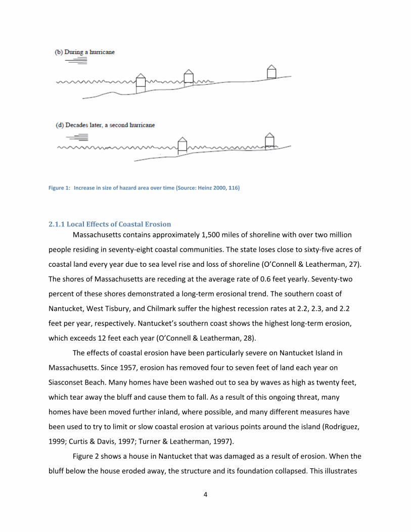
Figure 1: In
2.1.1Loc M
people re
coastal la
The shor
percent o
Nantucke
feet per y
which ex
T
Massach
Siasconse
which te
homes h
been use
1999; Cu
F
bluff belo
ncrease in size o
calEffectsofMassachuset
esiding in se
and every ye
es of Massa
of these sho
et, West Tisb
year, respec
xceeds 12 fee
he effects of
usetts. Since
et Beach. M
ar away the
ave been mo
ed to try to li
rtis & Davis,
igure 2 show
ow the hous
of hazard area ov
fCoastalErots contains a
venty‐eight
ear due to se
chusetts are
ores demons
bury, and Ch
ctively. Nant
et each year
f coastal ero
e 1957, eros
any homes h
bluff and ca
oved further
imit or slow
, 1997; Turn
ws a house in
se eroded aw
ver time (Source
osionapproximate
coastal com
ea level rise
e receding at
trated a lon
hilmark suffe
ucket’s sout
r (O’Connell
osion have b
sion has rem
have been w
ause them to
r inland, whe
coastal eros
er & Leathe
n Nantucket
way, the stru
4
e: Heinz 2000, 1
ely 1,500 mil
mmunities. Th
and loss of s
t the averag
g‐term eros
er the highes
thern coast s
& Leatherm
een particul
oved four to
washed out t
o fall. As a re
ere possible
sion at vario
rman, 1997)
that was da
ucture and it
116)
les of shorel
he state lose
shoreline (O
e rate of 0.6
ional trend.
st recession
shows the h
man, 28).
larly severe
o seven feet
to sea by wa
esult of this o
e, and many
ous points ar
).
amaged as a
ts foundatio
line with ove
es close to s
O’Connell & L
6 feet yearly
The southe
rates at 2.2
ighest long‐t
on Nantucke
t of land eac
aves as high
ongoing thre
different me
round the isl
result of er
n collapsed.
er two millio
ixty‐five acre
Leatherman,
. Seventy‐tw
rn coast of
, 2.3, and 2.
term erosio
et Island in
h year on
as twenty fe
eat, many
easures have
and (Rodrig
osion. When
This illustra
on
es of
, 27).
wo
2
n,
eet,
e
uez,
n the
ates
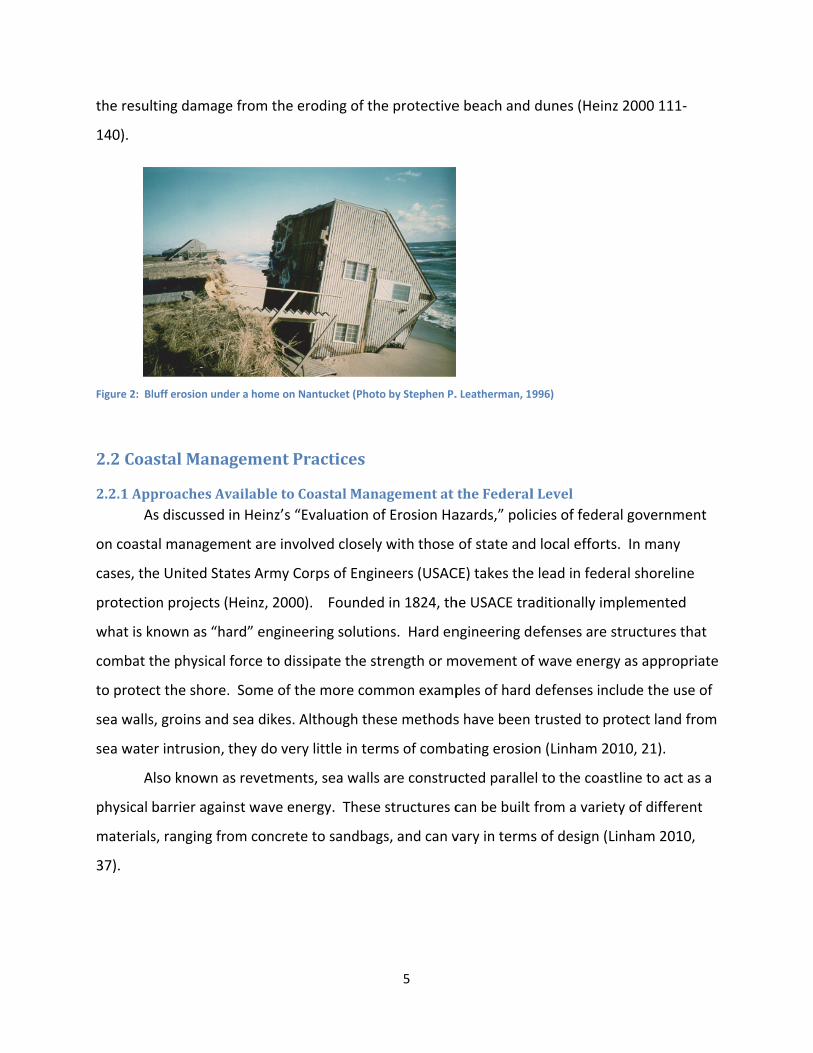
the resul
140).
Figure 2: Bl
2.2Coa
2.2.1App A
on coasta
cases, th
protectio
what is k
combat t
to protec
sea walls
sea wate
A
physical
materials
37).
ting damage
luff erosion und
astalMana
proachesAvAs discussed
al managem
e United Sta
on projects (
known as “ha
the physical
ct the shore.
s, groins and
er intrusion,
Also known a
barrier again
s, ranging fro
e from the e
der a home on N
agementPr
vailabletoCin Heinz’s “E
ment are invo
ates Army Co
Heinz, 2000
ard” enginee
force to diss
. Some of th
sea dikes. A
they do very
as revetment
nst wave ene
om concrete
roding of th
Nantucket (Photo
ractices
CoastalManaEvaluation o
olved closely
orps of Engin
). Founded
ering solutio
sipate the st
he more com
Although the
y little in ter
ts, sea walls
ergy. These
e to sandbag
5
e protective
o by Stephen P.
agementatf Erosion Ha
y with those
neers (USAC
d in 1824, th
ons. Hard en
trength or m
mmon examp
ese methods
ms of comb
are constru
structures c
gs, and can v
e beach and
. Leatherman, 19
theFederalazards,” poli
of state and
CE) takes the
he USACE tra
ngineering d
movement of
ples of hard
s have been
ating erosio
ucted paralle
can be built
vary in terms
dunes (Hein
996)
lLevelcies of feder
d local effort
e lead in fede
aditionally im
efenses are
f wave energ
defenses in
trusted to p
on (Linham 2
el to the coas
from a varie
s of design (
nz 2000 111‐
ral governm
ts. In many
eral shorelin
mplemented
structures t
gy as approp
clude the us
protect land
2010, 21).
stline to act
ety of differe
Linham 2010
‐
ent
ne
d
that
priate
se of
from
as a
ent
0,
6
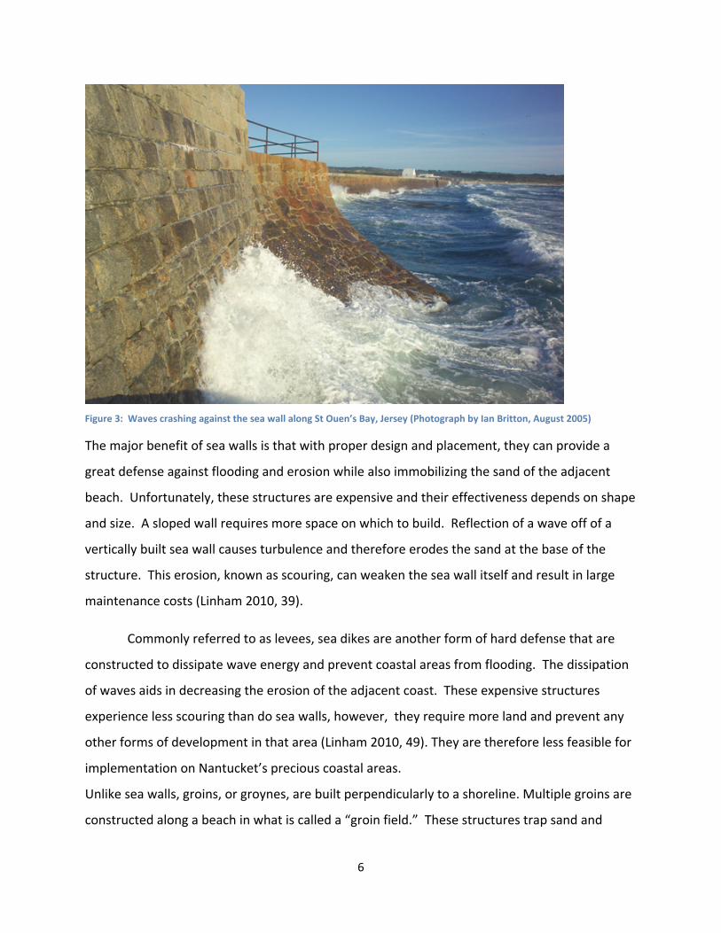
Figure 3: Waves crashing against the sea wall along St Ouen’s Bay, Jersey (Photograph by Ian Britton, August 2005)
The major benefit of sea walls is that with proper design and placement, they can provide a
great defense against flooding and erosion while also immobilizing the sand of the adjacent
beach. Unfortunately, these structures are expensive and their effectiveness depends on shape
and size. A sloped wall requires more space on which to build. Reflection of a wave off of a
vertically built sea wall causes turbulence and therefore erodes the sand at the base of the
structure. This erosion, known as scouring, can weaken the sea wall itself and result in large
maintenance costs (Linham 2010, 39).
Commonly referred to as levees, sea dikes are another form of hard defense that are
constructed to dissipate wave energy and prevent coastal areas from flooding. The dissipation
of waves aids in decreasing the erosion of the adjacent coast. These expensive structures
experience less scouring than do sea walls, however, they require more land and prevent any
other forms of development in that area (Linham 2010, 49). They are therefore less feasible for
implementation on Nantucket’s precious coastal areas.
Unlike sea walls, groins, or groynes, are built perpendicularly to a shoreline. Multiple groins are
constructed along a beach in what is called a “groin field.” These structures trap sand and
7
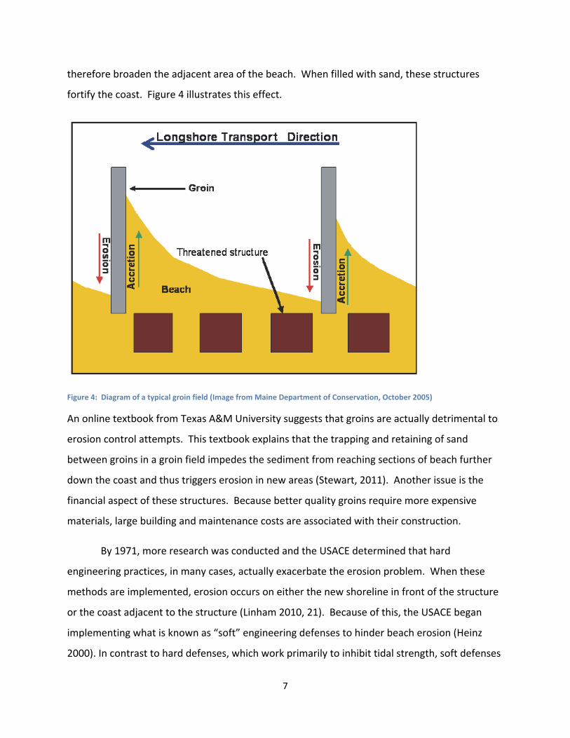
therefore broaden the adjacent area of the beach. When filled with sand, these structures
fortify the coast. Figure 4 illustrates this effect.
Figure 4: Diagram of a typical groin field (Image from Maine Department of Conservation, October 2005)
An online textbook from Texas A&M University suggests that groins are actually detrimental to
erosion control attempts. This textbook explains that the trapping and retaining of sand
between groins in a groin field impedes the sediment from reaching sections of beach further
down the coast and thus triggers erosion in new areas (Stewart, 2011). Another issue is the
financial aspect of these structures. Because better quality groins require more expensive
materials, large building and maintenance costs are associated with their construction.
By 1971, more research was conducted and the USACE determined that hard
engineering practices, in many cases, actually exacerbate the erosion problem. When these
methods are implemented, erosion occurs on either the new shoreline in front of the structure
or the coast adjacent to the structure (Linham 2010, 21). Because of this, the USACE began
implementing what is known as “soft” engineering defenses to hinder beach erosion (Heinz
2000). In contrast to hard defenses, which work primarily to inhibit tidal strength, soft defenses
8
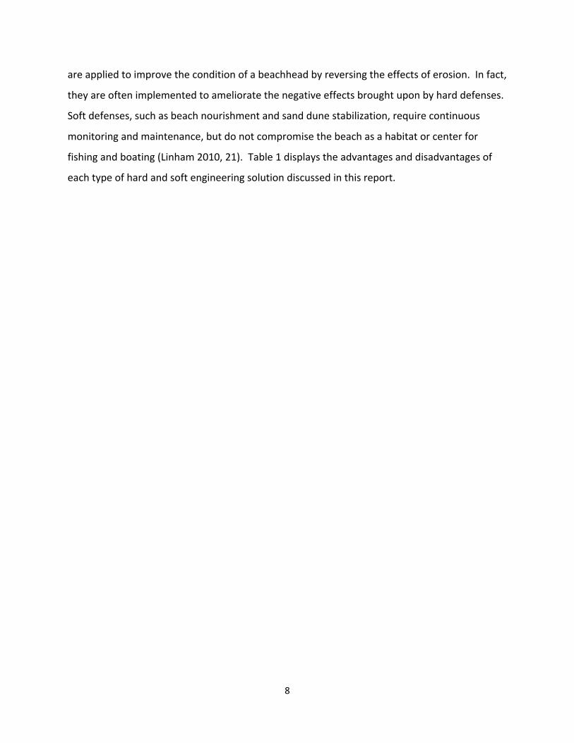
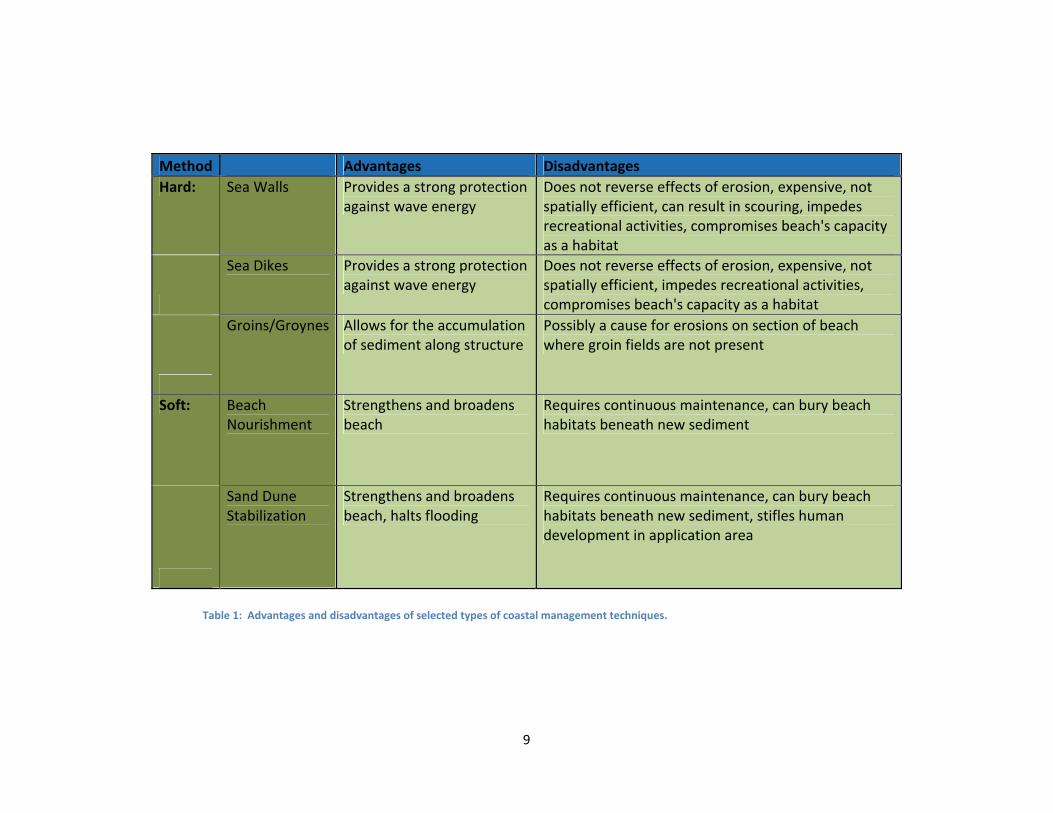
are applied to improve the condition of a beachhead by reversing the effects of erosion. In fact,
they are often implemented to ameliorate the negative effects brought upon by hard defenses.
Soft defenses, such as beach nourishment and sand dune stabilization, require continuous
monitoring and maintenance, but do not compromise the beach as a habitat or center for
fishing and boating (Linham 2010, 21). Table 1 displays the advantages and disadvantages of
each type of hard and soft engineering solution discussed in this report.
9
Method Advantages Disadvantages
Hard: Sea Walls Provides a strong protection against wave energy
Does not reverse effects of erosion, expensive, not spatially efficient, can result in scouring, impedes recreational activities, compromises beach's capacity as a habitat
Sea Dikes Provides a strong protection against wave energy
Does not reverse effects of erosion, expensive, not spatially efficient, impedes recreational activities, compromises beach's capacity as a habitat
Groins/Groynes Allows for the accumulation of sediment along structure
Possibly a cause for erosions on section of beach where groin fields are not present
Soft: Beach Nourishment
Strengthens and broadens beach
Requires continuous maintenance, can bury beach habitats beneath new sediment
Sand Dune Stabilization
Strengthens and broadens beach, halts flooding
Requires continuous maintenance, can bury beach habitats beneath new sediment, stifles human development in application area
Table 1: Advantages and disadvantages of selected types of coastal management techniques.
10
One of the more common forms of soft engineering is beach nourishment, which
involves the addition of new sand on eroding beaches. This broadens the beachhead as a
whole and therefore provides a larger surface on which waves can dissipate energy. As
explained in The UN Environment Programme, “beach nourishment provides a sacrificial, rather
than a fixed barrier against coastal erosion” (Linham 2010, 23). The newly deposited sand
erodes away, but as long as sand is added properly and at a greater rate than at which it
erodes, the beachhead will expand and this technique will work effectively. A major
disadvantage to beach nourishment is that new sediment must be continually added to
maintain the desired beachhead levels. Another problem is that the act of depositing sand onto
the beach may bury wildlife habitats beneath it and foul fishing areas offshore (Linham 2010,
26).
2.2.2ApproachesAvailableonaLocalLevel In regards to local shoreline management options, responsibility may fall either upon an
individual property owner or on a community as a whole. As mentioned in “Evaluation of
Erosion Hazards,” there are three major constraints on what an individual can do in terms of
coastal management. These constraints include:
“…local and state rules and regulations (including building standards) that pertain to
land use and development in shoreline areas, an individual’s economic wherewithal, and
the information and knowledge possessed by that individual regarding the erosion
hazard and adjustment options.” (Heinz 2000, 56)
Taking these limitations into account, there is still a wide array of actions an individual can take
to protect property from erosion damage. Most simply, a land owner should consider building
any structure on a coastal property as far from the shore as possible. This action, however,
may only delay the effects of erosion on the buildings within the property. Relocation is
another option to prevent property damage. In many cases, relocation is more cost effective
than the construction of hard engineering solutions (Heinz 2000, 59).
Where regulations allow, an individual may construct hard engineering defenses to
mitigate erosion damages. Unfortunately, many scientists suggest that these protective
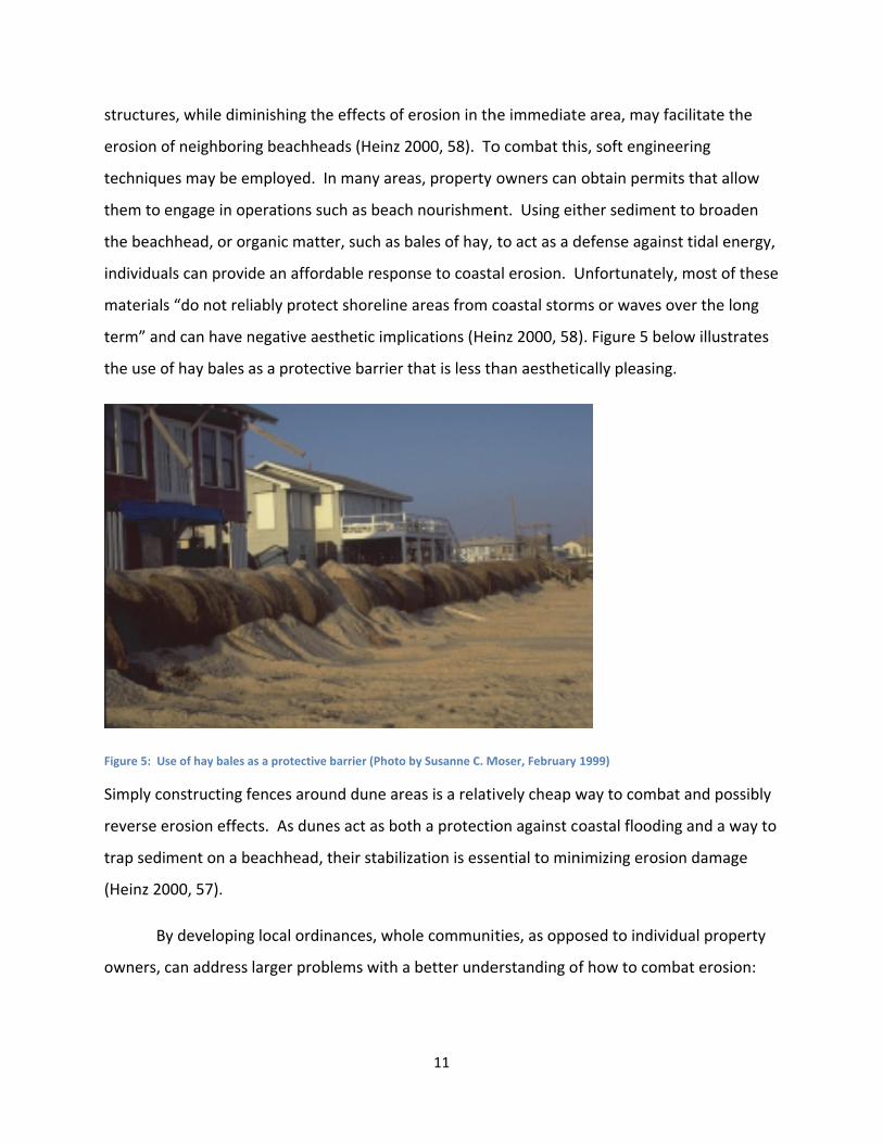
structure
erosion o
techniqu
them to e
the beac
individua
materials
term” an
the use o
Figure 5: U
Simply co
reverse e
trap sedi
(Heinz 20
B
owners,
es, while dim
of neighborin
es may be e
engage in op
hhead, or or
als can provi
s “do not rel
nd can have n
of hay bales
se of hay bales
onstructing f
erosion effec
ment on a b
000, 57).
y developing
can address
minishing the
ng beachhea
employed. In
perations su
rganic matte
de an afford
liably protec
negative aes
as a protect
as a protective
fences aroun
cts. As dune
beachhead, t
g local ordin
larger prob
e effects of e
ads (Heinz 2
n many area
ch as beach
er, such as b
dable respon
ct shoreline a
sthetic impli
tive barrier t
barrier (Photo b
nd dune are
es act as bot
their stabiliz
nances, whol
lems with a
11
erosion in th
000, 58). To
as, property
nourishmen
ales of hay,
nse to coasta
areas from c
cations (Hei
hat is less th
by Susanne C. M
as is a relati
h a protectio
ation is esse
le communit
better unde
he immediate
o combat thi
owners can
nt. Using eit
to act as a d
al erosion. U
coastal storm
inz 2000, 58
han aestheti
Moser, February
vely cheap w
on against c
ential to min
ties, as oppo
erstanding o
e area, may
is, soft engin
obtain perm
ther sedime
defense agai
Unfortunate
ms or waves
). Figure 5 b
cally pleasin
1999)
way to comb
oastal flood
nimizing eros
osed to indiv
f how to com
facilitate th
neering
mits that allo
nt to broade
nst tidal ene
ely, most of t
s over the lon
elow illustra
ng.
bat and poss
ing and a wa
sion damage
vidual prope
mbat erosio
e
ow
en
ergy,
these
ng
ates
sibly
ay to
e
erty
n:
12
“The shift to regional approaches, which frequently involve state and federal agencies,
has resulted in part from a recognition and improved understanding of sediment
transport processes and the down‐drift impacts of individual communities’ shoreline
protection activities.” (Heinz 2000, 67)
By addressing erosion locally, a community can engage in practices on a larger scale than can
individuals acting alone. A united community can organize a self‐imposed tax or lobby the local
government for funding or support for shoreline management projects. Because they are
acting as a unified front, a community can address the cumulative needs of all of its residents,
and therefore develop better solutions to coastal management problems (Heinz 2000, 65).
Sand dune stabilization commonly is used in conjunction with beach nourishment. This
method involves deposition of sand on a beach, reshaping of the new sediment, and planting of
vegetation so as to mimic the formation of naturally occurring sand dunes. Similar to beach
nourishment, this method provides a large area of protection on which waves dissipate energy.
Not only does sand dune stabilization face many of the same problems as does beach
nourishment, but it also stifles development in the area near the beach, as the dunes require
large amounts of land on which to build (Linham 2010, 34).
2.3RegulationofCoastalManagementCoastal erosion and erosion control technology have been issues for decades, and are
further complicated by the desire to develop in these hazardous areas. In an attempt to control
erosion and limit coastal development in hazardous areas, a system of laws, regulations, and
policies have evolved on the federal, state, and local levels. At the federal level, the National
Oceanic and Atmospheric Administration (NOAA) issues guidelines for coastal states to follow in
developing their own management programs and policies. Insurance for people wanting to live
near erosion zones is handled in a similar manner by the Federal Emergency Management
Agency (FEMA). State agencies like the Massachusetts Office of Coastal Zone Management
create plans based on the federal guidelines, and local offices create policies specific to their
location. The next sections provide a brief summary of the structure of laws and regulations
pertaining to coastal erosion, starting with the broad reach of federal policies, then moving
13
towards state policies, focusing more specifically on Massachusetts, and finally, policies on
Nantucket Island itself.
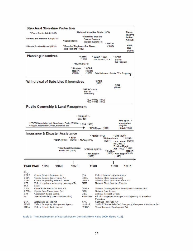
2.3.1RegulationsonaFederalLevelProtection of coastlines on a federal level is regulated by various organizations and
legislative acts. As seen in Table 2 below, planning incentives for states and communities is the
main strategy used by the National Oceanic and Atmospheric Administration (NOAA). In 1972,
Congress passed the Coastal Zone Management Act (CZMA) administered by NOAA in an effort
to "preserve, protect, develop, and where possible, to restore or enhance the resources of the
nation's coastal zone for this and succeeding generations" (Coastal Zone Management Act
[CZMA], 1972). It was created as encouragement for coastal states to protect their coast.
Through this act, coastal states receive grants from the federal government to protect their
coast and create their own state level programs following the CZMA guidelines. The state level
programs must be reviewed and approved by the Secretary of Commerce before receiving
funding (Coastal Zone Management Act [CZMA], 1972).
14
Table 2: The Development of Coastal Erosion Controls (from Heinz 2000, Figure 4.11).
15
Among the requirements for approval are some that apply directly to beach erosion.
The CZMA stipulates that a state must define the word “beach” and create “a planning process
for the protection of, and access to, public beaches and other public coastal areas.” (1972) A
state must also develop “a planning process for assessing the effects of, and studying and
evaluating ways to control, or lessen the impact of, shoreline erosion, and to restore areas
adversely affected by such erosion.” (1972)
Through this act, it is also possible for a coastal state to receive additional grants for a
coastal improvement program. Money received this way can be used for various coastal
management practices, including shoreline stabilization measures and engineering designs,
specifications, and reports (Coastal Zone Management Act [CZMA], 1972).
Insurance and disaster assistance is another major policy instrument used by the federal
government to manage coastlines, as can be seen in Table 2. Requiring flood insurance in
flood‐prone areas is designed to discourage inappropriate development, while provide private
funds to cover losses and damages in the event of a flood. The Federal Emergency
Management Agency provides key legislation in this category with the National Flood Insurance
Program (NFIP). The purpose of this program is "to provide flood insurance in communities
which adopt and adequately enforce floodplain management ordinances that meet minimum
NFIP requirements" (Heinz, 2000, p. 33). Similar to the CZMP, the NFIP provides
encouragement for states to create local floodplain management ordinances, but also allows
property owners to purchase flood insurance. States that choose to follow the NFIP guidelines
may receive federal flood insurance (National Flood Insurance Act [NFIA], 1968).
Accurate flood zone maps are essential in offering flood insurance. Flood Insurance
Rate Maps (FIRMs) distinguish between special flood hazard areas (SFHA) and non‐special flood
hazard areas (non‐SFHA). An SFHA contains all coastlines and is defined as “an area within a
floodplain having a one percent or greater chance of flood occurrence in any given year.”
(Heinz, 2000, p. 191) These areas can be further broken down into A‐zones and V‐zones. A‐
zones have wave action less than three feet high whereas V‐zones are subject to “high‐velocity
16
wave action” (Heinz, 2000, p. 34). People wanting to live in these zones must pay flood
insurance premiums, and those living in V‐zones pay higher premiums.
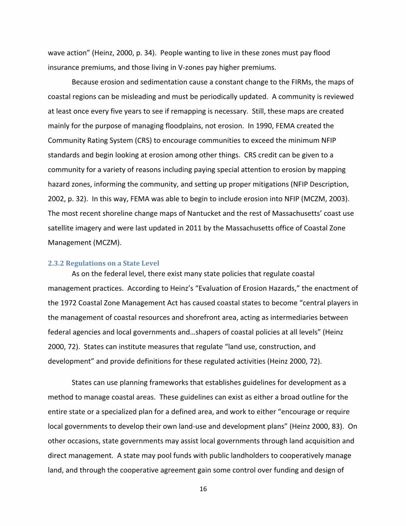
Because erosion and sedimentation cause a constant change to the FIRMs, the maps of
coastal regions can be misleading and must be periodically updated. A community is reviewed
at least once every five years to see if remapping is necessary. Still, these maps are created
mainly for the purpose of managing floodplains, not erosion. In 1990, FEMA created the
Community Rating System (CRS) to encourage communities to exceed the minimum NFIP
standards and begin looking at erosion among other things. CRS credit can be given to a
community for a variety of reasons including paying special attention to erosion by mapping
hazard zones, informing the community, and setting up proper mitigations (NFIP Description,
2002, p. 32). In this way, FEMA was able to begin to include erosion into NFIP (MCZM, 2003).
The most recent shoreline change maps of Nantucket and the rest of Massachusetts’ coast use
satellite imagery and were last updated in 2011 by the Massachusetts office of Coastal Zone
Management (MCZM).
2.3.2RegulationsonaStateLevel As on the federal level, there exist many state policies that regulate coastal
management practices. According to Heinz’s “Evaluation of Erosion Hazards,” the enactment of
the 1972 Coastal Zone Management Act has caused coastal states to become “central players in
the management of coastal resources and shorefront area, acting as intermediaries between
federal agencies and local governments and…shapers of coastal policies at all levels” (Heinz
2000, 72). States can institute measures that regulate “land use, construction, and
development” and provide definitions for these regulated activities (Heinz 2000, 72).
States can use planning frameworks that establishes guidelines for development as a
method to manage coastal areas. These guidelines can exist as either a broad outline for the
entire state or a specialized plan for a defined area, and work to either “encourage or require
local governments to develop their own land‐use and development plans” (Heinz 2000, 83). On
other occasions, state governments may assist local governments through land acquisition and
direct management. A state may pool funds with public landholders to cooperatively manage
land, and through the cooperative agreement gain some control over funding and design of

17
coastal management projects. Among other states, Massachusetts provides “financial or
technical support to communities for the relocation of public or private structures and the
creation, restoration, or re‐vegetation of disturbed dune areas” (Heinz 2000, 84).
States can enforce disclosure laws that act as an influence on development in certain
areas. These laws require information regarding the history of hazardous activity in an area to
be provided for potential land buyers. Through this influence, the state can either stimulate
development in less‐hazardous areas or promote shoreline protection programs by providing
incentives. In Massachusetts, only information regarding coastal flooding is required by the
disclosure laws. These laws, however, hold the land’s seller responsible for providing a buyer
with information regarding risks and definitions of what those risks are (Heinz 2000, 86).
2.3.3MassachusettsStatePoliciesandRegulationsIn 1978, Massachusetts became the first state on the eastern seaboard to have their
coastal management program approved by NOAA. The Massachusetts Office of Coastal Zone
Management (MCZM) was later created in 1983 within “An Act Relative to The Protection of
the Massachusetts Coastline.” The agency compiled a list of policies in a coastal zone policy
guide, “The CZM Policy Guide,” and separated the policies into different sections.
The Coastal Hazards section deals with erosion and, to some extent, erosion control. In
this section, MCZM states:
“It is CZM’s intent to: (1) prevent, eliminate, or significantly reduce threats to public
safety, property, and environmental resources resulting from hazards such as erosion…
(2) allow natural physical coastal processes to continue while allowing appropriately
sited coastal development and economic growth and promote the use of non‐structural
alternatives for shore protection where appropriate and to the extent feasible.” (MCZM
Policy Guide, 2011, p. 17)
Thus, the state of Massachusetts is seen to favor the use of newer non‐structure or ‘soft’
erosion control technologies or structural or ‘hard’ approaches. Coastal Hazard Policy #2 says
“erosion control projects must demonstrate no significant adverse effects on the project site or
18
adjacent or down‐coast areas.” (MCZM Policy Guide, 2011, p. 23) It is important to make sure
that any control technology used on Nantucket or anywhere else in the state has limited
adverse side effects.
In order to identify flood zones, MCZM uses the FIRMs discussed previously. It should
be noted that most of the Massachusetts Base Flood Elevations (BFE) are referenced to the
National Geodetic Vertical Datum of 1929, but Nantucket is referenced to the Half Tide Level
Datum of 1934. (Quigley, 2002) These maps are necessary to make sure property owners in
potential flood zones are able to purchase flood insurance appropriate to their situation.
In 2003, the Massachusetts Historic Shoreline Change Map Index was created by MCZM.
The index is made up of ninety‐six separate maps along the coast, with Nantucket accounting
for five. After a recent analysis of shoreline change from the mid‐1800s to 1978, these maps
now show a few historical shorelines and show the long‐term change rate at 50 meter intervals
along the shore (MassGIS, 2006). With this information, the severity of erosion on Nantucket
and other coastal areas in Massachusetts can easily be determined.
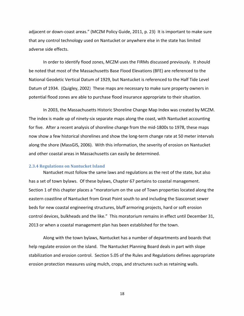
2.3.4RegulationsonNantucketIslandNantucket must follow the same laws and regulations as the rest of the state, but also
has a set of town bylaws. Of these bylaws, Chapter 67 pertains to coastal management.
Section 1 of this chapter places a “moratorium on the use of Town properties located along the
eastern coastline of Nantucket from Great Point south to and including the Siasconset sewer
beds for new coastal engineering structures, bluff armoring projects, hard or soft erosion
control devices, bulkheads and the like.” This moratorium remains in effect until December 31,
2013 or when a coastal management plan has been established for the town.
Along with the town bylaws, Nantucket has a number of departments and boards that
help regulate erosion on the island. The Nantucket Planning Board deals in part with slope
stabilization and erosion control. Section 5.05 of the Rules and Regulations defines appropriate
erosion protection measures using mulch, crops, and structures such as retaining walls.
19
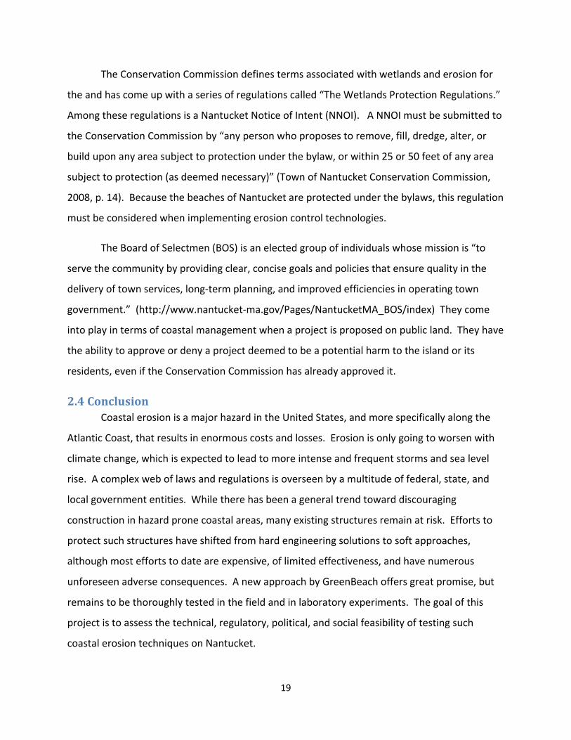
The Conservation Commission defines terms associated with wetlands and erosion for
the and has come up with a series of regulations called “The Wetlands Protection Regulations.”
Among these regulations is a Nantucket Notice of Intent (NNOI). A NNOI must be submitted to
the Conservation Commission by “any person who proposes to remove, fill, dredge, alter, or
build upon any area subject to protection under the bylaw, or within 25 or 50 feet of any area
subject to protection (as deemed necessary)” (Town of Nantucket Conservation Commission,
2008, p. 14). Because the beaches of Nantucket are protected under the bylaws, this regulation
must be considered when implementing erosion control technologies.
The Board of Selectmen (BOS) is an elected group of individuals whose mission is “to
serve the community by providing clear, concise goals and policies that ensure quality in the
delivery of town services, long‐term planning, and improved efficiencies in operating town
government.” (http://www.nantucket‐ma.gov/Pages/NantucketMA_BOS/index) They come
into play in terms of coastal management when a project is proposed on public land. They have
the ability to approve or deny a project deemed to be a potential harm to the island or its
residents, even if the Conservation Commission has already approved it.
2.4ConclusionCoastal erosion is a major hazard in the United States, and more specifically along the
Atlantic Coast, that results in enormous costs and losses. Erosion is only going to worsen with
climate change, which is expected to lead to more intense and frequent storms and sea level
rise. A complex web of laws and regulations is overseen by a multitude of federal, state, and
local government entities. While there has been a general trend toward discouraging
construction in hazard prone coastal areas, many existing structures remain at risk. Efforts to
protect such structures have shifted from hard engineering solutions to soft approaches,
although most efforts to date are expensive, of limited effectiveness, and have numerous
unforeseen adverse consequences. A new approach by GreenBeach offers great promise, but
remains to be thoroughly tested in the field and in laboratory experiments. The goal of this
project is to assess the technical, regulatory, political, and social feasibility of testing such
coastal erosion techniques on Nantucket.
20
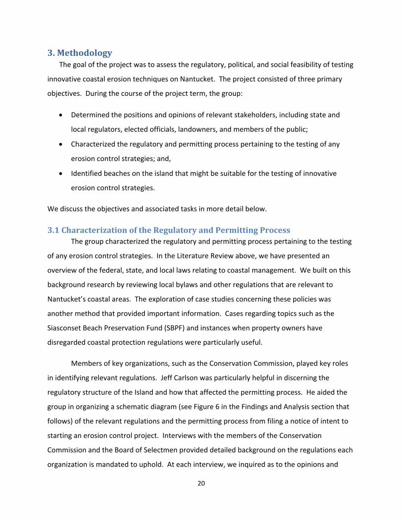
3.MethodologyThe goal of the project was to assess the regulatory, political, and social feasibility of testing
innovative coastal erosion techniques on Nantucket. The project consisted of three primary
objectives. During the course of the project term, the group:
Determined the positions and opinions of relevant stakeholders, including state and
local regulators, elected officials, landowners, and members of the public;
Characterized the regulatory and permitting process pertaining to the testing of any
erosion control strategies; and,
Identified beaches on the island that might be suitable for the testing of innovative
erosion control strategies.
We discuss the objectives and associated tasks in more detail below.
3.1CharacterizationoftheRegulatoryandPermittingProcessThe group characterized the regulatory and permitting process pertaining to the testing
of any erosion control strategies. In the Literature Review above, we have presented an
overview of the federal, state, and local laws relating to coastal management. We built on this
background research by reviewing local bylaws and other regulations that are relevant to
Nantucket’s coastal areas. The exploration of case studies concerning these policies was
another method that provided important information. Cases regarding topics such as the
Siasconset Beach Preservation Fund (SBPF) and instances when property owners have
disregarded coastal protection regulations were particularly useful.
Members of key organizations, such as the Conservation Commission, played key roles
in identifying relevant regulations. Jeff Carlson was particularly helpful in discerning the
regulatory structure of the Island and how that affected the permitting process. He aided the
group in organizing a schematic diagram (see Figure 6 in the Findings and Analysis section that
follows) of the relevant regulations and the permitting process from filing a notice of intent to
starting an erosion control project. Interviews with the members of the Conservation
Commission and the Board of Selectmen provided detailed background on the regulations each
organization is mandated to uphold. At each interview, we inquired as to the opinions and
21
concerns of the interviewee of past erosion control attempts. The group focused primarily on
the proposals of the Siasconset Beach Preservation Fund (SBPF), as they presented the largest‐
scale and most controversial erosion control project on the Island, but also investigated other
coastal management projects located on Nantucket.
Attendance at the Conservation Commission’s biweekly public hearings was also a
helpful tool in establishing an understanding of the structure of the permitting process. The
first meeting the group attended centered on the proposal of a sand dune rehabilitation
project. The meetings after that pertained principally on a SBPF proposal, which involved the
placement of sand‐covered stone mattresses and gabions along the base of the Siasconset
bluff. From these meetings, the group was not only able to observe the structure of a public
hearing, but we were also able to determine the most influential parties in terms of the
permitting process and how they impacted the decision‐making process of the Conservation
Commission.
3.2PoliticalOpinionsandContactsonNantucket One of the project group’s main objectives was to determine the positions and opinions
of relevant stakeholders, including state and local regulators, elected officials, and members of
the public. To begin, the project group reviewed the town’s newspapers, minutes of town
meetings, and relevant committees to identify the range of issues and the key figures involved.
We used interviews to extend and clarify the information received from these sources. The
group interviewed various elected and appointed officials and town staff members to gain an
understanding of their roles, responsibilities, and opinions in terms of enacting erosion control
methods and projects.
The first step in accomplishing this objective was to research local newspapers,
particularly The Nantucket Inquirer and Mirror. The group reviewed articles related to erosion
and coastal management on the Island, in order to identify the nature of past control efforts,
the range of opinions about these efforts among opinion leaders and the various interested and
affected parties. This review also revealed the range of agencies and organizations typically
involved in erosion control efforts. The newspapers revealed that although there have been
22
many discussions about coastal erosion efforts in the past, the most prominent case has been
and continues to be the efforts to mitigate erosion impacts in Siasconset.
In addition to examining newspaper articles, the group also reviewed the minutes of
meetings of various town boards and committees. We focused principally on minutes from the
public hearings of both the Nantucket Conservation Commission and the Board of Selectmen,
since these bodies have the largest role to play in erosion control efforts. The minutes from
these meetings highlighted the major topics that were presented while also providing
information as to the positions and opinions held by certain individuals regarding the erosion
and coastal management strategies.
The group elected to attend some of these public hearings, and witnessed key parties in
the regulation and permitting process of coastal management. The meetings provided insight
as to the main concerns of each organization that was present, and outlined what the probable
sources of scrutiny would be at hearings for future proposals. The major topic of the meetings
we attended was the Siasconset Beach Preservation Fund’s (SBPF) newest coastal management
project proposal. The hearings were most informative due to the fact that the SBPF case is the
largest ongoing erosion control project and as such illustrates the nature and range of issues
that any future erosion control effort is likely to encounter. From these meetings, the group
identified officials from the Conservation Commission and other pertinent organizations, who
would later serve as contacts to be interviewed. These hearings were an essential part of the
project since they allowed us to understand the permitting process and observe how the events
in Siasconset were playing out in the public and regulatory arena. By observing the way that
the Conservation Commission and the public reacted to the SBPF proposal, we were able to
gain a sense of who are the key parties and what are their concerns in terms of coastal
management projects. We were also able to gain from these meetings a sense of how the
permitting process plays out, and what steps are required to obtain approval for a project. This
helped us develop recommendations for our sponsor as to the appropriate way to proceed.
Once the key parties involved in and concerned about coastal erosion and erosion
control were identified, the group then moved to gather pertinent information from these
23
sources directly. The project team used in‐depth qualitative interviews as the main data
collection method. In‐depth qualitative interviews, although time consuming, have a
somewhat flexible structure in terms of question order and wording, and can be used to obtain
information from specific people. Instead of using a strict script of questions, this type of
interview employs a flexible set of questions that can be modified to fit the situation and
personality of the person the team is interviewing. With semi‐structured interviews, we were
not restrained by a rigid script, but could clarify the purpose of any inquiries and provide helpful
explanations upon the interviewee’s request. Structured interviews, on the other hand, can
often cause participants in the interview to feel intimidated, especially if the questions are
overly contrived. It is essential that the interview candidates feel comfortable so that they can
be open with us when providing us with responses. Located in Appendix B are some questions
that were asked during the interviews.
To begin the interview process, the group conducted an unstructured interview with
Janet Schulte of the Maria Mitchell Association (MMA). During the summer before the project
term, MMA held a workshop about erosion on Nantucket, and she therefore had knowledge of
the political environment surrounding the issue. The interview with her provided our project
group with new contact information along with a general overview of recent coastal
management projects attempted on the Island. She recommended that we speak to Jeff
Carlson, Nantucket’s Beach Manager and the Conservation Commission’s Natural Resource
Coordinator, Josh Posner of the Siasconset beach Preservation Fund (SBPF), and Bob DeCosta of
the Nantucket Board of Selectmen. We also communicated with Whitey Willauer, Vice‐
Chairman of the Nantucket Board of Selectmen.
Jeff Carlson was a very knowledgeable source in terms of the political environment and
regulatory process on Nantucket. He provided the group with names and contact information
for most of the members of the Conservation Commission, which lead us to contact with Dr.
Ernest Steinauer, Dr. Sarah Oktay, and John Brescher. The interviews with Conservation
Commission members focused on the role of that organization in terms or the regulation of
coastal management, past erosion control projects, and the concerns and potential risks
24
associated with future proposals. Their answers to these questions provided the project group
with insight as to the opinions and concerns of Conservation Commission members when
considering innovative coastal management techniques. These questions are displayed in
Appendix A.
3.3IdentifyingSuitableExperimentationSites It was essential that we developed a set of criteria that determined which coastal zones
on Nantucket would be ideal for the testing of innovative coastal erosion strategies. To do this,
we communicated with our project sponsor, Oscar Plotkin, and the lead scientist of
GreenBeach, Peter Rehage. Between these two contacts, the project group was able to
discover enough information necessary about the GreenBeach product to identify sites on the
Island that might be appropriate for potential application.
3.4ConclusionThe group’s project goal was achieved by effectively working together to collect data
through a series of semi‐structured interviews. We interviewed individuals from a variety of
organizations who hold strong feelings about the coastal erosion problem and are important in
terms of the regulatory process. The group used this, along with the information collected for
our literature review, to recommend a course of action for our sponsor concerning the further
testing of their product on Nantucket.
25
4.FindingsandAnalysis GreenBeach has developed a new approach to control beach erosion that involves the
application of an eponymous propriety substance. They have tested the technique in various
parts of the world including Oman, France and Brazil, and would like to conduct more extensive
testing in the United States, including Nantucket.1 This project was intended to explore the
history of erosion control on Nantucket, and layout the process and likely issues faced in testing
a new erosion control technology on the Island. Through interviews with key members of town
regulatory boards and committees and thorough additional archival research, the project group
examined Nantucket’s political environment regarding coastal management technology and
past attempts at halting erosion. The team identified and categorized the concerns and
regulatory roles of a variety of organizations. Using erosion rate maps to augment our
research, we have also developed a set of criteria that determine which beaches or areas on
the Island might serve as appropriate testing sites.
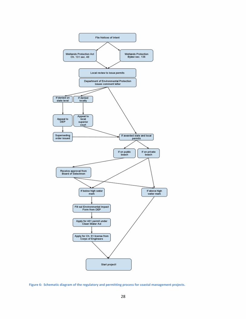
4.1RegulatoryStructureonNantucketAs part of our research, the group examined the process through which a coastal
management project must pass. We were able to lay out the steps into the flow diagram
shown in Figure 6, which will be closely followed through this section. The main permitting
body is the Conservation Commission, whose job is to enforce the Wetlands Protection Act
(WPA). Their mission statement is as follows:
“The Massachusetts Wetlands Protection Act (the Act) requires that no person shall
remove, dredge, or alter any bank, freshwater or coastal wetlands, beach, dunes, flat,
marsh, meadow or swamp bordering on any resource area as defined in the Act without
filing written notice of the intention to perform such work with the Conservation
Commission of the Town in which the land is located and receiving a permit from the
Commission to perform the work. “ (http://www.nantucket‐
ma.gov/Pages/NantucketMA_Conservation/index)
1 The project did not assess and makes no claims about the effectiveness or safety of the technique.
26
All coastal management projects take place on land protected by the WPA, and therefore must
go through the Conservation Commission. The Conservation Commission defines terms
associated with wetlands and erosion for the town bylaws and has come up with a series of
regulations called “The Wetlands Protection Regulations.” Among these regulations is a
Nantucket Notice of Intent (NNOI). A NNOI must be submitted to the Conservation
Commission by “any person who proposes to remove, fill, dredge, alter, or build upon any area
subject to protection under the bylaw, or within 25 or 50 feet of any area subject to protection
(as deemed necessary)” (Town of Nantucket Conservation Commission, 2008, p. 14).
As stated in the mission, the permitting process starts with the filing of an NNOI. An
NNOI must be filed for both the Department of Environmental Protection (DEP) on a state level
and the Conservation Commission on a local level. The DEP will review the NNOI in accordance
with Wetlands Protection Act Ch. 131 sec. 40 and issue a comment letter to the Nantucket
Conservation Commission. The Conservation Commission must then review the project based
on the local Wetlands Protection Bylaw sec. 136. They often have many concerns about
measures taken to control erosion in order to uphold the WPA. It becomes important to
address these concerns, as not doing so may lead to a denial of a permit. After the local review,
the Conservation Commission will decide whether to award both state and local permits, one or
the other, or deny both. The local bylaws tend to be more stringent than the state, so it is more
likely that the proposal will be denied locally and approved on the state level than the other
way around.
If the proposal is denied on the state level, the proposing party may choose to appeal to
the DEP. If the appeal is successful, a superseding order may be issued and the ruling of denial
may be overturned and a permit may be granted. If denied locally, the proposing party can
appeal to the local superior court, and again, if the appeal is successful, the court may grant a
local permit for the project.
At this point, if both state and local permits are awarded, there are two scenarios; the
proposed project could be on a public beach or on a private beach. If a project is proposed to
be on public beach, the proposal must be brought to the Board of Selectmen. The Board of
27
Selectmen (BOS) is an elected group of individuals whose job is to ensure quality in the delivery
of town services and long‐term planning. With this come certain functions that pertain to
coastal management projects on the island. The first is the ongoing process of creating a new
Coastal Management Plan. With the creation of this plan, the moratorium on engineering
projects, which outlaws any “new coastal engineering structures, bluff armoring projects, hard
or soft erosion control devices, bulkheads and the like” on the east coast of Nantucket, could be
lifted, allowing for new projects to protect the historic Siasconset Bluff (Nantucket Town Bylaw,
Ch. 67). The second function of the Board, which is applied in this scenario, is to approve
coastal management projects on public land or to choose to deny permission to conduct such a
project on public land, even if it were already permitted by the Conservation Commission. In
this way the Board plays an important role in the politics of coastal management, but will rarely
be involved in projects on private beach
The next step is to determine whether or not the project would be above or below the
high water mark. The high water mark is defined as the average point reached by the water at
high tide. A project above this mark has no further obstacles and may start work, however a
project below must complete a few final steps. The proposing party must fill out and
Environmental Impact form for the DEP, apply for a permit under the Clean Water Act, and
apply for a Chapter 91 license from the Corps of Engineers. After these three steps have been
finished, work on the project may begin.
A coastal management project can be removed by the Conservation Commission after it
has been constructed or implemented if they decide that the approved plan is not followed.
They require an escrow account, or a financial bond containing enough money to guarantee
that if a project plan is followed irresponsibly or negligently, then the Conservation Commission
can pay to shut down and remove the project. The Commission also requires that the
proponent of a project monitors and reports the progress of a project. Violation of this
requirement by either not properly monitoring or not providing progress reports can result in
an order to cease‐and‐desist.
28
Figure 6: Schematic diagram of the regulatory and permitting process for coastal management projects.
29
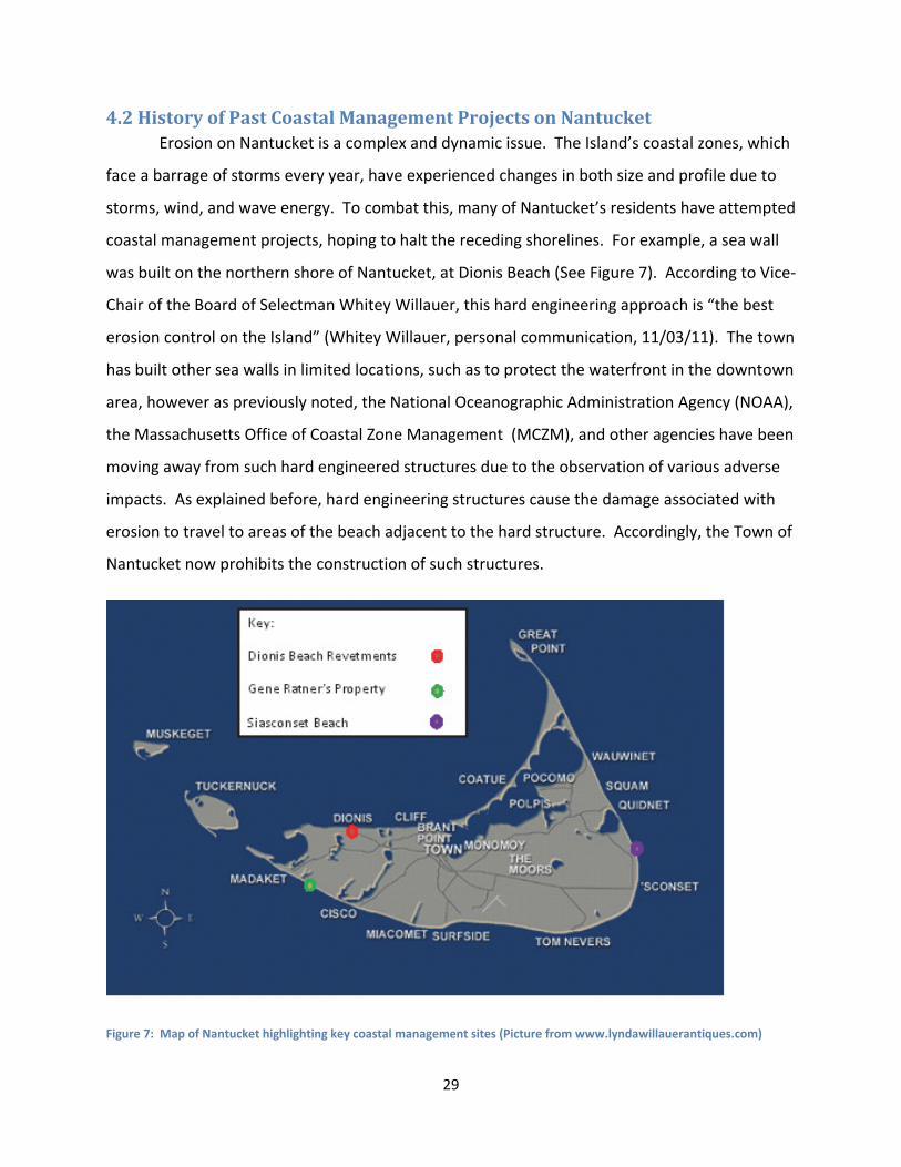
4.2HistoryofPastCoastalManagementProjectsonNantucket Erosion on Nantucket is a complex and dynamic issue. The Island’s coastal zones, which
face a barrage of storms every year, have experienced changes in both size and profile due to
storms, wind, and wave energy. To combat this, many of Nantucket’s residents have attempted
coastal management projects, hoping to halt the receding shorelines. For example, a sea wall
was built on the northern shore of Nantucket, at Dionis Beach (See Figure 7). According to Vice‐
Chair of the Board of Selectman Whitey Willauer, this hard engineering approach is “the best
erosion control on the Island” (Whitey Willauer, personal communication, 11/03/11). The town
has built other sea walls in limited locations, such as to protect the waterfront in the downtown
area, however as previously noted, the National Oceanographic Administration Agency (NOAA),
the Massachusetts Office of Coastal Zone Management (MCZM), and other agencies have been
moving away from such hard engineered structures due to the observation of various adverse
impacts. As explained before, hard engineering structures cause the damage associated with
erosion to travel to areas of the beach adjacent to the hard structure. Accordingly, the Town of
Nantucket now prohibits the construction of such structures.
Figure 7: Map of Nantucket highlighting key coastal management sites (Picture from www.lyndawillauerantiques.com)
30
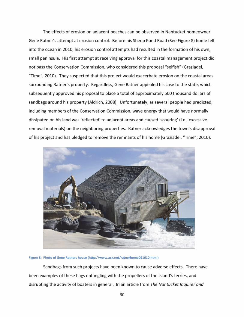
The effects of erosion on adjacent beaches can be observed in Nantucket homeowner
Gene Ratner’s attempt at erosion control. Before his Sheep Pond Road (See Figure 8) home fell
into the ocean in 2010, his erosion control attempts had resulted in the formation of his own,
small peninsula. His first attempt at receiving approval for this coastal management project did
not pass the Conservation Commission, who considered this proposal “selfish” (Graziadei,
“Time”, 2010). They suspected that this project would exacerbate erosion on the coastal areas
surrounding Ratner’s property. Regardless, Gene Ratner appealed his case to the state, which
subsequently approved his proposal to place a total of approximately 500 thousand dollars of
sandbags around his property (Aldrich, 2008). Unfortunately, as several people had predicted,
including members of the Conservation Commission, wave energy that would have normally
dissipated on his land was ‘reflected’ to adjacent areas and caused ‘scouring’ (i.e., excessive
removal materials) on the neighboring properties. Ratner acknowledges the town’s disapproval
of his project and has pledged to remove the remnants of his home (Graziadei, “Time”, 2010).
Figure 8: Photo of Gene Ratners house (http://www.ack.net/ratnerhome091610.html)
Sandbags from such projects have been known to cause adverse effects. There have
been examples of these bags entangling with the propellers of the Island’s ferries, and
disrupting the activity of boaters in general. In an article from The Nantucket Inquirer and
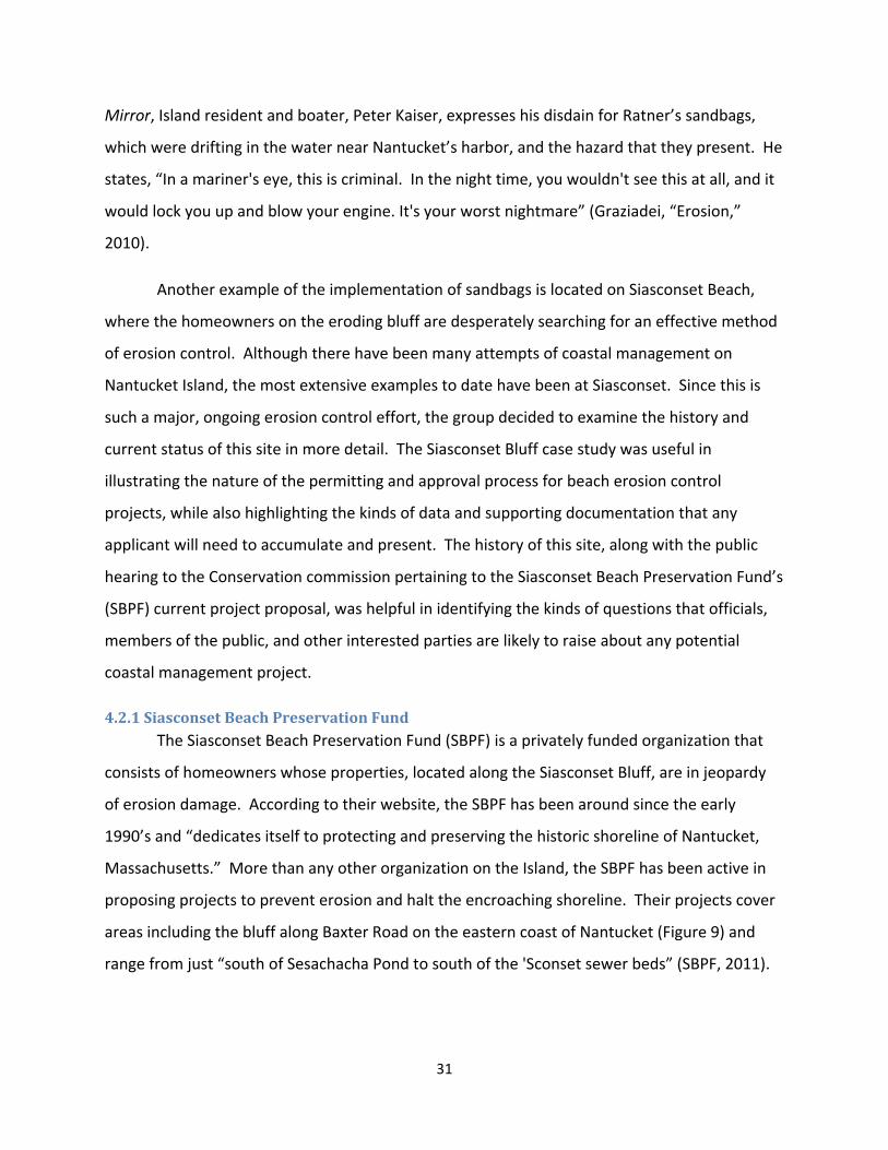
31
Mirror, Island resident and boater, Peter Kaiser, expresses his disdain for Ratner’s sandbags,
which were drifting in the water near Nantucket’s harbor, and the hazard that they present. He
states, “In a mariner's eye, this is criminal. In the night time, you wouldn't see this at all, and it
would lock you up and blow your engine. It's your worst nightmare” (Graziadei, “Erosion,”
2010).
Another example of the implementation of sandbags is located on Siasconset Beach,
where the homeowners on the eroding bluff are desperately searching for an effective method
of erosion control. Although there have been many attempts of coastal management on
Nantucket Island, the most extensive examples to date have been at Siasconset. Since this is
such a major, ongoing erosion control effort, the group decided to examine the history and
current status of this site in more detail. The Siasconset Bluff case study was useful in
illustrating the nature of the permitting and approval process for beach erosion control
projects, while also highlighting the kinds of data and supporting documentation that any
applicant will need to accumulate and present. The history of this site, along with the public
hearing to the Conservation commission pertaining to the Siasconset Beach Preservation Fund’s
(SBPF) current project proposal, was helpful in identifying the kinds of questions that officials,
members of the public, and other interested parties are likely to raise about any potential
coastal management project.
4.2.1SiasconsetBeachPreservationFundThe Siasconset Beach Preservation Fund (SBPF) is a privately funded organization that
consists of homeowners whose properties, located along the Siasconset Bluff, are in jeopardy
of erosion damage. According to their website, the SBPF has been around since the early
1990’s and “dedicates itself to protecting and preserving the historic shoreline of Nantucket,
Massachusetts.” More than any other organization on the Island, the SBPF has been active in
proposing projects to prevent erosion and halt the encroaching shoreline. Their projects cover
areas including the bluff along Baxter Road on the eastern coast of Nantucket (Figure 9) and
range from just “south of Sesachacha Pond to south of the 'Sconset sewer beds” (SBPF, 2011).
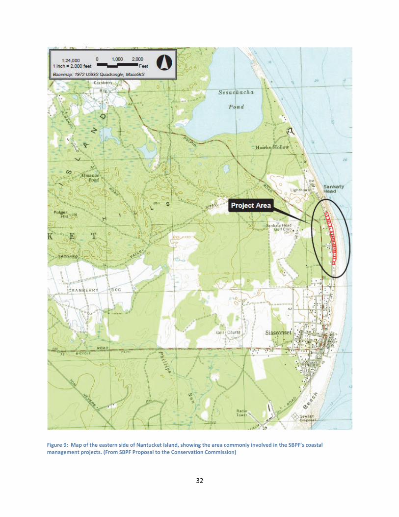
32
Figure 9: Map of the eastern side of Nantucket Island, showing the area commonly involved in the SBPF’s coastal management projects. (From SBPF Proposal to the Conservation Commission)
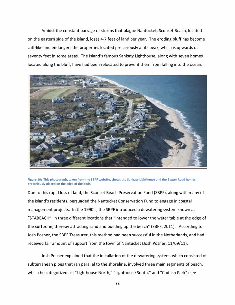
33
Amidst the constant barrage of storms that plague Nantucket, Sconset Beach, located
on the eastern side of the island, loses 4‐7 feet of land per year. The eroding bluff has become
cliff‐like and endangers the properties located precariously at its peak, which is upwards of
seventy feet in some areas. The Island’s famous Sankaty Lighthouse, along with seven homes
located along the bluff, have had been relocated to prevent them from falling into the ocean.
Figure 10: This photograph, taken from the SBPF website, shows the Sankaty Lighthouse and the Baxter Road homes precariously placed on the edge of the bluff.
Due to this rapid loss of land, the Sconset Beach Preservation Fund (SBPF), along with many of
the island’s residents, persuaded the Nantucket Conservation Fund to engage in coastal
management projects. In the 1990’s, the SBPF introduced a dewatering system known as
“STABEACH” in three different locations that “intended to lower the water table at the edge of
the surf zone, thereby attracting sand and building up the beach” (SBPF, 2011). According to
Josh Posner, the SBPF Treasurer, this method had been successful in the Netherlands, and had
received fair amount of support from the town of Nantucket (Josh Posner, 11/09/11).
Josh Posner explained that the installation of the dewatering system, which consisted of
subterranean pipes that ran parallel to the shoreline, involved three main segments of beach,
which he categorized as: “Lighthouse North,” “Lighthouse South,” and “Codfish Park” (see
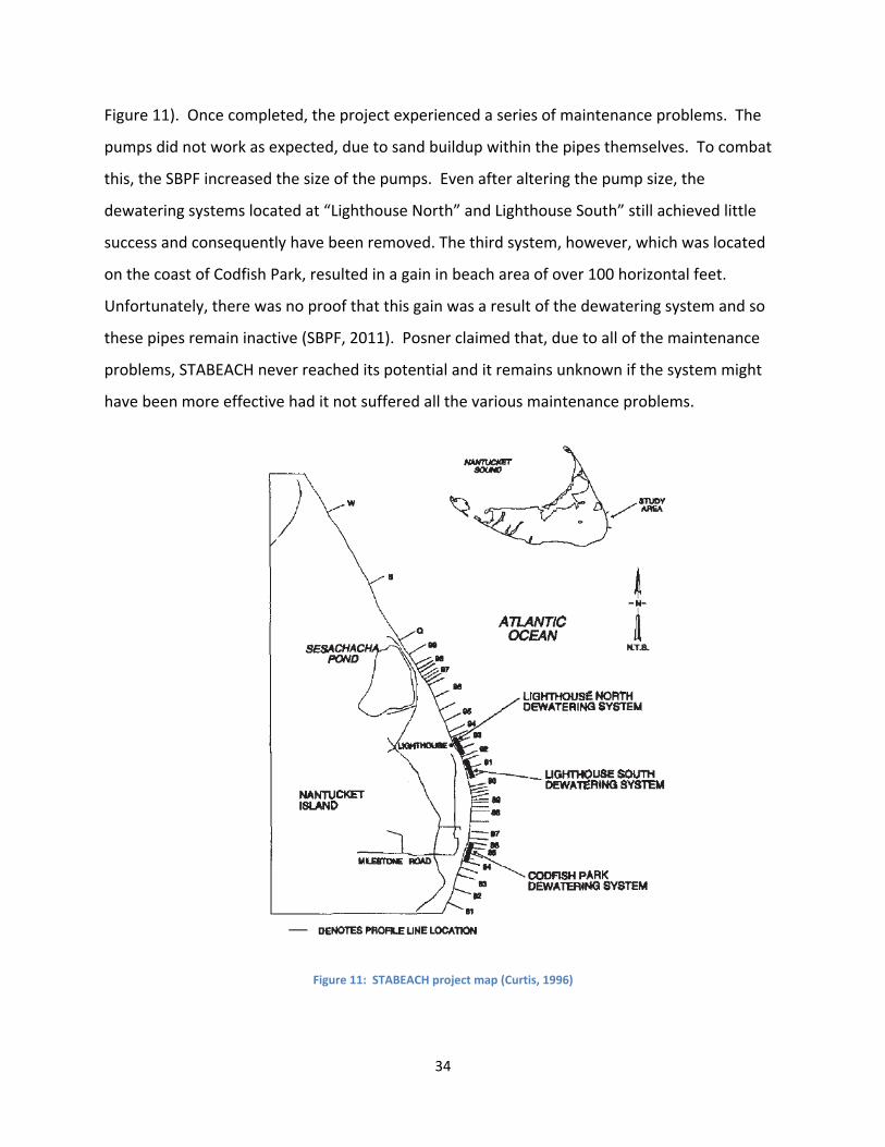
34
Figure 11). Once completed, the project experienced a series of maintenance problems. The
pumps did not work as expected, due to sand buildup within the pipes themselves. To combat
this, the SBPF increased the size of the pumps. Even after altering the pump size, the
dewatering systems located at “Lighthouse North” and Lighthouse South” still achieved little
success and consequently have been removed. The third system, however, which was located
on the coast of Codfish Park, resulted in a gain in beach area of over 100 horizontal feet.
Unfortunately, there was no proof that this gain was a result of the dewatering system and so
these pipes remain inactive (SBPF, 2011). Posner claimed that, due to all of the maintenance
problems, STABEACH never reached its potential and it remains unknown if the system might
have been more effective had it not suffered all the various maintenance problems.
Figure 11: STABEACH project map (Curtis, 1996)
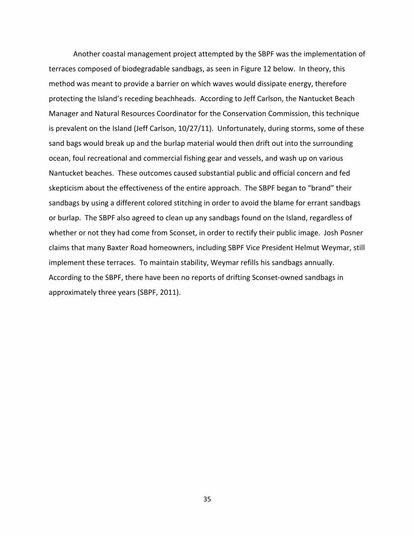
35
Another coastal management project attempted by the SBPF was the implementation of
terraces composed of biodegradable sandbags, as seen in Figure 12 below. In theory, this
method was meant to provide a barrier on which waves would dissipate energy, therefore
protecting the Island’s receding beachheads. According to Jeff Carlson, the Nantucket Beach
Manager and Natural Resources Coordinator for the Conservation Commission, this technique
is prevalent on the Island (Jeff Carlson, 10/27/11). Unfortunately, during storms, some of these
sand bags would break up and the burlap material would then drift out into the surrounding
ocean, foul recreational and commercial fishing gear and vessels, and wash up on various
Nantucket beaches. These outcomes caused substantial public and official concern and fed
skepticism about the effectiveness of the entire approach. The SBPF began to “brand” their
sandbags by using a different colored stitching in order to avoid the blame for errant sandbags
or burlap. The SBPF also agreed to clean up any sandbags found on the Island, regardless of
whether or not they had come from Sconset, in order to rectify their public image. Josh Posner
claims that many Baxter Road homeowners, including SBPF Vice President Helmut Weymar, still
implement these terraces. To maintain stability, Weymar refills his sandbags annually.
According to the SBPF, there have been no reports of drifting Sconset‐owned sandbags in
approximately three years (SBPF, 2011).
36
Figure 12: Photograph by Van Lieu Photography (2010): An Uncovered sandbag at the bottom on Siasconset Bluff
More recent attempts at erosion control on Sconset Beach include beach nourishment.
As explained earlier in this report, beach nourishment involves the addition of new sediment to
a coastal area. Although this method had already been employed in various states, its proposal
on Nantucket stirred much controversy. Posner stated that the SBPF wanted to take into
account the concerns of fishermen on the Island. In an interview with Bobby DeCosta, a
member of the Board of Selectmen and the Angler’s Club, he explained that the fishermen
frequent the waters off of the Siasconset Coast (Bobby DeCosta, 11/16/11). DeCosta expressed
his concern that the sediment would drift out into the ocean and result in the disruption and
covering of the rocky, bottom‐habitat known as ‘cobbles.’ The fishermen opposed the idea of
beach nourishment due to its potential danger to the surrounding marine habitat. Instead,
they advocate ‘hardening’ the bluff, an act that would violate the town’s coastal management
plan.
37
Despite losing the support of the Island’s fishermen, the SBPF continued with their
project proposal. Posner deems this loss of support to be the biggest blunder of the proposal
and directly contributed to its denial. In 2008, this project proposal was defeated in a
referendum to assess the project’s popularity. Subsequently, the SBPF withdrew its proposal,
which, according to Jeff Carlson, would have cost between thirty and thirty‐five million dollars.
He suggests that this project proposal and the surrounding controversies were detrimental to
the public image of the SBPF. The fact that this proposal was denied frustrated Posner, who
claims that the Nantucket environmentalists who voted against this had initially suggested the
project to the SBPF.
The SBPF’s most recent proposal involves the placement of a rock “mattresses and
gabions,” which would be wrapped in “geotextile plastic” mesh and covered in sand. After each
storm or when necessary, more sand would be added to the beach to keep the mattresses and
gabions completely concealed. This beach nourishment process would have to be conducted
continuously to maintain the level of sand required. In theory, this would essentially alter the
slope of the bluff and strengthen the base.
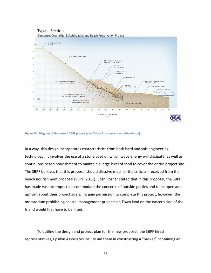
38
Figure 13: Diagram of the current SBPF project plan (Taken from www.sconsetbeach.org)
In a way, this design incorporates characteristics from both hard and soft engineering
technology. It involves the use of a stone base on which wave energy will dissipate, as well as
continuous beach nourishment to maintain a large level of sand to cover the entire project site.
The SBPF believes that this proposal should dissolve much of the criticism received from the
beach nourishment proposal (SBPF, 2011). Josh Posner stated that in this proposal, the SBPF
has made vast attempts to accommodate the concerns of outside parties and to be open and
upfront about their project goals. To gain permission to complete this project, however, the
moratorium prohibiting coastal management projects on Town land on the eastern side of the
Island would first have to be lifted.
To outline the design and project plan for the new proposal, the SBPF hired
representatives, Epsilon Associates Inc., to aid them in constructing a “packet” containing an
39
extensive set of documents for submission to the Commission. This “packet” introduces the
concepts and features of the design, and includes technical drawings, property maps and design
specifications from SBPF and Epsilon in support of their application. It contains notes of
support from abutters and others in favor of the project, as well as letters and supporting
documents raising concerns about different aspects. It is clear that the organization of this
packet required a large amount of time, research and preparation, as it was completed on
March 8, 2011 and the first hearing in which the project was presented was not until
approximately eight months later.
As mentioned before, the SBPF had attempted to address the concerns of various
parties during the process of creating the proposal. Despite these attempts, the project
proposal was still met with skepticism and controversy at its public hearing to the Conservation
Commission (which took place on 11/09/2011). The Commissioners’ concerns included the
effects of the project on the wildlife inhabiting the beach. Because this project involved the
covering of a large area of beach with rocks, the habitat there could be compromised. The type
of plastic was viewed as a potential risk, as its decomposition could release dangerous
substances into the beach. The Conservation Commission also addressed the issue that the
sand would need frequent replacement, as storm action would easily wash much of the
sediment away from the beach. Aside from the fact that this would be expensive to replace,
the Commission suggested that the loss of sand would result in the uncovering of the concealed
mattresses and gabions, debasing the aesthetic qualities of the beach. Due to the fact that
Nantucket is a major tourist location, any compromise to coastal areas in terms of aesthetics
comes as a major concern to the Conservation Commission. The Commission was adamant that
without proof that this project would not hinder the beach’s recreational capability, then the
project would not gain approval. The SBPF representatives from Epsilon replied that similar
technology was already in place in other locations, such as at Logan Airport and Marblehead,
but they were not prepared to present additional details or supporting evidence at the
meeting. A member of the public, who was apparently a former member of the Conservation
Commission, claimed that she had researched this type of coastal management technology and
found that additional sea groins were involved anywhere this method was successful. This
40
observation debased many supporting claims by the SBPF, as it suggested that their design
would be unsuccessful in terms of engineering. They could not produce evidence that explicitly
proved that the project design would effectively halt erosion even without the construction of
groins
The Land Council, which had hired a professional consultant to help review the case and
present arguments at the public hearing, raised concerns about the amount of sand necessary
to complete such a project. They also identified what they called a ‘numerical error’ within the
SBPF proposal concerning the amount of sand necessary for the project. When asked about
this ‘error,’ the engineers and spokesperson representing the SBPF could not formulate an
adequate response immediately and would have to examine the issue further and get back to
the Council and Commission. This essentially put the proponents of the design on the
defensive and communicated to all the attendees, including both the Conservation Commission
and members of the public, that there were still unknowns involving the proposal. . What
began as an arcane conversation about the amount of sand developed into a contentious and
heated debate. The Conservation Commission had already raised concerns about the sand
requirement, but through this apparent discrepancy regarding the numbers, the Land Council
presented a new series of concerns. They suggested that more sand would require more trucks
driving along the Island’s already delicate beaches, and inquired to the exact number of trucks
needed every month. Then the concern that the Island’s gravel pits would not be capable of
supporting a project such as this. If this was the case, and there would not be enough sand to
continuously nourish the site, attendees became concerned that the mattresses would
eventually become exposed and debase the aesthetics of the beach. Conversely, the Land
Council raised the concern that if the site were over‐nourished, then there may be a potential
risk to the fishing grounds located near Siasconset Beach.
It was clear from the manner in which this hearing was conducted that the applicants of
coastal erosion project containing any amount of controversy will be met with severe scrutiny.
Although the SBPF did not expect to obtain approval for the proposal at this hearing, they
expressed to the Conservation Commission their frustration that they had frequently
41
attempted to contact the Land Council so as to hear and address their concerns, but had not
received a reply. Attendance at this public hearing proved to be essential in our research, as it
highlighted many of the potential concerns that may be raised in future public hearings
relevant to coastal management. In the following section, we explain in depth the major
concerns and opinions of a variety of key players involved in relevant town boards, committees,
and concerned organizations in general.
4.3PoliticalOpinionsandConcerns Coastal management projects of any kind are viewed as controversial to Island residents
and are therefore met with severe scrutiny on Nantucket. A variety of different types of
technology have been implemented, many of which having impacts that are actually
detrimental to the Island. Due to this fact, key players and members of relevant boards and
committees on Nantucket harbor different concerns and opinions when adopting new
strategies to combat coastal erosion. The public hearings that the group attended provided
insight on who these key players were and also highlighted their major concerns. The concerns
presented at the hearings are outlined in Table 3, along with the functions of pertinent town
organizations.
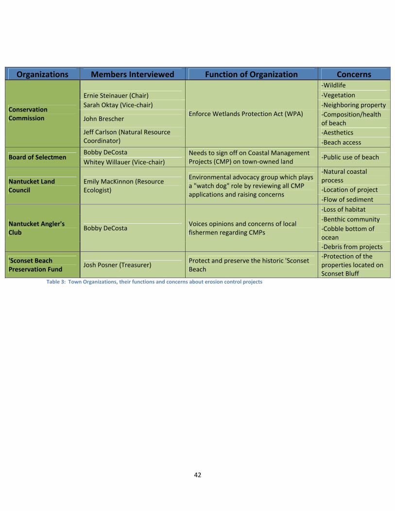
42
Organizations Members Interviewed Function of Organization Concerns
Conservation Commission
Ernie Steinauer (Chair)
Enforce Wetlands Protection Act (WPA)
‐Wildlife
‐Vegetation
Sarah Oktay (Vice‐chair) ‐Neighboring property
John Brescher ‐Composition/health of beach
Jeff Carlson (Natural Resource Coordinator)
‐Aesthetics
‐Beach access
Board of Selectmen Bobby DeCosta Needs to sign off on Coastal Management
Projects (CMP) on town‐owned land ‐Public use of beach
Whitey Willauer (Vice‐chair)
Nantucket Land Council
Emily MacKinnon (Resource Ecologist)
Environmental advocacy group which plays a "watch dog" role by reviewing all CMP applications and raising concerns
‐Natural coastal process
‐Location of project
‐Flow of sediment
Nantucket Angler's Club
Bobby DeCosta Voices opinions and concerns of local fishermen regarding CMPs
‐Loss of habitat
‐Benthic community
‐Cobble bottom of ocean
‐Debris from projects
'Sconset Beach Preservation Fund
Josh Posner (Treasurer) Protect and preserve the historic 'Sconset Beach
‐Protection of the properties located on Sconset Bluff
Table 3: Town Organizations, their functions and concerns about erosion control projects
43
Throughout the boards and committees that regulate land and impose policies on
Nantucket, coastal management technology has generated a great deal of controversy. Jeff
Carlson, the town Beach Manager, states that any attempts at controlling erosion eventually
fail, suggesting that “the ocean wins by attrition” (Jeff Carlson, 10/27/11). Despite this, the
Conservation Commission has allowed a series of soft engineering projects. Hard engineering
structures are seldom found on Nantucket, and further projects involving them are prohibited,
says Jeff Carlson. Carlson claims that the outlawing of this type of technology began at the
state level. He believes that not only does one lose the beach with hard engineering, but that it
actually exacerbates the effects and damage travels to adjacent areas. The Board of Selectmen
Vice‐Chair, Whitey Willauer, disagrees with this view. The longtime Island resident firmly
supports the use of revetments on Dionis Beach, located on the northern shore of Nantucket.
He questions the actions of Siasconset Beach Preservation Fund (SBPF), stating that he wonders
why they have not yet gone to the state to repeal the ban on hard engineering solutions.
Alluding to similar projects on Martha’s Vineyard and Cape Cod, he says that bulkheads have
been effective in halting the effects of erosion.
Bobby DeCosta, Angler’s Club member and another member of the Board of Selectmen,
agrees with Willauer’s views. DeCosta claims that, in the case of the Siasconset Bluff, beach
nourishment would not have been successful. In fact, he expressed fears that there was a
danger to the benthic community in a project like this. The cobble bottom ocean floor off the
coast of Siasconset is one of the few habitats of its kind in New England, and therefore, its
preservation is a major concern to ecologists in general and fishermen in particular. DeCosta
believes that if the sediment from a beach nourishment project washed out to sea, it could
result in the covering of such a habitat and disrupt fishing activity in the area. He stated that
the Island’s fishermen want to “armor the bluff and call it a day.” He also advised that future
projects need to take the concerns of local fishermen into account, and should provide data
through more extensive research, claiming that the previously proposed projects by SBPF did
not adequately do so.
44
The fishermen were not the only group on Nantucket that expressed concerns during
the SBPF beach nourishment project proposal. After this project was proposed and denied in
2008, the town imposed a moratorium that prohibits “the use of Town properties located along
the eastern coastline of Nantucket from Great Point south to and including the Siasconset
sewer beds for new coastal engineering structures, bluff armoring projects, hard or soft erosion
control devices, bulkheads and the like.” This moratorium has caused the SBPF to reevaluate
their approach in terms of proposing new coastal management projects. Nantucket town clerk,
Catherine Flanagan Stover, recently wrote a letter to the editor in The Nantucket Inquirer and
Mirror, exclaiming that the new SBPF proposal “deserves close scrutiny from the public and
town agencies.” Stover believes that the motives of the SBPF are directed not toward the
benefit of Island, but exclusively toward safety of their own property (Stover, 2011).
Many previous attempts at erosion control have been controversial, but one that holds
particular lessons for GreenBeach involves a substance called “Sand Rx,” which was developed
as an anti‐erosion measure for beach sand. According to an article in The Nantucket Inquirer
and Mirror, this material had been applied in September, 2004, without permission from the
Conservation Commission, on a beach near Sheep Pond Road. When the Beach Manager at the
time, Amanda Bixby, went to investigate the project, she was met by Blaize McArdle. He
claimed that he had a permit from the United States Army Corps of Engineers, however failed
to produce it when questioned. According to the article, town Health Officer Richard Ray
stated, “My concern is, is this some form of volatile organic compound? In its present state,
could it leach out into the ocean? We need to determine what it is.” He went on to say,
“People have to understand that no one can go out and try some whacko scheme without
getting permits” (Kinsella, 2004).
Conservation Commission Vice‐Chair, Sarah Oktay, shares these concerns. In an
interview, she explained that Sand Rx was extremely corrosive and that she opposed any
chemical application onto the beach. Oktay, who holds a doctorate in chemistry, did not
believe such an application would be effective (Sarah Oktay, 11/11/11). Likewise, Bobby
DeCosta suggested that this type of substance, which he labeled a “chemical binder,” involved
45
the potential risk of harming the benthic community. He explained that the word “chemical”
immediately “raises a red flag” amongst Island residents, and strongly doubted that Sand Rx
would have been approved if it had gone through a public hearing to the Conservation
Commission.
The environmental impact of any coastal management project is one of the main
concerns of many parties on the Island. Dr. Ernest Steinauer, Chairman of the Conservation
Commission, expressed that any potential risk of the inhibition of natural processes would be
met with extreme scrutiny (Ernest Steinauer, 11/14/11). The Nantucket Land Council, a non‐
profit organization that charges itself with environmental advocacy in the review of project
proposals that could affect the Island’s wetlands, shares this concern. At the public hearing for
the SBPF’s most recent project proposal, the representatives for the Land Council acted as
“watchdogs” for environmental safety. Sarah Oktay explains that “over the past decade or two,
Nantucket has tended to be more restrictive regarding wetland, coastal and environmental
protection than similar areas around Massachusetts.” During the SBPF public hearing, she
suggested that the type of plastic used in the geotubes could leach out into the beach,
potentially harming the habitat there. The Conservation Commission was very skeptical of the
entire project due to the fact that the representatives for the SBPF were unable to provide
evidence that their project would not negatively impact the environment.
One of the major concerns expressed at the public hearing and during our interviews is
the potential impact that a project may have on the beaches beyond the project area, including
both excessive erosion and sedimentation. Steinauer believes that in “any project, whether a
wall or deep sea barges, you’re taking sand out of the system that naturally replenishes it.”
With many coastal management strategies, both hard and soft, the process that naturally
brings sand back onto the beach is disrupted, and therefore erosion on adjacent areas can
occur. This, in effect, has caused many to question the efficacy of coastal management
projects. The Conservation Commission Chairman went on to explain that he has seen few
project designs that do not have an effect on neighboring properties. John Brescher, another
Conservation Commission member, called this a “snowball effect” (John Brescher, 11/09/11).
46
He explained that if one property owner conducts a coastal management project, the erosion
effects are moved to the abutting properties. These properties must then participate in some
form of erosion control, moving the damage further. Emily MacKinnon, resource ecologist for
the Nantucket Land Council, conceded that it is nearly impossible to determine after the fact
where the sediment has gone. She stated that it is a primary concern of the Land Council to
ensure that project applicants demonstrate to the Commission that adjacent beaches are not
starved of sediment as a result of a coastal management project.
The appropriate presentation of data and credible evidence are crucial to the approval
of a coastal management project. In an interview, Conservation Commission member John
Brescher claimed that the public “would want data that answers that science and technological
questions rather than just the political.” This statement was exemplified in the SBPF public
hearing. Although they had prepared an in‐depth presentation of the project, the SBPF did not
present evidence that their technology had been previously successful in other locations.
When questioned, the representatives of the SBPF were unable to prove that their technology
would be effective, rendering themselves unable to gain approval at that hearing. Conservation
Commission Chairman, Ernest Steinauer, suggested that a lack of adequate data provides the
Conservation Commission with a justifiable reason to deny a project.
4.4IdentificationofBeachesSuitableforTesting A common theme of responses when conducting interviews was that erosion control
measures should be custom fit to the specific area; there is no one‐size‐fits‐all solution. It is our
goal to identify suitable beaches for the test application of the GreenBeach technique on the
island of Nantucket, rather than assume this approach would be appropriate everywhere. To
further investigate what constitutes a beach appropriate for the application of GreenBeach, we
contacted Peter Rehage, a scientist at GreenBeach (Peter Rehage, 11/15/11). He gave us a
short list of criteria for what an ideal beach would be for testing. He states that an ideal beach
would be represented by the following qualities:
Fine to coarse sand available on shore or near the shore
47
Significant wave energy and or tidal flux (For example: sand in or nearby an estuary that
does not experience wave action but does experience currents associated with incoming
and outgoing tides)
Any beach experiencing consistent and or severe erosion
Rehage also added that the presence of natural flora aids in the recovery process of the beach,
but is not necessary to achieve that result. The GreenBeach product seems to have few
limitations as to where it can be applied. Oscar Plotkin suggested a suitable test area might
include a one kilometer stretch of beach on the south shore of the island near his residence, as
it contains the qualities described by Mr. Rehage.
48
5.ConclusionsandRecommendations
Due to the extensive property loss experienced nationwide, coastal erosion is a major
concern in the United States, and particularly on Nantucket Island. Various erosion control
attempts that have resulted in different levels of success or failure have been implemented on
the Island, and consequently a web of laws and regulations have been established so as to limit
the damages from both erosion as well as any inappropriate erosion control measures.
Between boards and committees that directly impose laws and policies, organizations that
serve as “watchdog” roles, and Nantucket residents who simply raise concerns, the beaches
and other wetland resource areas on the Island are regulated and protected.
Based on our research of the political and regulatory environment on Nantucket, we
have concluded that almost any effort to manage erosion on wetland resource areas,
particularly beaches, will likely raise concerns and generate substantial controversy. Due to
unsuccessful past attempts at erosion control, some of which actually having harmed the
environment and adjacent properties, any new project proposal is likely to be thoroughly
scrutinized. We recommend that anyone who is proposing an erosion control project proceed
through the appropriate channels with honesty, openness, and careful attention to the diverse
concerns of various constituencies. According to the members of the Conservation
Commission, it is very difficult to implement new technologies on the Island without first
gaining the trust and support of its residents. Proponents should also anticipate that the
process will be lengthy, arduous, and at times will seem circuitous.
The nature of the technology being proposed will also likely influence the support of
regulators, residents, and other interested and affected parties. With any type of erosion
control technology, protection of the beach as a habitat and the safety of the flora and fauna
on the beach and coastal waters are of prime importance. After interviewing a variety of
Conservation Commission members and observing the hearing process, we determined that all
attempts to control beach erosion would receive significant scrutiny by the Commission and
other interested and affected parties. Any erosion control effort that involved novel techniques
would receive additional scrutiny. Any effort that was perceived by the Commission, the public,
49
and other interveners to involve the use of “chemicals” or “foreign substances” on the beaches
in whatever form would likely receive particularly close, if not severe and extensive, scrutiny. In
part, this results from the previous experience with the application of Sand Rx that remains
‘seared’ into the memories of several Commission members and other officials.
After attending public hearings concerning current erosion control projects and
interviewing officials responsible for reviewing these proposals, we concluded that one of the
most crucial elements in a successful proposal is the submission of sufficient high quality, valid
supporting data. Detailed examples of showing the successful application of the technology in
other similar environmental situations would also strengthen the case of any submission.
Adequate supporting data and illustrative examples of other projects are extremely effective in
answering likely questions that the members of the Commission, various interveners, and
members of the public are likely to raise. Dr. Ernest Steinauer, Chairman of the Conservation
Commission, states that insufficient data to support a proposal is justifiable grounds for denial.
Consequently, we recommend that the proponent of any coastal management project should
prepare an organized and extensive set of data that demonstrate how the technology will
impact the project area itself, as well as areas nearby, including on‐ and off‐shore. The project
should anticipate the kinds of questions that are likely to be raised by any participant in the
process and plan to provide appropriate data to answer those questions as part of the
submission process and certainly in advance of any public meetings. Common concerns include
the effect of a project on wildlife, flow of sediment, aesthetics, and the scouring of neighboring
properties. Data that can alleviate these kinds of concerns is vital in gaining a permit to
continue with the project. The Conservation Commission stresses that they would like to view
examples of successful projects that are similar to new project proposals. We highly
recommend that the proponent of a coastal management project identifies successful examples
of the same technology and presents these to the Conservation Commission.
Another main concern of the Conservation Commission is the potential risk that the
project might fail and therefore require removal. Due to this concern, we recommend that the
proponent of a coastal management project prepare and present an appropriate and effective
50
cleanup plan. The Conservation Commission usually requires the establishment of an escrow
account to ensure that the removal of an unsuccessful project is financially possible.
Due to the contentious nature of the coastal management issue on Nantucket,
numerous organizations influence the approval of a project proposal, either directly by
imposing laws and regulations or indirectly by critiquing a proposal and identifying potential
risks and concerns. We have concluded that it is essential to gain their support early on in the
process and maintain it carefully in order for a project proposal to pass. Representatives of a
variety of these organizations commonly attend public hearings that deal with erosion control
projects. At these meetings, they ask questions and identify the concerns of their respective
groups. For example, the Nantucket Land Council has taken on an important role as a ‘third‐
party watchdog’ during the current Siasconset Beach Preservation Fund (SBPF) permit process.
They do not directly impose laws or policies, but serve as “watchdogs” during projects that
have any potential environmental risks. We have concluded that at public hearings, the
Conservation Commission carefully considers the opinions and concerns of the Land Council,
along with any other relevant organizations that are present. As we observed in the SBPF
proposal, the proponents are not always prepared to provide complete answers for every
question raised by these organizations at the public hearing. We recommend that the
proponent of any erosion control project speak with members of relevant and influential
parties and town political figures, and try to identify their likely major concerns prior to filing a
notice of intent. The importance of this approach is exemplified in the SBPF’s 2008 attempt to
get approval for their off‐shore dredging project proposal. Their permit was denied, in large
part because they lost the support of the fishermen on the Island and failed to adequately
address their concerns. Consequently, we recommend that any proponent of a coastal erosion
project carefully solicit the support of key constituencies, such as the Island’s fishermen,
identify their primary concerns, and try to respond to them appropriately.
After analyzing the data from our interviews, we determined that many of the
interviewees had stated that the effectiveness of a coastal research project depends on its
location. From this research, we have concluded that certain methods of erosion control are

51
appropriate only in certain locations. We recommend that the proponent of a coastal
management project proposal conducts extensive research to determine the most appropriate
locations for implementation.
52
ReferencesAldrich, I. (09/2008). Nantucket: A Disappearing Island: Beach erosion threatens homes,
lifestyles. Yankee Magazine. Retrieved From
http://www.yankeemagazine.com/issues/2008‐09/features/nantucket‐beach‐erosion/all
Britton, I. (Photographer). (2005). Waves crashing against the seawall. [Web Photo].
Retrieved From
http://www.freefoto.com/preview/1120‐15‐18/Waves‐crashing‐against‐the‐Seawall‐‐St‐
Ouen‐s‐Bay‐‐Jersey‐
Coastal Zone Management Act of 1972 § 303‐304, 16 U.S.C. § 1452‐1453
Curtis, W.R., and J.E. Davis. 1997. Evaluation of coastal erosion management via
beach dewatering at Nantucket, Massachusetts. Pp.541–543, 2679 in Coastal Zone ’97,
M.C. Miller and J. Cogan, eds. Vicksburg, Miss.: U.S. Army Corps of Engineers
and Washington, D.C: U.S. Environmental Protection Agency
Douglas, B.C., Leatherman S.P., & Zhang, K. (2004) Global Warming and Coastal Erosion.
Climatic Change, 64, 41‐58.
Epsilon Associates, Inc. (2011). Siasconset Coastal Bank Stabilization and Beach Preservation
Project: Project Desctription for Nantucket Board of Selectman. Maynard, MA.
Federal Emergency Management Agency. (August 1, 2002). National Flood Insurance Program
Description (p. 32). Washington, DC: U.S. Department of Homeland Security
Graziadei, J. (09/16/2010). Time, tide and town condemn Ratner's oceanfront home. The
Nantucket Inquirer and Mirror. http://www.ack.net/ratnerhome091610.html
Graziadei, J. (09/10/2010). Erosion‐control bags wreaking havoc in island waters. The Nantucket
Inquirer and Mirror. http://www.ack.net/baghazards091010.html
Heinz Center, 2000. Evaluation of Erosion Hazards. Report to the Federal Emergency
Management Agency, The H. John Heinz III Center for Science, Economics and the
Environment, Washington D.C.
53
Kinsella, J. (2004). Beach manager halts erosion work on Sheep Pond Road: Foul‐smelling
chemical was poured into sand. The Nantucket Inquirer and Mirror.
http://www.ack.net/1040imfpstory.html
Leatherman, S.P., & O’Connell, J.F.(1999). Coastal Erosion Hazards and Mapping Along the
Massachusetts Shore. Journal of Coastal Research, 28, 27‐33.
Linham, M. M. Nicholls, R. J. (2010). Technologies for Climate Change Adaption‐Coastal Erosion
and Flooding. Retrieved From
http://www.unep.org/pdf/TNAhandbook_CoastalErosionFlooding.pdf
Maine Department of Conservation. (2005). [Diagram of the function of groin fields]. Retrieved
From http://www.maine.gov/doc/nrimc/mgs/explore/marine/faq/groins.htm
Massachusetts Office of Coastal Zone Management. (2003). [A map of historical shoreline
change indexes done in 2003]. Massachusetts Historical Shoreline Change Map Index.
Retrieved from http://www.mass.gov/mgis/ix_shch.htm
Massachusetts Office of Coastal Zone Management. (May, 2011). Massachusetts Office of
Coastal Zone Management Policy Guide (p. 17, 23). Boston, MA
Massachusetts Office of Geographic Information. (April 20, 2006). The Shifting Shoreline on
Massachusetts. Retrieved from http://www.mass.gov/mgis/shorech.doc
Nantucket Planning Board. (December 20, 1999). Rules and Regulations Governing the
Subdivision of Land (p.41). Nantucket, MA
National Flood Insurance Act of 1968, Pub. L. No. 90‐448, 42 U.S.C. § 4001 et seq.
Quigley, W. (2002). The Art and Science of Identifying Flood Zones. Retrieved from
http://www.mass.gov/czm/coastlines/2002/c26.htm
Rodriguez, C.R. July 25, 1999. Home owners go against the grain. Boston Globe:
F1.
54
Siasconset Beach Preservation Fund (SBPF). (2011). Past and Current Projects. Retrieved From
http://www.sconsetbeach.org/sbpf_history.html
Siasconset Beach Preservation Fund (SBPF). (2011). Sconset Coastal Bank Stabilization and
Beach Preservation: Notice of Intent. Nantucket, MA.
Stewart, R. (2011). Coastal Erosion. Oceanography in the 21st Century‐An Online Textbook.
Retrieved From
http://oceanworld.tamu.edu/resources/oceanography‐book/coastalerosion.htm
Stover, C. (2011, October 13). New SBPF proposal deserves close scrutiny from public, town
agencies. The Nantucket Inquirer and Mirror, p. A13.
Town of Nantucket Conservation Commission. (Feb. 25, 1988, revised June 4, 2008). Wetland
Protection Regulations (p. 14). Nantucket, MA
Town of Nantucket Bylaws Ch. 66, § 1
Turner, I., and S.P. Leatherman. 1997. Beach dewatering as a soft engineering
solution to coastal erosion—A history and critical review. Journal of Coastal
Research 13:1050–1063.
U.S. Army Corps of Engineers, New England Division, 1994. Reconnaissance Report: Shore
Protection and Erosion Control
Van Lieu Photography. (03/04/2010). More on Sconset Bluff Erosion. [Photograph]. Retrieved
Online on 12/13/2011. Retrieved From
http://www.vanlieuphotography.com/blog/2010/03/04/more‐on‐sconset‐bluff‐erosion/
55
AppendixA:InterviewQuestions
ConservationCommission/LandCouncilQuestions/BoardofSelectmenQuestions What role does the ConComm/Land Council/Board of Selectmen play in the permitting process of erosion control projects? How do you think mitigation attempts have fared on Nantucket in the past? ‐SBPF projects? ‐Are there any other attempts we should be aware of? Do you have any suggestions for people preparing to undertake coastal management projects? What do you think are the biggest potential risks of applying new coastal erosion technologies? Oscar Plotkin/Preamble ‐Do you know/know of Oscar Plotkin? ‐What is the likely reaction to this proposal? ‐What are your main concerns?
PeterRehageQuestions What tests have been done to prove that the chemical is environmentally friendly?
‐Has it been tested on specific beaches?
During our research, we found that a product called “Sand Rx” was developed by Blaze McArdle, who tried to apply it here on Nantucket. Do you know about McArdle?
‐If yes how does “Green beach” differ from Sand Rx?
When you applied Green beach on Nantucket, Oscar said you spoke with a town official, who was it and what was the nature of the conversation? What criteria make a beach a good site for application of this product? One of the main concerns of ConComm members is the danger of the product if it is broken down and leaks into the ocean. What kind of danger is there? Is there danger if it is not broken down? How will the product affect the composition of the beach? Will it affect recreational activities?

56
JoshPosnerQuestions What are the SBPF’s past projects? ‐Outcomes? ‐Political implications? Who are some of the “island leaders” that we should talk to? Who are these people that are opposed to any form of erosion control? Oscar Plotkin/Preamble ‐Do you know/know of Oscar Plotkin? ‐What is the likely reaction to this proposal? ‐What are your main concerns?
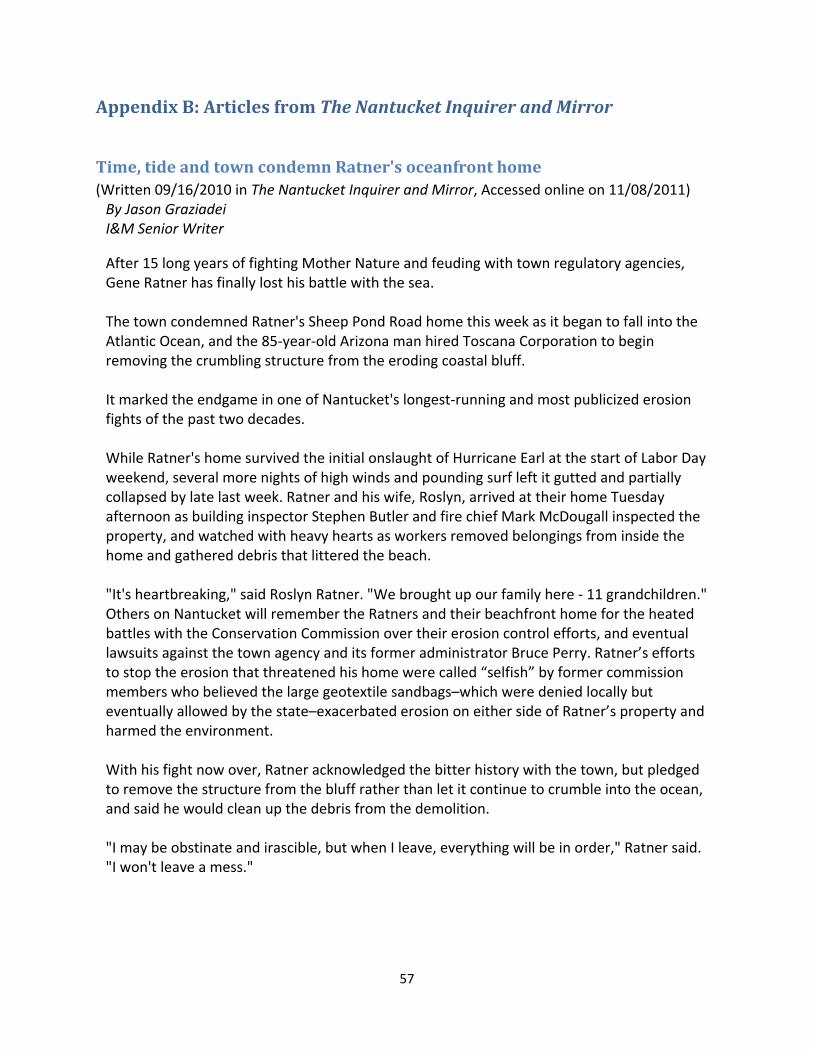
57
AppendixB:ArticlesfromTheNantucketInquirerandMirror
Time,tideandtowncondemnRatner'soceanfronthome(Written 09/16/2010 in The Nantucket Inquirer and Mirror, Accessed online on 11/08/2011) By Jason Graziadei I&M Senior Writer
After 15 long years of fighting Mother Nature and feuding with town regulatory agencies, Gene Ratner has finally lost his battle with the sea. The town condemned Ratner's Sheep Pond Road home this week as it began to fall into the Atlantic Ocean, and the 85‐year‐old Arizona man hired Toscana Corporation to begin removing the crumbling structure from the eroding coastal bluff. It marked the endgame in one of Nantucket's longest‐running and most publicized erosion fights of the past two decades. While Ratner's home survived the initial onslaught of Hurricane Earl at the start of Labor Day weekend, several more nights of high winds and pounding surf left it gutted and partially collapsed by late last week. Ratner and his wife, Roslyn, arrived at their home Tuesday afternoon as building inspector Stephen Butler and fire chief Mark McDougall inspected the property, and watched with heavy hearts as workers removed belongings from inside the home and gathered debris that littered the beach. "It's heartbreaking," said Roslyn Ratner. "We brought up our family here ‐ 11 grandchildren." Others on Nantucket will remember the Ratners and their beachfront home for the heated battles with the Conservation Commission over their erosion control efforts, and eventual lawsuits against the town agency and its former administrator Bruce Perry. Ratner’s efforts to stop the erosion that threatened his home were called “selfish” by former commission members who believed the large geotextile sandbags–which were denied locally but eventually allowed by the state–exacerbated erosion on either side of Ratner’s property and harmed the environment. With his fight now over, Ratner acknowledged the bitter history with the town, but pledged to remove the structure from the bluff rather than let it continue to crumble into the ocean, and said he would clean up the debris from the demolition. "I may be obstinate and irascible, but when I leave, everything will be in order," Ratner said. "I won't leave a mess."
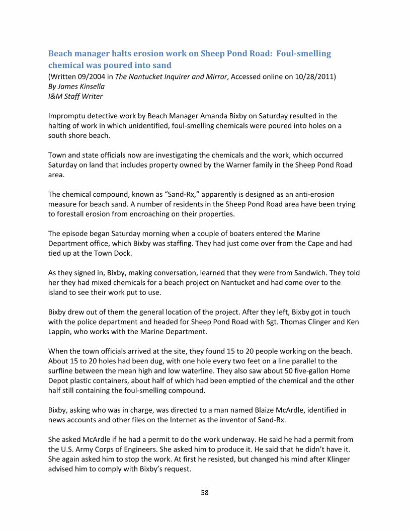
58
BeachmanagerhaltserosionworkonSheepPondRoad:Foul‐smellingchemicalwaspouredintosand(Written 09/2004 in The Nantucket Inquirer and Mirror, Accessed online on 10/28/2011) By James Kinsella I&M Staff Writer Impromptu detective work by Beach Manager Amanda Bixby on Saturday resulted in the halting of work in which unidentified, foul‐smelling chemicals were poured into holes on a south shore beach. Town and state officials now are investigating the chemicals and the work, which occurred Saturday on land that includes property owned by the Warner family in the Sheep Pond Road area. The chemical compound, known as “Sand‐Rx,” apparently is designed as an anti‐erosion measure for beach sand. A number of residents in the Sheep Pond Road area have been trying to forestall erosion from encroaching on their properties. The episode began Saturday morning when a couple of boaters entered the Marine Department office, which Bixby was staffing. They had just come over from the Cape and had tied up at the Town Dock. As they signed in, Bixby, making conversation, learned that they were from Sandwich. They told her they had mixed chemicals for a beach project on Nantucket and had come over to the island to see their work put to use. Bixby drew out of them the general location of the project. After they left, Bixby got in touch with the police department and headed for Sheep Pond Road with Sgt. Thomas Clinger and Ken Lappin, who works with the Marine Department. When the town officials arrived at the site, they found 15 to 20 people working on the beach. About 15 to 20 holes had been dug, with one hole every two feet on a line parallel to the surfline between the mean high and low waterline. They also saw about 50 five‐gallon Home Depot plastic containers, about half of which had been emptied of the chemical and the other half still containing the foul‐smelling compound. Bixby, asking who was in charge, was directed to a man named Blaize McArdle, identified in news accounts and other files on the Internet as the inventor of Sand‐Rx. She asked McArdle if he had a permit to do the work underway. He said he had a permit from the U.S. Army Corps of Engineers. She asked him to produce it. He said that he didn’t have it. She again asked him to stop the work. At first he resisted, but changed his mind after Klinger advised him to comply with Bixby’s request.

59
Bixby proceeded to get McArdle’s telephone number and address. Returning to the office, she proceeded to learn that the telephone number was that of a hair salon, while no one by McArdle’s name was listed at the address he gave in Bethlehem, Pa. Then the Steamship Authority got involved in the hunt. An SSA worker at the Nantucket terminal, having learned of the episode from a family member who is one of Bixby’s assistants, noticed a van getting onto the 6:30 a.m. ferry Sunday morning with New Jersey plates and a lot of Home Depot five‐gallon containers in the back. He took down the license, which yielded an accurate phone number on the ticket registration information for McArdle. Neither McArdle nor a member of the Warner family could be reached yesterday for comment. Nantucket Conservation Administrator Dirk Roggeveen said yesterday that no one had applied for any permits in connection with the work or the chemicals. Roggeveen said permits would be necessary to allow someone to alter the beach by digging holes, or to allow someone to try to alter the overall beach through a project. The investigation broadened Tuesday. On that morning, Roggeveen and Technical Consultant Peggy Fantozzi went to the site and retrieved some of the chemical, as well as a leftover lid from one of the containers. Roggeveen and Health Officer Richard Ray got in touch with the state Department of Environmental Protection: Roggeveen to advise them of the incident and work out the jurisdiction with the state, Ray to consult on the testing of the chemical. Fantozzi, meanwhile, called to ask the Sandwich health agent to investigate whether the people who came to the island Saturday had a commercial license to mix chemicals. “My concern is, is this some form of volatile organic compound?” Ray said Tuesday. “In its present state, could it leach out into the ocean? We need to determine what it is. “People have to understand that no one can go out and try some whacko scheme without getting permits,” Ray said. After speaking yesterday with the DEP’s Emergency Response Group yesterday, Roggeveen said he planned to do preliminary testing this week on the chemical. In news reports found in an Internet search, statements are attributed to McArdle that beaches erode because of the presence of anti‐caking agents in foods that eventually find their ways onto the beach. McArdle said Sand‐Rx counteracts these agents, allowing beaches to maintain themselves rather than erode into the water.
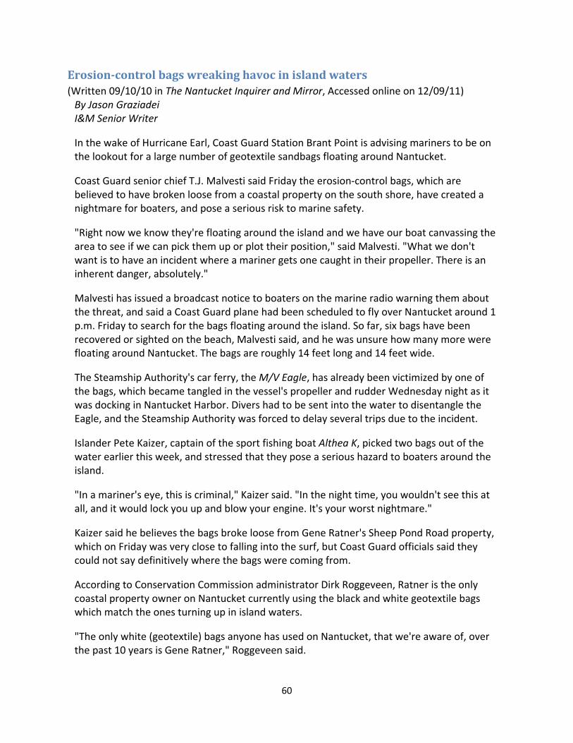
60
Erosion‐controlbagswreakinghavocinislandwaters(Written 09/10/10 in The Nantucket Inquirer and Mirror, Accessed online on 12/09/11) By Jason Graziadei I&M Senior Writer
In the wake of Hurricane Earl, Coast Guard Station Brant Point is advising mariners to be on the lookout for a large number of geotextile sandbags floating around Nantucket.
Coast Guard senior chief T.J. Malvesti said Friday the erosion‐control bags, which are believed to have broken loose from a coastal property on the south shore, have created a nightmare for boaters, and pose a serious risk to marine safety.
"Right now we know they're floating around the island and we have our boat canvassing the area to see if we can pick them up or plot their position," said Malvesti. "What we don't want is to have an incident where a mariner gets one caught in their propeller. There is an inherent danger, absolutely."
Malvesti has issued a broadcast notice to boaters on the marine radio warning them about the threat, and said a Coast Guard plane had been scheduled to fly over Nantucket around 1 p.m. Friday to search for the bags floating around the island. So far, six bags have been recovered or sighted on the beach, Malvesti said, and he was unsure how many more were floating around Nantucket. The bags are roughly 14 feet long and 14 feet wide.
The Steamship Authority's car ferry, the M/V Eagle, has already been victimized by one of the bags, which became tangled in the vessel's propeller and rudder Wednesday night as it was docking in Nantucket Harbor. Divers had to be sent into the water to disentangle the Eagle, and the Steamship Authority was forced to delay several trips due to the incident.
Islander Pete Kaizer, captain of the sport fishing boat Althea K, picked two bags out of the water earlier this week, and stressed that they pose a serious hazard to boaters around the island.
"In a mariner's eye, this is criminal," Kaizer said. "In the night time, you wouldn't see this at all, and it would lock you up and blow your engine. It's your worst nightmare."
Kaizer said he believes the bags broke loose from Gene Ratner's Sheep Pond Road property, which on Friday was very close to falling into the surf, but Coast Guard officials said they could not say definitively where the bags were coming from.
According to Conservation Commission administrator Dirk Roggeveen, Ratner is the only coastal property owner on Nantucket currently using the black and white geotextile bags which match the ones turning up in island waters.
"The only white (geotextile) bags anyone has used on Nantucket, that we're aware of, over the past 10 years is Gene Ratner," Roggeveen said.


