
RESPONSES TO SUBMISSIONSBULLI SEAM OPERATIONS
RESPONSES TO SUBMISSIONS
PART B - PUBLIC SUBMISSIONS
BULLI SEAM OPERATIONS RESPONSES TO SUBMISSIONS
PART B
RESPONSES TO PUBLIC SUBMISSIONS
APRIL 2010 Project No. BHPIC-07-01
Bulli Seam Operations – Response to Submissions
1 00317695
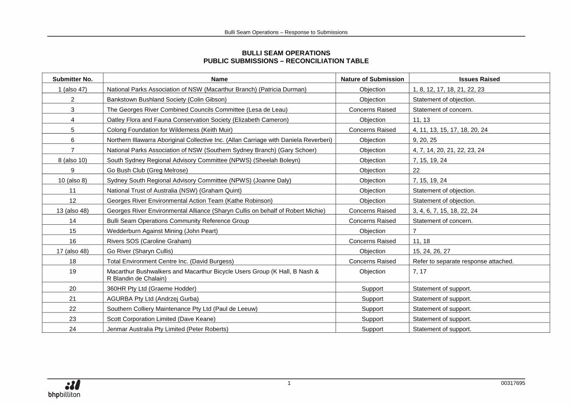
BULLI SEAM OPERATIONS PUBLIC SUBMISSIONS – RECONCILIATION TABLE
Submitter No. Name Nature of Submission Issues Raised
1 (also 47) National Parks Association of NSW (Macarthur Branch) (Patricia Durman) Objection 1, 8, 12, 17, 18, 21, 22, 23
2 Bankstown Bushland Society (Colin Gibson) Objection Statement of objection.
3 The Georges River Combined Councils Committee (Lesa de Leau) Concerns Raised Statement of concern.
4 Oatley Flora and Fauna Conservation Society (Elizabeth Cameron) Objection 11, 13
5 Colong Foundation for Wilderness (Keith Muir) Concerns Raised 4, 11, 13, 15, 17, 18, 20, 24
6 Northern Illawarra Aboriginal Collective Inc. (Allan Carriage with Daniela Reverberi) Objection 9, 20, 25
7 National Parks Association of NSW (Southern Sydney Branch) (Gary Schoer) Objection 4, 7, 14, 20, 21, 22, 23, 24
8 (also 10) South Sydney Regional Advisory Committee (NPWS) (Sheelah Boleyn) Objection 7, 15, 19, 24
9 Go Bush Club (Greg Melrose) Objection 22
10 (also 8) Sydney South Regional Advisory Committee (NPWS) (Joanne Daly) Objection 7, 15, 19, 24
11 National Trust of Australia (NSW) (Graham Quint) Objection Statement of objection.
12 Georges River Environmental Action Team (Kathe Robinson) Objection Statement of objection.
13 (also 48) Georges River Environmental Alliance (Sharyn Cullis on behalf of Robert Michie) Concerns Raised 3, 4, 6, 7, 15, 18, 22, 24
14 Bulli Seam Operations Community Reference Group Concerns Raised Statement of concern.
15 Wedderburn Against Mining (John Peart) Objection 7
16 Rivers SOS (Caroline Graham) Concerns Raised 11, 18
17 (also 48) Go River (Sharyn Cullis) Objection 15, 24, 26, 27
18 Total Environment Centre Inc. (David Burgess) Concerns Raised Refer to separate response attached.
19 Macarthur Bushwalkers and Macarthur Bicycle Users Group (K Hall, B Nash & R Blandin de Chalain)
Objection 7, 17
20 360HR Pty Ltd (Graeme Hodder) Support Statement of support.
21 AGURBA Pty Ltd (Andrzej Gurba) Support Statement of support.
22 Southern Colliery Maintenance Pty Ltd (Paul de Leeuw) Support Statement of support.
23 Scott Corporation Limited (Dave Keane) Support Statement of support.
24 Jenmar Australia Pty Limited (Peter Roberts) Support Statement of support.
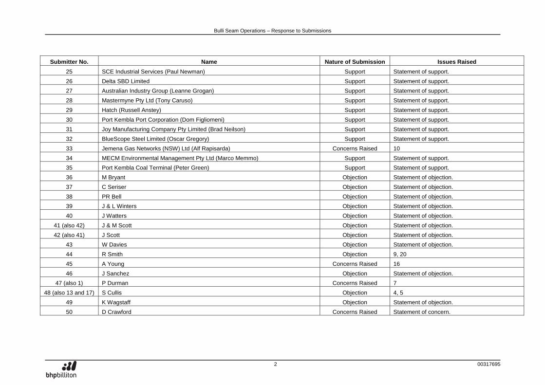
Bulli Seam Operations – Response to Submissions
2 00317695
Submitter No. Name Nature of Submission Issues Raised
25 SCE Industrial Services (Paul Newman) Support Statement of support.
26 Delta SBD Limited Support Statement of support.
27 Australian Industry Group (Leanne Grogan) Support Statement of support.
28 Mastermyne Pty Ltd (Tony Caruso) Support Statement of support.
29 Hatch (Russell Anstey) Support Statement of support.
30 Port Kembla Port Corporation (Dom Figliomeni) Support Statement of support.
31 Joy Manufacturing Company Pty Limited (Brad Neilson) Support Statement of support.
32 BlueScope Steel Limited (Oscar Gregory) Support Statement of support.
33 Jemena Gas Networks (NSW) Ltd (Alf Rapisarda) Concerns Raised 10
34 MECM Environmental Management Pty Ltd (Marco Memmo) Support Statement of support.
35 Port Kembla Coal Terminal (Peter Green) Support Statement of support.
36 M Bryant Objection Statement of objection.
37 C Seriser Objection Statement of objection.
38 PR Bell Objection Statement of objection.
39 J & L Winters Objection Statement of objection.
40 J Watters Objection Statement of objection.
41 (also 42) J & M Scott Objection Statement of objection.
42 (also 41) J Scott Objection Statement of objection.
43 W Davies Objection Statement of objection.
44 R Smith Objection 9, 20
45 A Young Concerns Raised 16
46 J Sanchez Objection Statement of objection.
47 (also 1) P Durman Concerns Raised 7
48 (also 13 and 17) S Cullis Objection 4, 5
49 K Wagstaff Objection Statement of objection.
50 D Crawford Concerns Raised Statement of concern.
Bulli Seam Operations – Response to Submissions
3 00317695
Submitter No. Name Nature of Submission Issues Raised
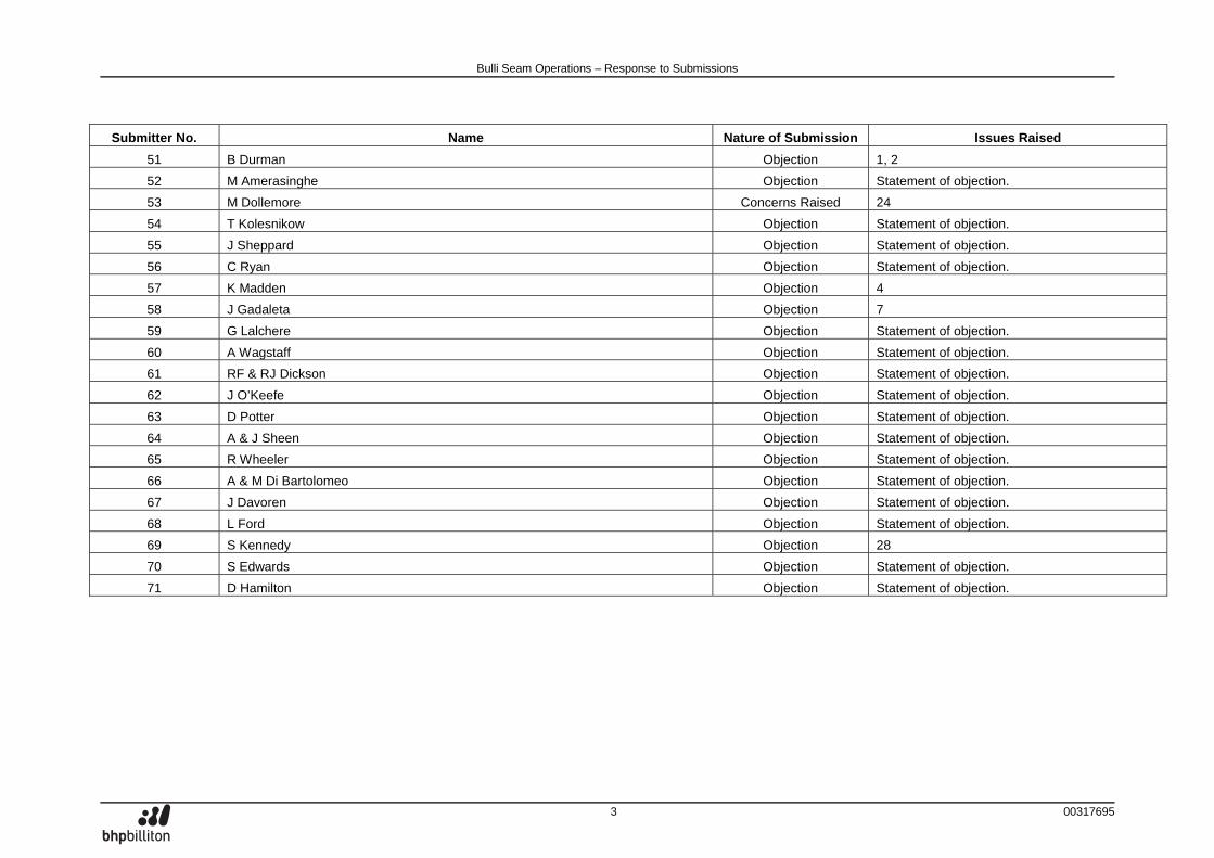
51 B Durman Objection 1, 2
52 M Amerasinghe Objection Statement of objection.
53 M Dollemore Concerns Raised 24
54 T Kolesnikow Objection Statement of objection.
55 J Sheppard Objection Statement of objection.
56 C Ryan Objection Statement of objection.
57 K Madden Objection 4
58 J Gadaleta Objection 7
59 G Lalchere Objection Statement of objection.
60 A Wagstaff Objection Statement of objection.
61 RF & RJ Dickson Objection Statement of objection.
62 J O’Keefe Objection Statement of objection.
63 D Potter Objection Statement of objection.
64 A & J Sheen Objection Statement of objection.
65 R Wheeler Objection Statement of objection.
66 A & M Di Bartolomeo Objection Statement of objection.
67 J Davoren Objection Statement of objection.
68 L Ford Objection Statement of objection.
69 S Kennedy Objection 28
70 S Edwards Objection Statement of objection.
71 D Hamilton Objection Statement of objection.
Bulli Seam Operations – Response to Submissions
4 00321837
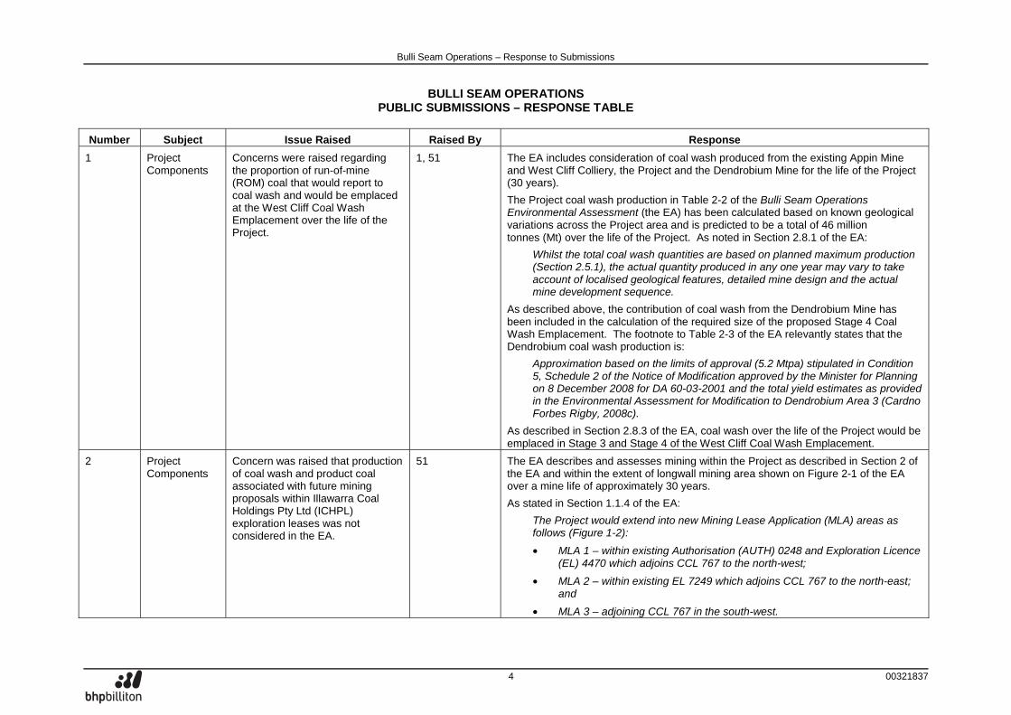
BULLI SEAM OPERATIONS PUBLIC SUBMISSIONS – RESPONSE TABLE
Number Subject Issue Raised Raised By Response
1 Project Components
Concerns were raised regarding the proportion of run-of-mine (ROM) coal that would report to coal wash and would be emplaced at the West Cliff Coal Wash Emplacement over the life of the Project.
1, 51 The EA includes consideration of coal wash produced from the existing Appin Mine and West Cliff Colliery, the Project and the Dendrobium Mine for the life of the Project (30 years).
The Project coal wash production in Table 2-2 of the Bulli Seam Operations Environmental Assessment (the EA) has been calculated based on known geological variations across the Project area and is predicted to be a total of 46 million tonnes (Mt) over the life of the Project. As noted in Section 2.8.1 of the EA:
Whilst the total coal wash quantities are based on planned maximum production (Section 2.5.1), the actual quantity produced in any one year may vary to take account of localised geological features, detailed mine design and the actual mine development sequence.
As described above, the contribution of coal wash from the Dendrobium Mine has been included in the calculation of the required size of the proposed Stage 4 Coal Wash Emplacement. The footnote to Table 2-3 of the EA relevantly states that the Dendrobium coal wash production is:
Approximation based on the limits of approval (5.2 Mtpa) stipulated in Condition 5, Schedule 2 of the Notice of Modification approved by the Minister for Planning on 8 December 2008 for DA 60-03-2001 and the total yield estimates as provided in the Environmental Assessment for Modification to Dendrobium Area 3 (Cardno Forbes Rigby, 2008c).
As described in Section 2.8.3 of the EA, coal wash over the life of the Project would be emplaced in Stage 3 and Stage 4 of the West Cliff Coal Wash Emplacement.
2 Project Components
Concern was raised that production of coal wash and product coal associated with future mining proposals within Illawarra Coal Holdings Pty Ltd (ICHPL) exploration leases was not considered in the EA.
51 The EA describes and assesses mining within the Project as described in Section 2 of the EA and within the extent of longwall mining area shown on Figure 2-1 of the EA over a mine life of approximately 30 years.
As stated in Section 1.1.4 of the EA:
The Project would extend into new Mining Lease Application (MLA) areas as follows (Figure 1-2):
• MLA 1 – within existing Authorisation (AUTH) 0248 and Exploration Licence (EL) 4470 which adjoins CCL 767 to the north-west;
• MLA 2 – within existing EL 7249 which adjoins CCL 767 to the north-east; and
• MLA 3 – adjoining CCL 767 in the south-west.
Bulli Seam Operations – Response to Submissions
5 00321837
Number Subject Issue Raised Raised By Response
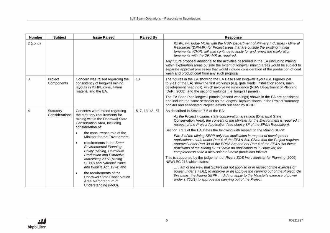
2 (cont.) ICHPL will lodge MLAs with the NSW Department of Primary Industries - Mineral Resources (DPI-MR) for Project areas that are outside the existing mining tenements. ICHPL will also continue to apply for and renew the exploration tenements with the DPI-MR as required.
Any future proposal additional to the activities described in the EA (including mining within exploration areas outside the extent of longwall mining area) would be subject to separate approval processes that would include consideration of the production of coal wash and product coal from any such proposal.
3 Project Components
Concern was raised regarding the consistency of longwall mining layouts in ICHPL consultation material and the EA.
13 The figures in the EA showing the EA Base Plan longwall layout (i.e. Figures 2-8 to 2-11 of the EA) show the first workings (e.g. gate roads, installation roads, main development headings), which involve no subsidence (NSW Department of Planning [DoP], 2008), and the second workings (i.e. longwall panels).
The EA Base Plan longwall panels (second workings) shown in the EA are consistent and include the same setbacks as the longwall layouts shown in the Project summary booklet and associated Project leaflets released by ICHPL.
4 Statutory Considerations
Concerns were raised regarding the statutory requirements for mining within the Dharawal State Conservation Area, including consideration of:
• the concurrence role of the Minister for the Environment;
• requirements in the State Environmental Planning Policy (Mining, Petroleum Production and Extractive Industries) 2007 (Mining SEPP) and National Parks and Wildlife Act, 1974; and
• the requirements of the Dharawal State Conservation Area Memorandum of Understanding (MoU).
5, 7, 13, 48, 57 As described in Section 7.5 of the EA:
As the Project includes state conservation area land [Dharawal State Conservation Area], the consent of the Minister for the Environment is required in respect of the Project Application (see clause 8F of the EP&A Regulation).
Section 7.2.1 of the EA states the following with respect to the Mining SEPP:
Part 3 of the Mining SEPP only has application in respect of development applications made under Part 4 of the EP&A Act. Given that the Project requires approval under Part 3A of the EP&A Act and not Part 4 of the EP&A Act these provisions of the Mining SEPP have no application to it. However, for completeness sake a discussion of these provisions follows.
This is supported by the judgement of Rivers SOS Inc v Minister for Planning [2009] NSWLEC 213 which states:
… I am of the view that SEPPs did not apply to or in respect of the exercise of power under s 75J(1) to approve or disapprove the carrying out of the Project. On this basis, the Mining SEPP … did not apply to the Minister’s exercise of power under s 75J(1) to approve the carrying out of the Project.
Bulli Seam Operations – Response to Submissions
6 00321837
Number Subject Issue Raised Raised By Response
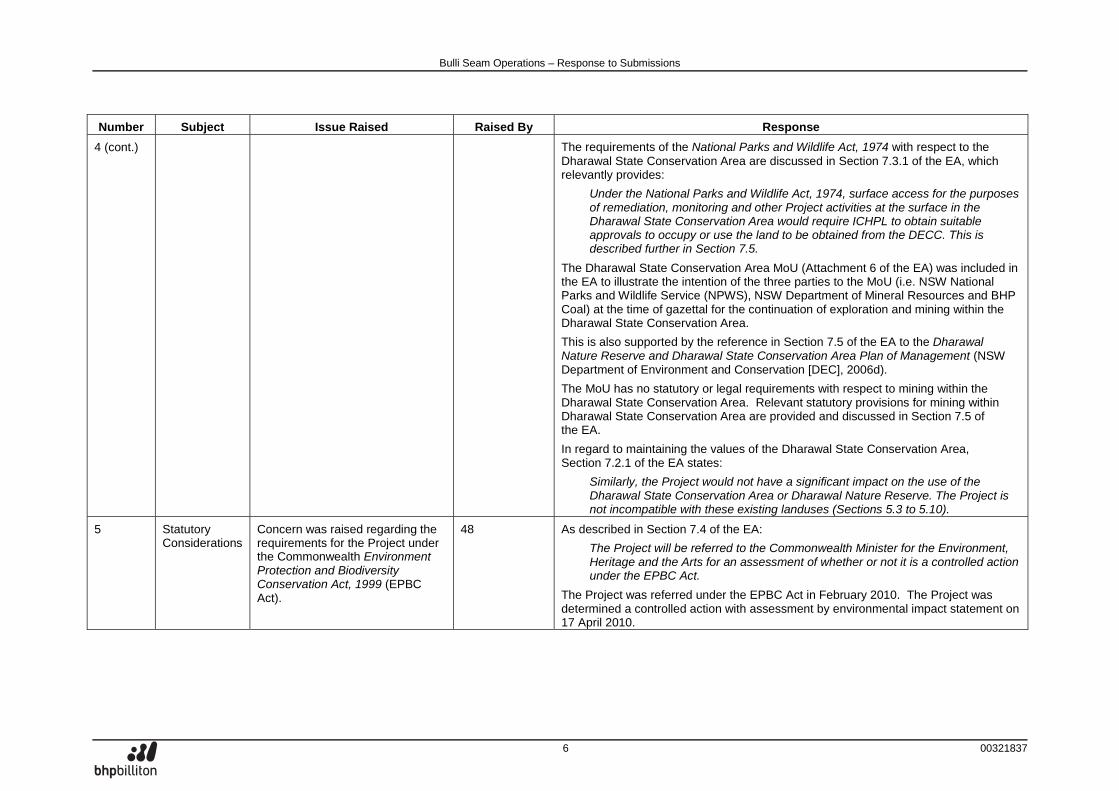
4 (cont.) The requirements of the National Parks and Wildlife Act, 1974 with respect to the Dharawal State Conservation Area are discussed in Section 7.3.1 of the EA, which relevantly provides:
Under the National Parks and Wildlife Act, 1974, surface access for the purposes of remediation, monitoring and other Project activities at the surface in the Dharawal State Conservation Area would require ICHPL to obtain suitable approvals to occupy or use the land to be obtained from the DECC. This is described further in Section 7.5.
The Dharawal State Conservation Area MoU (Attachment 6 of the EA) was included in the EA to illustrate the intention of the three parties to the MoU (i.e. NSW National Parks and Wildlife Service (NPWS), NSW Department of Mineral Resources and BHP Coal) at the time of gazettal for the continuation of exploration and mining within the Dharawal State Conservation Area.
This is also supported by the reference in Section 7.5 of the EA to the Dharawal Nature Reserve and Dharawal State Conservation Area Plan of Management (NSW Department of Environment and Conservation [DEC], 2006d).
The MoU has no statutory or legal requirements with respect to mining within the Dharawal State Conservation Area. Relevant statutory provisions for mining within Dharawal State Conservation Area are provided and discussed in Section 7.5 of the EA.
In regard to maintaining the values of the Dharawal State Conservation Area, Section 7.2.1 of the EA states:
Similarly, the Project would not have a significant impact on the use of the Dharawal State Conservation Area or Dharawal Nature Reserve. The Project is not incompatible with these existing landuses (Sections 5.3 to 5.10).
5 Statutory Considerations
Concern was raised regarding the requirements for the Project under the Commonwealth Environment Protection and Biodiversity Conservation Act, 1999 (EPBC Act).
48 As described in Section 7.4 of the EA:
The Project will be referred to the Commonwealth Minister for the Environment, Heritage and the Arts for an assessment of whether or not it is a controlled action under the EPBC Act.
The Project was referred under the EPBC Act in February 2010. The Project was determined a controlled action with assessment by environmental impact statement on 17 April 2010.
Bulli Seam Operations – Response to Submissions
7 00321837
Number Subject Issue Raised Raised By Response
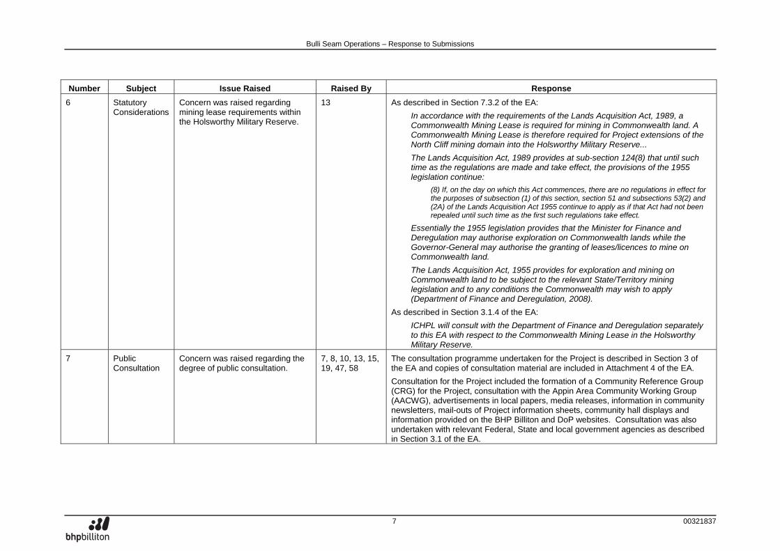
6 Statutory Considerations
Concern was raised regarding mining lease requirements within the Holsworthy Military Reserve.
13 As described in Section 7.3.2 of the EA:
In accordance with the requirements of the Lands Acquisition Act, 1989, a Commonwealth Mining Lease is required for mining in Commonwealth land. A Commonwealth Mining Lease is therefore required for Project extensions of the North Cliff mining domain into the Holsworthy Military Reserve...
The Lands Acquisition Act, 1989 provides at sub-section 124(8) that until such time as the regulations are made and take effect, the provisions of the 1955 legislation continue:
(8) If, on the day on which this Act commences, there are no regulations in effect for the purposes of subsection (1) of this section, section 51 and subsections 53(2) and (2A) of the Lands Acquisition Act 1955 continue to apply as if that Act had not been repealed until such time as the first such regulations take effect.
Essentially the 1955 legislation provides that the Minister for Finance and Deregulation may authorise exploration on Commonwealth lands while the Governor-General may authorise the granting of leases/licences to mine on Commonwealth land.
The Lands Acquisition Act, 1955 provides for exploration and mining on Commonwealth land to be subject to the relevant State/Territory mining legislation and to any conditions the Commonwealth may wish to apply (Department of Finance and Deregulation, 2008).
As described in Section 3.1.4 of the EA:
ICHPL will consult with the Department of Finance and Deregulation separately to this EA with respect to the Commonwealth Mining Lease in the Holsworthy Military Reserve.
7 Public Consultation
Concern was raised regarding the degree of public consultation.
7, 8, 10, 13, 15, 19, 47, 58
The consultation programme undertaken for the Project is described in Section 3 of the EA and copies of consultation material are included in Attachment 4 of the EA.
Consultation for the Project included the formation of a Community Reference Group (CRG) for the Project, consultation with the Appin Area Community Working Group (AACWG), advertisements in local papers, media releases, information in community newsletters, mail-outs of Project information sheets, community hall displays and information provided on the BHP Billiton and DoP websites. Consultation was also undertaken with relevant Federal, State and local government agencies as described in Section 3.1 of the EA.
Bulli Seam Operations – Response to Submissions
8 00321837
Number Subject Issue Raised Raised By Response
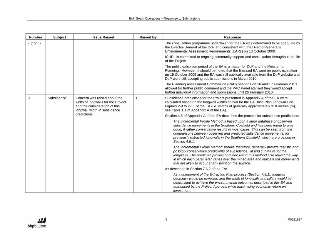
7 (cont.) The consultation programme undertaken for the EA was determined to be adequate by the Director-General of the DoP and consistent with the Director-General’s Environmental Assessment Requirements (EARs) on 13 October 2009.
ICHPL is committed to ongoing community support and consultation throughout the life of the Project.
The public exhibition period of the EA is a matter for DoP and the Minister for Planning. However, it should be noted that the finalised EA went on public exhibition on 19 October 2009 and the EA was still publically available from the DoP website and DoP were still accepting public submissions in March 2010.
The Planning Assessment Commission (PAC) hearings on 16 and 17 February 2010 allowed for further public comment and the PAC Panel advised they would accept further individual information and submissions until 26 February 2010.
8 Subsidence Concern was raised about the width of longwalls for the Project and the consideration of this longwall width in subsidence predictions.
1 Subsidence predictions for the Project presented in Appendix A of the EA were calculated based on the longwall widths shown for the EA Base Plan Longwalls on Figures 2-8 to 2-11 of the EA (i.e. widths of generally approximately 310 metres (m), see Table 1.1 of Appendix A of the EA).
Section 4.5 of Appendix A of the EA describes the process for subsidence predictions:
The Incremental Profile Method is based upon a large database of observed subsidence movements in the Southern Coalfield and has been found to give good, if rather conservative results in most cases. This can be seen from the comparisons between observed and predicted subsidence movements, for previously extracted longwalls in the Southern Coalfield, which are provided in Section 4.5.1.
The Incremental Profile Method should, therefore, generally provide realistic and possibly conservative predictions of subsidence, tilt and curvature for the longwalls. The predicted profiles obtained using this method also reflect the way in which each parameter varies over the mined area and indicate the movements that are likely to occur at any point on the surface.
As described in Section 7.6.2 of the EA:
As a component of the Extraction Plan process (Section 7.3.1), longwall geometry would be reviewed and the width of longwalls and pillars would be determined to achieve the environmental outcomes described in this EA and authorised by the Project Approval while maximising economic return on investment.
Bulli Seam Operations – Response to Submissions
9 00321837
Number Subject Issue Raised Raised By Response
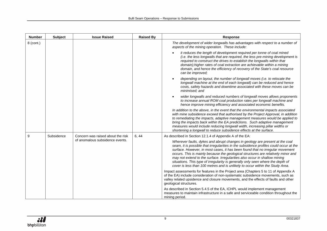
8 (cont.) The development of wider longwalls has advantages with respect to a number of aspects of the mining operation. These include:
• it reduces the length of development required per tonne of coal mined (i.e. the less longwalls that are required, the less pre-mining development is required to construct the drives to establish the longwalls within that domain);higher rates of coal extraction are achievable within a mining domain, and hence the efficiency of recovery of the State’s coal resource can be improved;
• depending on layout, the number of longwall moves (i.e. to relocate the longwall machine at the end of each longwall) can be reduced and hence costs, safety hazards and downtime associated with these moves can be minimised; and
• wider longwalls and reduced numbers of longwall moves allows proponents to increase annual ROM coal production rates per longwall machine and hence improve mining efficiency and associated economic benefits.
In addition to the above, in the event that the environmental impacts associated with mine subsidence exceed that authorised by the Project Approval, in addition to remediating the impacts, adaptive management measures would be applied to bring the impacts back within the EA predictions. Such adaptive management measures would include reducing longwall width, increasing pillar widths or shortening a longwall to reduce subsidence effects at the surface.
9 Subsidence Concern was raised about the risk of anomalous subsidence events.
6, 44 As described in Section 12.1.4 of Appendix A of the EA:
Wherever faults, dykes and abrupt changes in geology are present at the coal seam, it is possible that irregularities in the subsidence profiles could occur at the surface. However, in most cases, it has been found that no irregular movement occurs. This is mainly because the geological structures are relatively minor and may not extend to the surface. Irregularities also occur in shallow mining situations. This type of irregularity is generally only seen where the depth of cover is less than 100 metres and is unlikely to occur within the Study Area.
Impact assessments for features in the Project area (Chapters 5 to 11 of Appendix A of the EA) include consideration of non-systematic subsidence movements, such as valley related upsidence and closure movements, and the effects of faults and other geological structures.
As described in Section 5.4.5 of the EA, ICHPL would implement management measures to maintain infrastructure in a safe and serviceable condition throughout the mining period.
Bulli Seam Operations – Response to Submissions
10 00321837
Number Subject Issue Raised Raised By Response
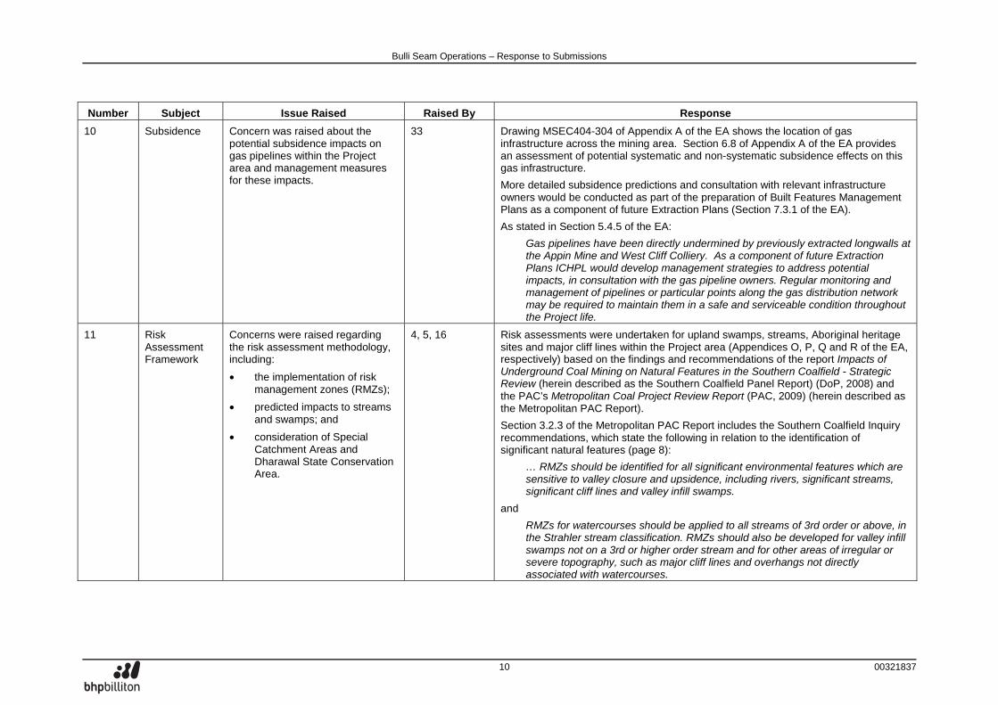
10 Subsidence Concern was raised about the potential subsidence impacts on gas pipelines within the Project area and management measures for these impacts.
33 Drawing MSEC404-304 of Appendix A of the EA shows the location of gas infrastructure across the mining area. Section 6.8 of Appendix A of the EA provides an assessment of potential systematic and non-systematic subsidence effects on this gas infrastructure.
More detailed subsidence predictions and consultation with relevant infrastructure owners would be conducted as part of the preparation of Built Features Management Plans as a component of future Extraction Plans (Section 7.3.1 of the EA).
As stated in Section 5.4.5 of the EA:
Gas pipelines have been directly undermined by previously extracted longwalls at the Appin Mine and West Cliff Colliery. As a component of future Extraction Plans ICHPL would develop management strategies to address potential impacts, in consultation with the gas pipeline owners. Regular monitoring and management of pipelines or particular points along the gas distribution network may be required to maintain them in a safe and serviceable condition throughout the Project life.
11 Risk Assessment Framework
Concerns were raised regarding the risk assessment methodology, including:
• the implementation of risk management zones (RMZs);
• predicted impacts to streams and swamps; and
• consideration of Special Catchment Areas and Dharawal State Conservation Area.
4, 5, 16 Risk assessments were undertaken for upland swamps, streams, Aboriginal heritage sites and major cliff lines within the Project area (Appendices O, P, Q and R of the EA, respectively) based on the findings and recommendations of the report Impacts of Underground Coal Mining on Natural Features in the Southern Coalfield - Strategic Review (herein described as the Southern Coalfield Panel Report) (DoP, 2008) and the PAC’s Metropolitan Coal Project Review Report (PAC, 2009) (herein described as the Metropolitan PAC Report).
Section 3.2.3 of the Metropolitan PAC Report includes the Southern Coalfield Inquiry recommendations, which state the following in relation to the identification of significant natural features (page 8):
… RMZs should be identified for all significant environmental features which are sensitive to valley closure and upsidence, including rivers, significant streams, significant cliff lines and valley infill swamps.
and
RMZs for watercourses should be applied to all streams of 3rd order or above, in the Strahler stream classification. RMZs should also be developed for valley infill swamps not on a 3rd or higher order stream and for other areas of irregular or severe topography, such as major cliff lines and overhangs not directly associated with watercourses.
Bulli Seam Operations – Response to Submissions
11 00321837
Number Subject Issue Raised Raised By Response
11 (cont.) RMZs have been applied to upland swamps, rivers and significant streams, Aboriginal heritage sites and major cliffs in Appendices O, P, Q and R of the EA, respectively. The RMZ boundaries are based on the definition prescribed in the SCPR (i.e. 400 m surface lateral distance from the outside extremity of the boundary of the feature or by a 40° angle from the vertical down to the coal seam which is proposed to be extracted, whichever is greater).
The Southern Coalfield Panel Report (DoP, 2008) did not recommend that mining should not occur within RMZs. As stated on page 6 of the Southern Coalfield Panel Report (DoP, 2008):
Approved mining within identified RMZs (and particularly in proximity to highly-significant natural features) should be subject to increased monitoring and assessment requirements which address subsidence effects, subsidence impacts and environmental consequences. The requirements should also address reporting procedures for back analysis and comparison of actual versus predicted effects and impacts, in order to review the accuracy and confidence levels of the prediction techniques used.
Further to the above, Metropolitan PAC Report (PAC, 2009) states (page 34):
The Panel notes that the perimeter of the offsets for the Waratah Rivulet associated with the predicted 200mm closure option, Drawing No: MSEC285-R101, closely correspond to the boundaries of a RMZ for such a feature as defined by the SCI (a 40° angle from the vertical down to the coal seam or 400m lateral distance from the edge of the feature, whichever is the greater). This is consistent with the objectives of the SCI that careful and particular consideration should be given to the level of tolerable impacts within this zone. It does not imply that longwall mining is not permissible within the RMZ.
The RMZ concept was applied to be consistent with Recommendation 2 of the Metropolitan PAC Report (pages 135 to 136):
Recommendation 2
The Panel recommends that the concept of RMZs enunciated in the SCI report be incorporated into a broader risk framework that includes:
• Identifying natural features likely to be at risk of negative environmental consequences from subsidence impacts.
• Assessing the potential risk to those features from the mining proposal.
• Identifying the options for dealing with any significant risk.
Bulli Seam Operations – Response to Submissions
12 00321837
Number Subject Issue Raised Raised By Response
11 (cont.) • Determining which of these options will form part of the management plan.
• Monitoring the subsidence impacts, consequences for the feature, and outcomes from the management strategies.
• Contingency options and planning to deal with exceedances, and
• Auditing of the risk management process.
The Upland Swamp Risk Assessment (Appendix O of the EA) identifies 55 swamps as having a real risk of negative environmental consequences. The Metropolitan PAC Report (PAC, 2009) does not define ‘real risk’, although it relevantly defines a ‘real possibility’ as:
… means that the risk of occurrence needs to be more than remote, but no [sic] so high as to require a finding of ‘more likely than not’. A risk occurrence of between 5 and 15 percent is probably an appropriate starting point for consideration.
The Stream Risk Assessment identified 43 watercourses with a Strahler stream order of 3 or above with predicted closure values greater than 200 millimetres (mm). Section P6.4 of Appendix P of the EA relevantly states:
MSEC (Appendix A of the EA) has developed a database of pool and rockbar sites that have experienced mining induced upsidence and valley closure movements in the Southern Coalfield. MSEC (Appendix A of the EA) note that there have been no observed pool flow diversion and pool water level impacts observed where the predicted total valley closure was less than 200 mm. MSEC also notes that there are numerous instances where pools have been subject to valley closure movements greater than, and sometimes substantially greater than 200 mm, without reports of flow diversion and pool level impacts. The 200 mm closure value has been adopted as a reference valley closure magnitude below which it is expected that flow diversion and pool water level impacts are unlikely to occur. The currently available database is however relatively small and the adoption of a 200 mm valley closure criteria is viewed as an indicator of low probability of flow diversion and pool level impacts.
The risk assessments for the EA included consideration of the associated landuse of the features, including those located within the Dharawal State Conservation Area and Sydney Catchment Authority (SCA) Special Areas (see Section O4.5 and Attachment OB of Appendix O, Section P4.5 and Attachment PB of Appendix P and Attachment RA of Appendix R of the EA).
Bulli Seam Operations – Response to Submissions
13 00321837
Number Subject Issue Raised Raised By Response
12 Upland Swamps
Concern was raised regarding the potential for swamp dieback.
1 Appendix O of the EA contains a risk assessment of the 226 upland swamp identified within the Project study area. The assessment provided in Appendix O of the EA was prepared based on data provided by Bio-Analysis, FloraSearch, Biosphere Environmental Consultants, Gilbert & Associates, Heritage Computing, Mine Subsidence Engineering Consultants (MSEC) and Gillespie Economics (Section O1 of Appendix O of the EA).
As provided in Appendix O of the EA, eight of the 226 swamps (i.e. 3.5%) may be subject to potential significant negative consequences. The Terrestrial Flora Assessment (Appendix E of the EA) concludes:
Given this, it is considered unlikely that flora species associated with upland swamps would be adversely impacted by the Project to the extent that the viability of any flora population would be put at risk.
Nevertheless, ICHPL would develop and implement measures to mitigate and manage negative consequences in these eight swamps. Further detail on these measures is provided in Section 5.2.2 and Section O7 of Appendix O of the EA.
13 Upland Swamps
Concern was raised about the consideration of vegetation within upland swamps including:
• the extent of vegetation surveys; and
• consideration of Endangered Ecological Communities (EECs) in upland swamps.
4, 5 The Terrestrial Flora Assessment (Appendix E of the EA) and the Upland Swamp Risk Assessment (Appendix O of the EA) use the results of multiple vegetation studies within the Project area as described in Section 2 of Appendix E of the EA.
The vegetation survey conducted for the EA was developed in accordance with the Department of Environment, Climate Change and Water (DECCW’s) Threatened Biodiversity Survey and Assessment: Guidelines for Developments and Activities Working Draft (DEC, 2004) and included representative sampling of swamp habitat. Flora sites surveyed relevant to upland swamps are provided in Attachment OB of Appendix O of the EA.
EECs listed under the Threatened Species Conservation Act, 1995 (TSC Act) and EPBC Act known to occur in the Project study area are listed in Table 7 of Appendix E of the EA. Vegetation identified within the Coastal Upland Swamp community group within the Project area was not considered representative of any EECs listed under the TSC Act or EPBC Act.
The following discussion on the potential for the presence of Temperate Highland Peat Swamps on Sandstone (THPSS) EEC within the Project area has been prepared by Dr Colin Bower (FloraSearch).
Bulli Seam Operations – Response to Submissions
14 00321837
Number Subject Issue Raised Raised By Response
13 (cont.) The Approved Conservation Advice for THPSS EEC (Department of Environment, Water, Heritage and the Arts [DEWHA], 2008) describes the community as follows:
The Temperate Highland Peat Swamps on Sandstone ecological community comprises temporary or permanent swamps occurring on sandstone in the temperate highlands region in NSW (DEH, 2005) from around 600–1100 m above sea level. The wetter parts of the swamps are occupied by sphagnum bogs and fens, while sedge and shrub associations occur in the drier parts (TSSC, 2005). The level of waterlogging and amount of sedimentation are influenced by the location of the swamps: hanging swamps (occurring on steep valley sides) have low levels of sedimentation, and accumulate organic material slowly; valley swamps and those along watercourses have greater levels of sedimentation, and accumulate organic material more quickly (TSSC, 2005).
The distribution of the EEC is defined in the Approved Conservation Advice (DEWHA, 2008) as:
Temperate Highland Peat Swamps on Sandstone are known from the Blue Mountains, Lithgow, Southern Highlands, and Bombala regions in NSW.
The key features of the THPSS EEC from these definitions are:
1. An altitudinal range from 600 to 1100 m above sea level;
2. A distribution on the NSW Central and Southern Tablelands including the Blue Mountains, Lithgow, Southern Highlands and Bombala regions; and
3. The presence of sphagnum bogs.
Dr Colin Bower has provided the following advice regarding the potential for the THPSS EEC to occur in the Project Area:
• No swamps on the Woronora Plateau were included in the circumscription of the THPSS EEC by DEWHA in any of the documentation on the community including the very detailed community profile (DEWHA 2009a), the Approved Conservation Advice (DEWHA 2008) and the distribution map (DEWHA 2009b). All coastal upland swamps on the Woronora Plateau occur below altitudes of 450 m, including all swamps in the Project area, and consequently fall outside the altitudinal range defined for the EEC. Nor does the Woronora Plateau as a whole occur within the geographical distribution defined for the EEC.
Bulli Seam Operations – Response to Submissions
15 00321837
Number Subject Issue Raised Raised By Response
13 (cont.) • Only the wetter swamps on the Woronora Plateau develop peat and these comprise the Cyperoid Heath and Tea Tree Thicket communities. However, if areas of these communities on the Woronora Plateau were to be included in the THPSS EEC, it would require a redefinition and renaming of the EEC. The altitudinal limits and distribution of the EEC would need to be redefined and in so doing the community would no longer be confined to the highlands.
• Comparison of the dominant flora species between THPSS EEC, as outlined in the DEWHA (2009a) community profile, and Upland Swamps on the Woronora Plateau, as determined by numerous studies including Bangalay Botanical Surveys (2008), FloraSearch (Appendix E of the EA), Keith and Myerscough (1993) and Keith et al. (2006), indicates there can be a high degree of floristic overlap between them, especially between the Woronora Plateau swamps and the highland swamps in the Blue Mountains. Despite this, there are also suites of species that occur only in either coastal upland swamps (e.g. Woronora Plateau) or highland swamps on the tablelands. A critical distinguishing feature of the THPSS EEC is the frequent and often dominant presence of sphagnum moss (Sphagnum cristatum) bogs, which are absent from coastal upland swamps. In addition, there are different suites of Tea-tree (Leptospermum) and Pea-flower (Faboideae) and Grevillea (Proteaceae) species, among others, in the highlands and coastal uplands.
Dr Colin Bower has concluded the above points effectively exclude peat swamps on the Woronora Plateau from the THPSS EEC.
14 Upland Swamps
Concern was raised about the consideration of the effect of longwall width on potential impacts on upland swamps.
7 Subsidence effects for the Project and the potential subsidence impacts on swamps were determined based on the longwall widths shown for the EA Base Plan Longwalls on Figures 2-8 to 2-11 of the EA.
Section O7.3.2.1 of Appendix O of the EA describes the consideration of alternative mine plans to examine the relative costs and benefits of modifying the mine layout by narrowing the longwall panel void widths to 163 m, relevantly that:
The analysis conducted by Gillespie Economics indicates that with the inclusion of the social community values estimated via the Choice Modelling Study, adjusting the mine parameters is not economically efficient and results in a significant net cost to society. Adopting the 163 m wide longwall panel voids would result in substantial cost and still result in greater than 200 mm predicted closure.
Bulli Seam Operations – Response to Submissions
16 00321837
Number Subject Issue Raised Raised By Response
15 Upland Swamps
Concerns were raised about the assessment and consideration of the role of swamps within the catchment system.
5, 8, 10, 13, 17 Section 4 of Appendix C of the EA states:
Based on the gauging station data, the results indicate that swamps contribute proportionally between half and a quarter as much to catchment yield, per unit area, as the catchment average and are therefore relatively low yielding.
This is consistent with basic hydrological principles. Swamps do not generate any water within themselves. Rather, they store rainfall runoff and groundwater in the soil matrix. Because swamps have relatively low gradients compared to other parts of the catchment and have dense vegetation growth, the evapotranspiration potential is high and the rate of runoff is comparatively low. Discussion of this characteristic of swamps is in no way an attempt to downplay the ecological or hydrological attributes of swamps. It was included in the EA for informative purposes following consultation with interested stakeholders.
16 Upland Swamps
Concerns were raised regarding monitoring of shallow groundwater levels in swamps, including:
• the extent of the monitoring programme; and
• the commencement of the monitoring programme prior to mining.
45 Table O-7 of Appendix O of the EA describes the piezometric monitoring that would be undertaken at swamps within the Project area:
• Initially (i.e. prior to the preparation of the Risk Management Plan), piezometers would be installed within a representative sample of the swamps to obtain baseline data on the local and regional groundwater systems. The swamps proposed to be monitored are:
– swamp CT2-S1a (at real risk of mechanisms 1 and 2);
– swamps CT2-S4, CT2-S6 and STC-S13, (at real risk of mechanisms 1 and 3);
– swamps CRE-S3b, CT1-S2, CT1-S4, CT1-S5, CT2-S7, STC-S24, STC-S34 and STC-S36 (at real risk of mechanisms 1, 2 and 3); and
– a selection of the remaining swamps at risk of mechanism 1.
• Piezometer monitoring would include shallow piezometer installations for the monitoring of groundwater levels/pressures within upland swamps. Water level measurements would be automated with daily or more frequent recording.
• Piezometer monitoring would also include a selection of deep piezometer installations for the monitoring of pore pressures within the natural rock strata. Pore pressure measurements would be automated with daily or more frequent recording.
Bulli Seam Operations – Response to Submissions
17 00321837
Number Subject Issue Raised Raised By Response
16 (cont.) • The need for piezometer monitoring in the remainder of the swamps considered to be at real risk of negative environmental consequences would be reviewed based on the outcomes of the fracture zone height analysis and piezometer monitoring described above.
The monitoring programme described in Section O7.5 of Appendix O of the EA would commence for any particular upland swamp(s) at least two years prior to mining within the RMZ of the particular upland swamp(s).
17 Surface Water Concerns were raised regarding the Surface Water Assessment and Stream Risk Assessment, including:
• the existing water quality of the Georges River;
• potential existing mining impacts on O’Hares Creek; and
• consideration of wild river characteristics.
1, 5, 19 The existing water quality within the Georges River catchment is described in Section 3.2.2.3 of Appendix C of the EA:
The water quality flowing into the Project area is characterised by levels of increased EC, consistently alkaline pH, sporadically high but otherwise consistent TKN and phosphorous levels, high total iron and aluminium and filtered nickel and zinc levels which exceed the relevant trigger levels in the ANZECC (2000a) Guidelines.
…The elevated levels observed for these parameters in the Georges River and its tributaries indicate the influence of urban area runoff, agricultural, industrial and mining activities in the Georges River catchment.
As described in the EA, it is proposed to continue to operate Brennans Creek Dam in accordance with Environment Protection Licence (EPL) 2504. As described in Section 5.6.3 of the EA:
ICHPL is conducting ecologically based studies and trials to determine an appropriate water quality release limit for salinity from Brennans Creek Dam under dry weather flow conditions, with the intention to include this limit in EPL 2504 for the West Cliff pit top. ICHPL is scheduled to complete these assessments and trials by the end of 2009 in accordance with the current PRP under EPL 2504.
Methods needed to achieve compliance with applicable limits (e.g. water treatment) would be the subject of a separate PRP. A plan to implement the preferred option would then follow for completion prior to July 2013 in accordance with the PRP under EPL 2504.
On 10 December 2009, ICHPL proposed to the Department of Environment, Climate Change and Water (DECCW) to submit the PRP 10 Stage 1 Report by 31 March 2010. The PRP 10 Stage 1 Report was submitted to DECCW on the 30 March 2010.

Bulli Seam Operations – Response to Submissions
18 00321837
Number Subject Issue Raised Raised By Response
17 (cont.) As described in Section 3.2.4.1 of Appendix C of the EA:
Historic mine workings were conducted at the Darkes Forest Colliery (late 1800s – early 1900s) undermining a small portion of the upper catchment of O’Hares Creek however no longwall mining has occurred beneath O’Hares Creek. North Cliff shafts No.3 and No.4 and associated surface infrastructure have been constructed in the upper catchment of O’Hares Creek.
Previous longwall mining has occurred near Stokes Creek, which is a major tributary of O’Hares Creek. Mining occurred in the Stokes Creek catchment from November 1986 to August 1987 and from July 1990 to March 1999 and included mining directly under Stokes Creek.
Section 3.2.4.2 of Appendix C of the EA included a statistical analysis of flow data within the Stokes Creek and O’Hares Creek catchments prior to and following mining. As described in Section 5.3 of Appendix C of the EA:
The assessment of recorded flow in the Stokes Creek and O’Hares Creek catchments over the pre and post mining periods indicates that there is no evidence that there has been a material change to the yield of these catchments which would suggest a loss of flow – refer Section 3.2.4.2.
DECCW lists the following wild rivers in NSW on it website (DECCW, 2010):
• Grose River;
• Colo River;
• Brogo River;
• Forbes and Upper Hastings Rivers;
• Kowmung River; and
• Washpool Creek.
None of the above rivers are located within the Project area.
The technique for the assessment of wild rivers includes (NSW Department of Environment and Climate Change [DECC], 2007):
• an assessment of biological health using AUSRIVAS; and
• an assessment of geomorphic condition using River Styles.
Bulli Seam Operations – Response to Submissions
19 00321837
Number Subject Issue Raised Raised By Response
17 (cont.) Results of an AUSRIVAS analysis for streams within the Project area are presented in Tables 7 and 8 of Appendix D of the EA.
Geomorphic classifications for streams within the Project area, based loosely on the River Styles framework as described in the paper by Brierley et al. (2002), are presented in Attachment PB of Appendix P of the EA.
18 Surface Water Concerns were raised regarding the Surface Water Assessment and Stream Risk Assessment, including:
• potential impacts on the use of water for recreational purposes;
• extent of data on loss of stream flows as a result of mining;
• potential impacts on water supply; and
• the results of the in-stream pools assessment.
1, 5, 13, 16 As described in Section P6.4.5 of Appendix P of the EA:
…Although mine subsidence effects can result in isolated, episodic pulses in iron, manganese, aluminium and electrical conductivity, these pulses have not had any measurable effect on water quality on downstream reservoirs (Appendix C of the EA). The Project is not expected to impact on the performance of Woronora Reservoir, Cataract Reservoir or Broughtons Pass Weir.
Any isolated episodic pulses in iron, manganese, aluminium and electrical conductivity are not expected to result in areas being unfit for swimming and other recreational purposes.
Access to recreational areas may be temporarily restricted during the implementation of remediation works, however there is expected to be no long-term impact on access to stream recreational areas.
The Metropolitan PAC Report (PAC, 2009) examined the issue of flow loss and made recommendations regarding further investigations into the potential for mine subsidence effects to lead to catchment yield losses. It concluded that it is not beyond doubt, however:
…the local and regional groundwater conditions coupled with the mine parameters, would suggest that the likelihood of water being lost from the surface water system as a consequence of mining, and then by-passing Woronora Reservoir, is very low. This conclusion accords with the findings of the Southern Coalfield Inquiry, viz:
No evidence was presented to the Panel to support the view that subsidence impacts on rivers and significant streams, valley infill or headwater swamps, or shallow or deep aquifers have resulted in any measurable reduction in runoff to the water supply system operated by the Sydney Catchment Authority or to otherwise represent a threat to the water supply of Sydney or the Illawarra region.
Sections 3.2.4.2 and 5.3 of Appendix C of the EA present an analysis of recorded flow in Stokes Creek, O’Hares Creek and Waratah Rivulet catchments over the pre and post-mining periods and determined that there is no evidence that there has been a material change to the yield of these catchments which would suggest a loss of flow.
Bulli Seam Operations – Response to Submissions
20 00321837
Number Subject Issue Raised Raised By Response
18 (cont.) Section P6.4.4 of Appendix P of the EA states:
…the Project would not result in adverse consequences to the quantity of water reaching the Cataract Dam, Woronora Dam or Broughtons Pass Weir.
As described in Section 5.4.1 of Appendix C of the EA:
A series of theoretical water balance analyses have been undertaken to illustrate the range of expected responses to subsidence induced dilation fracturing and underflow over the range of different catchment and pool ‘types’ that occur within the Project area. These analyses are indicative in nature and are based on different indicative pool geometries taken from stream mapping, indicative pool underflow rates based on values reported elsewhere in the Illawarra Region (Helensburgh Coal Pty Ltd, 2008) and simulated inflows based on recorded flows from the gauging station at O’Hares Creek at Wedderburn.
…
Recorded flows were adjusted to account for different catchment areas, different catchment rainfall and different low flow persistence characteristics. Results of the pool modelling presented above indicate that the frequency that pools would be full or near full might decrease by a few percent in some cases and up to 50% in rare situations (i.e. Scenario 2 above). Small, shallow pools in small catchments which become well connected to extensive subsidence induced fracture networks are likely to be the most likely to experience periodic drying. Small, deeper pools in large catchments with strong low flow persistence are less likely to be affected by subsidence induced bed fracturing. Streams formed in the Hawkesbury Sandstone terrains of the Project area typically contain a wide range of different pool sizes and types and experience has shown a range of different effects occur in response to subsidence induced dilation fracturing with some pools retaining water through dry periods (Gilbert & Associates, 2008).
Emeritus Professor Tom MacMahon states the following in regard to the in-stream pools assessment (Attachment 3 of the EA):
…I endorse the approach adopted in section 5.4 in which a water balance approach is developed for a hypothetical in-stream pool. I note that a key variable, the underflow rate, is based on values reported elsewhere in the Illawarra Region…
Bulli Seam Operations – Response to Submissions
21 00321837
Number Subject Issue Raised Raised By Response
19 Groundwater Concern was raised regarding consideration of impacts on perched water tables.
8, 10 An assessment of potential impacts on upland swamps (i.e. perched groundwater systems) was undertaken as part of the Upland Swamp Risk Assessment (Appendix O of the EA). This assessment was undertaken in accordance with the recommendations of the Metropolitan PAC Report (PAC, 2009), which identified three broad mechanisms by which subsidence could cause changes in swamp hydrology (pages 78-79):
1. The bedrock below the swamp cracks as a consequence of tensile strains and water drains into the fracture zone. If the fracture zone is large enough or connected to a source of escape (e.g. a deeper aquifer or bedding shear pathway to an open hillside) then it is possible for sufficient water to drain to alter the hydrologic balance of the swamp.
2. Tilting of sufficient magnitude occurs to either re-concentrate runoff leading to scour and erosion, potentially allowing water to escape from the swamp margins (possibly affecting the whole swamp) or to alter water distribution in parts of the swamp, thus favouring some flora species associations over others.
3. Buckling and bedding shear enhances fracture connectivity in the host bedrock which promotes vertical then lateral drainage of the swamp. This mechanism is similar to redirected surface flow observed in subsidence-upsidence affected creek beds.
The discussion of potential groundwater impacts on swamps within the Groundwater Assessment is consistent with the Metropolitan PAC Report. As described in Section 6.5.1.3 of Appendix B of the EA, there is expected to be no loss of water to depth but bed separation and tensile cracking still has the potential to occur:
The substantial depth of cover and the presence of a thick aquitard protect the shallow aquifers in the Hawkesbury Sandstone, which are in connection with streams and ecosystems, from transmitted effects due to reduction in groundwater pressures. Based on the analysis of the conceptual groundwater system, and modelling results, there is no expected dewatering of swamps from depressurisation at depth…
Bulli Seam Operations – Response to Submissions
22 00321837
Number Subject Issue Raised Raised By Response
19 (cont.) As the free-draining fractured zone that is to be expected above a goaf zone does not extend as high as the Bald Hill Claystone, the perched water in upland swamps would not be impacted directly by vertically connected cracking. The only possibilities for impact are through bed separation or superficial tensile cracking associated with a moving subsidence trough, and that is likely to be transitory or localised.
Very little drainage of water due to bed separation or superficial tensile cracking is expected from the perched water table in a swamp to the regional water table in the underlying sandstone, as the sandstone bedrock is massive in structure and permeability decreases with depth. Surface cracking that may occur would be superficial in nature (i.e. would be relatively shallow) and would terminate within the unsaturated part of the low permeability sandstone (MSEC, 2009). Due to the very low hydraulic gradient of the water table within a swamp, lateral movement of water through the swamp towards a crack would be very small and very slow.
Evidence supporting this position is described Section 6.5.1.3 of Appendix B of the EA:
…In addition, a preliminary study conducted by the SCA on the effects of borefield extraction under a swamp “clearly show no interaction between the water levels in Butler’s Swamp and the water being extracted from the sandstone aquifer” (SCA, 2007). This supports the argument that the regional aquifer is hydraulically disconnected from perched water in the upland swamps.
As also discussed in Section 2.12.2 of Appendix B of the EA:
Similarly, long-term pumping trials beneath Stockyard Swamp (Figure 17) and Butlers Swamp (Figure 18) at the planned Kangaloon Borefield near Robertson (about 40 km south-west) show no response in swamp perched water levels when the Hawkesbury Sandstone aquifer is depressurized (KBR, 2008). This illustrates the potential for hydraulic isolation of aquifers within the stratigraphic section when a deeper formation is depressurised.
Bulli Seam Operations – Response to Submissions
23 00321837
Number Subject Issue Raised Raised By Response
20 Major Cliff Lines
Concerns were raised about consideration of previous potential impacts on cliff lines, including:
• sandstone overhangs in Dendrobium Mine Area 1 mining area; and
• cliff lines along Douglas Park Drive.
5, 6, 7, 44 Several rock falls as a result of mining Longwalls 1 and 2 at Dendrobium Mine were reported by ICHPL to Government and community groups as required by the approved Subsidence Environmental Management Plan for Area 1. These rock falls were identified by field inspection undertaken by ICHPL and specialist consultants on a monthly basis during the mining process. Reports were issued on an interim basis (i.e. following the inspection each month).
These inspections were targeted and concentrated on areas safe to access and where cliff falls were predicted to be more likely. It was never the intention of the inspections as approved under the Subsidence Environmental Management Plan for Dendrobium Area 1 to ensure that the area was comprehensively inspected so that it was likely that every impact was observed. It was a risk and consequence based monitoring program.
Rock falls consisted of fallen boulders and rock fragments rather than cliff collapses. This reflects the higher depths of cover in the Southern Coalfield when compared to some other mining areas where cliff collapses have been recorded.
Inspection by environmental groups and the SCA during late January 2008 identified additional rock falls in areas not in the vicinity of the approved cliff monitoring sites (areas not previously inspected as part of the monitoring program).
A comprehensive inspection of the full length of cliff line in Dendrobium Area 1 subject to subsidence was undertaken by ICHPL as part of the next monitoring exercise. This inspection was beyond the requirements of the approved Subsidence Management Plan.
As a result an additional 13 rock falls were observed along the cliff line. The total number of observed rock falls along the entire Area 1 cliff line is 20, with 16 of 20 rock fall impacts classified as minor (often no more than single boulders) in accordance with the trigger levels defined in the Subsidence Environmental Management Plan, and the remaining 4 of 20 rock fall impacts classified as moderate. All of the rock fall sites appeared stable. All rock falls were given a site identification and their locations reported to government and community groups.
Bulli Seam Operations – Response to Submissions
24 00321837
Number Subject Issue Raised Raised By Response
20 (cont.) A comprehensive inspection of all of these sites occurred six months later as well as the full length of cliff line in Area 1 subject to subsidence. No new impacts were observed during this February 2009 inspection. There was no further rock movement or new fallen fragments observed at the rock falls. The only changes to these sites are that the exposed sandstone surfaces had a more weathered appearance, native vegetation was regenerating and additional leaf litter was providing ground cover. The disturbed areas caused by the rock falls continued to be stable with no signs of erosion or weed colonisation.
Based on these observations, the level of impact were then re-evaluated. For all of these rock falls, the impacts are now considered to be minor with respect to the approved Trigger Levels. Corrective Management Actions as approved in the Subsidence Environmental Management Plan were not considered to be required or beneficial.
ICHPL has undertaken detailed analysis of the available survey information to determine the total length of cliff line (including two levels of cliff in some locations) in Dendrobium Area 1. The total length of the affected cliff line in Area 1 is 2,961 m. Based on this and the total length of rock fall disturbance of 294 m, it is estimated that 10% of the total length of cliff line has been affected by rock falls. This is consistent with the predictions made in the Dendrobium Mine Environmental Impact Statement that only a small proportion of the cliff lines will be affected and that most rock falls will be of limited extent.
An intensive monitoring and survey program was implemented in the Nepean River gorge at the Douglas Park bridges during the mining of Longwalls 16 and 17. This included specific monitoring of the cliffs adjacent to Douglas Park Drive. No cliff instability was identified resulting from mining at these cliff locations.
Bulli Seam Operations – Response to Submissions
25 00321837
Number Subject Issue Raised Raised By Response
21 Flora and Fauna
Concerns were raised about consideration of species records and potential impacts on threatened species including:
• records maintained by the NPWS Wildlife Atlas;
• Acacia baueri subsp. aspera;
• Giant Burrowing Frog; and
• potential impacts to threatened species listed under the EPBC Act.
1, 7 Table 1 of Appendix F of the EA provided a list of 47 threatened vertebrate fauna species that have either previously been recorded or are considered possible occurrences within the study area or immediate surrounds. Table 1 also provides the relevant conservation status of each species under both state and federal legislation (i.e. the NSW Threatened Species Conservation Act, 1995 and the Commonwealth Environment Protection and Biodiversity Conservation Act, 1999). This species list includes records maintained by the NPWS Wildlife Atlas (Attachment A of Appendix F of the EA).
Species evaluations were undertaken for all threatened vertebrate fauna species listed in Table 1 of Appendix F of the EA. These species evaluations are provided in Section 6 of Appendix F of the EA.
Table 8 of Appendix E of the EA lists Acacia baueri subsp. aspera as known to occur in or near the study area. Acacia baueri subsp. aspera is associated with sandstone ridgetops, and a species evaluation is provided in Section 7.2.2 of Appendix E of the EA, which relevantly states:
It is considered unlikely that the Project would significantly affect the lifecycle of threatened sandstone ridgetop species such that there is a net adverse impact on the species or that a local population would be placed at risk…
…
The limited potential impacts of subsidence on sandstone ridgetops described in Section 5.1 and the measures to be outlined in the Biodiversity Management Plan (Section 6.2) to minimise potential impacts on flora habitat indicate the Project is unlikely to significantly reduce the quality or availability of habitat for these species.
…
It is considered unlikely that the Project would degrade or lessen existing habitat connectivity for threatened sandstone ridgetop species.
Bulli Seam Operations – Response to Submissions
26 00321837
Number Subject Issue Raised Raised By Response
21 (cont.) A species evaluation for the Giant Burrowing Frog is provided in Section 6.2.2 of Appendix F of the EA, which relevantly states:
…A number of streams provide potential habitat for the Giant Burrowing Frog (e.g. Four Mile Creek, Stokes Creek and Cobbong Creek). Only portions of streams considered known or potential habitat for this species are predicted to be subject to diversion of flows and drainage of pools during low flow events (MSEC, 2009; Gilbert and Associates, 2009). The Project stream impact minimisation criteria includes avoidance of significant cracking of rock bars that would result in surface flow diversion and draining of pools along a number of streams including Stokes Creek (downstream of Longwall 5a – refer to Appendix A of the EA). Experience has also shown that a range of different effects can occur in response to subsidence induced cracking with some pools retaining water through dry periods (Gilbert and Associates, 2009).
…
It is unlikely that the Project would adversely impact on the lifecycle of the Giant Burrowing Frog to the extent that a local population would be placed at risk of extinction.
…
Given the nature of the hydrological changes and other potential Project impacts, the Project is unlikely to significantly reduce the quality or availability of habitat for the Giant Burrowing Frog.
…
It is unlikely that habitat connectivity for the Giant Burrowing Frog would be significantly affected by the Project.
Table 8 of Appendix E and Table 1 of Appendix F of the EA list the threatened species listed under the EPBC Act with the potential to occur within the study area. Species evaluations were undertaken for all threatened vertebrate fauna species listed in Table 21 of Appendix E and Table 1 of Appendix F of the EA. These species evaluations are provided in Section 7.2 of Appendix E and Section 6 of Appendix F of the EA.
Bulli Seam Operations – Response to Submissions
27 00321837
Number Subject Issue Raised Raised By Response
21 (cont.) As described in Section 7.4 of the EA:
The Project will be referred to the Commonwealth Minister for the Environment, Heritage and the Arts for an assessment of whether or not it is a controlled action under the EPBC Act.
The Project was referred under the EPBC Act in February 2010. The Project was determined a controlled action with assessment by environmental impact statement on 17 April 2010.
22 Flora and Fauna
Concerns were raised about consideration of the key threatening processes.
1, 7, 9, 13 Relevant key threatening processes listed under the TSC Act, EPBC Act and Fisheries Management Act, 1994 were considered in the Aquatic Ecology Assessment, Terrestrial Flora Assessment and Terrestrial Fauna Assessment (Appendices D, E and F of the EA, respectively).
This included consideration of alteration of habitat following subsidence due to longwall mining which is listed as a key threatening process under the TSC Act (NSW Scientific Committee, 2005).
23 Holsworthy Military Reserve
Concerns were raised about potential hazards of surface and underground activities within the Holsworthy Military Reserve.
1, 7 As stated in Section 5.3.3 of the EA:
Access to the Holsworthy Military Reserve would continue to be undertaken in accordance with Department of Defence requirements.
As described in Section 3.1.4 of the EA:
ICHPL will consult with the Department of Finance and Deregulation separately to this EA with respect to the Commonwealth Mining Lease in the Holsworthy Military Reserve.
Consultation with the Commonwealth Department of Defence and Department of Finance and Deregulation would include any safety requirements associated with surface and underground activities within the Holsworthy Military Reserve.
Bulli Seam Operations – Response to Submissions
28 00321837
Number Subject Issue Raised Raised By Response
24 Remediation and Offset Measures
Concerns about the likely success of remediation and offset measures were raised, including:
• previous success of swamp remediation measures;
• the application of swamp remediation techniques to different types of swamps in the Project area;
• the use of polyurethane (PUR); and
• the amount of money allocated for remediation and offset measures.
5, 7, 8, 10, 13, 17, 53
Section O7.3.2 of Appendix O of the EA presents a number of potential maintenance responses that may be implemented at swamps within the Project area, including:
• knick point control;
• water spreading;
• sealing of bedrock fractures; and
• injection grouting.
The above potential maintenance responses have been applied in other types of remediation activities and will be adapted to swamps within the Project area.
Maintenance responses for specific swamp(s) would be provided in the Risk Management Plans (RMPs) to be prepared and included in Extraction Plans (Section O7.3.2.3 of Appendix O of the EA). The process for the preparation and approval of Extraction Plans is provided in Section 7.3.1 of the EA.
The development of Swamp RMPs (Section O7.1 of Appendix O of the EA) would include consideration of all available monitoring data and rehabilitation results, including data available from previously undermined swamps at the Project and at other mining operations (e.g. Dendrobium Area 3 and Metropolitan Mine). Section O7.7 of Appendix O of the EA describes the independent audit that would be conducted to assess the implementation and effectiveness of the RMPs.
Helensburgh Coal Pty Ltd (2009) provided the following information regarding the mechanical strength and chemical degradation properties of PUR:
Resistance tests conducted by Ingenieurgesellschaft mbH (Ing. mbH, 2008) provide guidance on the mechanical properties (tensile and compressive) of PUR under a range of storage conditions over time. Storage conditions included: air, water, alkaline solution (pH 13), sulphate solution, and acid (pH 4) solution. Testing at 6 month intervals over a 24 month period indicated an increase in tensile strength with time in all storage solutions. Since the material gained mechanical strength over this time period, a reliable estimate of workable life could not be determined quantitatively. However, Ing. mbH (2008) concluded that its lifespan was ‘a very long lifetime’.
The CarboPUR material once cured is very stable and Minova has used it for water stopping throughout the world on projects that require 100 year plus design life.
Bulli Seam Operations – Response to Submissions
29 00321837
Number Subject Issue Raised Raised By Response
24 (cont.) Leaching tests with creek water on test pieces of CarboPUR material and removed PUR grout material conducted by the University of Queensland show insignificant removal of dissolved organic carbon indicating inertness of the formed PUR. Since chemical degradation is not indicated, and since mechanical strength is not likely to degrade for ‘a very long lifetime’, the only mechanism for PUR degradation in the application to rock bar restoration is physical abrasion due to weathering. This would primarily occur where the PUR is exposed to the stream surface and the PUR is most likely to erode at the same rate as the surrounding rock.
For all practical purposes, PUR injected into rock fractures is considered permanent.
Monitoring of the success of rehabilitation measures would be undertaken for streams and swamps. Where rehabilitation is observed to be unsuccessful, contingency measures would be implemented as described in Tables 5-2 and 5-3 of the EA (e.g. additional remediation measures, contingency and offset measures).
Table SOC-2 of the EA provides a commitment to research and compensatory measures, including research programmes, catchment condition work and management within the Dharawal State Conservation Area and SCA controlled catchments (e.g. weed and pest control and fire management).
The commitments in Table SOC-2 of the EA are in addition to the compensatory land package described in Section SOC1 in the Statement of Commitments of the EA and any remediation and contingency measures required as a result of ICHPL’s preferred risk management approach presented in Tables 5-2 and 5-3 of the EA for streams and swamps, respectively. The cost of remediation activities has been included in the operational cost of the Project in the Benefit Cost Analysis (Appendix L of the EA) and is considered to be conservative.
25 Aboriginal Heritage
Concern was raised regarding the extent of consultation during the preparation of the Aboriginal Cultural Heritage Assessment.
6 An invitation to participate in the Aboriginal Cultural Heritage Assessment fieldwork program was extended to all registered Aboriginal stakeholders. Representatives from 11 registered stakeholder parties/groups participated in the fieldwork. Section 2.1 of Appendix G of the EA describes the incorporation of comments from Aboriginal stakeholders into the Aboriginal Cultural Heritage Assessment.
Bulli Seam Operations – Response to Submissions
30 00321837
Number Subject Issue Raised Raised By Response
25 (cont.) It should be noted that DECCW (2 December 2009) provided the following comments regarding the Aboriginal Cultural Heritage Assessment (Appendix G of the EA):
The assessment of archaeological significance of the sites has been carried out in accordance with the Australia International Council on Monuments and Sites (ICOMOS) Burra Charter guidelines, DECCW’s ACH Standards & Guidelines Kit (National Parks & Wildlife Service, 1997, draft) and DoP’s Draft Guidelines for ACH Impact Assessment and Community Consultation (2005) and is considered to be adequate, as is the community consultation…
…
DECCW notes the management recommendations in the ACH Assessment and supports these recommendations. Further, it is noted that the majority of the Aboriginal community responses also indicate support for these management recommendations.
26 Environmental Risk Assessment
Concern was raised regarding the methodology of the environmental risk assessment.
17 The Environmental Risk Assessment (Appendix N of the EA) was conducted in accordance with the EARs (Attachment 1 of the EA).
The risk assessment process was based on the framework provided in AS/NZS 4360:2004, Risk Management Handbook for the Mining Industry MDG1010 (NSW Department of Primary Industries [DPI], 1997) and Handbook (HB) 203: 2006 Environmental Risk Management – Principles and Process.
The risk assessment team involved a number of professionals with a mix of skills and extensive experience in environmental management and the mining industry.
As stated in Section 5.1 of the EA:
The ERA workshop was used to identify key potential environmental issues for further assessment in the EA. The key potential environmental issues identified during the ERA workshop are summarised in Table 5-1 and are addressed in Sections 5.2 to 5.19. Where relevant, the key potential environmental issues are also addressed in the various appendices to the EA.
The EA was deemed adequate by the Director-General of the DoP on 13 October 2009.
Bulli Seam Operations – Response to Submissions
31 00321837
Number Subject Issue Raised Raised By Response
27 Choice Modelling
Concern was raised regarding the methodology and survey methods of the Choice Modelling study.
17 As described in Appendix L of the EA, the Choice Modelling conducted for the Project was specifically targeted to address a number of concerns raised in the Metropolitan PAC Report (PAC, 2009) about cumulative environmental impact context and the consideration of social costs of mine closure at differing periods in the mine life. These concerns were addressed and amendments were included in the Choice Modelling conducted for this Project.
It should be noted that stated preference non-market valuation methods such as Choice Modelling are generally considered more likely to overstate community values rather than understate them because of their hypothetical nature. Numerous studies in the literature highlight this potential overstatement through comparison of hypothetical willingness to pay estimates from contingent valuation and choice modelling studies to actual payments or to revealed preference studies. Further, values from the choice modelling study have been conservatively aggregated to 46% of NSW households, even though the questionnaire response rate was much lower than this.
The Choice Modelling study has been peer reviewed by Dr John Rolfe, an expert in Choice Modelling, whose letter states (Attachment 3 of the EA):
This report details the performance of a very professionally conducted choice modeling study to assess the values of state and regional populations for the potential impacts of continued coal mining operations. The survey performance shows careful attention to design and conduct, and is in line with the standard operation of choice modelling studies that are currently being performed in Australia and internationally. The analysis of results is appropriate and of high quality, and the conclusions that have been drawn are in line with the outcomes of the results. The results appear appropriate for use in subsequent benefit cost analysis.
28 Non-Aboriginal Heritage
Concern was raised regarding the potential subsidence impacts on St. James Anglican Church and proposed management measures.
69 As described in Section 5.11.3 of the EA:
Detailed subsidence assessment and (if required) site-specific structural assessments would be conducted for each listed non-Aboriginal heritage item in the Project extent of longwall mining area (Table 5-25) as a component of future Extraction Plans.
The Extraction Plan process for managing non-Aboriginal heritage items would involve the following key components:
• A detailed subsidence assessment for each non-Aboriginal heritage item on
the basis of the final detailed design of longwall layouts.
Bulli Seam Operations – Response to Submissions
32 00321837
Number Subject Issue Raised Raised By Response
28 (cont.) • For heritage items that are occupied or are of regional, state and/or national heritage significance, a detailed structural assessment would be undertaken to determine the structure’s sensitivity to the subsidence predictions.
• All heritage items would be recorded and documented in detail to the standard required by the Heritage Branch of the DoP (according to their heritage significance), prior to undermining.
• For heritage items of state and/or national significance [e.g. St. James Anglican Church] that may be adversely affected by the Project the following measures would be implemented:
– ICHPL would complete an individual SOHI.
– According to the sensitivity and heritage values of the various sub-components of the listed item, ICHPL would design and implement pre-mining management or mitigation measures for the item where required in consultation with the owner. These measures would be designed utilising the subsidence assessment and structural assessment findings and, where relevant, input from a Conservation Architect and/or Structural Engineer.
– Options to manage or mitigate potential impacts on the heritage values may include the implementation of engineering measures (e.g. bracing/ strengthening) on the advice of a suitably qualified Structural Engineer and Conservation Architect.
– In the case that the heritage values cannot feasibly (either economically or technically) be maintained using engineering mitigation measures for items of state and/or national significance, adjustment to the mine plan would be considered to achieve the same. The management context and condition of the item, and the likelihood of long-term conservation being achieved would inform decision making.
• Where relevant, for occupied heritage items of local and regional significance, ICHPL would design and implement management or mitigation measures in consultation with the owner to maintain safety and serviceability.
Bulli Seam Operations – Response to Submissions
33 00321837
Number Subject Issue Raised Raised By Response
28 (cont.) Table 5-27 of the EA includes the following preliminary recommendations for St. James Anglican Church to maintain heritage values (to be reviewed following detailed structural assessment and preparation of Statement of Heritage Impact):
• Maintain structural stability and serviceability.
…
• Avoid damage to leadlight windows, timber panelling and other key aspects of the heritage fabric that cannot be readily restored without loss of heritage values in the event of damage.
Bulli Seam Operations – Response to Submissions
34 00321837
REFERENCES Bangalay Botanical Surveys (2008) Metropolitan Coal Project Baseline Flora Survey - Proposed
Longwall Mining Area. Report prepared for Helensburgh Coal Pty Ltd.
Brierley, G. Kryis, K. Outhet, D. and Massey, C. (2002) Application of the River Styles framework as a basis for river management in New South Wales, Australia.
Department of Environment and Climate Change (2007) Framework for Wild Rivers Assessment. Parks and Wildlife Group.
Department of Environment and Conservation (2004) Threatened Biodiversity Survey and Assessment: Guidelines for Developments and Activities, Working Draft.
Department of Environment and Conservation (2006) Dharawal Nature Reserve and Dharawal State Conservation Area Plan of Management.
Department of Environment, Climate Change and Water (2009) First Submission Environmental Assessment Bulli Seam Operations Project Application Number: 08_0150. Letter dated 2 December 2009.
Department of Environment, Climate Change and Water (2010) Wild Rivers. Website: http://www.environment.nsw.gov.au/parktypes/wildrivers.htm Date accessed: March 2010.
Department of Environment, Water, Heritage and the Arts (2008) Approved Conservation Advice for Temperate Highland Peat Swamps on Sandstone. Website: http://www.environment.gov.au/biodiversity/threatened/communities/pubs/32-conservation-advice.pdf Date accessed: February 2010.
Department of Environment, Water, Heritage and the Arts (2009a) Temperate Highland Peat Swamps on Sandstone. Website: http://www.environment.gov.au/cgibin/sprat/public/publicshowcommunity.pl?id=32 &status=Endangered Date accessed: February 2010.
Department of Environment, Water, Heritage and the Arts (2009b) Temperate Highland Peat Swamps on Sandstone Distribution Map. Website: http://www.environment.gov.au/cgibin/sprat/public/publicshowcommunity.pl?id=32 &status=Endangered#profile_dist_maps Date accessed: February 2010.
Department of Planning (2008) Impacts of Underground Coal Mining on Natural Features in the Southern Coalfield: Strategic Review. State of NSW through the NSW Department of Planning.
Department of Primary Industries (1997) Risk Management Handbook for the Mining Industry, MDG1010. May 1997.
Helensburgh Coal Pty Ltd (2009) Metropolitan Coal Project – Response to Planning Assessment Commission Queries.
Bulli Seam Operations – Response to Submissions
35 00321837
Keith, D.A. and Myerscough, P.J. (1993) ‘Floristics and soil relations of upland swamp vegetation near Sydney’. Australian Journal of Ecology 19: 325-344.
Keith, D., Rodoreda, S., Holman, L. and Lemmon, J. (2006) Monitoring change in upland swamps in Sydney’s water catchments: the roles of fire and rain. Final Report of Project RD07: Long-term Response of Upland Swamps to Fire. NSW Department of Environment and Conservation, Sydney.
NSW Scientific Committee (2005) Alteration of Habitat Following Subsidence due to Longwall Mining - Key Threatening Process.
Planning Assessment Commission (2009) Metropolitan Coal Project Review Report.
Bulli Seam Operations – Response to Submissions
00340312
ATTACHMENT A
RESPONSE TO TOTAL ENVIRONMENT CENTRE INC. SUBMISSION
Bulli Seam Operations – Response to Submissions
A-1 00332864
Bulli Seam Operations Response to Total Environment Centre Inc. Submission
28 December 2009 Each of the issues raised by Total Environment Centre Inc. (28 December 2009) (reproduced below in bold) are addressed below. RISK MANAGEMENT Total Environment Centre Inc. (28 December 2009) states:
Most of the natural values (streams, swamps, cliff lines and Aboriginal sites) within the project area occur in areas reserved for conservation or water supply purposes. In the proponent’s risk analysis remediation is overwhelmingly favoured over avoidance, which fails to respond to these tenures and afford recognition to the environmental values of the areas as recognised by both the scientific and general community.
Section O4.5 of Appendix O of the EA (Upland Swamp Risk Assessment) describes the land use associated with upland swamps, as follows:
O4.5 Associated Landuse
O4.5.1 Dharawal State Conservation Area
The Dharawal State Conservation Area is located within the Project area (Figure 2-1 in the Main Report of the EA). The Dharawal State Conservation Area is heavily vegetated and is generally undisturbed in comparison to agricultural and development centres in the west of the Project area (Figure 1-2 in the Main Report of the EA). As shown in Attachment OB, of the 226 delineated swamps, 121 swamps are located within the Dharawal State Conservation Area. The following excerpts of relevance are from the Dharawal Nature Reserve and Dharawal State Conservation Area Plan of Management (NPWS, 2006):
Dharawal Nature Reserve (NR) and Dharawal State Conservation Area (SCA) are contiguous and share related objectives of management and management policies, whereby management of the reserves will focus on natural and cultural heritage management, self-reliant passive recreation opportunities, education and research.
Prior to its reservation, the majority of the area of the two reserves was Crown land under the care, control and management of the Sydney Water Corporation and its predecessors. It remains a Schedule Two Special Area (O’Hares Creek Special Area) under the Sydney Water Catchment Management Act 1998 and is also subject to the Sydney Catchment Management (General) Regulation 2000.
Underground coal mining in the O’Hares Creek Special Area preceded reservation under the National Parks and Wildlife Act 1974 and this use will continue as an existing interest in the state conservation area for some time. The state conservation area and nature reserve boundary reflects the existing mining and exploration interests rather than any difference in conservation values of the two reserves.
While the O’Hares Creek Special Area has not been developed for water supply purposes, the Sydney Catchment Authority retains a statutory and joint management role in the protection and management of the Special Area. This interest is protected under Section 185 of the National Parks and Wildlife Act 1974. This section states that nothing in this Act affects the operation of any of the provisions of the Sydney Water Catchment Management Act 1998 in relation to lands within a nature reserve or state conservation area in so far as those provisions relate to catchment areas or special areas. The Authority’s concurrence is required for the granting of any lease, license, easement, or right of way over lands within the Special Area.
Bulli Seam Operations – Response to Submissions
A-2 00332864
…
A number of coal mining leases and authorisations to prospect currently exist within the state conservation area and will continue to operate. In order to accommodate these existing interests, the majority of the area has been reserved as a state conservation area. This state conservation area category provides for the continuation of existing mineral and petroleum exploration and extraction. The balance of the area has been reserved as nature reserve with the boundary being determined by existing mining and exploration interests rather than any difference in the conservation significance of the area.
The National Parks and Wildlife Service has had a long-standing interest in the area. In 1978, following advice from the then Metropolitan Water Sewage and Drainage Board that the catchment would not be developed for water supply purposes, the NSW Premier announced the Government’s intention to establish a state recreation area over the majority of the catchment. However, this proposal did not progress following negotiations involving the National Parks and Wildlife Service, the then Department of Mineral Resources (coal resources), the then Department of Lands (clay and shale extraction leases) and the Australian Army (military training).
…
Both Dharawal Nature Reserve and Dharawal State Conservation Area overlie the extensive Southern Coalfields and have a history of underground mining and associated surface activities. The majority of the area of the two reserves was reserved as a state conservation area to protect conservation values while continuing to accommodate mining and mineral exploration. As such, existing mining interests encompass almost the entire extent of Dharawal State Conservation Area and mining and surface exploration operations will continue until the interests expire. Mining interests are likely to persist for some time as over 30 years of coal reserves are estimated to remain in the area.
O4.5.2 Dharawal Nature Reserve
The Dharawal Nature Reserve is located more than 1 km outside of the south-eastern extent of the Project area (Figure 2-1 in the Main Report of the EA). No nature reserves are located within the Project area.
O4.5.3 Sydney Catchment Authority Special Areas and Drinking Water Catchments
The Project area coincides with three of the Sydney Catchment Authority’s (SCA’s) Special Areas, namely Woronora Special Area, Metropolitan Special Area and O’Hares Creek Special Area. Of the 226 delineated swamps, 27 are located within the Woronora Special Area, 74 within the Metropolitan Special Area and 121 within the O’Hares Creek Special Area (Attachment OB). As described in the Surface Water Assessment (Appendix C of the EA), the Woronora Special Area and Metropolitan Special Area are also covered by the Drinking Water Catchments Regional Environmental Plan No 1 (Drinking Water Catchments REP) which commenced on 1 January 2007. The Drinking Water Catchments REP applies to land within the ‘hydrological catchment’, which comprises a number of sub-catchments which contribute to Sydney’s (and surrounding regional centres) water supply, including the Upper Nepean River and Woronora River catchments. As described in Section O4.5.1 above, unlike the Woronora Special Area and Metropolitan Special Area, the O’Hares Creek Special Area has not been developed for water supply purposes however remains a Schedule Two Special Area under the Sydney Water Catchment Management Act, 1998.
Bulli Seam Operations – Response to Submissions
A-3 00332864
O4.5.4 Other
In addition to the information provided in Sections O4.5.1 to O4.5.3, Attachment OB provides the zoning of land on which the swamps are situated according to the Local Environmental Plan maps for the Wollondilly Shire, Wollongong City and Campbelltown City Councils. The swamps within the Project area are situated primarily on land zoned as special environmental protection or water catchment. One swamp is located on land zoned rural.
Attachment OB of Appendix O of the EA provides associated land use for every upland swamp within 600 metres (m) of secondary extraction. Appendices P and R of the EA (Stream Risk Assessment and Major Cliff Line Risk Assessment) provide similar information to that described above for all significant streams and all major cliff lines within 600 m of secondary extraction. Appendix G of the EA (Aboriginal Cultural Heritage Assessment) provides an archaeological (as determined by the archaeologist) and cultural (as determined by the Aboriginal community) significance rating for each Aboriginal site within 600 m of secondary extraction. These significance ratings are reproduced in the Aboriginal Heritage Site Risk Assessment (Appendix Q of the EA) and were considered as part of the assessment. The Choice Modelling study (Attachment A of Appendix L of the EA) was designed to measure the NSW community’s view on the value of impacts to key natural features in conservation and catchment areas. The results of the Choice Modelling study informed the environmental assessment and justification for the Project. In relation to remediation, Recommendation 34 of the NSW Planning Assessment Commission’s (PAC’s) Metropolitan Coal Project Review Report (PAC, 2009) (the Metropolitan PAC Report) states (pg 147):
Recommendation 34 The Panel recommends that remediation be required where subsidence impacts cause diversion of flows or drainage of pools with the objective of restoring flows and pool holding capacity to pre-mining levels as quickly as possible. The Panel notes that more than one remedial effort may be required at an individual feature (eg a rock bar) given that the total impacts are expected to be associated with successive longwalls. The Panel recommends that approval conditions should require close monitoring of impacts from all longwalls likely to affect such key features.
Total Environment Centre Inc. (28 December 2009) states:
… A number of streams within the project area are in or near pristine condition, including the almost wholly protected catchments of Stokes and O’Hares Creeks. Even temporary loss of water in the permanent pools that characterises the watercourses of the Woronora Plateau would have a devastating impact upon aquatic ecosystems, migration patterns and other ecological values.
Total Environment Centre Inc.’s claim that “even temporary loss of water…would have a devastating impact upon aquatic ecosystems, migration patterns and other ecological values” is not supported by scientific evidence.
Bulli Seam Operations – Response to Submissions
A-4 00332864
Notwithstanding, Sections 2.5.2 and 5.2.1 and Appendix C of the EA describe the stream impact minimisation criteria proposed as part of the Project, including for Stokes and O’Hares Creeks, as follows:
Stream impact minimisation criteria have been applied to three streams in North Cliff, namely O’Hares Creek, Stokes Creek and Woronora River. The longwall layout at North Cliff would be designed to avoid significant fracturing of rockbars that could result in the draining of associated pools along O’Hares Creek and Stokes Creek downstream of Longwall 5a (Figure 2-9). …
and
• Minor fracturing of controlling rockbars, with negligible diversion of water from associated pools.
…
Section 5.7.2 and Appendix D of the EA provide an assessment of the likely impacts of the Project on aquatic ecosystems, including subsidence impacts and potential flow diversion, as follows:
Based on the predicted impacts to aquatic habitats (e.g. stream flow, pool levels, connectivity and water quality) described in Section 5.6.2 and Appendix C and the abundance and diversity of macrophytes in the streams, the Project is considered unlikely to have a significant impact on the composition or distribution of aquatic macrophytes (Appendix D). … … Furthermore, changes in the structure of assemblages of plants and animals are commonly observed as the geomorphology of streams naturally change as they progress from their upper to lower reaches (Williams, 1980; Moss, 1988). Upstream and downstream differences can also occur because of obstructions (both human-made and natural). Natural variability in the richness and abundance of assemblages of macroinvertebrates can be related to their species-specific reproductive strategies as well as type of habitat including prevailing flow regimes. … … If however, adverse impacts on macroinvertebrates were to occur at pool specific locations, the remaining intact pools (acting concurrently as refugia pools), would likely rapidly seed macroinvertebrate re-establishment within the impacted pool, as and when water levels return (Appendix D). … Application of the stream impact minimisation criteria and proposed remediation measures would reduce the spatial and temporal extent of Project potential impacts on macroinvertebrate assemblages and their habitats.
Bulli Seam Operations – Response to Submissions
A-5 00332864
Total Environment Centre Inc. (28 December 2009) states:
The proponent also believes the swamps in the project area to be low in water yield and making a “relatively low” contribution to the overall water balance of the catchments (EA O-12 & O-13). TEC would like to see this claim examined in any future PAC Inquiry as it appears to be in dispute with the opinion of other wetland and swamp ecologists and hydrologists.
Section 4 of Appendix C of the EA states:
Based on the gauging station data, the results indicate that swamps contribute proportionally between half and a quarter as much to catchment yield, per unit area, as the catchment average and are therefore relatively low yielding.
This is consistent with basic hydrological principles. Swamps do not generate any water within themselves. Rather, they store rainfall runoff and groundwater in the soil matrix. Because swamps have relatively low gradients compared to other parts of the catchment and have dense vegetation growth, the evapotranspiration potential is high and the rate of runoff is comparatively low. Discussion of this characteristic of swamps is in no way an attempt to downplay the ecological or hydrological attributes of swamps. It was included in the EA for informative purposes following consultation with interested stakeholders. In regard to upland swamps, Total Environment Centre Inc. (28 December 2009) states:
The risk analysis does not demonstrate what would trigger a protection zone (of [sic] the kind proposed in the past by other NSW Government agencies (e.g. in DECC’s submission to the SCI) and environment organisations. It is clear to TEC that the failure of the SCI and Government authorities following the SCI to specify values, triggers and actions governing subsidence impacts on natural features (be it on a general or case by case basis) is allowing mining companies to conduct risk analysis while presenting little data, unspecified response actions (such as where avoidance would be practiced or precisely which locations remediation would be practicable) and a blurred picture of what damage will occur both in specific locations and cumulatively.
Section 5.2.2 of the EA states:
An Upland Swamp Risk Assessment has been conducted consistent with the steps described in Section 9.4.1 of the Metropolitan PAC Report. …
…
The characteristics of each swamp are summarised in Appendix O and detailed in Attachment OB. The characteristics described for each swamp include:
• Topographic characteristics (swamp elevation and swamp features).
• Hydrologic characteristics (swamp size, swamp catchment area, swamp catchment area to size ratio, regional groundwater table, contribution to catchment water balance [importance to catchment yield] and rockbar controlled swamps).
• Ecological significance (fire history, flora and fauna surveys, vegetation communities, EECs, threatened species records and swamp specialist species).
• Associated landuse (Dharawal State Conservation Area, Dharawal Nature Reserve, SCA, Special Areas and Drinking Water Catchments, and other landuses).
• Swamp photos (a catalogue of photos compiled from swamp surveys and inspections).
Bulli Seam Operations – Response to Submissions
A-6 00332864
Appendix O of the EA presents substantial detail on swamps in the Project area, including data collected during swamp inspections, swamp plans and long sections, aerial and on the ground photos, swamp Risk Management Zones, alternate mine plans and a matrix that summarises relevant characteristics and impact assessments for each swamp. Illawarra Coal Holdings Pty Ltd (ICHPL) and the NSW Department of Planning (DoP) consider that this level of data is adequate for a Part 3A environmental assessment. In regard to Total Environment Centre Inc’s comment that “The risk analysis does not demonstrate what would trigger a protection zone”, Section 5.2.2 of the EA states:
… the Metropolitan PAC Report indicates there is a range of possible approaches for dealing with negative environmental consequences. The Metropolitan PAC Report states that, “The Panel’s view is that Option (vi) provides the way forward.” Option (vi) states:
vi. Negative environmental consequences are considered undesirable for all swamps and
a) swamps of special significance will be protected from negative environmental consequences;
b) a presumption of protection from significant negative environmental consequences will exist for all other swamps unless the Proponent can demonstrate for an individual swamp that costs of avoidance would be prohibitive and mitigation or remediation options are not reasonable or feasible. Under circumstances where the decision is to allow significant negative environmental consequences to occur and remediation is not feasible offsets may be considered appropriate.
Section 5.2.2 of the EA further states:
Step 3 of the risk assessment framework involves the identification of any swamps of special significance. In relation to ‘special significance’ the Metropolitan PAC Report provides the following (page 42):
‘Special Significance Status’ is based on an assessment of a natural feature that determines the feature to be so special that it warrants a level of consideration (and possibly protection) well beyond that accorded to others of its kind. It may be based on a rigorous assessment of scientific importance, archaeological and cultural importance, uniqueness, meeting a statutory threshold or some other identifiable value or combination of values.
The Metropolitan PAC Report recommends that individual swamps be assessed on a case by case basis to determine whether, based on specific conservation reasons, individual swamps in a Project Area should be afforded ‘special significance’ status. The Metropolitan PAC Report also recognised that in the absence of quantifiable measures and an objective threshold, conclusions about ‘special significance’ will be subjective. The swamps have been assessed on a case by case basis in consideration of: substantial size; unusual complexity; contiguous habitat; presence of an EEC or threatened species; and swamp specialist species. No individual swamp or group of swamps in the Project area are considered to be sufficiently unique or different so as to require identification of ‘special significance’ and thus requiring special consideration in a risk assessment framework (Appendix O).
Bulli Seam Operations – Response to Submissions
A-7 00332864
Section 5.2.2 of the EA further states:
The Metropolitan PAC Report describes some of the important factors that need to be considered in the question of acceptability of negative environmental consequences for swamps such as landuse, ecological importance, distribution of the swamps, swamp variability, subsidence magnitudes and mitigation/remediation measures. Consideration of the avoidance, mitigation, remediation and/or tolerance options for swamps is provided in Appendix O. …
Section O7.3 of Appendix O includes consideration of avoidance, mitigation, remediation and/or tolerance options for each swamp and indicates that final detail of any option proposed for individual swamps would be developed and included in the relevant future Extraction Plan, as follows:
Preliminary consideration of the avoidance, mitigation, remediation and/or tolerance options for each swamp is provided below based on the outcomes of Step 4. The final impact avoidance, mitigation, remediation and/or tolerance options selected for each swamp would be informed by the updated risk assessment and presented in future Extraction Plans.
It is expected that any Project Approval would include conditions requiring future Extraction Plans (including the above described detail regarding specific options for swamps) to be prepared in consultation with the Department of Environment, Climate Change and Water (DECCW) and the Sydney Catchment Authority (SCA) (where relevant) to the satisfaction of DoP. UPLAND SWAMPS Total Environment Centre Inc. (28 December 2009) states:
We are also concerned that the monitoring program outlined in the EA will not run far enough ahead of mine planning so to allow for meaningful avoidance measures should impacts on conservation and/or hydrological values occur.
In regard to upland swamp monitoring, Section O7.5 of Appendix O of the EA states:
O7.5 SWAMP MONITORING The Metropolitan PAC Report states (page 83):
Monitoring regimes would need to be specified that stratified the effort so that the more vulnerable swamps were covered effectively. These regimes need to be based on sound science and cover the subsidence impacts, the environmental consequences (e.g. swamp health and composition), and the mechanism by which impacts become consequences (e.g. swamp hydrology).
The Metropolitan PAC Report also states (page 89):
Monitoring needs to focus on:
i. Using accepted techniques (indicators and sampling intensity) for an appropriate number of swamps in a Project Area to confirm that the predictions are accurate and that impacts above the predicted levels are identified and notified as they occur, and
ii. Confirming that any mitigation or remediation measures implemented are achieving their objectives. Monitoring information can be used as part of the research effort, but it must be designed in a way that the information can be analysed and interpreted as part of that research.
Monitoring facilitates adaptive management, where subsidence impacts and effects are monitored and based on the monitoring outcomes it is determined whether the management options being implemented are suitable or whether alternative options need to be implemented.
Bulli Seam Operations – Response to Submissions
A-8 00332864
Of the 226 swamps, a total of 55 swamps have been assessed as having a real risk of negative environmental consequences as a result of Swamp Impact Mechanisms 1, 2 and/or 3. Of these, eight swamps are considered to have the potential to result in significant negative environmental consequences. A preliminary swamp monitoring programme has been developed based on the outcomes of Step 4 (risk assessment and environmental consequences). Key components of the programme are described in Table O-7. It is proposed that a detailed monitoring programme be provided in an Upland Swamp Monitoring Plan to be prepared to the satisfaction of the DoP within a year of approval. Similar to the risk assessment conducted for the Project, the Upland Swamp Monitoring Plan would be reviewed and updated in accordance with any updated risk assessment. Trigger Action Response Plans (TARPs) would be prepared and included in the RMPs in future Extraction Plans. The TARP assists in the identification, assessment and response to impacts (including impacts greater than predicted). The triggers are based on comparison of baseline and impact monitoring results.
Section O6.1 of Appendix O of the EA describes Risk Management Zones for all upland swamps located above the extent of longwall mining area and within 600 m of the edge of secondary extraction, as follows:
O6.1 RISK MANAGEMENT ZONES As shown on the plans5 in Attachment OG, a Risk Management Zone (RMZ) has been applied to each swamp. The RMZ boundary is based on the definition prescribed in the SCPR (i.e. 400 m surface lateral distance from the outside extremity of the swamp boundary or by a 40 degree (°) angle from the vertical down to the coal seam which is proposed to be extracted, whichever is greater).
The monitoring programme described in Section O7.5 of Appendix O of the EA would commence for any particular upland swamp(s) at least two years prior to mining within the Risk Management Zone of the particular upland swamp(s). DHARAWAL STATE CONSERVATION AREA Total Environment Centre Inc. (28 December 2009) states:
… Regulation 14 of the State Environmental Planning Policy (Mining, Petroleum Production and Extractive Industries) 2007 requires that:
“(1) Before granting consent for development for the purposes of mining, petroleum production or extractive industry, the consent authority must consider whether or not the consent should be issued subject to conditions aimed at ensuring that the development is undertaken in an environmentally responsible manner, including conditions to ensure the following:
(a) that impacts on significant water resources, including surface and groundwater resources, are avoided, or are minimised to the greatest extent practicable,
(b) that impacts on threatened species and biodiversity, are avoided, or are minimised to the greatest extent practicable,
…
Parts 14-1 (a) and (b) appear to indicate that stricter standards of assessment are necessary in certain circumstances yet in the very structure of the EA and its risk assessment (Appendix N) the proponent does not appear to assess potential environmental impacts within Dharawal SCA as being on land valued legislatively and by society as being of a higher conservation value. This observation also applies to mining within the Metropolitan and Woronora Special Areas.
Bulli Seam Operations – Response to Submissions
A-9 00332864
As described in Section 7.5 of the EA:
As the Project includes state conservation area land [Dharawal State Conservation Area], the consent of the Minister for the Environment is required in respect of the Project Application (see clause 8F of the EP&A Regulation).
Section 7.2.1 of the EA states the following with respect to the State Environmental Planning Policy (Mining, Petroleum Production and Extractive Industries) 2007 (Mining SEPP):
Part 3 of the Mining SEPP only has application in respect of development applications made under Part 4 of the EP&A Act. Given that the Project requires approval under Part 3A of the EP&A Act and not Part 4 of the EP&A Act these provisions of the Mining SEPP have no application to it. However, for completeness sake a discussion of these provisions follows.
This is supported by the judgement of Rivers SOS Inc v Minister for Planning [2009] NSWLEC 213 which states:
… I am of the view that SEPPs did not apply to or in respect of the exercise of power under s 75J(1) to approve or disapprove the carrying out of the Project. On this basis, the Mining SEPP … did not apply to the Minister’s exercise of power under s 75J(1) to approve the carrying out of the Project.
In regard to the values placed on lands by society, the Choice Modelling study (Attachment A of Appendix L of the EA) was designed to measure the NSW community’s view on the value of impacts to key natural features in conservation areas. The results of the Choice Modelling study informed the environmental assessment and justification for the Project. Total Environment Centre Inc. (28 December 2009) states:
The EA states that 18 species of threatened vertebrate fauna are recorded in the SCA. However the Terrestrial Vertebrate Fauna of the Greater Southern Sydney Region report and the NSW Wildlife Atlas appear to indicate there are significantly more. Several of these species are federally listed.
Table 1 of Appendix F of the EA provided a list of 47 threatened species that have either previously been recorded or are considered possible occurrences within the study area or immediate surrounds. Table 1 also provides the relevant conservation status of each species under both state and federal legislation (i.e. the NSW Threatened Species Conservation Act, 1995 and the Commonwealth Environment Protection and Biodiversity Conservation Act, 1999), as follows:
Table 1 Threatened Fauna Species Considered Possible Occurrences
within the Study Area or Immediate Surrounds
Conservation Status Scientific Name Common Name
TSC Act1 EPBC Act2
Invertebrates
Camaenidae
Meridolum corneovirens Cumberland Plain Land Snail E -
Amphibians
Myobatrachidae
Heleioporus australiacus Giant Burrowing Frog V V
Pseudophryne australis Red-crowned Toadlet V -
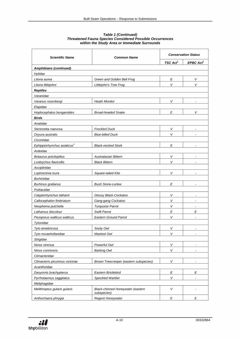
Bulli Seam Operations – Response to Submissions
A-10 00332864
Table 1 (Continued) Threatened Fauna Species Considered Possible Occurrences
within the Study Area or Immediate Surrounds
Conservation Status Scientific Name Common Name
TSC Act1 EPBC Act2
Amphibians (continued)
Hylidae
Litoria aurea Green and Golden Bell Frog E V
Litoria littlejohni Littlejohn's Tree Frog V V
Reptiles
Varanidae
Varanus rosenbergi Heath Monitor V -
Elapidae
Hoplocephalus bungaroides Broad-headed Snake E V
Birds
Anatidae
Stictonetta naevosa Freckled Duck V -
Oxyura australis Blue-billed Duck V -
Ciconiidae
Ephippiorhynchus asiaticus3 Black-necked Stork E -
Ardeidae
Botaurus poiciloptilus Australasian Bittern V -
Lxobrychus flavicollis Black Bittern V -
Accipitridae
Lophoictinia isura Square-tailed Kite V -
Burhinidae
Burhinus grallarius Bush Stone-curlew E -
Psittacidae
Calyptorhynchus lathami Glossy Black-Cockatoo V -
Callocephalon fimbriatum Gang-gang Cockatoo V -
Neophema pulchella Turquoise Parrot V -
Lathamus discolour Swift Parrot E E
Pezoporus wallicus wallicus Eastern Ground Parrot V -
Tytonidae
Tyto tenebricosa Sooty Owl V -
Tyto novaehollandiae Masked Owl V -
Strigidae
Ninox strenua Powerful Owl V -
Ninox connivens Barking Owl V -
Climacteridae
Climacteris picumnus victoriae Brown Treecreeper (eastern subspecies) V -
Acanthizidae
Dasyornis brachypterus Eastern Bristlebird E E
Pyrrholaemus saggitatus Speckled Warbler V -
Meliphagidae
Melithreptus gularis gularis Black-chinned Honeyeater (eastern subspecies)
V -
Anthochaera phrygia Regent Honeyeater E E
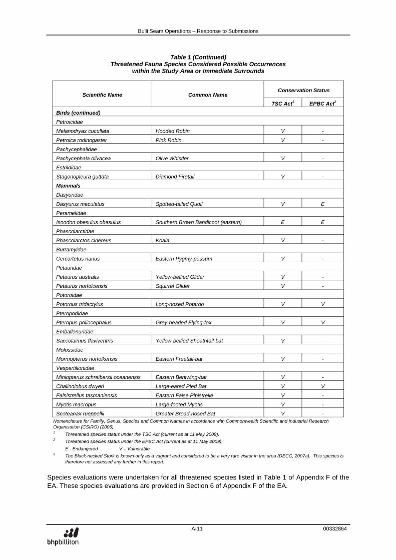
Bulli Seam Operations – Response to Submissions
A-11 00332864
Table 1 (Continued) Threatened Fauna Species Considered Possible Occurrences
within the Study Area or Immediate Surrounds
Conservation Status Scientific Name Common Name
TSC Act1 EPBC Act2
Birds (continued)
Petroicidae
Melanodryas cucullata Hooded Robin V -
Petroica rodinogaster Pink Robin V -
Pachycephalidae
Pachycephala olivacea Olive Whistler V -
Estrildidae
Stagonopleura guttata Diamond Firetail V -
Mammals
Dasyuridae
Dasyurus maculatus Spotted-tailed Quoll V E
Peramelidae
Isoodon obesulus obesulus Southern Brown Bandicoot (eastern) E E
Phascolarctidae
Phascolarctos cinereus Koala V -
Burramyidae
Cercartetus nanus Eastern Pygmy-possum V -
Petauridae
Petaurus australis Yellow-bellied Glider V -
Petaurus norfolcensis Squirrel Glider V -
Potoroidae
Potorous tridactylus Long-nosed Potaroo V V
Pteropodidae
Pteropus poliocephalus Grey-headed Flying-fox V V
Emballonuridae
Saccolaimus flaviventris Yellow-bellied Sheathtail-bat V -
Molossidae
Mormopterus norfolkensis Eastern Freetail-bat V -
Vespertilionidae
Miniopterus schreibersii oceanensis Eastern Bentwing-bat V -
Chalinolobus dwyeri Large-eared Pied Bat V V
Falsistrellus tasmaniensis Eastern False Pipistrelle V -
Myotis macropus Large-footed Myotis V -
Scoteanax rueppellii Greater Broad-nosed Bat V - Nomenclature for Family, Genus, Species and Common Names in accordance with Commonwealth Scientific and Industrial Research Organisation (CSIRO) (2006). 1 Threatened species status under the TSC Act (current as at 11 May 2009). 2 Threatened species status under the EPBC Act (current as at 11 May 2009).
E - Endangered V – Vulnerable 3 The Black-necked Stork is known only as a vagrant and considered to be a very rare visitor in the area (DECC, 2007a). This species is
therefore not assessed any further in this report.
Species evaluations were undertaken for all threatened species listed in Table 1 of Appendix F of the EA. These species evaluations are provided in Section 6 of Appendix F of the EA.
Bulli Seam Operations – Response to Submissions
A-12 00332864
Total Environment Centre Inc. (28 December 2009) states:
In 1998 a Memorandum of Understanding (MoU) regarding the then Dharawal State Recreation Area was signed by National Parks and Wildlife, the Department of Mineral Resources and BHP Steel (EA Attachment 6). This MoU was not altered in either of the 5-year review periods provided for in the document. … … … A key component of the MoU is that mining “recognises and respects the long term land use of the area for conservation, scientific, water quality and recreational purposes”. It is clear from the 2006 Plan of Management that an intention exists to strengthen the conservation status of the SCA to a “more appropriate” tenure and nominate its upland swamps for RAMSAR listing. Nowhere in the EA is it acknowledged how the proponent will specifically attempt to maintain the values of Dharawal SCA to achieve its overall strategy and objectives.
In regard to the Dharawal State Conservation Area, Total Environment Centre Inc. (28 December 2009) also states:
Nor is mining under Dharawal (or within the Special Areas) compatible with the values placed by the community on the area. Both the SCI and Metropolitan PAC recorded that community values must be taken into account when developing mine plans. The intensive mining proposed under a reserve with exceptional richness in biodiversity and endemism, including numerous aquatic values, is not consistent with the value of the area.
The 1998 Memorandum of Understanding referred to above also states:
The D-G NPW will permit continued exploration and mining in accordance with this MoU and the legislation under which the National Parks and Wildlife Service (“NPWS”) operates.
In regard to maintaining the values of the Dharawal State Conservation Area, Section 7.2.1 of the EA states:
Similarly, the Project would not have a significant impact on the use of the Dharawal State Conservation Area or Dharawal Nature Reserve. The Project is not incompatible with these existing landuses (Sections 5.3 to 5.10).
Also in regard to maintaining the values of the Dharawal State Conservation Area, Table 5-2 of the EA summarises the stream impact minimisation criteria and management measures that would be applied for the streams (including those within the Dharwal State Conservation Area) and the contingencies that would be implemented for predictions that are exceeded. As described in Section 5.2.1 of the EA:
ICHPL would prepare Stream Risk Management Plans (RMPs) for all of the streams identified in Appendix P that are situated within the extent of longwall mining area and within 600 m of the boundary of secondary extraction. The Stream RMPs would be included in future Extraction Plans for specific mining domains. The Stream Risk Assessment (Appendix P) would be reviewed and an updated risk assessment would be included in the RMPs based on the final mine plan (which would be consistent with any Project Approval conditions) and informed by relevant monitoring data.
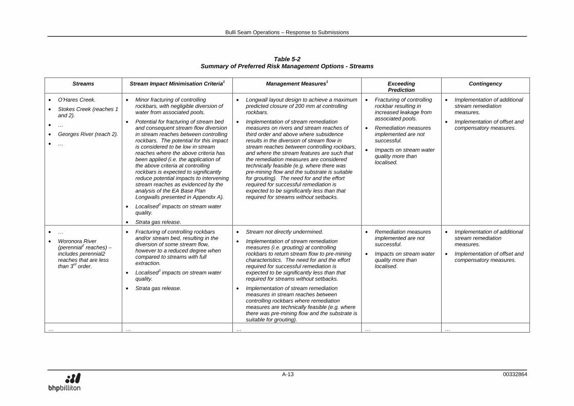
Bulli Seam Operations – Response to Submissions
A-13 00332864
Table 5-2 Summary of Preferred Risk Management Options - Streams
Streams Stream Impact Minimisation Criteria1 Management Measures1 Exceeding
Prediction Contingency
• O’Hares Creek.
• Stokes Creek (reaches 1 and 2).
• …
• Georges River (reach 2).
• …
• Minor fracturing of controlling rockbars, with negligible diversion of water from associated pools.
• Potential for fracturing of stream bed and consequent stream flow diversion in stream reaches between controlling rockbars. The potential for this impact is considered to be low in stream reaches where the above criteria has been applied (i.e. the application of the above criteria at controlling rockbars is expected to significantly reduce potential impacts to intervening stream reaches as evidenced by the analysis of the EA Base Plan Longwalls presented in Appendix A).
• Localised3 impacts on stream water quality.
• Strata gas release.
• Longwall layout design to achieve a maximum predicted closure of 200 mm at controlling rockbars.
• Implementation of stream remediation measures on rivers and stream reaches of third order and above where subsidence results in the diversion of stream flow in stream reaches between controlling rockbars, and where the stream features are such that the remediation measures are considered technically feasible (e.g. where there was pre-mining flow and the substrate is suitable for grouting). The need for and the effort required for successful remediation is expected to be significantly less than that required for streams without setbacks.
• Fracturing of controlling rockbar resulting in increased leakage from associated pools.
• Remediation measures implemented are not successful.
• Impacts on stream water quality more than localised.
• Implementation of additional stream remediation measures.
• Implementation of offset and compensatory measures.
• …
• Woronora River (perennial2 reaches) – includes perennial2 reaches that are less than 3rd order.
• Fracturing of controlling rockbars and/or stream bed, resulting in the diversion of some stream flow, however to a reduced degree when compared to streams with full extraction.
• Localised3 impacts on stream water quality.
• Strata gas release.
• Stream not directly undermined.
• Implementation of stream remediation measures (i.e. grouting) at controlling rockbars to return stream flow to pre-mining characteristics. The need for and the effort required for successful remediation is expected to be significantly less than that required for streams without setbacks.
• Implementation of stream remediation measures in stream reaches between controlling rockbars where remediation measures are technically feasible (e.g. where there was pre-mining flow and the substrate is suitable for grouting).
• Remediation measures implemented are not successful.
• Impacts on stream water quality more than localised.
• Implementation of additional stream remediation measures.
• Implementation of offset and compensatory measures.
… … … … …
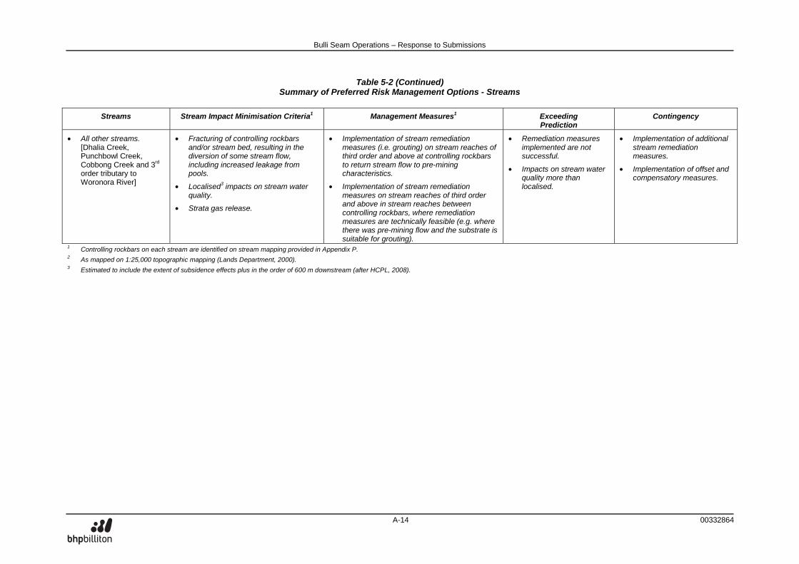
Bulli Seam Operations – Response to Submissions
A-14 00332864
Table 5-2 (Continued) Summary of Preferred Risk Management Options - Streams
Streams Stream Impact Minimisation Criteria1 Management Measures1 Exceeding
Prediction Contingency
• All other streams. [Dhalia Creek, Punchbowl Creek, Cobbong Creek and 3rd order tributary to Woronora River]
• Fracturing of controlling rockbars and/or stream bed, resulting in the diversion of some stream flow, including increased leakage from pools.
• Localised3 impacts on stream water quality.
• Strata gas release.
• Implementation of stream remediation measures (i.e. grouting) on stream reaches of third order and above at controlling rockbars to return stream flow to pre-mining characteristics.
• Implementation of stream remediation measures on stream reaches of third order and above in stream reaches between controlling rockbars, where remediation measures are technically feasible (e.g. where there was pre-mining flow and the substrate is suitable for grouting).
• Remediation measures implemented are not successful.
• Impacts on stream water quality more than localised.
• Implementation of additional stream remediation measures.
• Implementation of offset and compensatory measures.
1 Controlling rockbars on each stream are identified on stream mapping provided in Appendix P. 2 As mapped on 1:25,000 topographic mapping (Lands Department, 2000). 3 Estimated to include the extent of subsidence effects plus in the order of 600 m downstream (after HCPL, 2008).
Bulli Seam Operations – Response to Submissions
A-15 00332864
In regard to the Dharawal Nature Reserve and Dharawal State Conservation Area Plan of Management (Department of Environment and Conservation [DEC], 2006), Section 4.1.1 of the plan of management lists “Actions”, including:
• Investigate, and where appropriate, nominate the upland swamp communities for listing under the Ramsar convention.
ICHPL understands that no upland swamp communities in the Dharawal Conservation Area or the Dharawal Nature Reserve have been nominated by DECCW for listing under the Ramsar convention. Total Environment Centre Inc. (28 December 2009) states:
… Untried remediation methods … within the cluster of upland swamps in Dharawal SCA also have the potential to create disturbance on a large scale as does intensive monitoring.
The estimates of vegetation clearing required for the Project provided in the EA were calculated in consideration of environmental monitoring and management activities. The EA also commits to minimising vegetation clearance in upland swamps. Section 2.3 of the EA states:
The main activities associated with the development of the Project would include: … • ongoing surface monitoring and rehabilitation (including rehabilitation of mine related infrastructure
areas that are no longer required) and remediation of subsidence effects; and Section 5.8.2 of the EA states:
In addition to clearing for the Stage 4 Coal Wash Emplacement, it is estimated that the Project would involve approximately 37 ha of other vegetation clearance activities primarily associated with ongoing surface exploration activities, the upgrade and extension of surface infrastructure (e.g. gas wells and service boreholes), access tracks, environmental monitoring and management activities (e.g. installation of monitoring equipment), potential stream restoration activities and other localised Project-related surface activities. The specific locations of these vegetation clearance activities would be detailed in the relevant Extraction Plans as required by the DoP. … Vegetation clearance would not take place in upland swamps, except for very minor disturbance associated with environmental monitoring or mitigation purposes.
In regard to vegetation clearing associated with upland swamp remediation, should it be required, ICHPL would utilise existing access tracks and cleared areas where possible. Where drilling is required as part of upland swamp remediation, vegetation clearing would be minimised by handheld equipment where necessary, and with larger machinery such as generators and pumps located outside of the upland swamp.
Bulli Seam Operations – Response to Submissions
A-16 00332864
STAGED APPROVAL Total Environment Centre Inc. (28 December 2009) states:
… If approvals are granted for mining within the application area, they should be staged. Initial approval to mine in the western section of the application area, while still paying respect to rivers and important natural features, would allow the proponent some years of mining without high-risk mining and untried remediation methods on the upland swamps of Dharawal SCA (Northcliff) and in the Special Area 2 and Area 3). While understanding the technical planning that goes into developing a mine plan, TEC recommends that this focuses entirely upon the western side of the application area at this stage. Only staged approvals of no greater than five years would provide for a precautionary and adaptive approach in mine management.
…
ICHPL’s preferred approach is consistent with the second option presented by Industry & Investment (I&I NSW) (23 December 2009):
If the determination is not based on a staged process, there is a need for strong mechanisms to ensure adequate consultation, feasibility studies and lead time for the development of major management strategies, that is, the Extraction Plans Stage.
This approach is consistent with: • the NSW planning process (see Figure 44 of the Southern Coalfield Panel Report [Department of
Planning, 2008]); and
• contemporary Project Approvals under Part 3A of the Environmental Planning and Assessment Act, 1979 (e.g. Metropolitan Coal Project [08_0149]) which include the staged submission of detailed strategies, plans and programs (e.g. Subsidence Management Plans and/or Extraction Plans).
The above process includes strong consultation mechanisms, feasibility studies and long lead times (i.e. typically the lodgement of a Subsidence Management Plan six months prior to its desired approval). CLIFF LINES Total Environment Centre Inc. (28 December 2009) states:
… It would be appropriate for strict reporting conditions to include independent verification of end of panel reports that came in time to have relevant influence on further mining approvals.
It is envisaged that any Project Approval that is determined by the Minister for Planning for the Project would include a condition of similar nature to that included in the recent Metropolitan Coal Project Part 3A Project Approval (Application Number 08_0149, 22 June 2009), viz.:
8. By end of December 2011, and every 3 years thereafter, unless the Director-General directs otherwise, the Proponent shall commission and pay the full cost of an Independent Environmental Audit of the project. This audit must: (a) be conducted by suitably qualified, experienced and independent team of experts whose
appointment has been endorsed by the Director-General; (b) include consultation with the relevant agencies;
Bulli Seam Operations – Response to Submissions
A-17 00332864
(c) assess the environmental performance of the project and assess whether it is complying with the relevant requirements in this approval and any relevant EPL or Mining Lease (including any assessment, plan or program required under these approvals);
(d) review the adequacy of strategies, plans or programs required under these approvals; and, if appropriate; and
(e) recommend measures or actions to improve the environmental performance of the project, and/or any assessment, plan or program required under these approvals.
Note: This audit team must be led by a suitably qualified auditor and include experts in any fields specified by the Director-General.
COAL WASHERY Total Environment Centre Inc. (28 December 2009) states:
Indications by the proponent are that the company will seek alternatives to coal emplacement including a trial of placing the waste underground as has occurred at Metropolitan Colliery. However the clearing of 67ha of native vegetation suggests that surface emplacement will continue to form by far the major part of dealing with the waste product. This raises questions as to how much further the emplacement area at the headwaters of the Georges River will continue to be expanded given the increased output of coal from the combined mines. Stronger commitments beyond that of trials should be required from the proponent as space at the West Cliff emplacement area is already known to be an issue and further clearing of native vegetation is inappropriate.
The proposed additional disturbance area for Stage 4 of the West Cliff Coal Wash Emplacement is clearly identified and delineated on Figure 2-2 of the EA. The proposed disturbance area incorporates coal wash produced from the existing Appin Mine and West Cliff Colliery, the Project and the Dendrobium Mine for the life of the Project (30 years). As stated in Section 2.8.5 of the EA:
ICHPL has however committed to, and would continue to (Cardno Forbes Rigby, 2007b): • research and consider alternatives to coal wash emplacement;
• pursue the use of coal wash as an engineering fill material;
• negotiate with owners of suitably located and available sites that could be used as alternative emplacement sites to extend the life of the West Cliff Stage 3 Coal Wash Emplacement; and
• report progress of these actions to the NSW Government in the Annual Environmental Management Report (AEMR).
If approved, this commitment would continue for Stage 4. BENEFIT COST ANALYSIS Total Environment Centre Inc. (28 December 2009) states with respect to the EA Benefit Cost Analysis:
The BCA components of particular interest to TEC are the general conclusion and aspects of the choice modelling which we suggest inappropriately slant the conclusions. … The choice modelling study contains significant biases.
Bulli Seam Operations – Response to Submissions
A-18 00332864
As described in Appendix L of the EA, the Choice Modelling conducted for the Project was specifically targeted to address a number of concerns raised in the Metropolitan PAC Report (PAC, 2009) about cumulative environmental impact context and the consideration of social costs of mine closure at differing periods in the mine life. These concerns were addressed and amendments were included in the Choice Modelling conducted for this Project. It should be noted that stated preference non-market valuation methods such as Choice Modelling are generally considered more likely to overstate community values rather than understate them because of their hypothetical nature. Numerous studies in the literature highlight this potential overstatement through comparison of hypothetical willingness to pay estimates from contingent valuation and choice modelling studies to actual payments or to revealed preference studies. Further, values from the choice modelling study have been conservatively aggregated to 46% of NSW households, even though the questionnaire response rate was much lower than this. The Choice Modelling study has been peer reviewed by Dr John Rolfe, an expert in Choice Modelling, whose letter states (Attachment 3 of the EA):
This report details the performance of a very professionally conducted choice modeling study to assess the values of state and regional populations for the potential impacts of continued coal mining operations. The survey performance shows careful attention to design and conduct, and is in line with the standard operation of choice modelling studies that are currently being performed in Australia and internationally. The analysis of results is appropriate and of high quality, and the conclusions that have been drawn are in line with the outcomes of the results. The results appear appropriate for use in subsequent benefit cost analysis.
RECOMMENDATIONS Total Environment Centre Inc. (28 December 2009) makes the following three recommendations in regard to any Project Approval:
1. Grant approvals for sections of the project in stages commencing in the western portion of
the project area first and avoiding mining under Dharawal SCA and the Metropolitan Special Area
ICHPL’s preferred approach is consistent with the second option presented by I&I NSW (23 December 2009):
If the determination is not based on a staged process, there is a need for strong mechanisms to ensure adequate consultation, feasibility studies and lead time for the development of major management strategies, that is, the Extraction Plans Stage.
This approach is consistent with: • the NSW planning process (see Figure 44 of the Southern Coalfield Panel Report [Department of
Planning, 2008]); and
• contemporary Project Approvals under Part 3A of the Environmental Planning and Assessment Act, 1979 (e.g. Metropolitan Coal Project [08_0149]) which include the staged submission of detailed strategies, plans and programs (e.g. Subsidence Management Plans and/or Extraction Plans).
The above process includes strong consultation mechanisms, feasibility studies and long lead times (i.e. typically the lodgement of a Subsidence Management Plan six months prior to its desired approval).
Bulli Seam Operations – Response to Submissions
A-19 00332864
2. Improve the monitoring program to allow for adaptive management strategies that must be implemented prior to mining in sensitive areas. As it stands, monitoring results will come too late to respond adequately to the negative impacts of mining on the environment
The Extraction Plan process that would be implemented over the life of the Project is described in Section 7.3.1 of the EA:
Over the life of the Project, Extraction Plans would be progressively prepared as detailed mine designs are completed for each part of the Project area. The main aspects to be addressed by Project Extraction Plans would include:
• a detailed mine plan;
• plans of associated surface construction works;
• a coal resource recovery plan;
• final prediction of systematic (conventional) and non-systematic (non-conventional) subsidence effects;
• demonstration that the predicted subsidence impacts and consequences are consistent with those authorised by the Project Approval;
• a Subsidence Monitoring Programme;
• a Catchment Monitoring Programme;
• a Biodiversity Management Plan;
• a Heritage Management Plan; and
• a Built Features Management Plan. The Extraction Plan process provides a mechanism for the presentation of further detail regarding particular management measures for individual longwalls or mining domains. As part of the preparation of Extraction Plans, consultation would be undertaken with relevant stakeholders (e.g. relevant landholders, infrastructure owners and government authorities).
The Upland Swamp Risk Assessment (Appendix O of the EA) and the Stream Risk Assessment (Appendix P of the EA) describe the implementation of monitoring programmes and contingency plans, including Trigger Action Response Plans (TARPs). For example, Section O7.6 of Appendix O of the EA describes:
The contingency plan process would involve: • Implementation of the TARP described in Section O7.5, specifically:
– Implementation of the swamp monitoring programme.
– Collection of monitoring data.
– Analysis of results, including:
Assessment against monitoring triggers described in a TARP developed for swamps in the mining domain and included in relevant Extraction Plans.
Assessment of any trends in the data that may indicate changes are occurring.
Assessment of any impacts against predictions.
Root cause analysis of any change or impact.
Specialist input to analysis of results, as required.
– Reporting.
Bulli Seam Operations – Response to Submissions
A-20 00332864
The monitoring programmes described in Section O7.5 of Appendix O and Section P7.5 of Appendix P of the EA would commence for any particular upland swamp(s) or significant stream(s) at least two years prior to mining within the relevant Risk Management Zone.
3. Avoid mining under Dharawal SCA (acknowledging NPWS proposed strengthening of it’s conservation status and intended nomination of its upland swamps for RAMSAR listing contained in the Plan of Management) and surface impacts on major watercourses.
As described above, ICHPL understands that no upland swamp communities in the Dharawal Conservation Area or the Dharawal Nature Reserve have been nominated by DECCW for listing under the Ramsar convention. ICHPL’s preferred risk management options for swamps and streams are presented in Tables 5-2 and 5-3 of the EA. Benefit Cost Analysis (including consideration of environmental consequences) presented in Appendix L of the EA indicates that the level of swamp and stream protection recommended by Total Environment Centre Inc. (28 December 2009) is not supported by community values. REFERENCES Department of Environment and Conservation (2006) Dharawal Nature Reserve and Dharawal State
Conservation Area Plan of Management.
Department of Planning (2008) Impacts of Underground Coal Mining on Natural Features in the Southern Coalfield: Strategic Review. State of NSW through the NSW Department of Planning.
Industry and Investment NSW (2009) Bulli Seam Operations Project Environmental Assessment 08_0150. Letter dated 23 December 2009.
Planning Assessment Commission (2009) Metropolitan Coal Project Review Report.
Bulli Seam Operations – Response to Submissions
00340312
ATTACHMENT B
RESPONSE TO AUSTRALIAN WETLANDS CONSULTING PTY LTD REPORT
Bulli Seam Operations – Response to Submissions
B-1 00334680
Bulli Seam Operations Response to “Review of Bulli Seam Operations Environmental Assessment”
by Australian Wetlands Consulting Pty Ltd February 2010
A preliminary review has been conducted of the report Review of Bulli Seam Operations Environmental Assessment prepared by Australian Wetlands Consulting Pty Ltd (February 2010) for the Total Environment Centre Inc. The following presents responses to a number of claims made by Australian Wetlands Consulting Pty Ltd (February 2010). It is noted that Australian Wetlands Consulting Pty Ltd (February 2010) provides no alternative method or conclusion for: • the assessment of ‘special significance’ for swamps within the Project area; or
• the assessment of potential negative consequences or potential significant negative consequences for swamps within the Project area.
Australian Wetlands Consulting Pty Ltd (February 2010) states:
Swamp Impact Mechanism 3 provides no justification for the use of 200mm as the threshold for valley closure (this being defined as the process via which one or both sides a [sic] valley move horizontally towards the valley centre line due to changed stress conditions beneath the valley and its confining land mass).
The assessment of potential impacts to swamps has been undertaken in accordance with the recommendations of the NSW Planning Assessment Commission’s (PAC’s) Metropolitan Coal Project Review Report (PAC, 2009) (herein described as the Metropolitan PAC Report), which identified three broad mechanisms by which subsidence could cause changes in swamp hydrology (pages 78-79):
1. The bedrock below the swamp cracks as a consequence of tensile strains and water drains into the fracture zone. If the fracture zone is large enough or connected to a source of escape (e.g. a deeper aquifer or bedding shear pathway to an open hillside) then it is possible for sufficient water to drain to alter the hydrologic balance of the swamp.
2. Tilting of sufficient magnitude occurs to either re-concentrate runoff leading to scour and erosion, potentially allowing water to escape from the swamp margins (possibly affecting the whole swamp) or to alter water distribution in parts of the swamp, thus favouring some flora species associations over others.
3. Buckling and bedding shear enhances fracture connectivity in the host bedrock which promotes vertical then lateral drainage of the swamp. This mechanism is similar to redirected surface flow observed in subsidence-upsidence affected creek beds.
In regard to potential valley closure impacts (i.e. Swamp Impact Mechanism 3), the Metropolitan PAC Report states (page 119):
…the Panel considers negligible consequence for a watercourse to mean no diversion of flow, no change in the natural drainage behaviour of pools, and minimal iron staining, and is assumed to be achieved in circumstances where predicted valley closure is less than 200mm.
The use of the 200 millimetres (mm) valley closure threshold is considered to be consistent with the third mechanism identified by the Metropolitan PAC Report (PAC, 2009), which recognises that this mechanism is similar to redirected surface flow observed in valley closure affected creek beds.
Bulli Seam Operations – Response to Submissions
B-2 00334680
Australian Wetlands Consulting Pty Ltd (February 2010) states:
Within appendix O, no comment is made of subsidence impacts noted within attachment OB of between 500mm and 1500mm predicted for swamps within the study area. Such values would irrevocably change the character and function of these swamps in erratic and unpredictable ways, with there being little opportunity for adequate rehabilitation.
Section 5 of Appendix C of the EA describes the basis of 200 mm valley closure as a reference value including:
The 200 mm closure value has been adopted as a reference valley closure magnitude below which it is expected that flow diversion and pool water level impacts are unlikely to occur. The currently available database is however relatively small and the adoption of a 200 mm valley closure criteria is viewed as an indicator of a low probability of flow diversion and pool water level impacts rather than an absolute threshold.
The Upland Swamp Risk Assessment (Appendix O of the EA) conservatively assumes that all swamps with a predicted maximum valley closure of greater than 200 mm would experience potential negative consequences. Appendix O of the EA also provides the results of field inspections of swamp previously subject to subsidence, including six swamps with back predicted valley closure greater than 200 mm and one of these swamps with back predicted valley closure greater than 500 mm. None of these swamps had evidence of significant negative consequences (Section O6.4 of Appendix O of the EA). Australian Wetlands Consulting Pty Ltd’s (February 2010) claim that valley closures of greater than 500 mm would “irrevocably change the character and function of these swamps in erratic and unpredictable ways” is not supported by any scientific evidence. Australian Wetlands Consulting Pty Ltd (February 2010) states:
No explanation has been provided about how and why the parameters of characterisation as detailed within Attachment OA of Appendix O have been adopted; why the assessment tables are incomplete; and the significance of each parameter considered…
As stated in Section O4 of Appendix O of the EA:
Some 20 swamps were subject to detailed inspection during the preparation of the EA by Illawarra Coal Holdings Pty Ltd (ICHPL) and 16 of these swamps, plus an additional two swamps, were also inspected by Gilbert & Associates and FloraSearch. Observations recorded during the site inspections are provided in Attachment OA.
Attachment OA of Appendix O of the EA presents observations of the swamp inspected and is not a detailed database of swamp characteristics Parameters of characterisation for swamps are provided in the swamp matrix (Attachment OB of Appendix O of the EA) and include topographic, hydrological, ecological and landuse characteristics. The characterisation parameters in Attachment OB of Appendix O of the EA included the recommendations of the Metropolitan PAC Report (PAC, 2009) and were determined in consultation with key government agencies (e.g. the Department of Environment, Climate Change and Water [DECCW]). The characteristics identified were used to assess special significance and potential impacts as part of the Upland Swamp Risk Assessment (Appendix O of the EA).
Bulli Seam Operations – Response to Submissions
B-3 00334680
Attachment OB of Appendix O of the EA also includes clear explanations of the characteristics provided and the sources of data. There are no unexplained blanks in Attachment OB of Appendix O of the EA and the tables are complete. Australian Wetlands Consulting Pty Ltd (February 2010) states:
…Appendix O fails to acknowledge that longwall mining is listed as a threatening process under the TSC Act, 1995.
Relevant key threatening processes listed under the Threatened Species Conservation Act, 1995, Environment Protection and Biodiversity Conservation Act, 1999 and Fisheries Management Act, 1994 were specifically referenced and considered in the Aquatic Ecology Assessment, Terrestrial Flora Assessment and Terrestrial Fauna Assessment (Appendices D, E and F of the EA, respectively). This included consideration of alteration of habitat following subsidence due to longwall mining which is listed as a key threatening process under the Threatened Species Conservation Act, 1995 (NSW Scientific Committee, 2005). Key threatening processes listed under the abovementioned Acts are not a relevant consideration in the context of the assessment provided in Appendix O of the EA. Australian Wetlands Consulting Pty Ltd (February 2010) states:
Fauna survey effort only found three threatened species within the project area, despite NPWS databases showing that Upland Swamps are key habitat for at least 12 of the most threatened fauna species in Sydney’s southern region (DECC, 2007)…
As described in Section 3.3 of Appendix F of the EA, 17 threatened fauna species were recorded during the Project surveys. Section O5.5 of Appendix O of the EA describes the two threatened fauna species and the one threatened flora species that were recorded in swamps within the Project area:
Three threatened species were recorded in swamps by the Project surveys (Section O4.4.5). The Prickly Bush-pea (Pultenaea aristata) was found to be widely dispersed and locally common in the east of the study area (Appendix E of the EA). The species occurs primarily on the margins of swamps in Restioid Heath (Community 1d), Fringing Eucalypt Woodland (Community 1f) and to a lesser extent in Banksia Thicket (Community 1d) (ibid.). It was also occasionally found in riparian habitats in upper catchments. It also occurs in heath and heathy woodland in the far north-east of North Cliff at high altitudes where rainfall is also higher (Appendix E of the EA). Pultenaea aristata is endemic to the Woronora Plateau in NSW, between Helensburgh and Mount Keira. Targeted surveys for Pultenaea aristata conducted for the Project indicate the species is locally common and widely dispersed within the study area. The Eastern Ground Parrot (Pezoporus wallicus wallicus) is a species that has a greater dependence on swamp and heath habitats. During the Project surveys, the Eastern Ground Parrot was recorded in two swamps (Attachment OD). The Eastern Ground Parrot has also been recorded in two swamps nearby at the Metropolitan Colliery. The Eastern Pygmy-possum (Cercartetus nanus) inhabits a wide range of habitats including rainforest, wet and dry sclerophyll forest, subalpine woodland, coastal banksia woodland and wet heath (Turner and Ward, 1998; Menkhorst and Knight, 2001). In drier habitats banksias and myrtaceous shrubs and trees are favoured as food sources and nesting sites (Turner and Ward, 1998). During the Project surveys, this species was recorded at two gully forest sampling sites, three swamp sampling sites, one low woodland heath sampling site and one tall open woodland sampling site (Attachment OD).
Bulli Seam Operations – Response to Submissions
B-4 00334680
Subsequent to the DECC report referred to by Australian Wetlands Consulting Pty Ltd (February 2010), DECC (2009) provided a list of flora and fauna species that it considers either depend on swamps for survival or have a stronghold in swamps. Attachment OD of Appendix O of the EA includes discussion and consideration of the eight threatened fauna species identified by DECC (2009) as dependent on swamps for survival or that have a stronghold in swamps. In addition to the above, Table 1 of Appendix F of the EA provides a list of 47 threatened fauna species that have either previously been recorded or are considered possible occurrences within the study area or immediate surrounds. Species evaluations were undertaken for all threatened species listed in Table 1 of Appendix F of the EA and are provided in Section 6 of Appendix F of the EA. It is noted that Australian Wetlands Consulting Pty Ltd (February 2010) states:
No attempt has been made at this stage of our work to scrutinise methods employed for identifying wetlands, since this component of work is based on reputable sources (NPWS, Tozer et al, 2006).
Australian Wetlands Consulting Pty Ltd (February 2010) also states:
No explanation has been provided on the methods via which wetland boundaries were determined…
As described in Section O4.1 of Appendix O of the EA, the boundaries shown for upland swamps are based on vegetation mapping of the NSW National Parks and Wildlife Service (NPWS) (2003), Tozer et al. (2006) and Biosis Research (2007). As stated by Australian Wetlands Consulting Pty Ltd (February 2010) these are considered “reputable sources”. Delineating swamps using this vegetation mapping was considered appropriate for an impact assessment under Part 3A of the Environmental Planning and Assessment Act, 1979. Further delineation of upland swamp boundaries would be undertaken during the preparation of Upland Swamp Risk Management Plans (RMPs) as a component of future Extraction Plans. Australian Wetlands Consulting Pty Ltd (February 2010) further states in regard to upland swamp boundaries:
Delineation of wetland boundaries and associated ecotones is notoriously difficult. An ecotone can be defined as the transition between two vegetation communities containing the characteristic species of each. Common practice is to determine the wetland boundary as the outer edge of the wetland ecotone (Australian Wetlands, 2006). This has implications for the provision of setbacks and buffers around the wetlands, with the possibility that they have been incorrectly located within the study area. …It is highly recommended that mapping methods adopted for the environmental assessment be reviewed using a rigorous and objective wetland boundary method.
Section 5.2.2 of Appendix E of the EA describes natural disturbances to upland swamps within the Project area:
Upland swamps are subject to a range of natural disturbances including periodic wildfire, drought and storms. Evidence of charcoal within swamp sediments indicates that Woronora Plateau swamps have been burnt by wildfires and suffered gully erosion episodically over many thousands of years (Young, 1986; Tomkins and Humphreys, 2006)…
As a result of natural disturbances, swamps within the Project area are dynamic and wetland boundaries and associated ecotones are likely to shift throughout the life of the Project.
Bulli Seam Operations – Response to Submissions
B-5 00334680
Based on the above it is considered appropriate that rigorous delineation of wetland boundaries and associated ecotones is conducted during the preparation of Upland Swamp RMPs as a component of future Extraction Plans. Australian Wetlands Consulting Pty Ltd (February 2010) states:
Good et al (2006) is the key document relied upon for both the assertion that adverse impacts can be mitigated and the estimate of costs to undertake any rehabilitation works. Reviews of this document by us and other stakeholders is considered essential to gaining a full appreciation of the methods proposed; comparison of these methods with current best practice; and then determination of their likelihood of success. At this stage the applicant has refused to release this document as at 12 February 2010 (as requested by Total Environment Centre).
The Dendrobium Area 3A Swamp Impact, Monitoring, Management and Contingency Plan, at the time of request by Total Environment Centre, was being reviewed and assessed by the NSW Department of Planning (DoP) and hence was not suitable for public release. Since the time of the request, the Dendrobium Area 3A Swamp Impact, Monitoring, Management and Contingency Plan has been approved by DoP and is now publically available from the ICHPL website (http://www.bhpbilliton.com/bbContentRepository/docs/dendrobiumSwampImpactMonitoringManagementAndContingencyPlan.pdf). Australian Wetlands Consulting Pty Ltd (February 2010) states:
The rehabilitation methods can only be considered experimental (ACARP, 2002) and all parties acknowledge that insufficient time has passed to determine to [sic] likely success of methods currently employed (Illawarra Coal, Appendix O, Metropolitan PAC). … No case studies have been considered (or at least acknowledged) in the determination of appropriate responses or justification for decisions being made.
It is noted that Australian Wetlands Consulting Pty Ltd (February 2010) do not provide a complete reference to the report “ACARP, 2002” referred to above. As described in Section O7.3.2.3 of Appendix O of the EA:
Examples of potential maintenance responses are provided below. Potential maintenance responses for specific swamp(s) would be provided in the RMPs to be prepared and included in Extraction Plans.
A number of the maintenance and rehabilitation methods presented in Appendix O of the EA have been used in other circumstances which could be applied to managing potential subsidence impacts on swamps. For example, the use of coir log dams in swamp rehabilitation in the Blue Mountains and Snowy Mountains and sealing of bedrock fractures and injection grouting which have been used to rehabilitate streams within the Southern Coalfield. The development of Swamp RMPs as a component of the Extraction Plan process would include a review of the success of rehabilitation methods at the Project, other mines with the Southern Coalfield (e.g. Dendrobium Mine) and at other upland swamps within Australia. Section O7.7 of Appendix O of the EA describes that independent audits would be conducted to assess the implementation and effectiveness of the RMPs.
Bulli Seam Operations – Response to Submissions
B-6 00334680
Australian Wetlands Consulting Pty Ltd (February 2010) states:
Any assessment and rehabilitation strategy must consider the basis for plant distribution within a wetland…This is complicated further by the impact of eutrophication whereby fertility gradients can result in quite different and unnatural plant assemblages within wetlands (Keddy, 2002 after Levine et al 1998).
Eutrophication is considered very unlikely in the majority of swamps, as most of the swamps are located within the Dharawal State Conservation Area and/or O’Hares Creek, Woronora or Metropolitan Special Areas. These areas are generally undisturbed and the majority of swamps are unlikely to contain high levels of unnatural nutrient loads. Australian Wetlands Consulting Pty Ltd’s (February 2010) comment on eutrophication demonstrates the generic nature of its review and its lack of understanding of the swamps within the Project area. Australian Wetlands Consulting Pty Ltd (February 2010) states:
Groundwater levels are a key determinant of wetland form, however within Appendix O all mention of groundwater data is qualified as indicative. Groundwater characteristics are a key factor in upland swamp function and must be thoroughly understood in a spatial temporal context.
The discussion of potential groundwater impacts on swamps within the Groundwater Assessment is consistent with the Metropolitan PAC Report. As described in Section 6.5.1.3 of Appendix B of the EA, there is expected to be no loss of water to depth but bed separation and tensile cracking still has the potential to occur:
The substantial depth of cover and the presence of a thick aquitard protect the shallow aquifers in the Hawkesbury Sandstone, which are in connection with streams and ecosystems, from transmitted effects due to reduction in groundwater pressures. Based on the analysis of the conceptual groundwater system, and modelling results, there is no expected dewatering of swamps from depressurisation at depth… As the free-draining fractured zone that is to be expected above a goaf zone does not extend as high as the Bald Hill Claystone, the perched water in upland swamps would not be impacted directly by vertically connected cracking. The only possibilities for impact are through bed separation or superficial tensile cracking associated with a moving subsidence trough, and that is likely to be transitory or localised. Very little drainage of water due to bed separation or superficial tensile cracking is expected from the perched water table in a swamp to the regional water table in the underlying sandstone, as the sandstone bedrock is massive in structure and permeability decreases with depth. Surface cracking that may occur would be superficial in nature (i.e. would be relatively shallow) and would terminate within the unsaturated part of the low permeability sandstone (MSEC, 2009). Due to the very low hydraulic gradient of the water table within a swamp, lateral movement of water through the swamp towards a crack would be very small and very slow.
As described in Section O4.3.4 of Appendix O of the EA:
The minimum topographic points in each swamp have been compared to the modelled regional groundwater table by Heritage Computing to provide an indication of the position of the swamp in relation to the regional groundwater table. Comparisons were made using: (a) simulated steady-state water table levels; and (b) interpolated observed water table levels. This estimation of swamp position relative to the modelled regional groundwater table should be viewed as indicative only. Actual groundwater position at swamps of interest would be measured on a case by case basis. As described in Section O7, future monitoring/survey would be conducted to provide additional information that would be incorporated in Upland Swamp RMPs to be included in future Extraction Plans for specific mining domains.
Bulli Seam Operations – Response to Submissions
B-7 00334680
As stated in Table O-7 of Appendix O of the EA:
• Initially (i.e. prior to the preparation of the Risk Management Plan), piezometers would be installed within a representative sample of the swamps to obtain baseline data on the local and regional groundwater systems. The swamps proposed to be monitored are:
– swamp CT2-S1a (at real risk of mechanisms 1 and 2);
– swamps CT2-S4, CT2-S6 and STC-S13, (at real risk of mechanisms 1 and 3);
– swamps CRE-S3b, CT1-S2, CT1-S4, CT1-S5, CT2-S7, STC-S24, STC-S34 and STC-S36 (at real risk of mechanisms 1, 2 and 3); and
– a selection of the remaining swamps at risk of mechanism 1.
• Piezometer monitoring would include shallow piezometer installations for the monitoring of groundwater levels/pressures within upland swamps. Water level measurements would be automated with daily or more frequent recording.
• Piezometer monitoring would also include a selection of deep piezometer installations for the monitoring of pore pressures within the natural rock strata. Pore pressure measurements would be automated with daily or more frequent recording.
• The need for piezometer monitoring in the remainder of the swamps considered to be at real risk of negative environmental consequences would be reviewed based on the outcomes of the fracture zone height analysis and piezometer monitoring described above.
The monitoring programme described above would commence for any particular upland swamp(s) at least two years prior to mining within the Risk Management Zone of the particular upland swamp(s). Australian Wetlands Consulting Pty Ltd (February 2010) states:
No detail is provided in the EA on construction methods, monitoring requirements and definition of success in this context, or contingency measures in the event that proposed outcomes are not being achieved. … A rehabilitation design must be provided in much more detail before any approvals are considered.
The RMP process is described in Section O7.1 of Appendix O of the EA:
The RMPs would be included in future Extraction Plans for specific mining domains. Consistent with the Metropolitan PAC Report, the RMPs would identify:
(i) the options for managing the risk based on one or a combination of avoidance, mitigation, remediation or tolerance and taking account of any assessment of special significance of the feature;
(ii) where relevant, the potential costs of those options; (iii) a preferred option; (iv) where relevant, a monitoring regime that will detect impact, measure actual impact against predicted
impact and measure the effectiveness of the management strategies adopted; (v) contingency plans for dealing with the situation where actual impact exceeds predicted impact; and (vi) auditing of the implementation and effectiveness of the risk management plan.
Development of the RMP and the approach proposed to be taken for aspects (i) to (vi) above is described below. Specifically, Sections O7.2 to O7.7 present preliminary information upon which the RMPs would be based. The information presented in Sections O7.2 to O7.7 is preliminary on the basis that the Project Approval conditions (if the Project is approved by the Minister for Planning) and the final mine plan(s) would further inform the selection of particular risk management options that would be presented in future Extraction Plan(s).
Bulli Seam Operations – Response to Submissions
B-8 00334680
Section O7.3.2.3 of Appendix O of the EA provides examples of potential maintenance responses that may be provided in the RMPs for specific swamp(s) (to be prepared and included in Extraction Plans). This includes details of the construction methods for these maintenance responses. A preliminary swamp monitoring programme has been developed based on the outcomes of the risk assessment and is presented in Section O7.5 and Table O-7 of Appendix O of the EA. ICHPL’s preferred risk management option for swamps is presented in Table O-6 of Appendix O of the EA, which includes definitions for exceeding predictions and contingency measures. Australian Wetlands Consulting Pty Ltd (February 2010) states:
No explanation of rehabilitation costs has been provided within Appendix O. Numbers offered appear preliminary and arbitrary. By comparison it is reported that BHP allocated $2.2 M for repairs to Marhnyes Hole in their 2002/03 budget; while in another study $1M is suggested for every 100m2 of disturbance and that it is in fact cheaper to not extract coal from an area than to extract and have to undertake rehabilitation works (EcoLogical, 2004).
Table O-5 of Appendix O of the EA provides a commitment to research and compensatory measures, including research programmes, catchment condition work and management within the Dharawal State Conservation Area and Sydney Catchment Authority (SCA) controlled catchments (e.g. weed and pest control and fire management). The commitments in Table O-5 of Appendix O of the EA are in addition to any remediation and contingency measures required as a result of ICHPL’s preferred risk management approach for swamps presented in Table O-6 of Appendix O of the EA. Table O-5 of Appendix O of the EA does not include cost estimates for measures presented in Table O-6 of Appendix O of the EA. The cost of remediation activities for the Project has been determined based on the commitments made in the EA (e.g. Table O-6 of Appendix O of the EA). The cost of remediation activities has been included in the operational cost of the Project in the Benefit Cost Analysis and is considered to be conservative. EcoLogical (2004), which is referenced by Australian Wetlands Consulting (February 2010), was a report prepared for Total Environment Centre Inc. The statement “it is in fact cheaper to not extract coal from an area than to extract and have to undertake rehabilitation works” is not supported by economic or scientific evidence and is not the position of ICHPL. A detailed Cost Benefit Analysis of the Project, including alternatives, is included in Appendix L of the EA. Australian Wetlands Consulting Pty Ltd (February 2010) states:
While offsets and compensation have been acknowledged by the Metropolitan PAC report as a potentially suitable solution where avoidance, mitigation and rehabilitation are not feasible, no explanation of offset and rehabilitation methods are prescribed within the subject report. Table O-5 provides no explanation of financial contributions and monetary figures sited [sic] in this table appear arbitrary.
Rehabilitation and offset measures are described in Sections O7.3.2 and O7.3.4 of Appendix O of the EA, respectively.
Bulli Seam Operations – Response to Submissions
B-9 00334680
As described above, Table O-5 of Appendix O of the EA does not include cost estimates for remediation and contingency measures presented in Table O-6 of Appendix O of the EA. The cost of remediation activities for the Project has been determined based on the commitments made in the EA (e.g. Table O-6 of Appendix O of the EA). The cost of remediation activities has been included in the operational cost of the Project in the Benefit Cost Analysis and is considered to be conservative. Australian Wetlands Consulting Pty Ltd (February 2010) states:
Appendix O is a narrowly focused document which not only fails to consider current policy and legislation relevant to managing upland swamps and wetlands generally, but does not cite a single piece of relevant literature concerned with wetland management, ecology and rehabilitation.
The Upland Swamp Risk Assessment (Appendix O of the EA) was developed in consideration of the framework and assessment approach outlined in the Metropolitan PAC Report (PAC, 2009) and the findings of the Southern Coalfield Inquiry. The Metropolitan PAC Report (PAC, 2009) and the Southern Coalfield Panel Report (DoP, 2008) are considered to be representative of current policy. Australian Wetlands Consulting Pty Ltd (February 2010) do not provide additional commentary or expand on the conclusions of these two documents. Nor do Australian Wetlands Consulting Pty Ltd (February 2010) present any reference to other “current policy and legislation”. The Upland Swamp Risk Assessment (Appendix O of the EA) is a risk assessment not a scientific document, which was undertaken using the risk assessment framework recommended in the Metropolitan PAC Report (PAC, 2009). As described in Section O1 of Appendix O of the EA:
This Upland Swamp Risk Assessment has been prepared based on data provided by Bio-Analysis, FloraSearch, Biosphere Environmental Consultants, Gilbert & Associates, Heritage Computing, Mine Subsidence Engineering Consultants (MSEC) and Gillespie Economics.
The following documents include scientific assessments and relevant citations regarding the potential impacts and potential management, mitigation measures and monitoring for upland swamps within the Project area (i.e. are the scientific assessments prepared by the above quoted specialists): • Subsidence Assessment (Appendix A of the EA);
• Groundwater Assessment (Appendix B of the EA);
• Surface Water Assessment (Appendix C of the EA);
• Aquatic Ecology Assessment (Appendix D of the EA);
• Terrestrial Flora Assessment (Appendix E of the EA);
• Terrestrial Fauna Assessment (Appendix F of the EA); and
• Socio-Economic Assessment (Appendix L of the EA). These relevant appendices of the EA form the source documents for the Upland Swamp Risk Assessment (Appendix O of the EA).
Bulli Seam Operations – Response to Submissions
B-10 00334680
RECOMMENDATIONS Australian Wetlands Consulting Pty Ltd (February 2010) makes the following six recommendations:
1. A principle of zero harm should be the basis for assessment and any approval
The above statement is not consistent with the Metropolitan PAC Report (PAC, 2009) (page 81):
Scattered distribution of swamps within mining leases means that it is impossible in most cases to design economically viable longwall layouts that would avoid undermining all swamps. … There are possibilities other than avoidance of impact for preventing environmental consequences. In some circumstances mitigation measures or remediation measures may be adequate to prevent a significant subsidence impact becoming a negative environmental consequence.
The Benefit Cost Analysis (including consideration of environmental consequences) presented in Appendix L of the EA indicates that applying this level of protection to all swamps is economically inefficient.
2. In light of the acknowledgment by all parties that longwall mining will be detrimental for upland swamps within the study area, a 30 year approval (even with conditions) should not be given to the applicant. (We note a number of key agency and community submissions propose a staged or time limited approval).
ICHPL’s preferred approach is consistent with the second option presented by Industry & Investment (I&I NSW) (23 December 2009):
If the determination is not based on a staged process, there is a need for strong mechanisms to ensure adequate consultation, feasibility studies and lead time for the development of major management strategies, that is, the Extraction Plans Stage.
This approach is consistent with: • the NSW planning process (see Figure 44 of the Southern Coalfield Panel Report [NSW
Department of Planning (DoP), 2008]); and
• contemporary Project Approvals under Part 3A of the Environmental Planning and Assessment Act, 1979 (e.g. Metropolitan Coal Project [08_0149]) which include the staged submission of detailed strategies, plans and programs (e.g. Subsidence Management Plans and/or Extraction Plans).
The above process includes strong consultation mechanisms, feasibility studies and long lead times (i.e. typically the lodgement of a Subsidence Management Plan six months prior to its desired approval).
3. Rehabilitation techniques require refinement and review to determine their appropriateness within the study area.
As described above, the development of Swamp RMPs as a component of the Extraction Plan process would include a review of the success of rehabilitation methods at the Project, other mines with the Southern Coalfield (e.g. Dendrobium Mine) and at other upland swamps within Australia. Section O7.7 of Appendix O of the EA describes that independent audits would be conducted to assess the implementation and effectiveness of the RMPs.
Bulli Seam Operations – Response to Submissions
B-11 00334680
4. Any compensation or offset measures proposed should be developed as part of the project approval process, not the operational phase.
As stated in the Statement of Commitments (Section 8) of the EA:
Consistent with the approved compensatory land package for the Stage 3 Coal Wash Emplacement, ICHPL commits to the provision of a compensatory land package for the Project that will include: • transfer of at least 130 ha of native bushland (ratio of 2:1) from ICHPL to the NSW State
Government;
• selection of suitable bushland for transfer;
• funding for costs associated with transferring the relevant land title to the NSW State Government; and
• funding for minor site improvement works if required. Table SOC-2 of Section 8 of the EA provides commitments to research and compensatory measures, including research programmes, catchment condition work and management within the Dharawal State Conservation Area and Sydney Catchment Authority (SCA) controlled catchments (e.g. weed and pest control and fire management). In addition to the above, ICHPL’s preferred risk management approach for swamps is presented in Table O-6 of Appendix O of the EA, including remediation and contingency measures (e.g. offsets).
5. Cost estimates for offsets, research and rehabilitation nominated within Appendix O are wholly inadequate due to lack of detail and require revision.
The above statement by Australian Wetlands Consulting (February 2010) does not appear to be a recommendation. However, it should be noted that Table O-5 of Appendix O of the EA provides a commitment to research and compensatory measures, including research programmes, catchment condition work and management within the Dharawal State Conservation Area and Sydney Catchment Authority (SCA) controlled catchments (e.g. weed and pest control and fire management). The commitments in Table O-5 of Appendix O of the EA are in addition to any remediation and contingency measures required as a result of ICHPL’s preferred risk management approach for swamps presented in Table O-6 of Appendix O of the EA. Table O-5 of Appendix O of the EA does not include cost estimates for measures presented in Table O-6 of Appendix O of the EA. The cost of remediation activities for the Project has been determined based on the commitments made in the EA (e.g. Table O-6 of Appendix O of the EA). The cost of remediation activities has been included in the operational cost of the Project in the Benefit Cost Analysis and is considered to be conservative.
Bulli Seam Operations – Response to Submissions
B-12 00334680
6. Mapping methods require review to encompass ecotones beyond simplistic wetland boundaries.
As described above, swamps within the Project area are dynamic and wetland boundaries and associated ecotones are likely to shift throughout the life of the Project as a result of natural disturbances. Therefore, it is considered appropriate that rigorous delineation of wetland boundaries and associated ecotones is conducted during the preparation of Upland Swamp RMPs as a component of future Extraction Plans. REFERENCES Biosis Research (2007) West Cliff Colliery – Stage 3 Coal Wash Emplacement Application – Volume 3
Species Impact Statement.
Department of Environment and Climate Change (2009) Submission to the Metropolitan Coal Project – Appendix 1: Flora and Fauna at risk from subsidence impacts, assigned to three different priority classes.
Department of Planning (2008) Impacts of Underground Coal Mining on Natural Features in the Southern Coalfield: Strategic Review. State of NSW through the NSW Department of Planning.
National Parks and Wildlife Service (2003) The Native Vegetation of the Woronora, O’Hares and Metropolitan Catchments.
NSW Scientific Committee (2005) Alteration of Habitat Following Subsidence due to Longwall Mining - Key Threatening Process.
Planning Assessment Commission (2009) Metropolitan Coal Project Review Report.
Tozer, M.G., Turner, K., Simpson, C., Keith, D.A., Beukers, P., MacKenzie, B., Tindall, D. and Pennay, C. (2006). Native Vegetation of Southeast NSW: A Revised Classification and Map for the Coast and Eastern Tablelands. Version 1.


