Graeme Martin1, Hank Revercomb1, Larrabee Strow2, Dave Tobin1, Howard Moteller2, Liam Gumley1,
Ray Garcia1, Greg Quinn1, Joe Taylor1, Coda Phillips1, Bob Knuteson1, Jessica Braun1 1University of Wisconsin – Madison, Space Science & Engineering Center
2University of Maryland Baltimore County, Atmospheric Spectroscopy Laboratory
NASA Sounder Science Team Meeting October 16, 2015
CrIS L1B Project Status

Project Overview
• NASA-funded effort to write software to generate a climate quality CrIS L1B product
• Equivalent to IDPS SDR but some differences in algorithms and underlying science – Different software from IDPS
• Some team members are also involved in CrIS Cal/Val effort headed by NOAA STAR – Applying lessons learned from Cal/Val
• One year in to a 5-year project
CrIS L1B Project Status 2
Project Overview (2)
• Software will be improved, new versions will be released – Want feedback from users on products
• Source code and documentation will be publicly available
• With each new software release will reprocess mission dataset
• Plan to eventually release both normal spectral resolution (NSR) and full spectral resolution (FSR) datasets – Planned start of NSR dataset: Apr 2012
– Start date of FSR is TBD
CrIS L1B Project Status 3

First Year Progress
• Science – Identified high priority algorithm improvements
– Algorithm development and testing
• Data formats – Developed common CrIS / ATMS L1B file format in collaboration with JPL
– Determined L1B granulation scheme
– Participated in EDOS L0 format definition and testing
• Software – Developed new Level 1A and Geo software
– Adapted CCAST software as Calibration module
• Sample data – Released to Sounder Science teams
CrIS L1B Project Status 4

Future Software Deliveries
– Version 1.0 beta, target date Nov 18, 2015
– Will be delivered to the Sounder SIPS
– They will integrate to the DAAC
• Version 1.0 beta2?
• Version 1.0 final, early 2016 – NSR mission product will be generated and made
available
• Periodic software releases thereafter
CrIS L1B Project Status 5
Software Design
• Modular components connected by glue code
• Want to minimize expense of research to operations – Calibration module: leverage existing code and compiled
Matlab
• New modules and glue code written in Python
• First correctness, then performance optimization – Initially files as internal interfaces
• Command-line callable, CentOS-6 compatible
CrIS L1B Project Status 6

Data flow
• Inputs are EDOS L0 data and ancil files needed for Geo
• Outputs are L1A and L1B granules in NetCDF format
CrIS L1B Project Status 7

Granulation Comparison
CrIS L1B Project Status 8
IDPS L1B
granule size 31.997 seconds 6 minutes
granules / day about 2700 exactly 240
scans/granule usually 4, sometimes 3 45
granules/file 15 (aggregated) 1
granulation type instrument-based UTC-based
IDPS SDR file (15 granules)
L1B file (1 granule)

Data Product
• L1A and L1B data product files are NetCDF4
• Geo is in both the L1A and L1B file – Initially same Geo fields as SDRs, later version will add
information derived from static databases, e.g. mean elevation, land fraction, sun glint distance
– Later version will include terrain correction
• L1B File format was designed in collaboration with JPL and is common with ATMS
• Quality flags are TBD, will be somewhat different from IDPS
CrIS L1B Project Status 9

Metadata
• Metadata is compliant with CF and ACDD standards where possible
• Fill values and units are described in metadata
CrIS L1B Project Status 10
Example: Long wave radiance

Accessing L1B data – Many desktop data inspection and visualization tools support NetCDF4
(e.g. Panoply, HDFView)
– NetCDF4 libraries exist for most languages (Python, Fortran, C, Matlab, IDL)
– Libraries come with command line tools for inspecting and manipulating NetCDF
CrIS L1B Project Status 11
Example: opening a file and reading a variable in Python
import netCDF4 as nc4 ncf = nc4.Dataset(filename, 'r') rad_lw = ncf.variables['rad_lw'] atrack, xtrack, fov = 0, 0, 0 spectrum = rad_lw[atrack, xtrack, fov, :].squeeze()
Key Products in the L1B file
• Radiance spectra
• Geo products
• Wavelengths associated with each band
• NeDN
• Observation times in both UTC and TAI format
• Auxiliary outputs including imaginary spectra are located in a separate group
CrIS L1B Project Status 12

Comparison of SDR and L1B files
IDPS L1B
File type HDF5 NetCDF4
Geolocation in a separate file included in the same file
Terrain-corrected Geo?
no will be added after version 1.0
Wavelengths included?
no yes
Missing data representation
Multiple values in -999.x range
Single value near data max or min
CrIS L1B Project Status 13

Sample data
• Released sample L1b datasets – Two days of Normal spectra resolution data and 3 days of
full spectral resolution
– NSR: May 7-8, 2014
– FSR: February 17-19, 2015
• Data was generated with a pre-release software prototype
• Wanted to give users some data to work with before the first release, and get feedback
• Data was distributed to science teams, but can be made available to other users.
– Contact [email protected].
• Sample Data Users’ Guide
CrIS L1B Project Status 14

Science and ATBD
• Plan to release a delta ATBD with software describing differences compared to IDPS software
• Science changes will include – New calibration equation
– Spectral ringing correction
– Polarization correction
– Shortwave nonlinearity correction (possible)
– Low responsivity calibration
– Self-apodization corrections
– Spectral calibration and neon lamp tracking
– Radiometric uncertainty estimates
– Geolocation
CrIS L1B Project Status 15
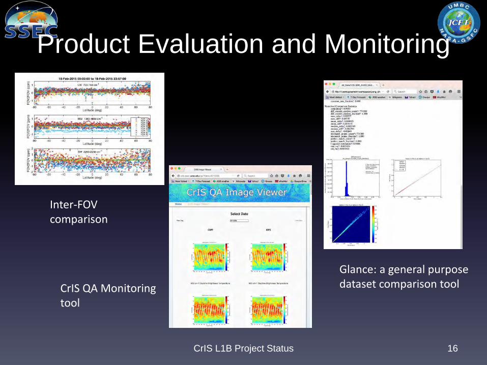
Product Evaluation and Monitoring
CrIS L1B Project Status 16
Inter-FOV comparison
Glance: a general purpose dataset comparison tool CrIS QA Monitoring
tool

CrIS L1B Project Status 17
SDRs from IDPS L1B sample data
real
im
agin
ary

Img module
• Indices of VIIRS pixels collocated within CrIS footprint
• Statistics derived from VIIRS L1 and L2 products
• Useful for interpreting CrIS data
• Provides continuity with similar AIRS and IASI products
• Year 3 activity
18 CrIS L1B Project Status

CrISXBCAL module
• Produces CrIS calibration subset files, to be used for – Long-term validation / trending
– Neon lamp calibration
• Includes – Clear scenes
– Small random subset
– Data over specific ground sites (e.g. ARM)
– Deep convective clouds
• Year 3 activity
19 CrIS L1B Project Status