

SEPARATE ATTACHMENT 9.1
Resilient Hills and Coasts
Climate Change Adaptation Plan for the
Adelaide Hills, Fleurieu Peninsula
and Kangaroo Island Region
Resilient Hills and Coasts: Climate Change
Adaptation Plan for the Adelaide Hills,
Fleurieu Peninsula and Kangaroo Island
Region
A plan prepared for the Resilient Hills and Coasts project
Prepared by Together with Seed Consulting Services URPS 106 Gilles Street, Adelaide, SA 5000 Suite 12/154 Fullarton Rd, Rose Park, SA 5067 www.seedcs.com.au www.urps.com.au
This plan should be cited as: Resilient Hills and Coasts (2016). Resilient Hills and Coasts: Climate Change Adaptation Plan for the Adelaide Hills, Fleurieu Peninsula and Kangaroo Island Region. A report prepared for Alexandrina Council on behalf of Resilient Hills and Coasts project partners by Seed Consulting Services and URPS.

Document Control
Document Information
Information
Document Owner Alexandrina Council on behalf of project partners
Project ID 600 RH&C
Last Saved Date 27 May 2016
File Name DRAFT RH&C_Adaptation Plan 050516
Project Director Mark Siebentritt (Seed Consulting)
Document History
Version Issue Date Changes
V1 Draft 10 April 2016
V2 Draft 4 May 2016 Edits from Steering Committee incorporated
V3 Final
Document Approvals
Role Name Signature Date
Written By Mark Siebentritt Jenni Garden
10/4/2016
Edited By Mark Siebentritt Jenni Garden
04/05/16
Disclaimer
The information contained in this Seed Consulting Services (Seed) report is given in good faith and has been derived from sources believed to be reliable and accurate. Seed accepts no legal liability for the accuracy of field data, analytical results or mapping data provided as part of this report or for any associated loss in productivity, business or such like through third part use of this data. Seed accepts no legal liability for failure of third parties to obtain any necessary government or other agency permits or approvals with respect to any issue raised in this report where approvals may be required. The material and opinions in this report may include the views or recommendations of third parties, which may not necessarily reflect the views of Seed, or indicate Seed’s recommendation regarding a particular course of action. Seed does not provide advice of an investment or commercial valuation nature. Seed does not accept any liability for investment decisions made on the basis of environmental or other information provided in this report.

Contents
Executive Summary ................................................................................................................ i
PART A – CONTEXT ............................................................................................................ 1
1 Introduction .................................................................................................................... 1
2 The Resilient Hills and Coasts region ............................................................................. 4
3 How will climate change affect the region? ..................................................................... 6
3.1 Overview ................................................................................................................. 6
3.2 Regional projections ................................................................................................ 8
3.2.1 Adelaide Hills and Fleurieu Peninsula .............................................................. 9
3.2.2 Kangaroo Island ..............................................................................................12
3.2.3 Ocean and Gulf waters ....................................................................................13
4 How has this plan been developed? ..............................................................................14
4.1 Approach ................................................................................................................14
4.2 Identifying priorities for adaptation planning ...........................................................15
PART B – ADELAIDE HILLS AND FLEURIEU PENINSULA ..............................................20
5 Priority adaptation options .............................................................................................20
5.1 Agriculture ..............................................................................................................20
5.2 Climate-ready homes and buildings .......................................................................24
5.3 Coastal ecosystems ...............................................................................................28
5.4 Community facilities and open space areas ...........................................................32
5.5 Emergency management .......................................................................................36
5.6 Infrastructure assets ...............................................................................................40
5.7 Natural landscapes ................................................................................................44
5.8 Public coastal assets ..............................................................................................49
5.9 Vulnerable members of the community ..................................................................53
5.10 Water-dependent ecosystems ................................................................................57
PART C – KANGAROO ISLAND .........................................................................................61
6 Priority adaptation options .............................................................................................61
6.1 Agriculture ..............................................................................................................61
6.2 Built coastal assets ................................................................................................65
6.3 Emergency management .......................................................................................69

6.4 Essential services and transport infrastructure .......................................................72
PART D – THE REGION ......................................................................................................76
7 Implementing the Plan ...................................................................................................76
7.1 Regional priority adaptation options .......................................................................76
7.2 Opportunities ..........................................................................................................82
7.3 Periodic review .......................................................................................................82
7.4 Alignment with adaptation in the South Australian Murray-Darling Basin ................83
7.5 Next steps ..............................................................................................................85
8 References ....................................................................................................................87
9 Glossary ........................................................................................................................90
Attachment A - Workshop and focus group participants .......................................................93
Attachment B - High vulnerability indicator summary ............................................................97
Attachment C - Adaptation options .......................................................................................99

Acronyms
AR5 – Fifth Assessment Report (released by the IPCC)
BOM – Bureau of Meteorology
CCIA – Climate Change in Australia
CSIRO – Commonwealth Scientific and Industrial Research Organisation
DEWNR – Department of Environment, Water and Natural Resources
ENSO – El Niño Southern Oscillation
GCM – Global Climate Model or Global Circulation Model
IOD – Indian Ocean Dipole
IPCC – Intergovernmental Panel on Climate Change
IVA – Integrated Vulnerability Assessment
LGA SA – Local Government Association of South Australia
NRM – Natural Resources Management
RCP – Representative Concentration Pathway
RDA – Regional Development Australia
RH&C – Resilient Hills and Coasts
SACR – SA Climate-ready
SA MDB – South Australian Murray-Darling Basin

i
Executive Summary Global climate change is already occurring, with the impacts being experienced world-wide.
Within continued emissions of greenhouse gases, the Earth is committed to further warming
and associated climate changes over the coming decades; though the magnitude and rate at
which this change occurs will depend on what mitigation actions are taken at the global level
to substantially reduce greenhouse gas emissions.
Although global mitigation action is critical, given that we are already experiencing, and will
continue to experience, a rapidly changing climate, preparing for local scale adaptation will
be just as critical. Finding a balance between adaptation and mitigation at local to global
scales of governance will offer the best opportunity for us to limit the severe impacts of
climate change and cope with those impacts that are already occurring and will occur in the
future.
Context
Resilient Hills & Coasts (RH&C) is a partner project between local government, NRM Boards
and State and federal governments to develop a Regional Climate Change Adaptation Plan
for the Adelaide Hills, Fleurieu Peninsula and Kangaroo Island region. The focus of the
RH&C project is to make sure that the region remains a strong and vibrant place to live, work
and visit and that businesses, communities and environments can respond positively to the
challenges and opportunities presented by a changing climate.
Despite global action being taken to manage and reduce greenhouse gas emissions we are
already on a pathway which means that substantial adaptation will still be required. By being
proactive and thinking and planning now for the impacts that are already happening and also
those that are likely to occur as the climate changes, the RH&C region can position itself to
manage adverse impacts and take advantage of any opportunities.
This Regional Climate Change Adaptation Plan (Adaptation Plan) provides the foundation for
a coordinated and collaborative response to climate change impacts and identifies priorities
for adaptation across the RH&C region.
Climate change in the region
While there is natural variability in the climate of the Adelaide Hills, Fleurieu Peninsula and
Kangaroo Island region, climate change will create a different future climate with warmer and
drier conditions and higher sea levels. Whilst the outcomes for the intermediate emissions
scenario are described below, the high emissions scenario (upon which the Earth is currently
tracking) would see a greater rate and magnitude of change in land and sea surface
temperature and rainfall and sea level rise over the coming decades.

ii
Under intermediate emissions by 2070 for the Adelaide Hills and Fleurieu Peninsula:
rainfall is projected to decline by about 6%;
rainfall intensity could increase by 11%;
maximum temperatures are projected to increase by 1.5ºC;
minimum temperatures could increase by 1.2ºC; and
extreme heat in Victor Harbor could increase by 30% to 11 days per year over 35ºC.
The increase in fire weather for the Adelaide Hills and Fleurieu Peninsula based on
projections for Adelaide is an increase from 1.7 severe fire danger days per year under
current conditions to 2.6 per year by 2090 under an intermediate emissions pathway.
Under intermediate emissions by 2070 for Kangaroo Island:
rainfall is projected to decline by about 7.9%;
rainfall intensity could increase by 8%;
maximum temperatures are projected to increase by 1.2ºC; and
minimum temperatures could increase by 1.0ºC.
For Ocean and Gulf waters, projections under intermediate emissions suggest a:
rise in sea levels of 33cm by 2070;
rise in sea surface temperatures of 1.2ºC by 2090; and
decline of 0.15 pH units by 2090.
Process
The Adaptation Plan has been developed via a three step process. The initial phase
comprising step 1 being completed in 2014, and the second phase comprising steps 2 and 3
completed in 2016. At the core of the approach has been the delivery of a participatory
process, focussed on engaging key stakeholders and subject matter experts. In all, 129
people attended project workshops and focus groups, representing 39 organisations.
The first step was completion of values and issues mapping exercises. These results were
used to develop indicators for two integrated vulnerability assessments. Together, the
integrated vulnerability assessments assessed a total of 108 indicators (54 for Kangaroo
Island and 53 for the Adelaide Hills and Fleurieu Peninsula).
Based on the results of the integrated vulnerability assessments, together with consideration
of emerging opportunities, key areas of decision making were developed as the basis for
further adaptation planning. The themes for key areas of decision making were as follows:
Adelaide Hills and Fleurieu Peninsula:
agriculture;
climate-ready homes and buildings;

iii
coastal ecosystems;
community facilities and open space;
emergency management services;
infrastructure assets;
natural landscapes;
public coastal assets;
vulnerable members of the community; and
water-dependent ecosystems.
Kangaroo Island:
agricultural productivity;
built coastal assets;
condition of sealed and unsealed roads;
essential services and infrastructure;
health and well-being of vulnerable members of the community;
protecting against bushfire threat (emergency services management);
wild-catch fisheries productivity;
biosecurity;
terrestrial ecosystems; and
aquatic ecosystems.
Note that the four NRM-related themes for Kangaroo Island are not considered in this Plan
as these are being addressed in a parallel process being undertaken by the Kangaroo Island
Natural Resource Management Board to prepare the Climate Change Ready NRM Plan.
Priority adaptation options have been identified based on the key areas of decision making
for each of these themes. In addition, regional priority adaptation options were identified
through the use of an action prioritisation framework, which combined the results of a
qualitative cost-benefit analysis all options and consideration of their regional relevance and
the practicality of implementation.
The regional adaptation priorities for RH&C, which present actions that have implementation
responsibilities for all project partners, are (in alphabetical order)1:
Adaptive management of protected areas on public lands - Adaptive management of
protected areas on public lands, with a focus on managing fuel loads in close proximity to
towns and private land. The emphasis on fuel loads will become increasingly important
1 Noting that some issues, such as water availability, apply across multiple key areas of decision
making and so are not considered independently.

iv
as fire risk increases and the community seeks to balance maintenance of environmental
values and ecosystem services with public health and safety concerns.
Climate-ready guidelines for public realm and green infrastructure management -
Preparing and commencing implementation of ‘climate-ready’ guidelines for public realm
and green infrastructure management will include appropriate material and tree species
selection, shade coverings, inclusion of water sensitive urban design features, and
opportunities for misting infrastructure.
Diversification of agricultural activities - Diversification of agricultural activities will
focus on investigating and encouraging the use of different varieties and types of crops
and pasture, and livestock and livestock management practices, from warmer and drier
parts of the State, and nationally.
Build more energy efficient housing – The region needs to focus on building more
energy efficient housing, which will require installation (and potentially development) of
energy efficient building materials and fixtures. This will need to be supported through
government incentives and local government advocating development of such materials,
working with the development industry (e.g. builders, developers, manufacturers) and
research institutes.
Incorporate design allowances for increases in extreme events - A regional
adaptation priority for local government in particular is to ensure that new and renewed
infrastructure is designed to allow for increases in extreme events.
Improved management of native vegetation on private properties - Support
landholders managing native vegetation on private properties, where possible through
the use of well-funded incentives.
Restricting development in hazard prone areas - Prevent or restrict development in
hazard prone areas, such as areas at risk from sea level rise along the coast, bushfires
inland and infrastructure and dwellings at risk from flooding following intense rainfall
events. While this response may take some time to gain community support, in the long
term it will avoid impacts on people and reduce the costs (e.g. insurance) associated with
protecting or relocating assets and people, and recovering post-disaster.
Water quality improvement measures - With rainfall seasonality, quantity and intensity
projected to change, greater emphasis is required on water quality management,
especially in relation to stormwater. Water quality improvement will require continued
investment in water sensitive urban design, stormwater retention areas and water
recycling.
In addition to these regional priorities, continued education and awareness raising about
the impacts and response options to climate change is essential to underpin broad scale
adaptation. Furthermore, anticipatory monitoring and evaluation is needed across all
sectors to detect climatic change impacts and develop triggers for implementing different
strategies.

v
Whilst the region faces significant challenges in adapting to climate change, it is better
placed than many others in the State due to its naturally cooler climate, and diversity of
industries across the region. The preferable climate combined with increasing population
could stimulate business activity and lead to opportunities such as:
encouraging the development of low carbon communities with housing that is energy and
water efficient and resilient to climate change;
incorporating “climate-ready” design principles into new buildings and essential services
infrastructure; and
increasing interest in green infrastructure for residential developments.
Successfully implementing this Plan will require:
maintaining momentum as the project transitions from planning to implementation;
localising action, to take up implementation with individual project partners;
responsive project management and governance reflecting on the learnings from the
project to date;
strengthening engagement and partnerships between project partners but also with
community, industry, business, education and government sectors;
a flexible and responsive approach, allowing the region to be responsive to new
information that emerges about the rate and magnitude of climate change.
1
PART A – CONTEXT
1 Introduction Global climate change impacts are already being experienced world-wide. The planet is now
committed to warming and associated climate changes over the coming decades; though the
magnitude and rate at which this change occurs will depend on what mitigation actions are
taken at the global level to reduce greenhouse gas emissions. Despite global action being
taken to manage and reduce greenhouse gas emissions, climate change continues to occur,
meaning that adaptation is, and will be, required now and into the future. By being proactive
and planning now for the impacts that are already occurring and those likely to occur in the
future as the climate continues to change, regions can position themselves to manage
adverse impacts and take advantage of any opportunities that arise.
Resilient Hills and Coasts (RH&C) is a climate change adaptation planning project covering
the Adelaide Hills, Fleurieu and Kangaroo Island Regional Development Australia (AHFKI
RDA) region (Figure 1). The RH&C name is also used to refer to the region covered.
The project partners are the:
Adelaide Hills Council;
Alexandrina Council;
City of Victor Harbor;
Mount Barker District Council;
District Council of Yankalilla;
Kangaroo Island Council;
Department of Environment, Water & Natural Resources;
Natural Resources Adelaide and Mount Lofty Ranges;
Natural Resources Kangaroo Island;
Regional Development Australia Adelaide Hills, Fleurieu and Kangaroo Island; and
Southern and Hills Local Government Association.
By collaborating, the RH&C region can deliver a coordinated response to climate change and
by sharing information, resources, responsibilities and actions, resilience can be built to the
benefit of the community, businesses and the environment. This Climate Change Adaptation
Plan (henceforth Adaptation Plan) provides the foundation for a coordinated and
collaborative response to climate change and identifies priorities for adaptation across the
region. It also addresses the requirements of the South Australian Climate Change
Adaptation Framework for regions in the State to develop regional climate change adaptation
plans.

2
The objective of this Adaptation Plan is to:
provide an overview of how climate change is likely to impact the RH&C region;
summarise the process involved in preparing the Plan, covering outcomes from previous
stages;
describe the key areas for adaptation planning, referred to as “key areas of decision
making”;
identify priority adaptation options for each key area of decision making; and
outline the regional priority adaptation options.
Because of the unique geography of the RH&C region, together with how the first phase of
the project was delivered, this Adaptation Plan is presented in four main parts:
1. Part A - Context: provides an overall introduction to the project and the region,
projected climate changes for each sub-region (i.e. Kangaroo Island, and Adelaide
Hill and Fleurieu Peninsula), and a summary of how this Plan has been developed;
2. Part B - Adelaide Hills and Fleurieu Peninsula: presents the priority adaptation
options and adaptation pathways for the mainland sub-region;
3. Part C - Kangaroo Island: presents the priority adaptation options and adaptation
pathways for the Kangaroo Island sub-region; and
4. Part D – The Region: focusses on the Region as a whole and implementing the plan.
It presents a set of regional adaptation prioritieshighlights opportunities for the
Region, discusses the plan review, and also identifies alignment between this Plan
and that for the South Australian Murray-Darling Basin region which partially overlaps
with the RH&C region.
This Adaptation Plan is a plan for the region and its implementation resides with individuals
and organisations across the region including service providers, State and local government
agencies, not-for-profit organisations, business and industry, infrastructure owners and
managers, and community groups.

3
Figure 1. RH&C map

4
2 The Resilient Hills and Coasts region The RH&C region, covers a land area of approximately 8,752km2 characterised by a highly
variable topography and geology, from coastal dunes and rocky escarpments to inland fertile
hills and pasturelands. It includes the entire Kangaroo Island natural resources management
(NRM) region and parts of the Adelaide and Mount Lofty Ranges and South Australian
Murray-Darling Basin NRM regions (Figure 1).
The population is approximately 120,000 people and is currently growing and aging, which is
changing the region’s demographics, though not consistently across all council areas
(Resilient Hills and Coasts, 2014a). For example, population growth rates tend to be highest
in the Victor Harbor local government area and lowest in the Adelaide Hills, and the aging
population is prevalent in coastal townships on the Fleurieu Peninsula, which present
particularly attractive retirement destinations. Comparatively, more inland local government
areas within the region are experiencing growing younger populations, due largely to
population growth from inland migration by working-aged people and young families
(Resilient Hills and Coasts, 2014a). Mount Barker, for example, is the largest town in the
Adelaide Hills, but is also one of the fastest growing regional centres in Australia and is on
track to become the State’s second biggest regional city (Mt Barker District Council 2015).
The region’s communities tend to be well educated and qualified, and on average are
physically healthier and have lower unemployment rates, compared to the State; though the
health and affluence of communities in the region also varies geographically (Resilient Hills
and Coasts, 2014a). For example, compared to the rest of the region, the Adelaide Hills local
government area has the lowest unemployment rates as well as the highest proportion of
education graduates. In the Adelaide Hills and Fleurieu Peninsula region, almost half of the
region’s workforce commutes to areas outside of the region for work, which is facilitated
through good connections to the Adelaide Metropolitan Area.
Due to its geographic isolation by sea, Kangaroo Island’s workforce is largely contained on
the island. This physical isolation also places the Island at increased risk of social
disconnectedness with limited access options to the mainland and the larger metropolitan
areas. However, the residents of Kangaroo Island maintain a community with a high level of
social connectedness, as is evident from their rate of volunteering which is the highest in the
region, and nearly double the average rate for the whole State. A major challenge on the
Island, and also in the mainland’s coastal townships, will be ensuring energy, water and
communications infrastructure, as well as emergency services, are able to withstand climate
change impacts, particularly sea level rise and storm surges. Predicted increasing tourism to
the region’s mainland coastal townships and Kangaroo Island will likely facilitate this
challenge by acting as a catalyst for the creation and upgrading of essential services,
facilities and infrastructure. The predicted tourism influx also presents one of the best

5
opportunities for future job creation in the region, which is likely to help decrease
unemployment rates and also decrease the need for some workers to commute outside of
the region for work.
The region supports a successful economy, with a strong and diverse primary production
sector, including dryland cropping, irrigated cropping, horticulture, aquaculture, viticulture and
livestock grazing. Forestry and commercial precincts, together with an increasingly growing
tourism industry add to the region’s overall economic prosperity (Resilient Hills and Coasts,
2014a).
The heterogeneous landscape of the region further underpins the region’s numerous natural
environmental assets and services including terrestrial, coastal, aquatic and marine systems
which support a diverse assemblage of flora and fauna species (including threatened
species), a number of threatened plant communities, and nationally and internationally
significant wetlands (Resilient Hills and Coasts, 2014a).
The RH&C region has a Mediterranean climate and as such experiences natural variability in
weather during the year, characterised by hot dry summers and cold wet winters. Compared
to other parts of South Australia, the region is characterised by moderate to high rainfall and
cooler summers. Interaction between the land and sea along the coast shapes much of the
landscape. Climate patterns vary year to year as well as with major climate influences
(Bureau of Meteorology, 2016) including the:
Indian Ocean Dipole (IOD), which affects the climate of Australia and other countries that
surround the Indian Ocean Basin, and is a significant contributor to rainfall variability; and
El Niño Southern Oscillation (ENSO), the oscillation between El Niño and La Niña
conditions which affects rainfall and temperature in eastern Australia.
The result of these and other climate influences are natural and major variations in rainfall
and temperature, especially drought cycles. In addition to this natural variability in climate,
there are longer term changes in rainfall, temperature and other variables occurring as a
result of climate change.

6
3 How will climate change affect the
region?
The following section provides an overview of climate change, climate projections modelling,
and climate projections relevant to the RH&C region. Further detailed information and
references can be found in the Climate Projections Report developed for the RH&C project
(Resilient Hills and Coasts, 2015).
3.1 Overview
Climate is the average weather over long periods of time (IPCC, 2013a). The World
Meteorological Organization defines the climate as the average weather over a 30 year
period. Climate change refers to altered climate trends (e.g. increasing temperatures,
decreasing rainfall) as averaged over decades or longer. It differs from climate variability
which refers to short-term weather fluctuations (1-10 years) (e.g. drought and non-drought
cycles) which may occur despite the underlying climate trend.
Climate change is a consequence of the release of greenhouse gases like carbon dioxide,
methane and nitrous oxide into the Earth’s atmosphere (CSIRO and Bureau of Meteorology,
2015). These gases are produced from a range of natural sources as well as from human
activities like energy production, transport, industrial processing, waste management,
agriculture, and land management. Greenhouse gases trap the sun’s energy in the Earth’s
atmosphere leading to changes in the global climate. These changes include: increasing air
temperatures, changes to rainfall patterns, rising sea levels, and increasing sea surface
temperatures.
The most authoritative source of information on climate change is provided by the
Intergovernmental Panel on Climate Change (IPCC). Every 5-6 years the IPCC produces an
Assessment Report which presents the most up-to-date scientific knowledge regarding
climate change. The most recent of these reports is the Fifth Assessment Report (AR5),
released in 2013 (IPCC, 2016). Climate change modelling results contained in these reports
are used globally to underpin climate change action, including adaptation planning.
It is not possible to “predict” or “forecast” what the future climate might be. Instead, climate
models use emissions and land-use scenarios to develop a range of “projections/scenarios”
that can be used to explore what future climate conditions may occur. These projections
contain inherent variability, which are important to understand when determining how best to
use climate data in adaptation planning (Resilient Hills and Coasts, 2015). Two of the main
sources of variability in climate projections derive from the choice of global climate model/s
(GCMs) and representative concentration pathway (RCP).

7
Global Climate Models are numerical models that explore how processes in the
atmosphere, ocean, cryosphere and land surface respond to increasing greenhouse gas
concentrations. GCMs are used to generate projections for climate variables like temperature
and rainfall. Given the variability that exists across the projections outputs of climate
modelling, communication of the outputs often use the median or 50th percentile model
output (sometimes described as the “best estimate”), or the 10th and 90th percentile outputs.
Representative Concentration Pathways refer to four main scenarios presented in IPCC
AR5 which consider time series of alternative emissions together with concentrations of the
full suite of greenhouse gases, aerosols and chemically active gases, as well as varying
land-use/land cover to produce alternative future climate conditions (IPCC, 2013b). The four
main RCPs outlined in AR5 as the basis for the climate projections (IIASA, 2009) are:
RCP2.5 “Peak and decline scenario” – an emissions pathway leading to very low
greenhouse gas concentration levels; a so-called "peak" scenario (radiative forcing peaks
at approximately 3 W m–2 before 2100 and then declines);
RCP4.5 “Intermediate, stabilisation scenario” – an emissions pathway where the
impact of climate change on the atmosphere is stabilised before 2100 by using a range of
technologies and strategies for reducing greenhouse gas emissions (radiative forcing
stabilises at approximately 4.5 W m–2 after 2100);
RCP6.0 “Intermediate, stabilisation scenario” – an emissions pathway where the
impact of climate change on the atmosphere is stabilised after 2100 by using a range of
technologies and strategies for reducing greenhouse gas emissions (radiative forcing is
stabilised at approximately 6.0 W m–2 after 2100); and
RCP8.5 “High emissions scenario” – an emissions pathway characterized by
increasing greenhouse gas emissions over time leading to high greenhouse gas
concentration levels.
For South Australia, there are two main sources of information on climate projections, which
both use RCPs and GCMs presented in the IPCC’s AR5 (Resilient Hills and Coasts, 2015):
SA Climate-ready (SACR)2: released in February 2015, this is the Goyder Institute’s
“Agreed downscaled climate projections for South Australia” project. The project provides
regional-scale projected climate trends for the State for four future timeframes (2030,
2050, 2070 and 2090), under two RCPs (RCP4.5 and RCP8.5), and for five climate
variables: areal evapotranspiration; temperature; rainfall; vapour pressure deficit; and
solar radiation;
2 Further information and regional scale summaries generated from SACR can be found at:
www.goyderinstitute.org or https://data.environment.sa.gov.au for access to the detailed datasets.

8
Climate Change in Australia (CCIA)3: released in February 2015, this is a national-
focused CSIRO and Bureau of Meteorology project that provides future “application
ready” climate data for eight GCMs. Information for the following climate variables is
available: fire weather days; sea surface temperature; mean and extreme sea-level rise;
sea surface salinity; ocean acidification; solar radiation; point potential
evapotranspiration; temperature; rainfall; wet areal evapotranspiration; relative humidity;
and wind speed.
Separate projections data are available for the Adelaide Hills and Fleurieu Peninsula and
Kangaroo Island.
3.2 Regional projections
Since the 1950’s, South Australia has experienced nearly 1°C of warming and a reduction in
average rainfall (CSIRO and Bureau of Meteorology, 2015). This warming and drying is
projected to continue into the future and will lead to changes in the environment, economy
and community. By 2050, Victor Harbor’s climate is predicted to be similar to the current
climate of Nuriootpa and Port Lincoln (under an intermediate emissions scenario), whereas
Kingscote will be more similar to Yorketown’s current conditions. By 2090, Victor Harbor’s
climate will be more similar to Adelaide’s and Keith’s current climate, and Kingscote will be
more similar to current climate conditions in Nhill in the Wimmera region of Victoria (Resilient
Hills and Coasts, 2015).
Specific projections for climate variables used in the RH&C project are shown in Table 1 and
briefly descried below, with further details available in the Climate Projections Report
(Resilient Hills and Coasts, 2015). Unless indicated otherwise, projections data is from SA
Climate-ready. Note that extreme heat and fire projections have not been specifically
calculated for Kangaroo Island. Instead, projections used for the Adelaide Hills and Fleurieu
Peninsula region are also applied to Kangaroo Island.
3 Additional information on the project and access to projection data can be found at
www.climatechangeinaustralia.gov.au.

9
Table 1. Climate variable projections for the Adelaide Hills and Fleurieu Peninsula (AHFP) and Kangaroo Island (KI) sub-regions under an intermediate emissions pathway (RCP4.5) to 2070 (for further details see Resilient Hills and Coasts (2015)).
Climate Variable
Projected Change by 2070
AHFP KI
Rainfall - annual median - declining 5.7% 7.9%
Rainfall - summer median - declining 9.6% 9.9%
Rainfall - autumn median - declining 3.2% 7.5%
Rainfall - winter median - declining 6% 6%
Rainfall - spring median - declining 16.4% 17.3%
Rainfall - intensity - increasing 11% 8%
Temperature - annual median maximum - increasing 1.5ºC 1.2ºC
Temperature - summer median maximum - increasing 1.5ºC 1.3ºC
Temperature - autumn median maximum - increasing 1.5ºC 1.2ºC
Temperature - winter median maximum - increasing 1.3ºC 1.1ºC
Temperature - spring median maximum - increasing 1.9ºC 1.4ºC
Temperature - annual median minimum - increasing 1.2ºC 1ºC
Temperature - summer median minimum - increasing 1.1ºC 1ºC
Temperature - autumn median minimum - increasing 1.2ºC 1.1ºC
Temperature - winter median minimum - increasing 1ºC 0.9ºC
Temperature - spring median minimum - increasing 1.2ºC 1.1ºC
Temperature - annual number of days above 35ºC - increasing 57% increase
Temperature - annual number of days above 40ºC - increasing 150% increase
Fire - annual number of severe fire risk days - increasing 65% increase
Sea level - increasing 33 cm
Temperature - sea surface - increasing 1.2ºC by 2090
Ocean acidity - increasing 0.15 decline in pH units to 2090 (41%)
3.2.1 Adelaide Hills and Fleurieu Peninsula
Rainfall
By 2050, the annual median rainfall is projected to decline by 6.8% and 7.4% compared with
the baseline (1986-2005) under the intermediate and high emissions pathways, respectively.
By 2070, projected rainfall decline under the intermediate emissions pathway is 6%,
compared to 11% under the high emissions pathway.
Under 2070 projections, for example, Mt Barker’s current annual average rainfall of 733mm
would decline to 689mm under the intermediate emissions pathway and 652mm under the
high emissions pathway. Under the same timeframe and pathways, Port Elliot’s current
485mm annual average rainfall would decline to 456mm and 432mm.

10
Seasonal differences in average rainfall are also projected for the region. By 2070, the
projected decline in median spring rainfall under an intermediate emissions pathway is
16.4%, compared with 3.2-9.6% for other seasons. For the high emissions pathway, the
spring decline is 20.6% compared to 7.5-11.6% for other seasons.
Rainfall intensity
According to the CCIA project, there is high confidence that the intensity of heavy rainfall
events (maximum 1-day rainfall) will increase in the RH&C region, despite projected
decreases in mean rainfall. The CCIA does not provide quantitative modelling for rainfall
intensity. However, for the purposes of obtaining regional projections, other recent analyses
outside of SACR and CCIA has been drawn upon to project increases in rainfall intensity in
the Adelaide Hills and Fleurieu Peninsula region by 9% and 11% by 2050 under an
intermediate and high emissions pathway, respectively, and at least 11% and 16% by 2070.
On Kangaroo Island, rainfall intensity could increase by 2050 by nearly 8% and 9%,
respectively, under an intermediate and high emissions pathway. By 2070, this could
increase to 8% and 13%.
Maximum temperature
Compared to baseline temperatures, annual median maximum temperatures will increase
under an intermediate emissions pathway by 1.3ºC and 1.5 ºC by 2050 and 2070,
respectively. Comparatively, under a high emissions pathway, temperature increases are
projected to be 1.6 ºC and 2.3ºC by 2050 and 2070, respectively.
To give a regional example, this means that the annual median maximum temperatures at Mt
Barker by 2070 could increase from the current 20.3ºC to 21.8ºC or 22.6ºC under an
intermediate or high emissions pathway, respectively. Under the same future timeframe and
emissions pathways, Parawa annual median maximum temperatures could increase from
17.8ºC to 19.3ºC or 20.1ºC.
Maximum temperatures vary across seasons, particularly for spring. A similar trend
continues in 2070, where summer, autumn, and winter median maximum temperatures are
projected to increase by 1.3-1.5ºC under an intermediate emissions pathway compared with
1.9ºC in spring. Under a high emissions pathway summer, autumn, and winter increase by
2.1-2.3ºC, and spring by 2.9ºC.
Minimum temperature
Annual median minimum temperatures show a similar trend to maximums, suggesting an
increase by 2050 of 1.0ºC and 1.3 ºC under the intermediate and high emissions pathways,
respectively. By 2070, the projected increase in minimum temperatures under an
intermediate emissions pathway is 1.2ºC compared with 2.0ºC under a high emissions
pathway.

11
The difference in projected median minimum temperatures across seasons is generally
minimal. By 2070, the range of change increases slightly under the intermediate emissions
pathway to 1.0-1.2ºC. It is only under the high emissions pathway for 2070 that the seasonal
difference is more pronounced, with summer and winter increases of 1.8-1.9ºC compared
with 2.2-2.3ºC for autumn and spring.
Heat extremes
The Adelaide Hills and Fleurieu Peninsula is likely to experience an increase in extreme heat
(i.e. number of days over 35ºC or 40ºC) in the future4. However, specific projections of
changes in extreme heat using CCIA results are available only for Adelaide and Victor
Harbor.
In Adelaide, by 2050 the number of days over 35ºC is projected to increase from 17 per year
to 23 or 27 per year under intermediate or high emissions pathways, respectively. By 2070,
under the same emissions pathways, the number of days over 35 ºC is projected to increase
to 25.5 or 31 per year. A greater increase occurs for the number of days over 40ºC, with at
least a doubling by 2050 under intermediate and high emissions, and an increase from 2
days per year to 5.5 or 8.5 by 2070.
In Victor Harbor, by 2070 the number of days over 35ºC under intermediate and high
emissions will increase from 7 to 11 or 14. Under baseline conditions (1986 – 2005), Victor
Harbor had not recorded any days over 40ºC. However, it is projected to experience 1.5 or 2
days over 40ºC by 2070.
Fire weather
Fire weather projections were estimated in the CCIA project using the McArthur Forest Fire
Danger Index (FFDI), which is a widely used measure to forecast the influence of weather on
fire behaviour (Hope, et al., 2015).
Fire weather is considered ‘severe’ when FFDI exceeds 50 and ‘extreme’ when FFDI
exceeds 75. The CCIA project generated FFDI projections for four weather stations in South
Australia, of which Adelaide is the most relevant to the RH&C region. The other locations in
the State are Ceduna, Woomera, and Mt Gambier. FFDI was calculated at Adelaide by
Hope et al. (2015) for only two future timeframes (2030 and 2090).
The FFDI projections indicate increased fire weather in the future for Adelaide. General fire
weather danger is projected to increase by 2030 by 6% or 13% under intermediate or high
emissions pathways, and by 12% or 29% by 2090.
4 Extreme heat measures differ from heatwave conditions, with extreme heat being based on total number of
days above a thermal threshold, whereas heatwave conditions have more specific definitions, such as “three or more consecutive days with the average of the daily maximum and minimum exceeding 32ºC”.

12
The number of days per year with a ‘severe’ fire danger rating is projected to increase by
2030 from 1.7 days under baseline conditions to an average of 2.6 or 2.1 under the
intermediate and high emissions pathways, respectively. By 2090, this will increase to 2.6
and 4 days per year (Hope, et al., 2015).
Note that the weather metrics differ and fuel loads (linked to wild fire risk) are substantially
lower in Adelaide, compared to the RH&C region. As such, although the Adelaide-based
projections are the most RH&C relevant projections available at the time of this project, they
likely underestimate the number of fire risk days within much of the RH&C region.
3.2.2 Kangaroo Island
Rainfall
By 2050, annual median rainfall is projected to decline by 7.5% or 8.9% under intermediate
or high emissions pathways, respectively. By 2070, rainfall is projected to decline by 7.9%
under an intermediate emissions pathway, compared with 12.5% under a high emissions
pathway. For Kingscote, this would result in a decline in rainfall from the current annual
average of 489mm to 450mm or 428mm under an intermediate or high emissions pathway,
respectively.
By 2070, the spring decline in median rainfall under the intermediate emissions pathway is
projected to be 17.3%, compared to 6.0-9.9% for summer, autumn, and winter. For the high
emissions pathway, the decline in spring rainfall is 23.7% compared to 10.1-17.3% for the
other seasons.
Maximum temperature
Compared to baseline temperatures, SACR projects that under an intermediate emissions
pathway, annual median maximum temperatures will increase by 1.1ºC and 1.2ºC by 2050
and 2070, respectively. Comparatively, under a high emissions pathway, temperatures are
projected to increase by 1.3ºC and 1.9 ºC by 2050 and 2070, respectively.
An increase in annual median maximum temperatures of this magnitude would see the
average maximum temperature at Kingscote increase from the current 19.6ºC to 20.8ºC or
21.5ºC under an intermediate or high emissions pathway, respectively.
Annual rainfall in the Adelaide Hills and Fleurieu Peninsula is projected to
decline by 2070, and annual maximum and minimum temperatures will
increase.

13
The difference between seasons for median maximum temperatures by 2070 under an
intermediate emissions pathway is limited, with winter temperatures projected to increase by
1.1ºC and spring only slighter higher at 1.4ºC. Under a high emissions pathway summer,
autumn and winter are projected to increase by 1.8-1.9 ºC and spring by 2.3ºC.
Minimum temperature
Annual median minimum temperatures show a similar trend to maximums, suggesting an
increase by 2050 of 0.8ºC and 1.1ºC under the intermediate and high emissions pathways,
respectively. By 2070, the SACR projected increase in minimum temperatures under an
intermediate emissions pathway is 1.0ºC compared with 1.6ºC under a high emissions
pathway.
By 2070, projected median minimum temperatures across seasons are 0.9-1.1ºC under an
intermediate emissions pathway. In contrast, the difference between seasons is greater for
the high emissions pathway with the spring increase of 2.2 ºC greater than for other seasons
(1.5-1.8 ºC).
3.2.3 Ocean and Gulf waters
For Ocean and Gulf waters, projections suggest a:
rise in sea levels of 33cm by 2070 under an intermediate emissions pathway;
rise in sea surface temperatures of 1.2ºC by 2090 under an intermediate emissions
pathway; and
decline of 0.15 pH units by 2090 under an intermediate emissions pathway.
Under a high emissions pathway these changes could be much greater, for example, with
sea levels reaching 0.6 m by the end of the century.
Annual rainfall on Kangaroo Island is projected to decline by 2070 and
annual maximum and minimum temperatures will increase.
Ocean and gulf waters will increase in temperature, pH will decline and sea
levels will rise.

14
4 How has this plan been developed?
4.1 Approach
This Adaptation Plan was developed in two main phases and has involved the active
participation of the region’s project partners as well as key stakeholders and subject matter
experts in order to provide a strong foundation for adaptation (Figure 2).
Figure 2. Overview of key steps undertaken to develop the RH&C Adaptation Plan.
As a collective, project partners, with input from community, business, government, industry
and academia, completed the initial phase of the RH&C project in 2014, which included three
main steps:
a “Knowledge Audit” describing the profile of the whole region (Resilient Hills and Coasts,
2014a);
values mapping workshops for the Adelaide Hills and Fleurieu Peninsula sub-region to
assess stakeholder issues and values in relation to climate change adaptation;
o (note that the Kangaroo Island sub-region conducted independent values mapping,
the results of which were considered in the following phase of the project; and
an integrated vulnerability assessment for Kangaroo Island sub-region (Resilient Hills
and Coasts, 2014b).
Purpose
Question
s
Outcome
s
Stakeholder Participation
Understand the RH&C
Region in relation to a
changing climate
What is
valued/important in the
region?
What key decisions do
we need to make?
What is the vision for
the future?
Vision, Values and Key
Decisions
Identify and assess the
vulnerability of what we
value
How will climate change
impact our vision for the
future and what we
value?
How vulnerable are
these things that we
value?
Integrated Vulnerability
Assessment
Identify adaptation
responses
What could we do?
What should we do?
Climate Change
Adaptation Plan

15
The second phase involved:
preparation of an up-to-date climate change projections report for the whole region
(Resilient Hills and Coasts, 2015);
an integrated vulnerability assessment for the Adelaide Hills and Fleurieu Peninsula
(Resilient Hills and Coasts, 2016); and
a process to identify and prioritise adaptation options for each sub-region and the region
as a whole.
Because of the geographic spread of the region and different project partner planning
processes, the initial values mapping and integrated vulnerability assessment phases were
conducted at separate times. In contrast, the process to identify and prioritise adaptation
options was delivered at the same time, through a series of workshops conducted in Victor
Harbor, Stirling and Kingscote in February 2016.
For the purposes of this Regional Adaptation Plan, specific elements relating to barrages
located at the mouth of the River Murray are not considered as they are covered in the
Regional Adaptation Plan for the South Australian Murray-Darling Basin (Siebentritt, et al.,
2014).
The project has incorporated a series of workshops involving representatives of
organisations that play a role in the region’s:
assets and infrastructure;
emergency management;
local economic development and sustainability;
natural environment, open space and water; and
social and community resilience and health.
Appendix A lists stakeholders who attended either workshop or focus groups during the
preparation of the Adaptation Plan.
4.2 Identifying priorities for adaptation planning
Values mapping and visioning exercises conducted separately in the Adelaide Hills and
Fleurieu Peninsula and on Kangaroo Island identified those values that were important to
stakeholders in the region in the context of projected climate change impacts. The focus of
values and key issues for the Adelaide Hills and Fleurieu Peninsula were:
agriculture and food security;
population growth;
water availability and quality;
community health, connectedness and emergency services;
coastal habitats and infrastructure; and

16
ecosystem services, urban biodiversity and green infrastructure.
Key values to emerge for Kangaroo Island were:
resilient environment;
healthy happy community;
innovative sustainable local community;
collective local leadership and use of local knowledge;
prosperity;
education and learning; and
distinctiveness.
Using the values and key issues identified for each sub-region to select indicators, two
integrated vulnerability assessments were undertaken consistent with the approach
described in the Local Government Association of South Australia’s Guidelines for
Developing a Climate Change Adaptation Plan and Integrated Climate Change Vulnerability
Assessment. Together, the integrated vulnerability assessments assessed a total of 108
indicators (54 for Kangaroo Island and 53 for the Adelaide Hills and Fleurieu Peninsula).
A subset of indicators was identified as having a higher vulnerability to climate change than
others. These high vulnerability indicators and their relevant themes are described in
Attachment B. Note that some indicators, such as water availability, were important across
multiple sectors in the region and so were considered as part of all assessments, rather than
considered independently. Based on the results of the integrated vulnerability assessment
together with consideration of emerging opportunities, key areas of decision making were
developed as the basis for further adaptation planning. Key areas of decision making
describe:
what is important for a region, making a connection between something of value or
importance to stakeholders such as an asset or service;
what responses are possible; and
how the important aspects could be impacted by climate change.
The key areas of decision making that are the focus of this Adaptation Plan are presented in
Table 2. Note that while 10 key areas of decision making are presented for Kangaroo Island
in Table 2, the four NRM-related key areas of decision making are not considered further in
this Adaptation Plan. Instead environmental and ecological considerations and adaptation
options for Kangaroo island will be determined as part of the preparation of the Island’s
Climate Change Ready NRM Plan, which is a parallel process currently being undertaken by
the Kangaroo Island Natural Resource Management Board in collaboration with community.
In addition, the remaining six key areas of decision making for Kangaroo Island are
consolidated in to four for the purposes of further discussion in this Adaptation Plan,
reflecting consolidation that occurred at the stakeholder workshop.

17
For the Adelaide Hills and Fleurieu Peninsula part of the region, additional research
conducted by AMLR NRM independently of this project was also taken into consideration in
developing the key areas of decision making. This independent research (West, 2016) was
relevant for informing key areas of decision making related to biodiversity and summarises
the vulnerability of different aspects of natural landscapes in the region using a landscape
scenario assessment.
Adaptation options for each key area of decision making were identified by the project team
and then reviewed and refined by key stakeholders and subject matter experts at a series of
project workshops. To assist with prioritisation, workshop participants were asked to conduct
a qualitative cost-benefit analysis on proposed adaptation options. Further prioritisation was
then conducted by the project steering committee (Appendix A) using an action prioritisation
framework to assist with identifying regional adaptation priorities. The framework applied a
three-step filtering process based on the results of the costs-benefit analysis, assessment of
the regional relevance of an option (relevance to multiple key areas of decision making and
multiple project partners), and practicality (availability of funding and project partner role in
delivery).

18
Table 2. Key areas of decision making for the Resilient Hills and Coasts region. Pairs of Kangaroo Island themes and key areas of decision making boxed in bold indicate those that are considered together for the remainder of the report.
Theme Key area of decision making
Adelaide Hills and Fleurieu Peninsula
Agriculture How do we maintain agricultural productivity and water security, especially
for horticulture, viticulture and dryland grazing, given projected declining
rainfall and increasing temperature?
Climate-ready
homes and
buildings
How do we improve the quality and efficiency of homes and buildings as the
risk of extreme events such as fire, extreme heat and flooding as a
consequence of rainfall intensity and sea level rise increases?
Coastal ecosystems How do we maintain the condition and extent of sedimentary coastal
ecosystems given projected increases in sea levels?
Community facilities
and open space
How do we maintain and expand community facilities and open space areas
for sport and recreation to meet a growing community’s demands given
projected declines in rainfall and increasing temperature and fire risk
coupled with increasing population and development?
Emergency
management
How do we respond to the growing demand for emergency management
services across multiple sectors as the risk of extreme events such as fire,
extreme heat and flooding (as a consequence of rainfall intensity and sea
level rise) increases?
Infrastructure
assets
How do we maintain and expand infrastructure assets, such as roads and
energy networks, given projected declines in rainfall and increasing
temperature and fire risk?
Natural landscapes How do we maintain and improve the condition of natural landscapes
(plains, flanks, uplands) given projected declines in rainfall and increasing
temperature and fire risk?
Public coastal
assets
How do we maintain the condition of public coastal assets given projected
increases in sea levels?
Vulnerable
members of the
community
How do we enhance the health, safety and well-being of vulnerable
members of the community as the risk of extreme events such as fire,
extreme heat and flooding (as a consequence of rainfall intensity and sea
level rise) increases?
Water-dependent
ecosystems
How do we protect water-dependent ecosystems given projected declining
rainfall and increasing temperature and fire risk?
Kangaroo Island
Agricultural
productivity
How do we maintain levels of crop, horticulture, and wool production, given
projections of declining rainfall and higher average temperatures?
Built coastal assets How can built assets along the coast be managed in the face of sea level
rise and coastal inundation?
Condition of sealed
and unsealed roads
How can the condition of sealed and unsealed roads be managed in the
face of altered climate conditions such as increasing rainfall intensity and
sea level rise, as well as increasing use?

19
Theme Key area of decision making
Essential services
and infrastructure
How can the condition and performance of energy and telecommunications
networks be improved given the expected increasing frequency and intensity
of extreme climatic events such as heatwaves and bushfires?
Health and well-
being of vulnerable
members of the
community
How can we maintain the well-being of vulnerable members of the
community given the increasing risk of extreme conditions such as
heatwaves and bushfires?
Protecting against
bushfire threat
(emergency
management)
How can we better protect natural environments, farming assets and built
infrastructure against more frequent and intense bushfires, particularly given the
limited residential volunteer pool coupled with geographic isolation from the
mainland?
Wild-catch fisheries
production
How can levels of production in wild-catch fisheries be maintained given changing
oceanic conditions?
Biosecurity How can the Island manage the impacts of pest and plant animal threats?
Terrestrial ecosystems How can the current diversity of vegetation communities be maintained,
particularly those providing important habitats and resources for threatened
species (e.g. forest communities)?
Aquatic ecosystems How can suitable habitats be maintained for aquatic dependent species (e.g. frogs
and freshwater fishes) given future predicted drier and hotter conditions that will
influence the availability of high quality fresh surface water?

20
PART B – ADELAIDE HILLS AND
FLEURIEU PENINSULA
5 Priority adaptation options
5.1 Agriculture
The Adelaide Hills and Fleurieu Peninsula supports a strong and diverse agriculture sector.
Major produce from the region includes (Resilient Hills and Coasts, 2014a):
livestock farming to produce meat and fibre;
fresh food such as fruit (e.g. apples, pears, cherries, berries), vegetables (e.g. brassicas)
and broad-acre crops (e.g. wheat, barley); and
wine, such as cool climate wines from the Adelaide Hills.
Climate change impacts
Based on the Integrated Vulnerability Assessment (Resilient Hills and Coasts, 2016), which
was informed by subject matter experts and the findings of a climate vulnerability
assessment for key agricultural industries in the Adelaide and Mount Lofty Ranges Natural
Resource Management Region (Thomas et al. 2016), the productivity of agriculture was
found to be highly susceptible to projected declines in winter and spring rainfall together with
increases in extreme heat and evaporation. Declining rainfall will impact the availability and
quality of ground- and surface-water as well as productivity of pastures and the need to
irrigate permanent crops (e.g. apples and vineyards). Extreme heat will influence the ripening
time of crops and could cause negative physiological responses in stock, such as reduced
growth and increased trauma.
While impacts are likely in the region, they may be less than for other regions in South
Australia that are projected to experience greater rainfall declines and increasing
temperatures and that already have warmer and drier average conditions. The response to
climate change in the Adelaide Hills and Fleurieu Peninsula will also occur at a time as
population in the region continues to grow and the proportion of small acreage or hobby
farmers continues to rise.
Key area of decision-making
How do we maintain agricultural productivity and water security, especially
for horticulture, viticulture and dryland grazing, given projected declining
rainfall and increasing temperature?

21
Priority adaptation options
The Adelaide Hills and Fleurieu Peninsula has built significant adaptive capacity in its
agricultural industries in response to periodic drought, with growers adopting land
management practices that enable them to farm during extended periods of reduced rainfall.
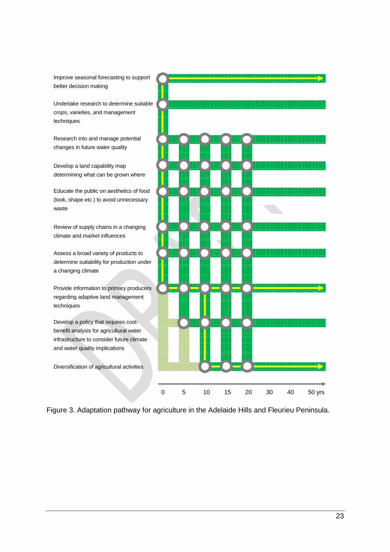
An immediate priority option is to continue to improve seasonal forecasting relating to
rainfall and temperature which will provide growers with the ability to make better decisions
on farms, such as when to trade stock or determining how to manage projected water
demand over a coming irrigation season. This option will need to be led by the Bureau of
Meteorology and can build on an existing suite of forecasting tools that have been
developed, such as three-month rainfall and temperature forecasts, and soil moisture and
evaporation models. The improvement of seasonal forecasting should continue to occur into
the foreseeable future in order to ensure the most up-to-date scientific information is being
captured (Figure 3).
An adaptation option also required now is to disseminate information to build the
capacity of primary producers so that they have the skills and understanding needed to
implement adaptive land and water management techniques. This can be achieved by
working with existing farming groups, economic development organisations and industry
associations such as the Apple and Pear Growers Association of South Australia, South
Australian Dairy Farmers Association, Livestock SA, Adelaide Hills Wine and rural land
management groups. Communications exercises will need to be conscious of the change in
farm types, with the trend towards an increasing number of smaller acreages being managed
by people with less extensive farming experience. The dissemination of information and
capacity building should be ongoing into the foreseeable future in order to ensure the most
up-to-date knowledge and scientific information is communicated and applied at the local
scale of action and management (Figure 3).
It is expected that within 10 years, farming in the region will need to further diversify
agricultural activities and adopt "adaptive processes". This will involve looking to other
regions in the State, nationally, and internationally, that already have a similar climate to that
which the Adelaide Hills and Fleurieu Peninsula will experience in the future and determine
what management practices they use, or what different crop varieties or animal breeds are
appropriate, noting the need to more closely manage greenhouse gas emissions from
livestock. In this regard the region is at an advantage compared with other parts of South
Australia because it is likely to experience conditions that already occur elsewhere. Once
implemented, investigating diversification options and learning from other locations should
continue into the foreseeable future (Figure 3).

22
Triggers
The speed at which new adaptation practices are adopted will be influenced by a range of
triggers. From a climate perspective an increase in the frequency and intensity of droughts,
fires and other extreme events will be important, which in turn will influence the cost of
farming (e.g. by driving up input costs such as insurance) and the viability of some
production systems in the region. The introduction of new technologies will also drive
changing farm management practices; although likely as a response to opportunities to
better manage farm costs or increase productivity, with adaptation being an indirect benefit.
Additional triggers could include marketing opportunities, generational change and insurance
related risks.
Enablers and barriers to adaptation
Agricultural adaptation options will need to demonstrate alignment with stakeholder values
relating to lifestyle and agricultural productivity, without which the uptake of options is likely to
be low. Broad-scale uptake of options is likely to be facilitated through existing networks, with
a subset of stakeholders acting as leaders and champions of new approaches and actions.
As is often the case in long-standing businesses involving social and generational gaps,
there is likely to be a degree of resistance to change, even if champions are able to
demonstrate promotion of lifestyle and agricultural productivity. Addressing a number of key
barriers will be critical in facilitating the uptake of options across the Adelaide Hills and
Fleurieu Peninsula. Key barriers include:
the need to demonstrate the “cost”-benefit of options (e.g. sustainability versus profit);
overcoming previous bad experiences with new knowledge and clearly communicating
and interpreting complex information for relevance at the scale of on-ground application;
addressing low levels of understanding in some government agencies of on-ground
issues; and,
addressing conflicting or inappropriate financial and budgeting strategies and legislation.
Key points
Adaptation for agriculture will require greater sharing of information with
farmers on adaptive land and water management techniques, improved
seasonal forecasting, and diversification of agricultural activities.
23
Figure 3. Adaptation pathway for agriculture in the Adelaide Hills and Fleurieu Peninsula.
Improve seasonal forecasting to support
better decision making
Undertake research to determine suitable
crops, varieties, and management
techniques
Research into and manage potential
changes in future water quality
Develop a land capability map
determining what can be grown where
Educate the public on aesthetics of food
(look, shape etc.) to avoid unnecessary
waste
Review of supply chains in a changing
climate and market influences
Assess a broad variety of products to
determine suitability for production under
a changing climate
Provide information to primary producers
regarding adaptive land management
techniques
Develop a policy that requires cost-
benefit analysis for agricultural water
infrastructure to consider future climate
and water quality implications
Diversification of agricultural activities
0 5 10 15 20 30 40 50 yrs

24
5.2 Climate-ready homes and buildings
The Adelaide Hills and Fleurieu Peninsula is highly valued as a place to live and work.
Residential housing within the region’s urban areas varies in age and condition, however,
significant numbers of new homes are being constructed in response to growing populations
in towns such as Goolwa, Mt Barker and Victor Harbor. The region contains a broad array of
non-residential private and public buildings including four public hospitals, one private
hospital, two TAFE SA campuses (Victor Harbor, Mount Barker), as well as a large number
of childcare centres, preschools and schools.
State and local heritage buildings also occur in the region and are particularly valued by both
locals and tourists (e.g. Steam Ranger Heritage Railway).
Potential impacts of climate change
Based on the Integrated Vulnerability Assessment (Resilient Hills and Coasts, 2016), homes
and buildings will be susceptible to increasing extreme events such as extreme heat,
bushfires, and flooding, all of which can result in direct physical damage to infrastructure.
The addition of new housing to the region presents an opportunity to build climate-ready
housing, more suited to a future climate that is warmer and drier. Not only can these
buildings be better designed to cope with changing climatic conditions and frequency of
extreme events, but they can also provide improved living conditions for residents, and
decrease energy use. The region already has examples of sustainable developments e.g.
“Beyond” at Hayborough.
Priority adaptation options
A raft of options have been identified that collectively will increase the number of climate
resilient homes and buildings in the region, either as a consequence of improved design of
new buildings or retrofitting of existing buildings. An agreed minimum standard and
definition for climate-ready buildings is required (Figure 4). If commenced now, it is
anticipated that this task should be completed within 10-15 years. Once established, these
standards can form the basis of encouraging cultural change in the development
industry (Figure 4), which will require engagement with builders, insurers and the finance
Key area of decision-making
How do we maintain the condition of existing homes and buildings (public
and private) and enhance their effective operation as the risk of extreme
events such as fire, extreme heat and flooding as a consequence of rainfall
intensity and sea level rise increases?

25
sector (among others). This can be led by local government but will require support from
State government agencies and industry associations.
Preparation and implementation of guidelines on how to encourage greater use of
climate-ready building techniques, can be used to raise awareness about the benefits
of climate-resilient buildings, especially to the community and building industry. The
preparation of guidelines is anticipated to occur over the next 5 years with implementation
ongoing (Figure 4).
A past barrier to greater adoption of climate resilient housing has been concerns about
additional short-term costs compared to traditional building practices, despite the reduced
long-term operational costs if more energy efficient. In response to this barrier, within five to
10 years, adaptation will require development of more affordable energy-efficient
building materials and fixtures and incentives for increased construction of climate-
ready buildings. Local government can provide an advocacy role implementing these
options, working with State government agencies and industry associations. Both of these
options should be continued into the foreseeable future in order to ensure new technologies
are captured and construction of suitable buildings continue (Figure 4).
Additional options identified for the region but that are considered to have too high a cost at
present include housing replacement (for buildings that are not “climate-ready”) and
mandating building requirements in some new residential developments (minimum
requirements). The latter requires further support by the development industry and so in the
interim the focus needs to be on educating new house builders about lifetime versus up-front
costs. While not high priorities at present, both options may require further consideration in
the future as the impacts of climate change are experienced in the region.
Triggers
A wide range of triggers exist that could lead to greater implementation of options to create
more climate resilient housing and buildings. The most important triggers are considered to
be:
lack of continuity of electricity supply (meaning that household appliances such as air-
conditioning are not able to be used);
increasing electricity and insurance costs; and’
increased State government leadership for climate-ready housing.
Other triggers could include:
increasing frequency and intensity of heatwaves;
experiencing drought or heavy rain events;
changes in the cost benefit analysis between retrofitting and rebuilding homes;
property sales and land divisions; and

26
insurance company policies or a major bushfire increasing the demand for “bushfire
ready” housing.
Enablers and barriers to adaptation
Taking actions to maintain the condition and enhance the operation of existing homes and
buildings under extreme events will be enabled by increasing community demand for climate-
ready buildings. Community buy-in will be further facilitated by greater sharing of existing
knowledge about how to create climate-ready buildings.
Key barriers to creating climate-ready buildings centre on budget and governance
constraints. Specifically, there is a need to demonstrate the cost-benefit of adaptation,
without which the costs can be viewed as being too high. In addition, the motivation and
willingness at the community level needs to be reflected or promoted at local and State
government levels.
Key points
Priority adaptation options for climate-ready homes and buildings are to
agree to a minimum standard and definition for climate-ready buildings;
encourage cultural change in the development industry; amend development
plans to include minimum building requirements; prepare guidelines on how
to encourage greater use of climate-ready building techniques; and raise
awareness about the benefits of climate-resilient buildings. Within five to 10
years adaptation will require incentives for increased construction of “climate-
ready” buildings and development of more affordable energy-efficient
building materials.

27
Figure 4. Adaptation pathway for climate-ready homes in the Adelaide Hills and Fleurieu Peninsula.
Agree to a minimum standard that
defines climate-ready buildings
Encourage cultural change in building,
development and finance industries
Prepare and implement guidelines on
climate-ready building techniques
Amend the development plan to require
region-wide climate-ready housing
initiatives
Raise awareness about the benefits of
climate-resilient buildings (especially to
building industry and community)
Better integrate building standards and
planning regulations
Mandate building requirements in some
new residential developments
Encourage affordable energy efficient
building materials and fixtures through
Government incentives
Provide incentives for increased
construction of “climate-ready” buildings
(community uptake)
Consider replacement of old houses that
are not climate-ready
Relocate existing infrastructure and
housing
0 5 10 15 20 30 40 50 yrs

28
5.3 Coastal ecosystems
The region’s extensive coastline is characterised by a mix of low energy coastal ecosystems
(i.e. samphire and estuaries), beach-dune ecosystems, and coastal cliff ecosystems
(including softer calcareous and harder lithology cliffs) (West, 2016). The coastline’s near
shore marine environment supports both seagrass and reef ecosystems and a range of
substrates. Such coastal systems are valued in the region for supporting a diversity of flora
and fauna species, as well as a range of recreational and commercial activities.
Climate change impacts
Based on the Integrated Vulnerability Assessment (Resilient Hills and Coasts, 2016), coastal
ecosystems will be most influenced by increasing sea levels, increasing rainfall intensity
(causing localised run-off), and increasing ocean acidity. Additional, complementary analysis
by Natural Resources Adelaide and Mount Lofty Ranges (West, 2016) found that:
Soft coastal ecosystems (e.g. beaches) have high exposure to climate change due to low
topographic variability, high realised sensitivity and little or no adaptive capacity because
of barriers that impede coastal (landward) migration; and
Coastal landscapes have low to high exposure to climate change depending on the
specific coastal ecosystems (e.g. sedimentary versus hard-rock cliff ecosystems), low to
high realised sensitivity and low to moderate adaptive capacity.
Priority adaptation options
Soft coastal ecosystems require transformational adaptation to pre-empt their likely loss
under sea level rise. This can occur by supporting their replacement (to maintain stability and
basic ecological functions), while artificially supporting coastal migration to minimise
biodiversity loss (West, 2016). Enacting such transformational adaptation can be aided by:
(a) amending planning regulations and the Coast Protection Act 1972 to ensure that
development approval processes reflect projected sea level increases; and (b) revising
development plans to establish improved zoning for sensitive coastal features and to
allow for future inland migration of ecosystems, saltmarshes, dunes and coastal wetlands.
Both options require some initial lead time preparation and planning before implementation
can commence, after which they should be continued into the foreseeable future (Figure 5).
Key area of decision-making
How do we maintain the condition and extent of sedimentary coastal
ecosystems given projected increases in sea levels?

29
While options are being pursued that will allow for future migration of coastal ecosystems,
restoring and enhancing coastal dunes is an immediate adaptation priority (Figure 5). This
involves continuing the work of existing organisations and community groups, including
Natural Resources Adelaide and Mount Lofty Ranges, and the Goolwa to Wellington Local
Action Planning group. This action should also be continued into the foreseeable future
(Figure 5)
Restoration and enhancement of dunes can be aided in some locations by improving the
quality and reducing the quantity of stormwater discharges from urban areas which cause
localised erosion at discharge points to the ocean and cause sedimentation and deliver
nutrients to near-shore marine ecosystems. This can be achieved through water sensitive
urban design and increasing stormwater retention areas.
Triggers
Triggers for greater implementation of adaptation options in the coastal zone are likely to
include:
major storm surge-induced flooding events resulting in damage to dune systems, cliff
erosion, major infrastructure damage and sewer backups;
court decisions resulting from damage by storm or sea level rise events;
changing composition of marine species; and,
reduced accessibility to beaches because of high sea levels or damaged beach
infrastructure.
To determine the timing of such events monitoring and modelling of the retreat of sand dunes
in response to sea level rise needs to be improved.
Enablers and barriers to adaptation
Adaptation of coastal ecosystems will be greatly facilitated by the high value that people
place on the coastal zone – even if these human values are not directly related to the
ecosystem values they will still have beneficial implications. For example, people value being
able to readily access clean, sandy beaches.
Although such community-held human values may directly or indirectly facilitate adaptation of
coastal ecosystems, they may also present a barrier if there is considered to be little
recognition of the role that ecosystems play. For example, without a clear understanding of
the importance of coastal ecosystems, people may operate under a strong entitlement
mindset, and advocate access and use of coastal areas unimpeded by environmental rules
and regulations. An additional barrier to protecting coastal ecosystems is likely to be the cost
of enabling inland migration, especially where this would require relocation of existing
infrastructure.
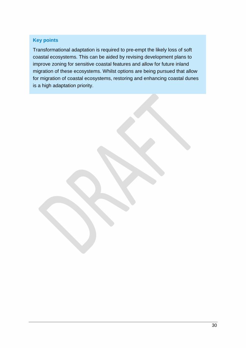
30
Key points
Transformational adaptation is required to pre-empt the likely loss of soft
coastal ecosystems. This can be aided by revising development plans to
improve zoning for sensitive coastal features and allow for future inland
migration of these ecosystems. Whilst options are being pursued that allow
for migration of coastal ecosystems, restoring and enhancing coastal dunes
is a high adaptation priority.

31
Figure 5. Adaptation pathway for coastal ecosystems on the Fleurieu Peninsula.
Determine community values and
priorities
Distribute sea level rise modelling data to
incorporate into local decision making
Improve quality and reduce quantity of stormwater discharges from urban areas
Maintain appropriate functional
vegetation
Establish a core repository/location of
relevant climate change data related to
coastal ecosystems and ensure access
by decision making stakeholders
Update coastal vegetation mapping
databases to assess/monitor changes.
(e.g. seagrasses, macroalgae and
land based ecosystems)
Raise community awareness on coastal
processes and reduce expectations on
maintenance levels
Restore and enhance coastal dunes
Improve Development Plan through
zoning sensitive coastal features allowing
for inland migration of ecosystems
Amend planning regulations to
ensure approval processes
reflect sea level increases
Provide opportunities and space for
landward migration (includes maintaining
water regimes/buffers etc.)
Relocate buildings and hard infrastructure
to enable coastal ecosystem retreat
0 5 10 15 20 30 40 50 yrs

32
5.4 Community facilities and open space areas
Community facilities and open space areas are valued for their role in supporting community
health, wellbeing and connectedness by providing opportunities for formal and informal
recreation, health and fitness, social interaction, relaxation, and children’s play and
development. A large number of open space areas and community facilities occur within the
region including: formal parks, playgrounds and reserves; sporting clubs and infrastructure
(e.g. tennis and netball courts, soccer and hockey fields, equestrian facilities, lawn bowls
greens and cricket ovals); recreation tracks and trails; libraries, child care centres, and
emergency services buildings; and community centres and meeting halls (for community
programs such as scouts, guides, and Returned Service League) (URPS, 2014).
Climate change impacts
Based on the Integrated Vulnerability Assessment (Resilient Hills and Coasts, 2016),
community facilities and open space areas will be influenced most by projected changes in:
altered rainfall patterns (i.e. amount and intensity), which will influence turf maintenance
(e.g. water availability for irrigation of ovals);
increasing extreme heat, which will influence participation rates in outdoor sporting and
recreation activities;
bushfire risk, which could lead to cancellation of events but also direct damage to
buildings and other infrastructure; and
rising sea levels which could damage low lying areas of vegetated open space and
community facilities (e.g. life-saving clubs, bowling clubs, foreshores).
Priority adaptation options
Adapting community facilities and open space in the Adelaide Hills and Fleurieu Peninsula
will require a combination of policy, awareness raising and on-ground activities (Figure 6).
Underpinning all adaptation is the immediate need for education and awareness raising
about the impacts of climate change and potential response options, with such education and
awareness being an ongoing requirement (Figure 6). A particular focus in the Adelaide Hills
and Fleurieu Peninsula will be initiatives to support activity centres, small to medium sized
enterprises and business groups to better understand risks and how to prepare, respond and
recover from extreme event related emergencies.
Key area of decision-making
How do we maintain and expand community facilities and open space areas
for sport and recreation to meet a growing community’s demands given
projected declines in rainfall and increasing temperature and fire risk coupled
with increasing population and development?

33
Another immediate priority will be preparing ‘climate-ready’ guidelines regarding public
realm and streetscape management. These will outline appropriate material and tree
species selection, shade cover, methods for inclusion of water sensitive urban design
features in community facilities and open space, and opportunities for misting infrastructure.
While this can be addressed at an individual local council scale, it also lends itself to a
regionally collaborative approach. The preparation of such guidelines, if commenced now, is
anticipated to occur over the next 5 years, after which ongoing revision and update or the
guidelines should be undertaken as necessary (Figure 6).
A direct and tangible outcome of preparing ‘climate-ready’ guidelines will be measures to
enhance the ‘greenness’ of retail and commercial centres, which should be implemented
on ground wherever possible. This will be especially pertinent along main streets and in car
parking areas in order to help reduce the urban heat island effect which will be exacerbated
by climate change-driven temperature increases. Being able to minimise temperatures in
urban centres will have substantial public health benefits and provide for more desirable
shopping precincts, leading to enhanced local economic prosperity. The implementation of
actions which enhance urban greenness should be ongoing (Figure 6).
Within 10 years, a major policy response will be to implement development plan
amendments that: (a) restrict development in areas at high risk from climate hazards such
as sea level rise and bushfire; and (b) require climate sensitive building design (Figure 6).
This will reduce the future risk of infrastructure damage in hazard prone areas and ensure
that community members are not at high risk when using community facilities and open
space.
Triggers
Triggers for implementing additional adaptation options for recreational and sporting clubs
are likely to include changing financial viability of clubs (e.g. lack of volunteers causing
increased operational costs) and when maintenance costs become unviable. Community,
economic triggers could include commercial activity decline in towns and population shifts
leading to lower participation rates.
Enablers and barriers to adaptation
The importance of community facilities and open spaces for providing desirable lifestyle
attributes, particularly for young and active people, is well understood. This means that a
high social value is often placed on such facilities and spaces, which will greatly facilitate a
proactive approach to implementation of adaptation options.
Despite this, it is anticipated that community engagement around adaptation options will still
be important, especially amongst aging and retirement populations who may place a lower
value on open space areas.

34
Key points
Adaptation of community facilities and open space areas will require
development plan amendments that restrict development in hazard prone
areas and require climate sensitive building design. Climate-ready guidelines
will provide broad direction regarding public realm and streetscape
management, which in-turn will guide enhancing the ‘greenness’ of retail and
commercial centres. Underpinning adaptation of community facilities will be
education and awareness raising.
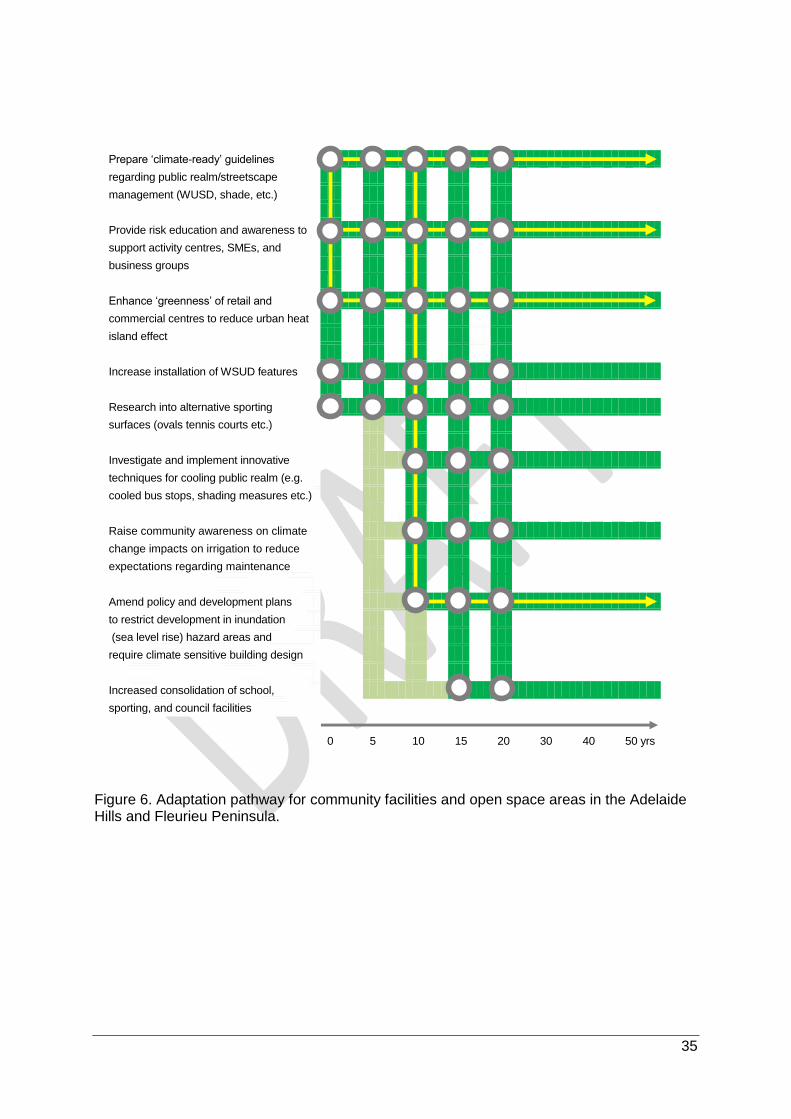
35
Figure 6. Adaptation pathway for community facilities and open space areas in the Adelaide Hills and Fleurieu Peninsula.
Prepare ‘climate-ready’ guidelines
regarding public realm/streetscape
management (WUSD, shade, etc.)
Provide risk education and awareness to
support activity centres, SMEs, and
business groups
Enhance ‘greenness’ of retail and
commercial centres to reduce urban heat
island effect
Increase installation of WSUD features
Research into alternative sporting
surfaces (ovals tennis courts etc.)
Investigate and implement innovative
techniques for cooling public realm (e.g.
cooled bus stops, shading measures etc.)
Raise community awareness on climate
change impacts on irrigation to reduce
expectations regarding maintenance
Amend policy and development plans
to restrict development in inundation
(sea level rise) hazard areas and
require climate sensitive building design
Increased consolidation of school,
sporting, and council facilities
0 5 10 15 20 30 40 50 yrs

36
5.5 Emergency management
Emergency management services are highly valued across the region for its role in
preventing, preparing for, responding to, and recovering from emergencies that threaten the
health and safety of residents, the condition of buildings and infrastructure, and farm
plantings and stock. Emergency services are provided by SA Police, the Metropolitan Fire
Service, Country Fire Service, SA Ambulance Service, State Emergency Service, and Surf
Lifesaving Clubs. Volunteers also play a vital role in helping to deliver emergency
management services in the region.
Potential impacts of climate change
Based on the Integrated Vulnerability Assessment (Resilient Hills and Coasts, 2016),
changes to the region’s climate will affect the frequency and severity of emergencies.
Bushfires, extreme heat events and storms in particular will increase the demand for
emergency management services. As well as their direct impact on property and
infrastructure, they can also impact the ability for critical emergency services to function
adequately, for example, through delayed response times due to communication network
damage or access routes being limited (e.g. damaged or blocked). Bushfire is likely to be
particularly important in the Adelaide Hills and Fleurieu Peninsula.
Priority adaptation options
An immediate focus of adaptation for emergency services management is to improve early
warning systems for flood and fire. This will require work with the Bureau of Meteorology
and potentially the development of mobile phone apps that advise of emerging high risk
conditions. This option has already been initiated, and it is expected that work on early
warning systems should be complete within 10 years (Figure 7).
Adaptation also requires work to assist the community and businesses to better prepare for
extreme events, especially fire. The first part of this strategy will involve community
education (prior to an event) involving the CFS and local government. This should use an
“all hazards” approach and include welcome packs for new residents. The action should
continue into the foreseeable future (Figure 7). Community education can also be improved
through working with organisations such as the Insurance Council of Australia regarding
Key area of decision-making
How do we respond to the growing demand for emergency management
services across multiple sectors as the risk of extreme events such as fire,
extreme heat and flooding (as a consequence of rainfall intensity and sea
level rise) increases?

37
community messaging around risk and insurance. As insurance policies and
communities change, this option should be continued into the foreseeable future (Figure 7).
A second key element of preparation is greater enforcement of Section 105F notices
under the Fire & Emergency Services Act 2005, which requires landowners to take action to
protect property on their land from fire, or to prevent or inhibit the outbreak of fire on their
land, or the spread of fire through their land. Although requiring implementation now, this
action should also be continued into the foreseeable future (Figure 7). Future adaptation
options could include advocating for legislative change to the Fire and Emergency Services
Act to reduce timeframes for 'action in default' of Section 105F, although this is expected to
not be required for at least several decades to come.
Triggers
Key triggers for implementation of emergency management adaptation options will be
improved knowledge of risk to vulnerable persons as well as major emergencies that result in
fatalities, serious injury or asset damage. Other triggers could include;
an increase in demand for emergency services because of more frequent and intense
climate hazards;
lack of access to emergency management services volunteers;
negative media to the response to extreme events;
failure to reduce risks through existing fire prevention measures (e.g. Section 105F
notices); and
increasing insurance costs and declining visitor numbers due to safety concerns.
Enablers and barriers to adaptation
Adaptation in the emergency services sector will be facilitated through drawing on the
experience of other regions and their solutions (e.g. use of plantings and infrastructure to
reduce flood risk), education about the value of emergency management services, continued
collaborative work between emergency management services and councils, and improved
and evolving communications and modelling technologies.
A key barrier to adaptation is the “she’ll be right”, “it won’t happen to me”, and “I can handle
it” attitude of some people who tend to focus on what are perceived as more imminent
priorities unless extreme events are occurring frequently or recently. Effective education and
information dissemination (including extreme event warnings) which elicits community action
and response is essential.
Limited legislative obligations together with ambiguity in council roles in emergency
management may also inhibit the implementation of adaptation options. In addition,
implementation will also be hindered by an inability of short-term planning and institutional
processes to prioritise funding and resourcing and to consider long-term issues like climate
change.

38
Key points
Adaptation for emergency services management will require a focus on
better fire preparation through community education involving the CFS and
local government, community messaging around risk and insurance, and
greater enforcement of Section 105F notices. To assist with responding
during emergencies, greater emphasis is required on improving early
warning systems for flood and fire.

39
Figure 7. Adaptation pathway for emergency management in the Adelaide Hills and Fleurieu Peninsula.
Develop early warning systems for flood
and fire
Community education prior to extreme
events about preparation and response
Develop community messaging around
risk and insurance
Greater enforcement of Section 105F
notices
Educate and engage with people from
non-English speaking backgrounds
Facilitate increased volunteerism
Regulate development in high risk
areas
Legislate to reduce timeframes for action
in default of Section 105F
0 5 10 15 20 30 40 50 yrs

40
5.6 Infrastructure assets
The Adelaide Hills and Fleurieu Peninsula supports a wide diversity of infrastructure assets
that service major towns and growing urban centres as well as the large areas of farming and
public conservation lands. Key infrastructure assets include (URPS, 2014):
arterial roads managed by State government (e.g. South Eastern Freeway) and local
roads managed by local councils;
footpaths, shared paths, street lighting, and traffic safety and control assets; and
a railway line between Mount Barker and Victor Harbor (traverses the Mount Barker,
Alexandrina and Victor Harbor LGAs), and the Adelaide-Melbourne rail line (traverses
Adelaide Hills and Mount Barker LGAs).
The importance of transport networks in growing parts of the region is highlighted by the
Adelaide Hills, where approximately 60% of residents work outside the region mainly in
metropolitan Adelaide because of proximity to the Adelaide Hills and accessibility via the
South Eastern Freeway.
Significant water resource management and treatment infrastructure also occurs in the
Adelaide Hills and Fleurieu Peninsula such as (SA Water, 2014; URPS, 2014):
stormwater pipes, culverts, pits and channels;
a number of council operated waste-water treatment plants/systems;
SA Water operated country waste-water treatment plants (Bird-in-Hand, Gumeracha,
Hahndorf, Heathfield, Myponga, Victor Harbor);
surface water pipes primarily used for urban and irrigation uses, including two of the
State’s five major pipelines which bisect the region (Murray Bridge-Onkaparinga and
Mannum-Adelaide pipelines); and
six reservoirs – four contained entirely within the region (including one on Kangaroo
Island) and two partially coinciding with the region.
Climate change impacts
Based on the Integrated Vulnerability Assessment (Resilient Hills and Coasts, 2016), altered
rainfall patterns (i.e. amount and intensity), and increasing extreme heat and bushfires, will
have the greatest influence on the condition and functioning of the region’s infrastructure
assets. For example, rainfall amount will influence soil heavage and cracking and rainfall
Key area of decision-making
How do we maintain and expand infrastructure assets, such as roads, water
management and energy networks, given projected declines in rainfall and
increasing temperature and fire risk?

41
intensity will impact on flooding. Extreme heat will influence how infrastructure is used by the
community and fire could cause direct physical damage to major infrastructure.
While the adaptive capacity of some existing infrastructure may be low, local population
growth will increase demand for new facilities which presents an opportunity to design them
in a way that is better suited to the region’s future climate.
Priority adaptation options
Adaptation for infrastructure in the Adelaide Hills and Fleurieu Peninsula will require
immediate changes to planning and building requirements for constructing new
infrastructure to ensure that they meet agreed energy efficiency and water reuse standards
(relates also to Section 1.1 – Climate-ready homes and buildings). Such planning and
building requirements will need to be assessed and potentially changed again in the future
based on learnings and the availability of new technologies/materials, and so this option
should be actively continued into the foreseeable future (Figure 8).
Documented climate risk assessments are required on project-by-project basis for local
government. While initially this may be viewed as an additional activity to existing practices,
the aim should be for this to become a business-as-usual practice (Figure 8). A specific
extension of this is the need to identify points of vulnerability in the road network, such
as through the development of a roads database. This will need to consider future potential
climate impacts and potential risks for sealed (expected to be detrimental because of hotter
drier conditions causing cracking and deterioration of the road seal) and unsealed (expected
to be beneficial because of less rainfall) roads (Figure 8).
Within five years, adaptation should focus on incorporating greater allowances for
increases in extreme events in infrastructure design (Figure 8). This will be particularly
relevant to stormwater management infrastructure, which may need to be larger in size to
continue to operate effectively if the frequency and intensity of rainfall increases. An
alternative to modifying infrastructure design will be to relocate it in order to reduce exposure
to extreme events altogether, which in some towns will lead to the undergrounding of
power lines in high risk areas (Figure 8). This will not only reduce the risk of fire resulting
from high winds causing power lines to contact and spark on vegetation, but will also improve
general landscape aesthetics and make it easier to plant trees in urban areas to provide
cooling and other benefits (which supports priority options identified in Section 5.4).
However, implementation of this option will need to consider the impact of decentralisation of
electricity generation, such as through rooftop solar PV, which may influence the extent to
which major power lines are required.
While not identified as immediate priorities, potential major future changes for water
management infrastructure are also noteworthy. In response to declining rainfall and
increasing local population, the Adelaide Hills and Fleurieu Peninsula may need to consider
greater use of recycled water, potentially even for mixing with potable supplies. Related to

42
this will be the need to ensure that community wastewater management systems and sewer
pump stations close to the coast are not impacted by rising sea levels, which could require
their re-location, although this is not expected to be a concern for several decades.
Triggers
Key triggers that will inform decision making for adaptation of infrastructure are likely to
include increasing frequency of intense storm events leading to annual flooding of homes
and public realm, increasing frequency of fires impacting the community and requiring the
relocation of infrastructure, and declining rainfall acting as a trigger to identify new water
sources. Other triggers could also include changing costs for water and electricity, and
reduced transport access leading to road upgrades or new roads.
Enablers and barriers to adaptation
Despite the community valuing the services provided by infrastructure in the region, it is
expected that there will be substantial values-based barriers to adaptation. For example,
water is a critical resource, yet negative community perceptions associated with recycled
water may greatly inhibit the uptake of water reuse schemes as an adaptation option (noting
that these are not likely to be required for at least another decade).
Support for climate adapted infrastructure will be facilitated through engaging the community
and providing education on climate change impacts. It will also be important that decision-
makers and administrators provide unified support for options. This will be aided by ensuring
that climate change impacts and adaptation options are clearly recognised and prioritised in
current standard practices, regulations, and policies. Ultimately though, major climatic events
may prove to be the key catalyst for changing community perceptions and opinions.
Key points
Adaptation for infrastructure will require changes to planning and building
requirements to include energy efficiency and water reuse measures, greater
allowance for projected increases in extreme events in infrastructure design
and undergrounding of power lines in high risk areas. Documented climate
risk assessments will start to become an increasing feature of adaptation for
infrastructure, which will require as one specific action identifying points of
vulnerability in the road network.

43
Figure 8. Adaptation pathway for infrastructure assets in the Adelaide Hills and Fleurieu Peninsula.
Avoid construction of essential services
buildings in high risk areas
Create wider corridors near power lines
or substations
Changes to planning and building
requirements (e.g. energy efficiency)
Identify points of vulnerability in the
road network
Documented climate risk assessments
Incorporate design allowances for
increases in extreme events
Undergrounding power lines in high
risk areas
Establish local solutions for backup and
domestic power storage
More frequent bitumen resealing and use
of alternate road sealing surfaces
Increase waste water reuse for potable
supplies
Relocate key assets in high risk areas
(e.g. sewer pump stations)
0 5 10 15 20 30 40 50 yrs

44
5.7 Natural landscapes
The Adelaide Hills and Fleurieu Peninsula is comprised of highly valued and variable natural
landscapes. Away from the coast, the predominant natural landscape types in the Adelaide
Hills and Fleurieu Peninsula (using the definition of West 2016) are the following areas:
Plains: On both the western and eastern side of the spine of range and typified by low
elevation and topographic relief. Dominated by mallee and shrub ecosystems;
Flanks: Form the transition zone between the plains and the upland landscapes and are
typified by higher relief than the plains. Dominated by ‘grassy’ woodland and grassland
ecosystems; and
Upland: Form the spine of the Mount Lofty Ranges and are typified by both high relief
and elevation. Dominated by a diversity of both ‘grassy’ and ‘shrubby’ woodland
ecosystems.
Natural landscapes in the region include some of the State’s most frequented and well
known parks, such as: Cleland Wildlife Park and Morialta Conservation Park in the Adelaide
Hills area, Granite Island Recreation Park in the Victor Harbor area, and Deep Creek
Conservation Park in the Yankalilla area (Government of South Australia 2014).
Remnant vegetation, together with the range of other natural assets, play a critical role in
supporting numerous environmental features of significance at local, State, Federal, and
international levels. These include endangered species and ecological communities listed
under the Environment Protection and Biodiversity Conservation Act 1999 (EPBC Act),
internationally important migratory bird species; Commonwealth heritage places; natural,
indigenous and historic places on the register of the national estate; and numerous state and
territory reserves (Resilient Hills and Coasts, 2014a).
Climate change impacts
An understanding of climate change impacts on natural landscapes in the region has been
informed by the Integrated Vulnerability Assessment (Resilient Hills and Coasts, 2016)
conducted for this project and the Climate Change and Biodiversity Landscape Scenario
Assessment for the Resilient Hills and Coasts Region (West, 2016).
Key area of decision-making
How do we maintain the condition of natural landscapes (plains, flanks,
uplands) given projected declines in rainfall and increasing temperature and
fire risk?

45
The likely exposure, sensitivity and adaptive capacity for the broad natural landscape
categories are as follows:
Plains - High exposure to climate change due to limited topographic variability, but low realised sensitivity and adaptive capacity due to the early and extensive modification of these landscapes.
Flanks - Moderate exposure to climate change due to some topographic variability, High realised sensitivity and low to moderate adaptive capacity, because although have been cleared landscapes they still often retain significant components of biodiversity; and
Upland landscapes - Low to moderate exposure to climate change due to high topographic variability, low to moderate realised sensitivity and moderate to high adaptive capacity.
Furthermore, it is expected that grassland, woodland and forest communities will be
influenced most by increasing fire risk, altered rainfall patterns (i.e. amount and timing), and
increasing temperatures. Potential interactions between such climate change impacts and
existing threatening processes (e.g. agriculture and urbanisation) will also become
increasingly important.
Priority adaptation options
At a broad landscape scale, active adaptation will be required for flanks landscapes. For
plains and upland areas the slightly lower impacts of climate change will mean that the focus
will be on increasing resilience (West, 2016). Primary producers in the region will play
important roles in enhancing natural landscape resilience through conservation actions
undertaken on private land which will complement similar actions elsewhere in the
landscape. For example, the increasing number of smaller acreages being managed by
people with less extensive farming experience provides an opportunity, if properly managed,
to contribute to resilience through increased diversity and more intensive management.
No regret adaptation options for immediate implementation (see Figure 9) include:
protecting existing natural features by stopping further losses of native vegetation
(focus on flanks);
better managing threats such as pests and diseases (focus for plains and uplands);
managing, restoring and increasing functional landscape connectivity to support
reassembly of flora and fauna;
identifying, protecting and managing climate refugia to provide locations in the
landscape for native flora and fauna to retreat to as the climate changes;
restoring natural landscapes by reinstating impaired ecological functions and
processes such as grazing and fire disturbance dynamics; and
encouraging land use changes with positive rather than negative biodiversity
outcomes. This can be supported through recognition of landscape values and
adaptation requirements in the development planning system.
46
All priority actions listed above are recognised as being important for ecosystem health
regardless of climate change impacts, but will become especially important for facilitating
ecological resilience and long-term persistence of species populations, communities,
processes and functions. Accordingly, these options should continue to occur into the
foreseeable future, with the exception of the “restoring natural landscapes” option which is
considered to be a useful focal option for implementation over the next 30 years, after which
it is anticipated that other options will become more pertinent (Figure 9). Within 10 years it is
anticipated that there may also be a need to support transitions in ecological
communities. The planning work for this option needs to commence now.
Triggers
The main trigger for implementation of adaptation options in the future will be observed
declines in existing flora and fauna species or communities or when unexpected changes in
populations are observed. The main tool currently used by councils for monitoring such
changes is the Bushland Rapid Assessment Technique (Bush RAT).
It is essential that partners in natural landscape management in the region invest in
anticipatory monitoring and evaluation to detect climatic change impacts and develop
conceptual models of likely change and triggers for different strategies.
Enablers and barriers to adaptation
Maintaining functional native vegetation communities will require more community support
and appreciation for the ecosystem services that they provide. This will require a shift from a
utilitarian, human use view of the landscape to a greater focus on inherent environmental
values. This transition can be assisted by working with environmental champions in the
community.
Barriers to maintaining functional vegetation communities include a lack of understanding of
ecosystem services and the seemingly overwhelming magnitude of the management
challenge. In addition, misinformation and negative bias against native vegetation in the
media generates confusion and scepticism in the community, which in turn creates aversion
to change.

47
Key points
Adaptation of natural landscapes will require protection of existing natural
features by stopping further losses of native vegetation; better management
of threats such as pests and diseases; managing, restoring and increasing
connectivity to support reassembly of flora and fauna; identifying, protecting
and managing climate refugia; restoring natural landscapes by reinstating
impaired ecological functions and processes; and encouraging land use
changes with positive rather than negative biodiversity outcomes.

48
Figure 9. Adaptation pathway for natural landscapes in the Adelaide Hills and Fleurieu Peninsula.
Protect existing natural features
Better manage threats (e.g. fire, pests
and diseases)
Manage, restore, and increase
connectivity to support migration and
range shifts of flora and fauna
Identify, protect and manage climate
refugia
Encourage land use changes with
positive rather than negative
biodiversity outcomes
Restore natural landscapes by reinstating
impaired ecological functions and
processes
Continue to include 'local species' in
plantings as some may adapt
Identify, measure and monitor ecosystem
services and value natural capital
Investigate the use of non-local native
species which may be more resilient to
changing climatic conditions
Consider and prepare for potential
transitions in ecological communities
0 5 10 15 20 30 40 50 yrs

49
5.8 Public coastal assets
The Adelaide Hills and Fleurieu Peninsula contain a number of public coastal assets, which
are highly valued for supporting recreational, residential, and commercial activities. For
example, there are 10 coastal jetties, 28 coastal boat ramps and three marinas (Goolwa,
Hindmarsh Island and St Vincent/Wirrina Cove). There are also buildings (e.g. surf lifesaving
clubs), and transport infrastructure (e.g. roads, pathways) located in the coastal zone.
Collectively these assets provide key infrastructure for accessing and using an iconic part of
the State’s coastline.
Climate change impacts
Based on the Integrated Vulnerability Assessment conducted for the region (Resilient Hills
and Coasts, 2016) the greatest impact from climate change on public coastal assets will be
sea level rise, though increasing rainfall intensity will also be important in some locations
susceptible to erosion, such as sandy beaches as opposed to rocky shores. Sea level rise
will impact assets through permanently inundating low lying areas along the coast, but also
exposing assets at higher elevations to greater risk of flooding and wave damage during
extreme high sea levels, such as during storms.
The barrages that separate Lake Alexandrina and the Coorong are a major public coastal
asset in the region that have social, economic, environmental and cultural significance.
However, they have not been considered in this assessment because climate impacts on this
asset were addressed in the development of the climate change adaptation plan for the
South Australian Murray-Darling Basin (see Section Error! Reference source not found.).
Priority adaptation options
Responding to sea level rise in the coastal zone typically involves a combination of options
that aim to defend, retreat or abandon natural or built assets. The initial focus of adaptation
for public coastal assets in the Adelaide Hills and Fleurieu Peninsula is on defence
(Figure 10).
An immediate priority is to prevent public coastal assets from being constructed in high risk
areas. This will be facilitated through development and implementation of guidelines for
coastal management design (Figure 10). These will outline planning controls for inclusion
in development plans, propose areas for restricted development and outline setback
distances from the coast for construction. This option, which will primarily involve local
Key area of decision-making
How do we maintain the condition of public coastal assets given projected increases
in sea levels?

50
councils, provides an opportunity for collaboration across the region and with other regions
given that similar challenges around development planning in the coastal zone are being
confronted elsewhere in the State.
To option to increase sand replenishment aims to maintain beaches which act as soft
structural barriers to sea level rise and extreme sea levels during storms. This option will
require local and State Government agreeing to the frequency of replenishment relative to
available budgets. Consideration will need to be given to how long this option will be effective
into the future given that it may no longer be viable in some locations once thresholds of sea
level rise are reached. For the purpose of this Plan, it is estimated that sand replenishment
will be viable for a further two decades, although this will require additional verification and
ongoing monitoring (Figure 10).
Linked to sand replenishment is protecting and enhancing dunes, which will include
planting appropriate vegetation in some locations to reduce sand erosion. This will provide
protection for public coastal assets through maintaining existing soft structural barriers, which
may be especially effective during storm surge events. Not only will this option support
adaptation for coastal assets, it will also support coastal ecosystems and maintain the beach
environment for recreational use. Both sand replenishment of beaches and dune protection
and enhancement will require collaboration amongst a number of organisations including
between local councils, Natural Resources Adelaide and Mont Lofty Ranges, the Coast
Protection Board and local environment groups such as the Goolwa to Wellington Local
Action Planning Group. Unlike sand replenishment, the protection and enhancement of
coastal dunes should be ongoing wherever such dunes continue to occur (Figure 10).
At this stage, more transformational options such as relocating or abandoning assets (e.g.
beach access, boat ramps, beach cafes, surf lifesaving clubs), or establishing major new
hard protection infrastructure such as sea walls are not considered immediate priorities for
the region, though they may be considered as priorities for certain local councils. These
options were assessed as having both high economic cost and high benefits but considered
to be not required for at least another one to two decades. However, if sea level rise is to
occur more rapidly than projected, such options will need to be implemented sooner.
Triggers
Triggers for decision making regarding public coastal assets will be linked to sea level rise
and the extent to which:
there is sustained damage to public assets such as paths, walls and boat ramps due to
storms and erosion;
key regional assets such as coastal bowling clubs and Granite Island are regularly
flooded;

51
tourism numbers decline because of impacts on natural features such as the Lower
Lakes; and
foreshore vegetation in public parks dies back due to salt leaching into the soil.
Enablers and barriers to adaptation
Maintaining public coastal assets will require a united community vision. The availability of
existing local to global knowledge, publications, and practical examples will help to facilitate a
united front, though only if such knowledge can be readily accessed and understood. Without
the ability to learn from others’ knowledge and experiences, unifying competing priorities in
the community may only occur following extreme events (e.g. flooding from major storm
surge, or asset loss due to coastal slump). This would cause triggers for decision making to
be refined.
Other barriers to maintaining public coastal assets on the mainland include: a lack of ongoing
research and knowledge building; substantial processes and “red tape” required at the State
level for most proposed activities impacting the coastal zone; and, the lack of a single
department/authority with governance and responsibilities over public coastal assets.
Key points
Adaptation for public coastal assets will involve sand replenishment to maintain
beaches, protecting and enhancing dunes to reduce sand erosion, preventing public
coastal assets from being constructed in high risk areas and developing guidelines
for coastal management and design.

52
Figure 10. Adaptation pathway for public coastal assets on the Fleurieu Peninsula.
Raise awareness about impacts of sea
rise on coastal assets
Utilise modelling and mapping
to identify assets at risk
Implement guidelines for coastal
management design
Increase sand replenishment
Protect and enhance coastal dunes
Trial impact reducing measures
Establish hard protection infrastructure
Abandon assets
Relocate coastal assets (e.g. beach
access, cafes, bowling clubs, surf clubs)
Acquire land in high risk areas
0 5 10 15 20 30 40 50 yrs

53
5.9 Vulnerable members of the community
Vulnerable members of the community live across the Adelaide Hills and Fleurieu Peninsula,
though higher populations tend to occur in the coastal and hills areas, particularly given the
attractiveness of such areas for retirees. The region as a whole compares well with other
parts of the State with respect to vulnerable members of the community (Resilient Hills and
Coasts, 2014a), for example:
community connectedness is relatively strong with personal mobility and volunteering
rates well above the State average and internet access and the number of people
requiring assistance with core activities on par with the State average;
unemployment rates have been historically low compared with the remainder of the State
over the past decade; and
income support levels are below the State average, although the percentage of people
receiving an aged pension is above the State average in Victor Harbor (25%) and
Alexandrina and Yankalilla (18% each) reflecting the high number of retirees.
Climate change impacts
Based on the Integrated Vulnerability Assessment (Resilient Hills and Coasts, 2016), the
health, safety and well-being of low income households followed by people aged over 75
were considered most vulnerable to the impacts of climate change. For low income
households, this was due to their sensitivity and low adaptive capacity to extreme events,
driven by limited funds to prepare for, respond to, and recover from, extreme events such as
extreme heat and fire.
The health of older, frail aged people is expected to be directly impacted by an increasing
number of extreme events, especially associated with extreme heat and bushfire. While
extreme weather will negatively affect the community, the Adelaide Hills and Fleurieu
Peninsula is likely to be impacted less than some other parts of the State.
Priority adaptation options
Heat waves are likely to have a large impact on vulnerable members of the community.
Scoping potential government responses relating to provision of heat refuges is an
Key area of decision-making
How do we enhance the health, safety and well-being of vulnerable members of the
community as the risk of extreme events such as fire, extreme heat and flooding (as
a consequence of rainfall intensity and sea level rise) increases?

54
immediate priority for the region and should aim to identify which local or State government
buildings are suitable as refuges for the community during periods of extreme heat. This
option is considered to be able to be completed within the next 10 years (Figure 11). Also
addressing heat waves is the need to continue to implement and enhance heatwave
response services such as the Australian Red Cross’ Telecross REDi service, with this
option identified as being of use in to the foreseeable future (Figure 11).
Education and awareness raising was highlighted as an important strategy to: (a) improve
understanding of the health impacts of climate hazards; and (b) assist people understand
how to prepare for, respond during, and recover from extreme events. Such education and
awareness raising activities should be focussed on frail-aged people, people with a disability
and members of the community from non-English speaking backgrounds. Providing similar
information to tourists in the region will also be beneficial. Accordingly, this option will be of
relevance into the foreseeable future (Figure 11).
A particular focus of education and awareness raising needs to be on educating people
about what to do on catastrophic fire days. The CFS can provide important support in this
regard such as through its Bushfire Safer Places advice5. This outlines a hierarchy of places
that can offer relative safety from bushfire. They are broken into three categories called
Bushfire Safer Settlements (suitable for use during forecast bad fire weather or during
bushfire), Bushfire Safer Precincts (suitable for use during forecast bad fire weather or during
bushfire) and Last Resort Refuges (not suitable for extended use and may provide only
limited protection during bushfire). Education of the community will be important to continue
into the foreseeable future (Figure 11).
Within five years a priority adaptation option for vulnerable members of the community is to
prevent development of facilities such as aged care residences, hospices and
hospitals in hazard prone areas. This includes those areas that may be at heightened risk
in the future from sea level rise or bushfire. Preventing development in high risk areas
reduces the risk of harm to people in these facilities, the need to relocate people during
extreme events, and potential damage to assets. Planning work will need to commence
immediately if this approach is to be implemented within five years, though the
implementation of this option should be ongoing (Figure 11).
While adopting more climate sensitive building designs is also a favoured option, it is
recognised as having high costs and high benefits if it is adopted at a whole-of-community
scale and therefore needs to be considered as part of a region-wide initiative (see Section
5.2).
5 See: http://www.cfs.sa.gov.au/site/prepare_for_bushfire/know_your_area/bushfire_safer_places.jsp

55
Triggers
Implementing options that build adaptive capacity for vulnerable members of the community
will likely be reactive and triggered by extreme heat, fire or flooding events that result in
additional mortality or hospital admissions. Another driver of change will be an increase in
the cost of health service provision as a consequence of climate change impacts.
Enablers and barriers to adaptation
Many communities in the region are already highly resilient and connected. Implementing
adaptation options to help vulnerable members of the community respond to a changing
climate can draw on existing community champions, programs and community warning
systems.
Barriers to implementing adaptation options will include the time taken to generate change in
policy and encourage the community to adopt new practices, especially where they are
geographically dispersed and have varying levels of capacity (e.g. funding, volunteer
resources).
Key points
Adaptation for vulnerable members of the community will require preventing
development of facilities such as aged care residences, hospices and hospitals in
hazard prone areas, education and awareness raising to explain how to prepare for
extreme events and respond, enhancing heatwave response services, and scoping
potential government responses regarding the provision of heat refuges.
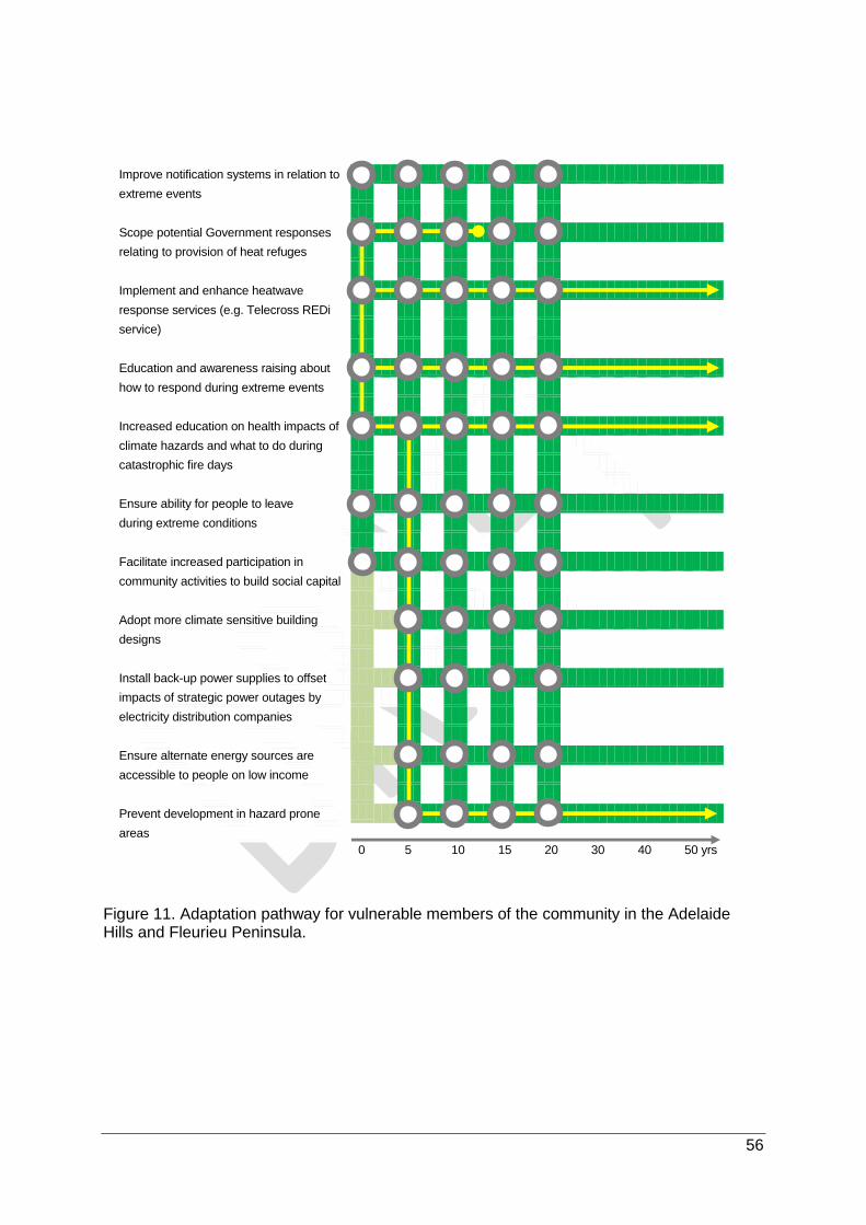
56
Figure 11. Adaptation pathway for vulnerable members of the community in the Adelaide Hills and Fleurieu Peninsula.
Improve notification systems in relation to
extreme events
Scope potential Government responses
relating to provision of heat refuges
Implement and enhance heatwave
response services (e.g. Telecross REDi
service)
Education and awareness raising about
how to respond during extreme events
Increased education on health impacts of
climate hazards and what to do during
catastrophic fire days
Ensure ability for people to leave
during extreme conditions
Facilitate increased participation in
community activities to build social capital
Adopt more climate sensitive building
designs
Install back-up power supplies to offset
impacts of strategic power outages by
electricity distribution companies
Ensure alternate energy sources are
accessible to people on low income
Prevent development in hazard prone
areas
0 5 10 15 20 30 40 50 yrs

57
5.10 Water-dependent ecosystems
Water-dependent ecosystems, such as wetlands and riparian zone communities, are valued
in the Adelaide Hills and Fleurieu Peninsula for the multiple roles they play in supporting
biodiversity, improving water quality and as recreational assets.
Surface water in the region includes numerous minor natural watercourses (e.g. streams and
rivers), man-made watercourses and natural and man-made water bodies (e.g. lakes,
wetlands, reservoirs). The region includes either partially or completely five main river basins:
Torrens River, Onkaparinga River, Myponga River, Fleurieu Peninsula, Lower Murray River,
and Kangaroo Island (Bureau of Meteorology, 2016). These are divided into 10 smaller river
catchment areas. Groundwater resources also supply creeks, rivers and wetlands in the
region.
Of particular note in the region are the:
internationally important (RAMSAR listed) Coorong and Lakes Alexandrina and Albert;
federally listed threatened ecological communities:
o Sub-tropical and Temperate Coastal Saltmarsh (listed as occurring in Alexandrina,
Kangaroo Island, and Victor Harbor local council areas)6; and
o Swamps of the Fleurieu Peninsula (listed as occurring within Alexandrina, Victor
Harbor, and Yankalilla local council areas).
Climate change impacts
Based on the Integrated Vulnerability Assessment (Resilient Hills and Coasts, 2016), when
and how often flows occur and the quality and quantity of water available will have significant
impacts on water-dependent ecosystems. Increasing fire risks, changing seasonal and
annual rainfall amounts, and increasing average temperature as a consequence of climate
change will therefore be particularly important.
The complementary assessment conducted by Natural Resources Adelaide and Mount Lofty
Ranges (West, 2016) suggests that water dependent ecosystems have an inherently high
exposure to climate change due to the amplifying effect of rainfall reductions on water flow.
This is exacerbated by high realised sensitivity and low adaptive capacity due to the reliance
of water dependent ecosystems on specific water regimes.
6 Only temperate (not sub-tropical) coastal saltmarshes occur within the region
Key area of decision-making
How do we protect water-dependent ecosystems given projected declining
rainfall and increasing temperature and fire risk?

58
Priority adaptation options
At a broad landscape scale, water dependent ecosystems will require active to
transformational adaptation, which will require a re-assembling of these systems to maintain
stability and ecological function. Within this broad requirement, immediate priority adaptation
options for the region include (see Figure 12):
supporting landholders to manage native vegetation in water dependent
ecosystems on private properties. This can be achieved through providing incentives.
The Fleurieu Swamps vegetation management guidelines for landholders (Conservation
Council SA, 2011) is an example of the support that can be provided to landholders
needing to manage native vegetation associated with water dependent ecosystems
occurring on private properties ;
adaptive management of protected areas, such as through management of fuel loads
which will be particularly important given the negative impact fire can have on wetlands
but the need to manage loads to protect human life and assets;
identifying and developing functional landscape connections to enable the
movement of aquatic species;
identifying, managing and protecting priority ecological assets (e.g. Fleurieu Swamps,
Deep Creek Conservation Park); and
protecting populations of threatened species (e.g. through seed banking,
translocation, captive population breeding programs).
Within five years, adaptation will also need to focus on:
increasing stormwater harvesting to improve water quality and quantity; and
establishing natural flow patterns, which may require securing low flows or the use of
landscape engineering solutions.
The five year lead time for these options is required to prepare and plan for implementation,
especially re-establishing natural flow patterns, which requires further work and stakeholder
engagement to determine how best to achieve this outcome.
Triggers
The major trigger for greater implementation of adaptation options will be when flow patterns
or water regimes at critical sites drop below thresholds to sustain water dependent
ecosystems. This could also manifest as a shift in vegetation composition in swamps or
wetlands to more terrestrial species. Other triggers could include events such as fire which
lead to the total loss of habitat.
As for other natural landscapes in the region, it is essential that partners in water dependent
ecosystem management in the region invest in anticipatory monitoring and evaluation to

59
detect climatic change impacts and develop conceptual models of likely change and triggers
for different strategies.
Enablers and barriers to adaptation
While the knowledge to facilitate adaptation of water-dependent ecosystems to climate
change exists, the environment is often not adequately prioritised and so adaptation tends to
be inhibited by a lack of funding. Adequately prioritising the environment will need clear
objectives and targets to be made, strong legislative support and advocacy, and a cohesive
cross-agency approach. On-ground uptake of adaptation options will also require buy-in from
land owners which will be influenced by the opinions, values, and actions of their family,
peers and broader community.
Key area of decision-making
Water dependent ecosystems will require active to transformational
adaptation, which may require reassembly to maintain stability and
ecological function. As part of this priority adaptation options include
supporting landholders to manage native vegetation on private properties;
adaptive management of protected areas with a focus on fire; identifying and
developing corridors to enable the movement of aquatic species; identifying,
managing and protecting priority ecological assets; and protecting
populations of threatened species. Within five years adaptation will also need
to consider how to re-establish and manage natural flow patterns, with the
lead time required to determine how best to achieve this outcome.

60
Figure 12. Adaptation pathway for water dependent ecosystems in the Adelaide Hills and Fleurieu Peninsula.
Support landholders managing native
vegetation on private properties
Adaptive management of protected areas
(e.g. manage fuel load)
Identify and develop corridors to enable
the movement of aquatic species
Identify, manage and protect priority
ecological assets (e.g. Deep Creek
Conservation Park, Fleurieu Swamps)
Protect populations of threatened species
(e.g. seed banking, captive population
breeding programs)
Undertake restoration to link and buffer
priority sites
Increase stormwater harvesting to
improve water quality and quantity
Re-establish and manage natural flow
patterns (securing low flows)
Consider landscape engineering solutions
to create natural flow patterns/systems
Acquire land with important
assets
0 5 10 15 20 30 40 50 yrs

61
PART C – KANGAROO ISLAND
This section of the Plan focuses on key areas of decision making that relate to agricultural
productivity, built coastal assets, emergency services management including vulnerable
members of the community, and essential services and transport infrastructure. The NRM
related KADMs are being considered in a parallel process being run by the Kangaroo Island
Natural Resource Management Board.
6 Priority adaptation options
6.1 Agriculture
A number of agricultural industries occur on Kangaroo Island that are highly valued for their
importance to the local economy, including cereal cropping, viticulture, livestock production,
wool industries and honey production. Being separated from the mainland, agriculture on
Kangaroo Island has some unique features which have supported the development of a
strong premium food and wine brand. For example, honey is produced from a near pure
Ligurian strain of bee and the Island is free from many pests and diseases making it an ideal
location to produce seed potatoes.
Climate change impacts
Based on the Integrated Vulnerability Assessment (Resilient Hills and Coasts, 2014b)
declining rainfall will be particularly important for cropping industries, whereas horticulture,
livestock (especially on the eastern end of the Island) and wool industries will be most
influenced by increasing bushfire risk and temperature. Rainfall will impact directly on
pasture production, with potential benefits occurring due to decreased waterlogging, though
the lack of spring rainfall will be especially problematic for finishing off. Comparatively, fire
can directly impact on farm assets (e.g. buildings, plant and equipment), stock and
permanent plantings. Being isolated from the mainland though means that the Island is likely
to be less susceptible to terrestrial dispersed pest and disease threats that may be enhanced
by a changing climate on the mainland. However, given the extensive coastal boundary of
the Island, consideration needs to be given to potential pests and diseases that may arrive
by sea.
Key areas of decision-making
How do we maintain levels of crop, horticulture, and wool production, given
projections of declining rainfall and higher average temperatures?

62
Priority adaptation options
An immediate priority for adaptation is to improve seasonal forecasting, which will require
support from the Bureau of Meteorology and will be an ongoing action into the foreseeable
future (Figure 13). The use of spring and summer seasonal forecasts for planning farm
operations will help growers to plan and better manage operations ahead of time and should
be integrated as part of standard practice (Figure 13). The focus of improved seasonal
weather forecasting for Kangaroo Island needs to include greater emphasis on the accuracy
of both long- and short-term forecasts.
Within five years, a priority for adaptation (and mitigation) will be to start incorporating
carbon sequestration into food based agriculture to a greater degree (Figure 13). On
Kangaroo Island this will primarily focus on increasing soil carbon levels, such as through
addition of biochar or increasing levels of organic matter. Such practices when used as
standard practice over the long-term can assist in retaining moisture and nutrients in the soil
which may assist during drier conditions, but subject to the availability of approved
methodologies, also help to generate carbon credits for sale through emissions reduction
schemes.
Another high priority for primary production on Kangaroo Island is to diversify agricultural
production systems. This will require local evaluation into alternative production systems,
particularly the use of new varieties of crops or pasture to determine what is appropriate to a
different future climate, the selection of livestock suited to seasonal conditions (e.g. shorter
turn off of lighter lambs), and other food/fruit and medicinal plants. Emphasis will need to be
on learning from what is already occurring on the drier parts of the Island and similar
locations elsewhere. Diversification can be aided through involvement of formal and informal
farming groups and support organisations such as Agriculture Kangaroo Island, Rural
Solutions, and the KI NRM Board, as well as off-island industry and research organisations
and individual farmers willing to share their knowledge and initiatives experience. Learnings
and implementation will be an ongoing action (Figure 13).
In addition to new learnings and altered practices, traditional measures such as shelter belts
and windbreaks will still assist with reducing climate-related impacts, such as evaporation
and flooding, and other non-climatic stresses, such as erosion. Building long-term resilience
into agricultural productions systems will be further aided by reducing existing stressors (e.g.
dropping stocking rates at key times) and supporting the natural functioning of surrounding
ecosystems (e.g. through strategic revegetation).
Triggers
There are multiple triggers that could influence when famers on Kangaroo Island start to
increase their adoption of new practices. These could include:
declining rainfall that, for example, may lead to lack of run-off into farm dams for
individual growers or a continued run of dry seasons;

63
declining returns (farm profit) per enterprise and the ability for farmers to access finance;
and
observed declines in natural resources as evidenced by bare, drifting paddocks and
increasing salinity.
Barriers and enablers
Broad-scale uptake of adaptation options on Kangaroos Island will be largely facilitated
through community support (i.e. friends, family, and neighbours) of the options, though such
support may equally inhibit uptake if directed away from the proposed changes. Further
facilitation of options uptake will occur through:
physically demonstrating the benefits of change (e.g. changing farm practices, carbon
trading opportunities) through localised and Island-specific research trials;
hosting field days;
working with farmers to ensure they have confidence in the reliability of information
underpinning the adaptation options;
and, understanding and allaying any risk concerns associated with enacting the options.
It will be important that adaptation options are shown to have clearly considered the
complexities associated with farming on the Island, particularly the interconnectedness of
practices meaning that a single change requires changing many component farming
elements, and also the often exacting market requirements, industry standards and
community expectations which can be challenging to meet on the Island, compared to the
mainland. Another key barrier to agricultural adaptation will occur if adaptation values and
drivers do not align with farming values and drivers for change.
Key points
Adapting agriculture to climate change will require diversifying agricultural
production systems, improved seasonal forecasting, incorporating carbon
sequestration into food based agriculture primarily through increasing soil carbon
and building the resilience of supporting ecosystems.

64
Figure 13. Adaptation pathway for agriculture on Kangaroo Island.
Improve seasonal weather forecasting
Utilise spring and summer forecasts for
planning farm operations
Change sowing/planting schedules to
avoid risky periods (seasonal response)
Adapt stocking rates to seasonal
conditions
Establish long term water plan to utilise
water for golf course for potential farming
and community use
Undertake regionally focussed
independent research to establish
mechanism to decrease the financial
risks of changing farming systems
Incorporate carbon sequestration into
food based agriculture
Undertake local evaluation to investigate
and begin farming new varieties of
existing crops and/or pasture
Improve soil structure and soil health by
changes to farming systems (e.g. cover
crops, subsoil amelioration etc.)
Increase water harvest through graded
catchments and decrease water loss
through evaporation
Improve prices through market
development
0 5 10 15 20 30 40 50 yrs

65
6.2 Built coastal assets
Much of the Kangaroo Island population lives within a short distance of the coastline, making
regular use of built coastal assets. These assets are highly valued by residents and visitors
for recreational and commercial purposes and include roads, buildings, and jetties and
wharves (e.g. Penneshaw, Kingscote, and Vivonne Bay). Notably, most of the Island’s major
settlements are also located on the coast (e.g. Kingscote, Penneshaw).
Climate change impacts
Based on the Integrated Vulnerability Assessment conducted for Kangaroo Island (Resilient
Hills and Coasts, 2014b), sea level rise and subsequent flooding from ocean inundation will
present the greatest climate change threat to the Island’s built coastal assets. This risk will
increase as sea levels rise over the coming century.
Priority adaptation options
Adaptation for built assets in the coastal zone on Kangaroo Island will require the
development and implementation of policy options for existing and future assets in
high risk areas (Figure 14). This policy should consider a portfolio of options, including the
protection of assets, the potential for and appropriateness of compensation, and planning for
potential future relocation. Whilst the development of policies will likely be achieved in the
next 5-10 years, implementation will be ongoing (Figure 14).
Related to the development of policy options is the implementation of guidelines for coastal
management design. These guidelines will become an enabler for action and will be
described in further detail in policy responses for assets in high risk areas. For example, a
guideline may provide information on whether set back distances or floor heights for new
construction works are required.
While identified as potential adaptation responses, abandoning, removing, relocating or re-
purposing built coastal assets, which all involve potentially high economic and/or social costs
and benefits, were considered to be options for future, rather than immediate,
implementation. Of these future options, establishing major hard protection infrastructure
(e.g. sea walls) was considered a last resort. However, if sea level rise occurs more quickly
than has been projected, these options will need to be considered sooner rather than later.
As such, a clear direction on the preferred response strategy should be scoped in the short
term (Figure 14).
Key areas of decision-making
How can built assets along the coast be managed in the face of sea level rise and
coastal inundation?

66
Triggers
A wide range of triggers were identified that could influence when adaptation options are
implemented in coastal areas, including:
extent of sea level rise at which time additional adaptation options should be
implemented;
loss of assets or restricted access because of inundation (e.g. Hog Bay Road being cut
off at Pelican Lagoon; damage to the ferry terminal at Penneshaw);
reduced investment due to the risk of the Island being “cut off' because of inundation
damage to transport and infrastructure;
reduced revenue to local businesses due to decreased tourist visitation because of
transport risks;
major increases in insurance premiums, a refusal to insure and/or difficulty in securing
finance; and
inability to sell real estate because of declining property values or lengthening timeframes
to sell.
Enablers and barriers to adaptation
Although much of Kangaroo Island’s residential, retail, and recreational infrastructure occurs
along its coastlines, the majority do not occur at or close to sea level due to the Island’s
topography. However, where sea level rise does pose risks to infrastructure, there are likely
to be a number of barriers to implementing options to protect built coastal assets. Many of
these are driven by a degree of scepticism in the community regarding the projected impacts
of climate change. This will need to be countered by continued education and awareness
raising about the observed and project impacts of climate change.
Facilitating the uptake of adaptation options on the Island will require the identification of
local community members who will champion the options and “lead the way”. There will also
need to be clear policies on liability (i.e. public versus private – who bears the cost and who
benefits), resources and funding, and development planning and zoning regulations. In
addition, a positive cost-benefit will need to be demonstrated in order to facilitate a proactive
rather than reactive approach.

67
Key points
Adaptation for built assets in the coastal zone on Kangaroo Island will require the
development of policy responses for existing and future assets in high risk areas
and guidelines for coastal management design.

68
Figure 14. Adaptation pathway for built coastal assets on Kangaroo Island.
Develop and implement policies for
assets in high risk areas
Implement guidelines for coastal
management design
Utilise modelling and mapping
to identify assets at risk
Protect and enhance coastal dunes
Re-purpose assets and open space
areas
Establish hard protection infrastructure
Relocate coastal assets (e.g. beach
access, jetties, sailing club)
Abandon or remove assets
0 5 10 15 20 30 40 50 yrs

69
6.3 Emergency management
Kangaroo Island supports extensive natural vegetation highly valued for its biodiversity,
aesthetic, and economic benefits. However, this vegetation also presents significant bushfire
risk to the community and key industries on Kangaroo Island. Emergency services are
provided by SA Police, the Country Fire Service, State Emergency Services and the SA
Ambulance Service. Additional fire-fighting resources external to the Island are at times
required when responding to major bushfire threats. A key focus of emergency management
services on Kangaroo Island are the protection of vulnerable members of the community,
especially those living in major towns or in isolated areas of the Island.
Climate change impacts
Based on the Integrated Vulnerability Assessment (Resilient Hills and Coasts, 2014b),
increasing bushfire risk is a key threat to the Island’s community, infrastructure, economy
and environment. Of particular concern is the risk to vulnerable members of the community
living in high risk locations such as people from low-income households, people with a
disability, and/or people aged over 75 years.
Priority adaptation options
An immediate priority for adaptation is to help prepare for fire events through additional
education and awareness-raising activities. Of particular importance will be: improved early
warning systems when leading in to fire events, which can be facilitated through greater
use of mobile phone apps, for example; and, community messaging around risk and
insurance developed and implemented in partnership with the Insurance Council of
Australia. Such systems should be developed now, but are expected to be readily available
within 10 years and implemented (and upgraded as necessary) into the foreseeable future
(Figure 15).
A key aspect of adaptation for emergency management on Kangaroo Island will be "whole-
of-island” vegetation management planning, with a particular focus on fire being
managed in order to strike a balance between biodiversity and fuel load reduction outcomes.
While increasing functional connectivity for plant and animal species across the landscape
Key areas of decision-making
How can we better protect natural environments, farming assets and built
infrastructure against more frequent and intense bushfires, particularly given the
limited residential volunteer pool coupled with geographic isolation from the
mainland?
How can we maintain the well-being of vulnerable members of the community given
the increasing risk of extreme conditions such as heatwaves and bushfires?

70
will serve to build the resilience of ecosystems, this will require identification of “pinch points”
that stop the spread of fire. Proactive planning of this type will also help to indicate what level
of resourcing is needed to conduct prescribed burns.
Further adaptation options identified that were considered to have high benefit compared to
costs include:
amending development planning to ensure that no community facilities are constructed in
significantly fire prone areas or areas that are difficult to access during a fire. This can be
complemented by educating members of the community about the consequences of
where they choose to live and the type of home they construct or live in; and
facilitating increased volunteerism through targeted and innovative campaigns.
Triggers
It is anticipated that a 50% increase in severe fire risk on Kangaroo Island will likely lead to
an accelerated implementation of new adaptation measures, and will include amendments to
planning and policy. Other triggers will be the consequences of low volunteer numbers being
available to assist in fire management (e.g. west end of the Island) and a lack of compliance
with legislation and regulations leading to greater fire risk and impacts (which will drive policy
change).
Enablers and barriers to adaptation
The Kangaroo Island community is intimately aware of the bushfire threat on the Island and
the need to implement adaptation options to protect against bushfires. Despite this
awareness, there is a lack of understanding regarding the management of prescription burns,
which will continue to be a key adaptation option. Continued awareness raising about how
these are designed and managed is paramount.
Despite a regulatory framework being in place and legislative responsibilities assigned, a
barrier to effective fire management is that the landholder carries the risk of prescribed burns
on private land, which is a disincentive to action, together with cost of preparing a fire
management plan and having resources on hand to control the fire.
Key points
Adaptation options for emergency management that will also assist in protecting
vulnerable members of the community involve "whole of island” vegetation
management planning to reduce fire risk, community messaging around risk and
insurance developed in partnership with the Insurance Council of Australia, and
improved early warning systems leading into fire events.

71
Figure 15. Adaptation pathway for emergency management on Kangaroo Island.
Improve and implement early warning
systems for flood and fire
Develop and implement community
messaging for risk and insurance
Whole of island vegetation management
planning
Community education prior to extreme
events about preparation and response
Increase enforcement and compliance
including increasing penalties
Research to develop more localised forecasting and triggers for extreme heat plan
Facilitate increased volunteerism
Move vulnerable people out of high
risk areas
Prevent construction of community
facilities in fire prone areas
Regulate residential development
in high risk areas
0 5 10 15 20 30 40 50 yrs

72
6.4 Essential services and transport infrastructure
The condition and performance of energy and telecommunications services is highly valued
on Kangaroo Island. However, there are existing concerns about the effectiveness of this
infrastructure. Access to both is essential for people maintaining contact within the
community and the mainland, for the operation of businesses and coordinating resources
during emergencies. Energy on Kangaroo Island is predominantly from conventional sources
delivered by an undersea cable from the mainland. However, some renewables do exist,
such as a dual-axis solar array system installed at the Kangaroo Island Airport plus a 14 kW
solar system installed at the Kingscote Town Hall, as part of the Island’s Visible Solar Project
(Kangaroo Island Council, 2014). There is also widespread community support for much
greater use of renewables to power Kangaroo Island in the future.
Roads on Kangaroo Island provide critical access to remote locations and services, facilitate
delivery of supplies, and are a key asset in supporting the agriculture and tourism industries.
The majority of roads on the Island are unsealed and maintained by Kangaroo Island
Council.
Climate change impacts
Climate change-induced increases in temperatures, heatwaves, and bushfires will increase
the demand for essential services, cause a higher number of black-out periods, and increase
the risk of physical damage to associated infrastructure (Resilient Hills and Coasts, 2014b).
This will in turn have a negative impact on the community and business on the Island.
Sea level rise, and increasing rainfall intensity, heatwaves and temperatures will also
negatively impact the condition of roads. Potential increased tourism, resulting from warmer
and longer fine weather conditions may also increase the wear and tear on roads. Future
flood damage is of major concern for unsealed roads in the wake of flooding in the
MacGillivray/Haines area of Kangaroo Island since June 2013, where the estimated damage
bill is more than Kangaroo Island Council’s total rates revenue.
Key areas of decision-making
How can the condition and performance of energy and telecommunications
networks be improved given the expected increasing frequency and intensity of
extreme climatic events such as heatwaves and bushfires?
How can the condition of sealed and unsealed roads be managed in the face of
altered climate conditions such as increasing rainfall intensity and sea level rise, as
well as increasing use?

73
Priority adaptation options
An immediate priority for adaptation of transport infrastructure on Kangaroo Island is to
identify points of vulnerability in the sealed and unsealed road network through
development of a roads database. This will identify points in the network to vulnerable to
flooding (e.g. MacGillivray/Haines) and/or fire. To do this, further flood modelling will need to
be undertaken for inland areas of the Island and the current understanding of coastal
evacuation requirements for small towns, such as Vivonne Bay, will need to be improved.
Identifying such points is not considered to be an ongoing requirement, rather it is likely to be
able to be completed within 5 years of commencement (Figure 16).
Another adaptation option that applies to all essential services and transport infrastructure on
Kangaroo Island will be to make design allowances for increases in extreme events,
such as fire and flood and extended periods of warmer and drier conditions (Figure 16). This
option, which is considered important to implement within the next five years, will primarily be
the responsibility of Kangaroo Island Council and needs to include allowances for strategic
road upgrades requiring vegetation clearance, raised road levels or re-routing (where
necessary) to allow for storm surge in some coastal locations, improved road drainage, and
stormwater management infrastructure upgrades. However, consideration must be taken
regarding potential maladaptive actions, such as the removal of roadside vegetation which
may lead to increased erosion and infrastructure.
Additional analysis is required to clarify priorities amongst the following adaptation options: a
strategic transport plan considering future transport modes and demands; more frequent
bitumen resealing in response to temperature induced oxidation; provision of additional
resources for alternative exit/entry points on farms; strategic freight depots in regions for
livestock and grain that link with collector freight roads; and, strategic water storage points
across the Island for road works and maintenance.
While energy infrastructure upgrades can make design allowances for future climate risks,
further work is also required to determine whether the majority of Kangaroo Island’s energy
will continue to come from the mainland via the undersea cable or whether alternative power
supplies can be generated, such as from solar, wind, tidal or biomass energy generation
(EconSearch, 2013).
Although not identified as priorities during the development of this Plan, further consideration
should also be given to ecosystem-based adaptation options such as maintaining and
restoring seagrass beds to reduce coastal wave energy and storm surge impacts, and
protecting and revegetating coastal dune and beach areas to reduce on-shore coastal
erosion. These responses provide a mixture of social, economic and environmental benefits.

74
Triggers
A key trigger for implementing adaptation options for transport infrastructure will be the
community pressure resulting from damage to roads caused by extended dry conditions,
major floods, access issues during bushfires and storm surge. For energy, a trigger will be
the point at which demand growth exceeds the supply capacity of the existing undersea
cable or when local distributed power solutions (e.g. solar PV) are at cost parity with
traditional sources.
Enablers and barriers to adaptation
Although improved design standards are available, and their benefits known, implementing
such options on Kangaroo Island could be impeded by a lack of clarity with regard to cost-
benefits, water resources management policy implications, and nuances of the Island
compared to the mainland (i.e. approaches implemented on the mainland may not be the
best for Kangaroo Island). This will need to be addressed through continue education and
awareness raising, especially in relation to cost-benefit analysis results.
In addition, adaptation options involving new technologies will require dedicated community
education and engagement strategies to gain support for on-ground implementation. The
impacts of short-term political cycles on long-term planning, delivery and monitoring of
adaptation requirements will also need to be overcome in order to successfully implement
options.
Key points
A priority adaptation option for transport infrastructure on Kangaroo Island is to
identify points of vulnerability in the sealed and unsealed road network. A further
option that applies to all essential services and transport infrastructure will be to
make design allowances for increases in extreme climatic events. This is also
important in underpinning provision of emergency services on the Island.

75
Figure 16. Adaptation pathway for essential services and transport infrastructure on Kangaroo Island.
Identify points of vulnerability in the
road network
Create wider corridors near powerlines
or substations
Investigate internal capacity building
regarding the impacts of climate change
on assets and procurement
Incorporate design allowances for
increases in extreme events
Seal currently unsealed roads to protect
against stormwater damage
More frequent bitumen resealing and use
of alternate road sealing surfaces
Develop strategic water and freight points
across the Island
Develop alternate entry and exit points
on farms
Renew the undersea power cable
Develop alternative energy solutions
on the Island
Investigate alternate road sealing
surfaces
0 5 10 15 20 30 40 50 yrs

76
PART D – THE REGION
7 Implementing the Plan
7.1 Regional priority adaptation options
Part B and C of this Plan presented priority adaptation options for key sectors in the Adelaide
Hills, Fleurieu Peninsula and Kangaroo Island on the basis of subject matter expert and
stakeholder engagement and additional analysis. However, a further aim of this Plan is to
identify regional priority adaptation options that are relevant to multiple sectors and partner
organisations.
Regional priorities were identified using a three step prioritisation process, involving
qualitative cost-benefit analysis, assessment of regional relevance, and consideration of the
practicality of implementation (see Section 4.2 for further details). A summary of the
relevance of regional priority options to the different key areas of decision making is provided
in Error! Reference source not found..
The regional adaptation priorities for the Adelaide Hills, Fleurieu Peninsula and Kangaroo
Island are as follows:
Adaptive management of protected areas on public lands
This option will need to be led by Natural Resources Adelaide and Mount Lofty Ranges and
the Department of Environment, Water and Natural Resources, working closely with local
government to manage community concerns where public lands are in close proximity to
towns and private land. As the climate changes there will be a need to continually learn from
how the environment in the region responds. This will require adaptive management of
protected areas on public lands, with a focus on managing fuel loads. The emphasis on fuel
loads will become increasingly important as fire risk increases and the community seeks to
balance maintenance of environmental values and ecosystem services with public health and
safety concerns.
This option was assessed as having high social benefits because of improved fire
management, but also moderate economic (avoided losses and impacts) and moderate
environmental benefits. Social and environmental costs were assessed as low, but economic
costs moderate because of the costs of implementing such a strategy.
Responsibility: Department of Environment, Water and Natural Resources, local government
(six regional councils)

77
Climate-ready guidelines for public realm and green infrastructure
For communities and business to continue to thrive in the region, public realm and streets
need to adapt to changing conditions, especially increased periods of extreme heat, greater
fire risk and greater flood risk from intense rainfall. Preparing and commencing
implementation of ‘climate-ready’ guidelines for public realm and streetscape management
will include appropriate material and tree species selection, shade coverings, inclusion of
water sensitive urban design features, and opportunities for misting infrastructure.
This option was assessed as having high social benefits because of improved public spaces
that are better adapted to a changing climate (e.g. increasing extreme heat), but also
moderate economic (enhanced attractiveness of retail and business precincts) and moderate
environmental benefits. Social and environmental costs were assessed as low, but economic
costs moderate because of the costs of developing and starting to implement the guidelines.
Responsibility: Local government (six regional councils)
Diversification of agricultural activities
Climate change will lead to warmer and drier conditions in the RH&C region, and without
adaptation will lead to declines in agricultural productivity. Likely increasing fire incidence is
also likely to lead to damage to stock and farm plant and equipment. However, the milder
existing conditions in the region mean that other parts of South Australia already have a
similar climate to what the RH&C region will experience in the future. As such, diversification
of agricultural activities can focus on investigating different varieties and types of crops and
pasture, and livestock and livestock management practices, from warmer and drier parts of
the state. This is an adaptation option that has low social, economic and environmental cost
but high benefit.
This option was assessed as having high social and economic benefits because of the
importance to people’s livelihoods and the region’s economy of maintaining agricultural
production in the region. Social, economic and environmental costs were assessed as low.
The economic costs could be higher though depending on the extent to which growers and
industry groups choose to invest into information dissemination and capacity building.
Responsibility: Farming systems groups, industry associations, Primary Industries and
Regions South Australia, Regional Development Australia Adelaide Hills, Fleurieu and
Kangaroo Island
Develop more energy efficient housing
While the RH&C region is already at an advantage compared to other parts of South
Australia because of its comparatively cooler climate, climate resilient buildings will be more
suited to the warmer and drier conditions that will emerge in the future. A major element of
climate resilient buildings will be energy efficient building materials and fixtures. These can

78
be supported through government incentives, but will also benefit from local government
advocating development of such materials, working with the development industry (e.g.
builders, developers, manufacturers) and research institutes.
This option was assessed as having high social benefits because of reduced cost of living
pressures and the creation of more climate-ready housing that will improve health and well-
being. The economic benefit was assessed as moderate because of the opportunity to
stimulate economic activity while the economic cost was low because the primary role of
local government is as an advocate and facilitator of change.
Responsibility: Local government (six regional councils), Regional Development Australia
Adelaide Hills, Fleurieu and Kangaroo Island
Incorporate infrastructure design allowances for increases in extreme events
Infrastructure in the region provides essential (electricity, potable water supply), water
management and transport services. Current infrastructure has been designed for existing
climate conditions, however, these will change in the future as periods of extreme heat
increase, fire risk becomes higher, and the risk of flooding in the coastal zone and inland
increases. A regional adaptation priority is for local government in particular to ensure that
new and renewed infrastructure is designed to cope with increases in extreme events. The
goal is for this to become a business as usual activity. This is important given that the
operational lifetime of many assets will be in excess of 50 years, meaning that the climate in
2070 needs to be considered. The rapid growth of the region’s population means that new
infrastructure in particular can include design allowances for extreme events.
This option was assessed as having high economic costs and benefits because of the cost of
construction infrastructure to new specifications but also the benefits from avoided costs
because of infrastructure failure in the long term. Improved continuity of service provision in
the future results in a high assessed social benefit.
Responsibility: Local government (six regional councils), Department of Planning, Transport
and Infrastructure, Regional Development Australia Adelaide Hills, Fleurieu and Kangaroo
Island
Improved management of native vegetation on private properties
While vast areas of remnant vegetation exist on protected public lands, important vegetation
and habitats also exist on private property. A future adaptation priority across a range of
landscape types in the region (e.g. plains, flanks, uplands and water dependent ecosystems)
is therefore to support landholders managing native vegetation on private properties, where
possible through the use of well-funded incentives. This will require leadership from private
landholders and support from Natural Resources Management Boards and the Department

79
of Environment, Water and Natural Resources, with the latter providing incentives for
improved management.
This option was assessed as having high environmental and moderate social benefits,
because of improvements in ecosystem condition and health and well-being of the
community, respectively. In contrast, the economic costs and benefits were both assessed
as moderate.
Responsibility: Natural Resources Adelaide and Mount Lofty Ranges and the Department of
Environment, Water and Natural Resources
Restricting development in hazard prone areas
In order to reduce impacts on people and infrastructure, a key adaptation strategy in the
region will be to prevent or restrict development in hazard prone areas. This includes areas
at risk from sea level rise along the coast, bushfires inland and infrastructure and dwellings at
risk from flooding following intense rainfall events. Local government will work together on
modelling and mapping projects to identify areas at high risk and implement policy and
development plan amendments. This response may take some time to gain community
support, however, in the long term it will avoid impacts on people and reduce the costs
associated with protecting or relocating assets and people.
Because restricting development in hazard prone areas will require a range of actions in
order to meet its objectives (e.g. mapping, modelling, policy review), consideration should be
given to how implementation is sequenced, specifically determining what actions are
required immediately and what can be delayed for delivery in five or more years’ time.
This option was assessed as having high social and economic benefit because of avoided
impacts on community health and well-being and reduced damage and costs of repair for
residential and commercial buildings, infrastructure (e.g. transport, water management) and
essential services.
Responsibility: Local government (six regional councils), Department of Planning, Transport
and Infrastructure, Coast Protection Board
Increase stormwater harvesting to improve water quantity and quality management
Water will continue to be essential for the health and well-being of the community, economic
prosperity and environmental condition in the RH&C region. With rainfall seasonality, quantity
and intensity projected to change, greater emphasis is required on water quality
management, especially in relation to stormwater. Managed well, stormwater can be a
resource to support different sectors in the region, but if managed poorly, it could have a
significant negative impact on wetlands and coastal ecosystems. Water quality improvement
80
will require continued investment in water sensitive urban design, stormwater retention areas
and water recycling.
This option was assessed as having high environmental and high social benefits but low
respective costs because of the improved management of flood risk and water quality. In
contrast, the economic costs and benefits were both assessed as high because of high
construction costs on the one hand and avoided costs from flood damage on the other.
Responsibility: Local government (six regional councils), Natural Resources Adelaide and
Mount Lofty Ranges, Water Sensitive SA
In addition to the regional priority adaptation options described above, consideration of the
triggers, enabling conditions and barriers for decision making suggest that the following two
actions are also regional priorities:
Anticipatory monitoring and evaluation – This Plan identifies a range of triggers that will
either inform or drive decision making for climate change adaptation in the region. While
many of the triggers are reactive, a proactive approach to informing decision making is also
required. As such it is essential that partners in the region invest in anticipatory monitoring
and evaluation to detect climatic change impacts and develop conceptual models of likely
change and triggers for different strategies. This links strongly with the adaptation pathways
approach whereby the results of such monitoring can better inform when adaptation options
should commence implementation.
Responsibility: Local and state government, RDA Adelaide Hills, Fleurieu Peninsula and
Kangaroo Island, industry groups.
Education and awareness raising – The need to better inform the community and
businesses about the broad range of potential impacts of climate change was considered for
almost all of the key areas of decision making. While it was assessed as an adaptation
option in its own right, it is also an essential enabler of many of the high priority options
identified in this Plan. Education and awareness raising should be progressed through the
development of a Resilient Hills and Coasts education and awareness raising program that
works across the community and businesses.
Responsibility: Local and state government, RDA Adelaide Hills, Fleurieu Peninsula and
Kangaroo Island, industry groups.

81
Table 3. Alignment of regional priority adaptation options for key areas of decision making.
Regional priority adaptation options
Key area of decision making themes
Infr
astr
uctu
re
an
d a
ss
ets
Ag
ricu
ltu
re
Pu
blic
co
asta
l
assets
Clim
ate
-
read
y
bu
ild
ing
s
Em
erg
en
cy
man
ag
em
en
t
Co
mm
un
ity
facilit
ies a
nd
op
en
sp
ac
e
Vu
lnera
ble
mem
bers
of
co
mm
un
ity
Wate
r
dep
en
den
t
eco
sy
ste
ms
Co
asta
l
eco
sy
ste
ms
Natu
ral
lan
dscap
es
Adaptive management of protected areas on public lands
x x
x x x
Climate-ready guidelines for public realm and streetscape management
x
x x x x x
Diversification of agricultural activities
x
x
Energy efficient housing x
x
Incorporate design allowances for increases in extreme events
x
x x x x x
Managing native vegetation on private properties
x
x
x x x
Restricting development in hazard prone areas
x
x x x x x
x x
Water quality improvement measures through improved stormwater management and harvesting
x x
x x x
x x x

82
7.2 Opportunities
Whilst the region faces significant challenges in adapting to climate change, it is better
placed than many other regions in the State due to its naturally cooler climate and diversity of
industries, tourism attractions and amenities across the region. Another important factor for
the region is that the population is expected to grow further, especially in locations such as
Mount Barker, Victor Harbor and Goolwa (Resilient Hills and Coasts, 2014a).
These drivers present opportunities in responding to a changing climate. For example, the
preferable climate and increasing population could stimulate business activity such as in the
construction and service sectors. This could lead to opportunities such as:
encouraging the development of low carbon communities with housing that is energy and
water efficient and resilient to climate change;
incorporating “climate-ready” design principles into new buildings and essential services
infrastructure; and
increasing interest in green infrastructure for residential developments.
In addition, the region offers a diversity of tourism experiences, which present greater
resilience to a changing climate. For example, summer tourism based on coastal attractions
is still likely to be popular because of the comparatively lower temperatures experienced on
the Fleurieu Peninsula compared with metropolitan Adelaide. However, even if tourism was
to decline during the summer period as a consequence of greater periods of extreme heat
and more frequent fire risk days the region still offers tourism experiences during other
seasons e.g. autumn leaves/gardens festivals, winter bed and breakfast getaways.
With climate change responses in South Australia now focusing on both adaptation and low
carbon economic growth, the Resilient Hills and Coasts is well positioned to build resilience
to a changing climate by implementing the adaptation options identified in this Plan, as well
as benefit from climate change mitigation opportunities that will be associated with greater
adoption of climate-ready housing, installation of new energy infrastructure (e.g. solar PV),
diversifying agricultural activities to include soil carbon sequestration and investing in natural
landscape restoration (e.g. through revegetation).
7.3 Periodic review
Over time and as the climate changes more information will become available on the impacts
on key sectors in the region and possible opportunities. This will mean that adaptation
options will require periodic review, resulting in some options ceasing to be implemented,

83
while others not currently considered a priority will commence. New options will also emerge.
Reviews can be designed to coincide with regional partner planning review timeframes, the
emergence of significant new understanding or innovation, or the availability of new climate
projection data from the IPCC, which occurs about every five to six years.
Periodic review can be aided through the development of indicators to determine the extent
to which priority adaptation options are being implemented, and whether triggers for decision
making are being met. Developing such indicators can build on the triggers identified for
each of the individual key areas of decision making themes. This will likely involve a
combination of climate (e.g. average temperature, annual rainfall, extreme heat, sea level,
number of severe or worse fire danger days) and system related indicators (e.g. condition of
infrastructure and property damage, condition of ecosystems, hospital admissions).
Future reviews should also consider when adaptation will need to move beyond continuing
with existing best practice and moving toward greater transformational responses, such as
may be the case where people or infrastructure will need to be relocated in high risk areas.
Acknowledging that both information and impacts will change, the response to the changing
climate will need to be adaptive. It is recommended that climate change indicators, impacts
and progress toward implementation of actions be reviewed at least every two years. The
governance of this arrangement will need to be resolved, and the potential for a Regional
Sector Agreement may be one way to ensure ongoing monitoring and evaluation.
7.4 Alignment with adaptation in the South Australian Murray-
Darling Basin
Alexandrina Council and the District Council of Mount Barker Council overlap with parts of
the South Australian Murray-Darling Basin Natural Resources Management Region, meaning
that comparison of adaptation priorities in this neighbouring region are warranted.
The climate change adaptation plan for the South Australian Murray-Darling Basin (SA MDB)
called “Building Resilience to a Changing Climate” (Siebentritt, et al., 2014) was released in
2014 and was informed by past studies and reports relevant to climate change in the region
as well as the experience and local knowledge of stakeholders, with over 150 people
participating in interviews, workshops and information and feedback sessions.
The project followed a similar process to the development of the RH&C Adaptation Plan,
involving values mapping, an integrated vulnerability assessment and identification and
prioritisation of adaptation actions within and between sectors.

84
There is strong alignment between the SA MDB Plan and this Plan, with the former’s key
area of decision making themes being:
native vegetation;
pest plants and animals;
Coorong and Lower Lakes;
vulnerable members of the community;
emergency services;
essential services;
irrigation; and
dryland farming:
The primary difference between the plans is the focus on water management for irrigation
and the environment as it relates to the River Murray in the Murraylands and Riverland
areas.
The priority adaptation options from the SAMDB Adaptation Plan that most directly align with
the RH&C region, and where opportunities may exist to collaborate for relevant RH&C
partners, include:
Native vegetation - support and promote landholders managing high value native
vegetation on private properties;
Coorong and Lower Lakes - commence social engagement to increase community
awareness and to promote informed debate about the future adequacy, operation and
location of the Barrages;
Vulnerable members of the community - help vulnerable members of the community be
better prepared for extreme events by building social capital (connectivity and resilience)
and encouraging the construction of more climate resilient buildings;
Emergency services management - facilitate increased rates of volunteerism;
Essential services - develop adaptive infrastructure for local solutions to backup and
power storage for water, sewer and telecommunications infrastructure, as well as
domestic storage to support distributed power systems like solar photovoltaic (PV); and
Dryland (rain dependant) farming - no till or reduced till practice, crop breeding and soil
improvement where applicable and cost effective should continue to be encouraged.
None of the adaptation priorities identified in the SA MDB Adaptation Plan are considered to
be maladaptive in relation to RH&C priorities.

85
7.5 Next steps
As climate change continues to increase in its magnitude and impact across the globe there
is a need for rapid decarbonisation and significantly increased carbon sequestration. At the
same time, local and regional communities and businesses need to start to adapt to a
different future climate; a climate that, in many instances, will be very different to what is
currently being experienced.
This Plan has outlined sector-specific adaptation priorities as well as regional scale
adaptation priorities that deliver a combination of social, economic and environmental
benefits and that are relevant to all project partners. In addition to implementing these priority
options the next steps in successfully implementing Plan requires the following:
Momentum
o Project partners recognise that maintaining momentum as the project transitions
from planning to implementation is a critical factor in ensuring its success in
building resilience and enabling adaptation.
o Partners have committed to a 12-month implementation phase to transition from
planning into action.
Localising action
o The plan is focussed on a regional perspective, and during the next stage, the
RH&C steering committee will collaborate with a range of partners to implement
regional priorities identified in the plan.
o Utilising the knowledge and data accumulated during the regional planning
process, it is intended that each of the local council areas will produce a local
action plan to guide tailored, sub-regional action.
o Each of the local government partners is committed to working with their
communities to localise climate change adaptation planning and action in
alignment with relevant regional priorities identified herein.
Responsive project management
o Reflecting on the learnings emerging from the project to date, there will be a focus
on informing future decision-making.
o Reviewing and, where necessary, enhancing governance arrangements to ensure
that project governance is aligned with the aspirations and priorities of the next
phase.
o Establishing and implementing a framework for monitoring and evaluating
progress against priorities.

86
Guarding against maladaptation
o While the Plan has a clear list of priority adaptation options, climate change
adaptation must also consider what decisions are being made in general across
the region and whether these are maladaptive, that is, reducing adaptive capacity
of the community or businesses.
Strengthening engagement and partnerships
o Project partners are committed to expanding and strengthening engagement and
collaboration across the region, not only with each other, but with community,
industry, business, education and government sectors.
Flexibility and revision
o Climate change projections will continue to be reviewed and refined as the climate
continues to change and actions are taken locally and globally to mitigate
emissions and slow the rate and magnitude of change.
o At the same time, new technologies and experiences from around the globe will
influence how we respond to climate change impacts, including how climate
change impacts interact with other global challenges such as food security.
o The project partners recognise that the current Plan is based on the best available
scientific knowledge and practical stakeholder knowledge at the time of the
workshops and writing, and that adaptation actions and priorities may need to
change in the future as scientific and technological advances occur, and we
continue to learn from our own and others’ experiences.

87
8 References Bureau of Meteorology, 2016. Topographic drainage divisions and river regions. [Online]
Available at: http://www.bom.gov.au/water/about/riverBasinAuxNav.shtml
Bureau of Meteorology, 2016. What are El Niño and La Niña Events?. [Online]
Available at: http://www.bom.gov.au/climate/enso/history/ln-2010-12/ENSO-what.shtml
[Accessed 2016].
Conservation Council SA, 2011. Swamp Management Guidelines for the Fleurieu Peninsula,
South Australia: Conservation Council SA.
CSIRO and Bureau of Meteorology, 2015. Climate Change in Australia Information for
Australia's Natural Resource Management Regions: Technical Report, Australia: CSIRO and
Bureau of Meteorology.
EconSearch, 2013. Appendix 1: Socio-economic profile for the Adelaide Hills Fleurieu and
Kangaroo Island Regional Development Australia Region. In: Regional Development
Australia Adelaide Hills Fleurieu and Kangaroo Island 2013-2016 Regional Roadmap. South
Australia: Report prepared for Regional Development Australia Board Adelaide Hills, Fleurieu
and Kangaroo Island Regional Development Australia.
Hope, P. et al., 2015. Southern and South-Western Flatlands Cluster Report, Climate
Change in Australia Projections for Australia’s Natural Resource Management Regions:
Cluster Reports. In: M. Ekstrom, et al. eds. Australia: CSIRO and Bureau of Meteorology.
IIASA, 2009. RCP Database. [Online]
Available at: http://tntcat.iiasa.ac.at:8787/RcpDb/dsd?Action=htmlpage&page=welcome
[Accessed 2015].
IPCC, 2013a. Summary for policymakers. In: T. F. Stocker, et al. eds. Climate change 2013:
the physical science basis. Contribution of Working group I to the fifth assessment report of
the intergovernmental panel on climate change. Cambridge, United Kingdom and New York,
NY, USA: Cambridge University Press.
IPCC, 2013b. Annex III: Glossary [Planton, S (ed)]. In: T. Stocker, et al. eds. Climate Change
2013: The Physical Science Basis. Contribution of Working Group I to the Fifth Assessment
Report of the Intergovernmental Panel on Climate Change. Cambridge, UK; New York, USA:
Cambridge University Press.

88
IPCC, 2014. Climate Change 2014: Synthesis Report. Contribution of Working Groups I, II
and III to the Fifth Assessment Report of the Intergovernmental Panel on Climate Change.
[Core Writing Team, R.K. Pachauri and L.A. Meyer (eds.)], Geneva, Switzerland: IPCC.
IPCC, 2016. Fifth Assessment Report (AR5). [Online] Available at:
https://www.ipcc.ch/report/ar5/ [Accessed 2015].
Kangaroo Island Council, 2014. Clean and Green Island Gets a $500,000 Solar Boost. Media
Release, 10 February 2014. Visible Solar Project – File 16.15.7., Kangaroo Island Council,
South Australia.
Mt Barker District Council, 2015. Mt Barker 2035 District Strategic Plan.
Resilient Hills and Coasts, 2014a. Knowledge audit for the Adelaide Hills, Fleurieu and
Kangaroo Island RDA Climate Change Adaptation Plan, South Australia: Prepared by Seed
Consulting Services and URPS as part of the Resilient Hills and Coasts cosultancy led by
Seed Consulting Services for Regional Development Australia Adelaide Hills, Flerieu and
Kangaroo Island.
Resilient Hills and Coasts, 2014b. Integrated Vulnerability Assessment for Kangaroo Island,
Prepared by Seed Consulting Services for Natural Resources Kangaroo Island.
Resilient Hills and Coasts, 2015. Climate Change Projections for the Adelaide Hills, Fleurieu
Peninsula and Kangaroo Island, South Australia: A report prepared for Alexandrina Council
on behalf of project partners by Seed Consulting Services.
Resilient Hills and Coasts, 2016. Integrated Vulnerability Assessment Report for the Adelaide
Hills and Fleurieu Peninsula, A report prepared for Alexandrina Council by Seed Consulting
Services and URPS.
SA Water, 2014. Reservoirs - Overview. Government of South Australia.. [Online] Available
at:
http://www.sawater.com.au/SAWater/WhatsNew/WaterDataUpdate/ReservoirData/default.ht
m
Siebentritt, M. A., Halsey, N., Meyer, W. & Williams, R., 2014. Building resilience to a
changing climate in the South Australian Murray-Darling Basin. A Climate Change
Adaptation Plan for the South Australian Murray-Darling Basin, Prepared for the South
Australian Murray-Darling Basin Natural Resources Management Board.
Siebentritt, M. A. & Stafford-Smtih, M., In review. Applied Adaptation Pathways User Guide ,
CSIRO and Seed Consulting Services.

89
Thomas, D., Hayman, P. and Bachar, Z. 2016. A Comparative Climate Vulnerability
Assessment for Key Agricultural Industries in the Adelaide and Mount Lofty Ranges Natural
Resource Management Region. Prepared for Natural Resources Adelaide and Mount Lofty
Ranges.
URPS, 2014. Adelaide Hills, Fleurieu and Kangaroo Island Climate Change Adaptation
Regional Profile, South Australia: Report prepared for Seed Consulting Services.
West, A., 2016. Climate Change and Biodiversity Landscape Scenario Assessment for the
Resilient Hills and Coasts Region, Adelaide: Natural Resources Adelaide and Mount Lofty
Ranges, Department of Environment, Water and Natural Resources.

90
9 Glossary Unless stated otherwise, all definitions are from IPCC (2013a; 2014).
Adaptation - The process of adjustment to actual or expected climate and its effects. In
human systems, adaptation seeks to moderate or avoid harm or exploit beneficial
opportunities. In some natural systems, human intervention may facilitate adjustment to
expected climate and its effects.
Incremental adaptation Adaptation actions where the central aim is to maintain the
essence and integrity of a system or process at a given scale.
Transformational adaptation Adaptation that changes the fundamental attributes of
a system in response to climate and its effects.
Aerosol - A suspension of airborne solid or liquid particles, with a typical size between a few
nanometres and 10 μm that reside in the atmosphere for at least several hours. Aerosols
may influence climate in several ways: directly through scattering and absorbing radiation
and indirectly by acting as cloud condensation nuclei or ice nuclei, modifying the optical
properties and lifetime of clouds.
Atmosphere - The gaseous envelope surrounding the Earth.
Baseline/reference - The baseline (or reference) is the state against which change is
measured.
Climate - Usually defined as the average weather, or more rigorously, as the statistical
description in terms of the mean and variability of relevant quantities over a period of time
ranging from months to thousands or millions of years.
Climate change - Climate change refers to a change in the state of the climate that can be
identified (e.g., by using statistical tests) by changes in the mean and/or the variability of its
properties, and that persists for an extended period, typically decades or longer.
Climate change in Australia (CCIA) – a national-focused climate change project released
in February 2015 and led by the CSIRO and Bureau of Meteorology (CSIRO and Bureau of
Meteorology 2015).
Climate model (spectrum or hierarchy) - A numerical representation of the climate system
based on the physical, chemical and biological properties of its components, their
interactions and feedback processes, and accounting for some of its known properties.
Climate variability - Climate variability refers to variations in the mean state and other
91
statistics (such as standard deviations, the occurrence of extremes, etc.) of the climate on all
spatial and temporal scales beyond that of individual weather events.
Emission scenario - A plausible representation of the future development of emissions of
substances that are potentially radiatively active (e.g., greenhouse gases, aerosols) based
on a coherent and internally consistent set of assumptions about driving forces (such as
demographic and socioeconomic development, technological change) and their key
relationships.
Greenhouse gas - Greenhouse gases are those gaseous constituents of the atmosphere,
both natural and anthropogenic, that absorb and emit radiation at specific wavelengths within
the spectrum of terrestrial radiation emitted by the Earth’s surface, the atmosphere itself, and
by clouds.
Global climate model (GCM) – also called general circulation models are mathematical
representations of the climate system which explicitly represent large-scale synoptic features
of the atmosphere (CSIRO and Bureau of Meteorology 2015).
Integrated vulnerability assessment (IVA) – a process used to assess the likelihood (or
exposure) and consequence (or sensitivity) of climate change impacts on key issues, as well
as assessing the adaptive capacity of issues in order to ensure a full understanding of
vulnerabilities (Local Government Association of South Australia 2015).
Key Area of Decision Making - An area of decision-making in an organisation, sector or
region within which adaptation options may be needed to manage the impacts of climate
change on an asset, value or service (Siebentritt and Stafford-Smith in review).
McArthur Forest Fire Danger Index (FFDI) - The McArthur Forest Fire Danger Index
(FFDI) is widely used to forecast the influence of weather on fire behavior. FFDI is based on
the temperature (˚C), T, wind speed (km h-1), v, relative humidity (%), RH, and a component
representing fuel availability called the Drought Factor (Dowdy et al. 2009).
Mitigation - A human intervention to reduce the sources or enhance the sinks of greenhouse
gases.
Projection - A projection is a potential future evolution of a quantity or set of quantities, often
computed with the aid of a model. Unlike predictions, projections are conditional on
assumptions concerning, for example, future socioeconomic and technological
developments that may or may not be realized.
Radiative forcing - Radiative forcing is the change in the net, downward minus upward,
radiative flux (expressed in W m–2) at the tropopause or top of atmosphere due to a change

92
in an external driver of climate change.
Regional climate model (RCM) - A climate model at higher resolution over a limited area.
Such models are used in downscaling global climate results over specific regional domains.
Representative concentration pathways (RCP) - Scenarios that include time series of
emissions and concentrations of the full suite of greenhouse gases and aerosols and
chemically active gases, as well as land use/land cover.
South Australia Climate-ready (SACR) – A Goyder Institute research project to develop
an agreed set of downscaled climate change projections for South Australia to support
proactive responses to climate change in water resource planning and management at a
State and regional scale (Goyder Institute 2015).
Trigger - When a monitored system driver (e.g. sea level rise or temperature rise) changes
to a point where existing response options should be reviewed and new options
implemented, i.e. a decision point is triggered. A trigger may occur without a threshold yet
being reached (e.g. a degree of sea level rise not yet expressed in terms of a bad flood
because a storm tide has not yet happened), but the conditions are set for a system
threshold to be crossed before decision-makers can do anything about it. Note that a trigger
should be easily monitored, for quick action.

93
Attachment A - Workshop and focus group
participants Stakeholders involved in developing the Resilient Hills and Coasts Climate Change
Adaptation Plan who attended either a project workshop or focus group. People shown in
bold text are members of the RH&C project’s steering committee.
NAME ORGANISATION
Mark Agnew Natural Resources Kangaroo Island
Glyn Ashman SA Water
Pat Austin Kangaroo Island Council
Zafi Bachar Natural Resources Adelaide and Mount Lofty Ranges
Carol Bailey District Council of Mount Barker
Sherie Bain Goolwa - Wellington LAP
Jenny Bell Community member
Jeremy Bell Be Active Field Officer
Sharon Bremmer Strathalbyn District Commerce Association
Piers Brissenden Natural Resources Adelaide and Mount Lofty Ranges
Lauren Burton Department of Environment, Water and Natural Resources
Sarah Carlson Adelaide Hills Wine
Glen Carter DC Mount Barker
Alan Collett SA Water
Ben Coventry City of Victor Harbor
John Crompton City of Victor Harbor
Michael Cutting Natural Resources South Australian Murray-Darling Basin
Peter Dinning Alexandrina Council
Lyn Dohle PIRSA
Brian Doman City of Victor Harbor
Alex Donald SA Water
Caroline Dorr Department of Environment, Water and Natural Resources
Peter Doumouras Department of Environment, Water and Natural Resources
Rebecca Duffield Conservation Council SA
Alison Eaton Department of Environment, Water and Natural Resources
Ranae Eden Adelaide Hills Council
Jeff Edwards Department of Environment, Water and Natural Resources
Anne Ellis Adelaide Hills Council
Rob Ellis Natural Resources Kangaroo Island
Gene Evans Livestock SA
David Farrelly Alexandrina Council

94
NAME ORGANISATION
John Fernandez Kangaroo Island Council
Julie Fiedler Horse SA
Grant Flanagan Natural Resources Kangaroo Island
Nicole Fox District Council of Mount Barker
Tony Fox Department of Environment, Water and Natural Resources
Peter Francis Port Elliot Surf Life Saving Club
Margaret Gardener Alexandrina Council
Grant Gartrell Alexandrina Council
Carol Gaston Goolwa and District Community Bank
Joan Gibbs University of South Australia
Linda Green Adelaide Hills Council
Steve Gregor Kangaroo Island Natural Resources Management Board
Debra Gregory Alexandrina Council
Tom Gregory Alexandrina Council
Simon Grenfell Alexandrina Council
Jeff Grinnell Adelaide Hills Council
Peter Hammond Viticulture
Alan Harvey Alexandrina Council
Peter Hayman South Australian Research and Development Institute
Kathy Hayter Alexandrina Council (RH&C project co-ordinator)
Peter Heylen Country Fire Service
Phillipa Holden Natural Resources Kangaroo Island
Vivienne Holloway City of Victor Harbor
Andrew Houlihan Alexandrina Council
Sarah Hourez Kangaroo Island Natural Resources Management Board
Amelia Hurren Trees for Life
Corey Jackson District Council of Yankalilla
Kate Jessep City of Victor Harbor
Martine Kinloch Natural Resources Kangaroo Island
Lisa Kirwan Alexandrina Council
Olga Kostic RDA Adelaide Hills, Fleurieu and Kangaroo Island
Miranda Lang Fleurieu Peninsula Tourism
Patrick Langlands Yankalilla Council
Terry Lee RDA Adelaide Hills, Fleurieu and Kangaroo Island
Sharon Leith Adelaide Hills Council
Anne Liddell Alexandrina Council
David Lloyd University of SA
Jan Loveday RDA Adelaide Hills, Fleurieu and Kangaroo Island
David Lynch Kangaroo Island Council

95
NAME ORGANISATION
Gary Lyons Alexandrina Council
Ian MacFarland Sheep Connect SA
Karl Manarangi District Council Mount Barker
Shen Mann Alexandrina Council
Ross Manthorpe Rural Skills Australia
Peter Manuel Flag Australia
Graeme Martin Southern Hills Local Government Association
Bev Maxwell Viticulturalist
John McArthur Adelaide Hills Council
Priti Meda SA Fire & Emergency Services
Damian Miley Natural Resources Kangaroo Island
Lachlan Miller Adelaide Hills Council
Damian Moroney Natural Resources Adelaide and Mount Lofty Ranges
Kerri Muller Kerri Muller NRM
David Mullins Alexandrina Council
Sarah Nankivell RDA Adelaide Hills, Fleurieu and Kangaroo Island
Alan Oliver Alexandrina Council
Anna Osman Kangaroo Island Council
Greg Parker District Council Mt Barker
Louisa Perrin SA Water
Graham Philp City of Victor Harbor
Sheryn Pitman DEWNR
Luke Price Natural Resources Adelaide and Mount Lofty Rages
Terri Purvis SA State Emergency Service
Dennis Rainsford Adelaide Hills Council
Peggy Rismiller Kangaroo Island Natural Resources Management Board
Sally Roberts Alexandrina Council
Matt Robertson District Council of Yankalilla
Dan Rogers Department of Environment, Water and Natural Resources
Karen Rokicinski Alexandrina Council
Greg Sarre District Council of Mount Barker
Anna Schmidt Alexandrina Council
Liz Schofield Goolwa to Wellington Local Action Planning Association
John Sharp Livestock SA
Rebecca Shepherd Adelaide Hills Council
Ben Simon Goolwa to Wellington Local Action Planning Association
Sally Smith Adelaide Hills Tourism
Bill Spragg Adelaide Hills Council
Cameron Stafford Rural Land Management, Adelaide Hills Council

96
NAME ORGANISATION
Martin Stokes Natural Resources Adelaide and Mount Lofty Ranges
Kathie Stove Kangaroo Island Natural Resources Management Board
Neville Styan Alexandrina Council
Susan Sweeney Department of Environment, Water and Natural Resources
Bronson Symmonds Alexandrina Council
Caroline Taylor Natural Resources Adelaide and Mount Lofty Ranges
Richard Trethewey Kangaroo Island Natural Resources Management Board
Tim Vale Conservation Council SA
Jason van Weenan Natural Resources Adelaide and Mount Lofty Ranges
Marta Vergara-Godoy SA Water
Lynton Vonow Adelaide Hills Council
Peter Watton Trees for Life
Martin Weidenbach Natural Resources Adelaide and Mount Lofty Ranges
Andrew West Natural Resources Adelaide and Mount Lofty Ranges
Susan Wiliams University of Adelaide
Aaron Wilksch Kangaroo Island Council
Amy Williams Primary Producers SA
Colin Wilson Viticulturalist
Matt Wittwer Adelaide Hills Council
Graeme Wynwood SA State Emergency Service

97
Attachment B - High vulnerability indicator
summary
High vulnerability indicators identified in the integrated vulnerability assessment. Indicators
were relatively ranked as high, medium, or low based on their vulnerability score, where:
Vulnerability = ((Exposure + Sensitivity) – Adaptive Capacity) + 10
Theme High Priority Indicators
Adelaide Hills and Fleurieu Peninsula
Agriculture Agricultural productivity, mostly in relation to horticulture, viticulture and dryland grazing
Biodiversity
(marine, aquatic,
terrestrial)
Condition of wetlands and riparian zone ecological communities
Condition of native vegetation (woodlands, forests, grasslands, scattered trees)
Condition of reefs and sea grass in marine habitats
Condition and extent of coastal zone ecological communities
Coastal
management
Condition of public coastal assets
Community health &
well-being
Health safety and well-being of vulnerable members of the community, defined as people aged over 75 years and under 15 years, people with a disability, and people from low income households
Community participation in clubs, organisations and groups
Community services and facilities meet the needs of all community members
Emergency
management
Demand for emergency management services
Infrastructure &
urban areas
Condition and effective operation of public and privately owned buildings, including State and local built heritage items and retail and commercial centres in towns
Effective operation of road network
Kangaroo Island
Community
connectedness
Participation in industry associations
Participation in organised sport, church or community group in local area
Social
inclusion/exclusion
Impact on people geographically isolated from transport services
Essential services Condition and performance of energy and telecommunications network infrastructure
Transport services Condition of roads

98
Theme High Priority Indicators
Health Impact on people aged over 65 years
Primary production Level of production (wild catch fisheries)
Local government
services
Property values
Biodiversity Number of native flora species/communities that are threatened (regional, state)
Area of native vegetation cover outside of DEWNR reserves
Seabirds
Abundance and diversity of frogs
Area of native vegetation cover by vegetation type (Forest)
Pest plants and
animals
Impact of pest plant and animal threats to the terrestrial environment
Water Quality of surface water

99
Attachment C - Adaptation options The following table provides the full list of adaptation options identified for each of the key
areas of decision making. Shown for each adaptation option is an assessment by workshop
participants of whether the option is: currently occurring in the region and will be suitable in
its current form for adaptation (current); currently occurring but will require some alteration to
be suitable for adaptation (altered), or is not currently occurring in the region but should be
implemented to facilitate adaptation (new). NB. Not all options were assessed as to whether
they were current, altered or new.

100
Theme Adaptation options Current Altered New
Adelaide Hills and Fleurieu Peninsula
Climate-ready
buildings
1. Relocate existing infrastructure and housing.
2. Provide incentives for increased construction of “climate-ready” buildings.
3. Raise awareness about the benefits of climate-resilient buildings particularly within the building industry and community.
4. Identify barriers to implementing existing provisions of the building code for climate-ready housing.
5. Mandate minimum sustainable building requirements in some new residential developments.
6. Prepare guidelines on how to encourage greater use of climate-ready building techniques.
7. Propose amendments to the development plan regarding minimum requirements.
8. Better integrate building standards and planning regulations.
9. Consider replacing buildings less suited to the projected changing climate.
10. Encourage cultural change promoting climate-ready building in the building and development industry including insurance and finance industries.
11. Region-wide development plan initiatives for climate-ready housing.

101
Theme Adaptation options Current Altered New
12. Cultivate a reputation as a region for climate-ready buildings.
13. Increase affordable energy-efficient building materials and fixtures through government incentives including an advocacy role for local governments.
14. Ensure quality control of products going into buildings based on minimum requirements and enforcing this through certification.
15. Advocacy partnerships for building industry regarding climate-ready approaches including not creating limiting deals.
16. Agree to a minimum standard for what constitutes a climate-ready building (eg. Local government defines characteristics).
Community
facilities and
open space areas
1. Increase installation of Water Sensitive Urban Design features.
2. Enhance ‘greenness’ of retail and commercial centres, especially main streets and car parking areas to reduce urban heat island effect.
3. Prepare ‘climate-ready’ guidelines regarding public realm/streetscape management including: appropriate material and species selection, shade cover, inclusion of Water Sensitive Urban Design features, opportunities for misting infrastructure, and water features.
4. Implement Policy and Development Plan amendments that restrict development in inundation (sea level rise) hazard areas and require climate sensitive building design.
5. Provide education and awareness to support activity centres, small-medium enterprises, and business groups (e.g. to plan for emergency preparation, response and recovery).
6. Provide additional bushfire management techniques around buildings, for example installation of mounds or sprinklers connected to back-up water.
7. Raise community awareness regarding climate change and its impact on irrigation in order to reduce expectations regarding maintenance levels and what constitutes best practice.
8. Investigate and implement innovative techniques for cooling public realm (e.g. solar fans, cooled bus stops, shading techniques and wall gardens).

102
Theme Adaptation options Current Altered New
9. Modify timing and location of sporting events including evening and twilight events and/or use of indoor facilities.
10. Amalgamation/co-location of facilities including schools and local council and regional facilities.
11. Undertake further research into and implement more appropriate surface materials for sporting ovals and tennis courts.
12. Increase shared use/consolidation of sporting facilities.
13. Modify current governance models from small local clubs focus to a broader management structures model.
Emergency
management
1. Facilitate increased volunteerism.
2. Improve early warning systems for extreme events.
3. Enforce section 105 notices regarding clean-up of land and fuel load.
4. Reduce red-tape and OH&S barriers to volunteering for SES, CFS.
5. Establish and implement early warning systems for storms, floods, fires and other hazards.
6. Work with the Insurance Council of Australia regarding community messaging around risk and insurance.
7. Regulate development in high risk areas (measures to protect rather than prevent).
8. Undertake modelling to identify future areas at high risk from bushfire, heatwaves, and flooding from sea level rise.
9. Community education on potential emergency hazards (prior to an event) through CFS, and local government (e.g. welcome packs for new residents) using an 'All hazards' and regional education approach.
10. Establish informal networks (social connectivity) through community groups. (eg. through local sporting clubs.
11. Advocate for legislative change to Fire and Emergency Services Act to reduce timeframes for 'action in default' of section 105F.

103
Theme Adaptation options Current Altered New
12. Increase engagement by local government, CFS and other emergency management agencies. Increase support of these agencies.
13. Educate/engage with persons from non-English speaking backgrounds within our communities. Assist emergency services to get information to pickers/employers of visitors. Tap into these sites for educating. Provide educative material to 'wicked' vans and other supply chains. Also provide hazard information on buses, bus stations, hire car, roadside signs, and visitor information centres.
Natural
Landscapes
1. Manage, restore, and increase connectivity to support migration and range shifts of flora and fauna.
2. Identify, manage, protect, and increase refugia.
3. Inspire positive ecosystem/human interactions.
4. Identify, measure and monitor ecosystem services and integrate ecosystem services with sustainable living practices.
5. Continue to include 'local species' in plantings, as some may adapt.
6. Investigate the use of non-local native species which may be more resilient to changing climatic conditions.
7. Favour land use changes with positive rather than negative biodiversity outcomes.
8. Manage landscapes for desired and manageable fire regimes.
9. Consider and prepare for potential transitions in vegetation communities.
10. Explore the potential benefits of underground houses including reduced bushfire risk and less energy consumption for in-door climate regulation.
11. Value natural capital against other types of capital.
Vulnerable
members of the
1. Implement and enhance heatwave response services (e.g. Telecross REDi service).
2. Scope potential government responses relating to provision of heat refuges.

104
Theme Adaptation options Current Altered New
community 3. Facilitate increased participation in community activities to build social capital (connectivity and resilience).
4. Raise education and awareness regarding health impacts of climate hazards.
5. Review and refine State arrangements for emergency warnings and communications for tourists and visitors to the region.
6. Amend development plan policy to prevent construction of community facilities in high risk areas.
7. Adopt more climate sensitive building designs.
8. Install back-up power supplies to offset the impacts of strategic power outages by electricity distribution companies.
9. Plant more appropriate trees in urban areas, with a focus on vulnerable community hotspots.
10. Assess and plan for population growth impacts on infrastructure.
11. Implement energy rebates for low income earners.
12. Implement affordable alternative sources of energy accessible to people low income.
13. Increase education and awareness regarding what to do before and during extreme hazard events.
14. Improve emergency hazard notification systems in relation to fire/flood/storm– including clearer information on where and when events are occurring.
15. Improve the ability of vulnerable people to evacuate safely during extreme conditions.
Agriculture
1. Undertake research and development for chill units including adapting varieties and researching sprays.
2. Identify, trial and establish new crop varieties.
3. Research and implement alternative vine canopy management to benefit viticulture.
4. Modifying stocking rates, water availability (drinking) and feed (import).

105
Theme Adaptation options Current Altered New
5. Manage canopies and provide shading (e.g. shade cloth for cherries and apples).
6. Use spring and summer seasonal forecasts to prepare ahead of time - research on how historical rainfalls may influence.
7. Increase frost mitigation efforts due to potential increase from drying climate.
8. Implement research into viability of crops in a changing climate to inform adaptation to suitable varieties.
9. Diversify agricultural production.
10. Improved dissemination of research to primary producers.
11. Increase local government’s advocacy role in encouraging research opportunities.
12. Implement more water reuse into current projects while projecting impacts of water quality on soils.
13. Advocacy role and buy in by community to invest in research and adaptation elements to ensure a readiness for future changes.
14. Reverse engineering - what will the climate be in 50 years and what should we be producing at that time. Can then plan and modify practices.
15. Facilitate cultural change - evolves over generations.
16. Increase current practices of netting.
17. Review of supply chains - who are we growing for and where are the markets.
18. Assess water quality impacts under future climate change scenarios.
Coastal
ecosystems
1. Continue and maintain modelling and mapping to assist with risk management.
2. Support sand replenishment programs.
3. Abandon selected mudflat and samphire areas that are unable to persist due to coastal squeeze and identify which areas are able to adapt.
4. Investigate and implement engineering solutions (e.g. seawalls, artificial seagrass/coral beds).
5. Relocate buildings and hard infrastructure to enable coastal ecosystem retreat.

106
Theme Adaptation options Current Altered New
6. Investigate and implement land-use change solutions to minimise sediment load.
7. Raise community awareness on coastal processes and reduce expectations on maintenance levels.
8. Enhance coastal dunes to provide protection and allow migration.
9. Monitor beaches and near shore sand reserves.
10. Maintain appropriate functional vegetation.
11. Acquire land in high risk areas.
12. Update coastal vegetation mapping database(s) to assess/monitor changes. e.g. seagrasses, macroalgae and land based ecosystems.
13. Distribute modelling data on projected sea level rise to incorporate into local decision making.
14. Amend/add to Planning Regulations and Coast Protection Act to ensure approval processes reflect projected sea level increases.
15. Improve Development Plan zoning of sensitive coastal features including saltmarshes, dunes, coastal wetlands and allow for future inland migration.
16. Ensure coastal systems are correctly zoned within Development Plans to ensure protection of systems and assist in infrastructure planning.
17. Increase coastal ecosystem resilience through minimising impacts from recreational activities and introduced pest species.
18. Improve stormwater quality and reduce stormwater discharge from urban areas through, Water Sensitive Urban Design, recycling, and retention areas.
19. Maintain and protect existing geographic linkages and establish additional linkages for the migration/translocation of species.
20. Establish a core repository/location of relevant climate change data related to coastal ecosystems and ensure access by decision making stakeholders.
21. Continue to promote and update Coastal Action Plans and Costal Conservation studies prepared by Coastal Management DEWNR and rolled out by NRM groups so that data is current.

107
Theme Adaptation options Current Altered New
Infrastructure
assets
1. Establish local solutions for backup and domestic power storage.
2. Integrate decentralised distributed power supply systems.
3. Avoid construction of essential services buildings in high risk areas.
4. Create wider corridors near power lines or substations.
5. Consider strategic transport plans considering future transport modes and demands.
6. Identify points of vulnerability in the network (e.g. roads database).
7. Incorporate design allowances for increases in extreme events.
8. Undertake research and development on improved techniques/materials.
9. Implement more reuse of waste water through dual use systems for new developments, agricultural use, increased utilisation of ASR, and construction implementation of more Community Wastewater Management Schemes.
10. Increase the utilisation of undergrounding power lines in high fire risk areas.
11. Increased development in the region due to ‘climate refugees’ leaving hotter drier Adelaide to Hills or Fleurieu.
12. Implement changes to planning and building requirements to promote increased energy efficiency and water use.
13. Reduce run-off in urban areas through local detention.
14. Documented Risk assessments for climate change on project by project basis for major developments.
Public coastal
assets
1. Prepare guidelines for coastal management design.
2. Increase support of sand replenishment.
3. Develop modelling and mapping for risk management and planning to identify assets at risk.
4. Raise awareness regarding coastal processes to reduce expectations.

108
Theme Adaptation options Current Altered New
5. Protect and enhance coastal dunes.
6. Establish hard protection infrastructure.
7. Acquire land in high risk areas.
8. Relocate assets.
9. Abandon assets.
10. Trial of impact reducing measures (e.g. Storm surge barriers, sea grass).
Water-dependent
ecosystems
1. Implement pest plant and animal control.
2. Identify and develop corridors to enable species movement.
3. Protect isolated patches of native vegetation and provide additional buffers.
4. Support landholders managing native vegetation on private properties.
5. Identify, manage and protect refugia.
6. Consider landscape engineering solutions.
7. Create reserves with hard boundaries and intensively manage within them.
8. Undertake revegetation and/or rehabilitation in cleared/degraded areas.
9. Improve water-use efficiency for irrigators.
10. Restricting urban sprawl - improving high density development approach (e.g. rainwater tanks).
11. Implement stormwater harvesting improvements (water quantity and quality improvements).
12. Re-establish/retain natural flow patterns (securing low flows).
13. Buyback/acquisition of land with important assets.
14. Adaptive management of protected areas (include fuel load).
15. Backup populations of threatened species (seed bank, translocation captive populations).

109
Theme Adaptation options Current Altered New
Kangaroo Island
Agricultural
productivity
1. Investigate and start farming new varieties of existing crops or pasture suited to Kangaroo Island’s seasonal conditions through local evaluation of farming systems.
2. Improve prices through market development .
3. Improve short and long term weather forecasting.
4. Incorporate carbon sequestration into food based agriculture.
5. Improve soil structure and soil health through changes in farming systems e.g. cover crops, subsoil amelioration etc.
6. Adapting stocking rates to seasonal conditions, increase water harvest (graded catchments) and decrease water loss (evaporation).
7. Change sowing/planting schedules to avoid risky periods (seasonal response).
8. Use spring and summer seasonal forecasts allowing greater preparation.
9. Develop and implement long term water plan to utilise water for golf course, potential farming and community use.
10. Develop mechanism to decrease financial risk of changing farming systems through strong, independent research and regionally focussed extension program.
Built coastal
assets
1. Prepare guidelines for coastal management design.
2. Develop modelling and mapping for risk management and planning to identify assets at risk.
3. Increase education regarding risks to coastal processes.
4. Establish hard protection infrastructure.
5. Relocate assets.
6. Abandon assets.
7. Develop policy options for existing and future assets in high risk areas eg. Protection, compensation, planning relocation (policy portfolio).

110
Theme Adaptation options Current Altered New
8. Remove assets.
9. Re-purpose assets/areas.
Condition of
sealed and
unsealed roads
1. Consider strategic transport plan considering future transport modes and demands.
2. Identify points of vulnerability in network (e.g. roads database).
3. Undertake research and development on improved techniques/materials.
4. Implement more frequent bitumen resealing due to temperature induced oxidation.
5. Seal currently unsealed strategic roads to protect against stormwater damage and ensure community can get in and out of their homes and farms.
6. Investigate alternate road sealing surfaces such as polymer binders and concrete/fly ash.
7. Consider longer term approaches to road maintenance and changes in materials that could have longer lifespan.
8. Investigate internal capacity building regarding the implications of projected climate change on assets, procurement etc.
9. Make design allowances for increases in extreme events including fire, flood, heat/dry.
10. Make resources available for alternative exit/entry points on farms - grade farm roads.
11. Install strategic water storage points across Island for road works and maintenance.
12. Install strategic freight depots in regions for livestock/grain that link with freight roads.
Essential
services
infrastructure
1. Establish local solutions for backup and domestic power storage.
2. Integrate distributed power supply systems through under-sea cable.
3. Create wider corridors near power lines or substations.
4. Make design allowances for increases in extreme events.
5. Reduce reliance on power from the grid through greater localised power production from solar, wind, and biomass energy.

111
Theme Adaptation options Current Altered New
6. Improve water policy and management.
7. Establish local solutions for backup and domestic power storage.
Health and well-
being of
vulnerable
members of the
community
1. Implement and enhance heatwave and bushfire response services (e.g. Telecross REDi service).
2. Scope potential government responses relating to provision of heat refuges.
3. Facilitate increased participation in community activities to build social capital (connectivity and resilience).
4. Raise education and awareness regarding health impacts of climate hazards.
5. Review and refine State arrangements for emergency warnings and communications for tourists and visitors to the region.
6. Amend development plan policy that prevents construction of community facilities in high risk areas.
7. Adopt more climate sensitive building designs.
8. Establish more trees in urban areas, with a focus on vulnerable community hotspots.
9. Install back-up power supplies to offset the impacts of strategic power outages by electricity distribution companies.
Protecting
against bushfire
threat
(Emergency
Management
Services)
1. Facilitate increased volunteerism through targeted and innovative campaigns.
2. Reduce red-tape and OH&S barriers to volunteering for SES, CFS.
3. Improve early warning systems for flood and fire.
4. Identify areas where housing should not be located due to high risk, difficulty to access etc.
5. Increase enforcement and compliance efforts including increasing penalties (anecdotal evidence suggest that some landholders think it is easier to pay a fine than undertake clean up).
6. Work with the Insurance Council of Australia regarding community messaging around risk and insurance.
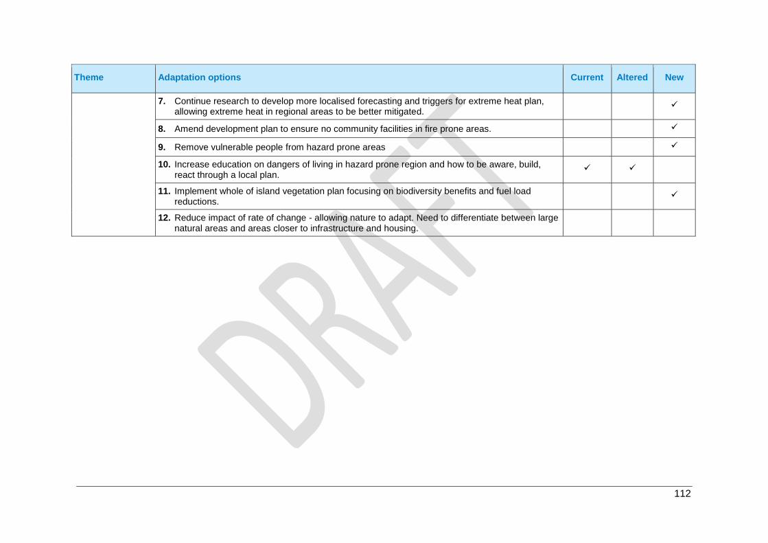
112
Theme Adaptation options Current Altered New
7. Continue research to develop more localised forecasting and triggers for extreme heat plan, allowing extreme heat in regional areas to be better mitigated.
8. Amend development plan to ensure no community facilities in fire prone areas.
9. Remove vulnerable people from hazard prone areas
10. Increase education on dangers of living in hazard prone region and how to be aware, build, react through a local plan.
11. Implement whole of island vegetation plan focusing on biodiversity benefits and fuel load reductions.
12. Reduce impact of rate of change - allowing nature to adapt. Need to differentiate between large natural areas and areas closer to infrastructure and housing.

113


