

1S
Subcatchment - 1
2S
Subcatchment - 2
3S
Subcatchment - 3
4S
Subcatchment - 4
5S
Subcatchment - 5
6S
Subcatchment - 6
7S
Subcatchment - 7
8S
Subcatchment - 8
9S
Subcatchment - 9
10S
Subcatchment - 10
POA-1
Existing Woods to the Northeast & Tributary to Existing Wetlands Area
POA-10
Existing Woods to the Northwest
POA-2
Existing Woods to the Northwest
POA-3
Existing Woods to the Northwest
POA-4
Existing Woods to the Northwest
POA-5
Existing Woods to the Northwest
POA-6
Existing Woods to the Northeast
POA-7
Existing Woods & Candlewood Roadside
Swales to the Northwest
POA-8
Existing Woods to the Northeast
POA-9
Existing Woods to the Northeast
Routing Diagram for New Milford Pre-DevelopmentPrepared by AMECFW, Printed 6/27/2017
HydroCAD® 10.00 s/n 00677 © 2011 HydroCAD Software Solutions LLC
Subcat Reach Pond Link

New Milford Pre-Development Printed 6/27/2017Prepared by AMECFW
Page 2HydroCAD® 10.00 s/n 00677 © 2011 HydroCAD Software Solutions LLC
Area Listing (all nodes)
Area(acres)
CN Description(subcatchment-numbers)
62.135 70 Woods, Good, HSG C (1S, 2S, 3S, 4S, 5S, 6S, 7S, 8S, 9S, 10S)2.273 74 Pasture/grassland/range, Good, HSG C (7S)8.723 77 Woods, Good, HSG D (1S, 2S, 7S)
10.179 86 Pasture/grassland/range, Poor, HSG C (6S, 8S, 9S, 10S)0.046 96 Gravel Road surface, HSG C (10S)0.574 96 Gravel surface, HSG C (7S)2.036 98 Unconnected Outcrop, HSG C (7S, 9S)3.799 98 Unconnected Outcrop, HSG D (1S, 2S, 6S, 8S, 9S)
89.764 75 TOTAL AREA

New Milford Pre-Development Printed 6/27/2017Prepared by AMECFW
Page 3HydroCAD® 10.00 s/n 00677 © 2011 HydroCAD Software Solutions LLC
Soil Listing (all nodes)
Area(acres)
SoilGroup
SubcatchmentNumbers
0.000 HSG A0.000 HSG B
77.242 HSG C 1S, 2S, 3S, 4S, 5S, 6S, 7S, 8S, 9S, 10S12.522 HSG D 1S, 2S, 6S, 7S, 8S, 9S
0.000 Other89.764 TOTAL AREA

New Milford Pre-Development Printed 6/27/2017Prepared by AMECFW
Page 4HydroCAD® 10.00 s/n 00677 © 2011 HydroCAD Software Solutions LLC
Ground Covers (all nodes)
HSG-A(acres)
HSG-B(acres)
HSG-C(acres)
HSG-D(acres)
Other(acres)
Total(acres)
GroundCover
SubcatchmentNumbers
0.000 0.000 0.046 0.000 0.000 0.046 Gravel Road surface 10S
0.000 0.000 2.036 3.799 0.000 5.835 Unconnected Outcrop 1S,2S,6S,7S,8S,9S
0.000 0.000 0.574 0.000 0.000 0.574 Gravel surface 7S0.000 0.000 10.179 0.000 0.000 10.179 Pasture/grassland/range, Poor 6S
,8S,9S,10S
0.000 0.000 2.273 0.000 0.000 2.273 Pasture/grassland/range, Good 7S0.000 0.000 62.135 8.723 0.000 70.858 Woods, Good 1S
,2S,3S,4S,5S,6S,7S,8S,9S,10S

New Milford Pre-Development Printed 6/27/2017Prepared by AMECFW
Page 5HydroCAD® 10.00 s/n 00677 © 2011 HydroCAD Software Solutions LLC
Ground Covers (all nodes) (continued)
HSG-A(acres)
HSG-B(acres)
HSG-C(acres)
HSG-D(acres)
Other(acres)
Total(acres)
GroundCover
SubcatchmentNumbers
0.000 0.000 77.242 12.522 0.000 89.764 TOTAL AREA

Type III 24-hr 1 year Rainfall=2.60"New Milford Pre-Development Printed 6/27/2017Prepared by AMECFW
Page 6HydroCAD® 10.00 s/n 00677 © 2011 HydroCAD Software Solutions LLC
Time span=1.00-30.00 hrs, dt=0.01 hrs, 2901 pointsRunoff by SCS TR-20 method, UH=SCS
Reach routing by Dyn-Stor-Ind method - Pond routing by Dyn-Stor-Ind method
Runoff Area=524,221 sf 12.76% Impervious Runoff Depth=0.67"Subcatchment1S: Subcatchment- 1 Flow Length=1,200' Tc=11.9 min UI Adjusted CN=74 Runoff=6.83 cfs 0.667 af
Runoff Area=560,880 sf 7.54% Impervious Runoff Depth=0.67"Subcatchment2S: Subcatchment- 2 Flow Length=910' Tc=6.0 min UI Adjusted CN=74 Runoff=8.96 cfs 0.714 af
Runoff Area=245,605 sf 0.00% Impervious Runoff Depth=0.50"Subcatchment3S: Subcatchment- 3 Flow Length=950' Tc=39.6 min CN=70 Runoff=1.33 cfs 0.237 af
Runoff Area=337,786 sf 0.00% Impervious Runoff Depth=0.50"Subcatchment4S: Subcatchment- 4 Flow Length=1,000' Tc=25.6 min CN=70 Runoff=2.23 cfs 0.326 af
Runoff Area=276,214 sf 0.00% Impervious Runoff Depth=0.50"Subcatchment5S: Subcatchment- 5 Flow Length=950' Tc=25.1 min CN=70 Runoff=1.84 cfs 0.266 af
Runoff Area=295,973 sf 1.89% Impervious Runoff Depth=0.62"Subcatchment6S: Subcatchment- 6 Flow Length=1,050' Tc=45.7 min CN=73 Runoff=1.98 cfs 0.352 af
Runoff Area=481,846 sf 15.77% Impervious Runoff Depth=0.71"Subcatchment7S: Subcatchment- 7 Flow Length=1,150' Tc=25.7 min UI Adjusted CN=75 Runoff=5.05 cfs 0.654 af
Runoff Area=578,171 sf 1.44% Impervious Runoff Depth=0.80"Subcatchment8S: Subcatchment- 8 Flow Length=1,075' Tc=20.4 min CN=77 Runoff=7.79 cfs 0.889 af
Runoff Area=409,386 sf 13.45% Impervious Runoff Depth=0.80"Subcatchment9S: Subcatchment- 9 Flow Length=1,275' Tc=20.2 min UI Adjusted CN=77 Runoff=5.53 cfs 0.629 af
Runoff Area=200,033 sf 0.00% Impervious Runoff Depth=0.58"Subcatchment10S: Subcatchment- 10 Flow Length=700' Tc=18.9 min CN=72 Runoff=1.82 cfs 0.222 af
Inflow=6.83 cfs 0.667 afReach POA-1:ExistingWoods to the Northeast& Tributaryto Existing Outflow=6.83 cfs 0.667 af
Inflow=1.82 cfs 0.222 afReach POA-10:ExistingWoods to the Northwest Outflow=1.82 cfs 0.222 af
Inflow=8.96 cfs 0.714 afReach POA-2:ExistingWoods to the Northwest Outflow=8.96 cfs 0.714 af
Inflow=1.33 cfs 0.237 afReach POA-3:ExistingWoods to the Northwest Outflow=1.33 cfs 0.237 af
Inflow=2.23 cfs 0.326 afReach POA-4:ExistingWoods to the Northwest Outflow=2.23 cfs 0.326 af
Inflow=1.84 cfs 0.266 afReach POA-5:ExistingWoods to the Northwest Outflow=1.84 cfs 0.266 af

Type III 24-hr 1 year Rainfall=2.60"New Milford Pre-Development Printed 6/27/2017Prepared by AMECFW
Page 7HydroCAD® 10.00 s/n 00677 © 2011 HydroCAD Software Solutions LLC
Inflow=1.98 cfs 0.352 afReach POA-6:ExistingWoods to the Northeast Outflow=1.98 cfs 0.352 af
Inflow=5.05 cfs 0.654 afReach POA-7:ExistingWoods & CandlewoodRoadsideSwales to the Outflow=5.05 cfs 0.654 af
Inflow=7.79 cfs 0.889 afReach POA-8:ExistingWoods to the Northeast Outflow=7.79 cfs 0.889 af
Inflow=5.53 cfs 0.629 afReach POA-9:ExistingWoods to the Northeast Outflow=5.53 cfs 0.629 af
Total Runoff Area = 89.764 ac Runoff Volume = 4.957 af Average Runoff Depth = 0.66"93.50% Pervious = 83.929 ac 6.50% Impervious = 5.835 ac
Type III 24-hr 1 year Rainfall=2.60"New Milford Pre-Development Printed 6/27/2017Prepared by AMECFW
Page 8HydroCAD® 10.00 s/n 00677 © 2011 HydroCAD Software Solutions LLC
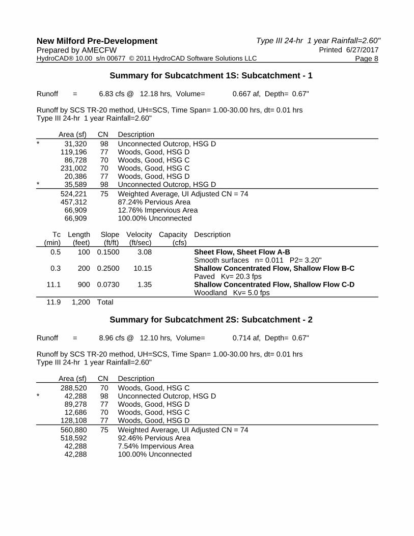
Summary for Subcatchment 1S: Subcatchment - 1
Runoff = 6.83 cfs @ 12.18 hrs, Volume= 0.667 af, Depth= 0.67"
Runoff by SCS TR-20 method, UH=SCS, Time Span= 1.00-30.00 hrs, dt= 0.01 hrsType III 24-hr 1 year Rainfall=2.60"
Area (sf) CN Description* 31,320 98 Unconnected Outcrop, HSG D
119,196 77 Woods, Good, HSG D86,728 70 Woods, Good, HSG C
231,002 70 Woods, Good, HSG C20,386 77 Woods, Good, HSG D
* 35,589 98 Unconnected Outcrop, HSG D524,221 75 Weighted Average, UI Adjusted CN = 74457,312 87.24% Pervious Area66,909 12.76% Impervious Area66,909 100.00% Unconnected
Tc Length Slope Velocity Capacity Description(min) (feet) (ft/ft) (ft/sec) (cfs)
0.5 100 0.1500 3.08 Sheet Flow, Sheet Flow A-BSmooth surfaces n= 0.011 P2= 3.20"
0.3 200 0.2500 10.15 Shallow Concentrated Flow, Shallow Flow B-CPaved Kv= 20.3 fps
11.1 900 0.0730 1.35 Shallow Concentrated Flow, Shallow Flow C-DWoodland Kv= 5.0 fps
11.9 1,200 Total
Summary for Subcatchment 2S: Subcatchment - 2
Runoff = 8.96 cfs @ 12.10 hrs, Volume= 0.714 af, Depth= 0.67"
Runoff by SCS TR-20 method, UH=SCS, Time Span= 1.00-30.00 hrs, dt= 0.01 hrsType III 24-hr 1 year Rainfall=2.60"
Area (sf) CN Description288,520 70 Woods, Good, HSG C
* 42,288 98 Unconnected Outcrop, HSG D89,278 77 Woods, Good, HSG D12,686 70 Woods, Good, HSG C
128,108 77 Woods, Good, HSG D560,880 75 Weighted Average, UI Adjusted CN = 74518,592 92.46% Pervious Area42,288 7.54% Impervious Area42,288 100.00% Unconnected

Type III 24-hr 1 year Rainfall=2.60"New Milford Pre-Development Printed 6/27/2017Prepared by AMECFW
Page 9HydroCAD® 10.00 s/n 00677 © 2011 HydroCAD Software Solutions LLC
Tc Length Slope Velocity Capacity Description(min) (feet) (ft/ft) (ft/sec) (cfs)
0.5 100 0.1600 3.16 Sheet Flow, Sheet Flow A-BSmooth surfaces n= 0.011 P2= 3.20"
0.2 110 0.1800 8.61 Shallow Concentrated Flow, Shallow Flow B-CPaved Kv= 20.3 fps
5.2 700 0.2000 2.24 Shallow Concentrated Flow, Shallow Flow C-DWoodland Kv= 5.0 fps
5.9 910 Total, Increased to minimum Tc = 6.0 min
Summary for Subcatchment 3S: Subcatchment - 3
Runoff = 1.33 cfs @ 12.64 hrs, Volume= 0.237 af, Depth= 0.50"
Runoff by SCS TR-20 method, UH=SCS, Time Span= 1.00-30.00 hrs, dt= 0.01 hrsType III 24-hr 1 year Rainfall=2.60"
Area (sf) CN Description196,656 70 Woods, Good, HSG C48,949 70 Woods, Good, HSG C
245,605 70 Weighted Average245,605 100.00% Pervious Area
Tc Length Slope Velocity Capacity Description(min) (feet) (ft/ft) (ft/sec) (cfs)29.7 150 0.0200 0.08 Sheet Flow, Sheet Flow A-B
Woods: Light underbrush n= 0.400 P2= 3.20"3.3 150 0.0230 0.76 Shallow Concentrated Flow, Shallow Flow B-C
Woodland Kv= 5.0 fps3.4 350 0.1200 1.73 Shallow Concentrated Flow, Shallow Flow C-D
Woodland Kv= 5.0 fps3.2 300 0.1000 1.58 Shallow Concentrated Flow, Shallow Flow D-E
Woodland Kv= 5.0 fps39.6 950 Total
Summary for Subcatchment 4S: Subcatchment - 4
Runoff = 2.23 cfs @ 12.43 hrs, Volume= 0.326 af, Depth= 0.50"
Runoff by SCS TR-20 method, UH=SCS, Time Span= 1.00-30.00 hrs, dt= 0.01 hrsType III 24-hr 1 year Rainfall=2.60"
Area (sf) CN Description8,570 70 Woods, Good, HSG C
329,216 70 Woods, Good, HSG C337,786 70 Weighted Average337,786 100.00% Pervious Area

Type III 24-hr 1 year Rainfall=2.60"New Milford Pre-Development Printed 6/27/2017Prepared by AMECFW
Page 10HydroCAD® 10.00 s/n 00677 © 2011 HydroCAD Software Solutions LLC
Tc Length Slope Velocity Capacity Description(min) (feet) (ft/ft) (ft/sec) (cfs)17.1 150 0.0800 0.15 Sheet Flow, Sheet Flow A-B
Woods: Light underbrush n= 0.400 P2= 3.20"8.5 850 0.1100 1.66 Shallow Concentrated Flow, Shallow Flow B-C
Woodland Kv= 5.0 fps25.6 1,000 Total
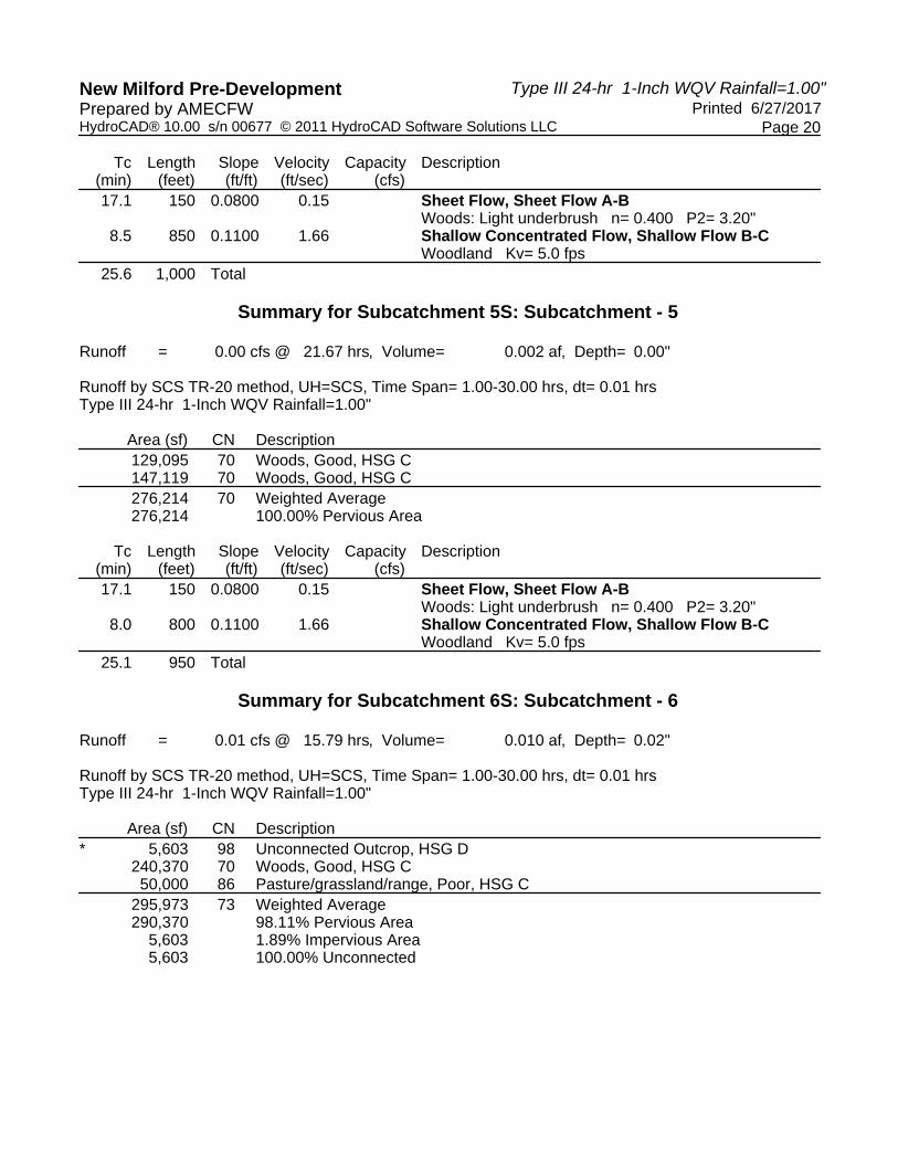
Summary for Subcatchment 5S: Subcatchment - 5
Runoff = 1.84 cfs @ 12.42 hrs, Volume= 0.266 af, Depth= 0.50"
Runoff by SCS TR-20 method, UH=SCS, Time Span= 1.00-30.00 hrs, dt= 0.01 hrsType III 24-hr 1 year Rainfall=2.60"
Area (sf) CN Description129,095 70 Woods, Good, HSG C147,119 70 Woods, Good, HSG C276,214 70 Weighted Average276,214 100.00% Pervious Area
Tc Length Slope Velocity Capacity Description(min) (feet) (ft/ft) (ft/sec) (cfs)17.1 150 0.0800 0.15 Sheet Flow, Sheet Flow A-B
Woods: Light underbrush n= 0.400 P2= 3.20"8.0 800 0.1100 1.66 Shallow Concentrated Flow, Shallow Flow B-C
Woodland Kv= 5.0 fps25.1 950 Total
Summary for Subcatchment 6S: Subcatchment - 6
Runoff = 1.98 cfs @ 12.70 hrs, Volume= 0.352 af, Depth= 0.62"
Runoff by SCS TR-20 method, UH=SCS, Time Span= 1.00-30.00 hrs, dt= 0.01 hrsType III 24-hr 1 year Rainfall=2.60"
Area (sf) CN Description* 5,603 98 Unconnected Outcrop, HSG D
240,370 70 Woods, Good, HSG C50,000 86 Pasture/grassland/range, Poor, HSG C
295,973 73 Weighted Average290,370 98.11% Pervious Area
5,603 1.89% Impervious Area5,603 100.00% Unconnected

Type III 24-hr 1 year Rainfall=2.60"New Milford Pre-Development Printed 6/27/2017Prepared by AMECFW
Page 11HydroCAD® 10.00 s/n 00677 © 2011 HydroCAD Software Solutions LLC
Tc Length Slope Velocity Capacity Description(min) (feet) (ft/ft) (ft/sec) (cfs)35.3 150 0.0130 0.07 Sheet Flow, Sheet Flow A-B
Woods: Light underbrush n= 0.400 P2= 3.20"5.0 260 0.0300 0.87 Shallow Concentrated Flow, Shallow Flow B-C
Woodland Kv= 5.0 fps2.8 390 0.1100 2.32 Shallow Concentrated Flow, Shallow Flow C-D
Short Grass Pasture Kv= 7.0 fps2.6 250 0.1000 1.58 Shallow Concentrated Flow, Shallow Flow C-D
Woodland Kv= 5.0 fps45.7 1,050 Total
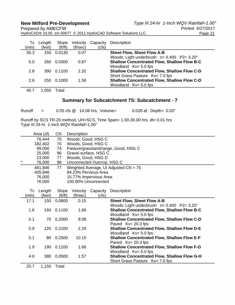
Summary for Subcatchment 7S: Subcatchment - 7
Runoff = 5.05 cfs @ 12.40 hrs, Volume= 0.654 af, Depth= 0.71"
Runoff by SCS TR-20 method, UH=SCS, Time Span= 1.00-30.00 hrs, dt= 0.01 hrsType III 24-hr 1 year Rainfall=2.60"
Area (sf) CN Description76,444 70 Woods, Good, HSG C
182,402 70 Woods, Good, HSG C99,000 74 Pasture/grassland/range, Good, HSG C25,000 96 Gravel surface, HSG C23,000 77 Woods, Good, HSG D
* 76,000 98 Unconnected Outcrop, HSG C481,846 77 Weighted Average, UI Adjusted CN = 75405,846 84.23% Pervious Area76,000 15.77% Impervious Area76,000 100.00% Unconnected
Tc Length Slope Velocity Capacity Description(min) (feet) (ft/ft) (ft/sec) (cfs)17.1 150 0.0800 0.15 Sheet Flow, Sheet Flow A-B
Woods: Light underbrush n= 0.400 P2= 3.20"1.6 160 0.1100 1.66 Shallow Concentrated Flow, Shallow Flow B-C
Woodland Kv= 5.0 fps0.1 70 0.2000 9.08 Shallow Concentrated Flow, Shallow Flow C-D
Paved Kv= 20.3 fps0.9 120 0.2100 2.29 Shallow Concentrated Flow, Shallow Flow D-E
Woodland Kv= 5.0 fps0.1 80 0.2500 10.15 Shallow Concentrated Flow, Shallow Flow E-F
Paved Kv= 20.3 fps1.9 190 0.1100 1.66 Shallow Concentrated Flow, Shallow Flow F-G
Woodland Kv= 5.0 fps4.0 380 0.0500 1.57 Shallow Concentrated Flow, Shallow Flow G-H
Short Grass Pasture Kv= 7.0 fps25.7 1,150 Total

Type III 24-hr 1 year Rainfall=2.60"New Milford Pre-Development Printed 6/27/2017Prepared by AMECFW
Page 12HydroCAD® 10.00 s/n 00677 © 2011 HydroCAD Software Solutions LLC
Summary for Subcatchment 8S: Subcatchment - 8
Runoff = 7.79 cfs @ 12.31 hrs, Volume= 0.889 af, Depth= 0.80"
Runoff by SCS TR-20 method, UH=SCS, Time Span= 1.00-30.00 hrs, dt= 0.01 hrsType III 24-hr 1 year Rainfall=2.60"
Area (sf) CN Description* 8,320 98 Unconnected Outcrop, HSG D
321,473 70 Woods, Good, HSG C248,378 86 Pasture/grassland/range, Poor, HSG C578,171 77 Weighted Average569,851 98.56% Pervious Area
8,320 1.44% Impervious Area8,320 100.00% Unconnected
Tc Length Slope Velocity Capacity Description(min) (feet) (ft/ft) (ft/sec) (cfs)12.1 150 0.0200 0.21 Sheet Flow, Sheet Flow A-B
Range n= 0.130 P2= 3.20"1.7 150 0.0460 1.50 Shallow Concentrated Flow, Shallow Flow B-C
Short Grass Pasture Kv= 7.0 fps1.0 75 0.0570 1.19 Shallow Concentrated Flow, Shallow Flow C-D
Woodland Kv= 5.0 fps3.4 450 0.1000 2.21 Shallow Concentrated Flow, Shallow Flow D-E
Short Grass Pasture Kv= 7.0 fps2.2 250 0.1440 1.90 Shallow Concentrated Flow, Shallow Flow E-F
Woodland Kv= 5.0 fps20.4 1,075 Total
Summary for Subcatchment 9S: Subcatchment - 9
Runoff = 5.53 cfs @ 12.30 hrs, Volume= 0.629 af, Depth= 0.80"
Runoff by SCS TR-20 method, UH=SCS, Time Span= 1.00-30.00 hrs, dt= 0.01 hrsType III 24-hr 1 year Rainfall=2.60"
Area (sf) CN Description* 42,364 98 Unconnected Outcrop, HSG D
229,322 70 Woods, Good, HSG C125,000 86 Pasture/grassland/range, Poor, HSG C
* 12,700 98 Unconnected Outcrop, HSG C409,386 79 Weighted Average, UI Adjusted CN = 77354,322 86.55% Pervious Area55,064 13.45% Impervious Area55,064 100.00% Unconnected

Type III 24-hr 1 year Rainfall=2.60"New Milford Pre-Development Printed 6/27/2017Prepared by AMECFW
Page 13HydroCAD® 10.00 s/n 00677 © 2011 HydroCAD Software Solutions LLC
Tc Length Slope Velocity Capacity Description(min) (feet) (ft/ft) (ft/sec) (cfs)
6.6 100 0.0400 0.25 Sheet Flow, Sheet Flow A-BRange n= 0.130 P2= 3.20"
8.8 500 0.0360 0.95 Shallow Concentrated Flow, Shallow Flow B-CWoodland Kv= 5.0 fps
4.1 575 0.1100 2.32 Shallow Concentrated Flow, Shallow Flow C-DShort Grass Pasture Kv= 7.0 fps
0.7 100 0.2400 2.45 Shallow Concentrated Flow, Shallow Flow D-EWoodland Kv= 5.0 fps
20.2 1,275 Total
Summary for Subcatchment 10S: Subcatchment - 10
Runoff = 1.82 cfs @ 12.31 hrs, Volume= 0.222 af, Depth= 0.58"
Runoff by SCS TR-20 method, UH=SCS, Time Span= 1.00-30.00 hrs, dt= 0.01 hrsType III 24-hr 1 year Rainfall=2.60"
Area (sf) CN Description47,717 70 Woods, Good, HSG C81,029 70 Woods, Good, HSG C49,287 70 Woods, Good, HSG C20,000 86 Pasture/grassland/range, Poor, HSG C
* 2,000 96 Gravel Road surface, HSG C200,033 72 Weighted Average200,033 100.00% Pervious Area
Tc Length Slope Velocity Capacity Description(min) (feet) (ft/ft) (ft/sec) (cfs)12.1 150 0.0200 0.21 Sheet Flow, Sheet Flow A-B
Range n= 0.130 P2= 3.20"1.1 100 0.0500 1.57 Shallow Concentrated Flow, Shallow Flow B-C
Short Grass Pasture Kv= 7.0 fps5.7 450 0.0700 1.32 Shallow Concentrated Flow, Shallow Flow C-D
Woodland Kv= 5.0 fps18.9 700 Total
Summary for Reach POA-1: Existing Woods to the Northeast & Tributary to Existing Wetlands Area
[40] Hint: Not Described (Outflow=Inflow)
Inflow Area = 12.034 ac, 12.76% Impervious, Inflow Depth = 0.67" for 1 year eventInflow = 6.83 cfs @ 12.18 hrs, Volume= 0.667 afOutflow = 6.83 cfs @ 12.18 hrs, Volume= 0.667 af, Atten= 0%, Lag= 0.0 min
Routing by Dyn-Stor-Ind method, Time Span= 1.00-30.00 hrs, dt= 0.01 hrs

Type III 24-hr 1 year Rainfall=2.60"New Milford Pre-Development Printed 6/27/2017Prepared by AMECFW
Page 14HydroCAD® 10.00 s/n 00677 © 2011 HydroCAD Software Solutions LLC
Summary for Reach POA-10: Existing Woods to the Northwest
[40] Hint: Not Described (Outflow=Inflow)
Inflow Area = 4.592 ac, 0.00% Impervious, Inflow Depth = 0.58" for 1 year eventInflow = 1.82 cfs @ 12.31 hrs, Volume= 0.222 afOutflow = 1.82 cfs @ 12.31 hrs, Volume= 0.222 af, Atten= 0%, Lag= 0.0 min
Routing by Dyn-Stor-Ind method, Time Span= 1.00-30.00 hrs, dt= 0.01 hrs
Summary for Reach POA-2: Existing Woods to the Northwest
[40] Hint: Not Described (Outflow=Inflow)
Inflow Area = 12.876 ac, 7.54% Impervious, Inflow Depth = 0.67" for 1 year eventInflow = 8.96 cfs @ 12.10 hrs, Volume= 0.714 afOutflow = 8.96 cfs @ 12.10 hrs, Volume= 0.714 af, Atten= 0%, Lag= 0.0 min
Routing by Dyn-Stor-Ind method, Time Span= 1.00-30.00 hrs, dt= 0.01 hrs
Summary for Reach POA-3: Existing Woods to the Northwest
[40] Hint: Not Described (Outflow=Inflow)
Inflow Area = 5.638 ac, 0.00% Impervious, Inflow Depth = 0.50" for 1 year eventInflow = 1.33 cfs @ 12.64 hrs, Volume= 0.237 afOutflow = 1.33 cfs @ 12.64 hrs, Volume= 0.237 af, Atten= 0%, Lag= 0.0 min
Routing by Dyn-Stor-Ind method, Time Span= 1.00-30.00 hrs, dt= 0.01 hrs
Summary for Reach POA-4: Existing Woods to the Northwest
[40] Hint: Not Described (Outflow=Inflow)
Inflow Area = 7.754 ac, 0.00% Impervious, Inflow Depth = 0.50" for 1 year eventInflow = 2.23 cfs @ 12.43 hrs, Volume= 0.326 afOutflow = 2.23 cfs @ 12.43 hrs, Volume= 0.326 af, Atten= 0%, Lag= 0.0 min
Routing by Dyn-Stor-Ind method, Time Span= 1.00-30.00 hrs, dt= 0.01 hrs
Summary for Reach POA-5: Existing Woods to the Northwest
[40] Hint: Not Described (Outflow=Inflow)
Inflow Area = 6.341 ac, 0.00% Impervious, Inflow Depth = 0.50" for 1 year eventInflow = 1.84 cfs @ 12.42 hrs, Volume= 0.266 afOutflow = 1.84 cfs @ 12.42 hrs, Volume= 0.266 af, Atten= 0%, Lag= 0.0 min

Type III 24-hr 1 year Rainfall=2.60"New Milford Pre-Development Printed 6/27/2017Prepared by AMECFW
Page 15HydroCAD® 10.00 s/n 00677 © 2011 HydroCAD Software Solutions LLC
Routing by Dyn-Stor-Ind method, Time Span= 1.00-30.00 hrs, dt= 0.01 hrs
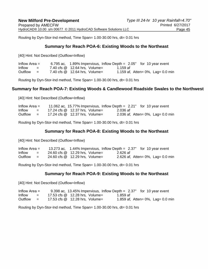
Summary for Reach POA-6: Existing Woods to the Northeast
[40] Hint: Not Described (Outflow=Inflow)
Inflow Area = 6.795 ac, 1.89% Impervious, Inflow Depth = 0.62" for 1 year eventInflow = 1.98 cfs @ 12.70 hrs, Volume= 0.352 afOutflow = 1.98 cfs @ 12.70 hrs, Volume= 0.352 af, Atten= 0%, Lag= 0.0 min
Routing by Dyn-Stor-Ind method, Time Span= 1.00-30.00 hrs, dt= 0.01 hrs
Summary for Reach POA-7: Existing Woods & Candlewood Roadside Swales to the Northwest
[40] Hint: Not Described (Outflow=Inflow)
Inflow Area = 11.062 ac, 15.77% Impervious, Inflow Depth = 0.71" for 1 year eventInflow = 5.05 cfs @ 12.40 hrs, Volume= 0.654 afOutflow = 5.05 cfs @ 12.40 hrs, Volume= 0.654 af, Atten= 0%, Lag= 0.0 min
Routing by Dyn-Stor-Ind method, Time Span= 1.00-30.00 hrs, dt= 0.01 hrs
Summary for Reach POA-8: Existing Woods to the Northeast
[40] Hint: Not Described (Outflow=Inflow)
Inflow Area = 13.273 ac, 1.44% Impervious, Inflow Depth = 0.80" for 1 year eventInflow = 7.79 cfs @ 12.31 hrs, Volume= 0.889 afOutflow = 7.79 cfs @ 12.31 hrs, Volume= 0.889 af, Atten= 0%, Lag= 0.0 min
Routing by Dyn-Stor-Ind method, Time Span= 1.00-30.00 hrs, dt= 0.01 hrs
Summary for Reach POA-9: Existing Woods to the Northeast
[40] Hint: Not Described (Outflow=Inflow)
Inflow Area = 9.398 ac, 13.45% Impervious, Inflow Depth = 0.80" for 1 year eventInflow = 5.53 cfs @ 12.30 hrs, Volume= 0.629 afOutflow = 5.53 cfs @ 12.30 hrs, Volume= 0.629 af, Atten= 0%, Lag= 0.0 min
Routing by Dyn-Stor-Ind method, Time Span= 1.00-30.00 hrs, dt= 0.01 hrs

Type III 24-hr 1-Inch WQV Rainfall=1.00"New Milford Pre-Development Printed 6/27/2017Prepared by AMECFW
Page 16HydroCAD® 10.00 s/n 00677 © 2011 HydroCAD Software Solutions LLC
Time span=1.00-30.00 hrs, dt=0.01 hrs, 2901 pointsRunoff by SCS TR-20 method, UH=SCS
Reach routing by Dyn-Stor-Ind method - Pond routing by Dyn-Stor-Ind method
Runoff Area=524,221 sf 12.76% Impervious Runoff Depth=0.02"Subcatchment1S: Subcatchment- 1 Flow Length=1,200' Tc=11.9 min UI Adjusted CN=74 Runoff=0.04 cfs 0.023 af
Runoff Area=560,880 sf 7.54% Impervious Runoff Depth=0.02"Subcatchment2S: Subcatchment- 2 Flow Length=910' Tc=6.0 min UI Adjusted CN=74 Runoff=0.04 cfs 0.025 af
Runoff Area=245,605 sf 0.00% Impervious Runoff Depth=0.00"Subcatchment3S: Subcatchment- 3 Flow Length=950' Tc=39.6 min CN=70 Runoff=0.00 cfs 0.002 af
Runoff Area=337,786 sf 0.00% Impervious Runoff Depth=0.00"Subcatchment4S: Subcatchment- 4 Flow Length=1,000' Tc=25.6 min CN=70 Runoff=0.00 cfs 0.003 af
Runoff Area=276,214 sf 0.00% Impervious Runoff Depth=0.00"Subcatchment5S: Subcatchment- 5 Flow Length=950' Tc=25.1 min CN=70 Runoff=0.00 cfs 0.002 af
Runoff Area=295,973 sf 1.89% Impervious Runoff Depth=0.02"Subcatchment6S: Subcatchment- 6 Flow Length=1,050' Tc=45.7 min CN=73 Runoff=0.01 cfs 0.010 af
Runoff Area=481,846 sf 15.77% Impervious Runoff Depth=0.03"Subcatchment7S: Subcatchment- 7 Flow Length=1,150' Tc=25.7 min UI Adjusted CN=75 Runoff=0.05 cfs 0.028 af
Runoff Area=578,171 sf 1.44% Impervious Runoff Depth=0.05"Subcatchment8S: Subcatchment- 8 Flow Length=1,075' Tc=20.4 min CN=77 Runoff=0.13 cfs 0.053 af
Runoff Area=409,386 sf 13.45% Impervious Runoff Depth=0.05"Subcatchment9S: Subcatchment- 9 Flow Length=1,275' Tc=20.2 min UI Adjusted CN=77 Runoff=0.09 cfs 0.037 af
Runoff Area=200,033 sf 0.00% Impervious Runoff Depth=0.01"Subcatchment10S: Subcatchment- 10 Flow Length=700' Tc=18.9 min CN=72 Runoff=0.01 cfs 0.005 af
Inflow=0.04 cfs 0.023 afReach POA-1:ExistingWoods to the Northeast& Tributaryto Existing Outflow=0.04 cfs 0.023 af
Inflow=0.01 cfs 0.005 afReach POA-10:ExistingWoods to the Northwest Outflow=0.01 cfs 0.005 af
Inflow=0.04 cfs 0.025 afReach POA-2:ExistingWoods to the Northwest Outflow=0.04 cfs 0.025 af
Inflow=0.00 cfs 0.002 afReach POA-3:ExistingWoods to the Northwest Outflow=0.00 cfs 0.002 af
Inflow=0.00 cfs 0.003 afReach POA-4:ExistingWoods to the Northwest Outflow=0.00 cfs 0.003 af
Inflow=0.00 cfs 0.002 afReach POA-5:ExistingWoods to the Northwest Outflow=0.00 cfs 0.002 af

Type III 24-hr 1-Inch WQV Rainfall=1.00"New Milford Pre-Development Printed 6/27/2017Prepared by AMECFW
Page 17HydroCAD® 10.00 s/n 00677 © 2011 HydroCAD Software Solutions LLC
Inflow=0.01 cfs 0.010 afReach POA-6:ExistingWoods to the Northeast Outflow=0.01 cfs 0.010 af
Inflow=0.05 cfs 0.028 afReach POA-7:ExistingWoods & CandlewoodRoadsideSwales to the Outflow=0.05 cfs 0.028 af
Inflow=0.13 cfs 0.053 afReach POA-8:ExistingWoods to the Northeast Outflow=0.13 cfs 0.053 af
Inflow=0.09 cfs 0.037 afReach POA-9:ExistingWoods to the Northeast Outflow=0.09 cfs 0.037 af
Total Runoff Area = 89.764 ac Runoff Volume = 0.188 af Average Runoff Depth = 0.03"93.50% Pervious = 83.929 ac 6.50% Impervious = 5.835 ac

Type III 24-hr 1-Inch WQV Rainfall=1.00"New Milford Pre-Development Printed 6/27/2017Prepared by AMECFW
Page 18HydroCAD® 10.00 s/n 00677 © 2011 HydroCAD Software Solutions LLC
Summary for Subcatchment 1S: Subcatchment - 1
Runoff = 0.04 cfs @ 14.85 hrs, Volume= 0.023 af, Depth= 0.02"
Runoff by SCS TR-20 method, UH=SCS, Time Span= 1.00-30.00 hrs, dt= 0.01 hrsType III 24-hr 1-Inch WQV Rainfall=1.00"
Area (sf) CN Description* 31,320 98 Unconnected Outcrop, HSG D
119,196 77 Woods, Good, HSG D86,728 70 Woods, Good, HSG C
231,002 70 Woods, Good, HSG C20,386 77 Woods, Good, HSG D
* 35,589 98 Unconnected Outcrop, HSG D524,221 75 Weighted Average, UI Adjusted CN = 74457,312 87.24% Pervious Area66,909 12.76% Impervious Area66,909 100.00% Unconnected
Tc Length Slope Velocity Capacity Description(min) (feet) (ft/ft) (ft/sec) (cfs)
0.5 100 0.1500 3.08 Sheet Flow, Sheet Flow A-BSmooth surfaces n= 0.011 P2= 3.20"
0.3 200 0.2500 10.15 Shallow Concentrated Flow, Shallow Flow B-CPaved Kv= 20.3 fps
11.1 900 0.0730 1.35 Shallow Concentrated Flow, Shallow Flow C-DWoodland Kv= 5.0 fps
11.9 1,200 Total
Summary for Subcatchment 2S: Subcatchment - 2
Runoff = 0.04 cfs @ 14.78 hrs, Volume= 0.025 af, Depth= 0.02"
Runoff by SCS TR-20 method, UH=SCS, Time Span= 1.00-30.00 hrs, dt= 0.01 hrsType III 24-hr 1-Inch WQV Rainfall=1.00"
Area (sf) CN Description288,520 70 Woods, Good, HSG C
* 42,288 98 Unconnected Outcrop, HSG D89,278 77 Woods, Good, HSG D12,686 70 Woods, Good, HSG C
128,108 77 Woods, Good, HSG D560,880 75 Weighted Average, UI Adjusted CN = 74518,592 92.46% Pervious Area42,288 7.54% Impervious Area42,288 100.00% Unconnected

Type III 24-hr 1-Inch WQV Rainfall=1.00"New Milford Pre-Development Printed 6/27/2017Prepared by AMECFW
Page 19HydroCAD® 10.00 s/n 00677 © 2011 HydroCAD Software Solutions LLC
Tc Length Slope Velocity Capacity Description(min) (feet) (ft/ft) (ft/sec) (cfs)
0.5 100 0.1600 3.16 Sheet Flow, Sheet Flow A-BSmooth surfaces n= 0.011 P2= 3.20"
0.2 110 0.1800 8.61 Shallow Concentrated Flow, Shallow Flow B-CPaved Kv= 20.3 fps
5.2 700 0.2000 2.24 Shallow Concentrated Flow, Shallow Flow C-DWoodland Kv= 5.0 fps
5.9 910 Total, Increased to minimum Tc = 6.0 min
Summary for Subcatchment 3S: Subcatchment - 3
Runoff = 0.00 cfs @ 21.87 hrs, Volume= 0.002 af, Depth= 0.00"
Runoff by SCS TR-20 method, UH=SCS, Time Span= 1.00-30.00 hrs, dt= 0.01 hrsType III 24-hr 1-Inch WQV Rainfall=1.00"
Area (sf) CN Description196,656 70 Woods, Good, HSG C48,949 70 Woods, Good, HSG C
245,605 70 Weighted Average245,605 100.00% Pervious Area
Tc Length Slope Velocity Capacity Description(min) (feet) (ft/ft) (ft/sec) (cfs)29.7 150 0.0200 0.08 Sheet Flow, Sheet Flow A-B
Woods: Light underbrush n= 0.400 P2= 3.20"3.3 150 0.0230 0.76 Shallow Concentrated Flow, Shallow Flow B-C
Woodland Kv= 5.0 fps3.4 350 0.1200 1.73 Shallow Concentrated Flow, Shallow Flow C-D
Woodland Kv= 5.0 fps3.2 300 0.1000 1.58 Shallow Concentrated Flow, Shallow Flow D-E
Woodland Kv= 5.0 fps39.6 950 Total
Summary for Subcatchment 4S: Subcatchment - 4
Runoff = 0.00 cfs @ 21.59 hrs, Volume= 0.003 af, Depth= 0.00"
Runoff by SCS TR-20 method, UH=SCS, Time Span= 1.00-30.00 hrs, dt= 0.01 hrsType III 24-hr 1-Inch WQV Rainfall=1.00"
Area (sf) CN Description8,570 70 Woods, Good, HSG C
329,216 70 Woods, Good, HSG C337,786 70 Weighted Average337,786 100.00% Pervious Area
Type III 24-hr 1-Inch WQV Rainfall=1.00"New Milford Pre-Development Printed 6/27/2017Prepared by AMECFW
Page 20HydroCAD® 10.00 s/n 00677 © 2011 HydroCAD Software Solutions LLC
Tc Length Slope Velocity Capacity Description(min) (feet) (ft/ft) (ft/sec) (cfs)17.1 150 0.0800 0.15 Sheet Flow, Sheet Flow A-B
Woods: Light underbrush n= 0.400 P2= 3.20"8.5 850 0.1100 1.66 Shallow Concentrated Flow, Shallow Flow B-C
Woodland Kv= 5.0 fps25.6 1,000 Total
Summary for Subcatchment 5S: Subcatchment - 5
Runoff = 0.00 cfs @ 21.67 hrs, Volume= 0.002 af, Depth= 0.00"
Runoff by SCS TR-20 method, UH=SCS, Time Span= 1.00-30.00 hrs, dt= 0.01 hrsType III 24-hr 1-Inch WQV Rainfall=1.00"
Area (sf) CN Description129,095 70 Woods, Good, HSG C147,119 70 Woods, Good, HSG C276,214 70 Weighted Average276,214 100.00% Pervious Area
Tc Length Slope Velocity Capacity Description(min) (feet) (ft/ft) (ft/sec) (cfs)17.1 150 0.0800 0.15 Sheet Flow, Sheet Flow A-B
Woods: Light underbrush n= 0.400 P2= 3.20"8.0 800 0.1100 1.66 Shallow Concentrated Flow, Shallow Flow B-C
Woodland Kv= 5.0 fps25.1 950 Total
Summary for Subcatchment 6S: Subcatchment - 6
Runoff = 0.01 cfs @ 15.79 hrs, Volume= 0.010 af, Depth= 0.02"
Runoff by SCS TR-20 method, UH=SCS, Time Span= 1.00-30.00 hrs, dt= 0.01 hrsType III 24-hr 1-Inch WQV Rainfall=1.00"
Area (sf) CN Description* 5,603 98 Unconnected Outcrop, HSG D
240,370 70 Woods, Good, HSG C50,000 86 Pasture/grassland/range, Poor, HSG C
295,973 73 Weighted Average290,370 98.11% Pervious Area
5,603 1.89% Impervious Area5,603 100.00% Unconnected
Type III 24-hr 1-Inch WQV Rainfall=1.00"New Milford Pre-Development Printed 6/27/2017Prepared by AMECFW
Page 21HydroCAD® 10.00 s/n 00677 © 2011 HydroCAD Software Solutions LLC
Tc Length Slope Velocity Capacity Description(min) (feet) (ft/ft) (ft/sec) (cfs)35.3 150 0.0130 0.07 Sheet Flow, Sheet Flow A-B
Woods: Light underbrush n= 0.400 P2= 3.20"5.0 260 0.0300 0.87 Shallow Concentrated Flow, Shallow Flow B-C
Woodland Kv= 5.0 fps2.8 390 0.1100 2.32 Shallow Concentrated Flow, Shallow Flow C-D
Short Grass Pasture Kv= 7.0 fps2.6 250 0.1000 1.58 Shallow Concentrated Flow, Shallow Flow C-D
Woodland Kv= 5.0 fps45.7 1,050 Total
Summary for Subcatchment 7S: Subcatchment - 7
Runoff = 0.05 cfs @ 14.08 hrs, Volume= 0.028 af, Depth= 0.03"
Runoff by SCS TR-20 method, UH=SCS, Time Span= 1.00-30.00 hrs, dt= 0.01 hrsType III 24-hr 1-Inch WQV Rainfall=1.00"
Area (sf) CN Description76,444 70 Woods, Good, HSG C
182,402 70 Woods, Good, HSG C99,000 74 Pasture/grassland/range, Good, HSG C25,000 96 Gravel surface, HSG C23,000 77 Woods, Good, HSG D
* 76,000 98 Unconnected Outcrop, HSG C481,846 77 Weighted Average, UI Adjusted CN = 75405,846 84.23% Pervious Area76,000 15.77% Impervious Area76,000 100.00% Unconnected
Tc Length Slope Velocity Capacity Description(min) (feet) (ft/ft) (ft/sec) (cfs)17.1 150 0.0800 0.15 Sheet Flow, Sheet Flow A-B
Woods: Light underbrush n= 0.400 P2= 3.20"1.6 160 0.1100 1.66 Shallow Concentrated Flow, Shallow Flow B-C
Woodland Kv= 5.0 fps0.1 70 0.2000 9.08 Shallow Concentrated Flow, Shallow Flow C-D
Paved Kv= 20.3 fps0.9 120 0.2100 2.29 Shallow Concentrated Flow, Shallow Flow D-E
Woodland Kv= 5.0 fps0.1 80 0.2500 10.15 Shallow Concentrated Flow, Shallow Flow E-F
Paved Kv= 20.3 fps1.9 190 0.1100 1.66 Shallow Concentrated Flow, Shallow Flow F-G
Woodland Kv= 5.0 fps4.0 380 0.0500 1.57 Shallow Concentrated Flow, Shallow Flow G-H
Short Grass Pasture Kv= 7.0 fps25.7 1,150 Total

Type III 24-hr 1-Inch WQV Rainfall=1.00"New Milford Pre-Development Printed 6/27/2017Prepared by AMECFW
Page 22HydroCAD® 10.00 s/n 00677 © 2011 HydroCAD Software Solutions LLC
Summary for Subcatchment 8S: Subcatchment - 8
Runoff = 0.13 cfs @ 12.67 hrs, Volume= 0.053 af, Depth= 0.05"
Runoff by SCS TR-20 method, UH=SCS, Time Span= 1.00-30.00 hrs, dt= 0.01 hrsType III 24-hr 1-Inch WQV Rainfall=1.00"
Area (sf) CN Description* 8,320 98 Unconnected Outcrop, HSG D
321,473 70 Woods, Good, HSG C248,378 86 Pasture/grassland/range, Poor, HSG C578,171 77 Weighted Average569,851 98.56% Pervious Area
8,320 1.44% Impervious Area8,320 100.00% Unconnected
Tc Length Slope Velocity Capacity Description(min) (feet) (ft/ft) (ft/sec) (cfs)12.1 150 0.0200 0.21 Sheet Flow, Sheet Flow A-B
Range n= 0.130 P2= 3.20"1.7 150 0.0460 1.50 Shallow Concentrated Flow, Shallow Flow B-C
Short Grass Pasture Kv= 7.0 fps1.0 75 0.0570 1.19 Shallow Concentrated Flow, Shallow Flow C-D
Woodland Kv= 5.0 fps3.4 450 0.1000 2.21 Shallow Concentrated Flow, Shallow Flow D-E
Short Grass Pasture Kv= 7.0 fps2.2 250 0.1440 1.90 Shallow Concentrated Flow, Shallow Flow E-F
Woodland Kv= 5.0 fps20.4 1,075 Total
Summary for Subcatchment 9S: Subcatchment - 9
Runoff = 0.09 cfs @ 12.66 hrs, Volume= 0.037 af, Depth= 0.05"
Runoff by SCS TR-20 method, UH=SCS, Time Span= 1.00-30.00 hrs, dt= 0.01 hrsType III 24-hr 1-Inch WQV Rainfall=1.00"
Area (sf) CN Description* 42,364 98 Unconnected Outcrop, HSG D
229,322 70 Woods, Good, HSG C125,000 86 Pasture/grassland/range, Poor, HSG C
* 12,700 98 Unconnected Outcrop, HSG C409,386 79 Weighted Average, UI Adjusted CN = 77354,322 86.55% Pervious Area55,064 13.45% Impervious Area55,064 100.00% Unconnected

Type III 24-hr 1-Inch WQV Rainfall=1.00"New Milford Pre-Development Printed 6/27/2017Prepared by AMECFW
Page 23HydroCAD® 10.00 s/n 00677 © 2011 HydroCAD Software Solutions LLC
Tc Length Slope Velocity Capacity Description(min) (feet) (ft/ft) (ft/sec) (cfs)
6.6 100 0.0400 0.25 Sheet Flow, Sheet Flow A-BRange n= 0.130 P2= 3.20"
8.8 500 0.0360 0.95 Shallow Concentrated Flow, Shallow Flow B-CWoodland Kv= 5.0 fps
4.1 575 0.1100 2.32 Shallow Concentrated Flow, Shallow Flow C-DShort Grass Pasture Kv= 7.0 fps
0.7 100 0.2400 2.45 Shallow Concentrated Flow, Shallow Flow D-EWoodland Kv= 5.0 fps
20.2 1,275 Total
Summary for Subcatchment 10S: Subcatchment - 10
Runoff = 0.01 cfs @ 15.69 hrs, Volume= 0.005 af, Depth= 0.01"
Runoff by SCS TR-20 method, UH=SCS, Time Span= 1.00-30.00 hrs, dt= 0.01 hrsType III 24-hr 1-Inch WQV Rainfall=1.00"
Area (sf) CN Description47,717 70 Woods, Good, HSG C81,029 70 Woods, Good, HSG C49,287 70 Woods, Good, HSG C20,000 86 Pasture/grassland/range, Poor, HSG C
* 2,000 96 Gravel Road surface, HSG C200,033 72 Weighted Average200,033 100.00% Pervious Area
Tc Length Slope Velocity Capacity Description(min) (feet) (ft/ft) (ft/sec) (cfs)12.1 150 0.0200 0.21 Sheet Flow, Sheet Flow A-B
Range n= 0.130 P2= 3.20"1.1 100 0.0500 1.57 Shallow Concentrated Flow, Shallow Flow B-C
Short Grass Pasture Kv= 7.0 fps5.7 450 0.0700 1.32 Shallow Concentrated Flow, Shallow Flow C-D
Woodland Kv= 5.0 fps18.9 700 Total
Summary for Reach POA-1: Existing Woods to the Northeast & Tributary to Existing Wetlands Area
[40] Hint: Not Described (Outflow=Inflow)
Inflow Area = 12.034 ac, 12.76% Impervious, Inflow Depth = 0.02" for 1-Inch WQV eventInflow = 0.04 cfs @ 14.85 hrs, Volume= 0.023 afOutflow = 0.04 cfs @ 14.85 hrs, Volume= 0.023 af, Atten= 0%, Lag= 0.0 min
Routing by Dyn-Stor-Ind method, Time Span= 1.00-30.00 hrs, dt= 0.01 hrs

Type III 24-hr 1-Inch WQV Rainfall=1.00"New Milford Pre-Development Printed 6/27/2017Prepared by AMECFW
Page 24HydroCAD® 10.00 s/n 00677 © 2011 HydroCAD Software Solutions LLC
Summary for Reach POA-10: Existing Woods to the Northwest
[40] Hint: Not Described (Outflow=Inflow)
Inflow Area = 4.592 ac, 0.00% Impervious, Inflow Depth = 0.01" for 1-Inch WQV eventInflow = 0.01 cfs @ 15.69 hrs, Volume= 0.005 afOutflow = 0.01 cfs @ 15.69 hrs, Volume= 0.005 af, Atten= 0%, Lag= 0.0 min
Routing by Dyn-Stor-Ind method, Time Span= 1.00-30.00 hrs, dt= 0.01 hrs
Summary for Reach POA-2: Existing Woods to the Northwest
[40] Hint: Not Described (Outflow=Inflow)
Inflow Area = 12.876 ac, 7.54% Impervious, Inflow Depth = 0.02" for 1-Inch WQV eventInflow = 0.04 cfs @ 14.78 hrs, Volume= 0.025 afOutflow = 0.04 cfs @ 14.78 hrs, Volume= 0.025 af, Atten= 0%, Lag= 0.0 min
Routing by Dyn-Stor-Ind method, Time Span= 1.00-30.00 hrs, dt= 0.01 hrs
Summary for Reach POA-3: Existing Woods to the Northwest
[40] Hint: Not Described (Outflow=Inflow)
Inflow Area = 5.638 ac, 0.00% Impervious, Inflow Depth = 0.00" for 1-Inch WQV eventInflow = 0.00 cfs @ 21.87 hrs, Volume= 0.002 afOutflow = 0.00 cfs @ 21.87 hrs, Volume= 0.002 af, Atten= 0%, Lag= 0.0 min
Routing by Dyn-Stor-Ind method, Time Span= 1.00-30.00 hrs, dt= 0.01 hrs
Summary for Reach POA-4: Existing Woods to the Northwest
[40] Hint: Not Described (Outflow=Inflow)
Inflow Area = 7.754 ac, 0.00% Impervious, Inflow Depth = 0.00" for 1-Inch WQV eventInflow = 0.00 cfs @ 21.59 hrs, Volume= 0.003 afOutflow = 0.00 cfs @ 21.59 hrs, Volume= 0.003 af, Atten= 0%, Lag= 0.0 min
Routing by Dyn-Stor-Ind method, Time Span= 1.00-30.00 hrs, dt= 0.01 hrs
Summary for Reach POA-5: Existing Woods to the Northwest
[40] Hint: Not Described (Outflow=Inflow)
Inflow Area = 6.341 ac, 0.00% Impervious, Inflow Depth = 0.00" for 1-Inch WQV eventInflow = 0.00 cfs @ 21.67 hrs, Volume= 0.002 afOutflow = 0.00 cfs @ 21.67 hrs, Volume= 0.002 af, Atten= 0%, Lag= 0.0 min

Type III 24-hr 1-Inch WQV Rainfall=1.00"New Milford Pre-Development Printed 6/27/2017Prepared by AMECFW
Page 25HydroCAD® 10.00 s/n 00677 © 2011 HydroCAD Software Solutions LLC
Routing by Dyn-Stor-Ind method, Time Span= 1.00-30.00 hrs, dt= 0.01 hrs
Summary for Reach POA-6: Existing Woods to the Northeast
[40] Hint: Not Described (Outflow=Inflow)
Inflow Area = 6.795 ac, 1.89% Impervious, Inflow Depth = 0.02" for 1-Inch WQV eventInflow = 0.01 cfs @ 15.79 hrs, Volume= 0.010 afOutflow = 0.01 cfs @ 15.79 hrs, Volume= 0.010 af, Atten= 0%, Lag= 0.0 min
Routing by Dyn-Stor-Ind method, Time Span= 1.00-30.00 hrs, dt= 0.01 hrs
Summary for Reach POA-7: Existing Woods & Candlewood Roadside Swales to the Northwest
[40] Hint: Not Described (Outflow=Inflow)
Inflow Area = 11.062 ac, 15.77% Impervious, Inflow Depth = 0.03" for 1-Inch WQV eventInflow = 0.05 cfs @ 14.08 hrs, Volume= 0.028 afOutflow = 0.05 cfs @ 14.08 hrs, Volume= 0.028 af, Atten= 0%, Lag= 0.0 min
Routing by Dyn-Stor-Ind method, Time Span= 1.00-30.00 hrs, dt= 0.01 hrs
Summary for Reach POA-8: Existing Woods to the Northeast
[40] Hint: Not Described (Outflow=Inflow)
Inflow Area = 13.273 ac, 1.44% Impervious, Inflow Depth = 0.05" for 1-Inch WQV eventInflow = 0.13 cfs @ 12.67 hrs, Volume= 0.053 afOutflow = 0.13 cfs @ 12.67 hrs, Volume= 0.053 af, Atten= 0%, Lag= 0.0 min
Routing by Dyn-Stor-Ind method, Time Span= 1.00-30.00 hrs, dt= 0.01 hrs
Summary for Reach POA-9: Existing Woods to the Northeast
[40] Hint: Not Described (Outflow=Inflow)
Inflow Area = 9.398 ac, 13.45% Impervious, Inflow Depth = 0.05" for 1-Inch WQV eventInflow = 0.09 cfs @ 12.66 hrs, Volume= 0.037 afOutflow = 0.09 cfs @ 12.66 hrs, Volume= 0.037 af, Atten= 0%, Lag= 0.0 min
Routing by Dyn-Stor-Ind method, Time Span= 1.00-30.00 hrs, dt= 0.01 hrs

Type III 24-hr 2 year Rainfall=3.20"New Milford Pre-Development Printed 6/27/2017Prepared by AMECFW
Page 26HydroCAD® 10.00 s/n 00677 © 2011 HydroCAD Software Solutions LLC
Time span=1.00-30.00 hrs, dt=0.01 hrs, 2901 pointsRunoff by SCS TR-20 method, UH=SCS
Reach routing by Dyn-Stor-Ind method - Pond routing by Dyn-Stor-Ind method
Runoff Area=524,221 sf 12.76% Impervious Runoff Depth=1.04"Subcatchment1S: Subcatchment- 1 Flow Length=1,200' Tc=11.9 min UI Adjusted CN=74 Runoff=11.36 cfs 1.041 af
Runoff Area=560,880 sf 7.54% Impervious Runoff Depth=1.04"Subcatchment2S: Subcatchment- 2 Flow Length=910' Tc=6.0 min UI Adjusted CN=74 Runoff=14.84 cfs 1.113 af
Runoff Area=245,605 sf 0.00% Impervious Runoff Depth=0.83"Subcatchment3S: Subcatchment- 3 Flow Length=950' Tc=39.6 min CN=70 Runoff=2.43 cfs 0.389 af
Runoff Area=337,786 sf 0.00% Impervious Runoff Depth=0.83"Subcatchment4S: Subcatchment- 4 Flow Length=1,000' Tc=25.6 min CN=70 Runoff=4.07 cfs 0.535 af
Runoff Area=276,214 sf 0.00% Impervious Runoff Depth=0.83"Subcatchment5S: Subcatchment- 5 Flow Length=950' Tc=25.1 min CN=70 Runoff=3.36 cfs 0.438 af
Runoff Area=295,973 sf 1.89% Impervious Runoff Depth=0.98"Subcatchment6S: Subcatchment- 6 Flow Length=1,050' Tc=45.7 min CN=73 Runoff=3.35 cfs 0.556 af
Runoff Area=481,846 sf 15.77% Impervious Runoff Depth=1.09"Subcatchment7S: Subcatchment- 7 Flow Length=1,150' Tc=25.7 min UI Adjusted CN=75 Runoff=8.18 cfs 1.008 af
Runoff Area=578,171 sf 1.44% Impervious Runoff Depth=1.21"Subcatchment8S: Subcatchment- 8 Flow Length=1,075' Tc=20.4 min CN=77 Runoff=12.20 cfs 1.340 af
Runoff Area=409,386 sf 13.45% Impervious Runoff Depth=1.21"Subcatchment9S: Subcatchment- 9 Flow Length=1,275' Tc=20.2 min UI Adjusted CN=77 Runoff=8.67 cfs 0.949 af
Runoff Area=200,033 sf 0.00% Impervious Runoff Depth=0.93"Subcatchment10S: Subcatchment- 10 Flow Length=700' Tc=18.9 min CN=72 Runoff=3.17 cfs 0.356 af
Inflow=11.36 cfs 1.041 afReach POA-1:ExistingWoods to the Northeast& Tributaryto Existing Outflow=11.36 cfs 1.041 af
Inflow=3.17 cfs 0.356 afReach POA-10:ExistingWoods to the Northwest Outflow=3.17 cfs 0.356 af
Inflow=14.84 cfs 1.113 afReach POA-2:ExistingWoods to the Northwest Outflow=14.84 cfs 1.113 af
Inflow=2.43 cfs 0.389 afReach POA-3:ExistingWoods to the Northwest Outflow=2.43 cfs 0.389 af
Inflow=4.07 cfs 0.535 afReach POA-4:ExistingWoods to the Northwest Outflow=4.07 cfs 0.535 af
Inflow=3.36 cfs 0.438 afReach POA-5:ExistingWoods to the Northwest Outflow=3.36 cfs 0.438 af

Type III 24-hr 2 year Rainfall=3.20"New Milford Pre-Development Printed 6/27/2017Prepared by AMECFW
Page 27HydroCAD® 10.00 s/n 00677 © 2011 HydroCAD Software Solutions LLC
Inflow=3.35 cfs 0.556 afReach POA-6:ExistingWoods to the Northeast Outflow=3.35 cfs 0.556 af
Inflow=8.18 cfs 1.008 afReach POA-7:ExistingWoods & CandlewoodRoadsideSwales to the Outflow=8.18 cfs 1.008 af
Inflow=12.20 cfs 1.340 afReach POA-8:ExistingWoods to the Northeast Outflow=12.20 cfs 1.340 af
Inflow=8.67 cfs 0.949 afReach POA-9:ExistingWoods to the Northeast Outflow=8.67 cfs 0.949 af
Total Runoff Area = 89.764 ac Runoff Volume = 7.726 af Average Runoff Depth = 1.03"93.50% Pervious = 83.929 ac 6.50% Impervious = 5.835 ac

Type III 24-hr 2 year Rainfall=3.20"New Milford Pre-Development Printed 6/27/2017Prepared by AMECFW
Page 28HydroCAD® 10.00 s/n 00677 © 2011 HydroCAD Software Solutions LLC
Summary for Subcatchment 1S: Subcatchment - 1
Runoff = 11.36 cfs @ 12.18 hrs, Volume= 1.041 af, Depth= 1.04"
Runoff by SCS TR-20 method, UH=SCS, Time Span= 1.00-30.00 hrs, dt= 0.01 hrsType III 24-hr 2 year Rainfall=3.20"
Area (sf) CN Description* 31,320 98 Unconnected Outcrop, HSG D
119,196 77 Woods, Good, HSG D86,728 70 Woods, Good, HSG C
231,002 70 Woods, Good, HSG C20,386 77 Woods, Good, HSG D
* 35,589 98 Unconnected Outcrop, HSG D524,221 75 Weighted Average, UI Adjusted CN = 74457,312 87.24% Pervious Area66,909 12.76% Impervious Area66,909 100.00% Unconnected
Tc Length Slope Velocity Capacity Description(min) (feet) (ft/ft) (ft/sec) (cfs)
0.5 100 0.1500 3.08 Sheet Flow, Sheet Flow A-BSmooth surfaces n= 0.011 P2= 3.20"
0.3 200 0.2500 10.15 Shallow Concentrated Flow, Shallow Flow B-CPaved Kv= 20.3 fps
11.1 900 0.0730 1.35 Shallow Concentrated Flow, Shallow Flow C-DWoodland Kv= 5.0 fps
11.9 1,200 Total
Summary for Subcatchment 2S: Subcatchment - 2
Runoff = 14.84 cfs @ 12.10 hrs, Volume= 1.113 af, Depth= 1.04"
Runoff by SCS TR-20 method, UH=SCS, Time Span= 1.00-30.00 hrs, dt= 0.01 hrsType III 24-hr 2 year Rainfall=3.20"
Area (sf) CN Description288,520 70 Woods, Good, HSG C
* 42,288 98 Unconnected Outcrop, HSG D89,278 77 Woods, Good, HSG D12,686 70 Woods, Good, HSG C
128,108 77 Woods, Good, HSG D560,880 75 Weighted Average, UI Adjusted CN = 74518,592 92.46% Pervious Area42,288 7.54% Impervious Area42,288 100.00% Unconnected

Type III 24-hr 2 year Rainfall=3.20"New Milford Pre-Development Printed 6/27/2017Prepared by AMECFW
Page 29HydroCAD® 10.00 s/n 00677 © 2011 HydroCAD Software Solutions LLC
Tc Length Slope Velocity Capacity Description(min) (feet) (ft/ft) (ft/sec) (cfs)
0.5 100 0.1600 3.16 Sheet Flow, Sheet Flow A-BSmooth surfaces n= 0.011 P2= 3.20"
0.2 110 0.1800 8.61 Shallow Concentrated Flow, Shallow Flow B-CPaved Kv= 20.3 fps
5.2 700 0.2000 2.24 Shallow Concentrated Flow, Shallow Flow C-DWoodland Kv= 5.0 fps
5.9 910 Total, Increased to minimum Tc = 6.0 min
Summary for Subcatchment 3S: Subcatchment - 3
Runoff = 2.43 cfs @ 12.63 hrs, Volume= 0.389 af, Depth= 0.83"
Runoff by SCS TR-20 method, UH=SCS, Time Span= 1.00-30.00 hrs, dt= 0.01 hrsType III 24-hr 2 year Rainfall=3.20"
Area (sf) CN Description196,656 70 Woods, Good, HSG C48,949 70 Woods, Good, HSG C
245,605 70 Weighted Average245,605 100.00% Pervious Area
Tc Length Slope Velocity Capacity Description(min) (feet) (ft/ft) (ft/sec) (cfs)29.7 150 0.0200 0.08 Sheet Flow, Sheet Flow A-B
Woods: Light underbrush n= 0.400 P2= 3.20"3.3 150 0.0230 0.76 Shallow Concentrated Flow, Shallow Flow B-C
Woodland Kv= 5.0 fps3.4 350 0.1200 1.73 Shallow Concentrated Flow, Shallow Flow C-D
Woodland Kv= 5.0 fps3.2 300 0.1000 1.58 Shallow Concentrated Flow, Shallow Flow D-E
Woodland Kv= 5.0 fps39.6 950 Total
Summary for Subcatchment 4S: Subcatchment - 4
Runoff = 4.07 cfs @ 12.40 hrs, Volume= 0.535 af, Depth= 0.83"
Runoff by SCS TR-20 method, UH=SCS, Time Span= 1.00-30.00 hrs, dt= 0.01 hrsType III 24-hr 2 year Rainfall=3.20"
Area (sf) CN Description8,570 70 Woods, Good, HSG C
329,216 70 Woods, Good, HSG C337,786 70 Weighted Average337,786 100.00% Pervious Area

Type III 24-hr 2 year Rainfall=3.20"New Milford Pre-Development Printed 6/27/2017Prepared by AMECFW
Page 30HydroCAD® 10.00 s/n 00677 © 2011 HydroCAD Software Solutions LLC
Tc Length Slope Velocity Capacity Description(min) (feet) (ft/ft) (ft/sec) (cfs)17.1 150 0.0800 0.15 Sheet Flow, Sheet Flow A-B
Woods: Light underbrush n= 0.400 P2= 3.20"8.5 850 0.1100 1.66 Shallow Concentrated Flow, Shallow Flow B-C
Woodland Kv= 5.0 fps25.6 1,000 Total
Summary for Subcatchment 5S: Subcatchment - 5
Runoff = 3.36 cfs @ 12.41 hrs, Volume= 0.438 af, Depth= 0.83"
Runoff by SCS TR-20 method, UH=SCS, Time Span= 1.00-30.00 hrs, dt= 0.01 hrsType III 24-hr 2 year Rainfall=3.20"
Area (sf) CN Description129,095 70 Woods, Good, HSG C147,119 70 Woods, Good, HSG C276,214 70 Weighted Average276,214 100.00% Pervious Area
Tc Length Slope Velocity Capacity Description(min) (feet) (ft/ft) (ft/sec) (cfs)17.1 150 0.0800 0.15 Sheet Flow, Sheet Flow A-B
Woods: Light underbrush n= 0.400 P2= 3.20"8.0 800 0.1100 1.66 Shallow Concentrated Flow, Shallow Flow B-C
Woodland Kv= 5.0 fps25.1 950 Total
Summary for Subcatchment 6S: Subcatchment - 6
Runoff = 3.35 cfs @ 12.69 hrs, Volume= 0.556 af, Depth= 0.98"
Runoff by SCS TR-20 method, UH=SCS, Time Span= 1.00-30.00 hrs, dt= 0.01 hrsType III 24-hr 2 year Rainfall=3.20"
Area (sf) CN Description* 5,603 98 Unconnected Outcrop, HSG D
240,370 70 Woods, Good, HSG C50,000 86 Pasture/grassland/range, Poor, HSG C
295,973 73 Weighted Average290,370 98.11% Pervious Area
5,603 1.89% Impervious Area5,603 100.00% Unconnected

Type III 24-hr 2 year Rainfall=3.20"New Milford Pre-Development Printed 6/27/2017Prepared by AMECFW
Page 31HydroCAD® 10.00 s/n 00677 © 2011 HydroCAD Software Solutions LLC
Tc Length Slope Velocity Capacity Description(min) (feet) (ft/ft) (ft/sec) (cfs)35.3 150 0.0130 0.07 Sheet Flow, Sheet Flow A-B
Woods: Light underbrush n= 0.400 P2= 3.20"5.0 260 0.0300 0.87 Shallow Concentrated Flow, Shallow Flow B-C
Woodland Kv= 5.0 fps2.8 390 0.1100 2.32 Shallow Concentrated Flow, Shallow Flow C-D
Short Grass Pasture Kv= 7.0 fps2.6 250 0.1000 1.58 Shallow Concentrated Flow, Shallow Flow C-D
Woodland Kv= 5.0 fps45.7 1,050 Total
Summary for Subcatchment 7S: Subcatchment - 7
Runoff = 8.18 cfs @ 12.39 hrs, Volume= 1.008 af, Depth= 1.09"
Runoff by SCS TR-20 method, UH=SCS, Time Span= 1.00-30.00 hrs, dt= 0.01 hrsType III 24-hr 2 year Rainfall=3.20"
Area (sf) CN Description76,444 70 Woods, Good, HSG C
182,402 70 Woods, Good, HSG C99,000 74 Pasture/grassland/range, Good, HSG C25,000 96 Gravel surface, HSG C23,000 77 Woods, Good, HSG D
* 76,000 98 Unconnected Outcrop, HSG C481,846 77 Weighted Average, UI Adjusted CN = 75405,846 84.23% Pervious Area76,000 15.77% Impervious Area76,000 100.00% Unconnected
Tc Length Slope Velocity Capacity Description(min) (feet) (ft/ft) (ft/sec) (cfs)17.1 150 0.0800 0.15 Sheet Flow, Sheet Flow A-B
Woods: Light underbrush n= 0.400 P2= 3.20"1.6 160 0.1100 1.66 Shallow Concentrated Flow, Shallow Flow B-C
Woodland Kv= 5.0 fps0.1 70 0.2000 9.08 Shallow Concentrated Flow, Shallow Flow C-D
Paved Kv= 20.3 fps0.9 120 0.2100 2.29 Shallow Concentrated Flow, Shallow Flow D-E
Woodland Kv= 5.0 fps0.1 80 0.2500 10.15 Shallow Concentrated Flow, Shallow Flow E-F
Paved Kv= 20.3 fps1.9 190 0.1100 1.66 Shallow Concentrated Flow, Shallow Flow F-G
Woodland Kv= 5.0 fps4.0 380 0.0500 1.57 Shallow Concentrated Flow, Shallow Flow G-H
Short Grass Pasture Kv= 7.0 fps25.7 1,150 Total

Type III 24-hr 2 year Rainfall=3.20"New Milford Pre-Development Printed 6/27/2017Prepared by AMECFW
Page 32HydroCAD® 10.00 s/n 00677 © 2011 HydroCAD Software Solutions LLC
Summary for Subcatchment 8S: Subcatchment - 8
Runoff = 12.20 cfs @ 12.30 hrs, Volume= 1.340 af, Depth= 1.21"
Runoff by SCS TR-20 method, UH=SCS, Time Span= 1.00-30.00 hrs, dt= 0.01 hrsType III 24-hr 2 year Rainfall=3.20"
Area (sf) CN Description* 8,320 98 Unconnected Outcrop, HSG D
321,473 70 Woods, Good, HSG C248,378 86 Pasture/grassland/range, Poor, HSG C578,171 77 Weighted Average569,851 98.56% Pervious Area
8,320 1.44% Impervious Area8,320 100.00% Unconnected
Tc Length Slope Velocity Capacity Description(min) (feet) (ft/ft) (ft/sec) (cfs)12.1 150 0.0200 0.21 Sheet Flow, Sheet Flow A-B
Range n= 0.130 P2= 3.20"1.7 150 0.0460 1.50 Shallow Concentrated Flow, Shallow Flow B-C
Short Grass Pasture Kv= 7.0 fps1.0 75 0.0570 1.19 Shallow Concentrated Flow, Shallow Flow C-D
Woodland Kv= 5.0 fps3.4 450 0.1000 2.21 Shallow Concentrated Flow, Shallow Flow D-E
Short Grass Pasture Kv= 7.0 fps2.2 250 0.1440 1.90 Shallow Concentrated Flow, Shallow Flow E-F
Woodland Kv= 5.0 fps20.4 1,075 Total
Summary for Subcatchment 9S: Subcatchment - 9
Runoff = 8.67 cfs @ 12.29 hrs, Volume= 0.949 af, Depth= 1.21"
Runoff by SCS TR-20 method, UH=SCS, Time Span= 1.00-30.00 hrs, dt= 0.01 hrsType III 24-hr 2 year Rainfall=3.20"
Area (sf) CN Description* 42,364 98 Unconnected Outcrop, HSG D
229,322 70 Woods, Good, HSG C125,000 86 Pasture/grassland/range, Poor, HSG C
* 12,700 98 Unconnected Outcrop, HSG C409,386 79 Weighted Average, UI Adjusted CN = 77354,322 86.55% Pervious Area55,064 13.45% Impervious Area55,064 100.00% Unconnected

Type III 24-hr 2 year Rainfall=3.20"New Milford Pre-Development Printed 6/27/2017Prepared by AMECFW
Page 33HydroCAD® 10.00 s/n 00677 © 2011 HydroCAD Software Solutions LLC
Tc Length Slope Velocity Capacity Description(min) (feet) (ft/ft) (ft/sec) (cfs)
6.6 100 0.0400 0.25 Sheet Flow, Sheet Flow A-BRange n= 0.130 P2= 3.20"
8.8 500 0.0360 0.95 Shallow Concentrated Flow, Shallow Flow B-CWoodland Kv= 5.0 fps
4.1 575 0.1100 2.32 Shallow Concentrated Flow, Shallow Flow C-DShort Grass Pasture Kv= 7.0 fps
0.7 100 0.2400 2.45 Shallow Concentrated Flow, Shallow Flow D-EWoodland Kv= 5.0 fps
20.2 1,275 Total
Summary for Subcatchment 10S: Subcatchment - 10
Runoff = 3.17 cfs @ 12.29 hrs, Volume= 0.356 af, Depth= 0.93"
Runoff by SCS TR-20 method, UH=SCS, Time Span= 1.00-30.00 hrs, dt= 0.01 hrsType III 24-hr 2 year Rainfall=3.20"
Area (sf) CN Description47,717 70 Woods, Good, HSG C81,029 70 Woods, Good, HSG C49,287 70 Woods, Good, HSG C20,000 86 Pasture/grassland/range, Poor, HSG C
* 2,000 96 Gravel Road surface, HSG C200,033 72 Weighted Average200,033 100.00% Pervious Area
Tc Length Slope Velocity Capacity Description(min) (feet) (ft/ft) (ft/sec) (cfs)12.1 150 0.0200 0.21 Sheet Flow, Sheet Flow A-B
Range n= 0.130 P2= 3.20"1.1 100 0.0500 1.57 Shallow Concentrated Flow, Shallow Flow B-C
Short Grass Pasture Kv= 7.0 fps5.7 450 0.0700 1.32 Shallow Concentrated Flow, Shallow Flow C-D
Woodland Kv= 5.0 fps18.9 700 Total
Summary for Reach POA-1: Existing Woods to the Northeast & Tributary to Existing Wetlands Area
[40] Hint: Not Described (Outflow=Inflow)
Inflow Area = 12.034 ac, 12.76% Impervious, Inflow Depth = 1.04" for 2 year eventInflow = 11.36 cfs @ 12.18 hrs, Volume= 1.041 afOutflow = 11.36 cfs @ 12.18 hrs, Volume= 1.041 af, Atten= 0%, Lag= 0.0 min
Routing by Dyn-Stor-Ind method, Time Span= 1.00-30.00 hrs, dt= 0.01 hrs

Type III 24-hr 2 year Rainfall=3.20"New Milford Pre-Development Printed 6/27/2017Prepared by AMECFW
Page 34HydroCAD® 10.00 s/n 00677 © 2011 HydroCAD Software Solutions LLC
Summary for Reach POA-10: Existing Woods to the Northwest
[40] Hint: Not Described (Outflow=Inflow)
Inflow Area = 4.592 ac, 0.00% Impervious, Inflow Depth = 0.93" for 2 year eventInflow = 3.17 cfs @ 12.29 hrs, Volume= 0.356 afOutflow = 3.17 cfs @ 12.29 hrs, Volume= 0.356 af, Atten= 0%, Lag= 0.0 min
Routing by Dyn-Stor-Ind method, Time Span= 1.00-30.00 hrs, dt= 0.01 hrs
Summary for Reach POA-2: Existing Woods to the Northwest
[40] Hint: Not Described (Outflow=Inflow)
Inflow Area = 12.876 ac, 7.54% Impervious, Inflow Depth = 1.04" for 2 year eventInflow = 14.84 cfs @ 12.10 hrs, Volume= 1.113 afOutflow = 14.84 cfs @ 12.10 hrs, Volume= 1.113 af, Atten= 0%, Lag= 0.0 min
Routing by Dyn-Stor-Ind method, Time Span= 1.00-30.00 hrs, dt= 0.01 hrs
Summary for Reach POA-3: Existing Woods to the Northwest
[40] Hint: Not Described (Outflow=Inflow)
Inflow Area = 5.638 ac, 0.00% Impervious, Inflow Depth = 0.83" for 2 year eventInflow = 2.43 cfs @ 12.63 hrs, Volume= 0.389 afOutflow = 2.43 cfs @ 12.63 hrs, Volume= 0.389 af, Atten= 0%, Lag= 0.0 min
Routing by Dyn-Stor-Ind method, Time Span= 1.00-30.00 hrs, dt= 0.01 hrs
Summary for Reach POA-4: Existing Woods to the Northwest
[40] Hint: Not Described (Outflow=Inflow)
Inflow Area = 7.754 ac, 0.00% Impervious, Inflow Depth = 0.83" for 2 year eventInflow = 4.07 cfs @ 12.40 hrs, Volume= 0.535 afOutflow = 4.07 cfs @ 12.40 hrs, Volume= 0.535 af, Atten= 0%, Lag= 0.0 min
Routing by Dyn-Stor-Ind method, Time Span= 1.00-30.00 hrs, dt= 0.01 hrs
Summary for Reach POA-5: Existing Woods to the Northwest
[40] Hint: Not Described (Outflow=Inflow)
Inflow Area = 6.341 ac, 0.00% Impervious, Inflow Depth = 0.83" for 2 year eventInflow = 3.36 cfs @ 12.41 hrs, Volume= 0.438 afOutflow = 3.36 cfs @ 12.41 hrs, Volume= 0.438 af, Atten= 0%, Lag= 0.0 min

Type III 24-hr 2 year Rainfall=3.20"New Milford Pre-Development Printed 6/27/2017Prepared by AMECFW
Page 35HydroCAD® 10.00 s/n 00677 © 2011 HydroCAD Software Solutions LLC
Routing by Dyn-Stor-Ind method, Time Span= 1.00-30.00 hrs, dt= 0.01 hrs
Summary for Reach POA-6: Existing Woods to the Northeast
[40] Hint: Not Described (Outflow=Inflow)
Inflow Area = 6.795 ac, 1.89% Impervious, Inflow Depth = 0.98" for 2 year eventInflow = 3.35 cfs @ 12.69 hrs, Volume= 0.556 afOutflow = 3.35 cfs @ 12.69 hrs, Volume= 0.556 af, Atten= 0%, Lag= 0.0 min
Routing by Dyn-Stor-Ind method, Time Span= 1.00-30.00 hrs, dt= 0.01 hrs
Summary for Reach POA-7: Existing Woods & Candlewood Roadside Swales to the Northwest
[40] Hint: Not Described (Outflow=Inflow)
Inflow Area = 11.062 ac, 15.77% Impervious, Inflow Depth = 1.09" for 2 year eventInflow = 8.18 cfs @ 12.39 hrs, Volume= 1.008 afOutflow = 8.18 cfs @ 12.39 hrs, Volume= 1.008 af, Atten= 0%, Lag= 0.0 min
Routing by Dyn-Stor-Ind method, Time Span= 1.00-30.00 hrs, dt= 0.01 hrs
Summary for Reach POA-8: Existing Woods to the Northeast
[40] Hint: Not Described (Outflow=Inflow)
Inflow Area = 13.273 ac, 1.44% Impervious, Inflow Depth = 1.21" for 2 year eventInflow = 12.20 cfs @ 12.30 hrs, Volume= 1.340 afOutflow = 12.20 cfs @ 12.30 hrs, Volume= 1.340 af, Atten= 0%, Lag= 0.0 min
Routing by Dyn-Stor-Ind method, Time Span= 1.00-30.00 hrs, dt= 0.01 hrs
Summary for Reach POA-9: Existing Woods to the Northeast
[40] Hint: Not Described (Outflow=Inflow)
Inflow Area = 9.398 ac, 13.45% Impervious, Inflow Depth = 1.21" for 2 year eventInflow = 8.67 cfs @ 12.29 hrs, Volume= 0.949 afOutflow = 8.67 cfs @ 12.29 hrs, Volume= 0.949 af, Atten= 0%, Lag= 0.0 min
Routing by Dyn-Stor-Ind method, Time Span= 1.00-30.00 hrs, dt= 0.01 hrs

Type III 24-hr 10 year Rainfall=4.70"New Milford Pre-Development Printed 6/27/2017Prepared by AMECFW
Page 36HydroCAD® 10.00 s/n 00677 © 2011 HydroCAD Software Solutions LLC
Time span=1.00-30.00 hrs, dt=0.01 hrs, 2901 pointsRunoff by SCS TR-20 method, UH=SCS
Reach routing by Dyn-Stor-Ind method - Pond routing by Dyn-Stor-Ind method
Runoff Area=524,221 sf 12.76% Impervious Runoff Depth=2.13"Subcatchment1S: Subcatchment- 1 Flow Length=1,200' Tc=11.9 min UI Adjusted CN=74 Runoff=24.47 cfs 2.133 af
Runoff Area=560,880 sf 7.54% Impervious Runoff Depth=2.13"Subcatchment2S: Subcatchment- 2 Flow Length=910' Tc=6.0 min UI Adjusted CN=74 Runoff=31.88 cfs 2.283 af
Runoff Area=245,605 sf 0.00% Impervious Runoff Depth=1.82"Subcatchment3S: Subcatchment- 3 Flow Length=950' Tc=39.6 min CN=70 Runoff=5.78 cfs 0.854 af
Runoff Area=337,786 sf 0.00% Impervious Runoff Depth=1.82"Subcatchment4S: Subcatchment- 4 Flow Length=1,000' Tc=25.6 min CN=70 Runoff=9.75 cfs 1.174 af
Runoff Area=276,214 sf 0.00% Impervious Runoff Depth=1.82"Subcatchment5S: Subcatchment- 5 Flow Length=950' Tc=25.1 min CN=70 Runoff=8.04 cfs 0.960 af
Runoff Area=295,973 sf 1.89% Impervious Runoff Depth=2.05"Subcatchment6S: Subcatchment- 6 Flow Length=1,050' Tc=45.7 min CN=73 Runoff=7.40 cfs 1.159 af
Runoff Area=481,846 sf 15.77% Impervious Runoff Depth=2.21"Subcatchment7S: Subcatchment- 7 Flow Length=1,150' Tc=25.7 min UI Adjusted CN=75 Runoff=17.24 cfs 2.036 af
Runoff Area=578,171 sf 1.44% Impervious Runoff Depth=2.37"Subcatchment8S: Subcatchment- 8 Flow Length=1,075' Tc=20.4 min CN=77 Runoff=24.60 cfs 2.626 af
Runoff Area=409,386 sf 13.45% Impervious Runoff Depth=2.37"Subcatchment9S: Subcatchment- 9 Flow Length=1,275' Tc=20.2 min UI Adjusted CN=77 Runoff=17.53 cfs 1.859 af
Runoff Area=200,033 sf 0.00% Impervious Runoff Depth=1.97"Subcatchment10S: Subcatchment- 10 Flow Length=700' Tc=18.9 min CN=72 Runoff=7.17 cfs 0.754 af
Inflow=24.47 cfs 2.133 afReach POA-1:ExistingWoods to the Northeast& Tributaryto Existing Outflow=24.47 cfs 2.133 af
Inflow=7.17 cfs 0.754 afReach POA-10:ExistingWoods to the Northwest Outflow=7.17 cfs 0.754 af
Inflow=31.88 cfs 2.283 afReach POA-2:ExistingWoods to the Northwest Outflow=31.88 cfs 2.283 af
Inflow=5.78 cfs 0.854 afReach POA-3:ExistingWoods to the Northwest Outflow=5.78 cfs 0.854 af
Inflow=9.75 cfs 1.174 afReach POA-4:ExistingWoods to the Northwest Outflow=9.75 cfs 1.174 af
Inflow=8.04 cfs 0.960 afReach POA-5:ExistingWoods to the Northwest Outflow=8.04 cfs 0.960 af

Type III 24-hr 10 year Rainfall=4.70"New Milford Pre-Development Printed 6/27/2017Prepared by AMECFW
Page 37HydroCAD® 10.00 s/n 00677 © 2011 HydroCAD Software Solutions LLC
Inflow=7.40 cfs 1.159 afReach POA-6:ExistingWoods to the Northeast Outflow=7.40 cfs 1.159 af
Inflow=17.24 cfs 2.036 afReach POA-7:ExistingWoods & CandlewoodRoadsideSwales to the Outflow=17.24 cfs 2.036 af
Inflow=24.60 cfs 2.626 afReach POA-8:ExistingWoods to the Northeast Outflow=24.60 cfs 2.626 af
Inflow=17.53 cfs 1.859 afReach POA-9:ExistingWoods to the Northeast Outflow=17.53 cfs 1.859 af
Total Runoff Area = 89.764 ac Runoff Volume = 15.838 af Average Runoff Depth = 2.12"93.50% Pervious = 83.929 ac 6.50% Impervious = 5.835 ac

Type III 24-hr 10 year Rainfall=4.70"New Milford Pre-Development Printed 6/27/2017Prepared by AMECFW
Page 38HydroCAD® 10.00 s/n 00677 © 2011 HydroCAD Software Solutions LLC
Summary for Subcatchment 1S: Subcatchment - 1
Runoff = 24.47 cfs @ 12.17 hrs, Volume= 2.133 af, Depth= 2.13"
Runoff by SCS TR-20 method, UH=SCS, Time Span= 1.00-30.00 hrs, dt= 0.01 hrsType III 24-hr 10 year Rainfall=4.70"
Area (sf) CN Description* 31,320 98 Unconnected Outcrop, HSG D
119,196 77 Woods, Good, HSG D86,728 70 Woods, Good, HSG C
231,002 70 Woods, Good, HSG C20,386 77 Woods, Good, HSG D
* 35,589 98 Unconnected Outcrop, HSG D524,221 75 Weighted Average, UI Adjusted CN = 74457,312 87.24% Pervious Area66,909 12.76% Impervious Area66,909 100.00% Unconnected
Tc Length Slope Velocity Capacity Description(min) (feet) (ft/ft) (ft/sec) (cfs)
0.5 100 0.1500 3.08 Sheet Flow, Sheet Flow A-BSmooth surfaces n= 0.011 P2= 3.20"
0.3 200 0.2500 10.15 Shallow Concentrated Flow, Shallow Flow B-CPaved Kv= 20.3 fps
11.1 900 0.0730 1.35 Shallow Concentrated Flow, Shallow Flow C-DWoodland Kv= 5.0 fps
11.9 1,200 Total
Summary for Subcatchment 2S: Subcatchment - 2
Runoff = 31.88 cfs @ 12.09 hrs, Volume= 2.283 af, Depth= 2.13"
Runoff by SCS TR-20 method, UH=SCS, Time Span= 1.00-30.00 hrs, dt= 0.01 hrsType III 24-hr 10 year Rainfall=4.70"
Area (sf) CN Description288,520 70 Woods, Good, HSG C
* 42,288 98 Unconnected Outcrop, HSG D89,278 77 Woods, Good, HSG D12,686 70 Woods, Good, HSG C
128,108 77 Woods, Good, HSG D560,880 75 Weighted Average, UI Adjusted CN = 74518,592 92.46% Pervious Area42,288 7.54% Impervious Area42,288 100.00% Unconnected

Type III 24-hr 10 year Rainfall=4.70"New Milford Pre-Development Printed 6/27/2017Prepared by AMECFW
Page 39HydroCAD® 10.00 s/n 00677 © 2011 HydroCAD Software Solutions LLC
Tc Length Slope Velocity Capacity Description(min) (feet) (ft/ft) (ft/sec) (cfs)
0.5 100 0.1600 3.16 Sheet Flow, Sheet Flow A-BSmooth surfaces n= 0.011 P2= 3.20"
0.2 110 0.1800 8.61 Shallow Concentrated Flow, Shallow Flow B-CPaved Kv= 20.3 fps
5.2 700 0.2000 2.24 Shallow Concentrated Flow, Shallow Flow C-DWoodland Kv= 5.0 fps
5.9 910 Total, Increased to minimum Tc = 6.0 min
Summary for Subcatchment 3S: Subcatchment - 3
Runoff = 5.78 cfs @ 12.58 hrs, Volume= 0.854 af, Depth= 1.82"
Runoff by SCS TR-20 method, UH=SCS, Time Span= 1.00-30.00 hrs, dt= 0.01 hrsType III 24-hr 10 year Rainfall=4.70"
Area (sf) CN Description196,656 70 Woods, Good, HSG C48,949 70 Woods, Good, HSG C
245,605 70 Weighted Average245,605 100.00% Pervious Area
Tc Length Slope Velocity Capacity Description(min) (feet) (ft/ft) (ft/sec) (cfs)29.7 150 0.0200 0.08 Sheet Flow, Sheet Flow A-B
Woods: Light underbrush n= 0.400 P2= 3.20"3.3 150 0.0230 0.76 Shallow Concentrated Flow, Shallow Flow B-C
Woodland Kv= 5.0 fps3.4 350 0.1200 1.73 Shallow Concentrated Flow, Shallow Flow C-D
Woodland Kv= 5.0 fps3.2 300 0.1000 1.58 Shallow Concentrated Flow, Shallow Flow D-E
Woodland Kv= 5.0 fps39.6 950 Total
Summary for Subcatchment 4S: Subcatchment - 4
Runoff = 9.75 cfs @ 12.37 hrs, Volume= 1.174 af, Depth= 1.82"
Runoff by SCS TR-20 method, UH=SCS, Time Span= 1.00-30.00 hrs, dt= 0.01 hrsType III 24-hr 10 year Rainfall=4.70"
Area (sf) CN Description8,570 70 Woods, Good, HSG C
329,216 70 Woods, Good, HSG C337,786 70 Weighted Average337,786 100.00% Pervious Area

Type III 24-hr 10 year Rainfall=4.70"New Milford Pre-Development Printed 6/27/2017Prepared by AMECFW
Page 40HydroCAD® 10.00 s/n 00677 © 2011 HydroCAD Software Solutions LLC
Tc Length Slope Velocity Capacity Description(min) (feet) (ft/ft) (ft/sec) (cfs)17.1 150 0.0800 0.15 Sheet Flow, Sheet Flow A-B
Woods: Light underbrush n= 0.400 P2= 3.20"8.5 850 0.1100 1.66 Shallow Concentrated Flow, Shallow Flow B-C
Woodland Kv= 5.0 fps25.6 1,000 Total
Summary for Subcatchment 5S: Subcatchment - 5
Runoff = 8.04 cfs @ 12.36 hrs, Volume= 0.960 af, Depth= 1.82"
Runoff by SCS TR-20 method, UH=SCS, Time Span= 1.00-30.00 hrs, dt= 0.01 hrsType III 24-hr 10 year Rainfall=4.70"
Area (sf) CN Description129,095 70 Woods, Good, HSG C147,119 70 Woods, Good, HSG C276,214 70 Weighted Average276,214 100.00% Pervious Area
Tc Length Slope Velocity Capacity Description(min) (feet) (ft/ft) (ft/sec) (cfs)17.1 150 0.0800 0.15 Sheet Flow, Sheet Flow A-B
Woods: Light underbrush n= 0.400 P2= 3.20"8.0 800 0.1100 1.66 Shallow Concentrated Flow, Shallow Flow B-C
Woodland Kv= 5.0 fps25.1 950 Total
Summary for Subcatchment 6S: Subcatchment - 6
Runoff = 7.40 cfs @ 12.64 hrs, Volume= 1.159 af, Depth= 2.05"
Runoff by SCS TR-20 method, UH=SCS, Time Span= 1.00-30.00 hrs, dt= 0.01 hrsType III 24-hr 10 year Rainfall=4.70"
Area (sf) CN Description* 5,603 98 Unconnected Outcrop, HSG D
240,370 70 Woods, Good, HSG C50,000 86 Pasture/grassland/range, Poor, HSG C
295,973 73 Weighted Average290,370 98.11% Pervious Area
5,603 1.89% Impervious Area5,603 100.00% Unconnected

Type III 24-hr 10 year Rainfall=4.70"New Milford Pre-Development Printed 6/27/2017Prepared by AMECFW
Page 41HydroCAD® 10.00 s/n 00677 © 2011 HydroCAD Software Solutions LLC
Tc Length Slope Velocity Capacity Description(min) (feet) (ft/ft) (ft/sec) (cfs)35.3 150 0.0130 0.07 Sheet Flow, Sheet Flow A-B
Woods: Light underbrush n= 0.400 P2= 3.20"5.0 260 0.0300 0.87 Shallow Concentrated Flow, Shallow Flow B-C
Woodland Kv= 5.0 fps2.8 390 0.1100 2.32 Shallow Concentrated Flow, Shallow Flow C-D
Short Grass Pasture Kv= 7.0 fps2.6 250 0.1000 1.58 Shallow Concentrated Flow, Shallow Flow C-D
Woodland Kv= 5.0 fps45.7 1,050 Total
Summary for Subcatchment 7S: Subcatchment - 7
Runoff = 17.24 cfs @ 12.37 hrs, Volume= 2.036 af, Depth= 2.21"
Runoff by SCS TR-20 method, UH=SCS, Time Span= 1.00-30.00 hrs, dt= 0.01 hrsType III 24-hr 10 year Rainfall=4.70"
Area (sf) CN Description76,444 70 Woods, Good, HSG C
182,402 70 Woods, Good, HSG C99,000 74 Pasture/grassland/range, Good, HSG C25,000 96 Gravel surface, HSG C23,000 77 Woods, Good, HSG D
* 76,000 98 Unconnected Outcrop, HSG C481,846 77 Weighted Average, UI Adjusted CN = 75405,846 84.23% Pervious Area76,000 15.77% Impervious Area76,000 100.00% Unconnected
Tc Length Slope Velocity Capacity Description(min) (feet) (ft/ft) (ft/sec) (cfs)17.1 150 0.0800 0.15 Sheet Flow, Sheet Flow A-B
Woods: Light underbrush n= 0.400 P2= 3.20"1.6 160 0.1100 1.66 Shallow Concentrated Flow, Shallow Flow B-C
Woodland Kv= 5.0 fps0.1 70 0.2000 9.08 Shallow Concentrated Flow, Shallow Flow C-D
Paved Kv= 20.3 fps0.9 120 0.2100 2.29 Shallow Concentrated Flow, Shallow Flow D-E
Woodland Kv= 5.0 fps0.1 80 0.2500 10.15 Shallow Concentrated Flow, Shallow Flow E-F
Paved Kv= 20.3 fps1.9 190 0.1100 1.66 Shallow Concentrated Flow, Shallow Flow F-G
Woodland Kv= 5.0 fps4.0 380 0.0500 1.57 Shallow Concentrated Flow, Shallow Flow G-H
Short Grass Pasture Kv= 7.0 fps25.7 1,150 Total

Type III 24-hr 10 year Rainfall=4.70"New Milford Pre-Development Printed 6/27/2017Prepared by AMECFW
Page 42HydroCAD® 10.00 s/n 00677 © 2011 HydroCAD Software Solutions LLC
Summary for Subcatchment 8S: Subcatchment - 8
Runoff = 24.60 cfs @ 12.29 hrs, Volume= 2.626 af, Depth= 2.37"
Runoff by SCS TR-20 method, UH=SCS, Time Span= 1.00-30.00 hrs, dt= 0.01 hrsType III 24-hr 10 year Rainfall=4.70"
Area (sf) CN Description* 8,320 98 Unconnected Outcrop, HSG D
321,473 70 Woods, Good, HSG C248,378 86 Pasture/grassland/range, Poor, HSG C578,171 77 Weighted Average569,851 98.56% Pervious Area
8,320 1.44% Impervious Area8,320 100.00% Unconnected
Tc Length Slope Velocity Capacity Description(min) (feet) (ft/ft) (ft/sec) (cfs)12.1 150 0.0200 0.21 Sheet Flow, Sheet Flow A-B
Range n= 0.130 P2= 3.20"1.7 150 0.0460 1.50 Shallow Concentrated Flow, Shallow Flow B-C
Short Grass Pasture Kv= 7.0 fps1.0 75 0.0570 1.19 Shallow Concentrated Flow, Shallow Flow C-D
Woodland Kv= 5.0 fps3.4 450 0.1000 2.21 Shallow Concentrated Flow, Shallow Flow D-E
Short Grass Pasture Kv= 7.0 fps2.2 250 0.1440 1.90 Shallow Concentrated Flow, Shallow Flow E-F
Woodland Kv= 5.0 fps20.4 1,075 Total
Summary for Subcatchment 9S: Subcatchment - 9
Runoff = 17.53 cfs @ 12.28 hrs, Volume= 1.859 af, Depth= 2.37"
Runoff by SCS TR-20 method, UH=SCS, Time Span= 1.00-30.00 hrs, dt= 0.01 hrsType III 24-hr 10 year Rainfall=4.70"
Area (sf) CN Description* 42,364 98 Unconnected Outcrop, HSG D
229,322 70 Woods, Good, HSG C125,000 86 Pasture/grassland/range, Poor, HSG C
* 12,700 98 Unconnected Outcrop, HSG C409,386 79 Weighted Average, UI Adjusted CN = 77354,322 86.55% Pervious Area55,064 13.45% Impervious Area55,064 100.00% Unconnected

Type III 24-hr 10 year Rainfall=4.70"New Milford Pre-Development Printed 6/27/2017Prepared by AMECFW
Page 43HydroCAD® 10.00 s/n 00677 © 2011 HydroCAD Software Solutions LLC
Tc Length Slope Velocity Capacity Description(min) (feet) (ft/ft) (ft/sec) (cfs)
6.6 100 0.0400 0.25 Sheet Flow, Sheet Flow A-BRange n= 0.130 P2= 3.20"
8.8 500 0.0360 0.95 Shallow Concentrated Flow, Shallow Flow B-CWoodland Kv= 5.0 fps
4.1 575 0.1100 2.32 Shallow Concentrated Flow, Shallow Flow C-DShort Grass Pasture Kv= 7.0 fps
0.7 100 0.2400 2.45 Shallow Concentrated Flow, Shallow Flow D-EWoodland Kv= 5.0 fps
20.2 1,275 Total
Summary for Subcatchment 10S: Subcatchment - 10
Runoff = 7.17 cfs @ 12.27 hrs, Volume= 0.754 af, Depth= 1.97"
Runoff by SCS TR-20 method, UH=SCS, Time Span= 1.00-30.00 hrs, dt= 0.01 hrsType III 24-hr 10 year Rainfall=4.70"
Area (sf) CN Description47,717 70 Woods, Good, HSG C81,029 70 Woods, Good, HSG C49,287 70 Woods, Good, HSG C20,000 86 Pasture/grassland/range, Poor, HSG C
* 2,000 96 Gravel Road surface, HSG C200,033 72 Weighted Average200,033 100.00% Pervious Area
Tc Length Slope Velocity Capacity Description(min) (feet) (ft/ft) (ft/sec) (cfs)12.1 150 0.0200 0.21 Sheet Flow, Sheet Flow A-B
Range n= 0.130 P2= 3.20"1.1 100 0.0500 1.57 Shallow Concentrated Flow, Shallow Flow B-C
Short Grass Pasture Kv= 7.0 fps5.7 450 0.0700 1.32 Shallow Concentrated Flow, Shallow Flow C-D
Woodland Kv= 5.0 fps18.9 700 Total
Summary for Reach POA-1: Existing Woods to the Northeast & Tributary to Existing Wetlands Area
[40] Hint: Not Described (Outflow=Inflow)
Inflow Area = 12.034 ac, 12.76% Impervious, Inflow Depth = 2.13" for 10 year eventInflow = 24.47 cfs @ 12.17 hrs, Volume= 2.133 afOutflow = 24.47 cfs @ 12.17 hrs, Volume= 2.133 af, Atten= 0%, Lag= 0.0 min
Routing by Dyn-Stor-Ind method, Time Span= 1.00-30.00 hrs, dt= 0.01 hrs

Type III 24-hr 10 year Rainfall=4.70"New Milford Pre-Development Printed 6/27/2017Prepared by AMECFW
Page 44HydroCAD® 10.00 s/n 00677 © 2011 HydroCAD Software Solutions LLC
Summary for Reach POA-10: Existing Woods to the Northwest
[40] Hint: Not Described (Outflow=Inflow)
Inflow Area = 4.592 ac, 0.00% Impervious, Inflow Depth = 1.97" for 10 year eventInflow = 7.17 cfs @ 12.27 hrs, Volume= 0.754 afOutflow = 7.17 cfs @ 12.27 hrs, Volume= 0.754 af, Atten= 0%, Lag= 0.0 min
Routing by Dyn-Stor-Ind method, Time Span= 1.00-30.00 hrs, dt= 0.01 hrs
Summary for Reach POA-2: Existing Woods to the Northwest
[40] Hint: Not Described (Outflow=Inflow)
Inflow Area = 12.876 ac, 7.54% Impervious, Inflow Depth = 2.13" for 10 year eventInflow = 31.88 cfs @ 12.09 hrs, Volume= 2.283 afOutflow = 31.88 cfs @ 12.09 hrs, Volume= 2.283 af, Atten= 0%, Lag= 0.0 min
Routing by Dyn-Stor-Ind method, Time Span= 1.00-30.00 hrs, dt= 0.01 hrs
Summary for Reach POA-3: Existing Woods to the Northwest
[40] Hint: Not Described (Outflow=Inflow)
Inflow Area = 5.638 ac, 0.00% Impervious, Inflow Depth = 1.82" for 10 year eventInflow = 5.78 cfs @ 12.58 hrs, Volume= 0.854 afOutflow = 5.78 cfs @ 12.58 hrs, Volume= 0.854 af, Atten= 0%, Lag= 0.0 min
Routing by Dyn-Stor-Ind method, Time Span= 1.00-30.00 hrs, dt= 0.01 hrs
Summary for Reach POA-4: Existing Woods to the Northwest
[40] Hint: Not Described (Outflow=Inflow)
Inflow Area = 7.754 ac, 0.00% Impervious, Inflow Depth = 1.82" for 10 year eventInflow = 9.75 cfs @ 12.37 hrs, Volume= 1.174 afOutflow = 9.75 cfs @ 12.37 hrs, Volume= 1.174 af, Atten= 0%, Lag= 0.0 min
Routing by Dyn-Stor-Ind method, Time Span= 1.00-30.00 hrs, dt= 0.01 hrs
Summary for Reach POA-5: Existing Woods to the Northwest
[40] Hint: Not Described (Outflow=Inflow)
Inflow Area = 6.341 ac, 0.00% Impervious, Inflow Depth = 1.82" for 10 year eventInflow = 8.04 cfs @ 12.36 hrs, Volume= 0.960 afOutflow = 8.04 cfs @ 12.36 hrs, Volume= 0.960 af, Atten= 0%, Lag= 0.0 min
Type III 24-hr 10 year Rainfall=4.70"New Milford Pre-Development Printed 6/27/2017Prepared by AMECFW
Page 45HydroCAD® 10.00 s/n 00677 © 2011 HydroCAD Software Solutions LLC
Routing by Dyn-Stor-Ind method, Time Span= 1.00-30.00 hrs, dt= 0.01 hrs
Summary for Reach POA-6: Existing Woods to the Northeast
[40] Hint: Not Described (Outflow=Inflow)
Inflow Area = 6.795 ac, 1.89% Impervious, Inflow Depth = 2.05" for 10 year eventInflow = 7.40 cfs @ 12.64 hrs, Volume= 1.159 afOutflow = 7.40 cfs @ 12.64 hrs, Volume= 1.159 af, Atten= 0%, Lag= 0.0 min
Routing by Dyn-Stor-Ind method, Time Span= 1.00-30.00 hrs, dt= 0.01 hrs
Summary for Reach POA-7: Existing Woods & Candlewood Roadside Swales to the Northwest
[40] Hint: Not Described (Outflow=Inflow)
Inflow Area = 11.062 ac, 15.77% Impervious, Inflow Depth = 2.21" for 10 year eventInflow = 17.24 cfs @ 12.37 hrs, Volume= 2.036 afOutflow = 17.24 cfs @ 12.37 hrs, Volume= 2.036 af, Atten= 0%, Lag= 0.0 min
Routing by Dyn-Stor-Ind method, Time Span= 1.00-30.00 hrs, dt= 0.01 hrs
Summary for Reach POA-8: Existing Woods to the Northeast
[40] Hint: Not Described (Outflow=Inflow)
Inflow Area = 13.273 ac, 1.44% Impervious, Inflow Depth = 2.37" for 10 year eventInflow = 24.60 cfs @ 12.29 hrs, Volume= 2.626 afOutflow = 24.60 cfs @ 12.29 hrs, Volume= 2.626 af, Atten= 0%, Lag= 0.0 min
Routing by Dyn-Stor-Ind method, Time Span= 1.00-30.00 hrs, dt= 0.01 hrs
Summary for Reach POA-9: Existing Woods to the Northeast
[40] Hint: Not Described (Outflow=Inflow)
Inflow Area = 9.398 ac, 13.45% Impervious, Inflow Depth = 2.37" for 10 year eventInflow = 17.53 cfs @ 12.28 hrs, Volume= 1.859 afOutflow = 17.53 cfs @ 12.28 hrs, Volume= 1.859 af, Atten= 0%, Lag= 0.0 min
Routing by Dyn-Stor-Ind method, Time Span= 1.00-30.00 hrs, dt= 0.01 hrs

Type III 24-hr 25 year Rainfall=5.50"New Milford Pre-Development Printed 6/27/2017Prepared by AMECFW
Page 46HydroCAD® 10.00 s/n 00677 © 2011 HydroCAD Software Solutions LLC
Time span=1.00-30.00 hrs, dt=0.01 hrs, 2901 pointsRunoff by SCS TR-20 method, UH=SCS
Reach routing by Dyn-Stor-Ind method - Pond routing by Dyn-Stor-Ind method
Runoff Area=524,221 sf 12.76% Impervious Runoff Depth=2.77"Subcatchment1S: Subcatchment- 1 Flow Length=1,200' Tc=11.9 min UI Adjusted CN=74 Runoff=32.09 cfs 2.777 af
Runoff Area=560,880 sf 7.54% Impervious Runoff Depth=2.77"Subcatchment2S: Subcatchment- 2 Flow Length=910' Tc=6.0 min UI Adjusted CN=74 Runoff=41.76 cfs 2.971 af
Runoff Area=245,605 sf 0.00% Impervious Runoff Depth=2.41"Subcatchment3S: Subcatchment- 3 Flow Length=950' Tc=39.6 min CN=70 Runoff=7.79 cfs 1.134 af
Runoff Area=337,786 sf 0.00% Impervious Runoff Depth=2.41"Subcatchment4S: Subcatchment- 4 Flow Length=1,000' Tc=25.6 min CN=70 Runoff=13.15 cfs 1.560 af
Runoff Area=276,214 sf 0.00% Impervious Runoff Depth=2.41"Subcatchment5S: Subcatchment- 5 Flow Length=950' Tc=25.1 min CN=70 Runoff=10.85 cfs 1.276 af
Runoff Area=295,973 sf 1.89% Impervious Runoff Depth=2.68"Subcatchment6S: Subcatchment- 6 Flow Length=1,050' Tc=45.7 min CN=73 Runoff=9.77 cfs 1.517 af
Runoff Area=481,846 sf 15.77% Impervious Runoff Depth=2.86"Subcatchment7S: Subcatchment- 7 Flow Length=1,150' Tc=25.7 min UI Adjusted CN=75 Runoff=22.46 cfs 2.637 af
Runoff Area=578,171 sf 1.44% Impervious Runoff Depth=3.05"Subcatchment8S: Subcatchment- 8 Flow Length=1,075' Tc=20.4 min CN=77 Runoff=31.67 cfs 3.370 af
Runoff Area=409,386 sf 13.45% Impervious Runoff Depth=3.05"Subcatchment9S: Subcatchment- 9 Flow Length=1,275' Tc=20.2 min UI Adjusted CN=77 Runoff=22.57 cfs 2.386 af
Runoff Area=200,033 sf 0.00% Impervious Runoff Depth=2.59"Subcatchment10S: Subcatchment- 10 Flow Length=700' Tc=18.9 min CN=72 Runoff=9.54 cfs 0.991 af
Inflow=32.09 cfs 2.777 afReach POA-1:ExistingWoods to the Northeast& Tributaryto Existing Outflow=32.09 cfs 2.777 af
Inflow=9.54 cfs 0.991 afReach POA-10:ExistingWoods to the Northwest Outflow=9.54 cfs 0.991 af
Inflow=41.76 cfs 2.971 afReach POA-2:ExistingWoods to the Northwest Outflow=41.76 cfs 2.971 af
Inflow=7.79 cfs 1.134 afReach POA-3:ExistingWoods to the Northwest Outflow=7.79 cfs 1.134 af
Inflow=13.15 cfs 1.560 afReach POA-4:ExistingWoods to the Northwest Outflow=13.15 cfs 1.560 af
Inflow=10.85 cfs 1.276 afReach POA-5:ExistingWoods to the Northwest Outflow=10.85 cfs 1.276 af

Type III 24-hr 25 year Rainfall=5.50"New Milford Pre-Development Printed 6/27/2017Prepared by AMECFW
Page 47HydroCAD® 10.00 s/n 00677 © 2011 HydroCAD Software Solutions LLC
Inflow=9.77 cfs 1.517 afReach POA-6:ExistingWoods to the Northeast Outflow=9.77 cfs 1.517 af
Inflow=22.46 cfs 2.637 afReach POA-7:ExistingWoods & CandlewoodRoadsideSwales to the Outflow=22.46 cfs 2.637 af
Inflow=31.67 cfs 3.370 afReach POA-8:ExistingWoods to the Northeast Outflow=31.67 cfs 3.370 af
Inflow=22.57 cfs 2.386 afReach POA-9:ExistingWoods to the Northeast Outflow=22.57 cfs 2.386 af
Total Runoff Area = 89.764 ac Runoff Volume = 20.619 af Average Runoff Depth = 2.76"93.50% Pervious = 83.929 ac 6.50% Impervious = 5.835 ac

Type III 24-hr 25 year Rainfall=5.50"New Milford Pre-Development Printed 6/27/2017Prepared by AMECFW
Page 48HydroCAD® 10.00 s/n 00677 © 2011 HydroCAD Software Solutions LLC
Summary for Subcatchment 1S: Subcatchment - 1
Runoff = 32.09 cfs @ 12.17 hrs, Volume= 2.777 af, Depth= 2.77"
Runoff by SCS TR-20 method, UH=SCS, Time Span= 1.00-30.00 hrs, dt= 0.01 hrsType III 24-hr 25 year Rainfall=5.50"
Area (sf) CN Description* 31,320 98 Unconnected Outcrop, HSG D
119,196 77 Woods, Good, HSG D86,728 70 Woods, Good, HSG C
231,002 70 Woods, Good, HSG C20,386 77 Woods, Good, HSG D
* 35,589 98 Unconnected Outcrop, HSG D524,221 75 Weighted Average, UI Adjusted CN = 74457,312 87.24% Pervious Area66,909 12.76% Impervious Area66,909 100.00% Unconnected
Tc Length Slope Velocity Capacity Description(min) (feet) (ft/ft) (ft/sec) (cfs)
0.5 100 0.1500 3.08 Sheet Flow, Sheet Flow A-BSmooth surfaces n= 0.011 P2= 3.20"
0.3 200 0.2500 10.15 Shallow Concentrated Flow, Shallow Flow B-CPaved Kv= 20.3 fps
11.1 900 0.0730 1.35 Shallow Concentrated Flow, Shallow Flow C-DWoodland Kv= 5.0 fps
11.9 1,200 Total
Summary for Subcatchment 2S: Subcatchment - 2
Runoff = 41.76 cfs @ 12.09 hrs, Volume= 2.971 af, Depth= 2.77"
Runoff by SCS TR-20 method, UH=SCS, Time Span= 1.00-30.00 hrs, dt= 0.01 hrsType III 24-hr 25 year Rainfall=5.50"
Area (sf) CN Description288,520 70 Woods, Good, HSG C
* 42,288 98 Unconnected Outcrop, HSG D89,278 77 Woods, Good, HSG D12,686 70 Woods, Good, HSG C
128,108 77 Woods, Good, HSG D560,880 75 Weighted Average, UI Adjusted CN = 74518,592 92.46% Pervious Area42,288 7.54% Impervious Area42,288 100.00% Unconnected
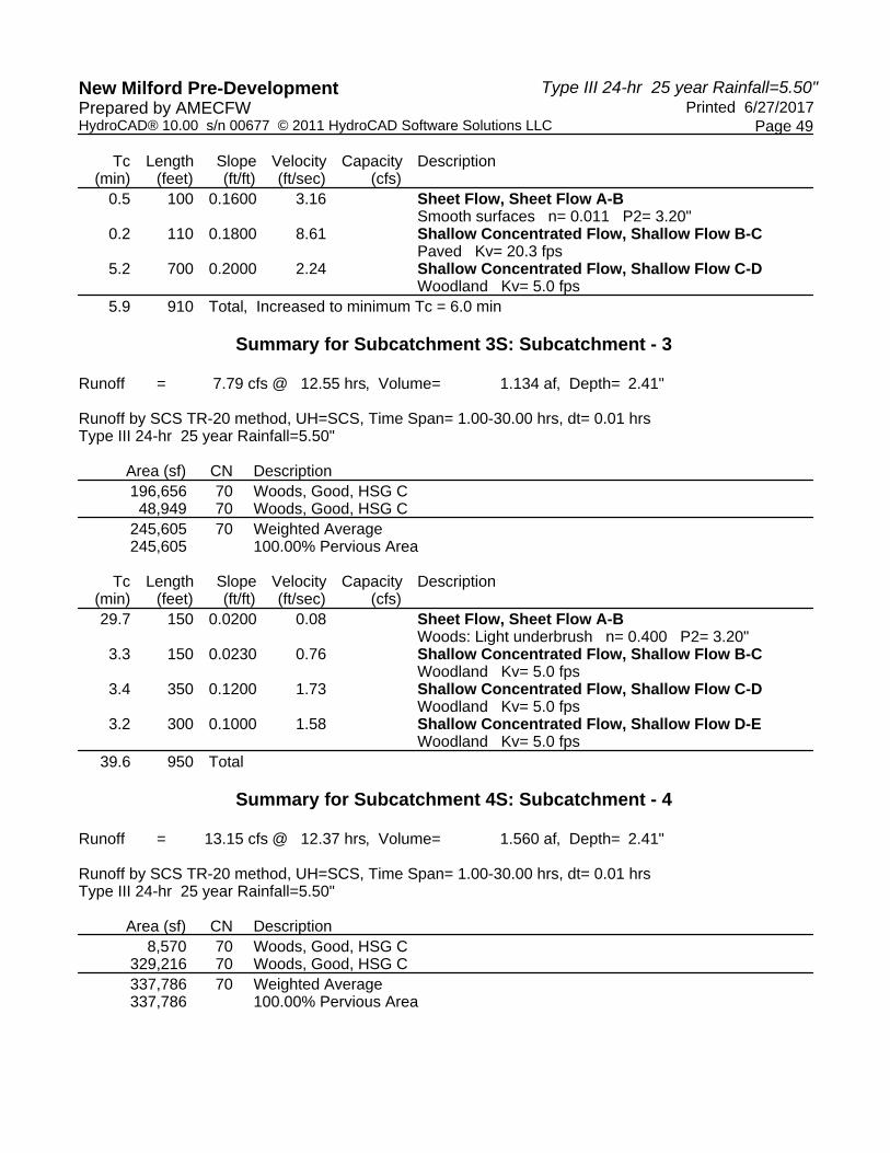
Type III 24-hr 25 year Rainfall=5.50"New Milford Pre-Development Printed 6/27/2017Prepared by AMECFW
Page 49HydroCAD® 10.00 s/n 00677 © 2011 HydroCAD Software Solutions LLC
Tc Length Slope Velocity Capacity Description(min) (feet) (ft/ft) (ft/sec) (cfs)
0.5 100 0.1600 3.16 Sheet Flow, Sheet Flow A-BSmooth surfaces n= 0.011 P2= 3.20"
0.2 110 0.1800 8.61 Shallow Concentrated Flow, Shallow Flow B-CPaved Kv= 20.3 fps
5.2 700 0.2000 2.24 Shallow Concentrated Flow, Shallow Flow C-DWoodland Kv= 5.0 fps
5.9 910 Total, Increased to minimum Tc = 6.0 min
Summary for Subcatchment 3S: Subcatchment - 3
Runoff = 7.79 cfs @ 12.55 hrs, Volume= 1.134 af, Depth= 2.41"
Runoff by SCS TR-20 method, UH=SCS, Time Span= 1.00-30.00 hrs, dt= 0.01 hrsType III 24-hr 25 year Rainfall=5.50"
Area (sf) CN Description196,656 70 Woods, Good, HSG C48,949 70 Woods, Good, HSG C
245,605 70 Weighted Average245,605 100.00% Pervious Area
Tc Length Slope Velocity Capacity Description(min) (feet) (ft/ft) (ft/sec) (cfs)29.7 150 0.0200 0.08 Sheet Flow, Sheet Flow A-B
Woods: Light underbrush n= 0.400 P2= 3.20"3.3 150 0.0230 0.76 Shallow Concentrated Flow, Shallow Flow B-C
Woodland Kv= 5.0 fps3.4 350 0.1200 1.73 Shallow Concentrated Flow, Shallow Flow C-D
Woodland Kv= 5.0 fps3.2 300 0.1000 1.58 Shallow Concentrated Flow, Shallow Flow D-E
Woodland Kv= 5.0 fps39.6 950 Total
Summary for Subcatchment 4S: Subcatchment - 4
Runoff = 13.15 cfs @ 12.37 hrs, Volume= 1.560 af, Depth= 2.41"
Runoff by SCS TR-20 method, UH=SCS, Time Span= 1.00-30.00 hrs, dt= 0.01 hrsType III 24-hr 25 year Rainfall=5.50"
Area (sf) CN Description8,570 70 Woods, Good, HSG C
329,216 70 Woods, Good, HSG C337,786 70 Weighted Average337,786 100.00% Pervious Area

Type III 24-hr 25 year Rainfall=5.50"New Milford Pre-Development Printed 6/27/2017Prepared by AMECFW
Page 50HydroCAD® 10.00 s/n 00677 © 2011 HydroCAD Software Solutions LLC
Tc Length Slope Velocity Capacity Description(min) (feet) (ft/ft) (ft/sec) (cfs)17.1 150 0.0800 0.15 Sheet Flow, Sheet Flow A-B
Woods: Light underbrush n= 0.400 P2= 3.20"8.5 850 0.1100 1.66 Shallow Concentrated Flow, Shallow Flow B-C
Woodland Kv= 5.0 fps25.6 1,000 Total
Summary for Subcatchment 5S: Subcatchment - 5
Runoff = 10.85 cfs @ 12.36 hrs, Volume= 1.276 af, Depth= 2.41"
Runoff by SCS TR-20 method, UH=SCS, Time Span= 1.00-30.00 hrs, dt= 0.01 hrsType III 24-hr 25 year Rainfall=5.50"
Area (sf) CN Description129,095 70 Woods, Good, HSG C147,119 70 Woods, Good, HSG C276,214 70 Weighted Average276,214 100.00% Pervious Area
Tc Length Slope Velocity Capacity Description(min) (feet) (ft/ft) (ft/sec) (cfs)17.1 150 0.0800 0.15 Sheet Flow, Sheet Flow A-B
Woods: Light underbrush n= 0.400 P2= 3.20"8.0 800 0.1100 1.66 Shallow Concentrated Flow, Shallow Flow B-C
Woodland Kv= 5.0 fps25.1 950 Total
Summary for Subcatchment 6S: Subcatchment - 6
Runoff = 9.77 cfs @ 12.64 hrs, Volume= 1.517 af, Depth= 2.68"
Runoff by SCS TR-20 method, UH=SCS, Time Span= 1.00-30.00 hrs, dt= 0.01 hrsType III 24-hr 25 year Rainfall=5.50"
Area (sf) CN Description* 5,603 98 Unconnected Outcrop, HSG D
240,370 70 Woods, Good, HSG C50,000 86 Pasture/grassland/range, Poor, HSG C
295,973 73 Weighted Average290,370 98.11% Pervious Area
5,603 1.89% Impervious Area5,603 100.00% Unconnected

Type III 24-hr 25 year Rainfall=5.50"New Milford Pre-Development Printed 6/27/2017Prepared by AMECFW
Page 51HydroCAD® 10.00 s/n 00677 © 2011 HydroCAD Software Solutions LLC
Tc Length Slope Velocity Capacity Description(min) (feet) (ft/ft) (ft/sec) (cfs)35.3 150 0.0130 0.07 Sheet Flow, Sheet Flow A-B
Woods: Light underbrush n= 0.400 P2= 3.20"5.0 260 0.0300 0.87 Shallow Concentrated Flow, Shallow Flow B-C
Woodland Kv= 5.0 fps2.8 390 0.1100 2.32 Shallow Concentrated Flow, Shallow Flow C-D
Short Grass Pasture Kv= 7.0 fps2.6 250 0.1000 1.58 Shallow Concentrated Flow, Shallow Flow C-D
Woodland Kv= 5.0 fps45.7 1,050 Total
Summary for Subcatchment 7S: Subcatchment - 7
Runoff = 22.46 cfs @ 12.36 hrs, Volume= 2.637 af, Depth= 2.86"
Runoff by SCS TR-20 method, UH=SCS, Time Span= 1.00-30.00 hrs, dt= 0.01 hrsType III 24-hr 25 year Rainfall=5.50"
Area (sf) CN Description76,444 70 Woods, Good, HSG C
182,402 70 Woods, Good, HSG C99,000 74 Pasture/grassland/range, Good, HSG C25,000 96 Gravel surface, HSG C23,000 77 Woods, Good, HSG D
* 76,000 98 Unconnected Outcrop, HSG C481,846 77 Weighted Average, UI Adjusted CN = 75405,846 84.23% Pervious Area76,000 15.77% Impervious Area76,000 100.00% Unconnected
Tc Length Slope Velocity Capacity Description(min) (feet) (ft/ft) (ft/sec) (cfs)17.1 150 0.0800 0.15 Sheet Flow, Sheet Flow A-B
Woods: Light underbrush n= 0.400 P2= 3.20"1.6 160 0.1100 1.66 Shallow Concentrated Flow, Shallow Flow B-C
Woodland Kv= 5.0 fps0.1 70 0.2000 9.08 Shallow Concentrated Flow, Shallow Flow C-D
Paved Kv= 20.3 fps0.9 120 0.2100 2.29 Shallow Concentrated Flow, Shallow Flow D-E
Woodland Kv= 5.0 fps0.1 80 0.2500 10.15 Shallow Concentrated Flow, Shallow Flow E-F
Paved Kv= 20.3 fps1.9 190 0.1100 1.66 Shallow Concentrated Flow, Shallow Flow F-G
Woodland Kv= 5.0 fps4.0 380 0.0500 1.57 Shallow Concentrated Flow, Shallow Flow G-H
Short Grass Pasture Kv= 7.0 fps25.7 1,150 Total

Type III 24-hr 25 year Rainfall=5.50"New Milford Pre-Development Printed 6/27/2017Prepared by AMECFW
Page 52HydroCAD® 10.00 s/n 00677 © 2011 HydroCAD Software Solutions LLC
Summary for Subcatchment 8S: Subcatchment - 8
Runoff = 31.67 cfs @ 12.28 hrs, Volume= 3.370 af, Depth= 3.05"
Runoff by SCS TR-20 method, UH=SCS, Time Span= 1.00-30.00 hrs, dt= 0.01 hrsType III 24-hr 25 year Rainfall=5.50"
Area (sf) CN Description* 8,320 98 Unconnected Outcrop, HSG D
321,473 70 Woods, Good, HSG C248,378 86 Pasture/grassland/range, Poor, HSG C578,171 77 Weighted Average569,851 98.56% Pervious Area
8,320 1.44% Impervious Area8,320 100.00% Unconnected
Tc Length Slope Velocity Capacity Description(min) (feet) (ft/ft) (ft/sec) (cfs)12.1 150 0.0200 0.21 Sheet Flow, Sheet Flow A-B
Range n= 0.130 P2= 3.20"1.7 150 0.0460 1.50 Shallow Concentrated Flow, Shallow Flow B-C
Short Grass Pasture Kv= 7.0 fps1.0 75 0.0570 1.19 Shallow Concentrated Flow, Shallow Flow C-D
Woodland Kv= 5.0 fps3.4 450 0.1000 2.21 Shallow Concentrated Flow, Shallow Flow D-E
Short Grass Pasture Kv= 7.0 fps2.2 250 0.1440 1.90 Shallow Concentrated Flow, Shallow Flow E-F
Woodland Kv= 5.0 fps20.4 1,075 Total
Summary for Subcatchment 9S: Subcatchment - 9
Runoff = 22.57 cfs @ 12.28 hrs, Volume= 2.386 af, Depth= 3.05"
Runoff by SCS TR-20 method, UH=SCS, Time Span= 1.00-30.00 hrs, dt= 0.01 hrsType III 24-hr 25 year Rainfall=5.50"
Area (sf) CN Description* 42,364 98 Unconnected Outcrop, HSG D
229,322 70 Woods, Good, HSG C125,000 86 Pasture/grassland/range, Poor, HSG C
* 12,700 98 Unconnected Outcrop, HSG C409,386 79 Weighted Average, UI Adjusted CN = 77354,322 86.55% Pervious Area55,064 13.45% Impervious Area55,064 100.00% Unconnected

Type III 24-hr 25 year Rainfall=5.50"New Milford Pre-Development Printed 6/27/2017Prepared by AMECFW
Page 53HydroCAD® 10.00 s/n 00677 © 2011 HydroCAD Software Solutions LLC
Tc Length Slope Velocity Capacity Description(min) (feet) (ft/ft) (ft/sec) (cfs)
6.6 100 0.0400 0.25 Sheet Flow, Sheet Flow A-BRange n= 0.130 P2= 3.20"
8.8 500 0.0360 0.95 Shallow Concentrated Flow, Shallow Flow B-CWoodland Kv= 5.0 fps
4.1 575 0.1100 2.32 Shallow Concentrated Flow, Shallow Flow C-DShort Grass Pasture Kv= 7.0 fps
0.7 100 0.2400 2.45 Shallow Concentrated Flow, Shallow Flow D-EWoodland Kv= 5.0 fps
20.2 1,275 Total
Summary for Subcatchment 10S: Subcatchment - 10
Runoff = 9.54 cfs @ 12.27 hrs, Volume= 0.991 af, Depth= 2.59"
Runoff by SCS TR-20 method, UH=SCS, Time Span= 1.00-30.00 hrs, dt= 0.01 hrsType III 24-hr 25 year Rainfall=5.50"
Area (sf) CN Description47,717 70 Woods, Good, HSG C81,029 70 Woods, Good, HSG C49,287 70 Woods, Good, HSG C20,000 86 Pasture/grassland/range, Poor, HSG C
* 2,000 96 Gravel Road surface, HSG C200,033 72 Weighted Average200,033 100.00% Pervious Area
Tc Length Slope Velocity Capacity Description(min) (feet) (ft/ft) (ft/sec) (cfs)12.1 150 0.0200 0.21 Sheet Flow, Sheet Flow A-B
Range n= 0.130 P2= 3.20"1.1 100 0.0500 1.57 Shallow Concentrated Flow, Shallow Flow B-C
Short Grass Pasture Kv= 7.0 fps5.7 450 0.0700 1.32 Shallow Concentrated Flow, Shallow Flow C-D
Woodland Kv= 5.0 fps18.9 700 Total
Summary for Reach POA-1: Existing Woods to the Northeast & Tributary to Existing Wetlands Area
[40] Hint: Not Described (Outflow=Inflow)
Inflow Area = 12.034 ac, 12.76% Impervious, Inflow Depth = 2.77" for 25 year eventInflow = 32.09 cfs @ 12.17 hrs, Volume= 2.777 afOutflow = 32.09 cfs @ 12.17 hrs, Volume= 2.777 af, Atten= 0%, Lag= 0.0 min
Routing by Dyn-Stor-Ind method, Time Span= 1.00-30.00 hrs, dt= 0.01 hrs

Type III 24-hr 25 year Rainfall=5.50"New Milford Pre-Development Printed 6/27/2017Prepared by AMECFW
Page 54HydroCAD® 10.00 s/n 00677 © 2011 HydroCAD Software Solutions LLC
Summary for Reach POA-10: Existing Woods to the Northwest
[40] Hint: Not Described (Outflow=Inflow)
Inflow Area = 4.592 ac, 0.00% Impervious, Inflow Depth = 2.59" for 25 year eventInflow = 9.54 cfs @ 12.27 hrs, Volume= 0.991 afOutflow = 9.54 cfs @ 12.27 hrs, Volume= 0.991 af, Atten= 0%, Lag= 0.0 min
Routing by Dyn-Stor-Ind method, Time Span= 1.00-30.00 hrs, dt= 0.01 hrs
Summary for Reach POA-2: Existing Woods to the Northwest
[40] Hint: Not Described (Outflow=Inflow)
Inflow Area = 12.876 ac, 7.54% Impervious, Inflow Depth = 2.77" for 25 year eventInflow = 41.76 cfs @ 12.09 hrs, Volume= 2.971 afOutflow = 41.76 cfs @ 12.09 hrs, Volume= 2.971 af, Atten= 0%, Lag= 0.0 min
Routing by Dyn-Stor-Ind method, Time Span= 1.00-30.00 hrs, dt= 0.01 hrs
Summary for Reach POA-3: Existing Woods to the Northwest
[40] Hint: Not Described (Outflow=Inflow)
Inflow Area = 5.638 ac, 0.00% Impervious, Inflow Depth = 2.41" for 25 year eventInflow = 7.79 cfs @ 12.55 hrs, Volume= 1.134 afOutflow = 7.79 cfs @ 12.55 hrs, Volume= 1.134 af, Atten= 0%, Lag= 0.0 min
Routing by Dyn-Stor-Ind method, Time Span= 1.00-30.00 hrs, dt= 0.01 hrs
Summary for Reach POA-4: Existing Woods to the Northwest
[40] Hint: Not Described (Outflow=Inflow)
Inflow Area = 7.754 ac, 0.00% Impervious, Inflow Depth = 2.41" for 25 year eventInflow = 13.15 cfs @ 12.37 hrs, Volume= 1.560 afOutflow = 13.15 cfs @ 12.37 hrs, Volume= 1.560 af, Atten= 0%, Lag= 0.0 min
Routing by Dyn-Stor-Ind method, Time Span= 1.00-30.00 hrs, dt= 0.01 hrs
Summary for Reach POA-5: Existing Woods to the Northwest
[40] Hint: Not Described (Outflow=Inflow)
Inflow Area = 6.341 ac, 0.00% Impervious, Inflow Depth = 2.41" for 25 year eventInflow = 10.85 cfs @ 12.36 hrs, Volume= 1.276 afOutflow = 10.85 cfs @ 12.36 hrs, Volume= 1.276 af, Atten= 0%, Lag= 0.0 min

Type III 24-hr 25 year Rainfall=5.50"New Milford Pre-Development Printed 6/27/2017Prepared by AMECFW
Page 55HydroCAD® 10.00 s/n 00677 © 2011 HydroCAD Software Solutions LLC
Routing by Dyn-Stor-Ind method, Time Span= 1.00-30.00 hrs, dt= 0.01 hrs
Summary for Reach POA-6: Existing Woods to the Northeast
[40] Hint: Not Described (Outflow=Inflow)
Inflow Area = 6.795 ac, 1.89% Impervious, Inflow Depth = 2.68" for 25 year eventInflow = 9.77 cfs @ 12.64 hrs, Volume= 1.517 afOutflow = 9.77 cfs @ 12.64 hrs, Volume= 1.517 af, Atten= 0%, Lag= 0.0 min
Routing by Dyn-Stor-Ind method, Time Span= 1.00-30.00 hrs, dt= 0.01 hrs
Summary for Reach POA-7: Existing Woods & Candlewood Roadside Swales to the Northwest
[40] Hint: Not Described (Outflow=Inflow)
Inflow Area = 11.062 ac, 15.77% Impervious, Inflow Depth = 2.86" for 25 year eventInflow = 22.46 cfs @ 12.36 hrs, Volume= 2.637 afOutflow = 22.46 cfs @ 12.36 hrs, Volume= 2.637 af, Atten= 0%, Lag= 0.0 min
Routing by Dyn-Stor-Ind method, Time Span= 1.00-30.00 hrs, dt= 0.01 hrs
Summary for Reach POA-8: Existing Woods to the Northeast
[40] Hint: Not Described (Outflow=Inflow)
Inflow Area = 13.273 ac, 1.44% Impervious, Inflow Depth = 3.05" for 25 year eventInflow = 31.67 cfs @ 12.28 hrs, Volume= 3.370 afOutflow = 31.67 cfs @ 12.28 hrs, Volume= 3.370 af, Atten= 0%, Lag= 0.0 min
Routing by Dyn-Stor-Ind method, Time Span= 1.00-30.00 hrs, dt= 0.01 hrs
Summary for Reach POA-9: Existing Woods to the Northeast
[40] Hint: Not Described (Outflow=Inflow)
Inflow Area = 9.398 ac, 13.45% Impervious, Inflow Depth = 3.05" for 25 year eventInflow = 22.57 cfs @ 12.28 hrs, Volume= 2.386 afOutflow = 22.57 cfs @ 12.28 hrs, Volume= 2.386 af, Atten= 0%, Lag= 0.0 min
Routing by Dyn-Stor-Ind method, Time Span= 1.00-30.00 hrs, dt= 0.01 hrs

Type III 24-hr 100 year Rainfall=7.00"New Milford Pre-Development Printed 6/27/2017Prepared by AMECFW
Page 56HydroCAD® 10.00 s/n 00677 © 2011 HydroCAD Software Solutions LLC
Time span=1.00-30.00 hrs, dt=0.01 hrs, 2901 pointsRunoff by SCS TR-20 method, UH=SCS
Reach routing by Dyn-Stor-Ind method - Pond routing by Dyn-Stor-Ind method
Runoff Area=524,221 sf 12.76% Impervious Runoff Depth=4.04"Subcatchment1S: Subcatchment- 1 Flow Length=1,200' Tc=11.9 min UI Adjusted CN=74 Runoff=46.98 cfs 4.054 af
Runoff Area=560,880 sf 7.54% Impervious Runoff Depth=4.04"Subcatchment2S: Subcatchment- 2 Flow Length=910' Tc=6.0 min UI Adjusted CN=74 Runoff=61.03 cfs 4.337 af
Runoff Area=245,605 sf 0.00% Impervious Runoff Depth=3.62"Subcatchment3S: Subcatchment- 3 Flow Length=950' Tc=39.6 min CN=70 Runoff=11.83 cfs 1.700 af
Runoff Area=337,786 sf 0.00% Impervious Runoff Depth=3.62"Subcatchment4S: Subcatchment- 4 Flow Length=1,000' Tc=25.6 min CN=70 Runoff=19.92 cfs 2.338 af
Runoff Area=276,214 sf 0.00% Impervious Runoff Depth=3.62"Subcatchment5S: Subcatchment- 5 Flow Length=950' Tc=25.1 min CN=70 Runoff=16.45 cfs 1.912 af
Runoff Area=295,973 sf 1.89% Impervious Runoff Depth=3.94"Subcatchment6S: Subcatchment- 6 Flow Length=1,050' Tc=45.7 min CN=73 Runoff=14.43 cfs 2.228 af
Runoff Area=481,846 sf 15.77% Impervious Runoff Depth=4.15"Subcatchment7S: Subcatchment- 7 Flow Length=1,150' Tc=25.7 min UI Adjusted CN=75 Runoff=32.62 cfs 3.825 af
Runoff Area=578,171 sf 1.44% Impervious Runoff Depth=4.37"Subcatchment8S: Subcatchment- 8 Flow Length=1,075' Tc=20.4 min CN=77 Runoff=45.34 cfs 4.829 af
Runoff Area=409,386 sf 13.45% Impervious Runoff Depth=4.37"Subcatchment9S: Subcatchment- 9 Flow Length=1,275' Tc=20.2 min UI Adjusted CN=77 Runoff=32.29 cfs 3.419 af
Runoff Area=200,033 sf 0.00% Impervious Runoff Depth=3.83"Subcatchment10S: Subcatchment- 10 Flow Length=700' Tc=18.9 min CN=72 Runoff=14.21 cfs 1.465 af
Inflow=46.98 cfs 4.054 afReach POA-1:ExistingWoods to the Northeast& Tributaryto Existing Outflow=46.98 cfs 4.054 af
Inflow=14.21 cfs 1.465 afReach POA-10:ExistingWoods to the Northwest Outflow=14.21 cfs 1.465 af
Inflow=61.03 cfs 4.337 afReach POA-2:ExistingWoods to the Northwest Outflow=61.03 cfs 4.337 af
Inflow=11.83 cfs 1.700 afReach POA-3:ExistingWoods to the Northwest Outflow=11.83 cfs 1.700 af
Inflow=19.92 cfs 2.338 afReach POA-4:ExistingWoods to the Northwest Outflow=19.92 cfs 2.338 af
Inflow=16.45 cfs 1.912 afReach POA-5:ExistingWoods to the Northwest Outflow=16.45 cfs 1.912 af

Type III 24-hr 100 year Rainfall=7.00"New Milford Pre-Development Printed 6/27/2017Prepared by AMECFW
Page 57HydroCAD® 10.00 s/n 00677 © 2011 HydroCAD Software Solutions LLC
Inflow=14.43 cfs 2.228 afReach POA-6:ExistingWoods to the Northeast Outflow=14.43 cfs 2.228 af
Inflow=32.62 cfs 3.825 afReach POA-7:ExistingWoods & CandlewoodRoadsideSwales to the Outflow=32.62 cfs 3.825 af
Inflow=45.34 cfs 4.829 afReach POA-8:ExistingWoods to the Northeast Outflow=45.34 cfs 4.829 af
Inflow=32.29 cfs 3.419 afReach POA-9:ExistingWoods to the Northeast Outflow=32.29 cfs 3.419 af
Total Runoff Area = 89.764 ac Runoff Volume = 30.108 af Average Runoff Depth = 4.02"93.50% Pervious = 83.929 ac 6.50% Impervious = 5.835 ac

Type III 24-hr 100 year Rainfall=7.00"New Milford Pre-Development Printed 6/27/2017Prepared by AMECFW
Page 58HydroCAD® 10.00 s/n 00677 © 2011 HydroCAD Software Solutions LLC
Summary for Subcatchment 1S: Subcatchment - 1
Runoff = 46.98 cfs @ 12.16 hrs, Volume= 4.054 af, Depth= 4.04"
Runoff by SCS TR-20 method, UH=SCS, Time Span= 1.00-30.00 hrs, dt= 0.01 hrsType III 24-hr 100 year Rainfall=7.00"
Area (sf) CN Description* 31,320 98 Unconnected Outcrop, HSG D
119,196 77 Woods, Good, HSG D86,728 70 Woods, Good, HSG C
231,002 70 Woods, Good, HSG C20,386 77 Woods, Good, HSG D
* 35,589 98 Unconnected Outcrop, HSG D524,221 75 Weighted Average, UI Adjusted CN = 74457,312 87.24% Pervious Area66,909 12.76% Impervious Area66,909 100.00% Unconnected
Tc Length Slope Velocity Capacity Description(min) (feet) (ft/ft) (ft/sec) (cfs)
0.5 100 0.1500 3.08 Sheet Flow, Sheet Flow A-BSmooth surfaces n= 0.011 P2= 3.20"
0.3 200 0.2500 10.15 Shallow Concentrated Flow, Shallow Flow B-CPaved Kv= 20.3 fps
11.1 900 0.0730 1.35 Shallow Concentrated Flow, Shallow Flow C-DWoodland Kv= 5.0 fps
11.9 1,200 Total
Summary for Subcatchment 2S: Subcatchment - 2
Runoff = 61.03 cfs @ 12.09 hrs, Volume= 4.337 af, Depth= 4.04"
Runoff by SCS TR-20 method, UH=SCS, Time Span= 1.00-30.00 hrs, dt= 0.01 hrsType III 24-hr 100 year Rainfall=7.00"
Area (sf) CN Description288,520 70 Woods, Good, HSG C
* 42,288 98 Unconnected Outcrop, HSG D89,278 77 Woods, Good, HSG D12,686 70 Woods, Good, HSG C
128,108 77 Woods, Good, HSG D560,880 75 Weighted Average, UI Adjusted CN = 74518,592 92.46% Pervious Area42,288 7.54% Impervious Area42,288 100.00% Unconnected

Type III 24-hr 100 year Rainfall=7.00"New Milford Pre-Development Printed 6/27/2017Prepared by AMECFW
Page 59HydroCAD® 10.00 s/n 00677 © 2011 HydroCAD Software Solutions LLC
Tc Length Slope Velocity Capacity Description(min) (feet) (ft/ft) (ft/sec) (cfs)
0.5 100 0.1600 3.16 Sheet Flow, Sheet Flow A-BSmooth surfaces n= 0.011 P2= 3.20"
0.2 110 0.1800 8.61 Shallow Concentrated Flow, Shallow Flow B-CPaved Kv= 20.3 fps
5.2 700 0.2000 2.24 Shallow Concentrated Flow, Shallow Flow C-DWoodland Kv= 5.0 fps
5.9 910 Total, Increased to minimum Tc = 6.0 min
Summary for Subcatchment 3S: Subcatchment - 3
Runoff = 11.83 cfs @ 12.54 hrs, Volume= 1.700 af, Depth= 3.62"
Runoff by SCS TR-20 method, UH=SCS, Time Span= 1.00-30.00 hrs, dt= 0.01 hrsType III 24-hr 100 year Rainfall=7.00"
Area (sf) CN Description196,656 70 Woods, Good, HSG C48,949 70 Woods, Good, HSG C
245,605 70 Weighted Average245,605 100.00% Pervious Area
Tc Length Slope Velocity Capacity Description(min) (feet) (ft/ft) (ft/sec) (cfs)29.7 150 0.0200 0.08 Sheet Flow, Sheet Flow A-B
Woods: Light underbrush n= 0.400 P2= 3.20"3.3 150 0.0230 0.76 Shallow Concentrated Flow, Shallow Flow B-C
Woodland Kv= 5.0 fps3.4 350 0.1200 1.73 Shallow Concentrated Flow, Shallow Flow C-D
Woodland Kv= 5.0 fps3.2 300 0.1000 1.58 Shallow Concentrated Flow, Shallow Flow D-E
Woodland Kv= 5.0 fps39.6 950 Total
Summary for Subcatchment 4S: Subcatchment - 4
Runoff = 19.92 cfs @ 12.37 hrs, Volume= 2.338 af, Depth= 3.62"
Runoff by SCS TR-20 method, UH=SCS, Time Span= 1.00-30.00 hrs, dt= 0.01 hrsType III 24-hr 100 year Rainfall=7.00"
Area (sf) CN Description8,570 70 Woods, Good, HSG C
329,216 70 Woods, Good, HSG C337,786 70 Weighted Average337,786 100.00% Pervious Area

Type III 24-hr 100 year Rainfall=7.00"New Milford Pre-Development Printed 6/27/2017Prepared by AMECFW
Page 60HydroCAD® 10.00 s/n 00677 © 2011 HydroCAD Software Solutions LLC
Tc Length Slope Velocity Capacity Description(min) (feet) (ft/ft) (ft/sec) (cfs)17.1 150 0.0800 0.15 Sheet Flow, Sheet Flow A-B
Woods: Light underbrush n= 0.400 P2= 3.20"8.5 850 0.1100 1.66 Shallow Concentrated Flow, Shallow Flow B-C
Woodland Kv= 5.0 fps25.6 1,000 Total
Summary for Subcatchment 5S: Subcatchment - 5
Runoff = 16.45 cfs @ 12.35 hrs, Volume= 1.912 af, Depth= 3.62"
Runoff by SCS TR-20 method, UH=SCS, Time Span= 1.00-30.00 hrs, dt= 0.01 hrsType III 24-hr 100 year Rainfall=7.00"
Area (sf) CN Description129,095 70 Woods, Good, HSG C147,119 70 Woods, Good, HSG C276,214 70 Weighted Average276,214 100.00% Pervious Area
Tc Length Slope Velocity Capacity Description(min) (feet) (ft/ft) (ft/sec) (cfs)17.1 150 0.0800 0.15 Sheet Flow, Sheet Flow A-B
Woods: Light underbrush n= 0.400 P2= 3.20"8.0 800 0.1100 1.66 Shallow Concentrated Flow, Shallow Flow B-C
Woodland Kv= 5.0 fps25.1 950 Total
Summary for Subcatchment 6S: Subcatchment - 6
Runoff = 14.43 cfs @ 12.64 hrs, Volume= 2.228 af, Depth= 3.94"
Runoff by SCS TR-20 method, UH=SCS, Time Span= 1.00-30.00 hrs, dt= 0.01 hrsType III 24-hr 100 year Rainfall=7.00"
Area (sf) CN Description* 5,603 98 Unconnected Outcrop, HSG D
240,370 70 Woods, Good, HSG C50,000 86 Pasture/grassland/range, Poor, HSG C
295,973 73 Weighted Average290,370 98.11% Pervious Area
5,603 1.89% Impervious Area5,603 100.00% Unconnected

Type III 24-hr 100 year Rainfall=7.00"New Milford Pre-Development Printed 6/27/2017Prepared by AMECFW
Page 61HydroCAD® 10.00 s/n 00677 © 2011 HydroCAD Software Solutions LLC
Tc Length Slope Velocity Capacity Description(min) (feet) (ft/ft) (ft/sec) (cfs)35.3 150 0.0130 0.07 Sheet Flow, Sheet Flow A-B
Woods: Light underbrush n= 0.400 P2= 3.20"5.0 260 0.0300 0.87 Shallow Concentrated Flow, Shallow Flow B-C
Woodland Kv= 5.0 fps2.8 390 0.1100 2.32 Shallow Concentrated Flow, Shallow Flow C-D
Short Grass Pasture Kv= 7.0 fps2.6 250 0.1000 1.58 Shallow Concentrated Flow, Shallow Flow C-D
Woodland Kv= 5.0 fps45.7 1,050 Total
Summary for Subcatchment 7S: Subcatchment - 7
Runoff = 32.62 cfs @ 12.36 hrs, Volume= 3.825 af, Depth= 4.15"
Runoff by SCS TR-20 method, UH=SCS, Time Span= 1.00-30.00 hrs, dt= 0.01 hrsType III 24-hr 100 year Rainfall=7.00"
Area (sf) CN Description76,444 70 Woods, Good, HSG C
182,402 70 Woods, Good, HSG C99,000 74 Pasture/grassland/range, Good, HSG C25,000 96 Gravel surface, HSG C23,000 77 Woods, Good, HSG D
* 76,000 98 Unconnected Outcrop, HSG C481,846 77 Weighted Average, UI Adjusted CN = 75405,846 84.23% Pervious Area76,000 15.77% Impervious Area76,000 100.00% Unconnected
Tc Length Slope Velocity Capacity Description(min) (feet) (ft/ft) (ft/sec) (cfs)17.1 150 0.0800 0.15 Sheet Flow, Sheet Flow A-B
Woods: Light underbrush n= 0.400 P2= 3.20"1.6 160 0.1100 1.66 Shallow Concentrated Flow, Shallow Flow B-C
Woodland Kv= 5.0 fps0.1 70 0.2000 9.08 Shallow Concentrated Flow, Shallow Flow C-D
Paved Kv= 20.3 fps0.9 120 0.2100 2.29 Shallow Concentrated Flow, Shallow Flow D-E
Woodland Kv= 5.0 fps0.1 80 0.2500 10.15 Shallow Concentrated Flow, Shallow Flow E-F
Paved Kv= 20.3 fps1.9 190 0.1100 1.66 Shallow Concentrated Flow, Shallow Flow F-G
Woodland Kv= 5.0 fps4.0 380 0.0500 1.57 Shallow Concentrated Flow, Shallow Flow G-H
Short Grass Pasture Kv= 7.0 fps25.7 1,150 Total

Type III 24-hr 100 year Rainfall=7.00"New Milford Pre-Development Printed 6/27/2017Prepared by AMECFW
Page 62HydroCAD® 10.00 s/n 00677 © 2011 HydroCAD Software Solutions LLC
Summary for Subcatchment 8S: Subcatchment - 8
Runoff = 45.34 cfs @ 12.27 hrs, Volume= 4.829 af, Depth= 4.37"
Runoff by SCS TR-20 method, UH=SCS, Time Span= 1.00-30.00 hrs, dt= 0.01 hrsType III 24-hr 100 year Rainfall=7.00"
Area (sf) CN Description* 8,320 98 Unconnected Outcrop, HSG D
321,473 70 Woods, Good, HSG C248,378 86 Pasture/grassland/range, Poor, HSG C578,171 77 Weighted Average569,851 98.56% Pervious Area
8,320 1.44% Impervious Area8,320 100.00% Unconnected
Tc Length Slope Velocity Capacity Description(min) (feet) (ft/ft) (ft/sec) (cfs)12.1 150 0.0200 0.21 Sheet Flow, Sheet Flow A-B
Range n= 0.130 P2= 3.20"1.7 150 0.0460 1.50 Shallow Concentrated Flow, Shallow Flow B-C
Short Grass Pasture Kv= 7.0 fps1.0 75 0.0570 1.19 Shallow Concentrated Flow, Shallow Flow C-D
Woodland Kv= 5.0 fps3.4 450 0.1000 2.21 Shallow Concentrated Flow, Shallow Flow D-E
Short Grass Pasture Kv= 7.0 fps2.2 250 0.1440 1.90 Shallow Concentrated Flow, Shallow Flow E-F
Woodland Kv= 5.0 fps20.4 1,075 Total
Summary for Subcatchment 9S: Subcatchment - 9
Runoff = 32.29 cfs @ 12.28 hrs, Volume= 3.419 af, Depth= 4.37"
Runoff by SCS TR-20 method, UH=SCS, Time Span= 1.00-30.00 hrs, dt= 0.01 hrsType III 24-hr 100 year Rainfall=7.00"
Area (sf) CN Description* 42,364 98 Unconnected Outcrop, HSG D
229,322 70 Woods, Good, HSG C125,000 86 Pasture/grassland/range, Poor, HSG C
* 12,700 98 Unconnected Outcrop, HSG C409,386 79 Weighted Average, UI Adjusted CN = 77354,322 86.55% Pervious Area55,064 13.45% Impervious Area55,064 100.00% Unconnected
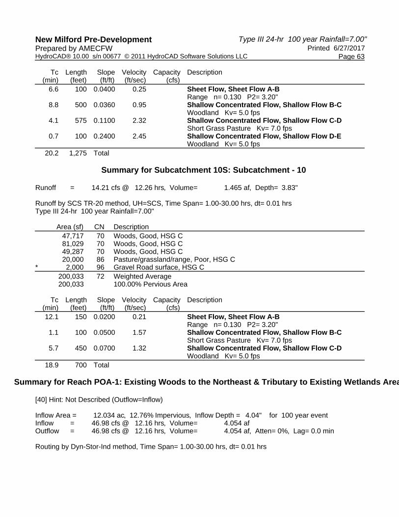
Type III 24-hr 100 year Rainfall=7.00"New Milford Pre-Development Printed 6/27/2017Prepared by AMECFW
Page 63HydroCAD® 10.00 s/n 00677 © 2011 HydroCAD Software Solutions LLC
Tc Length Slope Velocity Capacity Description(min) (feet) (ft/ft) (ft/sec) (cfs)
6.6 100 0.0400 0.25 Sheet Flow, Sheet Flow A-BRange n= 0.130 P2= 3.20"
8.8 500 0.0360 0.95 Shallow Concentrated Flow, Shallow Flow B-CWoodland Kv= 5.0 fps
4.1 575 0.1100 2.32 Shallow Concentrated Flow, Shallow Flow C-DShort Grass Pasture Kv= 7.0 fps
0.7 100 0.2400 2.45 Shallow Concentrated Flow, Shallow Flow D-EWoodland Kv= 5.0 fps
20.2 1,275 Total
Summary for Subcatchment 10S: Subcatchment - 10
Runoff = 14.21 cfs @ 12.26 hrs, Volume= 1.465 af, Depth= 3.83"
Runoff by SCS TR-20 method, UH=SCS, Time Span= 1.00-30.00 hrs, dt= 0.01 hrsType III 24-hr 100 year Rainfall=7.00"
Area (sf) CN Description47,717 70 Woods, Good, HSG C81,029 70 Woods, Good, HSG C49,287 70 Woods, Good, HSG C20,000 86 Pasture/grassland/range, Poor, HSG C
* 2,000 96 Gravel Road surface, HSG C200,033 72 Weighted Average200,033 100.00% Pervious Area
Tc Length Slope Velocity Capacity Description(min) (feet) (ft/ft) (ft/sec) (cfs)12.1 150 0.0200 0.21 Sheet Flow, Sheet Flow A-B
Range n= 0.130 P2= 3.20"1.1 100 0.0500 1.57 Shallow Concentrated Flow, Shallow Flow B-C
Short Grass Pasture Kv= 7.0 fps5.7 450 0.0700 1.32 Shallow Concentrated Flow, Shallow Flow C-D
Woodland Kv= 5.0 fps18.9 700 Total
Summary for Reach POA-1: Existing Woods to the Northeast & Tributary to Existing Wetlands Area
[40] Hint: Not Described (Outflow=Inflow)
Inflow Area = 12.034 ac, 12.76% Impervious, Inflow Depth = 4.04" for 100 year eventInflow = 46.98 cfs @ 12.16 hrs, Volume= 4.054 afOutflow = 46.98 cfs @ 12.16 hrs, Volume= 4.054 af, Atten= 0%, Lag= 0.0 min
Routing by Dyn-Stor-Ind method, Time Span= 1.00-30.00 hrs, dt= 0.01 hrs

Type III 24-hr 100 year Rainfall=7.00"New Milford Pre-Development Printed 6/27/2017Prepared by AMECFW
Page 64HydroCAD® 10.00 s/n 00677 © 2011 HydroCAD Software Solutions LLC
Summary for Reach POA-10: Existing Woods to the Northwest
[40] Hint: Not Described (Outflow=Inflow)
Inflow Area = 4.592 ac, 0.00% Impervious, Inflow Depth = 3.83" for 100 year eventInflow = 14.21 cfs @ 12.26 hrs, Volume= 1.465 afOutflow = 14.21 cfs @ 12.26 hrs, Volume= 1.465 af, Atten= 0%, Lag= 0.0 min
Routing by Dyn-Stor-Ind method, Time Span= 1.00-30.00 hrs, dt= 0.01 hrs
Summary for Reach POA-2: Existing Woods to the Northwest
[40] Hint: Not Described (Outflow=Inflow)
Inflow Area = 12.876 ac, 7.54% Impervious, Inflow Depth = 4.04" for 100 year eventInflow = 61.03 cfs @ 12.09 hrs, Volume= 4.337 afOutflow = 61.03 cfs @ 12.09 hrs, Volume= 4.337 af, Atten= 0%, Lag= 0.0 min
Routing by Dyn-Stor-Ind method, Time Span= 1.00-30.00 hrs, dt= 0.01 hrs
Summary for Reach POA-3: Existing Woods to the Northwest
[40] Hint: Not Described (Outflow=Inflow)
Inflow Area = 5.638 ac, 0.00% Impervious, Inflow Depth = 3.62" for 100 year eventInflow = 11.83 cfs @ 12.54 hrs, Volume= 1.700 afOutflow = 11.83 cfs @ 12.54 hrs, Volume= 1.700 af, Atten= 0%, Lag= 0.0 min
Routing by Dyn-Stor-Ind method, Time Span= 1.00-30.00 hrs, dt= 0.01 hrs
Summary for Reach POA-4: Existing Woods to the Northwest
[40] Hint: Not Described (Outflow=Inflow)
Inflow Area = 7.754 ac, 0.00% Impervious, Inflow Depth = 3.62" for 100 year eventInflow = 19.92 cfs @ 12.37 hrs, Volume= 2.338 afOutflow = 19.92 cfs @ 12.37 hrs, Volume= 2.338 af, Atten= 0%, Lag= 0.0 min
Routing by Dyn-Stor-Ind method, Time Span= 1.00-30.00 hrs, dt= 0.01 hrs
Summary for Reach POA-5: Existing Woods to the Northwest
[40] Hint: Not Described (Outflow=Inflow)
Inflow Area = 6.341 ac, 0.00% Impervious, Inflow Depth = 3.62" for 100 year eventInflow = 16.45 cfs @ 12.35 hrs, Volume= 1.912 afOutflow = 16.45 cfs @ 12.35 hrs, Volume= 1.912 af, Atten= 0%, Lag= 0.0 min

Type III 24-hr 100 year Rainfall=7.00"New Milford Pre-Development Printed 6/27/2017Prepared by AMECFW
Page 65HydroCAD® 10.00 s/n 00677 © 2011 HydroCAD Software Solutions LLC
Routing by Dyn-Stor-Ind method, Time Span= 1.00-30.00 hrs, dt= 0.01 hrs
Summary for Reach POA-6: Existing Woods to the Northeast
[40] Hint: Not Described (Outflow=Inflow)
Inflow Area = 6.795 ac, 1.89% Impervious, Inflow Depth = 3.94" for 100 year eventInflow = 14.43 cfs @ 12.64 hrs, Volume= 2.228 afOutflow = 14.43 cfs @ 12.64 hrs, Volume= 2.228 af, Atten= 0%, Lag= 0.0 min
Routing by Dyn-Stor-Ind method, Time Span= 1.00-30.00 hrs, dt= 0.01 hrs
Summary for Reach POA-7: Existing Woods & Candlewood Roadside Swales to the Northwest
[40] Hint: Not Described (Outflow=Inflow)
Inflow Area = 11.062 ac, 15.77% Impervious, Inflow Depth = 4.15" for 100 year eventInflow = 32.62 cfs @ 12.36 hrs, Volume= 3.825 afOutflow = 32.62 cfs @ 12.36 hrs, Volume= 3.825 af, Atten= 0%, Lag= 0.0 min
Routing by Dyn-Stor-Ind method, Time Span= 1.00-30.00 hrs, dt= 0.01 hrs
Summary for Reach POA-8: Existing Woods to the Northeast
[40] Hint: Not Described (Outflow=Inflow)
Inflow Area = 13.273 ac, 1.44% Impervious, Inflow Depth = 4.37" for 100 year eventInflow = 45.34 cfs @ 12.27 hrs, Volume= 4.829 afOutflow = 45.34 cfs @ 12.27 hrs, Volume= 4.829 af, Atten= 0%, Lag= 0.0 min
Routing by Dyn-Stor-Ind method, Time Span= 1.00-30.00 hrs, dt= 0.01 hrs
Summary for Reach POA-9: Existing Woods to the Northeast
[40] Hint: Not Described (Outflow=Inflow)
Inflow Area = 9.398 ac, 13.45% Impervious, Inflow Depth = 4.37" for 100 year eventInflow = 32.29 cfs @ 12.28 hrs, Volume= 3.419 afOutflow = 32.29 cfs @ 12.28 hrs, Volume= 3.419 af, Atten= 0%, Lag= 0.0 min
Routing by Dyn-Stor-Ind method, Time Span= 1.00-30.00 hrs, dt= 0.01 hrs

1AS
Subcatchment - 1A
1BS
Subcatchment - 1B
1CS
Subcatchment - 1C
2AS
Subcatchment - 2A
2BS
Subcatchment - 2B
2CS
Subcatchment - 2C
3AS
Subcatchment - 3A
3BS
Subcatchment - 3B
4AS
Subcatchment - 4
4BS
Subcatchment - 4B
5AS
Subcatchment - 5A
5BS
Subcatchment - 5B
6AS
Subcatchment - 6A
6BS
Subcatchment - 6B
7AS
Subcatchment - 7A
7BS
Subcatchment - 7B
7CS
Subcatchment - 7C
7DS
Subcatchment - 7D
8AS
Subcatchment - 8A
8BS
Subcatchment - 8B
8CS
Subcatchment - 8C
9AS
Subcatchment - 9A
9BS
Subcatchment - 9B
10S
Subcatchment - 10
POA-1
Existing Woods to the Northeast & Tributary to Existing Wetlands Area
POA-10
Existing Woods to the Northwest
POA-2
Existing Woods to the Northwest
POA-3
Existing Woods to the Northwest
POA-4
Existing Woods to the Northwest
POA-5
Existing Woods to the Northwest
POA-6
Existing Woods to the Northeast
POA-7
Existing Woods & Candlewood Roadside
Swales to the Northwest
POA-8
Existing Woods to the Northeast
POA-9
Existing Woods to the Northeast
Routing Diagram for New Milford Post-DevelopmentPrepared by AMECFW, Printed 6/27/2017
HydroCAD® 10.00 s/n 00677 © 2011 HydroCAD Software Solutions LLC
Subcat Reach Pond Link

New Milford Post-Development Printed 6/27/2017Prepared by AMECFW
Page 2HydroCAD® 10.00 s/n 00677 © 2011 HydroCAD Software Solutions LLC
Area Listing (all nodes)
Area(acres)
CN Description(subcatchment-numbers)
2.337 70 Woods, Good, HSG C (7AS, 7BS, 7CS, 7DS)70.206 71 Meadow, non-grazed, HSG C (1AS, 1BS, 1CS, 2BS, 2CS, 3AS, 3BS, 4AS, 4BS,
5AS, 5BS, 6AS, 6BS, 7AS, 7BS, 7CS, 7DS, 8AS, 8BS, 8CS, 9AS, 9BS, 10S)10.555 78 Meadow, non-grazed, HSG D (1AS, 1BS, 1CS, 2AS, 2BS, 2CS, 6AS, 6BS, 8AS,
8BS, 8CS, 9AS, 9BS)1.722 80 Pasture/grassland/range, Good, HSG D (7AS, 7DS)4.943 98 Unconnected Outcrop, HSG D (1AS, 1BS, 1CS, 2AS, 2BS, 2CS, 6BS, 7AS, 7BS,
7CS, 8BS, 8CS, 9AS, 9BS)89.764 73 TOTAL AREA
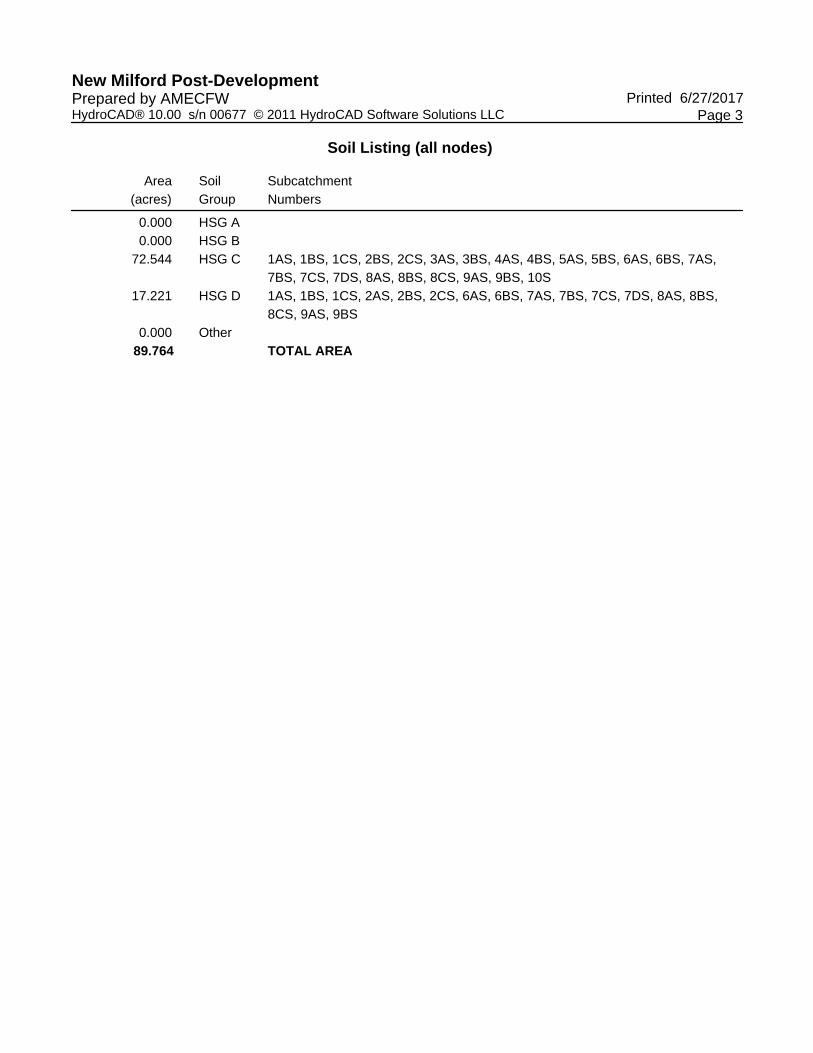
New Milford Post-Development Printed 6/27/2017Prepared by AMECFW
Page 3HydroCAD® 10.00 s/n 00677 © 2011 HydroCAD Software Solutions LLC
Soil Listing (all nodes)
Area(acres)
SoilGroup
SubcatchmentNumbers
0.000 HSG A0.000 HSG B
72.544 HSG C 1AS, 1BS, 1CS, 2BS, 2CS, 3AS, 3BS, 4AS, 4BS, 5AS, 5BS, 6AS, 6BS, 7AS,7BS, 7CS, 7DS, 8AS, 8BS, 8CS, 9AS, 9BS, 10S
17.221 HSG D 1AS, 1BS, 1CS, 2AS, 2BS, 2CS, 6AS, 6BS, 7AS, 7BS, 7CS, 7DS, 8AS, 8BS,8CS, 9AS, 9BS
0.000 Other89.764 TOTAL AREA

New Milford Post-Development Printed 6/27/2017Prepared by AMECFW
Page 4HydroCAD® 10.00 s/n 00677 © 2011 HydroCAD Software Solutions LLC
Ground Covers (all nodes)
HSG-A(acres)
HSG-B(acres)
HSG-C(acres)
HSG-D(acres)
Other(acres)
Total(acres)
GroundCover
SubcatchmentNumbers
0.000 0.000 0.000 4.943 0.000 4.943 Unconnected Outcrop 1AS,1BS,1CS,2AS,2BS,2CS,6BS,7AS,7BS,7CS,8BS,8CS,9AS,9BS
0.000 0.000 0.000 1.722 0.000 1.722 Pasture/grassland/range, Good 7AS,7DS
0.000 0.000 70.206 10.555 0.000 80.762 Meadow, non-grazed 1AS,1BS,1CS,2AS,2BS,2CS,3AS,3BS,4AS,4BS,5AS,5BS,6AS,6BS,7AS,7BS,7CS,7DS,8AS,8BS,8CS,9AS,9BS,10S

New Milford Post-Development Printed 6/27/2017Prepared by AMECFW
Page 5HydroCAD® 10.00 s/n 00677 © 2011 HydroCAD Software Solutions LLC
Ground Covers (all nodes) (continued)
HSG-A(acres)
HSG-B(acres)
HSG-C(acres)
HSG-D(acres)
Other(acres)
Total(acres)
GroundCover
SubcatchmentNumbers
0.000 0.000 2.337 0.000 0.000 2.337 Woods, Good 7AS,7BS,7CS,7DS
0.000 0.000 72.544 17.221 0.000 89.764 TOTAL AREA

Type III 24-hr 1 year Rainfall=2.60"New Milford Post-Development Printed 6/27/2017Prepared by AMECFW
Page 6HydroCAD® 10.00 s/n 00677 © 2011 HydroCAD Software Solutions LLC
Time span=1.00-30.00 hrs, dt=0.01 hrs, 2901 pointsRunoff by SCS TR-20 method, UH=SCS
Reach routing by Dyn-Stor-Ind method - Pond routing by Dyn-Stor-Ind method
Runoff Area=136,972 sf 38.73% Impervious Runoff Depth=1.33"Subcatchment1AS: Subcatchment- 1A Tc=0.0 min CN=86 Runoff=5.98 cfs 0.347 af
Runoff Area=204,474 sf 9.41% Impervious Runoff Depth=0.67"Subcatchment1BS: Subcatchment- 1B Tc=0.0 min UI Adjusted CN=74 Runoff=3.98 cfs 0.260 af
Runoff Area=189,496 sf 1.12% Impervious Runoff Depth=0.58"Subcatchment1CS: Subcatchment- 1C Tc=0.0 min CN=72 Runoff=3.06 cfs 0.211 af
Runoff Area=89,786 sf 15.05% Impervious Runoff Depth=0.96"Subcatchment2AS: Subcatchment- 2A Tc=0.0 min UI Adjusted CN=80 Runoff=2.75 cfs 0.165 af
Runoff Area=209,244 sf 7.62% Impervious Runoff Depth=0.71"Subcatchment2BS: Subcatchment- 2B Tc=0.0 min UI Adjusted CN=75 Runoff=4.43 cfs 0.284 af
Runoff Area=209,786 sf 4.23% Impervious Runoff Depth=0.62"Subcatchment2CS: Subcatchment- 2C Tc=0.0 min UI Adjusted CN=73 Runoff=3.73 cfs 0.250 af
Runoff Area=186,204 sf 0.00% Impervious Runoff Depth=0.54"Subcatchment3AS: Subcatchment- 3A Tc=0.0 min CN=71 Runoff=2.69 cfs 0.193 af
Runoff Area=111,129 sf 0.00% Impervious Runoff Depth=0.54"Subcatchment3BS: Subcatchment- 3B Tc=0.0 min CN=71 Runoff=1.60 cfs 0.115 af
Runoff Area=166,208 sf 0.00% Impervious Runoff Depth=0.54"Subcatchment4AS: Subcatchment- 4 Tc=0.0 min CN=71 Runoff=2.40 cfs 0.172 af
Runoff Area=191,314 sf 0.00% Impervious Runoff Depth=0.54"Subcatchment4BS: Subcatchment- 4B Tc=0.0 min CN=71 Runoff=2.76 cfs 0.198 af
Runoff Area=113,745 sf 0.00% Impervious Runoff Depth=0.54"Subcatchment5AS: Subcatchment- 5A Tc=0.0 min CN=71 Runoff=1.64 cfs 0.118 af
Runoff Area=112,627 sf 0.00% Impervious Runoff Depth=0.54"Subcatchment5BS: Subcatchment- 5B Tc=0.0 min CN=71 Runoff=1.62 cfs 0.117 af
Runoff Area=96,085 sf 0.00% Impervious Runoff Depth=0.54"Subcatchment6AS: Subcatchment- 6A Tc=0.0 min CN=71 Runoff=1.39 cfs 0.100 af
Runoff Area=198,421 sf 2.82% Impervious Runoff Depth=0.54"Subcatchment6BS: Subcatchment- 6B Tc=0.0 min UI Adjusted CN=71 Runoff=2.86 cfs 0.206 af
Runoff Area=177,887 sf 24.72% Impervious Runoff Depth=0.76"Subcatchment7AS: Subcatchment- 7A Tc=0.0 min UI Adjusted CN=76 Runoff=4.09 cfs 0.257 af
Runoff Area=161,349 sf 18.70% Impervious Runoff Depth=0.62"Subcatchment7BS: Subcatchment- 7B Tc=0.0 min UI Adjusted CN=73 Runoff=2.87 cfs 0.192 af

Type III 24-hr 1 year Rainfall=2.60"New Milford Post-Development Printed 6/27/2017Prepared by AMECFW
Page 7HydroCAD® 10.00 s/n 00677 © 2011 HydroCAD Software Solutions LLC
Runoff Area=102,117 sf 2.83% Impervious Runoff Depth=0.54"Subcatchment7CS: Subcatchment- 7C Tc=0.0 min UI Adjusted CN=71 Runoff=1.47 cfs 0.106 af
Runoff Area=67,146 sf 0.00% Impervious Runoff Depth=0.76"Subcatchment7DS: Subcatchment- 7D Flow Length=950' Tc=25.1 min CN=76 Runoff=0.77 cfs 0.097 af
Runoff Area=216,440 sf 0.00% Impervious Runoff Depth=0.58"Subcatchment8AS: Subcatchment- 8A Tc=0.0 min CN=72 Runoff=3.49 cfs 0.241 af
Runoff Area=192,247 sf 0.16% Impervious Runoff Depth=0.58"Subcatchment8BS: Subcatchment- 8B Tc=0.0 min CN=72 Runoff=3.10 cfs 0.214 af
Runoff Area=169,496 sf 5.88% Impervious Runoff Depth=0.62"Subcatchment8CS: Subcatchment- 8C Tc=0.0 min UI Adjusted CN=73 Runoff=3.01 cfs 0.202 af
Runoff Area=188,366 sf 4.68% Impervious Runoff Depth=0.58"Subcatchment9AS: Subcatchment- 9A Tc=0.0 min UI Adjusted CN=72 Runoff=3.04 cfs 0.210 af
Runoff Area=201,560 sf 0.44% Impervious Runoff Depth=0.54"Subcatchment9BS: Subcatchment- 9B Tc=0.0 min CN=71 Runoff=2.91 cfs 0.209 af
Runoff Area=218,036 sf 0.00% Impervious Runoff Depth=0.54"Subcatchment10S: Subcatchment- 10 Tc=0.0 min CN=71 Runoff=3.15 cfs 0.226 af
Inflow=13.00 cfs 0.818 afReach POA-1:ExistingWoods to the Northeast& Tributaryto Existing Outflow=13.00 cfs 0.818 af
Inflow=3.15 cfs 0.226 afReach POA-10:ExistingWoods to the Northwest Outflow=3.15 cfs 0.226 af
Inflow=10.91 cfs 0.699 afReach POA-2:ExistingWoods to the Northwest Outflow=10.91 cfs 0.699 af
Inflow=4.29 cfs 0.308 afReach POA-3:ExistingWoods to the Northwest Outflow=4.29 cfs 0.308 af
Inflow=5.16 cfs 0.371 afReach POA-4:ExistingWoods to the Northwest Outflow=5.16 cfs 0.371 af
Inflow=3.27 cfs 0.235 afReach POA-5:ExistingWoods to the Northwest Outflow=3.27 cfs 0.235 af
Inflow=4.25 cfs 0.305 afReach POA-6:ExistingWoods to the Northeast Outflow=4.25 cfs 0.305 af
Inflow=8.59 cfs 0.652 afReach POA-7:ExistingWoods & CandlewoodRoadsideSwales to the Outflow=8.59 cfs 0.652 af
Inflow=9.61 cfs 0.656 afReach POA-8:ExistingWoods to the Northeast Outflow=9.61 cfs 0.656 af

Type III 24-hr 1 year Rainfall=2.60"New Milford Post-Development Printed 6/27/2017Prepared by AMECFW
Page 8HydroCAD® 10.00 s/n 00677 © 2011 HydroCAD Software Solutions LLC
Inflow=5.92 cfs 0.418 afReach POA-9:ExistingWoods to the Northeast Outflow=5.92 cfs 0.418 af
Total Runoff Area = 89.764 ac Runoff Volume = 4.689 af Average Runoff Depth = 0.63"94.49% Pervious = 84.821 ac 5.51% Impervious = 4.943 ac

Type III 24-hr 1 year Rainfall=2.60"New Milford Post-Development Printed 6/27/2017Prepared by AMECFW
Page 9HydroCAD® 10.00 s/n 00677 © 2011 HydroCAD Software Solutions LLC
Summary for Subcatchment 1AS: Subcatchment - 1A
Runoff = 5.98 cfs @ 12.00 hrs, Volume= 0.347 af, Depth= 1.33"
Runoff by SCS TR-20 method, UH=SCS, Time Span= 1.00-30.00 hrs, dt= 0.01 hrsType III 24-hr 1 year Rainfall=2.60"
Area (sf) CN Description* 35,114 98 Unconnected Outcrop, HSG D
79,782 78 Meadow, non-grazed, HSG D* 17,933 98 Unconnected Outcrop, HSG D
4,143 71 Meadow, non-grazed, HSG C136,972 86 Weighted Average83,925 61.27% Pervious Area53,047 38.73% Impervious Area53,047 100.00% Unconnected

Type III 24-hr 1 year Rainfall=2.60"New Milford Post-Development Printed 6/27/2017Prepared by AMECFW
Page 10HydroCAD® 10.00 s/n 00677 © 2011 HydroCAD Software Solutions LLC
Summary for Subcatchment 1BS: Subcatchment - 1B
Runoff = 3.98 cfs @ 12.00 hrs, Volume= 0.260 af, Depth= 0.67"
Runoff by SCS TR-20 method, UH=SCS, Time Span= 1.00-30.00 hrs, dt= 0.01 hrsType III 24-hr 1 year Rainfall=2.60"
Area (sf) CN Description* 13,477 98 Unconnected Outcrop, HSG D
42,165 78 Meadow, non-grazed, HSG D47,492 71 Meadow, non-grazed, HSG C95,573 71 Meadow, non-grazed, HSG C
* 5,767 98 Unconnected Outcrop, HSG D204,474 75 Weighted Average, UI Adjusted CN = 74185,230 90.59% Pervious Area19,244 9.41% Impervious Area19,244 100.00% Unconnected

Type III 24-hr 1 year Rainfall=2.60"New Milford Post-Development Printed 6/27/2017Prepared by AMECFW
Page 11HydroCAD® 10.00 s/n 00677 © 2011 HydroCAD Software Solutions LLC
Summary for Subcatchment 1CS: Subcatchment - 1C
Runoff = 3.06 cfs @ 12.00 hrs, Volume= 0.211 af, Depth= 0.58"
Runoff by SCS TR-20 method, UH=SCS, Time Span= 1.00-30.00 hrs, dt= 0.01 hrsType III 24-hr 1 year Rainfall=2.60"
Area (sf) CN Description9,856 78 Meadow, non-grazed, HSG D
177,514 71 Meadow, non-grazed, HSG C* 2,126 98 Unconnected Outcrop, HSG D
189,496 72 Weighted Average187,370 98.88% Pervious Area
2,126 1.12% Impervious Area2,126 100.00% Unconnected

Type III 24-hr 1 year Rainfall=2.60"New Milford Post-Development Printed 6/27/2017Prepared by AMECFW
Page 12HydroCAD® 10.00 s/n 00677 © 2011 HydroCAD Software Solutions LLC
Summary for Subcatchment 2AS: Subcatchment - 2A
Runoff = 2.75 cfs @ 12.00 hrs, Volume= 0.165 af, Depth= 0.96"
Runoff by SCS TR-20 method, UH=SCS, Time Span= 1.00-30.00 hrs, dt= 0.01 hrsType III 24-hr 1 year Rainfall=2.60"
Area (sf) CN Description* 13,513 98 Unconnected Outcrop, HSG D
76,273 78 Meadow, non-grazed, HSG D89,786 81 Weighted Average, UI Adjusted CN = 8076,273 84.95% Pervious Area13,513 15.05% Impervious Area13,513 100.00% Unconnected

Type III 24-hr 1 year Rainfall=2.60"New Milford Post-Development Printed 6/27/2017Prepared by AMECFW
Page 13HydroCAD® 10.00 s/n 00677 © 2011 HydroCAD Software Solutions LLC
Summary for Subcatchment 2BS: Subcatchment - 2B
Runoff = 4.43 cfs @ 12.00 hrs, Volume= 0.284 af, Depth= 0.71"
Runoff by SCS TR-20 method, UH=SCS, Time Span= 1.00-30.00 hrs, dt= 0.01 hrsType III 24-hr 1 year Rainfall=2.60"
Area (sf) CN Description* 15,936 98 Unconnected Outcrop, HSG D
80,385 78 Meadow, non-grazed, HSG D112,923 71 Meadow, non-grazed, HSG C209,244 76 Weighted Average, UI Adjusted CN = 75193,308 92.38% Pervious Area15,936 7.62% Impervious Area15,936 100.00% Unconnected

Type III 24-hr 1 year Rainfall=2.60"New Milford Post-Development Printed 6/27/2017Prepared by AMECFW
Page 14HydroCAD® 10.00 s/n 00677 © 2011 HydroCAD Software Solutions LLC
Summary for Subcatchment 2CS: Subcatchment - 2C
Runoff = 3.73 cfs @ 12.00 hrs, Volume= 0.250 af, Depth= 0.62"
Runoff by SCS TR-20 method, UH=SCS, Time Span= 1.00-30.00 hrs, dt= 0.01 hrsType III 24-hr 1 year Rainfall=2.60"
Area (sf) CN Description* 8,868 98 Unconnected Outcrop, HSG D
50,494 78 Meadow, non-grazed, HSG D150,424 71 Meadow, non-grazed, HSG C209,786 74 Weighted Average, UI Adjusted CN = 73200,918 95.77% Pervious Area
8,868 4.23% Impervious Area8,868 100.00% Unconnected

Type III 24-hr 1 year Rainfall=2.60"New Milford Post-Development Printed 6/27/2017Prepared by AMECFW
Page 15HydroCAD® 10.00 s/n 00677 © 2011 HydroCAD Software Solutions LLC
Summary for Subcatchment 3AS: Subcatchment - 3A
Runoff = 2.69 cfs @ 12.01 hrs, Volume= 0.193 af, Depth= 0.54"
Runoff by SCS TR-20 method, UH=SCS, Time Span= 1.00-30.00 hrs, dt= 0.01 hrsType III 24-hr 1 year Rainfall=2.60"
Area (sf) CN Description186,204 71 Meadow, non-grazed, HSG C186,204 100.00% Pervious Area

Type III 24-hr 1 year Rainfall=2.60"New Milford Post-Development Printed 6/27/2017Prepared by AMECFW
Page 16HydroCAD® 10.00 s/n 00677 © 2011 HydroCAD Software Solutions LLC
Summary for Subcatchment 3BS: Subcatchment - 3B
Runoff = 1.60 cfs @ 12.01 hrs, Volume= 0.115 af, Depth= 0.54"
Runoff by SCS TR-20 method, UH=SCS, Time Span= 1.00-30.00 hrs, dt= 0.01 hrsType III 24-hr 1 year Rainfall=2.60"
Area (sf) CN Description111,129 71 Meadow, non-grazed, HSG C111,129 100.00% Pervious Area

Type III 24-hr 1 year Rainfall=2.60"New Milford Post-Development Printed 6/27/2017Prepared by AMECFW
Page 17HydroCAD® 10.00 s/n 00677 © 2011 HydroCAD Software Solutions LLC
Summary for Subcatchment 4AS: Subcatchment - 4
Runoff = 2.40 cfs @ 12.01 hrs, Volume= 0.172 af, Depth= 0.54"
Runoff by SCS TR-20 method, UH=SCS, Time Span= 1.00-30.00 hrs, dt= 0.01 hrsType III 24-hr 1 year Rainfall=2.60"
Area (sf) CN Description166,208 71 Meadow, non-grazed, HSG C166,208 100.00% Pervious Area

Type III 24-hr 1 year Rainfall=2.60"New Milford Post-Development Printed 6/27/2017Prepared by AMECFW
Page 18HydroCAD® 10.00 s/n 00677 © 2011 HydroCAD Software Solutions LLC
Summary for Subcatchment 4BS: Subcatchment - 4B
Runoff = 2.76 cfs @ 12.01 hrs, Volume= 0.198 af, Depth= 0.54"
Runoff by SCS TR-20 method, UH=SCS, Time Span= 1.00-30.00 hrs, dt= 0.01 hrsType III 24-hr 1 year Rainfall=2.60"
Area (sf) CN Description191,314 71 Meadow, non-grazed, HSG C191,314 100.00% Pervious Area
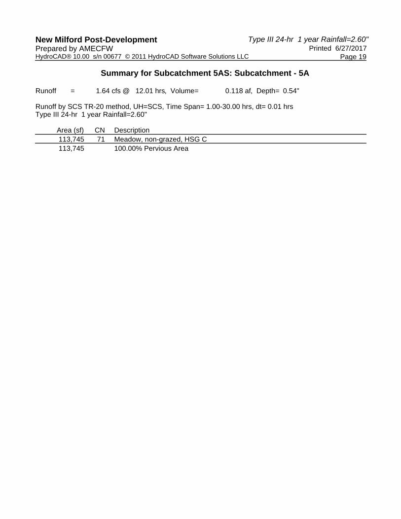
Type III 24-hr 1 year Rainfall=2.60"New Milford Post-Development Printed 6/27/2017Prepared by AMECFW
Page 19HydroCAD® 10.00 s/n 00677 © 2011 HydroCAD Software Solutions LLC
Summary for Subcatchment 5AS: Subcatchment - 5A
Runoff = 1.64 cfs @ 12.01 hrs, Volume= 0.118 af, Depth= 0.54"
Runoff by SCS TR-20 method, UH=SCS, Time Span= 1.00-30.00 hrs, dt= 0.01 hrsType III 24-hr 1 year Rainfall=2.60"
Area (sf) CN Description113,745 71 Meadow, non-grazed, HSG C113,745 100.00% Pervious Area

Type III 24-hr 1 year Rainfall=2.60"New Milford Post-Development Printed 6/27/2017Prepared by AMECFW
Page 20HydroCAD® 10.00 s/n 00677 © 2011 HydroCAD Software Solutions LLC
Summary for Subcatchment 5BS: Subcatchment - 5B
Runoff = 1.62 cfs @ 12.01 hrs, Volume= 0.117 af, Depth= 0.54"
Runoff by SCS TR-20 method, UH=SCS, Time Span= 1.00-30.00 hrs, dt= 0.01 hrsType III 24-hr 1 year Rainfall=2.60"
Area (sf) CN Description112,627 71 Meadow, non-grazed, HSG C112,627 100.00% Pervious Area

Type III 24-hr 1 year Rainfall=2.60"New Milford Post-Development Printed 6/27/2017Prepared by AMECFW
Page 21HydroCAD® 10.00 s/n 00677 © 2011 HydroCAD Software Solutions LLC
Summary for Subcatchment 6AS: Subcatchment - 6A
Runoff = 1.39 cfs @ 12.01 hrs, Volume= 0.100 af, Depth= 0.54"
Runoff by SCS TR-20 method, UH=SCS, Time Span= 1.00-30.00 hrs, dt= 0.01 hrsType III 24-hr 1 year Rainfall=2.60"
Area (sf) CN Description3,203 78 Meadow, non-grazed, HSG D
92,882 71 Meadow, non-grazed, HSG C96,085 71 Weighted Average96,085 100.00% Pervious Area

Type III 24-hr 1 year Rainfall=2.60"New Milford Post-Development Printed 6/27/2017Prepared by AMECFW
Page 22HydroCAD® 10.00 s/n 00677 © 2011 HydroCAD Software Solutions LLC
Summary for Subcatchment 6BS: Subcatchment - 6B
Runoff = 2.86 cfs @ 12.01 hrs, Volume= 0.206 af, Depth= 0.54"
Runoff by SCS TR-20 method, UH=SCS, Time Span= 1.00-30.00 hrs, dt= 0.01 hrsType III 24-hr 1 year Rainfall=2.60"
Area (sf) CN Description3,153 78 Meadow, non-grazed, HSG D
189,665 71 Meadow, non-grazed, HSG C* 5,603 98 Unconnected Outcrop, HSG D
198,421 72 Weighted Average, UI Adjusted CN = 71192,818 97.18% Pervious Area
5,603 2.82% Impervious Area5,603 100.00% Unconnected

Type III 24-hr 1 year Rainfall=2.60"New Milford Post-Development Printed 6/27/2017Prepared by AMECFW
Page 23HydroCAD® 10.00 s/n 00677 © 2011 HydroCAD Software Solutions LLC
Summary for Subcatchment 7AS: Subcatchment - 7A
Runoff = 4.09 cfs @ 12.00 hrs, Volume= 0.257 af, Depth= 0.76"
Runoff by SCS TR-20 method, UH=SCS, Time Span= 1.00-30.00 hrs, dt= 0.01 hrsType III 24-hr 1 year Rainfall=2.60"
Area (sf) CN Description59,019 71 Meadow, non-grazed, HSG C37,330 70 Woods, Good, HSG C37,558 80 Pasture/grassland/range, Good, HSG D
* 43,980 98 Unconnected Outcrop, HSG D177,887 79 Weighted Average, UI Adjusted CN = 76133,907 75.28% Pervious Area43,980 24.72% Impervious Area43,980 100.00% Unconnected

Type III 24-hr 1 year Rainfall=2.60"New Milford Post-Development Printed 6/27/2017Prepared by AMECFW
Page 24HydroCAD® 10.00 s/n 00677 © 2011 HydroCAD Software Solutions LLC
Summary for Subcatchment 7BS: Subcatchment - 7B
Runoff = 2.87 cfs @ 12.00 hrs, Volume= 0.192 af, Depth= 0.62"
Runoff by SCS TR-20 method, UH=SCS, Time Span= 1.00-30.00 hrs, dt= 0.01 hrsType III 24-hr 1 year Rainfall=2.60"
Area (sf) CN Description104,556 71 Meadow, non-grazed, HSG C26,624 70 Woods, Good, HSG C
* 30,169 98 Unconnected Outcrop, HSG D161,349 76 Weighted Average, UI Adjusted CN = 73131,180 81.30% Pervious Area30,169 18.70% Impervious Area30,169 100.00% Unconnected

Type III 24-hr 1 year Rainfall=2.60"New Milford Post-Development Printed 6/27/2017Prepared by AMECFW
Page 25HydroCAD® 10.00 s/n 00677 © 2011 HydroCAD Software Solutions LLC
Summary for Subcatchment 7CS: Subcatchment - 7C
Runoff = 1.47 cfs @ 12.01 hrs, Volume= 0.106 af, Depth= 0.54"
Runoff by SCS TR-20 method, UH=SCS, Time Span= 1.00-30.00 hrs, dt= 0.01 hrsType III 24-hr 1 year Rainfall=2.60"
Area (sf) CN Description89,143 71 Meadow, non-grazed, HSG C10,084 70 Woods, Good, HSG C
* 2,890 98 Unconnected Outcrop, HSG D102,117 72 Weighted Average, UI Adjusted CN = 7199,227 97.17% Pervious Area2,890 2.83% Impervious Area2,890 100.00% Unconnected

Type III 24-hr 1 year Rainfall=2.60"New Milford Post-Development Printed 6/27/2017Prepared by AMECFW
Page 26HydroCAD® 10.00 s/n 00677 © 2011 HydroCAD Software Solutions LLC
Summary for Subcatchment 7DS: Subcatchment - 7D
Runoff = 0.77 cfs @ 12.39 hrs, Volume= 0.097 af, Depth= 0.76"
Runoff by SCS TR-20 method, UH=SCS, Time Span= 1.00-30.00 hrs, dt= 0.01 hrsType III 24-hr 1 year Rainfall=2.60"
Area (sf) CN Description1,925 71 Meadow, non-grazed, HSG C
27,780 70 Woods, Good, HSG C37,441 80 Pasture/grassland/range, Good, HSG D67,146 76 Weighted Average67,146 100.00% Pervious Area
Tc Length Slope Velocity Capacity Description(min) (feet) (ft/ft) (ft/sec) (cfs)17.1 150 0.0800 0.15 Sheet Flow, Sheet Flow A-B
Woods: Light underbrush n= 0.400 P2= 3.20"8.0 800 0.1100 1.66 Shallow Concentrated Flow, Shallow Flow B-C
Woodland Kv= 5.0 fps25.1 950 Total

Type III 24-hr 1 year Rainfall=2.60"New Milford Post-Development Printed 6/27/2017Prepared by AMECFW
Page 27HydroCAD® 10.00 s/n 00677 © 2011 HydroCAD Software Solutions LLC
Summary for Subcatchment 8AS: Subcatchment - 8A
Runoff = 3.49 cfs @ 12.00 hrs, Volume= 0.241 af, Depth= 0.58"
Runoff by SCS TR-20 method, UH=SCS, Time Span= 1.00-30.00 hrs, dt= 0.01 hrsType III 24-hr 1 year Rainfall=2.60"
Area (sf) CN Description192,315 71 Meadow, non-grazed, HSG C24,125 78 Meadow, non-grazed, HSG D
216,440 72 Weighted Average216,440 100.00% Pervious Area

Type III 24-hr 1 year Rainfall=2.60"New Milford Post-Development Printed 6/27/2017Prepared by AMECFW
Page 28HydroCAD® 10.00 s/n 00677 © 2011 HydroCAD Software Solutions LLC
Summary for Subcatchment 8BS: Subcatchment - 8B
Runoff = 3.10 cfs @ 12.00 hrs, Volume= 0.214 af, Depth= 0.58"
Runoff by SCS TR-20 method, UH=SCS, Time Span= 1.00-30.00 hrs, dt= 0.01 hrsType III 24-hr 1 year Rainfall=2.60"
Area (sf) CN Description* 299 98 Unconnected Outcrop, HSG D
163,252 71 Meadow, non-grazed, HSG C28,696 78 Meadow, non-grazed, HSG D
192,247 72 Weighted Average191,948 99.84% Pervious Area
299 0.16% Impervious Area299 100.00% Unconnected

Type III 24-hr 1 year Rainfall=2.60"New Milford Post-Development Printed 6/27/2017Prepared by AMECFW
Page 29HydroCAD® 10.00 s/n 00677 © 2011 HydroCAD Software Solutions LLC
Summary for Subcatchment 8CS: Subcatchment - 8C
Runoff = 3.01 cfs @ 12.00 hrs, Volume= 0.202 af, Depth= 0.62"
Runoff by SCS TR-20 method, UH=SCS, Time Span= 1.00-30.00 hrs, dt= 0.01 hrsType III 24-hr 1 year Rainfall=2.60"
Area (sf) CN Description* 9,966 98 Unconnected Outcrop, HSG D
123,246 71 Meadow, non-grazed, HSG C36,284 78 Meadow, non-grazed, HSG D
169,496 74 Weighted Average, UI Adjusted CN = 73159,530 94.12% Pervious Area
9,966 5.88% Impervious Area9,966 100.00% Unconnected

Type III 24-hr 1 year Rainfall=2.60"New Milford Post-Development Printed 6/27/2017Prepared by AMECFW
Page 30HydroCAD® 10.00 s/n 00677 © 2011 HydroCAD Software Solutions LLC
Summary for Subcatchment 9AS: Subcatchment - 9A
Runoff = 3.04 cfs @ 12.00 hrs, Volume= 0.210 af, Depth= 0.58"
Runoff by SCS TR-20 method, UH=SCS, Time Span= 1.00-30.00 hrs, dt= 0.01 hrsType III 24-hr 1 year Rainfall=2.60"
Area (sf) CN Description* 8,808 98 Unconnected Outcrop, HSG D
158,319 71 Meadow, non-grazed, HSG C21,239 78 Meadow, non-grazed, HSG D
188,366 73 Weighted Average, UI Adjusted CN = 72179,558 95.32% Pervious Area
8,808 4.68% Impervious Area8,808 100.00% Unconnected

Type III 24-hr 1 year Rainfall=2.60"New Milford Post-Development Printed 6/27/2017Prepared by AMECFW
Page 31HydroCAD® 10.00 s/n 00677 © 2011 HydroCAD Software Solutions LLC
Summary for Subcatchment 9BS: Subcatchment - 9B
Runoff = 2.91 cfs @ 12.01 hrs, Volume= 0.209 af, Depth= 0.54"
Runoff by SCS TR-20 method, UH=SCS, Time Span= 1.00-30.00 hrs, dt= 0.01 hrsType III 24-hr 1 year Rainfall=2.60"
Area (sf) CN Description* 889 98 Unconnected Outcrop, HSG D
196,532 71 Meadow, non-grazed, HSG C4,139 78 Meadow, non-grazed, HSG D
201,560 71 Weighted Average200,671 99.56% Pervious Area
889 0.44% Impervious Area889 100.00% Unconnected

Type III 24-hr 1 year Rainfall=2.60"New Milford Post-Development Printed 6/27/2017Prepared by AMECFW
Page 32HydroCAD® 10.00 s/n 00677 © 2011 HydroCAD Software Solutions LLC
Summary for Subcatchment 10S: Subcatchment - 10
Runoff = 3.15 cfs @ 12.01 hrs, Volume= 0.226 af, Depth= 0.54"
Runoff by SCS TR-20 method, UH=SCS, Time Span= 1.00-30.00 hrs, dt= 0.01 hrsType III 24-hr 1 year Rainfall=2.60"
Area (sf) CN Description218,036 71 Meadow, non-grazed, HSG C218,036 100.00% Pervious Area

Type III 24-hr 1 year Rainfall=2.60"New Milford Post-Development Printed 6/27/2017Prepared by AMECFW
Page 33HydroCAD® 10.00 s/n 00677 © 2011 HydroCAD Software Solutions LLC
Summary for Reach POA-1: Existing Woods to the Northeast & Tributary to Existing Wetlands Area
Inflow Area = 12.189 ac, 14.02% Impervious, Inflow Depth = 0.81" for 1 year eventInflow = 13.00 cfs @ 12.00 hrs, Volume= 0.818 afOutflow = 13.00 cfs @ 12.00 hrs, Volume= 0.818 af, Atten= 0%, Lag= 0.0 min
Routing by Dyn-Stor-Ind method, Time Span= 1.00-30.00 hrs, dt= 0.01 hrs

Type III 24-hr 1 year Rainfall=2.60"New Milford Post-Development Printed 6/27/2017Prepared by AMECFW
Page 34HydroCAD® 10.00 s/n 00677 © 2011 HydroCAD Software Solutions LLC
Summary for Reach POA-10: Existing Woods to the Northwest
Inflow Area = 5.005 ac, 0.00% Impervious, Inflow Depth = 0.54" for 1 year eventInflow = 3.15 cfs @ 12.01 hrs, Volume= 0.226 afOutflow = 3.15 cfs @ 12.01 hrs, Volume= 0.226 af, Atten= 0%, Lag= 0.0 min
Routing by Dyn-Stor-Ind method, Time Span= 1.00-30.00 hrs, dt= 0.01 hrs

Type III 24-hr 1 year Rainfall=2.60"New Milford Post-Development Printed 6/27/2017Prepared by AMECFW
Page 35HydroCAD® 10.00 s/n 00677 © 2011 HydroCAD Software Solutions LLC
Summary for Reach POA-2: Existing Woods to the Northwest
Inflow Area = 11.681 ac, 7.53% Impervious, Inflow Depth = 0.72" for 1 year eventInflow = 10.91 cfs @ 12.00 hrs, Volume= 0.699 afOutflow = 10.91 cfs @ 12.00 hrs, Volume= 0.699 af, Atten= 0%, Lag= 0.0 min
Routing by Dyn-Stor-Ind method, Time Span= 1.00-30.00 hrs, dt= 0.01 hrs

Type III 24-hr 1 year Rainfall=2.60"New Milford Post-Development Printed 6/27/2017Prepared by AMECFW
Page 36HydroCAD® 10.00 s/n 00677 © 2011 HydroCAD Software Solutions LLC
Summary for Reach POA-3: Existing Woods to the Northwest
Inflow Area = 6.826 ac, 0.00% Impervious, Inflow Depth = 0.54" for 1 year eventInflow = 4.29 cfs @ 12.01 hrs, Volume= 0.308 afOutflow = 4.29 cfs @ 12.01 hrs, Volume= 0.308 af, Atten= 0%, Lag= 0.0 min
Routing by Dyn-Stor-Ind method, Time Span= 1.00-30.00 hrs, dt= 0.01 hrs

Type III 24-hr 1 year Rainfall=2.60"New Milford Post-Development Printed 6/27/2017Prepared by AMECFW
Page 37HydroCAD® 10.00 s/n 00677 © 2011 HydroCAD Software Solutions LLC
Summary for Reach POA-4: Existing Woods to the Northwest
Inflow Area = 8.208 ac, 0.00% Impervious, Inflow Depth = 0.54" for 1 year eventInflow = 5.16 cfs @ 12.01 hrs, Volume= 0.371 afOutflow = 5.16 cfs @ 12.01 hrs, Volume= 0.371 af, Atten= 0%, Lag= 0.0 min
Routing by Dyn-Stor-Ind method, Time Span= 1.00-30.00 hrs, dt= 0.01 hrs

Type III 24-hr 1 year Rainfall=2.60"New Milford Post-Development Printed 6/27/2017Prepared by AMECFW
Page 38HydroCAD® 10.00 s/n 00677 © 2011 HydroCAD Software Solutions LLC
Summary for Reach POA-5: Existing Woods to the Northwest
Inflow Area = 5.197 ac, 0.00% Impervious, Inflow Depth = 0.54" for 1 year eventInflow = 3.27 cfs @ 12.01 hrs, Volume= 0.235 afOutflow = 3.27 cfs @ 12.01 hrs, Volume= 0.235 af, Atten= 0%, Lag= 0.0 min
Routing by Dyn-Stor-Ind method, Time Span= 1.00-30.00 hrs, dt= 0.01 hrs

Type III 24-hr 1 year Rainfall=2.60"New Milford Post-Development Printed 6/27/2017Prepared by AMECFW
Page 39HydroCAD® 10.00 s/n 00677 © 2011 HydroCAD Software Solutions LLC
Summary for Reach POA-6: Existing Woods to the Northeast
Inflow Area = 6.761 ac, 1.90% Impervious, Inflow Depth = 0.54" for 1 year eventInflow = 4.25 cfs @ 12.01 hrs, Volume= 0.305 afOutflow = 4.25 cfs @ 12.01 hrs, Volume= 0.305 af, Atten= 0%, Lag= 0.0 min
Routing by Dyn-Stor-Ind method, Time Span= 1.00-30.00 hrs, dt= 0.01 hrs

Type III 24-hr 1 year Rainfall=2.60"New Milford Post-Development Printed 6/27/2017Prepared by AMECFW
Page 40HydroCAD® 10.00 s/n 00677 © 2011 HydroCAD Software Solutions LLC
Summary for Reach POA-7: Existing Woods & Candlewood Roadside Swales to the Northwest
Inflow Area = 11.674 ac, 15.15% Impervious, Inflow Depth = 0.67" for 1 year eventInflow = 8.59 cfs @ 12.00 hrs, Volume= 0.652 afOutflow = 8.59 cfs @ 12.00 hrs, Volume= 0.652 af, Atten= 0%, Lag= 0.0 min
Routing by Dyn-Stor-Ind method, Time Span= 1.00-30.00 hrs, dt= 0.01 hrs

Type III 24-hr 1 year Rainfall=2.60"New Milford Post-Development Printed 6/27/2017Prepared by AMECFW
Page 41HydroCAD® 10.00 s/n 00677 © 2011 HydroCAD Software Solutions LLC
Summary for Reach POA-8: Existing Woods to the Northeast
Inflow Area = 13.273 ac, 1.78% Impervious, Inflow Depth = 0.59" for 1 year eventInflow = 9.61 cfs @ 12.00 hrs, Volume= 0.656 afOutflow = 9.61 cfs @ 12.00 hrs, Volume= 0.656 af, Atten= 0%, Lag= 0.0 min
Routing by Dyn-Stor-Ind method, Time Span= 1.00-30.00 hrs, dt= 0.01 hrs

Type III 24-hr 1 year Rainfall=2.60"New Milford Post-Development Printed 6/27/2017Prepared by AMECFW
Page 42HydroCAD® 10.00 s/n 00677 © 2011 HydroCAD Software Solutions LLC
Summary for Reach POA-9: Existing Woods to the Northeast
Inflow Area = 8.951 ac, 2.49% Impervious, Inflow Depth = 0.56" for 1 year eventInflow = 5.92 cfs @ 12.01 hrs, Volume= 0.418 afOutflow = 5.92 cfs @ 12.01 hrs, Volume= 0.418 af, Atten= 0%, Lag= 0.0 min
Routing by Dyn-Stor-Ind method, Time Span= 1.00-30.00 hrs, dt= 0.01 hrs

Type III 24-hr 2 year Rainfall=3.20"New Milford Post-Development Printed 6/27/2017Prepared by AMECFW
Page 43HydroCAD® 10.00 s/n 00677 © 2011 HydroCAD Software Solutions LLC
Time span=1.00-30.00 hrs, dt=0.01 hrs, 2901 pointsRunoff by SCS TR-20 method, UH=SCS
Reach routing by Dyn-Stor-Ind method - Pond routing by Dyn-Stor-Ind method
Runoff Area=136,972 sf 38.73% Impervious Runoff Depth=1.84"Subcatchment1AS: Subcatchment- 1A Tc=0.0 min CN=86 Runoff=8.28 cfs 0.481 af
Runoff Area=204,474 sf 9.41% Impervious Runoff Depth=1.04"Subcatchment1BS: Subcatchment- 1B Tc=0.0 min UI Adjusted CN=74 Runoff=6.62 cfs 0.406 af
Runoff Area=189,496 sf 1.12% Impervious Runoff Depth=0.93"Subcatchment1CS: Subcatchment- 1C Tc=0.0 min CN=72 Runoff=5.35 cfs 0.337 af
Runoff Area=89,786 sf 15.05% Impervious Runoff Depth=1.40"Subcatchment2AS: Subcatchment- 2A Tc=0.0 min UI Adjusted CN=80 Runoff=4.11 cfs 0.241 af
Runoff Area=209,244 sf 7.62% Impervious Runoff Depth=1.09"Subcatchment2BS: Subcatchment- 2B Tc=0.0 min UI Adjusted CN=75 Runoff=7.22 cfs 0.438 af
Runoff Area=209,786 sf 4.23% Impervious Runoff Depth=0.98"Subcatchment2CS: Subcatchment- 2C Tc=0.0 min UI Adjusted CN=73 Runoff=6.35 cfs 0.394 af
Runoff Area=186,204 sf 0.00% Impervious Runoff Depth=0.88"Subcatchment3AS: Subcatchment- 3A Tc=0.0 min CN=71 Runoff=4.89 cfs 0.313 af
Runoff Area=111,129 sf 0.00% Impervious Runoff Depth=0.88"Subcatchment3BS: Subcatchment- 3B Tc=0.0 min CN=71 Runoff=2.92 cfs 0.187 af
Runoff Area=166,208 sf 0.00% Impervious Runoff Depth=0.88"Subcatchment4AS: Subcatchment- 4 Tc=0.0 min CN=71 Runoff=4.36 cfs 0.279 af
Runoff Area=191,314 sf 0.00% Impervious Runoff Depth=0.88"Subcatchment4BS: Subcatchment- 4B Tc=0.0 min CN=71 Runoff=5.02 cfs 0.321 af
Runoff Area=113,745 sf 0.00% Impervious Runoff Depth=0.88"Subcatchment5AS: Subcatchment- 5A Tc=0.0 min CN=71 Runoff=2.99 cfs 0.191 af
Runoff Area=112,627 sf 0.00% Impervious Runoff Depth=0.88"Subcatchment5BS: Subcatchment- 5B Tc=0.0 min CN=71 Runoff=2.96 cfs 0.189 af
Runoff Area=96,085 sf 0.00% Impervious Runoff Depth=0.88"Subcatchment6AS: Subcatchment- 6A Tc=0.0 min CN=71 Runoff=2.52 cfs 0.161 af
Runoff Area=198,421 sf 2.82% Impervious Runoff Depth=0.88"Subcatchment6BS: Subcatchment- 6B Tc=0.0 min UI Adjusted CN=71 Runoff=5.21 cfs 0.333 af
Runoff Area=177,887 sf 24.72% Impervious Runoff Depth=1.15"Subcatchment7AS: Subcatchment- 7A Tc=0.0 min UI Adjusted CN=76 Runoff=6.52 cfs 0.392 af
Runoff Area=161,349 sf 18.70% Impervious Runoff Depth=0.98"Subcatchment7BS: Subcatchment- 7B Tc=0.0 min UI Adjusted CN=73 Runoff=4.89 cfs 0.303 af
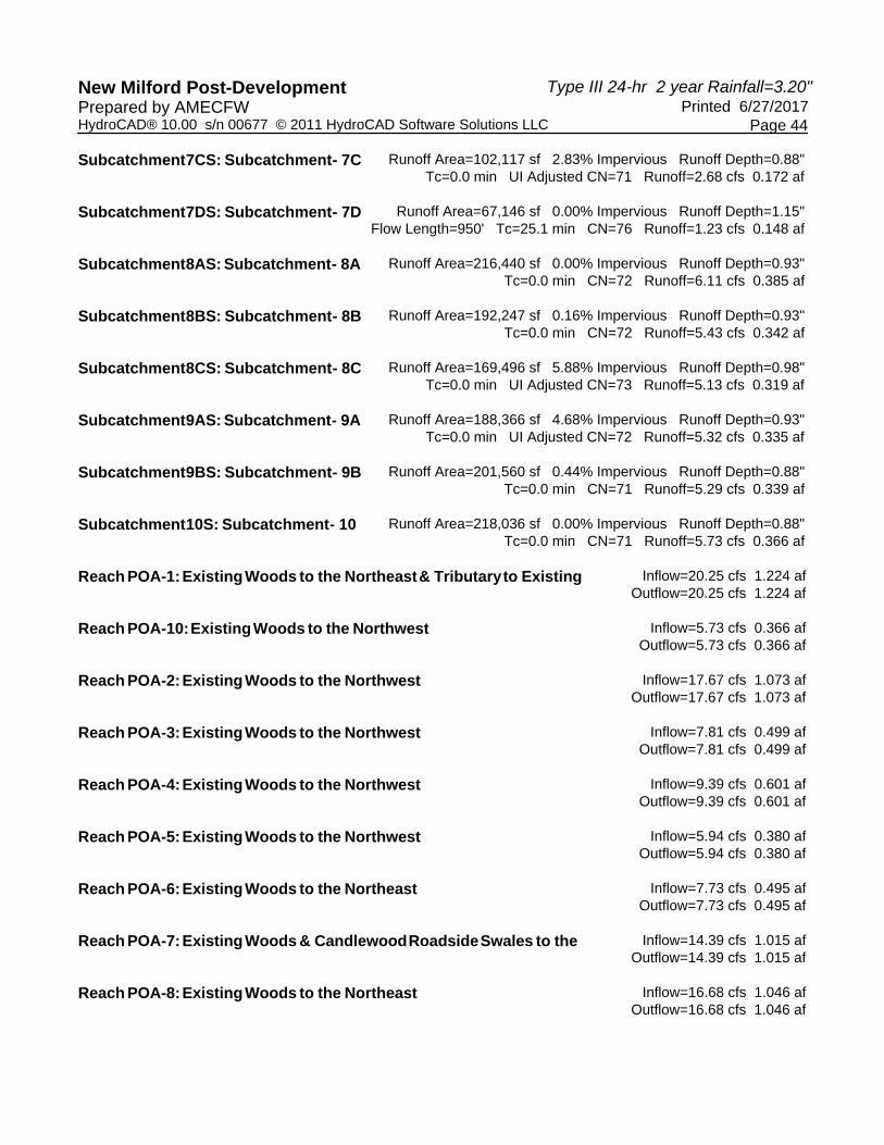
Type III 24-hr 2 year Rainfall=3.20"New Milford Post-Development Printed 6/27/2017Prepared by AMECFW
Page 44HydroCAD® 10.00 s/n 00677 © 2011 HydroCAD Software Solutions LLC
Runoff Area=102,117 sf 2.83% Impervious Runoff Depth=0.88"Subcatchment7CS: Subcatchment- 7C Tc=0.0 min UI Adjusted CN=71 Runoff=2.68 cfs 0.172 af
Runoff Area=67,146 sf 0.00% Impervious Runoff Depth=1.15"Subcatchment7DS: Subcatchment- 7D Flow Length=950' Tc=25.1 min CN=76 Runoff=1.23 cfs 0.148 af
Runoff Area=216,440 sf 0.00% Impervious Runoff Depth=0.93"Subcatchment8AS: Subcatchment- 8A Tc=0.0 min CN=72 Runoff=6.11 cfs 0.385 af
Runoff Area=192,247 sf 0.16% Impervious Runoff Depth=0.93"Subcatchment8BS: Subcatchment- 8B Tc=0.0 min CN=72 Runoff=5.43 cfs 0.342 af
Runoff Area=169,496 sf 5.88% Impervious Runoff Depth=0.98"Subcatchment8CS: Subcatchment- 8C Tc=0.0 min UI Adjusted CN=73 Runoff=5.13 cfs 0.319 af
Runoff Area=188,366 sf 4.68% Impervious Runoff Depth=0.93"Subcatchment9AS: Subcatchment- 9A Tc=0.0 min UI Adjusted CN=72 Runoff=5.32 cfs 0.335 af
Runoff Area=201,560 sf 0.44% Impervious Runoff Depth=0.88"Subcatchment9BS: Subcatchment- 9B Tc=0.0 min CN=71 Runoff=5.29 cfs 0.339 af
Runoff Area=218,036 sf 0.00% Impervious Runoff Depth=0.88"Subcatchment10S: Subcatchment- 10 Tc=0.0 min CN=71 Runoff=5.73 cfs 0.366 af
Inflow=20.25 cfs 1.224 afReach POA-1:ExistingWoods to the Northeast& Tributaryto Existing Outflow=20.25 cfs 1.224 af
Inflow=5.73 cfs 0.366 afReach POA-10:ExistingWoods to the Northwest Outflow=5.73 cfs 0.366 af
Inflow=17.67 cfs 1.073 afReach POA-2:ExistingWoods to the Northwest Outflow=17.67 cfs 1.073 af
Inflow=7.81 cfs 0.499 afReach POA-3:ExistingWoods to the Northwest Outflow=7.81 cfs 0.499 af
Inflow=9.39 cfs 0.601 afReach POA-4:ExistingWoods to the Northwest Outflow=9.39 cfs 0.601 af
Inflow=5.94 cfs 0.380 afReach POA-5:ExistingWoods to the Northwest Outflow=5.94 cfs 0.380 af
Inflow=7.73 cfs 0.495 afReach POA-6:ExistingWoods to the Northeast Outflow=7.73 cfs 0.495 af
Inflow=14.39 cfs 1.015 afReach POA-7:ExistingWoods & CandlewoodRoadsideSwales to the Outflow=14.39 cfs 1.015 af
Inflow=16.68 cfs 1.046 afReach POA-8:ExistingWoods to the Northeast Outflow=16.68 cfs 1.046 af

Type III 24-hr 2 year Rainfall=3.20"New Milford Post-Development Printed 6/27/2017Prepared by AMECFW
Page 45HydroCAD® 10.00 s/n 00677 © 2011 HydroCAD Software Solutions LLC
Inflow=10.61 cfs 0.674 afReach POA-9:ExistingWoods to the Northeast Outflow=10.61 cfs 0.674 af
Total Runoff Area = 89.764 ac Runoff Volume = 7.372 af Average Runoff Depth = 0.99"94.49% Pervious = 84.821 ac 5.51% Impervious = 4.943 ac

Type III 24-hr 2 year Rainfall=3.20"New Milford Post-Development Printed 6/27/2017Prepared by AMECFW
Page 46HydroCAD® 10.00 s/n 00677 © 2011 HydroCAD Software Solutions LLC
Summary for Subcatchment 1AS: Subcatchment - 1A
Runoff = 8.28 cfs @ 12.00 hrs, Volume= 0.481 af, Depth= 1.84"
Runoff by SCS TR-20 method, UH=SCS, Time Span= 1.00-30.00 hrs, dt= 0.01 hrsType III 24-hr 2 year Rainfall=3.20"
Area (sf) CN Description* 35,114 98 Unconnected Outcrop, HSG D
79,782 78 Meadow, non-grazed, HSG D* 17,933 98 Unconnected Outcrop, HSG D
4,143 71 Meadow, non-grazed, HSG C136,972 86 Weighted Average83,925 61.27% Pervious Area53,047 38.73% Impervious Area53,047 100.00% Unconnected

Type III 24-hr 2 year Rainfall=3.20"New Milford Post-Development Printed 6/27/2017Prepared by AMECFW
Page 47HydroCAD® 10.00 s/n 00677 © 2011 HydroCAD Software Solutions LLC
Summary for Subcatchment 1BS: Subcatchment - 1B
Runoff = 6.62 cfs @ 12.00 hrs, Volume= 0.406 af, Depth= 1.04"
Runoff by SCS TR-20 method, UH=SCS, Time Span= 1.00-30.00 hrs, dt= 0.01 hrsType III 24-hr 2 year Rainfall=3.20"
Area (sf) CN Description* 13,477 98 Unconnected Outcrop, HSG D
42,165 78 Meadow, non-grazed, HSG D47,492 71 Meadow, non-grazed, HSG C95,573 71 Meadow, non-grazed, HSG C
* 5,767 98 Unconnected Outcrop, HSG D204,474 75 Weighted Average, UI Adjusted CN = 74185,230 90.59% Pervious Area19,244 9.41% Impervious Area19,244 100.00% Unconnected

Type III 24-hr 2 year Rainfall=3.20"New Milford Post-Development Printed 6/27/2017Prepared by AMECFW
Page 48HydroCAD® 10.00 s/n 00677 © 2011 HydroCAD Software Solutions LLC
Summary for Subcatchment 1CS: Subcatchment - 1C
Runoff = 5.35 cfs @ 12.00 hrs, Volume= 0.337 af, Depth= 0.93"
Runoff by SCS TR-20 method, UH=SCS, Time Span= 1.00-30.00 hrs, dt= 0.01 hrsType III 24-hr 2 year Rainfall=3.20"
Area (sf) CN Description9,856 78 Meadow, non-grazed, HSG D
177,514 71 Meadow, non-grazed, HSG C* 2,126 98 Unconnected Outcrop, HSG D
189,496 72 Weighted Average187,370 98.88% Pervious Area
2,126 1.12% Impervious Area2,126 100.00% Unconnected

Type III 24-hr 2 year Rainfall=3.20"New Milford Post-Development Printed 6/27/2017Prepared by AMECFW
Page 49HydroCAD® 10.00 s/n 00677 © 2011 HydroCAD Software Solutions LLC
Summary for Subcatchment 2AS: Subcatchment - 2A
Runoff = 4.11 cfs @ 12.00 hrs, Volume= 0.241 af, Depth= 1.40"
Runoff by SCS TR-20 method, UH=SCS, Time Span= 1.00-30.00 hrs, dt= 0.01 hrsType III 24-hr 2 year Rainfall=3.20"
Area (sf) CN Description* 13,513 98 Unconnected Outcrop, HSG D
76,273 78 Meadow, non-grazed, HSG D89,786 81 Weighted Average, UI Adjusted CN = 8076,273 84.95% Pervious Area13,513 15.05% Impervious Area13,513 100.00% Unconnected

Type III 24-hr 2 year Rainfall=3.20"New Milford Post-Development Printed 6/27/2017Prepared by AMECFW
Page 50HydroCAD® 10.00 s/n 00677 © 2011 HydroCAD Software Solutions LLC
Summary for Subcatchment 2BS: Subcatchment - 2B
Runoff = 7.22 cfs @ 12.00 hrs, Volume= 0.438 af, Depth= 1.09"
Runoff by SCS TR-20 method, UH=SCS, Time Span= 1.00-30.00 hrs, dt= 0.01 hrsType III 24-hr 2 year Rainfall=3.20"
Area (sf) CN Description* 15,936 98 Unconnected Outcrop, HSG D
80,385 78 Meadow, non-grazed, HSG D112,923 71 Meadow, non-grazed, HSG C209,244 76 Weighted Average, UI Adjusted CN = 75193,308 92.38% Pervious Area15,936 7.62% Impervious Area15,936 100.00% Unconnected

Type III 24-hr 2 year Rainfall=3.20"New Milford Post-Development Printed 6/27/2017Prepared by AMECFW
Page 51HydroCAD® 10.00 s/n 00677 © 2011 HydroCAD Software Solutions LLC
Summary for Subcatchment 2CS: Subcatchment - 2C
Runoff = 6.35 cfs @ 12.00 hrs, Volume= 0.394 af, Depth= 0.98"
Runoff by SCS TR-20 method, UH=SCS, Time Span= 1.00-30.00 hrs, dt= 0.01 hrsType III 24-hr 2 year Rainfall=3.20"
Area (sf) CN Description* 8,868 98 Unconnected Outcrop, HSG D
50,494 78 Meadow, non-grazed, HSG D150,424 71 Meadow, non-grazed, HSG C209,786 74 Weighted Average, UI Adjusted CN = 73200,918 95.77% Pervious Area
8,868 4.23% Impervious Area8,868 100.00% Unconnected

Type III 24-hr 2 year Rainfall=3.20"New Milford Post-Development Printed 6/27/2017Prepared by AMECFW
Page 52HydroCAD® 10.00 s/n 00677 © 2011 HydroCAD Software Solutions LLC
Summary for Subcatchment 3AS: Subcatchment - 3A
Runoff = 4.89 cfs @ 12.00 hrs, Volume= 0.313 af, Depth= 0.88"
Runoff by SCS TR-20 method, UH=SCS, Time Span= 1.00-30.00 hrs, dt= 0.01 hrsType III 24-hr 2 year Rainfall=3.20"
Area (sf) CN Description186,204 71 Meadow, non-grazed, HSG C186,204 100.00% Pervious Area

Type III 24-hr 2 year Rainfall=3.20"New Milford Post-Development Printed 6/27/2017Prepared by AMECFW
Page 53HydroCAD® 10.00 s/n 00677 © 2011 HydroCAD Software Solutions LLC
Summary for Subcatchment 3BS: Subcatchment - 3B
Runoff = 2.92 cfs @ 12.00 hrs, Volume= 0.187 af, Depth= 0.88"
Runoff by SCS TR-20 method, UH=SCS, Time Span= 1.00-30.00 hrs, dt= 0.01 hrsType III 24-hr 2 year Rainfall=3.20"
Area (sf) CN Description111,129 71 Meadow, non-grazed, HSG C111,129 100.00% Pervious Area

Type III 24-hr 2 year Rainfall=3.20"New Milford Post-Development Printed 6/27/2017Prepared by AMECFW
Page 54HydroCAD® 10.00 s/n 00677 © 2011 HydroCAD Software Solutions LLC
Summary for Subcatchment 4AS: Subcatchment - 4
Runoff = 4.36 cfs @ 12.00 hrs, Volume= 0.279 af, Depth= 0.88"
Runoff by SCS TR-20 method, UH=SCS, Time Span= 1.00-30.00 hrs, dt= 0.01 hrsType III 24-hr 2 year Rainfall=3.20"
Area (sf) CN Description166,208 71 Meadow, non-grazed, HSG C166,208 100.00% Pervious Area

Type III 24-hr 2 year Rainfall=3.20"New Milford Post-Development Printed 6/27/2017Prepared by AMECFW
Page 55HydroCAD® 10.00 s/n 00677 © 2011 HydroCAD Software Solutions LLC
Summary for Subcatchment 4BS: Subcatchment - 4B
Runoff = 5.02 cfs @ 12.00 hrs, Volume= 0.321 af, Depth= 0.88"
Runoff by SCS TR-20 method, UH=SCS, Time Span= 1.00-30.00 hrs, dt= 0.01 hrsType III 24-hr 2 year Rainfall=3.20"
Area (sf) CN Description191,314 71 Meadow, non-grazed, HSG C191,314 100.00% Pervious Area

Type III 24-hr 2 year Rainfall=3.20"New Milford Post-Development Printed 6/27/2017Prepared by AMECFW
Page 56HydroCAD® 10.00 s/n 00677 © 2011 HydroCAD Software Solutions LLC
Summary for Subcatchment 5AS: Subcatchment - 5A
Runoff = 2.99 cfs @ 12.00 hrs, Volume= 0.191 af, Depth= 0.88"
Runoff by SCS TR-20 method, UH=SCS, Time Span= 1.00-30.00 hrs, dt= 0.01 hrsType III 24-hr 2 year Rainfall=3.20"
Area (sf) CN Description113,745 71 Meadow, non-grazed, HSG C113,745 100.00% Pervious Area

Type III 24-hr 2 year Rainfall=3.20"New Milford Post-Development Printed 6/27/2017Prepared by AMECFW
Page 57HydroCAD® 10.00 s/n 00677 © 2011 HydroCAD Software Solutions LLC
Summary for Subcatchment 5BS: Subcatchment - 5B
Runoff = 2.96 cfs @ 12.00 hrs, Volume= 0.189 af, Depth= 0.88"
Runoff by SCS TR-20 method, UH=SCS, Time Span= 1.00-30.00 hrs, dt= 0.01 hrsType III 24-hr 2 year Rainfall=3.20"
Area (sf) CN Description112,627 71 Meadow, non-grazed, HSG C112,627 100.00% Pervious Area

Type III 24-hr 2 year Rainfall=3.20"New Milford Post-Development Printed 6/27/2017Prepared by AMECFW
Page 58HydroCAD® 10.00 s/n 00677 © 2011 HydroCAD Software Solutions LLC
Summary for Subcatchment 6AS: Subcatchment - 6A
Runoff = 2.52 cfs @ 12.00 hrs, Volume= 0.161 af, Depth= 0.88"
Runoff by SCS TR-20 method, UH=SCS, Time Span= 1.00-30.00 hrs, dt= 0.01 hrsType III 24-hr 2 year Rainfall=3.20"
Area (sf) CN Description3,203 78 Meadow, non-grazed, HSG D
92,882 71 Meadow, non-grazed, HSG C96,085 71 Weighted Average96,085 100.00% Pervious Area

Type III 24-hr 2 year Rainfall=3.20"New Milford Post-Development Printed 6/27/2017Prepared by AMECFW
Page 59HydroCAD® 10.00 s/n 00677 © 2011 HydroCAD Software Solutions LLC
Summary for Subcatchment 6BS: Subcatchment - 6B
Runoff = 5.21 cfs @ 12.00 hrs, Volume= 0.333 af, Depth= 0.88"
Runoff by SCS TR-20 method, UH=SCS, Time Span= 1.00-30.00 hrs, dt= 0.01 hrsType III 24-hr 2 year Rainfall=3.20"
Area (sf) CN Description3,153 78 Meadow, non-grazed, HSG D
189,665 71 Meadow, non-grazed, HSG C* 5,603 98 Unconnected Outcrop, HSG D
198,421 72 Weighted Average, UI Adjusted CN = 71192,818 97.18% Pervious Area
5,603 2.82% Impervious Area5,603 100.00% Unconnected

Type III 24-hr 2 year Rainfall=3.20"New Milford Post-Development Printed 6/27/2017Prepared by AMECFW
Page 60HydroCAD® 10.00 s/n 00677 © 2011 HydroCAD Software Solutions LLC
Summary for Subcatchment 7AS: Subcatchment - 7A
Runoff = 6.52 cfs @ 12.00 hrs, Volume= 0.392 af, Depth= 1.15"
Runoff by SCS TR-20 method, UH=SCS, Time Span= 1.00-30.00 hrs, dt= 0.01 hrsType III 24-hr 2 year Rainfall=3.20"
Area (sf) CN Description59,019 71 Meadow, non-grazed, HSG C37,330 70 Woods, Good, HSG C37,558 80 Pasture/grassland/range, Good, HSG D
* 43,980 98 Unconnected Outcrop, HSG D177,887 79 Weighted Average, UI Adjusted CN = 76133,907 75.28% Pervious Area43,980 24.72% Impervious Area43,980 100.00% Unconnected

Type III 24-hr 2 year Rainfall=3.20"New Milford Post-Development Printed 6/27/2017Prepared by AMECFW
Page 61HydroCAD® 10.00 s/n 00677 © 2011 HydroCAD Software Solutions LLC
Summary for Subcatchment 7BS: Subcatchment - 7B
Runoff = 4.89 cfs @ 12.00 hrs, Volume= 0.303 af, Depth= 0.98"
Runoff by SCS TR-20 method, UH=SCS, Time Span= 1.00-30.00 hrs, dt= 0.01 hrsType III 24-hr 2 year Rainfall=3.20"
Area (sf) CN Description104,556 71 Meadow, non-grazed, HSG C26,624 70 Woods, Good, HSG C
* 30,169 98 Unconnected Outcrop, HSG D161,349 76 Weighted Average, UI Adjusted CN = 73131,180 81.30% Pervious Area30,169 18.70% Impervious Area30,169 100.00% Unconnected

Type III 24-hr 2 year Rainfall=3.20"New Milford Post-Development Printed 6/27/2017Prepared by AMECFW
Page 62HydroCAD® 10.00 s/n 00677 © 2011 HydroCAD Software Solutions LLC
Summary for Subcatchment 7CS: Subcatchment - 7C
Runoff = 2.68 cfs @ 12.00 hrs, Volume= 0.172 af, Depth= 0.88"
Runoff by SCS TR-20 method, UH=SCS, Time Span= 1.00-30.00 hrs, dt= 0.01 hrsType III 24-hr 2 year Rainfall=3.20"
Area (sf) CN Description89,143 71 Meadow, non-grazed, HSG C10,084 70 Woods, Good, HSG C
* 2,890 98 Unconnected Outcrop, HSG D102,117 72 Weighted Average, UI Adjusted CN = 7199,227 97.17% Pervious Area2,890 2.83% Impervious Area2,890 100.00% Unconnected

Type III 24-hr 2 year Rainfall=3.20"New Milford Post-Development Printed 6/27/2017Prepared by AMECFW
Page 63HydroCAD® 10.00 s/n 00677 © 2011 HydroCAD Software Solutions LLC
Summary for Subcatchment 7DS: Subcatchment - 7D
Runoff = 1.23 cfs @ 12.36 hrs, Volume= 0.148 af, Depth= 1.15"
Runoff by SCS TR-20 method, UH=SCS, Time Span= 1.00-30.00 hrs, dt= 0.01 hrsType III 24-hr 2 year Rainfall=3.20"
Area (sf) CN Description1,925 71 Meadow, non-grazed, HSG C
27,780 70 Woods, Good, HSG C37,441 80 Pasture/grassland/range, Good, HSG D67,146 76 Weighted Average67,146 100.00% Pervious Area
Tc Length Slope Velocity Capacity Description(min) (feet) (ft/ft) (ft/sec) (cfs)17.1 150 0.0800 0.15 Sheet Flow, Sheet Flow A-B
Woods: Light underbrush n= 0.400 P2= 3.20"8.0 800 0.1100 1.66 Shallow Concentrated Flow, Shallow Flow B-C
Woodland Kv= 5.0 fps25.1 950 Total

Type III 24-hr 2 year Rainfall=3.20"New Milford Post-Development Printed 6/27/2017Prepared by AMECFW
Page 64HydroCAD® 10.00 s/n 00677 © 2011 HydroCAD Software Solutions LLC
Summary for Subcatchment 8AS: Subcatchment - 8A
Runoff = 6.11 cfs @ 12.00 hrs, Volume= 0.385 af, Depth= 0.93"
Runoff by SCS TR-20 method, UH=SCS, Time Span= 1.00-30.00 hrs, dt= 0.01 hrsType III 24-hr 2 year Rainfall=3.20"
Area (sf) CN Description192,315 71 Meadow, non-grazed, HSG C24,125 78 Meadow, non-grazed, HSG D
216,440 72 Weighted Average216,440 100.00% Pervious Area

Type III 24-hr 2 year Rainfall=3.20"New Milford Post-Development Printed 6/27/2017Prepared by AMECFW
Page 65HydroCAD® 10.00 s/n 00677 © 2011 HydroCAD Software Solutions LLC
Summary for Subcatchment 8BS: Subcatchment - 8B
Runoff = 5.43 cfs @ 12.00 hrs, Volume= 0.342 af, Depth= 0.93"
Runoff by SCS TR-20 method, UH=SCS, Time Span= 1.00-30.00 hrs, dt= 0.01 hrsType III 24-hr 2 year Rainfall=3.20"
Area (sf) CN Description* 299 98 Unconnected Outcrop, HSG D
163,252 71 Meadow, non-grazed, HSG C28,696 78 Meadow, non-grazed, HSG D
192,247 72 Weighted Average191,948 99.84% Pervious Area
299 0.16% Impervious Area299 100.00% Unconnected

Type III 24-hr 2 year Rainfall=3.20"New Milford Post-Development Printed 6/27/2017Prepared by AMECFW
Page 66HydroCAD® 10.00 s/n 00677 © 2011 HydroCAD Software Solutions LLC
Summary for Subcatchment 8CS: Subcatchment - 8C
Runoff = 5.13 cfs @ 12.00 hrs, Volume= 0.319 af, Depth= 0.98"
Runoff by SCS TR-20 method, UH=SCS, Time Span= 1.00-30.00 hrs, dt= 0.01 hrsType III 24-hr 2 year Rainfall=3.20"
Area (sf) CN Description* 9,966 98 Unconnected Outcrop, HSG D
123,246 71 Meadow, non-grazed, HSG C36,284 78 Meadow, non-grazed, HSG D
169,496 74 Weighted Average, UI Adjusted CN = 73159,530 94.12% Pervious Area
9,966 5.88% Impervious Area9,966 100.00% Unconnected
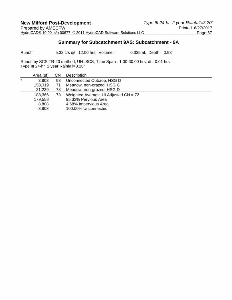
Type III 24-hr 2 year Rainfall=3.20"New Milford Post-Development Printed 6/27/2017Prepared by AMECFW
Page 67HydroCAD® 10.00 s/n 00677 © 2011 HydroCAD Software Solutions LLC
Summary for Subcatchment 9AS: Subcatchment - 9A
Runoff = 5.32 cfs @ 12.00 hrs, Volume= 0.335 af, Depth= 0.93"
Runoff by SCS TR-20 method, UH=SCS, Time Span= 1.00-30.00 hrs, dt= 0.01 hrsType III 24-hr 2 year Rainfall=3.20"
Area (sf) CN Description* 8,808 98 Unconnected Outcrop, HSG D
158,319 71 Meadow, non-grazed, HSG C21,239 78 Meadow, non-grazed, HSG D
188,366 73 Weighted Average, UI Adjusted CN = 72179,558 95.32% Pervious Area
8,808 4.68% Impervious Area8,808 100.00% Unconnected

Type III 24-hr 2 year Rainfall=3.20"New Milford Post-Development Printed 6/27/2017Prepared by AMECFW
Page 68HydroCAD® 10.00 s/n 00677 © 2011 HydroCAD Software Solutions LLC
Summary for Subcatchment 9BS: Subcatchment - 9B
Runoff = 5.29 cfs @ 12.00 hrs, Volume= 0.339 af, Depth= 0.88"
Runoff by SCS TR-20 method, UH=SCS, Time Span= 1.00-30.00 hrs, dt= 0.01 hrsType III 24-hr 2 year Rainfall=3.20"
Area (sf) CN Description* 889 98 Unconnected Outcrop, HSG D
196,532 71 Meadow, non-grazed, HSG C4,139 78 Meadow, non-grazed, HSG D
201,560 71 Weighted Average200,671 99.56% Pervious Area
889 0.44% Impervious Area889 100.00% Unconnected

Type III 24-hr 2 year Rainfall=3.20"New Milford Post-Development Printed 6/27/2017Prepared by AMECFW
Page 69HydroCAD® 10.00 s/n 00677 © 2011 HydroCAD Software Solutions LLC
Summary for Subcatchment 10S: Subcatchment - 10
Runoff = 5.73 cfs @ 12.00 hrs, Volume= 0.366 af, Depth= 0.88"
Runoff by SCS TR-20 method, UH=SCS, Time Span= 1.00-30.00 hrs, dt= 0.01 hrsType III 24-hr 2 year Rainfall=3.20"
Area (sf) CN Description218,036 71 Meadow, non-grazed, HSG C218,036 100.00% Pervious Area

Type III 24-hr 2 year Rainfall=3.20"New Milford Post-Development Printed 6/27/2017Prepared by AMECFW
Page 70HydroCAD® 10.00 s/n 00677 © 2011 HydroCAD Software Solutions LLC
Summary for Reach POA-1: Existing Woods to the Northeast & Tributary to Existing Wetlands Area
Inflow Area = 12.189 ac, 14.02% Impervious, Inflow Depth = 1.20" for 2 year eventInflow = 20.25 cfs @ 12.00 hrs, Volume= 1.224 afOutflow = 20.25 cfs @ 12.00 hrs, Volume= 1.224 af, Atten= 0%, Lag= 0.0 min
Routing by Dyn-Stor-Ind method, Time Span= 1.00-30.00 hrs, dt= 0.01 hrs

Type III 24-hr 2 year Rainfall=3.20"New Milford Post-Development Printed 6/27/2017Prepared by AMECFW
Page 71HydroCAD® 10.00 s/n 00677 © 2011 HydroCAD Software Solutions LLC
Summary for Reach POA-10: Existing Woods to the Northwest
Inflow Area = 5.005 ac, 0.00% Impervious, Inflow Depth = 0.88" for 2 year eventInflow = 5.73 cfs @ 12.00 hrs, Volume= 0.366 afOutflow = 5.73 cfs @ 12.00 hrs, Volume= 0.366 af, Atten= 0%, Lag= 0.0 min
Routing by Dyn-Stor-Ind method, Time Span= 1.00-30.00 hrs, dt= 0.01 hrs

Type III 24-hr 2 year Rainfall=3.20"New Milford Post-Development Printed 6/27/2017Prepared by AMECFW
Page 72HydroCAD® 10.00 s/n 00677 © 2011 HydroCAD Software Solutions LLC
Summary for Reach POA-2: Existing Woods to the Northwest
Inflow Area = 11.681 ac, 7.53% Impervious, Inflow Depth = 1.10" for 2 year eventInflow = 17.67 cfs @ 12.00 hrs, Volume= 1.073 afOutflow = 17.67 cfs @ 12.00 hrs, Volume= 1.073 af, Atten= 0%, Lag= 0.0 min
Routing by Dyn-Stor-Ind method, Time Span= 1.00-30.00 hrs, dt= 0.01 hrs

Type III 24-hr 2 year Rainfall=3.20"New Milford Post-Development Printed 6/27/2017Prepared by AMECFW
Page 73HydroCAD® 10.00 s/n 00677 © 2011 HydroCAD Software Solutions LLC
Summary for Reach POA-3: Existing Woods to the Northwest
Inflow Area = 6.826 ac, 0.00% Impervious, Inflow Depth = 0.88" for 2 year eventInflow = 7.81 cfs @ 12.00 hrs, Volume= 0.499 afOutflow = 7.81 cfs @ 12.00 hrs, Volume= 0.499 af, Atten= 0%, Lag= 0.0 min
Routing by Dyn-Stor-Ind method, Time Span= 1.00-30.00 hrs, dt= 0.01 hrs

Type III 24-hr 2 year Rainfall=3.20"New Milford Post-Development Printed 6/27/2017Prepared by AMECFW
Page 74HydroCAD® 10.00 s/n 00677 © 2011 HydroCAD Software Solutions LLC
Summary for Reach POA-4: Existing Woods to the Northwest
Inflow Area = 8.208 ac, 0.00% Impervious, Inflow Depth = 0.88" for 2 year eventInflow = 9.39 cfs @ 12.00 hrs, Volume= 0.601 afOutflow = 9.39 cfs @ 12.00 hrs, Volume= 0.601 af, Atten= 0%, Lag= 0.0 min
Routing by Dyn-Stor-Ind method, Time Span= 1.00-30.00 hrs, dt= 0.01 hrs

Type III 24-hr 2 year Rainfall=3.20"New Milford Post-Development Printed 6/27/2017Prepared by AMECFW
Page 75HydroCAD® 10.00 s/n 00677 © 2011 HydroCAD Software Solutions LLC
Summary for Reach POA-5: Existing Woods to the Northwest
Inflow Area = 5.197 ac, 0.00% Impervious, Inflow Depth = 0.88" for 2 year eventInflow = 5.94 cfs @ 12.00 hrs, Volume= 0.380 afOutflow = 5.94 cfs @ 12.00 hrs, Volume= 0.380 af, Atten= 0%, Lag= 0.0 min
Routing by Dyn-Stor-Ind method, Time Span= 1.00-30.00 hrs, dt= 0.01 hrs

Type III 24-hr 2 year Rainfall=3.20"New Milford Post-Development Printed 6/27/2017Prepared by AMECFW
Page 76HydroCAD® 10.00 s/n 00677 © 2011 HydroCAD Software Solutions LLC
Summary for Reach POA-6: Existing Woods to the Northeast
Inflow Area = 6.761 ac, 1.90% Impervious, Inflow Depth = 0.88" for 2 year eventInflow = 7.73 cfs @ 12.00 hrs, Volume= 0.495 afOutflow = 7.73 cfs @ 12.00 hrs, Volume= 0.495 af, Atten= 0%, Lag= 0.0 min
Routing by Dyn-Stor-Ind method, Time Span= 1.00-30.00 hrs, dt= 0.01 hrs

Type III 24-hr 2 year Rainfall=3.20"New Milford Post-Development Printed 6/27/2017Prepared by AMECFW
Page 77HydroCAD® 10.00 s/n 00677 © 2011 HydroCAD Software Solutions LLC
Summary for Reach POA-7: Existing Woods & Candlewood Roadside Swales to the Northwest
Inflow Area = 11.674 ac, 15.15% Impervious, Inflow Depth = 1.04" for 2 year eventInflow = 14.39 cfs @ 12.00 hrs, Volume= 1.015 afOutflow = 14.39 cfs @ 12.00 hrs, Volume= 1.015 af, Atten= 0%, Lag= 0.0 min
Routing by Dyn-Stor-Ind method, Time Span= 1.00-30.00 hrs, dt= 0.01 hrs

Type III 24-hr 2 year Rainfall=3.20"New Milford Post-Development Printed 6/27/2017Prepared by AMECFW
Page 78HydroCAD® 10.00 s/n 00677 © 2011 HydroCAD Software Solutions LLC
Summary for Reach POA-8: Existing Woods to the Northeast
Inflow Area = 13.273 ac, 1.78% Impervious, Inflow Depth = 0.95" for 2 year eventInflow = 16.68 cfs @ 12.00 hrs, Volume= 1.046 afOutflow = 16.68 cfs @ 12.00 hrs, Volume= 1.046 af, Atten= 0%, Lag= 0.0 min
Routing by Dyn-Stor-Ind method, Time Span= 1.00-30.00 hrs, dt= 0.01 hrs

Type III 24-hr 2 year Rainfall=3.20"New Milford Post-Development Printed 6/27/2017Prepared by AMECFW
Page 79HydroCAD® 10.00 s/n 00677 © 2011 HydroCAD Software Solutions LLC
Summary for Reach POA-9: Existing Woods to the Northeast
Inflow Area = 8.951 ac, 2.49% Impervious, Inflow Depth = 0.90" for 2 year eventInflow = 10.61 cfs @ 12.00 hrs, Volume= 0.674 afOutflow = 10.61 cfs @ 12.00 hrs, Volume= 0.674 af, Atten= 0%, Lag= 0.0 min
Routing by Dyn-Stor-Ind method, Time Span= 1.00-30.00 hrs, dt= 0.01 hrs

Type III 24-hr 10 year Rainfall=4.70"New Milford Post-Development Printed 6/27/2017Prepared by AMECFW
Page 80HydroCAD® 10.00 s/n 00677 © 2011 HydroCAD Software Solutions LLC
Time span=1.00-30.00 hrs, dt=0.01 hrs, 2901 pointsRunoff by SCS TR-20 method, UH=SCS
Reach routing by Dyn-Stor-Ind method - Pond routing by Dyn-Stor-Ind method
Runoff Area=136,972 sf 38.73% Impervious Runoff Depth=3.19"Subcatchment1AS: Subcatchment- 1A Tc=0.0 min CN=86 Runoff=14.22 cfs 0.835 af
Runoff Area=204,474 sf 9.41% Impervious Runoff Depth=2.13"Subcatchment1BS: Subcatchment- 1B Tc=0.0 min UI Adjusted CN=74 Runoff=14.23 cfs 0.832 af
Runoff Area=189,496 sf 1.12% Impervious Runoff Depth=1.97"Subcatchment1CS: Subcatchment- 1C Tc=0.0 min CN=72 Runoff=12.12 cfs 0.714 af
Runoff Area=89,786 sf 15.05% Impervious Runoff Depth=2.63"Subcatchment2AS: Subcatchment- 2A Tc=0.0 min UI Adjusted CN=80 Runoff=7.79 cfs 0.452 af
Runoff Area=209,244 sf 7.62% Impervious Runoff Depth=2.21"Subcatchment2BS: Subcatchment- 2B Tc=0.0 min UI Adjusted CN=75 Runoff=15.16 cfs 0.884 af
Runoff Area=209,786 sf 4.23% Impervious Runoff Depth=2.05"Subcatchment2CS: Subcatchment- 2C Tc=0.0 min UI Adjusted CN=73 Runoff=14.01 cfs 0.822 af
Runoff Area=186,204 sf 0.00% Impervious Runoff Depth=1.89"Subcatchment3AS: Subcatchment- 3A Tc=0.0 min CN=71 Runoff=11.39 cfs 0.674 af
Runoff Area=111,129 sf 0.00% Impervious Runoff Depth=1.89"Subcatchment3BS: Subcatchment- 3B Tc=0.0 min CN=71 Runoff=6.80 cfs 0.402 af
Runoff Area=166,208 sf 0.00% Impervious Runoff Depth=1.89"Subcatchment4AS: Subcatchment- 4 Tc=0.0 min CN=71 Runoff=10.17 cfs 0.602 af
Runoff Area=191,314 sf 0.00% Impervious Runoff Depth=1.89"Subcatchment4BS: Subcatchment- 4B Tc=0.0 min CN=71 Runoff=11.71 cfs 0.693 af
Runoff Area=113,745 sf 0.00% Impervious Runoff Depth=1.89"Subcatchment5AS: Subcatchment- 5A Tc=0.0 min CN=71 Runoff=6.96 cfs 0.412 af
Runoff Area=112,627 sf 0.00% Impervious Runoff Depth=1.89"Subcatchment5BS: Subcatchment- 5B Tc=0.0 min CN=71 Runoff=6.89 cfs 0.408 af
Runoff Area=96,085 sf 0.00% Impervious Runoff Depth=1.89"Subcatchment6AS: Subcatchment- 6A Tc=0.0 min CN=71 Runoff=5.88 cfs 0.348 af
Runoff Area=198,421 sf 2.82% Impervious Runoff Depth=1.89"Subcatchment6BS: Subcatchment- 6B Tc=0.0 min UI Adjusted CN=71 Runoff=12.14 cfs 0.718 af
Runoff Area=177,887 sf 24.72% Impervious Runoff Depth=2.29"Subcatchment7AS: Subcatchment- 7A Tc=0.0 min UI Adjusted CN=76 Runoff=13.39 cfs 0.779 af
Runoff Area=161,349 sf 18.70% Impervious Runoff Depth=2.05"Subcatchment7BS: Subcatchment- 7B Tc=0.0 min UI Adjusted CN=73 Runoff=10.77 cfs 0.632 af

Type III 24-hr 10 year Rainfall=4.70"New Milford Post-Development Printed 6/27/2017Prepared by AMECFW
Page 81HydroCAD® 10.00 s/n 00677 © 2011 HydroCAD Software Solutions LLC
Runoff Area=102,117 sf 2.83% Impervious Runoff Depth=1.89"Subcatchment7CS: Subcatchment- 7C Tc=0.0 min UI Adjusted CN=71 Runoff=6.25 cfs 0.370 af
Runoff Area=67,146 sf 0.00% Impervious Runoff Depth=2.29"Subcatchment7DS: Subcatchment- 7D Flow Length=950' Tc=25.1 min CN=76 Runoff=2.52 cfs 0.294 af
Runoff Area=216,440 sf 0.00% Impervious Runoff Depth=1.97"Subcatchment8AS: Subcatchment- 8A Tc=0.0 min CN=72 Runoff=13.85 cfs 0.815 af
Runoff Area=192,247 sf 0.16% Impervious Runoff Depth=1.97"Subcatchment8BS: Subcatchment- 8B Tc=0.0 min CN=72 Runoff=12.30 cfs 0.724 af
Runoff Area=169,496 sf 5.88% Impervious Runoff Depth=2.05"Subcatchment8CS: Subcatchment- 8C Tc=0.0 min UI Adjusted CN=73 Runoff=11.32 cfs 0.664 af
Runoff Area=188,366 sf 4.68% Impervious Runoff Depth=1.97"Subcatchment9AS: Subcatchment- 9A Tc=0.0 min UI Adjusted CN=72 Runoff=12.05 cfs 0.710 af
Runoff Area=201,560 sf 0.44% Impervious Runoff Depth=1.89"Subcatchment9BS: Subcatchment- 9B Tc=0.0 min CN=71 Runoff=12.33 cfs 0.730 af
Runoff Area=218,036 sf 0.00% Impervious Runoff Depth=1.89"Subcatchment10S: Subcatchment- 10 Tc=0.0 min CN=71 Runoff=13.34 cfs 0.789 af
Inflow=40.57 cfs 2.382 afReach POA-1:ExistingWoods to the Northeast& Tributaryto Existing Outflow=40.57 cfs 2.382 af
Inflow=13.34 cfs 0.789 afReach POA-10:ExistingWoods to the Northwest Outflow=13.34 cfs 0.789 af
Inflow=36.96 cfs 2.158 afReach POA-2:ExistingWoods to the Northwest Outflow=36.96 cfs 2.158 af
Inflow=18.19 cfs 1.076 afReach POA-3:ExistingWoods to the Northwest Outflow=18.19 cfs 1.076 af
Inflow=21.88 cfs 1.294 afReach POA-4:ExistingWoods to the Northwest Outflow=21.88 cfs 1.294 af
Inflow=13.85 cfs 0.820 afReach POA-5:ExistingWoods to the Northwest Outflow=13.85 cfs 0.820 af
Inflow=18.02 cfs 1.066 afReach POA-6:ExistingWoods to the Northeast Outflow=18.02 cfs 1.066 af
Inflow=31.18 cfs 2.076 afReach POA-7:ExistingWoods & CandlewoodRoadsideSwales to the Outflow=31.18 cfs 2.076 af
Inflow=37.46 cfs 2.204 afReach POA-8:ExistingWoods to the Northeast Outflow=37.46 cfs 2.204 af

Type III 24-hr 10 year Rainfall=4.70"New Milford Post-Development Printed 6/27/2017Prepared by AMECFW
Page 82HydroCAD® 10.00 s/n 00677 © 2011 HydroCAD Software Solutions LLC
Inflow=24.38 cfs 1.439 afReach POA-9:ExistingWoods to the Northeast Outflow=24.38 cfs 1.439 af
Total Runoff Area = 89.764 ac Runoff Volume = 15.304 af Average Runoff Depth = 2.05"94.49% Pervious = 84.821 ac 5.51% Impervious = 4.943 ac

Type III 24-hr 10 year Rainfall=4.70"New Milford Post-Development Printed 6/27/2017Prepared by AMECFW
Page 83HydroCAD® 10.00 s/n 00677 © 2011 HydroCAD Software Solutions LLC
Summary for Subcatchment 1AS: Subcatchment - 1A
Runoff = 14.22 cfs @ 12.00 hrs, Volume= 0.835 af, Depth= 3.19"
Runoff by SCS TR-20 method, UH=SCS, Time Span= 1.00-30.00 hrs, dt= 0.01 hrsType III 24-hr 10 year Rainfall=4.70"
Area (sf) CN Description* 35,114 98 Unconnected Outcrop, HSG D
79,782 78 Meadow, non-grazed, HSG D* 17,933 98 Unconnected Outcrop, HSG D
4,143 71 Meadow, non-grazed, HSG C136,972 86 Weighted Average83,925 61.27% Pervious Area53,047 38.73% Impervious Area53,047 100.00% Unconnected

Type III 24-hr 10 year Rainfall=4.70"New Milford Post-Development Printed 6/27/2017Prepared by AMECFW
Page 84HydroCAD® 10.00 s/n 00677 © 2011 HydroCAD Software Solutions LLC
Summary for Subcatchment 1BS: Subcatchment - 1B
Runoff = 14.23 cfs @ 12.00 hrs, Volume= 0.832 af, Depth= 2.13"
Runoff by SCS TR-20 method, UH=SCS, Time Span= 1.00-30.00 hrs, dt= 0.01 hrsType III 24-hr 10 year Rainfall=4.70"
Area (sf) CN Description* 13,477 98 Unconnected Outcrop, HSG D
42,165 78 Meadow, non-grazed, HSG D47,492 71 Meadow, non-grazed, HSG C95,573 71 Meadow, non-grazed, HSG C
* 5,767 98 Unconnected Outcrop, HSG D204,474 75 Weighted Average, UI Adjusted CN = 74185,230 90.59% Pervious Area19,244 9.41% Impervious Area19,244 100.00% Unconnected

Type III 24-hr 10 year Rainfall=4.70"New Milford Post-Development Printed 6/27/2017Prepared by AMECFW
Page 85HydroCAD® 10.00 s/n 00677 © 2011 HydroCAD Software Solutions LLC
Summary for Subcatchment 1CS: Subcatchment - 1C
Runoff = 12.12 cfs @ 12.00 hrs, Volume= 0.714 af, Depth= 1.97"
Runoff by SCS TR-20 method, UH=SCS, Time Span= 1.00-30.00 hrs, dt= 0.01 hrsType III 24-hr 10 year Rainfall=4.70"
Area (sf) CN Description9,856 78 Meadow, non-grazed, HSG D
177,514 71 Meadow, non-grazed, HSG C* 2,126 98 Unconnected Outcrop, HSG D
189,496 72 Weighted Average187,370 98.88% Pervious Area
2,126 1.12% Impervious Area2,126 100.00% Unconnected

Type III 24-hr 10 year Rainfall=4.70"New Milford Post-Development Printed 6/27/2017Prepared by AMECFW
Page 86HydroCAD® 10.00 s/n 00677 © 2011 HydroCAD Software Solutions LLC
Summary for Subcatchment 2AS: Subcatchment - 2A
Runoff = 7.79 cfs @ 12.00 hrs, Volume= 0.452 af, Depth= 2.63"
Runoff by SCS TR-20 method, UH=SCS, Time Span= 1.00-30.00 hrs, dt= 0.01 hrsType III 24-hr 10 year Rainfall=4.70"
Area (sf) CN Description* 13,513 98 Unconnected Outcrop, HSG D
76,273 78 Meadow, non-grazed, HSG D89,786 81 Weighted Average, UI Adjusted CN = 8076,273 84.95% Pervious Area13,513 15.05% Impervious Area13,513 100.00% Unconnected

Type III 24-hr 10 year Rainfall=4.70"New Milford Post-Development Printed 6/27/2017Prepared by AMECFW
Page 87HydroCAD® 10.00 s/n 00677 © 2011 HydroCAD Software Solutions LLC
Summary for Subcatchment 2BS: Subcatchment - 2B
Runoff = 15.16 cfs @ 12.00 hrs, Volume= 0.884 af, Depth= 2.21"
Runoff by SCS TR-20 method, UH=SCS, Time Span= 1.00-30.00 hrs, dt= 0.01 hrsType III 24-hr 10 year Rainfall=4.70"
Area (sf) CN Description* 15,936 98 Unconnected Outcrop, HSG D
80,385 78 Meadow, non-grazed, HSG D112,923 71 Meadow, non-grazed, HSG C209,244 76 Weighted Average, UI Adjusted CN = 75193,308 92.38% Pervious Area15,936 7.62% Impervious Area15,936 100.00% Unconnected

Type III 24-hr 10 year Rainfall=4.70"New Milford Post-Development Printed 6/27/2017Prepared by AMECFW
Page 88HydroCAD® 10.00 s/n 00677 © 2011 HydroCAD Software Solutions LLC
Summary for Subcatchment 2CS: Subcatchment - 2C
Runoff = 14.01 cfs @ 12.00 hrs, Volume= 0.822 af, Depth= 2.05"
Runoff by SCS TR-20 method, UH=SCS, Time Span= 1.00-30.00 hrs, dt= 0.01 hrsType III 24-hr 10 year Rainfall=4.70"
Area (sf) CN Description* 8,868 98 Unconnected Outcrop, HSG D
50,494 78 Meadow, non-grazed, HSG D150,424 71 Meadow, non-grazed, HSG C209,786 74 Weighted Average, UI Adjusted CN = 73200,918 95.77% Pervious Area
8,868 4.23% Impervious Area8,868 100.00% Unconnected
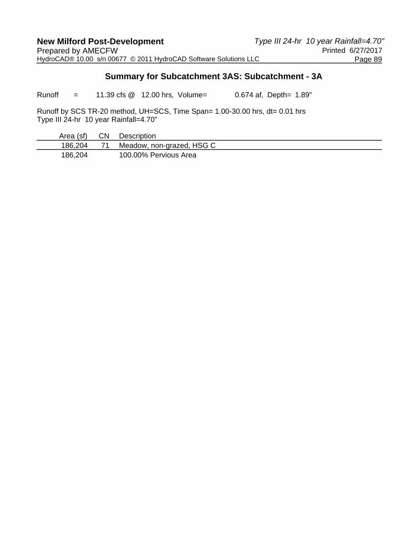
Type III 24-hr 10 year Rainfall=4.70"New Milford Post-Development Printed 6/27/2017Prepared by AMECFW
Page 89HydroCAD® 10.00 s/n 00677 © 2011 HydroCAD Software Solutions LLC
Summary for Subcatchment 3AS: Subcatchment - 3A
Runoff = 11.39 cfs @ 12.00 hrs, Volume= 0.674 af, Depth= 1.89"
Runoff by SCS TR-20 method, UH=SCS, Time Span= 1.00-30.00 hrs, dt= 0.01 hrsType III 24-hr 10 year Rainfall=4.70"
Area (sf) CN Description186,204 71 Meadow, non-grazed, HSG C186,204 100.00% Pervious Area
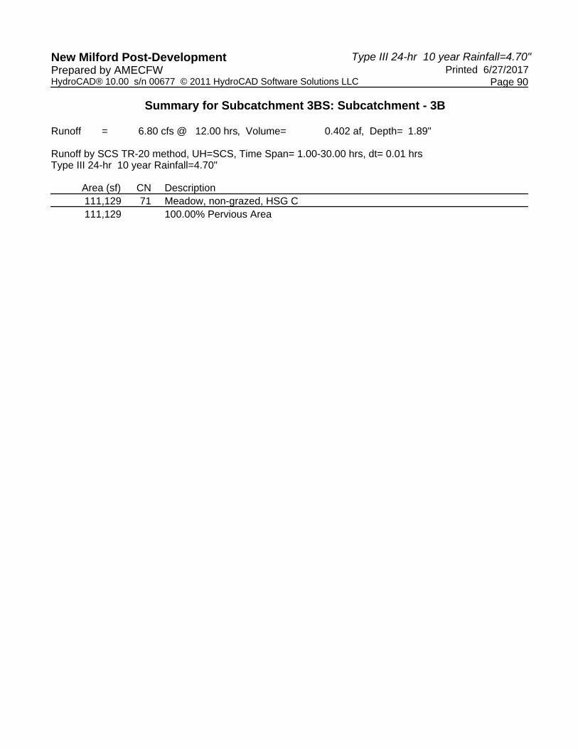
Type III 24-hr 10 year Rainfall=4.70"New Milford Post-Development Printed 6/27/2017Prepared by AMECFW
Page 90HydroCAD® 10.00 s/n 00677 © 2011 HydroCAD Software Solutions LLC
Summary for Subcatchment 3BS: Subcatchment - 3B
Runoff = 6.80 cfs @ 12.00 hrs, Volume= 0.402 af, Depth= 1.89"
Runoff by SCS TR-20 method, UH=SCS, Time Span= 1.00-30.00 hrs, dt= 0.01 hrsType III 24-hr 10 year Rainfall=4.70"
Area (sf) CN Description111,129 71 Meadow, non-grazed, HSG C111,129 100.00% Pervious Area

Type III 24-hr 10 year Rainfall=4.70"New Milford Post-Development Printed 6/27/2017Prepared by AMECFW
Page 91HydroCAD® 10.00 s/n 00677 © 2011 HydroCAD Software Solutions LLC
Summary for Subcatchment 4AS: Subcatchment - 4
Runoff = 10.17 cfs @ 12.00 hrs, Volume= 0.602 af, Depth= 1.89"
Runoff by SCS TR-20 method, UH=SCS, Time Span= 1.00-30.00 hrs, dt= 0.01 hrsType III 24-hr 10 year Rainfall=4.70"
Area (sf) CN Description166,208 71 Meadow, non-grazed, HSG C166,208 100.00% Pervious Area

Type III 24-hr 10 year Rainfall=4.70"New Milford Post-Development Printed 6/27/2017Prepared by AMECFW
Page 92HydroCAD® 10.00 s/n 00677 © 2011 HydroCAD Software Solutions LLC
Summary for Subcatchment 4BS: Subcatchment - 4B
Runoff = 11.71 cfs @ 12.00 hrs, Volume= 0.693 af, Depth= 1.89"
Runoff by SCS TR-20 method, UH=SCS, Time Span= 1.00-30.00 hrs, dt= 0.01 hrsType III 24-hr 10 year Rainfall=4.70"
Area (sf) CN Description191,314 71 Meadow, non-grazed, HSG C191,314 100.00% Pervious Area

Type III 24-hr 10 year Rainfall=4.70"New Milford Post-Development Printed 6/27/2017Prepared by AMECFW
Page 93HydroCAD® 10.00 s/n 00677 © 2011 HydroCAD Software Solutions LLC
Summary for Subcatchment 5AS: Subcatchment - 5A
Runoff = 6.96 cfs @ 12.00 hrs, Volume= 0.412 af, Depth= 1.89"
Runoff by SCS TR-20 method, UH=SCS, Time Span= 1.00-30.00 hrs, dt= 0.01 hrsType III 24-hr 10 year Rainfall=4.70"
Area (sf) CN Description113,745 71 Meadow, non-grazed, HSG C113,745 100.00% Pervious Area

Type III 24-hr 10 year Rainfall=4.70"New Milford Post-Development Printed 6/27/2017Prepared by AMECFW
Page 94HydroCAD® 10.00 s/n 00677 © 2011 HydroCAD Software Solutions LLC
Summary for Subcatchment 5BS: Subcatchment - 5B
Runoff = 6.89 cfs @ 12.00 hrs, Volume= 0.408 af, Depth= 1.89"
Runoff by SCS TR-20 method, UH=SCS, Time Span= 1.00-30.00 hrs, dt= 0.01 hrsType III 24-hr 10 year Rainfall=4.70"
Area (sf) CN Description112,627 71 Meadow, non-grazed, HSG C112,627 100.00% Pervious Area

Type III 24-hr 10 year Rainfall=4.70"New Milford Post-Development Printed 6/27/2017Prepared by AMECFW
Page 95HydroCAD® 10.00 s/n 00677 © 2011 HydroCAD Software Solutions LLC
Summary for Subcatchment 6AS: Subcatchment - 6A
Runoff = 5.88 cfs @ 12.00 hrs, Volume= 0.348 af, Depth= 1.89"
Runoff by SCS TR-20 method, UH=SCS, Time Span= 1.00-30.00 hrs, dt= 0.01 hrsType III 24-hr 10 year Rainfall=4.70"
Area (sf) CN Description3,203 78 Meadow, non-grazed, HSG D
92,882 71 Meadow, non-grazed, HSG C96,085 71 Weighted Average96,085 100.00% Pervious Area

Type III 24-hr 10 year Rainfall=4.70"New Milford Post-Development Printed 6/27/2017Prepared by AMECFW
Page 96HydroCAD® 10.00 s/n 00677 © 2011 HydroCAD Software Solutions LLC
Summary for Subcatchment 6BS: Subcatchment - 6B
Runoff = 12.14 cfs @ 12.00 hrs, Volume= 0.718 af, Depth= 1.89"
Runoff by SCS TR-20 method, UH=SCS, Time Span= 1.00-30.00 hrs, dt= 0.01 hrsType III 24-hr 10 year Rainfall=4.70"
Area (sf) CN Description3,153 78 Meadow, non-grazed, HSG D
189,665 71 Meadow, non-grazed, HSG C* 5,603 98 Unconnected Outcrop, HSG D
198,421 72 Weighted Average, UI Adjusted CN = 71192,818 97.18% Pervious Area
5,603 2.82% Impervious Area5,603 100.00% Unconnected

Type III 24-hr 10 year Rainfall=4.70"New Milford Post-Development Printed 6/27/2017Prepared by AMECFW
Page 97HydroCAD® 10.00 s/n 00677 © 2011 HydroCAD Software Solutions LLC
Summary for Subcatchment 7AS: Subcatchment - 7A
Runoff = 13.39 cfs @ 12.00 hrs, Volume= 0.779 af, Depth= 2.29"
Runoff by SCS TR-20 method, UH=SCS, Time Span= 1.00-30.00 hrs, dt= 0.01 hrsType III 24-hr 10 year Rainfall=4.70"
Area (sf) CN Description59,019 71 Meadow, non-grazed, HSG C37,330 70 Woods, Good, HSG C37,558 80 Pasture/grassland/range, Good, HSG D
* 43,980 98 Unconnected Outcrop, HSG D177,887 79 Weighted Average, UI Adjusted CN = 76133,907 75.28% Pervious Area43,980 24.72% Impervious Area43,980 100.00% Unconnected

Type III 24-hr 10 year Rainfall=4.70"New Milford Post-Development Printed 6/27/2017Prepared by AMECFW
Page 98HydroCAD® 10.00 s/n 00677 © 2011 HydroCAD Software Solutions LLC
Summary for Subcatchment 7BS: Subcatchment - 7B
Runoff = 10.77 cfs @ 12.00 hrs, Volume= 0.632 af, Depth= 2.05"
Runoff by SCS TR-20 method, UH=SCS, Time Span= 1.00-30.00 hrs, dt= 0.01 hrsType III 24-hr 10 year Rainfall=4.70"
Area (sf) CN Description104,556 71 Meadow, non-grazed, HSG C26,624 70 Woods, Good, HSG C
* 30,169 98 Unconnected Outcrop, HSG D161,349 76 Weighted Average, UI Adjusted CN = 73131,180 81.30% Pervious Area30,169 18.70% Impervious Area30,169 100.00% Unconnected

Type III 24-hr 10 year Rainfall=4.70"New Milford Post-Development Printed 6/27/2017Prepared by AMECFW
Page 99HydroCAD® 10.00 s/n 00677 © 2011 HydroCAD Software Solutions LLC
Summary for Subcatchment 7CS: Subcatchment - 7C
Runoff = 6.25 cfs @ 12.00 hrs, Volume= 0.370 af, Depth= 1.89"
Runoff by SCS TR-20 method, UH=SCS, Time Span= 1.00-30.00 hrs, dt= 0.01 hrsType III 24-hr 10 year Rainfall=4.70"
Area (sf) CN Description89,143 71 Meadow, non-grazed, HSG C10,084 70 Woods, Good, HSG C
* 2,890 98 Unconnected Outcrop, HSG D102,117 72 Weighted Average, UI Adjusted CN = 7199,227 97.17% Pervious Area2,890 2.83% Impervious Area2,890 100.00% Unconnected

Type III 24-hr 10 year Rainfall=4.70"New Milford Post-Development Printed 6/27/2017Prepared by AMECFW
Page 100HydroCAD® 10.00 s/n 00677 © 2011 HydroCAD Software Solutions LLC
Summary for Subcatchment 7DS: Subcatchment - 7D
Runoff = 2.52 cfs @ 12.36 hrs, Volume= 0.294 af, Depth= 2.29"
Runoff by SCS TR-20 method, UH=SCS, Time Span= 1.00-30.00 hrs, dt= 0.01 hrsType III 24-hr 10 year Rainfall=4.70"
Area (sf) CN Description1,925 71 Meadow, non-grazed, HSG C
27,780 70 Woods, Good, HSG C37,441 80 Pasture/grassland/range, Good, HSG D67,146 76 Weighted Average67,146 100.00% Pervious Area
Tc Length Slope Velocity Capacity Description(min) (feet) (ft/ft) (ft/sec) (cfs)17.1 150 0.0800 0.15 Sheet Flow, Sheet Flow A-B
Woods: Light underbrush n= 0.400 P2= 3.20"8.0 800 0.1100 1.66 Shallow Concentrated Flow, Shallow Flow B-C
Woodland Kv= 5.0 fps25.1 950 Total
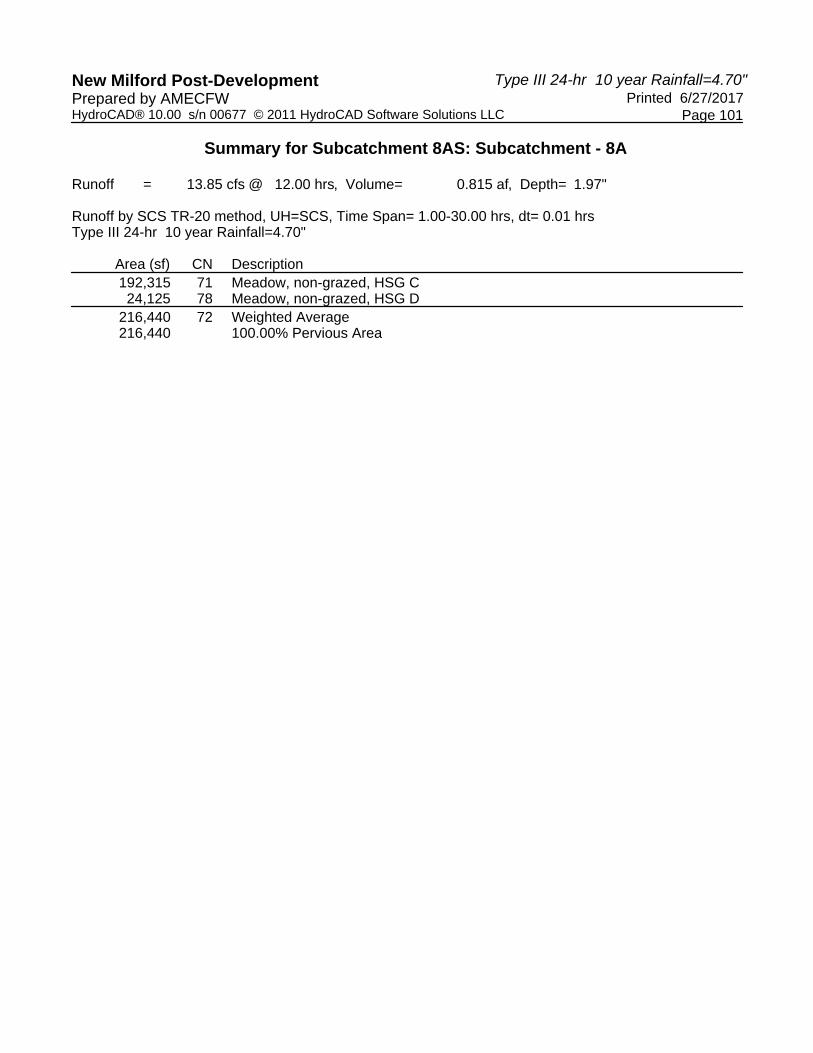
Type III 24-hr 10 year Rainfall=4.70"New Milford Post-Development Printed 6/27/2017Prepared by AMECFW
Page 101HydroCAD® 10.00 s/n 00677 © 2011 HydroCAD Software Solutions LLC
Summary for Subcatchment 8AS: Subcatchment - 8A
Runoff = 13.85 cfs @ 12.00 hrs, Volume= 0.815 af, Depth= 1.97"
Runoff by SCS TR-20 method, UH=SCS, Time Span= 1.00-30.00 hrs, dt= 0.01 hrsType III 24-hr 10 year Rainfall=4.70"
Area (sf) CN Description192,315 71 Meadow, non-grazed, HSG C24,125 78 Meadow, non-grazed, HSG D
216,440 72 Weighted Average216,440 100.00% Pervious Area

Type III 24-hr 10 year Rainfall=4.70"New Milford Post-Development Printed 6/27/2017Prepared by AMECFW
Page 102HydroCAD® 10.00 s/n 00677 © 2011 HydroCAD Software Solutions LLC
Summary for Subcatchment 8BS: Subcatchment - 8B
Runoff = 12.30 cfs @ 12.00 hrs, Volume= 0.724 af, Depth= 1.97"
Runoff by SCS TR-20 method, UH=SCS, Time Span= 1.00-30.00 hrs, dt= 0.01 hrsType III 24-hr 10 year Rainfall=4.70"
Area (sf) CN Description* 299 98 Unconnected Outcrop, HSG D
163,252 71 Meadow, non-grazed, HSG C28,696 78 Meadow, non-grazed, HSG D
192,247 72 Weighted Average191,948 99.84% Pervious Area
299 0.16% Impervious Area299 100.00% Unconnected

Type III 24-hr 10 year Rainfall=4.70"New Milford Post-Development Printed 6/27/2017Prepared by AMECFW
Page 103HydroCAD® 10.00 s/n 00677 © 2011 HydroCAD Software Solutions LLC
Summary for Subcatchment 8CS: Subcatchment - 8C
Runoff = 11.32 cfs @ 12.00 hrs, Volume= 0.664 af, Depth= 2.05"
Runoff by SCS TR-20 method, UH=SCS, Time Span= 1.00-30.00 hrs, dt= 0.01 hrsType III 24-hr 10 year Rainfall=4.70"
Area (sf) CN Description* 9,966 98 Unconnected Outcrop, HSG D
123,246 71 Meadow, non-grazed, HSG C36,284 78 Meadow, non-grazed, HSG D
169,496 74 Weighted Average, UI Adjusted CN = 73159,530 94.12% Pervious Area
9,966 5.88% Impervious Area9,966 100.00% Unconnected

Type III 24-hr 10 year Rainfall=4.70"New Milford Post-Development Printed 6/27/2017Prepared by AMECFW
Page 104HydroCAD® 10.00 s/n 00677 © 2011 HydroCAD Software Solutions LLC
Summary for Subcatchment 9AS: Subcatchment - 9A
Runoff = 12.05 cfs @ 12.00 hrs, Volume= 0.710 af, Depth= 1.97"
Runoff by SCS TR-20 method, UH=SCS, Time Span= 1.00-30.00 hrs, dt= 0.01 hrsType III 24-hr 10 year Rainfall=4.70"
Area (sf) CN Description* 8,808 98 Unconnected Outcrop, HSG D
158,319 71 Meadow, non-grazed, HSG C21,239 78 Meadow, non-grazed, HSG D
188,366 73 Weighted Average, UI Adjusted CN = 72179,558 95.32% Pervious Area
8,808 4.68% Impervious Area8,808 100.00% Unconnected

Type III 24-hr 10 year Rainfall=4.70"New Milford Post-Development Printed 6/27/2017Prepared by AMECFW
Page 105HydroCAD® 10.00 s/n 00677 © 2011 HydroCAD Software Solutions LLC
Summary for Subcatchment 9BS: Subcatchment - 9B
Runoff = 12.33 cfs @ 12.00 hrs, Volume= 0.730 af, Depth= 1.89"
Runoff by SCS TR-20 method, UH=SCS, Time Span= 1.00-30.00 hrs, dt= 0.01 hrsType III 24-hr 10 year Rainfall=4.70"
Area (sf) CN Description* 889 98 Unconnected Outcrop, HSG D
196,532 71 Meadow, non-grazed, HSG C4,139 78 Meadow, non-grazed, HSG D
201,560 71 Weighted Average200,671 99.56% Pervious Area
889 0.44% Impervious Area889 100.00% Unconnected

Type III 24-hr 10 year Rainfall=4.70"New Milford Post-Development Printed 6/27/2017Prepared by AMECFW
Page 106HydroCAD® 10.00 s/n 00677 © 2011 HydroCAD Software Solutions LLC
Summary for Subcatchment 10S: Subcatchment - 10
Runoff = 13.34 cfs @ 12.00 hrs, Volume= 0.789 af, Depth= 1.89"
Runoff by SCS TR-20 method, UH=SCS, Time Span= 1.00-30.00 hrs, dt= 0.01 hrsType III 24-hr 10 year Rainfall=4.70"
Area (sf) CN Description218,036 71 Meadow, non-grazed, HSG C218,036 100.00% Pervious Area
Type III 24-hr 10 year Rainfall=4.70"New Milford Post-Development Printed 6/27/2017Prepared by AMECFW
Page 107HydroCAD® 10.00 s/n 00677 © 2011 HydroCAD Software Solutions LLC
Summary for Reach POA-1: Existing Woods to the Northeast & Tributary to Existing Wetlands Area
Inflow Area = 12.189 ac, 14.02% Impervious, Inflow Depth = 2.34" for 10 year eventInflow = 40.57 cfs @ 12.00 hrs, Volume= 2.382 afOutflow = 40.57 cfs @ 12.00 hrs, Volume= 2.382 af, Atten= 0%, Lag= 0.0 min
Routing by Dyn-Stor-Ind method, Time Span= 1.00-30.00 hrs, dt= 0.01 hrs

Type III 24-hr 10 year Rainfall=4.70"New Milford Post-Development Printed 6/27/2017Prepared by AMECFW
Page 108HydroCAD® 10.00 s/n 00677 © 2011 HydroCAD Software Solutions LLC
Summary for Reach POA-10: Existing Woods to the Northwest
Inflow Area = 5.005 ac, 0.00% Impervious, Inflow Depth = 1.89" for 10 year eventInflow = 13.34 cfs @ 12.00 hrs, Volume= 0.789 afOutflow = 13.34 cfs @ 12.00 hrs, Volume= 0.789 af, Atten= 0%, Lag= 0.0 min
Routing by Dyn-Stor-Ind method, Time Span= 1.00-30.00 hrs, dt= 0.01 hrs

Type III 24-hr 10 year Rainfall=4.70"New Milford Post-Development Printed 6/27/2017Prepared by AMECFW
Page 109HydroCAD® 10.00 s/n 00677 © 2011 HydroCAD Software Solutions LLC
Summary for Reach POA-2: Existing Woods to the Northwest
Inflow Area = 11.681 ac, 7.53% Impervious, Inflow Depth = 2.22" for 10 year eventInflow = 36.96 cfs @ 12.00 hrs, Volume= 2.158 afOutflow = 36.96 cfs @ 12.00 hrs, Volume= 2.158 af, Atten= 0%, Lag= 0.0 min
Routing by Dyn-Stor-Ind method, Time Span= 1.00-30.00 hrs, dt= 0.01 hrs

Type III 24-hr 10 year Rainfall=4.70"New Milford Post-Development Printed 6/27/2017Prepared by AMECFW
Page 110HydroCAD® 10.00 s/n 00677 © 2011 HydroCAD Software Solutions LLC
Summary for Reach POA-3: Existing Woods to the Northwest
Inflow Area = 6.826 ac, 0.00% Impervious, Inflow Depth = 1.89" for 10 year eventInflow = 18.19 cfs @ 12.00 hrs, Volume= 1.076 afOutflow = 18.19 cfs @ 12.00 hrs, Volume= 1.076 af, Atten= 0%, Lag= 0.0 min
Routing by Dyn-Stor-Ind method, Time Span= 1.00-30.00 hrs, dt= 0.01 hrs

Type III 24-hr 10 year Rainfall=4.70"New Milford Post-Development Printed 6/27/2017Prepared by AMECFW
Page 111HydroCAD® 10.00 s/n 00677 © 2011 HydroCAD Software Solutions LLC
Summary for Reach POA-4: Existing Woods to the Northwest
Inflow Area = 8.208 ac, 0.00% Impervious, Inflow Depth = 1.89" for 10 year eventInflow = 21.88 cfs @ 12.00 hrs, Volume= 1.294 afOutflow = 21.88 cfs @ 12.00 hrs, Volume= 1.294 af, Atten= 0%, Lag= 0.0 min
Routing by Dyn-Stor-Ind method, Time Span= 1.00-30.00 hrs, dt= 0.01 hrs

Type III 24-hr 10 year Rainfall=4.70"New Milford Post-Development Printed 6/27/2017Prepared by AMECFW
Page 112HydroCAD® 10.00 s/n 00677 © 2011 HydroCAD Software Solutions LLC
Summary for Reach POA-5: Existing Woods to the Northwest
Inflow Area = 5.197 ac, 0.00% Impervious, Inflow Depth = 1.89" for 10 year eventInflow = 13.85 cfs @ 12.00 hrs, Volume= 0.820 afOutflow = 13.85 cfs @ 12.00 hrs, Volume= 0.820 af, Atten= 0%, Lag= 0.0 min
Routing by Dyn-Stor-Ind method, Time Span= 1.00-30.00 hrs, dt= 0.01 hrs

Type III 24-hr 10 year Rainfall=4.70"New Milford Post-Development Printed 6/27/2017Prepared by AMECFW
Page 113HydroCAD® 10.00 s/n 00677 © 2011 HydroCAD Software Solutions LLC
Summary for Reach POA-6: Existing Woods to the Northeast
Inflow Area = 6.761 ac, 1.90% Impervious, Inflow Depth = 1.89" for 10 year eventInflow = 18.02 cfs @ 12.00 hrs, Volume= 1.066 afOutflow = 18.02 cfs @ 12.00 hrs, Volume= 1.066 af, Atten= 0%, Lag= 0.0 min
Routing by Dyn-Stor-Ind method, Time Span= 1.00-30.00 hrs, dt= 0.01 hrs

Type III 24-hr 10 year Rainfall=4.70"New Milford Post-Development Printed 6/27/2017Prepared by AMECFW
Page 114HydroCAD® 10.00 s/n 00677 © 2011 HydroCAD Software Solutions LLC
Summary for Reach POA-7: Existing Woods & Candlewood Roadside Swales to the Northwest
Inflow Area = 11.674 ac, 15.15% Impervious, Inflow Depth = 2.13" for 10 year eventInflow = 31.18 cfs @ 12.00 hrs, Volume= 2.076 afOutflow = 31.18 cfs @ 12.00 hrs, Volume= 2.076 af, Atten= 0%, Lag= 0.0 min
Routing by Dyn-Stor-Ind method, Time Span= 1.00-30.00 hrs, dt= 0.01 hrs

Type III 24-hr 10 year Rainfall=4.70"New Milford Post-Development Printed 6/27/2017Prepared by AMECFW
Page 115HydroCAD® 10.00 s/n 00677 © 2011 HydroCAD Software Solutions LLC
Summary for Reach POA-8: Existing Woods to the Northeast
Inflow Area = 13.273 ac, 1.78% Impervious, Inflow Depth = 1.99" for 10 year eventInflow = 37.46 cfs @ 12.00 hrs, Volume= 2.204 afOutflow = 37.46 cfs @ 12.00 hrs, Volume= 2.204 af, Atten= 0%, Lag= 0.0 min
Routing by Dyn-Stor-Ind method, Time Span= 1.00-30.00 hrs, dt= 0.01 hrs

Type III 24-hr 10 year Rainfall=4.70"New Milford Post-Development Printed 6/27/2017Prepared by AMECFW
Page 116HydroCAD® 10.00 s/n 00677 © 2011 HydroCAD Software Solutions LLC
Summary for Reach POA-9: Existing Woods to the Northeast
Inflow Area = 8.951 ac, 2.49% Impervious, Inflow Depth = 1.93" for 10 year eventInflow = 24.38 cfs @ 12.00 hrs, Volume= 1.439 afOutflow = 24.38 cfs @ 12.00 hrs, Volume= 1.439 af, Atten= 0%, Lag= 0.0 min
Routing by Dyn-Stor-Ind method, Time Span= 1.00-30.00 hrs, dt= 0.01 hrs

Type III 24-hr 25 year Rainfall=5.50"New Milford Post-Development Printed 6/27/2017Prepared by AMECFW
Page 117HydroCAD® 10.00 s/n 00677 © 2011 HydroCAD Software Solutions LLC
Time span=1.00-30.00 hrs, dt=0.01 hrs, 2901 pointsRunoff by SCS TR-20 method, UH=SCS
Reach routing by Dyn-Stor-Ind method - Pond routing by Dyn-Stor-Ind method
Runoff Area=136,972 sf 38.73% Impervious Runoff Depth=3.94"Subcatchment1AS: Subcatchment- 1A Tc=0.0 min CN=86 Runoff=17.41 cfs 1.031 af
Runoff Area=204,474 sf 9.41% Impervious Runoff Depth=2.77"Subcatchment1BS: Subcatchment- 1B Tc=0.0 min UI Adjusted CN=74 Runoff=18.64 cfs 1.083 af
Runoff Area=189,496 sf 1.12% Impervious Runoff Depth=2.59"Subcatchment1CS: Subcatchment- 1C Tc=0.0 min CN=72 Runoff=16.10 cfs 0.939 af
Runoff Area=89,786 sf 15.05% Impervious Runoff Depth=3.33"Subcatchment2AS: Subcatchment- 2A Tc=0.0 min UI Adjusted CN=80 Runoff=9.84 cfs 0.573 af
Runoff Area=209,244 sf 7.62% Impervious Runoff Depth=2.86"Subcatchment2BS: Subcatchment- 2B Tc=0.0 min UI Adjusted CN=75 Runoff=19.72 cfs 1.145 af
Runoff Area=209,786 sf 4.23% Impervious Runoff Depth=2.68"Subcatchment2CS: Subcatchment- 2C Tc=0.0 min UI Adjusted CN=73 Runoff=18.47 cfs 1.075 af
Runoff Area=186,204 sf 0.00% Impervious Runoff Depth=2.50"Subcatchment3AS: Subcatchment- 3A Tc=0.0 min CN=71 Runoff=15.24 cfs 0.891 af
Runoff Area=111,129 sf 0.00% Impervious Runoff Depth=2.50"Subcatchment3BS: Subcatchment- 3B Tc=0.0 min CN=71 Runoff=9.10 cfs 0.532 af
Runoff Area=166,208 sf 0.00% Impervious Runoff Depth=2.50"Subcatchment4AS: Subcatchment- 4 Tc=0.0 min CN=71 Runoff=13.61 cfs 0.795 af
Runoff Area=191,314 sf 0.00% Impervious Runoff Depth=2.50"Subcatchment4BS: Subcatchment- 4B Tc=0.0 min CN=71 Runoff=15.66 cfs 0.916 af
Runoff Area=113,745 sf 0.00% Impervious Runoff Depth=2.50"Subcatchment5AS: Subcatchment- 5A Tc=0.0 min CN=71 Runoff=9.31 cfs 0.544 af
Runoff Area=112,627 sf 0.00% Impervious Runoff Depth=2.50"Subcatchment5BS: Subcatchment- 5B Tc=0.0 min CN=71 Runoff=9.22 cfs 0.539 af
Runoff Area=96,085 sf 0.00% Impervious Runoff Depth=2.50"Subcatchment6AS: Subcatchment- 6A Tc=0.0 min CN=71 Runoff=7.87 cfs 0.460 af
Runoff Area=198,421 sf 2.82% Impervious Runoff Depth=2.50"Subcatchment6BS: Subcatchment- 6B Tc=0.0 min UI Adjusted CN=71 Runoff=16.24 cfs 0.950 af
Runoff Area=177,887 sf 24.72% Impervious Runoff Depth=2.95"Subcatchment7AS: Subcatchment- 7A Tc=0.0 min UI Adjusted CN=76 Runoff=17.32 cfs 1.005 af
Runoff Area=161,349 sf 18.70% Impervious Runoff Depth=2.68"Subcatchment7BS: Subcatchment- 7B Tc=0.0 min UI Adjusted CN=73 Runoff=14.21 cfs 0.827 af

Type III 24-hr 25 year Rainfall=5.50"New Milford Post-Development Printed 6/27/2017Prepared by AMECFW
Page 118HydroCAD® 10.00 s/n 00677 © 2011 HydroCAD Software Solutions LLC
Runoff Area=102,117 sf 2.83% Impervious Runoff Depth=2.50"Subcatchment7CS: Subcatchment- 7C Tc=0.0 min UI Adjusted CN=71 Runoff=8.36 cfs 0.489 af
Runoff Area=67,146 sf 0.00% Impervious Runoff Depth=2.95"Subcatchment7DS: Subcatchment- 7D Flow Length=950' Tc=25.1 min CN=76 Runoff=3.27 cfs 0.379 af
Runoff Area=216,440 sf 0.00% Impervious Runoff Depth=2.59"Subcatchment8AS: Subcatchment- 8A Tc=0.0 min CN=72 Runoff=18.39 cfs 1.072 af
Runoff Area=192,247 sf 0.16% Impervious Runoff Depth=2.59"Subcatchment8BS: Subcatchment- 8B Tc=0.0 min CN=72 Runoff=16.33 cfs 0.952 af
Runoff Area=169,496 sf 5.88% Impervious Runoff Depth=2.68"Subcatchment8CS: Subcatchment- 8C Tc=0.0 min UI Adjusted CN=73 Runoff=14.93 cfs 0.869 af
Runoff Area=188,366 sf 4.68% Impervious Runoff Depth=2.59"Subcatchment9AS: Subcatchment- 9A Tc=0.0 min UI Adjusted CN=72 Runoff=16.00 cfs 0.933 af
Runoff Area=201,560 sf 0.44% Impervious Runoff Depth=2.50"Subcatchment9BS: Subcatchment- 9B Tc=0.0 min CN=71 Runoff=16.50 cfs 0.965 af
Runoff Area=218,036 sf 0.00% Impervious Runoff Depth=2.50"Subcatchment10S: Subcatchment- 10 Tc=0.0 min CN=71 Runoff=17.85 cfs 1.043 af
Inflow=52.15 cfs 3.053 afReach POA-1:ExistingWoods to the Northeast& Tributaryto Existing Outflow=52.15 cfs 3.053 af
Inflow=17.85 cfs 1.043 afReach POA-10:ExistingWoods to the Northwest Outflow=17.85 cfs 1.043 af
Inflow=48.04 cfs 2.793 afReach POA-2:ExistingWoods to the Northwest Outflow=48.04 cfs 2.793 af
Inflow=24.34 cfs 1.423 afReach POA-3:ExistingWoods to the Northwest Outflow=24.34 cfs 1.423 af
Inflow=29.27 cfs 1.711 afReach POA-4:ExistingWoods to the Northwest Outflow=29.27 cfs 1.711 af
Inflow=18.53 cfs 1.083 afReach POA-5:ExistingWoods to the Northwest Outflow=18.53 cfs 1.083 af
Inflow=24.11 cfs 1.409 afReach POA-6:ExistingWoods to the Northeast Outflow=24.11 cfs 1.409 af
Inflow=40.93 cfs 2.700 afReach POA-7:ExistingWoods & CandlewoodRoadsideSwales to the Outflow=40.93 cfs 2.700 af
Inflow=49.65 cfs 2.893 afReach POA-8:ExistingWoods to the Northeast Outflow=49.65 cfs 2.893 af

Type III 24-hr 25 year Rainfall=5.50"New Milford Post-Development Printed 6/27/2017Prepared by AMECFW
Page 119HydroCAD® 10.00 s/n 00677 © 2011 HydroCAD Software Solutions LLC
Inflow=32.51 cfs 1.898 afReach POA-9:ExistingWoods to the Northeast Outflow=32.51 cfs 1.898 af
Total Runoff Area = 89.764 ac Runoff Volume = 20.007 af Average Runoff Depth = 2.67"94.49% Pervious = 84.821 ac 5.51% Impervious = 4.943 ac

Type III 24-hr 25 year Rainfall=5.50"New Milford Post-Development Printed 6/27/2017Prepared by AMECFW
Page 120HydroCAD® 10.00 s/n 00677 © 2011 HydroCAD Software Solutions LLC
Summary for Subcatchment 1AS: Subcatchment - 1A
Runoff = 17.41 cfs @ 12.00 hrs, Volume= 1.031 af, Depth= 3.94"
Runoff by SCS TR-20 method, UH=SCS, Time Span= 1.00-30.00 hrs, dt= 0.01 hrsType III 24-hr 25 year Rainfall=5.50"
Area (sf) CN Description* 35,114 98 Unconnected Outcrop, HSG D
79,782 78 Meadow, non-grazed, HSG D* 17,933 98 Unconnected Outcrop, HSG D
4,143 71 Meadow, non-grazed, HSG C136,972 86 Weighted Average83,925 61.27% Pervious Area53,047 38.73% Impervious Area53,047 100.00% Unconnected

Type III 24-hr 25 year Rainfall=5.50"New Milford Post-Development Printed 6/27/2017Prepared by AMECFW
Page 121HydroCAD® 10.00 s/n 00677 © 2011 HydroCAD Software Solutions LLC
Summary for Subcatchment 1BS: Subcatchment - 1B
Runoff = 18.64 cfs @ 12.00 hrs, Volume= 1.083 af, Depth= 2.77"
Runoff by SCS TR-20 method, UH=SCS, Time Span= 1.00-30.00 hrs, dt= 0.01 hrsType III 24-hr 25 year Rainfall=5.50"
Area (sf) CN Description* 13,477 98 Unconnected Outcrop, HSG D
42,165 78 Meadow, non-grazed, HSG D47,492 71 Meadow, non-grazed, HSG C95,573 71 Meadow, non-grazed, HSG C
* 5,767 98 Unconnected Outcrop, HSG D204,474 75 Weighted Average, UI Adjusted CN = 74185,230 90.59% Pervious Area19,244 9.41% Impervious Area19,244 100.00% Unconnected

Type III 24-hr 25 year Rainfall=5.50"New Milford Post-Development Printed 6/27/2017Prepared by AMECFW
Page 122HydroCAD® 10.00 s/n 00677 © 2011 HydroCAD Software Solutions LLC
Summary for Subcatchment 1CS: Subcatchment - 1C
Runoff = 16.10 cfs @ 12.00 hrs, Volume= 0.939 af, Depth= 2.59"
Runoff by SCS TR-20 method, UH=SCS, Time Span= 1.00-30.00 hrs, dt= 0.01 hrsType III 24-hr 25 year Rainfall=5.50"
Area (sf) CN Description9,856 78 Meadow, non-grazed, HSG D
177,514 71 Meadow, non-grazed, HSG C* 2,126 98 Unconnected Outcrop, HSG D
189,496 72 Weighted Average187,370 98.88% Pervious Area
2,126 1.12% Impervious Area2,126 100.00% Unconnected

Type III 24-hr 25 year Rainfall=5.50"New Milford Post-Development Printed 6/27/2017Prepared by AMECFW
Page 123HydroCAD® 10.00 s/n 00677 © 2011 HydroCAD Software Solutions LLC
Summary for Subcatchment 2AS: Subcatchment - 2A
Runoff = 9.84 cfs @ 12.00 hrs, Volume= 0.573 af, Depth= 3.33"
Runoff by SCS TR-20 method, UH=SCS, Time Span= 1.00-30.00 hrs, dt= 0.01 hrsType III 24-hr 25 year Rainfall=5.50"
Area (sf) CN Description* 13,513 98 Unconnected Outcrop, HSG D
76,273 78 Meadow, non-grazed, HSG D89,786 81 Weighted Average, UI Adjusted CN = 8076,273 84.95% Pervious Area13,513 15.05% Impervious Area13,513 100.00% Unconnected

Type III 24-hr 25 year Rainfall=5.50"New Milford Post-Development Printed 6/27/2017Prepared by AMECFW
Page 124HydroCAD® 10.00 s/n 00677 © 2011 HydroCAD Software Solutions LLC
Summary for Subcatchment 2BS: Subcatchment - 2B
Runoff = 19.72 cfs @ 12.00 hrs, Volume= 1.145 af, Depth= 2.86"
Runoff by SCS TR-20 method, UH=SCS, Time Span= 1.00-30.00 hrs, dt= 0.01 hrsType III 24-hr 25 year Rainfall=5.50"
Area (sf) CN Description* 15,936 98 Unconnected Outcrop, HSG D
80,385 78 Meadow, non-grazed, HSG D112,923 71 Meadow, non-grazed, HSG C209,244 76 Weighted Average, UI Adjusted CN = 75193,308 92.38% Pervious Area15,936 7.62% Impervious Area15,936 100.00% Unconnected
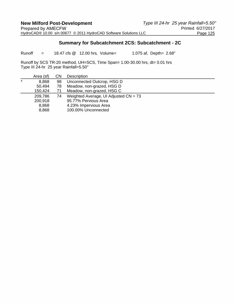
Type III 24-hr 25 year Rainfall=5.50"New Milford Post-Development Printed 6/27/2017Prepared by AMECFW
Page 125HydroCAD® 10.00 s/n 00677 © 2011 HydroCAD Software Solutions LLC
Summary for Subcatchment 2CS: Subcatchment - 2C
Runoff = 18.47 cfs @ 12.00 hrs, Volume= 1.075 af, Depth= 2.68"
Runoff by SCS TR-20 method, UH=SCS, Time Span= 1.00-30.00 hrs, dt= 0.01 hrsType III 24-hr 25 year Rainfall=5.50"
Area (sf) CN Description* 8,868 98 Unconnected Outcrop, HSG D
50,494 78 Meadow, non-grazed, HSG D150,424 71 Meadow, non-grazed, HSG C209,786 74 Weighted Average, UI Adjusted CN = 73200,918 95.77% Pervious Area
8,868 4.23% Impervious Area8,868 100.00% Unconnected
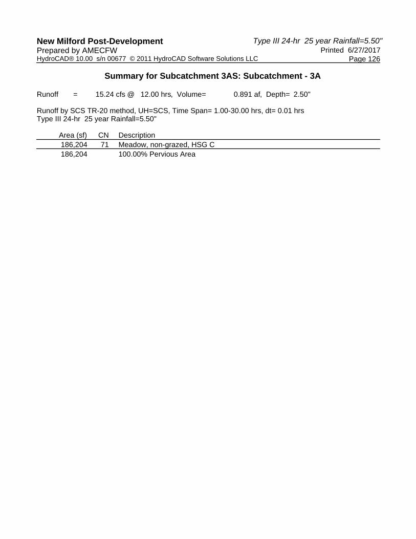
Type III 24-hr 25 year Rainfall=5.50"New Milford Post-Development Printed 6/27/2017Prepared by AMECFW
Page 126HydroCAD® 10.00 s/n 00677 © 2011 HydroCAD Software Solutions LLC
Summary for Subcatchment 3AS: Subcatchment - 3A
Runoff = 15.24 cfs @ 12.00 hrs, Volume= 0.891 af, Depth= 2.50"
Runoff by SCS TR-20 method, UH=SCS, Time Span= 1.00-30.00 hrs, dt= 0.01 hrsType III 24-hr 25 year Rainfall=5.50"
Area (sf) CN Description186,204 71 Meadow, non-grazed, HSG C186,204 100.00% Pervious Area

Type III 24-hr 25 year Rainfall=5.50"New Milford Post-Development Printed 6/27/2017Prepared by AMECFW
Page 127HydroCAD® 10.00 s/n 00677 © 2011 HydroCAD Software Solutions LLC
Summary for Subcatchment 3BS: Subcatchment - 3B
Runoff = 9.10 cfs @ 12.00 hrs, Volume= 0.532 af, Depth= 2.50"
Runoff by SCS TR-20 method, UH=SCS, Time Span= 1.00-30.00 hrs, dt= 0.01 hrsType III 24-hr 25 year Rainfall=5.50"
Area (sf) CN Description111,129 71 Meadow, non-grazed, HSG C111,129 100.00% Pervious Area

Type III 24-hr 25 year Rainfall=5.50"New Milford Post-Development Printed 6/27/2017Prepared by AMECFW
Page 128HydroCAD® 10.00 s/n 00677 © 2011 HydroCAD Software Solutions LLC
Summary for Subcatchment 4AS: Subcatchment - 4
Runoff = 13.61 cfs @ 12.00 hrs, Volume= 0.795 af, Depth= 2.50"
Runoff by SCS TR-20 method, UH=SCS, Time Span= 1.00-30.00 hrs, dt= 0.01 hrsType III 24-hr 25 year Rainfall=5.50"
Area (sf) CN Description166,208 71 Meadow, non-grazed, HSG C166,208 100.00% Pervious Area

Type III 24-hr 25 year Rainfall=5.50"New Milford Post-Development Printed 6/27/2017Prepared by AMECFW
Page 129HydroCAD® 10.00 s/n 00677 © 2011 HydroCAD Software Solutions LLC
Summary for Subcatchment 4BS: Subcatchment - 4B
Runoff = 15.66 cfs @ 12.00 hrs, Volume= 0.916 af, Depth= 2.50"
Runoff by SCS TR-20 method, UH=SCS, Time Span= 1.00-30.00 hrs, dt= 0.01 hrsType III 24-hr 25 year Rainfall=5.50"
Area (sf) CN Description191,314 71 Meadow, non-grazed, HSG C191,314 100.00% Pervious Area

Type III 24-hr 25 year Rainfall=5.50"New Milford Post-Development Printed 6/27/2017Prepared by AMECFW
Page 130HydroCAD® 10.00 s/n 00677 © 2011 HydroCAD Software Solutions LLC
Summary for Subcatchment 5AS: Subcatchment - 5A
Runoff = 9.31 cfs @ 12.00 hrs, Volume= 0.544 af, Depth= 2.50"
Runoff by SCS TR-20 method, UH=SCS, Time Span= 1.00-30.00 hrs, dt= 0.01 hrsType III 24-hr 25 year Rainfall=5.50"
Area (sf) CN Description113,745 71 Meadow, non-grazed, HSG C113,745 100.00% Pervious Area

Type III 24-hr 25 year Rainfall=5.50"New Milford Post-Development Printed 6/27/2017Prepared by AMECFW
Page 131HydroCAD® 10.00 s/n 00677 © 2011 HydroCAD Software Solutions LLC
Summary for Subcatchment 5BS: Subcatchment - 5B
Runoff = 9.22 cfs @ 12.00 hrs, Volume= 0.539 af, Depth= 2.50"
Runoff by SCS TR-20 method, UH=SCS, Time Span= 1.00-30.00 hrs, dt= 0.01 hrsType III 24-hr 25 year Rainfall=5.50"
Area (sf) CN Description112,627 71 Meadow, non-grazed, HSG C112,627 100.00% Pervious Area
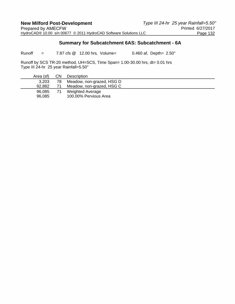
Type III 24-hr 25 year Rainfall=5.50"New Milford Post-Development Printed 6/27/2017Prepared by AMECFW
Page 132HydroCAD® 10.00 s/n 00677 © 2011 HydroCAD Software Solutions LLC
Summary for Subcatchment 6AS: Subcatchment - 6A
Runoff = 7.87 cfs @ 12.00 hrs, Volume= 0.460 af, Depth= 2.50"
Runoff by SCS TR-20 method, UH=SCS, Time Span= 1.00-30.00 hrs, dt= 0.01 hrsType III 24-hr 25 year Rainfall=5.50"
Area (sf) CN Description3,203 78 Meadow, non-grazed, HSG D
92,882 71 Meadow, non-grazed, HSG C96,085 71 Weighted Average96,085 100.00% Pervious Area

Type III 24-hr 25 year Rainfall=5.50"New Milford Post-Development Printed 6/27/2017Prepared by AMECFW
Page 133HydroCAD® 10.00 s/n 00677 © 2011 HydroCAD Software Solutions LLC
Summary for Subcatchment 6BS: Subcatchment - 6B
Runoff = 16.24 cfs @ 12.00 hrs, Volume= 0.950 af, Depth= 2.50"
Runoff by SCS TR-20 method, UH=SCS, Time Span= 1.00-30.00 hrs, dt= 0.01 hrsType III 24-hr 25 year Rainfall=5.50"
Area (sf) CN Description3,153 78 Meadow, non-grazed, HSG D
189,665 71 Meadow, non-grazed, HSG C* 5,603 98 Unconnected Outcrop, HSG D
198,421 72 Weighted Average, UI Adjusted CN = 71192,818 97.18% Pervious Area
5,603 2.82% Impervious Area5,603 100.00% Unconnected
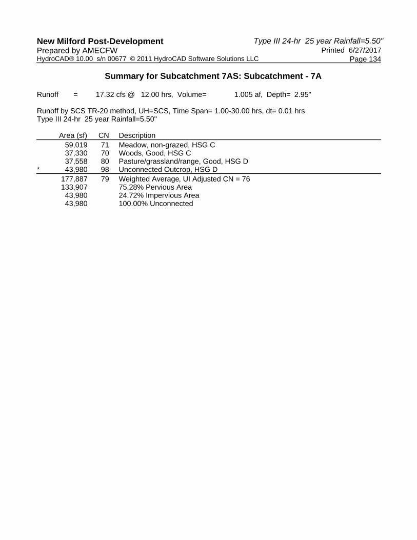
Type III 24-hr 25 year Rainfall=5.50"New Milford Post-Development Printed 6/27/2017Prepared by AMECFW
Page 134HydroCAD® 10.00 s/n 00677 © 2011 HydroCAD Software Solutions LLC
Summary for Subcatchment 7AS: Subcatchment - 7A
Runoff = 17.32 cfs @ 12.00 hrs, Volume= 1.005 af, Depth= 2.95"
Runoff by SCS TR-20 method, UH=SCS, Time Span= 1.00-30.00 hrs, dt= 0.01 hrsType III 24-hr 25 year Rainfall=5.50"
Area (sf) CN Description59,019 71 Meadow, non-grazed, HSG C37,330 70 Woods, Good, HSG C37,558 80 Pasture/grassland/range, Good, HSG D
* 43,980 98 Unconnected Outcrop, HSG D177,887 79 Weighted Average, UI Adjusted CN = 76133,907 75.28% Pervious Area43,980 24.72% Impervious Area43,980 100.00% Unconnected

Type III 24-hr 25 year Rainfall=5.50"New Milford Post-Development Printed 6/27/2017Prepared by AMECFW
Page 135HydroCAD® 10.00 s/n 00677 © 2011 HydroCAD Software Solutions LLC
Summary for Subcatchment 7BS: Subcatchment - 7B
Runoff = 14.21 cfs @ 12.00 hrs, Volume= 0.827 af, Depth= 2.68"
Runoff by SCS TR-20 method, UH=SCS, Time Span= 1.00-30.00 hrs, dt= 0.01 hrsType III 24-hr 25 year Rainfall=5.50"
Area (sf) CN Description104,556 71 Meadow, non-grazed, HSG C26,624 70 Woods, Good, HSG C
* 30,169 98 Unconnected Outcrop, HSG D161,349 76 Weighted Average, UI Adjusted CN = 73131,180 81.30% Pervious Area30,169 18.70% Impervious Area30,169 100.00% Unconnected

Type III 24-hr 25 year Rainfall=5.50"New Milford Post-Development Printed 6/27/2017Prepared by AMECFW
Page 136HydroCAD® 10.00 s/n 00677 © 2011 HydroCAD Software Solutions LLC
Summary for Subcatchment 7CS: Subcatchment - 7C
Runoff = 8.36 cfs @ 12.00 hrs, Volume= 0.489 af, Depth= 2.50"
Runoff by SCS TR-20 method, UH=SCS, Time Span= 1.00-30.00 hrs, dt= 0.01 hrsType III 24-hr 25 year Rainfall=5.50"
Area (sf) CN Description89,143 71 Meadow, non-grazed, HSG C10,084 70 Woods, Good, HSG C
* 2,890 98 Unconnected Outcrop, HSG D102,117 72 Weighted Average, UI Adjusted CN = 7199,227 97.17% Pervious Area2,890 2.83% Impervious Area2,890 100.00% Unconnected

Type III 24-hr 25 year Rainfall=5.50"New Milford Post-Development Printed 6/27/2017Prepared by AMECFW
Page 137HydroCAD® 10.00 s/n 00677 © 2011 HydroCAD Software Solutions LLC
Summary for Subcatchment 7DS: Subcatchment - 7D
Runoff = 3.27 cfs @ 12.35 hrs, Volume= 0.379 af, Depth= 2.95"
Runoff by SCS TR-20 method, UH=SCS, Time Span= 1.00-30.00 hrs, dt= 0.01 hrsType III 24-hr 25 year Rainfall=5.50"
Area (sf) CN Description1,925 71 Meadow, non-grazed, HSG C
27,780 70 Woods, Good, HSG C37,441 80 Pasture/grassland/range, Good, HSG D67,146 76 Weighted Average67,146 100.00% Pervious Area
Tc Length Slope Velocity Capacity Description(min) (feet) (ft/ft) (ft/sec) (cfs)17.1 150 0.0800 0.15 Sheet Flow, Sheet Flow A-B
Woods: Light underbrush n= 0.400 P2= 3.20"8.0 800 0.1100 1.66 Shallow Concentrated Flow, Shallow Flow B-C
Woodland Kv= 5.0 fps25.1 950 Total

Type III 24-hr 25 year Rainfall=5.50"New Milford Post-Development Printed 6/27/2017Prepared by AMECFW
Page 138HydroCAD® 10.00 s/n 00677 © 2011 HydroCAD Software Solutions LLC
Summary for Subcatchment 8AS: Subcatchment - 8A
Runoff = 18.39 cfs @ 12.00 hrs, Volume= 1.072 af, Depth= 2.59"
Runoff by SCS TR-20 method, UH=SCS, Time Span= 1.00-30.00 hrs, dt= 0.01 hrsType III 24-hr 25 year Rainfall=5.50"
Area (sf) CN Description192,315 71 Meadow, non-grazed, HSG C24,125 78 Meadow, non-grazed, HSG D
216,440 72 Weighted Average216,440 100.00% Pervious Area

Type III 24-hr 25 year Rainfall=5.50"New Milford Post-Development Printed 6/27/2017Prepared by AMECFW
Page 139HydroCAD® 10.00 s/n 00677 © 2011 HydroCAD Software Solutions LLC
Summary for Subcatchment 8BS: Subcatchment - 8B
Runoff = 16.33 cfs @ 12.00 hrs, Volume= 0.952 af, Depth= 2.59"
Runoff by SCS TR-20 method, UH=SCS, Time Span= 1.00-30.00 hrs, dt= 0.01 hrsType III 24-hr 25 year Rainfall=5.50"
Area (sf) CN Description* 299 98 Unconnected Outcrop, HSG D
163,252 71 Meadow, non-grazed, HSG C28,696 78 Meadow, non-grazed, HSG D
192,247 72 Weighted Average191,948 99.84% Pervious Area
299 0.16% Impervious Area299 100.00% Unconnected

Type III 24-hr 25 year Rainfall=5.50"New Milford Post-Development Printed 6/27/2017Prepared by AMECFW
Page 140HydroCAD® 10.00 s/n 00677 © 2011 HydroCAD Software Solutions LLC
Summary for Subcatchment 8CS: Subcatchment - 8C
Runoff = 14.93 cfs @ 12.00 hrs, Volume= 0.869 af, Depth= 2.68"
Runoff by SCS TR-20 method, UH=SCS, Time Span= 1.00-30.00 hrs, dt= 0.01 hrsType III 24-hr 25 year Rainfall=5.50"
Area (sf) CN Description* 9,966 98 Unconnected Outcrop, HSG D
123,246 71 Meadow, non-grazed, HSG C36,284 78 Meadow, non-grazed, HSG D
169,496 74 Weighted Average, UI Adjusted CN = 73159,530 94.12% Pervious Area
9,966 5.88% Impervious Area9,966 100.00% Unconnected

Type III 24-hr 25 year Rainfall=5.50"New Milford Post-Development Printed 6/27/2017Prepared by AMECFW
Page 141HydroCAD® 10.00 s/n 00677 © 2011 HydroCAD Software Solutions LLC
Summary for Subcatchment 9AS: Subcatchment - 9A
Runoff = 16.00 cfs @ 12.00 hrs, Volume= 0.933 af, Depth= 2.59"
Runoff by SCS TR-20 method, UH=SCS, Time Span= 1.00-30.00 hrs, dt= 0.01 hrsType III 24-hr 25 year Rainfall=5.50"
Area (sf) CN Description* 8,808 98 Unconnected Outcrop, HSG D
158,319 71 Meadow, non-grazed, HSG C21,239 78 Meadow, non-grazed, HSG D
188,366 73 Weighted Average, UI Adjusted CN = 72179,558 95.32% Pervious Area
8,808 4.68% Impervious Area8,808 100.00% Unconnected

Type III 24-hr 25 year Rainfall=5.50"New Milford Post-Development Printed 6/27/2017Prepared by AMECFW
Page 142HydroCAD® 10.00 s/n 00677 © 2011 HydroCAD Software Solutions LLC
Summary for Subcatchment 9BS: Subcatchment - 9B
Runoff = 16.50 cfs @ 12.00 hrs, Volume= 0.965 af, Depth= 2.50"
Runoff by SCS TR-20 method, UH=SCS, Time Span= 1.00-30.00 hrs, dt= 0.01 hrsType III 24-hr 25 year Rainfall=5.50"
Area (sf) CN Description* 889 98 Unconnected Outcrop, HSG D
196,532 71 Meadow, non-grazed, HSG C4,139 78 Meadow, non-grazed, HSG D
201,560 71 Weighted Average200,671 99.56% Pervious Area
889 0.44% Impervious Area889 100.00% Unconnected

Type III 24-hr 25 year Rainfall=5.50"New Milford Post-Development Printed 6/27/2017Prepared by AMECFW
Page 143HydroCAD® 10.00 s/n 00677 © 2011 HydroCAD Software Solutions LLC
Summary for Subcatchment 10S: Subcatchment - 10
Runoff = 17.85 cfs @ 12.00 hrs, Volume= 1.043 af, Depth= 2.50"
Runoff by SCS TR-20 method, UH=SCS, Time Span= 1.00-30.00 hrs, dt= 0.01 hrsType III 24-hr 25 year Rainfall=5.50"
Area (sf) CN Description218,036 71 Meadow, non-grazed, HSG C218,036 100.00% Pervious Area

Type III 24-hr 25 year Rainfall=5.50"New Milford Post-Development Printed 6/27/2017Prepared by AMECFW
Page 144HydroCAD® 10.00 s/n 00677 © 2011 HydroCAD Software Solutions LLC
Summary for Reach POA-1: Existing Woods to the Northeast & Tributary to Existing Wetlands Area
Inflow Area = 12.189 ac, 14.02% Impervious, Inflow Depth = 3.01" for 25 year eventInflow = 52.15 cfs @ 12.00 hrs, Volume= 3.053 afOutflow = 52.15 cfs @ 12.00 hrs, Volume= 3.053 af, Atten= 0%, Lag= 0.0 min
Routing by Dyn-Stor-Ind method, Time Span= 1.00-30.00 hrs, dt= 0.01 hrs
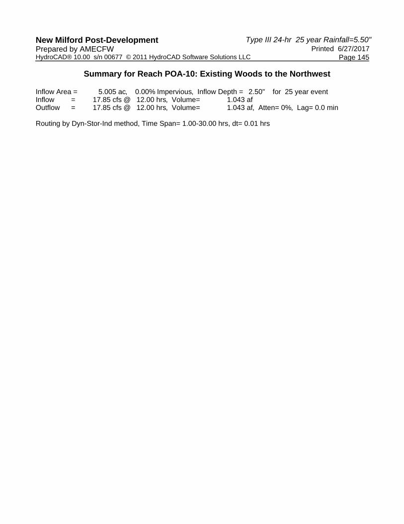
Type III 24-hr 25 year Rainfall=5.50"New Milford Post-Development Printed 6/27/2017Prepared by AMECFW
Page 145HydroCAD® 10.00 s/n 00677 © 2011 HydroCAD Software Solutions LLC
Summary for Reach POA-10: Existing Woods to the Northwest
Inflow Area = 5.005 ac, 0.00% Impervious, Inflow Depth = 2.50" for 25 year eventInflow = 17.85 cfs @ 12.00 hrs, Volume= 1.043 afOutflow = 17.85 cfs @ 12.00 hrs, Volume= 1.043 af, Atten= 0%, Lag= 0.0 min
Routing by Dyn-Stor-Ind method, Time Span= 1.00-30.00 hrs, dt= 0.01 hrs

Type III 24-hr 25 year Rainfall=5.50"New Milford Post-Development Printed 6/27/2017Prepared by AMECFW
Page 146HydroCAD® 10.00 s/n 00677 © 2011 HydroCAD Software Solutions LLC
Summary for Reach POA-2: Existing Woods to the Northwest
Inflow Area = 11.681 ac, 7.53% Impervious, Inflow Depth = 2.87" for 25 year eventInflow = 48.04 cfs @ 12.00 hrs, Volume= 2.793 afOutflow = 48.04 cfs @ 12.00 hrs, Volume= 2.793 af, Atten= 0%, Lag= 0.0 min
Routing by Dyn-Stor-Ind method, Time Span= 1.00-30.00 hrs, dt= 0.01 hrs

Type III 24-hr 25 year Rainfall=5.50"New Milford Post-Development Printed 6/27/2017Prepared by AMECFW
Page 147HydroCAD® 10.00 s/n 00677 © 2011 HydroCAD Software Solutions LLC
Summary for Reach POA-3: Existing Woods to the Northwest
Inflow Area = 6.826 ac, 0.00% Impervious, Inflow Depth = 2.50" for 25 year eventInflow = 24.34 cfs @ 12.00 hrs, Volume= 1.423 afOutflow = 24.34 cfs @ 12.00 hrs, Volume= 1.423 af, Atten= 0%, Lag= 0.0 min
Routing by Dyn-Stor-Ind method, Time Span= 1.00-30.00 hrs, dt= 0.01 hrs

Type III 24-hr 25 year Rainfall=5.50"New Milford Post-Development Printed 6/27/2017Prepared by AMECFW
Page 148HydroCAD® 10.00 s/n 00677 © 2011 HydroCAD Software Solutions LLC
Summary for Reach POA-4: Existing Woods to the Northwest
Inflow Area = 8.208 ac, 0.00% Impervious, Inflow Depth = 2.50" for 25 year eventInflow = 29.27 cfs @ 12.00 hrs, Volume= 1.711 afOutflow = 29.27 cfs @ 12.00 hrs, Volume= 1.711 af, Atten= 0%, Lag= 0.0 min
Routing by Dyn-Stor-Ind method, Time Span= 1.00-30.00 hrs, dt= 0.01 hrs

Type III 24-hr 25 year Rainfall=5.50"New Milford Post-Development Printed 6/27/2017Prepared by AMECFW
Page 149HydroCAD® 10.00 s/n 00677 © 2011 HydroCAD Software Solutions LLC
Summary for Reach POA-5: Existing Woods to the Northwest
Inflow Area = 5.197 ac, 0.00% Impervious, Inflow Depth = 2.50" for 25 year eventInflow = 18.53 cfs @ 12.00 hrs, Volume= 1.083 afOutflow = 18.53 cfs @ 12.00 hrs, Volume= 1.083 af, Atten= 0%, Lag= 0.0 min
Routing by Dyn-Stor-Ind method, Time Span= 1.00-30.00 hrs, dt= 0.01 hrs

Type III 24-hr 25 year Rainfall=5.50"New Milford Post-Development Printed 6/27/2017Prepared by AMECFW
Page 150HydroCAD® 10.00 s/n 00677 © 2011 HydroCAD Software Solutions LLC
Summary for Reach POA-6: Existing Woods to the Northeast
Inflow Area = 6.761 ac, 1.90% Impervious, Inflow Depth = 2.50" for 25 year eventInflow = 24.11 cfs @ 12.00 hrs, Volume= 1.409 afOutflow = 24.11 cfs @ 12.00 hrs, Volume= 1.409 af, Atten= 0%, Lag= 0.0 min
Routing by Dyn-Stor-Ind method, Time Span= 1.00-30.00 hrs, dt= 0.01 hrs

Type III 24-hr 25 year Rainfall=5.50"New Milford Post-Development Printed 6/27/2017Prepared by AMECFW
Page 151HydroCAD® 10.00 s/n 00677 © 2011 HydroCAD Software Solutions LLC
Summary for Reach POA-7: Existing Woods & Candlewood Roadside Swales to the Northwest
Inflow Area = 11.674 ac, 15.15% Impervious, Inflow Depth = 2.78" for 25 year eventInflow = 40.93 cfs @ 12.00 hrs, Volume= 2.700 afOutflow = 40.93 cfs @ 12.00 hrs, Volume= 2.700 af, Atten= 0%, Lag= 0.0 min
Routing by Dyn-Stor-Ind method, Time Span= 1.00-30.00 hrs, dt= 0.01 hrs

Type III 24-hr 25 year Rainfall=5.50"New Milford Post-Development Printed 6/27/2017Prepared by AMECFW
Page 152HydroCAD® 10.00 s/n 00677 © 2011 HydroCAD Software Solutions LLC
Summary for Reach POA-8: Existing Woods to the Northeast
Inflow Area = 13.273 ac, 1.78% Impervious, Inflow Depth = 2.62" for 25 year eventInflow = 49.65 cfs @ 12.00 hrs, Volume= 2.893 afOutflow = 49.65 cfs @ 12.00 hrs, Volume= 2.893 af, Atten= 0%, Lag= 0.0 min
Routing by Dyn-Stor-Ind method, Time Span= 1.00-30.00 hrs, dt= 0.01 hrs

Type III 24-hr 25 year Rainfall=5.50"New Milford Post-Development Printed 6/27/2017Prepared by AMECFW
Page 153HydroCAD® 10.00 s/n 00677 © 2011 HydroCAD Software Solutions LLC
Summary for Reach POA-9: Existing Woods to the Northeast
Inflow Area = 8.951 ac, 2.49% Impervious, Inflow Depth = 2.54" for 25 year eventInflow = 32.51 cfs @ 12.00 hrs, Volume= 1.898 afOutflow = 32.51 cfs @ 12.00 hrs, Volume= 1.898 af, Atten= 0%, Lag= 0.0 min
Routing by Dyn-Stor-Ind method, Time Span= 1.00-30.00 hrs, dt= 0.01 hrs
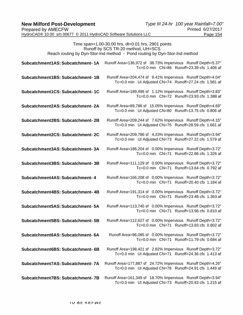
Type III 24-hr 100 year Rainfall=7.00"New Milford Post-Development Printed 6/27/2017Prepared by AMECFW
Page 154HydroCAD® 10.00 s/n 00677 © 2011 HydroCAD Software Solutions LLC
Time span=1.00-30.00 hrs, dt=0.01 hrs, 2901 pointsRunoff by SCS TR-20 method, UH=SCS
Reach routing by Dyn-Stor-Ind method - Pond routing by Dyn-Stor-Ind method
Runoff Area=136,972 sf 38.73% Impervious Runoff Depth=5.37"Subcatchment1AS: Subcatchment- 1A Tc=0.0 min CN=86 Runoff=23.39 cfs 1.406 af
Runoff Area=204,474 sf 9.41% Impervious Runoff Depth=4.04"Subcatchment1BS: Subcatchment- 1B Tc=0.0 min UI Adjusted CN=74 Runoff=27.24 cfs 1.581 af
Runoff Area=189,496 sf 1.12% Impervious Runoff Depth=3.83"Subcatchment1CS: Subcatchment- 1C Tc=0.0 min CN=72 Runoff=23.93 cfs 1.388 af
Runoff Area=89,786 sf 15.05% Impervious Runoff Depth=4.69"Subcatchment2AS: Subcatchment- 2A Tc=0.0 min UI Adjusted CN=80 Runoff=13.75 cfs 0.806 af
Runoff Area=209,244 sf 7.62% Impervious Runoff Depth=4.15"Subcatchment2BS: Subcatchment- 2B Tc=0.0 min UI Adjusted CN=75 Runoff=28.59 cfs 1.661 af
Runoff Area=209,786 sf 4.23% Impervious Runoff Depth=3.94"Subcatchment2CS: Subcatchment- 2C Tc=0.0 min UI Adjusted CN=73 Runoff=27.22 cfs 1.579 af
Runoff Area=186,204 sf 0.00% Impervious Runoff Depth=3.72"Subcatchment3AS: Subcatchment- 3A Tc=0.0 min CN=71 Runoff=22.86 cfs 1.326 af
Runoff Area=111,129 sf 0.00% Impervious Runoff Depth=3.72"Subcatchment3BS: Subcatchment- 3B Tc=0.0 min CN=71 Runoff=13.64 cfs 0.792 af
Runoff Area=166,208 sf 0.00% Impervious Runoff Depth=3.72"Subcatchment4AS: Subcatchment- 4 Tc=0.0 min CN=71 Runoff=20.40 cfs 1.184 af
Runoff Area=191,314 sf 0.00% Impervious Runoff Depth=3.72"Subcatchment4BS: Subcatchment- 4B Tc=0.0 min CN=71 Runoff=23.48 cfs 1.363 af
Runoff Area=113,745 sf 0.00% Impervious Runoff Depth=3.72"Subcatchment5AS: Subcatchment- 5A Tc=0.0 min CN=71 Runoff=13.96 cfs 0.810 af
Runoff Area=112,627 sf 0.00% Impervious Runoff Depth=3.72"Subcatchment5BS: Subcatchment- 5B Tc=0.0 min CN=71 Runoff=13.83 cfs 0.802 af
Runoff Area=96,085 sf 0.00% Impervious Runoff Depth=3.72"Subcatchment6AS: Subcatchment- 6A Tc=0.0 min CN=71 Runoff=11.79 cfs 0.684 af
Runoff Area=198,421 sf 2.82% Impervious Runoff Depth=3.72"Subcatchment6BS: Subcatchment- 6B Tc=0.0 min UI Adjusted CN=71 Runoff=24.36 cfs 1.413 af
Runoff Area=177,887 sf 24.72% Impervious Runoff Depth=4.26"Subcatchment7AS: Subcatchment- 7A Tc=0.0 min UI Adjusted CN=76 Runoff=24.91 cfs 1.449 af
Runoff Area=161,349 sf 18.70% Impervious Runoff Depth=3.94"Subcatchment7BS: Subcatchment- 7B Tc=0.0 min UI Adjusted CN=73 Runoff=20.93 cfs 1.215 af

Type III 24-hr 100 year Rainfall=7.00"New Milford Post-Development Printed 6/27/2017Prepared by AMECFW
Page 155HydroCAD® 10.00 s/n 00677 © 2011 HydroCAD Software Solutions LLC
Runoff Area=102,117 sf 2.83% Impervious Runoff Depth=3.72"Subcatchment7CS: Subcatchment- 7C Tc=0.0 min UI Adjusted CN=71 Runoff=12.54 cfs 0.727 af
Runoff Area=67,146 sf 0.00% Impervious Runoff Depth=4.26"Subcatchment7DS: Subcatchment- 7D Flow Length=950' Tc=25.1 min CN=76 Runoff=4.71 cfs 0.547 af
Runoff Area=216,440 sf 0.00% Impervious Runoff Depth=3.83"Subcatchment8AS: Subcatchment- 8A Tc=0.0 min CN=72 Runoff=27.33 cfs 1.585 af
Runoff Area=192,247 sf 0.16% Impervious Runoff Depth=3.83"Subcatchment8BS: Subcatchment- 8B Tc=0.0 min CN=72 Runoff=24.27 cfs 1.408 af
Runoff Area=169,496 sf 5.88% Impervious Runoff Depth=3.94"Subcatchment8CS: Subcatchment- 8C Tc=0.0 min UI Adjusted CN=73 Runoff=21.99 cfs 1.276 af
Runoff Area=188,366 sf 4.68% Impervious Runoff Depth=3.83"Subcatchment9AS: Subcatchment- 9A Tc=0.0 min UI Adjusted CN=72 Runoff=23.78 cfs 1.380 af
Runoff Area=201,560 sf 0.44% Impervious Runoff Depth=3.72"Subcatchment9BS: Subcatchment- 9B Tc=0.0 min CN=71 Runoff=24.74 cfs 1.436 af
Runoff Area=218,036 sf 0.00% Impervious Runoff Depth=3.72"Subcatchment10S: Subcatchment- 10 Tc=0.0 min CN=71 Runoff=26.76 cfs 1.553 af
Inflow=74.55 cfs 4.375 afReach POA-1:ExistingWoods to the Northeast& Tributaryto Existing Outflow=74.55 cfs 4.375 af
Inflow=26.76 cfs 1.553 afReach POA-10:ExistingWoods to the Northwest Outflow=26.76 cfs 1.553 af
Inflow=69.55 cfs 4.047 afReach POA-2:ExistingWoods to the Northwest Outflow=69.55 cfs 4.047 af
Inflow=36.50 cfs 2.118 afReach POA-3:ExistingWoods to the Northwest Outflow=36.50 cfs 2.118 af
Inflow=43.89 cfs 2.547 afReach POA-4:ExistingWoods to the Northwest Outflow=43.89 cfs 2.547 af
Inflow=27.79 cfs 1.612 afReach POA-5:ExistingWoods to the Northwest Outflow=27.79 cfs 1.612 af
Inflow=36.15 cfs 2.098 afReach POA-6:ExistingWoods to the Northeast Outflow=36.15 cfs 2.098 af
Inflow=59.97 cfs 3.938 afReach POA-7:ExistingWoods & CandlewoodRoadsideSwales to the Outflow=59.97 cfs 3.938 af
Inflow=73.59 cfs 4.270 afReach POA-8:ExistingWoods to the Northeast Outflow=73.59 cfs 4.270 af

Type III 24-hr 100 year Rainfall=7.00"New Milford Post-Development Printed 6/27/2017Prepared by AMECFW
Page 156HydroCAD® 10.00 s/n 00677 © 2011 HydroCAD Software Solutions LLC
Inflow=48.53 cfs 2.816 afReach POA-9:ExistingWoods to the Northeast Outflow=48.53 cfs 2.816 af
Total Runoff Area = 89.764 ac Runoff Volume = 29.373 af Average Runoff Depth = 3.93"94.49% Pervious = 84.821 ac 5.51% Impervious = 4.943 ac

Type III 24-hr 100 year Rainfall=7.00"New Milford Post-Development Printed 6/27/2017Prepared by AMECFW
Page 157HydroCAD® 10.00 s/n 00677 © 2011 HydroCAD Software Solutions LLC
Summary for Subcatchment 1AS: Subcatchment - 1A
Runoff = 23.39 cfs @ 12.00 hrs, Volume= 1.406 af, Depth= 5.37"
Runoff by SCS TR-20 method, UH=SCS, Time Span= 1.00-30.00 hrs, dt= 0.01 hrsType III 24-hr 100 year Rainfall=7.00"
Area (sf) CN Description* 35,114 98 Unconnected Outcrop, HSG D
79,782 78 Meadow, non-grazed, HSG D* 17,933 98 Unconnected Outcrop, HSG D
4,143 71 Meadow, non-grazed, HSG C136,972 86 Weighted Average83,925 61.27% Pervious Area53,047 38.73% Impervious Area53,047 100.00% Unconnected

Type III 24-hr 100 year Rainfall=7.00"New Milford Post-Development Printed 6/27/2017Prepared by AMECFW
Page 158HydroCAD® 10.00 s/n 00677 © 2011 HydroCAD Software Solutions LLC
Summary for Subcatchment 1BS: Subcatchment - 1B
Runoff = 27.24 cfs @ 12.00 hrs, Volume= 1.581 af, Depth= 4.04"
Runoff by SCS TR-20 method, UH=SCS, Time Span= 1.00-30.00 hrs, dt= 0.01 hrsType III 24-hr 100 year Rainfall=7.00"
Area (sf) CN Description* 13,477 98 Unconnected Outcrop, HSG D
42,165 78 Meadow, non-grazed, HSG D47,492 71 Meadow, non-grazed, HSG C95,573 71 Meadow, non-grazed, HSG C
* 5,767 98 Unconnected Outcrop, HSG D204,474 75 Weighted Average, UI Adjusted CN = 74185,230 90.59% Pervious Area19,244 9.41% Impervious Area19,244 100.00% Unconnected
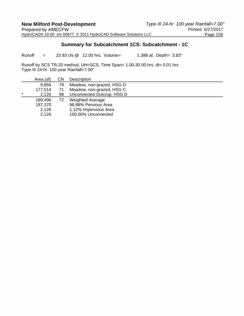
Type III 24-hr 100 year Rainfall=7.00"New Milford Post-Development Printed 6/27/2017Prepared by AMECFW
Page 159HydroCAD® 10.00 s/n 00677 © 2011 HydroCAD Software Solutions LLC
Summary for Subcatchment 1CS: Subcatchment - 1C
Runoff = 23.93 cfs @ 12.00 hrs, Volume= 1.388 af, Depth= 3.83"
Runoff by SCS TR-20 method, UH=SCS, Time Span= 1.00-30.00 hrs, dt= 0.01 hrsType III 24-hr 100 year Rainfall=7.00"
Area (sf) CN Description9,856 78 Meadow, non-grazed, HSG D
177,514 71 Meadow, non-grazed, HSG C* 2,126 98 Unconnected Outcrop, HSG D
189,496 72 Weighted Average187,370 98.88% Pervious Area
2,126 1.12% Impervious Area2,126 100.00% Unconnected

Type III 24-hr 100 year Rainfall=7.00"New Milford Post-Development Printed 6/27/2017Prepared by AMECFW
Page 160HydroCAD® 10.00 s/n 00677 © 2011 HydroCAD Software Solutions LLC
Summary for Subcatchment 2AS: Subcatchment - 2A
Runoff = 13.75 cfs @ 12.00 hrs, Volume= 0.806 af, Depth= 4.69"
Runoff by SCS TR-20 method, UH=SCS, Time Span= 1.00-30.00 hrs, dt= 0.01 hrsType III 24-hr 100 year Rainfall=7.00"
Area (sf) CN Description* 13,513 98 Unconnected Outcrop, HSG D
76,273 78 Meadow, non-grazed, HSG D89,786 81 Weighted Average, UI Adjusted CN = 8076,273 84.95% Pervious Area13,513 15.05% Impervious Area13,513 100.00% Unconnected

Type III 24-hr 100 year Rainfall=7.00"New Milford Post-Development Printed 6/27/2017Prepared by AMECFW
Page 161HydroCAD® 10.00 s/n 00677 © 2011 HydroCAD Software Solutions LLC
Summary for Subcatchment 2BS: Subcatchment - 2B
Runoff = 28.59 cfs @ 12.00 hrs, Volume= 1.661 af, Depth= 4.15"
Runoff by SCS TR-20 method, UH=SCS, Time Span= 1.00-30.00 hrs, dt= 0.01 hrsType III 24-hr 100 year Rainfall=7.00"
Area (sf) CN Description* 15,936 98 Unconnected Outcrop, HSG D
80,385 78 Meadow, non-grazed, HSG D112,923 71 Meadow, non-grazed, HSG C209,244 76 Weighted Average, UI Adjusted CN = 75193,308 92.38% Pervious Area15,936 7.62% Impervious Area15,936 100.00% Unconnected

Type III 24-hr 100 year Rainfall=7.00"New Milford Post-Development Printed 6/27/2017Prepared by AMECFW
Page 162HydroCAD® 10.00 s/n 00677 © 2011 HydroCAD Software Solutions LLC
Summary for Subcatchment 2CS: Subcatchment - 2C
Runoff = 27.22 cfs @ 12.00 hrs, Volume= 1.579 af, Depth= 3.94"
Runoff by SCS TR-20 method, UH=SCS, Time Span= 1.00-30.00 hrs, dt= 0.01 hrsType III 24-hr 100 year Rainfall=7.00"
Area (sf) CN Description* 8,868 98 Unconnected Outcrop, HSG D
50,494 78 Meadow, non-grazed, HSG D150,424 71 Meadow, non-grazed, HSG C209,786 74 Weighted Average, UI Adjusted CN = 73200,918 95.77% Pervious Area
8,868 4.23% Impervious Area8,868 100.00% Unconnected

Type III 24-hr 100 year Rainfall=7.00"New Milford Post-Development Printed 6/27/2017Prepared by AMECFW
Page 163HydroCAD® 10.00 s/n 00677 © 2011 HydroCAD Software Solutions LLC
Summary for Subcatchment 3AS: Subcatchment - 3A
Runoff = 22.86 cfs @ 12.00 hrs, Volume= 1.326 af, Depth= 3.72"
Runoff by SCS TR-20 method, UH=SCS, Time Span= 1.00-30.00 hrs, dt= 0.01 hrsType III 24-hr 100 year Rainfall=7.00"
Area (sf) CN Description186,204 71 Meadow, non-grazed, HSG C186,204 100.00% Pervious Area

Type III 24-hr 100 year Rainfall=7.00"New Milford Post-Development Printed 6/27/2017Prepared by AMECFW
Page 164HydroCAD® 10.00 s/n 00677 © 2011 HydroCAD Software Solutions LLC
Summary for Subcatchment 3BS: Subcatchment - 3B
Runoff = 13.64 cfs @ 12.00 hrs, Volume= 0.792 af, Depth= 3.72"
Runoff by SCS TR-20 method, UH=SCS, Time Span= 1.00-30.00 hrs, dt= 0.01 hrsType III 24-hr 100 year Rainfall=7.00"
Area (sf) CN Description111,129 71 Meadow, non-grazed, HSG C111,129 100.00% Pervious Area

Type III 24-hr 100 year Rainfall=7.00"New Milford Post-Development Printed 6/27/2017Prepared by AMECFW
Page 165HydroCAD® 10.00 s/n 00677 © 2011 HydroCAD Software Solutions LLC
Summary for Subcatchment 4AS: Subcatchment - 4
Runoff = 20.40 cfs @ 12.00 hrs, Volume= 1.184 af, Depth= 3.72"
Runoff by SCS TR-20 method, UH=SCS, Time Span= 1.00-30.00 hrs, dt= 0.01 hrsType III 24-hr 100 year Rainfall=7.00"
Area (sf) CN Description166,208 71 Meadow, non-grazed, HSG C166,208 100.00% Pervious Area

Type III 24-hr 100 year Rainfall=7.00"New Milford Post-Development Printed 6/27/2017Prepared by AMECFW
Page 166HydroCAD® 10.00 s/n 00677 © 2011 HydroCAD Software Solutions LLC
Summary for Subcatchment 4BS: Subcatchment - 4B
Runoff = 23.48 cfs @ 12.00 hrs, Volume= 1.363 af, Depth= 3.72"
Runoff by SCS TR-20 method, UH=SCS, Time Span= 1.00-30.00 hrs, dt= 0.01 hrsType III 24-hr 100 year Rainfall=7.00"
Area (sf) CN Description191,314 71 Meadow, non-grazed, HSG C191,314 100.00% Pervious Area

Type III 24-hr 100 year Rainfall=7.00"New Milford Post-Development Printed 6/27/2017Prepared by AMECFW
Page 167HydroCAD® 10.00 s/n 00677 © 2011 HydroCAD Software Solutions LLC
Summary for Subcatchment 5AS: Subcatchment - 5A
Runoff = 13.96 cfs @ 12.00 hrs, Volume= 0.810 af, Depth= 3.72"
Runoff by SCS TR-20 method, UH=SCS, Time Span= 1.00-30.00 hrs, dt= 0.01 hrsType III 24-hr 100 year Rainfall=7.00"
Area (sf) CN Description113,745 71 Meadow, non-grazed, HSG C113,745 100.00% Pervious Area

Type III 24-hr 100 year Rainfall=7.00"New Milford Post-Development Printed 6/27/2017Prepared by AMECFW
Page 168HydroCAD® 10.00 s/n 00677 © 2011 HydroCAD Software Solutions LLC
Summary for Subcatchment 5BS: Subcatchment - 5B
Runoff = 13.83 cfs @ 12.00 hrs, Volume= 0.802 af, Depth= 3.72"
Runoff by SCS TR-20 method, UH=SCS, Time Span= 1.00-30.00 hrs, dt= 0.01 hrsType III 24-hr 100 year Rainfall=7.00"
Area (sf) CN Description112,627 71 Meadow, non-grazed, HSG C112,627 100.00% Pervious Area

Type III 24-hr 100 year Rainfall=7.00"New Milford Post-Development Printed 6/27/2017Prepared by AMECFW
Page 169HydroCAD® 10.00 s/n 00677 © 2011 HydroCAD Software Solutions LLC
Summary for Subcatchment 6AS: Subcatchment - 6A
Runoff = 11.79 cfs @ 12.00 hrs, Volume= 0.684 af, Depth= 3.72"
Runoff by SCS TR-20 method, UH=SCS, Time Span= 1.00-30.00 hrs, dt= 0.01 hrsType III 24-hr 100 year Rainfall=7.00"
Area (sf) CN Description3,203 78 Meadow, non-grazed, HSG D
92,882 71 Meadow, non-grazed, HSG C96,085 71 Weighted Average96,085 100.00% Pervious Area

Type III 24-hr 100 year Rainfall=7.00"New Milford Post-Development Printed 6/27/2017Prepared by AMECFW
Page 170HydroCAD® 10.00 s/n 00677 © 2011 HydroCAD Software Solutions LLC
Summary for Subcatchment 6BS: Subcatchment - 6B
Runoff = 24.36 cfs @ 12.00 hrs, Volume= 1.413 af, Depth= 3.72"
Runoff by SCS TR-20 method, UH=SCS, Time Span= 1.00-30.00 hrs, dt= 0.01 hrsType III 24-hr 100 year Rainfall=7.00"
Area (sf) CN Description3,153 78 Meadow, non-grazed, HSG D
189,665 71 Meadow, non-grazed, HSG C* 5,603 98 Unconnected Outcrop, HSG D
198,421 72 Weighted Average, UI Adjusted CN = 71192,818 97.18% Pervious Area
5,603 2.82% Impervious Area5,603 100.00% Unconnected

Type III 24-hr 100 year Rainfall=7.00"New Milford Post-Development Printed 6/27/2017Prepared by AMECFW
Page 171HydroCAD® 10.00 s/n 00677 © 2011 HydroCAD Software Solutions LLC
Summary for Subcatchment 7AS: Subcatchment - 7A
Runoff = 24.91 cfs @ 12.00 hrs, Volume= 1.449 af, Depth= 4.26"
Runoff by SCS TR-20 method, UH=SCS, Time Span= 1.00-30.00 hrs, dt= 0.01 hrsType III 24-hr 100 year Rainfall=7.00"
Area (sf) CN Description59,019 71 Meadow, non-grazed, HSG C37,330 70 Woods, Good, HSG C37,558 80 Pasture/grassland/range, Good, HSG D
* 43,980 98 Unconnected Outcrop, HSG D177,887 79 Weighted Average, UI Adjusted CN = 76133,907 75.28% Pervious Area43,980 24.72% Impervious Area43,980 100.00% Unconnected

Type III 24-hr 100 year Rainfall=7.00"New Milford Post-Development Printed 6/27/2017Prepared by AMECFW
Page 172HydroCAD® 10.00 s/n 00677 © 2011 HydroCAD Software Solutions LLC
Summary for Subcatchment 7BS: Subcatchment - 7B
Runoff = 20.93 cfs @ 12.00 hrs, Volume= 1.215 af, Depth= 3.94"
Runoff by SCS TR-20 method, UH=SCS, Time Span= 1.00-30.00 hrs, dt= 0.01 hrsType III 24-hr 100 year Rainfall=7.00"
Area (sf) CN Description104,556 71 Meadow, non-grazed, HSG C26,624 70 Woods, Good, HSG C
* 30,169 98 Unconnected Outcrop, HSG D161,349 76 Weighted Average, UI Adjusted CN = 73131,180 81.30% Pervious Area30,169 18.70% Impervious Area30,169 100.00% Unconnected

Type III 24-hr 100 year Rainfall=7.00"New Milford Post-Development Printed 6/27/2017Prepared by AMECFW
Page 173HydroCAD® 10.00 s/n 00677 © 2011 HydroCAD Software Solutions LLC
Summary for Subcatchment 7CS: Subcatchment - 7C
Runoff = 12.54 cfs @ 12.00 hrs, Volume= 0.727 af, Depth= 3.72"
Runoff by SCS TR-20 method, UH=SCS, Time Span= 1.00-30.00 hrs, dt= 0.01 hrsType III 24-hr 100 year Rainfall=7.00"
Area (sf) CN Description89,143 71 Meadow, non-grazed, HSG C10,084 70 Woods, Good, HSG C
* 2,890 98 Unconnected Outcrop, HSG D102,117 72 Weighted Average, UI Adjusted CN = 7199,227 97.17% Pervious Area2,890 2.83% Impervious Area2,890 100.00% Unconnected
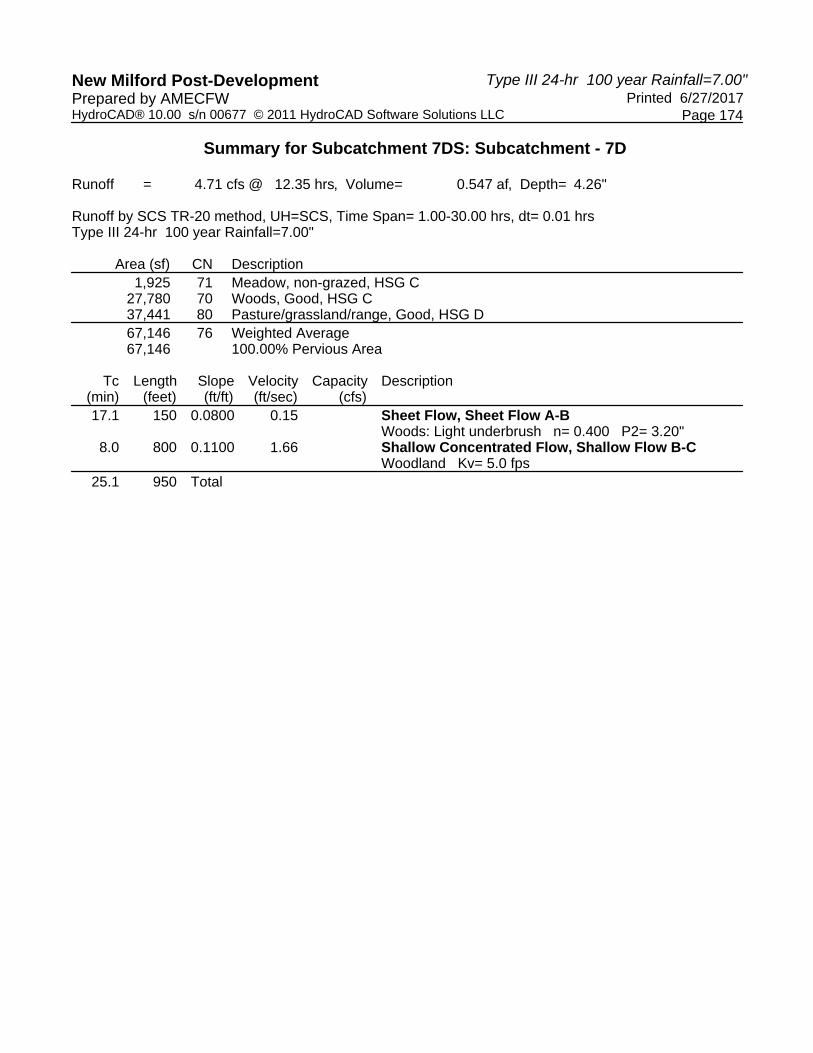
Type III 24-hr 100 year Rainfall=7.00"New Milford Post-Development Printed 6/27/2017Prepared by AMECFW
Page 174HydroCAD® 10.00 s/n 00677 © 2011 HydroCAD Software Solutions LLC
Summary for Subcatchment 7DS: Subcatchment - 7D
Runoff = 4.71 cfs @ 12.35 hrs, Volume= 0.547 af, Depth= 4.26"
Runoff by SCS TR-20 method, UH=SCS, Time Span= 1.00-30.00 hrs, dt= 0.01 hrsType III 24-hr 100 year Rainfall=7.00"
Area (sf) CN Description1,925 71 Meadow, non-grazed, HSG C
27,780 70 Woods, Good, HSG C37,441 80 Pasture/grassland/range, Good, HSG D67,146 76 Weighted Average67,146 100.00% Pervious Area
Tc Length Slope Velocity Capacity Description(min) (feet) (ft/ft) (ft/sec) (cfs)17.1 150 0.0800 0.15 Sheet Flow, Sheet Flow A-B
Woods: Light underbrush n= 0.400 P2= 3.20"8.0 800 0.1100 1.66 Shallow Concentrated Flow, Shallow Flow B-C
Woodland Kv= 5.0 fps25.1 950 Total

Type III 24-hr 100 year Rainfall=7.00"New Milford Post-Development Printed 6/27/2017Prepared by AMECFW
Page 175HydroCAD® 10.00 s/n 00677 © 2011 HydroCAD Software Solutions LLC
Summary for Subcatchment 8AS: Subcatchment - 8A
Runoff = 27.33 cfs @ 12.00 hrs, Volume= 1.585 af, Depth= 3.83"
Runoff by SCS TR-20 method, UH=SCS, Time Span= 1.00-30.00 hrs, dt= 0.01 hrsType III 24-hr 100 year Rainfall=7.00"
Area (sf) CN Description192,315 71 Meadow, non-grazed, HSG C24,125 78 Meadow, non-grazed, HSG D
216,440 72 Weighted Average216,440 100.00% Pervious Area

Type III 24-hr 100 year Rainfall=7.00"New Milford Post-Development Printed 6/27/2017Prepared by AMECFW
Page 176HydroCAD® 10.00 s/n 00677 © 2011 HydroCAD Software Solutions LLC
Summary for Subcatchment 8BS: Subcatchment - 8B
Runoff = 24.27 cfs @ 12.00 hrs, Volume= 1.408 af, Depth= 3.83"
Runoff by SCS TR-20 method, UH=SCS, Time Span= 1.00-30.00 hrs, dt= 0.01 hrsType III 24-hr 100 year Rainfall=7.00"
Area (sf) CN Description* 299 98 Unconnected Outcrop, HSG D
163,252 71 Meadow, non-grazed, HSG C28,696 78 Meadow, non-grazed, HSG D
192,247 72 Weighted Average191,948 99.84% Pervious Area
299 0.16% Impervious Area299 100.00% Unconnected
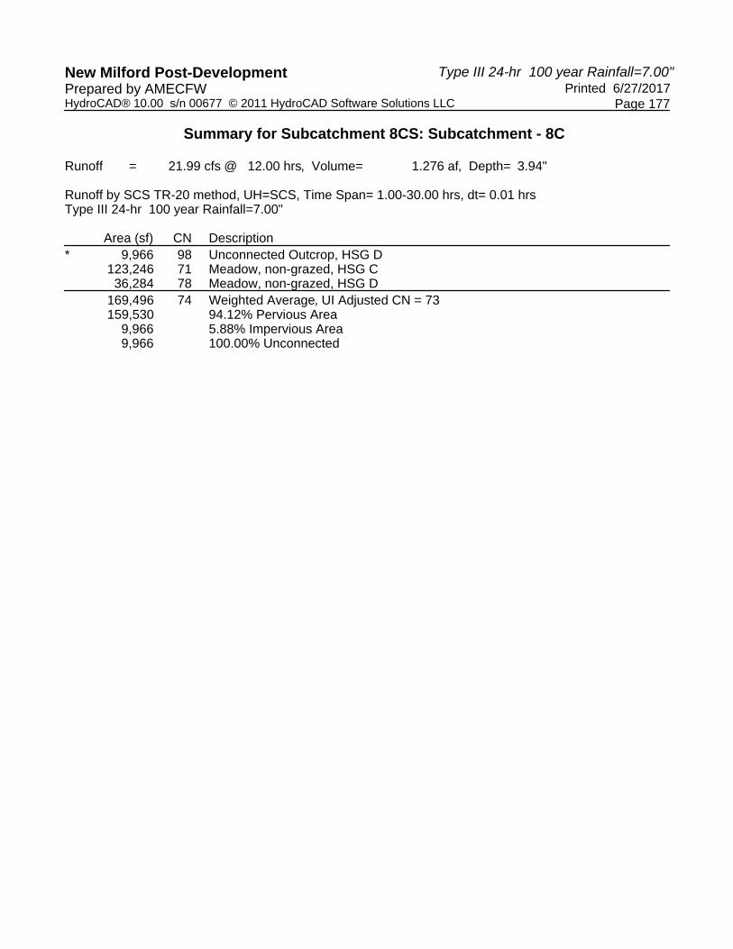
Type III 24-hr 100 year Rainfall=7.00"New Milford Post-Development Printed 6/27/2017Prepared by AMECFW
Page 177HydroCAD® 10.00 s/n 00677 © 2011 HydroCAD Software Solutions LLC
Summary for Subcatchment 8CS: Subcatchment - 8C
Runoff = 21.99 cfs @ 12.00 hrs, Volume= 1.276 af, Depth= 3.94"
Runoff by SCS TR-20 method, UH=SCS, Time Span= 1.00-30.00 hrs, dt= 0.01 hrsType III 24-hr 100 year Rainfall=7.00"
Area (sf) CN Description* 9,966 98 Unconnected Outcrop, HSG D
123,246 71 Meadow, non-grazed, HSG C36,284 78 Meadow, non-grazed, HSG D
169,496 74 Weighted Average, UI Adjusted CN = 73159,530 94.12% Pervious Area
9,966 5.88% Impervious Area9,966 100.00% Unconnected

Type III 24-hr 100 year Rainfall=7.00"New Milford Post-Development Printed 6/27/2017Prepared by AMECFW
Page 178HydroCAD® 10.00 s/n 00677 © 2011 HydroCAD Software Solutions LLC
Summary for Subcatchment 9AS: Subcatchment - 9A
Runoff = 23.78 cfs @ 12.00 hrs, Volume= 1.380 af, Depth= 3.83"
Runoff by SCS TR-20 method, UH=SCS, Time Span= 1.00-30.00 hrs, dt= 0.01 hrsType III 24-hr 100 year Rainfall=7.00"
Area (sf) CN Description* 8,808 98 Unconnected Outcrop, HSG D
158,319 71 Meadow, non-grazed, HSG C21,239 78 Meadow, non-grazed, HSG D
188,366 73 Weighted Average, UI Adjusted CN = 72179,558 95.32% Pervious Area
8,808 4.68% Impervious Area8,808 100.00% Unconnected

Type III 24-hr 100 year Rainfall=7.00"New Milford Post-Development Printed 6/27/2017Prepared by AMECFW
Page 179HydroCAD® 10.00 s/n 00677 © 2011 HydroCAD Software Solutions LLC
Summary for Subcatchment 9BS: Subcatchment - 9B
Runoff = 24.74 cfs @ 12.00 hrs, Volume= 1.436 af, Depth= 3.72"
Runoff by SCS TR-20 method, UH=SCS, Time Span= 1.00-30.00 hrs, dt= 0.01 hrsType III 24-hr 100 year Rainfall=7.00"
Area (sf) CN Description* 889 98 Unconnected Outcrop, HSG D
196,532 71 Meadow, non-grazed, HSG C4,139 78 Meadow, non-grazed, HSG D
201,560 71 Weighted Average200,671 99.56% Pervious Area
889 0.44% Impervious Area889 100.00% Unconnected

Type III 24-hr 100 year Rainfall=7.00"New Milford Post-Development Printed 6/27/2017Prepared by AMECFW
Page 180HydroCAD® 10.00 s/n 00677 © 2011 HydroCAD Software Solutions LLC
Summary for Subcatchment 10S: Subcatchment - 10
Runoff = 26.76 cfs @ 12.00 hrs, Volume= 1.553 af, Depth= 3.72"
Runoff by SCS TR-20 method, UH=SCS, Time Span= 1.00-30.00 hrs, dt= 0.01 hrsType III 24-hr 100 year Rainfall=7.00"
Area (sf) CN Description218,036 71 Meadow, non-grazed, HSG C218,036 100.00% Pervious Area

Type III 24-hr 100 year Rainfall=7.00"New Milford Post-Development Printed 6/27/2017Prepared by AMECFW
Page 181HydroCAD® 10.00 s/n 00677 © 2011 HydroCAD Software Solutions LLC
Summary for Reach POA-1: Existing Woods to the Northeast & Tributary to Existing Wetlands Area
Inflow Area = 12.189 ac, 14.02% Impervious, Inflow Depth = 4.31" for 100 year eventInflow = 74.55 cfs @ 12.00 hrs, Volume= 4.375 afOutflow = 74.55 cfs @ 12.00 hrs, Volume= 4.375 af, Atten= 0%, Lag= 0.0 min
Routing by Dyn-Stor-Ind method, Time Span= 1.00-30.00 hrs, dt= 0.01 hrs

Type III 24-hr 100 year Rainfall=7.00"New Milford Post-Development Printed 6/27/2017Prepared by AMECFW
Page 182HydroCAD® 10.00 s/n 00677 © 2011 HydroCAD Software Solutions LLC
Summary for Reach POA-10: Existing Woods to the Northwest
Inflow Area = 5.005 ac, 0.00% Impervious, Inflow Depth = 3.72" for 100 year eventInflow = 26.76 cfs @ 12.00 hrs, Volume= 1.553 afOutflow = 26.76 cfs @ 12.00 hrs, Volume= 1.553 af, Atten= 0%, Lag= 0.0 min
Routing by Dyn-Stor-Ind method, Time Span= 1.00-30.00 hrs, dt= 0.01 hrs

Type III 24-hr 100 year Rainfall=7.00"New Milford Post-Development Printed 6/27/2017Prepared by AMECFW
Page 183HydroCAD® 10.00 s/n 00677 © 2011 HydroCAD Software Solutions LLC
Summary for Reach POA-2: Existing Woods to the Northwest
Inflow Area = 11.681 ac, 7.53% Impervious, Inflow Depth = 4.16" for 100 year eventInflow = 69.55 cfs @ 12.00 hrs, Volume= 4.047 afOutflow = 69.55 cfs @ 12.00 hrs, Volume= 4.047 af, Atten= 0%, Lag= 0.0 min
Routing by Dyn-Stor-Ind method, Time Span= 1.00-30.00 hrs, dt= 0.01 hrs

Type III 24-hr 100 year Rainfall=7.00"New Milford Post-Development Printed 6/27/2017Prepared by AMECFW
Page 184HydroCAD® 10.00 s/n 00677 © 2011 HydroCAD Software Solutions LLC
Summary for Reach POA-3: Existing Woods to the Northwest
Inflow Area = 6.826 ac, 0.00% Impervious, Inflow Depth = 3.72" for 100 year eventInflow = 36.50 cfs @ 12.00 hrs, Volume= 2.118 afOutflow = 36.50 cfs @ 12.00 hrs, Volume= 2.118 af, Atten= 0%, Lag= 0.0 min
Routing by Dyn-Stor-Ind method, Time Span= 1.00-30.00 hrs, dt= 0.01 hrs

Type III 24-hr 100 year Rainfall=7.00"New Milford Post-Development Printed 6/27/2017Prepared by AMECFW
Page 185HydroCAD® 10.00 s/n 00677 © 2011 HydroCAD Software Solutions LLC
Summary for Reach POA-4: Existing Woods to the Northwest
Inflow Area = 8.208 ac, 0.00% Impervious, Inflow Depth = 3.72" for 100 year eventInflow = 43.89 cfs @ 12.00 hrs, Volume= 2.547 afOutflow = 43.89 cfs @ 12.00 hrs, Volume= 2.547 af, Atten= 0%, Lag= 0.0 min
Routing by Dyn-Stor-Ind method, Time Span= 1.00-30.00 hrs, dt= 0.01 hrs

Type III 24-hr 100 year Rainfall=7.00"New Milford Post-Development Printed 6/27/2017Prepared by AMECFW
Page 186HydroCAD® 10.00 s/n 00677 © 2011 HydroCAD Software Solutions LLC
Summary for Reach POA-5: Existing Woods to the Northwest
Inflow Area = 5.197 ac, 0.00% Impervious, Inflow Depth = 3.72" for 100 year eventInflow = 27.79 cfs @ 12.00 hrs, Volume= 1.612 afOutflow = 27.79 cfs @ 12.00 hrs, Volume= 1.612 af, Atten= 0%, Lag= 0.0 min
Routing by Dyn-Stor-Ind method, Time Span= 1.00-30.00 hrs, dt= 0.01 hrs

Type III 24-hr 100 year Rainfall=7.00"New Milford Post-Development Printed 6/27/2017Prepared by AMECFW
Page 187HydroCAD® 10.00 s/n 00677 © 2011 HydroCAD Software Solutions LLC
Summary for Reach POA-6: Existing Woods to the Northeast
Inflow Area = 6.761 ac, 1.90% Impervious, Inflow Depth = 3.72" for 100 year eventInflow = 36.15 cfs @ 12.00 hrs, Volume= 2.098 afOutflow = 36.15 cfs @ 12.00 hrs, Volume= 2.098 af, Atten= 0%, Lag= 0.0 min
Routing by Dyn-Stor-Ind method, Time Span= 1.00-30.00 hrs, dt= 0.01 hrs

Type III 24-hr 100 year Rainfall=7.00"New Milford Post-Development Printed 6/27/2017Prepared by AMECFW
Page 188HydroCAD® 10.00 s/n 00677 © 2011 HydroCAD Software Solutions LLC
Summary for Reach POA-7: Existing Woods & Candlewood Roadside Swales to the Northwest
Inflow Area = 11.674 ac, 15.15% Impervious, Inflow Depth = 4.05" for 100 year eventInflow = 59.97 cfs @ 12.00 hrs, Volume= 3.938 afOutflow = 59.97 cfs @ 12.00 hrs, Volume= 3.938 af, Atten= 0%, Lag= 0.0 min
Routing by Dyn-Stor-Ind method, Time Span= 1.00-30.00 hrs, dt= 0.01 hrs

Type III 24-hr 100 year Rainfall=7.00"New Milford Post-Development Printed 6/27/2017Prepared by AMECFW
Page 189HydroCAD® 10.00 s/n 00677 © 2011 HydroCAD Software Solutions LLC
Summary for Reach POA-8: Existing Woods to the Northeast
Inflow Area = 13.273 ac, 1.78% Impervious, Inflow Depth = 3.86" for 100 year eventInflow = 73.59 cfs @ 12.00 hrs, Volume= 4.270 afOutflow = 73.59 cfs @ 12.00 hrs, Volume= 4.270 af, Atten= 0%, Lag= 0.0 min
Routing by Dyn-Stor-Ind method, Time Span= 1.00-30.00 hrs, dt= 0.01 hrs

Type III 24-hr 100 year Rainfall=7.00"New Milford Post-Development Printed 6/27/2017Prepared by AMECFW
Page 190HydroCAD® 10.00 s/n 00677 © 2011 HydroCAD Software Solutions LLC
Summary for Reach POA-9: Existing Woods to the Northeast
Inflow Area = 8.951 ac, 2.49% Impervious, Inflow Depth = 3.77" for 100 year eventInflow = 48.53 cfs @ 12.00 hrs, Volume= 2.816 afOutflow = 48.53 cfs @ 12.00 hrs, Volume= 2.816 af, Atten= 0%, Lag= 0.0 min
Routing by Dyn-Stor-Ind method, Time Span= 1.00-30.00 hrs, dt= 0.01 hrs


