
Gre
enw
ay R
d
Rou
te 1
30
Wood Rd
Bar
low
Rd
Jefferson Rd
Tank Alley
Wheelock Rd
Gibbs Rd
Cha
dwic
k R
d
Pocasset Sandwich Rd
Arnold Rd
Snake Pond Rd
Green
way
Rd
By Pas
s
Snake Pond Rd
BA-5
C-16
BA-6
Kd Range
J-1 RANGE
K Range 1941
J-3 Rng(now) H Rng (30-50
K Range 1960
L Range
SE and SW Ranges (currentN Range (67-79)
M Rng (60s)M-2 Rng(40-50
M-3 Range (40-50s)
M Rng (70-80)M-1Rng(40-50
MUSKETRY RANGE 1
Mock Village
500 Yard Rifle Range
CURRENT O (SECOND G)
M-4 Range (40-50s)
Peters Pond
Snake Pond
J3 Wetland
Ox Pond
J1 J2
J3
FS-12( EDB)
CS-10( TCE)
0 2,000 4,0001,000
Feet
O
US Army CorpsUS Army Corpsof Engineersof EngineersPhiladelphia DistrictPhiladelphia District
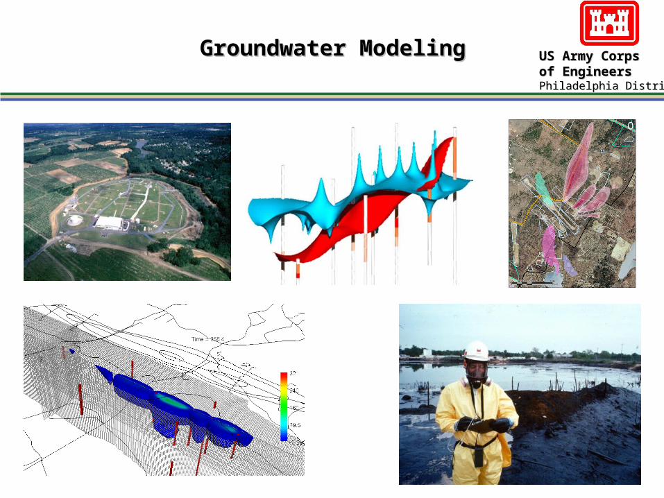
Groundwater ModelingGroundwater Modeling

Problem IdentificationProblem Identification US Army CorpsUS Army Corpsof Engineersof EngineersPhiladelphia DistrictPhiladelphia District
AOC with Water WellsAOC with Water WellsFt Dix Groundwater StudyFt Dix Groundwater Study
Lang SuperfundSite
Lakehurst NAES
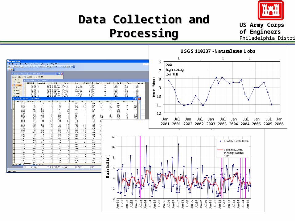
Data Collection and Data Collection and ProcessingProcessing
Millville Airport Rain Gage
0
2
4
6
8
10
12
Jan
-91
Jul-
91
Jan
-92
Jul-
92
Jan
-93
Jul-
93
Jan
-94
Jul-
94
Jan
-95
Jul-
95
Jan
-96
Jul-
96
Jan
-97
Jul-
97
Jan
-98
Jul-
98
Jan
-99
Jul-
99
Jan
-00
Jul-
00
Jan
-01
Jul-
01
Jan
-02
Jul-
02
Jan
-03
Jul-
03
Jan
-04
Jul-
04
Jan
-05
Ra
infa
ll (
in)
Monthly Rainfall Data
6 per. Mov. Avg.(Monthly RainfallData)
USGS 110237 - Natural area 1 obs
6
7
8
9
10
11
12
Jan2001
Jul2001
Jan2002
Jul2002
Jan2003
Jul2003
Jan2004
Jul2004
Jan2005
Jul2005
Jan2006
De
pth
(ft
bg
s)
2001high springlow fall
2002"high"springlow fall
2003high spring"low" fall
2004high springlow fall
normal dry wet normal
US Army CorpsUS Army Corpsof Engineersof EngineersPhiladelphia DistrictPhiladelphia District
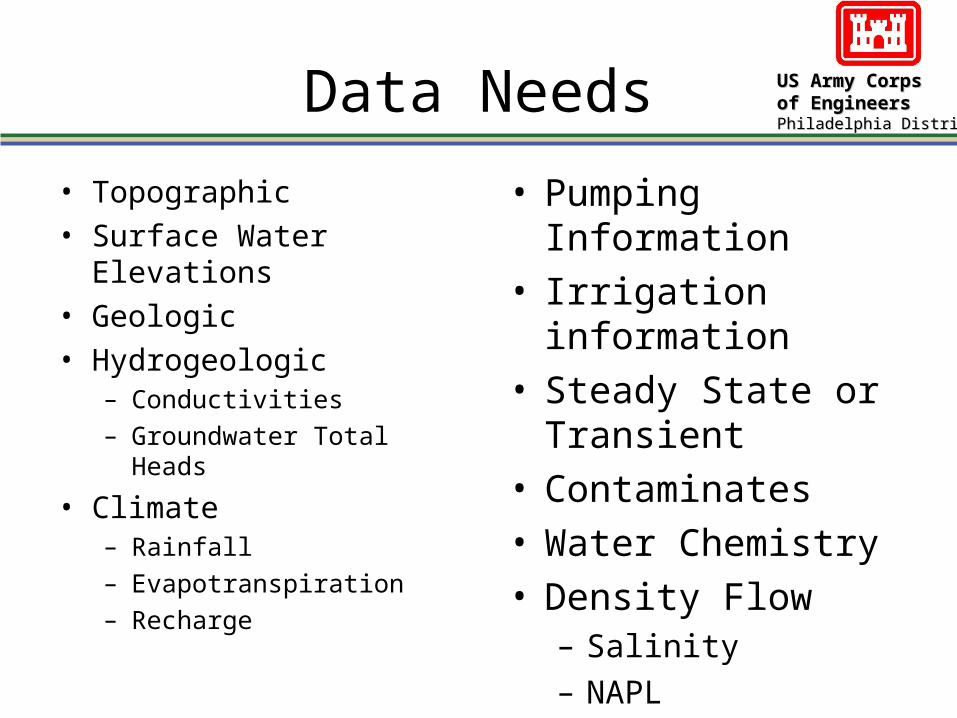
Data Needs
• Topographic• Surface Water Elevations• Geologic• Hydrogeologic
– Conductivities– Groundwater Total Heads
• Climate– Rainfall– Evapotranspiration– Recharge
US Army CorpsUS Army Corpsof Engineersof EngineersPhiladelphia DistrictPhiladelphia District
• Pumping Information• Irrigation information• Steady State or
Transient • Contaminates• Water Chemistry• Density Flow
– Salinity – NAPL
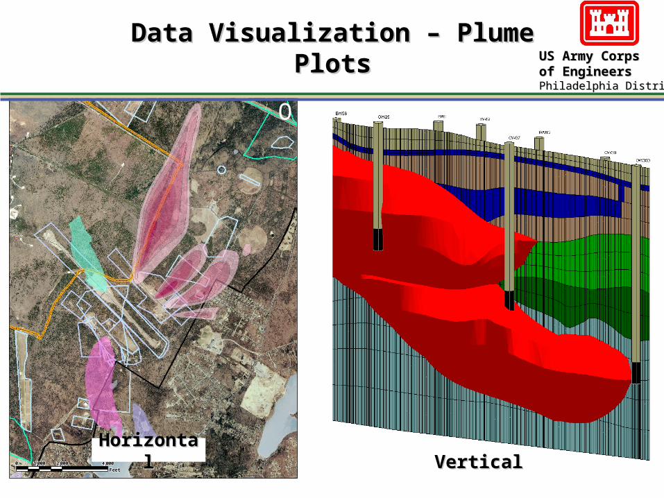
Data Visualization – Plume Data Visualization – Plume PlotsPlots
Gre
enw
ay R
d
Rou
te 1
30
Wood Rd
Bar
low
Rd
Jefferson Rd
Tank Alley
Wheelock Rd
Gibbs Rd
Cha
dwic
k R
d
Pocasset Sandwich Rd
Arnold Rd
Snake Pond Rd
Green
way
Rd B
y Pas
s
Snake Pond Rd
BA-5
C-16
BA-6
Kd Range
J-1 RANGE
K Range 1941
J-3 Rng(now) H Rng (30-50
K Range 1960
L Range
SE and SW Ranges (currentN Range (67-79)
M Rng (60s)M-2 Rng(40-50
M-3 Range (40-50s)
M Rng (70-80)M-1Rng(40-50
MUSKETRY RANGE 1
Mock Village
500 Yard Rifle Range
CURRENT O (SECOND G)
M-4 Range (40-50s)
Peters Pond
Snake Pond
J3 Wetland
Ox Pond
J1 J2
J3
FS-12( EDB)
CS-10( TCE)
0 2,000 4,0001,000
Feet
O
HorizontHorizontalal VerticalVertical
US Army CorpsUS Army Corpsof Engineersof EngineersPhiladelphia DistrictPhiladelphia District
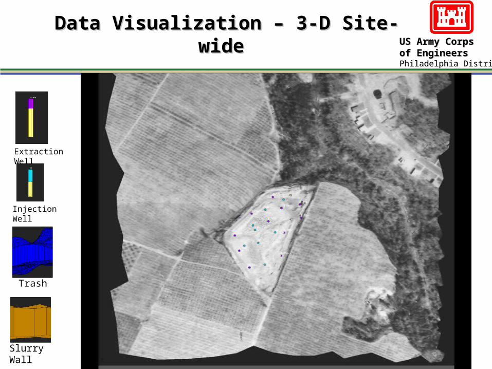
Trash
Slurry Wall
Injection Well
Extraction Well
Data Visualization – 3-D Site-Data Visualization – 3-D Site-wide wide US Army CorpsUS Army Corps
of Engineersof EngineersPhiladelphia DistrictPhiladelphia District
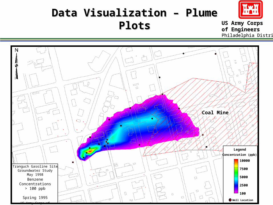
Data Visualization – Plume Data Visualization – Plume PlotsPlots US Army CorpsUS Army Corps
of Engineersof EngineersPhiladelphia DistrictPhiladelphia District
Tranguch Gasoline SiteGroundwater Study
May 1998
Benzene Concentrations> 100 ppb
Spring 1995US Army Corps of Engineers,
Philadelphia District
Legend
Concentration (ppb)
10000
7500
5000
2500
100
Coal Mine
Well Location

GMS BoreholesBorehole Materials
Layer 1 - undifferentiated
Layer 2 - peat, clay, silt
Layer 3A - limestone
3-D Geologic 3-D Geologic ConceptualizationConceptualization US Army CorpsUS Army Corps
of Engineersof EngineersPhiladelphia DistrictPhiladelphia District
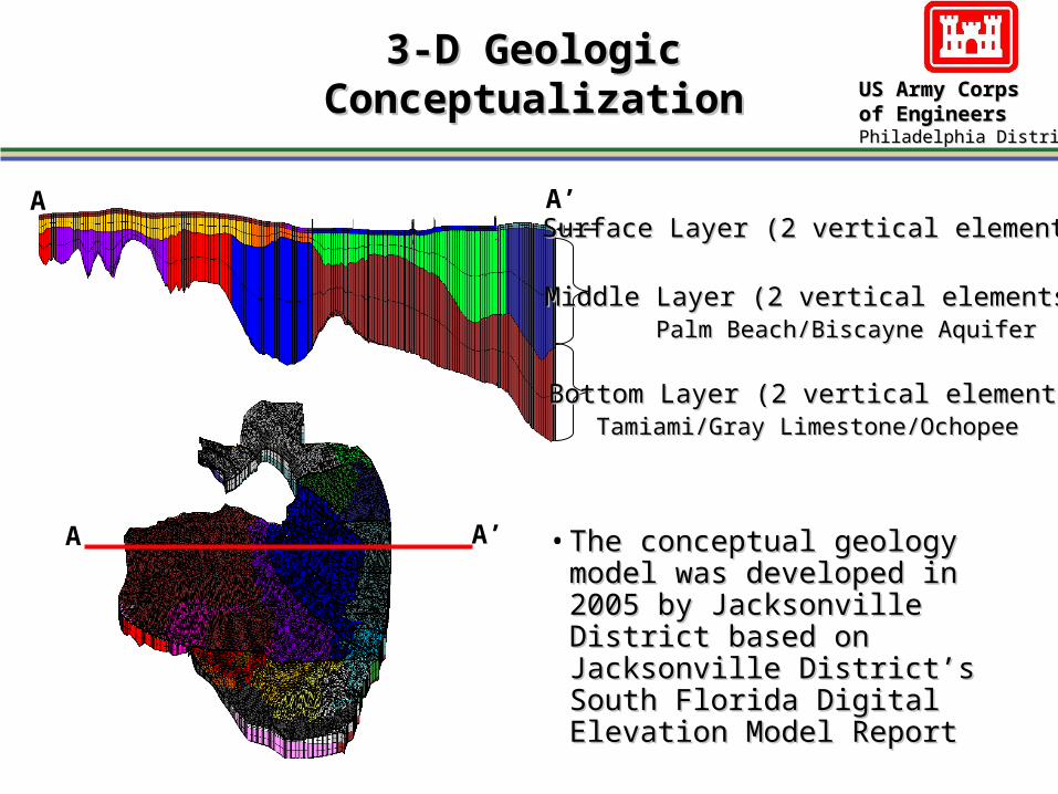
3-D Geologic 3-D Geologic ConceptualizationConceptualization US Army CorpsUS Army Corps
of Engineersof EngineersPhiladelphia DistrictPhiladelphia District
Surface Layer (2 vertical elements)Surface Layer (2 vertical elements)
Middle Layer (2 vertical elements)Middle Layer (2 vertical elements) Palm Beach/Biscayne AquiferPalm Beach/Biscayne Aquifer
Bottom Layer (2 vertical elements)Bottom Layer (2 vertical elements) Tamiami/Gray Limestone/OchopeeTamiami/Gray Limestone/Ochopee
A A’
A A’ •The conceptual geology model The conceptual geology model was developed in 2005 by was developed in 2005 by Jacksonville District based on Jacksonville District based on Jacksonville District’s South Jacksonville District’s South Florida Digital Elevation Model Florida Digital Elevation Model ReportReport
3-D Conceptual Models3-D Conceptual Models US Army CorpsUS Army Corpsof Engineersof EngineersPhiladelphia DistrictPhiladelphia District
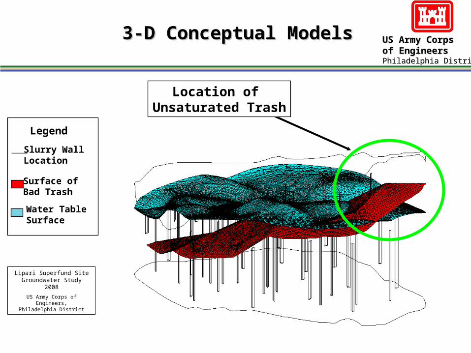
Legend
Slurry Wall Location
Surface of Bad Trash
Water TableSurface
Location of Unsaturated Trash
Lipari Superfund SiteGroundwater Study
2008
US Army Corps of Engineers,Philadelphia District
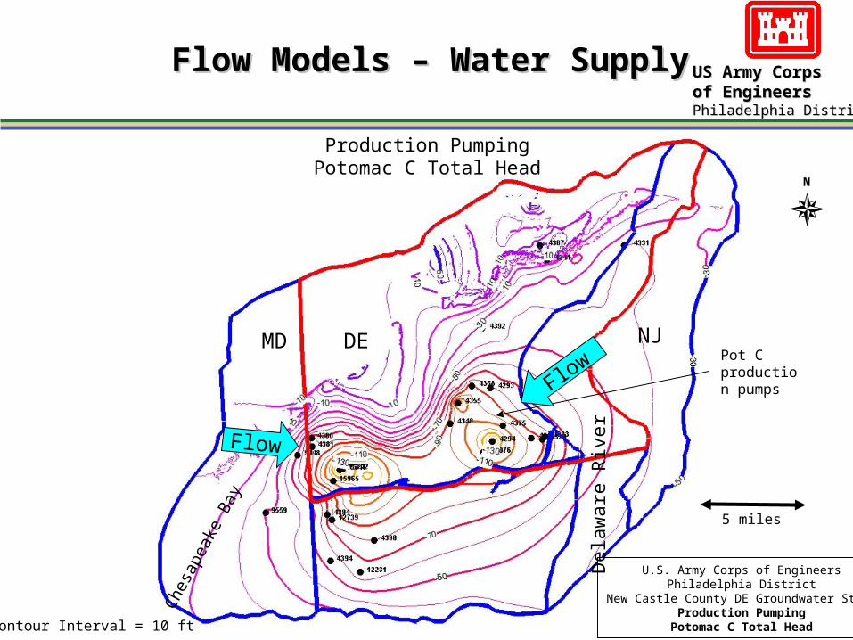
Flow Models – Water SupplyFlow Models – Water Supply US Army CorpsUS Army Corpsof Engineersof EngineersPhiladelphia DistrictPhiladelphia District
Production PumpingPotomac C Total Head
Pot C production pumps
Contour Interval = 10 ft
U.S. Army Corps of EngineersPhiladelphia District
New Castle County DE Groundwater StudyProduction Pumping
Potomac C Total Head
5 miles
N
Flow
Flow
Del
awar
e R
iver
MD DE NJ
Che
sape
ake
Bay
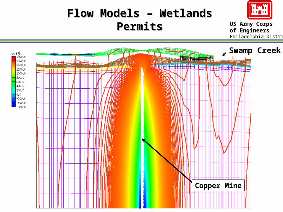
Flow Models – Wetlands Flow Models – Wetlands PermitsPermits US Army CorpsUS Army Corps
of Engineersof EngineersPhiladelphia DistrictPhiladelphia District
Copper Mine
Swamp Creek
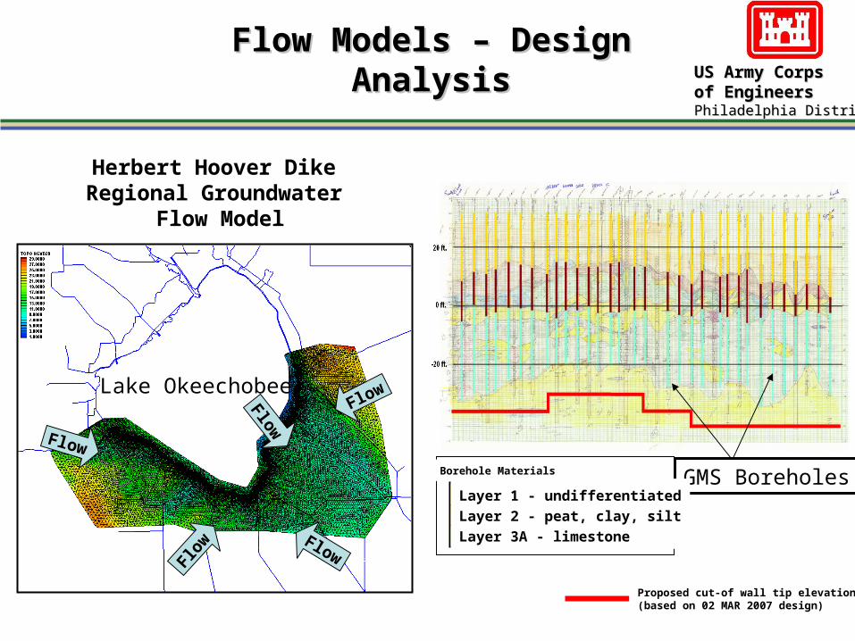
Flow Models – Design Flow Models – Design AnalysisAnalysis US Army CorpsUS Army Corps
of Engineersof EngineersPhiladelphia DistrictPhiladelphia District
Flow
Flow
Flow
Flow
Flow
GMS Boreholes
Proposed cut-of wall tip elevation(based on 02 MAR 2007 design)
Borehole Materials
Layer 1 - undifferentiated
Layer 2 - peat, clay, silt
Layer 3A - limestone
Herbert Hoover Dike Regional Groundwater
Flow Model
Lake Okeechobee
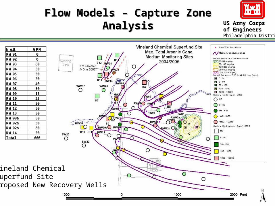
Flow Models – Capture Zone Flow Models – Capture Zone AnalysisAnalysis US Army CorpsUS Army Corps
of Engineersof EngineersPhiladelphia DistrictPhiladelphia District
Vineland ChemicalSuperfund SiteProposed New Recovery Wells
Well GPMRW01 0RW02 0RW03 60RW04 30RW05 50RW06 30RW07 40RW08 50RW09 15RW10 25RW11 50RW12 50RW13 30RW09a 50RW02a 50RW02b 80RW14 50Total 660
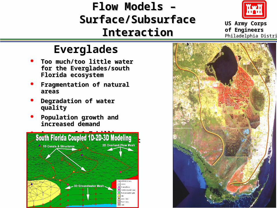
Flow Models – Flow Models – Surface/Subsurface InteractionSurface/Subsurface Interaction US Army CorpsUS Army Corps
of Engineersof EngineersPhiladelphia DistrictPhiladelphia District
Too much/too little water for the Too much/too little water for the Everglades/south Florida Everglades/south Florida ecosystemecosystem
Fragmentation of natural areasFragmentation of natural areas Degradation of water qualityDegradation of water quality Population growth and increased Population growth and increased
demanddemand Average of 1.7 billion gallons of Average of 1.7 billion gallons of
water a day lost to tidewater a day lost to tide
Everglades
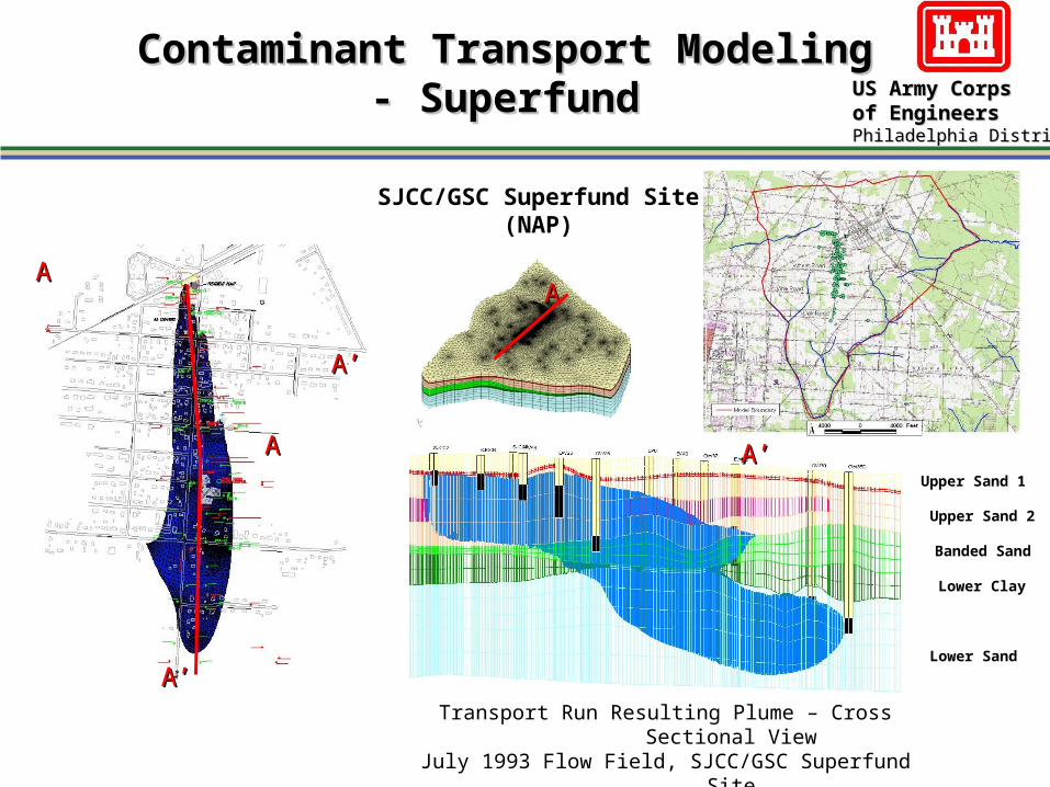
Contaminant Transport Modeling Contaminant Transport Modeling - Superfund- Superfund US Army CorpsUS Army Corps
of Engineersof EngineersPhiladelphia DistrictPhiladelphia District
Upper Sand 1
Upper Sand 2
Banded Sand
Lower Clay
Lower Sand
Transport Run Resulting Plume – Cross Sectional View
July 1993 Flow Field, SJCC/GSC Superfund Site
SJCC/GSC Superfund Site(NAP)
AA
A’A’
AA A’A’
AA
A’A’
US Army CorpsUS Army Corpsof Engineersof EngineersPhiladelphia DistrictPhiladelphia District
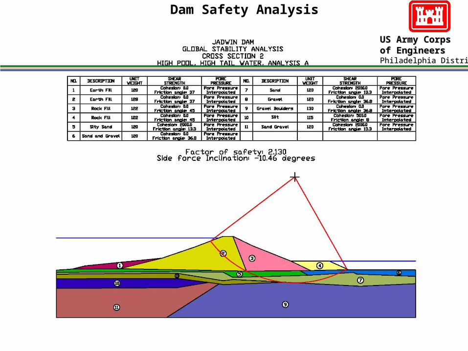
Dam Safety Analysis
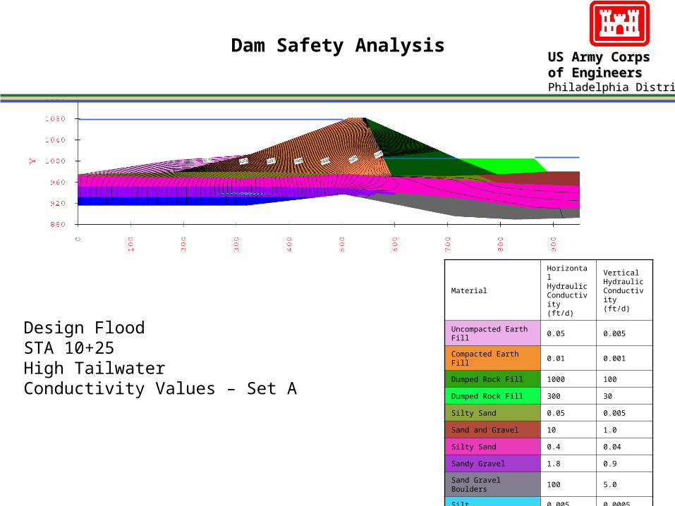
Design FloodSTA 10+25High TailwaterConductivity Values – Set A
Material
Horizontal Hydraulic Conductivity (ft/d)
Vertical Hydraulic Conductivity (ft/d)
Uncompacted Earth Fill 0.05 0.005
Compacted Earth Fill 0.01 0.001
Dumped Rock Fill 1000 100
Dumped Rock Fill 300 30
Silty Sand 0.05 0.005
Sand and Gravel 10 1.0
Silty Sand 0.4 0.04
Sandy Gravel 1.8 0.9
Sand Gravel Boulders 100 5.0
Silt 0.005 0.0005
Silty Sand Gravel 0.5 0.05
US Army CorpsUS Army Corpsof Engineersof EngineersPhiladelphia DistrictPhiladelphia District
Dam Safety Analysis
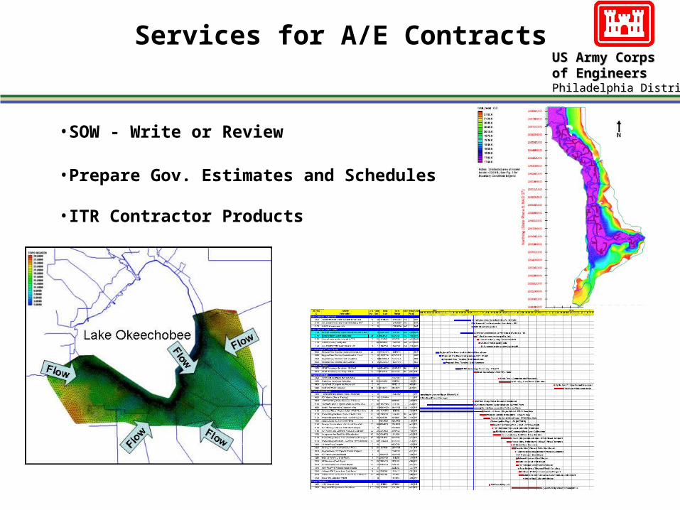
Services for A/E Contracts
•SOW - Write or Review
•Prepare Gov. Estimates and Schedules
•ITR Contractor Products
US Army CorpsUS Army Corpsof Engineersof EngineersPhiladelphia DistrictPhiladelphia District
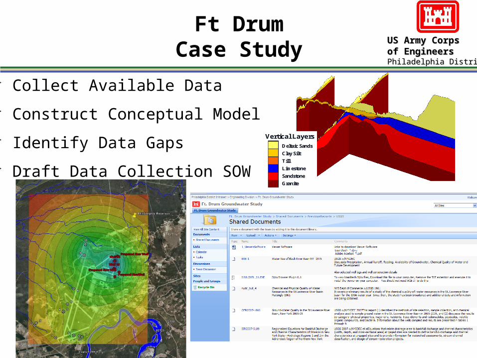
Collect Available Data
Construct Conceptual Model
Identify Data Gaps
Draft Data Collection SOW
Vertical Layers
Deltaic Sands
Clay Silt
Till
Limestone
Sandstone
Granite
Vertical Layers
Deltaic Sands
Clay Silt
Till
Limestone
Sandstone
Granite
US Army CorpsUS Army Corpsof Engineersof EngineersPhiladelphia DistrictPhiladelphia District
Ft DrumCase Study

Modeling on the Cutting Edge of TechnologyModeling on the Cutting Edge of Technology
ADH
US Army CorpsUS Army Corpsof Engineersof EngineersPhiladelphia DistrictPhiladelphia District

Internal Technical Reviews Internal Technical Reviews (ITR)(ITR) US Army CorpsUS Army Corps
of Engineersof EngineersPhiladelphia DistrictPhiladelphia District
Kootenia RiverITR for NWS


