
Motivation and IntroductionImplementation
W3DS - OperationsW3DS in action
Conclusions
Web 3D Service (W3DS) in Geoserver
Jorge Gustavo [email protected]
Nuno Carvalho [email protected]
VI Jornadas SIG Libre, Girona, March 23, 2012
Jorge Rocha, Nuno Oliveira Web 3D Service (W3DS) in Geoserver

Motivation and IntroductionImplementation
W3DS - OperationsW3DS in action
Conclusions
1 Motivation and Introduction
2 Implementation
3 W3DS - Operations
4 W3DS in action
5 Conclusions
Jorge Rocha, Nuno Oliveira Web 3D Service (W3DS) in Geoserver

Motivation and IntroductionImplementation
W3DS - OperationsW3DS in action
Conclusions
Motivation
The availability of 3D data “on demand”, through a service
The development of web clients where 3D data can be fullyexplored, while minimizing data communication
Take advantage of the native WebGL support in recentbrowsers
No plug ins are necessary to see 3D in browsersBrowsers can be as fast as any native application to render 3Dgraphics
Create and share a reference implementation of the W3DSdraft
This implementation can be used for interoperability tests toimprove the specification
Jorge Rocha, Nuno Oliveira Web 3D Service (W3DS) in Geoserver

Motivation and IntroductionImplementation
W3DS - OperationsW3DS in action
Conclusions
Introduction
OGC visualization models
Jorge Rocha, Nuno Oliveira Web 3D Service (W3DS) in Geoserver

Motivation and IntroductionImplementation
W3DS - OperationsW3DS in action
Conclusions
Built on top of existing open source software stacks
Built on top of GeoServer
Previous experience with GeoServer
Advantages
Web Services protocol already implementedCommon GIS formats already supportedAn extensible architecture
Disadvantages
High initial difficulty (Maven, JAVA Spring developmentframework, Apache Wicket)GeoServer dependencies (GeoTools for example)Scarse developers documentation
Jorge Rocha, Nuno Oliveira Web 3D Service (W3DS) in Geoserver

Motivation and IntroductionImplementation
W3DS - OperationsW3DS in action
Conclusions
Main implementation tasks
Register the W3DS service in the GeoServer architecture
Each operation implementation have three major steps:
Parse and represent the requestExecute itWrite the result in the requested output format
Add the X3D as a new supported format
Update the GeoServer Web interface accordingly to theW3DS requirements
Extend GeoTools support (PostGIS, styles, etc)
Jorge Rocha, Nuno Oliveira Web 3D Service (W3DS) in Geoserver

Motivation and IntroductionImplementation
W3DS - OperationsW3DS in action
Conclusions
GetCapabilities - Request
Request String
http://3dwebgis.di.uminho.pt/geoserver3D/w3ds?
VERSION=0.4.0&
SERVICE=w3ds&
REQUEST=GetCapabilities
Jorge Rocha, Nuno Oliveira Web 3D Service (W3DS) in Geoserver

Motivation and IntroductionImplementation
W3DS - OperationsW3DS in action
Conclusions
GetCapabilities - Result
As usual, GetCapabilities shows the available operations. In thiscase, the new GetScene operation is shown.
GetScene Description(...)
<ows:Operation name="GetScene">
<ows:DCP>
<ows:HTTP>
<ows:Get xlink:href="http://3dwebgis.di.uminho.pt/geoserver3D/w3ds?">
<ows:Constraint name="GetEncoding">
<ows:AllowedValues>
<ows:Value>KVP</ows:Value>
</ows:AllowedValues>
</ows:Constraint>
</ows:Get>
</ows:HTTP>
</ows:DCP>
</ows:Operation>
(...)
Jorge Rocha, Nuno Oliveira Web 3D Service (W3DS) in Geoserver

Motivation and IntroductionImplementation
W3DS - OperationsW3DS in action
Conclusions
GetCapabilities - Result
Part of the GetCapabilities result that show a layer description.
Layer Description(...)
<w3ds:Contents>
<w3ds:Layer>
<ows:Title>buildings_3d</ows:Title>
<ows:Abstract>Some 3D Buildings</ows:Abstract>
<ows:Identifier>geoserver3D:buildings_3d</ows:Identifier>
<ows:BoundingBox crs="EPSG:27492">
<ows:LowerCorner>-17119.121 193602.0</ows:LowerCorner>
<ows:UpperCorner>-10236.43 199013.891</ows:UpperCorner>
</ows:BoundingBox>
<w3ds:DefaultCRS>EPSG:27492</w3ds:DefaultCRS>
<w3ds:Queriable>true</w3ds:Queriable>
<w3ds:Tiled>false</w3ds:Tiled>
</w3ds:Layer>
(...)
Jorge Rocha, Nuno Oliveira Web 3D Service (W3DS) in Geoserver
Motivation and IntroductionImplementation
W3DS - OperationsW3DS in action
Conclusions
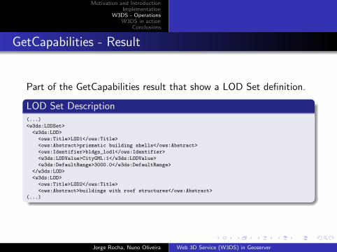
GetCapabilities - Result
Part of the GetCapabilities result that show a LOD Set definition.
LOD Set Description(...)
<w3ds:LODSet>
<w3ds:LOD>
<ows:Title>LOD1</ows:Title>
<ows:Abstract>prismatic building shells</ows:Abstract>
<ows:Identifier>bldgs_lod1</ows:Identifier>
<w3ds:LODValue>CityGML:1</w3ds:LODValue>
<w3ds:DefaultRange>3000.0</w3ds:DefaultRange>
</w3ds:LOD>
<w3ds:LOD>
<ows:Title>LOD2</ows:Title>
<ows:Abstract>buildings with roof structures</ows:Abstract>
(...)
Jorge Rocha, Nuno Oliveira Web 3D Service (W3DS) in Geoserver

Motivation and IntroductionImplementation
W3DS - OperationsW3DS in action
Conclusions
GetCapabilities - Result
Part of the GetCapabilities result that show a Tile Set definition.
Tile Set Description(...)
<w3ds:TileSet>
<ows:Identifier>dem_tileset</ows:Identifier>
<w3ds:CRS>EPSG:27492</w3ds:CRS>
<w3ds:TileSizes>4000.0 2000.0 1000.0 500.0</w3ds:TileSizes>
<w3ds:LowerCorner>-17096.156000 193503.057000</w3ds:LowerCorner>
</w3ds:TileSet>
(...)
Jorge Rocha, Nuno Oliveira Web 3D Service (W3DS) in Geoserver

Motivation and IntroductionImplementation
W3DS - OperationsW3DS in action
Conclusions
GetScene - Request
Request String
http://3dwebgis.di.uminho.pt/cgi-bin/proxy.cgi?
url=http://3dwebgis.di.uminho.pt/geoserver3D/w3ds?
VERSION=0.4.0&
SERVICE=w3ds&
REQUEST=GetScene&
CRS=EPSG:4326&
FORMAT=text/html&
LAYERS=buildings_3d,dem_3d&
BOUNDINGBOX=-8.301200,41.437741,-8.294825,41.444161&
STYLES=buildings_by_type,dem_texture_igp
Jorge Rocha, Nuno Oliveira Web 3D Service (W3DS) in Geoserver

Motivation and IntroductionImplementation
W3DS - OperationsW3DS in action
Conclusions
GetScene - Result
X3D Scene Rendering
Jorge Rocha, Nuno Oliveira Web 3D Service (W3DS) in Geoserver

Motivation and IntroductionImplementation
W3DS - OperationsW3DS in action
Conclusions
GetTile
Request String
http://3dwebgis.di.uminho.pt:8080/geoserver3D/w3ds?
version=0.4&
service=w3ds&
request=GetTile&
CRS=EPSG:27492&
FORMAT=model/x3d+xml&
LAYER=dem_tiled_3d&
TILELEVEL=0&
TILEROW=5&GetTile
TILECOL=7&
style=dem_texture_igp
Jorge Rocha, Nuno Oliveira Web 3D Service (W3DS) in Geoserver
Motivation and IntroductionImplementation
W3DS - OperationsW3DS in action
Conclusions
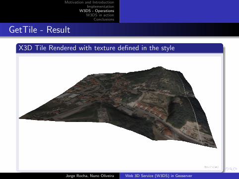
GetTile - Result
X3D Tile Rendered with texture defined in the style
Jorge Rocha, Nuno Oliveira Web 3D Service (W3DS) in Geoserver
Motivation and IntroductionImplementation
W3DS - OperationsW3DS in action
Conclusions
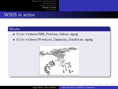
W3DS in action
Movies
file:videos/OSM_Postes_Cabos.mpeg
file:videos/Predios_Camaras_Condutas.mpeg
Jorge Rocha, Nuno Oliveira Web 3D Service (W3DS) in Geoserver

Motivation and IntroductionImplementation
W3DS - OperationsW3DS in action
Conclusions
Conclusions
W3DS is necessary for 3D WebGIS applications as WMS hasbeen for web mapping
W3DS (open source) implementations are necessary to dointeroperability experiments
A fully operational W3DS implementation was presented
The service can be downloaded (as WAR) or as source forlocal deployment
A working demo service is available athttp://3dwebgis.di.uminho.pt/geoserver3D/
Jorge Rocha, Nuno Oliveira Web 3D Service (W3DS) in Geoserver

Motivation and IntroductionImplementation
W3DS - OperationsW3DS in action
Conclusions
Web 3D Service (W3DS) in Geoserver
Jorge Gustavo [email protected]
Nuno Carvalho [email protected]
VI Jornadas SIG Libre, Girona, March 23, 2012
Jorge Rocha, Nuno Oliveira Web 3D Service (W3DS) in Geoserver


