Pertemuan Ilmiah Tahunan MAPIN XIV”Pemanfaatan Efektif Penginderaan Jauh Untuk Peningkatan Kesejahteraan Bangsa” IMPROVEMENT OF LAND AND FOREST FIRE HAZARD MAPPING METHOD FOR SUMATERA AND KALIMANTAN BASED ON REMOTE SENSING DATA Erna S. Adiningsih 1 , P. A. Winarso 1 , Z.L. Dupe 1 , dan A. Buono 1 1 Pusat Pengembangan Pemanfaatan dan Teknologi Penginderaan Jauh – LAPAN Jl. LAPAN no. 70, Pekayon, Pasar Rebo, Jakarta 13710 email: [email protected]Abstract Improvement of land and forest fire hazard mapping method for sumatera and kalimantan based on remote sensing data. Fire hazard prediction model has been developed using spatial and satellite data for Sumatra and Kalimantan since these areas are very prone to land and forest fires. The model could predict fire hazard for several months ahead based on predicted rainfall and predicted vegetation indices. The previous method used four parameters as inputs, which were rainfall, vegetation index, land cover, and land type. The objectives of this research are to improve the method of fire hazard determination using spatial and satellite data and to compare the results of previous and last methods for Sumatra and Kalimantan. An improved method has been developed by using topographic map as additional input of the method. Improvement has been also made by using raster format data instead of vector format data as used in previous method of overlaying by geographic information system software. The results show that the use of raster data format could produce more detailed land/forest fire hazard maps for Sumatra and Kalimantan compared with the use of vector data. Further more, the use of slope p arameter based on topographic map derived from SRTM data could generate better fire hazard maps in terms of vulnerability indication and spatial inf ormation. Keywords: fire hazard, raster data, vector data, slope 1. INTRODUCTION Since 1980s land and forest fires in Indonesia have been attracted world attention particularly in Southeast Asia. In most occurrences, the fires set by the ranchers and subsistence farmers often get out of hand or uncontrolled, inadvertently burning forests, pastures, and plantations. Each year, fires in Sumatra and Kalimantan burn a large area ofshrubs, logged forests, croplands, and plantations. Wetlands and peat lands would cause the fires spread out fast and produce a large number ofsmoke and haze. The haze will increase air pollution even become transboundary haze over the Southeast Asia and has various impacts (Murdiyarso, 1998; Mudiyarso and Lebel, 1998; Suyanto et al., 2001, 2003). According to Saharjo (2000) the sources of land and forest fires come from illegal shifting cultivation, forest concession, plantation, logging, and spreading. Tacconi (2003) suggests that land cover and its changes are major influencing factors on fires in Indonesia. Based on fires in 1997/1998 it has been calculated that the largest amount of burned areas in Indonesia consists ofcrop land and followed by brackish forest, peat forest, lowland forest, shrubs, grassland, forest plantations and plantations. Furthermore the results of Murdiyarso et al. (2002) reveal that forest fire risks are related to accessibility and vegetation type or fuel type. Highest fire frequency (as indicated by cumulative hotspot frequency) is usually found at the areas having high accessibility by secondary roads. Various studies on fires are therefore becoming higher interests of many scientists in Indonesia as well as in other countries. Research on land and forest fire hazard has been done by modeling the impact of climate anomaly on fire hazard prediction for Sumatra and Gedung Rektorat lt. 3 Kampus Institut Teknologi Sepuluh NopemberSurabaya, 14 – 15 September 2005 MBA - 96
Improvement of land and forest fire hazard mapping method for sumatera and kalimantan based on remote sensing data.
Fire hazard prediction model has been developed using spatial and satellite data for Sumatra and Kalimantan since theseareas are very prone to land and forest fires. The model could predict fire hazard for several months ahead based on
predicted rainfall and predicted vegetation indices. The previous method used four parameters as inputs, which were
rainfall, vegetation index, land cover, and land type. The objectives of this research are to improve the method of fire
hazard determination using spatial and satellite data and to compare the results of previous and last methods for
Sumatra and Kalimantan. An improved method has been developed by using topographic map as additional input of the
method. Improvement has been also made by using raster format data instead of vector format data as used in previous
method of overlaying by geographic information system software. The results show that the use of raster data format
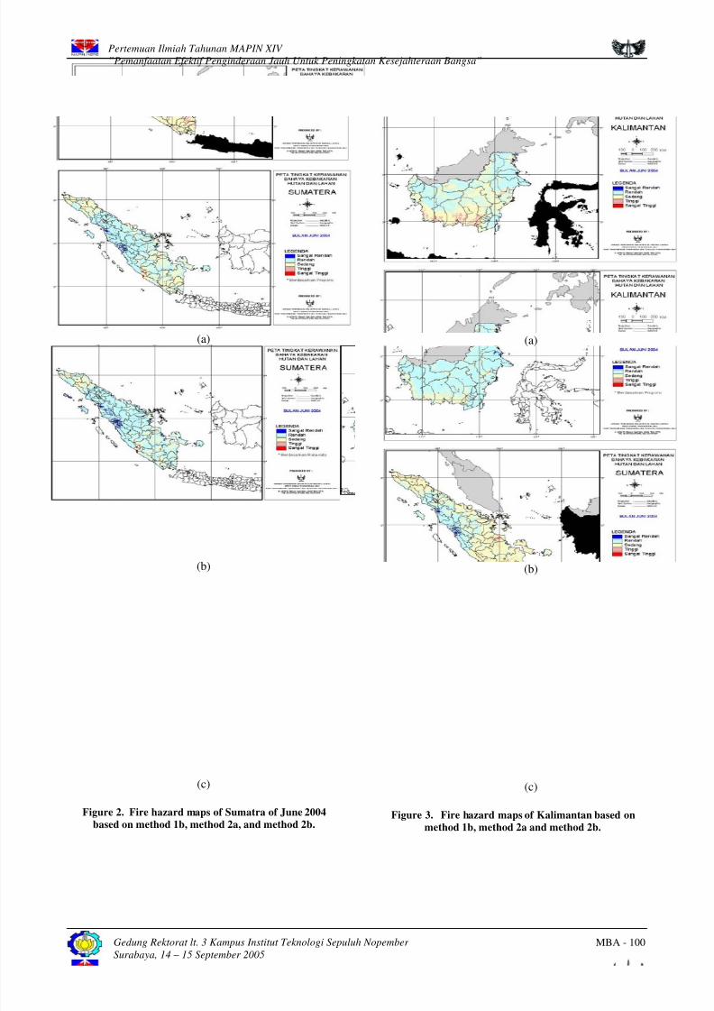
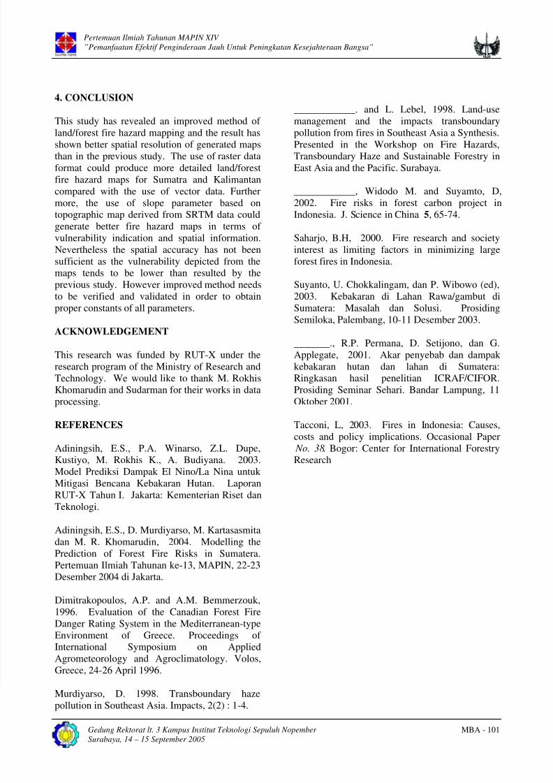
could produce more detailed land/forest fire hazard maps for Sumatra and Kalimantan compared with the use of vector
data. Further more, the use of slope parameter based on topographic map derived from SRTM data could generate better
fire hazard maps in terms of vulnerability indication and spatial information.
Keywords: fire hazard, raster data, vector data, slope
1. INTRODUCTION
Since 1980s land and forest fires in Indonesia
have been attracted world attention particularly in
Southeast Asia. In most occurrences, the fires set
by the ranchers and subsistence farmers often get
out of hand or uncontrolled, inadvertently burning
forests, pastures, and plantations. Each year, firesin Sumatra and Kalimantan burn a large area of
shrubs, logged forests, croplands, and plantations.
Wetlands and peat lands would cause the fires
spread out fast and produce a large number of
smoke and haze. The haze will increase air
pollution even become transboundary haze over
the Southeast Asia and has various impacts
(Murdiyarso, 1998; Mudiyarso and Lebel, 1998;
Suyanto et al., 2001, 2003).
According to Saharjo (2000) the sources of land
and forest fires come from illegal shiftingcultivation, forest concession, plantation, logging,
and spreading. Tacconi (2003) suggests that land
cover and its changes are major influencing
factors on fires in Indonesia. Based on fires in
1997/1998 it has been calculated that the largest
amount of burned areas in Indonesia consists of
crop land and followed by brackish forest, peat
forest, lowland forest, shrubs, grassland, forest
plantations and plantations. Furthermore theresults of Murdiyarso et al. (2002) reveal that
forest fire risks are related to accessibility and
vegetation type or fuel type. Highest fire
frequency (as indicated by cumulative hotspot
frequency) is usually found at the areas having
high accessibility by secondary roads. Various
studies on fires are therefore becoming higher
interests of many scientists in Indonesia as well as
in other countries.
Research on land and forest fire hazard has been
done by modeling the impact of climate anomalyon fire hazard prediction for Sumatra and
Gedung Rektorat lt. 3 Kampus Institut Teknologi Sepuluh Nopember