+ All Categories
Home > Documents > 200 (MOIG: gbbgLGIJ1 guq 10 M0Ltp-aontp cl.oaa aGC1!01J …

200 (MOIG: gbbgLGIJ1 guq 10 M0Ltp-aontp cl.oaa aGC1!01J …

Date post: 25-Nov-2021
Category:
Upload: others
View: 0 times
Download: 0 times
Share this document with a friend
1
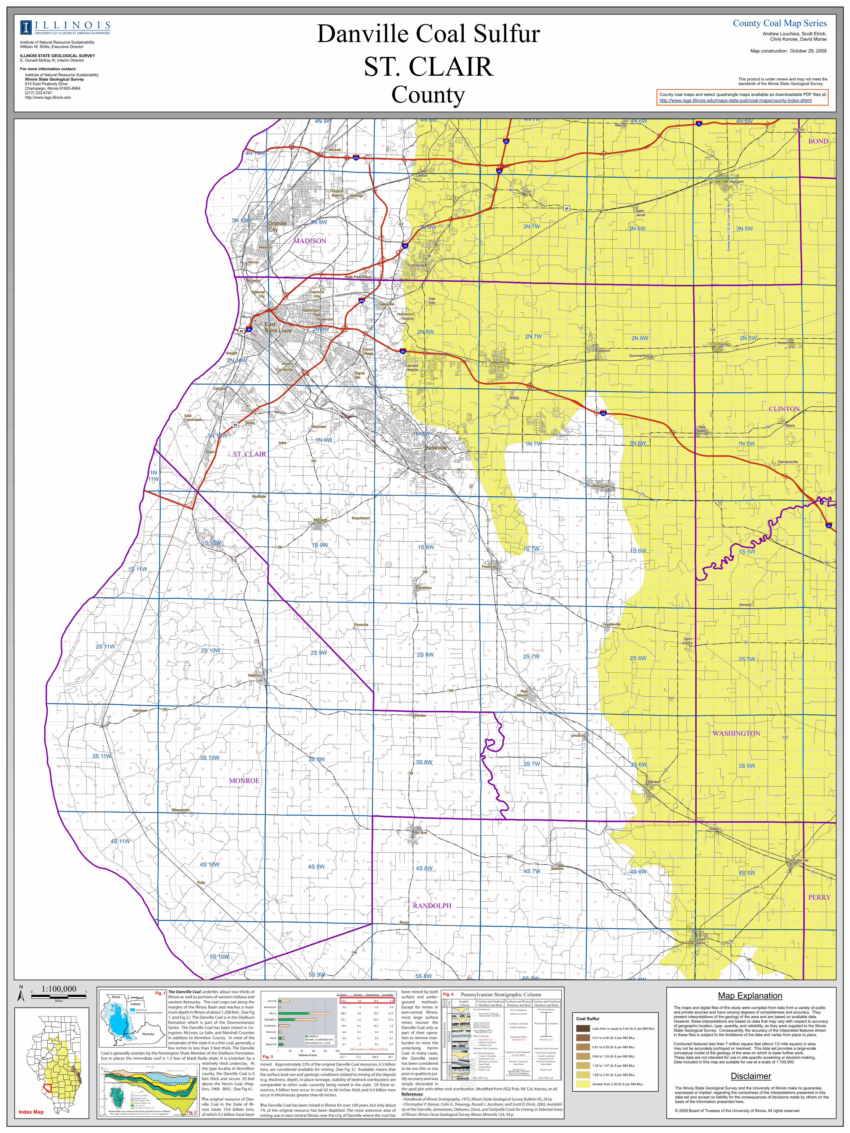
7 6 7 7 6 7 6 7 7 7 6 6 6 7 6 9 5 7 7 6 4 2 8 7 5 5 2 4 5 3 5 9 4 4 3 6 2 4 9 5 2 6 7 2 6 9 5 3 8 5 3 4 5 5 7 8 8 8 9 9 4 7 4 3 6 3 8 3 9 3 4 5 8 1 7 2 6 5 4 9 5 1 8 1 8 4 2 9 7 8 6 9 7 7 9 1 8 8 1 8 9 8 9 2 8 3 6 9 9 2 8 7 7 8 6 5 8 2 2 6 1 6 5 3 9 4 8 6 3 3 4 7 1 1 8 4 3 3 9 8 9 8 9 8 8 9 9 9 2 8 4 9 3 6 8 6 8 1 9 9 1 7 9 8 7 2 8 5 4 7 3 2 3 6 8 9 1 8 6 4 1 8 7 9 5 3 9 9 6 9 5 7 5 8 3 2 9 1 8 1 2 7 2 4 9 1 3 3 1 8 9 8 4 8 5 2 5 8 5 1 8 6 9 1 1 5 2 2 5 7 9 7 8 1 7 5 1 8 7 4 4 2 1 2 1 2 9 5 5 7 8 1 8 6 7 4 4 3 2 3 7 8 9 5 2 2 2 4 8 17 11 10 33 11 13 14 11 35 24 16 31 30 12 18 30 31 3 3 2 8 5 9 2 3 9 2 4 2 4 3 3 5 3 6 2 6 8 9 3 7 6 8 4 1 1 5 1 2 4 1 5 5 9 3 1 5 1 7 1 7 6 2 5 5 1 6 9 2 2 4 3 8 8 1 2 4 8 4 3 7 2 4 1 6 2 11 21 11 3 7 8 9 1 1 9 4 6 5 1 3 5 5 6 4 6 6 7 4 4 7 9 5 4 6 4 2 1 5 7 7 3 4 3 5 6 9 2 1 1 6 1 5 5 6 3 8 3 3 6 4 2 1 6 3 5 3 2 5 1 5 6 1 7 4 5 6 5 3 7 4 4 1 6 8 3 2 1 4 2 2 2 3 7 3 4 1 7 6 6 6 4 5 1 5 4 5 4 7 6 1 6 2 5 3 3 1 3 1 7 7 2 6 6 7 7 2 8 6 7 5 31 19 19 18 30 31 18 31 30 9 18 6 31 19 30 18 8 31 5 18 18 19 30 30 19 30 18 31 19 19 30 30 31 8 29 32 31 11 11 11 31 31 18 33 20 11 19 30 12 20 18 21 11 11 18 19 11 30 11 18 11 11 11 28 25 28 11 11 20 19 11 16 11 11 11 28 31 34 16 26 29 33 23 29 33 11 30 27 14 16 11 17 11 34 11 11 11 24 26 11 11 11 11 11 25 10 32 13 11 11 19 11 28 11 28 11 11 18 1 17 21 11 22 13 26 23 11 12 34 31 17 11 26 11 30 35 35 19 11 35 11 19 27 30 24 11 15 30 11 18 33 21 31 14 23 15 16 26 15 28 36 15 10 26 18 15 33 22 3 24 23 17 21 25 18 36 34 13 18 21 16 31 17 29 16 14 32 22 27 21 32 27 14 36 25 26 36 29 17 24 16 25 29 20 16 25 13 10 27 24 30 35 10 23 23 23 24 22 16 28 22 14 12 13 20 31 16 28 15 16 16 12 35 13 35 25 29 26 20 35 19 20 21 18 36 15 32 19 29 29 29 17 10 19 23 17 17 15 29 27 17 36 12 18 15 20 16 13 12 17 23 16 13 24 27 10 32 25 15 25 33 32 14 19 18 32 12 17 29 14 35 25 10 22 10 31 14 23 20 18 15 31 27 25 12 26 10 12 30 20 20 11 20 27 23 10 18 24 23 36 32 17 16 17 22 36 26 24 19 22 14 22 10 24 10 22 35 17 21 36 10 27 29 35 20 17 35 32 24 29 12 20 32 15 25 12 21 23 29 22 24 35 17 16 22 16 13 16 12 35 26 10 17 11 15 14 28 16 20 36 30 15 21 17 36 14 28 30 13 24 29 10 18 16 21 14 15 14 26 32 17 33 22 26 34 14 27 33 33 17 27 16 25 26 10 30 35 12 26 33 21 32 16 25 10 19 24 20 21 14 34 16 14 28 26 29 36 27 22 24 34 15 17 32 33 36 10 28 29 22 23 36 26 34 28 32 13 15 26 21 25 27 25 27 22 36 36 26 13 32 17 20 36 32 32 14 21 21 34 22 18 21 18 10 27 34 20 13 35 20 28 34 32 34 18 27 26 16 23 20 17 13 26 33 28 12 26 32 25 21 28 24 29 28 25 35 21 14 25 16 30 23 33 31 19 35 17 24 32 34 35 12 33 21 28 16 23 12 10 32 26 27 24 22 16 33 17 14 23 26 36 15 10 20 35 27 14 13 30 34 12 22 29 28 32 21 27 13 35 27 29 20 26 29 29 32 23 17 33 20 10 29 25 13 36 12 28 35 23 34 34 14 24 18 35 27 13 22 22 22 34 35 36 21 33 32 26 21 22 23 20 29 16 22 12 27 17 10 32 10 22 27 15 25 32 35 13 20 26 20 35 14 17 26 36 27 28 24 33 36 14 17 32 26 35 34 15 25 33 26 25 23 17 33 33 27 29 26 28 35 26 36 15 21 23 28 20 25 21 26 36 21 27 35 34 10 27 34 23 13 34 36 20 34 10 27 36 16 13 23 29 32 35 21 29 15 15 34 33 29 23 12 13 36 34 36 17 15 14 29 19 34 10 17 30 13 15 10 21 32 23 27 13 12 29 24 27 33 28 34 24 20 10 22 23 20 35 14 26 15 35 21 34 29 20 34 17 25 24 14 34 14 15 36 13 26 28 15 25 10 24 17 24 32 28 12 18 32 22 25 24 17 35 35 18 36 33 21 34 22 29 33 15 33 22 26 10 31 32 19 25 17 33 36 22 26 34 27 33 30 20 25 21 20 10 35 15 23 27 21 15 33 21 34 16 23 29 29 14 13 17 12 23 32 23 36 17 34 19 22 20 33 19 21 25 14 26 32 17 20 36 33 29 29 15 33 25 20 27 27 15 20 16 27 34 26 15 15 15 25 26 30 29 31 24 15 36 22 12 31 29 33 15 26 35 20 31 22 23 33 10 28 29 32 17 15 35 35 23 18 20 36 23 15 25 25 32 17 16 12 10 30 24 33 12 32 31 13 12 14 22 34 24 28 10 19 29 25 19 27 28 15 31 21 22 28 28 32 36 27 34 15 35 34 12 13 23 36 30 32 33 14 16 34 24 10 13 35 24 35 32 32 29 36 32 13 15 13 32 21 14 20 23 29 32 28 23 23 16 26 32 16 34 12 14 28 19 26 25 28 17 35 25 30 34 12 23 20 36 28 33 10 30 17 10 14 16 17 31 28 34 21 28 10 31 20 31 20 33 26 13 35 33 25 36 33 27 21 28 17 14 13 28 22 28 10 16 19 17 12 10 28 12 19 33 31 12 33 34 25 24 33 16 22 29 14 14 28 18 35 17 24 27 24 19 30 16 17 24 14 25 32 28 27 18 22 12 29 22 14 16 14 23 29 20 12 13 13 14 25 19 12 17 35 10 21 31 26 18 34 29 24 22 10 36 13 21 28 20 18 36 14 10 31 36 13 31 14 12 20 32 30 18 20 27 23 12 24 26 18 16 22 36 13 13 22 12 10 26 29 12 26 13 15 23 35 21 29 36 15 20 26 22 32 27 12 31 36 24 27 21 16 17 19 14 16 29 36 24 16 15 24 24 19 2 13 24 28 12 14 25 34 20 23 12 14 18 21 32 16 29 36 14 24 13 36 24 36 20 26 25 13 22 20 35 23 17 29 31 24 30 12 18 20 23 32 15 28 18 23 22 24 34 25 34 21 18 12 12 10 33 27 13 29 10 22 20 19 25 34 15 12 30 10 35 25 19 27 31 19 23 35 33 33 31 19 24 12 27 36 34 31 13 31 19 35 31 13 13 17 18 30 30 16 12 21 13 29 25 30 30 25 28 13 25 34 24 12 18 21 31 19 19 31 22 31 4 30 30 17 19 16 32 30 18 25 4 18 23 18 31 5 30 32 12 22 13 24 19 14 19 23 31 18 19 19 18 19 30 30 25 30 30 31 31 19 19 30 30 18 18 19 29 31 5 9 30 31 30 31 20 9 2 30 18 23 19 36 19 19 30 18 31 11 18 30 31 14 30 19 18 27 33 11 31 6 31 1 7 18 15 8 19 13 32 32 8 19 9 16 25 32 16 10 15 36 20 10 15 14 24 23 14 30 25 25 9 5 24 17 31 20 35 31 27 18 7 16 22 19 30 27 13 32 15 1 11 14 14 33 7 6 22 30 21 3 26 17 19 24 2 5 7 2 21 6 24 5 18 11 22 1 26 30 18 24 7 32 21 18 32 31 7 34 6 31 17 28 20 21 14 10 29 15 29 15 17 30 4 13 20 29 19 22 2N 10W 2N 9W 2N 8W 2N 7W 2N 5W 2N 6W 4N 9W 4N 8W 4N 7W 4N 5W 4N 6W 4N 10W 3N 10W 3N 9W 3N 8W 3N 7W 3N 5W 3N 6W 2S 11W 2S 9W 2S 8W 2S 7W 2S 6W 2S 5W 3S 11W 3S 10W 3S 9W 3S 8W 3S 7W 3S 6W 3S 5W 4S 11W 4S 10W 4S 9W 4S 8W 4S 7W 4S 6W 4S 5W 5S 10W 5S 9W 5S 8W 5S 7W 5S 6W 5S 5W 1N 10W 1N 9W 1N 8W 1N 7W 1N 6W 1N 5W 1N 11W 1S 11W 1S 10W 1S 9W 1S 8W 1S 7W 1S 6W 1S 5W 2S 10W 162 159 158 15 155 177 13 158 157 156 203 154 160 154 3 13 163 4 4 161 15 15 13 153 177 15 161 4 143 4 157 111 13 153 159 156 3 3 159 160 £ ¤ 50 £ ¤ 40 £ ¤ 40 § ¨ ¦ 64 § ¨ ¦ 80 § ¨ ¦ 55 § ¨ ¦ 270 § ¨ ¦ 80 § ¨ ¦ 70 § ¨ ¦ 64 § ¨ ¦ 70 § ¨ ¦ 64 § ¨ ¦ 255 RANDOLPH WASHINGTON MONROE ST. CLAIR CLINTON MADISON PERRY BOND Greater than 2.50 (lb S per MM Btu) East Carondelet Westview Stolle Sparta Damiansville Cahokia New Baden Shiloh Centreville Signal Hill Alorton Sauget Albers Fairview Heights Rosemont Summerfield Lebanon Washington Park Hollywood Heights Caseyville National City Trenton Oak Hills Fairmont City Brooklyn Aviston State Park Place Baldwin Venice Madison Collinsville Stallings Pontoon Beach Saint Jacob Troy Glen Carbon Mitchell Highland Marine Hecker Pierron French Village Millstadt Maeystown Red Bud Coulterville Tilden Marissa Ruma Valmeyer Lenzburg Roachtown Bluffside Fults Dupo Waterloo New Athens Mascoutah Imbs Floraville Saint Libory Fayetteville Smithton Venedy Freeburg East Saint Louis Belleville Granite City Danville Coal Sulfur County County Coal Map Series This product is under review and may not meet the standards of the Illinois State Geological Survey. County coal maps and select quadrangle maps available as downloadable PDF files at: http://www.isgs.illinois.edu/maps-data-pub/coal-maps/county-index.shtml Institute of Natural Resource Sustainablity Illinois State Geological Survey 615 East Peabody Drive Champaign, Illinois 61820-6964 (217) 333-4747 http://www.isgs.illinois.edu For more information contact: Institute of Natural Resource Sustainability William W. Shilts, Executive Director ILLINOIS STATE GEOLOGICAL SURVEY E. Donald McKay III, Interim Director Andrew Louchios, Scott Elrick, Chris Korose, David Morse Map construction: 1:100,000 0 3 Miles Disclaimer Map Explanation The maps and digital files of this study were compiled from data from a variety of public and private sources and have varying degrees of completeness and accuracy. They present interpretations of the geology of the area and are based on available data. However, these interpretations are based on data that may vary with respect to accuracy of geographic location, type, quantity, and reliability, as they were supplied to the Illinois State Geological Survey. Consequently, the accuracy of the interpreted features shown in these files is subject to the limitations of the data and varies from place to place. Contoured features less than 7 million square feet (about 1/2 mile square) in area may not be accurately portrayed or resolved. This data set provides a large-scale conceptual model of the geology of the area on which to base further work. These data are not intended for use in site-specific screening or decision-making. Data included in this map are suitable for use at a scale of 1:100,000. The Illinois State Geological Survey and the University of Illinois make no guarantee, expressed or implied, regarding the correctness of the interpretations presented in this data set and accept no liability for the consequences of decisions made by others on the basis of the information presented here. © 2009 Board of Trustees of the University of Illinois. All rights reserved. Index Map October 29, 2009 ST. CLAIR The Danville Coal underlies about two thirds of Illinois as well as portions of western Indiana and western Kentucky. The coal crops out along the margins of the Illinois Basin and reaches a maxi- mum depth in Illinois of about 1,200 feet. (See Fig 1. and Fig 2.) The Danville Coal is in the Shelburn formation which is part of the Desmoninesian Series. The Danville Coal has been mined in Liv- ingston, McLean, La Salle, and Marshall Counties in addition to Vermilion County. In most of the remainder of the state it is a thin coal, generally a few inches to less than 3 feet thick. The Danville Coal is generally overlain by the Farmington Shale Member of the Shelburn Formation, relatively thick underclay. At the type locality in Vermillion county, the Danville Coal is 6 feet thick and occurs 20 feet above the Herrin Coal. (Hop- kins, 1968 - B95). (See Fig 4.) The original resource of Dan- ville Coal in the State of Illi- nois totals 19.6 billion tons, of which 0.2 billion have been 0 50 100 Miles Danville Coal Extent of Pennsylvannian System ± Illinois Indiana Kentucky mined. Approximately 23% of the original Danville Coal resources, 4.5 billion tons, are considered available for mining. (See Fig 3.) Available means that the surface land-use and geologic conditions related to mining of the deposit (e.g. thickness, depth, in-place tonnage, stability of bedrock overburden) are comparable to other coals currently being mined in the state. Of these re- sources, 4 billion tons occur in coal 42 to 66 inches thick and 0.4 billion tons occur in thicknesses greater than 66 inches. The Danville Coal has been mined in Illinois for over 100 years, but only about 1% of the original resource has been depleted. The most extensive area of mining was in east-central Illinois near the ci ty of Danville where the coal has been mined by both surface and under- ground methods. Except for mines in east-central Illinois, most large surface mines recover the Danville Coal only as part of their opera- tion to remove over- burden to mine the underlying Herrin Coal. In many cases, the Danville seam has been considered to be too thin or too poor in quality to jus- tify recovery and was simply discarded in References: - Handbook of Illinois Stratigraphy, 1975, Illinois State Geological Survey Bulletin 95, 261p. - Christopher P. Korose, Colin G. Treworgy, Russell J. Jacobson, and Scott D. Elrick, 2002, Availabil- ity of the Danville, Jamestown, Dekoven, Davis, and Seelyville Coals for mining in Selected Areas of Illinois: Illinois State Geological Survey Illinois Minerals 124, 44 p. Trivoli Sandstone Scottville Limestone Athensville Coal (SW) Lake Creek Coal Pond Creek Coal Gimlet Sandstone Rock Branch (SW)/ DeGraff (S) Coal Piasa Limestone Danville Coal Galum Limestone Allenby Coal Bankston Fork Limestone Anvil Rock Sandstone Conant Limestone Jamestown Coal Brereton Limestone Anna Shale Energy Shale Herrin Coal Briar Hill Coal Canton Shale Trivoli Sandstone Exline Limestone Lonsdale Limestone Gimlet Sandstone Farmington Shale Danville Coal Copperas Creek Sandstone Lawson Shale Brereton Limestone Anna Shale Herrin Coal Spring Lake Coal Bed Big Creek Sandstone Vermillionville Sandstone Canton Shale Canton Shale Briar Hill Coal Herrin Coal Anna Shale Brereton Limestone Jamestown Coal Conant Limestone Anvil Rock Sandstone Bankston Fork Limestone Danville Coal West Franklin Limestone Trivoli Sandstone Desmoinesian Series Shelburn Carbondale Central and Southern Members and Beds Northern and Western Members and Beds Eastern and Southern Members and Beds Graphic Column Fm. Series Pennsylvanian Stratigraphic Column Original M ined R emaining Available 19.6 0.2 19.4 4.5 3.6 0 3.6 0.9 88.5 9.4 79.0 51.0 65.1 2.2 63.0 27.0 19.0 0.5 18.5 1.0 6.0 0.1 5.9 0.3 9.6 0.1 9.5 4.7 9.7 0 9.7 6.7 - - - - - - - - - - - - - - - - - - - - - - - - - - - - - - - - - - - - - - - - - - - - - - - - - - - - - - - - - - - - - - 221.1 12.5 208.6 96.1 (All numbers in Billions of Tons) Fig. 1 Fig. 2 Fig. 3 Fig. 4 Coal Sulfur Less than or equal to 0.40 (lb S per MM Btu) 0.41 to 0.60 (lb S per MM Btu) 0.61 to 0.83 (lb S per MM Btu) 0.84 to 1.24 (lb S per MM Btu) 1.25 to 1.67 (lb S per MM Btu) 1.68 to 2.50 (lb S per MM Btu) Greater than 2.50 (lb S per MM Btu)
Transcript

7

6

7

7

6

7

6

7

7

7

6

6

6

7

6

9

5

7

7

6

4 2

8

7

55 2

4

5

35

9

4

4

36

2

4

9

5

2

6

7

2

6

9

5

3

8

5

3

4 5

5

7

8

8

8

9

9

4

7

4

3

6

3

8

3

9

3

4

5

8

1

7

26

5

4

9

5

1

8

1

8

4 2

9

7

8

6

9

7

7

9

1

8

8

1

8

9

8

9

2

8

3

6

9

9

2

8

7

7

8

6

5

8

2

2

6

16

5

3

9

4

8

6

3

3

4

7

1

1

8

4

3

3

9

8

9

8

9

8

8

9

9

9

2

8

4

9

3

6

8

6

8

1

9

9

1

7

9

8

7

2

8

5

4

7

3

2 3

6

8

9

1

8

6

4

1

8

7

9

5

3

9

9

6

9

5

7

5

8

3

2

9

1

8

1

2

7

2

4

9

1

3

3

1

8

9

8

4

8

5

2

5

8

5

1

8

6

9

1

1

5

2

2

5

7

9

7

8

1

7

5

1

8

7

4

4

2

1

2 1

2

9

5

5

7 8

1

8

6

7

44

3

2

3

7

8

9

5

2

2

2

4

8

17

11

10

33

11

13

14

11

35

24

16

31

30

12

18

30

31

3

3

2

8

5

9

23

9

2

4

2

4

3

3

5

3

6

2

6

8

9

3

7

6

8

4

1

1 5

1

24

1

5

5

9

3

1

5

1

7

1

7

6

2

5

5

1

6

9

2

2

4

3

8

8

1

2

4

8

4

3

7

2

4

1

6

2

11

21

11

3

7

89

1

1

9

4

6

5

1

3

5

5

6

4

6

6

7

4

4

7

9

5

4

6

4

2

1

5

7

7

34

35

6

9

2

1

1

6

1

5

5

6

3

8

3

3

6

4

2

1

63 5 3

2

5

1

5

6

1

7

4

5

6

5

3

7

4

4

1

6

8

3

2

1

4

2

2

2

3

7

3

4

1

7

6

6

6

4

5

1

5

4

5

4

7

6

1

6

2

5

3

3

13

1

7

7

2

6

6

7

7

2

8

6

7

5

31

19

19

18

30

31

18

31

30

9

18

6

31

19

30

18

8

31

5

18

18

19

30

30

19

30

18

31

19

19

30

30

31

8

29

32

31

11

11

11

31

31

18

33

20

11

19

30

12

20

18

21

11

11

18

19

11

30

11

18

1111

11

28

25

28

11

11

20

19

11

16

11

11

11

28

31

34

16

26

29

33

23

29

33

11

30

27

14

16

11

17

11

34

11

11

11

24

26

11

11

11

11

11

25

10

32

13

11

11

19

11

28

11

28

11

11

18

1

17

21

11

22

13

26

23

11

12

34

31

17

11

26

11

30

35

35

19

11

35

11

19

27

30

24

11

15

30

11

18

33

21

31

14

23

15

16

26

15

28

36

15

10

26

18

15

33

22

3

24

23

17

21

25

18

3634

13 18

21

16

31

17

29

16

14

32

22

27

21

32

27

14

36

25

26

36

29

17

24

16

25

29

20

16

25

13

10

27

24

30

35

10

23

23

23

2422

16

28

22

14

12

13

20

31

16

28

15

16 16

12

35

13

35

25

29

26

20

35

1920

21

18

36

15

32

19

29

29

29

17

10

19

23

17

17

15

29

27

17

36

12

18

15

20

16

13

12

17

23

1613

24

27

10

32

25

15

25

33

32

14

13

19

18

32

12

17

29

14

35

25

10

22

10

31

14

23

20

18

15

31

27

25

12

26

10

12

30

20

20

11

20

27

23

10

18

24

23

36

32

17

16

17

22

36

26

24

19

22

14

22

10

24

10

22

35

17

21

36

10

27

29

35

20

17

3532

24

29

12

20

32

15

25

12

21

23

29

22

24

35

17

16

22

16

13

16

12

35

26

10

17

11

15

14

28

16

20

36

30

15

21

17

36

14

28

30

13

24

29

10

18

16

17

21

14

1514

26

32

17

33

22

26

34

14

27

33

33

17

27

16

25

26

10

30

35

12

26

33

21

32

16

25

10

19

24

20

21

14

34

16 14

2826

29

36

27

2224

34

15

17

32

33

36

10

28

29

22

23

36

26

34

28

32

13

15

26

21

2527

25

27

22

36

36

26

13

32

17

20

36

32

32

14

21 21

34

22

18

21

18

10

27

34

20

13

35

20

28

3432

34

18

27

26

16

2320

17

13

26

33

28

12

26

32

25

21

28

24

29

28

25

35

21

14

25

16

30

23

33

31

19

35

17

24

32

34

35

12

33

21

17

28

16

23

12

10

32

26

27

24

22

16

33

17

14

23

26

36

15

10

20

35

27

14

13

30

34

12

22

29

28

32

21

27

13

35

27

29

20

26

29 29

32

23

17

33

20

10

29

25

13

36

12

28

35

23

34

34

14

24

18

35

27

13

22

22

22

14

34 35

36

21

33

32

26

21

22

23

20

29

16

22

12

27

17

10

32

10

22

27

15

25

32

35

13

20

26

20

35

14

17

26

36

27

28

24

33

36

14

17

32

26

35

34

15

25

33

26

25

23

17

33

33

27

29

26

28

35

26

36

15

21

23

28

20

25

21

26

36

21

27

35

34

10

27

34

23

13

34

36

20

34

10

27

36

16

13

23

29

32

35

21

29

15

15

34

33

29

23

12

13

36

34

36

17

15

14

29

19

34

10

17

30

13

15

10

21

32

23

27

13

12

29

24

27

33

28

34

24

20

10

22

2320

35

14

26

15

35

21

34

29

20

34

17

25

24

14

34

14

15

36

13

26

28

15

25

10

24

17

24

32

28

12

18

32

22

25

24

17

35

35

18

36 33

21

34

22

29

33

15

33

22

26

10

31

32

19

25

17

33

36

22

26

34

27

33

30

20

25

21

20

10

35

15

23

27

21

15

33

21

34

16

23

29 29

14

13

17

12

23

32

23

36

17

34

19

22

20

33

19

21

25

14

26

32

17

20

36

33

29

29

15

33

25

20

2727

15

20

16

27

34

26

15

15

15

25

26

30

29

31

24

15

36

22

12

31

29

33

15

26

35

20

31

22

23

33

10

28

29

32

17

15

35

35

23

18

20

36

23

15

25

25

32

17

16

12

10

30

24

33

12

32

31

13

12

14

22

34

24

28

10

19

29

25

19

27

28

15

31

21

22

28

28

32

36

27

34

15

35

34

12

13

23

36

30

32 33

14

16

34

24

10

13

35

24

35

32

32

29

36

32

13

15

13

32

21

14

20

23

29

32

28

23

23

16

26

32

16

34

12

14

28

19

26

25

28

17

35

25

30

34

12

23

20

36

28

33

10

30

17

10

14

16

17

31

28

34

21

28

10

31

20

15

31

20

33

26

13

35

33

25

3633

27

21

28

1714

13

28

22

28

10

16

19

17

12

10

28

12

19

33

31

12

33

34

25

24

33

16

22

29

14

14

28

18

35

17

24

27

24

19

30

16

17

24

14

25

32

28

27

18

22

12

29

22

14

16

14

23

29

20

12

13

13

14

25

19

12

17

35

10

21

31

26

18

34

29

24

22

10

36

13

21

28

20

18

36

14

10

31

36

13

31

14

12

20

32

30

18

20

27

23

12

24

26

18

16

22

36

13

13

22

12 10

26

29

12

26

13

15

23

35

21

29

36

15

20

26

22

32

27

12

31

36

24

27

21

16

17

19

14

16

29

36

24

16

15

24

24

19

2

13

24

28

12

14

25

34

20

23

12

14

18

21

32

16

29

36

14

24

13

36

24

36

20

26

25

13

22

20

35

23

17

29

31

24

30

12

18

2023

32

15

28

18

23

22

24

34

25

34

21

18

12

12

10

33

27

13

29

10

22

2019

25

34

15

12

30

10

35

25

19

27

31

19

23

35

33

33 31

19

24

12

27

36

34

31

13

31

19

35

31

13

13

17

18

30

30

16

12

21

13

29

25

30

30

25

28

13

25

34

24

12

18

21

31

19

19

31

22

31

4

30

30

17

19

16

32

30

18

25

4

18

23

18

31

5

30

32

12

22

13

24

19

14

19

23

31

18

19

19

18

19

30

30

25

3030

31

31

19

19

30

30

18

18

19

29

31

5

9

30

31

30

31

18

20

9

2

30

18

23

19

36

19

19

30

18

31

11

18

30

31

14

30

19

18

27

33

11

31

6

31

1

7

18

15

8

19

13

32

32

8

19

9

16

25

32

16

10

15

36

20

10

15

14

24

23

14

30

2525

9

5

24

17

31

20

35

31

27

18

7

16

22

19

30

27

13

32

15

1

11

14

14

33

7

6

22

30

21

3

26

17

19

24

2

5

7

2

21

6

24

5

18

11

22

1

26

30

18

24

7

32

21

21

18

3231

7

34

631

17

28

20

21

14

10

29

15

29

15

17

30

4

13

20

29

19

22

18

2N 10W

2N 9W 2N 8W 2N 7W 2N 5W2N 6W

4N 9W 4N 8W 4N 7W 4N 5W4N 6W

4N 10W

3N 10W 3N 9W 3N 8W 3N 7W 3N 5W3N 6W

2S 11W2S 9W 2S 8W 2S 7W 2S 6W 2S 5W

3S 11W 3S 10W 3S 9W 3S 8W 3S 7W 3S 6W 3S 5W

4S 11W

4S 10W 4S 9W 4S 8W 4S 7W 4S 6W 4S 5W

5S 10W

5S 9W 5S 8W 5S 7W 5S 6W 5S 5W

1N 10W 1N 9W1N 8W

1N 7W 1N 6W 1N 5W

1N11W

1S 11W

1S 10W 1S 9W 1S 8W 1S 7W 1S 6W 1S 5W

2S 10W

162

159

158

15

155

177

13

158

157

156

203

154

160

154

3

13

163

4

4

161

15

15

13

153

177

15

161

4

143

4

157

111

13

153

159

156

3

3

159

160

£¤50

£¤40

£¤40

§̈¦64

§̈¦80

§̈¦55

§̈¦270

§̈¦80

§̈¦70

§̈¦64

§̈¦70

§̈¦64

§̈¦255

RANDOLPH

WASHINGTON

MONROE

ST. CLAIR

CLINTON

MADISON

PERRY

BOND

Grea

ter th

an 2.

50 (lb

S pe

r MM

Btu)

EastCarondelet

WestviewStolle

Sparta

Damiansville

Cahokia

NewBaden

Shiloh

CentrevilleSignalHill

Alorton

Sauget

Albers

FairviewHeights

Rosemont

SummerfieldLebanon

WashingtonPark Hollywood

Heights

Caseyville

NationalCity

Trenton

OakHills

FairmontCity

Brooklyn

Aviston

State Park Place

Baldwin

Venice

Madison

Collinsville

StallingsPontoonBeach

SaintJacob

Troy

GlenCarbon

Mitchell

Highland

Marine

Hecker

Pierron

FrenchVillage

Millstadt

Maeystown

Red Bud

Coulterville

Tilden

Marissa

Ruma

Valmeyer

Lenzburg

Roachtown

Bluffside

Fults

Dupo

Waterloo

NewAthens

Mascoutah

Imbs

Floraville

SaintLibory

Fayetteville

Smithton

Venedy

Freeburg

EastSaint Louis

Belleville

GraniteCity

Danville Coal SulfurCounty

County Coal Map Series

This product is under review and may not meet the standards of the Illinois State Geological Survey.

County coal maps and select quadrangle maps available as downloadable PDF files at:http://www.isgs.illinois.edu/maps-data-pub/coal-maps/county-index.shtml

Institute of Natural Resource SustainablityIllinois State Geological Survey615 East Peabody DriveChampaign, Illinois 61820-6964(217) 333-4747http://www.isgs.illinois.edu

For more information contact:

Institute of Natural Resource SustainabilityWilliam W. Shilts, Executive DirectorILLINOIS STATE GEOLOGICAL SURVEYE. Donald McKay III, Interim Director

Andrew Louchios, Scott Elrick,Chris Korose, David Morse

Map construction:

1:100,0000 3

Miles

Disclaimer

Map ExplanationThe maps and digital files of this study were compiled from data from a variety of publicand private sources and have varying degrees of completeness and accuracy. Theypresent interpretations of the geology of the area and are based on available data. However, these interpretations are based on data that may vary with respect to accuracyof geographic location, type, quantity, and reliability, as they were supplied to the IllinoisState Geological Survey. Consequently, the accuracy of the interpreted features shownin these files is subject to the limitations of the data and varies from place to place. Contoured features less than 7 million square feet (about 1/2 mile square) in area may not be accurately portrayed or resolved. This data set provides a large-scale conceptual model of the geology of the area on which to base further work. These data are not intended for use in site-specific screening or decision-making. Data included in this map are suitable for use at a scale of 1:100,000.

The Illinois State Geological Survey and the University of Illinois make no guarantee,expressed or implied, regarding the correctness of the interpretations presented in thisdata set and accept no liability for the consequences of decisions made by others on thebasis of the information presented here. © 2009 Board of Trustees of the University of Illinois. All rights reserved.Index Map

October 29, 2009ST. CLAIR

The Danville Coal underlies about two thirds ofIllinois as well as portions of western Indiana andwestern Kentucky. The coal crops out along themargins of the Illinois Basin and reaches a maxi-mum depth in Illinois of about 1,200 feet. (See Fig1. and Fig 2.) The Danville Coal is in the Shelburnformation which is part of the DesmoninesianSeries. The Danville Coal has been mined in Liv-ingston, McLean, La Salle, and Marshall Countiesin addition to Vermilion County. In most of theremainder of the state it is a thin coal, generally afew inches to less than 3 feet thick. The Danville

Coal is generally overlain by the Farmington Shale Member of the Shelburn Formation,

relatively thick underclay. Atthe type locality in Vermillioncounty, the Danville Coal is 6feet thick and occurs 20 feetabove the Herrin Coal. (Hop-kins, 1968 - B95). (See Fig 4.)

The original resource of Dan-ville Coal in the State of Illi-nois totals 19.6 billion tons,of which 0.2 billion have been

0 50 100

Miles

Danville Coal

Extent of Pennsylvannian System

±IllinoisIndiana

Kentucky

mined. Approximately 23% of the original Danville Coal resources, 4.5 billiontons, are considered available for mining. (See Fig 3.) Available means thatthe surface land-use and geologic conditions related to mining of the deposit(e.g. thickness, depth, in-place tonnage, stability of bedrock overburden) arecomparable to other coals currently being mined in the state. Of these re-sources, 4 billion tons occur in coal 42 to 66 inches thick and 0.4 billion tonsoccur in thicknesses greater than 66 inches.

The Danville Coal has been mined in Illinois for over 100 years, but only about1% of the original resource has been depleted. The most extensive area ofmining was in east-central Illinois near the city of Danville where the coal has

been mined by bothsurface and under-ground methods.Except for mines ineast-central Illinois,most large surfacemines recover theDanville Coal only aspart of their opera-tion to remove over-burden to mine theunderlying HerrinCoal. In many cases,the Danville seamhas been consideredto be too thin or toopoor in quality to jus-tify recovery and wassimply discarded in

References:- Handbook of Illinois Stratigraphy, 1975, Illinois State Geological Survey Bulletin 95, 261p.- Christopher P. Korose, Colin G. Treworgy, Russell J. Jacobson, and Scott D. Elrick, 2002, Availabil-ity of the Danville, Jamestown, Dekoven, Davis, and Seelyville Coals for mining in Selected Areasof Illinois: Illinois State Geological Survey Illinois Minerals 124, 44 p.

Central and SouthernMembers and Beds

Northern and WesternMembers and Beds

Eastern and SouthernMembers and Beds

GraphicColumnFm

.Se

ries

Woodbury Limestone“Graveyard Hill Shale”Greenup Limestone

“Dieterich Shale”“Lis Coal”Gila Limestone“Wetweather Shale”“Shamrock Limestone”Trowbridge Coal

Bogata Limestone“Ingraham Shale”Effingham Limestone

Shumway Limestone“Lake Sarah Shale”“Watson Coal”

Omega LimestoneCalhoun Coal

Shelbyville CoalOpdyke/Occonee CoalBelle Rive/Loudon CoalDix LimestoneCohn Coal?

Millersville Limestone

Coffeen LimestoneWitt CoalFlat Creek CoalBunje Limestone (SW)

Sorento LimestoneMcWain Sandstone

Carthage LimestoneNew Haven CoalMacoupin LimestoneWomac Coal

Burroughs Limestone (SW)Carlinville LimestoneCramer LimestoneChapel Coal

Trivoli SandstoneScottville LimestoneAthensville Coal (SW)

Lake Creek CoalPond Creek CoalGimlet SandstoneRock Branch (SW)/DeGraff (S) Coal

Piasa LimestoneDanville CoalGalum LimestoneAllenby Coal

Bankston Fork LimestoneAnvil Rock Sandstone

Conant LimestoneJamestown CoalBrereton LimestoneAnna ShaleEnergy ShaleHerrin Coal

Briar Hill CoalCanton ShaleSt. David LimestoneTurner Mine ShaleDykersburg ShaleSpringfield Coal

Hanover LimestoneExcello ShaleHouchin Creek Coal

Roodhouse CoalPleasantview SandstoneSurvant Coal

Oak Grove LimestoneMecca Quarry Shale

Colchester Coal

Palzo Sandstone

Dekoven CoalDavis CoalVergennes SandstoneSeahorne LimestoneCarrier Mills ShaleStonefort Limestone

Wise Ridge Coal BedMt. Rorah Coal BedCreal Springs LimestoneMurphysboro Coal

Mitchellsville LimestoneNew Burnside CoalDelwood CoalCurlew Limestone

Litchfield/Assumption Coal

Murray Bluff Sandstone

Willis Coal Bed

Grindstaff SandstoneBell Coal BedReynoldsburg Coal Bed

Pounds Sandstone

Gentry Coal BedSellers Limestone Bed

Battery Rock Sandstone

Wayside Member

Mississippian Mississippian to Ordivician Mississippian

LittleVermilion LimestoneLa Salle Limestone

Hall Limestone

Carthage LimestoneNew Haven Coal

Cramer LimestoneChapel Coal

Trivoli SandstoneExline Limestone

Lonsdale LimestoneGimlet Sandstone

Farmington ShaleDanville Coal

Copperas Creek SandstoneLawson Shale

Brereton LimestoneAnna Shale

Herrin CoalSpring Lake Coal BedBig Creek SandstoneVermillionville Sandstone

Canton ShaleSt. David LimestoneTurner Mine Shale

Springfield Coal Springfield Coal

Turner Mine ShaleSt. David Limestone

Canton ShaleBriar Hill Coal

Herrin Coal

Anna ShaleBrereton Limestone

Jamestown CoalConant Limestone

Anvil Rock SandstoneBankston Fork Limestone

Danville Coal

Covel ConglomerateHanover Limestone

Excello Shale Excello ShaleHouchin Creek Coal Houchin Creek CoalBreezy Hill LimestoneKerton Creek CoalPleasantview Sandstone Pleasantview Sandstone

Lowell Coal Survant CoalOak Grove Limestone

Mecca Quarry Shale Mecca Quarry ShaleJake Creek SanstoneFrancis Creek SandstoneCardiff Coal BedColchester Coal Colchester CoalBrowning SandstoneAbingdon Coal BedIsabel Sandstone

Greenbush CoalWiley Coal

Seahorne Limestone

De Long Coal

Brush Coal

Seville LimestoneRock Island Coal

Bernadotte Sandstone

Pope Creek Coal Bed

Tarter CoalManley Coal

Babylon Sandstone

Carrier Mills Shale

Seelyville Coal

West Franklin Limestone

Trivoli SandstoneChapel Coal

New Haven CoalCarthage Limestone

Mt. Carmel Sandstone

Flannigan CoalReel Limestone

Bristol Hill CoalLivingston Limestone (E)

Witt Coal

Friendsville CoalMcCleary’s Bluff Coal

Keensburg CoalMerom Sandstone

Cohn Coal?

Calhoun CoalBonpas Limestone

Virgil

ian Se

ries

Matto

on Fo

rmati

onBo

ndMi

ssouri

an Se

ries

Patok

aDe

smoin

esian

Serie

sSh

elburn

Carbo

ndale

Desm

oinesi

an Se

ries

Trade

water

Atok

an Se

ries

Casey

ville

Morro

wan S

eries

Chelt

enha

m Cl

ay

Notes: Rocks present only in subsurface. Local oil-field names have been used informally. Beds in quotes to left are informal beds only used byWeibel in 1991and have not been adopted formally yet by the ISGS and are subject to change.

0

50

100 ft.

Pennsylvanian Stratigraphic Column

Central and SouthernMembers and Beds

Northern and WesternMembers and Beds

Eastern and SouthernMembers and Beds

GraphicColumnFm

.Se

ries

Pennsylvanian Stratigraphic ColumnOr iginal M ined R emaining Available

19.6 0.2 19.4 4.5

3.6 0 3.6 0.9

88.5 9.4 79.0 51.0

65.1 2.2 63.0 27.0

19.0 0.5 18.5 1.0

6.0 0.1 5.9 0.3

9.6 0.1 9.5 4.7

9.7 0 9.7 6.7

--------------------------------------------------------------221.1 12.5 208.6 96.1

(All numbers in Billions of Tons)

Fig. 1

Fig. 2

Fig. 3

Fig. 4

Coal SulfurLess than or equal to 0.40 (lb S per MM Btu)

0.41 to 0.60 (lb S per MM Btu)

0.61 to 0.83 (lb S per MM Btu)

0.84 to 1.24 (lb S per MM Btu)

1.25 to 1.67 (lb S per MM Btu)

1.68 to 2.50 (lb S per MM Btu)

Greater than 2.50 (lb S per MM Btu)

Recommended