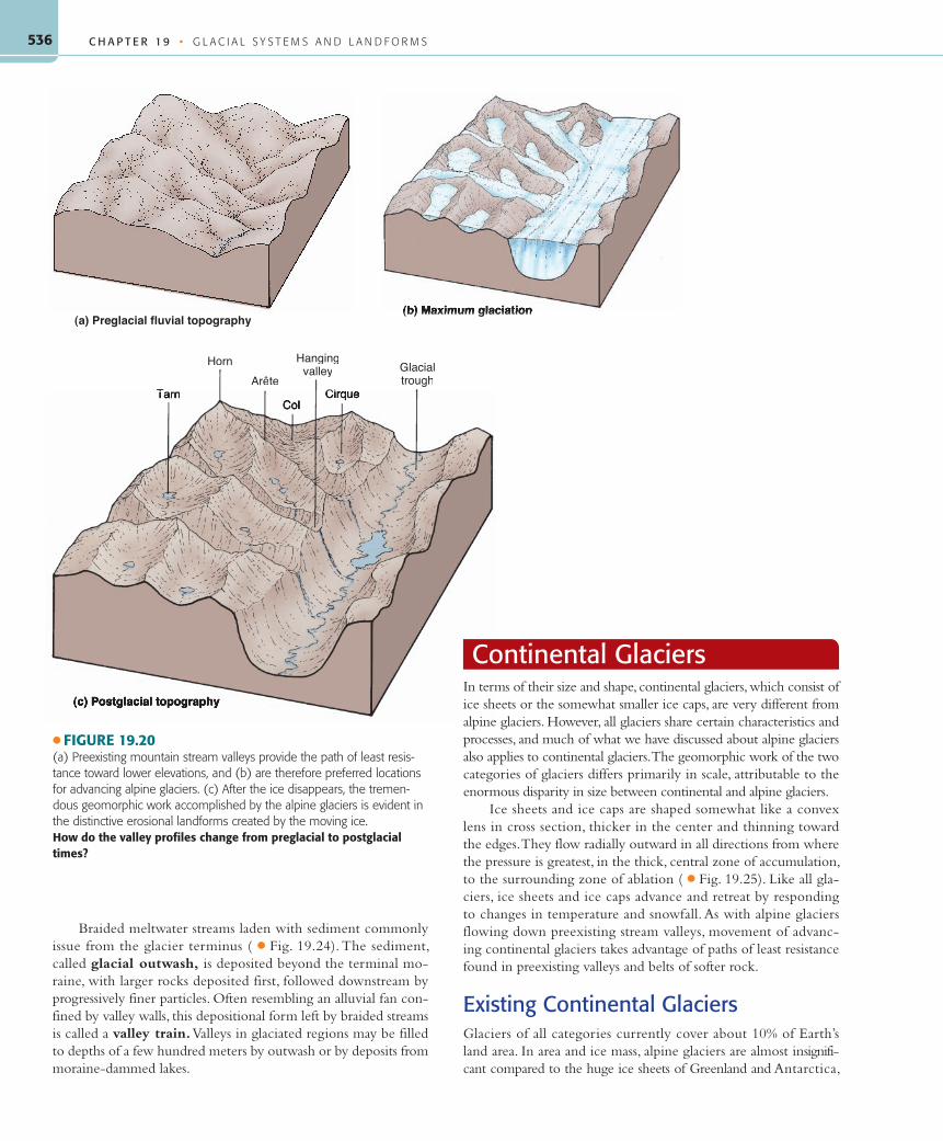
CHAPTER 19 • GLACIAL SYSTEMS AND LANDFORMS 536 (a) Preglacial fluvial topography (b) Maximum glaciation Tarn Horn Hanging valley Ci Glacial trough Arête Braided meltwater streams laden with sediment commonly issue from the glacier terminus ( ● Fig. 19.24). The sediment, called glacial outwash, is deposited beyond the terminal mo- raine, with larger rocks deposited first, followed downstream by progressively finer particles. Often resembling an alluvial fan con- fined by valley walls, this depositional form left by braided streams is called a valley train. Valleys in glaciated regions may be filled to depths of a few hundred meters by outwash or by deposits from moraine-dammed lakes. Continental Glaciers In terms of their size and shape, continental glaciers, which consist of ice sheets or the somewhat smaller ice caps, are very different from alpine glaciers. However, all glaciers share certain characteristics and processes, and much of what we have discussed about alpine glaciers also applies to continental glaciers.The geomorphic work of the two categories of glaciers differs primarily in scale, attributable to the enormous disparity in size between continental and alpine glaciers. Ice sheets and ice caps are shaped somewhat like a convex lens in cross section, thicker in the center and thinning toward the edges.They flow radially outward in all directions from where the pressure is greatest, in the thick, central zone of accumulation, to the surrounding zone of ablation ( ● Fig. 19.25). Like all gla- ciers, ice sheets and ice caps advance and retreat by responding to changes in temperature and snowfall. As with alpine glaciers flowing down preexisting stream valleys, movement of advanc- ing continental glaciers takes advantage of paths of least resistance found in preexisting valleys and belts of softer rock. Existing Continental Glaciers Glaciers of all categories currently cover about 10% of Earth’s land area. In area and ice mass, alpine glaciers are almost insignifi- cant compared to the huge ice sheets of Greenland and Antarctica, ● FIGURE 19.20 (a) Preexisting mountain stream valleys provide the path of least resis- tance toward lower elevations, and (b) are therefore preferred locations for advancing alpine glaciers. (c) After the ice disappears, the tremen- dous geomorphic work accomplished by the alpine glaciers is evident in the distinctive erosional landforms created by the moving ice. How do the valley profiles change from preglacial to postglacial times?
Transcript
C H A P T E R 1 9 • G L A C I A L S Y S T E M S A N D L A N D F O R M S536
(a) Preglacial fluvial topography(b) Maximum glaciation
Tarn
Horn Hangingvalley
Ci
GlacialtroughArête
Braided meltwater streams laden with sediment commonly issue from the glacier terminus ( ● Fig. 19.24). The sediment, called glacial outwash, is deposited beyond the terminal mo-raine, with larger rocks deposited first, followed downstream by progressively finer particles. Often resembling an alluvial fan con-fined by valley walls, this depositional form left by braided streams is called a valley train. Valleys in glaciated regions may be filled to depths of a few hundred meters by outwash or by deposits from moraine-dammed lakes.
Continental GlaciersIn terms of their size and shape, continental glaciers, which consist of ice sheets or the somewhat smaller ice caps, are very different from alpine glaciers. However, all glaciers share certain characteristics and processes, and much of what we have discussed about alpine glaciers also applies to continental glaciers. The geomorphic work of the two categories of glaciers differs primarily in scale, attributable to the enormous disparity in size between continental and alpine glaciers.
Ice sheets and ice caps are shaped somewhat like a convex lens in cross section, thicker in the center and thinning toward the edges. They flow radially outward in all directions from where the pressure is greatest, in the thick, central zone of accumulation, to the surrounding zone of ablation ( ● Fig. 19.25). Like all gla-ciers, ice sheets and ice caps advance and retreat by responding to changes in temperature and snowfall. As with alpine glaciers flowing down preexisting stream valleys, movement of advanc-ing continental glaciers takes advantage of paths of least resistance found in preexisting valleys and belts of softer rock.
Existing Continental GlaciersGlaciers of all categories currently cover about 10% of Earth’s land area. In area and ice mass, alpine glaciers are almost insignifi-cant compared to the huge ice sheets of Greenland and Antarctica,
● FIGURE 19.20(a) Preexisting mountain stream valleys provide the path of least resis-tance toward lower elevations, and (b) are therefore preferred locations for advancing alpine glaciers. (c) After the ice disappears, the tremen-dous geomorphic work accomplished by the alpine glaciers is evident in the distinctive erosional landforms created by the moving ice.How do the valley profiles change from preglacial to postglacial times?
which account for 96% of the area occupied by glaciers today. Ice caps currently exist in Iceland, on the arctic islands of Canada and Russia, in Alaska, and in the Canadian Rockies.
The Greenland ice sheet covers the world’s largest island with a glacier that is more than 3 kilometers (2 mi) thick in the center.
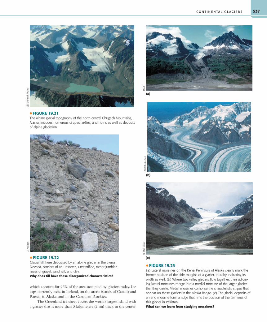
● FIGURE 19.21The alpine glacial topography of the north-central Chugach Mountains, Alaska, includes numerous cirques, arêtes, and horns as well as deposits of alpine glaciation.
USGS
/Bru
ce F.
Mol
nia
● FIGURE 19.22Glacial till, here deposited by an alpine glacier in the Sierra Nevada, consists of an unsorted, unstratified, rather jumbled mass of gravel, sand, silt, and clay.Why does till have these disorganized characteristics?
J. P
eter
sen
(c)
(a)
(b)
● FIGURE 19.23(a) Lateral moraines on the Kenai Peninsula of Alaska clearly mark the former position of the side margins of a glacier, thereby indicating its width as well. (b) Where two valley glaciers flow together, their adjoin-ing lateral moraines merge into a medial moraine of the larger glacier that they create. Medial moraines comprise the characteristic stripes that ap pear on these glaciers in the Alaska Range. (c) The glacial deposits of an end moraine form a ridge that rims the position of the terminus of this glacier in Pakistan.What can we learn from studying moraines?
C H A P T E R 1 9 • G L A C I A L S Y S T E M S A N D L A N D F O R M S538
The only land exposed in Greenland is a narrow, mountainous coastal strip ( ● Fig. 19.26). Where the ice reaches the ocean, it usually does so through fjords. These flows of ice to the sea re-semble alpine glaciers and are called outlet glaciers. The action of waves and tides on the outlet glaciers breaks off huge ice masses that float away. The resulting icebergs are a hazard to vessels in the North Atlantic shipping lanes south of Greenland. Tragic maritime disasters, such as the sinking of the Titanic, have been caused by collisions with these large irregular chunks of ice, which are nine-tenths submerged and thus mostly invisible to ships. Today, with iceberg tracking by radar, satellites, and the ships and aircraft of the International Ice Patrol, these sea disasters are minimized.
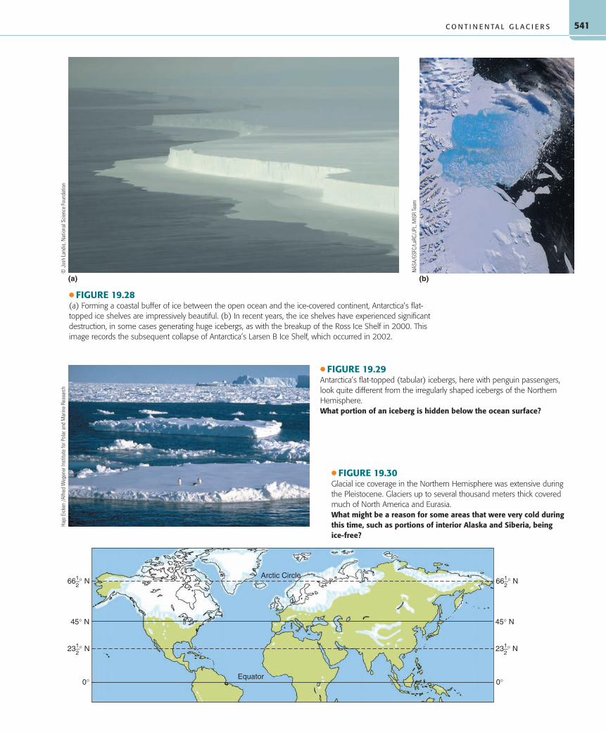
The Antarctic ice sheet covers some 13 million square kilo-meters (5 million sq mi), almost 7.5 times the area of the Green-land ice sheet ( ● Fig. 19.27). As in Greenland, little land is ex-posed in Antarctica, and the weight of the 4.5-kilometer- (nearly 3 mi) thick ice in some interior areas has depressed the land well below sea level. Where the ice reaches the sea, it contributes to the ice shelves, enormous flat-topped plates of ice attached to land along at least one side ( ● Fig. 19.28). These ice shelves are the source of icebergs in Antarctic waters, which do not have the irregular surface form of Greenland’s icebergs. Because they do
not float into heavily used shipping lanes, these extensive tabular-shaped Antarctic icebergs are not as much of a hazard to navigation ( ● Fig. 19.29). They do, however, add to the problem of access to Antarctica for scientists. The huge wall of the ice shelf itself, the massive, broken-up sea ice, and the extreme climate combine to make Antarctica inaccessible to all but the hardiest individuals and equipment. This icy continent serves, however, as a natural labora-tory for scientists from many countries to study Antarctic glaciol-ogy, climatology, and ecology.
Pleistocene GlaciationThe Pleistocene Epoch of geologic time was an interval of great climate change that began about 2.4 million years ago and ended around 10,000 years before the present. There were a great number of glacial fluctuations during the Pleistocene, marked by numerous major advances and retreats of ice over large portions of the world’s landmasses. It is a common miscon-ception that the continental ice sheets originated, and remain thickest, at the poles. When the Pleistocene glaciers advanced, ice spread outward from centers in Canada, Scandinavia, and eastern Siberia, as well as Greenland and Antarctica, while al-pine glaciers spread to lower elevations. At their maximum ex-tent in the Pleistocene, glaciers covered nearly a third of Earth’s land surface ( ● Fig. 19.30). At the same time, the extent of sea ice (frozen sea water) expanded equatorward. In the Northern Hemisphere, sea ice was present along coasts as far south as Del-aware in North America and Spain in Europe. Between each glacial advance, a warmer time called an interglacial occurred, during which the enormous continental ice sheets, ice caps, and sea ice retreated and almost completely disappeared. Stud-ies of glacial deposits and landforms have revealed that within each major glacial advance, many minor retreats and advances occurred, reflecting smaller changes in global temperature and precipitation. During each advance of the ice sheets, alpine glaciers were much more numerous, extensive, and massive in highland areas than they are today, but their total extent was still dwarfed by that of the continental glaciers.
North America and Eurasia experienced major glacial ex-pansion during the Pleistocene. In North America, ice sheets ex-tended as far south as the Missouri and Ohio Rivers and covered nearly all of Canada and much of the northern Great Plains, the Midwest, and the northeastern United States. In New England, the ice was thick enough to overrun the highest mountains, in-cluding Mount Washington, which has an elevation of 2063 me-ters (6288 ft). The ice was more than 2000 meters (6500 ft) thick in the Great Lakes region. In Europe, glaciers spread over most of what is now Great Britain, Ireland, Scandinavia, northern Germany, Poland, and western Russia. The weight of the ice depressed the land surface several hundred meters. As the ice receded, the land rose by isostatic rebound. Measurable isostatic rebound still raises elevations in parts of Sweden, Canada, and eastern Siberia by up to 2 centimeters (1 in.) per year and it may cause Hudson Bay and the Baltic Sea to emerge someday above sea level. Should Green-land and Antarctica lose their ice sheets, their depressed central land areas would also rise to reach isostatic balance.
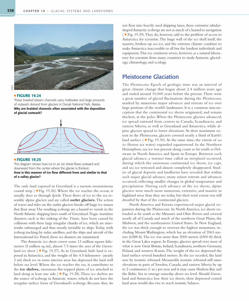
● FIGURE 19.24These braided stream channels carry meltwater and large amounts of outwash derived from glaciers in Denali National Park, Alaska.Why are braided channels often associated with the deposition of glacial outwash?
USGS
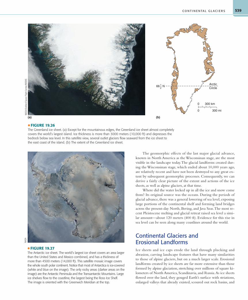
● FIGURE 19.25This diagram shows how ice in an ice sheet flows outward and downward from the center where the glacier is thickest.How is this manner of ice flow different from and similar to that of a valley glacier?
The geomorphic effects of the last major glacial advance, known in North America as the Wisconsinan stage, are the most visible in the landscape today. The glacial landforms created dur-ing the Wisconsinan stage, which ended about 10,000 years ago, are relatively recent and have not been destroyed to any great ex-tent by subsequent geomorphic processes. Consequently, we can derive a fairly clear picture of the extent and actions of the ice sheets, as well as alpine glaciers, at that time.
Where did the water locked up in all the ice and snow come from? Its original source was the oceans. During the periods of glacial advance, there was a general lowering of sea level, exposing large portions of the continental shelf and forming land bridges across the present-day North, Bering, and Java Seas. The most re-cent Pleistocene melting and glacial retreat raised sea level a simi-lar amount—about 120 meters (400 ft). Evidence for this rise in sea level can be seen along many coastlines around the world.
Continental Glaciers and Erosional LandformsIce sheets and ice caps erode the land through plucking and abrasion, carving landscape features that have many similarities to those of alpine glaciers, but on a much larger scale. Erosional landforms created by ice sheets are far more extensive than those formed by alpine glaciation, stretching over millions of square ki-lometers of North America, Scandinavia, and Russia. As ice sheets flowed over the land, they gouged Earth’s surface with striations, enlarged valleys that already existed, scoured out rock basins, and
● FIGURE 19.27The Antarctic ice sheet. The world’s largest ice sheet covers an area larger than the United States and Mexico combined, and has a thickness of more than 4500 meters (14,000 ft). This satellite mosaic image covers the whole south polar continent. Notice that most of Antarctica is ice-covered (white and blue on the image). The only rocky areas (darker areas on the image) are the Antarctic Peninsula and the Transantarctic Mountains. Large ice shelves flow to the coastline, the largest being the Ross Ice Shelf. The image is oriented with the Greenwich Meridian at the top.
NAS
A
● FIGURE 19.26The Greenland ice sheet. (a) Except for the mountainous edges, the Greenland ice sheet almost completely covers the world’s largest island. Ice thickness is more than 3000 meters (10,000 ft) and depresses the bedrock below sea level. In this satellite view, several outlet glaciers flow seaward from the ice sheet to the east coast of the island. (b) The extent of the Greenland ice sheet.
C H A P T E R 1 9 • G L A C I A L S Y S T E M S A N D L A N D F O R M S540
G E O G R A P H Y ’ S S P A T I A L S C I E N C E P E R S P E C T I V E
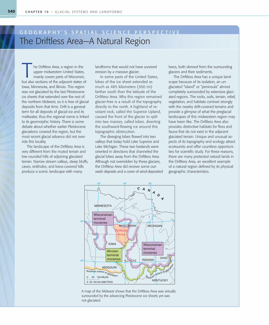
The Driftless Area—A Natural Region
he Driftless Area, a region in the upper midwestern United States, mainly covers parts of Wisconsin,
but also sections of the adjacent states of Iowa, Minnesota, and Illinois. This region was not glaciated by the last Pleistocene ice sheets that extended over the rest of the northern Midwest, so it is free of glacial deposits from that time. Drift is a general term for all deposits of glacial ice and its meltwater, thus the regional name is linked to its geomorphic history. There is some debate about whether earlier Pleistocene glaciations covered the region, but the most recent glacial advance did not over-ride this locality.
The landscape of the Driftless Area is very different from the muted terrain and low rounded hills of adjoining glaciated terrain. Narrow stream valleys, steep bluffs, caves, sinkholes, and loess-covered hills produce a scenic landscape with many
landforms that would not have survived erosion by a massive glacier.
In some parts of the United States, lobes of the ice sheet extended as much as 485 kilometers (300 mi) farther south than the latitude of the Driftless Area. Why this region remained glacier-free is a result of the topography directly to the north. A highland of re-sistant rock, called the Superior Upland, caused the front of the glacier to split into two masses, called lobes, diverting the southward-flowing ice around this topographic obstruction.
The diverging lobes flowed into two valleys that today hold Lake Superior and Lake Michigan. These two lowlands were oriented in directions that channeled the glacial lobes away from the Driftless Area. Although not overridden by these glaciers, the Driftless Area did receive some out-wash deposits and a cover of wind-deposited
loess, both derived from the surrounding glaciers and their sediments.
The Driftless Area has a unique land-scape because of its isolation, an un-glaciated “island” or “peninsula” almost completely surrounded by extensive glaci-ated regions. The rocks, soils, terrain, relief, vegetation, and habitats contrast strongly with the nearby drift-covered terrains and provide a glimpse of what the preglacial landscapes of this midwestern region may have been like. The Driftless Area also provides distinctive habitats for flora and fauna that do not exist in the adjacent glaciated terrain. Unique and unusual as-pects of its topography and ecology attract ecotourists and offer countless opportuni-ties for scientific study. For these reasons, there are many protected natural lands in the Driftless Area, an excellent example of a natural region defined by its physical geographic characteristics.
MINNESOTA
IOWA
INDIANAOHIO
KENTUCKY
MISSOURI
ILLINOISILLINOISILLINOIS
WISCONSIN MICHIGAN
C A N AD
A
0
0 100 KILOMETERS
50 100 MILES
50
So u t hernextent of glacia
tion
Southern extent of glaciation
95°
45°
40°
90° 85°
Wisconsinanterminalmoraines
Illinoianterminalmoraines
Wisconsinanterminalmoraines
DriftlessArea
A map of the Midwest shows that the Driftless Area was virtually surrounded by the advancing Pleistocene ice sheets yet was not glaciated.
● FIGURE 19.29Antarctica’s flat-topped (tabular) icebergs, here with penguin passengers, look quite different from the irregularly shaped icebergs of the Northern Hemisphere.What portion of an iceberg is hidden below the ocean surface?
Hajo
Eic
ken
/Alfr
ed W
egen
er In
stitu
te fo
r Pol
ar a
nd M
arin
e Re
sear
ch
(b)(a)
● FIGURE 19.28(a) Forming a coastal buffer of ice between the open ocean and the ice-covered continent, Antarctica’s flat-topped ice shelves are impressively beautiful. (b) In recent years, the ice shelves have experienced significant destruction, in some cases generating huge icebergs, as with the breakup of the Ross Ice Shelf in 2000. This image records the subsequent collapse of Antarctica’s Larsen B Ice Shelf, which occurred in 2002.
● FIGURE 19.30Glacial ice coverage in the Northern Hemisphere was extensive during the Pleistocene. Glaciers up to several thousand meters thick covered much of North America and Eurasia.What might be a reason for some areas that were very cold during this time, such as portions of interior Alaska and Siberia, being ice-free?
C H A P T E R 1 9 • G L A C I A L S Y S T E M S A N D L A N D F O R M S542
smoothed off existing hills. The ice sheets removed most of the soil and then eroded the bedrock below. Today, these ice-scoured plains are areas of low, rounded hills, lake-filled depressions, and wide exposures of bedrock ( ● Fig. 19.31).
When ice sheets expand, they cover and totally disrupt the former stream patterns. Because the last glaciation was so recent in terms of landscape development, new drainage systems have not had time to form a well-integrated system of stream chan-nels. In addition to large expanses of exposed gouged bedrock, ice-scoured plains are characterized by extensive areas of standing water, including lakes, marshes, and muskeg (poorly drained areas grown over with vegetation that form in cold climates).
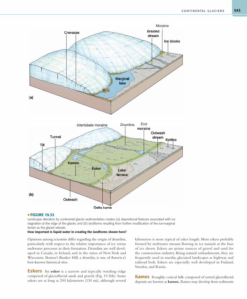
Continental Glaciers and Depositional LandformsThe sheer disparity in scale causes depositional landforms of ice sheets and ice caps to differ from those of alpine glaciers. Al-though terminal and recessional moraines, ground moraines, and glaciofluvial deposits are produced by both categories of glaciers, retreating continental glaciers leave significantly more extensive versions of these features than alpine glaciers do ( ● Fig. 19.32 and Map Interpretation: Continental Glaciation).
End Moraines Terminal and recessional end moraines de-posited by Pleistocene ice sheets comprise substantial belts of low hills and ridges on the land in areas affected by continental
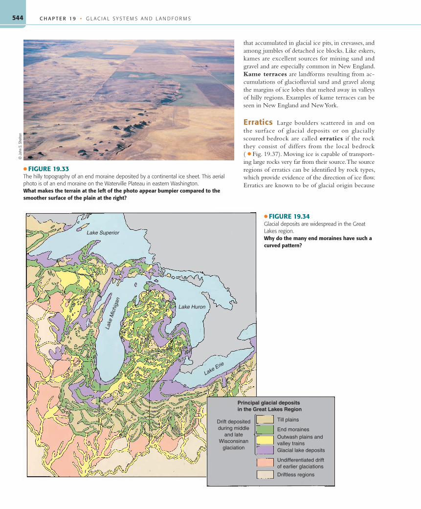
glaciation. These landforms generally range up to about 60 meters (200 ft) in height ( ● Fig. 19.33). The last major Pleistocene glacial advance through New England left its terminal moraine running the length of New York’s Long Island and created the offshore islands of Martha’s Vineyard and Nantucket, Massachusetts. Gla-cial retreat left recessional moraines forming both Cape Cod and the rounded southern end of Lake Michigan. Both types of end moraine are usually arc-shaped and convex toward the direc-tion of ice flow. Their pattern and placement indicate that the ice sheets did not maintain an even front but spread out in tongue-shaped lobes channeled by the underlying terrain ( ● Fig. 19.34). The positions of terminal and recessional moraines provide more evidence than simply the direction of ice flow. Examining the characteristics of deposited materials helps us detect the sequence of advances and retreats of each successive ice sheet.
Till Plains In the zone of ice sheet deposition, massive amounts of poorly sorted glacial till accumulated, often to depths of 30 meters (100 ft) or more to form till plains. Because of the uneven nature of deposition from the wasting ice, the topographic configuration of land covered by till varies from place to place. In some areas, the till is too thin to hide the original contours of the land, while in other regions, thick deposits of till make broad, rolling plains of low relief. Small hills and slight depressions, some filled with water, characterize most till plains, reflecting the un-even glacial deposition. Some of the best agricultural land of the United States is found on the gently rolling till plains of Illinois and Iowa. The young, dark-colored, grassland soils (mostly mol-lisols) that developed on the till are extremely fertile.
Outwash Plains Beyond the belts of hills that represent terminal and recessional moraines lie outwash plains composed of meltwater deposits. These extensive areas of relatively low re-lief consist of glaciofluvial deposits that were sorted as they were transported by meltwater from the ice sheets. Outwash plains, which may cover hundreds of square kilometers, are analogous to the valley trains of alpine glaciers.
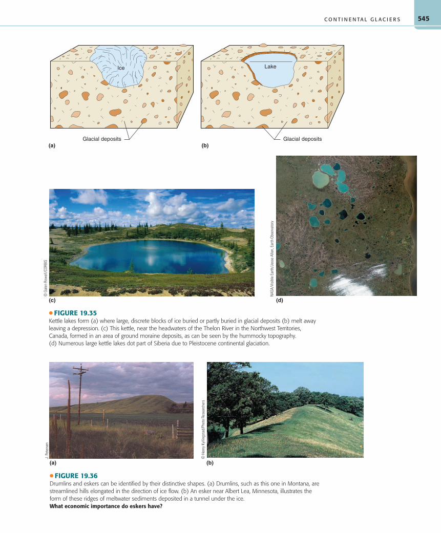
Small depressions or pits, called kettles, mark some outwash plains, till plains, and moraines. Kettles represent places where blocks of ice were originally buried in glacial deposits. When the blocks of ice eventually melted, they left surface depressions, and many kettles now contain kettle lakes ( ● Fig. 19.35). For ex-ample, most of Minnesota’s famous 10,000 lakes are kettle lakes. Some kettles occur in association with alpine glacial deposits, but the vast majority are found in landscapes that were occupied by ice sheets or ice caps.
Drumlins A drumlin is a streamlined hill, often about 0.5 kilometer (0.3 mi) in length and less than 50 meters (160 ft) high, molded in glacial drift on till plains ( ● Fig. 19.36a). The most conspicuous feature of drumlins is the elongated, stream-lined shape that resembles half an egg or the convex side of a tea-spoon. The broad, steep end faces in the up-ice direction, while the gently sloping tapered end points in the direction that the ice flowed; thus the geometry of a drumlin is the reverse of that of roches moutonnées. Drumlins are usually found in swarms, called drumlin fields, with as many as a hundred or more clustered together.
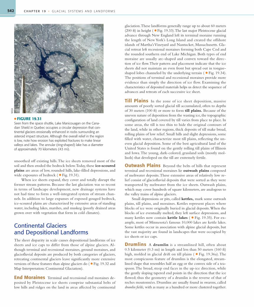
● FIGURE 19.31Seen from the space shuttle, Lake Manicouagan on the Cana-dian Shield in Quebec occupies a circular depression that con-tinental glaciers erosionally enhanced in rocks surrounding an asteroid impact structure. Although the overall relief in the region is low, note how erosion has exploited fractures to make linear valleys and lakes. The annular (ring-shaped) lake has a diameter of approximately 70 kilometers (43 mi).
Opinions among scientists differ regarding the origin of drumlins, particularly with respect to the relative importance of ice versus meltwater processes in their formation. Drumlins are well devel-oped in Canada, in Ireland, and in the states of New York and Wisconsin. Boston’s Bunker Hill, a drumlin, is one of America’s best-known historical sites.
Eskers An esker is a narrow and typically winding ridge composed of glaciofluvial sands and gravels (Fig. 19.36b). Some eskers are as long as 200 kilometers (130 mi), although several
kilometers is more typical of esker length. Most eskers probably formed by meltwater streams flowing in ice tunnels at the base of ice sheets. Eskers are prime sources of gravel and sand for the construction industry. Being natural embankments, they are frequently used in marshy, glaciated landscapes as highway and railroad beds. Eskers are especially well developed in Finland, Sweden, and Russia.
Kames Roughly conical hills composed of sorted glaciofluvial deposits are known as kames. Kames may develop from sediments
● FIGURE 19.32Landscape alteration by continental glacier sedimentation creates (a) depositional features associated with ice stagnation at the edge of the glacier, and (b) landforms resulting from further modification of the ice-marginal terrain as the glacier retreats.How important is liquid water in creating the landforms shown here?
C H A P T E R 1 9 • G L A C I A L S Y S T E M S A N D L A N D F O R M S544
that accumulated in glacial ice pits, in crevasses, and among jumbles of detached ice blocks. Like eskers, kames are excellent sources for mining sand and gravel and are especially common in New England. Kame terraces are landforms resulting from ac-cumulations of glaciofluvial sand and gravel along the margins of ice lobes that melted away in valleys of hilly regions. Examples of kame terraces can be seen in New England and New York.
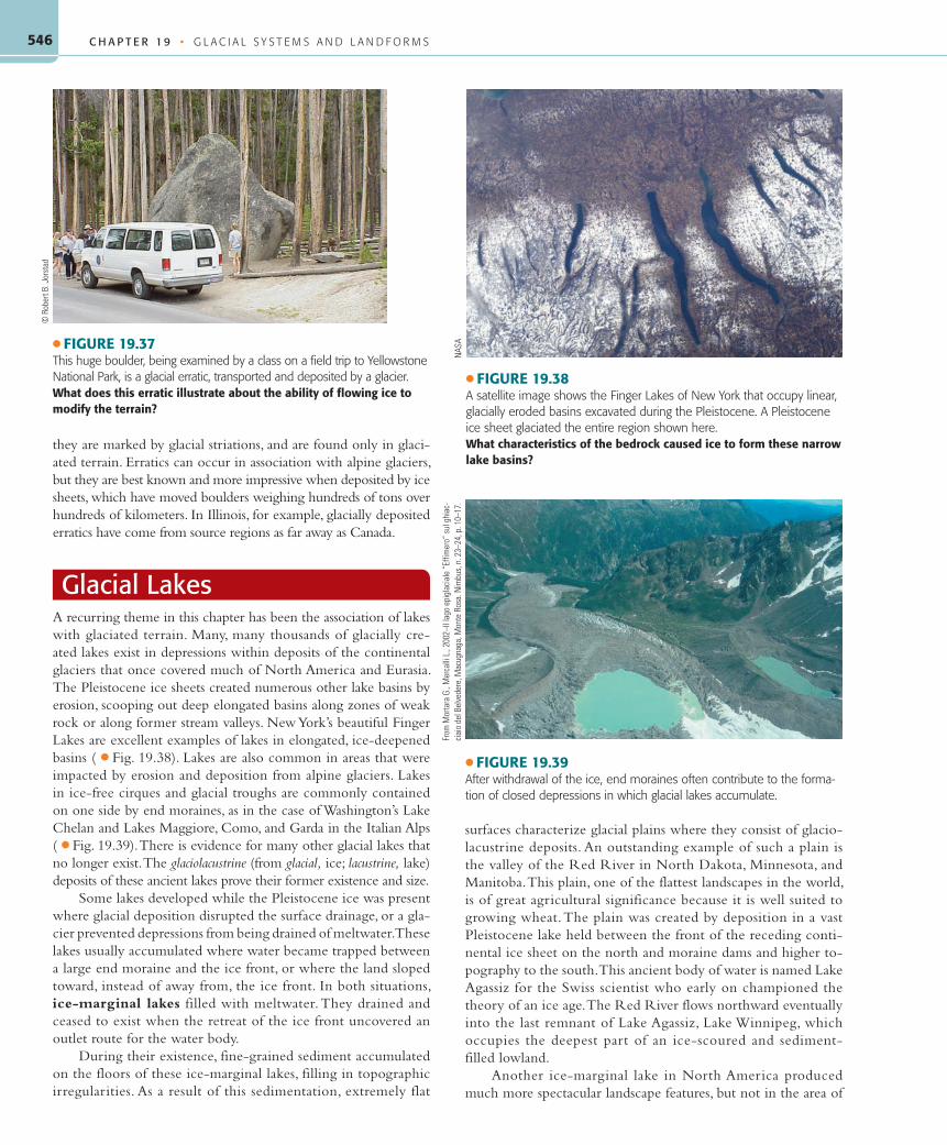
Erratics Large boulders scattered in and on the surface of glacial deposits or on glacially scoured bedrock are called erratics if the rock they consist of differs from the local bedrock ( ● Fig. 19.37). Moving ice is capable of transport-ing large rocks very far from their source. The source regions of erratics can be identified by rock types, which provide evidence of the direction of ice flow. Erratics are known to be of glacial origin because
● FIGURE 19.33The hilly topography of an end moraine deposited by a continental ice sheet. This aerial photo is of an end moraine on the Waterville Plateau in eastern Washington.What makes the terrain at the left of the photo appear bumpier compared to the smoother surface of the plain at the right?
● FIGURE 19.35Kettle lakes form (a) where large, discrete blocks of ice buried or partly buried in glacial deposits (b) melt away leaving a depression. (c) This kettle, near the headwaters of the Thelon River in the Northwest Territories, Canada, formed in an area of ground moraine deposits, as can be seen by the hummocky topography. (d) Numerous large kettle lakes dot part of Siberia due to Pleistocene continental glaciation.
(a) (b)
● FIGURE 19.36Drumlins and eskers can be identified by their distinctive shapes. (a) Drumlins, such as this one in Montana, are streamlined hills elongated in the direction of ice flow. (b) An esker near Albert Lea, Minnesota, illustrates the form of these ridges of meltwater sediments deposited in a tunnel under the ice.What economic importance do eskers have?
C H A P T E R 1 9 • G L A C I A L S Y S T E M S A N D L A N D F O R M S546
they are marked by glacial striations, and are found only in glaci-ated terrain. Erratics can occur in association with alpine glaciers, but they are best known and more impressive when deposited by ice sheets, which have moved boulders weighing hundreds of tons over hundreds of kilometers. In Illinois, for example, glacially deposited erratics have come from source regions as far away as Canada.
Glacial LakesA recurring theme in this chapter has been the association of lakes with glaciated terrain. Many, many thousands of glacially cre-ated lakes exist in depressions within deposits of the continental glaciers that once covered much of North America and Eurasia. The Pleistocene ice sheets created numerous other lake basins by erosion, scooping out deep elongated basins along zones of weak rock or along former stream valleys. New York’s beautiful Finger Lakes are excellent examples of lakes in elongated, ice-deepened basins ( ● Fig. 19.38). Lakes are also common in areas that were impacted by erosion and deposition from alpine glaciers. Lakes in ice-free cirques and glacial troughs are commonly contained on one side by end moraines, as in the case of Washington’s Lake Chelan and Lakes Maggiore, Como, and Garda in the Italian Alps ( ● Fig. 19.39). There is evidence for many other glacial lakes that no longer exist. The glaciolacustrine (from glacial, ice; lacustrine, lake) deposits of these ancient lakes prove their former existence and size.
Some lakes developed while the Pleistocene ice was present where glacial deposition disrupted the surface drainage, or a gla-cier prevented depressions from being drained of meltwater. These lakes usually accumulated where water became trapped between a large end moraine and the ice front, or where the land sloped toward, instead of away from, the ice front. In both situations, ice-marginal lakes filled with meltwater. They drained and ceased to exist when the retreat of the ice front uncovered an outlet route for the water body.
During their existence, fine-grained sediment accumulated on the floors of these ice-marginal lakes, filling in topographic irregularities. As a result of this sedimentation, extremely flat
surfaces characterize glacial plains where they consist of glacio-lacustrine deposits. An outstanding example of such a plain is the valley of the Red River in North Dakota, Minnesota, and Manitoba. This plain, one of the flattest landscapes in the world, is of great agricultural significance because it is well suited to growing wheat. The plain was created by deposition in a vast Pleistocene lake held between the front of the receding conti-nental ice sheet on the north and moraine dams and higher to-pography to the south. This ancient body of water is named Lake Agassiz for the Swiss scientist who early on championed the theory of an ice age. The Red River flows northward eventually into the last remnant of Lake Agassiz, Lake Winnipeg, which occupies the deepest part of an ice-scoured and sediment-filled lowland.
Another ice-marginal lake in North America produced much more spectacular landscape features, but not in the area of
● FIGURE 19.37This huge boulder, being examined by a class on a field trip to Yellowstone National Park, is a glacial erratic, transported and deposited by a glacier.What does this erratic illustrate about the ability of flowing ice to modify the terrain?
● FIGURE 19.38A satellite image shows the Finger Lakes of New York that occupy linear, glacially eroded basins excavated during the Pleistocene. A Pleistocene ice sheet glaciated the entire region shown here.What characteristics of the bedrock caused ice to form these narrow lake basins?
NAS
A
● FIGURE 19.39After withdrawal of the ice, end moraines often contribute to the forma-tion of closed depressions in which glacial lakes accumulate.
(d) Postglacial Great Lakes(c) Glacial retreat (post-Valderan)
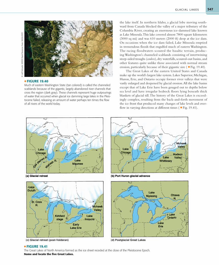
● FIGURE 19.41The Great Lakes of North America formed as the ice sheet receded at the close of the Pleistocene Epoch.Name and locate the five Great Lakes.
the lake itself. In northern Idaho, a glacial lobe moving south-ward from Canada blocked the valley of a major tributary of the Columbia River, creating an enormous ice-dammed lake known as Lake Missoula. This lake covered almost 7800 square kilometers (3000 sq mi) and was 610 meters (2000 ft) deep at the ice dam. On occasions when the ice dam failed, Lake Missoula emptied in tremendous floods that engulfed much of eastern Washington. The racing floodwaters scoured the basaltic terrain, produc-ing Washington’s channeled scablands consisting of intertwining steep-sided troughs (coulees), dry waterfalls, scoured-out basins, and other features quite unlike those associated with normal stream erosion, particularly because of their gigantic size ( ● Fig. 19.40).
The Great Lakes of the eastern United States and Canada make up the world’s largest lake system. Lakes Superior, Michigan, Huron, Erie, and Ontario occupy former river valleys that were vastly enlarged and deepened by glacial erosion. All the lake basins except that of Lake Erie have been gouged out to depths below sea level and have irregular bedrock floors lying beneath thick blankets of glacial till. The history of the Great Lakes is exceed-ingly complex, resulting from the back-and-forth movement of the ice front that produced many changes of lake levels and over-flow in varying directions at different times ( ● Fig. 19.41).
● FIGURE 19.40Much of eastern Washington State (tan colored) is called the channeled scablands because of the gigantic, largely abandoned river channels that cross the region (dark gray). These channels represent huge outpourings of water that occurred when glacial ice damming large lakes in the Pleis-tocene failed, releasing an amount of water perhaps ten times the flow of all rivers of the world today.