Taira, A., Hill, I., Firth, J., et al., 1991 Proceedings of the Ocean Drilling Program, Initial Reports, Vol. 131 7. SEDIMENT DEFORMATION AND HYDROGEOLOGY AT THE NANKAI ACCRETIONARY PRISM: SYNTHESIS OF ODP LEG 131 SHIPBOARD RESULTS 1 Shipboard Scientific Party 2 ABSTRACT The Nankai accretionary prism is arguably the best-known clastic prism in the world. The main objective of ODP Leg 131 was to provide data on the deformational processes and associated hydrogeology of the prism. Such information can be incorporated into the existing geophysical and geological data set to characterize the evolution of sediments in this tectonic setting. The objective was approached by drilling Site 808, at which the frontal thrust and décollement of the prism toe were penetrated. Drilling also succeeded, for the first time in the history of ocean drilling, in penetrating the complete sedimentary sequence to basaltic basement, and with good core recovery. Both the frontal thrust and the décollement were clearly recognizable in the cored material. Bedding dips, faults, and shear bands analyzed in the cores confirm the pattern of deformation to be mainly due to northwest-southeast shortening. Below the décollement no significant deformation features were observed. Physical properties data show major discontinuities at the décollement, notably an increase in porosity below the décollement. This might indicate excess pore pressure in the subducted section. An increase in porosity below the frontal thrust is less marked and might reflect only the youthfulness of this feature. Attempts to make downhole measurements were severely hampered by unstable hole conditions, but useful constraints have been placed on the thermal regime, some calibration of laboratory physical properties to in-situ conditions has been provided, and in-situ stress and pore pressure were measured in the uppermost sediments. Evidence of channelized fluid flow is inconclusive because no vein structures were observed in the cores, no unequivocal geochemical anomalies indicative of flow were found, and thermal measurements are not significantly different from those predicted by a purely conductive heat-flow model. We conclude that dewatering probably occurs mainly through diffuse flow at this site. INTRODUCTION The accretion of sediments in ocean trenches is an initial step in the process of mountain building and continental crustal growth. An understanding of the processes operating during accretion is thus of fundamental importance. These processes are an attractive target for drilling that allows both recovery of samples from depth, and in-situ measurements of physical parameters. At present, technical limitations restrict complete drilling penetration of a prism to the relatively thin sediments near the prism toe. The landward increase in complexity of the structures and processes also argues for initial concentration on the relative simplicity of the prism toe. There are three essential aspects that must be investigated. First, there should be a mechanical model that relates the geological structures to the stress fields producing them, and to the physical properties of the deforming sediments. Sec- ond, a hydrological model should relate the compaction and dewatering of the sediment to the flow patterns constrained by bulk permeability or channeled flow. Finally, a geochemical model should relate the diagenetic changes in the sediments to pore-water interaction and the thermal regime. These three models are heavily interdependent and must be developed within an interdisciplinary program. Leg 110 investigated a clay-dominated prism, while in contrast Leg 131 targeted a clastic-dominated prism. The Nankai Trough was considered one of the best places to target a clastic prism because (1) substantial site survey data exist, including excellent images of the thrust structures by seismic profiling (Nasu et al., 1982; Aoki et al., 1982; Kato et al., 1983; Moore et al., 1990); (2) the décollement (detachment zone) is 1 Taira, A., Hill, I., Firth, J., et al., 1991. Proc. ODP, Init. Repts., 131: College Station, TX (Ocean Drilling Program). Shipboard Scientific Party is as given in the list of participants preceding the contents. relatively shallow (ca. 1000 m) and can be penetrated with present drilling technology; (3) the trench sediments are sandy turbidites that are typical of most ancient accretionary prisms (e.g., Shimanto Belt, Taira et al., 1988a, 1988b; Southern Upland, Leggett et al., 1982); (4) large heat flow in the trough indicates a steep thermal gradient and extensive diagenetic alteration; and (5) an almost direct ancient analog is exposed on land (the Shimanto accretionary prism), providing an opportunity for comparative study. This paper summarizes the data obtained on Leg 131 and discusses the implications for the development of models of prism processes. The regional tectonic structure is reviewed, the scientific results of the shipboard measurements are de- scribed, and the relationship of the specific structures encoun- tered at Site 808 to this regional setting are explained. Our discussion centers around the relevance of these new data to the processes indicated above. BACKGROUND Tectonic Setting of the Nankai Trough The arc-trench system of southwest Japan shows unique characteristics that can be summarized as follows (see sum- mary by Shiono, 1988; Niitsuma, 1988; and Taira et al., 1989): 1. The Wadati-Benioflf Zone extends only to a depth of 50 km. 2. Volcanic activity has been scarce since middle Miocene. 3. There is anomalously large heat flow within the forearc region. 4. The trench (Nankai Trough) is shallow and rarely exceeds 4900 m. 5. The entire arc basement and forearc region are com- posed of accreted material. The first three characteristics are closely related to the age and history of the subducted oceanic lithosphere, that of the 273
Transcript
Taira, A., Hill, I., Firth, J., et al., 1991Proceedings of the Ocean Drilling Program, Initial Reports, Vol. 131
7. SEDIMENT DEFORMATION AND HYDROGEOLOGY AT THE NANKAI ACCRETIONARYPRISM: SYNTHESIS OF ODP LEG 131 SHIPBOARD RESULTS1
Shipboard Scientific Party2
ABSTRACT
The Nankai accretionary prism is arguably the best-known clastic prism in the world. The main objective of ODPLeg 131 was to provide data on the deformational processes and associated hydrogeology of the prism. Suchinformation can be incorporated into the existing geophysical and geological data set to characterize the evolutionof sediments in this tectonic setting. The objective was approached by drilling Site 808, at which the frontal thrustand décollement of the prism toe were penetrated. Drilling also succeeded, for the first time in the history of oceandrilling, in penetrating the complete sedimentary sequence to basaltic basement, and with good core recovery. Boththe frontal thrust and the décollement were clearly recognizable in the cored material. Bedding dips, faults, andshear bands analyzed in the cores confirm the pattern of deformation to be mainly due to northwest-southeastshortening. Below the décollement no significant deformation features were observed. Physical properties datashow major discontinuities at the décollement, notably an increase in porosity below the décollement. This mightindicate excess pore pressure in the subducted section. An increase in porosity below the frontal thrust is lessmarked and might reflect only the youthfulness of this feature. Attempts to make downhole measurements wereseverely hampered by unstable hole conditions, but useful constraints have been placed on the thermal regime, somecalibration of laboratory physical properties to in-situ conditions has been provided, and in-situ stress and porepressure were measured in the uppermost sediments. Evidence of channelized fluid flow is inconclusive because novein structures were observed in the cores, no unequivocal geochemical anomalies indicative of flow were found,and thermal measurements are not significantly different from those predicted by a purely conductive heat-flowmodel. We conclude that dewatering probably occurs mainly through diffuse flow at this site.
INTRODUCTION
The accretion of sediments in ocean trenches is an initialstep in the process of mountain building and continentalcrustal growth. An understanding of the processes operatingduring accretion is thus of fundamental importance. Theseprocesses are an attractive target for drilling that allows bothrecovery of samples from depth, and in-situ measurements ofphysical parameters. At present, technical limitations restrictcomplete drilling penetration of a prism to the relatively thinsediments near the prism toe. The landward increase incomplexity of the structures and processes also argues forinitial concentration on the relative simplicity of the prism toe.
There are three essential aspects that must be investigated.First, there should be a mechanical model that relates thegeological structures to the stress fields producing them, andto the physical properties of the deforming sediments. Sec-ond, a hydrological model should relate the compaction anddewatering of the sediment to the flow patterns constrained bybulk permeability or channeled flow. Finally, a geochemicalmodel should relate the diagenetic changes in the sediments topore-water interaction and the thermal regime. These threemodels are heavily interdependent and must be developedwithin an interdisciplinary program.
Leg 110 investigated a clay-dominated prism, while incontrast Leg 131 targeted a clastic-dominated prism. TheNankai Trough was considered one of the best places to targeta clastic prism because (1) substantial site survey data exist,including excellent images of the thrust structures by seismicprofiling (Nasu et al., 1982; Aoki et al., 1982; Kato et al., 1983;Moore et al., 1990); (2) the décollement (detachment zone) is
1 Taira, A., Hill, I., Firth, J., et al., 1991. Proc. ODP, Init. Repts., 131:College Station, TX (Ocean Drilling Program).
Shipboard Scientific Party is as given in the list of participants precedingthe contents.
relatively shallow (ca. 1000 m) and can be penetrated withpresent drilling technology; (3) the trench sediments are sandyturbidites that are typical of most ancient accretionary prisms(e.g., Shimanto Belt, Taira et al., 1988a, 1988b; SouthernUpland, Leggett et al., 1982); (4) large heat flow in the troughindicates a steep thermal gradient and extensive diageneticalteration; and (5) an almost direct ancient analog is exposedon land (the Shimanto accretionary prism), providing anopportunity for comparative study.
This paper summarizes the data obtained on Leg 131 anddiscusses the implications for the development of models ofprism processes. The regional tectonic structure is reviewed,the scientific results of the shipboard measurements are de-scribed, and the relationship of the specific structures encoun-tered at Site 808 to this regional setting are explained. Ourdiscussion centers around the relevance of these new data tothe processes indicated above.
BACKGROUND
Tectonic Setting of the Nankai TroughThe arc-trench system of southwest Japan shows unique
characteristics that can be summarized as follows (see sum-mary by Shiono, 1988; Niitsuma, 1988; and Taira et al., 1989):
1. The Wadati-Benioflf Zone extends only to a depth of 50km.
2. Volcanic activity has been scarce since middle Miocene.3. There is anomalously large heat flow within the forearc
region.4. The trench (Nankai Trough) is shallow and rarely
exceeds 4900 m.5. The entire arc basement and forearc region are com-
posed of accreted material.The first three characteristics are closely related to the age
and history of the subducted oceanic lithosphere, that of the
273
SHIPBOARD SCIENTIFIC PARTY
young, backarc Shikoku Basin. The fourth and fifth charac-teristics reflect the history of sediment input and accretion atthe trench. To understand these characteristics of the South-west Japan arc-trench system and the tectonic setting of theNankai Trough, it is necessary to review the geologic devel-opment of the arc.
The Japanese island arcs comprise five segments of themajor arc systems of the western Pacific: Kuril, northeastJapan, southwest Japan, Ryukyu, and Izu-Bonin (Izu-Ogasa-wara) arcs (Fig. 1 from Geological Background and Objectiveschapter). Two separate oceanic lithospheric plates, the PacificPlate and the Philippine Sea Plate, are being subducted atthese arcs. The junction of the northeast Japan, southwestJapan, and Izu-Bonin arcs is a consequence of arc-arc colli-sion producing a TTT triple junction. This complex arc-trencharchitecture is a product of dramatic Neogene tectonic evolu-tion. However, the basement geology of the islands can betraced back to the late Paleozoic.
The geology of the Japanese islands can be broadly classi-fied into three categories: Neogene cover sequence, igneousintrusives, extrusives of mostly Mesozoic and Cenozoic age,and basement rocks. Of these, only the basement rocks areconsidered here. The basement rocks mostly comprise a latePaleozoic to Cenozoic accretionary complex that shows var-ious degrees of metamorphism. These basement rocks arebest exposed in southwest Japan, where they display a longhistory of sediment accretion processes (Fig. 3 from Geolog-ical Background and Objectives chapter). The late Paleozoicand Jurassic prisms are mostly composed of thrust piles ofmelange and relatively coherent turbidite sequences. Themelange lithology includes various-sized tectonic slivers ofthe uppermost part of the oceanic crust (pillow lavas), sea-mount complex (pillow lavas and reef limestone), pelagicsequence (bedded radiolarian cherts and pelagic shale), andhemipelagic sequence, embedded in a scaly argillaceous ma-trix (Taira et al., 1989).
The youngest accretionary prism, which was formed at thecontinental margin of eastern Asia before the opening of theJapan Sea, is called the Shimanto Belt. This is also composedof thrust piles of turbidite sequence and melange (Taira et al.,1988a). The age of the Shimanto Belt ranges from Cretaceousto early Miocene, the younger part being exposed more to thePacific side of southwest Japan and shows a record of succes-sive accretion toward the present trench. The Shimanto Belthas been interpreted as offscraped packages of trench tur-bidites, bounded by melange belts that contain tectonic sliversof oceanic plate materials in a scaly argillaceous matrix.
Formation of the Shimanto Belt overlapped the start of theopening of the Shikoku Basin but preceded the opening of theSea of Japan, which more or less shaped the present config-uration of the island arc systems of the Japanese islands. TheShikoku Basin was formed as a backarc basin of the Izu-Boninarc primarily by east-west spreading (25 to 15 Ma), possiblyfollowed later (14 to 12 Ma) by more north-south trendingspreading. The basement topography in the central part of theShikoku Basin shows a north northwest-south southeast-trending topographic high and a chain of seamounts that runsapproximately parallel to the magnetic anomalies. The centraltopographic high has been interpreted as a fossil spreadingcenter, and the magnetic anomalies as well as previous drillingresults indicate a spreading episode of Oligocene-Miocene age(25 to 15 Ma; Kobayashi and Nakada, 1978; Shih, 1980). Anew interpretation of basement topography and magneticanomalies obtained during the Kaiko Project (Kaiko I Re-search Group, 1986) showed a north-south trending spreadingaxis, active during the final stage of opening in the centralregion and producing a complex topographic mixture of
north-south trending transform faults and northwest-southeasttrending horst-graben features. This interpretation of mag-netic anomalies assigned the age of the youngest part of theShikoku Basin to be 14 to 12 Ma; Chamot-Rooke et al., 1987).Subsequent subduction of the Shikoku Basin and collision ofthe Izu-Bonin arc have since controlled the history of tecton-ics and sedimentation in the southwest Japan arc (Niitsuma,1988; Okuda and Honza, 1988).
In the newly formed Shikoku Basin, fine-grained terrige-nous sediments, volcanic ash and biogenic componentsstarted to accumulate as hemipelagic sediment cover. Thecollision of the Bonin arc against the southwest and northeastJapan arcs (called the Izu collision zone) produced majorcrustal imbrication. The topographic manifestation of thistectonic activity is the uplift of the central mountain range ofHonshu (Japan Alps), which provided the main provenance ofclastic sediments to the Nankai Trough. An enormous yield oferoded elastics produced a fan-delta system at the collisionboundary. Earthquakes have periodically destabilized thefan-delta slope to create turbidity currents that flowed west-ward along the Nankai Trough axis. A sequence of hemipe-lagite and turbidite sediments has been deformed and oflF-scraped to form an accretionary prism with typical fold-thrustbelt geometry.
Morpho-tectonic Features of the Nankai TroughThe topography and tectonic regime of the Nankai Trough
forearc and trench floor varies considerably along strike (Fig.2, from Geological Background and Objectives chapter). Theeastern end of Nankai Trough and its extension, the SurugaTrough, are dominated by the tectonics of the Izu collisionzone. A steep gradient of both oceanic and landward slopes,oblique convergence, and considerable erosion of slope andtrough floor are morpho-tectonic characteristics of this region(Shimamura, 1988).
Toward the west the trough floor becomes flat and asystematic pattern of step-like topography, apparently relatedto the thrust-fold geometry of the accretionary prism, devel-ops along the lower part of the landward slope. The westernend of the Nankai Trough is another collision/subductionboundary, where the Kyushu-Palau Ridge subducts under-neath Kyushu Island. Because of the much subdued topogra-phy of the ridge, the compressional tectonic effects here areless profound than in the Izu collision zone and no evidence oflarge-scale crustal imbrication has been documented.
The structure of the toe of the Nankai Trough accretionaryprism in the central and western Nankai Trough, approxi-mately 137°E longitude, is characterized by two structuralzones; the protothrust zone and the imbricate thrust zone. Theprotothrust zone designates an initial deformation featureobserved both on the bathymetric map and seismic profiles.This zone is characterized by a development of small verticaldisplacement (5 to 20 m) faults, gentle seaward tilting of thetrench wedge, and gradual thickening of the sedimentarysection. The protothrust zone is followed, to the landward, bydevelopment of a major thrust (frontal thrust), usually withvertical displacement of 50 to 200 m, which marks an initiationof the imbricate thrust zone. In most of the seismic sections,the first two or three thrusts can be imaged by a reflection andare accompanied by a hanging-wall anticline. The thrusts soleto a horizontal reflector in the deeper part of the section.Judging from its structural style, this horizontal reflector thatdevelops in the middle of the hemipelagic section can beinterpreted as a décollement (detachment surface). The re-flected seismic wavelet is of reverse polarity and a low-velocity zone beneath it has been observed (Aoki et al., 1986).Toward the arc, the clear seismic image within the accretion-
274
SYNTHESIS OF SHIPBOARD RESULTS
ary prism is lost and replaced by vague, landward-dippingreflectors. It is notable, however, that a strong bottom-simulating reflector (BSR) develops slightly landward of thefrontal thrust. This BSR has been interpreted as the base ofthe gas hydrate stability field, which is an indicator of regionalheat flow and possibly fluid flow. Farther landward, theaccretionary prism is covered by a series of slope basins,which are gradually tilted landward and eventually are foldedinto synclinorium form.
Although there is a gross uniformity in structural styles ofthe central and western Nankai accretionary prism as ex-plained above, there are noticeable local variations. The Leg131 region shows the following unique features that areimportant in understanding the structural and hydrogeologicalcharacteristics of this region:
1. The lowest critical taper angle in the Nankai accretion-ary prism.
2. The longest seismically traceable décollement.3. The highest regional heat flow.4. One of the thinnest sedimentary sections.5. One of the areas where spacing regularity and strike
direction continuity of thrusts and folds are well documented(Figs. 4 and 5 from Geological Background and Objectiveschapter).
6. Oceanic basement near the site is flat, and no majordisturbances are evident from seismic profiles.
For the study of hydrogeology and structural evolution,this site offered an ideal place because we expected highertemperature, elevated fluid pressure, and relatively simplestructural style. We hoped that the various parameters to bemeasured should show a large gradient that would be easilydetected.
Seismic line NT62-8 (backpocket Fig. 2 from StructuralFramework chapter, this volume) provides a basic strati-graphic and structural framework for the drilling site, beingcomplemented by many other regional seismic lines includ-ing ones obtained by Ocean Research Institute, Universityof Tokyo and JAPEX. The profile NT62-8 and a 3.5-kHzrecord obtained during the underway geophysical site sur-vey show that in the drilling area the trough is 14 km widewith a flat seafloor and a possible shallow channel feature inthe middle. At about 7 km landward of the outer margin ofthe trench fill, the trench floor is elevated by 10 m or so,indicating the seaward extent of tectonic thickening. At thesame location, in the middle of the hemipelagic section (950mbsp), a reflector can be traced landward to what becomesthe décollement. Landward of the horizontally-beddedtrench fill, the trench turbidite reflectors are tilted seawardand the first indication of major faulting can be recognized atCDP 820. An anticline of about 1.5-km wavelength isimaged, the landward edge of which is bounded by thefrontal thrust with 150 m vertical displacement. We definethe frontal thrust as the boundary between the protothrustzone and the imbricate thrust zone. Behind this anticline, asecond major thrust can be defined as a reflector dippingabout 20 degrees in the upper part and more steeply in thedeeper part of the section. These faults all sole out to thedécollement that occurs at 970 mbsf below the toe of theprism (about CMP 950 on seismic line NT62-8).
Site 808, the single site of Leg 131, comprised seven closelyspaced holes. Holes 808A, 808B, and 808C were dedicated tocoring, whereas the remainder were primarily for downholemeasurements and wireline logging. All the holes are within a150 m × 300 m area and are located toward the oceanward rimof the first hanging-wall anticline above the frontal thrust.
Hole 808C at 1327 mbsf is the deepest penetration hole everdrilled into an accretionary prism.
SCIENTIFIC RESULTS
Lithology and StratigraphyThe lithologies encountered at Site 808 have been divided
into five lithologic units mainly based on grain size, bed/layerthickness, sedimentary structures, and mineralogy as shownin Table 2 (Sedimentology Section, Site 808 chapter, thisvolume).
Unit I is about 20 m thick, representing deposits of thetrench landward slope apron, comprising mainly fine-grainedturbidites and slump deposits. Some of the thin, sandy tur-bidites may have been deposited by axial flows that lappedonto the lower slope as plumes of suspended sediment. Theslump deposits are characterized by repeated occurrence ofrecumbent folds, bed truncation, and pinch-and-swell fea-tures.
Unit II represents the main episode of trench infilling byturbidites. The Unit is divided into three subunits that show anoverall coarsening upward trend. Subunit Ha is 100 m thickand composed of thick beds (up to 3 m thick) of very coarse tomedium-grained sand showing graded beds, scoured bases,and concentrations of plant debris at the tops. This unit isinterpreted as axial trench sandy deposits. Subunit lib is 144m thick and much finer grained than Subunit Ila. The domi-nant lithology is 10- to 50-cm thick turbidite beds composed offine-grained sand at the base with parallel lamination, ripplelamination, and bioturbated silt to thin hemipelagic mud.Subunit lie, 147 m thick, is characterized by very fine-grainedsand and silt-sized thin turbidite layers intercalated withhemipelagic mud. The Subunits lib and lie are inferred torepresent outer depositional sites of the axial trench environ-ment.
Unit III is 62 m thick and shows intercalations of threedifferent types of lithology: thin graded silt, highly bioturbatedhemipelagic mud, and volcanic ash layers. Because this unitshows characteristics of both overlying Subunit lie (silt tur-bidite) and Subunit IVa (hemipelagite and ash layers), the unitrepresents a transitional zone such as the trenchward slope ofthe outer swell of the oceanic plate.
Unit IV is dominated by a rather monotonous sequence ofbioturbated olive-gray hemipelagic mudstone that is dividedinto two subunits mainly based on the abundance of ash-layerintercalations. The volcanic ashes are much more common inSubunit IVa than IVb.
Unit V shows a unique lithology: thick white acidic tuffsinterbedded with varicolored (greenish gray, buff red, anddark olive gray) hemipelagic mudstone, the total thickness ofwhich is 46 m. The maximum thickness of an individual acidictuff bed reaches 4.5 m; this bed also shows altered glassshards.
Unit VI represents basalts and intercalated red tuffaceousmudstones. The uppermost unit of the basalts is inferred to bea sill intruded into sediments, and the lower part is inferred tobe pillow lavas.
Mineralogy and DiagenesisThin-section examination of turbidite sands shows a vari-
ety of components including quartz, feldspar, volcanic rockfragments, sedimentary rock fragments, chert, and metamor-phic (generally low-grade) rock fragments and several suitesof heavy minerals, typically pyroxene, amphibole, and mica.The provenance must be from a polymictic province. The dataagree well with Taira and Niitsuma's (1986) tabulation andsupport their inference on the Suruga Trough-Fuji River
The bulk mineralogy determined by XRD analysis indi-cates the relative proportions of the major crystalline compo-nents of the sediments: quartz, feldspar, clay minerals, andcalcite. Other minor components include several species ofheavy minerals and zeolites.
There is a general increase in quartz content and decreasein feldspar content downward. As there is a rough correlationbetween quartz/feldspar ratio and grain size, this down-sec-tion trend indicates a general decrease in grain size (Fig. 32Ein Sedimentary Petrology section, Site 808 chapter).
The calcium carbonate content of the sedimentary section(Fig. 32D in Sedimentary Petrology section, Site 808 chapter)is primarily controlled by the calcareous fossil content. Spo-radic occurrence of very high values (30%) occur wheresediments are light olive-gray, nannoplankton-rich/micriticoozes that probably represent events of calcareous turbiditycurrent deposition. Discarding these high values, the patternof CaCO3 content shows three maximums: a broad peak from600 mbsf to 850 mbsf, a sharp peak at 970 mbsf, and anotherpeak at 1150 mbsf. The first 600-850 mbsf-peak coincides withthe upper Shikoku Basin hemipelagite, and smear-slide inves-tigation shows an increase in nannoplankton and foraminifercontent. The second peak matches roughly with the décolle-ment; the maximum occurs from within the zone of deforma-tion to 20 m into the undeformed section below. The origin ofthis CaCO3 content is not clear as there is no visible increasein biogenic component. There is a possibility that this peak ofCaCO3 content may reflect diagenetic precipitation. The thirdpeak seems to be related to another interval of increasedbiogenic contribution.
Clay minerals include illite, chlorite, smectite, and kaolin-ite in the order of relative abundance. These clay mineralswere supplied by diverse detrital sources, as suggested previ-ously by Chamley et al. (1986). The abundance of theseminerals relative to total bulk does not change significantlywith depth; however, there are subtle changes within the claysthat are important (Figs. 36, 38, 44, 45, 46, and 47 inSedimentary Petrology section, Site 808 chapter). Observa-tions of core lithologies indicate that volcanic input increasesin the lower part of the sedimentary section relative to theupper sandy units. However, the data show a small decreasein smectite content. It is noteworthy that the peak associatedwith the (001) illite reflection becomes increasingly broad andasymmetric beginning at a depth of roughly 530 mbsf. Theselines of evidence indicate that possible diagenetic alteration ofsmectite to illite-smectite mixed layer phase may have takenplace below about 530 mbsf. Additional detailed work must becarried out, however, before we can make further inferencesconcerning these important processes.
Another aspect of diagenetic alteration detected was thediscrete occurrence of zeolites. Zeolites, mainly clinoptilolite,occur in greatest abundance from 740 to 816 mbsf, whichmatches with the lower part of ash-rich Subunit IVa (Fig. 34 inSedimentary Petrology section, Site 808 chapter).
Biostratigraphy and MagnetostratigraphyThe age assignment of the stratigraphic section recovered
at Site 808 was achieved mainly by two methods: calcareousnannoplankton biostratigraphy and magnetostratigraphy.Nannoplankton occur throughout the section despite the nearlysoclinal depth of deposition. Preservation was moderate topoor, but was adequate for reasonable age control.
The results of paleomagnetic measurements show goodagreement with biostratigraphy. The intensity of magnetiza-tion is generally strong compared with normal marine sedi-
ments. The magnetization is stable, but the intensity de-clines considerably between 700 to 800 mbsf. Shipboardexamination of magnetic properties of discrete core speci-mens from this interval suggests the possibility of ratherstrong remagnetization imprints at that interval. By discard-ing parts of the interval with very weak intensity, weestablished reasonably well-constrained magnetostratigra-phy throughout the section.
Figure 76 (see Paleomagnetics section, Site 808 chapter)shows the established stratigraphy and age assignment, andFigure 160 (see Sedimentation Accumulation Rates, Site 808chapter) shows rate of sedimentation. The age of the base oflithologic Unit III, which shows the influence of the trenchturbidity current activity, is about 0.46 Ma. The ShikokuBasin hemipelagic sedimentation ranges from 0.46 to 15 Ma.The rate of trench sedimentation reaches almost 1400 m/m.y.The Shikoku Basin hemipelagic sequence, Unit IV, showsthree separate sedimentation rates. From 1240 mbsf to 1090mbsf, the sedimentation rate averages 100 m/m.y., then itdrops to 35 m/m.y. between 1090 mbsf to 980 mbsf. Itincreases to 200 m/m.y. at 620 mbsf and upward. The sedi-mentation rate of the hemipelagic mud estimated from variouspiston coring results in the landward slope basins and forearcbasins in this region is about 200 to 300 m/m.y., comparable tothe upper part of Subunits IVb and IVa. It is noteworthy thata break in the sedimentation rate at 980 m occurs just belowthe horizon of décollement development.
Correlation with Seismic UnitsDepth migration of seismic line NT62-8 provided an
excellent image in depth because of velocity control pro-vided by a previous two-ship experiment (Stoffa et al., inpress). Thus, there is a good correlation between the litho-logic units based on core description and the major seismicunits defined in the profile (backpocket Fig. 155 in SeismicStratigraphy and VSP section, Site 808 chapter). The upperpart of the axial sandy trench deposits, Subunits Ha and lib,are represented by a series of laterally continuous, medium-amplitude reflections. The outer marginal trench deposits(Subunit He) are a zone of low-amplitude reflections imagedabove and below the frontal thrust. The trench-to-basintransition (Unit III) is represented by a series of fourmoderate- to high-amplitude reflections that are continuouslaterally to the southeast below the trench wedge. The upper60 m of the upper Shikoku Basin hemipelagites (upper partof Subunit IVa) are acoustically nonreflective. The lowerpart of Subunit IVa is imaged as a series of three moderate-amplitude, laterally continuous reflections. The upper part(above the décollement) of the lower Shikoku Basin hemi-pelagites (Subunit IVb) is characterized by low- amplitude,discontinuous reflections. Below the décollement, SubunitIVb is almost acoustically nonreflective; this zone hasseveral very low-amplitude, highly continuous reflections.The acidic volcaniclastic deposits (Unit V) are representedby a single moderate-amplitude reflection overlying the veryhigh- amplitude, laterally continuous, low-frequency base-ment reflection (Unit VI).
Structural GeologyLeg 131 produced probably the largest structural data set in
the history of DSDP-ODP Legs. This includes 3000 structuralmeasurements, over 70% of which have been corrected togeographic coordinates using paleomagnetic data.
The structural features observed at Site 808 were classifiedinto four main types: small faults, shear bands, zones ofbreccia/scaly fabrics, and steepened beds (Fig. 59 in Struc-tural Geology section, Site 808 chapter). The macroscopic-
276
SYNTHESIS OF SHIPBOARD RESULTS
scale character and distribution of these structures with depthare described in the following paragraphs.
Small faults, which are the most abundant features in thecores, typically occur as narrow (<l mm), sharply boundedzones of small displacement (less than a few centimeters) thatappear much darker than the surrounding sediments. The faultsurface is commonly coated with dark gray material, whichXRD-analysis indicated to be rich in iron-sulfate minerals(greigite/pyrite). The surfaces show slickenlines and variousdegrees of polished appearance.
Shear bands appear macroscopically as diffusely boundedzones that are slightly darker than the surrounding material.The bands are commonly a few millimeters across, but someexamples reach a width of 1 cm. Although the bands showsome displacement, the displacements are relatively small (<a few mm) compared with small faults, even when the bandsare very wide and appear well developed. The surface groovesand polish are not as well developed as in the faults. In threedimensions, the bands appear to form relatively simple con-jugate sets centered on bedding, with a dihedral angle rangingfrom 30 to 45 degrees.
The zones of breccia and scaly fabrics are marked by a highconcentration of trapezoidal and lens-shaped fragments ofmudstone with highly polished and/or slickensided surfaces.Steepened bedding dips occur in several horizons includingoverturned bedding in the frontal thrust zone.
Measurements of these structural features throughout thecore enabled six structural domains to be distinguished (Fig.50 in Structural Geology section, Site 808 chapter). Domain 1represents the shallowest structural level. The upper part ofthe domain, above 200 mbsf, shows syndepositional deforma-tion features including a 10-m thick slump horizon, and below260 mbsf tectonic structures become increasingly abundant.Domain 2 includes the interval of intense deformation thatconstitutes the frontal thrust. The zone is defined by steep-ened and overturned bedding dips, faulting, and the develop-ment of fine breccias and scaly fabrics. Domain 3 occursbetween the frontal thrust and décollement and is composedof moderately to intensively deformed trench deposits tohemipelagic mudstone of the Shikoku Basin (Units II to IV).The deformation is characterized by arrays of the macro-scaledeformation features mentioned above, showing a markedlyheterogeneous distribution. Domain 4 includes the interval ofintense faulting and brecciation associated with the décolle-ment. This interval lies within the hemipelagic sediments ofthe Lower Shikoku Basin and is about 19 m thick. Domain 5represents the hemipelagic sediments of Unit IV that are beingunderthrust beneath the décollement and the Nankai accre-tionary prism. Deformation structures are conspicuously fee-ble in their development. Domain 6 comprises the fracturedand veined basalts of the oceanic basement.
In general, most of the structures strike northeast/south-west, parallel to the trend of the Nankai Trough, whenpaleomagnetically corrected for rotations due to drilling.Rotated slickenlines and conjugate shear bands and faults alsosuggest that the shortening direction associated with thesestructures trends northwest, parallel to the inferred plateconvergence vector. There are a few exceptions to thisgeneralization that will be discussed below. We discuss nowthe features of the three most important structural domains inmore detail: the frontal thrust, deformed sediments betweenthrust and décollement, and the décollement itself.
Frontal Thrust Zone
This zone corresponds to structural domain 2 and containsthe highest concentration of steeply dipping beds. Within thiszone, bedding increases in dip up to 90 degrees and becomes
overturned. The observed bedding orientations closely con-strain the style and orientation of the overall structure withinthe thrust zone, even though the core recovery was relativelypoor in the upper part of this zone. When corrected paleo-magnetically for rotations due to drilling, the bedding planesdominantly face toward the southeast, suggesting the pres-ence of inclined folds with axial surfaces dipping toward thenorthwest (Fig. 63 in Structural Geology section, Site 808chapter).
The shear bands and faults range in abundance between 5and 20 per meter, with localized zones having 20 faults/shearbands per meter. In general, these structures strike to thenortheast-southwest when corrected with paleomagnetic data(Fig. 65 in Structural Geology section, Site 808 chapter). Thebreccia/scaly fabrics are best developed at about 366 mbsf.
The frontal thrust of the prism is regarded as a zone thatextends in Hole 808C from 360 down to 390 mbsf, based on thedistribution of scaly breccias and frequency of faults and shearbands. The displacement associated with the thrust zone isbest marked by a mudstone-pebble conglomerate horizon, thetop of which is recognized at both 264.4 mbsf in Hole 808Band at 409.1 mbsf in Hole 808C. The observed verticaldifference between these two levels, the stratigraphic throw ofthe thrust, is therefore about 145 m, and, using a 30° dip for thestructure, the fault-parallel separation is 309 m. This last valuealso represents the true total movement within the thrustzone, assuming the motion is dip-slip, as suggested by slick-enline orientation.
Deformed Sediments between the Thrust and Décollement
The sediments between the frontal thrust and the décolle-ment record the initial deformation of the lower part of theaccretionary prism. It is characterized by an overall decreasein the development of shear bands with depth, a generally lowbedding dip (<IO degrees), and the presence of faults through-out the zone but with intervals of marked concentration (Fig.59 in Structural Geology section, Site 808 chapter).
The shear bands are concentrated in the 200-m intervalbetween just above the frontal thrust (above 300-350 mbsf)and 550 mbsf, where there are on average over 10 bands permeter. Below about 560 mbsf the shear bands are very rare.The distribution of the shear bands seems to be controlled bytwo factors: appropriate strain magnitude and pre-existingfabric. The deformation associated with the frontal thrustprovided the necessary strain that affected lithologies thatbore the necessary fabric.
The orientation of small faults changes down the section(Figs. 65, 66, 67, 69, 71, and 72 in Structural Geologysection, Site 808 chapter). Above 600 m, the faults aregenerally conjugate, as are shear bands. Between 600 to 720m the faults show a more complex pattern of orientation;generally with low dip angles but with variable dip direc-tions. The slickenlines, however, consistently show a north-west-southeast movement direction. Between 780-820 mbsfthere are apparently two sets of fault orientations; onesimilar to the 600-720-m interval and the other consisting ofhigh-angle faults with down-dip and strike-slip offset. Thelatter predates the former set and seems to represent anearly phase of faulting, judging from the paucity of openfractures. Between 880-930 mbsf, further complexity oc-curs. This zone marks the highest concentration of faults,where in addition to the fault types described above, apeculiar set of faults is recorded. This set shows slickenlinestrending east-northeast, parallel to the Nankai Trough, andat 90 degrees to the shortening direction inferred for theaccreted sediments at higher structural levels. The reasonfor this is unclear and requires further investigation.
277
SHIPBOARD SCIENTIFIC PARTY
An isolated, centimeter-wide sandstone dike occurs at 813mbsf. It is composed of medium-grained sandstone injectedinto a dark gray silty claystone host rock. The dike dipsmoderately to the northwest approximately parallel to severalfaults that are also present in this area. This feature representsthe only direct evidence observed in the cores for overpres-suring anywhere within the prism. Considering the low prob-ability of encountering a single dike by drilling, it is possiblethat such features are quite abundant.
The Décollement
Domain 4 represents the basal décollement of the Nankaiaccretionary prism. It contains a relatively high concentrationof faults per meter and a local increase in bedding dip andmarked brecciation. The top of the domain is sharplybounded, marked by the abrupt onset of a well-developed,1.5-m thick, breccia/scaly fabric zone at about 945 mbsf, anda sharp increase in the number of faults per meter. The bottomof the domain at 964.3 mbsf is also very sharp and is markedby both an abrupt decrease in brecciation and by a rapid dropin the number of faults per meter. We therefore consider thisdomain to be about 19 m thick. There is a 10-cm thick, veryclay-rich horizon at the sole of the décollement. Whether thisclayey horizon is the original décollement sole or a drilling-induced artifact was not resolved by core observation orshipboard XRD analysis.
Within this interval of intense faulting and brecciation wewere able to locate a 1-2-m section that was both magneticallyand structurally coherent. This zone was carefully dissectedfor fault orientation and kinematic indicators to compare itwith the sections above and below the décollement. The faultsin this interval generally dip to the northwest and haveslickenlines that trend northwest-southeast, consistent withthe direction of plate convergence direction in this area (Fig.71, Structural Geology section, Site 808 chapter). There are noprominent veins or mineral precipitates suggestive of abun-dant fluid flow in the décollement. However, this does notpreclude the possibility of fluid flow activity. This point will bediscussed later.
In summary, structural analysis provided a measure of thestrain recorded in the accreted sediments above the décolle-ment. This suggests consistent northwest-southeast shorten-ing that is parallel to the convergence direction. On the otherhand, below the décollement, there is no evidence for suchstrain, and deformation structures are very sparse. Becausethe contrast occurs over no more than a few meters, the stressboundary must be very sharp-
Physical PropertiesThe physical properties of the sediments in the accretion-
ary prism are a function both of their original depositionalhistory and of later mechanical and chemical diagenetic pro-cesses. For this reason they have great potential for revealingdetails of the accretion processes. Similar data from thesediments seaward of the deformation front would facilitatethe separation of the depositional and accretion effects. Be-cause directly comparative data are not available, care mustbe taken to attempt to separate these two factors, namely thephysical characterization of lithologic units and the estimationof tectonically generated components of compaction andstrength changes of the sediment.
The physical properties data at Site 808 were collected at amean sample spacing of about 1 m. The spacing variability is,however, high. Sampling was restricted in the upper part ofthe section, above 300 mbsf, where the recovery was poor andthe cores were badly disrupted by gas expansion. Below this,core recovery was generally good except in specific zones,
which unfortunately coincide with critical structures such asthe décollement. Measurements were obtained primarily fromHole 808C, which was cored through the interval from 300 to1290 mbsf in sediments. The upper 350 m of the sequence wascored in Holes 808A and 808B. In the following discussion thedata have been assembled into one continuous array withdepth. The index properties (bulk density, porosity, watercontent, and grain density) coupled with measurements ofseismic velocity provide the essential basis for analysis of thephysical properties (Figs. 116 and 121 in Physical Propertiessection, Site 808 chapter).
The most striking features of the physical properties recordare a dramatic downhole decrease in bulk density and velocityand an increase in porosity that occur at a depth of about 960mbsf. When viewed in detail a zone can be discerned wherethe bulk density increases sharply by about 0.1 g/cm3 at 950mbsf, then decreases equally sharply by about 0.25 g/cm3 at965 mbsf. This zone is the décollement as identified by thestructural fabric of the cores. Both above and below thedécollement the physical properties of the sediment show anormal compaction trend with depth, this being offset sharplyacross the décollement. The lithology is uniform across thiswhole zone, making it clear that the effect seen here istectonic. From comparison with the porosity-depth functionof Shikoku Basin deposits from Site 582 (Bray and Karig,1986), it appears most likely that the sediments under thedécollement are undercompacted. This in turn suggests re-stricted dewatering of the subducted sediments and associatedelevated pore pressures. The décollement may act as a barrierto upward flow, either by being impermeable or by beingoverpressured itself.
Above about 800 mbsf the scatter in the physical propertiesdata is greater so that the underlying trends are not so clearlydisplayed. This scatter results from the increased lithologicaldiversity on a fine scale through the Upper Shikoku Basinhemipelagic and ash/tuff deposits (Unit IV) and the transi-tional and trench wedge turbidite deposits (Units III and II).The variation in grain density clearly documents the lithologicvariability. Above 300 mbsf the data points are very scattered.
Just above 400 mbsf a less distinct offset in the density andvelocity data has a similar pattern to that seen at the décolle-ment. This change is the signature of the frontal thrust fault.Here it can be seen that the sediment in the footwall of thethrust has not responded to the increased lithostatic loadcreated by the fault displacement. This may be interpreted asindicating either delayed dewatering, or the very recent natureof the thrust event.
Between the thrust and the décollement the physical prop-erties trends are smoothly variable. These variations clearlyreflect the lithologic changes, but it is not clear how much ofthis is primary lithologic effect, and how much may bediffering tectonic response in the different lithologies.
Acoustic velocity data generally follow the trend shownby the density values. A detailed acoustic impedance log canbe calculated from the sample data and shows a goodqualitative correlation with the seismic reflection data acrossthis site. It is interesting to note that the acoustic anisotropyshows a trend of decreasing anisotropy with depth throughthe interval from 500 to 800 mbsf. The cause of this effect isnot clear.
Thermal conductivity data broadly follow the pattern ofthe porosity variation as may be expected, with somemoderation by grain compositional effects. Interestinglythere is no observable offset in the thermal conductivitycurve at the décollement, where the porosity values areoffset sharply. The significance of the conductivity data arethat they provide a firm basis for the extrapolation of the
278
SYNTHESIS OF SHIPBOARD RESULTS
observed shallow temperature measurements throughout thesediment column.
GeochemistrySamples for both interstitial water analysis for inorganic
chemistry, and headspace gas analysis for organic chemistrywere taken systematically throughout the cored sequences. Theinorganic chemistry dominantly responds to lithological signalsof the formation chemistry and to potential perturbance of thissignal by advection of fluids. Hence it can be a powerfulindicator of hydrogeological effects. The organic chemistry re-sponds to lithologic factors in terms of organic carbon content,but is primarily a function of biological activity, temperature,and time. In addition, possible effects may occur as a result offluid flow. The complementary data from both aspects of thegeochemistry will be reviewed in turn.
Inorganic Geochemistry
Effects observed in the inorganic analysis of pore-waterchemistry can be broadly divided into four categories: bio-genic effects mainly above 150 mbsf; lithologic effects con-trolled by the varying chemistry of the sedimentary sequenceoccurring at many lithological boundaries; diagenetic effectslinked to either mineralogical changes or gas hydrate occur-rences, mainly above 250 mbsf; and potential changes inconcentration gradients due to fluid flow.
Biogenic effects are clearly evident in the concentration ofdissolved sulfate, alkalinity, ammonia, and phosphate. Rapidchanges in concentrations in the uppermost 20 m are mainly aproduct of the biological activity in this zone. Below this,biogenic methane production is linked with the changes inalkalinity and sulfate.
Lithologic boundaries are associated with signals in manychemical constituents, but major features are shown in theconcentrations of calcium, magnesium, lithium, and silica.Changes in sodium, calcium, and magnesium occur in the upper150 m and may reflect a combination of the biotic activity anddiagenetic effects in that zone; there being close relationshipsbetween the two. There are subtle changes in chemistry at adepth of about 366 mbsf that clearly correlate with the frontalthrust (Fig. 85). A sharp variation in the lithium concentrationcurve typifies this chemical signature and is interpreted as aresult of the juxtaposition of the different lithologies across thefault. The sharpness of this variation, with little apparentsmoothing due to diffusion effects, argues that the fault motion isrecent or indeed active. While this is in itself an expectedconclusion, the presence of this anomaly also implies that thewater chemistry is closely linked to the formations at this depth.This can be taken as evidence for little fluid circulation along thefault zone, which would probably have the effect of destroyingthis simple signature.
The boundary between the trench fill turbidites and thetrench-basin transitional deposits at 560 mbsf produces majorconcentration changes in many components. Dissolved silicashows marked variability below this boundary, probably inresponse to the ash horizons present from this depth down to820 mbsf (Fig.88). Calcium, magnesium, and potassium alsohave abrupt concentration gradient changes at 560 mbsf,which can be related to diagenetic effects close to the litho-logic boundary. The lithologic boundary at 824 mbsf is markedonly by relatively subtle changes, including a decrease invariability and absolute values of silica. There is no indicationof any profound features either of lithologic contrast or fluidmovement at this boundary. Below 1200 mbsf, changes incalcium, strontium, and the Na/Cl ratio show a signal charac-teristic of alteration reactions occurring in the volcanogenicsediments overlying the basaltic basement.
A possible diagenetic front may be indicated at 195 mbsf(Fig. 86). Here a sudden rise in silica, a local lithium maxi-mum, a calcium increase and a magnesium decrease form apattern comparable to that seen at other drilling sites (Gieskeset al, 1983). In each case a likely explanation of the effectsinvolves alteration of volcanogenic material. Interestingly,these effects also coincide in depth with the depth of extinc-tion of gas hydrates at this site. Another possible diageneticsignature at 560 mbsf has been described above.
Fluid flow effects can often be isolated by effects on thechloride concentration, because chloride is relatively unreactivein response to lithologic variations. A major chloride concentra-tion anomaly exists (Fig. 82) with a minimum below the décol-lement (at about 1100 mbsf) rising slowly to reach a maximum at560 mbsf. Though low chloride levels here have similarities tothose found in the décollement zone of the Barbados Prism(Gieskes et al., 1990) where fluid flow was implied, at least someof the effect here can be attributed to in-situ reaction, perhaps byclay dehydration reactions at the ambient temperatures of 60° to120°C. However, if low-chloride fluid flow has occurred, itprobably would have been along the décollement. Such a low-chloride input would then have propagated to the sediments bothabove and below the décollement. This must have been a pastevent because the gradients observed are clearly diffusion af-fected. The possibility of a "leaky" décollement cannot beexcluded, the leakage helping to maintain the chloride gradient.Evidence for fluid flow at other depths in the prism is weak ornonexistent.
Organic Geochemistry
Although a general decrease in sediment organic mattercontent occurs with increasing depth, marine organic matterappears to be abundant in all samples. Above 600 mbsf the lowsulfate amounts coupled with significant methane abundancesuggests bacterial origin of that methane. Gas componentsethane to pentane (Fig. 104, Site 808 chapter) indicate thatthermogenic gases appear below 380 mbsf, occur mixed withbiogenic components to 1020 mbsf, and that below this depthonly thermogenic gases are found.
The gas composition indicates that thermogenic gases from600 to 800 mbsf and 1060 to 1280 mbsf were generated in-situfrom the organic matter of the host sediments. This observationraises several important questions. The maturity of organicmatter appears higher than expected from previously acceptedmodels using heat-flow and temperature data. This may be theresult of underestimates in these models. Also, the absence ofgases within the zone 800 to 1060 mbsf remains enigmatic.Source organic material is definitely present. Either maturationtemperatures were not reached, or the gases have been laterremoved. Both these alternatives would imply complex solu-tions. The existence of the décollement centrally within thisanomalous zone may not be coincidental. However, there is noevidence for gas migration at the décollement level, or the frontalthrust. Resolution of this problem must await later analysis of thestate of maturation of the organic carbon, and the isotopiccomposition of the hydrocarbon gases.
Downhole MeasurementsWhile a large range of downhole measurements were at-
tempted at Site 808, problems with both the unstable holeconditions and the equipment reduced the range of useful dataobtained. The measurements can be conveniently subdividedinto two categories on a purely technical basis, wireline loggingand discrete instrumental measurements. The former employsmainly Schlumberger well-logging technology, whereas the latterincludes a wide variety of purpose-built tools. These measure-ments are central to the scientific objectives in providing direct
279
SHIPBOARD SCIENTIFIC PARTY
measurement of in-situ physical properties and fields such astemperature, pore pressure and stress.
Wireline logging has a pivotal role in linking the recoveredcore material to the in-situ regime in the borehole. Despiteconsiderable efforts, the logging activities met with verylimited success, recovering only very limited sections ofopen-hole logs and being restricted to through-pipe logs forthe interval from 0 to 750 mbsf. The causes of this were acombination of loose sands, swelling clays and rubbly faultzones, all of which made the holes highly unstable. It istempting to speculate about the component of hole instabilitycaused by break-outs due to tectonic stress effects, but nodirect evidence was gained to indicate this might have beenthe case. The through-pipe logs require considerable correc-tion for attenuation effects and their geological value has notyet been extracted.
The open-hole logs cover the depth ranges 80-180 mbsf and525-615 mbsf. Only in the lower interval was core recoverygood. Here the log and laboratory average values for seismicvelocity agree very closely, but the detailed correlation is onlyfair. In the upper logged interval the poor core recoveryprecludes detailed comparison. The log data do, however,show considerable lithological variability, reflecting the tur-biditic nature of the sediments. Coarsening upward and finingupward cycles can be outlined from the natural gamma,resistivity, and sonic logs, the signal being largely a responseto the varying porosity in the different turbidite units. The dataalso provide some definition of a porosity velocity relationshipthat may be useful for regional seismic velocity data. Allpossible log runs included the Lamont temperature tool (TLT)to record the borehole temperature profile. Despite the drillingdisturbance, these data can provide useful constraints onequilibrium thermal profiles, and particularly on fluid flow.The data are discussed in the Heat Flow section below.
The success rate of instrumental downhole measurementswas also not high. No useful data were obtained afterrepeated efforts with the rotatable packer, and the ONDOtemperature tool was not successfully deployed on Leg 131.After some mechanical modification, the ONDO was suc-cessfully deployed on Leg 132, but as yet no measurementshave been recovered from it. A vertical seismic profileexperiment was limited by hole stability to the depth range0-620 mbsf for the downhole geophones, and the noise levelwas high due to coupling of drill-pipe vibration into thecasing. Nevertheless, detailed processing is expected torecover a useful velocity profile from these measurements.The newly developed lateral stress tool (LAST) was de-ployed seven times, recording data correctly on three ofthem. Owing to the loss of the nonmagnetic drill collar, thestress data cannot be orientated; however, magnitudes ofin-situ horizontal stress and pore-pressure values are ofgreat interest. Preliminary results from about 186 mbsf (Fig.151, LAST section, Site 808 chapter) indicate excess porepressures exist even at shallow depths in the relativelycoarse-grained turbidite sequence and that measured hori-zontal stress exceeds the vertical effective stress (at hydro-static pressure). The water sampling, temperature, andpore-pressure tool (WSTP) was run several times in variousholes within the depth range 0-390 mbsf. Only five success-ful temperature determinations were made, and these arediscussed in the heat-flow section below.
Heat FlowParticular objectives of thermal properties were to establish
the background advective heat flow at the site by determining thethermal profile and thermal conductivity values, and to assessthe possibility of convective heat transfer. Thermal conductivity
measurements were made routinely as part of the physicalproperties analysis and are described above.
Six reliable temperature measurements were made usingthe WSTP tool in the depth range 40 to 360 mbsf (Fig. 165 inHeat Flow section, Site 808 chapter). These values do not fallon a simple straight line, but are fit by a regression line givinga temperature gradient of lll°C/km. Unfortunately, for mostof the depth range of these measurements, the core recoverywas poor and the sediment disturbed, so that the thermalconductivity data are not very tightly constrained. Neverthe-less, a heat-flow value of 126-129 mW/m2 can be derived.Further thermal data from the downhole logs are quite com-patible with this gradient, allowing for the complex effects ofdrilling circulation on the borehole thermal profile. The finaltemperature-depth predictions for the total depth range at Site808 is shown on Figure 168 (Heat Flow section, Site 808chapter). The value obtained is high, but within the range ofthat predicted purely from conductive heat transfer fromoceanic crust having an age of that part of the Shikoku Basin(125-136 mW/m2). Thus conduction is favored as the mostsignificant heat transfer process through the sediments. It ispossible that a lower predicted heat flow value should beconsidered to allow for the effect of the very high sedimenta-tion rate in this area (Yamano et al., 1984). In this case themeasured heat flow would suggest excess conductive flow ofthe same magnitude as the sedimentation rate correction.
None of the data reported here provide evidence for present-day fluid- flow activity at this site. The WSTP measurement at299 mbsf could infer a 3°-4°C negative anomaly at this depth, butexperimental error in this value cannot be excluded.
DISCUSSION
Sedimentary Fades Evolution
The lithologies encountered at Site 808 can be interpretedin the tectonic context of Shikoku Basin evolution and dy-namic stratigraphy of the Nankai Trough subduction zone.Here, we review the processes of facies evolution and regionalhistory that provide a basis for understanding the structuralevolution and hydrogeologic framework.
Opening of the Shikoku Basin emplaced basalts and basal-tic tuffs. The basement lithology is similar to previous drillingsites in the Shikoku Basin (Leg 58, Sites 442, 443) and iscomposed of a lower pillow lava unit overlain by massive lavaor sill units. The age (15-16 Ma) assigned by calcareousnannoplankton within the interbedded tuffaceous mudstoneindicates that at least this portion of the oceanic basement isolder than the age (14-12 Ma) inferred by the two-stagespreading episode proposed by Chamot-Rooke et al. (1987).
We hypothesize that the subduction of the active ridgecaused anomalous near-trench volcanic activity, whichformed acidic magma. This volcanic activity was a source forthe pyroclastic deposits that were transported ca. 450 km to aposition close to the ridge axis, explaining the lithologyencountered in Unit V. Contemporaneous middle Mioceneacidic igneous rocks exposed in the Kii Peninsula (Miyake,1988) to the north of Site 808 may represent a part of thissource region. This magmatism was succeeded by a long-lasting rather quiet period of hemipelagic accumulation (14-2.5 Ma). Within this period there are some variations insedimentation rate and lithology changes. Slow sedimentaccumulation below the décollement and a few peaks ofCaCO3 input, highlight the variation. About 2.5 Ma, explosivevolcanic activity started, enhanced probably in the southwestJapan-Ryukyu arcs, and ash layers started to accumulate.These ash deposits mark the transition from lithologic SubunitIVb to Subunit IVa.
280
SYNTHESIS OF SHIPBOARD RESULTS
Seawardmargin ofturbidite
Drill site
Slope aprondeposit
Horizontal displacementof frontal displacement
h= dcos 30°
Rate of horizontal displacement
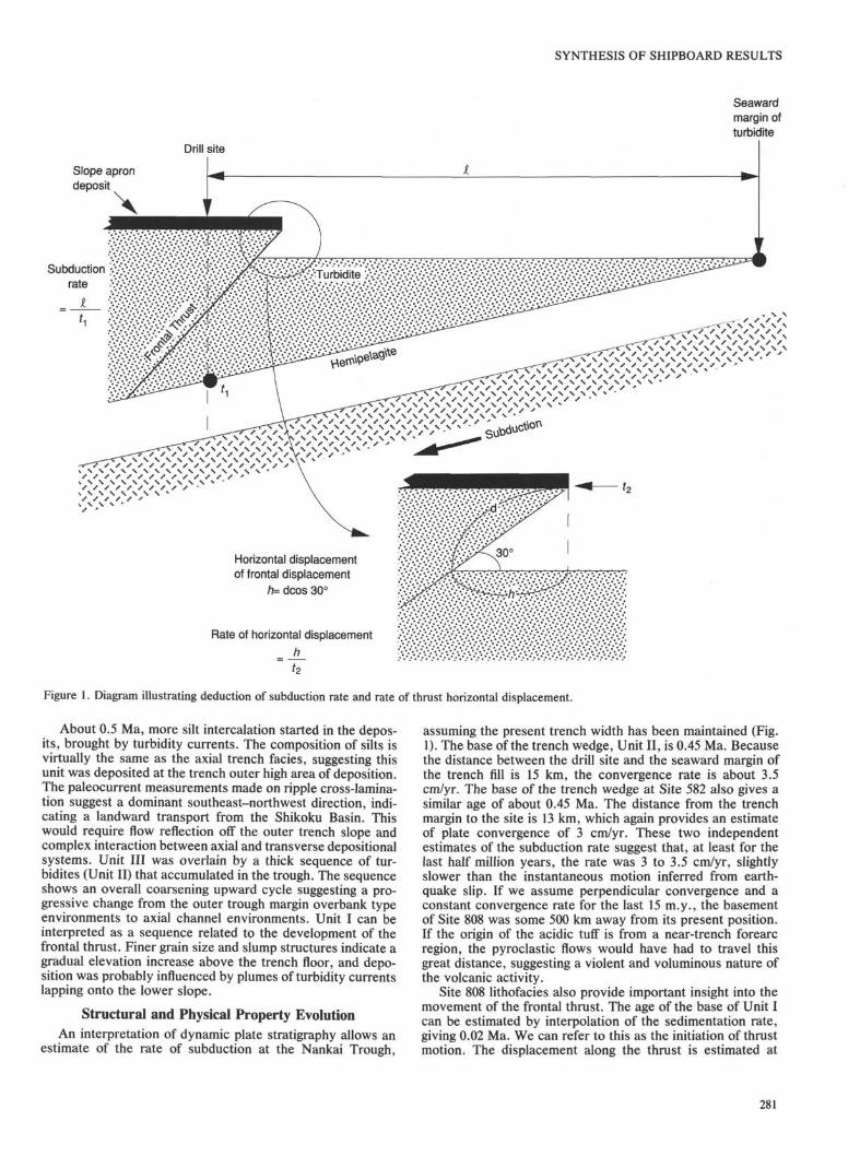
Figure 1. Diagram illustrating deduction of subduction rate and rate of thrust horizontal displacement.
About 0.5 Ma, more silt intercalation started in the depos-its, brought by turbidity currents. The composition of silts isvirtually the same as the axial trench facies, suggesting thisunit was deposited at the trench outer high area of deposition.The paleocurrent measurements made on ripple cross-lamina-tion suggest a dominant southeast-northwest direction, indi-cating a landward transport from the Shikoku Basin. Thiswould require flow reflection off the outer trench slope andcomplex interaction between axial and transverse depositionalsystems. Unit III was overlain by a thick sequence of tur-bidites (Unit II) that accumulated in the trough. The sequenceshows an overall coarsening upward cycle suggesting a pro-gressive change from the outer trough margin overbank typeenvironments to axial channel environments. Unit I can beinterpreted as a sequence related to the development of thefrontal thrust. Finer grain size and slump structures indicate agradual elevation increase above the trench floor, and depo-sition was probably influenced by plumes of turbidity currentslapping onto the lower slope.
Structural and Physical Property EvolutionAn interpretation of dynamic plate stratigraphy allows an
estimate of the rate of subduction at the Nankai Trough,
assuming the present trench width has been maintained (Fig.1). The base of the trench wedge, Unit II, is 0.45 Ma. Becausethe distance between the drill site and the seaward margin ofthe trench fill is 15 km, the convergence rate is about 3.5cm/yr. The base of the trench wedge at Site 582 also gives asimilar age of about 0.45 Ma. The distance from the trenchmargin to the site is 13 km, which again provides an estimateof plate convergence of 3 cm/yr. These two independentestimates of the subduction rate suggest that, at least for thelast half million years, the rate was 3 to 3.5 cm/yr, slightlyslower than the instantaneous motion inferred from earth-quake slip. If we assume perpendicular convergence and aconstant convergence rate for the last 15 m.y., the basementof Site 808 was some 500 km away from its present position.If the origin of the acidic tuff is from a near-trench forearcregion, the pyroclastic flows would have had to travel thisgreat distance, suggesting a violent and voluminous nature ofthe volcanic activity.
Site 808 lithofacies also provide important insight into themovement of the frontal thrust. The age of the base of Unit Ican be estimated by interpolation of the sedimentation rate,giving 0.02 Ma. We can refer to this as the initiation of thrustmotion. The displacement along the thrust is estimated at
281
SHIPBOARD SCIENTIFIC PARTY
about 300 m of dip-slip motion. The rate of fault movement istherefore 1.5 cm/yr. Assuming that the average angle of thethrust is 30 degrees, the rate of horizontal displacement of thefault is 1.3 cm/yr. This suggests that about 40% of the plateconvergence is accommodated at the single frontal thrust.
The striking change in physical properties above and belowthe décollement is an important finding of this leg. A majorincrease in porosity from the accreted sediments to theunderthrust sediments was found. Comparison of Site 808sediment porosities with several consolidation curves of ma-rine clastic sediment and with Site 582 indicates that theaccreted sediment at Site 808 is probably overconsolidatedand that underthrust sediment is underconsolidated. Theunderconsolidation condition of the underthrust sediment maybe maintained by low matrix permeability and excess porepressure. However, acoustic anisotropy increases normallywith depth below the décollement, suggesting that the sedi-ment has seen a normal consolidation pattern in the past.
These observations suggest the following consolidationhistory. At the Shikoku Basin side, hemipelagic mud accumu-lated with a slow accumulation rate where we expect a normalbasin-type consolidation characteristic. It is likely that thenormal consolidation trend imprinted on acoustic anisotropywas acquired at this time. At the trench, turbidite sedimenta-tion took place at a high rate over 1000 m/m.y. This highsedimentation event could have induced an underconsolidatedstate in the hemipelagic sequence, although the sand and siltcomponent of the turbidites provide high permeability path-ways that may drain excess pressures. The controlling factorfor the stratigraphic position of the décollement is not clear.Shi and Wang (1988) pointed out that high pore pressure ismost likely to develop in the middle of a sedimentary sectionbecause of the maximum length of drainage pathway there.Although this general inference may be applied to the Nankaisetting, the lithologic control of particular horizons is notclear. Two characters change across the décollement: thesedimentation rate and the peak in CaCO3 content. We are notsure whether these parameters are related to stratigraphiccontrol on décollement development. Nevertheless, the sedi-ments below and above the décollement have undergone verydifferent consolidation histories. The underthrust sedimentseems to remain underconsolidated, and parts of the accretedsection may be overconsolidated.
HydrogeologyThere are several possibilities for the escape of fluid from
the accreted sediments: (1) fluid loss occurs as pervasiveupward diffusion through almost the entire accretionaryprism; (2) fluid loss occurs in a semilocalized way, controlledby structures such as microfaults, shear bands, and clasticdikes; (3) fluid loss occurs in a localized manner throughconduits such as the décollement, thrust faults, or certainstratigraphic horizons. Our shipboard results do not resolvethis issue. However, there are several important observations.
Pervasive upward flow throughout the prism will affectnumerous measurable parameters including heat flow andpore-water geochemistry. The thermal measurements at thissite define raw thermal gradient and heat-flow values that arecompatible with purely conductive heat transfer from theoceanic crust. A correction to account for the very highsedimentation rate in this area would lower the backgroundheat-flow value probably by about 10%, but with considerablerange in error. This leaves open the possibility that thebalance of the observed heat flow could be due to advectionflow.
The geochemical data provide no clear evidence for perva-sive fluid flow, while at the same time failing to completely
exclude the possibility of such flow. For example, the Clgradient can be attributed, at least in part, to in-situ claydiagenesis. The correspondence of pore-fluid geochemistrywith lithologic boundaries argues that any flow must be slow,most geochemical gradients being determined mostly by reac-tion and diffusion.
The absence of a BSR at this site may also argue againstconsiderable upward diffusive flow. If the BSR that is seenlandward of this site is produced by upward diffuse flow assuggested by Davies et al. (1990), then the absence of a BSRat this site must again imply that any diffuse flow must berelatively slow or that the methane concentrations in the porewater are very different.
There is a clastic dike at 810 mbsf. Although we do notknow the origin of the sand in the dike and when it wasgenerated, it is reasonable to say that such dikes may be quiteabundant within the prism. In the Shimanto Belt, Taira (1984)showed that sandstone dikes are quite common and wereintruded into 30%-40% porosity mudstone. The present po-rosity value of the mudstone at this horizon is about 37% andpossibly might have been intruded relatively recently after thedeformation started. If so, this provides one important avenueof fluid expulsion.
Sidescan sonar seafloor images obtained by the IZANAGIsystem show the existence of sediment volcanoes in thetrench floor of the Nankai Trough. Within the Kaiko-Nankaisurvey area of the eastern Nankai Trough there are severalsediment diapirs. One was visited by the Nautile, but norecent fluid venting activity was detected. One swarm ofvolcanoes has been found at the Shionomisaki canyon fan,about 200 km east of this site. Another group is found 20 kmsoutheast of this site. Three possible volcanoes with maxi-mum diameter of 3 km are recognized near the deformationfront. As we do not know the nature of these volcanoes, it ispremature to further assess any importance of these features.However, it can be said that, although the number of sedimentvolcanoes is seemingly less than Barbados, at least they playsome role in fluid expulsion in the Nankai Trough.
The complete absence of veining and mineralization wasone of the surprising results of this leg. The absence of suchveining even in the deformation zones, and the absence of anymajor geochemical signatures in the pore fluids, preclude thepossibility of channelized fluid flow in this prism.
In the light of all the evidence, we conclude that the mostlikely mechanisms for fluid expulsion from the accreted sedi-ments are: (1) upward diffusive flow through a large portion ofthe prism; and (2) rather localized material involved transferprocesses such as diking and sediment diapirism. The role ofthe small faults and shear bands in fluid flow has not beenascertained.
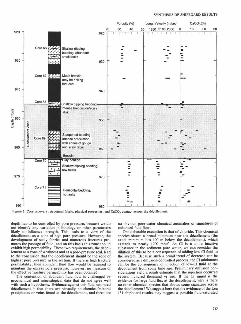
The décollement was identified at 945-964 mbsf as adeformation zone below which the sediment is virtually unde-formed (Fig. 2). This 20-m zone of fractured rock offsets theporosity values from 30% above it to 40% below it, a hugedifference over this narrow interval. The relatively coherentmaterial from the décollement shows low porosity values (lessthan 30%) and conjugate faults that record northwest-south-east shortening. Above the décollement, for about 100 m,there is a concentration of faults that decrease in abundanceupward. Therefore the physical properties are inhomogeneousin the décollement zone and the deformation is quite asym-metrical.
Two questions arise: (1) why doesn't the décollementtransmit stress, and (2) how is the porosity difference main-tained? These two issues may be inter-related. A simpleassumption is that the décollement is a zone of loweststrength. If this is correct, the strength of material at this
Steepened bedding ;intense brecciation,: with zones of gougeand scaly fabric 960
lonzon
Shallow dipping bedding,few faults
970
Horizontal bedding,no faults
980 J I
Figure 2. Core recovery, structural fabric, physical properties, and CaCO3 contact across the décollement.
depth has to be controlled by pore pressure, because we donot identify any variation in lithology or other parameterslikely to influence strength. This leads to a view of thedécollement as a zone of high pore pressure. However, thedevelopment of scaly fabrics and numerous fractures pro-motes the passage of fluid, and on this basis this zone shouldexhibit high permeability. These two requirements, the décol-lement as a zone of weakness and as a pore-pressure seal, leadto the conclusion that the décollement should be the zone ofhighest pore pressure in the section. If there is high fracturepermeability, then abundant fluid flow would be required tomaintain the excess pore pressure; however, no measure ofthe effective fracture permeability has been obtained.
The contention of abundant fluid flow is challenged bygeochemical and mineralogical data that do not agree wellwith such a hypothesis. Evidence against this fluid-saturateddécollement is that there are virtually no chemical/mineralprecipitates or veins found at the décollement, and there are
no obvious pore-water chemical anomalies or signatures ofenhanced fluid flow.
One debatable exception is that of chloride. This chemicalspecies shows a broad minimum near the décollement (theexact minimum lies 100 m below the décollement), whichextends to nearly 1200 mbsf. As Cl is a quite inactivesubstance in the sediment pore water, we can consider thedilution of this to be a consequence of adding low Cl fluid tothe system. Because such a broad trend of decrease can beconsidered as a diffusion-controlled process, the Cl minimumscan be the consequence of injection of low-Cl fluid at thedécollement from some time ago. Preliminary diffusion con-siderations yield a rough estimate that the injection occurredseveral hundred thousand yr ago. If the Cl signal is theevidence for large fluid flux at the décollement, why is thereno other chemical species that shows some signature acrossthe décollement? We suggest here that the evidence of the Leg131 shipboard results may suggest a possible fluid-saturated
283
SHIPBOARD SCIENTIFIC PARTY
décollement, likely to be episodic, but this inference is incon-clusive.
The heat flow at this site is compatible with purely conduc-tive heat transfer from the oceanic crust below. This does notpreclude some component of advective transfer, perhapscompensated by the effect of very high sedimentation rates.
CONCLUSIONWe list below some of the important findings, conclusions,
and questions raised during the leg.
LithostratigraphyProvenance of sands was confirmed as similar to Site 582,
mainly from the Suruga Trough drainage system. An overallcoarsening-upward trend in trench sedimentary fades wasclearly defined. A complex pattern of turbidity current activity,however, was found in the outer trench environments. Thissuggests a sequence of events such as slumping and turbiditycurrent generation from the prism, and transverse to obliquereflection of flows off the seaward slopes. The mineralogy ofdetrital grains such as quartz/feldspar shows grain-size-depen-dent features representing coarsening upward sequences. Thereis an acid pyroclastic horizon just above the basaltic basementrocks suggestive of near- trench forearc volcanism at 15-14 Ma.Basement lithology of basalts indicates upper sill layers above apillowed horizon similar to the Leg 58 results.
Around 800 mbsf there is a clear peak in zeolite mineraliza-tion. As the lower boundary of the peak shows such an abrupttermination, it is a lithology-controlled (ash abundance) change.There is a slight increase in illite content and asymmetry of theillite (001) peak, and a concomitant decrease in smectite contentbetween 550 to 800 m suggestive of clay dehydration.
Structural Geology and Physical PropertiesPhysical properties analysis indicates three main zones of
property changes, these being above, within, and below thedécollement. Downhole changes of physical properties gen-erally show normal consolidation patterns, although por-tions of the offscraped sequence appear to be relatively over-and underconsolidated. Sediments within the décollementare highly overcompacted, and underlying subducted sedi-ments are underconsolidated relative to their lithologicequivalents above the décollement. Thus, the décollementmarks a significant offset of physical properties. The lowerzone shows an acoustic anisotropy that is indicative of anormal consolidation history. Pore pressure and in-situstress was only measured in the uppermost oflfscrapedsediments, but preliminary results indicate that excess porepressures and high lateral stresses exist even at theserelatively shallow depths.
Structural geology shows evidence of northwest-southeastshortening above the décollement and virtually no deformationbelow. Among prominent structural features, shear bands areconfined to the upper 600 m and seem to have formed earlierthan the small faults, both structures reflecting bulk shortening ofthe prism. We conclude that the stress field throughout the prismhas a maximum horizontal compressive stress oriented north-west-southeast. Below the décollement the principal stress isvertical. Thus the décollement acts as a zone of very lowstrength isolating the different stress regimes.
Hydrogeology
Organic geochemistry indicates two different stratigraphichorizons of thermal generation of hydrocarbons, at 600-800mbsf and 1050-1200 mbsf.
Inorganic geochemistry of pore fluids suggests there arefour important processes operating in this prism: (1) Near-surface decomposition of organic materials; (2) diageneticeffects (and possibly gas hydrate generation); (3) equilibra-tion to lithologic compositions; (4) possible fluid injection.This latter process is of fundamental importance to theevolution of the prism. A broad Cl minimum in the lowerpart of the section may indicate a possible fluid injectionalong the décollement. However, the great width of thisfeature is surprising. It may have been generated, at least inpart, by dehydration reactions of clay minerals. If the Clminimum was created by fluid injection, consideration ofdiffusion rates suggests that this must have occurred at leastseveral hundred thousand yr ago. In the light of our failure toobserve any unequivocal evidence for localized fluid flow,we conclude that diffuse flow probably dominates the hydro-geologic pattern of this prism.
These findings can be condensed into two important con-clusions for sediment deformation processes at this conver-gent margin.
1. The prism is undergoing localized thrust displacementand significant bulk shortening, but is decoupled from theundeformed sediments below.
2. Although inconclusive, hydrogeologic inference sug-gests the possibility of a fluid-saturated, highly pressureddécollement. The accreted sediments above, however, seemto have drained by diffuse flow and some material transfersuch as diking and diapirism.
Shore-based studies should provide further insight into theproblems and inferences outlined above.
REFERENCES
Aoki, Y., Kinoshita, H., and Kagami, H., 1986. Evidence of alow-velocity layer beneath the accretionary prism of the NankaiTrough; inference from a synthetic sonic log. In Kagami, H.,Karig, D. E., Coulbourn, W., et al., Init. Repts. DSDP, 87:Washington (U.S. Govt. Printing Office), 727-735.
Aoki, Y., Tamano, T., and Kato, S., 1982. Detailed structure of theNankai Trough from migrated seismic sections. In Watkins, J.,and Drake, C. L. (Eds.), Studies in Continental Margin Geology.AAPGMem., 34:309-322.
Bray, C. J., and Karig, D. E., 1986. Physical properties of sedimentsfrom the Nankai Trough, Deep Sea Drilling Project Leg 87A, Sites582 and 583. In Kagami, H., Karig, D. E., Coulbourn, W. C , etal., Init. Repts., DSDP, 87: Washington (U.S. Govt. PrintingOffice), 827-842.
Chamley, H., Cadet, J. P., and Charvet, J., 1986. Nankai Trough andJapan Trench Late Cenozoic paleoenvironments deduced fromclay mineralogy data. In Kagami, H., Karig, D. E., Coulbourn, W.C , et al., Init. Repts. DSDP, 87: Washington (U.S. Govt. PrintingOffice), 633-642.
Chamot-Rooke, N., Renard, V., and Le Pichon, X., 1987. Magneticanomalies in the Shikoku Basin: a new interpretation. EarthPlanet. Sci. Lett., 83: 214-228.
Davies, E. E., Hyndman, R. D., and Villinger, H., 1990. Rates of fluidexpulsion across the northern Cascadia accretionary prism: con-straints from new heat flow and multichannel seismic reflectiondata. J. Geophys. Res., 95:8869-8889.
Gieskes, J. M., Vrolijk, P., and Blanc, G., 1990. Hydrogeochemistryof the Northern Barbados Accretionary Complex Transect: ODPLeg 110. J. Geophys. Res., 95:8809-8818.
Gieskes, J. M., Elderfield, H., and Nevsky, B., 1983. Interstitialwater studies, Leg 65. In Lewis, B.R.T., Robinson, P., et al.,Init. Repts. DSDP, 65: Washington (U.S. Govt. Printing Office),441-449.
284
SYNTHESIS OF SHIPBOARD RESULTS
Kaiko I Research Group, 1986. Taira, A., and Tokuyama, H. (Eds.),Topography and Structure of Trenches Around Japan-Data Atlas ofFranco-Japanese Kaiko Project, Phase I: Tokyo (Univ. of TokyoPress).
Kato, S., Sato, T., and Sakurai, M., 1983. Multi-channel seismicreflection survey in the Nankai, Suruga and Sagami Troughs.Rept. Hydrographic Res., 18:1-23.
Kobayashi, K., and Nakada, M., 1978. Magnetic anomalies andtectonic evolution of the Shikoku inter-arc basin. J. Phys. Earth,26:391-402.
Leggett, J. K., McKerrow, W. S., and Casey, D. M., 1982. Theanatomy of a Lower Paleozoic accretionary forearc: the SouthernUplands of Scotland. In Leggett, J. K. (Ed.), Trench-Fore arcGeology. Geol. Soc. Spec. Publ. London, 10:496-520.
Miyake, Y., 1988. Petrology of the Shionomisaki igneous complex,southwest Japan and its implication for the ophiolite generation.Mod. Geol., 12:283-302.
Moore, G. F., Shipley, T. H., Stoffa, P. L., Karig, D. E., Taira, A.,Kuramoto, H., Tokuyama, and Suyehiro, K., 1990. Structure ofthe Nankai Trough accretionary zone from multichannel seismicreflection data. J. Geophys. Res., 95:8753-8765.
Nasu, N., et al., 1982. Multi-channel Seismic Reflection Data acrossNankai Trough. IPOD-Japan Basic Data Series, 4. Ocean Res.Inst., Univ. of Tokyo.
Okuda, Y., and Honza, E., 1988. Tectonic evolution of the Seinan(SW) Japan fore-arc and accretion in the Nankai Trough. Mod.Geol., 12:411-434.
Shi, Y., and Wang, C.-Y., 1988. Generation of high pore pressures inaccretionary prisms: inferences from the Barbados SubductionComplex. J. Geophys. Res., 93:8893-8909.
Shih, T. C , 1980. Magnetic lineations in the Shikoku Basin. In Klein,G. deVries, and Kobayashi, K., et al., Init. Rept. DSDP, 58:Washington (U.S. Govt. Printing Office), 783-788.
Shimamura, K., 1988. Sedimentation and tectonics of Zenisu Ridge,Eastern Nankai Trough and Suruga Trough Regions. Sci. Rep.Tohoku Univ., Ser. 2, 58:107-167.
Shiono, K., 1988. Seismicity of the SW Japan arc - subduction of theyoung Shikoku Basin. Mod. Geol., 12:449-464.
Shipboard Scientific Party, 1986. Site 582. In Kagami, H., Karig, D.E., Coulbourn, W. C , et al., Init. Repts. DSDP, 87: Washington(U.S. Govt. Printing Office), 35-122.
Stoffa, P. C , Wood, W. T., Shipley, T. H., Bothelo, H.A.B., Taira,A., Tokuyama, H., Nishiyama, E., Suyehiro, K., and Moore, G.F., in press. High resolution expanding spread and split-spreadmarine seismic profiles: Acquisition and velocity analysis meth-ods. J. Geophys. Res., 95:8753-8765.
Taira, A., 1984. Tectonics significance of sandstone dykes in theEocene Murotohanto Group, Shimanto Belt (subduction com-plex), Shikoku. Res. Rept. of Kochi Univ., 32:162-178.
Taira, A., Katto, J., Tashiro, M., Okamura, M., and Kodama, K.,1988. The Shimanto Belt in Shikoku, Japan: evolution of Creta-ceous to Miocene accretionary prism. Mod. Geol., 12:5-46.
Taira, A., and Niitsuma, N., 1986. Turbidite sedimentation in theNankai Trough as interpreted from magnetic fabric, grain size, anddetrital modal analyses. In Kagami, H., Karig, D. E., Coulbourn,W. C , et al., Init. Repts. DSDP, 87: Washington (U.S. Govt.Printing Office), 611-632.
Taira, A., and the Scientific Members of the Expedition, 1988.Preliminary Report of the Hakuho-Maru Cruise KH86-5. OceanRes. Inst., Univ. of Tokyo.
Taira, A., Tokuyama, H., and Soh, W., 1989. Accretion tectonics andevolution of Japan. In Ben-Avraham, Z. (Ed.), The Evolution ofPacific Ocean Margins: Oxford (Oxford Univ. Press), 100-123.
Yamano, M., Honda, S., and Uyeda, S., 1984. Nankai Trough: a hottrench? Mar. Geophys. Res., 6:187-203.