Relinquishment Report for License P1643 January 2010, Canamens Energy Ltd 1. Header License Number P1643 License Round 25 th Round (effective 12 Feb 2009) License Type Traditional Block number 8/25b Operator (% share) Canamens Energy North Sea Ltd (50%) Partner (% share) Nautical Petroleum plc (50%) Work programme summary Reprocess 50km 2 3d seismic in first year, then make drill-or-drop decision with well to be drilled in first four years 2. Synopsis License P1643 has been relinquished in full, approved by DECC with effective date 22 December 2009. This document forms the relinquishment report requested by DECC in the acknowledgement letter of the relinquishment. The reasons for relinquishment are a. The main lead in the license (named Coelacanth) is not sufficiently large to be developed as a stand- alone project b. A joint development with the neighbouring Kelpie prospect (in 8/25a) would not be large enough to proceed c. The chance of finding oil at Kelpie dropped sharply following the dry hole at the adjacent Selkie prospect (8/25a-1) and has not risen significantly following subsequent intensive G&G work in that license d. The probability of an economically-viable regional development centred on the Skipper discovery appears low, and Coelacanth’s additional volumes may not be large enough to offset additional costs of its integration in that development The sister license to P1643, which is P976 and covers block 8/25a (see Figure 2), has been operated by the same Canamens-Nautical partnership, with a recent internal work program that integrates the two licenses. This second license has been relinquished with the same effective date, and a second relinquishment report submitted. The relinquishment of license P1643 is effectively the “drop” option of the drill-or-drop decision required by DECC within the first year of the license. 3. Exploration Activities a. Seismic reprocessing Fugro Seismic Imaging reprocessed 100km 2 of the Agip 1998 3d survey for the license partnership in mid 2009, including large parts of 8/25b in addition to the relevant neighbouring structures at Kelpie (in 8/25a) and Skipper (in 9/21, Figure 1). The original dataset is owned by Nautical Petroleum, and is stored at Merlin Datawise in Ledbury. The master copies of the reprocessed data are held by Canamens Energy in our Stavanger office (contact Knut Hansch). The reprocessing project fulfilled the work commitment described in the license documents issued by DECC.
Transcript
Relinquishment Report for License P1643 January 2010, Canamens Energy Ltd
1. Header
License Number P1643
License Round 25th
Round (effective 12 Feb 2009)
License Type Traditional
Block number 8/25b
Operator (% share) Canamens Energy North Sea Ltd (50%)
Partner (% share) Nautical Petroleum plc (50%)
Work programme summary Reprocess 50km2 3d seismic in first year,
then make drill-or-drop decision with well to
be drilled in first four years
2. Synopsis
License P1643 has been relinquished in full, approved by DECC with effective date 22 December 2009. This
document forms the relinquishment report requested by DECC in the acknowledgement letter of the
relinquishment. The reasons for relinquishment are
a. The main lead in the license (named Coelacanth) is not sufficiently large to be developed as a stand-
alone project
b. A joint development with the neighbouring Kelpie prospect (in 8/25a) would not be large enough to
proceed
c. The chance of finding oil at Kelpie dropped sharply following the dry hole at the adjacent Selkie
prospect (8/25a-1) and has not risen significantly following subsequent intensive G&G work in that
license
d. The probability of an economically-viable regional development centred on the Skipper discovery
appears low, and Coelacanth’s additional volumes may not be large enough to offset additional
costs of its integration in that development
The sister license to P1643, which is P976 and covers block 8/25a (see Figure 2), has been operated by the
same Canamens-Nautical partnership, with a recent internal work program that integrates the two
licenses. This second license has been relinquished with the same effective date, and a second
relinquishment report submitted.
The relinquishment of license P1643 is effectively the “drop” option of the drill-or-drop decision required
by DECC within the first year of the license.
3. Exploration Activities
a. Seismic reprocessing
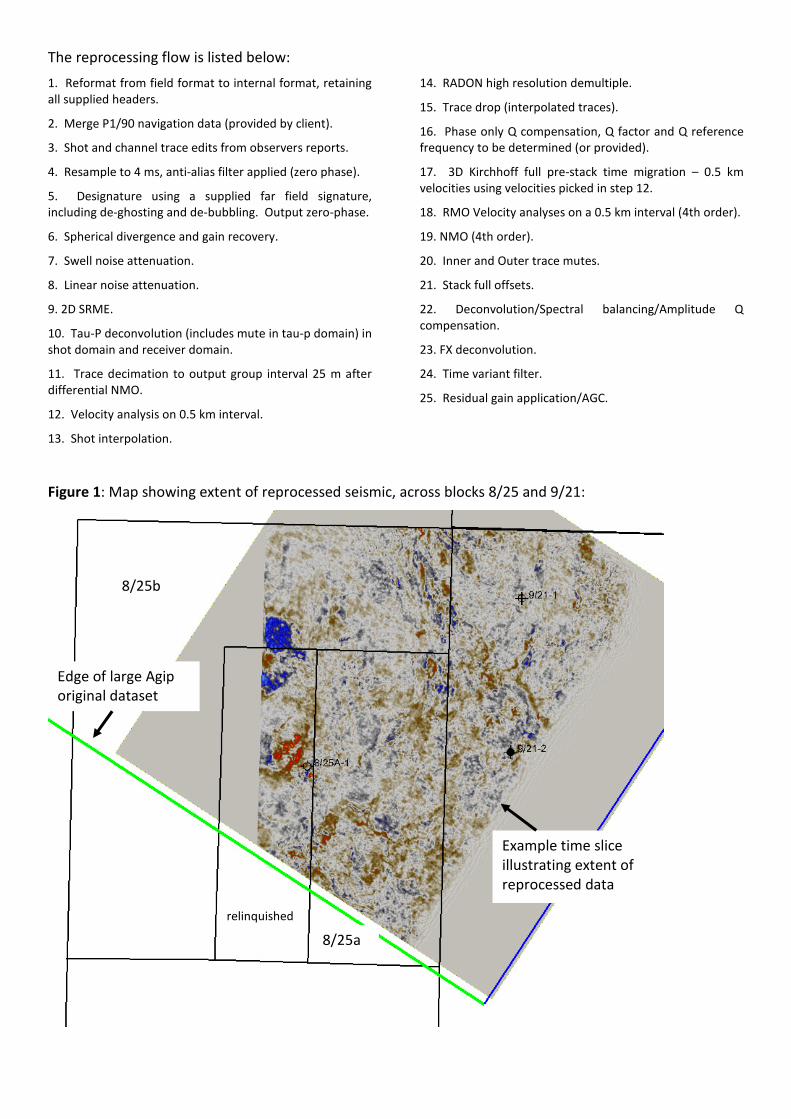
Fugro Seismic Imaging reprocessed 100km2 of the Agip 1998 3d survey for the license partnership in mid
2009, including large parts of 8/25b in addition to the relevant neighbouring structures at Kelpie (in 8/25a)
and Skipper (in 9/21, Figure 1). The original dataset is owned by Nautical Petroleum, and is stored at
Merlin Datawise in Ledbury. The master copies of the reprocessed data are held by Canamens Energy in
our Stavanger office (contact Knut Hansch). The reprocessing project fulfilled the work commitment
described in the license documents issued by DECC.
The reprocessing flow is listed below:
1. Reformat from field format to internal format, retaining
all supplied headers.
2. Merge P1/90 navigation data (provided by client).
3. Shot and channel trace edits from observers reports.
4. Resample to 4 ms, anti-alias filter applied (zero phase).
5. Designature using a supplied far field signature,
including de-ghosting and de-bubbling. Output zero-phase.
6. Spherical divergence and gain recovery.
7. Swell noise attenuation.
8. Linear noise attenuation.
9. 2D SRME.
10. Tau-P deconvolution (includes mute in tau-p domain) in
shot domain and receiver domain.
11. Trace decimation to output group interval 25 m after
differential NMO.
12. Velocity analysis on 0.5 km interval.
13. Shot interpolation.
14. RADON high resolution demultiple.
15. Trace drop (interpolated traces).
16. Phase only Q compensation, Q factor and Q reference
frequency to be determined (or provided).
17. 3D Kirchhoff full pre-stack time migration – 0.5 km
velocities using velocities picked in step 12.
18. RMO Velocity analyses on a 0.5 km interval (4th order).
19. NMO (4th order).
20. Inner and Outer trace mutes.
21. Stack full offsets.
22. Deconvolution/Spectral balancing/Amplitude Q
compensation.
23. FX deconvolution.
24. Time variant filter.
25. Residual gain application/AGC.
Figure 1: Map showing extent of reprocessed seismic, across blocks 8/25 and 9/21:
8/25b
relinquished
8/25a
Example time slice
illustrating extent of
reprocessed data
Edge of large Agip
original dataset
b. Seismic interpretation
During 2009 the Operator re-evaluated prospectivity in the remaining part of 8/25a together with 8/25b
and western 9/21. The 3d seismic survey that Agip and partners acquired during 1999 was reinterpreted at
reservoir level, and integrated with Selkie well information to assess the remaining potential of the Kelpie
prospect (described in the relinquishment report for P976), as well as the Coelacanth prospect in 8/25b.
This mapping was then compared with the newly-reprocessed seismic data at the end of 2009. Although
frequency content is slightly higher, the new dataset does not reveal new structures or further
prospectivity (Figure 3).
There is one significant lead in 8/25b, named Coelacanth by previous operators, located in the north east
of the block (Figure 3). It lies on a long-lived sandy channel axis that has a NW to SE orientation and
appears to have been active through much of the Paleocene. Coelacanth is a Dornoch level lead, with
compactional four way structural closure. Lower levels have very small to negligible closure, with nothing
preventing up-channel migration to the NW. Lower levels are also likely to have very risky top seal, given
the high sand thickness indicated by the large differentially-compacted relief across the channel.
Top reservoir depth is shown in Figure 3, and an example line across the Coelacanth lead is shown in Figure
4.
4. Prospectivity Analysis
The possible Tertiary hydrocarbon plays present in the 8/25 area are listed below.
Play Wells targeted at play &
results
Comments
Maureen
Sandstone
9/21-1, 9/21-2, 8/20-1.
All dry holes at Maureen
level
Reservoir level pinches out westwards in eastern 8/25a, with a
remaining untested stratigraphic concept play there. Maureen sands
extend further west along the NW-SE trending Skipper channel. Play
successful in Mariner. Original operator of both Mariner and 9/21
blocks was Unocal. Maureen Sandstone appears not to be charged in
the area, although were these wells all on valid closures?
Upper
Dornoch
Sandstone
8/25a-1 dry hole -
Prospect was not
charged, although there
may also be topseal
issues
9/21-2 serendipitously discovered oil in this play. 9/21-1 had shows in
Beauly Sandstone.
To further pursue this play in the block requires derisking of the one
remaining prospect at Upper Dornoch level, Kelpie, incorporating a
greater understanding of migration pathways (see below).
Mousa
Sandstone
None in immediate area This play has worked in 9/16 block to the north. 9/26-1 to south has
shows. Play not yet evaluated in 8/25a. Probability that any
hydrocarbons at this level will be heavier than 9/21-2. Pursuit of this
play would require new work
Heimdal
Sandstone
Secondary objective in
8/20-1 (dry hole).
Probable topseal problems; requires intra formational seal. This type
of play is not usually successful, however, claystones of 200ft or more
can provide intra formational seals in some areas of the East Shetland
Platform. This play has not been evaluated by Canamens or Nautical.
b. Hydrocarbon migration study
A detailed modelling study was undertaken by Fugro Robertson for the partnership during 2009, designed
to predict hydrocarbon migration pathways across much of the East Shetland Platform, in the light of oil
discovery at 9/21-2 (Skipper) and a dry hole at 8/25a-1. The study remains confidential in general, but
suggests that migration from the graben is likely to have been directed north westwards through Skipper
and updip from there along the long-lived channel axis on which Coelacanth lies. The study suggested that
if sufficient oil volumes to over-fill the Skipper structure had passed along the pathway and reached
Coelacanth, it would be heavy, with API of around 11.
c. Chance of success at Coelacanth
Reservoir Dornoch sand presence likely, though may be focussed either side of the
newly-forming compaction structure and thinner on crest
0.7
Source Long distance lateral migration from graben proven at Skipper, but absent
at Selkie. Migration studies suggest Coelacanth is on pathway updip from
Skipper
0.6
Trap Low-amplitude 4-way dip closure is likely present; critical saddle exists to
NW, which may be affected by precise depth conversion
0.7
Top seal T45 top seal has significant variation in offset wells and also in seismic
character: unpredictable
0.7
Coelacanth has an estimated chance of success of 20%.
5. Coelacanth Reserves Summary
Gross thickness 40m GRV above spill 1.86x10⁷ m
3
Net:Gross 70%
Porosity 27% STOOIP 16.3 mmbbl
Expansion Factor 1.05 Recovery factor 18%
Water saturation 30% Recoverable 2.9 mmbbl
6. Maps and Figures
coelacanth
8/25b
Figure 2: P1643 occupies block
8/25b including the Coelacanth
lead
8/25a Skipper
selkie
kelpie
8/25c
line of following section
Figure 3: top Dornoch
(i.e. top reservoir) map
No 3d south of this line
Figure 4: Seismic line from Agip 1998 3d survey. Location on Figure 3
Top Dornoch
Base Tertiary
Selkie structure
with 8/25a-1
gamma log Coelacanth
North west South east
7. Clearance
The submitting operator confirms that DECC is free to publish and that all 3rd
party ownership rights (on
any contained data and/or interpretations) have been considered and appropriately cleared for publication