A CULTURAL AND HISTORICAL GEOGRAPHY OF CAMPBELL CREEK, ANCHORAGE, ALASKA By Cherie Northon, Ph.D. For the Alaska Humanities Forum August 2007 North Fork of Campbell Creek, Far North Bicentennial Park, 2006 (photo by author)
Transcript
A CULTURAL AND HISTORICAL GEOGRAPHY OF CAMPBELL CREEK, ANCHORAGE, ALASKA
By Cherie Northon, Ph.D.
For the Alaska Humanities Forum
August 2007
North Fork of Campbell Creek, Far North Bicentennial Park, 2006 (photo by author)
2
ACKNOWLEDGEMENTS
I would like to thank the Alaska Humanities Forum for funding my research time and expenses on this project. Additionally, I have received generous in-kind donations from William Rice, hydrologist at the U.S. Fish and Wildlife, Anchorage Field Office, and Holly Kent, Executive Director of the Anchorage Waterways Council. Assistance has also come from Megan Marie, habitat biologist from the Alaska Department of Natural Resources, Cindy Anderson, fishery biologist from the Alaska Department of Natural Resources, Tracy Leithauser, museum librarian at the Anchorage Museum at Rasmuson Center, Karin Preston, GIS database coordinator at Chugach National Forest, Thede Tobish, planner at the Municipality of Anchorage, Kathryn Smith, Polaris K-12 science teacher, and her students, and the citizens of Anchorage who were willing to answer my many questions. Permissions for use of archival and published images have been received from the Anchorage Museum at Rasmuson Center, the Elmer E. Rasmuson Library at the University of Alaska Fairbanks, Google EarthTM Mapping Services, Dr. James Fall, and Dr. Elizabeth Tower who kindly provided me with her manuscript map of homesteads. Lastly, I would like to thank fellow geographer Dr. Thom Eley, who accompanies, assists, and critiques me as well as shares my passion for our discipline.
3
INTRODUCTION
Campbell Creek is one of eight waterways in urban Anchorage. The other seven creeks are Ship, Chester, Hood, Fish, Potter, Furrow, and Rabbit (Fig. 1). As the city developed over the past 90+ years, there have been major changes to most of these anadromous1 creeks. This report will focus on the history of Campbell Creek and its tributaries along with the cultural environment that has evolved since non-Native settlement in 1912. The headwaters of Campbell Creek begin in the Chugach Mountains at an elevation of roughly 5,000 ft. and drain approximate 70 mi2 into Turnagain Arm—part of Cook Inlet. There are three main tributaries to Campbell Creek: the South Fork that drains 28.7 mi2, the North Fork that drains 16.5 mi2, and Little Campbell Creek that drains 24 mi2. The upper reaches of the Campbell Creek watershed are in a portion of Chugach State Park, which is forested with steep topography. As the creek winds towards Turnagain Arm, the terrain flattens out and is characterized by residential and commercial development along its banks. Just before Campbell Creek enters Turnagain Arm, it is partially impounded by Campbell Lake, a human-created water body which is approximately 125 acres with a 3.5 mile shoreline (ADEC 2006:10).
Fig. 1 Study Area (map by author)
1 Anadromous (salmon-bearing) streams are designated as such by the Alaska Department of Fish and Game Anadromous Fish Catalog at http://www.sf.adfg.state.ak.us/SARR/FishDistrib/anadcat.cfm
4
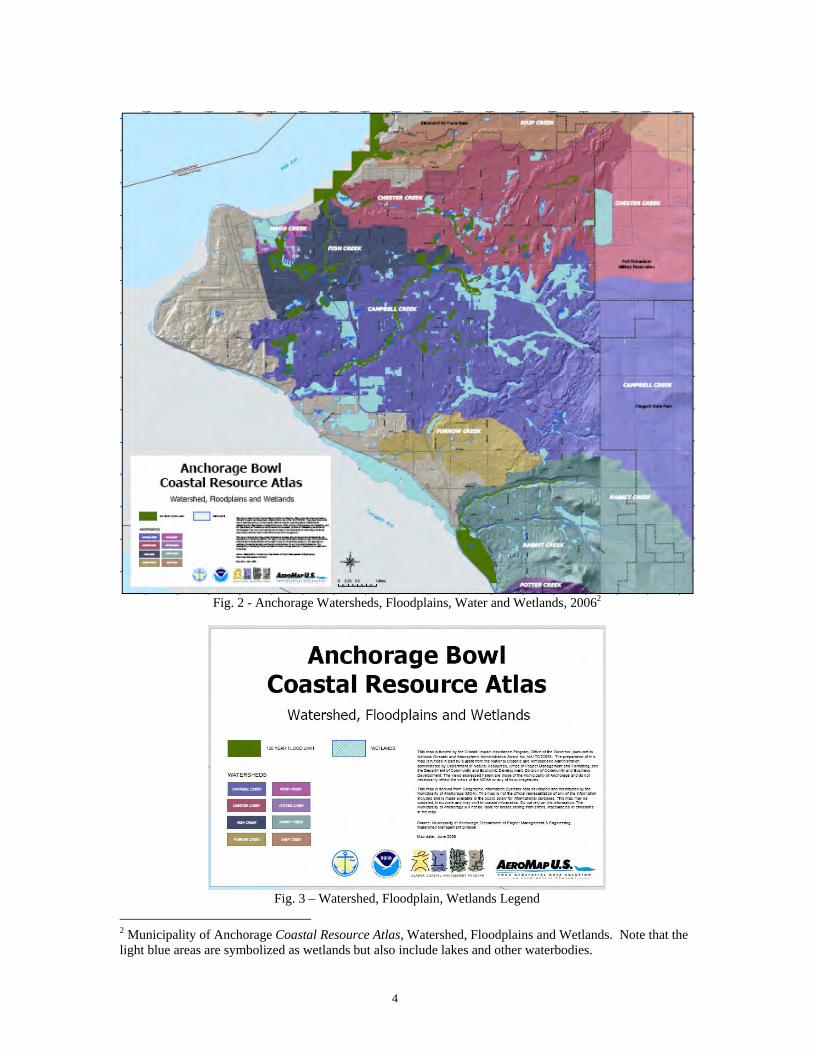
Fig. 2 - Anchorage Watersheds, Floodplains, Water and Wetlands, 20062
Fig. 3 – Watershed, Floodplain, Wetlands Legend
2 Municipality of Anchorage Coastal Resource Atlas, Watershed, Floodplains and Wetlands. Note that the light blue areas are symbolized as wetlands but also include lakes and other waterbodies.
5
EARLIEST EUROPEAN ACCOUNTS OF THE ANCHORAGE AREA
In late May 1778, Captain James Cook, R.N., entered what is now known as Cook Inlet. With his two ships, the Resolution and Discovery, and a crew that included such well known figures as George Vancouver, George Dixon, and the Resolution’s Master William Bligh, Cook woefully admitted on June 1 that this was not going to be a route to the Northwest Passage that was his mission to find.
Fig. 4 - Map Depicting “Cook’s River” (La Rivière de Cook) by M. Bonne, ca. 1778 (author’s collection)
He named the waterway to the south of what is now modern Anchorage “Turnagain River” after realizing that he could no longer proceed in that direction.
Fig. 5 - “Turn-Again River” close-up from “Cook’s River” map, M. Bonne, ca. 1778 (author’s collection)
6
As Cook left the area, he opined,
If the discovery of this River should prove of use either to the present or future ages the time spent in exploring it ought to be less regretted, but to us who had a much greater object in View it was an essential loss. (Beaglehole 1999:367).
Even so, Cook did lay claim to this “trifling point in Geography” (Beaglehole 1999:368) in the name of his Majesty King George III, and we are afforded a brief view of the indigenous inhabitants and the environment. His journals recount how the natives offered salmon, halibut, dogs, and furs in trade for some old clothing, and Cook believed them to be from the same “Nation” of those in “Sandwich Sound” 3. The coastal area around Turnagain Arm was described as being “swampy, the Soil poor light and black; it produced a few trees and shrubs, such as spruce, birch, willow, Rose, and Current [sic] bushes and a little grass; but they saw not a single plant in flower”4 (Beaglehole 1999:369). In 1794 Captain George Vancouver returned to Cook Inlet where he did a survey that provided additional names to this area. From accounts that James Kari and James Fall have gathered for Shem Pete’s Alaska, it is likely that Cook’s first indigenous encounter was with the Dena’ina, who had inhabited the coastal areas around Cook Inlet for perhaps the previous 1,000 years (2003:15). From Shem Pete’s Alaska we additionally have indigenous names for the area of this study.
INDIGENOUS NAMES IN THE ANCHORAGE AREA
Prior to the official designation of Anchorage in 1915, several indigenous names existed for the area. What we now call Ship Creek’s outlet into Knik Arm was Dgheyay Kaq’, or “Stickleback Mouth”, in Dena’ina (Kari and Fall 2003:332). It was an area of abundant stickleback (Gasterosteus aculeatus), an important food source for local residents after a long winter. Ship Creek was also called Dgheyaytnu, translated to “Stickleback Creek”, and Dgheyay Leht, which is “Where Stickleback Run”. There are Dena’ina names for the two other large creeks in Anchorage, Chester Creek is Chanshtnu, or “Grass Creek”, and the topic of this study, Campbell Creek, is Qin Cheghitnu or “Crying Ridge Creek”. Qin Cheghi, or “Crying Ridge”, refers to Tanaina Peak to the east in the Chugach Mountains and the ridge along the north side of upper Campbell Creek. The name implies that this was a place of mourning (Kari and Fall 2003:339-341). The Dena’ina were originally an interior Athabaskan Indian group that settled along the shores of Cook Inlet. They are interesting in the fact that as Langdon explains,
Athabaskans are considered flexible and adaptive people who incorporate tools, social principles and ceremonial practices from their non-Athabaskan neighbors. Examples include the Dena’ina use of the baidarka [sea kayak] and kamleika
3 Sandwich Sound is now known as Prince William Sound. 4 Recall that this was the end of May and early June.
7
[parka] adapted from their Koniag and Chugach neighbors for sea-mammal hunting (2002:81).
The Dena’ina diet not only included marine mammals, but salmon from the Cook Inlet area were very important—if not the most important food aspect of their diet. And, historical evidence shows that the salmon from early times were taken from the creeks we frequent today.
Fig. 6 - Kari and Fall’s “Place names map of the Eastern Knik Arm”, (2003:312)5
THOUGHTS ON THE ORIGINS OF “CAMPBELL”
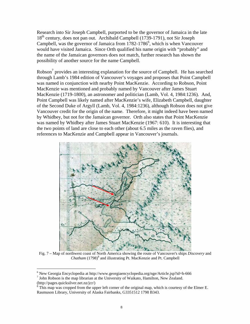
The accepted authority of names in Alaska has, since 1967, been Donald J. Orth’s Dictionary of Alaska Place Names. Campbell Creek, according to Orth, is a “local name reported in 1906 by T.G. Gerdine and R.H. Sargent, USGS; derived from nearby Point Campbell” (1967:177). Point Campbell, the tip of land between Knik and Turnagain Arms on Cook Inlet, was “named May 4, 1794, by Joseph Whidbey, probably for Sir Joseph Campbell, governor of Jamaica in 1785 when Capt. George Vancouver, RN, was in the West Indies” (Orth 1967:177). Recall that Vancouver was on Cook’s expedition into this area in 1778, and Joseph Whidbey was the Master of Vancouver’s ship Discovery from 1791-1794 when they sailed through Alaska waters.
5 From Shem Pete’s Alaska, The Territory of the Upper Cook Inlet Dena’ina, with permission from the authors.
8
Research into Sir Joseph Campbell, purported to be the governor of Jamaica in the late 18th century, does not pan out. Archibald Campbell (1739-1791), not Sir Joseph Campbell, was the governor of Jamaica from 1782-17866, which is when Vancouver would have visited Jamaica. Since Orth qualified his name origin with “probably” and the name of the Jamaican governors does not match, further research has shown the possibility of another source for the name Campbell. Robson7 provides an interesting explanation for the source of Campbell. He has searched through Lamb’s 1984 edition of Vancouver’s voyages and proposes that Point Campbell was named in conjunction with nearby Point MacKenzie. According to Robson, Point MacKenzie was mentioned and probably named by Vancouver after James Stuart MacKenzie (1719-1800), an astronomer and politician (Lamb, Vol. 4, 1984:1236). And, Point Campbell was likely named after MacKenzie’s wife, Elizabeth Campbell, daughter of the Second Duke of Argyll (Lamb, Vol. 4, 1984:1236), although Robson does not give Vancouver credit for the origin of the name. Therefore, it might indeed have been named by Whidbey, but not for the Jamaican governor. Orth also states that Point MacKenzie was named by Whidbey after James Stuart MacKenzie (1967: 610). It is interesting that the two points of land are close to each other (about 6.5 miles as the raven flies), and references to MacKenzie and Campbell appear in Vancouver’s journals.
Fig. 7 – Map of northwest coast of North America showing the route of Vancouver's ships Discovery and
Chatham (1798)8 and illustrating Pt. MacKenzie and Pt. Campbell
6 New Georgia Encyclopedia at http://www.georgiaencyclopedia.org/nge/Article.jsp?id=h-666 7 John Robson is the map librarian at the University of Waikato, Hamilton, New Zealand. (http://pages.quicksilver.net.nz/jcr/) 8 This map was cropped from the upper left corner of the original map, which is courtesy of the Elmer E. Rasmuson Library, University of Alaska Fairbanks, G3351512 1798 B343.
9
Fig. 8 - 1911 Map of Cook Inlet by Alfred H. Brooks showing the soon-to-be townsite of Anchorage9, note
Campbell Creek to the northeast of Pt. Campbell (from author’s collection)
There are other references to geographical features using the name Campbell in the Anchorage area besides Point Campbell and Campbell Creek. Two Campbell Lakes are located in west Anchorage very close to each other, and Campbell Creek Canyon runs northwest to southeast out of Chugach State Park. Campbell has been used as the Alaska Railroad flag stop near W. Potter and C Sts. in midtown Anchorage, a few streets in town are named after Campbell, and the Campbell Airstrip is located in Far North Bicentennial Park10. An ever popular hands-on facility, the BLM’s Campbell Creek Science Center, is also in Far North Bicentennial Park adjacent to the South Fork of Campbell Creek.
9 This map was cropped from “Reconnaissance Map of Mount McKinley Region, Alaska”, by Alfred H. Brooks, 1911. 10 In 1942, 7,680 acres were withdrawn from public lands for the War Department which is where the Campbell Airstrip was built in 1942-43. See http://www.blm.gov/ak/ado/ctfhist-1.html. In 1971, 5000 acres were transferred to BLM, and today the Municipality of Anchorage retains about 4200 acres in the area. See http://www.kidsneedparks.org/fnbp.htm.
10
Fig. 9 – 1962/1967 U.S.G.S topographic map showing Campbell Landing Strip11 on the South Fork of
Campbell Creek
Fig. 10 - Plan of Campbell Airstrip by Campbell Creek12
11 “Anchorage and Vicinity”, 1:24,000 U.S.G.S. Topographic Map, 1962 with 1967 revisions. 12 http://www.blm.gov/ak/ado/ctfhist-1.html
11
Fig. 11 - Campbell flag stop in midtown Anchorage (photo by author)
EARLY LAND EXPLORATION AND NON-NATIVE SETTLEMENT IN THE
ANCHORAGE AREA
The impetus for 19th and 20th century exploration and settlement by non-Natives in what is now known as Anchorage was precipitated by the need for a railroad from coastal areas into the interior, which was opening up quickly after the discovery of mineral resources (gold, copper and coal). There are records of settlement in the area by non-Natives as early as 1880 at Tyonek, a Dena’ina village (Orth 1967:1001); Ladd, a trading post run by a Mr. Ladd in 1895 (Orth 1967:560); and in 1903 at Knik, another Dena’ina village where George Palmer opened a trading post called Palmer’s Cache (Orth 1967:533) and Orville Herning settled and built a store (Chandonnet 2000:26). Even so, the east side of Cook Inlet remained relatively untouched with the exception of its Dena’ina inhabitants. Survey parties, such as that led by geologist Walter Mendenhall sent by Captain William Glenn in 1898 over what is now the Crow Creek Pass (Tower 1999:17) and Chief Engineer Charles Anderson’s party that created a right-of-way from Potter north in 1902 (Tower 1999:18) came close to modern-day Anchorage, but neither reached the area near Ship Creek that ultimately would be first settled as a townsite. In 1912 the Alaska Railroad Commission was formed to study the best rail routes to benefit the country. That same year Alfred H. Brooks, the renowned geologist, and three engineers made a whirlwind visit and survey to Alaska, and their report recommended two rail lines: one would extend the Copper River and Northwestern Railroad to Fairbanks and the other would link the Alaska Northern Line to the Innoko-Iditarod mining district (Carberry and Lane, 1986:102).
12
Fig. 12 - Sleem’s 1910 Map showing Anchorage before settlement. Red dashed lines indicate the proposed
railroad, and circles represent placer deposits13
Although the decision for the railroad was still a couple of years away, the Ship Creek area was settled in 1912 by a couple, John and Nellie Brown. John was a forester for the nearly 5 million acre Chugach National Forest, which had been established throughout Prince William Sound in 1907 and expanded into the Anchorage area over the next few years. His assignment was to make sure that miners and other settlers were following the rules and regulations for preservation of the forest on behalf of the U.S. Forest Service. Recently married, the two settled in a tent on Ship Creek and later that year moved to a log cache that had been built by the Whitneys, a couple of homesteaders who moved near what is now Elmendorf Air Force Base. There were a few other short-term early settlers, but John and Nellie remained in the area until their deaths in 1972 and 1978 respectively.
13 D.H. Sleem’s “Map of Central Alaska: Showing Yentna, Susitna, Matanuska, Kuskokwim, Kantishna, Fairbanks, Iditarod, Innoko and Tanana Mining Districts” (author’s collection).
13
Fig. 13 - Chugach National Forest, 1915, showing Anchorage Townsite and a military reservation at Pt.
Campbell14 (see Fig. 14 for detail)15
The same year that the Browns settled at Ship Creek was also when the U.S. Congress passed an act that created a legislative assembly for the Territory of Alaska and gave the President the authority to appoint a commission to examine Alaska’s transportation problems which were hindering territorial development (Barry 2000:47). In 1914 the Alaska Engineering Commission (AEC) was formed to begin a study of the area around the mouth of Ship Creek (Tower 1999:26). The two railroad routes to the interior identified by Brooks and his group were in contention, and speculation on which would be the winner was rampant. Finally on April 10, 1915, President Woodrow Wilson chose Ship Creek for the railroad terminus. In anticipation of this choice, several speculators had hastily thrown up a tent city in the area adjacent to Ship Creek, which truly had the potential for being a major transportation hub. Large ships could travel a considerable distance up Cook Inlet, and then smaller boats would transfer people and goods to shore at Ship Creek, Knik, or further around Turnagain Arm at Hope and Sunrise. As the soon-to-be townsite was carved out of the Chugach National Forest, a quick survey of the 350 acres was completed by Andrew Christensen, the chief of the General Land Office. Based on the typical railroad grid planning found in most of the western U.S., the area immediately south of Ship Creek was platted at right angles with streets running east to west named numerically, and those going north to south with letters.
14 By 1915 the area around Point Campbell had been turned into the Point Campbell Military Reserve. During the Cold War years, Point Campbell Military Reserve housed Nike and Hercules missiles until 1979 when they were deactivated, and this area became Kincaid Park a year earlier. (http://www.anchoragenordicski.com/Trails/trailsKincaid.htm#history). 15 Courtesy of the U.S.D.A. Forest Service “Forest Service map of Chugach National Forest Alaska”, showing Proclamation dated Aug. 2, 1915.
14
Rules were set up for an auction of the lots, and on July 10, 1915, Christensen oversaw the bidding. Within a week, 655 lots had been sold for nearly $150,000 (Tower 1999:29), and the building began. Its name at the time was “Knik Anchorage” or sometimes it was referred to just as “Anchorage” (Tower 1999:30), but to finalize the new settlement’s name an election was held August 9, 1915. The other choices were: Matanuska, Alaska City, Ship Creek, Winalaska, Gateway, Terminal, Homestead, Lane, Brownsville, Whitney, New Knik, Woodrow City, Port Woodrow, and Woodrow. Anchorage won out—and it has been known as such since. Five years later Anchorage was incorporated.
Fig. 14 - The 350 acre Anchorage Townsite within Chugach National Forest16
The early environment that faced first the Browns and later the new tent city dwellers and parcel owners was one of wilderness. It was rich with trees and high grasses, which were quickly felled to accommodate the needs of the new settlers. Lumber was a greatly sought-after commodity, and the landscape paid the price of supplying building materials for the ever-expanding population. For several decades the town core still remained close to the original townsite area with small satellite areas springing up slowly.
16 U.S.D.A. “Forest Service map of Chugach National Forest Alaska”, showing Proclamation dated Aug. 2, 1915. Note also that Ship Creek was designated as Woodrow Creek in honor of President Woodrow Wilson who awarded the railroad contract to this area. For a good history of the Chugach National Forest, which is celebrating its centennial this year, see Rakestraw’s A History of the United States Forest Service in Alaska, 2002.
15
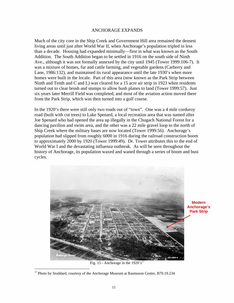
ANCHORAGE EXPANDS Much of the city core in the Ship Creek and Government Hill area remained the densest living areas until just after World War II, when Anchorage’s population tripled in less than a decade. Housing had expanded minimally—first in what was known as the South Addition. The South Addition began to be settled in 1916 on the south side of Ninth Ave., although it was not formally annexed by the city until 1945 (Tower 1999:106-7). It was a mixture of homes, fur and cattle farming, and vegetable gardens (Carberry and Lane, 1986:132), and maintained its rural appearance until the late 1930’s when more homes were built in the locale. Part of this area (now known as the Park Strip between Ninth and Tenth and C and L) was cleared for a 15 acre air strip in 1923 when residents turned out to clear brush and stumps to allow bush planes to land (Tower 1999:57). Just six years later Merrill Field was completed, and most of the aviation action moved there from the Park Strip, which was then turned into a golf course. In the 1920’s there were still only two roads out of “town”. One was a 4 mile corduroy road (built with cut trees) to Lake Spenard, a local recreation area that was named after Joe Spenard who had opened the area up illegally in the Chugach National Forest for a dancing pavilion and swim area, and the other was a 22 mile gravel loop to the north of Ship Creek where the military bases are now located (Tower 1999:56). Anchorage’s population had slipped from roughly 6000 in 1916 during the railroad construction boom to approximately 2000 by 1920 (Tower 1999:49). Dr. Tower attributes this to the end of World War I and the devastating influenza outbreak. As will be seen throughout the history of Anchorage, its population waxed and waned through a series of boom and bust cycles.
Fig. 15 - Anchorage in the 1920’s17
17 Photo by Stoddard, courtesy of the Anchorage Museum at Rasmuson Center, B70.19.234
Modern Anchorage’s
Park Strip
16
The 1930’s began as an upswing. The Territorial Congressional Delegate Anthony J. Dimond was urging Congress to consider Alaska’s value as a crossroads to the Far East. Japan was beginning its expansion in Asia, and air power was coming of age. In 1939 and 1940 the area north of Ship Creek was being turned into an air base on what was then the original Ft. Richardson (later Fort Richardson moved east). Campbell Airfield was built in 1942 on Campbell Tract, land that had been removed from the Public Domain and appropriated by the War Department for use in military operations. And with construction opportunities came people. Anchorage’s population jumped from 4,000 in 1940 to 9,000 in 18 months (Tower 1999:83)—and with it came a housing crunch. Much of the area outside of the original townsite had been homesteaded, including the lands bought up from settlers to accommodate the new military bases. To the south of the original townsite, homes were haphazardly built wherever people could place them, and subdivisions sprang up everywhere, such as Eastchester, Spenard, Mountain View and Woodland Park. City annexation was a contentious issue because while there was a benefit of having services—the downside meant taxes. Regardless, in 1954 four areas were annexed: Russian Jack Springs, Rogers Park, Spenard and Fairview. The densest settlement of Anchorage still remained well north of Campbell Creek as is evident in the 1952/1963 topographic map shown here.
Fig. 16 - 1952 Anchorage A-8, 1:63,360 U.S.G.S. Topographic Map with minor revisions in 1963
Mountain View
Spenard
South Addition
Original Townsite
17
Alaska’s site and situation worked to its advantage with developments following World War II. The Cold War started to heat up, and once again the strategic location of military bases in Alaska could not be overlooked. Anchorage gained prominence on the Great Circle flying route between the lower ’48 and Asia, and Anchorage International Airport was opened in December 1951. Oil was discovered on the Kenai Peninsula in the late 1950’s, and the push for statehood began in earnest. The Alaska Constitution was begun in 1955 and endorsed by the electorate a year later. On May 28, 1958, the Alaska Statehood Bill was passed. The population in Alaska in 1960 was up to 82,833, and a decade later it had increased by 50% to 124,385 (Tower 1999:128). With Alaska’s new status, came a focus on its internal form of government. Attempts to avoid mistakes in local governments often found in the lower ’48 resulted in the passage of the Mandatory Borough Act of 1963. In essence, the Greater Anchorage Area Borough (GAAB) was established and given area-wide powers for planning, zoning, education, property assessment, and tax collection (Tower 1999:132). This was also a time of an economic slow-down in the area, but a stroke of irony—the Good Friday Earthquake of March 27, 1964—changed that with a rebuilding boom after the devastating 9.2 earthquake. Following on the heals of this boon was the discovery of oil at Prudhoe Bay in 1968, and the next boom cycle was the building of the Trans-Alaska Pipeline in the 1970’s. Anchorage’s population (along with Alaska’s) swelled during this decade.
Fig. 17 - Diagram of urban and suburban expansion from 1920-1970 (Selkregg)
Lidia Selkregg’s 1972 Environmental Atlas of the Greater Anchorage Area Borough provides a good visual of how sparsely Anchorage was settled until the 70’s as well as the direction of settlement. On the following map, the density of population is indicated
18
by type of land use. Medium to high density residential predominates in the city core and outward into the areas of early expansion, while south Anchorage is either undeveloped or low density residential.
Fig. 18 - “Generalized Existing Land Use in the Greater Anchorage Area Borough” map, 197218
Fig. 19 – Legend for “Generalized Existing Land Use in the Greater Anchorage Area Borough”, 1972
18 From Environmental Atlas of the Greater Anchorage Area Borough, Alaska, Edited and Coordinated by Lidia L. Selkregg, 1972, p. 98.
19
When the Campbell Creek watershed is laid over the map, as seen in the next figure, it is quite apparent that much of the over 15,000 acre watershed was unsettled in the early 70’s.
Fig. 20 - 1972 “Generalized Existing Land Use Map in the Greater Anchorage Area Borough” with
Campbell Creek watershed overlay (transparent white)
In the 1980’s it was estimated that 1,000 people arrived in Anchorage monthly (Tower 1999:177). And again, a housing shortage had to be addressed. This is when settlement began to expand faster into the open areas of Campbell Creek watershed and south. In the following figure dated 2006, residential expansion has basically filled in the southern part of the Anchorage bowl.
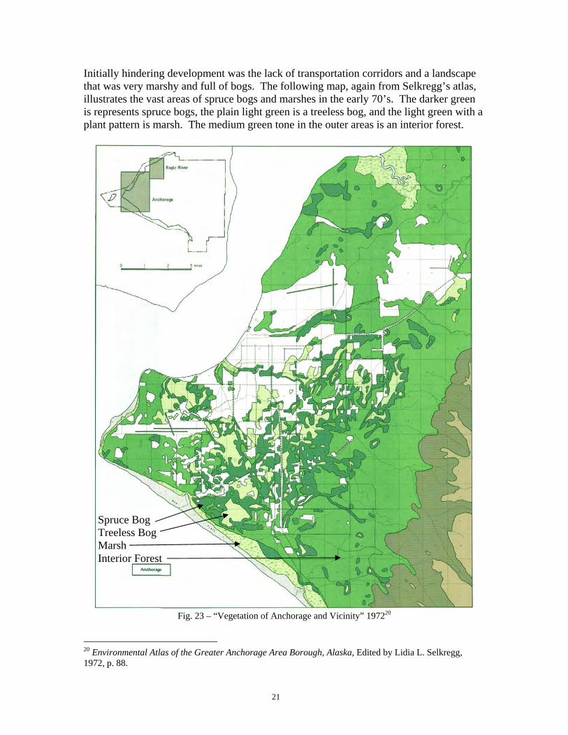
Initially hindering development was the lack of transportation corridors and a landscape that was very marshy and full of bogs. The following map, again from Selkregg’s atlas, illustrates the vast areas of spruce bogs and marshes in the early 70’s. The darker green is represents spruce bogs, the plain light green is a treeless bog, and the light green with a plant pattern is marsh. The medium green tone in the outer areas is an interior forest.
Fig. 23 – “Vegetation of Anchorage and Vicinity” 197220
20 Environmental Atlas of the Greater Anchorage Area Borough, Alaska, Edited by Lidia L. Selkregg, 1972, p. 88.
Spruce Bog Treeless Bog Marsh Interior Forest
22
THE CHANGING ENVIRONMENT OF ANCHORAGE
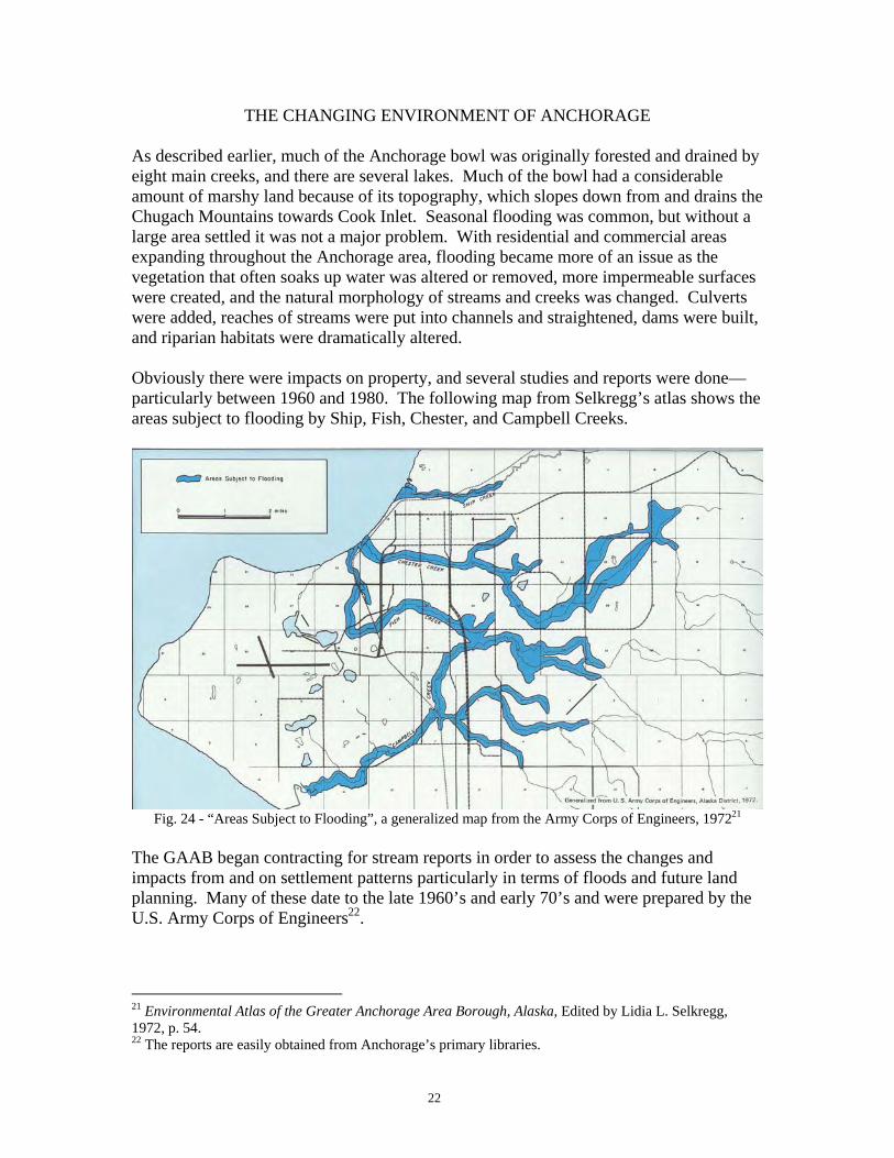
As described earlier, much of the Anchorage bowl was originally forested and drained by eight main creeks, and there are several lakes. Much of the bowl had a considerable amount of marshy land because of its topography, which slopes down from and drains the Chugach Mountains towards Cook Inlet. Seasonal flooding was common, but without a large area settled it was not a major problem. With residential and commercial areas expanding throughout the Anchorage area, flooding became more of an issue as the vegetation that often soaks up water was altered or removed, more impermeable surfaces were created, and the natural morphology of streams and creeks was changed. Culverts were added, reaches of streams were put into channels and straightened, dams were built, and riparian habitats were dramatically altered. Obviously there were impacts on property, and several studies and reports were done—particularly between 1960 and 1980. The following map from Selkregg’s atlas shows the areas subject to flooding by Ship, Fish, Chester, and Campbell Creeks.
Fig. 24 - “Areas Subject to Flooding”, a generalized map from the Army Corps of Engineers, 197221
The GAAB began contracting for stream reports in order to assess the changes and impacts from and on settlement patterns particularly in terms of floods and future land planning. Many of these date to the late 1960’s and early 70’s and were prepared by the U.S. Army Corps of Engineers22.
21 Environmental Atlas of the Greater Anchorage Area Borough, Alaska, Edited by Lidia L. Selkregg, 1972, p. 54. 22 The reports are easily obtained from Anchorage’s primary libraries.
23
In regard to the potential for flooding, a 1975 report23 states,
Today, the areas adjacent to Campbell Creek are in a state of rapid development. Land is continually being subdivided and developed as the Anchorage area population grows and requires additional space. This results in an increased tendency to encroach upon the flood plains of Campbell Creek and other local streams. (1975:1)
Seven years prior to this report, another Corps of Engineers’ report24 warned,
Increased damage from flooding will occur as the vegetation is removed because of increased development in the foothills of the Anchorage drainage area and the land is ditched to allow a faster runoff. Every new subdivision and residence in the upper reaches of the drainage area increases the possibility of flooding in the lower areas of the basin. (1968:17)
The report included the following graphics.
Fig. 25 - Example of ditching from a 1968 Army Corps of Engineers Report25. Note the lack of
vegetation, which greatly contributes to erosion and silt deposition.
23 Special Flood Hazard Report: Greater Anchorage Area, Campbell Creek, U.S. Army Corps of Engineers, 1975. 24 Flood Plain Information, Campbell Creek, Anchorage, Alaska, U.S. Army Corps of Engineers, 1968. 25 Flood Plain Information, Campbell Creek, Anchorage, Alaska, U.S. Army Corps of Engineers, 1968.
24
Fig. 26 - Stream straightening and channelization26
Figs. 27 and 28 - Two reaches of Little Campbell Creek showing straightening and culverts and natural
sinuosity and vegetation (left photo by author, right photo by Municipality of Anchorage)
26 Flood Plain Information, Campbell Creek, Anchorage, Alaska, U.S. Army Corps of Engineers, 1968.
25
The Corps of Engineers’ report also highlighted some positive steps that were being taken,
The expansion trend of the Anchorage area is toward Campbell Creek because of favorable topography and accessibility. Portions of the flood plain have been purchased and designated as a greenbelt area for recreational development, such as riding trails, foot paths, [sled] dog racing areas, picnic grounds, etc. Parts of the green belt have been inundated by floods in the past [which is part of their role as an absorber of overflow], and a substantially greater area is within reach of the potentially larger floods of the future. (1975:3)
Fig. 29 - Campbell Creek at Piper Street, August 2006, flood water being absorbed by greenbelt adjacent to
walkway and bike trail (photo by author)
CAMPBELL CREEK—THEN AND NOW As noted, with the expansion of settlement into the Campbell Creek watershed, the creek and its tributaries have had some major alterations. Several reaches along Little Campbell Creek have been straightened, channelized, and put into culverts in order to accommodate development. Marshy areas have been drained, and large developments, i.e. the Dimond Mall, have replaced former wetlands. And perhaps the most dramatic alteration was the damming of Campbell Creek near its mouth to create Campbell Lake (not to be confused with the original Campbell Lake).
26
SETTLEMENT ALONG CAMPBELL CREEK
Fig. 30 - 1945 View towards Campbell Airstrip by Steve McCutcheon27
Fig. 31 - 2007 View towards Campbell Airstrip from Google28
27 From the McCutcheon Collection, courtesy of the Anchorage Museum at Rasmuson Center, #23797 28 Google EarthTM Mapping Services, with permission
Goose Lake
Goose Lake
Campbell Airstrip
Campbell Creek and remnant wetlands Tudor Rd.
Lake Otis Pkwy
Campbell Airstrip Campbell Creek and associated wetlands
27
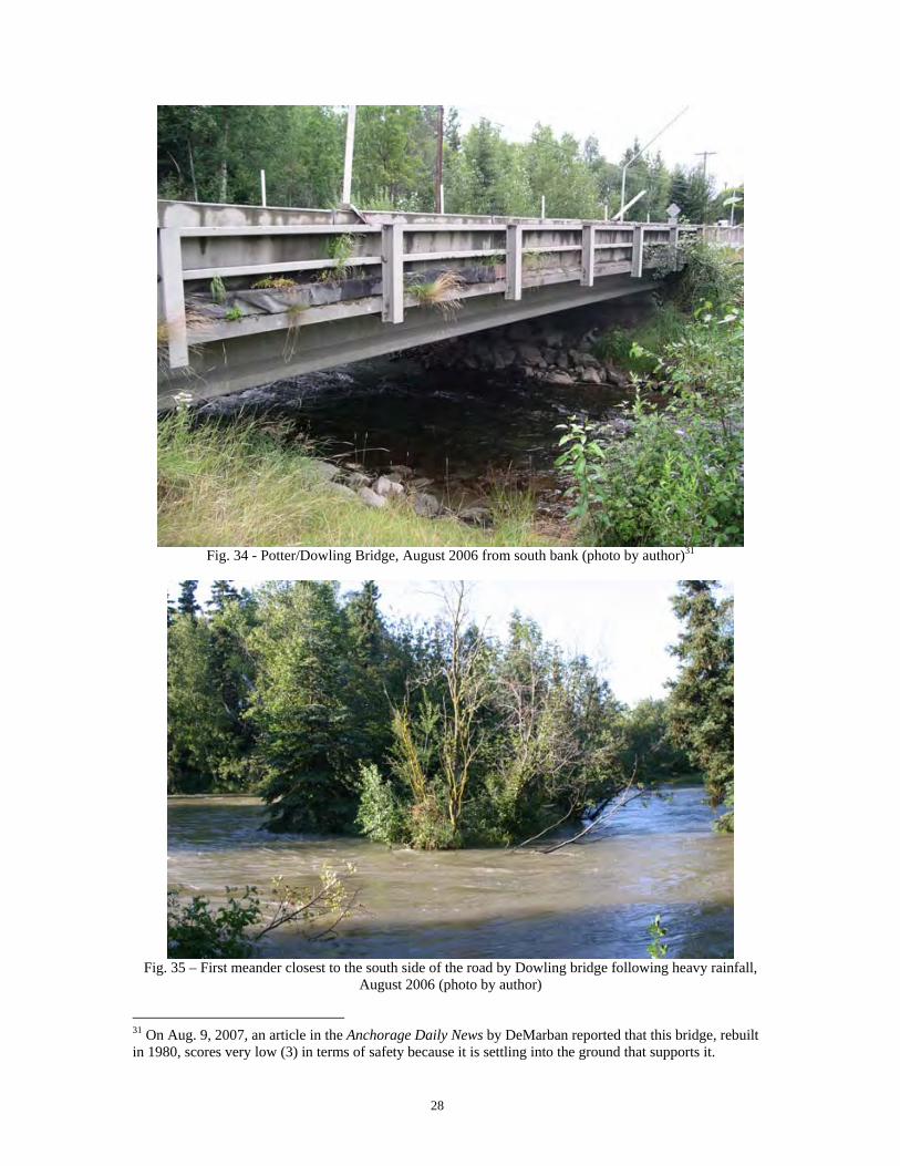
In the 60+ years since the McCutcheon photo was taken, the expansion of buildings is impressive. Furthermore, it is apparent from the original photo that much of the wetland area near Tudor Road has been filled and built upon. The next photo looks to the southwest at the bridge over Campbell Creek on Potter Rd. (now Dowling) just below the original Seward Highway (now the Old Seward Highway). Note the vast empty space toward Turnagain Arm in the early photo.
Fig. 32 - 1952 Photo by Ward Wells29
Fig. 33 - 2007 View towards bridge from Google Earth30
29 Ward Wells Collection, courtesy of the Anchorage Museum at Rasmuson Center, B83.91 30 Google EarthTM Mapping Services, with permission
Bridge
Dowling Rd.
Bridge
Potter (Dowling)
See Figs. 34 and 35 for shot of bridge and this meander
Meander
28
Fig. 34 - Potter/Dowling Bridge, August 2006 from south bank (photo by author)31
Fig. 35 – First meander closest to the south side of the road by Dowling bridge following heavy rainfall,
August 2006 (photo by author)
31 On Aug. 9, 2007, an article in the Anchorage Daily News by DeMarban reported that this bridge, rebuilt in 1980, scores very low (3) in terms of safety because it is settling into the ground that supports it.
29
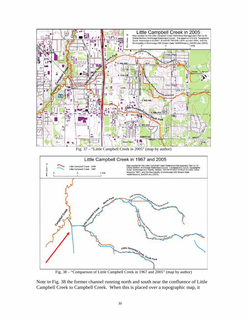
LITTLE CAMPBELL CREEK One of the most dramatic examples of channel changes is found along Little Campbell Creek, a major tributary to Campbell Creek. Little Campbell Creek drains about 12,000 acres of the Campbell Creek watershed, and is formed by two main forks that run approximately 24 miles all together. In the following maps that have overlays of Little Campbell Creek in 1962 (blue) and 2005 (red), it is easy to see the areas that have been straightened, angled, and generally changed from the natural sinuous channel. Besides allowing the stream to run more swiftly, which exacerbates flood hazards, there are impacts on the critters that live in the creek: salmon, trout, stickleback, and Dolly Varden. Little Campbell Creek is a small waterway that is a perfect habitat for juvenile fish in many areas. Good gravelly bottoms, overhanging vegetation to protect fish from predators and heat, and slow moving water are the ideal. Human intervention by straightening and putting streams in culverts alters these factors, and it makes it much more difficult for juvenile fish to survive. Their survival is further impacted by run-off from storm drains, streets, and non-vegetated areas that pollute the water with silt and chemicals. Development that is not done well contributes to a high fish mortality rate.
Fig. 36 “Little Campbell Creek in 1967” (map by author)
30
Fig. 37 – “Little Campbell Creek in 2005” (map by author)
Fig. 38 – “Comparison of Little Campbell Creek in 1967 and 2005” (map by author)
Note in Fig. 38 the former channel running north and south near the confluence of Little Campbell Creek to Campbell Creek. When this is placed over a topographic map, it
31
clearly illustrates what happened when Dimond Mall was built. The former wetland that now sits under Dimond Mall has been paved over, and a new lake, Taku Lake, a former gravel pit32 is now present to the northwest of Dimond Mall.
Fig. 39 – 1967 area before Dimond Mall Fig. 40 - 1994 after Dimond Mall
Fig. 41 - Dimond Mall area, Google Earth 200733
32 Email communication from Thede Tobish, Municipality of Anchorage Planning Department, August 2007. 33 Google EarthTM Mapping Services, with permission
Taku Lake
DIMOND MALL
32
The 1975 U.S. Army Corps of Engineers’ flood report34 that was quoted previously explains the impacts of some of these changes,
[F]ormerly rather damp and swampy areas are now being developed for real estate purposes. In recent years, drainage ditches have been excavated in the flood plain to lower than the water table, thereby enabling the ground to drain enough to construct foundations and cesspools in new housing developments. When floods occur, these drainage ditches fill, the water table rises and cesspools overflow, creating not only damage from high water but general health hazards to all those living in the flood plain area. (1975:3)
As will be noted later in this report, there are still similar concerns on Campbell Creek, and development as described above continues today.
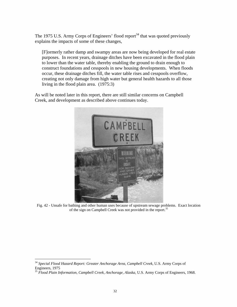
Fig. 42 - Unsafe for bathing and other human uses because of upstream sewage problems. Exact location
of the sign on Campbell Creek was not provided in the report.35
34 Special Flood Hazard Report: Greater Anchorage Area, Campbell Creek, U.S. Army Corps of Engineers, 1975 35 Flood Plain Information, Campbell Creek, Anchorage, Alaska, U.S. Army Corps of Engineers, 1968.
33
CAMPBELL LAKE(S)
As mentioned above, there are actually two Campbell Lakes in Anchorage, and one of them is an artificial lake that was created by damming Campbell Creek in 1959, when an earthen dam was formed across Campbell Creek just upstream of where it enters the intertidal zone of Turnagain Arm. Orth lists both lakes:
Campbell Lake: 1.3 mi. long, in course of Campbell Creek, name of a former lake reported in 1962 by USGS. Lake drained during the earthquake of 1964 (1967:177) Campbell Lake: 0.3 mi. long, 1.7 mi. E. of Point Campbell. Local name published by USGS; probably derived from nearby Point Campbell (1967:177)
Fig. 43 - USGS Topographic Map, “Anchorage and Vicinity, Alaska”, 1:24,000, 1962 with minor revisions
1967
Over time, and probably to avoid confusion, the original Campbell Lake has been called by other names. The Alaska Department of Fish and Game refers to it as Point Campbell Lake and their website36 also lists it as Little Campbell Lake and Beer-can Lake. Because it does not connect to Campbell Creek, it will not be discussed in any greater detail.
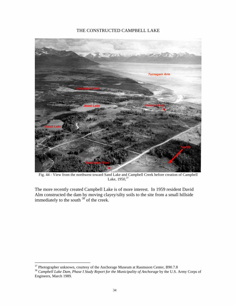
Fig. 44 - View from the northwest toward Sand Lake and Campbell Creek before creation of Campbell
Lake, 1950,37 The more recently created Campbell Lake is of more interest. In 1959 resident David Alm constructed the dam by moving clayey/silty soils to the site from a small hillside immediately to the south 38 of the creek.
37 Photographer unknown, courtesy of the Anchorage Museum at Rasmuson Center, B90.7.8 38 Campbell Lake Dam, Phase I Study Report for the Municipality of Anchorage by the U.S. Army Corps of Engineers, March 1989.
Alm and his partner, George McCullough, had apparently acquired title to many of the surrounding homesteads that had been issued in the 1940’s and 50’s, so that formation of the lake provided an aesthetic and utilitarian area for the adjacent residential property. Dr. Elizabeth Tower has researched much of the homesteading history of Anchorage and has completed maps with the owners, patent numbers, and years of acquisition. Following is one that covers this area.
36
Fig. 47 - Map compiled and courtesy of Dr. Elizabeth Tower
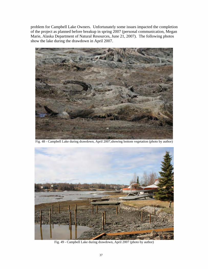
Today the lake contains more than 150+ float planes that sit below homes with a lake view. Besides being a private float pond, Campbell Lake also provides boating, fishing, snowmachining, skating, and swimming opportunities for the adjacent residents. It is unfortunate that there is minimal public access to the lake for non-lake residents. Campbell Lake is also the initial freshwater entrance for the many anadromous fish that enter Campbell Creek, including chinook (Oncorhynchus tshawytscha) , coho (O. kisutch), sockeye (O. nerka), pink (O. gorbuscha), and chum (O. keta) salmon as well as resident Dolly Varden (Salvelinus malma) and slimey sculpin (Cottus cognatus) . Responsibility for the lake’s upkeep is by the Campbell Lake Owners, Inc. (CLO), who must deal with issues that develop such as siltation and high aquatic vegetation growth. In fall 2006 a plan was executed to do a drawdown on the lake to expose the bottom in order to dredge and remove excess vegetation and silt. Since the movement of sediment downstream is a natural function of a waterway, this will be an unending and expensive
David Alm’s property George McCullough’s property
37
problem for Campbell Lake Owners. Unfortunately some issues impacted the completion of the project as planned before breakup in spring 2007 (personal communication, Megan Marie, Alaska Department of Natural Resources, June 21, 2007). The following photos show the lake during the drawdown in April 2007.
Fig. 48 - Campbell Lake during drawdown, April 2007,showing bottom vegetation (photo by author)
Fig. 49 - Campbell Lake during drawdown, April 2007 (photo by author)
38
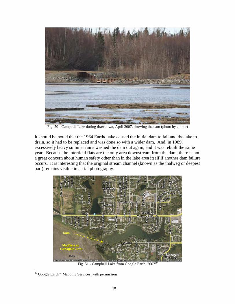
Fig. 50 - Campbell Lake during drawdown, April 2007, showing the dam (photo by author)
It should be noted that the 1964 Earthquake caused the initial dam to fail and the lake to drain, so it had to be replaced and was done so with a wider dam. And, in 1989, excessively heavy summer rains washed the dam out again, and it was rebuilt the same year. Because the intertidal flats are the only area downstream from the dam, there is not a great concern about human safety other than in the lake area itself if another dam failure occurs. It is interesting that the original stream channel (known as the thalweg or deepest part) remains visible in aerial photography.
Fig. 51 - Campbell Lake from Google Earth, 200739
39 Google EarthTM Mapping Services, with permission
Mudflats at Turnagain Arm
Dam
39
CAMPBELL CREEK TODAY
Anchorage’s population has grown from the initial few thousand settlers at Ship Creek to over 260,000 today, and has spread throughout the Anchorage Bowl—the approximately 100 square miles of urbanized area bounded by the Chugach State Park, Turnagain and Knik Arms, and Elmendorf and Ft. Richardson Military bases40. Yet despite cautions against building around Campbell Creek, much of this area has homes and businesses along it and in the general flood plain. Because the Campbell Creek area was settled later, there are some amenities that enhance the area. Several reaches of the stream have greenbelts and parks along them, and a significant trail system41 covers much of the creek from near Bragaw on the North Fork of Campbell Creek to Northwood Drive by Campbell Lake42. Whether walking or riding along the creek trail, there are several things to see and do. It is not uncommon in the summer to see youngsters rafting, tubing or wading in the creek, as well as kayakers and canoers and people fishing. A series of bridges and overlooks are found along the creek, which allow excellent viewing of the many salmon species that migrate upstream beginning in the mid-summer. Some areas are suited for disabled access and fishing. Restaurants, such as the Peanut Farm and Arctic Roadrunner, have outside eating areas near the creek. Anchorage’s assorted critters are also commonly found in the greenbelts and creeks. Beaver activity is especially noticeable by the Peanut Farm. Students from Polaris K-12 science classes use Little Campbell Creek as an outdoor lab to monitor water quality, and the Campbell Creek Science Center takes advantage of its location for similar activities. There are lots of things to see and do and a lot is going on!
Fig. 52 – Children fishing at Bancroft Park (photo by author) Fig. 53 – Campbell kayakers (photo by author)
40 The entire Municipality of Anchorage encompasses nearly 2,000 sq. miles, but most of it is in forest and other areas not suitable for building. Anchorage 2020 Plan, Municipality of Anchorage, Planning Dept., 2001. 41 Anchorage’s trails are multi-purpose and are used for sled dog races, cross-country ski races, horse-back riding, bicycling, walking, and jogging. 42 A few areas of the trail, such as where it intersects with the New Seward Highway, remain disconnected from the trail system. See www.AnchorageParkFoundation.org or their “Anchorage Trails and Parks Map”, 2006, or Mountain Bike Anchorage, 2005 by Rosemary Austin. Trails in Chugach State Park are found on the “Chugach State Park, Chugach Mountains, Alaska” map by IMUS Geographics, 2001.
40
Fig. 54 - Peanut Farm at Campbell Creek and Old Seward, 2006 (photo by author)
Fig. 55 -1968 View of the Peanut Farm43
43 Flood Plain Information, Campbell Creek, Anchorage, Alaska, U.S. Army Corps of Engineers, 1968.
41
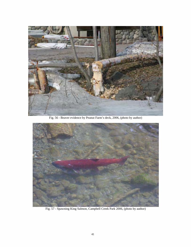
Fig. 56 - Beaver evidence by Peanut Farm’s deck, 2006, (photo by author)
Fig. 57 - Spawning King Salmon, Campbell Creek Park 2006, (photo by author)
42
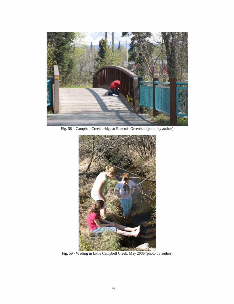
Fig. 58 – Campbell Creek bridge at Bancroft Greenbelt (photo by author)
Fig. 59 - Wading in Little Campbell Creek, May 2006 (photo by author)
43
Fig. 60 - Kathryn Smith’s Polaris K-12 science class doing water quality testing on Little Campbell Creek,
E. 68th and Brayton, May 2007 (photo by author)
Fig. 61 - Kathryn Smith’s Polaris K-12 science class doing water quality testing on Little Campbell Creek,
E. 68th and Brayton, May 2007 (photo by author)
44
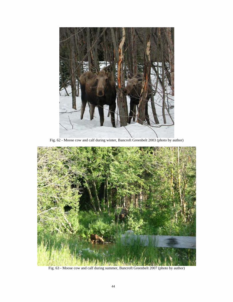
Fig. 62 - Moose cow and calf during winter, Bancroft Greenbelt 2003 (photo by author)
Fig. 63 - Moose cow and calf during summer, Bancroft Greenbelt 2007 (photo by author)
45
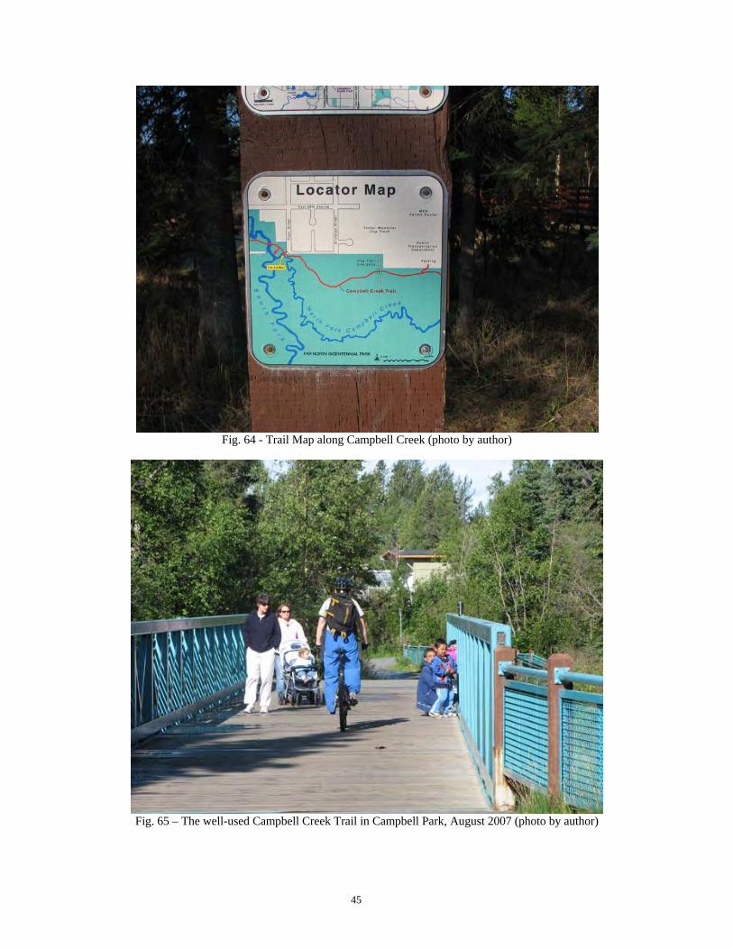
Fig. 64 - Trail Map along Campbell Creek (photo by author)
Fig. 65 – The well-used Campbell Creek Trail in Campbell Park, August 2007 (photo by author)
46
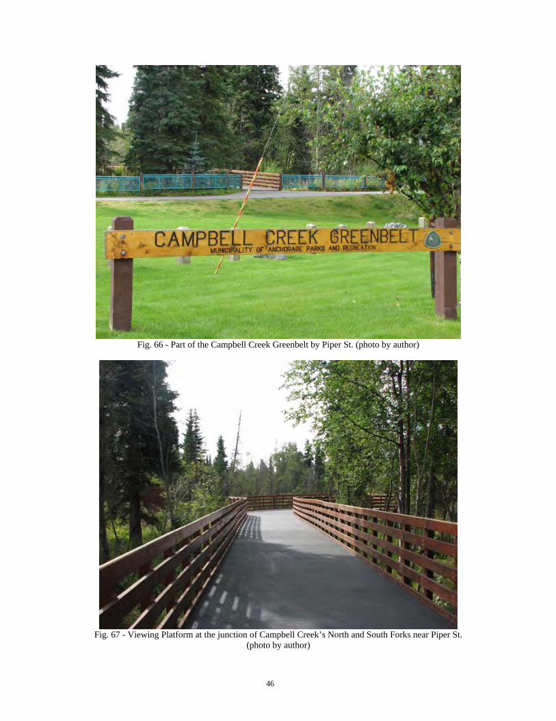
Fig. 66 - Part of the Campbell Creek Greenbelt by Piper St. (photo by author)
Fig. 67 - Viewing Platform at the junction of Campbell Creek’s North and South Forks near Piper St.
(photo by author)
47
Fig. 68 – Interpretive Signs are currently being installed along Campbell Creek Trail44 (photo by author)
Fig. 69 – Artwork along the Campbell Creek bike trail (photo by author)
44 See “Stroll along Campbell Creek and you’ll get an education”, Anchorage Daily News, October 5, 2006, p. B-5 by Rose Cox.
48
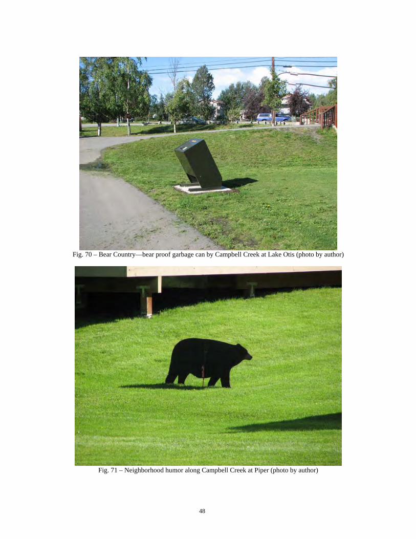
Fig. 70 – Bear Country—bear proof garbage can by Campbell Creek at Lake Otis (photo by author)
Fig. 71 – Neighborhood humor along Campbell Creek at Piper (photo by author)
49
Fig. 72 - Trail by Bancroft Park Greenbelt (photo by author)
Fig. 73 – Campbell Creek Bike Trail Detour due to the Bragaw St. Extension construction, August 2007
Fig. 76 - Looking into the Campbell Creek upper watershed along Campbell Airstrip Rd., 2006 (photo by
author)
Fig. 77 - Origins of North Fork Campbell Creek, Chugach State Park, 2006 (photo by author)
52
PROBLEMS ON CAMPBELL CREEK
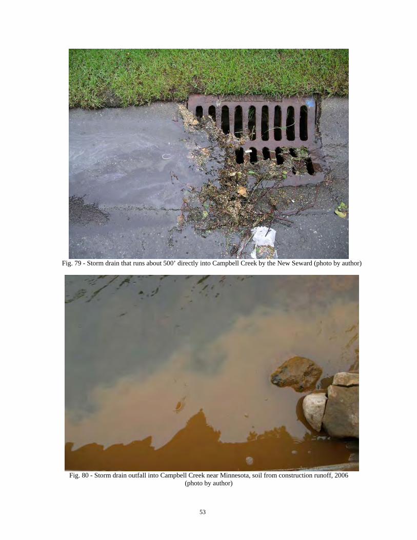
Clearly Campbell Creek, with all its great amenities and beauty, has its problems. Some have been discussed, such as the change in water courses, installation of culverts, ditches, channels, a dam, and overall development. Alterations in stream morphology result in the creek trying to rebalance itself, and an increase in erosion in some places. A number of the issues can be mitigated, and some cannot. One of the biggest problems facing Campbell and the other Anchorage creeks is their use as a receptacle for storm water. Most every storm drain in Anchorage eventually makes its way, usually untreated, into a creek before it runs out to Cook Inlet. Runoff receives fluids and winter sand from our roadways, fertilizers and pesticides from our yards, soap from washing our cars, soil from denuded construction sites, trash that is not thrown into garbage cans, and animal waste that is not picked up. Water quality is greatly impacted as well as the animals and people that use the creeks. Just as was found in 1968, warnings on the water quality still exist.
Fig. 78 – Sign on creek at Campbell Park at Lake Otis, August 2007 (photo by author)
53
Fig. 79 - Storm drain that runs about 500’ directly into Campbell Creek by the New Seward (photo by author)
Fig. 80 - Storm drain outfall into Campbell Creek near Minnesota, soil from construction runoff, 2006
(photo by author)
54
Fig. 81 - Lawn adjacent to Campbell Creek where fertilizers, pesticides and other can chemicals can easily make
their way into the creek with runoff from rain or watering, 2006 (photo by author)
Fig. 82 - Trash in North Fork of Little Campbell Creek, 2006 (photo by author)
55
Fig. 83 - Dog feces on foot bridge directly over Campbell Creek at Rakof, 2006 (photo by author)
The “Scoop the Poop” campaign is geared at getting dog owners to clean up after their pets. It is estimated that every day the 65,000 pets in Anchorage deposit ten tons of waste45. Any amount has an impact on our creeks—do your part!
Fig. 84 – Scoop the Poop poster at Campbell Park by Lake Otis (photo by author)
45 See Anchorage Waterways Council, www.anchoragecreeks.org, Scoop the Poop
56
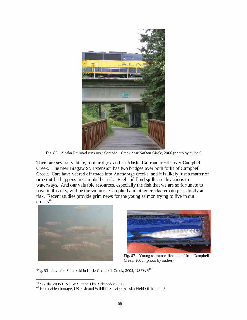
Fig. 85 - Alaska Railroad runs over Campbell Creek near Nathan Circle, 2006 (photo by author)
There are several vehicle, foot bridges, and an Alaska Railroad trestle over Campbell Creek. The new Bragaw St. Extension has two bridges over both forks of Campbell Creek. Cars have veered off roads into Anchorage creeks, and it is likely just a matter of time until it happens in Campbell Creek. Fuel and fluid spills are disastrous to waterways. And our valuable resources, especially the fish that we are so fortunate to have in this city, will be the victims. Campbell and other creeks remain perpetually at risk. Recent studies provide grim news for the young salmon trying to live in our creeks46
Fig. 87 – Young salmon collected in Little Campbell Creek, 2006, (photo by author) Fig. 86 – Juvenile Salmonid in Little Campbell Creek, 2005, USFWS47
46 See the 2005 U.S.F.W.S. report by Schroeder 2005. 47 From video footage, US Fish and Wildlife Service, Alaska Field Office, 2005
57
Fig. 88 – Bragaw St. Extension over Campbell Creek near the Municipal Offices, August 2007 (photo by author)
Fig. 89 – Bragaw St. Extension Bridge over Campbell Creek, August 2007 (photo by author)
58
WHAT IS BEING DONE
It is not all bad news. The many valuable aspects of our creeks are being acted on by agencies, local government, and NGO’s. Grants and other funding to analyze water quality, fish species and habitat, existing and potential problems, and mitigation efforts—including the purchase of lands for conservation—are happening today. Some of these collaborating groups include: the U.S. Fish and Wildlife Service, National Oceanic and Atmospheric Administration, the Alaska Department of Fish and Game, the Alaska Department of Natural Resources, the Alaska Department of Environmental Conservation, the Army Corps of Engineers, the Environmental Protection Agency, the Municipality of Anchorage, the Great Land Trust, and the Anchorage Waterways Council.
WHY HISTORY AND CULTURAL PATTERNS ARE IMPORTANT
Creeks enhance our lives in a variety of ways. They provide beauty, solace, sustenance, floods, renewal, recreation, and much more. Waterways are essential for the basics of our very existence, and we must respect that. We need to know and understand what they were like “before” and what we and others have done to them in order to protect their present and future. The following statement, I believe, sums up why we care and why we should care and why we need to take care of our waterways, which includes understanding their history and the impact of human culture on them,
“Every river needs a steward, and every person needs a river.”48
Figs. 90 and 91 – Campbell Creek at Bancroft Greenbelt near Rakof in fall and winter (photo by author)
48 From the Talachulitna River Society, http://www.talriversociety.org/
59
REFERENCES Alaska Department of Environmental Conservation (ADEC), Total Maximum Daily Loads (TMDLs) for Fecal Coliform Bacteria in the Waters of Campbell Creek and Campbell Lake in Anchorage, Alaska, May 2006, 77 pages. Alaska Department of Fish and Game Anadromous Fish Catalog at http://www.sf.adfg.state.ak.us/statewide/lakedata/index.cfm/FA/main.lakeDetail/MgtAreaID/1/LakeID/126 Austin, Rosemary, Mountain Bike Anchorage, Anchorage: Near Point Press, 2005. Barry, Mary, Jack and Nellie Brown: Pioneer Settlers of Anchorage, Alaska, MJP Barry: Anchorage, 2000. Beaglehole, J.C. (ed.), The Journals of Captain James Cook on His Voyages of Discovery: The Voyage of the Resolution and Discovery, 1776-1780, Vol. III, Part 1, Woodbridge: The Boydell Press, 1999. Carberry, Michael and Donna Lane, Patterns of the Past, An Inventory of Anchorage’s Historic Resources, Anchorage: Municipality of Anchorage, 1986. Chandonnet, Ann, Early Photographs of the Great Land, Whitehorse: Wolf Creek Books, Inc., 2000. Cox, Rose, “Stroll along Campbell Creek, and you’ll get an education”, Anchorage Daily News, October 5, 2006, p. B-5. DeMarban, Alex, “State gets low marks on bridges”, Anchorage Daily News, August 9, 2007, p. 1. Kari, James, and James A. Fall, Shem Pete’s Alaska, The Territory of the Upper Cook Inlet Dena’ina, Fairbanks: University of Alaska Press, 2003. Lamb, W. Kaye. (ed.), A Voyage of Discovery to the North Pacific Ocean and Round the World, 4 vols, London: Hakluyt Society, 1984. Langdon, Steve J., The Native People of Alaska, Anchorage: Great Land Graphics, 2002. Municipality of Anchorage Planning Department, Anchorage 2020 Plan, 2001. Municipality of Anchorage Planning Department, Coastal Resource Atlas, 2006. Orth, Donald J., Dictionary of Alaska Place Names, Washington: U.S. Government Printing Office, 1967.
60
Rakestraw, Lawrence, A History of the United States Forest Service in Alaska, U.S.D.A Forest Service, 2002. Robson, John, http://pages.quicksilver.net.nz/jcr/, August 2007. Schroeder, Mark, Restoring ecological function and value to aquatic resources in the Little Campbell Creek watershed: Recommendations for the Great Land Trust, Anchorage Field Office: U.S. Fish and Wildlife, 2005. Selkregg, Lidia L., (Ed.), Environmental Atlas of the Greater Anchorage Area Borough, Alaska, Anchorage: University of Alaska Anchorage, 1972. Tower, Elizabeth, Anchorage, From its Humble Origins as a Railroad Construction Camp, Fairbanks: Epicenter Press, 1999. U.S. Army Corps of Engineers, Flood Plain Information, Campbell Creek, Anchorage, Alaska, 1968 U.S. Army Corps of Engineers, Special Flood Hazard Report: Greater Anchorage Area, Campbell Creek, 1975. U.S. Army Corps of Engineers, Campbell Lake Dam, Phase I Study Report for the Municipality of Anchorage, March 1989.
Marie, Megan, personal communication June 21, 2007
61
Tobish, Thede, personal communication August 21, 2007
MAPS “A Chart Shewing part of the Coast of N.W. America with the Tracks of His Majesty’s Sloop Discovery and Armed Tender Chatham Commanded by George Vancouver Esq. and prepared under his immediate inspection by Lieu. Joseph Baker”, 1798. The Elmer E. Rasmuson Library, University of Alaska Fairbanks, G 3351512, 1798, B343. “Anchorage and Vicinity”, U.S.G.S. 1:24,000 Topographic Map, 1962 with 1967 revisions. Bonne, M., “Carte de la Rivière de Cook dans la partie N.O. de l’Amérique”, 1778. Brooks, Alfred H., “Reconnaissance Map of Mt. McKinley Region Alaska” in The Mount McKinley Region, Alaska, by Alfred H. Brooks with Descriptions of the igneous rocks of the Bonnifield and Kantishna Districts, Washington, Government Printing Office, 1911. Plate XI IMUS Graphics, “Chugach State Park”, 1:100,000, 2001. Kari, James, and James A. Fall, “Place Names Map of the Eastern Knik Arm” in Shem Pete’s Alaska, The Territory of the Upper Cook Inlet Dena’ina, Fairbanks: University of Alaska Press, 2003 Municipality of Anchorage, “Anchorage Trails and Parks Map”, 2006. Municipality of Anchorage Planning Department, “Landuse Map”, Coastal Resource Atlas, 2006 Municipality of Anchorage Planning Department, “Watersheds, Floodplains and Wetlands”, Coastal Resource Atlas, 2006 Northon, Cherie, “Comparison of Little Campbell Creek in 1967 and 2005” Northon, Cherie, “Little Campbell Creek in 1967” Northon, Cherie, “Little Campbell Creek in 2005” Northon, Cherie, “Campbell Creek Study Area” Selkregg, Lidia L., (Ed.), “Areas Subject to Flooding” in Environmental Atlas of the Greater Anchorage Area Borough, Alaska, Anchorage: University of Alaska Anchorage, 1972.
62
Selkregg, Lidia L., (Ed.), “Diagram of Urban and Suburban Expansion from 1920-1970” in Environmental Atlas of the Greater Anchorage Area Borough, Alaska, Anchorage: University of Alaska Anchorage, 1972. Selkregg, Lidia L., (Ed.), “Generalized Existing Land Use in the Greater Anchorage Area Borough” in Environmental Atlas of the Greater Anchorage Area Borough, Alaska, Anchorage: University of Alaska Anchorage, 1972. Selkregg, Lidia L., (Ed.), “Vegetation of Anchorage and Vicinity” in Environmental Atlas of the Greater Anchorage Area Borough, Alaska, Anchorage: University of Alaska Anchorage, 1972 Sleem, D.H., “Map of Central Alaska: Showing Yentna, Susitna, Matanuska, Kuskokwim, Kantishna, Fairbanks, Iditarod, Innoko and Tanana Mining Districts”, 1910. Tower, Elizabeth, “Who Homesteaded the Sand Lake Area?”, manuscript copy U.S.D.A. Forest Service, “Forest Service Map of Chugach National Forest Alaska”, 1915. U.S.G.S. “Anchorage A-8”, 1:63,360 Topographic Map, 1952 with minor revisions 1963. U.S.G.S. “Anchorage A-8”, 1:63,360 Topographic Map, 1994