1147_condensed_2019.01.22 A Wind and Thermodynamic Profiling System (WTPS) For Aviation Applications An Atmospheric Boundary Layer Profiling System including a Radar Wind Profiler, a Profiling Radiometer, an Optional Acoustic Wind Profiler System, with Data Integration and Nowcasting Display Software Radiometrics Corporation Boulder, Colorado, USA In cooperation with Weather Decision Support Systems, International Norman, Oklahoma, USA October 2018
Transcript
1147_condensed_2019.01.22
A Wind and Thermodynamic Profiling System (WTPS) For Aviation Applications
An Atmospheric Boundary Layer Profiling System including a Radar Wind Profiler, a Profiling Radiometer, an Optional Acoustic Wind Profiler System,
with Data Integration and Nowcasting Display Software
Radiometrics Corporation
Boulder, Colorado, USA
In cooperation with
Weather Decision Support Systems, International
Norman, Oklahoma, USA
October 2018
Radiometrics Proprietary 2 October 2018
SkyCast™ Wind and Thermodynamic
Profiling System (WTPS)
1. Introduction to SkyCast®
Radiometrics Corporation (RDX) of Boulder, Colorado, has developed SkyCast®- an integrated wind and thermodynamic profiling system (WTPS) that includes all needed instrumentation and feature-rich data analysis, display and automated alerts applications. SkyCast utilizes advanced atmospheric remote sensing technologies to provide continuous boundary layer wind, temperature, vapor and liquid profiles. Weather Decision Support Systems, International (WDSS) offers VizAir™ - a software suite developed specifically for SkyCast that provides cutting-edge nowcasting and visualization tools for airport installations. SkyCast systems can be configured for a wide variety of applications including air quality monitoring, emergency management support, mesonet monitoring solutions and space launch support. This document focuses specifically on SkyCast configurations optimized for airport applications. A SkyCast airport installation is shown in Figure 1.
Figure 1. SkyCast installation at Abu Dhabi International Airport (AUH).
As depicted in the above figure, SkyCast uniquely integrates remotely sensed observations from multiple instruments including a Radiometrics RAPTOR® Boundary Layer Radar Wind Profiler (RWP), a Radiometrics MP-3000A Microwave Profiling Radiometer (MPR), a Radiometrics Acoustic Wind Profiler (AWP or “sodar”), and a surface weather observing system. All data from the collocated sensors are integrated and processed through proprietary software called VizAir, developed and supported by WDSS. VizAir is a web-based software suite that automatically generates and delivers critical nowcasting products along with a fully customizable alerting system. VizAir provides weather forecasters and decision makers with up-to-date information and observations during hazardous weather conditions and dynamic weather events which impact airport operations.
The SkyCast Total Atmospheric Profiling Solution serves to enhance airport operational safety, reliability, and efficiency by providing forecasters with the proven remote sensing technologies and state-of-the-science tools necessary to produce more timely and accurate alerts and warnings of impending hazardous weather conditions. The resulting improvement in weather situational awareness by forecasters, pilots and airport managers allows for more efficient, safe, and successful airport operations, which translates to cost savings. Radiometrics’ MPRs, RWPs and SkyCast total atmospheric profiling systems are currently in operation at several high-traffic international airports including Dubai (DXB), Bangkok (BKK), Bahrain (BAH), and Abu Dhabi (AUH).
Radiometrics Proprietary 3 October 2018
SkyCast™ Wind and Thermodynamic
Profiling System (WTPS)
2. Relevance of the SkyCast System for Airport Operations
SkyCast provides continuous, high temporal resolution profiles of atmospheric thermodynamic and wind conditions to monitor:
• Temperature, humidity, and liquid water content
• Atmospheric stability and convective forecast indices
• Temperature inversions
• Wind profiles and wind shear characteristics
• Evolution of the low-level jets
• Development and dissipation of fog events
• Presence of icing conditions
SkyCast provides key meteorological information within the Planetary Boundary Layer (PBL) from the surface to approximately 3000 m AGL1 . The evolution and dynamics of PBL processes often drive the onset of mesoscale meteorological phenomena including high impact weather events. As such, the ability to monitor rapidly changing conditions in real-time is critical to assisting forecasters in providing timely and effective support for airport and aircraft operations, including those related to the approach/landing and takeoff/climb-out characteristics.
2.1 Terminal Area Wind Measurements
SkyCast provides the ability to constantly monitor low-level wind field characteristics along with any associated wind shear, low-level jets, headwinds, tailwinds, and crosswinds. These parameters are critical to pilot weather situational awareness and gauging of aircraft performance. Wind retrievals are processed through proprietary wind shear algorithms which derive user-defined magnitude and depth characteristics. The parameters can then be utilized by decision makers, including controllers and pilots, to make informed decisions regarding takeoff and landing operations that take into account potential changes in aircraft performance resulting from wind shear conditions.
SkyCast airport wind displays are shown in Figure 2 and 3. The figures show wind shear alerts based on user definable shear thresholds and depth. Shear alerts can be defined based on across or along runway values. By default, wind shear calculations and alerts are based on FAA or ICAO standards. All wind barb profiles and shear calculations are updated every 5 mins.
1 Higher altitudes available in other system configurations; contact Radiometrics for details.
Radiometrics Proprietary 4 October 2018
SkyCast™ Wind and Thermodynamic
Profiling System (WTPS)
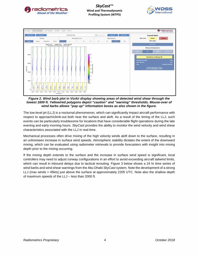
Figure 2. Wind barb plot in VizAir display showing areas of detected wind shear through the
lowest 1600 ft. Yellow/red polygons depict “caution” and ”warning” thresholds. Mouse-over of wind barbs allows “pop up” information boxes as also shown in the figure.
The low-level jet (LLJ) is a nocturnal phenomenon, which can significantly impact aircraft performance with respect to approach/climb-out both near the surface and aloft. As a result of the timing of the LLJ, such events can be particularly troublesome for locations that have considerable flight operations during the late evening and early morning hours. SkyCast provides the ability to monitor the wind velocity and wind shear characteristics associated with the LLJ in real-time.
Mechanical processes often drive mixing of the high velocity winds aloft down to the surface, resulting in an unforeseen increase in surface wind speeds. Atmospheric stability dictates the extent of the downward mixing, which can be evaluated using radiometer retrievals to provide forecasters with insight into mixing depth prior to the mixing occurring.
If the mixing depth extends to the surface and the increase in surface wind speed is significant, local controllers may need to adjust runway configurations in an effort to avoid exceeding aircraft tailwind limits, which can result in inbound delays due to tactical rerouting. Figure 3 below shows a 24 hr time series of wind barbs and wind shear warnings from the Abu Dhabi SkyCast system. Note the development of a strong LLJ (max winds > 45kts) just above the surface at approximately 2205 UTC. Note also the shallow depth of maximum speeds of the LLJ – less than 2000 ft.
Radiometrics Proprietary 5 October 2018
SkyCast™ Wind and Thermodynamic
Profiling System (WTPS)
Figure 3. Wind speed, cross-wind, wind shear and
low level wind shear with wind barb overlays.
Although Figure 3 shows a 24-hour time series, it must be noted the wind profiles are updated every 5 minutes, allowing the ability to closely monitor the onset and dissipation of phenomena such as the LLJ. Without this type of information, an airport forecaster cannot reliably predict LLJ onset, depth, or dissipation.
In addition to the surface hazards, strong shear and turbulence aloft may also be present due to the difference in wind velocity between the surface and the LLJ, which may result in critical changes to aircraft performance, particularly during approach and climb-out. Knowledge of these conditions prior to approach/climb-out provides pilots with the necessary awareness to make informed decisions regarding aircraft operation.
2.2 Temperature Inversions
SkyCast thermodynamic retrievals provide the ability to monitor low-level temperature inversions (LLTI) that effectively change the atmospheric density profile. Upon take-off, fully loaded aircraft encountering a LLTI will notice changes in performance including a decrease in climb rate for the same thrust rate when compared to a take-off where a LLTI is not present. The LLTI strength and depth characteristics provided by SkyCast provide awareness of the possibility of occurrence of these performance changes, allowing the operators to mitigate the potential for inadvertent corrections due to lower than expected climb rates. In addition, quantitative data from the radiometer can be utilized in conjunction with ambient air temperature and density altitude calculations to support establishment of climb-out protocols, both to improve operational safety and provide potential fuel savings.
Radiometrics Proprietary 6 October 2018
SkyCast™ Wind and Thermodynamic
Profiling System (WTPS)
A SkyCast airport thermodynamic and wind analysis is shown in the VizAir display in Figure 4. The figure shows a 6-hour time period in which an inversion of approximately 7 °C is centered at about 2000 ft AGL. Note the significant increase in low-level humidity and liquid water content during the inversion period.
Figure 4. Time series (6 hrs) showing temperature inversion, RH and LWC overlain with wind
barbs.
Radiometrics Proprietary 7 October 2018
SkyCast™ Wind and Thermodynamic
Profiling System (WTPS)
2.3 Terminal Area Fog Conditions
SkyCast water vapor and liquid water measurements provide information on the amount and depth of liquid and vapor present in the PBL. This information, combined with temperature, dewpoint, and relative humidity characteristics, forms the basis for reliable detection and characterization of fog, a major contributor to airport delays. Studies using WTPS instrumentation have demonstrated that conditions associated with the evolution of fog events are dependent on the type of fog as well as mesoscale and geographic features specific to the location. As such, formation and dissipation characteristics need to be analyzed at the installation site in an effort to adapt SkyCast algorithms for the nuances specific to the location.
Forecasters at the Dubai International Airport (DXB) have successfully shown that the additional information gained from SkyCast in-situ observations significantly increases the understanding of the local PBL structure during fog events, and as a result, the predictability of such occurrences. For example, DXB meteorologists used WTPS observations to verify that high humidity in the PBL in excess of 1,000 feet deep inhibits fog formation. Under these conditions radiative cooling cannot provide enough heat loss to cool the atmosphere sufficiently to reach saturation during the overnight hours. Additionally, cooling at the top of the PBL often leads to stratus cloud development, further limiting the amount of longwave radiation that can escape the PBL. Although this scenario is contrary to general fog formation characteristics, local forecasters are now able to recognize when these conditions are present and successfully provide a confident ‘no fog’ forecast, even though the numerical weather prediction models suggest fog formation in the terminal area. A SkyCast airport analysis and display including fog is shown in Figure 5.
Figure 5. Temperature, relative humidity, vapor density, liquid water (fog) and winds at LAX.
Radiometrics Proprietary 8 October 2018
SkyCast™ Wind and Thermodynamic
Profiling System (WTPS)
2.4 Terminal Area Frost, Freezing Rain, and Icing Conditions
SkyCast provides measurements of integrated vapor and integrated liquid throughout the atmosphere. These measurements, when combined with the retrieved temperature profiles, allow for the monitoring of potentially hazardous phenomena including frost, freezing rain potential, and PBL icing potential.
Similar to SkyCast’s ability to provide information for fog forecasting as described above, the retrievals can also be utilized to improve forecasts of frost characteristics including intensity. This information can provide end-users with the necessary knowledge to determine with high confidence whether deicing will be required and may also provide timing information including onset and dissipation.
During potentially hazardous precipitation events, SkyCast provides continuous monitoring of PBL temperature profiles along with liquid water and vapor density profiles. This information is vital to determining precipitation type and amount at the surface and can help discriminate between rain, freezing rain, ice pellets, and snow. The real-time temperature profiles can also assist in forecasting the timing of any precipitation phase changes as well. The ability to monitor and nowcast such changes in real-time allows for informed decision making that can result in significant improvements to operational procedures and expenses, including improvements to the scheduling and efficiency of deicing operations. A SkyCast airport display identifying icing hazard in shown in Figure 6.
Figure 6. Dense supercooled drizzle and fog during a late fall upslope storm
presented severe icing hazard at Denver International Airport (DIA).
2.5 Atmospheric Stability, Forecast Indices, and Convection
SkyCast provides real-time monitoring of atmospheric thermodynamic and wind conditions. This information can be utilized to derive stability parameters along with traditional sounding forecast indices, which allow for the monitoring of the potential for severe weather including convective storms. By tracking
Radiometrics Proprietary 9 October 2018
SkyCast™ Wind and Thermodynamic
Profiling System (WTPS)
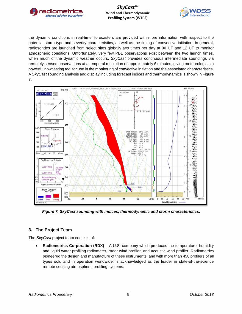
the dynamic conditions in real-time, forecasters are provided with more information with respect to the potential storm type and severity characteristics, as well as the timing of convective initiation. In general, radiosondes are launched from select sites globally two times per day at 00 UT and 12 UT to monitor atmospheric conditions. Unfortunately, very few PBL observations exist between the two launch times, when much of the dynamic weather occurs. SkyCast provides continuous intermediate soundings via remotely sensed observations at a temporal resolution of approximately 6 minutes, giving meteorologists a powerful nowcasting tool for use in the monitoring of convective initiation and the associated characteristics. A SkyCast sounding analysis and display including forecast indices and thermodynamics is shown in Figure 7.
Figure 7. SkyCast sounding with indices, thermodynamic and storm characteristics.
3. The Project Team
The SkyCast project team consists of:
• Radiometrics Corporation (RDX) – A U.S. company which produces the temperature, humidity and liquid water profiling radiometer, radar wind profiler, and acoustic wind profiler. Radiometrics pioneered the design and manufacture of these instruments, and with more than 450 profilers of all types sold and in operation worldwide, is acknowledged as the leader in state-of-the-science remote sensing atmospheric profiling systems.
Radiometrics Proprietary 10 October 2018
SkyCast™ Wind and Thermodynamic
Profiling System (WTPS)
• Weather Decision Support Systems, International (WDSS) – A U.S. company with extensive practical aviation weather experience and proven expertise in the development, deployment, and support of custom decision support systems, including multiple SkyCast installations.
4. Remote Sensing Instrumentation
The following remote sensing instrumentation are delivered as part of the SkyCast system:
• Radiometrics MP-3000A Microwave Thermodynamic Profiling Radiometer (MPR) provides continuous real-time vertical retrievals of temperature, humidity, and liquid water from the surface to 10 km. SkyCast utilizes the full profiles to derive traditional forecast indices, while leveraging the profiler’s inherent strength in the low levels for high-resolution boundary layer analyses. Hallmarked by high reliability (MTBF > 40,000 hours) and proven profiling accuracy, there are over 230 MP-3000A instruments in operation worldwide.
• Radiometrics RAPTOR Boundary Layer Radar Wind Profiler (RWP) accurately measures wind speed and direction up to 3 km AGL or higher, depending on atmospheric conditions. For northern latitudes, regions with dry climates, or locations where winds above the PBL are desired, additional higher-power Radiometrics radar wind profiler options are available.
• Radiometrics Acoustic Wind Profiler AWP-4000 transmits at a frequency of 4500 Hz to provide high-resolution wind observations from near-surface to 200 m AGL. The derived low-level winds combined with surface observations can be used to bridge the gap between the surface observation and the lowest gate of the RWP.
• Meteorological Point Sensors are already usually available at airport, but the RDX WDSS team can provide surface weather sensors if needed.
5. Analysis and Visualization Software Suite
The analysis and visualization software delivered as part of the system are as follows:
• VizAir Launchpad is a dashboard that displays user alerts and provides easy access to additional applications.
• Integrated Wind Shear Alerting System is an algorithm and alerting suite that detects shear of the horizontal winds according to FAA or ICAO standards for non-convective wind shear, and provides alerts based on user-defined alerting thresholds.
• Fog Detection and Trending System is an algorithm and alerting suite that detects fog and analyzes trend information to estimate burn off rates.
• Inversion Detection and Trending System is an algorithm and alerting suite that detects inversions and analyzes trend information to estimate dissipation times.
• Nowcast Product Generator is software package which is responsible for data integration, database generation, algorithmic processing, data archiving, and playback.
• VizAir Display is the primary visualization software for examining integrated data and evaluating alerts.
• Sounding Toolkit software allows for the visualization and comprehensive interrogation of sounding data using the Universal Rawinsonde Observation (RAOB) program.
• VizMet-B serves as the control interface for the MPR and provides basic visualization displays.
• BIRCH™ serves as the control interface and health and status monitoring for the RWP.
Radiometrics Proprietary 11 October 2018
SkyCast™ Wind and Thermodynamic
Profiling System (WTPS)
• ASPEN™ serves as the signal processing and data display system for the RWP.
• SoDARView™ serves as the signal processing and data display system for the AWP.
• SkyCast Status Page provides a quick-look overview of the status of various hardware and processing components, shelter environmental conditions, and file latency information.
Figure 8. SkyCast system configuration with a stand-alone central processing shelter.
6. SkyCast Data Integration, Processing, and Visualization
The SkyCast installation includes all hardware and software necessary to integrate data retrievals from all instrumentation, process the integrated data through proprietary algorithms, and display the products for visualization and analysis.
The VizAir Launchpad serves as the primary dashboard through which end-users can access data and alerts for quick evaluation, as well as launch additional applications for further in-depth analyses. Figure 9 shows an example of the VizAir Launchpad featuring a personalized customer logo along with options for quick access to the composite sounding through the WTPS Main Page, VizMet-B through the ‘Radiometer’ tab, RAOB through the ‘Sounding Toolkit’ tab, and user-defined alerts through the ‘Alerts’ tab. A visual pop-up will also be displayed for any active alerts generated, including wind shear and inversion notifications. The Launchpad can be downloaded and run from any PC on the customer LAN that has access to the VizAir URL.
Radiometrics Proprietary 12 October 2018
SkyCast™ Wind and Thermodynamic
Profiling System (WTPS)
Figure 9. VizAir Launchpad with alert pop-up capability.
Composite soundings accessed through the WTPS Web page provide forecasters with an integrated display of the most recent thermodynamic and wind profiles as well as the ability to inspect all current automated alerts including those for fog, low ceilings, inversions, and wind shear (Figure 90). Users also have the capability to go back in time to analyze archived profiles and alerts as well as overlay previous soundings for comparison.
Figure 90. VizAir WTPS Main Page showing thermodynamic and
wind profiles with current alerts including type and details.
Radiometrics Proprietary 13 October 2018
SkyCast™ Wind and Thermodynamic
Profiling System (WTPS)
While the VizAir WTPS Main Page provides the forecasters with a quick look at soundings and alerts, the RAOB Sounding Toolkit allows for an in-depth interrogation of all aspects of the sounding data. The Sounding Toolkit provides users with the ability to generate hundreds of forecast indices, as well as manipulate the soundings manually to more readily assess the impacts on future atmospheric conditions (Figure 101).
Figure 101. RAOB integrated sounding showing forecast indices and tools.
7. Integrated Wind Shear Alerting System
The SkyCast wind profilers, when combined with surface observations, provide continuous vertical profiles of wind characteristics within the boundary layer from the surface to approximately 3 km. As such, the high-resolution data are ideal for determining the vertical shear of the horizontal wind. The Integrated Wind Shear Alerting System (IWAS) ingests the wind profiler, sodar, and surface station data and processes it through a detection algorithm to isolate regions of vertical shear of the horizontal wind according to FAA or ICAO standards for moderate and severe shear or for other user-defined shear thresholds.
IWAS is built around the requirements for wind shear calculations according to ICAO regulations for non-US applications. These calculations are outlined in the ICAO Manual on Low-level Wind Shear. That is, wind shear is calculated in the lowest 500 m (1600 ft) and expressed as kts/100 ft or km/h per 30 m. IWAS also takes runway orientation into account to determine gain or loss during approach and climb out.
Additional wind shear calculations derived from the IWAS software include:
• Along-runway wind shear magnitude
• Across-runway wind shear magnitude
• Customer requested wind shear calculations
Radiometrics Proprietary 14 October 2018
SkyCast™ Wind and Thermodynamic
Profiling System (WTPS)
Figure 112. Integrated Wind Shear Alerting System (IWAS) display.
Figure 112 above shows IWAS output in the VizAir display. The three primary displays in the IWAS software relate to page navigation, data analysis, and alerts. Components of the displays include:
• Graphical and numerical wind velocity output for all profiler levels
• Panels showing output for varying time periods and vertical depths
• Color coded wind barbs based on wind speed
• Color coded alerts, which outline regions of vertical wind shear
• Automated warnings when vertical wind shear is detected
• Ability to analyze archived plots and alerts
Messages regarding wind shear are put into standard formats according to requirements as outlined in ICAO Annex 3 on International Standards and Recommended Practices. An example of a wind shear warning from the system that can be broadcast would be:
GABS WS WRNG 01 031900Z VALID TL 031930Z WS IN APCH AND CLIMB-OUT WS DUE TO LOW LEVEL JET OBS AT 1900 40 KT LOSS RWY 06
The “Archive” function under the page navigation allows the user to search previous time periods via a calendar interface, providing the ability to review past data plots and wind shear alerts. Previously generated alerts can also be found via the alert search page, which provides the capability to search by type, date range, and alert severity (Figure13).
Radiometrics Proprietary 15 October 2018
SkyCast™ Wind and Thermodynamic
Profiling System (WTPS)
Figure13. Alert search function for parameters based on type, date range, and severity.
8. Conclusions
The SkyCast system represents an integrated state-of-the-science atmospheric remote sensing solution, which provides forecasters with continuous real-time monitoring of the atmospheric boundary layer conditions along with automated analyses and alerting for local high-impact hazardous weather conditions that affect airport operations. Through a strong partnership, RDX and WDSS have collaborated on many successful deployments and installations around the world, over many years, and will work diligently to ensure all aspects of the project, from procurement through site acceptance testing and post-installation support are managed in a highly professional and knowledgeable manner.


![Data Profiling Guide - start [Gerardnico] · PDF fileData Profiling Guide. Informatica PowerCenter Data Profiling Guide ... available at http:](https://static.documents.pub/doc/80x56/5aa4fb3a7f8b9ab4788c93d6/data-profiling-guide-start-gerardnico-profiling-guide-informatica-powercenter.jpg)


