42
ALVECHURCH PARISH DESIGN STATEMENT A Community Voice for Rural Character Forms part of the Alvechurch Parish Neighbourhood Plan 5 th September 2017
| Date post: | 06-Mar-2018 |
| Category: |
Documents |
| Upload: | truongngoc |
| View: | 216 times |
| Download: | 2 times |

ALVECHURCH
PARISH
DESIGN
STATEMENT A Community Voice for Rural Character
Forms part of the
Alvechurch Parish Neighbourhood Plan
5th September 2017

Page 2 of 42
Alvechurch Parish Design Statement http://www.alvechurch.gov.uk/
2017
HOW TO USE THIS DESIGN STATEMENT 5
THE PEOPLE WHO CREATED THE DESIGN STATEMENT 8
SECTION 1 FEATURES COMMON THROUGHOUT THE PARISH 9
SECTION 1.1 HISTORY 9
SECTION 1.2 LANDSCAPE SETTING AND WILDLIFE 10
SECTION 1.3 SETTLEMENT FORM 11
SECTION 1.4 BUILDINGS 13
SECTION 1.5 HIGHWAYS AND RELATED FEATURES 14
SECTION 2: FEATURES OF ALVECHURCH VILLAGE 15
SECTION 2.1 HISTORY: 15
SECTION 2.2.LANDSCAPE SETTING AND WILDLIFE 15
SECTION 2.3 SETTLEMENT FORM: 16
SECTION 2.4. BUILDINGS ; REFER ALSO TO FEATURES COMMON THROUGHOUT PARISH – P9 18
SECTION 2.5 HIGHWAYS AND RELATED FEATURES 20
SECTION 3 FEATURES OF WITHYBED GREEN 22
SECTION 3.1 HISTORY; 22
SECTION 3.2 LANDSCAPE SETTING AND WILDLIFE: 22
SECTION 3.3 SETTLEMENT FORM POPULATION APPROX. 100, REFER ALSO TO FEATURES COMMON THROUGHOUT PARISH – P11 22
SECTION 3.4 BUILDINGS; 23
SECTION 3.4 HIGHWAYS AND RELATED FEATURES 23
SECTION 4: FEATURES OF ROWNEY GREEN 24
REFER ALSO TO FEATURES COMMON THROUGHOUT PARISH-P10-12 24
SECTION 4.1 HISTORY: 24
SECTION 4.2 LANDSCAPE SETTING AND WILDLIFE 24
SECTION 4.3 SETTLEMENT FORM, REFER ALSO TO FEATURES COMMON THROUGHOUT PARISH – P9-11 25
SECTION 4.4 BUILDINGS: 26
SECTION 4.5 HIGHWAYS AND RELATED FEATURES 27
SECTION 5: FEATURES OF HOPWOOD 28
SECTION 5.1 HISTORY; 28
SECTION 5.2 LANDSCAPE SETTING AND WILDLIFE: 28
SECTION 5.3 SETTLEMENT FORM:, 28
SECTION 5.4 BUILDINGS 30
SECTION 5.5 HIGHWAYS AND RELATED FEATURES 30
FEATURES OF HOPWOOD 31
SECTION 6 FEATURES OF BORDESLEY 32
SECTION 6.1 HISTORY 32
SECTION 6.2 LANDSCAPE SETTING AND WILDLIFE 32
EXTENSIVE VIEWS OF THE SURROUNDING HILLS AND OPEN FARMLAND ARE BORDESLEY’S MOST SIGNIFICANT LANDSCAPE FEATURE 32
Page 3 of 42
Alvechurch Parish Design Statement http://www.alvechurch.gov.uk/
2017
SECTION 6.3 SETTLEMENT FORM 32
SECTION 6.4 SETTLEMENT FORM CONTINUED 33
SECTION 6.5 BUILDINGS: REFER ALSO TO FEATURES COMMON THROUGHOUT PARISH – P9-11 33
SECTION 6.6 HIGHWAYS AND RELATED FEATURES: REFER ALSO TO FEATURES COMMON THROUGHOUT THE PARISH P9-11 33
SECTION 7 FEATURES OF WEATHEROAK 34
SECTION 7.1 HISTORY 34
SECTION 7.2 34
SECTION 7.3 SETTLEMENT FORM 34
SECTION 7.4 BUILDINGS 35
SECTION 7.5 HIGHWAYS AND RELATED FEATURES 36
FEATURES OF WEATHEROAK 37
SECTION 8: EXAMPLES OF DETAIL DESIGN FROM WITHIN THE PARISH 38
8.1: DOORS AND PORCHES 38
EXAMPLES OF DETAIL DESIGN FROM WITHIN THE PARISH 39
8.2: CHIMNEYS AND ROOFS: 39
8.3: WINDOWS, DRIVEWAYS AND PATHS 39
8.4: DRIVEWAYS AND PATHS 40
EXAMPLES OF DETAIL DESIGN FROM WITHIN THE PARISH 41
8.5: PLANTING TO SOFTEN THE APPEARANCE OF BUILDINGS 41
8.6: BOUNDARIES 42
Page 4 of 42
Alvechurch Parish Design Statement http://www.alvechurch.gov.uk/
2017
Foreword Ask an architect, a planner and a resident to define good design and there will be three different answers. However, we should respect a comment made recently by a family who had waited for over 10 years to be able to move into a new home where their family had lived for more than a generation, they said “it looks so lovely”. Continually refining both the design and development process and providing future homes can be complicated. The romantic view of village housing as “thatched cottages with roses round the door” has long been overtaken by “sustainability” considerations and the complex requirements placed on the many different departments and bodies involved. What is sustainability? You may ask, (I like to think it is no more than, the “ability to cope and endure”, with whatever comes along!). The community involved in making this Alvechurch Parish Design Statement (APDS), want to ensure that homes in our parish are built to a high quality standard and are sensitive to the local area. This statement aims to meet the needs of local people, create safe and attractive neighbourhoods, whilst limiting environmental impact, and making sure design and materials are appropriate to the rural setting. Thus avoiding inappropriate and sometimes more urban based designs: there is always room for improvement. Through early involvement with Rural Housing enablers and local authority partners in the development process, and through, most importantly, the support and engagement of our local community and Parish Council, this will continue to provide homes that reflect our local character. Homes should be well designed and look attractive, maybe some, even with roses round the doors! All those involved in the design and development of rural housing are encouraged to use this guide, produced through close collaboration between planners, highway officers, environment and landscape officers, urban designers, development officers and rural housing enablers. This document was initially conceived in 2004 and has now been updated by current members of the community and the Alvechurch Neighbourhood Plan (NP) Steering Group that includes some of those who originally conceived the initial Alvechurch Village Design Statement. I believe design and development principles relate well to the earliest surviving work on Architecture, written in the 1st century by Roman architect Vitruvius, freely translated as: Durability – should stand up robustly and remain in good condition, Utility – should be useful and function well and for those using it, Beauty – should delight people and raise their spirits. These principles reflect the vision of current design standards, which is, that new housing developments should be attractive, functional and located in sustainable places. Developments in rural areas like ours must be particularly sensitive to their context and reflect relationships between buildings, spaces, the landscape and other features that are locally distinctive. This Parish Design Statement forms an integral part of the Alvechurch Parish Neighbourhood Plan (APNP) to be read in conjunction with planning, design and housing policies. Firstly the APNP (which includes the APDS), and the Bromsgrove District Council’s Local Plan, the Government’s National Planning Policy Framework and the Worcestershire County Council’s, “Alvechurch Historic Environment Resource Assessment”. These plans will give an up-to-date picture of the policies to be applied for a specific site. In addition, there are a number of guidance documents issued by government which also give practical advice on design. Councillor Adrian Smith Chairman of the APNP Steering Group

Page 5 of 42
Alvechurch Parish Design Statement http://www.alvechurch.gov.uk/
2017
HOW TO USE THIS DESIGN STATEMENT
If you’re in Local Government, at County, District or Parish level, involved in Planning, Highway Design or Highway Maintenance, or you’re an Architect, a Planning Applicant, a Developer or a Property Owner……
THEN THIS DESIGN STATEMENT IS FOR YOU.
First, refer to the Parish Section, because it’s common to all areas.
Second, refer to the Village Section, Ward or Hamlet in which you have a specific interest
If you’re in a hurry, make for “To be encouraged” at the end of each section
Complementary material that’s available via Bromsgrove District Council:
Design Guides for; Agricultural Buildings, Conversion of Rural Buildings, Agricultural Dwellings and Occupancy, Shop fronts, Advertisements and Car Parking Standards; The 1968 “Gedge” report.
As a property owner why not prepare a Character Assessment for your property?
If you are considering changing any external detail of your property, its paintwork, associated signs, garden or surroundings then please consider the factors within this statement, which may help encourage rural character.
Look at the frontage from some distance so as to see it in association with its surroundings, including trees, shrubs and hedges.
Note the most distinguishing features and, separately, those, which seem to be more recent and perhaps out of character.
If necessary, take photographs and consult with friends and neighbours.
Now stand close to the property and note details of the building design itself – its doors windows walls and roofing etc.
Repeat the procedure for each elevation and consider each in relation to the rural character described in this Village Design Statement.
Now think about the changes you propose, consider whether they might prejudice any of the distinctive characteristics you previously noted. If so, are there any other ways of meeting your requirements but which would conserve the building’s heritage?
Where possible, use the opportunity for change to help remove any unwanted and uncharacteristic features
When looking for guidance to implement Design Statement ideas, your Parish Council can provide assistance and consultation
Thank you for helping to preserve and enhance “Rural Character”
The Alvechurch Parish Neighbourhood Plan (APNP) Steering Group and members of the Alvechurch Parish community helped to bring the Alvechurch Parish Design Statement (APDS), back to the head of the list of planning documents to be used first of all when planning proposals are put forward for Alvechurch parish. It forms an integral part of the Alvechurch Parish Neighbourhood Plan as mentioned by APNP Policy 11: “APDS ensures new development adheres to its design guidelines and principles”.

Page 6 of 42
Alvechurch Parish Design Statement http://www.alvechurch.gov.uk/
2017

Page 7 of 42
Alvechurch Parish Design Statement http://www.alvechurch.gov.uk/
2017
Introduction
The Parish lies in a rural setting, in Green Belt between the Birmingham and Redditch Planning Authorities
When we make alterations to existing buildings, construct something new or change a planting layout, do we consider how it may affect the rural and historic character? Something seen in another setting or context, which looked good at the time, may be inappropriate in our village.
We are the present guardians of our heritage. It is our responsibility, collectively and individually, to preserve it and to evolve and develop it in an appropriate way.
The material contained within is a statement of what is positive and valued in our community, present and future. There are inevitably examples of design within the Parish that do not fit the character defined, but it’s not within the brief of the Alvechurch Parish Design Statement (APDS) to be critical.
The APDS aims to raise the rural and historic character awareness amongst local residents, businesses, planning applicants, highway designers, local planning committees and planning officers.
We need to know how best to take account of what is special about rural character and the local distinctiveness of our buildings and surroundings
This APDS has been gathered via a series of public meetings, workshops and consultation, involving a considerable number of local people. That programme has been co-ordinated by a Steering Group following the Countryside Commission Format.
This finished document was updated by the Alvechurch Parish Neighbourhood Plan Steering Group in November 2017. It is issued for Planning Guidance as part of the Alvechurch Parish Neighbourhood Plan and is available to the community and specifically to those considering Planning in the parish.

Page 8 of 42
Alvechurch Parish Design Statement http://www.alvechurch.gov.uk/
2017
The People Who Created the Design Statement This Design Statement contains the summaries of material collected from each of five Character Workshops in which a broad cross section of the Parish community took part. The material from the workshops has been supplemented by historical contributions from specialists within the community and other additional content compiled by the Steering Group The Steering Group members and contributors to the workshops and feedback phases and document preparation are listed below. Without their help, completion of the project would not have been possible. The following organisations kindly contributed towards the making of the Parish Design Statement Alvechurch Parish Council, Alvechurch Village Society, Bromsgrove District Council, Shell Better Britain Campaign, Worcestershire County Council, The Countryside Agency (formerly the Countryside Commission), The Neighbourhood Plan Steering Group and WCC Archaeology Archive Services. For further information contact: Alvechurch Parish Council George Road Alvechurch
www.alvechurch.gov.uk Telephone 0121 447 8016 Or Bromsgrove District Council Planning Department
www.Bromsgrove.gov.uk Telephone 01527 881288 Residents and helpers who made the original Alvechurch Village Design Statement;- Sarah and Simon Carless Ann and Tom Thurrell Nan Fellows Patricia and Ian Rich
Rehan ul-Haq Anne and Tony Cowles Christine and Tim Grainger Rob Buckey Liz, Marianne, Malcolm Ross Jan Brice Shena and John Burkill Jane and Garry Macklin Linda Williams Jim and Pat Parker Jane and Andy Edwards Jenny and Trevor Rankin Charles Sims Sylvia Hickman Sue Moxon Richard Peach Shell and Bob Dale Martin and Pat Phipps Derek Waters Forest Hansen Rachel and Ian Hayes Clare and Trevor Galletly Rosemary and Roger Sutton Michael Brumsen Dorothy Snaddon Hannah Genders John Sidwell John Alexander Lois Small Neil Harris Sylvia Cartwright John Puckering Roger Hollingworth Annette Dowd Jim Wilkes Brenda Bytom Pauline Knight Jill Coleman Alan Ogden Vera Hill Rosalie and Richard Freeman Richard Graham Gill Lungley Paul Crysell
Steve and Ben Newman Roger Parish Andy Stephens
Updated during 2014 to 2017 in conjunction with the Neighbourhood Plan by: Adrian Smith, Andy Humphries, Dorothy Snaddon, John Cypher, Linda Alan, Mary Green, Steve Lewis, Tom Thurrell, Alan
Helmore, Marc Worrell, Peter Freeman, Tony Cowles and BDC planning officers, Helen Smith and Mike Dunphy.
Page 9 of 42
Alvechurch Parish Design Statement http://www.alvechurch.gov.uk/
2017
SECTION 1 FEATURES COMMON THROUGHOUT THE PARISH
Section 1.1 History
The Parish Map, which forms part of this document, shows the geographic relationship between Alvechurch Village and its
Hamlets. All within the Green Belt apart from the centre of Alvechurch Village which is now classified as an urban rural
Village, between Birmingham and Redditch.
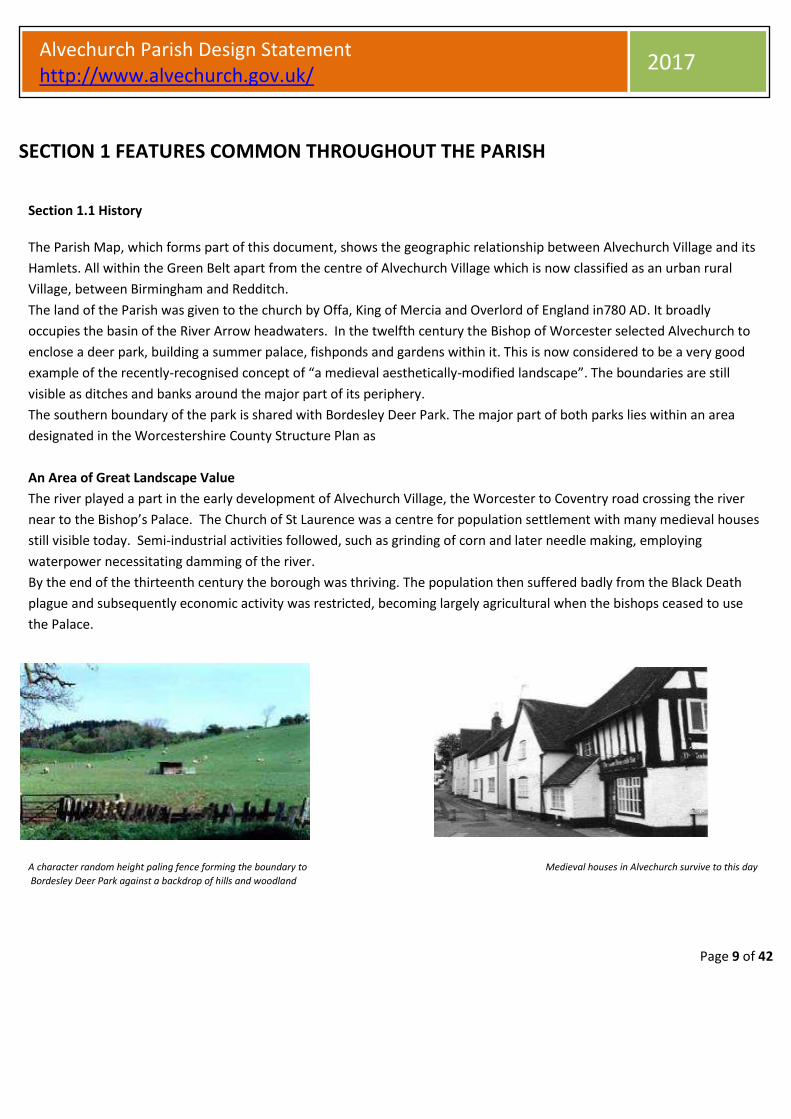
The land of the Parish was given to the church by Offa, King of Mercia and Overlord of England in780 AD. It broadly
occupies the basin of the River Arrow headwaters. In the twelfth century the Bishop of Worcester selected Alvechurch to
enclose a deer park, building a summer palace, fishponds and gardens within it. This is now considered to be a very good
example of the recently-recognised concept of “a medieval aesthetically-modified landscape”. The boundaries are still
visible as ditches and banks around the major part of its periphery.
The southern boundary of the park is shared with Bordesley Deer Park. The major part of both parks lies within an area
designated in the Worcestershire County Structure Plan as
An Area of Great Landscape Value
The river played a part in the early development of Alvechurch Village, the Worcester to Coventry road crossing the river
near to the Bishop’s Palace. The Church of St Laurence was a centre for population settlement with many medieval houses
still visible today. Semi-industrial activities followed, such as grinding of corn and later needle making, employing
waterpower necessitating damming of the river.
By the end of the thirteenth century the borough was thriving. The population then suffered badly from the Black Death
plague and subsequently economic activity was restricted, becoming largely agricultural when the bishops ceased to use
the Palace.
A character random height paling fence forming the boundary to Medieval houses in Alvechurch survive to this day Bordesley Deer Park against a backdrop of hills and woodland

Page 10 of 42
Alvechurch Parish Design Statement http://www.alvechurch.gov.uk/
2017
The use of traditional materials, roof angles and other detailing helps retain original character
Section 1.2 Landscape Setting and Wildlife
Features Common throughout the Parish
The whole of Alvechurch Parish is designated Green Belt, with the exception of Alvechurch Village which is classed as a
rural urban village. The parish has different Landscape Character areas: Principal Timbered Farmland: Wooded Estatelands
and Wooded Hills. There are large tracts of open countryside, mostly agricultural, surrounding the Village and its Hamlets,
these being of great importance in maintaining the buffer between Birmingham and Redditch. The Parish is set in a
landscape of low rolling glaciated hills bisected by the River Arrow and includes the old Bordesley and Alvechurch Parks.
In the foreground, hardly visible, is Hopwood Park Motorway Services and
behind it Alvechurch Village – both blend into the landscape within a
“bowl” surrounded by hills.
At the Parish Centre, the Village of Alvechurch lies in a bowl within
the valley. On the west side, Scarfield Hill and Coopers Hill are on
the rim of the bowl with Grovely and Wast Hills to the north.
Eastwards lays Swan Hill and Weatheroak. The River Arrow flows
out of the bowl through a narrow gap between Newbourne Hill and
Cobley Hill towards Redditch in the South. The Church of St.
Laurence, dating back to 900 A.D., sits on a hill within the bowl on
the south edge of Alvechurch Village.
The Hamlets of Withybed Green, Hopwood, Weatheroak, Rowney Green, and Bordesley are separated from Alvechurch
Village by tracts of open countryside; there are also small settlements at Lye Bridge and Forhill and all of these being of
great importance in maintaining the Green Belt between Birmingham and Redditch.
The countryside within the Parish is interspersed with; some new woodland planting, old hedgerows, a variety of trees;
copses and woodland remnants showing Ancient Woodland characteristics. Peck Wood on the edge of Newbourne Hill
between Rowney Green and Alvechurch Village is visible from many parts of the Parish. The hillsides afford spectacular
distant views, extending across Warwickshire to the Cotswold Hills and Worcestershire to the Breedon and Malvern Hills.
The Parish comprises a diversity of important wildlife habitats, which support many plant and animal species including
some of high conservation concern

Page 11 of 42
Alvechurch Parish Design Statement http://www.alvechurch.gov.uk/
2017
To be encouraged in all sections:
More thoughtful detailing when altering and/or extending properties and paying attention, to what is local
Maintaining original window proportions/positioning and features common throughout the parish
Section 1.3 Settlement Form
Features Common throughout the Parish
The Parish of Alvechurch has several significant transport routes passing through its area.
The M42 bisects the Parish with Hopwood and Weatheroak to the north, and the remaining areas to the south.
The A441 Birmingham to Redditch road runs through the area from north to south, following a by-pass, skirting Alvechurch Village to its east. The by-pass, where it joins the M42, influenced the siting of The Hopwood Park Motorway Service Area.
The Birmingham and Worcester Canal provides a pleasant feature as it runs north to south at the western edge of the Parish. Together with the M42 and the Redditch Spur Railway line it forms a man-made boundary to the settlement. The canal was originally built to transport bulky and heavy materials from Birmingham and beyond but that died out gradually after World War One. More recently it has seen a rebirth as a source of recreation; Alvechurch having its own boat yard offering rental and mooring for narrow boats.
Local brickworks in Alvechurch supplied red bricks for buildings in the area during the period between the mid-19th century and 1939.
There is an extensive network of public rights of way, including public footpaths and bridleways maintained by volunteers from the Alvechurch Village Society. Canal towpaths are available to local people as well as for regional and national visitors. The excellence of the footpath network and its maintenance is referred to in several published guides to walks in Worcestershire and The Midlands.
The pattern of development in the outlying hamlets has been established principally around farming communities although, along with Alvechurch Village, they now form part of the commuter belt serving the West Midlands Conurbation in general and the commercially important centre of Redditch to the south.
The Parish contains many important landmarks and features, for example, at the centre of Alvechurch Village there are historic half-timbered medieval buildings; along the river, there are water meadows with wild flowers and the Old Mill, Radford Road (no longer active as a mill).
Certain developments within the hamlets, and also within the village of Alvechurch itself, benefit from the spectacular views offered by hillside locations.
Each of the outlying hamlets has its own established local communities whilst also having a bond with the wider community of the Parish via the use of pubs, shops, schools and restaurants etc.
Age profile predictions for the Parish in the medium to longer term may lead to increased demand for sheltered accommodation and singe person dwellings.
Employment opportunities within the Parish are limited and, in line with the transport policies and environmental concerns, sympathetic commercial developments and building restorations would be appropriate, particularly on existing brown field sites, even if they fall outside existing village envelopes.

Page 12 of 42
Alvechurch Parish Design Statement http://www.alvechurch.gov.uk/
2017
To be Encouraged Settlement Form
Features Common throughout the Parish
• Open spaces and play areas planted with native species
• Views of open spaces, trees, hedges and hills
• Rural gates, fences and unclipped greenery
• Access to canal towpaths, public footpaths and bridle paths
• Open water provided by the canal, lakes, river and streams
• Agriculture and horticulture
• Any features contributing to rural pursuits
• Barn conversions, small-scale industry and commerce making use of redundant character buildings
Quiet lanes provide the ideal setting Bittell Lakes create opportunities The Parish is well provided with country
for walking, cycling and horse riding for sailing and fishing pubs
Footpaths across open farmland link Horses being ridden along lanes and The Parish has many pony paddocks each area of the Parish bridle paths are a common sight with associated stables, some well-disguised
Open farmland and informal green space Including woodland and spinneys between Alvechurch and its surrounding hamlets,
particularly on the Rowney Green and Weatheroak side; contribute importantly to the area’s rural character and recreational
quality. This factor was expressed with enthusiasm at each of the Character Workshops.
Page 13 of 42
Alvechurch Parish Design Statement http://www.alvechurch.gov.uk/
2017
Section 1.4 Buildings
Features Common throughout the Parish
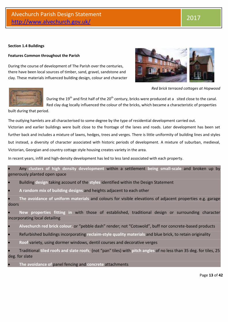
During the course of development of The Parish over the centuries,
there have been local sources of timber, sand, gravel, sandstone and
clay. These materials influenced building design, colour and character
Red brick terraced cottages at Hopwood
During the 19th and first half of the 20th century, bricks were produced at a sited close to the canal.
Red clay dug locally influenced the colour of the bricks, which became a characteristic of properties
built during that period. The outlying hamlets are all characterised to some degree by the type of residential development carried out. Victorian and earlier buildings were built close to the frontage of the lanes and roads. Later development has been set
further back and includes a mixture of lawns, hedges, trees and verges. There is little uniformity of building lines and styles
but instead, a diversity of character associated with historic periods of development. A mixture of suburban, medieval,
Victorian, Georgian and country cottage style housing creates variety in the area. In recent years, infill and high-density development has led to less land associated with each property.
Any clusters of high density development within a settlement being small-scale and broken up by generously planted open space
Building design taking account of the styles identified within the Design Statement
A random mix of building designs and heights adjacent to each other
The avoidance of uniform materials and colours for visible elevations of adjacent properties e.g. garage doors
New properties fitting in with those of established, traditional design or surrounding character incorporating local detailing
Alvechurch red brick colour, or “pebble dash” render; not “Cotswold”, buff nor concrete-based products
Refurbished buildings incorporating reclaim-style quality materials and blue brick, to retain originality
Roof variety, using dormer windows, dentil courses and decorative verges
Traditional tiled roofs and slate roofs, (not “pan" tiles) with pitch angles of no less than 35 deg. for tiles, 25 deg. for slate
The avoidance of panel fencing and concrete attachments

Page 14 of 42
Alvechurch Parish Design Statement http://www.alvechurch.gov.uk/
2017
Where privacy and security is necessary, reclaim-style brick walls complete with a frost proof brick or stone header course
Features Common throughout the Parish: (Please note all sections within the statement should also refer back to common
features of the parish on pages 10 to 12)
Section 1.5 Highways and Related Features
Stone setts must be retained and setting kerbing height below 80mm Rough-faced conservation kerbing encouraged for use in new will improve its appearance will mellow faster than the smooth schemes where possible concrete of a standard kerb
Local “duck” stones can be used as cobbles in small measure associated with paths, highways and
Bus shelters with pitched roofs are preferred to flat roofed alternatives
To be encouraged
Highways and Related Features
•The avoidance of additional kerbing - any necessary new sections should be low level (below 80mm) and either reconstituted stone character or, best option, granite setts
•“Damaged” kerbs repaired by resetting the originals or using recycled materials in order to improve function but retain character
•Raised sections of road surfacing material to form a bund preventing water spillage from the road into properties in rural lanes without footpaths; not the introduction of kerbing
•The use of appropriate materials with mellow appearance and/or the ability to weather down quickly
•The avoidance of bollards, mini roundabouts and intrusive street lighting
•Non-uniform block-paving, blue brick and/or tarmac

Page 15 of 42
Alvechurch Parish Design Statement http://www.alvechurch.gov.uk/
2017
•Verges left to flower and re-seed in early summer: Over mowing to be discouraged
•Narrow footpaths with hedges alongside
SECTION 2: FEATURES OF ALVECHURCH VILLAGE Section 2.1 History:
Alvechurch Village Hall St Laurence Church
Over many years Alvechurch has enjoyed the benefit of its Village hall, its Baptist Church, Catholic Church and Church of
England St Laurence and the shared church in Rowney Green
The advent of the canal, the turnpike and eventually the railway did not result in significant residential development. Historical maps of the village show a slow rate of development up to the beginning of the 20th century; it then accelerated, particularly since 1950. At first, “ribbon” development satisfied the need for residential expansion and later, large areas on the western side of the village were in-filled. Ribbon development began before World War Two but significant expansions began post-1945, and for the most part, post 1960.
Section 2.2.Landscape Setting and Wildlife
The oldest part of Alvechurch Village is set amongst mature trees and hedgerows adjacent to the River Arrow and on the adjoining Bear Hill. St Laurence Church commands a prominent position on Bear Hill, surrounded by low-density residential properties and ragged hedgerows containing a variety of wildlife. Most development has taken place on the same side of the river as Bear Hill. Properties set on the hillside form a major feature and add to the pleasant randomly evolved nature identified during the Alvechurch Character Workshop. Other developments within the valley have a more suburban character but all benefit from views of the adjacent hills and the rich planting of native mature trees and hedgerows forming wild life corridors
Low-density housing at the fringes of the village The shopping precinct sits within mature

Page 16 of 42
Alvechurch Parish Design Statement http://www.alvechurch.gov.uk/
2017
Homes set on slopes benefit from views of the surrounding landscape help it blend with the surrounding landscape trees when viewed from The Meadows
Features of Alvechurch Village
Section 2.3 Settlement Form:
Alvechurch Village (population approx. 2,600) at the cross roads of the Worcester to Coventry road and the Birmingham to Pershore Turnpike, is a commercial and social centre. It provides schooling up to age thirteen, has local shops, restaurants and fast food outlets. There is limited employment in today’s Alvechurch. Many of its residents commute to the neighbouring conurbations of Redditch and Birmingham, with the adjacent M42 motorway providing easy access to a wider area. The Wiggin Memorial Playing Fields (“The Meadows”), Crown Meadow, George Road Playing Field and the School Playing Fields are the significant publically accessible open spaces within the village. Smaller less formal open spaces have gradually been in-filled, making those that remain valuable assets not only as informal play areas, but also as oases for wildlife. Despite the urban-style development, which has taken place in blocks between 1950 and the present, many parts of the village retain a rural character and there is a strong community spirit, often fostered by rural activity.
The use of the canal should be encouraged; it The character of the network of walks linking The adjacency of the countryside and
forms a natural boundary but is also a different parts of the village, with its footpath access to agricultural land is
recreational amenity and a contributor to the commercial economy. associated trees and hedges should be maintained. important.
Much of the housing in the Conservation Area in the centre of
Alvechurch is small character properties. Future changes to the village
must meet the needs of a changing society through consideration and
regard to this Design Statement and the WCC Alvechurch Historic
Environment Resource Assessment

Page 17 of 42
Alvechurch Parish Design Statement http://www.alvechurch.gov.uk/
2017
To be encouraged Settlement Form
• Environmental impact assessments, made before allowing further development of open spaces
• Strengthening of rural character to be a focus for the future
• Convenience of use of the railway station, upgraded to 2 platforms in 2015
• Canal and boating facilities within convenient walking distance of the village centre
• The convenient use of the canal; it forms a natural boundary but is also a recreational amenity and a contributor
to the commercial economy
• The character of the network of walks, with its associated trees and hedges, linking different parts of the village,
e.g. through the churchyard and its surroundings
• Streams open, not piped in
• Maintenance of hedges in a manner sensitive to wildlife and planting of native species trees and hedges for
succession
• The harmonious mix of recreational, residential and commercial activity within the village
• Character landmarks, e.g. Humpback bridges, The Square and major trees, sadly, one such as on the Redditch Road
approach, the large beech tree forming a natural archway into the village had disease and was felled . Now replaced
with a similar species sapling dedicated to a longstanding servant of Alvechurch Village Society, Jim Parker
• The adjacency of the countryside and footpath access to agricultural land
• Introduction of more rural character design into areas where it is lacking, e.g.to residential estates and the
shopping precinct and its associated square
• Plot sizes should follow what is typical of the immediate vicinity’
• Shop fronts and their signs, in character with the buildings they occupy
• Spaciousness of existing recreation sites associated with native species planting
• The Village Car Park recycling area which is well hidden and functional to be kept clean a clean and well
maintained village
Shop fronts and their signs in keeping with the character of the buildings they occupy are to be encouraged Features of Alvechurch
Village
Features of Alvechurch Village

Page 18 of 42
Alvechurch Parish Design Statement http://www.alvechurch.gov.uk/
2017
Section 2.4. Buildings ;
New buildings in local brick colour are in keeping
The predominant mix of building character in the Conservation Area of Swan Street, Red Lion Street, and Bear Hill is Elizabethan, Victorian and Georgian. Other parts of the village could be encouraged to follow those themes where appropriate
Building lines back from the road allow
space for full size trees to grow without
damage to properties or the significant
exclusion of light
Some late 20th century developments have adopted elements of traditional detail design, brick colour and roof angles. Attention needs to be given to building layout, variety in height and planting of native trees
Mill Court is an excellent example of modern
development in keeping with old industrial heritage
Brookside is a good example of mature planting
within a development
Adopt roof pitch angles of no less than
35 deg. for tiles, 25 deg. for slate
Page 19 of 42
Alvechurch Parish Design Statement http://www.alvechurch.gov.uk/
2017
To be encouraged Buildings • Informal, random layout and random height of buildings
• New properties blending in with those of established design
• Local-colour red brick, as opposed to buff or “Cotswold”
• The predominant mix of building character in the Conservation Area of Swan Street, Red Lion Street, and Bear Hill is Elizabethan, Victorian and Georgian. Other parts of the village could be encouraged to follow the same themes where appropriate but a pastiche of half-timbered buildings is considered inappropriate
• Refurbished buildings incorporating good quality reclaim-style materials or modern equivalent and blue bricks, to help retain originality
• Generous planting such as found in the Brookside development
• Clever use of the contours of the land such as in the “Buckleys” development
• Small house designs softened by the planting of trees and hedges
• Spaciousness of layout and set-back building lines can be mixed with small clusters of higher density buildings as per Meadow Lane but must be associated with adjacent open space and planting
• Variation in roof lines including the use of dormers, dentil courses, decorative verges and gable ends
• Incorporation of traditional tiled and slate roofs, (not “pan" tiles) or modern equivalent
• Pitch angles of no less than 35 deg. for tiles, 25 deg. for slate
• Subtle changes in levels, creating variety
• Appealing rooflines and roof character viewed from outside the development
• Retention and further planting of native species trees and hedgerows to disguise the severity of new buildings
• Self-sustainable planting schemes within shopping areas
• Rural-type gates and rustic non-panel fencing without visible concrete attachments
• Where privacy and security is necessary, the use of a reclaim-style brick wall with a blue brick header course
• Residential road edges free from urban kerbing – no kerbing at all if possible.
• Gravel, crushed stone, random-sized block or tarmac driveways which weather down to become mellow
• Walks and cycle ways fringed with rural greenery linking various sections of development
• Business and shop front and design with a “traditional village” character
Features of Alvechurch Village

Page 20 of 42
Alvechurch Parish Design Statement http://www.alvechurch.gov.uk/
2017
Features of Alvechurch Village
Section 2.5 Highways and Related Features Refer also to Features Common throughout Parish – P10
Victorian paving bricks, conservation kerbing, grey or brindle “drivesett” blocks, stone setts, cobbles and tarmac are preferred materials than that of
modern day block-paving
Road side planting highlights feature
Bus stop o/s The Red Lion
Hoop- top fencing introduced into a part of the village previously devoid of “conservation” street furniture
Good design public seating in a non-manicured setting
Roadside parking can be an advantageous means of traffic calming whilst contributing to passing trade for shops
The canal forming part of the Alvechurch Village boundary is a valuable cycle way and footpath leading in and out of the area
Should lamp standards need to be replaced, heritage-type designs are preferred or good quality equivalent

Page 21 of 42
Alvechurch Parish Design Statement http://www.alvechurch.gov.uk/
2017
Features of Alvechurch Village
To be encouraged
Highways and Related Features
• All highways signage where practical including canals/motorway and rail should be highlighted as leading to Alvechurch as being a “Gateway to the Countryside
• Footpaths, made from asphalt, mellowed over a period of time, with vegetation at the fringes
• Victorian paving bricks, grey or brindle “drivesett” blocks, stone setts, cobbles and tarmac for highway-associated construction (red or buff brick-sized block paving is to be avoided)
• The avoidance of high concrete kerbs (height below 80mm)
• Low-level, stone-character conservation kerbs
• The highway within the built up area specifically designed for servicing village businesses and homes, thus encouraging through traffic to use the bypass
• Service roads with mature hedges and trees reducing traffic noise from the main highway
• Edges of roads and paths left uncut in spring and early summer
• Character narrow roads and lanes coming into the centre of the village
• The importance of informal road and footpath edges, unclipped hedges and trees, fundamental to rural character as identified in each of the Character Workshops
Traffic Calming Measures including for the whole parish
To be encouraged if their visual appearance takes account of rural character
• Their appearance must not be urban
• Coloured road surfaces and the use of bright colours should be kept to a minimum
• “Gateways signs” to the Village centre must be specifically designed to reflect local character
• Designs should eliminate the need for high-profile concrete kerbs
• The use of illuminated bollards should be avoided where possible
• Low-level “moulded” roundabouts with a mock brick appearance are a better visual alternative than mini roundabouts with kerbs, bollards, lighting and signs
• Lighting, visible away from the area intended to be lit is inappropriate
• Lamps should be “white light” not sodium vapour and should be shrouded
• Any necessary lighting supports should be in keeping with the village hoop-top fencing character
• Parking provision can be an advantageous means of traffic calming whilst also contributing to passing trade for shops
Page 22 of 42
Alvechurch Parish Design Statement http://www.alvechurch.gov.uk/
2017
SECTION 3 FEATURES OF WITHYBED GREEN Section 3.1 History;
Refer also to Features Common throughout parish-P10-12
The development of Withybed Green was initiated during the 18th century by the building of the canal, and
continues to be influenced by it, attracting a steady tourist trade particularly during the holiday season.
Section 3.2 Landscape Setting and Wildlife:
It lies west of Alvechurch at the foot of Scarfield and Coopers Hills and is separated from the housing of
Alvechurch Village by the canal and single-track railway line. Withybed’s canal brooks and small woodland copses
in its hilly agricultural setting are a stable environment for a diversity of plants and wildlife.
Section 3.3 Settlement Form
The canal moorings Near the Crown public house Withybed lane passing the Crown
The compact and unspoilt hamlet of Withybed Green with a population of approximately 100, contributes greatly to Parish
recreation, via its access to footpaths across farmland. The country pub”, The Crown Inn provides a focus for the
community as well as food and drink for locals and visitors alike.
The mix of character terraced cottages and detached properties have attracted a broad age band of residents who, whilst
taking part in Alvechurch activities as a whole, identify with Withybed Green’s unique community and character.
The hamlet of Withybed Green is identified by Worcestershire’s Villages survey as a special character area.

Page 23 of 42
Alvechurch Parish Design Statement http://www.alvechurch.gov.uk/
2017
To be encouraged
• More thoughtful detailing when altering and/or extending properties, paying attention to what is local’
• ‘Maintaining original window proportions/positioning’
• The retention of unspoilt landscape around Withybed Green
• Canal-side development, only of existing buildings or in small scale, adjacent to them, whether residential
or commercial, incorporating boating facilities, helping to consolidate present character and acting as a
link with Withybed’s historical background
• Any new or alteration building work, architecturally in keeping with the best of existing character
• Ample self-contained parking associated with any building alteration or development schemes
• An absence of kerbing, signage and street lighting, apart for reasons of security and safety.
Features of Withybed Green
Section 3.4 Buildings;
Most 19th century with some 18th, built in response to the commercial activity associated with the canal, agriculture and brickworks. Section 3.4 Highways and Related Features

Page 24 of 42
Alvechurch Parish Design Statement http://www.alvechurch.gov.uk/
2017
SECTION 4: FEATURES OF ROWNEY GREEN
Refer also to Features Common throughout parish-P10-12 Section 4.1 History:
Rowney Green The main area of population (A Ribbon Development)
Comprising mainly large detached properties, this settlement, whilst it had its origins in farming during the 18th century plus some gravel extraction, has become a ribbon development, most of which was constructed post 1950. The Landscape Character of the area comprises: Wooded Estatelands, Wooded Hills / Ancient Woodland (Peck Wood), some added modern woodland (Newbourne wood) and open land with low density of settlement.
The Seechem Area This is a small community half a mile from the main village hall, identified through its listed property of Seechem Manor that dates back to medieval times. Longfield Manor and Rowney Green House Farm are also listed properties in what is one of the oldest parts of Rowney Green.
Lower Rowney Green Originally comprising cottages built on The Bishop of Worcester’s land during 17th and 18th centuries, this compact community identifies to this day with its “unspoilt”; quiet “hidden valley” and smallholding agriculture of the past.
Section 4.2 Landscape Setting and Wildlife
The settlement, with each of its three sub-sections, is spread over approximately one square mile and situated about a mile south east of Alvechurch Village, separated by farmland, the Alvechurch by-pass and the slopes of Newbourne Hill. Each of the three sub-sections has subtly different landscape character. To the northern side of Newbourne Hill, close to the motorway, lies Seecham agricultural and equine community. The ribbon development of Rowney Green lies on the Eastern side of Newbourne Hill and Lower Rowney Green lies in a small adjacent valley. Under the present District Plan policy the whole of Rowney Green is designated as a “Village Envelope” area. Extensive areas of bracken and bluebell woods are an added bonus. There are large pockets of uncultivated spinney and woodland as well as ancient grassland. The spring-fed stream of Lower Rowney Green contains water, filtered through the adjacent sand and gravel hilltop. The whole Rowney Green area is a haven for a rich variety of wildlife.
The spaciousness within the development, including mature native trees and hedges, forms a major part of Rowney Green’s rural character
The traditional design of recently constructed stables blends into the mature landscape
Unrestricted rural landscape views from Chapel Lane providing good walks and recreational amenity for villagers and visitors
Page 25 of 42
Alvechurch Parish Design Statement http://www.alvechurch.gov.uk/
2017
Features of Rowney Green
Section 4.3 Settlement Form, refer also to Features Common throughout parish – P9-11
Access to footpaths and bridle paths from Stables, where possible, should be set down Pretty country lanes without through
within the village ensures that all residents into the landscape or amongst trees traffic are ideal for walking and horse
and visitors can enjoy the benefit of the riding
landscape and farmland
With a population of approximately 520 a good community spirit is promoted by societies and individuals using the village hall which is maintained and run by a volunteer committee of local residents. With no shop, nor pub, The Village Hall (formerly called The Peace Memorial Hall) provides a focal point for village social life with a “one day” pub “The Goat and Trousers” being held there on Friday evenings and a coffee/tea shop on Monday mornings.
With the nearest school and shops three miles away in Alvechurch Village, and with only limited public transport, households rely heavily on private cars. On the fringe of the village development, to the south, is Bordesley Hall, hidden behind woodland, within a fold of the hill. Split into small industrial and commercial units, it provides local employment. Peck wood, also on the south side of the settlement, contains an outdoor pursuit centre.
The Rowney Green Lane ribbon development forms the major part of the settlement, containing approximately 90 dwellings. Many of the houses were built to maximise on the spectacular views to the north and east.
Seecham is mainly an agricultural area containing only a limited number of properties, but includes a long-established riding school.
Lower Rowney Green, characterised by the “loop” formed by Gravel Pit Lane and Chapel Lane, provides a recreational walk into open countryside comprising fields, woodland and spinneys. It is a community that’s spread out with a “time warp” character, made possible by strict application of green belt policy with little infill development. The “cottage” community has around it a mixture of smallholdings and pony paddocks.
Visitors to Rowney Green make extensive use of the public rights of way footpaths and bridleways within the immediate area well maintained by Alvechurch Village Society foot path maintenance group volunteers.

Page 26 of 42
Alvechurch Parish Design Statement http://www.alvechurch.gov.uk/
2017
Features of Rowney Green
Section 4.4 Buildings:
A recently built, traditional design
cottage. Retention of the mature
hedge is good practice
Sympathetic barn conversions also form part of
the Seecham Area character.
A recently-built garage, making good use of
reclaimed bricks, slate roof and wooden
window frames, to blend with the original
cottage
Retention and additional planting of native species of hedgerow and trees can help soften new properties
Holly trees and hawthorn hedges, allowed to grow to large scale - the houses behind them are set back substantially from the road
Residential development partly hidden behind mature native hedges and trees is a typical of Rowney Green character
Buildings, set within a spacious plot have room for substantial adjacent
planting helping blend them into their rural surroundings
Rowney Green, like other hamlets within the Parish, has a small
development of well-designed houses, originally council-owned
When altering or renovating old properties, the use of traditional materials and roof angles and other detailing helps retain original character
Page 27 of 42
Alvechurch Parish Design Statement http://www.alvechurch.gov.uk/
2017
Features of Rowney Green
Section 4.5 Highways and Related Features
Where a footpath is necessary, the Un-adopted narrow access lanes with their Informal openings to driveways, as informal look of low-level mellow associated trees and hedges are a pleasant opposed to hard paved surfaces and
kerbing provides a better rural feel Rowney Green feature concrete edging, are good practice than urban-type kerbing.
An absence of kerbing, signage and street lighting is preferred. Should it be necessary for
certain safety or functional reasons, it should be of a non-urban style.
TO BE ENCOURAGED
• Access to footpaths and bridle paths within the village enabling residents and visitors to enjoy the benefit of landscape and farmland
• Application of Green Belt Policy with no infill development ensuring the on-going recreational quality of Seechem and Lower Rowney Green
• Stables and other livestock-related facilities, where possible, blending into the landscape or set amongst trees
• Spaciousness within the development, including mature native trees and hedges, forming a major part of Rowney Green’s rural character
• Small Industry and commerce, in harmony with rural character
• The use of traditional and reclaim-type materials
• When altering or renovating old properties, the use of original roof angles, window opening proportions and styles, and other detailing helping to retain character
• Where possible, at the time of new building, the retention of existing native hedges and trees or, if that’s impractical, planting of replacements
• Informal openings and thresholds to driveways, as opposed to hard paved surfaces and/or concrete edging
Page 28 of 42
Alvechurch Parish Design Statement http://www.alvechurch.gov.uk/
2017
SECTION 5: FEATURES OF HOPWOOD
Refer also to Features Common throughout parish – P10-12
Section 5.1 History;
Hopwood forms the largest land area within the Parish; most of it agricultural with a low population density.
Scattered individual properties date back to 17th century but most of the housing has been built during the 20th century,
close to the A441.
Section 5.2 Landscape Setting and Wildlife:
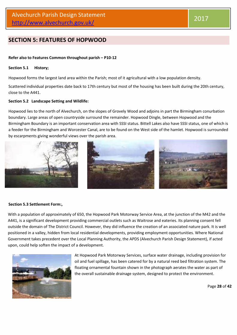
Hopwood lies to the north of Alvechurch, on the slopes of Grovely Wood and adjoins in part the Birmingham conurbation
boundary. Large areas of open countryside surround the remainder. Hopwood Dingle, between Hopwood and the
Birmingham Boundary is an important conservation area with SSSI status. Bittell Lakes also have SSSI status, one of which is
a feeder for the Birmingham and Worcester Canal, are to be found on the West side of the hamlet. Hopwood is surrounded
by escarpments giving wonderful views over the parish area.
Section 5.3 Settlement Form:,
With a population of approximately of 650, the Hopwood Park Motorway Service Area, at the junction of the M42 and the
A441, is a significant development providing commercial outlets such as Waitrose and eateries. Its planning consent fell
outside the domain of The District Council. However, they did influence the creation of an associated nature park. It is well
positioned in a valley, hidden from local residential developments, providing employment opportunities. Where National
Government takes precedent over the Local Planning Authority, the APDS (Alvechurch Parish Design Statement), if acted
upon, could help soften the impact of a development.
At Hopwood Park Motorway Services, surface water drainage, including provision for
oil and fuel spillage, has been catered for by a natural reed bed filtration system. The
floating ornamental fountain shown in the photograph aerates the water as part of
the overall sustainable drainage system, designed to protect the environment.

Page 29 of 42
Alvechurch Parish Design Statement http://www.alvechurch.gov.uk/
2017
Features of Hopwood:
Settlement Form continued
Canal feeder lakes provide opportunities for wildlife observation, fishing and boating In
addition to enhancing views across a spacious, open landscape.
The Peacock is a “country pub” within one
mile of the Birmingham City boundary
The Hopwood settlement is well served for recreation facilities. It has two pubs, a hotel, a village Hall, a community centre
and playing fields, two rugby clubs, a cricket club, a sailing club, fishing lakes and canal. Part of the Public Right of Way
(PROW) ‘North Worcestershire Path’ runs through Hopwood.
It is the largest land area Ward within Alvechurch Parish but has the lowest population density. It is also the closest ward to
the Birmingham City boundary. The level of recreation on offer is an amenity for the adjacent urban population as well as
for local people.
Successive Planners have maintained a building moratorium and encouraged agriculture. It is important to maintain
defences against creeping urbanisation in the future if the spaciousness of Hopwood is to be retained.
Hopwood residential development is mainly distributed along a one-mile section of the A441 and the lanes leading from it
along with an affordable development of 20 houses off Ash lane. There is also a mobile home park at which approximately
16% of the population reside.
The volume of traffic now using the A441is increasing considerably due to the Birmingham Longbridge development
scheme that is replacing the old Austin motor works. Traffic safety, calming measures and the provision of some crossing
facility is urgently required on this downhill section of what has rapidly become a major urban feeder road for the M42
motorway.
The M42 Motorway crosses Hopwood in an east-west direction and separates the hamlet from the rest of the Parish.
Commercial transport has given large houses used Affordable housing in Hopwood
way to recreational uses for care homes

Page 30 of 42
Alvechurch Parish Design Statement http://www.alvechurch.gov.uk/
2017
Features of Hopwood
Section 5.4 Buildings
Most of the properties in Hopwood were built pre-1950 apart from; the recently built 2010 Woodpecker Close, a mobile home park and the rest of recent building work confined to barn conversions. It has neither church, nor school, but instead, a Village Hall and Community Centre are a focus for community use. Some of the older houses along the A441 were built end-on to the road, so that their front and back faced north and south
Smedley Crooke Place; A well designed small development and associated planting
This three-storey farmhouse is a local feature common also to other parts of The Parish
Overhanging eaves, inset dormer windows and decorative gable ends, are a local characteristic
Section 5.5 Highways and Related Features
The absence of kerbing, signage and street lighting is preferred. Should it be necessary for certain safety or functional
reasons, it should be of a non-urban style.
Where the ribbon development along the main road is set back on a service road, trees and hedgerow help to blend it in with its surroundings
A quiet unsurfaced, access lane off the main A441 makes a welcome contrast to the noise and busyness of the adjacent road
The A441 Birmingham to Redditch Road carries a large amount of traffic, connecting South Birmingham with the M42

Page 31 of 42
Alvechurch Parish Design Statement http://www.alvechurch.gov.uk/
2017
To be encouraged
• Defence against creeping urbanisation to retain the spaciousness of Hopwood and protect the rest of the parish
from encroachment from Birmingham
• Where National Government takes precedent over the Local Planning Authority, implementation of the Parish
Design Statement could help to soften the impact of development
• Encouraging the efforts by working farms, a welcome sight along the back lanes of Hopwood, to prosper and protect
the environment
• Canal-side development, whether residential or commercial, incorporating boating facilities and consolidating
Hopwood’s present character
• The change of use of residential properties into suitable commercial activities, incorporating their restoration to
original character
• Self-contained parking provided for in any building alteration or development schemes
• The absence of kerbing, signage and intrusive street lighting. Should it be necessary for certain safety or functional
reasons, it should be of a non-urban style
• The retention of the current hamlet curtilage to prevent precedence by not allowing sprawl into the Green Belt and
by limiting development to infilling only apart from very local survey proven need
Features of Hopwood
Page 32 of 42
Alvechurch Parish Design Statement http://www.alvechurch.gov.uk/
2017
SECTION 6 FEATURES OF BORDESLEY Refer also to Features Common throughout parish, Pages 10-12
Section 6.1 History
The community, developed largely during the 20th century, retains an independence from its close neighbour, the Borough of
Redditch. Its rural character relies largely upon its setting within farmland and its uninterrupted views of surrounding hills
Section 6.2 Landscape Setting and Wildlife
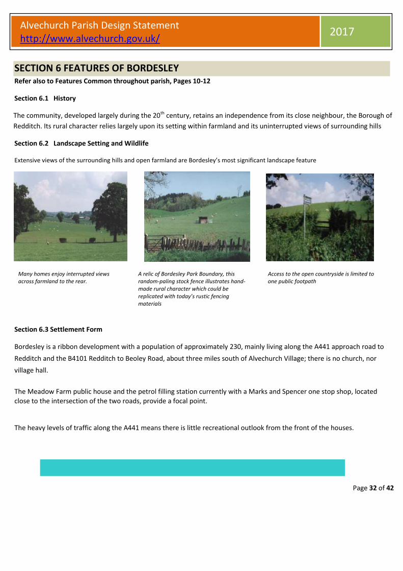
Extensive views of the surrounding hills and open farmland are Bordesley’s most significant landscape feature
Many homes enjoy interrupted views across farmland to the rear.
A relic of Bordesley Park Boundary, this random-paling stock fence illustrates hand-made rural character which could be replicated with today’s rustic fencing materials
Access to the open countryside is limited to one public footpath
Section 6.3 Settlement Form
Bordesley is a ribbon development with a population of approximately 230, mainly living along the A441 approach road to
Redditch and the B4101 Redditch to Beoley Road, about three miles south of Alvechurch Village; there is no church, nor
village hall.
The Meadow Farm public house and the petrol filling station currently with a Marks and Spencer one stop shop, located
close to the intersection of the two roads, provide a focal point.
The heavy levels of traffic along the A441 means there is little recreational outlook from the front of the houses.

Page 33 of 42
Alvechurch Parish Design Statement http://www.alvechurch.gov.uk/
2017
To be encouraged
• An absence of kerbing, signage and street lighting. Should it be necessary for safety or functional reasons, it
would be of a non-urban style
• Factors covered within the VDS implemented to help prevent the oncoming of creeping urbanisation
• Ample off-road parking, enabling vehicles to turn around and re-enter the main road in relative safely
Maintaining the openness of land through Green Belt land that keeps a buffer between Alvechurch Parish
and the conurbation of Redditch.
Features of Bordesley
Section 6.4 Settlement Form continued
Service station plus car sales and service facility provides potential for employment and convenience shopping but takes no account of rural character
A wholesale horticultural nursery is an appropriate commercial activity hidden from the road and providing potential for local employment
Ample unclipped verges with large mature trees and hedges result from low-density development
Section 6.5 Buildings: Houses are predominately mid-20th century, with some more recent infilling
Sufficiently large plot sizes allowing large
trees and unclipped hedges to co-exist with
buildings, helping them to blend with the
rural setting
Section 6.6 Highways and Related Features

Page 34 of 42
Alvechurch Parish Design Statement http://www.alvechurch.gov.uk/
2017
SECTION 7 FEATURES OF WEATHEROAK Refer also to Features Common throughout parish, Pages 10-12
Section 7.1 History
The settlement of Weatheroak, dating back to Roman times, began at the cross roads of the Roman road Ricknild Street (now called Icknield Street) and the Worcester to Coventry road.
Properties range from the 14th to 19th century with one or two 20th century examples only.
The majority were built in association with agriculture and for the estate workers of Weatheroak Hall, now the clubhouse of a Golf Club.
The former owners of the hall (The Mynors) built several of the cottages at Weatheroak in the early 1800s to house staff.
The designer was thought to be W.H.Bidlake, a well-known architect of that time, who also designed the local St. Mary’s Church tower. Weatheroak Hall design probably influenced these cottages since there are similarities between the buildings. Weatheroak Hall itself, together with the golf course, falls outside Alvechurch Parish, in the Parish of Wythall.
Section 7.2
The Weatheroak settlement blends into the natural landscape. The pattern of agricultural development is sympathetic to it and defined by it.
The compact and sparsely developed hamlet lies three miles east of Alvechurch Village, centred on Weatheroak Hill. Gently sloping grazing land, a wealth of hedgerows and specimen trees are characteristic of the area
Highly visible features on the skyline such as tall
trees, the windmill and woodland, visible from
some miles away, give the settlement a positive
sense of identity
Section 7.3 Settlement Form
With a well dispersed population of approximately 80, Weatheroak has no village hall, nor a shop, but the Coach and
Horses public house provide a focal point for the community. People employed in nearby conurbations occupy most of the
residential properties. The Kings Norton golf club, (once Weatheroak Hall the local landlord) attracts many hundreds of
people into the area to either play golf or attend social functions.

Page 35 of 42
Alvechurch Parish Design Statement http://www.alvechurch.gov.uk/
2017
Features of Weatheroak
Settlement Form continued
Coach and Horses public house, has a traditional walk-in entrance from the road. It has been extended but the “original pub” character has been cleverly retained
An existing character building, previously used as a store for the public house, appropriately converted for commercial use as a micro brewery
Local farming flanked by abundance of hedge rows and Giant Redwoods in Alvechurch seen from Weatheroak in Watery Lane
Active conventional dairy and sheep farming, complete with farmyard smells, adds true rural character to the settlement, close to the public house
Icknield Street is a single track low traffic usage lane providing a good recreational opportunity for walkers, horse riders and cyclists
The wall-mounted post box opposite the Coach and Horses pub at the Icknield Street crossroads is a strong man-made landmark.
Section 7.4 Buildings
A small number are converted agricultural buildings. The Bourneville Trust, which owned and maintained substantial
amounts of land and property in and around Weatheroak during the 20th century, has had a stabilising effect on
development.
Weatheroak building character has been affected only in a small way by late 20th century development and contains fine
examples of architecture dating back to 14th century. Good building design detail linking a number of residential,
agricultural and commercial properties within the settlement is also to be found in places elsewhere within the Parish

Page 36 of 42
Alvechurch Parish Design Statement http://www.alvechurch.gov.uk/
2017
Buildings continued
Informal boundaries created by hedges and loose stone driveways without kerbing
Steep roof angles, windows with leaded lights, ornate chimneys, stone architraves all practical to build with today’s materials
Decorative barge boards on gable ends and local Alvechurch-character red brick
A local landmark, this listed property has had a recent porch addition in keeping with the original building’s character
Examples of recent building additions in keeping with original character
Section 7.5 Highways and Related Features
An absence of kerbing, signage and street lighting is preferred. Should
installation be necessary for certain safety or functional reasons, it
should be a non-urban style.
The absence of road markings and kerbing on country lanes may
encourage lower speeds of through traffic unfamiliar with the route

Page 37 of 42
Alvechurch Parish Design Statement http://www.alvechurch.gov.uk/
2017
Features of Weatheroak
To be encouraged
• Tall native trees planted on the top of the hill as landmarks for the benefit of future generations
• Continued planting of woodland saplings as has happened during the past 15 years on several acres of
agricultural land between Brockhill and Icknield Street
• Any development, should it be necessary, reflecting historic building character and continuing agricultural land
use.
• Converted agricultural buildings should not be extended beyond their original size
• Suitable commercial activity, e.g. Weatheroak Brewery associated with the Coach and Horses is a good use of
existing buildings
• Working farms having a positive influence on rural character
• Hedges, forming boundaries; an important character element and encouragement to wildlife
• Attractive recreational rural locations. The pub and picnic points continuing to attract walkers, cyclists, horse-
riders and motorists from the local area and the neighbouring conurbations of Birmingham and Redditch
• Strong man-made landmarks e.g. the red brick windmill and the wall-mounted post boxes
• Support for continuity of the existing policy of major land and property owners,
• The Bourneville Trust, which, during the 20th century, has had a stabilising effect on development
• An absence of kerbing, signage and intrusive street lighting. Should it be necessary for safety or functional
reasons, it must be of a non-urban style

Page 38 of 42
Alvechurch Parish Design Statement http://www.alvechurch.gov.uk/
2017
SECTION 8: EXAMPLES OF DETAIL DESIGN FROM WITHIN THE PARISH 8.1: Doors and Porches Individually made joinery doesn’t automatically cost more than off-the-peg items but enables owners to maintain their properties in keeping with traditional character. There are local contractors able to supply your needs: for advice Contact the APDS team via your; Parish Council: 0121 447 8016 U-PVC doors and windows are inappropriate in listed properties and The Conservation Area in general, and listed building consent is required to change windows and doors in listed buildings. Here are some examples of historic doors and some modern equivalents which may be appropriate, depending on the age and style of your property.
Incorporate designs like these in your property

Page 39 of 42
Alvechurch Parish Design Statement http://www.alvechurch.gov.uk/
2017
EXAMPLES OF DETAIL DESIGN FROM WITHIN THE PARISH 8.2: Chimneys and Roofs:
Not all the details illustrated are suitable for every property, for example the Victorian bargeboards, in the photograph
bottom left hand corner, would not be appropriate on a vernacular cottage.

Page 40 of 42
Alvechurch Parish Design Statement http://www.alvechurch.gov.uk/
2017
8.3: Windows, driveways and paths
U-PVC doors and windows are inappropriate in listed properties and The Conservation Area in general
8.4: Driveways and paths
Gravel, Tarmac, stone setts, cobbles or random block Informal paths, driveway edges and verges
Examples of Detail Design from within the Parish

Page 41 of 42
Alvechurch Parish Design Statement http://www.alvechurch.gov.uk/
2017
Examples of Detail Design from within the Parish
8.5: Planting to soften the appearance of buildings

Page 42 of 42
Alvechurch Parish Design Statement http://www.alvechurch.gov.uk/
2017
Chestnut fencing Clipped Hedges Picket fencing Natural colours Random height palings Woven wattle
Combined fencing and hedging Blue brick capping; Natural unclipped verges. Reclaimed brick walls and edging - five-bar gates, rustic posts and rails
8.6: Boundaries


