A NEW JOINT AND VELOCITY MODEL OF THE MANTLE PARAMETERIZED IN CUBIC B-SPLINES Michael Antolik, G¨ oran Ekstr¨ om, Adam M. Dziewonski, Yu J. Gu, Jian-feng Pan, and Lapo Boschi Department of Earth and Planetary Sciences, Harvard University Cambridge, MA 02138 Contract No.: DSWA01-97-C-0124 Abstract The objective of the project is to develop and improve upon three-dimensional (3-D) seismic velocity mod- els of the Earth and to utilize such models for improving the locations of events recorded at regional and teleseismic distances. Our previous experiments performed using 3-D models of varying resolution show that the accuracy of event location with respect to ground truth does not necessarily improve with an in- creasing number of free parameters in a model. One reason for this may be the lack of waveform data used for constructing recent high-resolution models, since the maximum sensitivity of seismic travel times to structure is in the middle to lower mantle. In this paper we develop a new joint, and velocity model parameterized in terms of radial and horizontal cubic splines, using a combination of direct and differential travel times and surface wave phase measurements. The accuracy of the travel time data has been improved by relocating the events using a previously existing 3-D mantle wave model. The cubic spline param- eterization conveniently allows more detailed models to be inserted within it for use of regional phases in event location. Our preliminary model shows substantial differences in compressional velocity in the upper- most mantle compared with previous models. In conjunction with the model development, we are collecting new reference events with accurate locations, among them earthquakes on mid-ocean ridges and transforms, using a constrained inversion technique. Key words: Event location; seismic tomography; mantle heterogeneity
Transcript
A NEW JOINT P AND S VELOCITY MODEL OF THE MANTLE PARAMETERIZED INCUBIC B-SPLINES
Michael Antolik, Goran Ekstrom, Adam M. Dziewonski, Yu J. Gu, Jian-feng Pan, and Lapo BoschiDepartment of Earth and Planetary Sciences, Harvard University
Cambridge, MA 02138
Contract No.: DSWA01-97-C-0124
Abstract
The objective of the project is to develop and improve upon three-dimensional (3-D) seismic velocity mod-els of the Earth and to utilize such models for improving the locations of events recorded at regional andteleseismic distances. Our previous experiments performed using 3-D models of varying resolution showthat the accuracy of event location with respect to ground truth does not necessarily improve with an in-creasing number of free parameters in a model. One reason for this may be the lack of waveform data usedfor constructing recent high-resolution models, since the maximum sensitivity of seismic travel times tostructure is in the middle to lower mantle. In this paper we develop a new joint,P andS velocity modelparameterized in terms of radial and horizontal cubic splines, using a combination of direct and differentialtravel times and surface wave phase measurements. The accuracy of the travel time data has been improvedby relocating the events using a previously existing 3-D mantleP wave model. The cubic spline param-eterization conveniently allows more detailed models to be inserted within it for use of regional phases inevent location. Our preliminary model shows substantial differences in compressional velocity in the upper-most mantle compared with previous models. In conjunction with the model development, we are collectingnew reference events with accurate locations, among them earthquakes on mid-ocean ridges and transforms,using a constrained inversion technique.
The aim of this project is to ultimately improve the locations of earthquakes and other seismicallyrecorded events in order to enhance the ability to monitor the Comprehensive Nuclear-Test-Ban-Treaty(CTBT). Our strategy is based on developing new, detailed 3-D models of the mantle, with an emphasison P wave structure. This involves the construction of global high-resolution models with more detail incertain areas where particularly good data coverage is available. A second, subsidiary objective concernsthe development of additional techniques used in locating events teleseismically and regionally with sparsedatasets, and with assessing the improvement in accuracy afforded by the new techniques and models. Wehave previously studied the location accuracy obtained by some previously existing mantleP wave models[Antolik et al., 2000]. Here we describe the development of a new jointP andS wave velocity model of themantle, using a diverse and improved data set of travel times and surface wave phase velocity measurements.
Research Accomplished
The accuracy of event location with respect to ground truth is not a simple function of the number offree parameters or “resolution” of a particular velocity model. This was reported byAntolik et al. [2000],where they tested four existingP wave models. Two of these models, S&P12/WM13 (hereafter referred toas SP12) [Su and Dziewonski, 1993] and MK12WM13 [Su and Dziewonski, 1997] were parameterized interms of relatively low-order spherical harmonic functions. The other two models, that ofvan der Hilst et
0 2 4 6 8 10 12 14
Maximum layer number
10.0
10.5
11.0
11.5
12.0
12.5
13.0
13.5
14.0
RM
S m
islo
catio
n (
km)
670 km
1000 km
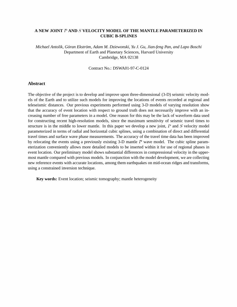
Figure 1: Root mean square mislocation obtained from locating a set of nuclear explosions with known locationsusing model corrections from BDP98 corresponding to layers only shallower than a certain depth. Each layer isslightly less than 200 km thick and are numbered in ascending order from the top to the bottom of the mantle. Thedepths of 670 km and 1000 km are indicated by the vertical lines. The data point for layer 0 is equivalent to locatingthe events in the reference 1-D model PREM (no layers from BDP98 were used). The majority of the improvement inlocation accuracy is obtained by considering only those layers above 1000 km.
al. [1997] (HWE97) andBoschi and Dziewonski[1999] (BDP98), were parameterized in terms of constant-
velocity blocks with horizontal dimensions of 2� and 5�, respectively, and contain nearly an order of mag-nitude more free parameters. Surprisingly, the best locations were provided by model SP12 even though themodels with higher resolution provide a better fit to the travel time residuals. These tests were performed us-ing a well-calibrated set of explosions and earthquakes [Kennett and Engdahl, 1991] and datasets consistingof a limited number of teleseismic phases in order to simulate global location of small events by the Inter-national Monitoring System (IMS) seismic network. Model SP12 provided consistently smaller magnitudemislocations than the other three models.
There are several possible reasons for this result. The parameterization most often chosen for newer,high-resolution models is typically that of blocks with constant velocities [e.g.,Boschi and Dziewonski,1999; Vasco and Johnson, 1998; Grand et al., 1997]. These models therefore introduce artificial lateraldiscontinuities into the structure and may induce an unrealistic shape in long-wavelength anomalies. Alack of correlation between new, high-resolution Earth models and earlier longer wavelength models haspreviously been noted [Grand et al., 1997]. Another issue is the coverage of the data sets used in theinversion problem. Because of the very large number of parameters used to define the higher resolutionmodels, most of these models make use of a somewhat limited data set (for example, only phase traveltimes) in order to reduce the size of the necessary computer resources (memory and CPU time). Thismay result in a relative lack of resolution in certain areas of the mantle (particularly at shallow depths) towhich teleseismic phase travel times are not sensitive. As an example, we show in Figure 1 the mislocationobtained from a group of explosions using only a subset of the layers of model BDP98 as a correction toPREM. Nearly all of the improvement in the locations is obtained by considering depths above 1000 km,which shows that resolution of the shallow mantle is most critical to teleseismic event location. Modelswhich do not recover the upper mantle structure well will not provide the most accurate locations.
0
1
2
3
4
5
6
7
8
9
10
11
12
13
14
15
B-s
plin
e #
0 2 4 6 8 10 12 14 16 18 20
data set #
Lov
e D
ISP
Ray
leig
h D
ISP
man
tle
WF
(T>8
5s,T
)
man
tle
WF
(T>1
35s,
T)
man
tle
WF
(T>8
5s,V
)
man
tle
WF
(T>2
00s,
T)
man
tle
WF
(T>1
35s,
V)
man
tle
WF
(T>2
00s,
V)
body
WF
1(T
>45s
,V)
body
WF
2(T
>45s
,V)
body
WF
2(T
>45s
,T)
body
WF
1(T
>45s
,T)
SS-S
SS S ScS-
S
ScS
S-SK
S
SKK
S-SK
S
norm
aliz
ed a
mpl
itud
e (%
)
100
0
Figure 2:Diagram showing the average amplitide of the diagonal elements of an inner product matrix for an inversionfor shear wave velocity [Gu et al., 2000]. Each cell corresponds to that portion of the matrix describing sensitivityof a particular data set used (listed at the top) to one of the radial B-splines of the model. The splines are numberedin ascending order from the CMB to the top of the mantle (i.e., spline 1 has maximum amplitude near the CMB, seeFigure 4). A higher normalized amplitude indicates greater sensitivity of a dataset to the coefficients of a radial spline.
-0.4 -0.2 0.00.2
0˚ 12|
0.4
-0.4
-0.2
0.0
0.2
-0.4
0.2
0.4
0.6
0.8
1.0
(a)
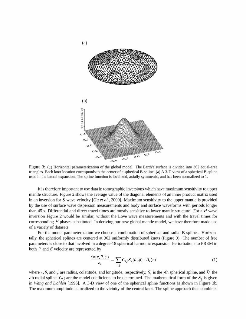
(b)
Figure 3: (a) Horizontal parameterization of the global model. The Earth’s surface is divided into 362 equal-areatriangles. Each knot location corresponds to the center of a spherical B-spline. (b) A 3-D view of a spherical B-splineused in the lateral expansion. The spline function is localized, axially symmetric, and has been normalized to 1.
It is therefore important to use data in tomographic inversions which have maximum sensitivity to uppermantle structure. Figure 2 shows the average value of the diagonal elements of an inner product matrix usedin an inversion forS wave velocity [Gu et al., 2000]. Maximum sensitivity to the upper mantle is providedby the use of surface wave dispersion measurements and body and surface waveforms with periods longerthan 45 s. Differential and direct travel times are mostly sensitive to lower mantle structure. For aP waveinversion Figure 2 would be similar, without the Love wave measurements and with the travel times forcorrespondingP phases substituted. In deriving our new global mantle model, we have therefore made useof a variety of datasets.
For the model parameterization we choose a combination of spherical and radial B-splines. Horizon-tally, the spherical splines are centered at 362 uniformly distributed knots (Figure 3). The number of freeparameters is close to that involved in a degree-18 spherical harmonic expansion. Perturbations to PREM inbothP andS velocity are represented by
�v(r; �; �)
v�
=Xi;j
CijSj(�; �) � Bi(r) (1)
wherer, �, and� are radius, colatitude, and longitude, respectively,Sj is thejth spherical spline, andBi theith radial spline.Cij are the model coefficients to be determined. The mathematical form of theSj is givenin Wang and Dahlen[1995]. A 3-D view of one of the spherical spline functions is shown in Figure 3b.The maximum amplitude is localized to the vicinity of the central knot. The spline approach thus combines
some of the advantages of using a local, block parameterization with the advantage of producing a smoothmodel.
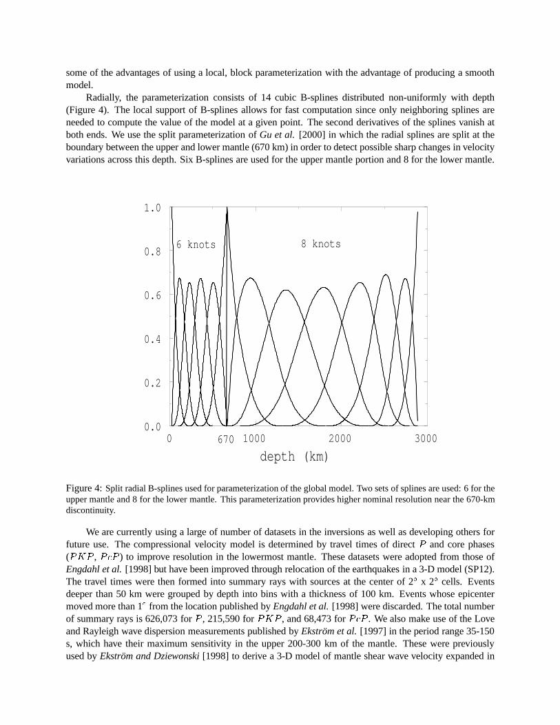
Radially, the parameterization consists of 14 cubic B-splines distributed non-uniformly with depth(Figure 4). The local support of B-splines allows for fast computation since only neighboring splines areneeded to compute the value of the model at a given point. The second derivatives of the splines vanish atboth ends. We use the split parameterization ofGu et al. [2000] in which the radial splines are split at theboundary between the upper and lower mantle (670 km) in order to detect possible sharp changes in velocityvariations across this depth. Six B-splines are used for the upper mantle portion and 8 for the lower mantle.
0 1000 2000 3000
depth (km)
0.0
0.2
0.4
0.6
0.8
1.0
670
8 knots6 knots
Figure 4:Split radial B-splines used for parameterization of the global model. Two sets of splines are used: 6 for theupper mantle and 8 for the lower mantle. This parameterization provides higher nominal resolution near the 670-kmdiscontinuity.
We are currently using a large of number of datasets in the inversions as well as developing others forfuture use. The compressional velocity model is determined by travel times of directP and core phases(PKP , PcP ) to improve resolution in the lowermost mantle. These datasets were adopted from those ofEngdahl et al.[1998] but have been improved through relocation of the earthquakes in a 3-D model (SP12).The travel times were then formed into summary rays with sources at the center of 2� x 2� cells. Eventsdeeper than 50 km were grouped by depth into bins with a thickness of 100 km. Events whose epicentermoved more than 1� from the location published byEngdahl et al.[1998] were discarded. The total numberof summary rays is 626,073 forP , 215,590 forPKP , and 68,473 forPcP . We also make use of the Loveand Rayleigh wave dispersion measurements published byEkstrom et al.[1997] in the period range 35-150s, which have their maximum sensitivity in the upper 200-300 km of the mantle. These were previouslyused byEkstrom and Dziewonski[1998] to derive a 3-D model of mantle shear wave velocity expanded in
spherical harmonics up to degree 20 as part of an earlier phase of this project. For shear velocity inversions,we also use the direct and differential travel time datasets described inSu et al. [1994]. They consist ofapproximately 45,000 measurements ofS, SS, ScS, SS - S, S - SKS, ScS - S, andSKKS - SKS traveltimes. Future models will also include the extensive dataset of body and surface waveforms compiled overthe years at Harvard.
We solve the inverse problem by non-linear, iterative least-squares analysis. The equations are of theform
�d0 = A�x (2)
where�x is the perturbation in the model from the previous iteration,�d0 is the corresponding unexplainedportion of the data vector, andA is the kernel matrix. For the final iteration, we require that
jA�x� �d0j2 + �2j�xj2 + �2g2 = min (3)
where� and� are damping factors andg2 is the integrated squared gradient of the model:
g2 =
Z
Z rmoho
rcmb
j 5 (�v=v0)j2drd: (4)
The least-squares model solution at each iteration is computed by the method of Cholesky factorization[Trefethen and Bau, 1997].
An initial P wave velocity model is shown in Figure 5. With respect to model BDP98, the new modelshows higher amplitude velocity perturbations in the upper mantle, which may be the result of the 3-Drelocation of the sources prior to inversion. Use of the surface wave measurements produces lower velocitiesthroughout the eastern and central Pacific than are observed using travel times alone. At the bottom of themantle, the new model has slightly lower amplitude than BDP98 and much lower amplitude than modelSP12, especially in the southern hemisphere. This may be partly due to the relatively coarse separationof the radial splines in the lower mantle in this parameterization. Since, as noted above, the upper mantleis most critical for accurate earthquake location, the new model may improve upon the location accuracyprovided by BDP98 and other high-resolution models. Our new models will be tested using the dataset ofcalibration events compiled at Harvard and other institutions.
Constraining earthquake locations on mid-ocean ridges and transforms
In addition to the construction of more detailed and accurate global velocity models, we have focusedour efforts on building a larger database of reference or “ground-truth” events to be used for model calibra-tion. So far, the geographical distribution of events with locations known to an accuracy of 5 km or better isextremely limited. Many of these events are nuclear explosions and are concentrated in only a few sourceregions, making comprehensive testing of velocity models and calibration of new seismic stations very dif-ficult. We are experimenting with relocation of events on remote plate boundaries using a technique whichconstrains the location to a point along the plate boundary. For example, by limiting the process to onlylarge events for which a Centroid Moment Tensor (CMT) solution exists, an assessment can be made as towhether an event should be located along a mid-ocean ridge segment or an adjacent transform fault based onits focal mechanism. We then perform a transformation of coordinates into the system defined by the pole ofrotation between the two plates, such that the ridge or transform fault lies along a parallel or meridian. Weuse accurate bathymetry to determine the precise location and trend of the boundary [Smith and Sandwell,1997]. In the subsequent location process, the coordinate (latitude or longitude) which corresponds to theplate boundary is held fixed. In this way, we are able to develop a master set of events which can then beused to relocate other smaller events in the same region.
-0.006 0.006
100 km 300 km
550 km 900 km
1300 km 1800 km
2500 km 2800 km
dv/v
Figure 5:Model ofP wave velocity at various depths obtained in joint inversion of compressional and shear velocityusing travel times and surface wave phase velocities. Scale shows fractional velocity perturbation from PREM.
We have thus far compiled a catalog of these events along most of the transform faults in the Atlantic,Pacific, and Indian oceans. Figure 6 shows the relocation of events along the Romanche Fracture Zone(RFZ) in the central Atlantic. The top panel shows the ISC locations of events in the CMT catalog. Afterrelocation (middle panel), the strike-slip earthquakes associated with the RFZ lie along the trend definedby the bathymetry. The ISC locations are systematically displaced to the south relative to the RFZ, andthe apparent mislocations are as large as 40 km. The results obtained thus far are promising but requireextensive testing to determine the accuracy of the relocations.
Conclusions and Recommendations
Although the current generation of global velocity models provides substantial improvement over 1-Dvelocity models for teleseismic earthquake location [Smith and Ekstrom, 1996;Antolik et al., 2000], thereis still much room for improvement. The consistent accurate location of small events to within the areaspecified for on-site inspection under the CTBT (1000 km2) will likely require the use of regional phases inaddition to teleseismic travel times, and also possibly consideration of anisotropy or arrival angle data. Tothis end, we are developing new global models which combine a local parameterization with the advantages
335˚ 340˚ 345˚-2˚ -2˚
-1˚ -1˚
0˚ 0˚
1˚ 1˚
2˚ 2˚
335˚ 340˚ 345˚-2˚ -2˚
-1˚ -1˚
0˚ 0˚
1˚ 1˚
2˚ 2˚
335˚ 340˚ 345˚-2˚ -2˚
-1˚ -1˚
0˚ 0˚
1˚ 1˚
2˚ 2˚
335˚ 340˚ 345˚-2˚ -2˚
-1˚ -1˚
0˚ 0˚
1˚ 1˚
2˚ 2˚
-8000-7000-6000-5000-4000-3000-2000-1000 0
meters
Figure 6:Relocation of earthquakes along the Romanche Fracture Zone in the central Atlantic. The top panel showsthe focal mechanisms of large earthquakes in the region plotted at their ISC locations. After identification of the strike-slip events to be constrained to the RFZ, these events are relocated after coordinate transformation (middle panel). Thebottom panel shows the change in location of these same events, multiplied by a factor of 2.5. Bathymetry is takenfrom Smith and Sandwell[1997].
of smoothness over large distances. This will enable straightforward replacement of portions of the globalmodel by a more detailed model covering a particular region. The smooth parameterization will allow simplecomputation of 3-D raypaths.
Testing of new global and regional velocity models, as well as calibration of newer IMS stations, willbenefit from the compilation of reference events in remote regions. Our database of relocated events onmid-ocean plate boundaries will also enable construction of more accurate travel time and phase velocitydatasets.
References
Antolik, M., G. Ekstrom, and A. M. Dziewonski, Global event location with full and sparse datasets usingthree-dimensional models of mantleP wave velocity,Pure Appl. Geophys., in press, 2000.
Boschi, L. and A. M. Dziewonski, “High” and “low” resolution images of the Earth’s mantle: Implicationsof different approaches to tomographic modeling,J. Geophys. Res., 104, 25,567-25,594, 1999.
Ekstrom, G., and A. M. Dziewonski, The unique anisotropy of the Pacific upper mantle,Nature, 394, 168-172, 1998.
Ekstrom, G., J. Tromp, and E. W. F. Larson, Measurements and global models of surface wave propagation,J. Geophys. Res., 102, 8137-8157, 1997.
Engdahl, E. R., R. D. van der Hilst, and R. P. Buland, Global teleseismic earthquake relocation with im-proved travel times and procedures for depth determination,Bull. Seism. Soc. Am., 88, 722-743, 1998.
Grand, S. P., R. D. van der Hilst, and S. Widiyantoro, Global seismic tomography: A snapshot of convectionin the Earth,GSA Today, 7(4), 1-7, 1997.
Gu, Y. J., A. M. Dziewonski, W. Su, and G. Ekstr¨om, Shear velocity model of the mantle and discontinuitiesin the pattern of lateral heterogeneities, submitted toJ. Geophys. Res., 2000.
Kennett, B. L. N., and E. R. Engdahl, Traveltimes for global earthquake location and phase identification,Geophys. J. Int., 105, 429-465, 1991.
Smith, G. P., and G. Ekstr¨om, Improving teleseismic event locations using a three-dimensional earth model,Bull. Seism. Soc. Am., 86,, 788-796, 1996.
Smith, W. H. F., and D. T. Sandwell, Global sea floor topography from satellite altimetry and ship depthsoundings,Science, 277, 1956-1962, 1997.
Su, W. and A. M. Dziewonski, Joint 3-D inversion forP - andS-velocity in the mantle,EOS, 74,557, 1993.Su, W. and A. M. Dziewonski, Simultaneous inversion for 3-D variations in shear and bulk velocity in the
mantle,Phys. Earth Planet. Inter., 100, 135-156, 1997.Su, W., R. L. Woodward, and A. M. Dziewonski, Degree-12 model of shear velocity heterogeneity in the
mantle,J. Geophys. Res., 99, 6,945-6,980, 1994.Trefethen, L. N., and D. Bau,Numerical Linear Algebra, Soc. for Ind. and Appl. Math., Philadelphia, PA,
1997.van der Hilst, R. D., S. Widiyantoro, and E. R. Engdahl, Evidence for deep mantle circulation from global
tomography,Nature, 386, 578-584, 1997.Vasco, D. W. and L. R. Johnson, Whole Earth structure estimated from seismic arrival times,J. Geophys.
Res., 103, 2633-2671, 1998.Wang, Z., and F. Dahlen, Spherical-spline parameterization of three-dimensional Earth models,Geophys.


![Humidity influences on creasing behaviour of … influences on creasing behaviour of corrugated board ... demand for corrugated board shows an annual increase. [2] This can be attributed](https://static.documents.pub/doc/80x56/5ab3ac377f8b9ad9788e574e/humidity-influences-on-creasing-behaviour-of-influences-on-creasing-behaviour.jpg)


