24
APPLICATION OF MATHEMATICAL MODELING IN RAINFALL FORECAST: A CASE STUDY OF SUNGAI SARAWAK BASIN Beatrice Christianus Bidaun , Master of Engineering (Civil Engineering) 2013
APPLICATION OF MATHEMATICAL MODELING IN RAINFALL FORECAST A CASE STUDY OF SUNGAI SARAWAK BASIN
Beatrice Christianus Bidaun
Master of Engineering (Civil Engineering)
2013
ACKNOWLEDGEMENT
First and foremost praises and thanks to the Lord God almighty for His showers of blessings
I would like to express my deepest gratitude to my supervisor Assoc Prof Dr Nasser Rostam
Afshar and co-supervisor Dr Onni Suhaiza Selaman for their excellent guidance patience
motivation and immense knowledge throughout the study
I want to thank the Department of Civil Engineering UNIMAS and the Faculty of Civil
Engineering UiTM Sarawak for their continuous support and kindness I have gained so much
knowledge from everyone Thank you to the Department of Irrigation and Drainage Sarawak
for providing the required hydrology data as well as technical knowledge
My appreciation also goes to my batch thank you for being such awesome friends and
classmates To dearest friends thank you for the support and encouragement To my family
thank you for being the rock of my life
ABSTRACT
Rainfall is a random and probabilistic phenomenon that plays a great role in the life of
humans The study embarks to apply a mathematical modeling in rainfall forecasting for
the Sungai Sarawak basin Recent study reveals that the FS has the ability to simulate
long-term rainfall up to 300 years is viewed as an important finding in the study of rainfall
forecast Rainfall data was collected from eight rain gauge stations from the Department
of Irrigation and Drainage Sarawak The data was then analyzed and prepared for missing
data consistency check and adequacy of number of stations Simple statistical analysis
was conducted on the data such as maximum minimum mean and standard deviation 27
years of annual rainfall data were simulated with the Fourier Series equation using
spreadsheet Hence the result was compared with the Fitting N -term Harmonic Series
The model result reveals that the Fourier Series has the ability to simulate the observed
data by being able to describe the rainfall pattern The result was tested using x2 and
RMSE 295 and 1133 mm respectively There is a reasonable relationship between the
simulation and observed data with p-value of 093 For future study it is highly
recommended to have a refinement in the data analysis that can highly influences the
perfonnance of the model
II
ABSTRAK
Hujan adalah satu fenomena alam yang memainkan peranan yang besar dalam kehidupan
manusia Kajian ini dijalankan sebagai salah satu langkah menghadapi kesan-kesan
perubahan iklim Kawasan kajian yang terbabit adalah Lembagan Sungai Sarawak dan
kaedah model hujan yang telah digunapakai ialah Fourier Series Kajian baru-baru ini
telah mendapati FS berupaya untuk mensimulasikan hujan dalam jangka panjang iaitu
sehingga 300 tahun dilihat sebagai penemuan penting Data hujan daripada lapan stesen
hidrologi daripada Jabatan Pengairan dan Saliran Sarawak telah dianalisa bagi data yang
hilang dan juga keseragaman data Analisis statistik telah dijalankan ke atas data seperti
maksimum minimum dan min 27 tahun data hujan tahunan disimulasikan dengan
persamaan FS dengan menggunakan perisian excel Simulasi model ini telah
dibandingkan dengan Fitting N-term Harmonic Series Hasil model mendapati FS
mempunyai keupayaan untuk mensimulasikan corak hujan Hasil dapatan kajian ini telah
diuji dengan menggunakan x2 dan RMSE 295 dan 1133 mm Terdapat hubungan yang
wajar di antara simulasi dan data dengan p-nilai 093 Untuk kajian di masa hadapan
dicadangkan untuk melakukan analisa data yang lebih terperinci bagi meningkatkan
prestasi model
III
Pu ut Khidmu MakJumat Ak demik I 1 VSIA SARAWAK
TABLE OF CONTENT
CONTENT Page
ACKNOWLEDGEMENT
ABSTRACT 11
ABSTRAK 1lI
LIST OF FIGURES vii
LIST OF TABLES VllI
LIST OF ABBREVIA nONS IX
CHAPTER 1 INTRODUCTION
11 General
12 Problem Statement 4
13 Objectives 5
14 Scope Of Study 6
15 Significance Of Study 9
16 Report Outline 12
CHAPTER 2 LITERATURE REVIEW
21 Introduction 13
22 Hydrological Model 14
23 Preceding Study 16
24 Fourier Series 19
-
IV
25 Performance Evaluation Of Models 23
25 Summary 24
CHAPTER 3 METHODOLOGY
31 Introduction 26
32 Data Collection 28
33 Preparation Of Data 29
34 Fourier Series 31
35 Modeling Procedures 35
36 Summary 41
CHAPTER 4 RESULTS AND ANALYSIS
41 Introduction 42
42 Analysis Of Data 42
43 Simulation Results 45
CHAPTER 5 CONCLUSIONS AND RECOMMENDATIONS
51 Overview 49 i
52 Conclusions 50
53 Recommendations For Future Study 50
REFERENCES
APPENDICES
v
LIST OF FIGURES
Title Page
Figure 11 HadCM3 PRECIS simulations of annual raindays for Malaysia 3
Figure 12 HadCM3 PRECIS simu1ations of annual and DJF seasonal 3
precipitation anomaly for Malaysia
Figure 13 Sungai Sarawak basin area and location of hydrological stations 8
Figure 14 Map of SCORE 10
Figure 15 Projected flow 11
Figure 21 Hydrological model development 15
Figure 22 Observed and fitted mean rainy day 21
Figure 23 Annual and average rainfall in Iran 23
Figure 31 Research framework 27
Figure 32 Annual rainfall periodic function of case study 36
Figure 33 Fitting N-term Harmonic Series simulation procedures 38
Figure 34 Fitting N-term Harmonic Series 39
Figure 35 Setting the harmonic series 39
Figure 36 Coefficients of Fourier Series 40
Figure 37 RMS andx2 40 ~
Figure 38 Output 41
Figure 41 Consistency check - Sembam 43
Figure 42 Consistency check - Padawan 43
Figure 43 Consistency check - Sungai China 43
Figure 44 Simulation output for 2003 to 2011 46
VI
LIST OF TABLES
Table Description Page
Table 11 ResHCM-PM PRECIS hydro climatic observed and projections in 2
Malaysia
Table 21 Summary of statistics criteria performance evaluation of models 23
Table 22 FS coefficients and NSRP parameters 24
Table 31 Selected hydrological stations 28
Table 41 Polygon area and weightage by Thiessen-Polygon Method 44
Table 42 Descri pti ve statistics 45
Table 43 RMSE and x2 for n = 2 3 and 4 47
Table 44 Simulation result and observed rainfall 47
Vll
LIST OF APPENDICES
Appendices Description
APPENDIX A Monthly data
APPENDIX B Adequacy check of rain gauge stations
APPENDIX C Estimation of missing rainfall data - Normal Ratio Method
APPENDIX D Mean areal precipitation using Thiessen Polygon Method
APPENDIX E Fitting N-term Harmonic Series simulation output
VIII
LIST OF ABBREVIATIONS
Abbreviations Descriptions
N Number of optimal stations
Coefficient of variation
Allowable degree of error
Precipitation of station
M Number of neighboring stations
Monthly normal of station
Corrected precipitation
Corrected slope of the double-mass curve
Original slope of the double mass-curve
IX
CHAPTERl
INTRODUCTION
11 General
Recent reports on climate change have stirred global worries The regional climate
projects that the mean sea level temperature and rainfall variability in all regions will
increase in the future Precipitation in the southern part and most part of Southeast Asia
will likely increase in boreal winter and summer Christensen et a1 (2007) predicts
extreme rainfall and winds associated with tropical cyclones will likely to increase with
an increase in the frequency of intense precipitation events
In the Malaysia Second National Communication (NC2) to the United Nation
Frameworks Convection on Climate Change (UNFCC) has revealed that there is an
increase in the annual mean surface temperature to 06 degc - 12 degc per year based on 40shy
year observations Rainfall intensity observations from the year 2000 to 2007 are found to
have exceeded the highest recorded rainfall intensity in 1971 to 1980 that was previously
reported During the same observation period the annual maximum rainfall intensity has
increased by 17 and 29 for 1 hour and 3 hour durations respectively The mean sea
level recorded at Tanjung Piai Johor also indicated an increase of rate as much as 13
mmJ year in the observed year 1986 to 2006 (N C2 2011) The behavior of the results is
found to be consistent with the findings of the regional climate projections
In concern with the climate change particularly in Malaysia two models were
used to evaluate the hydro climatic projections for the year 2050 and 2099 The models
are known as Regional Hydro - Climate Model for Peninsular Malaysia (ResHCM-PM)
and Providing Regional Climater for Impact Studies (PRECIS) Both models were used
for hydro climatic projections in the West Malaysia however only PRECIS was used for
hydro climatic projections in the East Malaysia The findings for both observed and
projected climate change throughout the country is summarized in Table 11
Table 1 1 ResHCM-PM PRECIS hydro climatic observed and projections in Malaysia (NC22011)
Observed Projected by 2050
Temperature 06 Uc - 12 Uc per 50 years (1969 - 2009)
15 vc - 2 vc increase
Rainfall (amount) No appreciable difference (-) 5 to (+) 9 change in regions within PM
(-) 6 to (+) 11 change in reglOns within Sabah and Sarawak
Rainfall intensmiddot y Increased by 17 for 1 hour duration and 29 for 3hour duration (2000-2007) compared to 1971-1980)
Increase in extremes within wet cycles
Increase in frequency of extreme weather
Sea level rise (SLR) 13 mmlyr (1986 - 2006 Tanjung Piai Johor)
05 m rise (Global high worst case at 10 mmlyr)
2
LIlA
Figure 1 1 HadCM3 PRECIS simulations of annual rain days for Malaysia (Sammathuria et al 2010)
DeC1ATO
rl- LunULUIIA
uluI
Figure 1 2 HadCM3 PRECIS simulations of annual and DJF seasonal precipitation anomaly for Malaysia (Sammathuria et al 2010)
Sammathuria et al (2010) have used HadCMe PRECIS to project the annual
precipitation anomaly December-January-February (DJF) seasonal precipitation anomaly
and annual rain days projections for the year 2000 to 2099 Results of the simulation are
as depicted in Figure 11 and Figure 12 The significant interdecadal variation detected
3
in all simulations suggested that there would be a long-term extended dry spells Sarawak
is predicted to experience negative annual precipitation for forty years
Both regional and national reports have suggested there is a change in the rainfall
pattern whereby the intensity of precipitation events will increase Christensen et al
(2007) stated that the regional quantitative estimations of precipitation change are
difficult to obtain as they are limited to uncertainties in the sources and studies should be
done on a smaller scale While Sammathuria et al (2010) suggested that Sarawak will
experience forty years of drought in their projection up to the year 2099 Therefore
studies in enhancing the ability for rainfall forecasting models in capturing the change of
climate and its effects on the rainfall patterns are greatly needed for future guidelines and
preparations
12 Problem Statement
The study of rainfall forecasting plays an important role to a country such as
Malaysia where the rain is abundant Malaysia receives rainfall from 2000 mm to 4000
mm annually where it is greatly influenced by two monsoon periods in November to
March and May to September The state of Sarawak is well known for its long and wide
rivers and rivers have always been the main transportation and still are in certain remote
areas Numerous activities such as commercial industrial and residential can always be
found in the vicinity of the rivers The activities have started since decades ago and still
continue to grow and spatially expanding through times providing incomes ranging from
4
--~--111----------p~ut1~hidmat Maklumat Akademik ~Ill MALAYSIA SARAWA)
small fanners to the largest corporations Unfortunately these areas are expected to
experience frequent flood events as well as possible receding water level in rivers based
on the findings of previous studies If the projections are accurate the productivity of
these activities will be reduced hence in a longer tenn may affect the economy of the
state as whole as well
Therefore there is an urgent need for existing knowledge on rainfall behavior to be
revised as effects of climate change with the intention that the state can fully utilize the
favorable conditions and make scientific based decisions in the future Further study in
rainfall forecasting focusing on the state of Sarawak as suggested lby Christensen et al
(2207) is indeed very crucial to improve the estimation accuracy for long-tenn rainfall
prediction Long-tenn prediction is important for planning and management in various
sectors where rain is considered as a major driving factor such as agriculture and water
resources
13 Objective
Fourier Series has been well accepted as a tool that has improved the result of
hydrological modeling and reduces complex parameters analysis for simulation purposes
Recent study by Rostam Afshar and Fahmi (2012) reveals the ability of Fourier Series to
simulate long-tenn rainfall up to 300 years is viewed as an important finding in the study
of rainfall forecast For this reason the main goal of the study is to forecast rainfall for
Sungai Sarawak basin and the objectives are
5
1 To screen missing rainfall data
~
2 To check on the adequacy of the number of selected rain gauge station
3 To check on the consistency of the rainfall record
4 To estimate the mean areal rainfall of the Sg Sarawak basin
5 To model the rainfall simulation using mathematical modeling le Fourier
Series
6 To verify the simulation result using statistical analysis ie Root Mean Square
and Chi-Square
14 Scope of Study
The selected study area was Sungai Sarawak basin as depicted in Figure 13 The
basin is currently under the management of the Sarawak Department of Drainage (DID)
Daily rainfall data was obtained from DID for eight hydrological stations Data was
prepared and analyzed as monthly rainfall data for modeling purpose The method of
modeling was using Fourier Series and results were statistically verified for one year
observed data
The basin consists of 49 hydrological stations of which 37 are rain gauge stations
The basin area is approximately 2 459 km2 with river length of 120 km Originating from
Kapuas Mountains Sg Sarawak that consists of two main tributaries ie Sg Sarawak
6
Kiri and Sg Sarawak Kanan runs through the city before exiting to South China Sea The
river is lively with numerous activities along the river Improvement in the rainfall
forecast study will benefit the state as well as public by proper planning and mitigation of
water resources
7
17
J
15
SUNGAI 8ARAlJAX BASIN 1shy CAL
Figure 13 Sg Sarawak basin area and location of hydrological stations (DID)
8
15 Significance of Study
Rain is considered to be an important hydrological component in the study of
water resources in general Malaysia is predicted to have adequate water resources
between the years 2025 to 2050 however during dry season urban areas are expected to
experience water disruption since water supply will be greatly shared among many
sectors such as domestic and industries The increase in population and rapid
development in various sectors will give rise to the demand of water significantly which
leads to a draw down in water supply reservoirs In 2012 the water level in Sungai
Selangor dam was reported has dropped and the capacity of the dam has decreased as
much as 50 (Mahmood 2012) In the same year the rivers water level in Kota Tinggi
Kluang Mersing and Muar districts were also reported have slightly dropped due to the
hot weather which caused SAl holdings to be on alert ensuring there was not disruption
of water supply at the Sungai Sayong water treatment Kota Tinggi SAl holdings is
currently in charge for the water treatment and distribution of treated water in lohor
It is to the authors point of view that the same scenarios will occur here in
Sarawak Sarawak in its long term planning via series of dams construction has aim to
increase the industrial activities within the state to enhance economy growth through
hydropower Larger areas allocated for industries would definitely lead to significant
increase in water demand Under the Master Plan of Sarawak Corridor of Renewable I
Energy (SCORE) to connect to the industries that are located along the coastal twelve
hydroelectric dams of 20 000 MW capacity needed to be built for a distance
approximately 320 km from Tanjung Manis to Samalaju (Figure 14) The area covered
is half ofthe size of the state 70 709 km2 (Sovacool and Bulan 2012)
9
- Po ~ upr tornlklf bull l(Cn(lll (M 1I111 lluIII power
bull H~dlo poIcnllai III I 1(101 D Rm 0001
Po(I dtlmlld ((110 ~1I1m110n n~ rClllo1l S((1R MII
bull II n l 1gt1 bull ~ I of I~ hydr(l II
o r~ middotInll IIhln Hil i 11 111 ~
bull ~ IXJO~I (lOfallinl bull SmiddotOOO GllCD(I~middot
B 1111 1
lu ail -
~ _ ___u
bull Figure 14 Map of SCORE (Sarawak Energy Berhad 2013)
Agricultural production depends very much on the temperature and rainfall
variability Prolong drought or seasonal rainfall will hinder the productivity of the sector
The long duration of drought will disrupt the irrigation of water and may stop any
planting activity while flood will damage the crops within the affected areas The study of
rainfall estimation is viewed to be able to minimize the damages and take advantage the
favorable behavior of the climate for agricultural poundectors through proper planning and
mitigation
In addition to the 2011 climate change projection for Malaysia one of the findings
that should be taken seriously is the prediction of increase in the flood frequency The rise
of mean sea level together with the increase in the rainfall intensity NC2 (2011)
10
projected that the existing flood affected areas will experience an Increase In the
frequency of flood event while present unaffected areas will likely experience flood
(Figure 15) Located at the vicinity of estuary a flood prone area at present the city of
Kuching is viewed to be more vulnerable in the future based on the projections It is to the
authors point of view that this study will benefit the state of Sarawak very much in its
future planning and mitigation
NAHRIMs RegHCM-SS KEDAMAIAN ( 1 J P amp FLOODS )
Projected Flow 2040-2050 2090middot2100 Low Flow (mls) 175f(340) 3181(340)
High Flow (mls) 218 9i 1008) 1484 ( 10080)
amp I bull 1Lltsn I I1middot-1UG1 I 1I 1Jn11 ~1 - ~ ~ E r ~ _ ~l ~
8 ~
I
~L tthul out
middot ~~ middotft rr 1 1t
~ uill1 I II )ab I
Ed ~rmiddotL IIbIIqJ
TnL r
J
FLOODSSARAWAK R (FLOODS ) CJ 2040 middot2050 2090 middot21 00
Low Flow(mls) 29 1 405 6 16i (405) High Flow(mls) 8942( 9842) 13391(9842)
Figure 15 Projected flow(NC2 2011)
11
future study
16 Report Outline
The report consists of five main chapters Chapter 1 gives the overVIew of study
background A problem statement is discussed where from there the objective of the study
is detennined The breadth and depth of the study is given in the scope of study and the
significance of conducting the study
Chapter 2 is the literature review mainly focusing on the study development of rainfall
forecasting especially on abstract model the development of hydrological modeling the
limitations as well as the improvements and the challenges often faced by researchers
Chapter 3 outlines the procedures done in carrying out the study eg preparation of data
construction of model and methods of verification
Chapter 4 presents the results and discussions of the study inclusive of the evaluation on
whether the model was able to achieve the objective of the study and the limitations ofthe
study
Chapter 5 generally summarized the study based on the results and analysis Conclusion
was made whether the study has achieved its main purpose and recommendations for
12
CHAPTER 2
LITERATURE REVIEW
21 General
The tudy of rainfall forecast is crucial to a country such as Malaysia where rainfall
is received in abundant annually Every year there is always news on flood events taking
place throughout the country In addition having agricultural activity as one of the main
contributor to the economy growth of the country there is an even greater need to
understand the occurrence of future rainfall for planning and management for both dry and
wet season The country would benefit by taking advantage of the favorable conditions by
baving a guiding standard in increasing crop production for reservoir operation and
flooding prevention Simultaneously mitigate the adverse impacts of the rainfall during
extreme events of wet and dry season The sustainability of water resources in some part
of the country is also at question where recent reports on the drop in the water storage
have cause worries among the stakeholders as they have to find other source of water for
future usage
Malaysia is predicted to experience wet and dry season to the extreme in 50 years
With the combination of the sea level increment and increase in rainfall intensity floods
are expected to occur in low-lying areas especially coastal areas Sarawak having the
13
largest river in Malaysia where having high population concentration can be observed
along the river there is a tendency for these areas to be frequently inundated in the future
Rainfall forecasts can be a great tool in making scientifically based decisions on long-term
planning and management of water resources therefore minimizing any possible hardship
incurred to stakeholders
22 Hydrological Model
Generally the development of hydrologic models can be constructed with
guidelines such as in Figure 21 Chow et al (1988) stated that the model could be
classified according to the way they transform the input to output Deterministic models
transform inputs to outputs based on the deterministic relationship Models that work on
such principle are also known as physical or conceptual models Conceptual model is
designed based on the knowledge and characteristics of the basin normally for a smallshy
scale basin It assembles component equations that represent the hydrologic processes of
the basin However physical model is not feasible in the study of rainfall forecasting
because it requires significant calibration data to reasoning rainfall Furthennore the
salculations of rainfall volume will require sophisticated mathematical tools in addition to
solve the thermodynamic equation Despite that the model can be improved with the
development of mixed stochastic detenninistic models such as simplified meteorological
models on a basin scale (Burlando et al 1996 Wei 2008 Luk et al 2001)
14

ACKNOWLEDGEMENT
First and foremost praises and thanks to the Lord God almighty for His showers of blessings
I would like to express my deepest gratitude to my supervisor Assoc Prof Dr Nasser Rostam
Afshar and co-supervisor Dr Onni Suhaiza Selaman for their excellent guidance patience
motivation and immense knowledge throughout the study
I want to thank the Department of Civil Engineering UNIMAS and the Faculty of Civil
Engineering UiTM Sarawak for their continuous support and kindness I have gained so much
knowledge from everyone Thank you to the Department of Irrigation and Drainage Sarawak
for providing the required hydrology data as well as technical knowledge
My appreciation also goes to my batch thank you for being such awesome friends and
classmates To dearest friends thank you for the support and encouragement To my family
thank you for being the rock of my life
ABSTRACT
Rainfall is a random and probabilistic phenomenon that plays a great role in the life of
humans The study embarks to apply a mathematical modeling in rainfall forecasting for
the Sungai Sarawak basin Recent study reveals that the FS has the ability to simulate
long-term rainfall up to 300 years is viewed as an important finding in the study of rainfall
forecast Rainfall data was collected from eight rain gauge stations from the Department
of Irrigation and Drainage Sarawak The data was then analyzed and prepared for missing
data consistency check and adequacy of number of stations Simple statistical analysis
was conducted on the data such as maximum minimum mean and standard deviation 27
years of annual rainfall data were simulated with the Fourier Series equation using
spreadsheet Hence the result was compared with the Fitting N -term Harmonic Series
The model result reveals that the Fourier Series has the ability to simulate the observed
data by being able to describe the rainfall pattern The result was tested using x2 and
RMSE 295 and 1133 mm respectively There is a reasonable relationship between the
simulation and observed data with p-value of 093 For future study it is highly
recommended to have a refinement in the data analysis that can highly influences the
perfonnance of the model
II
ABSTRAK
Hujan adalah satu fenomena alam yang memainkan peranan yang besar dalam kehidupan
manusia Kajian ini dijalankan sebagai salah satu langkah menghadapi kesan-kesan
perubahan iklim Kawasan kajian yang terbabit adalah Lembagan Sungai Sarawak dan
kaedah model hujan yang telah digunapakai ialah Fourier Series Kajian baru-baru ini
telah mendapati FS berupaya untuk mensimulasikan hujan dalam jangka panjang iaitu
sehingga 300 tahun dilihat sebagai penemuan penting Data hujan daripada lapan stesen
hidrologi daripada Jabatan Pengairan dan Saliran Sarawak telah dianalisa bagi data yang
hilang dan juga keseragaman data Analisis statistik telah dijalankan ke atas data seperti
maksimum minimum dan min 27 tahun data hujan tahunan disimulasikan dengan
persamaan FS dengan menggunakan perisian excel Simulasi model ini telah
dibandingkan dengan Fitting N-term Harmonic Series Hasil model mendapati FS
mempunyai keupayaan untuk mensimulasikan corak hujan Hasil dapatan kajian ini telah
diuji dengan menggunakan x2 dan RMSE 295 dan 1133 mm Terdapat hubungan yang
wajar di antara simulasi dan data dengan p-nilai 093 Untuk kajian di masa hadapan
dicadangkan untuk melakukan analisa data yang lebih terperinci bagi meningkatkan
prestasi model
III
Pu ut Khidmu MakJumat Ak demik I 1 VSIA SARAWAK
TABLE OF CONTENT
CONTENT Page
ACKNOWLEDGEMENT
ABSTRACT 11
ABSTRAK 1lI
LIST OF FIGURES vii
LIST OF TABLES VllI
LIST OF ABBREVIA nONS IX
CHAPTER 1 INTRODUCTION
11 General
12 Problem Statement 4
13 Objectives 5
14 Scope Of Study 6
15 Significance Of Study 9
16 Report Outline 12
CHAPTER 2 LITERATURE REVIEW
21 Introduction 13
22 Hydrological Model 14
23 Preceding Study 16
24 Fourier Series 19
-
IV
25 Performance Evaluation Of Models 23
25 Summary 24
CHAPTER 3 METHODOLOGY
31 Introduction 26
32 Data Collection 28
33 Preparation Of Data 29
34 Fourier Series 31
35 Modeling Procedures 35
36 Summary 41
CHAPTER 4 RESULTS AND ANALYSIS
41 Introduction 42
42 Analysis Of Data 42
43 Simulation Results 45
CHAPTER 5 CONCLUSIONS AND RECOMMENDATIONS
51 Overview 49 i
52 Conclusions 50
53 Recommendations For Future Study 50
REFERENCES
APPENDICES
v
LIST OF FIGURES
Title Page
Figure 11 HadCM3 PRECIS simulations of annual raindays for Malaysia 3
Figure 12 HadCM3 PRECIS simu1ations of annual and DJF seasonal 3
precipitation anomaly for Malaysia
Figure 13 Sungai Sarawak basin area and location of hydrological stations 8
Figure 14 Map of SCORE 10
Figure 15 Projected flow 11
Figure 21 Hydrological model development 15
Figure 22 Observed and fitted mean rainy day 21
Figure 23 Annual and average rainfall in Iran 23
Figure 31 Research framework 27
Figure 32 Annual rainfall periodic function of case study 36
Figure 33 Fitting N-term Harmonic Series simulation procedures 38
Figure 34 Fitting N-term Harmonic Series 39
Figure 35 Setting the harmonic series 39
Figure 36 Coefficients of Fourier Series 40
Figure 37 RMS andx2 40 ~
Figure 38 Output 41
Figure 41 Consistency check - Sembam 43
Figure 42 Consistency check - Padawan 43
Figure 43 Consistency check - Sungai China 43
Figure 44 Simulation output for 2003 to 2011 46
VI
LIST OF TABLES
Table Description Page
Table 11 ResHCM-PM PRECIS hydro climatic observed and projections in 2
Malaysia
Table 21 Summary of statistics criteria performance evaluation of models 23
Table 22 FS coefficients and NSRP parameters 24
Table 31 Selected hydrological stations 28
Table 41 Polygon area and weightage by Thiessen-Polygon Method 44
Table 42 Descri pti ve statistics 45
Table 43 RMSE and x2 for n = 2 3 and 4 47
Table 44 Simulation result and observed rainfall 47
Vll
LIST OF APPENDICES
Appendices Description
APPENDIX A Monthly data
APPENDIX B Adequacy check of rain gauge stations
APPENDIX C Estimation of missing rainfall data - Normal Ratio Method
APPENDIX D Mean areal precipitation using Thiessen Polygon Method
APPENDIX E Fitting N-term Harmonic Series simulation output
VIII
LIST OF ABBREVIATIONS
Abbreviations Descriptions
N Number of optimal stations
Coefficient of variation
Allowable degree of error
Precipitation of station
M Number of neighboring stations
Monthly normal of station
Corrected precipitation
Corrected slope of the double-mass curve
Original slope of the double mass-curve
IX
CHAPTERl
INTRODUCTION
11 General
Recent reports on climate change have stirred global worries The regional climate
projects that the mean sea level temperature and rainfall variability in all regions will
increase in the future Precipitation in the southern part and most part of Southeast Asia
will likely increase in boreal winter and summer Christensen et a1 (2007) predicts
extreme rainfall and winds associated with tropical cyclones will likely to increase with
an increase in the frequency of intense precipitation events
In the Malaysia Second National Communication (NC2) to the United Nation
Frameworks Convection on Climate Change (UNFCC) has revealed that there is an
increase in the annual mean surface temperature to 06 degc - 12 degc per year based on 40shy
year observations Rainfall intensity observations from the year 2000 to 2007 are found to
have exceeded the highest recorded rainfall intensity in 1971 to 1980 that was previously
reported During the same observation period the annual maximum rainfall intensity has
increased by 17 and 29 for 1 hour and 3 hour durations respectively The mean sea
level recorded at Tanjung Piai Johor also indicated an increase of rate as much as 13
mmJ year in the observed year 1986 to 2006 (N C2 2011) The behavior of the results is
found to be consistent with the findings of the regional climate projections
In concern with the climate change particularly in Malaysia two models were
used to evaluate the hydro climatic projections for the year 2050 and 2099 The models
are known as Regional Hydro - Climate Model for Peninsular Malaysia (ResHCM-PM)
and Providing Regional Climater for Impact Studies (PRECIS) Both models were used
for hydro climatic projections in the West Malaysia however only PRECIS was used for
hydro climatic projections in the East Malaysia The findings for both observed and
projected climate change throughout the country is summarized in Table 11
Table 1 1 ResHCM-PM PRECIS hydro climatic observed and projections in Malaysia (NC22011)
Observed Projected by 2050
Temperature 06 Uc - 12 Uc per 50 years (1969 - 2009)
15 vc - 2 vc increase
Rainfall (amount) No appreciable difference (-) 5 to (+) 9 change in regions within PM
(-) 6 to (+) 11 change in reglOns within Sabah and Sarawak
Rainfall intensmiddot y Increased by 17 for 1 hour duration and 29 for 3hour duration (2000-2007) compared to 1971-1980)
Increase in extremes within wet cycles
Increase in frequency of extreme weather
Sea level rise (SLR) 13 mmlyr (1986 - 2006 Tanjung Piai Johor)
05 m rise (Global high worst case at 10 mmlyr)
2
LIlA
Figure 1 1 HadCM3 PRECIS simulations of annual rain days for Malaysia (Sammathuria et al 2010)
DeC1ATO
rl- LunULUIIA
uluI
Figure 1 2 HadCM3 PRECIS simulations of annual and DJF seasonal precipitation anomaly for Malaysia (Sammathuria et al 2010)
Sammathuria et al (2010) have used HadCMe PRECIS to project the annual
precipitation anomaly December-January-February (DJF) seasonal precipitation anomaly
and annual rain days projections for the year 2000 to 2099 Results of the simulation are
as depicted in Figure 11 and Figure 12 The significant interdecadal variation detected
3
in all simulations suggested that there would be a long-term extended dry spells Sarawak
is predicted to experience negative annual precipitation for forty years
Both regional and national reports have suggested there is a change in the rainfall
pattern whereby the intensity of precipitation events will increase Christensen et al
(2007) stated that the regional quantitative estimations of precipitation change are
difficult to obtain as they are limited to uncertainties in the sources and studies should be
done on a smaller scale While Sammathuria et al (2010) suggested that Sarawak will
experience forty years of drought in their projection up to the year 2099 Therefore
studies in enhancing the ability for rainfall forecasting models in capturing the change of
climate and its effects on the rainfall patterns are greatly needed for future guidelines and
preparations
12 Problem Statement
The study of rainfall forecasting plays an important role to a country such as
Malaysia where the rain is abundant Malaysia receives rainfall from 2000 mm to 4000
mm annually where it is greatly influenced by two monsoon periods in November to
March and May to September The state of Sarawak is well known for its long and wide
rivers and rivers have always been the main transportation and still are in certain remote
areas Numerous activities such as commercial industrial and residential can always be
found in the vicinity of the rivers The activities have started since decades ago and still
continue to grow and spatially expanding through times providing incomes ranging from
4
--~--111----------p~ut1~hidmat Maklumat Akademik ~Ill MALAYSIA SARAWA)
small fanners to the largest corporations Unfortunately these areas are expected to
experience frequent flood events as well as possible receding water level in rivers based
on the findings of previous studies If the projections are accurate the productivity of
these activities will be reduced hence in a longer tenn may affect the economy of the
state as whole as well
Therefore there is an urgent need for existing knowledge on rainfall behavior to be
revised as effects of climate change with the intention that the state can fully utilize the
favorable conditions and make scientific based decisions in the future Further study in
rainfall forecasting focusing on the state of Sarawak as suggested lby Christensen et al
(2207) is indeed very crucial to improve the estimation accuracy for long-tenn rainfall
prediction Long-tenn prediction is important for planning and management in various
sectors where rain is considered as a major driving factor such as agriculture and water
resources
13 Objective
Fourier Series has been well accepted as a tool that has improved the result of
hydrological modeling and reduces complex parameters analysis for simulation purposes
Recent study by Rostam Afshar and Fahmi (2012) reveals the ability of Fourier Series to
simulate long-tenn rainfall up to 300 years is viewed as an important finding in the study
of rainfall forecast For this reason the main goal of the study is to forecast rainfall for
Sungai Sarawak basin and the objectives are
5
1 To screen missing rainfall data
~
2 To check on the adequacy of the number of selected rain gauge station
3 To check on the consistency of the rainfall record
4 To estimate the mean areal rainfall of the Sg Sarawak basin
5 To model the rainfall simulation using mathematical modeling le Fourier
Series
6 To verify the simulation result using statistical analysis ie Root Mean Square
and Chi-Square
14 Scope of Study
The selected study area was Sungai Sarawak basin as depicted in Figure 13 The
basin is currently under the management of the Sarawak Department of Drainage (DID)
Daily rainfall data was obtained from DID for eight hydrological stations Data was
prepared and analyzed as monthly rainfall data for modeling purpose The method of
modeling was using Fourier Series and results were statistically verified for one year
observed data
The basin consists of 49 hydrological stations of which 37 are rain gauge stations
The basin area is approximately 2 459 km2 with river length of 120 km Originating from
Kapuas Mountains Sg Sarawak that consists of two main tributaries ie Sg Sarawak
6
Kiri and Sg Sarawak Kanan runs through the city before exiting to South China Sea The
river is lively with numerous activities along the river Improvement in the rainfall
forecast study will benefit the state as well as public by proper planning and mitigation of
water resources
7
17
J
15
SUNGAI 8ARAlJAX BASIN 1shy CAL
Figure 13 Sg Sarawak basin area and location of hydrological stations (DID)
8
15 Significance of Study
Rain is considered to be an important hydrological component in the study of
water resources in general Malaysia is predicted to have adequate water resources
between the years 2025 to 2050 however during dry season urban areas are expected to
experience water disruption since water supply will be greatly shared among many
sectors such as domestic and industries The increase in population and rapid
development in various sectors will give rise to the demand of water significantly which
leads to a draw down in water supply reservoirs In 2012 the water level in Sungai
Selangor dam was reported has dropped and the capacity of the dam has decreased as
much as 50 (Mahmood 2012) In the same year the rivers water level in Kota Tinggi
Kluang Mersing and Muar districts were also reported have slightly dropped due to the
hot weather which caused SAl holdings to be on alert ensuring there was not disruption
of water supply at the Sungai Sayong water treatment Kota Tinggi SAl holdings is
currently in charge for the water treatment and distribution of treated water in lohor
It is to the authors point of view that the same scenarios will occur here in
Sarawak Sarawak in its long term planning via series of dams construction has aim to
increase the industrial activities within the state to enhance economy growth through
hydropower Larger areas allocated for industries would definitely lead to significant
increase in water demand Under the Master Plan of Sarawak Corridor of Renewable I
Energy (SCORE) to connect to the industries that are located along the coastal twelve
hydroelectric dams of 20 000 MW capacity needed to be built for a distance
approximately 320 km from Tanjung Manis to Samalaju (Figure 14) The area covered
is half ofthe size of the state 70 709 km2 (Sovacool and Bulan 2012)
9
- Po ~ upr tornlklf bull l(Cn(lll (M 1I111 lluIII power
bull H~dlo poIcnllai III I 1(101 D Rm 0001
Po(I dtlmlld ((110 ~1I1m110n n~ rClllo1l S((1R MII
bull II n l 1gt1 bull ~ I of I~ hydr(l II
o r~ middotInll IIhln Hil i 11 111 ~
bull ~ IXJO~I (lOfallinl bull SmiddotOOO GllCD(I~middot
B 1111 1
lu ail -
~ _ ___u
bull Figure 14 Map of SCORE (Sarawak Energy Berhad 2013)
Agricultural production depends very much on the temperature and rainfall
variability Prolong drought or seasonal rainfall will hinder the productivity of the sector
The long duration of drought will disrupt the irrigation of water and may stop any
planting activity while flood will damage the crops within the affected areas The study of
rainfall estimation is viewed to be able to minimize the damages and take advantage the
favorable behavior of the climate for agricultural poundectors through proper planning and
mitigation
In addition to the 2011 climate change projection for Malaysia one of the findings
that should be taken seriously is the prediction of increase in the flood frequency The rise
of mean sea level together with the increase in the rainfall intensity NC2 (2011)
10
projected that the existing flood affected areas will experience an Increase In the
frequency of flood event while present unaffected areas will likely experience flood
(Figure 15) Located at the vicinity of estuary a flood prone area at present the city of
Kuching is viewed to be more vulnerable in the future based on the projections It is to the
authors point of view that this study will benefit the state of Sarawak very much in its
future planning and mitigation
NAHRIMs RegHCM-SS KEDAMAIAN ( 1 J P amp FLOODS )
Projected Flow 2040-2050 2090middot2100 Low Flow (mls) 175f(340) 3181(340)
High Flow (mls) 218 9i 1008) 1484 ( 10080)
amp I bull 1Lltsn I I1middot-1UG1 I 1I 1Jn11 ~1 - ~ ~ E r ~ _ ~l ~
8 ~
I
~L tthul out
middot ~~ middotft rr 1 1t
~ uill1 I II )ab I
Ed ~rmiddotL IIbIIqJ
TnL r
J
FLOODSSARAWAK R (FLOODS ) CJ 2040 middot2050 2090 middot21 00
Low Flow(mls) 29 1 405 6 16i (405) High Flow(mls) 8942( 9842) 13391(9842)
Figure 15 Projected flow(NC2 2011)
11
future study
16 Report Outline
The report consists of five main chapters Chapter 1 gives the overVIew of study
background A problem statement is discussed where from there the objective of the study
is detennined The breadth and depth of the study is given in the scope of study and the
significance of conducting the study
Chapter 2 is the literature review mainly focusing on the study development of rainfall
forecasting especially on abstract model the development of hydrological modeling the
limitations as well as the improvements and the challenges often faced by researchers
Chapter 3 outlines the procedures done in carrying out the study eg preparation of data
construction of model and methods of verification
Chapter 4 presents the results and discussions of the study inclusive of the evaluation on
whether the model was able to achieve the objective of the study and the limitations ofthe
study
Chapter 5 generally summarized the study based on the results and analysis Conclusion
was made whether the study has achieved its main purpose and recommendations for
12
CHAPTER 2
LITERATURE REVIEW
21 General
The tudy of rainfall forecast is crucial to a country such as Malaysia where rainfall
is received in abundant annually Every year there is always news on flood events taking
place throughout the country In addition having agricultural activity as one of the main
contributor to the economy growth of the country there is an even greater need to
understand the occurrence of future rainfall for planning and management for both dry and
wet season The country would benefit by taking advantage of the favorable conditions by
baving a guiding standard in increasing crop production for reservoir operation and
flooding prevention Simultaneously mitigate the adverse impacts of the rainfall during
extreme events of wet and dry season The sustainability of water resources in some part
of the country is also at question where recent reports on the drop in the water storage
have cause worries among the stakeholders as they have to find other source of water for
future usage
Malaysia is predicted to experience wet and dry season to the extreme in 50 years
With the combination of the sea level increment and increase in rainfall intensity floods
are expected to occur in low-lying areas especially coastal areas Sarawak having the
13
largest river in Malaysia where having high population concentration can be observed
along the river there is a tendency for these areas to be frequently inundated in the future
Rainfall forecasts can be a great tool in making scientifically based decisions on long-term
planning and management of water resources therefore minimizing any possible hardship
incurred to stakeholders
22 Hydrological Model
Generally the development of hydrologic models can be constructed with
guidelines such as in Figure 21 Chow et al (1988) stated that the model could be
classified according to the way they transform the input to output Deterministic models
transform inputs to outputs based on the deterministic relationship Models that work on
such principle are also known as physical or conceptual models Conceptual model is
designed based on the knowledge and characteristics of the basin normally for a smallshy
scale basin It assembles component equations that represent the hydrologic processes of
the basin However physical model is not feasible in the study of rainfall forecasting
because it requires significant calibration data to reasoning rainfall Furthennore the
salculations of rainfall volume will require sophisticated mathematical tools in addition to
solve the thermodynamic equation Despite that the model can be improved with the
development of mixed stochastic detenninistic models such as simplified meteorological
models on a basin scale (Burlando et al 1996 Wei 2008 Luk et al 2001)
14
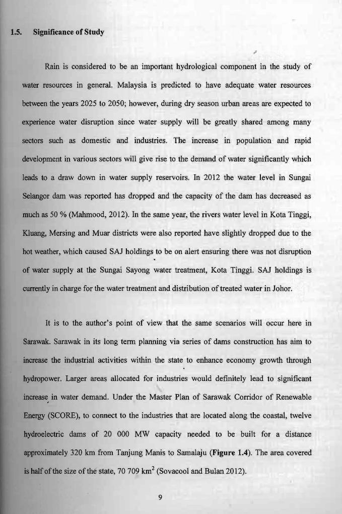
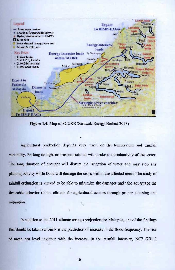


