Applications of monsoon research: Opportunities to inform decisionmaking and reduce regional vulnerability Andrea J. Ray 1 , Gregg M. Garfin 2 , Margaret Wilder 3 , Marcela Vásquez-León 4 , Melanie Lenart 2 , and Andrew C. Comrie 5 1 NOAA Earth Systems Research Laboratory, Physical Sciences, Boulder, CO; all others at University of Arizona, Tucson, AZ: 2 Climate Assessment for the Southwest and Institute for the Study of Planet Earth, 3 Center for Latin American Studies, 4 Bureau of Applied Research in Anthropology, 5 Department of Geography and Regional Development Submitted to Journal of Climate Special Issue on NAME Corresponding author address: Dr. Andrea J. Ray NOAA ESRL/PSD1 325 Broadway, Boulder, CO 80305-3328 Email: [email protected]Phone: 303-497-6434 Fax: 303-497-6449
Transcript
Applications of monsoon research: Opportunities to inform decisionmaking and reduce regional vulnerability
Andrea J. Ray1, Gregg M. Garfin2, Margaret Wilder3, Marcela Vásquez-León4, Melanie Lenart2, and Andrew C. Comrie5
1 NOAA Earth Systems Research Laboratory, Physical Sciences, Boulder, CO; all others at University of Arizona, Tucson, AZ: 2Climate Assessment for the Southwest and Institute for the
Study of Planet Earth, 3Center for Latin American Studies, 4Bureau of Applied Research in Anthropology, 5Department of Geography and Regional Development
Submitted to Journal of Climate Special Issue on NAME
Corresponding author address:Dr. Andrea J. Ray
NOAA ESRL/PSD1325 Broadway, Boulder, CO 80305-3328
This article presents ongoing efforts to understand interactions between the North American
Monsoon and society, in order to develop applications for monsoon research in a highly
complex, multicultural and binational region. The North American Monsoon is an annual
precipitation regime that begins in early June in Mexico and progresses northward to the
southwestern United States. The region includes stakeholders in large urban complexes,
productive agricultural areas, and sparsely populated arid and semi-arid ecosystems. The
political, cultural, and socioeconomic divisions between the U.S. and Mexico create a broad
range of sensitivities to climate variability as well as capacities to use forecasts and other
information to cope with climate.
We highlight methodologies to link climate science with society and analyze opportunities
for monsoon science to benefit society in four sectors: natural hazards management, agriculture,
public health, and water management. We synthesize a list of stakeholder needs and a calendar
of decisions to help scientists link user needs to potential forecasts and products. To ensure
usability of forecasts and other research products, we recommend iterative scientist-stakeholder
interactions, through integrated assessments. These knowledge-exchange interactions can
improve the capacity for stakeholders to use forecasts thoughtfully and inform the development
of research, and for the research community to obtain feedback on climate-related products and
receive insights to guide research direction. We expect that integrated assessments can capitalize
on the opportunities for monsoon science to inform decisionmaking, in the best instances, reduce
regional climate vulnerabilities and enhance regional sustainability
2
1. Introduction
The goal of the multinational, multi-year North American Monsoon Experiment (NAME)
program is to improve understanding of monsoon dynamics to improve prediction skill (NAME,
2004). A larger goal for monsoon research is to enhance society’s ability to cope with climate
variability and therefore reduce its vulnerability by providing monsoon information and
predictions. Lemos and Morehouse (2005) recently described models to facilitate the “co-
production of knowledge,” i.e., the development of usable information and the identification of
meaningful responses to climate variability and change. They find that addressing vulnerability
to climate requires a balance between research to understand complex science problems and
research on what stakeholders perceive as necessary for making decisions. Furthermore,
interactions between scientists and stakeholders are necessary to achieve “fit” between
stakeholders’ needs and science products, and these interactions are most successful in the
context of integrated assessments (Lemos and Morehouse, 2005). This article reviews recent
work in the monsoon region to synthesize knowledge on vulnerability for specific sectors in the
region, and identify opportunities for scientist-stakeholder interactions that might inform
decisionmaking and reduce vulnerability in the region.
The North American Monsoon (hereafter, “the monsoon”) is the major source of warm-
season precipitation across the U.S. Southwest and Northern Mexico, contributing more than
50% of the annual precipitation in some areas (Sheppard et al. 2002). The monsoon typically
begins in southern Mexico in early June and progresses northward to the southwestern U.S. by
early July (Adams and Comrie 1997; Higgins et al. 1999). The region’s climate is highly
variable: in northern Sonora over the past decade, climate variability has included seven to eight
years of drought, intense rains in 1994-1995, and freezing temperatures in 1996 (Browning-
Aiken et al. 2005).
Over the past decade, significant advances in the observation and understanding of the
monsoon system have contributed to the potential to predict monsoon parameters, including: the
timing of onset and retreat; total precipitation during the season; intra-seasonal and intra-annual
features, such as moisture surges, bursts and breaks; and the consequent hydroclimatology of the
3
region (Barlow et al. 1998; Magaña et al. 1999; Gutzler 2000; Higgins and Shi, 2000; Castro et
al. 2001; Hawkins et al. 2002; Douglas and Leal, 2003; Li et al. 2004; ).
In recent years, federal science programs have focused on improving the connection between
science and society by making science more relevant and usable to decisionmakers (NRC 2001;
Jacobs et al. 2005a). However, decades of research have shown that the effective delivery of
climate information to stakeholders is less straightforward than simply making information
available (Changnon et al. 1988; Stern and Easterling 1999; Hartmann et al. 2002a,b; Greenfield
and Fisher 2003; Gamble et al. 2003; Rayner et al. 2005). Stakeholders – including organizations
and individuals who own or manage land, manage or use water, contribute to the economy, or
live in the region (Bales et al. 2004) -- require climate information tailored to their specific
decisionmaking contexts, for example, suit the timing and spatial scale of management decisions,
and in language understood by information users (Chagnon et al. 1988; Ray 2004; Lemos and
Morehouse 2005; Jacobs et al. 2005a). These contexts encompass institutional, socioeconomic,
and political settings with a range of sensitivities, vulnerabilities, and capacities to respond to
climate and forecasts. Growing population and rising water use increase vulnerability in both the
U.S. (Liverman and Merideth 2002) and northern Mexico (Magaña and Conde 2000).
Fortunately, efforts to apply monsoon research for decisionmaking are beginning just as
integrated assessment projects and methodologies are bearing fruit. Integrated assessments are
interdisciplinary efforts to produce usable science through participatory stakeholder processes
and research-applications partnerships that bring together researchers, managers, policy makers
and others. These efforts, such as the Climate Assessment for the Southwest (CLIMAS) at the
University of Arizona (Liverman and Merideth 2002) have shown that stakeholders require
information at appropriate scales (Gamble et al. 2003), that forecast products often do not match
stakeholders' interests (Bales et al. 2004), and that scientists’ questions may not be aligned with
those of stakeholders (Lemos and Morehouse 2005).
This article discusses current efforts to understand the interaction of climate and society in
order to develop applications for monsoon research. Because many stakeholders are sensitive to
an interlocking set of climate phenomena including winter precipitation, ENSO impacts, and
4
climate change, we draw on insights about climate vulnerability across time scales. After
summarizing the state of monsoon forecasting, we present methodologies to study vulnerability
and to develop usable climate science. We next introduce the monsoon region and its
socioeconomic and institutional characteristics, because these contexts for vulnerability are
critical to an understanding of climate and society interactions. The fourth section highlights four
principal stakeholder communities: natural hazards management, public health, agriculture, and
water management. Based on these studies, we synthesize a list of information needs associated
with the North American Monsoon. To ensure that products are usable by stakeholders, we
recommend that monsoon researchers interested in developing usable research and products
should participate in integrated assessment activities in the region, including capacity-building
efforts such as a Monsoon Outlook.
2. State of monsoon forecasting
Currently, monsoon-related forecasts include the official NOAA/NWS monthly and seasonal
U.S. precipitation forecasts issued by the Climate Prediction Center (CPC). These forecasts are
issued mid-month, and an updated monthly forecast is issued on the last day of the month.1 The
Mexican Servicio Meteorológico Nacional (National Meteorological Service, SMN) issues
analogous seasonal precipitation forecasts.2 Although some experimental forecasts and monsoon-
related information are available, primarily on research or experimental webpages, no
operational3 forecasts of key seasonal features of the monsoon currently exist (e.g. onset, overall
strength, duration). Forecasts of a number of monsoon-related parameters exist primarily at
short-term (weather) time scales and with only a few days lead time. Leading up to and during
the monsoon, NWS Weather Forecast Offices (WFOs) and some commercial meteorological
services make short-term weather forecasts of monsoon-related parameters and may provide
related information. The Predictive Services Group of the National Interagency Coordination
1 http://www.cpc.ncep.noaa.gov/products/forecasts/month_to_season_outlooks.shtml2 http://smn.cna.gob.mx/SMN.html3 Operational is a specific NWS term referring to, “products and data that have been fully tested and evaluated that are produced on a regular and ongoing basis,” http://www.cpc.ncep.noaa.gov/products/outreach/glossary.shtml.
5
Center (NIFC) makes monsoon-related weather forecasts as part of assessing fire potential before
and during the fire season. A webpage maintained by the NWS/WFO Tucson tracks precipitation
totals and other variables for several sites in southern Arizona, with data comparing the current
year to previous years, start dates, and educational material on the monsoon.4
A major goal of the NAME program is to improve the simulation of monsoon variability in
coupled (ocean-land-atmosphere) climate models in order to predict features of the monsoon
months to seasons in advance (Higgins et al. 2006). The NAME Model Assessment Project
(NAMAP) analysis found current models can simulate the basic evolution of a summer
precipitation maximum near the core monsoon region, but there are important differences in the
monthly evolution and diurnal cycle of precipitation generated by the models compared to
observations (Gutzler et al. 2005). Several metrics have been identified to quantify model
simulation quality and improvement focused on monsoon onset and the diurnal cycle of
precipitation, surface air temperature and fluxes, low-level winds, and moisture transport.
3. Methodologies
The assessment of social vulnerability has become a widely accepted theoretical and
methodological framework for analyzing climate-society interactions. Vulnerability is a dynamic
social indicator linking human society, natural ecosystems, and socioeconomic and political
structures. Kelly and Adger (2000) define vulnerability as “the ability or inability of individuals
and social groups to respond to, in the sense of cope with, recover from or adapt to, any external
stress placed on their livelihoods and well-being.” Vulnerability assessment is not simply a
measure of exposure to hazards, but a broader assessment encompassing human-environment
systems and factors both within and outside those systems that affect their vulnerability (Turner
et al. 2003), including exposure to events, capacity to respond, and resilience (Bohle et al. 1994).
An assessment also identifies which stakeholder groups are especially susceptible or sensitive to
climatic conditions, degrees of sensitivity among different socioeconomic groups, and the causes
of that sensitivity (Vásquez-León et al. 2002; Ribot 1996). A less vulnerable community or
creating usable products by engaging early on with the stakeholders identified by integrated
assessments in the region, and by using findings of scientist-stakeholder interactions to inform
research planning and product development (feedbacks in Figure 1). Farmers’ interests in 5-year
outlooks of precipitation may be unrealistic, but interactions can also help stakeholders
understand what improvements scientists can realistically deliver in the near future or within
several years. Stakeholders can then thoughtfully inform research planning and product
development.
At this time, there is no product that brings together information on the monsoon. Existing
monsoon information is scattered across a variety of government, university, and research
institution web sites across the U.S. and Mexico. Information is not consistent or coordinated
across sources and temporal scales. While a centralized access point on the web would improve
accessibility of information, many stakeholders do not have internet access, and a webpage alone
is not enough to build capacity to use information.
We recommend the creation of a regularly issued product focused on the monsoon, a bi-
national Monsoon Outlook. Such a product would draw successful models such as the CLIMAS
Outlook, the U.S. Drought Monitor (Svoboda et al. 2002), the North American Drought Monitor
(Lawrimore 2002), and the web-based “Monsoon On-Line” product that tracks the Asian
monsoon by indices and regions, compares values with averages, and provides station data and
forecasts.6 Even in before a monsoon forecast is available, a monsoon product could provide
monitoring of current climate conditions, background material on monsoon variability and
dynamics, and summary articles on recent research, written for non-experts. Articles on how the
monsoon influences drought and fire risk, for example, will help improve stakeholders’
understanding of climate influences on their activities. The product should take advantage of
improved understanding of how to improve communication of climate information, e.g., the need
to avoid technical jargon, include simple or easily accessible ancillary information such as a
legend, definitions of terms, or units (e.g., mm. or in.), and to explain of probabilistic
information (e.g., Hartmann et al. 2002b).
6 http://www.tropmet.res.in/~kolli/MOL/
28
This product should be a joint effort of U.S. and Mexican climate-services organizations.
Ideally, several issues should be published through the season, in English and Spanish. The first
issue should be in early spring, when stakeholders’ interest begins and some have planning and
operational issues that require information on the potential strength and duration of the monsoon.
Several updates should be released as onset approaches and throughout the season. A web-based
product can also be available as a printable document, with provisions for dissemination to those
without web access. A Monsoon Outlook could be disseminated as a stand-alone product, and
also through user-oriented experiments other experimental climate services efforts. Many
stakeholder organizations have their own newsletters or professional publications including the
fire community, ranchers and farming publications, and state extension products that could ingest
and disseminate this value-added monsoon information to a larger audience.
7. Conclusions
The monsoon region as a binational, multilingual, and multicultural region poses challenges
for the development of monsoon science applications and for climate products and services.
This article has described integrated sector-based assessments and user-oriented experiments in
the contexts of natural hazards, agriculture and ranching, public health, and water management.
Underlying our analysis is an integrated definition of “region” that recognizes the
interdependencies of climate, ecosystems, and human communities on both sides of the
binational border, while acknowledging the socioeconomic, linguistic, cultural and institutional
distinctions that also are a reality. Across a range of stakeholders, there is potential for monsoon
and climate information to contribute to the reduction of vulnerability in the region by providing
specific information that decisionmakers can act on, or by raising awareness of risks in order to
improve preparedness. We have identified a list of products (Table 1) and a calendar of timing
of monsoon information needs (Figure 3), that provide starting points for developing usable
monsoon science. Although there are no climate-scale operational monsoon forecasts, many
users are interested in near–real-time monitoring, easy access to historical observations, and
outlooks of individual monsoon parameters. We recommend creating a binational Monsoon
29
Outlook to enhance the capacity to use forecasts when they are available, and to maintain
ongoing communication between scientists and stakeholders.
To realize the potential for monsoon research to benefit society, usable, stakeholder-
focused products must be developed. The monsoon research and forecasting community can
substantially increase the likelihood that products will be usable by collaborating with integrated
assessment activities to co-produce knowledge about the monsoon. Through a process of
interactions, stakeholders can thoughtfully inform the scientific questions to be investigated by
NAME and the operational products to be issued by the NWS, SMN, and other climate service
providers. These efforts should capitalize on the opportunities for monsoon science to inform
decisionmaking, and, in the best instances, reduce regional climate vulnerabilities and enhance
regional sustainability.
Acknowledgements: The authors appreciate the constructive comments of David Gochis and two
anonymous reviewers, and also thank Ben Crawford of CLIMAS for creating Figure 1 and Alex
McCord of CLIMAS for his helpful insight. Funding to support this research has come from the
NOAA Office of Global Programs, the NOAA Office of Oceanic and Atmospheric Research,
and the Morris K. Udall Foundation.
30
References
Adams, D. K. and A. Comrie, 1997: The North American Monsoon. Bull. Amer. Meteor. Soc., 78, 2197-2213.
Arizona Division of Emergency Management, 1997: Arizona National Guard Annual Report 1997. Appendix F: Arizona Division of Emergency Management. 14pp. [Available at: http://www.az.ngb.army.mil/AnnualReport97/annual%20report%20F.htm].
_______, 2004. Arizona Department of Emergency and Military Affairs, Annual Report 2004. 14pp. [Available at: http://www.azdema.gov/AnnualRptFY042.pdf].
Austin, D., S. Gerlack, and C. Smith, 2000: Building partnerships with Native Americans in climate-related research and outreach. Univ. of Arizona Institute for the Study of Planet Earth, Tucson. 35pp. CLIMAS Report #CL2-00. [Available at: http://www.ispe.arizona.edu/climas/pubs].
Bales, R. C., D. M. Liverman, and B. J. Morehouse, 2004: Integrated assessment as a step toward reducing climate vulnerability in the southwestern United States. Bull. Amer. Meteor. Soc., 85, 1727–1734.
Barlow, M., S. Nigam, and E. H. Berbery, 1998: Evolution of the North American Monsoon System. J. Climate, 11, 2238–2257.
Benequista N., and J.S. James, 1999: Pilot stakeholder assessment report. Univ. of Arizona Institute for the Study of Planet Earth. [Available at: http://www.ispe.arizona.edu/climas/pubs].
Bohle, H. G., T. E. Downing, and M. J. Watts, 1994: Climate change and social vulnerability: toward a sociology and geography of food insecurity. Global Env.Change, 4, 37–48.
Brown, T.J., G.Garfin, T. Wordell, R. Ochoa and B. Morehouse, 2004: Climate, fuels, fire and decisions: The making of monthly and seasonal wildland fire outlooks. Proc. of the AMS 14th
Conference on Applied Climatology, 8 pp.
Brandt, R.R., A.C. Comrie and S.R. Yool, 2005: The North American Monsoon System and wildfire frequency in southeastern Arizona. To be submitted.
Carter, R.H., and B. J. Morehouse, 2003: Climate and urban water providers in Arizona: An analysis of vulnerability perceptions and climate information. Univ. of Arizona Institute for the Study of Planet Earth, Tucson. 42pp. CLIMAS Report #CL1-03. [Available at: http://www.ispe.arizona.edu/climas/pubs.html].
Castro, C. L., T. B. McKee, and R. A. Pielke, Sr., 2001: The relationship of the North American Monsoon to tropical and North Pacific sea surface temperatures as revealed by observational analyses. J. Climate, 14, 4449–4473.
Cavazos, T., A. C. Comrie, and D. M. Liverman, 2002: Intraseasonal variability associated with wet
31
monsoons in southeast Arizona. J. Climate, 15, 2477–2490.
Changnon, S. A., S. T. Sonka, and S. Hofing, 1988: Assessing climate information use in agribusiness. Part I: Actual and potential use and impediments to usage. J. Climate, 1, 757-765.
Crimmins, M., 2005: Arizona Cooperative Extension Climate Specialist, personal communication to Gregg Garfin.
Crimmins, M. A. and A. C. Comrie, 2004: Interactions between antecedent climate and wildland fire variability across south-eastern Arizona. Int. J. Wildland Fire, 13: 455-466
Comrie, A. C., 2003: Climate doesn't stop at the border: U.S.-Mexico climatic regions and causes of variability. Impacts of climatic variations on water resources: A focus on borders in the Americas, H. F. Diaz and B. J. Morehouse, Eds. Kluwer, 291-316.
Comrie, A. C., 2005: Climate factors influencing Coccidioidomycosis seasonality and outbreaks. Env. Health Perspectives, 113, 688-692.
Diem, J. E. and A. C. Comrie, 2001: Air quality, climate, and policy: A case study of ozone pollution in Tucson, Arizona. Professional Geographer, 53, 469-491.
Douglas, M. W. and J. Carlos Leal, 2003: Summertime surges over the Gulf of California: Aspects of their climatology, mean structure, and evolution from radiosonde, NCEP reanalysis, and rainfall data. Wea. and Forecasting, 18, 55–74.
Eakin, H. and J. Conley, 2002: Climate variablity and the vulnerability of ranching in southeastern Arizona: A pilot study. Climate Research, 21, 271-282.
Finan, T., and C. West (eds.), 2000: An Assessment of Climate Vulnerability in the Middle San Pedro River. University of Arizona Institute for the Study of Planet Earth, Tucson, Arizona. 112 pp. CLIMAS Report #CL3-00 [Available at http://www.ispe.arizona.edu/climas/pubs.html]
Federal Emergency Management Agency, 2002: National Situation Update: Thursday, July 18, 2002. [Available at: http://www.fema.gov/emanagers/2002/nat071802.shtm]
Gamble, J. L., J. Furlow, A. K. Snover, A. F. Hamlet, B. J. Morehouse, H. Hartmann, and T. Pagano, 2003: Assessing the impact of climate variability and change on regional water resources: The implications for stakeholders. Water: science, policy, and management, R. Lawford, D. Fort, H. C. Hartmann, and S. Eden, Eds. Amer. Geophys. Union, 341-368.
Garfin, G.M., and B.J. Morehouse, 2001: Facilitating use of climate information for wildfire decision-making in the U.S. Southwest. AMS 4th Symposium on Fire and Forest Meteorology, Reno, NV, 8 pp.
Garfin, G. M. and B. J. Morehouse, 2003: Climate information and water resource management: Two initiatives in the Southwest. AMS 83rd Annual Meeting Symposium on Impacts of Water Variability: Benefits and Challenges, Long Beach, CA, 5pp.
32
_______, Wordell, T., Brown, T. J., Ochoa, R., and Morehouse, B. M., 2003. National Seasonal Assessment Workshop: Mesa, Arizona, February 25-28, 2003. Final Report. Tucson: ISPE, 24 pp. [Available at: http://www.ispe.arizona.edu/climas/pubs.html].
______, Wordell, T., Brown, T. J., Ochoa, R., and Morehouse, B. M., 2003. The 2003 National Seasonal Assessment Workshop: A Proactive Approach To Preseason Fire Danger Assessment. AMS 5th Symposium on Fire and Forest Meteorology, Orlando, FL, 7 pp.
______, Brown, T. J., R.Ochoa, and H. Hockenberry, 2004. National Seasonal Assessment Workshop: Eastern and Southern States, Shepherdstown, West Virginia, January 27-29, 2004. Final Report. Institute for the Study of Planet Earth, Tucson, 19 pp. [Available at: http://www.ispe.arizona.edu/climas/pubs.html].
Glantz, M.H. (ed.), 1995. Usable Science II: The Potential Use and Misuse of ENSO Information in North America. Proc. of a conference held 31 October-3 November, 1994 at National Center for Atmospheric Research. Boulder, CO: NCAR.
Greenfield, R.S., and G.M. Fisher, 2003: Improving responses to climate predictions: an introduction. Bull. Amer. Meteor. Soc., 84, 1685.
Gochis, D. J., L. Brito-Castillo, and W. J. Shuttleworth, 2006: Hydroclimatology of the North American Monsoon region in northwest Mexico. J. Hydrology, 316. 53-70.
Gutzler, D. S., H.-K. Kim, R. W. Higgins, H.-M. H. Juang, M. Kanamitsu, K. Mitchell, K. Mo, P. Pegion, E. Ritchie, J.-K. Schemm, S. Schubert, Y. Song and R. Yang. 2005: The North American Monsoon Model Assessment Project: Integrating numerical modeling into a field-based process study. Bull. Amer. Meteor. Soc: 86, 1423–1429.
_____, 2000: Covariability of spring snowpack and summer rainfall across the southwest United States. J. Climate, 13, 4018–4027.
Hackos, J. T. and J. C. Redish, 1998. User and task analysis for interface design. John Wiley & Sons, 488 pp.
Hall, B.L., and T.J. Brown, 2003: A comparison of precipitation and drought indices related to fire activity in the U.S. Proc. AMS 5th Symposium on Fire and Forest Meteorology , 6 pp.
Hartmann, H. C., T. C. Pagano, S. Sorooshian, and R. Bales, 2002a: Confidence builders: Evaluating seasonal climate forecasts from user perspectives. Bull. Amer. Meteor. Soc., 83, 683-698.
______, R. Bales, and S. Sorooshian, 2002b: Weather, climate, and hydrologic forecasting for the US Southwest: a survey. Climate Research, 21, 239-258.
Hawkins, T. W., A. W. Ellis, D. Reigle, J. Skindlov. 2002: Intra-annual analysis of the North American snow cover-monsoon teleconnection: Seasonal forecasting utility, J. Climate, 15, 1743-1753.
33
Higgins, R. W. et al. 2006: The NAME 2004 field campaign and modeling strategy. Bull. Amer. Meteor. Soc.: 87, 79–94.
_______, Y. Chen, and A. V. Douglas, 1999: Interannual variability of the North American warm season precipitation regime. J. Climate, 12, 653-680.
_______, and W. Shi. 2000. Dominant factors responsible for interannual variability of the summer monsoon in the southwestern United States. J. Climate, 13, 759-776.
Hoeck, P. A. E., F. B. Ramberg, S. A. Merrill, C. Moll, and H. H. Hagedorn, 2003: Population and parity levels of Aedes aegypti collected in Tucson. J. Vector Ecology, 28: 65-73.
Instituto Nacional de Estadistica, Geografia e Informatica (INEGI) 2000: XII Censo de Poblacion y Vivienda. Aguascalientes, Ags. INEGI, Hermosillo.
Jacobs, K. G.M. Garfin, M.L. Lenart, 2005a: Walking the talk: connecting science with decisionmaking. Environment, 47, 6-21.
_____, G. M. Garfin, and B. J. Morehouse, 2005b: Climate science and drought planning: the Arizona experience. J. Amer. Wat. Res. Assn, 41: 437-445.
Jain, S., J. K. Eischeid, D. J. Topping, T. S. Melis, and R.S. Pulwarty, 2006: The impact of eastern North Pacific tropical storms on the interannual variability of warm season hydroclimate in the Southwest United States. In review.
Jagtap, S.S., J.W. Jones, P. Hildebrand, D. Letson, J.J. O’Brien, G.P. Podestá, D.F. Zierden, and F. Zazueta, 2002. Responding to stakeholders’ demands for climate information: from research to applications in Florida. Agricultural Systems 74, 415-430
Kelly, P.M. and W.N.Adger, 2000. Theory and practice in assessing vulnerability to climate change and facilitating adaptation,” Climatic Change 47, 325-352.
Lawrimore, J., R. R. Heim, M. Svoboda, V. Swail, and P. J. Englehart, 2002: Beginning a new era of drought monitoring across North America. Bull. Amer. Meteor. Soc., 83: 1191-1192.
Lemos, M. C. and B. J. Morehouse, 2005: The Co-production of science and policy in integrated climate assessments. Global Env. Change, 15, 57-68.
Lenart, M., T. Brown, R. Ochoa, H. Hockenberry, and G. Garfin, 2005. National Seasonal Assessment Workshop, Western States & Alaska, Final Report, March 28-April 1, 2005. University of Arizona Climate Assessment for the Southwest. 29 pp. [Available at http://www.ispe.arizona.edu/climas/pubs.html].
Liverman, D. M., R. Varady, O. Chavez, and R. Sanchez. 1999. Environmental issues along the U.S.-Mexico border - drivers of changes and the response of citizens and institutions. Ann. Rev. Energy and Env., 24, 603-643.
34
______, and R. Merideth, 2002: Climate and society in the Southwest U.S, Clim. Res., 21: 199-218.
Luers, A., D.B. Lobell, L.S. Sklar, C.L. Addams, P.A. Matson. 2003. A method for quantifying vulnerability, applied to the agricultural system of the Yaqui Valley, Mexico. Global Env. Change ,13, 255-267.
Magaña, V., and C. Conde, 2000: Climate and Freshwater Resources in Northern Mexico: Sonora: A Case Study. Env. Monit. and Assessment, 60, 167-185.
_____, J.A. Amador and S. Medina, 1999: The midsummer drought over Mexico and Central America. J. Climate: 12, 1577–1588.
Marra, R., 2002: Hydrologist, Tucson Water. Personal communication to Gregg Garfin.
Maxwell, C., 2005: Southwest Predictive Services internal communication to fire management community. Personal communication to Melanie Lenart.
McCord, A., 2005: ADEM [retired] Hazards Assessment Specialist, personal communication to Gregg Garfin.
Meyer, M.C., 1996: Water in the Hispanic Southwest: A social and legal history, 1550-1850. University of Arizona Press, 189 pp.
Miles, E. L., A. K. Snover, A. F. Hamlet, B. M. Callahan, and D. L. Fluharty, 2000: Pacific Northwest Regional Assessment: the impacts of climate variability and climate change on the water resources of the Columbia River basin. J. Amer. Wat. Res. Assn, 36, 399-420.
Mohrle, C. R., 2003. The Southwest Monsoon and the relation to rire occurrence. M.S. thesis, University of Nevada (Reno) Department of Atmospheric Sciences, 97pp.
______, B.L. Hall, and T.J. Brown, 2003: The southwest monsoon and its impact on wildland fire. Proc. of the AMS Fifth Symposium on Fire and Forest Meteorology, 8 pp.
Morehouse, B. M., (ed.), 2000: The implications of La Niña and El Niño for fire management. Workshop Proc., February 23-24, 2000. Tucson: ISPE, 46 pp. [Available at website:http://www.ispe.arizona.edu/climas/pubs.html]
______, R. Carter, and T. Sprouse. 2000: The implications of sustained drought for transboundary water management in Nogales, Arizona and Nogales, Sonora. Nat. Res. Jour., 40, 783-817.
Nabhan, G.P., 1982. The desert smells like rain: a naturalist in Papago Indian country. North Point Press, 148 pp.
NAME Science Working Group, 2004. North American Monsoon Experiment (NAME) Science and Implementation Plan. May 2004, 92 pp. [Available at: http://www.cpc.ncep.noaa.gov/products/precip/monsoon/NAME.html]
35
National Research Council, 2001: A climate services vision: first steps towards the future. National Academy Press, 84 pp.
Pagano, T. C., H. C. Hartmann, and S. Sorooshian, 2001: Using climate forecasts for water management: Arizona and the 1997-1998 El Niño. J. Amer. Wat. Res. Assn., 37, 1139-1153.
Pulwarty, R. S. and K. T. Redmond, 1997: Climate and salmon restoration in the Columbia River Basin: the role and useability of seasonal forecasts. Bull. Am. Met. Soc, 78, 381-397.
Pulwarty, R. S. and T. S. Melis, 2001: Climate extremes and adaptive management on the Colorado River: lessons from the 1997-98 ENSO event. Jour of Env. Management, 63, 304-324.
Ray, A. J., 2004: Linking climate to multi-purpose reservoir management: Adaptive capacity and needs for climate information in the Gunnison Basin, Colorado. Ph.D. dissertation, Univ. of Colorado Dept of Geography, 328pp.
______, N. Schmidt, B. J. Morehouse, and R. S. Webb, 2003: Report on research opportunities for climate and society interactions in the North American Monsoon region. Workshop on Applications and Human Dimensions of Monsoon Research 18-20 June 2001. Tucson, AZ, Institute for the Study of Planet Earth, Univ. of Arizona, 42pp. [Available at: http://www.ispe.arizona.edu/climas/pubs.html]
Rayner, S., D. Lach, and H. Ingram, 2005: Weather forecasts are for wimps: Why water managers do not use climate forecasts. Climatic Change, 69, 197-227.
Reinbold, H.J., J.O. Roads, T.J. Brown, 2005: Evaluation of ECPC's fire danger forecasts with RAWS observations. Int. J. Wildland Fire, 14, 19-36.
Ribot, J. C., 1996: Climate variability, climate change and vulnerability: moving forward by looking back. In J. C. Ribot, A. R. Magalhaes, and S. S. Panagides (eds.), Climate variability, climate change and social vulnerability in the semi-arid tropics, 1–12. Cambridge Univ. Press.
Roads, J., J. Ritchie, F. Fujioka, and R. Burgan, 2005: Seasonal fire danger forecasts for the USA. Int. J. Wildland Fire, 13, 1-18.
Rogers, E. M., 1995: Diffusion of innovations. 4th ed. The Free Press, 519 pp.
Secretaría de Agricultura, Ganadería, Desarrollo Rural, Pesca y Alimentación (SAGARPA), 2003: Programa de desarrollo rural sustentable-DDR Magdalena: Carpeta basica de informacion 1997-1999, Sonora, Mexico.
Sheppard, P. R., A. C. Comrie, G. D. Packin, K. Angersbach, and M. K. Hughes, 2002: The climate of the U.S. Southwest. Climate Research, 21, 219-238.
Shipek, L., M. Wilder, and J. Kentnor, 2005a: Climate change beyond borders: A bilingual curriculum for the binational Santa Cruz watershed. Univ. of Arizona Press. 18 pp.
36
_____, Wilder, M., and J. Kentnor, 2005b: Drought beyond borders: A bilingual curriculum for the binational Santa Cruz watershed. Univ. of Arizona Press. 20 pp.
Sprouse, T.W. and L. F. Vaughn, 2003: Water resource management in response to El Niño-Southern Oscillation (ENSO) droughts and floods: The case of Ambos Nogales, In Climate, Water, and Transboundary Challenges in the Americas, H. Diaz and B. Morehouse (eds.), Kluwer Academic Publishers, 117-144.
Svoboda, M., D. LeComte, M. Hayes, R. Heim, K. Gleason, J. Angel, B. Rippey, R. Tinker, M. Palecki, D. Stooksbury, D. Miskus, and S. Stephens, 2002: The Drought Monitor. Bull. Amer. Meteor. Soc., 83, 1181-1190.
Stensrud, D. J., R. L. Gall, and M. K. Nordquist, 1997: Surges over the Gulf of California during the Mexican Monsoon. Mon. Wea. Rev., 125, 417-437.
Stern, P. C. and W. E. Easterling, Eds., 1999: Making Climate Forecasts Matter. National Academy Press, 175 pp.
Swetnam, T. W. and J. L. Betancourt, 1998: Mesoscale disturbance and ecological response to decadal climatic variability in the American southwest, J. Clim., 11, 3128-47.
Turner, B.L. II, R. E. Kasperson, P.A. Matson, J. J. McCarthy, R.W. Corell, L. Christensen, N. Eckley, J.X. Kasperson, A. Luers, M.L. Martello, C.Polsky, A.Pulsipher, and A. Schiller, 2003. A framework for vulnerability analysis in sustainability science. Proc. of the National Academy of Sciences, 100, 8074-8079.
U.S. Census 2000. (www.census.gov)
US Global Change Research Program. 2000: Climate change impacts on the United States: tthe potential consequences of climate variability and change: overview. Cambridge University Press, 158 pp.
U.S. Forest Service, 2003. Healthy forests initiative update for Arizona. [Available at: http://www.fs.fed.us/projects/hfi/docs/fact-sheet-arizona.pdf].
Varady, R., and B. Morehouse, 2003: Moving borders from the periphery to the center: river basins, political boundaries, and water management policy. Water: science, policy, and management, R. Lawford, D. Fort, H. Hartmann, and S. Eden, Eds, Amer. Geophys. Union, 143-160.
Vásquez-León, M. and A. Bracamonte 2005: Indicadores ambientales para la agricultura sustentable: un estudio del noreste de Sonora. Report for CONAHEC. El Colegio de Sonora, Sonora, Mexico and the Univ. of Arizona Bureau of Applied Research in Anthropology, Tucson.
______,and D. Liverman. 2004: The Political Ecology of Land-Use Change: The Case of Affluent Ranchers and Destitute Farmers in the Mexican Municipio of Alamos. Human Organization, 63, 21- 33.
37
_____, M., C. T. West, and T. J. Finan, 2003: A comparative assessment of climate vulnerability: agriculture and ranching on both sides of the U.S.-Mexico border. Global Env. Change, 13, 159-173.
_____, C. T. West, B. Wolf, J. Moody, and T. J. Finan. 2002: Vulnerability to climate variability in the farming sector. Institute for the Study of Planet Earth, University of Arizona, Tucson. 97 pp. CLIMAS Report #CL1. [Available at: http://www.ispe.arizona.edu/climas/pubs/CL1-02.html]
Western Governors Association, 2004: Creating a drought early warning system for the 21st century: the National Integrated Drought Information System (NIDIS), 16 pp. [Available at: http://www.westgov.org]
Westerling, A.L., A. Gershunov, T.J. Brown, D.R. Cayan, and M.D. Dettinger, 2003. Climate and wildfire in the western United States. Bull. Amer. Meteorol. Soc. 84, 595-604.
Wilder, M., 2006: Decentralization and urban water management in northern Mexico (in preparation).
_____, 2005. Water, power and social transformation: Neoliberal reforms in Mexico, VertigO: La revue électronique en sciences de l’environnement. 6, 1-5.
_____, 2002: In name only: Water policy, the state, and ejidatario producers in northern Mexico.Ph.D. dissertation, Dept. of Geography and Regional Development, Univ. of Arizona.
_____, and N. Pineda Pablos, 2006. River basin councils and climate science: Use toward Sustainability Planning in Northern Mexico (in preparation).
_____, and S. Whiteford, 2006: Flowing uphill towards money: Groundwater management and ejidal producers in a free trade era. The Changing Structure of Mexico: Political, Social and Economic Prospects, Laura Randall, ed., Armonk, New York: M.E. Sharpe. 568 pp.
Wise, E. K. and A. C. Comrie, 2005a: Meteorologically adjusted urban air quality trends in the Southwestern United States. Atmos. Env., 39, 2969-2980
______, and A. C. Comrie, 2005b: Extending the Kolmorgorov-Zurbenko filter: Application to ozone, particulate matter, and meteorological trends. J. Air Waste Mgmt. Assn., 55, 1208-1216.
Zhu, C., D. P. Lettenmaier, and T. Cavazos, 2005: Role of antecedent land surface conditions on monsoon rainfall variability. J. Clim, 18, 2824-2841.
Zinser, M., F. R. F., and E. Willott, 2004: Culex quinquefasciatus (Diptera: Culicidae) as a potential West Nile virus vector in Tucson, Arizona. J. Insect Science, 4, Article No 20.
38
Figure Captions
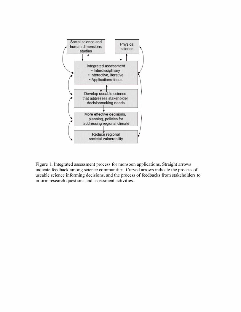
Figure 1. Integrated assessment process for monsoon applications. Straight arrows indicate feedback among science communities. Curved arrows indicate the process of useable science informing decisions, and the process of feedbacks from stakeholders to inform research questions and assessment activities.
Figure 2. The North American Monsoon region. Areas influenced by monsoon precipitation include the Mexican states of Sonora, Sinaloa, Durango, and Chihuahua, and the U.S. states of Arizona, New Mexico, Utah, and Colorado, as well as some surrounding areas. Major geographic features include the Sonoran Desert and portions of the Sierra Madre and the southern Rocky Mountains. Dark lines indicate the boundaries of NAME Tier I and Tier II regions; All of Tier III is not shown, it extends from 5° N to 50 N° and 125° W to 75° W
Figure 3. Annual decision calendar for monsoon applications. This calendar is a framework for assessment scientists to link user needs to potential uses of forecasts and information products. Shaded bars indicate the timing of information needs for planning and operational issues over the year.
Figure 1. Integrated assessment process for monsoon applications. Straight arrows indicate feedback among science communities. Curved arrows indicate the process of useable science informing decisions, and the process of feedbacks from stakeholders to inform research questions and assessment activities..
Figure 2. The North American Monsoon region. Areas influenced by monsoon precipitation include the Mexican states of Sonora, Sinaloa, Durango, and Chihuahua, and the U.S. states of Arizona, New Mexico, Utah, and Colorado, and some surrounding areas. Major geographic features include the Sonoran Desert and portions of the Sierra Madre and the southern Rocky Mountains. Dark lines indicate the boundaries of NAME Tier I and Tier II regions; All of Tier III is not shown, it extends from 5° N to 50 N° and 125° W to 75° W
Figure 3. Annual decision calendar for monsoon applications. This calendar is a framework for assessment scientists to link user needs to potential uses of forecasts and information products. Shaded bars indicate the timing of information needs for planning and operational issues over the year.
Table 1. Monsoon information needs of several stakeholder sectors, with variables and
potential uses in five categories: a seasonal outlook; monsoon onset; within-season
parameters; monsoon breaks, and demise or retreat.
Monsoon Feature/
Stakeholder group
Variables of interest Potential use
Seasonal outlook
Farmers Seasonal precipitation January-February for crop planning; or if a dry
conditions are anticipated, to find other work;
for allocation plans for user associations
Fire Managers Seasonal precipitation; weak/
strong monsoon, outlook for
early/late onset
In March-April and updated later for west-wide
planning and deployment of firefighting
resources to the highest risk areas
Reservoir managers Seasonal precipitation In February and updated to estimate reservoir
contents and agricultural water supply; to
estimate risk of flooding and assist in reservoir
decisions involving trade-offs between flood
control and water storage
Air quality managers Length and strength of season;
outlook for early/late onset
Weeks to months in advance to plan for
management and mitigation of ozone and PM
management, over the season
Monsoon onset
Fire Managers Relative humidity (RH);
probabilistic forecasts of dry
lightening strikes prior to onset;
improved ability to recognize
false-starts
Days to weeks in advance to anticipate peak
wildfire numbers, and potential decline in the
fire season; potential to redeploy those resources
to higher risk areas
Emergency fire
response
Precipitation; assessment of
whether there is a “false-start”
Dry lightening at the beginning of the monsoon
season starts many fires; false-starts are not
followed by rains which mitigate fire strength
Ranchers Precipitation anomalies
associated with early/late onset
Information necessary to plan for supplemental
feed if onset is expected to be late
Wildlife managers Precipitation anomalies
associated with late onset
Outlook for long lapses in precipitation, so they
can plan for emergency water hauling for
various habitats
Air Quality managers Mixing height and RH Days to weeks, for ozone and PM mitigation
Public Health officials Early onset prediction or
observation of wet pre-season
Days-weeks in advance to mitigate exposure to
dust associated with valley fever outbreak
Urban water managers Precipitation associated with
monsoon onset
Days to weeks in advance to plan for peak
seasonal water demand, which occurs just prior
to onset, and to plan conservation during drought
Within-season
parameters
Ranchers JAS precipitation; spatial extent
of precipitation
About a month in advance to anticipate forage
for cattle and plan for supplemental feed if dry
Fire managers and
responders
Parameters related to fire
ignition efficiency: cloudiness,
temperature, RH, wind
Days in advance: these parameters are related to
energy release and rate of fire spread, and risk
for a fire start to develop into a large fire
Emergency managers Precipitation intensity Day to a week in advance, for flash flood
response, especially if there is wide-spread
heavy precipitation requiring coordination of
resources across wide areas
Emergency Managers Forecasts of widespread and
intense storms; moisture surges
(wind, lightening, intense
precipitation)
Day to a week in advance, to allow pre-
positioning of flood response; planning and
recovery for wind damage, including power
outages (associated with wind and lightening)
Public health and
emergency response
Cloudiness (may be inversely
correlated with daytime
maximum temperatures)
Days to weeks in advance to anticipate heat
stress, which is correlated with substantial
numbers of heat related deaths each summer
Farmers Within season precipitation,
forecasts of early/late demise or
tropical storm precipitation
Days to weeks in advance for within season crop
planning. Late precipitation due to a late end or
tropical storms may impede crop harvest
Urban water managers Weather forecasts, especially
for high temperatures
A week in advance for planning water use and
groundwater pumping, because demand is higher
in high temperatures and repairs.
Irrigated farming Medium range precipitation and
monsoon-surge predictions;
forecasts of late monsoon end
or tropical storm precipitation
Days to two weeks in advance to schedule
irrigation deliveries. Water delivered but not
needed in wet periods may be wasted.
Anomalous late rain may impede crop harvest
Wildlife managers Timing of summer precipitation
or periods without precipitation
Week(s) in advance for planning and
implementation of habitat management for
endangered wildlife species
Monsoon breaks
Fire managers Breaks, storminess; probability
of dry lightening strikes;
consistency of precipitation
Within-season management of resources; breaks
of 8-10 days may lead to an increase in wildfires
Air Quality managers Mixing height and humidity
variables
Days in advance for ozone and PM mitigation
Monsoon
demise/retreat
Fire Managers Decrease in relative humidity
and lightening strikes; within-
season forecast of demise
Days to weeks in advance for planning for
proscribed burns after the monsoon season ends
Wildlife managers Precipitation deficit; early end
to the monsoon
Planning and implementation of habitat
management for endangered wildlife speciesFarming Forecasts of late monsoon
demise or tropical storm precipitation
Harvest planning: later than usual precipitation due to a late demise or tropical storms may impede the ability of farmers to harvest crops