15
£1.00 around Newcastleton

£1.00
around Newcastleton

2
Paths Around Newcastleton Paths Around Newcastleton
3
Route
Route 1
Route 2
Route 3
Route 4
Route 5
Route 6
Route 7
Route 8
Route 9
Distance
2miles/3km
2.5miles/4km
6 miles/10km
6 miles/10km
4 miles/6km
3 miles/5km
3 miles/5km
4.5miles/7km
11miles/18km
Location
River and Woodland
Ettleton
Blackburn Falls
Dykescroft & Castleton
Raltonside & Blackburn
The hanging Tree
Demainholm
Mangerton Tower
Across the Border
Page
8
10
12
14
16
18
20
22
24
Contents
Kielder

4
Paths Around Newcastleton Paths Around Newcastleton
5
IntroductionThis booklet includes 9 routes around the village of Newcastleton, which is 20 miles / 32km south of Hawick on the B6399. The village is only a few kilometres from the England – Scotland border.
The routes described are especially suitable for walkers and range from short strolls to strenuous rough hill climbs. Where stated multi-use is possible. Each route has a summary containing distance, estimated time to complete, start and finish points and an indication of the terrain to be expected. The route descriptions contain directions with wildlife and historical information. Further information is available from the Tourist Information Centres.
These routes were initially developed in partnership with the Liddesdale Heritage Association and local landowners as part of the European Funded Border Paths Partnership Project. They are now managed by Scottish Borders Council.
Newcastleton and the surrounding area
The village of Newcastleton or Copshaw Holm or simply ‘Copshie’ is a prime example of a planned village. It was established in 1793 to a plan by William Keir of Whithaugh for the 3rd Duke of Buccleuch as a settlement for handloom weavers. The streets are laid out on a grid pattern with plenty of open space and a main gathering area called Douglas Square. To the east, the streets run down to the Liddel Water. The new village was established on the site of a tower called Copshaw, but took its names from the older settlement Castleton (passed on Route 4).
The weaving enterprise was not particularly successful and the new inhabitants had to make their living in other ways. Each house in the village was given land (one acre for a single-storey, two acres for two storeys) and many villagers kept livestock and grew crops.
This area, Liddesdale, was plagued with wars between Scotland and England as illustrated by the troubled history of Hermitage Castle (located 6 miles to the north). There were also
countless skirmishes by the Border Reivers ensuing their violence, treachery, murder and raiding to those on both sides of the Border.
Today, the village is an attractive quiet settlement sitting in fine open countryside. The street pattern of Newcastleton has changed little and is still well preserved, as a walk around Newcastleton will show. The village has a variety of shops dotted along the main street, various holiday accommodation providers, and in Douglas Square, the Liddesdale Hotel and The Grapes Hotel. To the south of the village the Liddesdale Heritage Centre and Museum can be found. Information on Newcastleton can be found at www.visitnewcastleton.com
The countryside around Newcastleton features fantastic rolling moorland hills, woodlands, forests and follows the Liddel Water valley. It is home to some of Scotland’s best-loved wildlife, roe deer, brown and mountain hare, feral goat, otter, badger, hen harrier, red squirrel, and wild flowers are all in abundance. In addition there are many places to visit for geology and archaeology interests.
East of Newcastleton there is extensive forests, within easy striking distance, to Kielder Water and Forest Park, in Northumberland. Some of the routes in this booklet give access to Newcastleton Forest and onwards to Kielder. Further information on forest trails can be obtained from the Forestry Commission Scotland or through their website www.forestry.gov.uk/newcastleton
Access in ScotlandThe Land Reform (Scotland) Act 2003 and the Scottish Outdoor Access Code came into effect in February 2005. The Land Reform (Scotland) Act establishes a statutory right of responsible access to land and inland waters for outdoor recreation, crossing land, and some educational and commercial purposes. The Scottish Outdoor Access Code gives
Macdiarmid Monument
Know the Code before you go... Enjoy Scotland’s outdoors -
responsibly!Enjoy Scotland’s outdoors! Everyone has the right to be on most land and inland water for recreation, education and for going from place to place providing they act responsibly. These access rights and responsibilities are explained in the Scottish Outdoor Access Code. The key things are:
When you’re in the outdoors:● take personal responsibility for your own
actions and act safely;● respect people’s privacy and peace of mind;● help land managers and others to work safely
and effectively;● care for your environment and take your litter
home; ● keep your dog under proper control;● take extra care if you’re organising an event
or running a business.
When you’re managing the outdoors:● respect access rights;● act reasonably when asking people to avoid
land management operations;● work with your local authority and other bodies
to help integrate access and land management;● respect rights of way and customary access;
Find out more by visiting www.outdooraccess-scotland.com or telephoning your local Scottish Natural Heritage office.
detailed guidance on your responsibilities when exercising access rights and if you are managing land and water. The Act sets out where and when access rights apply. The Code defines how access rights should be exercised responsibly.

6
Paths Around Newcastleton Paths Around Newcastleton
7
Health Warning! Germs from animals can cause serious human illness.Stay safe from diseases when out in the countryside by: a. Washing hands with soap & water
(or use wet wipes) after visiting the toilet, after activities, touching animals and before handling, cooking and eating food
b. Taking care to avoid spreading animal faeces on footwear
c. Avoiding camping or having a picnic on land which has recently been used for grazing animals
d. Not drinking untreated water from rivers, streams and lochs
e. Avoiding tick bites, cover legs when walking through long vegetation
Contact the Public Health Department for more information 01896 82 5560
Take great care when walking on country roads. • Pavements or paths should be used if
provided. • If there is no pavement or path, walk
on the right-hand side of the road so that you can see oncoming traffic. You should take extra care and be prepared to walk in single file, especially on narrow roads or in poor light. Keep close to the side of the road. It may be safer to cross the road well before a sharp right-hand bend (so that oncoming traffic has a better chance of seeing you). Cross back after the bend.
• Help other road users to see you. Wear or carry something light coloured, bright or fluorescent in poor daylight conditions.
General AdviceBefore setting off on longer walks, always check the weather forecast and prepare yourself accordingly. Remember that weather conditions can change rapidly and that hot weather, causing sunburn and/ or dehydration, can be just as debilitating as rain or snow. Always carry adequate cover for your body in all conditions.
On longer hill walks you should always wear or carry good waterproofs, proper walking boots, windproof clothing, and take food and drink with you. These provisions may not be necessary on the shorter, low level walks, but a light waterproof and refreshments are still worth taking, just in case. When out on the hills, a map and compass should be carried to aid navigation.
Toilet FacilitiesPublic toilets in Newcastleton are situated in Langholm Street, just off Douglas Square. Toilets are also available at the entrance to Newcastleton Forest at Dykescroft Car Park.
LivestockAll of the routes in this booklet pass through livestock farming areas. Please remember that the farmer’s livelihood may depend on the rearing and sale of livestock, and always act responsibly. Dogs can be a particular concern for farmers during lambing time (March – May) and when cows are calving (Spring & Autumn).
Dogs therefore should not be taken into fields where there are young livestock. This includes all young livestock such as lambs, calves and foals. In more open countryside where lambs are present, keep your dog on a short lead.
Disturbance at this time can separate young livestock from their mothers leaving them cold, hungry and exposed to predators.
Dogs should not be taken into fields of cattle when they have calves, as the cows see a dog as a threat and may attack it. Go into a neighbouring field or onto adjacent land.
During the bird breeding season (April – June) keep your dog under close control or on a short lead in ground nesting areas. Without a dog, if you walk quietly through livestock areas, keeping a safe distance from stock and watching them carefully, you should experience little or no difficulty. Please leave gates as you find them and ensure that if you have to open a gate, you close it securely behind you. Thank you for your cooperation, which will help to ensure that these walks are available for those who follow in your footsteps in future years.
Waymarking and MapsMany routes are way-marked, however an Ordnance Survey Landranger 1:50 000 or Explorer 1:25 000 maps should be used in conjunction with this booklet to help identify the hills and other points of interest.
Other RoutesThere are various routes promoted for different activities within the area. Information can be gained by visiting the relevant website or contacting Visit Scotland (contact details at rear of booklet)Newcastleton route information www.visitnewcastleton.comForestry Commission Trails www.forestry.gov.uk/newcastletonKielder Forest and Water Park routes www.visitkielder.com
Walk it is the Paths to Health Project in the Scottish Borders and aims to encourage people to take up walking as part of a healthier lifestyle. Our walks are usually short and easy though the routes can sometimes involve rough paths and low level gradients. You will find the Walk it logo on route 1. We have chosen this walk for its length and level gradient. For information telephone 01835 825060
Scottish Borders Festival of Walking
The Scottish Borders Festival of Walking, a week long celebration of walking and the countryside, was the first of its kind in Scotland and has been held annually since 1995. It usually takes place in September and the host town rotates to give a different choice of walks each year. Further details are available from Visit Scotland.
Forestry Ranger and Donald

8
Paths Around Newcastleton Paths Around Newcastleton
9
Pass through an iron gate and take the track to the left. In about 100 metres, enter the wood by a stile and a wooden bridge. There are lovely wild flowers in spring including bluebells, and the summer birds include woodpeckers.
Follow the path along the upper edge of the wood until just before a deep gully, a small path leads down to the left. This is a short cut back to the village. To continue the full walk, cross two
bridges and continue along the edge of the wood to the Bull Park, enclosed on the far side by a stone wall. Here the villagers used to keep a bull beside the common grazing land on Holm Hill.
The next bridge takes you over the mill lade which runs for 5km/3 miles down the hill from where it has been diverted from the Black Burn. There were two manmade ponds nearby, one used to supply water for the railway engines at the station, the other for the sawmill.
Climb the steps, cross two stiles and descend a steep bank to the Newcastleton-Langholm road. You can see the ruined sawmill on the left.
You can walk down the road back to the village, or turn right up the hill to Holmhill Cottages, originally built as an isolation hospital. It was built in 1906 because infectious diseases were rife at the time, but was relatively little used and closed in 1930. Cottage no 3 incorporates the hospital ’s former washhouse and mortuary.
Go through the gate just below the cottages and follow the lane, near the end of which a steep path will lead you down to the old railway line. Cross the stile, turn left and follow the route back to the village along the old line.
Liddlesdale Valley
Bluebells in the woodland
Route 1
River and Woodland
Distance: 3km/2 miles.Start and finish: Douglas Square, Newcastleton.Terrain: Generally good paths. Boots or strong shoes recommended.Toilets: At the start.Refreshments: In Newcastleton.
This shor t route explores the environs of Newcastleton itself and is attractive at all times of the year.
From the north end of Douglas Square, turn down to the Liddel Water and turn left along the riverside path, passing Whithaugh Pool, at one time a favourite bathing place. Among the birds you might see are dipper, pied wagtail, oystercatcher and heron. Across the river are the lands of Whithaugh, owned by the Armstrong family in the reiving days.
Swing left with the path past the Auction Mart, a busy place when livestock are being sold. After about 1km/0.6 mile, the path curves left, up to a kissing gate. At this point turn left to complete the short Walk it route or turn right for a few metres, then left (at the village sign) to cross the bridge over the former railway line. This was the famous Waverley Line from Edinburgh to Carlisle; Newcastleton Station opened on 1 March 1862 and for much of the ensuing century it was possible to travel directly to London from here. The line closed, very much against local wishes, in January 1969.

10
Paths Around Newcastleton Paths Around Newcastleton
11
Milnholm Cross
Continue with the track for about 800 metres. Near its end, turn right along a line of old beech trees, the remains of an ancient hedge. In about 100 metres, go left on a rough path down the bank. Cross the small burn and follow the fence up to the right. It will bring you to a stile leading into the newer part of Ettleton Cemetery.
Turn right through the gap in the wall to walk up through the older graveyard. There was once a church here, around 400 years ago, but there is now no trace of it or the settlement of Ettleton. What remains is a highly atmospheric place, worth spending a little time in. It commands a fine view across Liddesdale and is beautifully maintained.
Old tombstones bear such features as a miller’s trademark, and a tall obelisk records the unusual death of William Armstrong, a farmer at Sorbietrees. He was ‘shot without challenge or warning by Rev Joseph Smith, incumbent at Walton, Cumberland’ in April 1851, aged 37. It must have been a notable event at the time, and the obelisk was erected by ‘a numerous body of friends on both sides of the Border’.
In a railed enclosure there are fragments of very early medieval stones decorated with swords, shears and other symbols. Another large memorial commemorates members of the Black family, including Rev John Black, minister here for 50 years. He is described as ‘a man of genius who lived his life quietly among these hills’. Next to him is a tablet to his eldest son William, who was lost at sea off the coast of China in 1870, aged just 20. There are many other stones worthy of study.
When you are ready to leave, follow the narrow cemetery access road as it twists down the hill to meet the main road at Milnholm Cross, a medieval monument
believed to have been erected in 1320 to commemorate Alexander Armstrong, a prominent clansman who was murdered at Hermitage Castle. It is thought that the funeral party rested here before climbing the hill to Ettleton churchyard. The cross, which carries the clear initials AA, stands near the site of former buildings belonging to the farm of Milnholm, and looks across the river to the walls of Mangerton Mill.
Turn left along the main road and continue back towards the village. For the final section, you can if you wish go down the steps at the Holm Bridge and follow the riverbank path.
Ettleton Cemetery
Route 2
Ettleton
Distance: 4km/2.5 miles.Start and finish: Douglas Square, Newcastleton.Terrain: Generally good paths and minor roads. Boots or strong shoes recommended.Toilets: At the start.Refreshments: In Newcastleton.
From Douglas Square, head south along the main street. Just past the football pitch is a track on the right. Follow this track as it crosses the old railway line and bends to the left, uphill through the wood quaintly known as Boosie Plantation.
The track bends right again. Take the first track on the left, which runs across the slope and is quite rough in places. To left and right you can see the remains of fence and hedge lines delineating the pattern of small fields once worked by the villagers.
Liddel Holm Bridge

12
Paths Around Newcastleton Paths Around Newcastleton
13
N
From the north end of Douglas Square, follow the road down to the Liddel Water and turn left along the riverside path, passing Whithaugh Pool, at one time a favourite bathing place. Among the birds you might see are dipper, pied wagtail, oystercatcher and heron. Across the river are the lands of Whithaugh, owned by the Armstrong family in the reiving days.
Curve left with the path past the Auction Mart. After about 1km/0.6 mile, the path curves left, up to a kissing gate. Reach the road and turn right for a few metres, then left (at the village sign) to cross the bridge over the former railway line. Turn left and follow the rough track up the hill. This track skirts the northern side of Pathhead Moss.
Route 3
Blackburn Falls
Distance: 10km/6 miles.Start and finish: Douglas Square, Newcastleton.Terrain: Tracks, paths and rough ground. Boots or strong shoes recommended.Toilets: At the start.Refreshments: In Newcastleton.
Note: The moorland section of this route, leading over to the falls, is very exposed and sections are quite rough. It is therefore not recommended in poor weather conditions.
Go through a gate in the stone dyke and follow the telephone poles along the edge of the field to another gate. Go through this gate and up the next field to a third gate which brings you to the Blackburn Farm road. Turn right, walk down to the farm, go through the farm yard (taking care if there is any machinery moving about) and through a gate between the large barn and the farmhouse.
Walk down the track to the bridge over the Black Burn. Cross the bridge, and immediately turn left on a clear track close to the burn.
At a fork, keep left, close to the burn (there are sheep pens to the
right). Go through a gate and follow the grassy track across a
field, with the burn chuckling along on your left. Go
through another gate
and ahead on the very clear vehicle track, climbing steadily.
Pass through two gateways onto the open hill. The character of the landscape has changed markedly from the fields you have just left behind. Ahead are long swells of rough moorland, cut through by burns. The ground rises steadily to the heights of Cooms Fell and Watch Hill at over 500 metres. These are unfrequented, pathless hills.
As the track bends right and continues climbing, an expansive view across Liddesdale opens up to the right. At a fork go left, down to the attractive little Hog Gill, which is crossed at a ford. ‘Hog’ here is not a reference to pigs but (also spelled hogg) is a term for a yearling sheep before it is sheared.
The track curves right to a large double stone sheep stell. Leave the track just before the stell and head left on a faint path over the moor, aiming for a gateway in the next fenceline which will become clearer as you approach it.
Once through this gateway, you pick up a rough track which leads on and round to the right to another gateway. Go through and take the path that curves left.
In about 120 metres, as the path starts to descend, you will see the Blackburn Falls down to your right. It is difficult to approach them more closely, and
scrambling down the slope is only advised if you are totally confident of your footing - and of your ability to get back up again! The falls are attractive at any time but are naturally more impressive after heavy rain. Although the falls are at the confluence of Long Gill and Rough Gill, they are known locally as the Blackburn Falls.
The path continues down to the site of the former buildings at Annetshiel, probably a summer shieling in former times. However, there is no continuation of this path, and unless you particularly want to see the Annetshiel site, it is best to retrace your steps from the viewpoint above the falls. If you do go down to the Annetshiel site, look for the large ‘knocking stone’ once used to grind corn.
Once you regain the stone stell the going is easy, and mainly downhill, with good views across Liddesdale and the Black Burn for company most of the way back to the village and the end of the route.
Liddel Water
Track to Blackburn Falls
14
Paths Around Newcastleton Paths Around Newcastleton
15
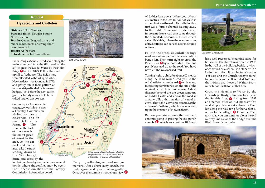
has a well-preserved ‘mounting stone’ for horsemen. The church was closed in 1952. In the wall of the building beside it, which once served as a school, is a stone with a Latin inscription. It can be translated as ‘For God and the Church, today is mine, tomorrow is yours’. It is dated 1621 and the initials are those of Walter Scott, minister of Castleton at that time.
Cross the Hermitage Water by the Hermitage Bridge, known locally as the Smiddy Brig, dating from 1792 and named after an old blacksmith’s workshop which once stood nearby. Keep left along the road for a further 2.5km to return to the village. From the Roan farm road you can continue along the old railway line as far as the bridge over the Black Burn if you prefer.
Route 4
Dykecrofts and Castleton
Distance: 10km/6 miles.Start and finish: Douglas Square, Newcastleton.Terrain: Generally good paths and minor roads. Boots or strong shoes recommended.Toilets: At the start.Refreshments: In Newcastleton.
From Douglas Square, head south along the main street and take the fifth road on the left, to cross the Liddel Water by the Holm Brige, built in 1823. Follow the road uphill to Yethouse. The fields here were allocated to the villagers when Newcastleton was founded in 1793, and partly retain their pattern of narrow strips divided by fences or hedges. Just before the next cattle grid, the turf dykes of an old farm called Jingles can be seen.
Continue past the former farm cottages, one of which is now a Forestry Commission v is i tor centre and classroom, and on past Dykecrof ts Farm. The wood at the back of the farm is the oldest piece of forest in the area. At the car park and picnic area, take the track leading down to t h e W h i t h a u g h Burn, and cross by the footbridge. Nearby on the left are several ponds where dragonflies may be seen. For further information see the Forestry Commission information board.
1/2 mile
1 kilometre
P
Old Schoolhouse
Carry on, following red and orange markers. After a short stony stretch, the track is green and open, climbing gently. Once over the summit a marvellous view
of Liddesdale opens before you. About 200 metres to the left, but out of view, is an ancient earthwork. Two distinctive turf walls form a channel leading away to the right. These used to define an important drove road as it came through the cultivated enclosures of the settlement called Belshiels, where the scant remains of two cottages can be seen near the clump of trees.
Follow the track downhill (orange markers - often wet in this area) until it bends left. Then turn right to cross the Piper Burn by a footbridge. Continue past Newstead up to the road. You have now left the waymarked trail.
Turning right, uphill, for about 600 metres along the road would lead you to the old Castleton churchyard with many interesting tombstones, on the site of the original parish church and manse. A short distance beyond are the green ramparts of Liddel Castle and across the road is a stone pillar, the remains of a market cross. This is the last visible remains of the village of Castleton, which was removed upon the creation of Newcastleton.
Retrace your steps down the road and continue along it, passing the old parish church which was built in 1808 and
Castleton Graveyard
Hermitage Castle

16
Paths Around Newcastleton Paths Around Newcastleton
17
Route 5
Raltonside and Blackburn
Distance: 6km/4 miles.Start and finish: Douglas Square, Newcastleton.Terrain: Generally good paths. Boots or strong shoes recommended.Toilets: At the start.Refreshments: In Newcastleton.
From the north end of Douglas Square, head down to the Liddel Water and turn left along the riverside path, passing Whithaugh Pool, at one time a favourite bathing place. Among the birds you might see are dipper, pied wagtail, oystercatcher and heron. Across the river are the lands of Whithaugh, owned by the Armstrong family in the reiving days.
Curve left with the path past the Auction Mart, a busy place when livestock are being sold. After about a kilometre, the path curves left, up to a kissing gate. Reach the road and turn right to cross the Black Burn. In a few more metres, come off the road to the left, turn right on the old railway line and continue along it for about 800 metres to the Roan farm road. There are beautiful banks of primroses alongside the old line in spring.
Turn left up the Roan farm road and then left again on a track near the Ralton Burn.
Pass Raltonside Cottage and continue on the track close to the burn on to the open hill, where the track divides. Take the left fork which will lead you across the hill, from where you have a fine view over the valley, through a gate and across a large field towards Woolhope.
Locally pronounced more like ‘Oolock’ and recorded as such as far back as 1376, Woolhope was formerly a separate small farm but the building is now abandoned.
Through the gate in the field corner, go down the slope on a rough track to join a better track which leads across a bridge and uphill again to Blackburn Farm. The medieval farm “Blackburnsyd” lay next to the burn and you pass the site of it after crossing the bridge.
Heron
Pass through the farmyard, taking care if there is any machinery moving about, and follow the access road over a bridge. Go through the second gate on the left beyond the bridge and follow the track down through the field. It leads through another gate and up the side of the next field beside the telephone poles.
Go through another gate on to the Pathhead Moss. Take the track which skirts the northern edge of the Moss and leads down towards the village. Where the track bends left, go right to enter the wood by a stile and footbridge. Follow the path along the upper edge of the wood until just before a deep gully, a small path leads down to the left. This is a short cut back to the village. To continue the full walk, cross two bridges and continue along the edge of the wood to the Bull Park, enclosed on the far side by a stone wall. Here the villagers used to keep a bull beside the common grazing land on Holm Hill.
The next bridge takes you over the mill lade which runs for 5km/3 miles down the hill from where it has been diverted
from the Black Burn. There were two manmade ponds nearby, one to supply water for the railway engines at the station, the other for the sawmill.
Climb the steps, and descend a steep bank to the Newcastleton-Langholm road. You can see the ruined sawmill on the left. Turn left and return to the village and the end of the route.
Douglas Square, Newcastleton
18
Paths Around Newcastleton Paths Around Newcastleton
19
Route 6
The Hanging Tree
Distance: 5km/3 miles.Start and finish: Forestry Commission car park, Dykecrofts. Turn east at the south end of Newcastleton village and follow the signs along the minor road for 3km.Terrain: Generally good paths. Boots or strong shoes recommended.Toilets: None on route. Nearest in Newcastleton.Refreshments: In Newcastleton.
The Forestry Commission has laid out a series of trails starting from Dykecrofts, and one of them is described here. A leaflet available locally shows all the trails.
For this route, follow red waymarks. Head down the track from the car park and cross the Whithaugh Burn by the footbridge. This was once a ford where an old county turnpike road crossed the burn. The spot was said to be haunted by fairies and by the spirits of the dead from Castleton churchyard, and a sign read ‘No Road This Way After Dark’. It is a more peaceful spot now.
Go up the track on the other side. Initially stony, it soon becomes grassy, providing an excellent surface. After a short climb, the track levels out with a widening view ahead leading the eye to the distant bulk of Arnton Fell. Pass the
junction where the Viewpoint comes in from the left and in a further 150 metres, fork right.
Pass through an area of fine mature trees including several old Scots pines. The view of Liddesdale has now really opened up. On the right is the site of the former farmstead of Belshiels, long since abandoned. The people who lived here would have planted some of the trees we admire today.
Reach a field corner and continue along the fence for a short distance. The path then curves away from the fence across a felled area and is rather overgrown for a short stretch. It soon improves.
At the edge of the young plantation, where the Drove Road Walk goes right, go straight ahead through the trees. At the far side of the plantation the path drops to meet a forest road. Turn left and in 50 metres go sharply right on a narrow grass path into more mature conifers. There are primroses here in spring.
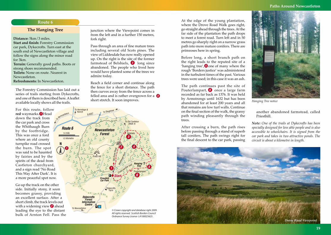
Before long, a short branch path on the right leads to the reputed site of a ‘hanging tree’, one of many where the rough ‘Borders justice’ was administered in the turbulent times of the past. Various trees were used; in this case it was an ash.
The path continues past the site of Pouterlampart, once a large farm recorded as far back as 1376. It was held by Armstrongs until 1632 but has been abandoned for at least 200 years and all that remains are low turf walls. Continue on the final section of the walk, the grassy path winding pleasantly through the trees.
After crossing a burn, the path rises before passing through a stand of superb tall conifers. The path swings right for the final descent to the car park, passing
Hanging Tree notice
another abandoned farmstead, called Priesthill.
Note: One of the trails at Dykecrofts has been specially designed for less able people and is also accessible to wheelchairs. It is signed from the car park and takes in two attractive ponds. The circuit is about a kilometre in length.
Drove Road Viewpoint

20
Paths Around Newcastleton Paths Around Newcastleton
21
Dragonfly
Route 7
Demainholm
Distance: 5km/3 miles.Start and finish: Demainholm Forest car park, on the west of the road 2km south of Newcastleton.Terrain: Generally good paths. Rough and often wet section in the middle. Boots or strong shoes recommended.Toilets: None on route. Nearest in Newcastleton.Refreshments: In Newcastleton.
Demainholm, which is owned by Buccleuch Estates, was planted in 1995, so the trees are still young. The estate has laid out two walks, one of which is described here.
For this route, you are following orange markers. From the car park, turn left up the track into the forest. After a short section of more mature trees, you soon enter the young plantation. These conifers will be cropped when they are 30-35 years old, so the planting is a very long-term investment.
Turn left on another clear track and cross a small burn. After climbing gently for a while, the track levels out and there are wide views across the valley and to the surrounding hills. The quarry on Greena Hill, ahead, is clearly seen. Birdlife in the forest includes buzzards and short-eared owls, which feed partly on the thriving population of voles found here.
Where the yellow walk goes left on a rough path, keep ahead on the track. Pass a small pond where mallard ducks can sometimes be seen, and also dragonflies in summer, and reach the end of the track.
The route goes straight ahead on a rough ride. It is worth persevering, but if you are uncertain about the going underfoot, you can simply retrace your steps from this point. Keep going along the ride to reach a point overlooking a small burn. On its far side is a sturdy stone dyke, and beyond that a more mature plantation owned by the Forestry Commission.
Turn left here and continue between the young and older trees. You reach an area of fine old trees, including venerable beeches, and descend a rough bank to the left through a grassy area with the Tinnis Water chuckling along on the right beyond the dyke.
After about 300 metres, a sign directs you left on to a rough track that climbs steeply. At the top of the slope it swings left and becomes grassy, running on for about 400 metres to return you to the main track.
Turn right and continue back along the track to the car park, enjoying the wide views up the valley of Liddesdale. Road to Demainholm
Kershopefoot
22
Paths Around Newcastleton Paths Around Newcastleton
23
Holm Hill
Route 8
Mangerton Tower
Distance: 7km/4.5 miles.Start and finish: Douglas Square, Newcastleton.Terrain: Generally good paths and minor roads. One section of rough path. Boots or strong shoes recommended.Toilets: At the start.Refreshments: In Newcastleton.
This generally easy route passes the site of a former Armstrong fortified house and provides a pleasant outing. Much of it is on quiet minor roads.
From Douglas Square, head down to the Liddel Water and turn right. Follow the riverside path along past the houses and then beside the sports field. There are seats and picnic tables on the way. Climb the steps onto the Holm Bridge, built in 1823, and turn left over the bridge. You may see dippers and other water birds around here.
Follow the road round to the right and walk along passing a number of caravans. In about 500 metres, after crossing the bridge over the Tweeden Burn, turn right at a seat. The tree cover on the right hides the Liddel Water, but where the trees end, if you look right you can see where the railway line formerly crossed the river. This was locally called the Caul’ Pool Brig, because there was a ‘cauld’ or weir in the river here. The bridge, an impressive arched viaduct, was demolished in 1986.
As you approach Mangerton Farm, turn left on to the old railway line (‘Mangerton Walk’ sign). Continue along the old line. There are beautiful wild flowers beside the track in summer.
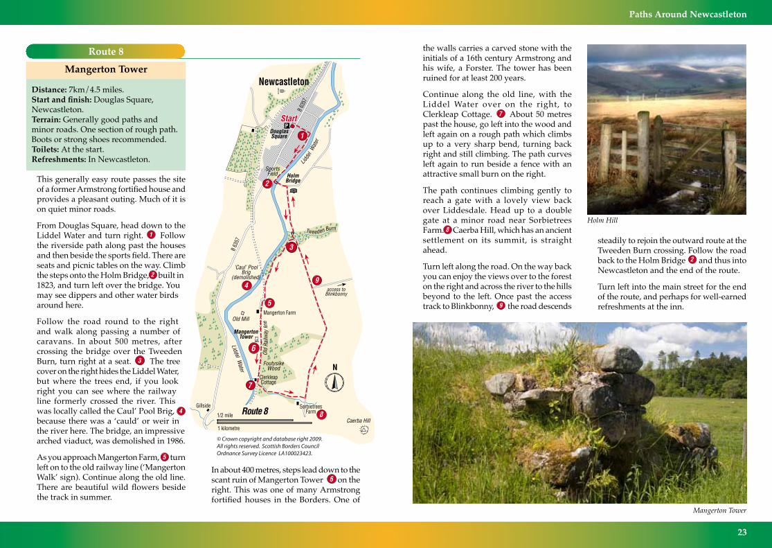
In about 400 metres, steps lead down to the scant ruin of Mangerton Tower on the right. This was one of many Armstrong fortified houses in the Borders. One of
the walls carries a carved stone with the initials of a 16th century Armstrong and his wife, a Forster. The tower has been ruined for at least 200 years.
Continue along the old line, with the Liddel Water over on the right, to Clerkleap Cottage. About 50 metres past the house, go left into the wood and left again on a rough path which climbs up to a very sharp bend, turning back right and still climbing. The path curves left again to run beside a fence with an attractive small burn on the right.
The path continues climbing gently to reach a gate with a lovely view back over Liddesdale. Head up to a double gate at a minor road near Sorbietrees Farm. Caerba Hill, which has an ancient settlement on its summit, is straight ahead.
Turn left along the road. On the way back you can enjoy the views over to the forest on the right and across the river to the hills beyond to the left. Once past the access track to Blinkbonny, the road descends
steadily to rejoin the outward route at the Tweeden Burn crossing. Follow the road back to the Holm Bridge and thus into Newcastleton and the end of the route.
Turn left into the main street for the end of the route, and perhaps for well-earned refreshments at the inn.
Mangerton Tower

24
Paths Around Newcastleton Paths Around Newcastleton
25
Route 9
Across the Border
Distance: 18km/11 miles.Start and finish: Douglas Square, Newcastleton.Terrain: Generally good paths and minor roads. Boots or strong shoes only needed in wet conditions.Toilets: At the start.Refreshments: In Newcastleton.
This is the longest route in the booklet, and for part of its length it is just on the English side of the Border, so it can be almost classed as an transnational expedition! The walk follows minor roads, the old railway and a section of the Cross-Border Cycle Trail, so the route is quite straightforward.
From Newcastleton, follow the same route along minor roads to Dykecrofts as for Route 4. However, when you reach the Forestry Commission buildings, before Dykecrofts Farm, turn right on a track which is signed for the cycle trail.
This track climbs behind the buildings and soon turns right to enter the forest, heading south. Between Castle Hill and Hillhouse Wood it then swings south-east to run close to a gorge on the left known as the Clintheugh Linn, before heading south again past Thwartergill Head and along beside the Muckle Thwarter Gill. The names are wonderfully evocative.
Some of the trees in this part of the forest were among the first to be planted here by the Forestry Commission in the early 1920s. They are now classed (in terms of timber production) as ‘over mature’, but are being left to enhance the amenity of the area and encourage birdlife. Species include spruce, larch and Douglas fir.
Most of the cropped timber is Sitka spruce, and the timber is used for building work, fencing material and for paper production.
The track meets another trail coming down from the left, and this is where it starts to follow the England-Scotland border. Cross the Kershope Burn - and walk into England! The trail runs south-west, just on the English side of the border and near the edge of the forest, to reach a minor road at Kershope Bridge. On the way it passes Day Holm, a place mentioned in the Ballad of Kinmont Willie, a famous Border tale.
From Kershope Bridge there are two alternatives. The more direct route is simply to follow the road as it curves gradually north below Caerba Hill to pass several disused quarries and reach Sorbietrees. Continue with the road all the way to the Holm Bridge, and on to Newcastleton.
Perhaps the nicer way back, although it is a little longer, is to continue with the cycle trail for 2km from Kershope Bridge down to meet another road and into Kershopefoot, an attractive little place but with few facilities. From the 1940s to
the 1960s there was a large camp here for forestry workers.
At the ‘Welcome to Scottish Borders’ sign, instead of crossing the Liddel Water, turn right at what was once a level crossing and walk along the old railway line. An unusual feature of the line was that north of Scots Dyke, although it ran close to the Border it did not actually enter
Scotland until crossing the Kershope Burn here, some
34km from Carlisle.
Having crossed the burn and passed through a gate, you are on a low embankment across a field. This field is the historic Tourney Holm where cross-border disputes were settled in the reiving days.
Continue along the old line through Flatt Farm land with the Liddel Water close on your left until you pass Clerkleap Cottage and the ruin of Mangerton Tower (see Route 8). At Mangerton Farm leave the railway line and take the farm road. At a T-junction turn left and head back for the Holm Bridge and Newcastleton.
Holm Bridge

26
Paths Around Newcastleton Paths Around Newcastleton
27
Contact Information
AcknowledgementsThe co-operation of farmers and landowners in developing these routes is gratefully acknowledged. The original booklet and the routes were originally produced with financial assistance from Scottish Border Paths, which was a partnership of public agencies aimed at developing outdoor countryside access in Scottish Borders. Much of the funds at that time came from the European Union whose assistance is also greatly acknowledged. Today the routes are managed by Scottish Borders Council.
Copyright InformationAll text, photographs and maps in this publication are copyright. Photographs by Brian Jefferson and Keith Robeson. Maps designed and drawn by David Langworth. Crown copyright. All rights reserved. Scottish Borders Council, Licence 100023423, 2009.
VisitScotland BordersShepherd’s Mill, Whinfield Road, Selkirk, TD7 5DT.Accommodation Bookings: 0845 22 55 121Tel: 01835 863170Email: bordersinfo@visitscotland.comwww.visitscottishborders.comScottish Borders Tourist Information Centres Jedburgh, Peebles and Melrose, Kelso, Eyemouth, Hawick and Selkirk.Opening dates and times vary For Information: Tel: 01835 863170Scottish Natural Heritage (Information on Scottish Outdoor Access Code)Lothian & Borders Area OfficeTel: 01896 756652www.outdooraccess-scotland.comTraveline (for public transport information)Tel: 0871 200 2233 www.traveline.org.ukScottish Borders Councilwww.scotborders.gov.ukAccess & Countryside TeamCouncil Headquarters,Newtown St Boswells, Melrose, TD6 0SATel: 01835 825060Email: [email protected]
Other websitesInformation on Newcastletonwww.visitnewcastleton.comForestry Commission Trails www.forestry.gov.uk/newcastletonKielder Forest and Water Park routes www.visitkielder.comScottish Borders Council countryside website: www.scotborders.gov.uk/life/environment/outdooraccessThe Southern Upland Way website is at:www.southernuplandway.gov.ukFor further information on walking inScotland, visit: www.walkingwild.comMountain Rescue Team - Scottish BordersIt is considered best practice to alert the MRT to all incidents where a casualty is located on a hill, moor, upland or other countryside, or missing on such ground even if the Ambulance Service has been requested.To call the MRT to such incidents the following procedure should be followed:1. Dial 9992. Ask for Police3. Tell the Police that you require Mountain RescueTell the Police why and where you require theMRT.
Every effort has been made to ensure that the information and advice contained in this booklet is correct at the date of publication. However, it is always for you to assess whether completing a route is within your capability, using your common sense and your knowledge of your own state of health and fitness, competence and experience. No liability is accepted by the authors or publishers for any loss, injury or damage, arising out of, or in any way connected with, any person or persons undertaking or attempting to undertake any of the routes described in this booklet, howsoever caused.
Alternative format/languageYou can get this document on tape, in large print, and various other formats by contacting us at the address below. In addition, contact the address below for information on language translations, additional copies, or to arrange for an officer to meet with you to explain any areas of the publication that you would like clarified. Also: if you encounter any problems on any of these routes please contact:
OuTDOOR ACCESS TEAM Scottish Borders Council Planning Department Council HeadquartersNewtown St Boswells MELROSETD6 0SATel 01835 825060
Holm Bridge

Text by Scottish Borders Council, Photographs by Brian Jefferson and Keith RobesonDesigned by Scottish Borders Council Graphic Design Section
Maps by David Langworth Printed 2003, Re-printed in the Scottish Borders 2009
I*IA
M
pe
[
Sout
h He
rmita
ge S
treet
Nor
th H
erm
itage
Stre
et
Langholm Street
AuctionMart
Mid
Lid
del S
treet
Doug
las
Squa
re
Liddesdale HeritageMuseum
Newcastleton Village
0 100 200 30050Metres
© Crown copyright and database right 2009. All rights reserved. Ordnance Survey Licence number 100023423. © TGG


