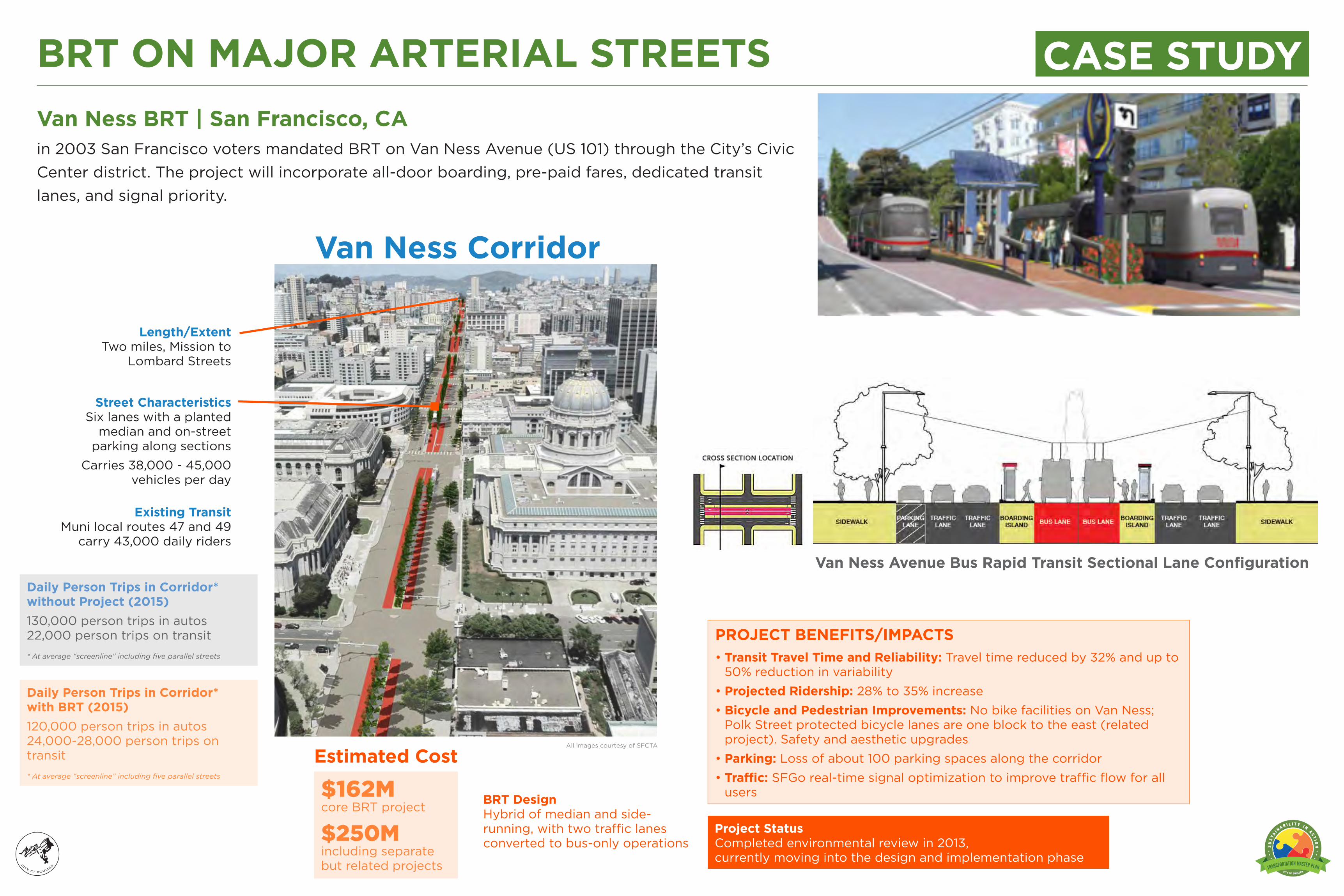
BIKE. WALK. BRT ON MAJOR ARTERIAL STREETS Daily Person Trips in Corridor* without Project (2015) 130,000 person trips in autos 22,000 person trips on transit * At average “screenline” including five parallel streets Van Ness BRT | San Francisco, CA in 2003 San Francisco voters mandated BRT on Van Ness Avenue (US 101) through the City’s Civic Center district. The project will incorporate all-door boarding, pre-paid fares, dedicated transit lanes, and signal priority. All images courtesy of SFCTA Length/Extent Two miles, Mission to Lombard Streets Street Characteristics Six lanes with a planted median and on-street parking along sections Carries 38,000 - 45,000 vehicles per day BRT Design Hybrid of median and side- running, with two traffic lanes converted to bus-only operations PROJECT BENEFITS/IMPACTS • Transit Travel Time and Reliability: Travel time reduced by 32% and up to 50% reduction in variability • Projected Ridership: 28% to 35% increase • Bicycle and Pedestrian Improvements: No bike facilities on Van Ness; Polk Street protected bicycle lanes are one block to the east (related project). Safety and aesthetic upgrades • Parking: Loss of about 100 parking spaces along the corridor • Traffic: SFGo real-time signal optimization to improve traffic flow for all users Existing Transit Muni local routes 47 and 49 carry 43,000 daily riders Van Ness Corridor $162M core BRT project $250M including separate but related projects Estimated Cost Project Status Completed environmental review in 2013, currently moving into the design and implementation phase Van Ness Avenue Bus Rapid Transit Sectional Lane Configuration CASE STUDY Daily Person Trips in Corridor* with BRT (2015) 120,000 person trips in autos 24,000-28,000 person trips on transit * At average “screenline” including five parallel streets
Transcript
BUS. BIKE. WALK.
Welcome Transportation Master Plan UpdateInitial Public Open HouseMonday March 4, 2013
BRT ON MAJOR ARTERIAL STREETS
Daily Person Trips in Corridor* without Project (2015)130,000 person trips in autos 22,000 person trips on transit* At average “screenline” including five parallel streets
Van Ness BRT | San Francisco, CAin 2003 San Francisco voters mandated BRT on Van Ness Avenue (US 101) through the City’s Civic Center district. The project will incorporate all-door boarding, pre-paid fares, dedicated transit lanes, and signal priority.
All images courtesy of SFCTA
Length/Extent Two miles, Mission to
Lombard Streets
Street Characteristics Six lanes with a planted
median and on-street parking along sections
Carries 38,000 - 45,000 vehicles per day
BRT Design Hybrid of median and side-running, with two traffic lanes converted to bus-only operations
PROJECT BENEFITS/IMPACTS• Transit Travel Time and Reliability: Travel time reduced by 32% and up to
50% reduction in variability• Projected Ridership: 28% to 35% increase• Bicycle and Pedestrian Improvements: No bike facilities on Van Ness;
Polk Street protected bicycle lanes are one block to the east (related project). Safety and aesthetic upgrades
• Parking: Loss of about 100 parking spaces along the corridor• Traffic: SFGo real-time signal optimization to improve traffic flow for all
users
Existing Transit Muni local routes 47 and 49
carry 43,000 daily riders
Van Ness Corridor
$162M core BRT project
$250M including separate but related projects
Estimated Cost
Project Status Completed environmental review in 2013, currently moving into the design and implementation phase
Van Ness Avenue Bus Rapid Transit Sectional Lane Configuration
CASE STUDY
Daily Person Trips in Corridor* with BRT (2015)120,000 person trips in autos 24,000-28,000 person trips on transit* At average “screenline” including five parallel streets
BUS. BIKE. WALK.
Welcome Transportation Master Plan UpdateInitial Public Open HouseMonday March 4, 2013
Project Status Environmental review phase. Projected opening 2018 or later.
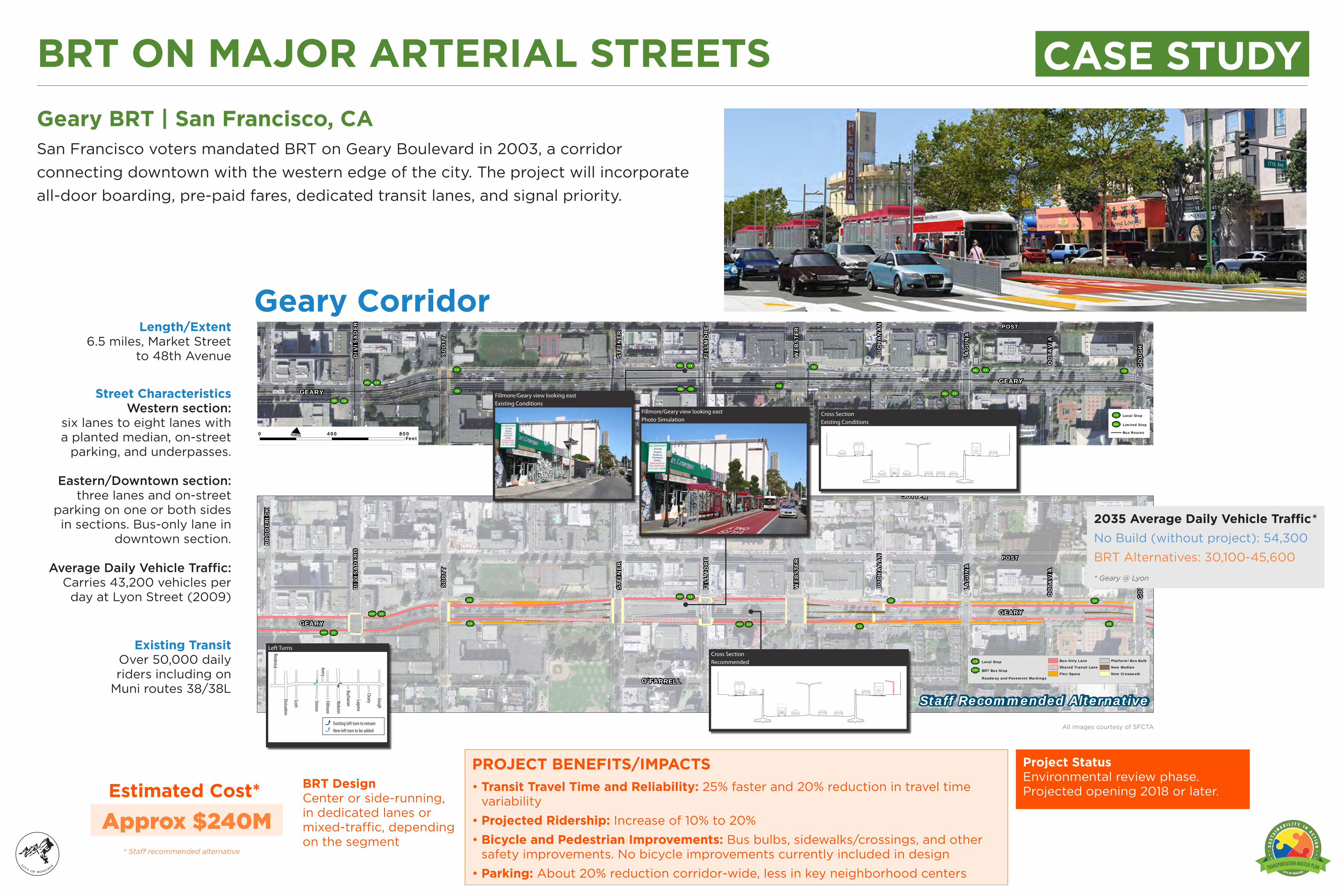
BRT ON MAJOR ARTERIAL STREETSGeary BRT | San Francisco, CASan Francisco voters mandated BRT on Geary Boulevard in 2003, a corridor connecting downtown with the western edge of the city. The project will incorporate all-door boarding, pre-paid fares, dedicated transit lanes, and signal priority.
All images courtesy of SFCTA
Length/Extent 6.5 miles, Market Street
to 48th Avenue
Street Characteristics Western section:
six lanes to eight lanes with a planted median, on-street
parking, and underpasses.
Eastern/Downtown section: three lanes and on-street
parking on one or both sides in sections. Bus-only lane in
downtown section.
Average Daily Vehicle Traffic:Carries 43,200 vehicles per
day at Lyon Street (2009)
BRT Design Center or side-running, in dedicated lanes or mixed-traffic, depending on the segment
PROJECT BENEFITS/IMPACTS• Transit Travel Time and Reliability: 25% faster and 20% reduction in travel time
variability• Projected Ridership: Increase of 10% to 20%• Bicycle and Pedestrian Improvements: Bus bulbs, sidewalks/crossings, and other
safety improvements. No bicycle improvements currently included in design • Parking: About 20% reduction corridor-wide, less in key neighborhood centers
Welcome Transportation Master Plan UpdateInitial Public Open HouseMonday March 4, 2013
THE Connections The Mason Corridor and MAX will provide both community and regional connections. MAX will link Downtown Fort Collins, Colorado State University (Main Campus, Veterinary Teaching Hospital and Natural Resources Research Center), South College Retail, Foothills Mall, Park & Rides, as well as connect to east/west transit options and trail systems. MAX will also provide much needed regional connections to the North Front Range and the Denver Metro Area. The Mason Corridor connects to the FLEX regional transit service from Fort Collins to Loveland. MAX is designed to work in concert with the State’s long range plans for regional transit along the I-25 Corridor, or future commuter rail along the BNSF railroad corridor.
THE Map
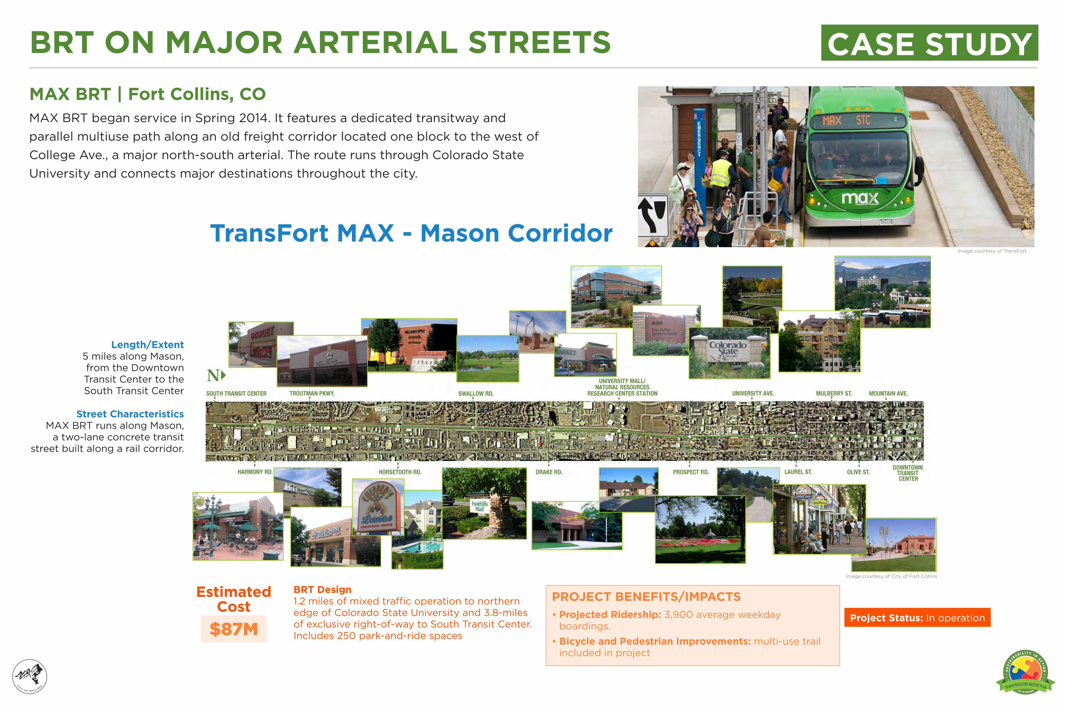
BRT ON MAJOR ARTERIAL STREETSMAX BRT | Fort Collins, COMAX BRT began service in Spring 2014. It features a dedicated transitway and parallel multiuse path along an old freight corridor located one block to the west of College Ave., a major north-south arterial. The route runs through Colorado State University and connects major destinations throughout the city.
Image courtesy of City of Fort Collins
Image courtesy of TransFort
Length/Extent 5 miles along Mason, from the Downtown Transit Center to the South Transit Center
Street Characteristics MAX BRT runs along Mason,
a two-lane concrete transit street built along a rail corridor.
BRT Design 1.2 miles of mixed traffic operation to northern edge of Colorado State University and 3.8-miles of exclusive right-of-way to South Transit Center. Includes 250 park-and-ride spaces
PROJECT BENEFITS/IMPACTS• Projected Ridership: 3,900 average weekday
boardings. • Bicycle and Pedestrian Improvements: multi-use trail
included in project
$87M
Estimated Cost
Project Status: In operation
CASE STUDY
TransFort MAX - Mason Corridor
BUS. BIKE. WALK.
Welcome Transportation Master Plan UpdateInitial Public Open HouseMonday March 4, 2013
OldhamCrane
Six SacSelf-Storage Corp
OldhamCrane
Vacant
Vacant
Vacant
Big B
FRANKLIN BLVD
GLE
NW
OO
D B
LVD
HEN
DER
SON
AV
E
14TH ST
17TH ST
15TH ST
MIS
SISS
IPPI
AV
E
CO
NC
ORD
ST
BRO
OKL
YN S
T MCVAY HW
Y
LEXI
NG
TON
AV
E
SEN
ECA
AV
E
Lucky DogDay and
Night Care
WillametteGraystone
Shared Access to StoveTec,Oregon Converter Co., andKnez Building Materials
Shared Access to Willamette Graystone,Central Valley Cycle, Inter City Inc., and Dress 2 Impress
Building and front landscaping considered eligiblefor the National Register of Historic Places,
Henderson Ave to Glenwood Blvd Cross Section Mississippi Ave to Henderson Ave Cross Section McVay Hwy to Mississippi Ave Cross Section
McVay Hwy Roundabouts
McVay Hwy Roundabouts
Henderson Ave RoundaboutGlenwood Blvd Roundabout
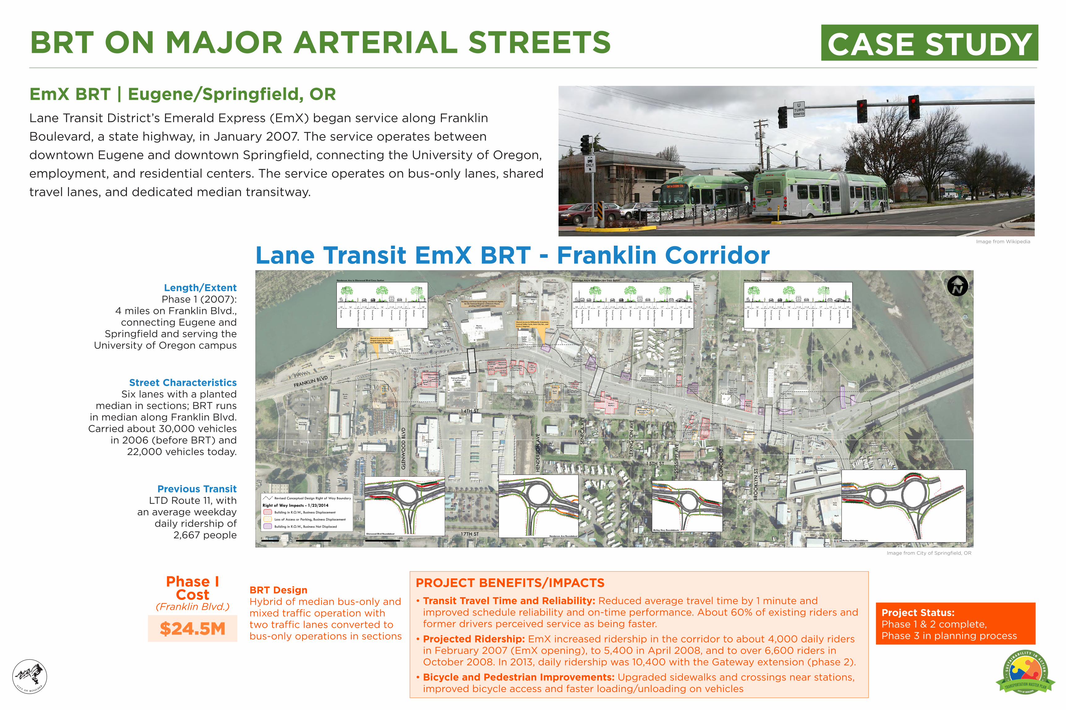
BRT ON MAJOR ARTERIAL STREETSEmX BRT | Eugene/Springfield, ORLane Transit District’s Emerald Express (EmX) began service along Franklin Boulevard, a state highway, in January 2007. The service operates between downtown Eugene and downtown Springfield, connecting the University of Oregon, employment, and residential centers. The service operates on bus-only lanes, shared travel lanes, and dedicated median transitway.
Image from Wikipedia
Image from City of Springfield, OR
Length/Extent Phase 1 (2007):
4 miles on Franklin Blvd., connecting Eugene and
Springfield and serving the University of Oregon campus
Street Characteristics Six lanes with a planted
median in sections; BRT runs in median along Franklin Blvd. Carried about 30,000 vehicles
in 2006 (before BRT) and 22,000 vehicles today.
BRT Design Hybrid of median bus-only and mixed traffic operation with two traffic lanes converted to bus-only operations in sections
PROJECT BENEFITS/IMPACTS• Transit Travel Time and Reliability: Reduced average travel time by 1 minute and
improved schedule reliability and on-time performance. About 60% of existing riders and former drivers perceived service as being faster.
• Projected Ridership: EmX increased ridership in the corridor to about 4,000 daily riders in February 2007 (EmX opening), to 5,400 in April 2008, and to over 6,600 riders in October 2008. In 2013, daily ridership was 10,400 with the Gateway extension (phase 2).
• Bicycle and Pedestrian Improvements: Upgraded sidewalks and crossings near stations, improved bicycle access and faster loading/unloading on vehicles
Lane Transit EmX BRT - Franklin Corridor
$24.5M
Phase I Cost
(Franklin Blvd.) Project Status: Phase 1 & 2 complete, Phase 3 in planning process