31
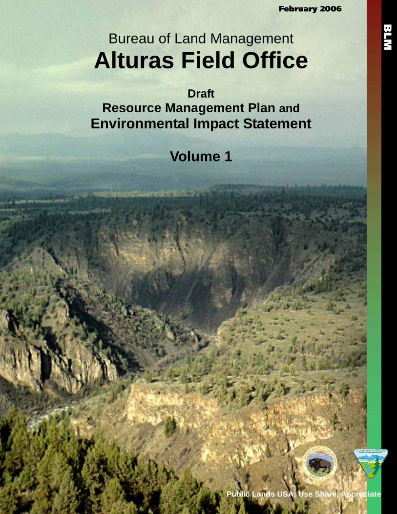
February 2006 Bureau of Land Management Alturas Field Office Draft Resource Management Plan and Environmental Impact Statement Volume 1 BLM Public Lands USA; Use Share, Appreciate
February 2006
Bureau of Land Management
Alturas Field Office Draft
Resource Management Plan and Environmental Impact Statement
Volume 1
BLM
Public Lands USA; Use Share, Appreciate
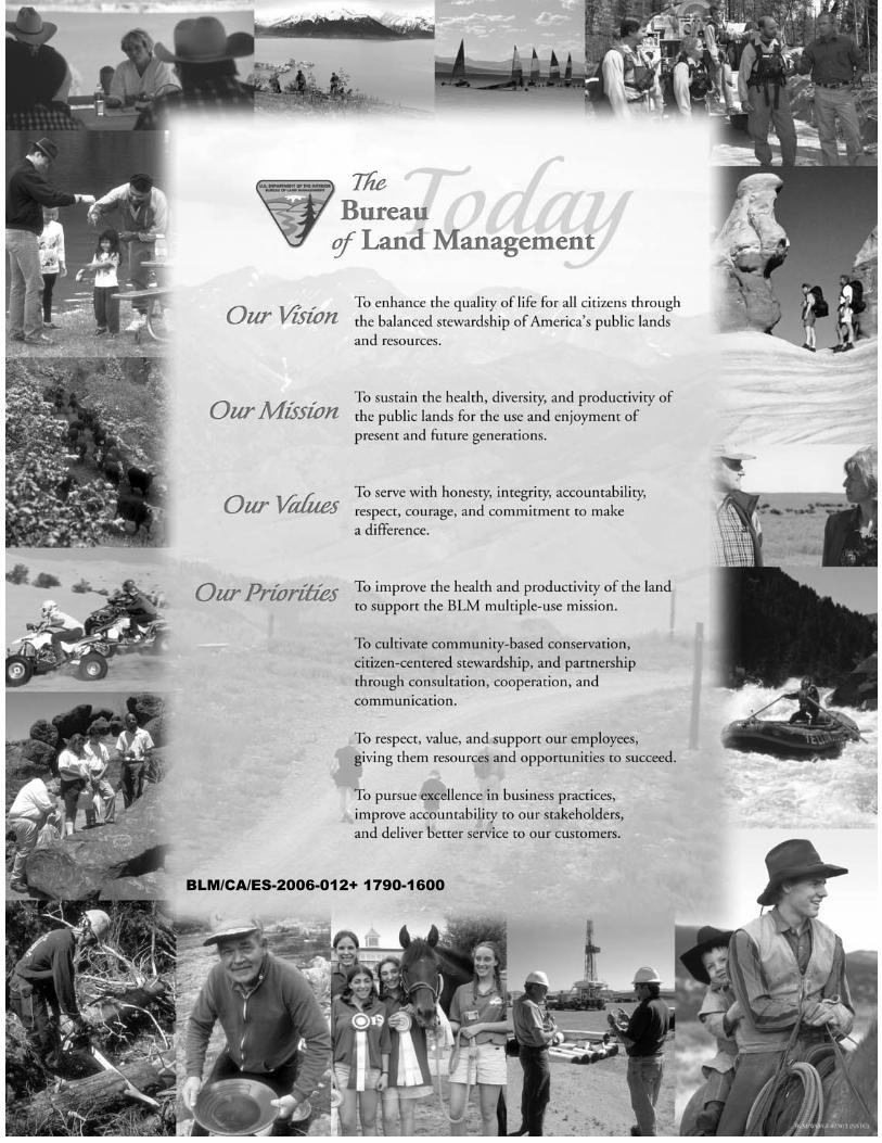
BLM/CA/ES-2006-012+ 1790-1600
United States Department of the Interior BUREAU OF LAND MANAGEMENT
Alturas Field Office 708 West 12th Street Alturas, CA 96101
Phone: (530) 233-4666 Fax: (530) 233-5696
www.ca.blm.gov/alturas
Dear Reader:
Enclosed for your review and comment is the Draft Resource Management Plan (DRMP) and Draft Environmental Impact Statement (DEIS) for the Bureau of Land Management’s (BLM) Alturas Field Office. This document was prepared by the BLM in concert with eight cooperating agencies, as well as from public comments received during the scoping phase of this planning effort.
The geographic planning area includes BLM managed public lands within the counties of Lassen, Modoc, Shasta, and Siskiyou, California. The overall intent of this RMP is to develop a comprehensive management strategy that will guide the management of public lands administered by the Alturas Field Office into the future. This RMP replaces ten land use plans into a single, unified Alturas Field Office RMP.
A Reader’s Guide is included to help you navigate through the chapters of this document, and is located directly after the Abstract. BLM is interested in seeking your comments on the adequacy and accuracy of all five proposed alternatives and the analysis of their respective management decisions. The Proposed RMP/Final EIS, which is the next phase of the planning process, could select various aspects of each of the alternatives as the management strategy that best meets the needs of the many resources and values being planned for in this area.
The announcement in the Federal Register that the Alturas Draft Resource Management Plan and EIS is available will start a 90-day public comment period during which members of the public are encouraged to review the document and provide comments. During this period, comments may be submitted using several methods:
Written comments should be sent to: Alturas RMP Comments Attention: Planning Coordinator Bureau of Land Management Eagle Lake Field Office 2950 Riverside Drive Susanville, California 96130
E-mail comments to: [email protected]
Comments may also be made electronically at: www.ca.blm.gov/alturas
Comments, including names and addresses of respondents, will be available for public review at the BLM Altuas Field Office, 708 West 12th Street, Alturas, California 96101, during normal business hours (8:00 a.m. to 4:30 p.m., except weekends and holidays). All submissions from organizations or businesses will be made available for public inspection in their entirety. Individuals may request confidentiality with respect to their name, address, and phone number.
If you wish to have your name or street address withheld from public review, or from disclosure under the Freedom of Information Act, the first line of the comment should start with the words “CONFIDENTIALITY REQUESTED” in uppercase letters in order for BLM to comply with your request. Such requests will be honored to the extent allowed by law. Comment contents will not be kept confidential.
BLM would like to thank our cooperating agency partners that have worked so hard to help us complete this document. They have provided support and expertise to facilitate focusing the issues and developing alternatives to help resolve the many compelling resource concerns that face the Alturas Field Office. We would like to particularly recognize Lassen, Modoc, Shasta, and Siskiyou Counties, the U.S. Fish and Wildlife Service, California Department of Fish and Game, and California State Historic Preservation Offices as cooperating agencies on this document. Their experience and dedication has made this a better process and BLM looks forward to continuing to work with them to complete this planning effort. We also extend thanks to those individuals and organizations that have provided extensive information and many excellent ideas that have been considered during this process.
Sincerely,
Tim Burke Field Manager Alturas Field Office
_______________________________
ALTURAS FIELD OFFICE
DRAFT RESOURCE MANAGEMENT PLAN AND
ENVIRONMENTAL IMPACT STATEMENT ALTURAS FIELD OFFICE ALTURAS, CALIFORNIA
United States Department of the Interior Bureau of Land Management
California State Office
Approved:
Mike Pool State Director
February 2006
Alturas FIELD OFFICE
Draft Resource Management Plan
And Environmental Impact Statement
Prepared by:
U.S. Department of Interior, Bureau of Land Management Alturas Field Office, Alturas California
February 2006
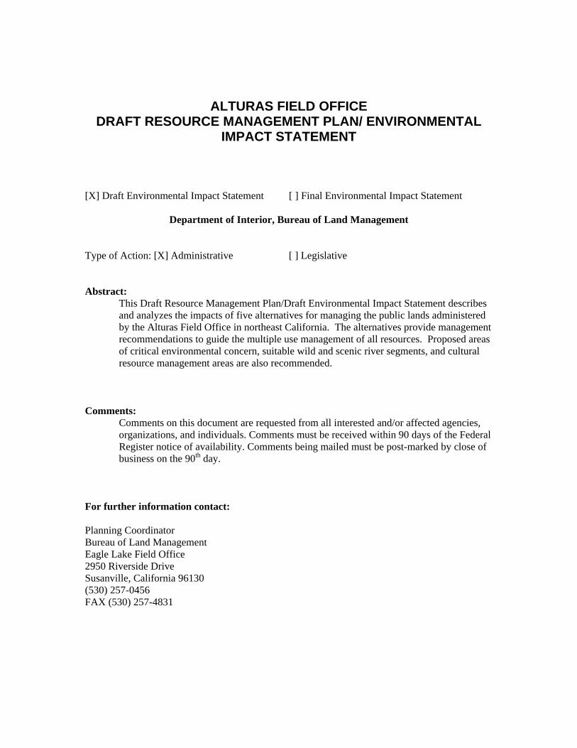
ALTURAS FIELD OFFICE DRAFT RESOURCE MANAGEMENT PLAN/ ENVIRONMENTAL
IMPACT STATEMENT
[X] Draft Environmental Impact Statement [ ] Final Environmental Impact Statement
Department of Interior, Bureau of Land Management
Type of Action: [X] Administrative [ ] Legislative
Abstract: This Draft Resource Management Plan/Draft Environmental Impact Statement describes and analyzes the impacts of five alternatives for managing the public lands administered by the Alturas Field Office in northeast California. The alternatives provide management recommendations to guide the multiple use management of all resources. Proposed areas of critical environmental concern, suitable wild and scenic river segments, and cultural resource management areas are also recommended.
Comments: Comments on this document are requested from all interested and/or affected agencies, organizations, and individuals. Comments must be received within 90 days of the Federal Register notice of availability. Comments being mailed must be post-marked by close of business on the 90th day.
For further information contact:
Planning Coordinator Bureau of Land Management Eagle Lake Field Office 2950 Riverside Drive Susanville, California 96130 (530) 257-0456 FAX (530) 257-4831
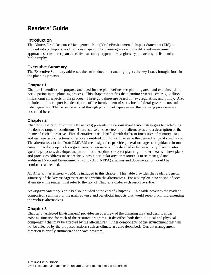
Readers’ Guide
Introduction The Alturas Draft Resource Management Plan (RMP)/Environmental Impact Statement (EIS) is divided into 5 chapters, and includes maps (of the planning area and the different management approaches considered), an executive summary, appendices, a glossary and acronyms list, and a bibliography.
Executive Summary The Executive Summary addresses the entire document and highlights the key issues brought forth in the planning process.
Chapter 1Chapter 1 identifies the purpose and need for the plan, defines the planning area, and explains public participation in the planning process. This chapter identifies the planning criteria used as guidelines influencing all aspects of the process. These guidelines are based on law, regulation, and policy. Also included in this chapter is a description of the involvement of state, local, federal governments and tribal agencies. The issues developed through public participation and the planning processes are described herein.
Chapter 2 Chapter 2 (Description of the Alternatives) presents the various management strategies for achieving the desired range of conditions. There is also an overview of the alternatives and a description of the theme of each alternative. Five alternatives are identified with different intensities of resource uses and management directions to resolve identified conflicts and achieve the desired range of conditions. The alternatives in this Draft RMP/EIS are designed to provide general management guidance in most cases. Specific projects for a given area or resource will be detailed in future activity plans or site-specific proposals developed as part of interdisciplinary project planning or other means. These plans and processes address more precisely how a particular area or resource is to be managed and additional National Environmental Policy Act (NEPA) analysis and documentation would be conducted as needed.
An Alternatives Summary Table is included in this chapter. This table provides the reader a general summary of the key management actions within the alternatives. For a complete description of each alternative, the reader must refer to the text of Chapter 2 under each resource subject.
An Impacts Summary Table is also included at the end of Chapter 2. This table provides the reader a comparison summary of the main adverse and beneficial impacts that would result from implementing the various alternatives.
Chapter 3 Chapter 3 (Affected Environment) provides an overview of the planning area and describes the existing situation for each of the resource programs. It describes both the biological and physical components that may be affected by the alternatives. Other components of the environment that will not be affected by the proposed actions such as climate are also described. Current management direction is briefly summarized for each program.
ALTURAS FIELD OFFICE Draft Resource Management Plan and Environmental Impact Statement
Chapter 4Chapter 4 (Environmental Consequences) analyzes the beneficial and adverse effects of the alternatives. There are assumptions at the beginning of each specific resource programs to help guide the reader through the thought process. At the end of the analysis of each resource subject a summary of the effects is provided, along with a discussion of the cumulative effects.
Chapter 5 Chapter 5 summarizes key events in the consultation and coordination process prior to and during preparation of the Draft RMP/EIS. It also lists those agencies, organizations, and individuals who were contacted or provided input into the planning process. Also listed are the technical specialists and editors who prepared this plan.
ALTURAS FIELD OFFICE Draft Resource Management Plan and Environmental Impact Statement
EXECUTIVE SUMMARY
Introduction The Bureau of Land Management (BLM) has prepared this Draft Resource Management Plan (RMP) and Environmental Impact Statement (EIS) to provide direction for managing public lands within the Alturas Field Office planning area and to analyze the environmental effects resulting from implementing the alternatives addressed in this Draft RMP.
The Alturas Field Office includes approximately 503,045 acres of BLM-managed surface acres in northeastern California. The geographic area includes public lands within the counties of Lassen, Modoc, Shasta, and Siskiyou, California. BLM’s mission is to sustain the health, diversity, and productivity of the public lands it manages for the use and enjoyment of present and future generations. The Alturas Draft RMP was developed in coordination with the Eagle Lake and Surprise Field Office RMPs to provide a consistent framework for managing public lands and resource uses in northeast California and northwest Nevada.
The RMP is being prepared using BLM’s planning regulations and guidance issued under the authority of the Federal Land Policy and Management Act (FLPMA) of 1976. An EIS is also included in this document to meet the requirements of the National Environmental Policy Act of 1969 (NEPA), Council on Environmental Quality regulations for implanting NEPA (40 Code of Federal Regulations 1500-1508), and requirements of BLM’s NEPA Handbook, H-1790-1.
Purpose and Need The purpose of the Alturas Resource Management Plan (RMP) is to provide guidance in the management of the lands and resources administered by the Alturas Field Office of the BLM that will address major resource issues identified during scoping, and through internal and cooperating agency meetings. The Alturas RMP is meant to be comprehensive in nature, providing guidance for management of all uses and resources administered by BLM in the planning area.
Current management direction for the Alturas Field Office is contained in ten land use plans or amendments that were developed from 1973-2002. New information, changed circumstances and resource conditions since these plans were prepared require the revision of these existing plans into a single updated RMP.
Population growth in the vicinity of Fall River Valley in Lassen and Shasta Counties, California and the metropolitan areas of Klamath Falls, Oregon; Reno, Nevada; and Redding, California has caused an increased demand for use of public lands to support community needs and low impact recreation. The Alturas Field Office has experienced a substantial increase in requests for land tenure decisions or adjustments and for land use permits and authorizations, including those for renewable energy development.
Vegetation communities continue to be threatened by both the encroachment of western juniper into sagebrush-grasslands and from the invasion of annual exotic grasses and noxious weeds. The number of plant and animal species recognized by California as special-status species has increased. In addition, the decline of sage-grouse populations in the western United States has triggered BLM national, state, and local strategies with new guidance to address habitat requirements of the species.
ALTURAS FIELD OFFICE ES-1 Draft Resource Management Plan and Environmental Impact Statement
EXECUTIVE SUMMARY
New protocol agreements between BLM and the State Historic Preservation Office guide the protection, inventory, and conservation of cultural resources as they relate to other resources and land uses. Emphasis is being placed on finding and managing traditional cultural properties in accord with local tribes.
Planning and Scoping Process BLM officially initiated the planning process for the Alturas Resource Management Plan (RMP) with publication of a Notice of Intent in the Federal Register on July 22, 2003 (Volume 68, Number 140). Issues related to resource management in the Alturas planning area were assembled during the scoping process consisting of public scoping meetings, field tours, socioeconomic workshops, and interactions with federal, state, tribal, and county collaborators.
BLM hosted six public scoping meetings in August and September 2003. A total of 205 people attended these meetings. Four meetings were held within the planning area. Other meetings were held in Redding, California, and Reno, Nevada, to ensure that BLM heard the concerns of user groups residing outside the planning area. BLM also conducted a scoping meeting in the field in August 2003. A community workshop was conducted to discuss economics and social values in December 2003.
The scoping process generated 15 key issues to be addressed in the RMP. These issues, listed below, and summarized in Chapter 1, were used to develop alternatives and are addressed in other sections of the resource management plan (e.g. effects on local economies).
1. How should upland ecosystems be managed?
2. How should forest resources be utilized and forestry issues resolved?
3. How and where should water be utilized and managed?
4. How will visual resources be managed and preserved?
5. How should riparian areas and wetlands be managed?
6. How should wildland and prescribed fire be managed and utilized?
7. How should motorized access and vehicular recreation be managed on public lands?
8. How should public lands be managed to support traditional practices and preserve traditional cultural properties of Native Americans?
9. How should public lands be managed to support the needs of local communities?
10. How should rangelands and livestock grazing be managed?
11. What lands should be made available for energy and mineral development?
12. What lands should be identified for retention, exchange, disposal and acquisition?
13. How should recreation opportunities be managed?
14. How should fish, wildlife, and special-status species be managed?
15. How should special resource values and special management areas be designated and managed?
ALTURAS FIELD OFFICE ES-2 Draft Resource Management Plan and Environmental Impact Statement
EXECUTIVE SUMMARY
Collaboration BLM approaches planning with community-based collaboration, in which interested groups and people– often with varied or opposing interests–work together to devise solutions with broad public support for managing BLM-administered lands. Cooperating local, state, tribal, and federal agencies have been part of the planning team for the RMPs to the fullest extent possible. During plan implementation BLM will continue partnerships with these public and local, state, and tribal governments and agencies to select high priority projects and to resolve emerging issues.
The Council of Environmental Quality defines a cooperating agency as any agency that has jurisdiction by law or special expertise for proposals covered by National Environmental Policy Act (NEPA) (40 CFR 1501.6). Any federal, state, or local government jurisdiction with such qualifications may become a cooperating agency by agreement with the lead agency. The following are formal cooperating agencies for this RMP:
• Modoc County; • Lassen County; • Shasta County; • U.S. Fish and Wildlife Service; • California Department of Fish and Game; • California State Historic Preservation Offices; and • Pit River Tribe.
The Northeast California Resource Advisory Council (RAC) contributed issues and reviewed goals, objectives, and management alternatives. Other groups that participated in the planning process include the Modoc-Washoe Experimental Stewardship Group.
Management Alternatives The Bureau of Land Management (BLM) developed management alternatives for the Alturas Field Office Draft Resource Management Plan using input and comments from public scoping meetings, written comments, as well as from staffs of BLM and other cooperating agency partners. National Environmental Policy Act (NEPA) regulations and BLM resource management planning regulations require the formulation of a reasonable range of alternatives that seek to address identified planning issues and management concerns. Each alternative must be evaluated to ensure that it would be consistent with resource goals and objectives, and current laws, regulations, and policy.
Alternatives are developed to establish a framework to evaluate the potential impacts on the planning area that might occur as a result of implemented management decisions. The five management alternatives developed for the Alturas RMP are detailed in this section, including:
No Action Alternative (required by NEPA): Retains current management through guidance and direction from current policies, and existing management plans.
Alternative 1. Resource / Economic Development: Emphasizes commodity production from BLM resources in accordance with local economies and land use plans from local communities and counties.
Alternative 2. Ecosystem Restoration or Protection: Maximizes efforts to maintain, restore, or improve components of the ecosystem using natural ecosystem processes.
ALTURAS FIELD OFFICE ES-3 Draft Resource Management Plan and Environmental Impact Statement
EXECUTIVE SUMMARY
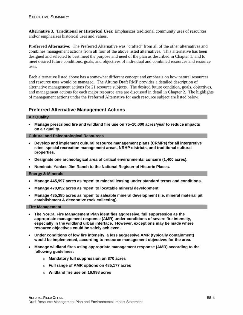
Alternative 3. Traditional or Historical Uses: Emphasizes traditional community uses of resources and/or emphasizes historical uses and values.
Preferred Alternative: The Preferred Alternative was “crafted” from all of the other alternatives and combines management actions from all four of the above listed alternatives. This alternative has been designed and selected to best meet the purpose and need of the plan as described in Chapter 1; and to meet desired future conditions, goals, and objectives of individual and combined resources and resource uses.
Each alternative listed above has a somewhat different concept and emphasis on how natural resources and resource uses would be managed. The Alturas Draft RMP provides a detailed description of alternative management actions for 21 resource subjects. The desired future condition, goals, objectives, and management actions for each major resource area are discussed in detail in Chapter 2. The highlights of management actions under the Preferred Alternative for each resource subject are listed below.
Preferred Alternative Management Actions Air Quality
• Manage prescribed fire and wildland fire use on 75–10,000 acres/year to reduce impacts on air quality.
Cultural and Paleontological Resources
• Develop and implement cultural resource management plans (CRMPs) for all interpretive sites, special recreation management areas, NRHP districts, and traditional cultural properties.
• Designate one archeological area of critical environmental concern (1,400 acres).
• Nominate Yankee Jim Ranch to the National Register of Historic Places.
Energy & Minerals
• Manage 445,997 acres as ‘open’ to mineral leasing under standard terms and conditions.
• Manage 470,052 acres as ‘open’ to locatable mineral development.
• Manage 435,385 acres as ‘open’ to saleable mineral development (i.e. mineral material pit establishment & decorative rock collecting).
Fire Management
• The NorCal Fire Management Plan identifies aggressive, full suppression as the appropriate management response (AMR) under conditions of severe fire intensity, especially in the wildland urban interface. However, exceptions may be made where resource objectives could be safely achieved.
• Under conditions of low fire intensity, a less aggressive AMR (typically containment) would be implemented, according to resource management objectives for the area.
• Manage wildland fires using appropriate management response (AMR) according to the following guidelines:
o Mandatory full suppression on 870 acres
o Full range of AMR options on 485,177 acres
o Wildland fire use on 16,998 acres
ALTURAS FIELD OFFICE ES-4 Draft Resource Management Plan and Environmental Impact Statement
EXECUTIVE SUMMARY
Forestry Resources
• Manage 13,800 acres of commercial and low-site forests for multiple-use objectives using appropriate methods of silviculture.
• Manage 40% of commercial timberlands as late-succession forests and maintain a substantial area of late-succession forests on low-site forestlands.
• Timber harvesting would not be allowed in commercial forestland on Mount Dome to preserve a bald eagle roosting area.
• Forests would be managed to preserve ecosystem health and maintain a sustainable rate of harvest.
• Implement fuel reduction and stand improvement using prescribed fire on 13,800 acres.
• Implement timber production and mechanical harvest of commercial and low-site forestlands on 12,000 acres.
• Implement reforestation of 8,000 acres.
Fuels Management
• Implement fuels treatments using prescribed fire--as well as mechanical, chemical and biological methods--to reduce hazardous fuel accumulation, provide fuel breaks, and create defensible space around at-risk communities according to the following schedule:
o Prescribed fire: 7510,000 acres/year o Mechanical treatment: 7510,000 acres/year o Biological treatment: 01,250 acres/year o Chemical treatment: 502,000 acres/year
Lands and Realty
• The Alturas Land Tenure Adjustment Plan (LTAP) (2002) would be the basis for future land tenure adjustments (but modified to include conservation easement projects and the Madeline retention/acquisition area).
• A priority list of land tenure adjustments would be developed from the LTAP and this RMP.
• Public access would be secured to BLM-administered lands, resources, and facilities— including road construction around private lands where access is desirable and easement acquisition isn’t feasible.
Rights-of-Way
• Continue authorization of current rights-of-way (ROWs) and communication sites. Any new development would be restricted to existing corridors and sites wherever feasible.
• Identify lands potentially available for telecommunications sites and utility ROWs on 435,385 acres.
• Avoid or exclude right-of-way authorizations in areas with ‘special area’ designation.
• Livestock Grazing
• Maintain 145 grazing allotments for livestock use with 454,649 acres open to grazing.
• ‘Active’ animal-unit-months (AUMs) would remain at 54,881; while 27,000 AUMs would be authorized for actual use.
• Grazing practices will be modified to achieve compliance on allotments failing to meet land health standards.
ALTURAS FIELD OFFICE ES-5 Draft Resource Management Plan and Environmental Impact Statement
EXECUTIVE SUMMARY
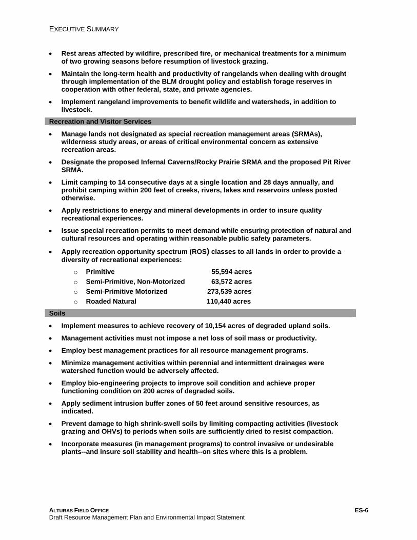
• Rest areas affected by wildfire, prescribed fire, or mechanical treatments for a minimum of two growing seasons before resumption of livestock grazing.
• Maintain the long-term health and productivity of rangelands when dealing with drought through implementation of the BLM drought policy and establish forage reserves in cooperation with other federal, state, and private agencies.
• Implement rangeland improvements to benefit wildlife and watersheds, in addition to livestock.
Recreation and Visitor Services
• Manage lands not designated as special recreation management areas (SRMAs), wilderness study areas, or areas of critical environmental concern as extensive recreation areas.
• Designate the proposed Infernal Caverns/Rocky Prairie SRMA and the proposed Pit River SRMA.
• Limit camping to 14 consecutive days at a single location and 28 days annually, and prohibit camping within 200 feet of creeks, rivers, lakes and reservoirs unless posted otherwise.
• Apply restrictions to energy and mineral developments in order to insure quality recreational experiences.
• Issue special recreation permits to meet demand while ensuring protection of natural and cultural resources and operating within reasonable public safety parameters.
• Apply recreation opportunity spectrum (ROS) classes to all lands in order to provide a diversity of recreational experiences:
o Primitive 55,594 acres o Semi-Primitive, Non-Motorized 63,572 acres o Semi-Primitive Motorized 273,539 acres o Roaded Natural 110,440 acres
Soils
• Implement measures to achieve recovery of 10,154 acres of degraded upland soils.
• Management activities must not impose a net loss of soil mass or productivity.
• Employ best management practices for all resource management programs.
• Minimize management activities within perennial and intermittent drainages were watershed function would be adversely affected.
• Employ bio-engineering projects to improve soil condition and achieve proper functioning condition on 200 acres of degraded soils.
• Apply sediment intrusion buffer zones of 50 feet around sensitive resources, as indicated.
• Prevent damage to high shrink-swell soils by limiting compacting activities (livestock grazing and OHVs) to periods when soils are sufficiently dried to resist compaction.
• Incorporate measures (in management programs) to control invasive or undesirable plants--and insure soil stability and health--on sites where this is a problem.
ALTURAS FIELD OFFICE ES-6 Draft Resource Management Plan and Environmental Impact Statement
EXECUTIVE SUMMARY
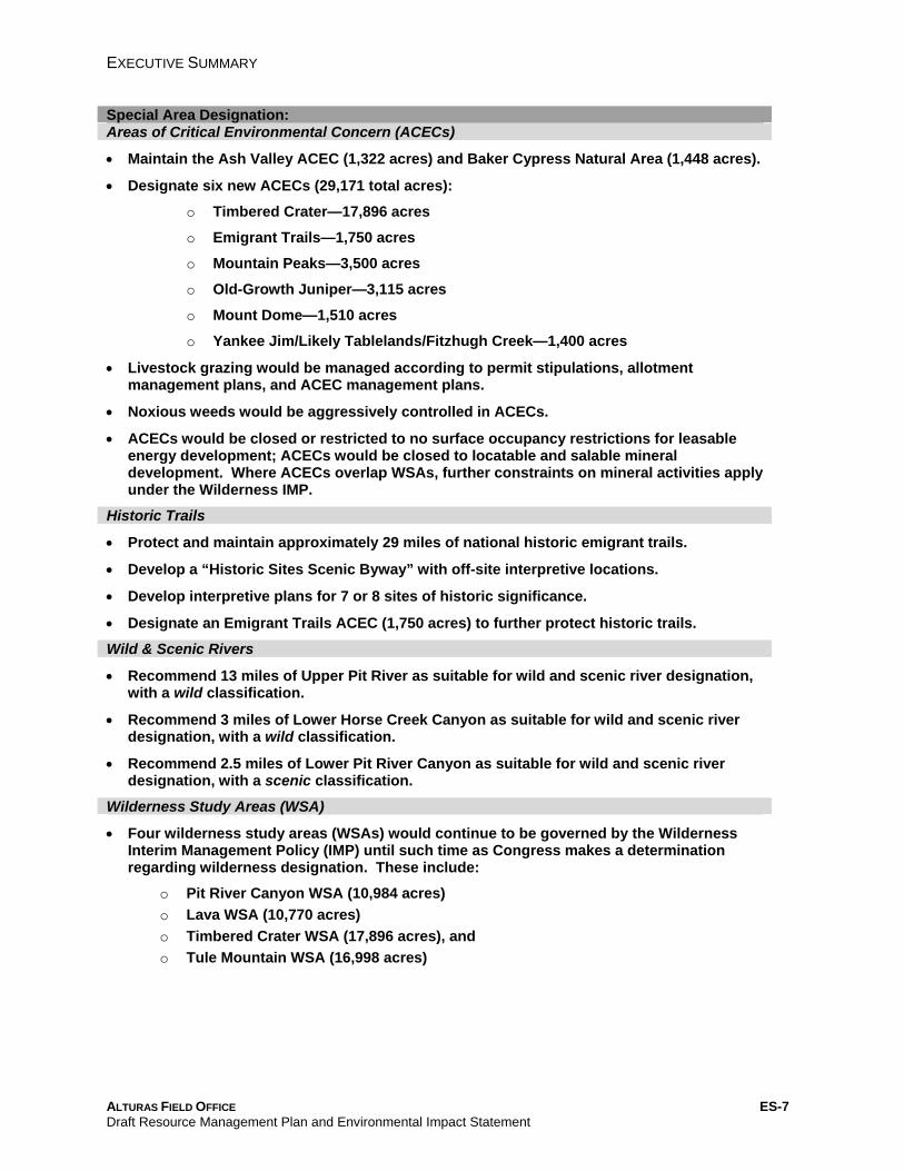
Special Area Designation: Areas of Critical Environmental Concern (ACECs)
• Maintain the Ash Valley ACEC (1,322 acres) and Baker Cypress Natural Area (1,448 acres).
• Designate six new ACECs (29,171 total acres):
o Timbered Crater—17,896 acres
o Emigrant Trails—1,750 acres
o Mountain Peaks—3,500 acres
o Old-Growth Juniper—3,115 acres
o Mount Dome—1,510 acres
o Yankee Jim/Likely Tablelands/Fitzhugh Creek—1,400 acres
• Livestock grazing would be managed according to permit stipulations, allotment management plans, and ACEC management plans.
• Noxious weeds would be aggressively controlled in ACECs.
• ACECs would be closed or restricted to no surface occupancy restrictions for leasable energy development; ACECs would be closed to locatable and salable mineral development. Where ACECs overlap WSAs, further constraints on mineral activities apply under the Wilderness IMP.
Historic Trails
• Protect and maintain approximately 29 miles of national historic emigrant trails.
• Develop a “Historic Sites Scenic Byway” with off-site interpretive locations.
• Develop interpretive plans for 7 or 8 sites of historic significance.
• Designate an Emigrant Trails ACEC (1,750 acres) to further protect historic trails.
Wild & Scenic Rivers
• Recommend 13 miles of Upper Pit River as suitable for wild and scenic river designation, with a wild classification.
• Recommend 3 miles of Lower Horse Creek Canyon as suitable for wild and scenic river designation, with a wild classification.
• Recommend 2.5 miles of Lower Pit River Canyon as suitable for wild and scenic river designation, with a scenic classification.
Wilderness Study Areas (WSA)
• Four wilderness study areas (WSAs) would continue to be governed by the Wilderness Interim Management Policy (IMP) until such time as Congress makes a determination regarding wilderness designation. These include:
o Pit River Canyon WSA (10,984 acres) o Lava WSA (10,770 acres) o Timbered Crater WSA (17,896 acres), and o Tule Mountain WSA (16,998 acres)
ALTURAS FIELD OFFICE ES-7 Draft Resource Management Plan and Environmental Impact Statement
EXECUTIVE SUMMARY
Travel Management
• OHV travel would be ‘limited to existing roads and trails’ year-round, except where further restrictions are specifically assigned (e.g. ‘open,’ ‘closed,’ ‘seasonally closed,’ or ‘limited to designated routes’).
• Where travel on an existing road is creating sufficient adverse impacts, the road may be closed (on a temporary or permanent basis) through plan maintenance.
• Travel on the Nelson Corral Reservoir Road would be expanded to a year-round ‘limited to existing roads and trails’ designation.
• The Cinder Cone OHV Management Area (80 acres) would be ‘open’ to year-round OHV travel. However, organized off-highway vehicle events would only be permitted in this location or on designated routes in other specially-approved locations.
• Assign off-highway vehicle use area designations:
o Open 80 acres o Limited to existing routes 340,158 acres o Limited to designated routes 57,982 acres o Closed 4,825 acres
• Construct 25.5 miles of new non-motorized trails.
• Motorized boating would be unrestricted on West Valley Reservoir.
• Motorized boating in the Infernal Caverns/Rocky Prairie SRMA would be limited to trolling motors and four-cycle gasoline engines, (and no personal watercraft).
• Nelson Corral Reservoir would be limited to non-motorized boating as would the Lower Pit River and the Pit River Canyon WSA.
• Motorized over-snow travel would not be permitted on 8,000 acres in the Nelson Corral high-country.
Utilities, Transportation, and Telecommunications
• ACECs, WSRs, and wilderness study areas are right-of-way exclusion zones. Development proposals for WSAs must meet the non-impairment criteria (which prohibits permanent facilities--unless they have valid, pre-existing rights or provide access to private inholdings).
• Utility corridors would not exceed 250 feet in width.
Vegetation
• Employ natural disturbance processes—particularly prescribed fire and wildland fire use—as the preferred method of restoring shrub communities, along with thinning (using mechanical and manual methods) to stimulate seeding and sprouting.
• Designate four areas as combined areas of critical environmental concern and research natural areas to protect unique plant species and communities: Timbered Crater, Mount Dome, Mountain Peaks, and Old-Growth Juniper ACECs.
• Incorporate guidelines from the sage-grouse conservation strategies to restore sage- grouse habitat in Wyoming and mountain big sagebrush ecosystems.
• Livestock would be excluded from seeded areas in bitterbrush stands for 3 to 5 years following treatment.
ALTURAS FIELD OFFICE ES-8 Draft Resource Management Plan and Environmental Impact Statement
EXECUTIVE SUMMARY
• Exclude livestock from aspen stands using: Permanent fencing - 200 acres Temporary fencing - 300 acres
• Rejuvenate or maintain stands of curlleaf mountain mahogany through selected treatments on up to 1,000 acres per year.
• Rejuvenate or maintain oak woodlands with abundant saplings and in mixed age classes through selected treatments on up to 5,000 acres per year.
Noxious Weeds & Invasive Species
• Implement integrated weed management (IWM) procedures on BLM lands. Review project proposals to determine necessary IWM actions and coordinate treatment with local agencies.
• Conduct periodic inventory of noxious weeds to detect new infestations and monitor the condition of existing infestations. The highest priority for noxious weed inventory would be critical wildlife habitat, at-risk plant communities, high-use areas, and recreation sites.
• Monitor sites to determine treatment effectiveness and impacts on non-target vegetation.
• Educate the public regarding noxious weed infestation and introduce practical measures to minimize infestations through public awareness and cooperation.
Riparian/Wetland Associations
• Assess riparian areas for proper functioning condition, existing—or potential—natural community, and ecological site description.
• Protect riparian areas from grazing using exclosure fencing and alternative water sources, as well as bio-engineering and planting of riparian vegetation.
• Livestock salting sites would be located ¼ to ½ mile from riparian areas and aspen stands to discourage damage by livestock.
• Re-route roads through Little and Big Buck Meadows; rehabilitate existing roads with native herbaceous vegetation.
Special Status Plants
• Manage habitats for special status plants so that BLM actions do not contribute to the need to ‘list’ these species (as threatened or endangered) under federal law.
• Reduce or eliminate adverse impacts on special status plants (and their habitats) during ground-disturbing activities.
• Acquire lands (from willing sellers) that support unprotected populations of special status plants.
• Protect ‘special interest’ plants (and their habitats) to prevent them from becoming special status plants.
Western Juniper
• Old-growth juniper would be protected from timber harvest, firewood cutting, and decorative rock collecting.
ALTURAS FIELD OFFICE ES-9 Draft Resource Management Plan and Environmental Impact Statement
EXECUTIVE SUMMARY
• Prioritize restoration treatment methods for removal of invasive juniper in shrub–steppe communities: (Total acres)
Mechanical harvesting 80,000 Manual treatments 5,000 Firewood cutting 15,000 Prescribed burning 100,000 Application of herbicides 8,000
• Construct 10 miles of permanent roads to facilitate juniper treatments.
• Construct 300 miles of temporary roads to facilitate juniper treatments.
Visual Resources
• Manage wilderness study areas as visual resource management (VRM) Class I.
• Assign VRM Class designations to BLM-administered lands and manage according to class requirements in order to protect scenic quality:
o VRM Class I 56,648 acres o VRM Class II 157,177 acres o VRM Class III 104,006 acres o VRM Class IV 185,214 acres
Water Resources
• Establish proper functioning condition (PFC) or desired future condition (DFC) on 15 miles of streams and 74 acres of springs or wetland areas. Achieve state water quality standards and the needs of beneficial users on 17 miles of streams.
• Implement restorative measures to improve water quality and make significant progress toward achieving state standards. Emphasize natural recovery processes, livestock exclosures, planting of woody riparian vegetation, and construction of in-stream structures.
• All resource management programs will use ‘best management practices’ to protect water quality and supply.
• Maintain existing and develop new water sources to improve livestock distribution and extend seasonal availability for wildlife.
• Withdraw state-appropriated water rights on waters that are not ‘waters of the state.’
• Assert riparian rights on all perennial and important intermittent streams.
• Projects that involve inter-basin transfer of water would be coordinated with local and regional governments.
Wild Horses
• Recommend adjustment of the appropriate management level for the Red Rock Herd Management Area to zero to protect archaeological sites and eliminate degradation of BLM and private rangelands. Horses would be made available for adoption or transferred to long-term holding facilities.
• Cooperate with the US Forest Service in periodic removal, adoption, and holding of animals from the Devil’s Garden Wild Horse Territory to keep horse numbers within appropriate management levels (AMLs) for the Emigrant Herd Management Area.
ALTURAS FIELD OFFICE ES-10 Draft Resource Management Plan and Environmental Impact Statement
EXECUTIVE SUMMARY
Wildlife and Fisheries Federally Listed Species
Bald Eagle • Conduct nesting and population surveys and implement seasonal protective measures
and buffer zones for permitted activities.
• Develop habitat management plans for the Conrad Ranch and Timbered Crater nesting areas, as well as the Juniper Creek roosting site.
• Manage suitable forest habitat to retain potential nest trees.
Northern Spotted Owl • Northern spotted owl and its habitat will be managed per existing terms and conditions
contained in plan and program-level biological opinions.
Modoc, Shortnose, and Lost River Suckers, and Shasta Crayfish • These species and their habitats (where and when found) will be managed according to
existing recovery plans and the terms and conditions of plan and program-level biological opinion.
Yellow-Billed Cuckoo and Oregon Spotted Frog • These species have not been found in the management area. However, the AFO will
contribute to appropriate survey efforts and – if a population of either species is discovered – would develop conservation and action plans.
State and BLM Listed Sensitive Species
• Cooperate with partners to obtain information on occurrence, abundance and distribution. Develop a GIS database to document and track information.
• Use seasonal protective measures and buffer zones for permitted activities in critical habitats for these species.
Ungulates
• Focus management on priority habitat areas for mule deer and black-tailed deer on 128,000 acres to maintain and improve ecological conditions.
• Prioritize management areas for improvements to pronghorn habitats by maintaining healthy low sagebrush habitat. Focus management on priority habitat areas (60,145 acres), and identified high quality habitat (130,000 acres).
• Control invasive juniper and noxious weeds to improve or reestablish native habitats. • Use seeding, planting, willow thinning and other vegetation treatments to improve
terrestrial and aquatic habitats. • Assign off-highway vehicle designations to protect wintering ungulates. Assign seasonal
road closures to protect wintering ungulates on the following areas: o Likely Tablelands o Barnes Grade o Day Bench
• If Rocky Mountain elk become established in the management area, coordinate with state wildlife agencies and other stakeholders--including livestock owners--to develop and implement a management plan.
• Coordinate with CDFG in the development of a management plan prior to reintroduction of California bighorn sheep.
• Provide artificial water sources (e.g. guzzlers) in areas with high wildlife potential, especially were natural sources are depleted or limited.
ALTURAS FIELD OFFICE ES-11 Draft Resource Management Plan and Environmental Impact Statement
EXECUTIVE SUMMARY
Sagebrush Ecosystems and Sagebrush Obligate Species
• Use fire (to restore natural disturbance processes) and thinning to restore sagebrush habitats according to recommendations of the conservation strategies for sage-grouse.
• Reduce invasive juniper and noxious weeds, implement seasonal protection measures and buffer zones, and timber and fuel treatments to maintain and improve habitat.
• Avoid practices that convert sagebrush habitats to non-native grassland or agricultural land.
Sage-Grouse:
• Implement locally-developed strategies found in Conservation Strategies for Sage-Grouse and Sagebrush Ecosystems within the Buffalo-Skedaddle, Likely Tablelands/Rocky Prairie and Devil’s Garden/Clear Lake Population Management Units. Utilize translocation to augment low populations in conjunction with habitat management projects.
Burrowing Owl:
• Inventory and map suitable habitat. Develop a conservation strategy to protect identified nesting burrows and other seasonal habitats.
Pygmy Rabbit:
• Inventory and map suitable habitat and determined species abundance. Develop a conservation strategy to protect occupied habitat.
Other Sagebrush-Obligate Species:
Survey to determine use of sagebrush habitats by sagebrush-obligate species. Determine demographic trends and habitat utilization for these species for utilization in medium and large-scale area, regional, and national strategies for managing sagebrush-obligate species.
Other Native Wildlife Species
• Manage migratory birds in accordance with the Migratory Bird Treaty Act and Migratory Bird Executive Order 13186, “Responsibilities of Federal Agencies to Protect Migratory Birds.”
• Coordinate reintroductions, augmentations, and translocations of native species with state wildlife agencies.
• Create brush piles and water sources for upland game birds and small mammals in important habitats where cover or water is depleted or unreliable.
• Maintain waterfowl nesting islands and exclosure fencing on 17 reservoirs and create additional islands on 26 new reservoirs.
Native and Non-Native Fish and Other Aquatic Wildlife
• Restore proper functioning condition to springs and streams by installing and maintaining riparian fencing, maintaining or improving minimum pool depths, augmenting clean spawning gravels, and stabilizing stream banks.
• Reduce or eliminate populations of non-native aquatic species that (actually or potentially) pose a threat to native species. Coordinate with state agencies when implementing management actions--especially proposed stocking of fish.
Non-Native Terrestrial Wildlife
• Manage desirable non-native terrestrial wildlife (i.e. wild turkey) and eliminate or control other non-native species in cooperation with state (and other applicable) conservation plans.
ALTURAS FIELD OFFICE ES-12 Draft Resource Management Plan and Environmental Impact Statement
EXECUTIVE SUMMARY
Environmental Consequences The potential environmental consequences (or impacts) of the five alternatives were analyzed for each natural resource, resource use, and social and economic conditions. Detailed descriptions of the direct and indirect impacts of resource management under all five alternatives are provided in Chapter 4, along with a discussion of the possible cumulative impacts that could result from actions taken in this RMP. A comparison summary of these impacts is described in the Impacts Summary Table at the end of Chapter 2.
The Preferred Alternative would enhance the ability of BLM to achieve the purpose and need of this document, as outlined in Chapter 1, as well as meet desired future conditions, goals and objectives of specific resources as outlined in Chapter 2. Alternatives 1, 3 and No Action lack the degree of management emphasis required to restore degraded sagebrush steppe communities and habitats, in relation to the encroachment of juniper.
The Preferred Alternative would result in overall minor to moderate adverse impacts to resources, and these impacts would continue to be mitigated. Management actions under the Preferred Alternative would result in moderate to major beneficial impacts to native vegetation communities from restoration efforts, and the use of prescribed fire to remove invasive juniper. Improvements to riparian areas, water bodies, and other special habitats would improve soil and water resources, and wildlife habitat. The designation of six areas of critical environmental concern, three wild and scenic river segments, and an increased emphasis on cultural resource protection and management would have beneficial impacts to these important and unique resources.
ALTURAS FIELD OFFICE ES-13 Draft Resource Management Plan and Environmental Impact Statement
TABLE OF CONTENTS
TABLE OF CONTENTS
VOLUME 1
Chapter 1. Purpose and Need 1.1 Purpose and Need for the Plan……………………………………………………………………………...1-3
1.2 Changed Circumstances…..…………………………………………………………………………………1-3
1.3 Planning Area…...……………………………………………………………………………………………..1-4
1.4 Planning and Scoping Process………………………………………………………………………………1-5
1.5 Issues Raised During the Scoping Process………………………………………………………………..1-8
1.6 Issues Considered but Not Addressed……………..………………………………………………….….1-16
1.7 Planning Criteria……………………………………………………………………………………………..1-16
1.8 Collaboration…………………………………………………………………………………………………1-18
1.9 Coordination and Consistency with Other Plans…………………………………………………………1-18
Chapter 2. Alternatives Introduction………………………………...................................……………………………………………….2-3
2.1 Air Quality……………………………………….…………...……………………………………….………..2-7
2.2 Cultural Resources and Paleontology…………………...……………………………………….…………2-9
2.3 Energy and Minerals……………………………………………………………………………………..….2-22
2.4 Fire Management (Appropriate Management Response)……………………………………………….2-29
2.5 Forestry…………………………………………………………………………………………...……….….2-37
2.6 Fuels Management…………………………………………………………………………………………..2-40
2.7 Lands and Realty…………………………………………………………………………………………….2-44
2.8 Livestock Grazing…………………………………………………………….………………...……………2-50
2.9 Recreation and Visitor Services...………………………………………………………………………….2-55
2.9.11 Recreation Opportunity Spectrum...........................................................................................2-66
2.10 Soils…………………………………………………………………………...……………………………..2-74
2.11 Areas of Critical Environmental Concern (ACEC)…………………………………………...….……...2-79
2.12 Historic Trails...................................................................................................................................2-89
2.13 Wild and Scenic Rivers……………………………………………………………..………......….…..…2-95
2.14 Wilderness Study Areas …………………………………………………….……..………..……………2-99
2.15 Travel Management…………………………………………………………….....…………….…...…..2-103
2.16 Utilities, Telecommunications, and Transportation........................................................................2-125
2.17 Vegetation…………………………………………………………………………………………...…….2-129
2.17.2 Native Plant Communities………………………………..………………………………………..2-130
ALTURAS LAKE FIELD OFFICE Draft Resource Management Plan and Environmental Impact Statement
I
TABLE OF CONTENTS
2.17.3 Riparian-Wetland Communities.............................................................................................2-137
2.17.4 Rare and Unique Plant Communities…………………………………...………………………..2-141
2.17.5 Special Status Plants…………………………..…………………………………………….........2-148
2.17.6 Noxious Weeds……………………...………………………………………..….………...……....2-154
2.18 Visual Resource Management………………………………………………...…………...……….......2-159
2.19 Water Quality and Hydrologic Function……………………………………………………...……..….2-164
2.20 Wild Horses and Burros………………………………………………………...………….…………….2-170
2.21 Wildlife And Fisheries………………………………………………………………………....……….…2-173
Alternatives Summary Table………………………………..…………………………………………………2-200
Impacts Summary Table…………………………………………..…………………………………………...2-240
Chapter 3. Affected Environment Introduction………………………………………………...……………………………………………………….3-3
3.1 Air Resources………………………………………………….………………………………………….…...3-4
3.2 Cultural Resources and Paleontology…………………………………………………………….…..…....3-9
3.3 Economic Conditions…………………………….……….…………………...……………………….……3-16
3.4 Energy and Minerals…………………………….………….……………………………….......................3-21
3.5 Environmental Justice……………………….………….……................................................................3-25
3.6 Fire and Fuels………………………………………………….……………...……………………………..3-27
3.7 Forestry……………………………………………………………………………...…………………….….3-35
3.8 Lands and Realty……………………………………..…………………………...………………………...3-37
3.9 Livestock Grazing…………………………………………………………………………………………....3-40
3.10 Recreation Resources………………………………………………………………………………….….3-44
3.11 Social Conditions.............................................................................................................................3-48
3.12 Soil Resources…………………………………………….…………………………………………….….3-52
3.13 Special Area Designations………………………………..……………………………………………….3-56
3.13.1 Areas of Critical Environmental Concern……....………………….…....…………..……...……..3-56
3.13.3 Historic National Trails.............................................................................................................3-56
3.13.4 Wilderness Study Areas…………………………………………………....…………………....….3-59
3.13.5 Wild and Scenic Rivers………………………………...…………...….……....……………….…..3-57
3.14 Travel Management………………………………………..............................................................….3-60
3.15 Utilities, Transportation, and Telecommunications......................................................................…3-66
3.16 Vegetation……………………………………………………………..……………….....………………...3-68
3.16.2 Noxious Weed Species .........................................................................................................3-82
3.16.3 Special-Status Plants..............................................................................................................3-83
3.17 Visual Resources………………………………..…………………………………....…...……………….3-92
3.18 Water Resources……………………………………..…………………………………………………….3-93
ALTURAS LAKE FIELD OFFICE Draft Resource Management Plan and Environmental Impact Statement
II
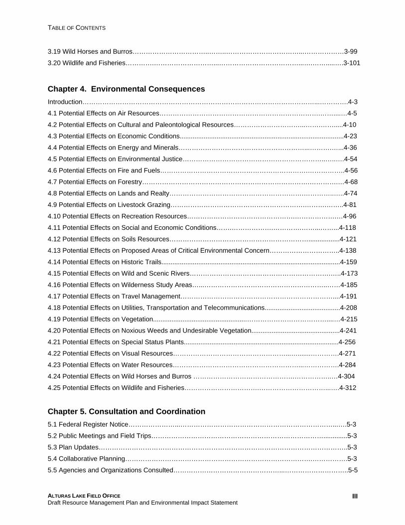
TABLE OF CONTENTS
3.19 Wild Horses and Burros……………………………..……..……………………………...………………3-99
3.20 Wildlife and Fisheries………….………………………...………………………………...….…….....….3-101
Chapter 4. Environmental Consequences Introduction……………………………………………………………………………………………...………….4-3
4.1 Potential Effects on Air Resources……………………………………………………………….……....…4-5
4.2 Potential Effects on Cultural and Paleontological Resources…………………………...…….…….....4-10
4.3 Potential Effects on Economic Conditions.........................................................................................4-23
4.4 Potential Effects on Energy and Minerals…………………………………………………...……….…...4-36
4.5 Potential Effects on Environmental Justice………………………………………………………..…..….4-54
4.6 Potential Effects on Fire and Fuels………………………………………………………….……………..4-56
4.7 Potential Effects on Forestry………………………………………………………………….………….…4-68
4.8 Potential Effects on Lands and Realty…………………………………………………….…………..…..4-74
4.9 Potential Effects on Livestock Grazing…………………………………………………….……….……..4-81
4.10 Potential Effects on Recreation Resources………………………………………….……………….…4-96
4.11 Potential Effects on Social and Economic Conditions…….……………….………….……...……...4-118
4.12 Potential Effects on Soils Resources……………………………………………………….................4-121
4.13 Potential Effects on Proposed Areas of Critical Environmental Concern…………………………..4-138
4.14 Potential Effects on Historic Trails.................................................................................................4-159
4.15 Potential Effects on Wild and Scenic Rivers……………………………………………………….…..4-173
4.16 Potential Effects on Wilderness Study Areas…...………………………………………………..……4-185
4.17 Potential Effects on Travel Management……………………………………………………………....4-191
4.18 Potential Effects on Utilities, Transportation and Telecommunications.........................................4-208
4.19 Potential Effects on Vegetation...................................................………………………………....…4-215
4.20 Potential Effects on Noxious Weeds and Undesirable Vegetation................................................4-241
4.21 Potential Effects on Special Status Plants....................................................................................4-256
4.22 Potential Effects on Visual Resources……………………………………………...….......………….4-271
4.23 Potential Effects on Water Resources…………………………………………………...…………….4-284
4.24 Potential Effects on Wild Horses and Burros ……………………………………….……………..…4-304
4.25 Potential Effects on Wildlife and Fisheries…………………………….…………………………...….4-312
Chapter 5. Consultation and Coordination 5.1 Federal Register Notice…………………...……………………………………………………………...….5-3
5.2 Public Meetings and Field Trips…………………………………………………………………….............5-3
5.3 Plan Updates…………………………………………………………………………………………………..5-3
5.4 Collaborative Planning………………………………………………………………………….…………….5-3
5.5 Agencies and Organizations Consulted…………………………………………...………………………..5-5
ALTURAS LAKE FIELD OFFICE Draft Resource Management Plan and Environmental Impact Statement
III
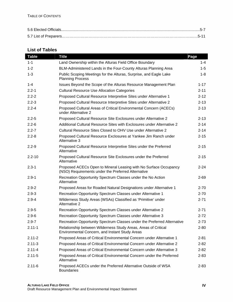
TABLE OF CONTENTS
5.6 Elected Officials...................................................................................................................................5-7
5.7 List of Preparers…………………………………….…………………………………………….……...….5-11
List of Tables Table Title Page 1-1 Land Ownership within the Alturas Field Office Boundary 1-4 1-2 BLM-Administered Lands in the Four-County Alturas Planning Area 1-5 1-3 Public Scoping Meetings for the Alturas, Surprise, and Eagle Lake 1-8
Planning Process 1-4 Issues Beyond the Scope of the Alturas Resource Management Plan 1-17 2.2-1 Cultural Resource Use Allocation Categories 2-11 2.2-2 Proposed Cultural Resource Interpretive Sites under Alternative 1 2-12 2.2-3 Proposed Cultural Resource Interpretive Sites under Alternative 2 2-13 2.2-4 Proposed Cultural Areas of Critical Environmental Concern (ACECs) 2-13
under Alternative 2 2.2-5 Proposed Cultural Resource Site Exclosures under Alternative 2 2-13 2.2-6 Additional Cultural Resource Sites with Exclosures under Alternative 2 2-14 2.2-7 Cultural Resource Sites Closed to OHV Use under Alternative 2 2-14 2.2-8 Proposed Cultural Resource Exclosures at Yankee Jim Ranch under 2-15
Alternative 3 2.2-9 Proposed Cultural Resource Interpretive Sites under the Preferred 2-15
Alternative 2.2-10 Proposed Cultural Resource Site Exclosures under the Preferred 2-15
Alternative 2.3-1 Proposed ACECs Open to Mineral Leasing with No Surface Occupancy 2-24
(NSO) Requirements under the Preferred Alternative 2.9-1 Recreation Opportunity Spectrum Classes under the No Action 2-69
Alternative 2.9-2 Proposed Areas for Roaded Natural Designations under Alternative 1 2-70 2.9-3 Recreation Opportunity Spectrum Classes under Alternative 1 2-70 2.9-4 Wilderness Study Areas (WSAs) Classified as ‘Primitive’ under 2-71
Alternative 2 2.9-5 Recreation Opportunity Spectrum Classes under Alternative 2 2-71 2.9-6 Recreation Opportunity Spectrum Classes under Alternative 3 2-72 2.9-7 Recreation Opportunity Spectrum Classes under the Preferred Alternative 2-73 2.11-1 Relationship between Wilderness Study Areas, Areas of Critical 2-80
Environmental Concern, and Instant Study Areas 2.11-2 Proposed Areas of Critical Environmental Concern under Alternative 1 2-81 2.11-3 Proposed Areas of Critical Environmental Concern under Alternative 2 2-82 2.11-4 Proposed Areas of Critical Environmental Concern under Alternative 3 2-82 2.11-5 Proposed Areas of Critical Environmental Concern under the Preferred 2-83
Alternative 2.11-6 Proposed ACECs under the Preferred Alternative Outside of WSA 2-83
Boundaries
ALTURAS LAKE FIELD OFFICE Draft Resource Management Plan and Environmental Impact Statement
IV
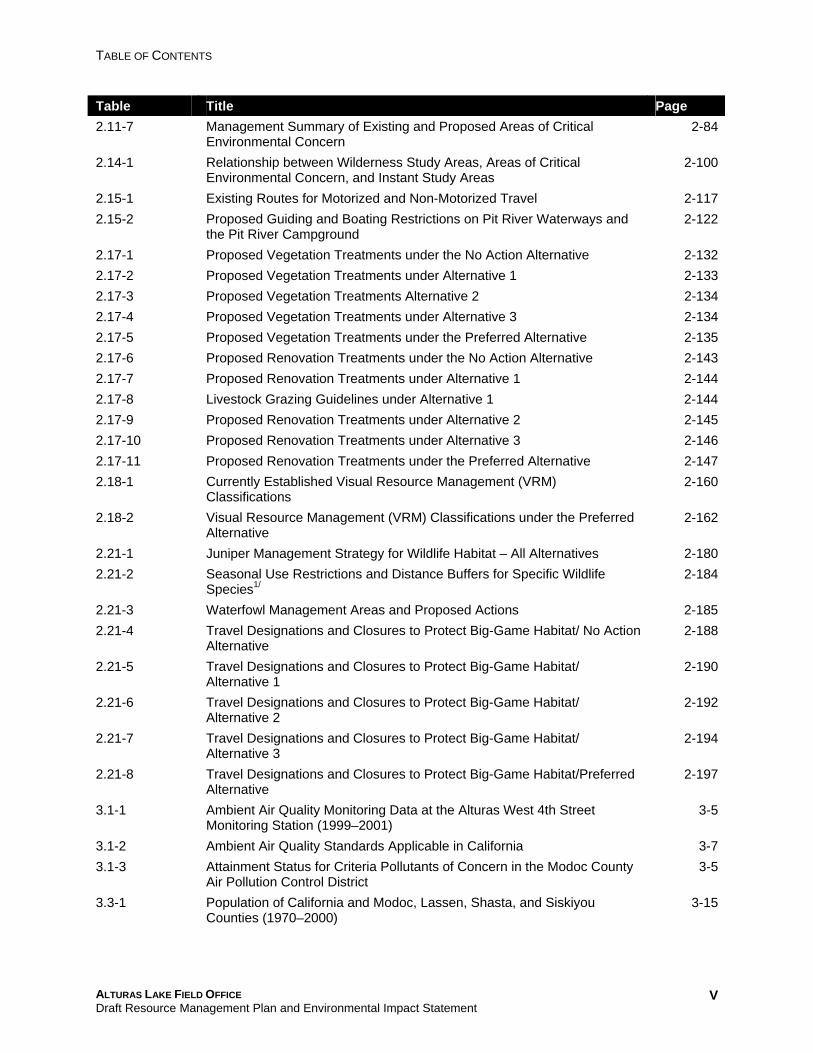
TABLE OF CONTENTS
Table Title Page 2.11-7 Management Summary of Existing and Proposed Areas of Critical 2-84
Environmental Concern 2.14-1 Relationship between Wilderness Study Areas, Areas of Critical 2-100
Environmental Concern, and Instant Study Areas 2.15-1 Existing Routes for Motorized and Non-Motorized Travel 2-117 2.15-2 Proposed Guiding and Boating Restrictions on Pit River Waterways and 2-122
the Pit River Campground 2.17-1 Proposed Vegetation Treatments under the No Action Alternative 2-132 2.17-2 Proposed Vegetation Treatments under Alternative 1 2-133 2.17-3 Proposed Vegetation Treatments Alternative 2 2-134 2.17-4 Proposed Vegetation Treatments under Alternative 3 2-134 2.17-5 Proposed Vegetation Treatments under the Preferred Alternative 2-135 2.17-6 Proposed Renovation Treatments under the No Action Alternative 2-143 2.17-7 Proposed Renovation Treatments under Alternative 1 2-144 2.17-8 Livestock Grazing Guidelines under Alternative 1 2-144 2.17-9 Proposed Renovation Treatments under Alternative 2 2-145 2.17-10 Proposed Renovation Treatments under Alternative 3 2-146 2.17-11 Proposed Renovation Treatments under the Preferred Alternative 2-147 2.18-1 Currently Established Visual Resource Management (VRM) 2-160
Classifications 2.18-2 Visual Resource Management (VRM) Classifications under the Preferred 2-162
Alternative 2.21-1 Juniper Management Strategy for Wildlife Habitat – All Alternatives 2-180 2.21-2 Seasonal Use Restrictions and Distance Buffers for Specific Wildlife
Species1/ 2-184
2.21-3 Waterfowl Management Areas and Proposed Actions 2-185 2.21-4 Travel Designations and Closures to Protect Big-Game Habitat/ No Action 2-188
Alternative 2.21-5 Travel Designations and Closures to Protect Big-Game Habitat/ 2-190
Alternative 1 2.21-6 Travel Designations and Closures to Protect Big-Game Habitat/ 2-192
Alternative 2 2.21-7 Travel Designations and Closures to Protect Big-Game Habitat/ 2-194
Alternative 3 2.21-8 Travel Designations and Closures to Protect Big-Game Habitat/Preferred 2-197
Alternative 3.1-1 Ambient Air Quality Monitoring Data at the Alturas West 4th Street 3-5
Monitoring Station (1999–2001) 3.1-2 Ambient Air Quality Standards Applicable in California 3-7 3.1-3 Attainment Status for Criteria Pollutants of Concern in the Modoc County 3-5
Air Pollution Control District 3.3-1 Population of California and Modoc, Lassen, Shasta, and Siskiyou 3-15
Counties (1970–2000)
ALTURAS LAKE FIELD OFFICE Draft Resource Management Plan and Environmental Impact Statement
V
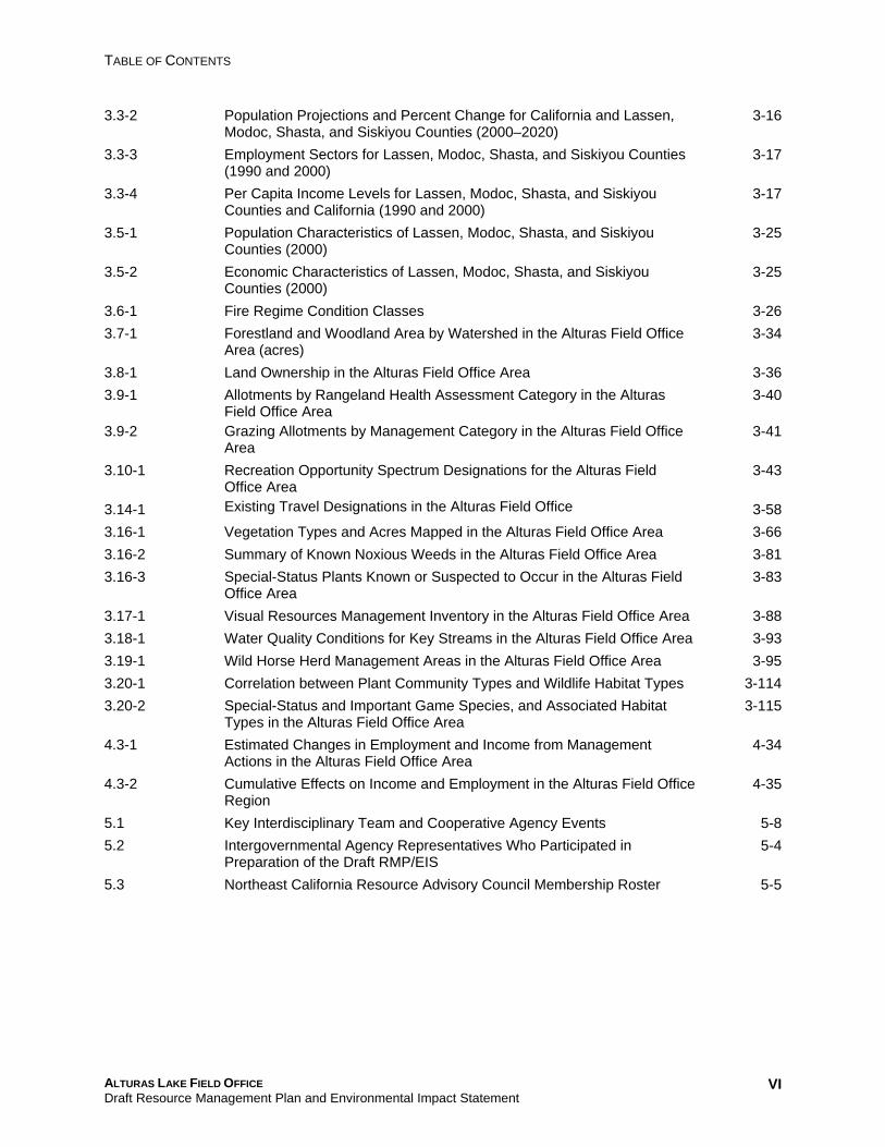
TABLE OF CONTENTS
3.3-2 Population Projections and Percent Change for California and Lassen, 3-16 Modoc, Shasta, and Siskiyou Counties (2000–2020)
3.3-3 Employment Sectors for Lassen, Modoc, Shasta, and Siskiyou Counties 3-17 (1990 and 2000)
3.3-4 Per Capita Income Levels for Lassen, Modoc, Shasta, and Siskiyou 3-17 Counties and California (1990 and 2000)
3.5-1 Population Characteristics of Lassen, Modoc, Shasta, and Siskiyou 3-25 Counties (2000)
3.5-2 Economic Characteristics of Lassen, Modoc, Shasta, and Siskiyou 3-25 Counties (2000)
3.6-1 Fire Regime Condition Classes 3-26
3.7-1 Forestland and Woodland Area by Watershed in the Alturas Field Office 3-34 Area (acres)
3.8-1 Land Ownership in the Alturas Field Office Area 3-36
3.9-1 Allotments by Rangeland Health Assessment Category in the Alturas 3-40 Field Office Area
3.9-2 Grazing Allotments by Management Category in the Alturas Field Office 3-41 Area
3.10-1 Recreation Opportunity Spectrum Designations for the Alturas Field 3-43 Office Area
3.14-1 Existing Travel Designations in the Alturas Field Office 3-58
3.16-1 Vegetation Types and Acres Mapped in the Alturas Field Office Area 3-66
3.16-2 Summary of Known Noxious Weeds in the Alturas Field Office Area 3-81
3.16-3 Special-Status Plants Known or Suspected to Occur in the Alturas Field 3-83 Office Area
3.17-1 Visual Resources Management Inventory in the Alturas Field Office Area 3-88
3.18-1 Water Quality Conditions for Key Streams in the Alturas Field Office Area 3-93
3.19-1 Wild Horse Herd Management Areas in the Alturas Field Office Area 3-95
3.20-1 Correlation between Plant Community Types and Wildlife Habitat Types 3-114
3.20-2 Special-Status and Important Game Species, and Associated Habitat 3-115 Types in the Alturas Field Office Area
4.3-1 Estimated Changes in Employment and Income from Management 4-34 Actions in the Alturas Field Office Area
4.3-2 Cumulative Effects on Income and Employment in the Alturas Field Office 4-35 Region
5.1 Key Interdisciplinary Team and Cooperative Agency Events 5-8
5.2 Intergovernmental Agency Representatives Who Participated in 5-4 Preparation of the Draft RMP/EIS
5.3 Northeast California Resource Advisory Council Membership Roster 5-5
ALTURAS LAKE FIELD OFFICE Draft Resource Management Plan and Environmental Impact Statement
VI
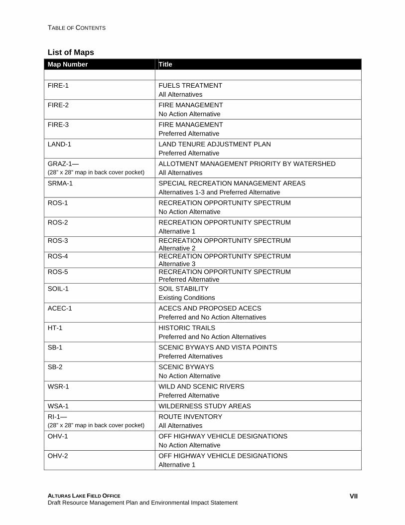
TABLE OF CONTENTS
List of Maps Map Number Title ARCH-1 CULTURAL RESOURCES SENSITIVITY AREAS FIRE-1 FUELS TREATMENT
All Alternatives FIRE-2 FIRE MANAGEMENT
No Action Alternative FIRE-3 FIRE MANAGEMENT
Preferred Alternative LAND-1 LAND TENURE ADJUSTMENT PLAN
Preferred Alternative GRAZ-1— (28” x 28” map in back cover pocket)
ALLOTMENT MANAGEMENT PRIORITY BY WATERSHED All Alternatives
SRMA-1 SPECIAL RECREATION MANAGEMENT AREAS Alternatives 1-3 and Preferred Alternative
ROS-1 RECREATION OPPORTUNITY SPECTRUM No Action Alternative
ROS-2 RECREATION OPPORTUNITY SPECTRUM Alternative 1
ROS-3 RECREATION OPPORTUNITY SPECTRUM Alternative 2
ROS-4 RECREATION OPPORTUNITY SPECTRUM Alternative 3
ROS-5 RECREATION OPPORTUNITY SPECTRUM Preferred Alternative
SOIL-1 SOIL STABILITY Existing Conditions
ACEC-1 ACECS AND PROPOSED ACECS Preferred and No Action Alternatives
HT-1 HISTORIC TRAILS Preferred and No Action Alternatives
SB-1 SCENIC BYWAYS AND VISTA POINTS Preferred Alternatives
SB-2 SCENIC BYWAYS No Action Alternative
WSR-1 WILD AND SCENIC RIVERS Preferred Alternative
WSA-1 WILDERNESS STUDY AREAS RI-1— (28” x 28” map in back cover pocket)
ROUTE INVENTORY All Alternatives
OHV-1 OFF HIGHWAY VEHICLE DESIGNATIONS No Action Alternative
OHV-2 OFF HIGHWAY VEHICLE DESIGNATIONS Alternative 1
ALTURAS LAKE FIELD OFFICE Draft Resource Management Plan and Environmental Impact Statement
VII
TABLE OF CONTENTS
OHV-3 OFF HIGHWAY VEHICLE DESIGNATIONS Alternative 2
OHV-4 OFF HIGHWAY VEHICLE DESIGNATIONS Alternative 3
OHV-5 OFF HIGHWAY VEHICLE DESIGNATIONS Preferred Alternative
VEG-1— (28” x 28” map in back cover pocket)
VEGETATION TYPES All Alternatives
VEG-2 NOXIOUS WEEDS All Alternatives
VEG-3 SPECIAL STATUS PLANTS All Alternatives
VRM-1 VISUAL RESOURCE MANAGEMENT All Alternatives
WATER-1 WATER QUALITY AND RIPARIAN FUNCTIONAL ASSESSMENT Existing Condition
WHB-1 WILD HORSE & BURRO HERD MANAGEMENT AREAS All Alternatives
WILD-1 OCCUPIED AND DESIGNATED CRITICAL HABITAT FOR MODOC SUCKER All Alternatives
WILD-2a WATERFOWL MANAGEMENT All Alternatives
WILD-2b WATERFOWL MANAGEMENT CONT. All Alternatives
WILD-3 DEER RANGE Preferred Alternative
WILD-4 ANTELOPE RANGE Preferred Alternative
WILD-5 WILDLIFE MANAGEMENT AREAS Alternatives 1,2, and Preferred Alternative
ALTURAS LAKE FIELD OFFICE Draft Resource Management Plan and Environmental Impact Statement
VIII
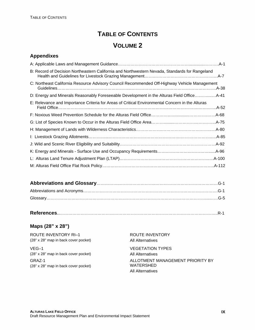
TABLE OF CONTENTS
TABLE OF CONTENTS
VOLUME 2 Appendixes A: Applicable Laws and Management Guidance…………………………………………….............………..A-1
B: Record of Decision Northeastern California and Northwestern Nevada, Standards for Rangeland Health and Guidelines for Livestock Grazing Management…….…………………………………….…A-7
C: Northeast California Resource Advisory Council Recommended Off-Highway Vehicle Management Guidelines……………………………………………...…………………………………………………….A-38
D: Energy and Minerals Reasonably Foreseeable Development in the Alturas Field Office………....…A-41
E: Relevance and Importance Criteria for Areas of Critical Environmental Concern in the Alturas Field Office…………………...…………………………..……………………………………….………….A-52
F: Noxious Weed Prevention Schedule for the Alturas Field Office…………..….............………….……A-68
G: List of Species Known to Occur in the Alturas Field Office Area……….........……………...…….…...A-75
H: Management of Lands with Wilderness Characteristics……………….……………………….……..…A-80
I: Livestock Grazing Allotments…………...…………………………………………….…………………..…A-85
J: Wild and Scenic River Eligibility and Suitability……………………………………………………………A-92
K: Energy and Minerals - Surface Use and Occupancy Requirements…….…………………………......A-96
L: Alturas Land Tenure Adjustment Plan (LTAP)………………………………………………………..…A-100
M: Alturas Field Office Flat Rock Policy…………………………….………………………………………..A-112
Abbreviations and Glossary……………..……………………..………………………………………G-1
Abbreviations and Acronyms…………………………………………………………………………………….G-1
Glossary………………………………….…………………………………………………………………...……G-5
References..…………………………………………………………………………….……………………..R-1
Maps (28” x 28”) ROUTE INVENTORY RI–1 ROUTE INVENTORY (28” x 28” map in back cover pocket) All Alternatives
VEG–1 VEGETATION TYPES (28” x 28” map in back cover pocket) All Alternatives GRAZ-1 ALLOTMENT MANAGEMENT PRIORITY BY (28” x 28” map in back cover pocket) WATERSHED
All Alternatives
ALTURAS LAKE FIELD OFFICE Draft Resource Management Plan and Environmental Impact Statement
IX


