page 1 of 12 Yakima County Public Services Department Planning Division Yakima County’s 2017 Review of its UGAs and Permitted Densities (as required by the Growth Management Act) Urban Growth Area for City of Sunnyside Staff Report Planning Commission Recommendation August 26, 2016 Staff contact: Noelle Madera, Senior Project Planner [email protected], (509) 574-2235 1. Introduction The Growth Management Act (GMA) provides: “(a) Each county that designates urban growth areas under RCW 36.70A.110 shall review, according to the schedules established in subsection (5) of this section, its designated urban growth area or areas, and the densities permitted within both the incorporated and unincorporated portions of each urban growth area. In conjunction with this review by the county, each city located within an urban growth area shall review the densities permitted within its boundaries, and the extent to which the urban growth occurring within the county has located within each city and the unincorporated portions of the urban growth areas. “(b) The county comprehensive plan designating urban growth areas, and the densities permitted in the urban growth areas by the comprehensive plans of the county and each city located within the urban growth areas, shall be revised to accommodate the urban growth projected to occur in the county for the succeeding twenty-year period …” [RCW 36.70A.130(3)] Subsection (5) of section RCW 36.70A.130 requires Yakima County and its cities to complete these UGA reviews and revisions by June 30, 2017. [RCW 36.70A.130(5)(c)] The mandates mentioned above are being met by two reports: a. Report 1 - Yakima County Population and Employment Projections and Allocations was issued on July 14, 2015 and establishes the number of people to accommodate in each of the County’s 14 UGAs in year 2040. Attachment 2 is the excerpt from Report 1 showing the population projections for Sunnyside. b. Report 2 – Land Capacity Analysis identifies the amount of land each of the County’s 14 cities has for future growth within their Urban Growth Areas. This staff report includes the Land Capacity for Sunnyside’s UGA (Attachment 3) and is part of Yakima County’s efforts to meet its obligations under the RCWs cited above. It constitutes a recommendation to the County Planning Commission as well as the County’s initial “show-your-work” exhibit as required by the GMA.
Transcript
page 1 of 12
Yakima County
Public Services Department
Planning Division
Yakima County’s 2017 Review of its UGAs and Permitted Densities
(as required by the Growth Management Act)
Urban Growth Area for
City of Sunnyside
Staff Report
Planning Commission Recommendation
August 26, 2016 Staff contact: Noelle Madera, Senior Project Planner
(5) Plan policy and other text amendments including capital facilities plans must be
consistent with the GMA, SMA, CWPP, other comprehensive plan goals and policies,
and, where applicable, city comprehensive plans and adopted inter-local agreements.
Findings: Not applicable. The changes to Sunnyside’s UGA are map amendments rather
than policy or text amendments.
(6) Prior to forwarding a proposed development regulation text amendment to the Planning
Commission for its docketing consideration, the Administrative Official must make a
determination that the proposed amendment is consistent with the GMA, CWPP, other
comprehensive plan goals and policies, and, where applicable, city comprehensive plans
and adopted inter-local agreements.
Findings: Not applicable. The changes to Sunnyside’s UGA are map amendments rather
than policy or text amendments.
7. Conclusions
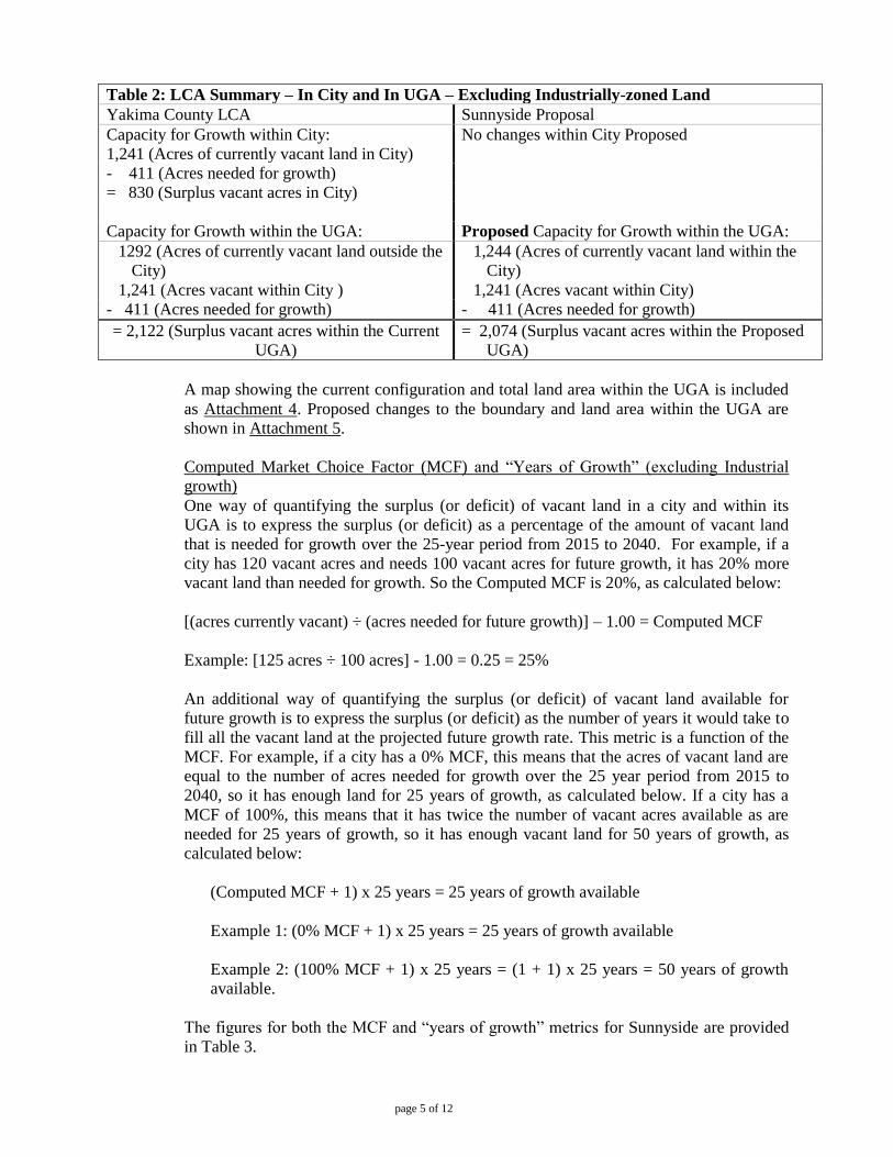
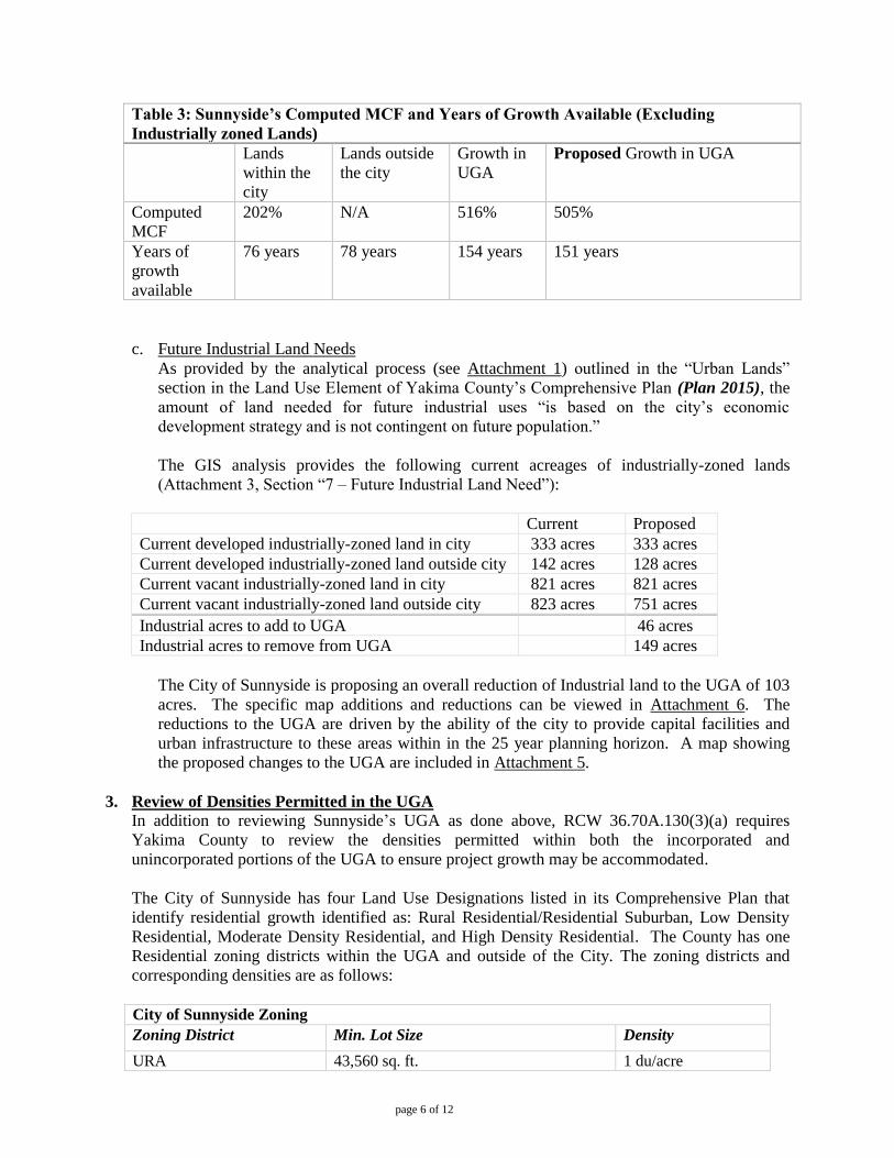
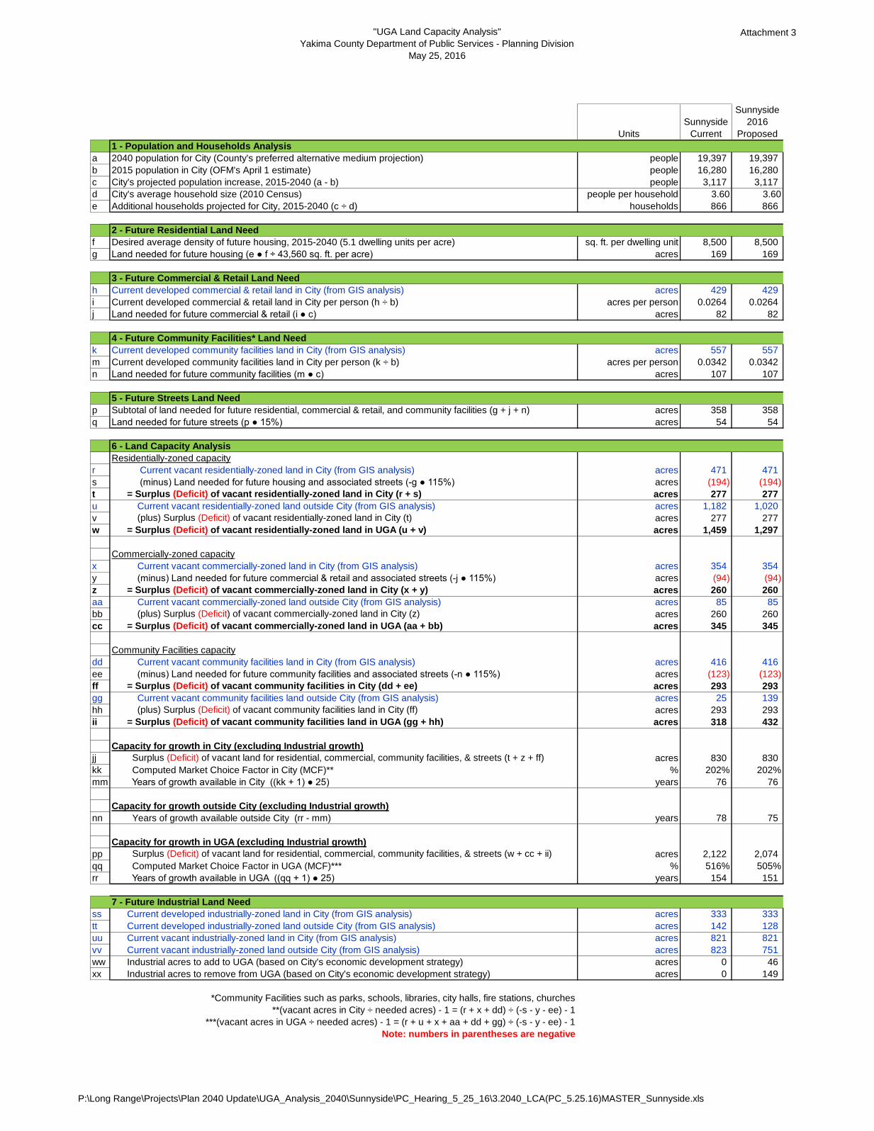
a. The County’s Land Capacity Analysis for Sunnyside calculates a surplus of 830 acres of
vacant land available for future growth (excluding industrial growth) in the City, which
presents available vacant land for 76 years of growth. The LCA calculates a surplus of 2,211
acres of vacant land available for future growth (excluding industrial growth) in the UGA,
which represent available vacant land for 154 years of growth. The City of Sunnyside’s
UGA proposal would represent a decrease in the vacant land available for future growth
(excluding industrial growth) of 48 acres representing available land for 151 years of growth.
The existing UGA is able to accommodate the densities and projected non-industrial growth
through 2040.
b. Sunnyside proposes to remove 149 acres of existing industrial land use designations from the
UGA because they have determined through Capital Facility Planning that those areas would
be too difficult to serve. They are proposing to include a 46 acre parcel into the UGA as
industrial land. This results in a net reduction of 103 acres of industrial land. This is in
alignment with their economic development strategy.
c. Given the Sunnyside proposal to begin bringing the UGA closer to 20-year growth needs and
their economic development strategy to remove industrial uses in the UGA based on capital
facilities planning, the changes proposed should be considered for approval.
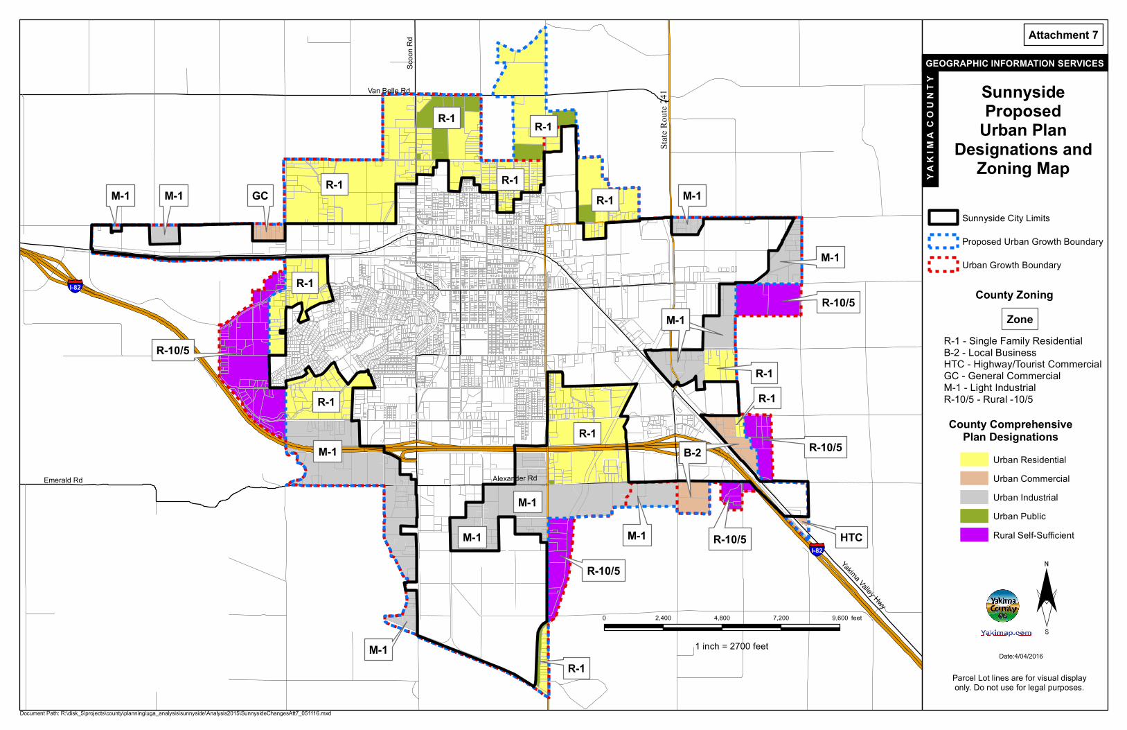
8. Recommendations a. Yakima County’s Future Land Use Designations will be applied to existing land within
Sunnyside’s UGA and land added to Sunnyside’s UGA (Attachment 7), along with
corresponding zoning districts.
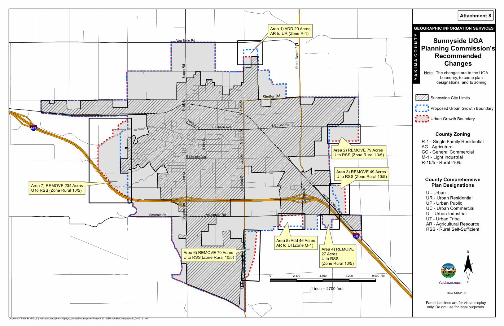
b. Yakima County planning staff recommendations to the City of Sunnyside’s proposed UGA
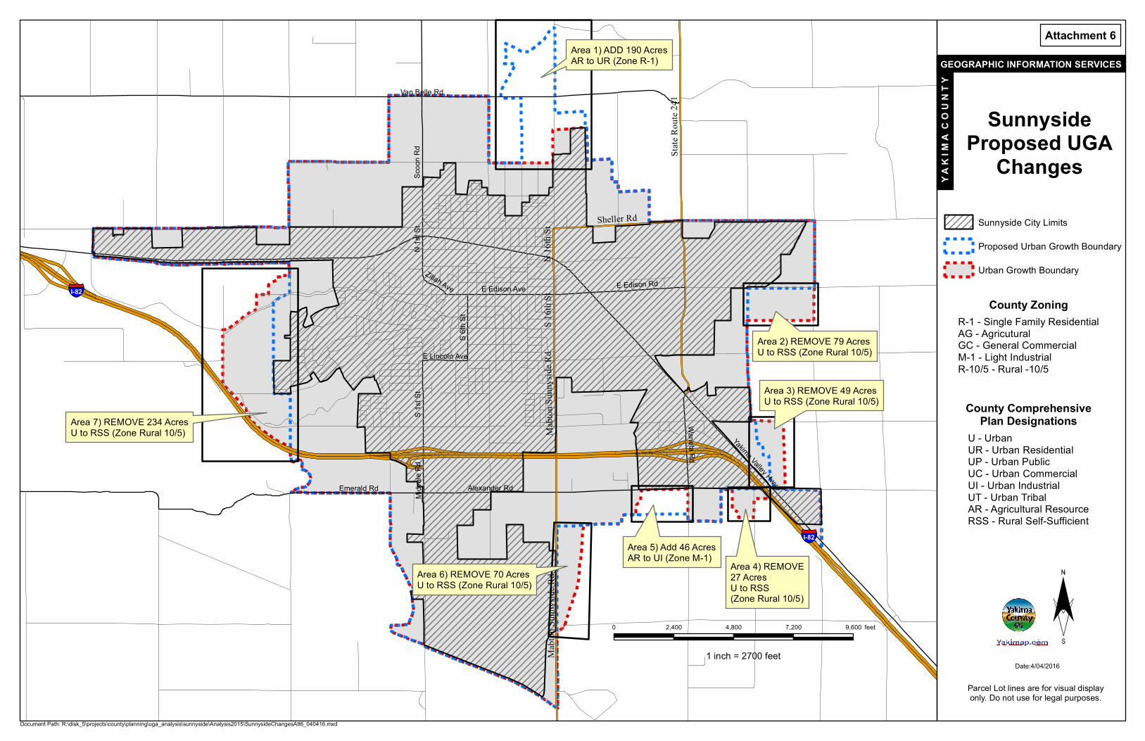
changes are outlined in the Table below: (A map showing each area is included as
Attachment 6.)
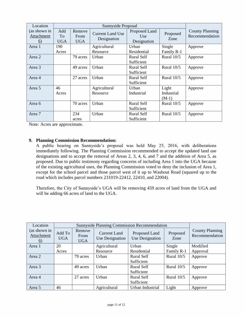
page 11 of 12
Location
(as shown in
Attachment
6)
Sunnyside Proposal
County Planning
Recommendation Add
To
UGA
Remove
From
UGA
Current Land Use
Designation
Proposed Land
Use
Designation
Proposed
Zone
Area 1 190
Acres
Agricultural
Resource
Urban
Residential
Single
Family R-1
Approve
Area 2 79 acres Urban Rural Self
Sufficient
Rural 10/5 Approve
Area 3 49 acres Urban Rural Self
Sufficient
Rural 10/5 Approve
Area 4 27 acres Urban Rural Self
Sufficient
Rural 10/5 Approve
Area 5 46
Acres
Agricultural
Resource
Urban
Industrial
Light
Industrial
(M-1)
Approve
Area 6 70 acres Urban Rural Self
Sufficient
Rural 10/5 Approve
Area 7 234
acres
Urban Rural Self
Sufficient
Rural 10/5 Approve
Note: Acres are approximate.
9. Planning Commission Recommendation:
A public hearing on Sunnyside’s proposal was held May 25, 2016, with deliberations
immediately following. The Planning Commission recommended to accept the updated land use
designations and to accept the removal of Areas 2, 3, 4, 6, and 7 and the addition of Area 5, as
proposed. Due to public testimony regarding concerns of including Area 1 into the UGA because
of the existing agricultural uses, the Planning Commission voted to deny the inclusion of Area 1,
except for the school parcel and those parcel west of it up to Washout Road (squared up to the
road which includes parcel numbers 231019-22412, 22410, and 22004).
Therefore, the City of Sunnyside’s UGA will be removing 459 acres of land from the UGA and
will be adding 66 acres of land to the UGA.
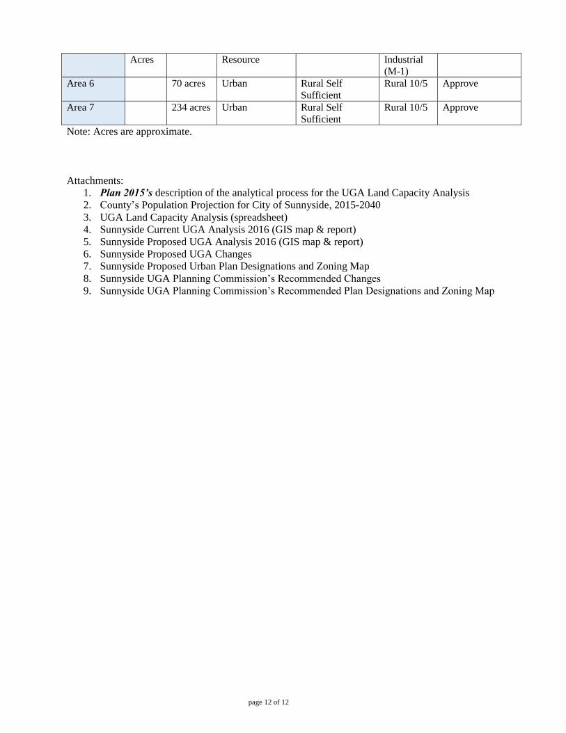
Location
(as shown in
Attachment
6)
Sunnyside Planning Commission Recommendation
County Planning
Recommendation Add To
UGA
Remove
From
UGA
Current Land
Use Designation
Proposed Land
Use Designation
Proposed
Zone
Area 1 20
Acres
Agricultural
Resource
Urban
Residential
Single
Family R-1
Modified
Approval
Area 2 79 acres Urban Rural Self
Sufficient
Rural 10/5 Approve
Area 3 49 acres Urban Rural Self
Sufficient
Rural 10/5 Approve
Area 4 27 acres Urban Rural Self
Sufficient
Rural 10/5 Approve
Area 5 46 Agricultural Urban Industrial Light Approve
page 12 of 12
Acres Resource Industrial
(M-1)
Area 6 70 acres Urban Rural Self
Sufficient
Rural 10/5 Approve
Area 7 234 acres Urban Rural Self
Sufficient
Rural 10/5 Approve
Note: Acres are approximate.
Attachments:
1. Plan 2015’s description of the analytical process for the UGA Land Capacity Analysis
2. County’s Population Projection for City of Sunnyside, 2015-2040
3. UGA Land Capacity Analysis (spreadsheet)
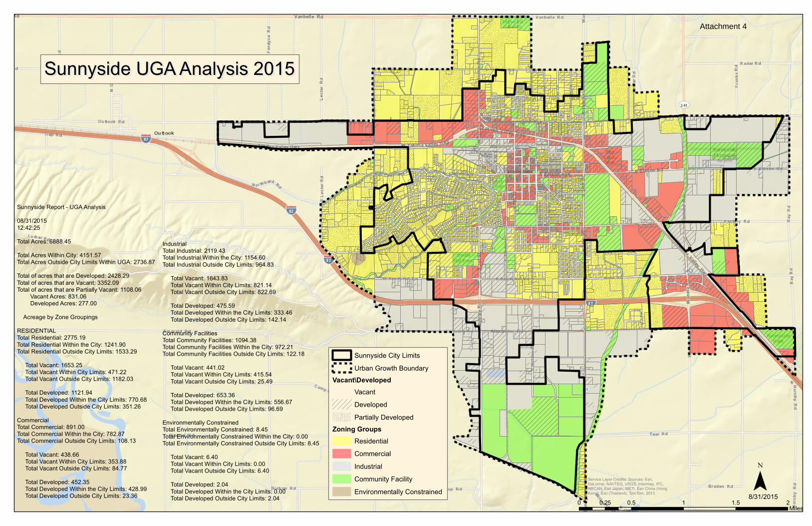
4. Sunnyside Current UGA Analysis 2016 (GIS map & report)
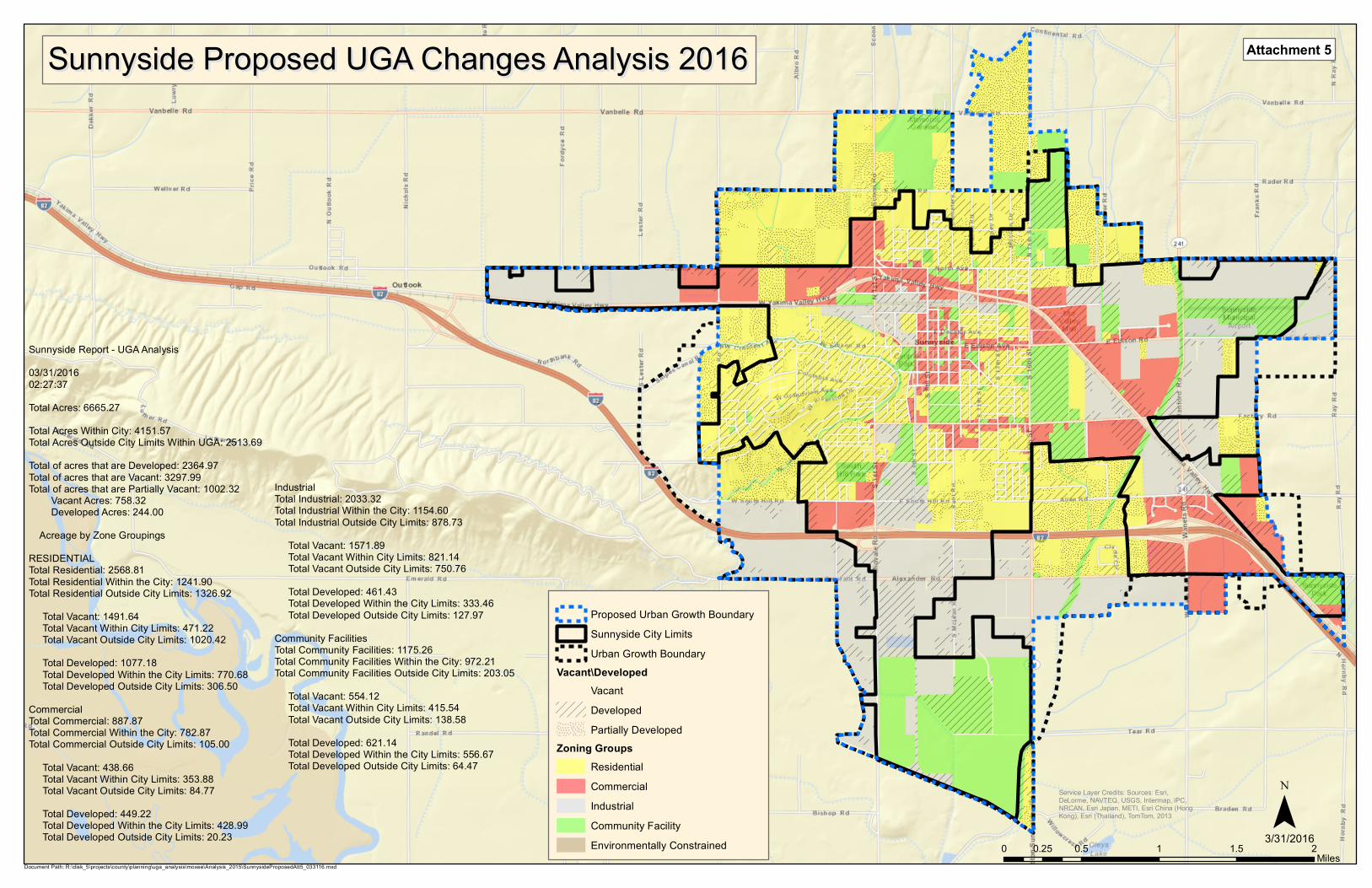
5. Sunnyside Proposed UGA Analysis 2016 (GIS map & report)
6. Sunnyside Proposed UGA Changes
7. Sunnyside Proposed Urban Plan Designations and Zoning Map
8. Sunnyside UGA Planning Commission’s Recommended Changes
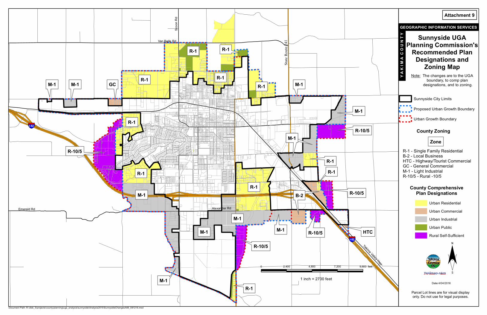
9. Sunnyside UGA Planning Commission’s Recommended Plan Designations and Zoning Map
Plan 2015 - Policy Plan Land Use
I-LU-6 May 1997;GMA Update December 2007
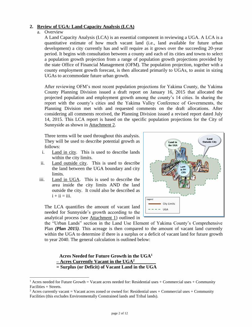
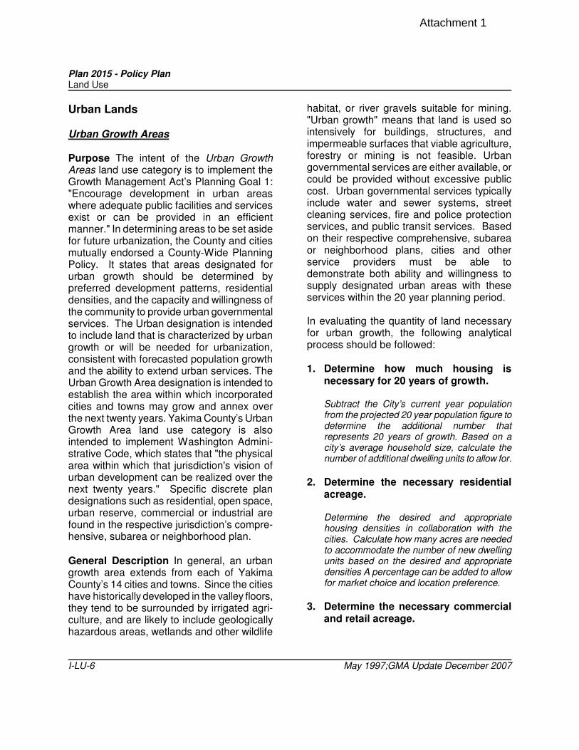
Urban Lands Urban Growth Areas Purpose The intent of the Urban Growth Areas land use category is to implement the Growth Management Act’s Planning Goal 1: "Encourage development in urban areas where adequate public facilities and services exist or can be provided in an efficient manner." In determining areas to be set aside for future urbanization, the County and cities mutually endorsed a County-Wide Planning Policy. It states that areas designated for urban growth should be determined by preferred development patterns, residential densities, and the capacity and willingness of the community to provide urban governmental services. The Urban designation is intended to include land that is characterized by urban growth or will be needed for urbanization, consistent with forecasted population growth and the ability to extend urban services. The Urban Growth Area designation is intended to establish the area within which incorporated cities and towns may grow and annex over the next twenty years. Yakima County’s Urban Growth Area land use category is also intended to implement Washington Admini-strative Code, which states that "the physical area within which that jurisdiction's vision of urban development can be realized over the next twenty years." Specific discrete plan designations such as residential, open space, urban reserve, commercial or industrial are found in the respective jurisdiction’s compre-hensive, subarea or neighborhood plan. General Description In general, an urban growth area extends from each of Yakima County’s 14 cities and towns. Since the cities have historically developed in the valley floors, they tend to be surrounded by irrigated agri-culture, and are likely to include geologically hazardous areas, wetlands and other wildlife
habitat, or river gravels suitable for mining. "Urban growth" means that land is used so intensively for buildings, structures, and impermeable surfaces that viable agriculture, forestry or mining is not feasible. Urban governmental services are either available, or could be provided without excessive public cost. Urban governmental services typically include water and sewer systems, street cleaning services, fire and police protection services, and public transit services. Based on their respective comprehensive, subarea or neighborhood plans, cities and other service providers must be able to demonstrate both ability and willingness to supply designated urban areas with these services within the 20 year planning period. In evaluating the quantity of land necessary for urban growth, the following analytical process should be followed: 1. Determine how much housing is
necessary for 20 years of growth. Subtract the City’s current year population from the projected 20 year population figure to determine the additional number that represents 20 years of growth. Based on a city’s average household size, calculate the number of additional dwelling units to allow for.
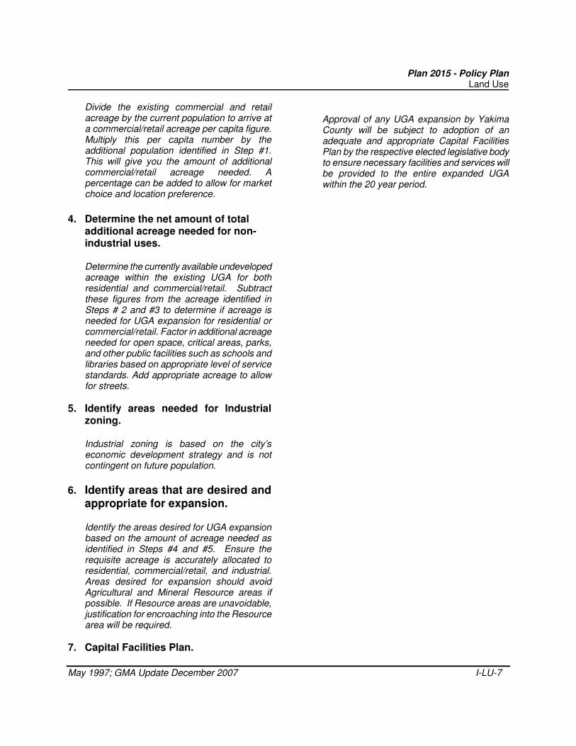
2. Determine the necessary residential
acreage.
Determine the desired and appropriate housing densities in collaboration with the cities. Calculate how many acres are needed to accommodate the number of new dwelling units based on the desired and appropriate densities A percentage can be added to allow for market choice and location preference.
3. Determine the necessary commercial
and retail acreage.
Attachment 1
Plan 2015 - Policy Plan Land Use
May 1997; GMA Update December 2007 I-LU-7
Divide the existing commercial and retail acreage by the current population to arrive at a commercial/retail acreage per capita figure. Multiply this per capita number by the additional population identified in Step #1. This will give you the amount of additional commercial/retail acreage needed. A percentage can be added to allow for market choice and location preference.
4. Determine the net amount of total
additional acreage needed for non-industrial uses.
Determine the currently available undeveloped acreage within the existing UGA for both residential and commercial/retail. Subtract these figures from the acreage identified in Steps # 2 and #3 to determine if acreage is needed for UGA expansion for residential or commercial/retail. Factor in additional acreage needed for open space, critical areas, parks, and other public facilities such as schools and libraries based on appropriate level of service standards. Add appropriate acreage to allow for streets.
5. Identify areas needed for Industrial zoning.
Industrial zoning is based on the city’s economic development strategy and is not contingent on future population.
6. Identify areas that are desired and appropriate for expansion.
Identify the areas desired for UGA expansion based on the amount of acreage needed as identified in Steps #4 and #5. Ensure the requisite acreage is accurately allocated to residential, commercial/retail, and industrial. Areas desired for expansion should avoid Agricultural and Mineral Resource areas if possible. If Resource areas are unavoidable, justification for encroaching into the Resource area will be required.
7. Capital Facilities Plan.
Approval of any UGA expansion by Yakima County will be subject to adoption of an adequate and appropriate Capital Facilities Plan by the respective elected legislative body to ensure necessary facilities and services will be provided to the entire expanded UGA within the 20 year period.
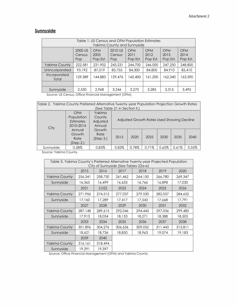
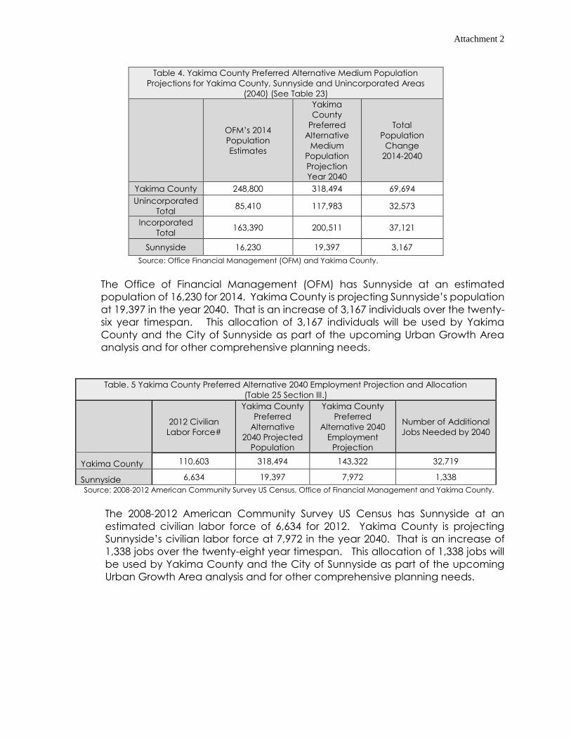
Attachment 2
Sunnyside
Table 1. US Census and OFM Population Estimates
Yakima County and Sunnyside
2000 US
Census
Pop
OFM
2005
Pop Est.
2010 US
Census
Pop
OFM
2011
Pop Est.
OFM
2012
Pop Est.
OFM
2013
Pop Est.
OFM
2014
Pop Est.
Yakima County 222,581 231,902 243,231 244,700 246,000 247,250 248,800
Sunnyside Report - UGA Analysis08/31/201512:42:25Total Acres: 6888.45Total Acres Within City: 4151.57Total Acres Outside City Limits Within UGA: 2736.87Total of acres that are Developed: 2428.29Total of acres that are Vacant: 3352.09Total of acres that are Partially Vacant: 1108.06 Vacant Acres: 831.06 Developed Acres: 277.00 Acreage by Zone GroupingsRESIDENTIALTotal Residential: 2775.19Total Residential Within the City: 1241.90Total Residential Outside City Limits: 1533.29 Total Vacant: 1653.25 Total Vacant Within City Limits: 471.22 Total Vacant Outside City Limits: 1182.03 Total Developed: 1121.94 Total Developed Within the City Limits: 770.68 Total Developed Outside City Limits: 351.26CommercialTotal Commercial: 891.00Total Commercial Within the City: 782.87Total Commercial Outside City Limits: 108.13 Total Vacant: 438.66 Total Vacant Within City Limits: 353.88 Total Vacant Outside City Limits: 84.77 Total Developed: 452.35 Total Developed Within the City Limits: 428.99 Total Developed Outside City Limits: 23.36
IndustrialTotal Industrial: 2119.43Total Industrial Within the City: 1154.60Total Industrial Outside City Limits: 964.83 Total Vacant: 1643.83 Total Vacant Within City Limits: 821.14 Total Vacant Outside City Limits: 822.69 Total Developed: 475.59 Total Developed Within the City Limits: 333.46 Total Developed Outside City Limits: 142.14Community FacilitiesTotal Community Facilities: 1094.38Total Community Facilities Within the City: 972.21Total Community Facilities Outside City Limits: 122.18 Total Vacant: 441.02 Total Vacant Within City Limits: 415.54 Total Vacant Outside City Limits: 25.49 Total Developed: 653.36 Total Developed Within the City Limits: 556.67 Total Developed Outside City Limits: 96.69Environmentally ConstrainedTotal Environmentally Constrained: 8.45Total Environmentally Constrained Within the City: 0.00Total Environmentally Constrained Outside City Limits: 8.45 Total Vacant: 6.40 Total Vacant Within City Limits: 0.00 Total Vacant Outside City Limits: 6.40 Total Developed: 2.04 Total Developed Within the City Limits: 0.00 Total Developed Outside City Limits: 2.04
Attachment 4
Sunnyside Proposed UGA Changes Analysis 2016Sunnyside Proposed UGA Changes Analysis 2016
0 0.5 1 1.5 20.25Miles
¯3/31/2016
Service Layer Credits: Sources: Esri,DeLorme, NAVTEQ, USGS, Intermap, iPC,NRCAN, Esri Japan, METI, Esri China (HongKong), Esri (Thailand), TomTom, 2013
Sunnyside Report - UGA Analysis03/31/201602:27:37Total Acres: 6665.27Total Acres Within City: 4151.57Total Acres Outside City Limits Within UGA: 2513.69Total of acres that are Developed: 2364.97Total of acres that are Vacant: 3297.99Total of acres that are Partially Vacant: 1002.32 Vacant Acres: 758.32 Developed Acres: 244.00 Acreage by Zone GroupingsRESIDENTIALTotal Residential: 2568.81Total Residential Within the City: 1241.90Total Residential Outside City Limits: 1326.92 Total Vacant: 1491.64 Total Vacant Within City Limits: 471.22 Total Vacant Outside City Limits: 1020.42 Total Developed: 1077.18 Total Developed Within the City Limits: 770.68 Total Developed Outside City Limits: 306.50CommercialTotal Commercial: 887.87Total Commercial Within the City: 782.87Total Commercial Outside City Limits: 105.00 Total Vacant: 438.66 Total Vacant Within City Limits: 353.88 Total Vacant Outside City Limits: 84.77 Total Developed: 449.22 Total Developed Within the City Limits: 428.99 Total Developed Outside City Limits: 20.23
IndustrialTotal Industrial: 2033.32Total Industrial Within the City: 1154.60Total Industrial Outside City Limits: 878.73 Total Vacant: 1571.89 Total Vacant Within City Limits: 821.14 Total Vacant Outside City Limits: 750.76 Total Developed: 461.43 Total Developed Within the City Limits: 333.46 Total Developed Outside City Limits: 127.97Community FacilitiesTotal Community Facilities: 1175.26Total Community Facilities Within the City: 972.21Total Community Facilities Outside City Limits: 203.05 Total Vacant: 554.12 Total Vacant Within City Limits: 415.54 Total Vacant Outside City Limits: 138.58 Total Developed: 621.14 Total Developed Within the City Limits: 556.67 Total Developed Outside City Limits: 64.47
Proposed Urban Growth BoundarySunnyside City LimitsUrban Growth Boundary
Vacant\DevelopedVacantDevelopedPartially Developed