212
Sunnyside Heights Neighbourhood Concept Plan Stage 2 Plan November 2010

Sunnyside Heights Neighbourhood Concept Plan
Stage 2 Plan November 2010

Sunnyside Heights Neighbourhood Concept Plan 2010
i
Sunnyside Heights Neighbourhood Concept Plan
Acknowledgements
The City of Surrey acknowledges the contributions and participation of the following
individuals and organizations through the preparation of this Neighbourhood Concept Plan: Citizens’ Advisory Committee
Ken A. Bailey Ray Long Bill Anderson Janice Melody
Richard Bury John Munro Connie Chow Suzanne Sigurdson
Rick Clough Frank Spanevello William Dobie Rob Velenosi
Steven Simonyi-Gindele Rusty Ward Joyce Gordon Sally Wassall
Roy Langton Hart Wellmeier George Lebl
Community Association and ALR Representatives to the CAC
Mark Layton Grandview Heights Residents' Association Fred Hubbick Fergus Creek Pocket Taxpayers' Association Ed Champion South Grandview Estates' Association
Elena Simerl South Grandview Residents' Together Dave Moffat Country Woods Residents' Association
Gary Scott West Grandview Heights Residents' Association Doreen Steckler Highway 99 Corridor Local Area Plan Area
Harry Trommel Agricultural Land Reserve

Sunnyside Heights Neighbourhood Concept Plan 2010
ii
City of Surrey Staff
Murray Dinwoodie
City Manager
Planning & Development
Jean Lamontagne General Manager, Planning & Development
Don Luymes Manager, Community Planning
Preet Heer Senior Planner / Project Manager
Hernan Bello Senior Planner/Urban Designer
Bhargav Parghi
Greg Mitchell
Senior Planner
Planner
Markus Kischnick
Fay Wong
Planning Technician II
Planning Technician II
Joe Waskito GIS Technician / CAD Drafter
Engineering
Vincent Lalonde General Manager, Engineering
Rémi Dubé Development Services Manager (Acting)
Jeannie Lee Project Engineer
Mira Petrovic Transportation Engineer
John Wilson Project Manager
Parks, Recreation and Cultural Services
Tiina Mack Manager, Parks Planning
Ted Uhrich Parks Planner
Consultants
Urban Systems Ltd. Fraser Smith
Fadum Consulting Mike Fadum
ENKON Environmental Glenn Stewart
Commonwealth Historic Resources
Management Limited
Hal Kalman
Hemmera Ruben Arellano

Sunnyside Heights Neighbourhood Concept Plan 2010
iii
Sunnyside Heights NCP Table of Contents
PART 1 : BACKGROUND .................................................................................................................. 1
1.1 INTRODUCTION ............................................................................................................................... 1
1.2 PLAN AREA ..................................................................................................................................... 3
1.3 PLANNING CONTEXT ........................................................................................................................ 4
1.3.1 Grandview Heights General Land Use Plan and NCPs ......................................................... 4 1.3.2 Official Community Plan ...................................................................................................... 5
1.3.3 Highway 99 Corridor Local Area Plan .................................................................................. 6 1.4 PLANNING PROCESS & CONSULTATION ............................................................................................... 7
1.5 SUSTAINABILITY ELEMENTS ................................................................................................................ 8
1.5.1 Connectivity ......................................................................................................................... 8 1.5.2 Diversity of Housing Form and Tenure ................................................................................ 8
1.5.3 Placemaking and Character ................................................................................................. 9 1.5.4 Employment Opportunities .................................................................................................. 9
1.5.5 Natural Environment Preservation .................................................................................... 10 1.5.6 Geoexchange Systems ....................................................................................................... 11
1.5.7 LED Street Lighting ............................................................................................................. 11
PART 2: PLANNING .......................................................................................................................... 12
2.1 PLANNING OBJECTIVES ....................................................................................................................... 12
2.2 PLANNING PRINCIPLES AND VISION ....................................................................................................... 13
2.2.1 General Land Use Plan Vision ............................................................................................ 13 2.2.3 Sunnyside Heights CAC- Guiding Principles ....................................................................... 14
2.3 THE LAND USE PLAN AND POLICIES ...................................................................................................... 15
2.3.1 Residential ......................................................................................................................... 15
2.3.2 Community Commercial .................................................................................................... 18 2.3.3 Institutional ........................................................................................................................ 20 2.3.4 Parks, Trails, Riparian Areas and Open Space ................................................................... 21
2.4 POPULATION AND DWELLING UNIT PROJECTIONS ................................................................................... 24
2.4.1 Residential ......................................................................................................................... 24

Sunnyside Heights Neighbourhood Concept Plan 2010
iv
2.4.2 Commercial ........................................................................................................................ 24 2.4.3 Institutional Uses and Schools ........................................................................................... 24
2.4.4 Parks and Open Space ....................................................................................................... 24 2.5 INTERFACE WITH ADJACENT LANDS ....................................................................................................... 26
2.5.1 Agricultural Land Reserve .................................................................................................. 26 2.5.2 Larger Suburban Acreage Parcels ...................................................................................... 26
2.5.2 Commercial and Business Park Uses .................................................................................. 27 2.5.3 Morgan Heights and Orchard Grove NCPs ........................................................................ 27
2.6 LAND CONSOLIDATION AREAS ............................................................................................................. 28
2.7 PLACEMAKING CONSIDERATIONS .......................................................................................................... 30
2.8 ENVIRONMENTAL ASSESSMENT ............................................................................................................ 32
2.8.1 Wildlife Corridors ............................................................................................................... 32
2.8.2 Significant Tree Patches ..................................................................................................... 32 2.8.3 Streams and Stream Classifications ................................................................................... 32
2.9 HISTORY AND HERITAGE OF GRANDVIEW HEIGHTS .................................................................................. 34
PART 3: DESIGN & DEVELOPMENT GUIDELINES ................................................................................. 36
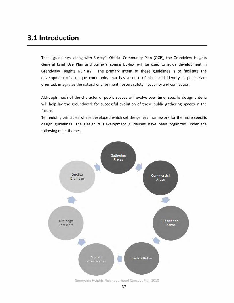
3.1 INTRODUCTION ................................................................................................................................. 37
3.2 DESIGN PRINCIPLES ............................................................................................................................ 38
3.3 COMMUNITY GATHERING SPACES ........................................................................................................ 39
3.3.1 Neighbourhood Square ...................................................................................................... 39 3.3.2 Parks & Open Space ........................................................................................................... 42
3.3.3 Landmarks & Entrance Markers ........................................................................................ 43 3.4 COMMERCIAL AREAS ...................................................................................................................... 47
3.4.1 Mixed-Use Development (Commercial Residential 25-45 upa) ......................................... 47 3.4.2 Small Scale Commercial ..................................................................................................... 49
3.5 RESIDENTIAL AREAS ....................................................................................................................... 50
3.5.1 Special Residential (15-25 upa) .......................................................................................... 50
3.5.2 Multiple Residential (30-45 upa) ....................................................................................... 51 3.5.3 Multiple Residential (15-25 upa) ....................................................................................... 53
3.5.4 Medium Density Residential (10-15 upa) .......................................................................... 54 3.5.5 Low Density Residential (6-10 upa) ................................................................................... 55 3.5.6 Urban Transitional Designation (Up to 8 upa) ................................................................... 55
Sunnyside Heights Neighbourhood Concept Plan 2010
v
3.5.7 Suburban Transitional (2-4 upa)& Suburban Residential (1-2 upa) ................................... 56 3.5.8 Cluster Areas ...................................................................................................................... 56
3.5 TRAILS AND BUFFERS ...................................................................................................................... 60
3.5.1 Grandview Ridge Trail ........................................................................................................ 60
3.5.2 - 168 Street Buffer .............................................................................................................. 64 3.6 STREETSCAPES ............................................................................................................................... 66
3.6.1 Treatment of Intersections at Trail Crossings .................................................................... 66 3.6.2 Roads Leading into Neighbourhood Square ...................................................................... 66
3.7 MULTI-USE DRAINAGE CORRIDORS ...................................................................................................... 67
3.7 MULTI-USE DRAINAGE CORRIDORS ...................................................................................................... 68
3.7.1 Five Metre Drainage Corridors .......................................................................................... 69 3.7.2 Ten Metre Drainage Corridors on 164th Street .................................................................. 71
3.7.3 Ten Metre Drainage Median Corridors .............................................................................. 71 3.7.4 Twenty Metre Drainage Corridors ..................................................................................... 72
3.7.3 Interface with Private Lands Abutting the Corridors ......................................................... 73 3.8 ON-SITE STORMWATER CONTROLS .............................................................................................. 74
3.8.1 Single-Family Residential Land Use ................................................................................... 74
3.8.2 Multi-Family Residential, Commercial, and Industrial Land Uses ..................................... 74
PART 4: ENGINEERING ..................................................................................................................... 76
4.1 SANITARY SEWER ............................................................................................................................... 76
4.1.1 Catchments ........................................................................................................................ 77
4.1.2 Sewer Design Guidelines and Sizing ................................................................................... 79 4.1.3 Catchment 1- Sanitary Sewer ............................................................................................ 80
4.1.4 Catchment 2 - Sanitary Sewer (Pumped) ........................................................................... 83 4.1.5 Cost Estimates and Financing Approach............................................................................ 87
4.1.6 Options and Implementation Issues Related to Funding the DCC Shortfall ....................... 90 4.1.7 10 Year Servicing Plan ........................................................................................................ 91
4.2 WATER DISTRIBUTION ........................................................................................................................ 92
4.2.1 Existing System .................................................................................................................. 92
4.2.2 Recent Supply System Improvements ................................................................................ 92 4.2.3 Proposed Supply System Improvements ............................................................................ 93 4.2.4 System Analysis .................................................................................................................. 95
4.2.5 Analysis Criteria and Pressure Zones ................................................................................. 95

Sunnyside Heights Neighbourhood Concept Plan 2010
vi
4.2.6 Hydraulic Analysis .............................................................................................................. 97 4.2.7 Discussion .......................................................................................................................... 98
4.2.8 Cost Estimates and Financing Approach.......................................................................... 100 4.2.9 Ten Year Servicing Plan .................................................................................................... 103
4.3 STORMWATER MANAGEMENT ........................................................................................................... 104
4.3.1 Study Area ........................................................................................................................ 104
4.3.2 Hydrologic / Hydraulic Model Development .................................................................... 114 4.3.3 Model Results .................................................................................................................. 122
4.3.4 Water Quality .................................................................................................................. 131 4.3.5 Proposed Stormwater Management Concept ................................................................. 135
4.3.6 Cost Estimates and Financing Approach.......................................................................... 147 4.3.7 Ten Year Servicing Plan .................................................................................................... 148
4.4 TRANSPORTATION ...................................................................................................................... 149
4.4.1 Introduction ..................................................................................................................... 149
4.4.2 Study Area ........................................................................................................................ 149 4.4.3 Current Traffic Conditions ................................................................................................ 155 4.4.4 Proposed Development .................................................................................................... 159
4.4.5 Future Transportation Network ....................................................................................... 167 4.4.6 Required Roadway Network Improvements .................................................................... 174
4.4.7 Cost Estimates and Financing Approach.......................................................................... 181 4.4.8 Ten Year Servicing Plan .................................................................................................... 183
4.5 UTILITIES (POWER, TELECOMMUNICATIONS, NATURAL GAS) .................................................................. 184
4.5.1 Power ............................................................................................................................... 184
4.5.2 Telecommunications/Cable ............................................................................................. 184 4.5.3 Natural Gas ...................................................................................................................... 184
4.6 DEVELOPMENT PHASING............................................................................................................... 185
4.7 INFRASTRUCTURE FINANCING AND FUNDING .................................................................................... 187
4.7.1 Financing Approach ......................................................................................................... 187 4.7.2 Financing Summary ......................................................................................................... 188
4.7.3 DCC Revenues and Expenditures...................................................................................... 188 4.7.4 Sanitary Sewer Pump Station and Force Main ................................................................ 189 4.7.5 Financing Drainage Corridors .......................................................................................... 190
PART 5: COMMUNITY SERVICES & AMENITIES ................................................................................ 193
5.1 SERVICES AND AMENITIES ................................................................................................................. 193

Sunnyside Heights Neighbourhood Concept Plan 2010
vii
5.1.1 Parkland Development .................................................................................................... 193 5.1.2 Library and Library Material ............................................................................................ 194
5.1.3 Fire and Police Protection ................................................................................................ 194 5.2 SUMMARY OF AMENITY FUNDING ARRANGEMENTS .............................................................................. 194
PART 6.0 IMPLEMENTATION ..................................................................................................... 196
6.1 OCP AMENDMENTS ......................................................................................................................... 196
6.2 REZONING ...................................................................................................................................... 196
6.3 SUBDIVISION ................................................................................................................................... 196
6.4 DEVELOPMENT PERMIT AREA GUIDELINES ........................................................................................... 197
6.5 DESIGN GUIDELINES ......................................................................................................................... 197
6.6 AMENITY CONTRIBUTIONS ................................................................................................................ 198
6.7 ZONING BY-LAW AMENDMENT .......................................................................................................... 198
6.8 NCP AMENDMENTS ......................................................................................................................... 198
APPENDICES ..................................................................................................................................... A
APPENDIX A.1 SANITARY SEWER .............................................................................................................. B
APPENDIX A.2 WATER ............................................................................................................................ C
APPENDIX A.3 STORMWATER MANAGEMENT ............................................................................................. D
APPENDIX A.4 TRANSPORTATION ............................................................................................................. E
APPENDIX B DCC REVENUE ESTIMATES ..................................................................................................... F

Sunnyside Heights Neighbourhood Concept Plan 2010
1
PART 1 : BACKGROUND
1.1 Introduction
The objective of this document is to outline the desired future land uses in Neighbourhood Area
#2 of Grandview Heights in south Surrey called Sunnyside Heights. This document describes the proposed land use designations and accompanying policies, design and development guidelines
that include place making and character defining elements as well as servicing strategy and a comprehensive financial plan. Together, these elements are intended to establish the foundation for the creation of a healthy and sustainable neighbourhood.
Planning for Sunnyside Heights began in the fall of 2005 and has been guided by a Citizens’
Advisory Committee (CAC). The CAC is a group of approximately 27 residents and community association representatives. The planning process has included consultation with other area
stakeholders and has been coordinated by City of Surrey staff.
Figure 1.1, the Land Use Concept Map, has been developed through extensive consultation with the CAC, City staff, project consultants, other stakeholders and the public. The intent of this
concept is to guide the development of a compact, environmentally friendly, and sustainable community.

Sunnyside Heights Neighbourhood Concept Plan 2010
2
Figure 1.1: Stage 2 Land Use Concept
Sunnyside Heights Neighbourhood Concept Plan 2010
3
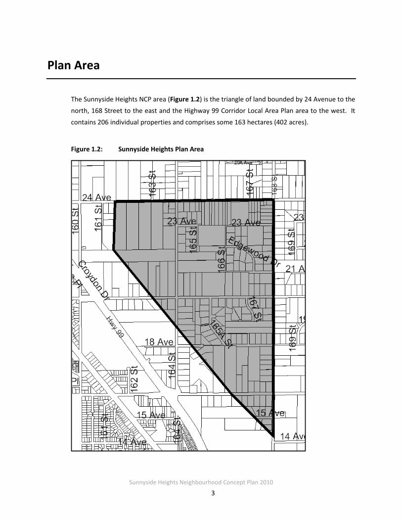
Plan Area
The Sunnyside Heights NCP area (Figure 1.2) is the triangle of land bounded by 24 Avenue to the north, 168 Street to the east and the Highway 99 Corridor Local Area Plan area to the west. It
contains 206 individual properties and comprises some 163 hectares (402 acres).
Figure 1.2: Sunnyside Heights Plan Area

Sunnyside Heights Neighbourhood Concept Plan 2010
4
1.2 Planning Context
1.3.1 Grandview Heights General Land Use Plan and NCPs
On June 30, 2005, Surrey City Council approved the Grandview Heights General Land Use Plan,
which provides the broad land use and servicing concept for the overall Grandview Heights area. The plan sets out a vision for Grandview Heights as a complete community with a mix of
residential densities, small commercial nodes, community facilities, schools, parks, pathways, trees and protected areas.
Figure 1.3 shows the Sunnyside Heights (outlined in red) in relation to the larger Grandview Heights General Land Use Plan.
Figure1.3: Grandview Heights General Land Use Plan (GLUP)

Sunnyside Heights Neighbourhood Concept Plan 2010
5
The General Land Use Plan defines the boundaries for five separate NCP areas (Figure 1.4).
Surrey City Council authorized the preparation of a Terms of Reference for Neighbourhood Concept Plan (NCP) #2 in Grandview Heights on April 4, 2005. Council approved the first NCP,
Morgan Heights, in September 2006.
Figure 1.4 Grandview Heights GLUP Sub Areas
1.3.2 Official Community Plan
The entire NCP area, Sunnyside Heights, is designated Suburban in the City of Surrey’s Official
Community Plan. This designation provides for a maximum residential density of one unit per acre. The OCP also states that for Suburban designated lands indicated as having potential for
urban, commercial, business or industrial development, the minimum lot area for subdivision is 0.8 hectare (2 acres).
Sunnyside Heights Neighbourhood Concept Plan 2010
6
1.3.3 Highway 99 Corridor Local Area Plan
The Highway 99 Corridor Land Use Plan borders Sunnyside Heights to the west and provides for
future commercial, Business Park and light industrial uses. The commercial node at160 Street and 24 Avenue, will ultimately contain up to 1.5 million square feet of commercial and services uses at full build-out. The southern part of the plan area contains an important Habitat
Preservation Area associated with Fergus Creek - a Class A fish bearing watercourse.
The Highway 99 Plan will provide a substantial buffer along its eastern boundary. The Sunnyside Heights process has explored mechanisms to ensure for appropriate buffering, linkages and
transitions related to new residential development, including links to the Pioneer Greenway, as well as access and landscaping at the detention pond south of the future Superstore site.

Sunnyside Heights Neighbourhood Concept Plan 2010
7
1.3 Planning Process & Consultation
The planning process for Sunnyside Heights has included meetings with the Citizens’ Advisory Committee, Interagency meetings, and Public Open Houses. Key points in the process include:
Sunnyside Heights Stage 1 Process:
• A Suburban and Transitional Property Owners’ Meeting on May 2, 2006;
• Inter-agency meetings on September 12, 2005 and October 23, 2006 and electronic
circulation of the preferred land use concept on June 26 2007;
• A meeting with the members of the original Grandview Heights General Land Use Plan
CAC on November 8, 2006;
• Meetings with all the Agricultural and Environmental Advisory Committees and the
Heritage Advisory Commission;
• Three public open houses; and
• Numerous site visits, discussions with area residents, and interested stakeholders.
Sunnyside Heights Stage 2 Process:
• Ongoing consultation with CAC and stakeholder groups
• Open House May 18, 2010
Sunnyside Heights Neighbourhood Concept Plan 2010
8
1.4 Sustainability Elements
Sustainability principles and features have been incorporated into the Sunnyside Heights NCP. The NCP framework provides for walkability and inter-connection, places for community
gathering and social interaction, diversity of housing form and tenure, protection of biodiversity through riparian area protection, and drainage systems that mimic natural infiltration. These
elements are described in more detail below.
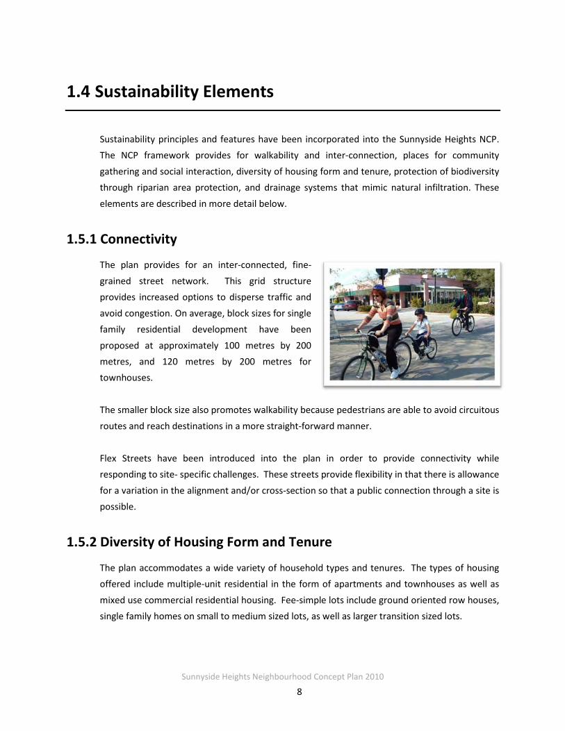
1.5.1 Connectivity
The plan provides for an inter-connected, fine-
grained street network. This grid structure provides increased options to disperse traffic and
avoid congestion. On average, block sizes for single family residential development have been
proposed at approximately 100 metres by 200 metres, and 120 metres by 200 metres for townhouses.
The smaller block size also promotes walkability because pedestrians are able to avoid circuitous
routes and reach destinations in a more straight-forward manner.
Flex Streets have been introduced into the plan in order to provide connectivity while responding to site- specific challenges. These streets provide flexibility in that there is allowance
for a variation in the alignment and/or cross-section so that a public connection through a site is possible.
1.5.2 Diversity of Housing Form and Tenure
The plan accommodates a wide variety of household types and tenures. The types of housing offered include multiple-unit residential in the form of apartments and townhouses as well as
mixed use commercial residential housing. Fee-simple lots include ground oriented row houses, single family homes on small to medium sized lots, as well as larger transition sized lots.
Sunnyside Heights Neighbourhood Concept Plan 2010
9
To allow for affordable rental suites, small-lot single family homes will be able to accommodate either a secondary suite or coach house. Smaller unit sizes will be provided through apartments.
1.5.3 Placemaking and Character
Creating places for community interaction was an important consideration when developing the land use plan. Several elements were used to contribute to the social realm and provide civic
focal points.
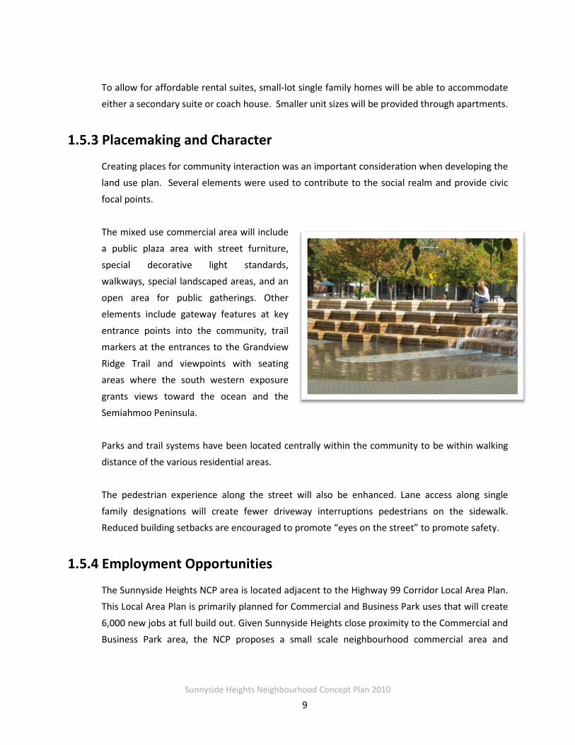
The mixed use commercial area will include a public plaza area with street furniture,
special decorative light standards, walkways, special landscaped areas, and an
open area for public gatherings. Other elements include gateway features at key
entrance points into the community, trail markers at the entrances to the Grandview
Ridge Trail and viewpoints with seating areas where the south western exposure
grants views toward the ocean and the Semiahmoo Peninsula.
Parks and trail systems have been located centrally within the community to be within walking distance of the various residential areas.
The pedestrian experience along the street will also be enhanced. Lane access along single
family designations will create fewer driveway interruptions pedestrians on the sidewalk. Reduced building setbacks are encouraged to promote “eyes on the street” to promote safety.
1.5.4 Employment Opportunities
The Sunnyside Heights NCP area is located adjacent to the Highway 99 Corridor Local Area Plan. This Local Area Plan is primarily planned for Commercial and Business Park uses that will create
6,000 new jobs at full build out. Given Sunnyside Heights close proximity to the Commercial and Business Park area, the NCP proposes a small scale neighbourhood commercial area and
Sunnyside Heights Neighbourhood Concept Plan 2010
10
another mixed use commercial development. The residential areas in the NCP will support the employment lands in the Highway 99 Corridor.
Opportunities for live/work have been introduced into the plan through the Special Residential"
Designation. This land use offers a flexible type of development that permits limited and voluntary retail or service commercial uses on the ground floor of a townhouse unit.
1.5.5 Natural Environment Preservation
The green infrastructure of the plan includes system of Parks, Riparian area, Trail, and Cluster Residential Designations and sustainable drainage features.
A riparian area is located along the 164th Street unopened road right-of-way. A Class B
watercourse is located within the riparian area. This area will be preserved through 30-metre setbacks on the development parcels to each side of the watercourse.
In addition to Park acquisition areas, Cluster Residential Designations have been used in key
areas of the plan to allow for the retention of valuable trees stands. The Cluster Designation aims for a 30-40% preservation of open space in exchange for higher densities on the
developable portions of the site.
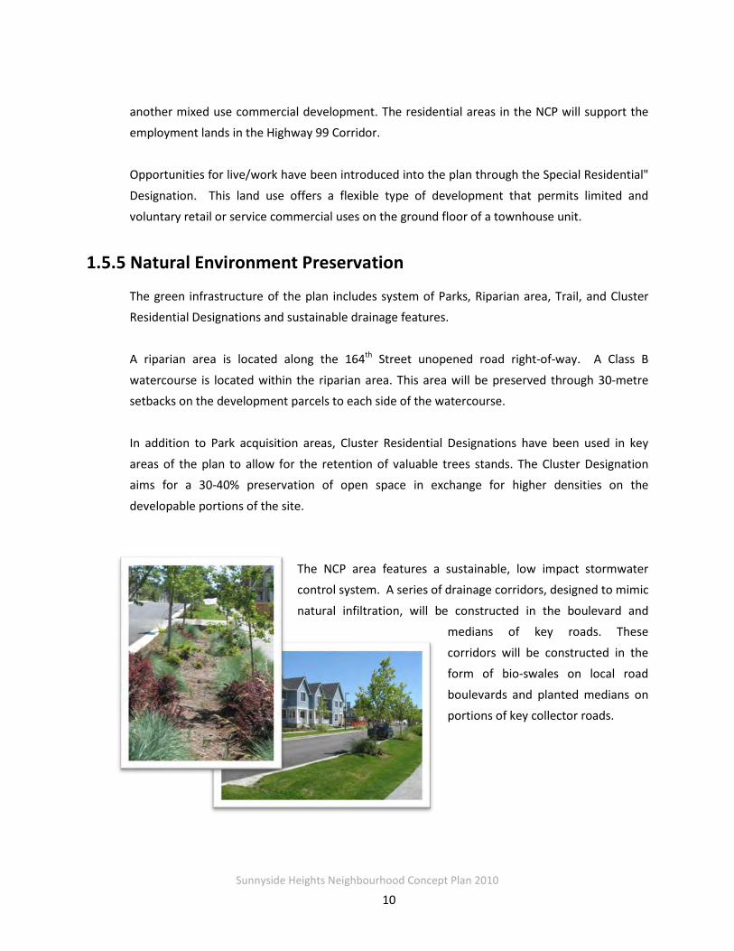
The NCP area features a sustainable, low impact stormwater control system. A series of drainage corridors, designed to mimic
natural infiltration, will be constructed in the boulevard and medians of key roads. These
corridors will be constructed in the form of bio-swales on local road
boulevards and planted medians on portions of key collector roads.

Sunnyside Heights Neighbourhood Concept Plan 2010
11
1.5.6 Geoexchange Systems
Prior to the initiation of an NCP for this area, staff evaluated the potential for geoexchange heating systems in this area. Based on that
preliminary investigation, it appears that geoexchange heating systems in this area of the City are technically feasible and financially viable. Geoexchange systems rely on a thermal coupling with the
earth. The coupling is known as a ground heat exchanger (GHX). Specifically, vertical closed-loop GHX systems are estimated to have a
payback between 3 and 23-years depending on the density of the development.
In addition to individual GHX systems, there could be opportunities for a series of private district energy systems for this area. GHX systems are not generally the best thermal energy source for
residential district energy systems given the limited load diversity available in predominately residential areas. However, other thermal energy sources such as natural gas based systems
may be viable.
1.5.7 LED Street Lighting
The use of LED street lighting has been identified as an opportunity to reduce energy
consumption for this area. LED streetlights have different characteristics and higher up front capital cost than standard light fixtures, thus are difficult to economically retrofit into a street
light system. However, with a new neighbourhood, the street light system can be designed to suit LED lights which may make it economical over the lifetime of the lights. Staff have been consulting with LED suppliers and lighting experts to determine specifications to incorporate
into plan with the development application process.

Sunnyside Heights Neighbourhood Concept Plan 2010
12
PART 2: PLANNING
2.1 Planning Objectives
The Neighbourhood Concept Plan outlines the desired future land uses for Neighbourhood #2 of
Grandview Heights. This section describes the land use designations and built forms, policies related to specific land uses, and illustrations of character defining elements. Together, these
elements are intended to establish the foundation for the creation of a healthy, affordable and special place to live and work.

Sunnyside Heights Neighbourhood Concept Plan 2010
13
2.2 Planning Principles and Vision
The framework for the development of the Grandview Heights area was established by the visioning process during the General Land Use Plan. From this vision, the Sunnyside Heights
Citizen’s Advisory Committee created a set of Guiding Principles to develop the land use plan for the NCP. These principles reflect overall sustainability principles set out in the City’s
Sustainability Charter.
2.2.1 General Land Use Plan Vision
The Grandview Heights General Land Plan, approved by Council June 30, 2005, envisages Grandview Heights:
“…as a complete community with a mix of residential densities, small commercial nodes,
community facilities, schools, parks, pathways, trees and protected areas.” It also contains guiding principles for the development of individual NCPs. The principles that
specifically relate to Neighbourhood Concept Plan for Sunnyside Heights are:
• Community Structure and Character - tree retention, respect for the ALR and protection of key view corridors of both mountains and water;
• Residential Land Use - a variety of housing types with highest densities adjacent to the Highway 99 Corridor, transition densities and a review of residential densities in the
vicinity of Edgewood Drive;
• Commercial Land Use - a commercial node at the southwest corner of 168 Street and 24 Avenue;
• Schools, Parks, Greenways and Community Amenities - a new elementary school
associated with a park; a park area on and/or adjacent to the GVRD water reservoir, a pedestrian and bicycle circulation systems, greenways along 16, 20 and 24 Avenues and stormwater detention ponds as community amenities or as natural park areas;

Sunnyside Heights Neighbourhood Concept Plan 2010
14
• Environment and Agriculture -evaluation of significant forest blocks and watercourses, development methods to protect sensitive areas, buffers to ALR uses and mitigation of
water runoff in accordance with a GVRD Liquid Waste Management Plan (the Fergus Creek Integrated Stormwater Management Plan);
• Community Heritage - celebration of historic people and events wherever possible and
incorporation of community history and heritage features into the design, naming and character of new neighbourhoods;
• Transportation - special road and pathway standards to preserve rural character, a modified grid road system with greenways to encourage walking and cycling and to slow
down traffic, appropriate treatment of 24 Avenue to ensure it does not separate the community; and
• Servicing and Infrastructure - drainage plans (Fergus Creek ISMP) to mitigate impacts
related to land use change and a new pump station on 168 Street, at approximately 12 Avenue.
2.2.3 Sunnyside Heights CAC- Guiding Principles
The Citizens’ Advisory Committee for Sunnyside Heights has considered these principles throughout the process. The CAC also reflected on its vision for the area including:
• Create a healthy, affordable and special place to live;
• Develop a mixed use neighbourhood;
• Create a wonderful place for people to live within walking and bike riding paths and plenty of greenery;
• Create a place that is attractive for people to work;
• Create a sustainable community of which we are all proud;
• Encourage interesting design;
• Develop at densities that support public transit; and
• Maintain the peace and quiet.

Sunnyside Heights Neighbourhood Concept Plan 2010
15
2.3 The Land Use Plan and Policies
Sunnyside Heights in Grandview Heights will primarily be a residential community offering a variety of housing forms and densities. The community will have a mixed use
commercial/residential node, an elementary school and three parks, and a network of trails and open spaces, as shown on Figure 1.1- of the Land Use Concept. The sections below provide an
overview of the proposed designations. The Design Guidelines (Section 3 of the document) outline the specific design criteria for each land use designation.
2.3.1 Residential
Approximately 91 hectares (224 acres) of the Sunnyside Height’s land area is proposed for future residential use. The proposed residential land uses will offer a wide variety of densities
and housing forms. The residential land use designations are based on “net” density calculations.
“Suburban Residential” and “Suburban Transitional” Designations • Suburban Residential designation: 1-2
units per acre
• Suburban Transitional designation: 2-4 units per acre
This land use designation is located along the southern edge of the plan area in close proximity
to the Agricultural Land Reserve (ALR). These designations will allow for single family homes on
larger residential lots. Other forms of housing within the permitted density ranges may be considered (particularly on the north side of 16 Avenue).
These land uses provide a transition to the ALR in accordance with the Official Community Plan
(OCP) and Policy No.O-23 (“Residential Buffering Adjacent to the ALR/Agricultural Designation)’. In accordance with Policy O-23, a 15 metre (50 ft.) wide landscaped buffer will be required for
lots along 168 St., south of 16 Ave.

Sunnyside Heights Neighbourhood Concept Plan 2010
16
“Urban Transitional” Designation • Up to 8 units per acre
The Urban Transitional Designation was created to ensure an appropriate transition to the suburban lands to the east of the plan area. These transitional densities are located along 168
Street between 20th Avenue and 16th Avenue.
This designation allows for larger lots and urban sized lots (approx 9,000 to 6,000 sq. ft.). Lots fronting 168 Street will be required provide a 10 metre wide landscaped buffer strip in the front
yard.
“Low Density Residential” Designation • 6-10 units per acre
The Low Density Residential Designation is located roughly between 23 and 16A Avenues, and
between 165A/166 Street and 167A Street. This designation provides for standard sized residential lots and the retention and mirroring of the existing curved alignment of Edgewood
Drive.
This land use designation allows for standard single family residential forms of development with urban lot sizes (approximately 4,000 to 5,000 sq. ft.).
A minimum 5-acre lot consolidation for redevelopment would be required both north and south of Edgewood Drive to minimize impact on residents desiring to stay in the community in the
short to medium term. Lot consolidation of a lesser area may be considered on a case-by-case basis.
“Medium Density Residential” Designation • 10-15 units per acre
The Medium Density Residential Designation is located between 24 and 20 Avenues, between 164 and 166 Streets. This land use designation provides for “small” lots, including 9 metres (30
ft.) or 12 metres (40 ft.) wide, which may include coach houses (suites above lane-access garages). This designation can also accommodate small lot duplexes (RF-SD zone) or row houses.
The lot sizes can range from approximately 2,000 to 3,300 sq. ft. for these housing forms.

Sunnyside Heights Neighbourhood Concept Plan 2010
17
“Cluster Residential” Designations • Cluster 10-15 units per acre
• Cluster 6-10 units per acre
The Cluster Designations locations were determined by the high value tree stand locations in the plan area. Through the Cluster Residential Designation, properties will be required to provide between 30 and 40% Open Space. In exchange, the density from the land provided for open
space will be transferred to the remaining portion of the development, thus creating a higher net density.
The built form on the net developable areas (excluding the Open Space) will be as follows:
• Cluster 10-15 units per acre designation will allow between 25- 30 units per acre on the developable areas of the site
• Cluster 6-10 units per acre designation will allow between 20-25 units per acre on the developable areas of the site
Lot consolidation may be required for development of some of these areas as shown in Figure 2.3.
“Multiple Residential” Designation • 30-45 units per acre
• 15-25 units per acre
• 10-15 units per acre
The highest densities (30-45 upa), envisioned as low rise apartments are
located on the western side of the plan, adjacent to the Commercial and Business
Park uses of Grandview Corners and the Highway 99 Corridor Plan. Townhouses (15-25 upa) will generally be located to the east of the
apartments and along 24th Avenue. The Multiple Residential 10-15 units per acre designation is located along 164 Street, south of
20th Avenue. This area may be developed as low density townhouses, duplexes, or detached

Sunnyside Heights Neighbourhood Concept Plan 2010
18
units. However, due to the irregular shaped lots and shallow lot depths, a strata form of development is envisioned for this designation.
To avoid the isolation of any individual properties as development in the NCP area,
consolidation will be required for the properties as shown on Figure 2.3.
“Special Residential” Designation • 15-25 units per acre
The “Special Residential” Designation is located east of the water reservoir, surrounding the commercial-residential node. This designation provides for a flexible development form permitting limited and voluntary retail or service commercial uses on the ground floor of a
townhouse or single family dwelling. Lot consolidation will be required as shown on Figure 2.3.
2.3.2 Community Commercial
There are two commercially designated areas and the Special Residential area in the NCP comprises a total of 1.4 hectares (3.5 acres) of land area. These commercial areas will be designed to serve the local neighbourhood, while the commercial lands outside the NCP in
Grandview Corners is expected to encompass a larger trade area.

Sunnyside Heights Neighbourhood Concept Plan 2010
19
“Commercial Residential” Designation • 25-45 units per acre
The “Commercial Residential” Designation is located at the northwest corner of the
NCP area at 168 Street and 24th Avenue. It will encompass approximately five
properties where lot consolidation will be required for development.
This designation allows for a mixed use development form, with commercial and office store
fronts located at ground level or the second floor with residential units above. A public plaza that can serve as a community meeting place will be required to be incorporated into the
development. This area is required to be pedestrian oriented terms of street design as well as massing and orientation. The development is to have a “village-centre” character (see Section
3, Design & Development Guidelines, for design details).
“Neighbourhood Commercial” Designation
The Neighbourhood Commercial Designation is located on a triangle portion of a lot located at south west corner of 20th Avenue and the future 164 Street alignment The western portion of
this site is encumbered by a Hydro right-of–way leaving the remainder, a small triangle shaped portion, for development. The plan allows for a commercial building to be located on the triangle portion of the property, and parking to be accommodated on the Hydro right-of-way
area.
The smaller-scale commercial will be a street-fronting neighbourhood/community oriented commercial development (see Section 3, Design & Development Guidelines, for design details).

Sunnyside Heights Neighbourhood Concept Plan 2010
20
2.3.3 Institutional
Elementary School Sites A school/park site is shown to the south side of the future park (Sunnyside Saddle Club). If an
alternative school location is proposed, the lands shown as preferred school site cannot be developed until another location for the school site is deemed acceptable by the School District
and the City.
Civic Utility This plan provides for a City utility maintenance and materials storage depot on City-owned land
on 24 Avenue (south of the existing GVRD reservoir and City pumping station) subject to appropriate access and buffering from adjacent residential uses. In the event that the City
explores development of this site for noted utility use, the facility will only have access off of 24 Avenue, or off of the future 167A Street, the alignment of which is located to the east of the site, and will be used during standard operating hours except in emergency situations. It is
proposed that the noted driveway access off 24 Avenue will be located as westerly as possible so as to retain trees and a buffer area on the east side of the property.
Clustering of structures and uses will be explored, with a view to retaining the important forest
patch identified on the southern portion of the City-owned property. A tree integrity study may be required. Development of the site shall be done in a way that recognizes the importance of
the area in the structure of the community; or contributes to the character of the area.
Possible hard surface recreational uses such as tennis courts on the top of the reservoir will
continue to be explored subject to water safety & security issues being addressed.

Sunnyside Heights Neighbourhood Concept Plan 2010
21
2.3.4 Parks, Trails, Riparian Areas and Open Space
A total of 12 hectares (30 acres) of the NCP area is allocated for an integrated system of public
and natural areas consisting of: three neighbourhood parks, a riparian area, and trail network. Two of the three neighbourhood parks are proposed that have direct connections to the Grandview Ridge Trail, and riparian area. The Parks, Riparian Trail System is shown on Figure
2.1.
Figure 2.1 Parks, Trails and Riparian Areas
Neighbourhood Parks Three park sites have been identified in the NCP area: Park A (Sunnyside Riding Club); Park B (22nd Avenue); and Park C (18th Avenue). Surrey’s Parks, Recreation and Culture Department
will manage and oversee the construction and maintenance of all public parks. Detailed design will be completed in consultation with the future community; however potential uses that are
viable given the size and nature of each park include the following:

Sunnyside Heights Neighbourhood Concept Plan 2010
22
• Park A is approximately 9.6 acres and will be adjacent to a future school site. Under the PRC new park classifications, this park could serve as a large, integrated amenity
neighbourhood park.
• The emphasis of Park B is natural area connectivity and local children and youth amenities. Due to projected density of the surrounding areas, there will be a need for a
local early and young child play amenities.
• Park C in the southern section of the NCP, is surrounded by lower residential densities,
and has high tree preservation values. This neighbourhood amenity park will need to ensure a high level of use and activity, to increase park security and appropriate use.
Riparian Area A riparian area is located along the 164th Street unopened road right-of-way. A Class B
watercourse is located within the riparian area. A segment of the Grandview Ridge Trail runs through the riparian area.
Grandview Ridge Trail The Grandview Ridge Trail, a continuous 2 kilometer recreational trail situated at the top of the slope, will connect the northern and southern parts of the neighbourhood. The trail will
accommodate a range of users, provide significant viewpoints and connect two of the three parks. Seating areas, signage and trail markers will be provided at key points along the trail.
Most of the trail will be located in a 20 metre wide corridor, will be conveyed to the City as
parkland. Properties affected by the Trail will be able to have this density transferred to the remaining portion of the lot.
A typical cross section will include a 4-metre permeable meandering path with 8-metres of treed
landscaping on either side. Portions of the trail will include seating, lookout viewpoints and signage. Special design guidelines will be developed for residential developments adjacent to
the Trail (See section 3, Design & Development Guidelines for detailed design requirements for the trail).
Modifications to cross section of the Grandview Ridge Trail have been made in areas where the alignment runs adjacent to a road. Typically the conveyance for the trail has been reduced

Sunnyside Heights Neighbourhood Concept Plan 2010
23
because the road dedication includes sidewalks and boulevards in the dedication area. These areas include where modifications have been made are described below:
• The property along the northern portion of the trail located along at 163 Street, north of
22 Avenue and along 22 Avenue east of 163 Street will be required to provide a 10-metre conveyance because the road allowance will include dedication for a sidewalk
and tree planted boulevard.
Figure 2.2: Sketch of Potential Viewpoint on Grandview Ridge Trail
Greenway/Multi-Use Path Three greenways are proposed in the plan area: one along the north side of 16 Avenue, the second on the north side of 20th Avenue and the third on the south side of 24th Avenue.

Sunnyside Heights Neighbourhood Concept Plan 2010
24
2.4 Population and Dwelling Unit Projections
The following section summarizes the amount of land allocated within the NCP for different land uses, the estimated number of dwelling units, the population of the area and potential
commercial floor area at build out of the Land Use Plan. The designations are based on a net density calculation.
2.4.1 Residential
The Stage 2 Land Use Plan provides for 91 Ha./224 Ac. of Residential-designated land. The Land Use Plan anticipates between 2,750 dwelling units at the low end of the prescribed density
range in the various residential areas to 4,250 dwelling units at the high end of the density range. Based on an average ratio of 2.8 persons per dwelling unit, the build-out population of
Sunnyside heights will be between 7,400 and 11,500.
2.4.2 Commercial
The Land Use Plan allocates a total of 1.4 Ha./3.5 Ac. to the Commercial designations. At the
built-out stage, the total amount of the commercial floor area is estimated to be approximately 930 sq. m./10,000 sq. ft., based on a floor area ratio varying from 0.3 to 0.6 depending on the
specific commercial designation in the Land Use Plan. This number includes the commercial component of the “Special Residential” designation as well.
2.4.3 Institutional Uses and Schools
The land designated for institutional uses, such as schools, amounts to 2 Ha./5 Ac.
2.4.4 Parks and Open Space
Parks, greenways and riparian areas occupy approximately 12 Ha./30 acres of land within the plan area.

Sunnyside Heights Neighbourhood Concept Plan 2010
25
Table 2.1: Land Use and Population Low / High Projections
Land Use Acres Low
Projected Units
High Projected
Units
Low Projected
Population
High Projected
Population
Neighbourhood Commercial 0.2 0 0 0 0 Commercial Residential 25-45upa 1.8 45 82 97 175 Suburban Residential 1-2upa 11.6 12 23 37 75 Suburban Transitional 2-4upa 4.0 8 16 26 52 Urban Transitional Up to 8upa 10.2 82 82 264 264 Low Density Residential 6-10upa 58.9 354 589 1,142 1,903 Cluster Residential 10-15upa 23.0 230 645 710 1,996 Cluster Residential 6-10upa 11.4 68 114 220 366 Medium Density Residential 10-15upa 22.7 227 341 704 1,056 Special Residential 15-25upa 4.8 71 119 221 368 Multiple Residential 10-15upa 9.7 97 146 300 451 Multiple Residential 15-25upa 26.3 394 657 1,220 2,033 Multiple Residential 30-45upa 38.6 1,158 1,737 2,479 3,719 Buffer 3.8 0 0 0 0 Linkages 3.4 0 0 0 0 School 5.2 0 0 0 0 Civic Utility 5.0 0 0 0 0 Park / Open Space 19.9 0 0 0 0 Grandview Ridge Trail 8.4 0 0 0 0 Drainage Corridors 19.5 0 0 0 0 Roads 112.1 0 0 0 0 Total 400.8 2,746 4,551 7,421 12,458

Sunnyside Heights Neighbourhood Concept Plan 2010
26
2.5 Interface with Adjacent Lands
The plan boundaries are adjacent to the Agricultural Land Reserve (ALR) to the southeast, larger suburban lots to the east, Commercial and Business Park uses planned to the west, and multi-
family residential densities to the north (Morgan Heights and Orchard Grove NCP areas). As a result of the varying interface conditions, several strategies were considered when developing
the land uses for the plan area.
2.5.1 Agricultural Land Reserve
City Policy number O-23, "Residential Buffering Adjacent to the ALR/Agricultural Boundary", identifies a transition area and provides for densities of 1-2 units per acre within the Outer Ring
Transition Area of 200 metres from the ALR boundary and densities of approximately 4 units per acre within the Inner Ring Transition Area of at least 400 metres of the ALR boundary.
These parameters were adhered to for the majority of the ALR interface area. However, densities were increased to 6-10 units per acre for an area within the 200-400 metre transition
area above a ridge line. Given the specific topographical conditions and configuration of this part of the NCP, and as noted in the General Land Use Plan, a strict application of City Policy No.
O-23 was not deemed necessary. This change in elevation between the proposed urban properties and the ALR creates a physical separation between the two areas. As a result the
densities were increased somewhat for properties above the ridgeline.
Properties along the west side of 168 Street, south side of 16th Avenue, will be required to provide a 15-metre (50 foot) landscaped buffer in accordance with the OCP Development Permit
Area Guidelines for areas adjacent to the agricultural designation.
2.5.2 Larger Suburban Acreage Parcels
The area to the east of 168 Street is comprised of larger suburban sized acreage lots. Some of
the owners of these lots had expressed concerns about smaller urban lots t across 168 Street in the plan area. However, some property owners wanted to see increased densities. As a result,
the “Urban Transition up to 8 units per acre” designation was proposed for properties along 168 Street, on the south side of 20th Avenue. Properties to the north of 20th Avenue, along 168

Sunnyside Heights Neighbourhood Concept Plan 2010
27
Street, were designated at 6-10 units per acre because of their closer proximity to the commercial area at 24th and 168 Street.
A landscape buffer on private property will be required on all lots along 168 Street to help buffer
against potential noise along 168 Street.
2.5.2 Commercial and Business Park Uses
The western boundary of the NCP area is situated on a downhill slope adjacent to Commercial
and future Business Park uses in the Highway 99 Corridor Local Area Plan. The NCP has proposed apartment densities along this edge. From a planning perspective, higher residential
densities are suited along commercial edges. In addition, the apartment housing form typically requires underground parking; the hillside will allow the utilization of the hillside for the
underground parking areas.
2.5.3 Morgan Heights and Orchard Grove NCPs
The north side of the NCP is adjacent to Morgan Heights (NCP #1), and Orchard Grove (NCP
#5A). A major Arterial (24th Avenue) is located between Sunnyside Heights and the 2 other NCP areas to the north. To help provide connectivity across 24th Avenue, key north/south roads have
been aligned to allow connections to the north side (161A Street, 163 Street, 164 Street, 167 Street and 168 Street). Signalized intersections will be at 164 and 168 Streets.
The housing densities along 24th Avenue range from apartments to townhouses. These are
similar to existing and planned densities across 24th Avenues.

Sunnyside Heights Neighbourhood Concept Plan 2010
28
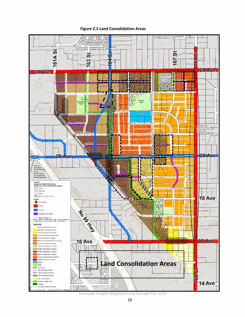
2.6 Land Consolidation Areas
Within the plan area there are a number of smaller acreage parcels and irregular shaped lots; in several areas lot consolidation is required in order to ensure efficient and feasible development
of these properties. These land consolidation opportunities can often be determined on a case-by-case basis at development application stage. In some cases, however, pre-determined
consolidation requirements are identified in the Land Use Plan in order to avoid creating remnant pieces that could not develop on their own. These particular properties need to be
developed together through consolidation and land assemblies or through coordinated development.
Land consolidation areas have been identified to help advice future developers of the consolidation requirement, to ensure compatibility and feasible development areas, and to
achieve an equitable distribution of road dedication and construction costs amongst properties. These areas have been identified in Figure 2.3.
Sunnyside Heights Neighbourhood Concept Plan 2010
29
Land Consolidation Areas
Figure 2.3 Land Consolidation Areas
Sunnyside Heights Neighbourhood Concept Plan 2010
30
2.7 Placemaking Considerations
Creating places for community interaction was an important consideration when developing the land use plan. Several elements that contribute to the creation of a sense of place within the
NCP have been identified on the Character Plan (Figure 2.4). These include community landmarks, entrance features, trail markers, seating areas and a public square. These elements
are described in detail in Section 3 (Design & Development Guidelines).
Successful places generally have the following qualities:
• The spaces are accessible;
• Places where people are engaged in activities;
• The spaces are comfortable and have a good image; and
• The spaces are designed to promote social interaction.
Design considerations that promote these qualities have been incorporated into the Design & Development Guidelines in Section 3 of the document.
In general, the placemaking elements in the plan include:
• Gateway features at key entrance points into the community;
• Trail markers at the entrances to the Grandview Ridge Trail and viewpoints with seating areas where the south western exposure grants
views toward the ocean and the Semiahmoo Peninsula; and
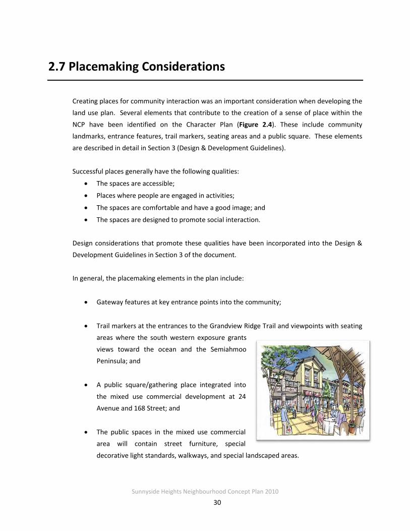
• A public square/gathering place integrated into
the mixed use commercial development at 24 Avenue and 168 Street; and
• The public spaces in the mixed use commercial area will contain street furniture, special
decorative light standards, walkways, and special landscaped areas.

Sunnyside Heights Neighbourhood Concept Plan 2010
31
Figure 2.4 Character Plan

Sunnyside Heights Neighbourhood Concept Plan 2010
32
2.8 Environmental Assessment ENKON Environmental Limited was retained by the City to inventory fish, wildlife and vegetation
resources and identifies any environmentally sensitive areas within the NCP area. The consultant reviewed all relevant environmental reports and also conducted a total of 6
biological surveys during the fall of 2005 and the spring of 2006.
2.8.1 Wildlife Corridors
Connectivity analysis was completed for the overall Fergus Creek Watershed in the Integrated
Stormwater Management Plan and important wildlife movement corridors were identified within this analysis related to Plan Area 2.
This corridor is envisaged as a component of the Grandview Ridge Trail. While narrower than a
wildlife corridor, it still provides connectivity through the community and between habitat patches including the proposed parks, Dart’s Hill Park, and the Fergus Creek Habitat Preservation Area.
2.8.2 Significant Tree Patches
Seven stands of trees ranging in size from 2.0 – 5.4 Hectares were identified and rated on a scale
of 0-10 (10 being the highest) related to habitat value protection value.
In addition to the Environmental Study, a Tree Study was performed during Stage 2 of the plan process. The goal of this study was to further examine the tree stands identified for habitat
value in the Enkon report, as well as other tree stands that had value as specimen trees. The results of this study helped to define the Cluster Designation in the plan.
2.8.3 Streams and Stream Classifications
A complete assessment of watercourses was undertaken and some watercourses were
reclassified as shown of Figure 2.5. The most significant watercourse runs along the unopened

Sunnyside Heights Neighbourhood Concept Plan 2010
33
road allowance of 164 Street. This is a Class B (Yellow coded) watercourse – Significant food/nutrient value, with no fish present.
Class A, A(O) and B watercourse are regulated under the federal Fisheries Act and as such
require Fisheries and Oceans approval for any modification of in-stream or riparian habitat. Class C watercourses may or may not be regulated under the Fisheries Act.
Figure 2.5: Riparian Areas Map
Setbacks for streams regulated under the Fisheries Act were determined using the Simple Assessment Methodology from the provincial Riparian Areas Regulation.
It is noted that it there is any use of City-owned riparian areas to provide habitat compensation for development in the area, the City of Surrey will be required to be compensated for the full
value of the compensation received.

Sunnyside Heights Neighbourhood Concept Plan 2010
34
2.9 History and Heritage of Grandview Heights
Commonwealth Historic Resources Management Limited completed a Heritage Study for the Grandview Heights NCPs # 1 and # 2 areas. This study identified heritage resources in the area
and outlined opportunities for the ‘preservation, commemoration, and integration of any identified heritage features into development in these areas.
Though there was no individual building or site identified that had any heritage amenity, the
consultants identified many representative examples of landscapes, subdivisions, houses, and other built and natural features that are specific to the heritage of Grandview Heights. The
report states that ‘the cultural landscape that is NCP # 2 and NCP # 1 has organically evolved by virtue of the many ways the land has been used.’
Features that were identified as being important from a cultural heritage perspective include:
• The property lines – having followed the boundaries of the original sections and quarter sections marked out by early surveys and subdivided from there over time;
• Unimpeded views along the roadways, with significant views from its highest points;
• Coniferous (and some deciduous) plantings demarking property lines and driveways into the properties. Mature second growth is evidenced throughout the area;
• Fencing and posts, including farm, residential, and equestrian fencing;
• A variety of streetscapes characterized by roadway patterns, roadside plantings, ornamental plantings on the residential properties.
Heritage recommendations included:
• The NCP # 2 community should take a name from the neighbourhood’s history, the
name “Sunnyside Heights” was chosen;
Sunnyside Heights Neighbourhood Concept Plan 2010
35
• Conservation: retaining some rural and semi-rural features such as retaining existing lines of trees or, alternatively, rebuilding or replanting trees in a similar fashion;
• Commemoration: Panels or plaques at specific locations or vistas to explain what was
once there;
• Interpretive: Storyboards that tell the story of the area: from logging to farming to suburban to urban. These could be located in the proposed park areas or at gateway locations to the community;
• Retention or restoration of street or place names such as secondary names to
numbered streets;
• Naming of the proposed park areas;
• Opportunities for Public Art either by competition of commission. Representative
examples include poetry rocks and the commemorative pieces at the new Surrey Museum.
The report suggested these as opportunities to conserve a heritage element in a community
that has no specifically identifiable heritage building or structure. Additionally, this type of heritage recognition can be used as part of the character and place making options for this
community.

Sunnyside Heights Neighbourhood Concept Plan 2010
36
PART 3: DESIGN & DEVELOPMENT GUIDELINES
During Stage 2 of the process, a set of Design and Development Guidelines were established to help guide development in the NCP. The purpose of the Design Guidelines is to achieve a
pedestrian-friendly, high quality and co-coordinated neighbourhood that is consistent with the principles and objectives of sustainable development. The Design & Development Guidelines
describe the dominant characteristics that will be encouraged in these areas. Issues addressed by the Guidelines include the relationship of buildings to streets, built form and character, and
design considerations for crime prevention.
Sunnyside Heights Neighbourhood Concept Plan 2010
37
3.1 Introduction
These guidelines, along with Surrey’s Official Community Plan (OCP), the Grandview Heights General Land Use Plan and Surrey’s Zoning By-law will be used to guide development in
Grandview Heights NCP #2. The primary intent of these guidelines is to facilitate the development of a unique community that has a sense of place and identity, is pedestrian-
oriented, integrates the natural environment, fosters safety, liveability and connection. Although much of the character of public spaces will evolve over time, specific design criteria
will help lay the groundwork for successful evolution of these public gathering spaces in the future.
Ten guiding principles where developed which set the general framework for the more specific design guidelines. The Design & Development guidelines have been organized under the following main themes:
Sunnyside Heights Neighbourhood Concept Plan 2010
38
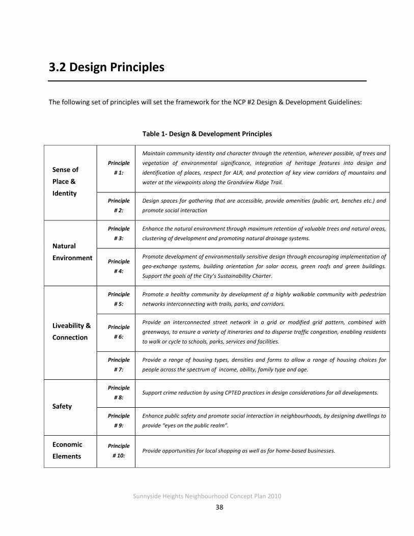
3.2 Design Principles
The following set of principles will set the framework for the NCP #2 Design & Development Guidelines:
Table 1- Design & Development Principles
Sense of
Place & Identity
Principle
# 1:
Maintain community identity and character through the retention, wherever possible, of trees and
vegetation of environmental significance, integration of heritage features into design and
identification of places, respect for ALR, and protection of key view corridors of mountains and
water at the viewpoints along the Grandview Ridge Trail.
Principle
# 2:
Design spaces for gathering that are accessible, provide amenities (public art, benches etc.) and
promote social interaction
Natural
Environment
Principle
# 3:
Enhance the natural environment through maximum retention of valuable trees and natural areas,
clustering of development and promoting natural drainage systems.
Principle
# 4:
Promote development of environmentally sensitive design through encouraging implementation of
geo-exchange systems, building orientation for solar access, green roofs and green buildings.
Support the goals of the City’s Sustainability Charter.
Liveability & Connection
Principle
# 5:
Promote a healthy community by development of a highly walkable community with pedestrian
networks interconnecting with trails, parks, and corridors.
Principle
# 6:
Provide an interconnected street network in a grid or modified grid pattern, combined with
greenways, to ensure a variety of itineraries and to disperse traffic congestion, enabling residents
to walk or cycle to schools, parks, services and facilities.
Principle
# 7:
Provide a range of housing types, densities and forms to allow a range of housing choices for
people across the spectrum of income, ability, family type and age.
Safety
Principle
# 8: Support crime reduction by using CPTED practices in design considerations for all developments.
Principle
# 9:
Enhance public safety and promote social interaction in neighbourhoods, by designing dwellings to
provide “eyes on the public realm”.
Economic Elements
Principle
# 10: Provide opportunities for local shopping as well as for home-based businesses.

Sunnyside Heights Neighbourhood Concept Plan 2010
39
Figure 3.1 - Neighborhood Square Interface with Mixed Use Development and Street
3.3 Community Gathering Spaces
The intent of the public spaces design guidelines is to encourage the development of public gathering spaces that are connected to the larger community and provide a vibrant and safe
place for community interaction.
The following section will focus on public space design guidelines for:
• Neighbourhood Square/Plaza • Parks and Open Space • Landmarks and Entrance Markers
3.3.1 Neighbourhood Square
A neighbourhood square is planned as part of the mixed use residential and commercial
designation at the corner of 168 Street and 24th Avenue. This square will face onto 167A Street and 23A Avenue. The objective of this square is to serve as a neighbourhood heart by providing
a combination of activities and spaces that give residents a vibrant, attractive place to come together. Important considerations for this neighbourhood square include elements such as
access and connection to surrounding streets, public seating, public art, and a strong image and identity. The following cross-section of the neighbourhood square and mixed use development
(Figure 3.1) provides a conceptual framework.

Sunnyside Heights Neighbourhood Concept Plan 2010
40
Design Components • The square should include a central open
space appropriate for accommodating neighbourhood events and gatherings, along with smaller, more intimate areas defined through the use of canopies, trees, and trellises.
• A strong feature, such as a fountain or a public art installation, should be included as a focal point in the square. This feature will provide the square with a strong image and identity.
• Commercial developments along the edges
of the square shall provide public seating. The public seating may be provided in multiple forms such as benches, sit-walls, ledges and steps.
• The surface of the square shall have pavement with contrasting colours and textures for visual interest.
• Adequate bicycle parking racks shall be provided.
• Commercial and directional signage should be oriented to pedestrians and relate to the
scale and character of the neighbourhood commercial area.
Access and Circulation • Streets, sidewalks and public rights-of-way through adjacent developments should lead into
the square at multiple points, providing easy and flexible pedestrian access. The square should be accessible by foot, wheelchairs, scooters, cycles and cars.
• Streets adjacent to the square should use traffic-calming measures such as planted curb bulges, traffic bollards, traffic circles, and/or angled parking.
• Large surface parking lots are not permitted in the square. Short-term on-street parking may
be supplemented by limited off street parking.
• Crosswalks leading to the square shall be well marked. The use of curb extensions and pavement treatment is encouraged.
• Provision should be made for transit stops within easy walking distance of the square.

Sunnyside Heights Neighbourhood Concept Plan 2010
41
Safety • Residential development across the street from the square shall face the square and have
reduced building setbacks to encourage visual surveillance.
• Commercial buildings on the edge of the square shall be designed to provide good visual surveillance both from within the space and along the edges.
• Decorative lamp post and luminaire lights (such as those used in Rosemary Heights) shall be
used throughout the neighbourhood plaza/square area
User Attractions • Public art should be integrated into the
development of the square. Consideration should be given to public art that evokes/recalls the history, heritage and character of the Grandview area (e.g. the agricultural and equestrian heritage). The installations should be interactive and “child-friendly”, encouraging sitting, climbing, and/or touching.
• Outdoor extensions of cafes and restaurants into the square are encouraged where the context is appropriate.
• The design of the square shall give consideration to future programming of the space (e.g. have flexibility for open spaces that could be used for performances, outdoor markets, and other activity generators).

Sunnyside Heights Neighbourhood Concept Plan 2010
42
3.3.2 Parks & Open Space
Three park sites have been identified in the Sunnyside Heights (NCP #2) area: Park A (Sunnyside Riding Club); Park B (22nd Avenue); and Park C (18th Avenue). Three major corridors connect
these parks: the Grandview Ridge Trail, the multi-use drainage corridors, and enhanced sidewalks. Surrey’s Parks, Recreation and Culture Department will manage and oversee the construction and maintenance of all public parks. Detailed design will be completed in
consultation with the future community; however potential uses that are viable given the size and nature of each park include the following:
Neighbourhood Park A Park A is approximately 9.6 acres and will be adjacent to a future school site. Under the PRC
new park classifications, this park could serve as a large, integrated amenity neighbourhood park. This kind of park could have a informal multi-use sport field shared by the school and the
park and a shared parking lot. Other possible amenities for the site might include integrated and compact youth, early child play areas, courts, a possible skate park, a walking track around
the park parameter, a possible water spray area for tots, and community gardens. The park amenities will be determined based on community consultation at time of development.
Neighbourhood Park B The emphasis of Park B is natural area connectivity and local children and youth amenities. Due to projected density of the surrounding areas, there will be a need for a local early and young
child play amenities. Amenities in this park should compliment and build upon the nature of the site and existing grades that allow for views corridors. Forest based amenities could include a
cross training running track which could also be used for free-ride bike trails.
Neighbourhood Park C Park C in the southern section of the NCP, is surrounded by lower residential densities, and has high tree preservation values. This neighbourhood amenity park will need to ensure a high level
of use and activity, to increase park security and appropriate use. While open informal fields and picnic areas, benefiting from the viewpoints have been identified, there will also be a for a multitude of local amenities in the park, to ensure a wide spectrum of multi-generational uses.
Examples could include local sport fields, sensory gardens, frisbee gold, a large young and early child play area, a water park, popular court use, such as tennis and or basket ball, in addition to
walking trails, to ensure the park is active and safe.
Sunnyside Heights Neighbourhood Concept Plan 2010
43
Common Park Design Features Common design features for each park include:
• Trails, natural areas, and pedestrian/cycle connections to other neighbourhood amenities and greenways;
• Circuit trails around the park’s perimeter, wherever feasible;
• Activity areas such as playgrounds or sitting areas located in highly visible locations, either near entrances to the park or along the perimeter of the park, visible from surrounding streets;
• Tree plantings that emphasize a strong vegetated edge surrounding an open interior space, while permitting views into the park from surrounding streets and homes.
3.3.3 Landmarks & Entrance Markers
The Character Plan (Figure 3.2) outlines opportunities and requirements to clearly identify the
community through Gateway Landmarks, Community Landmarks and Entrance Markers. Public art and landscaping should be incorporated into these features. The Character Plan
identifies a number of potential entrance and community landmarks.
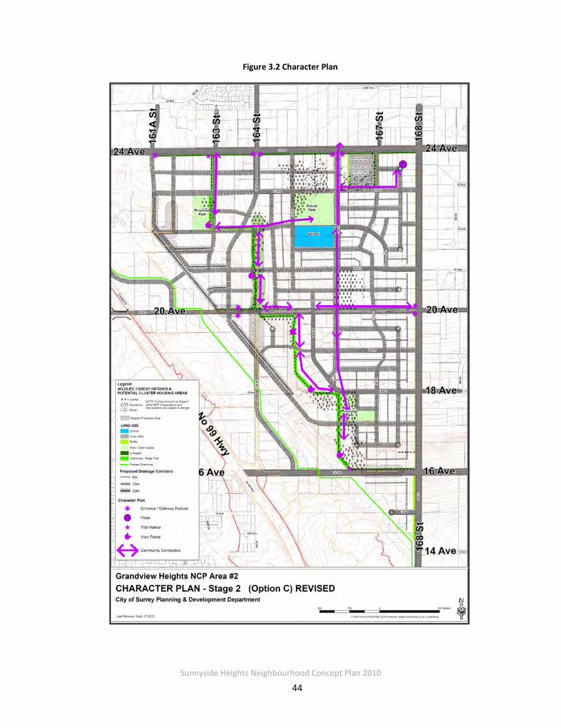
Sunnyside Heights Neighbourhood Concept Plan 2010
44
Figure 3.2 Character Plan
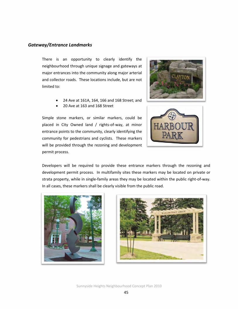
Sunnyside Heights Neighbourhood Concept Plan 2010
45
Gateway/Entrance Landmarks There is an opportunity to clearly identify the
neighbourhood through unique signage and gateways at major entrances into the community along major arterial
and collector roads. These locations include, but are not limited to:
• 24 Ave at 161A, 164, 166 and 168 Street; and • 20 Ave at 163 and 168 Street
Simple stone markers, or similar markers, could be
placed in City Owned land / rights-of-way, at minor entrance points to the community, clearly identifying the
community for pedestrians and cyclists. These markers will be provided through the rezoning and development permit process.
Developers will be required to provide these entrance markers through the rezoning and
development permit process. In multifamily sites these markers may be located on private or strata property, while in single-family areas they may be located within the public right-of-way.
In all cases, these markers shall be clearly visible from the public road.

Sunnyside Heights Neighbourhood Concept Plan 2010
46
Plaza Feature A Plaza will be included as part of the mixed use commercial development at 168 Street and 24th
Avenue. The plaza will include a feature that could a heritage monument, water feature, and/or other forms of community identification, and are intended to mark the heart of this community.
The following sketch (Figure 3.3) provides a conceptual framework for the design of the square.
Landscaping, seating, textured surfaces, public art, special lighting and open space shall be components of the design. The specific layout and design options of the plaza will be explored at the development stage.
Figure 3.3 - Conceptual Sketch of Neighborhood Square
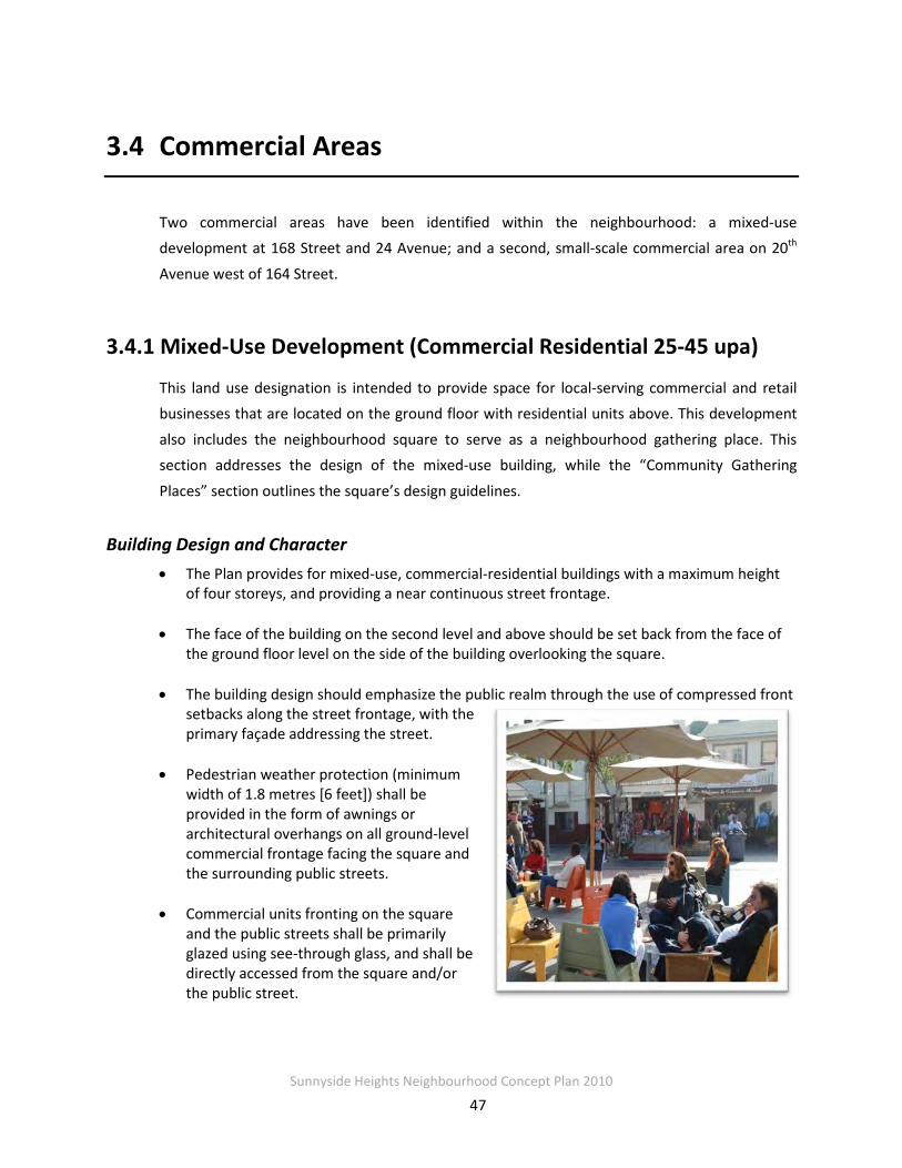
Sunnyside Heights Neighbourhood Concept Plan 2010
47
3.4 Commercial Areas
Two commercial areas have been identified within the neighbourhood: a mixed-use development at 168 Street and 24 Avenue; and a second, small-scale commercial area on 20th
Avenue west of 164 Street.
3.4.1 Mixed-Use Development (Commercial Residential 25-45 upa)
This land use designation is intended to provide space for local-serving commercial and retail businesses that are located on the ground floor with residential units above. This development
also includes the neighbourhood square to serve as a neighbourhood gathering place. This section addresses the design of the mixed-use building, while the “Community Gathering
Places” section outlines the square’s design guidelines.
Building Design and Character • The Plan provides for mixed-use, commercial-residential buildings with a maximum height
of four storeys, and providing a near continuous street frontage.
• The face of the building on the second level and above should be set back from the face of the ground floor level on the side of the building overlooking the square.
• The building design should emphasize the public realm through the use of compressed front
setbacks along the street frontage, with the primary façade addressing the street.
• Pedestrian weather protection (minimum
width of 1.8 metres [6 feet]) shall be provided in the form of awnings or architectural overhangs on all ground-level commercial frontage facing the square and the surrounding public streets.
• Commercial units fronting on the square
and the public streets shall be primarily glazed using see-through glass, and shall be directly accessed from the square and/or the public street.

Sunnyside Heights Neighbourhood Concept Plan 2010
48
• Wall mounted lighting fixtures are encouraged on all commercial developments. Decorative lamppost and luminaire lighting, designed for the pedestrian scale should be used throughout the commercial area (see neighbourhood square section above).
• Access into the commercial units should be provided directly from the plaza, and also from
the public street.
• Terraces or decks are encouraged on the upper levels of the building overlooking the neighbourhood square.
• Several narrow commercial shop fronts are preferred over a single large commercial unit
facing the neighbourhood square.
• Residential parking for the mixed-use development shall be provided in underground garages.
• The following illustration shows the character intended for the commercial street frontage.
Examples of Commercial Street Frontage Character
Sunnyside Heights Neighbourhood Concept Plan 2010
49
3.4.2 Small Scale Commercial
A node for small scale community commercial will be located on a triangle portion of a lot located at the south west corner of 20th Avenue and 164th Street. The intent of this area is to
provide for retail and service development that features small scale commercial enterprises and services such as a neighbourhood grocery or convenience store) that caters to everyday needs of local residents.
Building Design and Character
• The western portion of this site is encumbered by a Hydro right-of–way leaving the remainder, a small triangle shaped portion, for development. It is envisioned that a commercial building be located on the triangle portion of the property, and parking would be accommodated on the Hydro right-of-way area.
• The building form and massing should reflect the surrounding residential character and integrate with the roundabout planned at 20th Avenue and 164 Street.
• The primary façade of the building should address the streets and include architectural detailing that relates to the roundabout.

Sunnyside Heights Neighbourhood Concept Plan 2010
50
3.5 Residential Areas
The guidelines for Residential Areas promote the development of a range of housing types, densities, and forms that will provide a variety of housing options while ensuring a strong and
unified presence and character for the neighbourhood.
The provision of a variety of housing types and densities from single family to apartments is intended to provide a range of housing choices for people across the spectrum of incomes and
family types, and provide options for residents to remain in the neighbourhood as they age.
3.5.1 Special Residential (15-25 upa)
The intent of the Special Residential areas is to provide a flexible option for commercial and
residential development. This designation permits and encourages the development of a medium
density dual use (residential and business) neighbourhood allowing a wide array of compatible businesses such as artists workshops /
studios, craft stores, shops, and similar small-scale retail businesses, personal service uses, and
consultants’ offices.
At densities between 15 to 25 units per acre these areas will take the form of townhouses or
row houses. The following objectives support the development of a functional, and liveable
Special Residential area:
• There should be direct pedestrian access from the fronting street to each individual business.
• The business portion of the building shall be located at the ground level. • Commercial frontages should include weather protection in the form of small canopies or
awnings protruding a minimum of 1.5 metres (5 feet) from the building face.

Sunnyside Heights Neighbourhood Concept Plan 2010
51
• Signage should be integrated into the design and detailing of the building, and should be
scaled and oriented to pedestrians.
• Dwelling units should be designed to ensure a maximum amount of natural light to penetrate the unit.
• Fascia signs, projecting and window signs are encouraged.
• Special Residential development should maintain a residential character in terms of building
massing, rooflines, window sizes and locations and architectural articulation such as porches, balconies and bay windows.
• All multiple family developments should investigate opportunities for introducing geo-
exchange heating and cooling systems in their developments.
3.5.2 Multiple Residential (30-45 upa)
The multiple residential density of 30-45 units per acre provides for a range of housing types, from
townhouses to apartment style buildings of a variety of designs. Dwelling units should face the public street wherever possible, and units located on the ground floor shall have direct access to the
street. Parking should be primarily provided underground with access from internal rear lanes or off street driveways.
• All ground-level units should front, and have direct pedestrian access to and from the street wherever possible, to ensure a high degree of walkability. • To promote “eyes on the public realm” reduced setbacks are encouraged for units that directly abut a street, trail or multi-use drainage corridor. Setbacks of 4 metres for ground-floor levels, and 6 metres for the upper levels are preferred; other variations will be considered.
• Units along a street frontage should have a strong street-oriented character.
• There should be clear delineation between private space and public space, without sacrificing opportunities for casual observation of public spaces.
• Wall mounted lighting is encouraged on units adjacent to trails and corridors.

Sunnyside Heights Neighbourhood Concept Plan 2010
52
Figure 3.4 - Cross Section of Multi-Family Site and Street Interface
• Common pedestrian access to adjacent trails, corridors or parks should be provided by clear, identifiable entryways differentiating between public and private lands. Permanently closed gates are not acceptable.
• For sites along the Grandview Ridge Trail, developers will be responsible for erecting fencing on private property fronting the trail. These fences shall be no more than 1.2 metres (4 feet) of a non-solid, wood fence (see Landscaping and Fencing section of the Grandview Ridge Trail above).
• Building facades should be articulated by recessed front entries or porches which clearly
distinguish individual units while reinforcing a unified residential character.
• Private rooftop decks and/or private balconies in upper level units are encouraged.
• The massing and proportions of the buildings shall contribute to a humanizing of the street edge through such means as porches, entryways, cornices and overhangs or stepped-back upper levels.
• Dwelling units should be designed to ensure a maximum amount of natural light to penetrate
the unit.
• Parking shall be provided underground accessed from rear lanes, or from well landscaped entrances off local streets.
• All multiple family developments should investigate opportunities for introducing geo-exchange
heating and cooling systems in their developments.
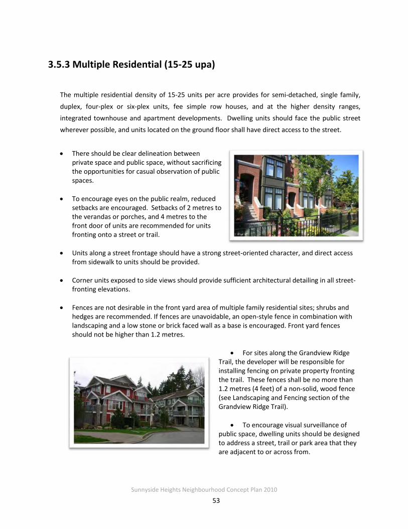
Sunnyside Heights Neighbourhood Concept Plan 2010
53
3.5.3 Multiple Residential (15-25 upa)
The multiple residential density of 15-25 units per acre provides for semi-detached, single family,
duplex, four-plex or six-plex units, fee simple row houses, and at the higher density ranges, integrated townhouse and apartment developments. Dwelling units should face the public street wherever possible, and units located on the ground floor shall have direct access to the street.
• There should be clear delineation between private space and public space, without sacrificing the opportunities for casual observation of public spaces.
• To encourage eyes on the public realm, reduced setbacks are encouraged. Setbacks of 2 metres to the verandas or porches, and 4 metres to the front door of units are recommended for units fronting onto a street or trail.
• Units along a street frontage should have a strong street-oriented character, and direct access
from sidewalk to units should be provided.
• Corner units exposed to side views should provide sufficient architectural detailing in all street-fronting elevations.
• Fences are not desirable in the front yard area of multiple family residential sites; shrubs and
hedges are recommended. If fences are unavoidable, an open-style fence in combination with landscaping and a low stone or brick faced wall as a base is encouraged. Front yard fences should not be higher than 1.2 metres.
• For sites along the Grandview Ridge
Trail, the developer will be responsible for installing fencing on private property fronting the trail. These fences shall be no more than 1.2 metres (4 feet) of a non-solid, wood fence (see Landscaping and Fencing section of the Grandview Ridge Trail).
• To encourage visual surveillance of public space, dwelling units should be designed to address a street, trail or park area that they are adjacent to or across from.

Sunnyside Heights Neighbourhood Concept Plan 2010
54
• Dwelling units should be designed to ensure a maximum amount of natural light to penetrate the unit.
• Common pedestrian access to adjacent trails, corridors or parks should be provided by clear,
identifiable entryways differentiating between public and private lands. Permanently closed gates are not acceptable.
• All multiple residential developments will investigate opportunities for introducing geo-
exchange heating and cooling systems in their developments.
3.5.4 Medium Density Residential (10-15 upa)
This land use designation is intended to provide for
areas of predominantly single-family residential homes in a more compact neighbourhood, while
allowing for some opportunities for alternative housing types including duplexes or row houses. In
all cases, access to the garage from the rear lane is mandatory in this area where a rear lane exits. Other features of units in this area include the following:
• Units shall have reduced setbacks of 2.0 metres to front porches and 4 metres to the fronts of units to reinforce the human scale of the street while allowing more backyard space and to encourage surveillance of the street.
• Garages and ancillary dwellings (coach houses etc.) must be accessed by way of the rear lanes.
• Front yards should clearly delineate public
and semi-private space through the use of natural low landscaping, and low, open-style fencing.
• Units shall have articulated facades with
appropriately proportioned windows and roof projections / peaks.
• Dwelling units should be designed to ensure a maximum amount of natural light to penetrate
the unit.
• Use of permeable surfaces for driveways and other paved areas is strongly encouraged.

Sunnyside Heights Neighbourhood Concept Plan 2010
55
3.5.5 Low Density Residential (6-10 upa)
The low-density residential designation of 6-10 units per acre permits single-family homes, with the potential for secondary suites and coach house units depending on the size of the lot. These lots
would be serviced primarily by rear lanes with on-street parking, and few, if any, driveways or garages facing the street. Opportunities for a reduced or varied front setback would be considered in order to create a friendly and unique street frontage, while allowing for a larger rear yard, yet
clearly identifying between public and private realms at the fronts of houses.
• Units may have reduced front yard setbacks to allow for more room with the private back yard space.
• Houses on corner lots will be architecturally unique, and shall face the street on both sides;
• Front porches and verandas with overhangs that define a semi-private area in front of the unit are strongly encouraged.
• Front yards will clearly delineate public and semi-private space through the use of natural low landscaping, and low, open-style fencing.
• Units shall have articulated facades and architectural features such as bay windows, roof projections and gable ends facing the public street.
• Wherever possible, units shall be designed to ensure a maximum amount of natural light to
penetrate the unit.
• Use of permeable surfaces for driveways and other paved areas is strongly encouraged.
3.5.6 Urban Transitional Designation (Up to 8 upa)
This designation of up to 8 dwelling units per acre (gross density) is intended to provide a transition between lots on the west side of 168 Street, and larger suburban lots on the east. The lots facing
onto 168 Street will provide a landscape buffer on private property to help reduce the impact of the arterial street as well as to provide a smooth transition to the larger suburban lots to the east.

Sunnyside Heights Neighbourhood Concept Plan 2010
56
• Lots fronting 168 Street shall have a 10 metre (33 feet) front yard setback in order to accommodate a 5 metre (16 feet) wide landscaped buffer (see Figure 3.10 )
• The buffer shall be comprised of a double staggered row of trees and flowering shrubs.
• The buffer will be secured through a restrictive covenant for planting and maintenance as well as landscape security held by the City.
• Developments that front 168 Street must provide vehicle access to the unit from rear lanes.
3.5.7 Suburban Transitional (2-4 upa)& Suburban Residential (1-2 upa)
This designation is for an area of ¼ to ½ acre lots that support a larger building footprint in proximity to the
Agricultural Land Reserve and Fergus Creek Nature reserve.
• The future subdivision potential and lot layout will need to consider Policy O-23 for transition and buffering to Agricultural Land Reserve to the southeast.
3.5.8 Cluster Areas
Through the Cluster Residential Designation, properties will be required to provide between 30 and 40% Open Space. In exchange, the density from the land provided for open space will be
transferred to the remaining portion of the development, thus creating a higher net density. Two cluster designations have developed for this NCP, Cluster (10-15 upa) and Cluster (6-10 upa):
Cluster 10-15 upa • Cluster 10-15 units per acre designation will allow between 25- 30 units per acre on the
developable areas of the site
Cluster 6-10 upa • Cluster 6-10 units per acre designation will allow between 20-25 units per acre on the
developable areas of the site
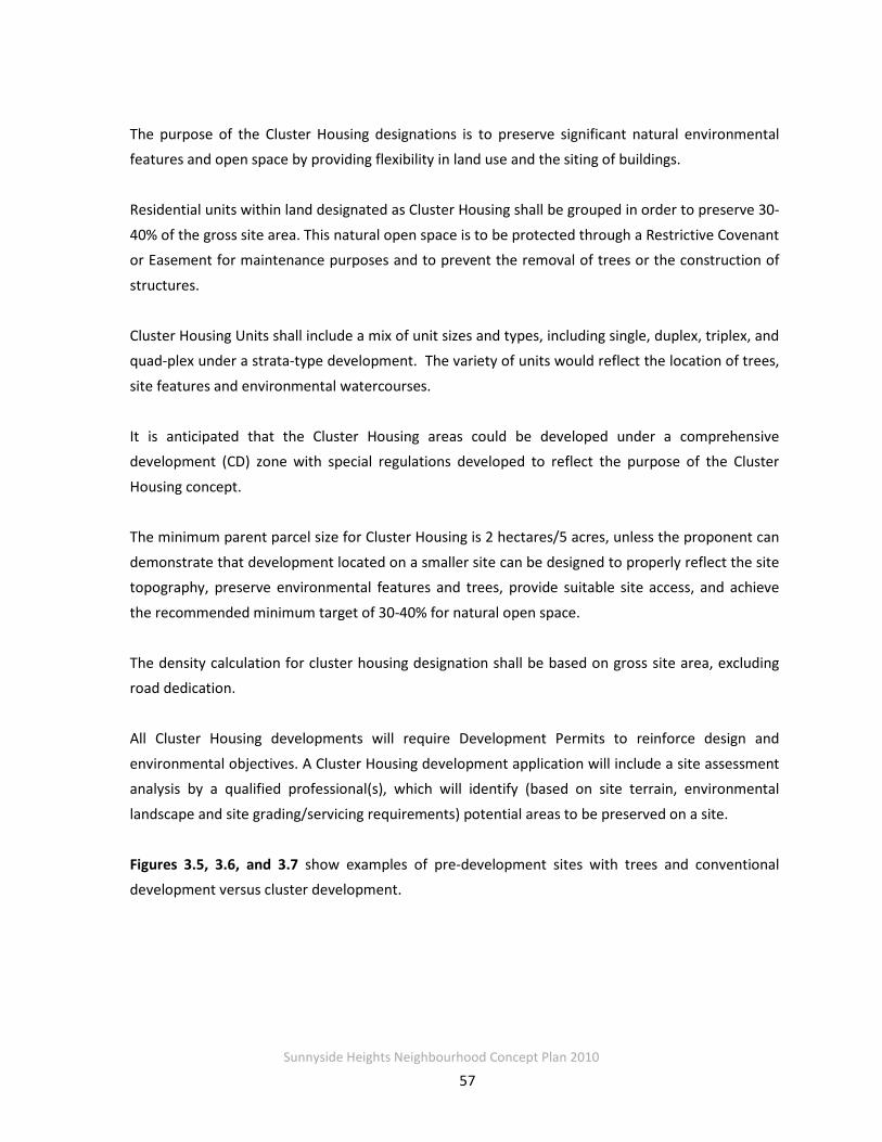
Sunnyside Heights Neighbourhood Concept Plan 2010
57
The purpose of the Cluster Housing designations is to preserve significant natural environmental features and open space by providing flexibility in land use and the siting of buildings.
Residential units within land designated as Cluster Housing shall be grouped in order to preserve 30-
40% of the gross site area. This natural open space is to be protected through a Restrictive Covenant or Easement for maintenance purposes and to prevent the removal of trees or the construction of
structures.
Cluster Housing Units shall include a mix of unit sizes and types, including single, duplex, triplex, and quad-plex under a strata-type development. The variety of units would reflect the location of trees,
site features and environmental watercourses.
It is anticipated that the Cluster Housing areas could be developed under a comprehensive development (CD) zone with special regulations developed to reflect the purpose of the Cluster
Housing concept. The minimum parent parcel size for Cluster Housing is 2 hectares/5 acres, unless the proponent can
demonstrate that development located on a smaller site can be designed to properly reflect the site topography, preserve environmental features and trees, provide suitable site access, and achieve
the recommended minimum target of 30-40% for natural open space.
The density calculation for cluster housing designation shall be based on gross site area, excluding road dedication.
All Cluster Housing developments will require Development Permits to reinforce design and
environmental objectives. A Cluster Housing development application will include a site assessment analysis by a qualified professional(s), which will identify (based on site terrain, environmental
landscape and site grading/servicing requirements) potential areas to be preserved on a site.
Figures 3.5, 3.6, and 3.7 show examples of pre-development sites with trees and conventional development versus cluster development.

Sunnyside Heights Neighbourhood Concept Plan 2010
58
Figure 3.5 Pre-development site for Cluster Housing
Figure 3.6 Conventional Development
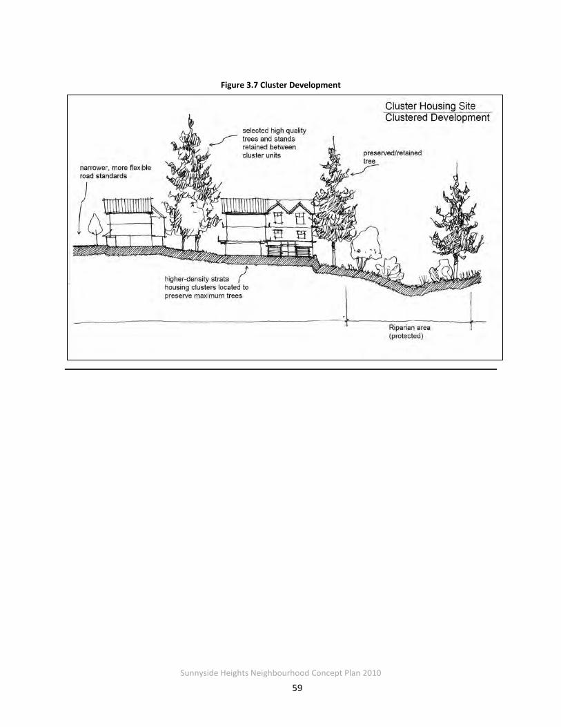
Sunnyside Heights Neighbourhood Concept Plan 2010
59
Figure 3.7 Cluster Development

Sunnyside Heights Neighbourhood Concept Plan 2010
60
Figure 3.8 Typical Cross-Section of Grandview Ridge Trail
3.5 Trails and Buffers
3.5.1 Grandview Ridge Trail
The Grandview Ridge Trail is a continuous, 2 km, multi-use permeable pathway leading from the
Grandview Corners area to Darts Hill Park. The Trail will be within a 20-metre wide corridor generally running north – south on the western side of the NCP Area. Situated at the top of a
slope, the Trail will provide significant viewpoints as well as a connection to two of the three parks and the riparian area identified in the NCP. The trail system will be accessible to all
residents of the community through multiple easy and safe trail access points and will connect a variety of land uses, including residential areas.
The 20-metre wide corridor to be conveyed at no cost to the City for the Trail will be secured
through subdivision and rezoning applications. The trail is mostly located along or through multi-family sites in the NCP area. It will be constructed and maintained by the developer of
each multifamily site. The design will be regulated through the Development Permit approval process. Figure 3.8 shows a typical cross-section of the Trail (refer to Section 2.3.4 for special areas with reduced cross-section widths).
location of trail varies
Sunnyside Heights Neighbourhood Concept Plan 2010
61
The following elements shall be considered in the design and development of the trail:
Design Elements • The path will be 4 metres wide, located within a 20-metre wide corridor.
• The pathway within the corridor will be situated near the top of the slope wherever feasible,
and designed to maintain a stable slope by the use of retaining walls or other means, where necessary.
• The path will be designed to encourage rainwater infiltration by using a permeable surface
or by ensuring runoff from the path flows onto a vegetated area. The path surface shall be designed to allow for use by bicycles, wheelchairs and strollers.
• The gradient of the path shall not exceed 8%, and shall be less than 5% wherever possible,
to maximize accessibility.
• The edges of the pathway should be well defined to avoid surface erosion and reduce trail maintenance.
Access and Connection
• Direct connections from ground-level multi-family housing units to the trail are recommended. If no direct access from housing units is provided, an access walkway to the trail should be provided, located near the midpoint of development sites.
• Open space and outdoor amenity areas in multi-family developments should be placed
adjacent to the trail wherever possible.
Landscaping and Fencing • Where feasible, and based on the recommendations of a Certified Arborist, existing trees
along the ridge area will be retained. Native vegetation and planting should be provided along either side of the pathway.
• The landscaped areas adjacent to the pathway should be covered by tree canopy at
maturity. Tree species should include both deciduous and coniferous varieties. Coniferous trees should be located to allow for sunlight penetration onto the Trail, particularly during winter months. Vegetation that contributes to foraging and nesting habitat for songbirds is encouraged.
• Viewpoints along the Trail as identified in the Character Plan shall be protected wherever
possible and views must be considered in tree selection and spacing.

Sunnyside Heights Neighbourhood Concept Plan 2010
62
• Seating shall be provided at viewpoints (numbered 1 through 4 on the Character Plan) by the multi-family developments and maintained by the respective strata. Seating will be placed in a manner that encourages both the visual surveillance of the trail and surveillance of the seating area from adjacent residences.
• “Equestrian fencing” delineating the trails edge (an example is shown in the photo below) is
strongly encouraged; other forms of similar fencing, will be considered.
Examples of open style fencing
Trail Markers The unique character of this trail will be recognized through trail markers similar to the markers and signs along the Semiahmoo Heritage Trail.
• developments that include entrances to the trail will provide trail markers at the entrances to the trail.
View Points The trail viewpoints are a key feature of the community, capitalizing on extensive views to the south and the west including Boundary Bay and the San Juan Islands. The areas marked as
viewpoints on the Character Plan are subject to further examination, and should include information installations and benches to enjoy the view, wherever feasible. Figure 3.9 shows a
cross section of the Grandview Ridge Trail and Multi-family Residential with a view point area.

Sunnyside Heights Neighbourhood Concept Plan 2010
63
Figure 3.9 - Sample Viewpoint along Multi-Family site on the Grandview Ridge Trail
Development Standards for Private Land Abutting the Trail • Multi-family developments adjacent to the Grandview Ridge Trail will be required to convey
land to the City at no cost to the City for the Trail through the development site. The net density of these sites will not be affected by the presence of the trail.
• Dwelling units located along the corridor should provide second floor windows and balconies facing the corridor to allow casual surveillance of the corridor.
• Pedestrian scale low-level lighting and wall-mounted lighting on units abutting the trail are
encouraged, to increase the safety and the perception of safety.
• Housing units along the Trail should face the Trail directly, preferably with direct pedestrian access onto the Trail.
• Multi-family housing developments along the Trail should place active/inhabitable spaces on
the ground floor towards the Trail, and should place common outdoor recreation areas and amenity areas next to the Trail wherever possible.
location of
trail varies

Sunnyside Heights Neighbourhood Concept Plan 2010
64
• Developers will be responsible for erecting fencing on private property fronting the Trail. These fences shall be no more than 1.2 metres (4 feet) in height and consist of a non-solid fence constructed of wood or wood with masonry pillars (see Landscaping and Fencing section above).
• Seating shall be provided at viewpoints (numbered 1 through 4 on the attached Character
Plan) by the multi-family developments and maintained by the respective strata. Seating should be placed in a manner that encourages both the visual surveillance of the trail as well as surveillance of the seating from the residential.
• Common pedestrian access to the trail from adjacent lands may be provided by clear, identifiable entryways differentiating between public and private lands. Permanently closed gates are not acceptable.
• The landscaping plan for the trail corridor will be established as part of the development permit for multiple family projects fronting the trail.
• Single-family developments along the Trail should front onto the Trail, with automobile
access to the houses from a lane at the back of the lot.
Maintaining the Trail • Where the Trail exists within a roadway, abutting multiple family developments, the
respective strata corporations will maintain the grass boulevard. The Trail surface will be maintained by the City.
• In areas where the trail passes through parkland, the trail will be treated as part of the Greenway network, and maintained and designed in a manner consistent with the intent of the Greenways Master Plan.
3.5.2 - 168 Street Buffer
The buffer along 168th Street is important from the perspective of ensuring a matching street frontage to future development along 168th Street, from East to West, and also from the
perspective of protecting development from impacts associated with increased traffic along 168 Street. Lots facing onto 168 Street will have a depth between 35-40 metres and require special setbacks to accommodate a landscaped buffer on private property.
Lots north of 16th Avenue along 168 Street:
• Lots will require a special front yard setback of 10 metres to provide for a 5-metre wide landscaped buffer, on private property, along this arterial road.
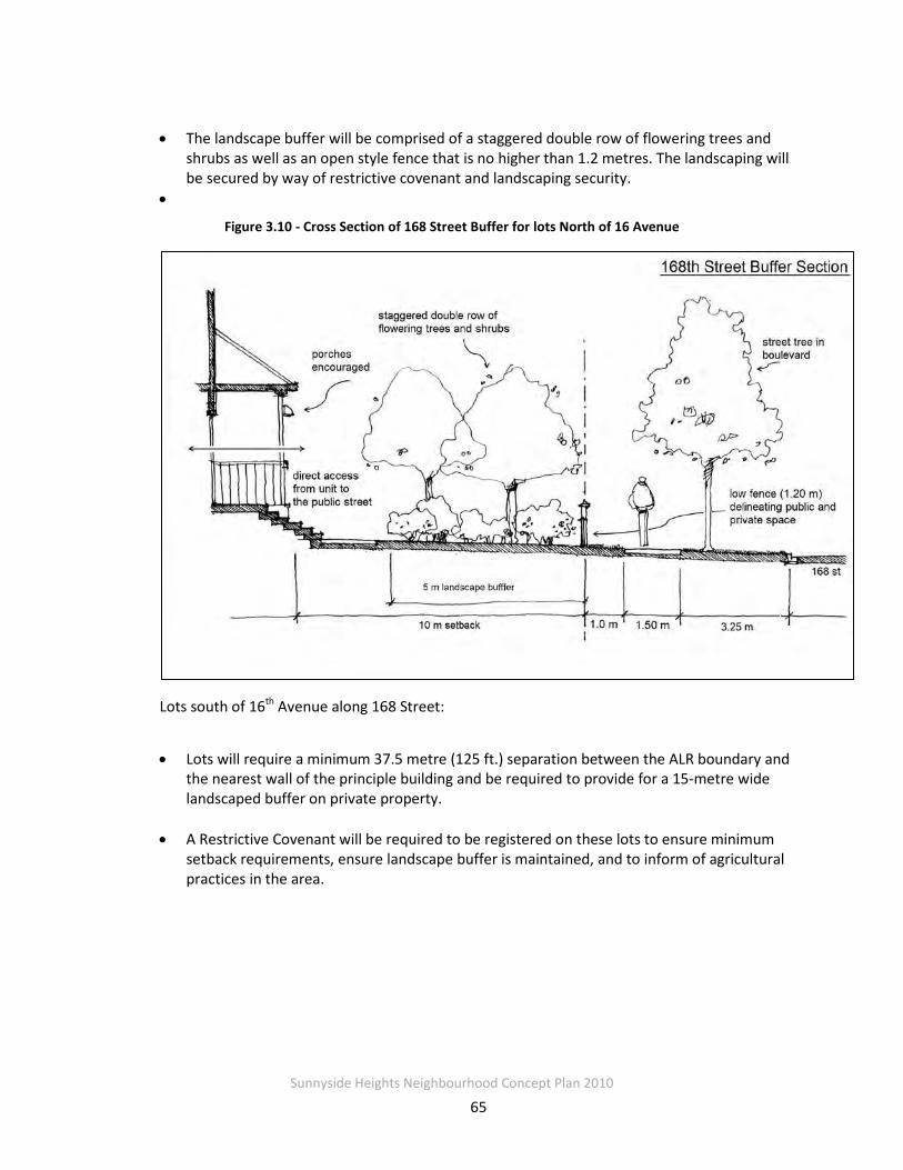
Sunnyside Heights Neighbourhood Concept Plan 2010
65
• The landscape buffer will be comprised of a staggered double row of flowering trees and shrubs as well as an open style fence that is no higher than 1.2 metres. The landscaping will be secured by way of restrictive covenant and landscaping security.
•
Figure 3.10 - Cross Section of 168 Street Buffer for lots North of 16 Avenue
Lots south of 16th Avenue along 168 Street:
• Lots will require a minimum 37.5 metre (125 ft.) separation between the ALR boundary and the nearest wall of the principle building and be required to provide for a 15-metre wide landscaped buffer on private property.
• A Restrictive Covenant will be required to be registered on these lots to ensure minimum setback requirements, ensure landscape buffer is maintained, and to inform of agricultural practices in the area.

Sunnyside Heights Neighbourhood Concept Plan 2010
66
3.6 Streetscapes
NCP #2 will be a highly walkable and interconnected community with streets that have sidewalks, street trees and drainage corridors in key locations. The street network is based on a
grid or modified grid pattern, combined with greenways, to allow a variety of itineraries and to disperse traffic; and to enable residents to walk or cycle to schools, parks, services and facilities.
3.6.1 Treatment of Intersections at Trail Crossings
• Decorative pavers, textured paving or other means should be used at all intersections with Grandview Ridge Trail crossings.
• Bollards, curb extensions and trail signage will incorporated into roads at trail crossings.
• See Figure 4.18 in Transportation Section for road cross-section at trail crossings.
3.6.2 Roads Leading into Neighbourhood Square
167A Street and 23A Avenue leading to the Neighbourhood Square are designated for street-
oriented higher density residential development, including “Special Residential” townhouses or row houses as well as mixed use apartment buildings. The “Special Residential” designation provides for live/work units.
The following elements will help define the
pedestrian character of these streets:
• A landscaped traffic circle will be constructed at the intersection of 163A Street and 23A Avenue.
• • Traffic bollards will be used at the intersection of 167A Street and 23A Avenue to delineate between the public plaza and the street.
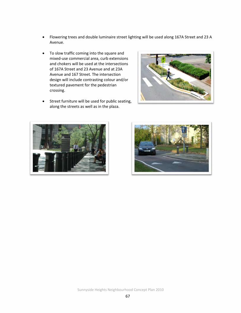
Sunnyside Heights Neighbourhood Concept Plan 2010
67
• Flowering trees and double luminaire street lighting will be used along 167A Street and 23 A Avenue.
• To slow traffic coming into the square and mixed-use commercial area, curb extensions and chokers will be used at the intersections of 167A Street and 23 Avenue and at 23A Avenue and 167 Street. The intersection design will include contrasting colour and/or textured pavement for the pedestrian crossing.
• Street furniture will be used for public seating,
along the streets as well as in the plaza.
Sunnyside Heights Neighbourhood Concept Plan 2010
68
3.7 Multi-Use Drainage Corridors
Multi-use corridors are intended to serve as stormwater management facilities while also providing a green public amenity. As development in the NCP proceeds, the initial purpose of
these corridors is as pervious open space and to provide water quality treatment through surficial infiltration. The stormwater servicing concept for the NCP is designed to control
stormwater through on-site source controls combined with the pervious area provided by the drainage corridors. The intent is to mimic a “natural” drainage system by increasing the amount
and quality of permeable surfaces. This will reduce the runoff volume and peak flow entering Fergus Creek and mitigate further creek erosion. If required in the future, enhanced infiltration
systems can be constructed within these corridors to enable increased stormwater control. Stormwater control features that can be included within the corridors include:
• Open channel bioretention filter swales (“bioswales”) to promote infiltration and provide runoff treatment;
• Subsurface drain-rock style storage system and perforated underdrains to promote
infiltration;
• Periodic water quality ponding areas along the swales;
• Deep amended topsoil
• Trees; and
• In some cases, a trunk storm sewer main if needed for major storm routing.
The bioswales are shallow, wide swales landscaped with grass for the 5-metres corridors or with grass, shrubs, and trees for use in the wider corridors. Bioswales are sized to capture and treat
runoff from small rain events (about 30mm in 24 hours). They will typicalls have an overflow structure (lawn basin/field inlet) at the end of each block, connected to the storm sewer to
shunt excess flows out of the bioswale. Surface grading is away from houses towards the bioswale and the bioswales are normally on the uphill side of the streets, so that in very severe
weather or if the overflow structure is blocked, excess flow may cause some street flooding but should not flood houses.

Sunnyside Heights Neighbourhood Concept Plan 2010
69
Future uses of the drainage corridor may include the construction of underground stormwater infiltration or detention storage facilities or the construction of surface infiltration measures
such as rain gardens. Landscaping of the corridor must take into consideration of these possible future uses. Extensive tree planting is not permitted in the corridor and no trees are to be
planted within the bio-swale. Utilities and other underground services may be permitted in the stormwater corridor if they do not obstruct the construction of future potential underground
stormwater facilities in the corridor.
The plan includes three different widths of drainage corridors that are located along the many roadways throughout the plan area. Most of the corridors are 5-metres wide, approximately
80%, while the remainders are 10 and 20-metres wide.
3.7.1 Five Metre Drainage Corridors
The 5m corridors are located on most east-west oriented, Type II and III local roads. A bio-swale
is located in the corridor to infiltrate and convey overland flow runoff from the sidewalk and half of the adjacent road surface. The road cross-slope is crowned.
Figure 3.11 Cross Section of 5-Metre Drainage Corridor

Sunnyside Heights Neighbourhood Concept Plan 2010
70
Figure 3.12 Typical Cross sections for grassed and planted bioswales

Sunnyside Heights Neighbourhood Concept Plan 2010
71
3.7.2 Ten Metre Drainage Corridors on 164th Street
A 10m wide corridor is located on the west side of 164 Street from 23 Avenue south to 18 Avenue.
3.7.3 Ten Metre Drainage Median Corridors
The 10m corridors are located in the centre median of selected Type Ia collector roads, namely
164 Street from 24 Avenue to about 22A Avenue, 166 Street from 23 Avenue to 24 Avenue, and 20 Avenue from 164 Street to 168 Street. A bio-swale is located in the corridor to infiltrate and convey overland flow runoff from the adjacent road surfaces. Overland flow runs off from both
sides of the road and enters the drainage corridor through curb cuts. Both directions of road surface are sloped towards the corridor instead of the traditional crowned road.
Figure 3.13 Cross Section of 10-metre Drainage Median Corridor
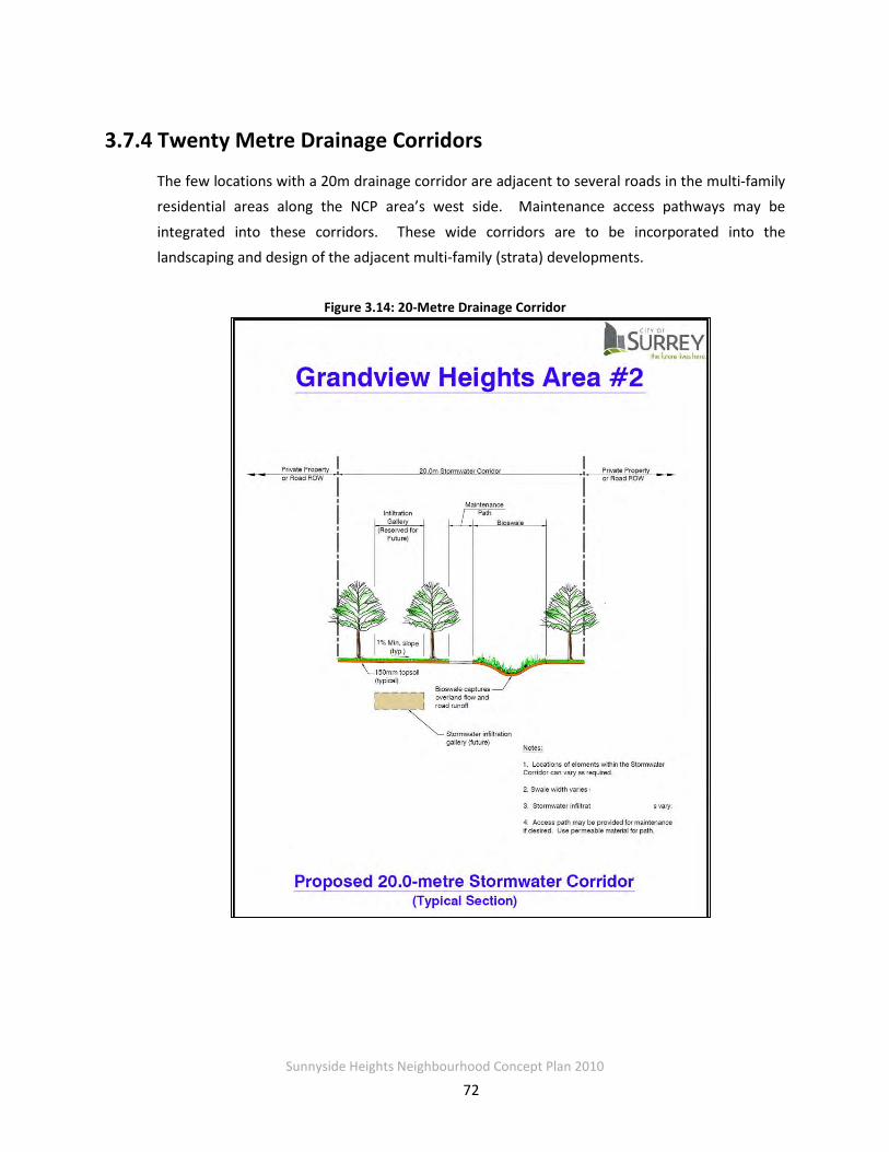
Sunnyside Heights Neighbourhood Concept Plan 2010
72
3.7.4 Twenty Metre Drainage Corridors
The few locations with a 20m drainage corridor are adjacent to several roads in the multi-family residential areas along the NCP area’s west side. Maintenance access pathways may be
integrated into these corridors. These wide corridors are to be incorporated into the landscaping and design of the adjacent multi-family (strata) developments.
Figure 3.14: 20-Metre Drainage Corridor

Sunnyside Heights Neighbourhood Concept Plan 2010
73
3.7.3 Interface with Private Lands Abutting the Corridors
• Multi-family dwelling units located along the corridor should provide second floor windows and balconies facing the corridor to allow casual surveillance of the corridor.
• The location of the pathway will be situated close to the dwelling units in order to allow for casual surveillance from the units.
Sunnyside Heights Neighbourhood Concept Plan 2010
74
3.8 ON-SITE STORMWATER CONTROLS
On-site stormwater controls are required for all lots in the Grandview Heights NCP #2 area. Relying heavily on sustainable, landscaped-based stormwater source controls, the intent is to
maximize infiltration and evapo-transpiration of rainwater. These types of on-site controls are described in Metro Vancouver’s April 2005 publication “Stormwater Source Control Design
Guidelines 2005.”
3.8.1 Single-Family Residential Land Use
For single-family residential lots, a minimum depth of 150mm of amended topsoil is to be applied to all yards and pervious areas. This is to ensure a minimum level of infiltration and
rainfall absorption is designed into the lot development. Roof leader drains are to be disconnected from the piped storm sewer system and are discharged onto landscaped areas.
Single-family residential lots are also encouraged to incorporate additional forms of on-site controls to minimize the impervious lot coverage associated with paved driveways, patios, and pathways. These on-site controls may include porous pavement, rain gardens, and retaining
existing tree cover. Layout, configuration, and construction of these additional controls should be done in accordance with “Stormwater Source Control Guidelines 2005.” The Engineer of
Record is to verify in writing that the amended topsoil meets the requirements of the Guidelines and has been property installed and that roof leaders discharge to ground not to a storm sewer.
3.8.2 Multi-Family Residential, Commercial, and Industrial Land Uses
Multi-family residential, commercial, and industrial lots are required to meet performance targets for on-site stormwater source controls. The requirements are:
• Install a minimum depth of 150mm of amended topsoil in yard and pervious areas; • Provide on-site stormwater storage equal to 150 m3/ha of gross site area released at a
specified rate according to lot location. The maximum release rate from on-site storage is 0.719 L/s/ha for lots located in the north-west portion approximately bounded by 24 Avenue, 162 Street, the BC Hydro ROW, and 164 Street plus an area between 23 Avenue and 24 Avenue from 164 Street to approximately 167 Street. The maximum release rate for other areas is 0.435 L/s/ha.

Sunnyside Heights Neighbourhood Concept Plan 2010
75
• Provide water quality treatment for any specific high risk contaminants associated with the
site’s land use activities as required by the City; and
• Promote the use of landscape-based stormwater source controls that emphasize infiltration and evapo-transpiration of rainwater from small storms.
The specific mix of source control methods is up to each site owner to allow for integration into the site’s overall architectural and landscaping concept. Layout, configuration, and construction should
be done in accordance with “Stormwater Source Control Guidelines 2005.” The Engineer of Record is to verify in writing that all BMPs have been designed in accordance with the Guidelines and property installed.

Sunnyside Heights Neighbourhood Concept Plan 2010
76
PART 4: ENGINEERING 4.1 Sanitary Sewer
The lands within Grandview Heights NCP Area #2 are presently serviced by septic tanks and fields. There is no existing sewer infrastructure. The ultimate sanitary sewer servicing concept
for the area will include sanitary sewers to service the entire area.
NCP Area #2 is located south of 24th Avenue and west of 168th Street on the southwest side of a gradual sloping hill with a slope generally in the range of 7 percent toward the south. The highest portion of the area is located to the northeast with an upper contour of about 114 m.
The lowest portion of the area is located in the south at an elevation of about 25 m.
A large capacity (600 mm diameter) sewer was recently constructed on 160th Street north of 24th Avenue to capture the anticipated demand from NCP Area #2 and other areas and convey it
to the Grandview Heights Interceptor, which runs from east to west and crosses 160th Street north of 28th Ave. All flows from NCP Area #2 will be directed to this sewer either by gravity or
pump. The intersection at 24th Avenue and 160th Street is at an elevation of approximately 80 m.
South of 24th Avenue another gravity sewer extends southwards along 160th Street to Croydon
Drive and then along Croydon Drive until it reaches Highway 99. At this point the sewer continues south along the north bound shoulder of Highway 99. This sewer is dedicated to
servicing the southern portion of the Highway 99 Corridor Plan; there is no capacity in the system to accommodate flow from Grandview Heights NCP Area #2.
There are areas outside of NCP Area #2 that will contribute flows to the sanitary infrastructure within the neighbourhood. The following table outlines the equivalent population expected for
sanitary loading and pump station sizing.

Sunnyside Heights Neighbourhood Concept Plan 2010
77
Table 4.2: Serviced Populations
Neighbourhood Equivalent Population
NCP #2 Sanitary catchment 1 (not to PS) 4,980
Sanitary catchment 2 (Pumped) 6,531 Hwy 99 (Pumped) 5,800
NCP #5 (Pumped) 6,630 NCP #3 (Pumped) 2,980
Total 26,921 Notes:
1. Populations from other NCP areas taken from Grandview Heights South Sanitary Sewer Servicing Plan
Study by Earth Tech (Canada) Inc. Final Report September 18, 2006 or developed based on the criteria
established. Population for Area #2 based on High Range - 2010 Jan 10.
This sanitary sewer servicing plan has been assembled with consideration of the City of Surrey
Design Criteria Manual (DCM).
4.1.1 Catchments
Fundamentally, there are two primary catchments within NCP Area #2: flows that can be
conveyed by gravity to the discharge point (intersection of 160th Street and 24th Avenue) and those that need to be pumped. Any flows that are not captured with the trunk sewer and
conveyed by gravity will travel downhill to the pump station.
The gravity catchment will be termed Catchment 1, and the pumped catchment will be termed Catchment 2. There are a number of sub catchments that make up each catchment and discharge into the respective trunk sewers. See Figure 4.1 for catchments and sub catchments.
The population for each catchment and sub catchment is based on population projections
provided by the City of Surrey for each land use polygon. Additional population (2.8 additional people for 50 percent of the units) has been included from Area #2 to account for potential
secondary suites in the following land use zones:
• Suburban Residential
• Suburban Transitional
• Urban Transitional
• Low Density Residential
• Medium Density Residential

Sunnyside Heights Neighbourhood Concept Plan 2010
78
Figure 4.1: Catchment Boundaries

Sunnyside Heights Neighbourhood Concept Plan 2010
79
4.1.2 Sewer Design Guidelines and Sizing
The collection system has been designed with consideration for the Surrey Design Criteria Manual (DCM). The following are key design criteria that were followed.
The sizing layout of sewers takes into consideration the following criteria:
• Average daily flows of 350 L/cap/day
• Peaking factor as per Harmon formula
• Manning’s “n” of 0.013 for all pipes
• Ground water infiltration of 11,200 L/hectare/day
• Sanitary sewer flow shall not exceed 50 percent of internal diameter
• Trunk and interceptor sewer flow shall not exceed 70 percent of internal diameter
• Maximum depth of trunk and interceptor sewers = 5.0 m (traversing localized areas and short sections only). Preferred maximum depth of trunk and interceptor sewers = 3.5 m
• Maximum depth of local sewers = 4.5 m (only to allow collection of downslope lots);
preferred maximum depth of local sewers = 3.5 m.
• Minimum depth of sewers = 2.0 m
• Minimum pipe slope of 0.5 percent on local sewers.
• Minimum slope on terminal sections of local sewers to be 1 percent
The maximum depth of sewers has been limited to 5 m at the invert for short sections with a preferred maximum depth of 3.5 m. Sewers deeper than 3.5 m are located only in areas to
allow servicing of downhill properties or to route sewers past localized high spots.
Local permanent or temporary pump stations have not been included as part of the design, and the City's policy is not to allow them. The City may consider temporary local sewage pump stations on a case by case basis.
The proposed sanitary network layout (primarily the local sewer system) is conceptual and will
be refined to reflect the latest road network with the City’s approval.

Sunnyside Heights Neighbourhood Concept Plan 2010
80
4.1.3 Catchment 1- Sanitary Sewer
The foundation for the collection system within Catchment 1 is the trunk sewer that extends from 20th Avenue and 168th Street to 24th Avenue and 160th Street. The trunk sewer collects all
the flows from Catchment 1 and conveys them to the existing gravity sewer on 160th Street.
See Figure 4.2 for an overview of the collection system. The proposed sanitary network layout is conceptual and should be refined at the detailed design phase with the City’s approval.
See Appendix A.1 for details of the collection system.

Sunnyside Heights Neighbourhood Concept Plan 2010
81
Figure 4.2: Proposed Sanitary Sewer
Sunnyside Heights Neighbourhood Concept Plan 2010
82
Trunk Sewer Alignment Flows from Grandview NCP Area #2 that cannot be captured by gravity will flow downhill to the
south and require pumping. The capital and ongoing costs of pumping are a strong incentive to capture as much flow by gravity as possible. The goal when locating this trunk sewer was to
maximize the area serviced by gravity flow to the intersection of 24th Avenue and 160th Street.
The alignment of the trunk sewer is based on topography and compatibility with the proposed road and land use plan. The alignment is placed within roads where possible; however, there
are some instances where lots were traversed. When it was required to traverse a lot, it was taken at right angles to roads where possible to align with future lot lines and building sites. The
minimum grade of the trunk would be 0.5% and the depth would be set to 3 to 4.5 metres in the single family zone such that the truck drains as many basements on the downhill side as
possible. The trunk sewer does cross a proposed park site between 21 and 22 Avenues and 162 A and 163
Streets. There are some significant trees situated on this proposed park and the alignment will need to be reviewed at the detailed design stage to minimize impacts to these existing trees.
Ditch Crossing at 164th Street
Within the 164th Street RoW south of 22nd Avenue, there is a constructed ditch that has been identified as a potential location for a future park and is reported to be a yellow listed
watercourse. The trunk sewer route crosses this ditch near where 21A Street would be located if it continued through. Due to the environmental significance of this area, an application was
made to the Surrey ERC for approval in principal. Approval was given and was recorded on the meeting minutes from May 21st, 2008. See Appendix A.1 for preliminary crossing design and
environmental requirements.
Future Eastward Extension The trunk sewer begins near the intersection of 168th Street and 20th Avenue. There is potential to continue this sewer to the east to allow capture of some flows from NCP Area # 5 in the
future. The sewer downstream has been sized to accommodate flows from this area with an allowance for a population of 3,650 and a land area of 46 Ha.

Sunnyside Heights Neighbourhood Concept Plan 2010
83
System Phasing The sewer system has been designed to allow development to progress from north to south where possible. With the trunk sewer critical to servicing the lands along its route, it is
important that downstream land develop prior to land upstream. It is expected that Catchment 1 and particularly areas to the north will develop first. As development proceeds south, the
trunk sewer must be constructed first. Once the trunk sewer is operational, development can proceed in conjunction with the collection system.
4.1.4 Catchment 2 - Sanitary Sewer (Pumped)
Alignment and Collection System There are a number of sewers within this catchment that traverse green space, trails or the BC Hydro RoW. These crossings are key to servicing the upstream lands. Rights-of-way will
need to be established for these sewers.
The sewers within this catchment collect and convey flow to the Grandview Heights South Pump Station.
With many of the roads following the contour lines, the parcels downhill from the sewer may have difficulty discharging to the sewer from basements. The primary area where this is a
concern is on the south-facing slope south of 20th Avenue.
As part of the collection system design, the service connections have been assumed to be located 7.5 m in from the property line and at a depth of 2.5 m below existing ground. Given a
slope of 2 percent from the service connection to the sewer, the maximum lot slope that can be serviced from the front road has been determined. The maximum depth of sewer in the road in
these instances is 4.5 m. This means that lots with a slope greater than about 5 percent must be serviced with back lane sewers. Where required, back lane sewers have been shown on the
collection system in Figure 4.2.
A collection sewer has been located along the south west edge of the NCP Area #2 (next to the BC Hydro corridor) that will require a dedicated utility RoW where it is not coincident with any road. The sewer RoW will be a minimum of 6 m wide and adjacent to the BC Hydro RoW. This
sewer will collect flows and convey them to the Grandview Heights South Pump Station. It is expected that the sanitary force main from the pump station will share this sewer RoW.
See Appendix A.1 for details of the collection system.
Sunnyside Heights Neighbourhood Concept Plan 2010
84
Grandview Heights South Pump Station Location Previous studies have recommended that the Grandview Heights South Pump Station be located
in the vicinity of 12th Avenue and 168th Street. Land fronting 168th Street between 14th Avenue and 12th Avenue on the east side is in the ALR. Only one house currently fronts 168th Street in
this portion of the road. Land south of 14th Avenue is unlikely to develop, and existing housing is presently situated on acreage parcels with septic fields. Based on a field reconnaissance
completed in February 2007, it is recommended that the pump station be situated in the vicinity of 168th Street and just north of 14th Avenue in the northwest corner of the city-owned land next
to the BC Hydro RoW. An overhead high voltage BC Hydro line crosses the intersection of 14th Avenue and 168th Street. The pump station must have its own dedicated location and cannot
encroach into the road RoW. The station is expected to require approximately a 40 m by 40 m parcel. The preferred location for the pump station is on the west side of 168th Street north of
the BC Hydro RoW. This land is currently vacant and not within the ALR, and an extensive area has recently been acquired by the City for environmental preservation and open space uses. The land is also relatively flat, and site grading would be straightforward. An arrangement
would be required with the Parks and Recreation Department for the location of the pump station on this site.
Pump Station Operating Conditions and Design
The ultimate flow to the pump station will be a combination of NCP Area #2 (Catchment 2), Area #5, Hwy 99 Grandview Corner, Hwy 99 South 1 and 2. At the time the pump station is
constructed, there will likely be limited development in the catchment. Initially there may only be a small amount of flow to the pump station.
It is planned to divert flows from Hwy 99 Corridor area once the Grandview South Pump Station
is operational. In the interim, the Hwy 99 flows will be conveyed to the Semiahmoo sanitary pump station; however, only 40 L/sec has been allocated to the Hwy 99 area. This initial
diversion of flow from Hwy 99 will be an important initial contribution to the pump station. With the minimal initial flows to the pump station, there is concern of odour issues arising from
the potentially long residence time of sewage within the force main. To reduce this risk, consideration has been given to twinning the force main as well as odour control systems. See
the technical memo in Appendix A.1 for details.
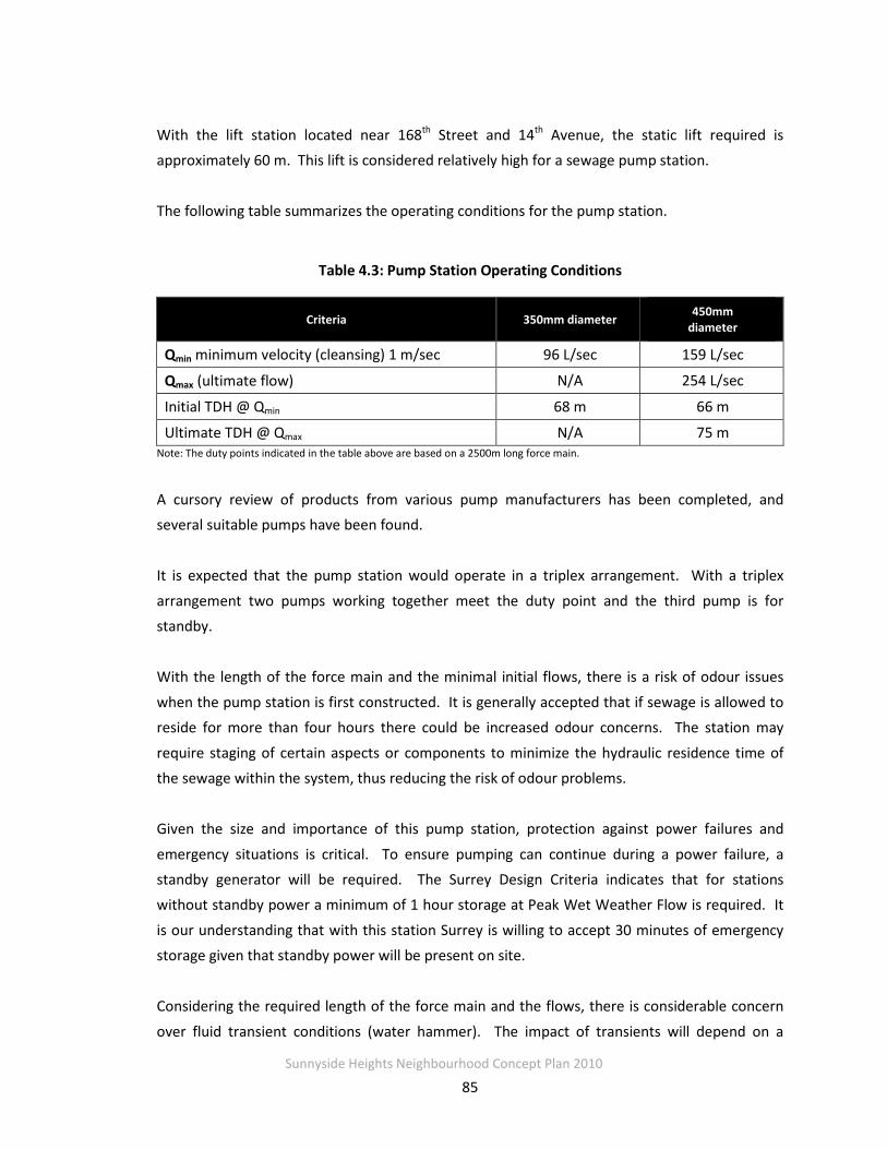
Sunnyside Heights Neighbourhood Concept Plan 2010
85
With the lift station located near 168th Street and 14th Avenue, the static lift required is approximately 60 m. This lift is considered relatively high for a sewage pump station.
The following table summarizes the operating conditions for the pump station.
Table 4.3: Pump Station Operating Conditions
Criteria 350mm diameter 450mm diameter
Qmin minimum velocity (cleansing) 1 m/sec 96 L/sec 159 L/sec
Qmax (ultimate flow) N/A 254 L/sec
Initial TDH @ Qmin 68 m 66 m
Ultimate TDH @ Qmax N/A 75 m Note: The duty points indicated in the table above are based on a 2500m long force main.
A cursory review of products from various pump manufacturers has been completed, and several suitable pumps have been found.
It is expected that the pump station would operate in a triplex arrangement. With a triplex
arrangement two pumps working together meet the duty point and the third pump is for standby.
With the length of the force main and the minimal initial flows, there is a risk of odour issues
when the pump station is first constructed. It is generally accepted that if sewage is allowed to reside for more than four hours there could be increased odour concerns. The station may
require staging of certain aspects or components to minimize the hydraulic residence time of the sewage within the system, thus reducing the risk of odour problems.
Given the size and importance of this pump station, protection against power failures and
emergency situations is critical. To ensure pumping can continue during a power failure, a standby generator will be required. The Surrey Design Criteria indicates that for stations without standby power a minimum of 1 hour storage at Peak Wet Weather Flow is required. It
is our understanding that with this station Surrey is willing to accept 30 minutes of emergency storage given that standby power will be present on site.
Considering the required length of the force main and the flows, there is considerable concern
over fluid transient conditions (water hammer). The impact of transients will depend on a

Sunnyside Heights Neighbourhood Concept Plan 2010
86
number of issues including: pipe materials, flow, and pump characteristics; however, it is expected that transient control measures and protection will be an essential components of the
pump station.
Intermediate or Permanent Lift Station at Mid Elevation Consideration has been given to the potential of constructing a sanitary lift station at an intermediate point within Area #2. This lift station would only serve Area #2, Catchment 2
parcels above wherever the lift station were located. If the lift station were located at 18th Avenue, it would collect approximately 70 L/sec PWWF
(Peak Wet Weather Flow) from Area #2. This intermediate lift station would only serve Area #2.
Technical challenges with an intermediate lift station include the access to 3 phase hydro power and staging of the force main to ensure adequate cleansing velocity.
Challenges with an intermediate lift station include additional overall capital costs as well as ongoing operations and maintenance costs. If an intermediate lift station were constructed, the
majority of the high density zoning within Area #2 could be captured by it; however, it would leave the other NCP areas with lower density the financial burden of construction of the main
lift station at the bottom of the hill. This burden may cause resistance to development in the lower (southern) portion of Area #2 as well as other NCP Areas.
Based on the increased costs (capital, operational and maintenance) for an additional
intermediate lift station, it is recommended that the single lift station be constructed at the bottom of the hill.
Force Main A force main will be required from the pump station to the discharge point at 162nd Street. In
order to service the pump station at build-out, a 450 mm diameter pipe or an equivalent twinned pipe is recommended. The size is a balance between achieving cleansing velocity as soon as the pump station is built and limiting the friction loss in the pipe during the ultimate
condition.
Surrey’s DCM dictates a minimum cleansing velocity of 1 m/sec within the pipe. This is required to ensure no accumulation of solids within the pipe.

Sunnyside Heights Neighbourhood Concept Plan 2010
87
As discussed previously, odour risks may provide incentive to twinning the force main with smaller diameter pipes. The advantage to this would be reduced initial odour risks; however,
the overall cost would be higher.
The route of the force main has been assumed to travel up 168th Street to 16th Avenue and then west to the BC Hydro RoW. From 16th Avenue the route will follow along the proposed sewer
RoW on the east side of the Hydro RoW. See Figure 4.2 for force main alignment.
System Phasing The pump station and force main must be constructed first before any development within Catchment 2. As part of the initial pump station operation, the diversion from Hwy 99 Corridor
is required, thus necessitating a gravity sewer from the west. With a gravity sewer in the west, it would make sense for the areas serviced by it to be developed first. Once the pump station is
operational, development can proceed in conjunction with the collection system.
4.1.5 Cost Estimates and Financing Approach
To accommodate planned growth, NCP Area #2 must be connected to the City’s sanitary sewer
system (Currently the area is serviced only by septic fields and septic tanks). The required system will comprise the following three components: upsizing of mains to achieve sizes greater than 200mm, trunk sewers for flows greater than 40 l/s, and a force main and lift station to
carry flow from Catchment 2 (see Figure 4.2). The force main and pump station will serve not only NCP Area #2 but also future development within the Highway 99 Corridor, a component of
future NCP Area #5, and all of future NCP Area #3.
Consistent with current practice, developers will be required to fund frontage works, including costs associated with 200 mm sewer mains. The concept is that the DCC program will fund the
upsizing of the base size to achieve the most of the trunk system. Where flows exceed 40 l/s and the trunk element does not front benefiting properties and, therefore, are not achievable using
an upsizing approach, the full trunk element costs are included in the DCC eligible works. At this time, it is not possible to exactly identify all the elements that may not benefit fronting
development; consequently, a worst case relating to amount of trunk elements has been identified. Where these trunks are achievable through the upsizing approach, this is the
approach that will be used. The sewers to be upsized and the identified trunk elements are detailed in Appendix A.1 and the costs are summarized in Table 4.4.
Sunnyside Heights Neighbourhood Concept Plan 2010
88
The estimated cost for the force main and pump station (including RoW costs for the force main, land costs for the pump station, and engineering and contingency costs) to service the ultimate
catchment area is $10.4 million. Although the pump station serves future NCP Areas #3 and #5, these areas currently remain suburban and un-sewered; consequently, until these future NCPs
move to a greater level of certainty, no contribution from these areas can be relied on at this time. Excluding the pumping capacity for Areas 3 and 5 reduces the pump station cost to $10.1
million. A contribution of nearly $1.8 million from Highway 99 Corridor toward the pump station has been included in the City’s 10-Year Servicing Plan. Therefore if any development in
Area #2 is to proceed ahead of the completion of the NCPs for Areas #3 and #5, Area #2 must be capable of financing the full cost of the pump station less the approximately $1.8 million
contribution from Highway 99. If Area #2 does proceed ahead of Areas #3 and #5, then the pumping capacity for Areas #3 and #5 can be deferred, which reduces the cost of the pump
station to $10.1 million.
As shown in Table 4.4, all costs for the required trunk sewers and upsizing of the collection system will be financed through DCCs. The cost recovery approach for the pump station and force main is discussed in Section 4.1.6. As shown in Table 4.5, a special cost recovery approach
is needed for the pump station and force main because anticipated DCC revenues are less than expected costs for these works.

Sunnyside Heights Neighbourhood Concept Plan 2010
89
Table 4.4: Sanitary Sewer Cost Estimates and Financing Approach
Capital Item Total Cost
Costs Allocated
to Area #2
Costs
Allocated to
Other NCPs
Cost Recovery Approach
City-Wide DCCs
Collected from
Area #2
DWA from
Area #2
Hwy 99
DCC
Adjustment
Sanitary Pump Station and Force Main
$10,100,000 $5,764,000 $4,336,000 $3,230,000 $2,534,000 $2,555,000
Trunk Sewer
Elements $1,467,000 $1,467,000 $0 $1,467,000 $0 $0
Upsizing (above base
size)
$956,000 $956,000 $0 $956,000 $0 $0
Total $12,523,000 $8,187,000 $4,336,000 $5,653,000 $2,534,000 $2,555,000
Notes:
1. Costs updated to January 2010 construction costs. Pump station cost excludes pump capacity for NCP Areas #3
and #5.
2. See Table 4.4 for the comparison of anticipated DCC revenues and DCC costs.
3. “Other” cost recovery approaches include Development Works Agreements (see Section 4.7). 4. Pump station estimate does not include pumping capacity for future NCP areas 3 & 5.
5. There have been minor changes to the road network since the detailed trunk sewer cost estimates were prepared,
these changes are not considered significant and are considered within the limits of normal estimating accuracy.

Sunnyside Heights Neighbourhood Concept Plan 2010
90
Table 4.5: Estimated DCC Revenues and Expenditures – Sanitary Sewer
Estimated DCC Revenues DCC Eligible Costs Balance
$5,653,000 $8,187,000 -$2,534,000
Notes: 1. DCCs based on the average development yield for the area.
2. DCC revenues do not include potential DCC revenues from commercial or institutional development within Area #2.
3. DCC eligible costs include those costs in Table 4.3 identified to be recovered
through DCCs generated from within the NCP combined with Development
Work Agreements or equivalent financial mechanisms.
4.1.6 Options and Implementation Issues Related to Funding the DCC
Shortfall
As identified in Section 4.1.5 there is a shortfall between what is generated by DCCs and the
trunk/pump station needs typically funded by DCCs. This shortfall is created by one item, namely the sewer pump station to service Catchment 2 (the southern catchment). This pump
station also services other areas, comprising the Highway 99 Corridor, (which provides a $1.8 million contribution) and the future NCPs Grandview Area #3 and a portion of Area #5.
However, because Areas #3 and #5 are in the future and have no official status, funding from these areas cannot be built into the financial model at this time nor has the cost for the pumping capacity for these areas been included in the estimate. This leaves a $5.089 million
shortfall for the pump station to be funded by NCP Area #2. This funding situation is further complicated due to the fact that Catchment 1 (the northern catchment) does not physically
need the pump station to be able to develop.
The proposed funding approach to overcome this shortfall and fund the pump station for Catchment 2 would be through a Development Works Agreement. Under this approach a
developer, or group of developers, could frontend the pump station with cost recovery through a combination of a DCC Frontenders Agreement over the entire NCP (for the component of the
DCC not needed for trunks and upsizing - $3.23 million) and a Development Works Agreement ($5.089 million) over Catchment 2.
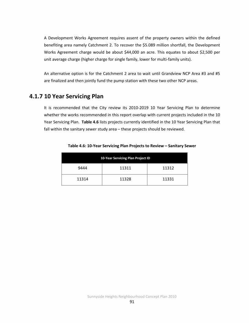
Sunnyside Heights Neighbourhood Concept Plan 2010
91
A Development Works Agreement requires assent of the property owners within the defined benefiting area namely Catchment 2. To recover the $5.089 million shortfall, the Development
Works Agreement charge would be about $44,000 an acre. This equates to about $2,500 per unit average charge (higher charge for single family, lower for multi-family units).
An alternative option is for the Catchment 2 area to wait until Grandview NCP Area #3 and #5
are finalized and then jointly fund the pump station with these two other NCP areas.
4.1.7 10 Year Servicing Plan
It is recommended that the City review its 2010-2019 10 Year Servicing Plan to determine
whether the works recommended in this report overlap with current projects included in the 10 Year Servicing Plan. Table 4.6 lists projects currently identified in the 10 Year Servicing Plan that
fall within the sanitary sewer study area – these projects should be reviewed.
Table 4.6: 10-Year Servicing Plan Projects to Review – Sanitary Sewer
10-Year Servicing Plan Project ID
9444 11311 11312
11314 11328 11331

Sunnyside Heights Neighbourhood Concept Plan 2010
92
4.2 Water Distribution
This section presents an analysis of the future water system in and around the South Grandview
Heights NCP Area #2 study region. The investigation includes a discussion of the existing distribution network as well as the required upgrades. In addition, this section provides specific
details of the water distribution system necessary to service the NCP area.
4.2.1 Existing System
Currently the watermains in the study area comprise primarily small diameter pipes (150 and
200 mm diameter) intended to service semi rural areas. There is insufficient capacity to provide adequate service for the proposed land use.
The Grandview Reservoir was constructed in 1999 and is intended to provide water supply to
the area. The GVRD transmission main located on 24th Avenue supplies the reservoir. The Grandview Pump Station constructed in 2006 is intended to supply water into the 142 m HGL pressure zone.
To link the Grandview Pump Station with the distribution system to the west a, 600 mm
diameter main was constructed in 2007. Currently this 600 mm diameter main extends from the pump station near 24th Avenue and 166th Street to 24th Avenue and 164th Street. The line
extends west of 164th Street on 24th Avenue as a 350 mm diameter pipe.
4.2.2 Recent Supply System Improvements
A 500 mm diameter feeder main to supply the 110 m HGL pressure zone was recently
constructed. This feeder main is located within the 164th Street right-of-way south of 24th Avenue. The pipe crosses Highway 99 and connects with an existing 450 mm main on King
George Highway. Initially this pipe will be connected to the 142 m HGL zone through a Pressure Reducing Valve (PRV) at 24th Avenue and 164th Street. Since reducing pressure from a boosted
(pumped) system wastes energy, the pipe will ultimately be fed directly by gravity from the Grandview Reservoir.

Sunnyside Heights Neighbourhood Concept Plan 2010
93
4.2.3 Proposed Supply System Improvements
Improvements to provide NCP Area #2 with municipal water are shown in Figure 4.3. The proposed improvements will ensure a solid backbone for the area’s water supply system. This is
based on satisfying peak hour demands as well as providing adequate fire flows as needed. Figure 4.3 shows the ultimate network required, including pipe sizes. Existing pipes that could form part of the future system have been indicated as a dashed line. The proposed water
network is conceptual and should be refined to reflect the latest road network and phasing of development applications with the City’s approval.
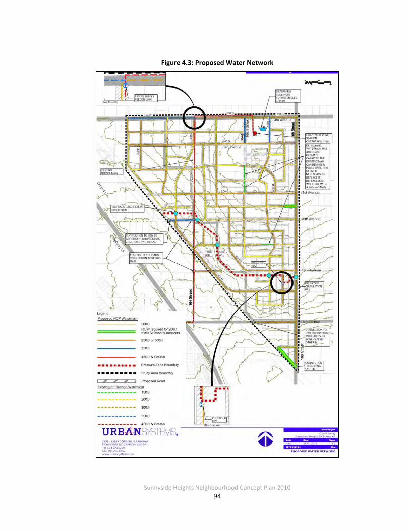
Sunnyside Heights Neighbourhood Concept Plan 2010
94
Figure 4.3: Proposed Water Network
Sunnyside Heights Neighbourhood Concept Plan 2010
95
4.2.4 System Analysis
To support the proposed development, a network of new mains will be required. WaterCAD was used to model the system with peak hour demands as well as combinations of maximum
day demand with fire flows.
4.2.5 Analysis Criteria and Pressure Zones
Water consumption rates for existing and future development in and around the study area
were taken from the City of Surrey Design Criteria Manual (DCM). The following table summarizes the consumption rates:
Table 4.7: Consumption Rates
Demand Type L/capita/day
Average Day Demand 500
Maximum Day Demand 1000
Peak Hour Demand 2000
Population projections within the NCP study area were provided by the City of Surrey for each land use area.
The minimum pressure required during peak hour demands is 274 kPa (28 m).
The DCM outlines the following criteria for pipes under design flow:
• Hydraulic Grades in water mains greater than 250 mm in diameter not to exceed 0.5 percent; and
• Velocity in pipes not to exceed 2 m/sec
Fire flow capacity of the water system was analyzed for the ultimate system only; fire flows for interim conditions were not considered. Fire flows were based on land use and zoning according to the DCM. For this study area the following flows were used:
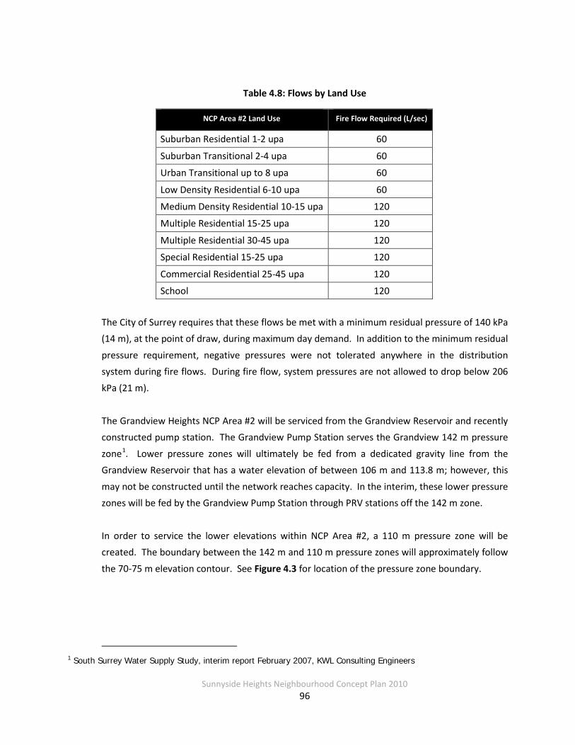
Sunnyside Heights Neighbourhood Concept Plan 2010
96
Table 4.8: Flows by Land Use
NCP Area #2 Land Use Fire Flow Required (L/sec)
Suburban Residential 1-2 upa 60
Suburban Transitional 2-4 upa 60
Urban Transitional up to 8 upa 60
Low Density Residential 6-10 upa 60
Medium Density Residential 10-15 upa 120
Multiple Residential 15-25 upa 120
Multiple Residential 30-45 upa 120
Special Residential 15-25 upa 120
Commercial Residential 25-45 upa 120
School 120
The City of Surrey requires that these flows be met with a minimum residual pressure of 140 kPa (14 m), at the point of draw, during maximum day demand. In addition to the minimum residual
pressure requirement, negative pressures were not tolerated anywhere in the distribution system during fire flows. During fire flow, system pressures are not allowed to drop below 206
kPa (21 m).
The Grandview Heights NCP Area #2 will be serviced from the Grandview Reservoir and recently constructed pump station. The Grandview Pump Station serves the Grandview 142 m pressure
zone1. Lower pressure zones will ultimately be fed from a dedicated gravity line from the Grandview Reservoir that has a water elevation of between 106 m and 113.8 m; however, this
may not be constructed until the network reaches capacity. In the interim, these lower pressure zones will be fed by the Grandview Pump Station through PRV stations off the 142 m zone.
In order to service the lower elevations within NCP Area #2, a 110 m pressure zone will be created. The boundary between the 142 m and 110 m pressure zones will approximately follow
the 70-75 m elevation contour. See Figure 4.3 for location of the pressure zone boundary.
1 South Surrey Water Supply Study, interim report February 2007, KWL Consulting Engineers
Sunnyside Heights Neighbourhood Concept Plan 2010
97
4.2.6 Hydraulic Analysis
The hydraulic model used for simulations was of the future system only. Figure 4.3 illustrates the general layout of the water model. Also shown are the existing and future system elements
that form the ultimate network. Demands were allocated as "bulk” point demands to main intersections on the distribution grid.
To simplify the analysis of the study area, only a portion of the overall distribution system was
modeled. In constructing the model this way, several assumptions were made about the model boundaries (points where the model ends but the actual system continues). The model
boundary conditions are described below:
• The Grandview Pump Station will supply the 142 m HGL zone.
• The 110 m zone was assumed to be fed from a grid main connection to the feeder main at the intersection of 20th Avenue and 164th Street and another connection at 18th Avenue. This feeder main was assumed to be operating at 102 m HGL at the point of
connection. In reality the 110 m zone will be connected with the 142 m zone with PRVs in one or several locations. It is assumed that these PRVs will be configured so they will
not open under normal operating conditions.
• Areas outside the Grandview Heights NCP Area #2 were not modeled.
• Demands arising from outside the boundaries of the NCP Area were not included in the model. With the 142 m HGL zone, pipes along the boundary (primarily 24th Avenue and 168th Street) were assumed to have pressures equivalent to the max allowed HGL loss
(0.5 percent) at the distance from the supply point.
Demands Demands used in the analysis were based on population projections provided by the City of
Surrey for the proposed land use areas. The following is a breakdown of future population and future demand:

Sunnyside Heights Neighbourhood Concept Plan 2010
98
Table 4.9: Future Demand
Area Future Population (# People) Future Average Day Demand
142 m HGL zone 8,200 47 L/sec
110 m HGL zone 3,100 18 L/sec
Total 11,300 65 L/sec
System Performance The distribution system as shown in Figure 4.3 meets the criteria for pressure, line velocities,
and fire flows.
4.2.7 Discussion
The network is configured so each component contributes to the overall integrity and
functionality of the system. As development occurs and partial construction of the system takes place, an evaluation of the interim system to meet requirements is necessary.
The recently constructed 600 mm diameter water main on 24th Avenue currently extends west
to 164th Street. The City has no plan to upgrade the pipe network north and west of the intersection of 24 Avenue and 164 Street. For the purposes of NCP Area #2, it has been assumed
that the existing 350 mm diameter pipe west of 164th Street will remain.
On 24th Avenue, there are two distribution mains providing water to both hydrants and residents. The two pipes are a 150 mm pipe and a newer 300 mm main (350 mm west of 164th
Street). The modeling assumed that the 150 mm pipe will be abandoned and any services connections or hydrants would be transferred to the 300 or 350 mm diameter pipe.
There are a number of existing pipes of small diameter that are not included within the future system. These existing pipes located in areas where new pipes are shown should be removed as
installation of the new ones proceeds. Hydrants and service connections should be transferred over as the new mains are extended.
For the 110 m pressure zone, there are a number of locations where the Area #2 water system is
potentially connected to adjoining areas. Specifically these locations are:

Sunnyside Heights Neighbourhood Concept Plan 2010
99
• 20th Avenue and 163rd Street
• 18th Avenue and 164th Street
• 16th Avenue and 166th Street
• 16th Avenue and 168th Street
• 14th Avenue and 168th Street
Pressure Reducing Valves The proposed Pressure Reducing Valve (PRV) at 17A Avenue and 167A Street will provide a
strong redundant linkage to the higher pressure zone to the north. This secondary connection to the high pressure system is an essential component of a secure supply system.
The PRV will be configured to operate only during emergencies or shutdowns of the main supply
line. The location of the PRV is important from the standpoint of its connection to the supply network. It was located on 167A Street because that area is a hub for a number of network
pipes. The portion of the 110 m pressure zone within NCP Area #2 is only a portion of the total 110 m pressure zone network. The sizing and capacity of this PRV should be considered with respect to an overall servicing strategy to the 110 m pressure zone.
To provide some flow for water across the pressure zone boundary for quality purposes, four
circulation PRVs are proposed. This will allow a small amount of water to be circulated across the pressure zone boundary through what would otherwise be dead end pipes thus avoiding
problems related to stagnant water. One circulation PRV replaces the existing check valve located near 168th Street and 17A Avenue.
System Phasing The staging of development within NCP Area #2 is expected to start in the north within the 142
m pressure zone based on constraints imposed with the sanitary sewer system. This is fortunate because the water supply system is fed from the north and the pipes are sized accordingly. The
water supply network within the 142 m pressure zone must be constructed from the north to the south. The first step will be to complete the tie-ins to the mains on 24th Avenue and then to provide the grid main linkages extending to the south. As development proceeds, loops and
linkages within the network should be constructed to ensure a strong intermediate distribution network.

Sunnyside Heights Neighbourhood Concept Plan 2010
100
The recently constructed 164th Street feeder main will provide adequate supply for development to take place in the 110 m pressure zone. The construction of the PRV station at 17A Avenue
and 167A Street should occur as soon as there are sufficient distribution mains within the 142 m zone and the 110 m zone to support the connection.
To achieve the required fire flows and system performance, there is a reliance on the integrity of
the network. Each pipe on its own would not be able to carry the full flow, but all the pipes working together can. This means that when only part of the system is constructed, it may not
be able to convey the required flows. Developments that are proposed to be built with only part of the network in place will need to evaluate the partial system on a case-by-case basis.
Over-sizing of pipes to meet temporary requirements may be required.
4.2.8 Cost Estimates and Financing Approach
To satisfy anticipated peak hour demands and provide adequate fire flows, NCP Area #2 will
need additional distribution mains and new and/or upgraded trunk mains, as well as a new PRV2 at 17A Avenue and 167A Street and four smaller re-circulating PRVs. Consistent with current
practice, developers will be required to fund frontage works, as well as off site water mains of sufficient size to provide adequate fire and domestic flow for the proposed development,
including costs associated with 200 mm distribution mains. The upsizing is based on City of Surrey 2010 ‘all up’ rates for upsizing including engineering, administration, etc. Some sections of the trunk water network already have 200 mm diameter mains, consequently the upsizing
approach cannot be use to achieve these sections, and a full cost has been allowed for. The PRV is estimated to cost $75,000, and the circulating PRVs are estimated at $10,000 each (including
15 percent engineering, 5 percent administration, and 30 percent contingency).
As shown in
2 The system will also require four circulation PRVs, which will be funded by developers as part of their local servicing requirements.

Sunnyside Heights Neighbourhood Concept Plan 2010
101
Table 4.10, the cost to upsize mains larger than 200 mm, the cost for new trunk elements not achievable through upsizing and the PRV stations are to be recovered through DCCs.
Further details on upsizing locations and cost estimates are included in Appendix A.2.
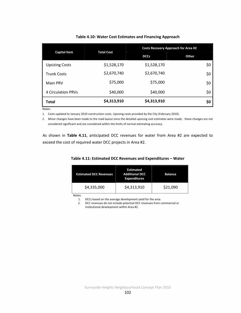
Sunnyside Heights Neighbourhood Concept Plan 2010
102
Table 4.10: Water Cost Estimates and Financing Approach
Capital Item Total Cost Costs Recovery Approach for Area #2
DCCs Other
Upsizing Costs $1,528,170 $1,528,170 $0
Trunk Costs $2,670,740 $2,670,740 $0
Main PRV $75,000 $75,000 $0
4 Circulation PRVs $40,000 $40,000 $0
Total $4,313,910 $4,313,910 $0 Notes: 1. Costs updated to January 2010 construction costs. Upsizing costs provided by the City (February 2010).
2. Minor changes have been made to the road layout since the detailed upsizing cost estimates were made; these changes are not
considered significant and are considered within the limits of normal estimating accuracy.
As shown in Table 4.11, anticipated DCC revenues for water from Area #2 are expected to exceed the cost of required water DCC projects in Area #2.
Table 4.11: Estimated DCC Revenues and Expenditures – Water
Estimated DCC Revenues Estimated
Additional DCC Expenditures
Balance
$4,335,000 $4,313,910 $21,090
Notes: 1. DCCs based on the average development yield for the area. 2. DCC revenues do not include potential DCC revenues from commercial or
institutional development within Area #2.

Sunnyside Heights Neighbourhood Concept Plan 2010
103
4.2.9 Ten Year Servicing Plan
It is recommended that the City review its 2010-2019 10 Year Servicing Plan to determine whether the works recommended in this report overlap with current projects included in the 10
Year Servicing Plan. Table 4.12 lists projects currently identified in the 10 Year Servicing Plan that fall within the NCP study area – these projects should be reviewed.
Table 4.12: 10 year Servicing Plan Projects to Review – Water
10 Year Servicing Plan Project ID
4943 5379 9914
9955 9956 9957
10358 10359 10500
10502 10505 11515
11532 11561 11562
11563 11564 11565
11566 11567 11568
11569 11570 11571
11572 11573 11574
11575 11576 11577
11578 11579 11580
11633

Sunnyside Heights Neighbourhood Concept Plan 2010
104
4.3 Stormwater Management
Most of the neighbourhood lies within the Fergus Creek watershed, for which a Master Drainage Plan (MDP) and an integrated stormwater management plan (ISMP) have been previously
prepared. The MDP, updated in 2001, provides the basis for conveying major storm event runoff from the area to the creek, including provision for attenuation of peak runoff flows as
needed. The ISMP extended the work of the MDP and proposed strategy for managing the many small storm events that occur during the course of a year, with an emphasis on lower
impact, source control best management practices. In accordance with direction from the City, the Grandview Heights NCP Area #2 stormwater management plan is to be consistent with this
ISMP, with elements from the MDP adapted as required to supplement this framework.
4.3.1 Study Area
Figure 4.4 shows the Grandview Heights Area NCP Area #2, located in the south part of Surrey,
just east of the Highway 99 Corridor, as well as the existing drainage infrastructure. The neighbourhood, roughly triangular in shape, covers about 163 hectares and is bounded by 24th
Avenue and 168th Street on the north and east sides, respectively. The west side extends along 161A Street; however, about 200 m south of 24th Avenue, the boundary cuts diagonally to the
southeast along the BC Hydro corridor, hitting 168th Street just north of 14th Avenue.
Land Use Existing
Except for several parcels on or near the north boundary of the study area (24th Avenue), the neighbourhood is a mixture of rural and low density, single family residential land use
conditions. The only significant non-rural, non-residential land uses in the area cluster along 24th Avenue, including a corner grocery at 168th Street and 24th Avenue, a City water reservoir
and miscellaneous small machine, auto repair and agriculture uses in the northwest corner of the area.
Sunnyside Heights Neighbourhood Concept Plan 2010
105
Proposed Grandview Heights Area #2 is proposed to remain largely residential, with both suburban and
urban-type densities planned. As currently, the corner of 24th Avenue and 168th Street will retain a small commercial node; there are no proposed industrial uses for the area. An
elementary school is proposed to be developed on the north end of the study area, which will include large open-space sports field areas. The existing water reservoir will be retained, and its
site will also include a City utility maintenance and materials storage depot.
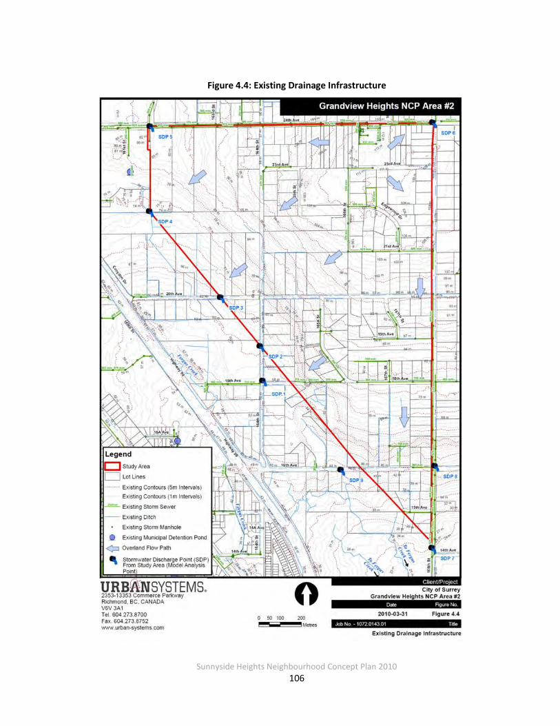
Sunnyside Heights Neighbourhood Concept Plan 2010
106
Figure 4.4: Existing Drainage Infrastructure

Sunnyside Heights Neighbourhood Concept Plan 2010
107
Topography The area generally slopes from a high area near 24th Avenue and 168th Street toward the south, southwest and west. The top of the hill, in the neighbourhood’s northeast corner, is relatively
flat, while a 10+ m high ridge or steep area runs along the area’s diagonal southwest boundary, being most prominent from about 20th Avenue and 168th Street down to 16th Avenue and
168th Street.
Overall, the total elevation drop from northeast to south is 87 m with an average slope of 4.8 percent, and from northeast to northwest is 32 m with an average slope of 1.8 percent.
Consistent with this, the eastern parts of many east-west streets are characterized by gentle profile grades while north-south streets tend to be steeper.
Watersheds Nearly the entire neighbourhood lies within the Fergus Creek watershed except for the most northeasterly corner (3 hectares, total) at 24th Avenue and 168th Street. The corner drains
toward Burrows Ditch. The Fergus Creek system, covering about 7.8 km2 in total, drains toward the Campbell River then into Semiahmoo Bay. Burrows Ditch on the other hand drains to the
north toward the Nicomekl River, which in turn drains to Mud Bay.
Although storm sewers do serve several of the subdivisions in the neighbourhood now, by and large the area is serviced by open ditch systems. One of these, lying within the 164th Street
right-of-way (RoW) from about 23rd Avenue to 20th Avenue and then as a roadway ditch continuing on south to 16th Avenue (just outside the neighbourhood area), is proposed as a
riparian protection corridor due to its identification as a Class B watercourse.
Stormwater Management Concepts Standard of practice for stormwater management in Surrey is undergoing a rapid change, as it is
across North America. So-called “traditional” approaches, including simply collecting, conveying and discharging runoff in storm sewers without any control as well as using detention ponds to
attenuate peak runoff flows, are losing favour for a variety of reasons including:
• They do not mitigate damage to receiving water ecosystems
• They often exacerbate erosion and flooding if not coordinated within a watershed

Sunnyside Heights Neighbourhood Concept Plan 2010
108
• They often do not fit with environmentally sensitive site and community designs now more frequently favoured by homeowners
In lieu of the traditional approaches, more sustainable, lower impact stormwater controls are
required for Grandview Heights Area #2 since the area drains to Fergus Creek. Fergus Creek is a fish-bearing watercourse with existing erosion issues. Lower impact controls (sometimes called
“low impact development” or LID) emphasize integrating stormwater controls more carefully with environmental values (e.g., fish and wildlife habitat preservation and enhancement) and
addressing runoff generation closer to the source, often through the use of landscape-based design practices.
The watershed context for the Grandview Heights Area #2 plan is addressed in two separate but related plans, the Fergus Creek Master Drainage Plan (MDP) Update (2001) and the Fergus
Creek Integrated Stormwater Management Plan (ISMP) (2007). The MDP Update provides a framework for conveying runoff from major storm events from the area to Fergus Creek, and
includes provision for trunk storm sewers and two offsite detention ponds (see Figure 4.5).
While it assesses the full spectrum of rainfall events, the ISMP particularly focuses on the “typical” or average rain event conditions that represent 90 percent or more of the rainfall that
occurs in the course of a year. It further describes flow maintenance and stormwater control targets for the entire watershed as required to maintain and protect the hydrologic conditions
in Fergus Creek. The proposed control targets across the watershed are:
• 10 percent (with a minimum of 5%) set aside of open, pervious area available for
rainwater infiltration
• 150 m3 of rainwater detention storage per hectare
• Release rate that varies across the watershed
Sunnyside Heights Neighbourhood Concept Plan 2010
109
For Grandview Heights Area #2, the release rates are 0.719 L/s/ha and 0.435 L/s/ha for the western and eastern portions, respectively, of the area. To support these overall targets, the
ISMP recommended that three basic types of best management practices (BMPs) be applied throughout the Fergus Creek watershed:
• Roof leader disconnection
• Topsoil preservation and augmentation including:
o Maintaining tree cover density o Increased top soil depth o Porous pavement
o Green roofs o Some infiltration-type swales
• Implementation of infiltration infrastructure, including: o Rain gardens
o Infiltration swales with storage o Surface or subsurface storage
o Infiltration ponds o Underground galleries

Sunnyside Heights Neighbourhood Concept Plan 2010
110
Figure 4.5: Conceptual Drainage Plan from 2001 MDP Update
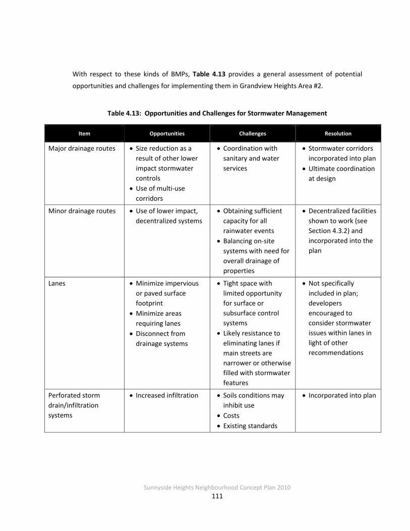
Sunnyside Heights Neighbourhood Concept Plan 2010
111
With respect to these kinds of BMPs, Table 4.13 provides a general assessment of potential
opportunities and challenges for implementing them in Grandview Heights Area #2.
Table 4.13: Opportunities and Challenges for Stormwater Management
Item Opportunities Challenges Resolution
Major drainage routes • Size reduction as a result of other lower impact stormwater controls
• Use of multi-use corridors
• Coordination with sanitary and water services
• Stormwater corridors incorporated into plan
• Ultimate coordination at design
Minor drainage routes • Use of lower impact, decentralized systems
• Obtaining sufficient capacity for all rainwater events
• Balancing on-site systems with need for overall drainage of properties
• Decentralized facilities shown to work (see Section 4.3.2) and incorporated into the plan
Lanes • Minimize impervious or paved surface footprint
• Minimize areas requiring lanes
• Disconnect from drainage systems
• Tight space with limited opportunity for surface or subsurface control systems
• Likely resistance to eliminating lanes if main streets are narrower or otherwise filled with stormwater features
• Not specifically included in plan; developers encouraged to consider stormwater issues within lanes in light of other recommendations
Perforated storm drain/infiltration systems
• Increased infiltration • Soils conditions may inhibit use
• Costs • Existing standards
• Incorporated into plan
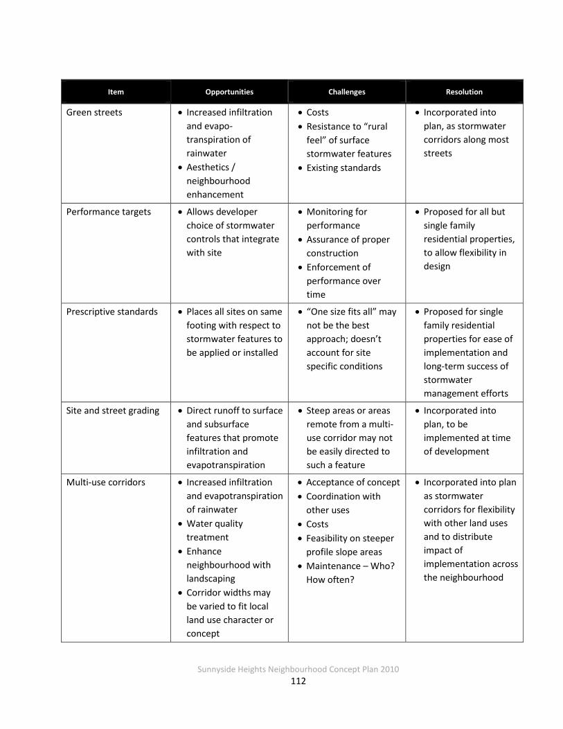
Sunnyside Heights Neighbourhood Concept Plan 2010
112
Item Opportunities Challenges Resolution
Green streets • Increased infiltration and evapo-transpiration of rainwater
• Aesthetics / neighbourhood enhancement
• Costs • Resistance to “rural
feel” of surface stormwater features
• Existing standards
• Incorporated into plan, as stormwater corridors along most streets
Performance targets • Allows developer choice of stormwater controls that integrate with site
• Monitoring for performance
• Assurance of proper construction
• Enforcement of performance over time
• Proposed for all but single family residential properties, to allow flexibility in design
Prescriptive standards • Places all sites on same footing with respect to stormwater features to be applied or installed
• “One size fits all” may not be the best approach; doesn’t account for site specific conditions
• Proposed for single family residential properties for ease of implementation and long-term success of stormwater management efforts
Site and street grading • Direct runoff to surface and subsurface features that promote infiltration and evapotranspiration
• Steep areas or areas remote from a multi-use corridor may not be easily directed to such a feature
• Incorporated into plan, to be implemented at time of development
Multi-use corridors • Increased infiltration and evapotranspiration of rainwater
• Water quality treatment
• Enhance neighbourhood with landscaping
• Corridor widths may be varied to fit local land use character or concept
• Acceptance of concept • Coordination with
other uses • Costs • Feasibility on steeper
profile slope areas • Maintenance – Who?
How often?
• Incorporated into plan as stormwater corridors for flexibility with other land uses and to distribute impact of implementation across the neighbourhood

Sunnyside Heights Neighbourhood Concept Plan 2010
113
Item Opportunities Challenges Resolution
Infiltration-based BMPs • Limit runoff and enhance base flows in streams
• Decentralize the systems
• Soils conditions, including depth to hardpan, infiltration capacities (long-term saturated conductivity) and depth to seasonal high water tables
• Incorporated into plan
On-site BMPs (“lower impact stormwater source controls”)
• Decentralize the systems
• Maximize rainwater infiltration and evapotranspiration
• Guaranteeing sufficient number and size of systems have been installed
• Existing standards
• Decentralized systems incorporated into plan
On-site subsurface infiltration trenches
• Increased infiltration • Soils or site conditions may not allow use
• Costs • Long-term
maintenance
• Encouraged on single family residential properties and allowed on all other properties to meet performance targets
Amended soils (minimum 150 mm)
• Increased infiltration • Healthier lawns
• “Soggy lawns” • Costs • Existing standards • Enforcement
• Incorporated into plan per Fergus Creek ISMP
Disconnected roof-leaders
• Increased infiltration • Avoiding “soggy lawns” in areas adjacent to houses
• Enforcement, i.e., obtaining full compliance in all areas
• Incorporated into plan, per current City standard for single family residential
The next section describes hydrologic and hydraulic modeling undertaken to assess some of these practices.

Sunnyside Heights Neighbourhood Concept Plan 2010
114
4.3.2 Hydrologic / Hydraulic Model Development
The Fergus Creek ISMP hydrologic/hydraulic modeling focused on the creek system only and was not to the level of detail required for use as the basis of the Grandview Heights Area #2
stormwater management plan. Thus a new hydrologic/hydraulic model of the study area was developed using the XPSWMM modeling software program. The following sections describe the input parameters for the development of the XPSWMM model.
Hydrologic Parameters Catchment Area Properties
Drainage catchment areas were delineated based on a number of factors including topography, existing land uses, existing drainage network configuration, and the anticipated future drainage
network configuration. Drainage catchment areas and corresponding stormwater discharge points from the study area are shown on Figure 4.6.
Using 2007 aerial photography supplied by the City, the existing impervious coverage within
each drainage catchment area was calculated and expressed as a percentage. To compute impervious coverage for the future development scenarios, discussions were held with City staff
to reach a consensus on the runoff coefficients and % impervious levels to be used. Based on the land uses specified in the Stage 1 Land Use plan, equivalent zoning designations were selected and agreed upon by the project team and City staff. Corresponding runoff coefficients
and % impervious values were then taken from Table 5.3(h) of the City’s 2004 Design Criteria Manual (DCM) and applied to the equivalent zoning designations, as summarized in Table 4.14.
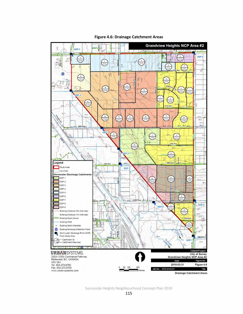
Sunnyside Heights Neighbourhood Concept Plan 2010
115
Figure 4.6: Drainage Catchment Areas
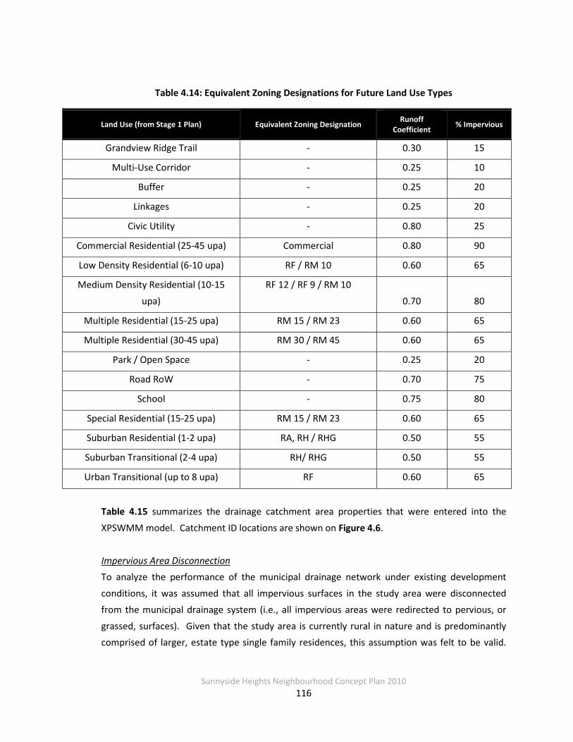
Sunnyside Heights Neighbourhood Concept Plan 2010
116
Table 4.14: Equivalent Zoning Designations for Future Land Use Types
Land Use (from Stage 1 Plan) Equivalent Zoning Designation Runoff Coefficient % Impervious
Grandview Ridge Trail - 0.30 15
Multi-Use Corridor - 0.25 10
Buffer - 0.25 20
Linkages - 0.25 20
Civic Utility - 0.80 25
Commercial Residential (25-45 upa) Commercial 0.80 90
Low Density Residential (6-10 upa) RF / RM 10 0.60 65
Medium Density Residential (10-15
upa)
RF 12 / RF 9 / RM 10
0.70 80
Multiple Residential (15-25 upa) RM 15 / RM 23 0.60 65
Multiple Residential (30-45 upa) RM 30 / RM 45 0.60 65
Park / Open Space - 0.25 20
Road RoW - 0.70 75
School - 0.75 80
Special Residential (15-25 upa) RM 15 / RM 23 0.60 65
Suburban Residential (1-2 upa) RA, RH / RHG 0.50 55
Suburban Transitional (2-4 upa) RH/ RHG 0.50 55
Urban Transitional (up to 8 upa) RF 0.60 65
Table 4.15 summarizes the drainage catchment area properties that were entered into the
XPSWMM model. Catchment ID locations are shown on Figure 4.6.
Impervious Area Disconnection To analyze the performance of the municipal drainage network under existing development
conditions, it was assumed that all impervious surfaces in the study area were disconnected from the municipal drainage system (i.e., all impervious areas were redirected to pervious, or
grassed, surfaces). Given that the study area is currently rural in nature and is predominantly comprised of larger, estate type single family residences, this assumption was felt to be valid.
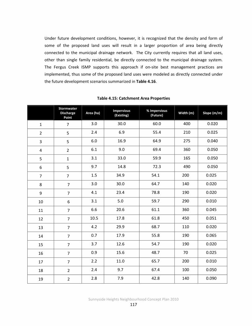
Sunnyside Heights Neighbourhood Concept Plan 2010
117
Under future development conditions, however, it is recognized that the density and form of some of the proposed land uses will result in a larger proportion of area being directly
connected to the municipal drainage network. The City currently requires that all land uses, other than single family residential, be directly connected to the municipal drainage system.
The Fergus Creek ISMP supports this approach if on-site best management practices are implemented, thus some of the proposed land uses were modeled as directly connected under
the future development scenarios summarized in Table 4.16.
Table 4.15: Catchment Area Properties
Stormwater
Discharge Point
Area (ha) Impervious (Existing)
% Impervious (Future) Width (m) Slope (m/m)
1 7 3.0 30.0 60.0 400 0.020
2 5 2.4 6.9 55.4 210 0.025
3 5 6.0 16.9 64.9 275 0.040
4 2 6.1 9.0 69.4 360 0.050
5 1 3.1 33.0 59.9 165 0.050
6 5 9.7 14.8 72.3 490 0.050
7 7 1.5 34.9 54.1 200 0.025
8 7 3.0 30.0 64.7 140 0.020
9 7 4.1 23.4 78.8 190 0.020
10 6 3.1 5.0 59.7 290 0.010
11 7 6.6 20.6 61.1 360 0.045
12 7 10.5 17.8 61.8 450 0.051
13 7 4.2 29.9 68.7 110 0.020
14 7 0.7 17.9 55.8 190 0.065
15 7 3.7 12.6 54.7 190 0.020
16 7 0.9 15.6 48.7 70 0.025
17 7 2.2 11.0 65.7 200 0.010
18 2 2.4 9.7 67.4 100 0.050
19 2 2.8 7.9 42.8 140 0.090
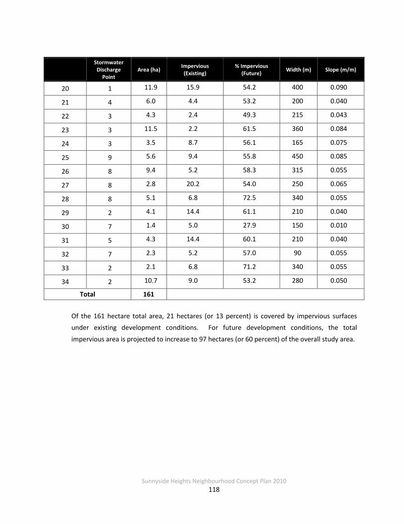
Sunnyside Heights Neighbourhood Concept Plan 2010
118
Stormwater
Discharge Point
Area (ha) Impervious (Existing)
% Impervious (Future) Width (m) Slope (m/m)
20 1 11.9 15.9 54.2 400 0.090
21 4 6.0 4.4 53.2 200 0.040
22 3 4.3 2.4 49.3 215 0.043
23 3 11.5 2.2 61.5 360 0.084
24 3 3.5 8.7 56.1 165 0.075
25 9 5.6 9.4 55.8 450 0.085
26 8 9.4 5.2 58.3 315 0.055
27 8 2.8 20.2 54.0 250 0.065
28 8 5.1 6.8 72.5 340 0.055
29 2 4.1 14.4 61.1 210 0.040
30 7 1.4 5.0 27.9 150 0.010
31 5 4.3 14.4 60.1 210 0.040
32 7 2.3 5.2 57.0 90 0.055
33 2 2.1 6.8 71.2 340 0.055
34 2 10.7 9.0 53.2 280 0.050
Total 161 Of the 161 hectare total area, 21 hectares (or 13 percent) is covered by impervious surfaces under existing development conditions. For future development conditions, the total
impervious area is projected to increase to 97 hectares (or 60 percent) of the overall study area.
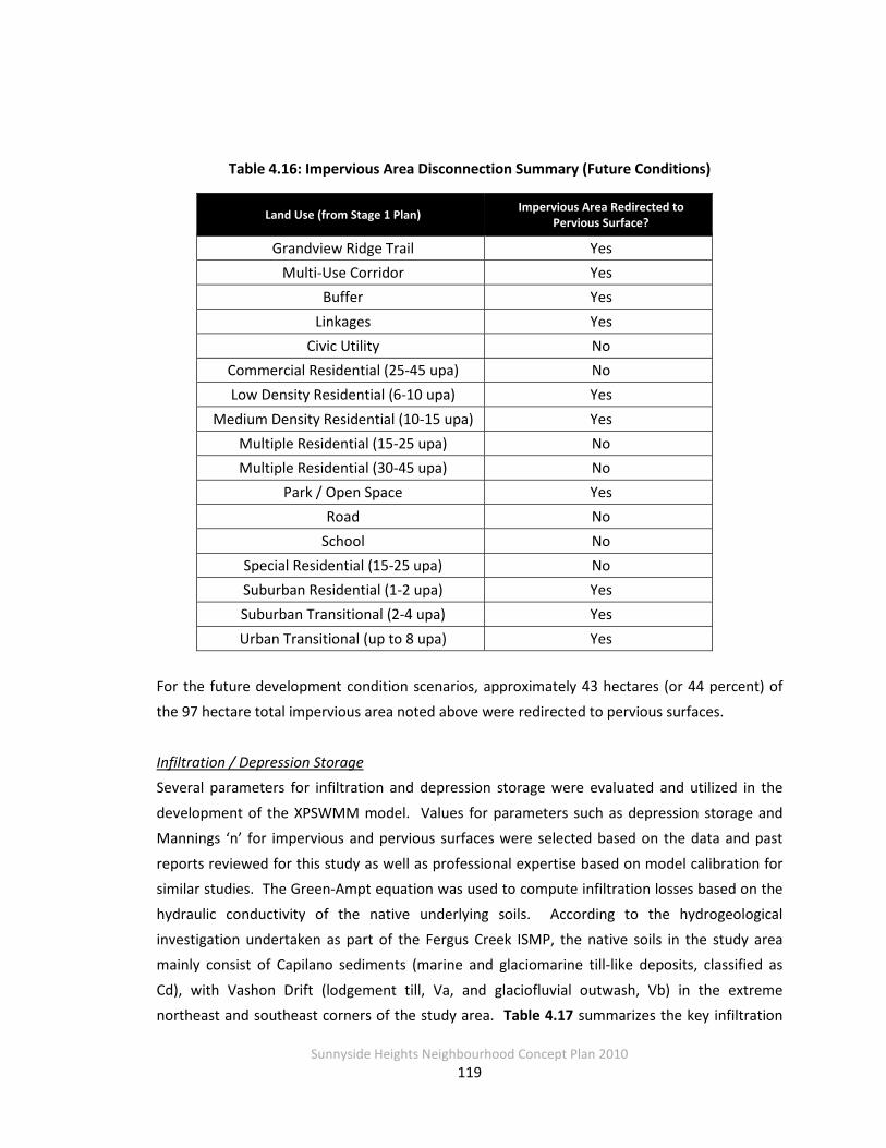
Sunnyside Heights Neighbourhood Concept Plan 2010
119
Table 4.16: Impervious Area Disconnection Summary (Future Conditions)
Land Use (from Stage 1 Plan) Impervious Area Redirected to Pervious Surface?
Grandview Ridge Trail Yes Multi-Use Corridor Yes
Buffer Yes Linkages Yes
Civic Utility No Commercial Residential (25-45 upa) No Low Density Residential (6-10 upa) Yes
Medium Density Residential (10-15 upa) Yes Multiple Residential (15-25 upa) No Multiple Residential (30-45 upa) No
Park / Open Space Yes Road No
School No Special Residential (15-25 upa) No Suburban Residential (1-2 upa) Yes Suburban Transitional (2-4 upa) Yes Urban Transitional (up to 8 upa) Yes
For the future development condition scenarios, approximately 43 hectares (or 44 percent) of
the 97 hectare total impervious area noted above were redirected to pervious surfaces.
Infiltration / Depression Storage Several parameters for infiltration and depression storage were evaluated and utilized in the
development of the XPSWMM model. Values for parameters such as depression storage and Mannings ‘n’ for impervious and pervious surfaces were selected based on the data and past
reports reviewed for this study as well as professional expertise based on model calibration for similar studies. The Green-Ampt equation was used to compute infiltration losses based on the hydraulic conductivity of the native underlying soils. According to the hydrogeological
investigation undertaken as part of the Fergus Creek ISMP, the native soils in the study area mainly consist of Capilano sediments (marine and glaciomarine till-like deposits, classified as
Cd), with Vashon Drift (lodgement till, Va, and glaciofluvial outwash, Vb) in the extreme northeast and southeast corners of the study area. Table 4.17 summarizes the key infiltration
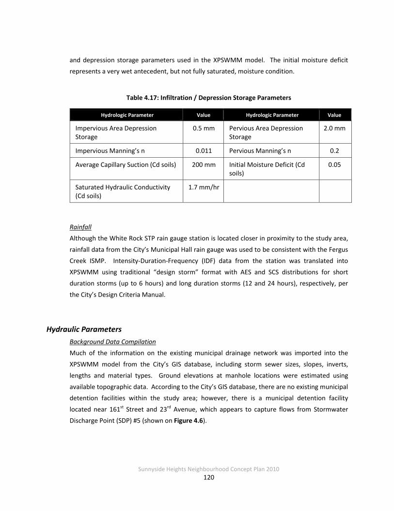
Sunnyside Heights Neighbourhood Concept Plan 2010
120
and depression storage parameters used in the XPSWMM model. The initial moisture deficit represents a very wet antecedent, but not fully saturated, moisture condition.
Table 4.17: Infiltration / Depression Storage Parameters
Hydrologic Parameter Value Hydrologic Parameter Value
Impervious Area Depression Storage
0.5 mm Pervious Area Depression Storage
2.0 mm
Impervious Manning’s n 0.011 Pervious Manning’s n 0.2
Average Capillary Suction (Cd soils) 200 mm Initial Moisture Deficit (Cd soils)
0.05
Saturated Hydraulic Conductivity (Cd soils)
1.7 mm/hr
Rainfall Although the White Rock STP rain gauge station is located closer in proximity to the study area,
rainfall data from the City’s Municipal Hall rain gauge was used to be consistent with the Fergus Creek ISMP. Intensity-Duration-Frequency (IDF) data from the station was translated into
XPSWMM using traditional “design storm” format with AES and SCS distributions for short duration storms (up to 6 hours) and long duration storms (12 and 24 hours), respectively, per
the City’s Design Criteria Manual.
Hydraulic Parameters Background Data Compilation Much of the information on the existing municipal drainage network was imported into the
XPSWMM model from the City’s GIS database, including storm sewer sizes, slopes, inverts, lengths and material types. Ground elevations at manhole locations were estimated using
available topographic data. According to the City’s GIS database, there are no existing municipal detention facilities within the study area; however, there is a municipal detention facility
located near 161st Street and 23rd Avenue, which appears to capture flows from Stormwater Discharge Point (SDP) #5 (shown on Figure 4.6).

Sunnyside Heights Neighbourhood Concept Plan 2010
121
The City’s GIS database does not include information on the existing ditch and channel network within the study area, thus field measurements of these features were taken during the site
reconnaissance. Ditch and channel slopes were estimated based on the available topographic data as well as the inverts of municipal storm sewers connected to these features.
Stormwater Discharge Points
Based on the configuration of the existing municipal drainage network, nine stormwater discharge points (SDP) were identified for the study area. Discharge point in this context simply
means the point at which stormwater runoff that has been collected in pipes or ditches leaves the study area boundaries; some runoff actually leaves the area as overland flow. Eight of the
SDPs direct runoff southwards within Fergus Creek watershed; the creek ultimately conveys flows to the Campbell River and Semiahmoo Bay. SDP 6 conveys runoff northeast from the
study area to the Burrows Ditch watershed, then to the Nicomekl River and eventually Mud Bay. For the purposes of our analysis, each SDP was considered to be a free outfall, meaning that
there is no backwater elevation or constriction downstream that influences the water levels in the municipal drainage network within the study area. SDP locations are summarized in Table 4.18 and shown on Figure 4.6.
Simulated Conditions Once the XPSWMM model development was complete, the model was run for the 5-year and 100-year return period events to evaluate the performance of the existing municipal drainage
network within the study area. These return periods were chosen as they correspond to the minor and major system, respectively, as defined by the City’s current drainage design criteria.
The 5- and 100-year return period events were run for the following durations: 30-minute, 1-hour, 2-hour, 6-hour, 12-hour and 24-hour. The 30-minute duration generally produced the
highest peak flows, thus this duration is considered the critical duration for analysis purposes.
The performance of the existing municipal drainage network was also evaluated with the Mean Annual Rainfall event (MAR), defined statistically as the 2.33-year, 24-hour event; for the study area the MAR is 60 mm. Stormwater BMPs are sometimes sized for the MAR event, as
approximately 90 percent of the total annual rainfall volume experienced in the Lower Mainland corresponds to events that are less than MAR intensity.
Sunnyside Heights Neighbourhood Concept Plan 2010
122
It should be noted that the XPSWMM model has not been calibrated, as flow data was not available to perform the calibration. However, watershed specific data from past studies and
reports were incorporated into the model as much as possible to provide a reasonably accurate picture of the watershed’s characteristics. Future work may include a sensitivity analysis on key
model parameters to determine which parameters have the most influence on model results.
4.3.3 Model Results
Existing Development Conditions Municipal Drainage Infrastructure Performance As noted earlier, the City’s current drainage design criteria states that the existing municipal
drainage network is intended to convey flows up to the minor event (5-year return period). Thus, the XPSWMM model was initially run for the 5-year return period event to evaluate the
performance of the municipal drainage network under existing development conditions. Model results indicate that while most of the existing municipal drainage network meets the City’s
criteria, there were some reaches of existing storm sewer that were surcharged during the 5-year return period event as shown on Figure 4.7. Particular areas of concern include:
• 145 m of 375mmØ storm sewer on 168th Street, just north of 16th Avenue
• 98 m of 375mmØ and 232 m of 450mmØ storm sewer on 18th Avenue, between 167th Street and 168th Street
The Fergus Creek ISMP had also identified the 375mmØ storm sewer on 168th Street as having insufficient capacity to convey the minor event. This is a short reach of 375mmØ pipe with
450mmØ pipe immediately upstream and downstream of it. The XPSWMM model was thus revised to upgrade this reach to a 450mmØ storm sewer. The model results also indicated that
surcharging on 18th Avenue would be very minor in nature, and given that the downstream system on 168th Street is already a 450mmØ pipe, no upgrades are proposed for 18th Avenue.
For the 100-year return period event, the magnitude of surcharging and flooding increases significantly. The model results indicate that the majority of flooding would occur within the
SDP 5 and SDP 7 catchment areas for existing development conditions.

Sunnyside Heights Neighbourhood Concept Plan 2010
123
In summary, the model results indicate that the majority of the existing municipal drainage infrastructure within the study area is adequately sized to service existing development as
defined by the City’s current drainage design criteria with the exception of the few reaches noted above. We understand from discussions with City staff that there have been past
drainage/ flooding issues in a few locations, including near 168th Street/18th Avenue and 166th Street/ 23rd Avenue. The City stated that both of these locations appeared to be due to tree
roots entering the storm sewer joints rather than resulting from pipe capacity issues.
Peak flows at each stormwater discharge point for the MAR, 5-year and 100-year return period events are shown on Tables 4.18, 4.19 and 4.20, respectively. Total runoff volumes for the
same events are tabulated in Tables 4.21, 4.22 and 4.23, respectively.
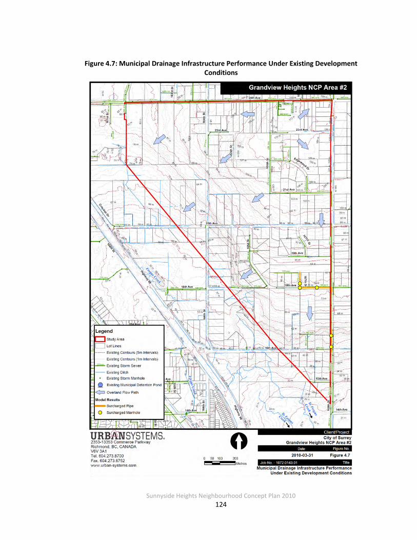
Sunnyside Heights Neighbourhood Concept Plan 2010
124
Figure 4.7: Municipal Drainage Infrastructure Performance Under Existing Development Conditions

Sunnyside Heights Neighbourhood Concept Plan 2010
125
Future Development Conditions The Fergus Creek ISMP recommends three main stormwater best management practices (BMPs) for mitigating future development impacts within the Fergus Creek watershed:
• BMP #1 – Impervious area disconnection for single family residential development
• BMP #2 – Amended topsoil on all pervious areas
• BMP #3 – Onsite detention/infiltration facilities The XPSWMM model was utilized to assess the benefits of implementing these three
stormwater BMPs (using a tiered approach) to mitigate the impacts of future development within the study area. Peak flows and volumes were computed for the MAR, 5-year and 100-
year return period events and compared against peak flows and volumes for existing development conditions (with the upgrade on 168th Street in place).
The following sections discuss the results of these future condition scenario runs. Hydrographs
for existing and future development condition scenarios at each stormwater discharge point are also included in Appendix A.3. (Note that in Appendix A.3 the “BMP #1” scenario is denoted as
“future conditions (unmanaged)”.) BMP #1 – Impervious Area Disconnection
The existing conditions XPSWMM model (with the pipe upgrade on 168th Street in place) was modified to reflect future land uses and impervious levels, as shown on the Stage 1 Land Use
Plan and tabulated previously in Tables 4.13 and 4.14. Impervious surfaces associated with some future land uses were redirected to pervious areas within the same catchment, as
previously discussed. The model was then run assuming that no further upgrades to the municipal drainage network were implemented, to assess the system’s performance.
Not surprisingly, the model results indicate that both peak flows and volumes would increase
significantly over existing development conditions, as summarized in Tables 4.18 through 4.23. The impact is also shown graphically in the hydrographs contained in Appendix A.3. As these
values are well beyond the existing regime that Fergus Creek currently experiences, implementing BMP #1 alone is insufficient to reduce peak flows and volumes to existing levels.
Sunnyside Heights Neighbourhood Concept Plan 2010
126
BMP #2 – Amended Topsoil For this scenario, the future conditions model was modified to include 150mm of amended
topsoil over all pervious areas in the study area. The model was then run to evaluate whether any additional benefit could be achieved by implementing this BMP.
The model results indicate that, if BMPs #1 and 2 are implemented together, a significant
benefit could be achieved in the study area over implementing BMP #1 alone. This was particularly evident for longer duration events such as the MAR event, where the model
indicated that peak flows were only slightly above existing conditions peak flows at several discharge points. The benefit of additional topsoil was most notable for catchment areas with
higher proportions of pervious surfaces (generally single family residential areas).
While runoff volumes were still higher than the volumes generated for existing development conditions, a reduction in volume was also achieved in this scenario over implementing BMP #1
alone. However, the implementation of BMPs #1 and #2 together was still insufficient to match existing condition peak flows and volumes for the 5-year and 100-year return period events. Peak flow and volume summaries are tabulated in Tables 4.18 through 4.23, and shown
graphically in Appendix A.3.
BMP #3 – Onsite Detention / Infiltration Facilities This third scenario examined the benefits of providing onsite detention storage and encouraging
additional infiltration of stormwater, in addition to implementing BMPs #1 and #2. The Fergus Creek ISMP states that each lot within the study area must dedicate 5% of its land area for
infiltration purposes, as well as provide 150m3/ha of detention storage with the following release rates:
• 0.435 L/s/ha for catchment areas draining to SDPs 1, 2, 6, 7, 8 and 9
• 0.719 L/s/ha for catchments areas draining to SDPs 3, 4 and 5
In modeling terms, each catchment area was routed through a storage node that provided 150m3/ha of detention storage spread over an area equal to 5 percent of the catchment area.
The scope and nature of this detention storage would be determined during detailed design. An internal rating curve was developed for each storage node that maximized the available storage
when the above noted release rates were reached. Flows that exceeded the detention storage capacity were then routed in the model via trunk storm sewers, ditches and overland flow with
no further attenuation. Infiltration was also simulated by inputting a constant outflow from the

Sunnyside Heights Neighbourhood Concept Plan 2010
127
storage node that was equal to the saturated hydraulic conductivity of the underlying soils (1.7 mm/hr).
By implementing BMPs #1, #2 and #3, the peak flow rates for future development conditions
were reduced to well below existing condition rates for the MAR, 5-year and 100-year return period events. Runoff volumes were generally lower than existing conditions as well, with the
exception of SDPs 3, 4, 5 and 6 where future condition runoff volumes were still slightly higher than existing conditions for the MAR and 5-year return period events.
The Stage 1 Land Use plan identified the inclusion of multi-use stormwater corridors throughout
the study area. Based on discussions with City staff and the Fergus Creek ISMP consultant, we understand that, while land for these corridors will be set aside as development proceeds, they
would not initially be used for subsurface detention storage and infiltration. Thus, the corridors were modeled only as open space at this time.
Peak flow and runoff volume summaries for all model scenarios are tabulated in Tables 4.18 through 4.23, and shown graphically in Appendix A.3.
Table 4.18: Stormwater Discharge Points (SDP) from Study Area
Stormwater Discharge Point Location Discharge Location Watershed
SDP 1 164th Street / 18th Avenue Ditch Fergus
SDP 2 164th Street / 18th Avenue Ditch Fergus
SDP 3 20th Avenue (west of 164th Street)
Ditch Fergus
SDP 4 161A Street / 22nd Avenue Ditch Fergus
SDP 5 161A Street / 24th Avenue Trunk storm sewer Fergus
SDP 6 168th Street / 24th Avenue Trunk storm sewer Burrows
SDP 7 168th Street / 14th Avenue Trunk storm sewer, west side of 168th
Fergus
SDP 8 168th Street / 16th Avenue Trunk storm sewer, east side of 168th
Fergus
SDP 9 166th Street / 16th Avenue Unnamed Creek Fergus

Sunnyside Heights Neighbourhood Concept Plan 2010
128
Table 4.19: Peak Flow Summary (MAR Event)
Stormwater Discharge Point
(SDP)
Peak Flow (m3/s)
Existing Conditions Future Conditions
BMP #1 BMP #1 + #2 BMP #1 + #2 + #3 SDP 1 0.103 0.189 0.106 0.013 SDP 2 0.155 0.438 0.269 0.061 SDP 3 0.080 0.239 0.182 0.048 SDP 4 0.022 0.071 0.049 0.010 SDP 5 0.120 0.263 0.227 0.067 SDP 6 0.014 0.039 0.030 0.011 SDP 7 0.325 0.645 0.294 0.059 SDP 8 0.060 0.160 0.052 0.005 SDP 9 0.039 0.078 0.032 0.002
Table 4.20: Peak Flow Summary (5-Year, 30-Minute Event)
Stormwater Discharge Point
(SDP)
Peak Flow (m3/s)
Existing Conditions Future Conditions
BMP #1 BMP #1 + #2 BMP #1 + #2 + #3 SDP 1 0.100 0.535 0.437 0.001 SDP 2 0.106 1.022 0.561 0.001 SDP 3 0.059 0.744 0.695 0.004 SDP 4 0.017 0.231 0.214 0.001 SDP 5 0.123 0.864 0.589 0.002 SDP 6 0.013 0.148 0.135 0.000 SDP 7 0.235 1.426 0.667 0.004 SDP 8 0.056 0.316 0.219 0.001 SDP 9 0.051 0.215 0.053 0.000
Table 4.21: Peak Flow Summary (100-Year, 30-Minute Event)
Stormwater Discharge Point
(SDP)
Peak Flow (m3/s)
Existing Conditions Future Conditions
BMP #1 BMP #1 + #2 BMP #1 + #2 + #3 SDP 1 0.488 1.339 0.839 0.002 SDP 2 0.663 2.510 1.092 0.004 SDP 3 0.424 1.226 1.148 0.009 SDP 4 0.112 0.538 0.415 0.002 SDP 5 0.350 1.801 1.106 0.006 SDP 6 0.077 0.330 0.258 0.001 SDP 7 0.781 2.923 1.274 0.006 SDP 8 0.302 0.811 0.410 0.001 SDP 9 0.264 0.551 0.101 0.000

Sunnyside Heights Neighbourhood Concept Plan 2010
129
Table 4.22: Volume Summary (MAR Event)
Stormwater Discharge Point (SDP)
Volume (m3)
Existing Conditions Future Conditions
BMP #1 BMP #1 + #2 BMP #1 + #2 + #3 SDP 1 1,932 4,799 3,859 859 SDP 2 2,910 11,363 7,932 2,867 SDP 3 1,428 6,718 5,983 3,115 SDP 4 442 1,921 1,616 673 SDP 5 2,108 7,271 6,217 3,194 SDP 6 245 1,112 993 459 SDP 7 6,316 16,239 11,323 4,028 SDP 8 1,125 3,878 2,321 529 SDP 9 549 1,707 895 187
Table 4.23: Volume Summary (5-Year, 30-Minute Event)
Stormwater Discharge Point
(SDP)
Volume (m3)
Existing Conditions Future Conditions
BMP #1 BMP #1 + #2 BMP #1 + #2 + #3 SDP 1 219 893 632 61 SDP 2 248 1,910 860 77 SDP 3 119 1,223 1,065 243 SDP 4 28 333 282 55 SDP 5 216 1,311 754 142 SDP 6 20 199 175 29 SDP 7 678 2,819 1,281 200 SDP 8 116 621 291 18 SDP 9 86 336 81 3
As the analysis shows, application of amended topsoil throughout the NCP, coupled with disconnection of roof leaders in single home residential areas (which is currently required within
the City in any case), provides high levels of rainwater control generally sufficient to limit runoff to existing levels and to foster infiltration of rainwater. The addition of detention storage at the
level recommended in the Fergus Creek ISMP (150 m3/ha) throughout the entire area yields peak runoff discharges and total runoff volumes significantly lower than existing conditions. Based on these results, it was decided to limit single family residential requirements to
disconnection of roof leaders and application of 150 mm of amended topsoil, leaving the detention storage requirements for larger scale site developments (such as multi-unit facilities).
For all scenarios, a 5% (minimum) green space allocation for stormwater corridors was included.
Sunnyside Heights Neighbourhood Concept Plan 2010
130
One significant limitation in fully evaluating the benefits of stormwater BMPs using design storm formatted rainfall is that the long term performance of these BMPs cannot be quantified under
varying real-time conditions. The Lower Mainland typically sees successive storm events where ponds, depression storage areas and soils do not fully discharge, empty or “dry out” before the
next rainfall event commences. As part of a separate work assignment outside the preparation of this stormwater servicing plan for the neighbourhood, continuous simulation was done for a
single subcatchment (SDP 2). Using 36 years of hourly rainfall data, hydrologic computations were completed for all four stormwater management scenarios (existing conditions, plus three
future conditions). The results confirmed what the design storm-based modeling presented herein suggests, namely, that the objectives of controlling runoff and maximizing infiltration can
be met with a combination of disconnected roof leaders, amended soils and targeted detention storage, when also coupled with a set 5% aside of open space for stormwater corridors.
Trunk Storm Sewers The locations of trunk storm sewers were also determined for the study area. Trunk storm sewers are typically designated by the City for all catchments with a service area equal to or
greater than 20 hectares. The trunk storm sewer sizing was based on the future development peak flows generated from the 5-year, 30-minute return period event with only BMP # 1 in
place.
Based on the above criteria, four trunk storm sewer systems were identified, as summarized below. Trunk storm sewer locations are shown on Figure 4.8(a).
• 675mmØ trunk storm sewer on 164th Street, conveying flows from SDP 2 to an existing drainage ditch along 164th Street (approx. total length = 245 m)
• 600mmØ trunk storm sewer on 163rd Street, conveying flows from SDP 3 to the existing drainage ditch along 20th Avenue (approx. total length = 80 m)
• 675mmØ trunk storm sewer on 24th Avenue, conveying flows from SDP 5 to the existing
municipal detention facility near 161st Street and 23rd Avenue (approx. total length = 335 m)
• 525mmØ – 750mmØ trunk storm sewer on 168th Street, conveying flows from SDP 7 to an existing drainage ditch along 168th Street (approx. total length = 1,860 m)
In light of the proposed extensive use of low impact BMPs within the neighbourhood the two municipal detention facilities previously recommended in the Fergus Creek MDP (see Figure 4.5)

Sunnyside Heights Neighbourhood Concept Plan 2010
131
were eliminated. A separate assessment was made of the potential for constructing surface water “features”, in lieu of the proposed low impact BMPs, within a section of the
neighbourhood; if constructed, these water features could also provide stormwater detention. This feasibility assessment and its results are included at the end of Appendix A.3.
Cost estimates for the drainage trunk storm sewer system are provided in Section 4.3.6.
Ditch / Channel Erosion Protection
As part of the XPSWMM modeling effort, peak velocities in the principal ditches within the study area were computed. The principal ditches include:
• 164th Street ditch, south of 22nd Avenue (SDP 2)
• 20th Avenue ditch (SDP 3)
• 161A Street ditch (SDP 4)
• 167th Street RoW ditch, north of 16th Avenue (SDP 8)
• BC Hydro RoW ditch, north of 16th Avenue (SDP 9)
Future condition peak velocities (with BMP #1 only) ranged from 0.7 m/s to 2.0 m/s for flows generated by the 100-year, 30-minute return period event. If the ditches experience peak
velocities in the upper range, it is possible that erosion could occur, thus, erosion protection measures should be implemented. At the NCP level of analysis, however, it is difficult to
quantify the scope of remedial measures to undertake. For the purposes of costing erosion protection works, it was assumed that erosion protection would consist of riprap and geotextile
fabric. We have not accounted for habitat enhancement opportunities and have assumed that only 25 percent of the total ditch length in the NCP would require erosion protection.
4.3.4 Water Quality
Urban development will affect not only runoff peaks and volumes but also the quality of that runoff. Typical pollutants that are conveyed in runoff include suspended sediments, nutrients
such as nitrogen and phosphorous, trace metals such as copper, nickel and zinc, bacteria, and hydrocarbons. Many of these are by-products of the means of transportation upon which we
rely, i.e., automobiles, buses and trucks, but also of such things as our use of chemicals to maintain green lawns, pet and wildlife activities, and even general littering.
Sunnyside Heights Neighbourhood Concept Plan 2010
132
In order to obtain an overview of the runoff quality conditions now and for future developed conditions, a simple runoff pollutant loading model was developed as described below. This
method and variations on it have been widely used across North America, particularly the U.S., for preliminary assessment of the impact of non-point source pollutant loads in runoff.
Estimated Runoff Pollutant Loads In order to assess the pollutant loads associated with stormwater runoff, we used a screening-
level tool developed by the Center for Watershed Protection (CWP), a non-profit watershed consulting organization from the U.S. The tool3, or method, requires minimal input, all of which
was readily available for this preliminary assessment:
• Drainage (catchment) area(s) – this information was developed for the XPSWMM model
• Impervious cover – this also was developed for the XPSWMM model
• Annual precipitation – this information was readily available
• Pollutant concentrations – median event mean concentrations (EMCs) are based on
data collated by researchers in the U.S.; we focused on just a few pollutants, as representative of the spectrum of potential contaminants in runoff: total suspended solids (TSS); total nitrogen; dissolved phosphorus; total copper; total zinc; and bacteria
(specifically, fecal coliforms)
To determine annual pollutant loadings, we assigned one or more of three basic land use categories to each catchment and then used median pollutant concentrations associated with
those land use categories. The basic categories are: residential; commercial; and open space4. The method was applied to both existing and future “unmanaged” conditions.
Table 4.24 shows the results for both existing and future conditions. As shown loads can be
expected to increase nearly four-fold from existing to fully developed conditions if no controls or BMPs are applied.
3 Schueller, Tom, Controlling Urban Runoff: A Practical Manual for Planning and Designing Urban BMP’s, for
Metropolitan Council of Governments, Washington, D.C., 1987. 4 Two additional categories are available (industrial and highway); since these do not apply to the Grandview
Heights Area #2, they were not used.

Sunnyside Heights Neighbourhood Concept Plan 2010
133
Table 4.24: Volume Summary (100-Year, 30-Minute Event)
Stormwater Discharge Point
(SDP)
Volume (m3)
Existing Conditions Future Conditions
BMP #1 BMP #1 + #2 BMP #1 + #2 + #3 SDP 1 1,202 2,042 1,120 197 SDP 2 1,930 4,459 2,012 338 SDP 3 1,068 2,468 1,885 671 SDP 4 288 770 509 162 SDP 5 1,510 2,928 1,727 544 SDP 6 175 431 313 77 SDP 7 3,928 6,616 2,374 554 SDP 8 773 1,569 514 77 SDP 9 469 776 138 14
Impact of Proposed BMPs on Runoff Quality Reduction in total annual runoff from the neighbourhood due to use of low impact best management practices will also directly reduce discharge of runoff-generated pollutants. In
other words, runoff that is infiltrated also effectively removes pollutants from surface discharge to local streams and to Fergus Creek itself. Absorbent landscaping (i.e., deep amended topsoil),
disconnected roof drains, rain gardens, subsurface bioswales and similar low impact BMPs will promote infiltration. Even in specific locations within Grandview Heights #2 where perforated
underdrains may be required beneath the BMP due to the presence of shallow impermeable soil layer, contact with soil and vegetation will provide substantial removal of key pollutants such as
suspended sediments, trace metals and bacteria.
In addition to showing the estimate pollutant loads for existing and future (no controls) conditions, Table 4.25 also lists the estimated loads with proposed BMPs implemented (as
described in Section 4.3.5, below). Appendix A3 provides expanded tables for the pollutant load estimates.
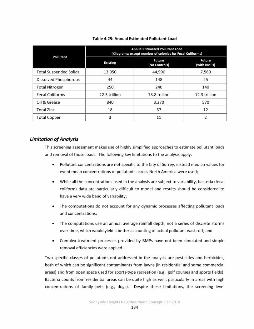
Sunnyside Heights Neighbourhood Concept Plan 2010
134
Table 4.25: Annual Estimated Pollutant Load
Pollutant
Annual Estimated Pollutant Load (Kilograms; except number of colonies for Fecal Coliforms)
Existing Future (No Controls)
Future (with BMPs)
Total Suspended Solids 13,950 44,990 7,560
Dissolved Phosphorous 44 148 25
Total Nitrogen 250 240 140
Fecal Coliforms 22.3 trillion 73.8 trillion 12.3 trillion
Oil & Grease 840 3,270 570
Total Zinc 18 67 12
Total Copper 3 11 2
Limitation of Analysis This screening assessment makes use of highly simplified approaches to estimate pollutant loads
and removal of those loads. The following key limitations to the analysis apply:
• Pollutant concentrations are not specific to the City of Surrey, instead median values for event mean concentrations of pollutants across North America were used;
• While all the concentrations used in the analysis are subject to variability, bacteria (fecal coliform) data are particularly difficult to model and results should be considered to
have a very wide band of variability;
• The computations do not account for any dynamic processes affecting pollutant loads
and concentrations;
• The computations use an annual average rainfall depth, not a series of discrete storms over time, which would yield a better accounting of actual pollutant wash-off; and
• Complex treatment processes provided by BMPs have not been simulated and simple removal efficiencies were applied.
Two specific classes of pollutants not addressed in the analysis are pesticides and herbicides, both of which can be significant contaminants from lawns (in residential and some commercial
areas) and from open space used for sports-type recreation (e.g., golf courses and sports fields). Bacteria counts from residential areas can be quite high as well, particularly in areas with high concentrations of family pets (e.g., dogs). Despite these limitations, the screening level

Sunnyside Heights Neighbourhood Concept Plan 2010
135
assessment provides a reasonable assessment of the significance of pollutant loading issues and creates a framework for understanding the implications of pollutant washoff in urban areas such
as Grandview Heights #2.
4.3.5 Proposed Stormwater Management Concept
The proposed management concept is consistent with the program set forth in the Fergus Creek
ISMP and with the level of service expected in developments within the City of Surrey. The focus is on controlling runoff at the source, or as near the source as possible, as well as on
maintaining base flows in Fergus Creek, while providing traditional drainage control through use of local and trunk sewers as needed.
Goals and Objectives The goal of the stormwater / drainage servicing plan in Grandview Heights Neighbourhood #2 is to provide a stormwater management system that is sustainable, protects property and the
public, and is well-suited to the cultural and ecological conditions of the neighbourhood.
To meet this goal, stormwater management objectives for the Grandview Heights Area #2 are:
• Control runoff generated (or potentially generated) by small, minor storms through the use of retention, infiltration, evapo-transpiration and long-term storage at, or very close
to, the points of generation;
• Provide publicly-maintained stormwater facilities for control of stormwater runoff
generated within rights-of-way and to supplement the onsite controls noted in the first objective;
• Control runoff from major storms by providing adequate safe flow paths and/or temporary detention storage within the roads, stormwater corridors and other areas as may be designated; and
• Minimize adverse impacts of development on runoff quality to the local streams, including Fergus Creek itself.
The stormwater management system will consist of an inter-related set of on-site and public controls, including stormwater corridors, perforated local storm drains in street rights-of-way
and landscape-based, low impact source controls on individual lots. Figures 4.8(a) and 4.8(b) show the locations for various elements of the proposed stormwater servicing plan. Sections
4.3.3 already discussed trunk sewers and erosion protection requirements of the servicing plan; other elements are discussed in more detail below.

Sunnyside Heights Neighbourhood Concept Plan 2010
136
Figure 4.8(a): Proposed Drainage Infrastructure

Sunnyside Heights Neighbourhood Concept Plan 2010
137
On-Site Controls The first line of stormwater management features will be incorporated into each property developed within Grandview Heights #2. Relying heavily on sustainable, landscape-based
stormwater source controls, the intent is to maximize infiltration and evapotranspiration of rainwater. These types of controls are described in Metro Vancouver’s publication,
“Stormwater Source Control Design Guidelines 2005” (April 2005)5.
Single Family Residential On single family residential properties, there are two requirements:
• Install at least 150 mm of amended topsoil (per “Stormwater Source Control Design Guidelines 2005”) in yards; and
• As per current Surrey standards, discharge roof leaders to ground rather to the storm
drain collection system in the streets.
In addition, homeowners will be encouraged to incorporate other stormwater source controls into their properties such as:
• Maintenance (or retention) of high tree cover densities;
• Rain gardens; and
• Permeable pavement for drives, walks and patios.
Layout, configuration and construction of these additional controls should be completed in
accordance with “Stormwater Source Control Design Guidelines 2005”.
The Engineer of Record should verify in writing that the amended topsoil meets the requirements of the Guidelines and has been properly installed and that roof leaders discharge
to ground not to a storm sewer. Multi-Family, Commercial and Institutional Areas
Multi-family, commercial and institutional sites will be required to meet specific performance targets for stormwater source controls:
• Install at least 150 mm of amended topsoil in lawn areas;
5 Document is available online at http://www.metrovancouver.org/about/publications/Pages/default.aspx or search for “Stormwater Source Control Guidelines 2005” on MetroVancouver’s Website: http://www.metrovancouver.org/Pages/default.aspx.
Sunnyside Heights Neighbourhood Concept Plan 2010
138
• Provide runoff storage on-site equal to 150 m3/ha of gross site area released at a rate dependent on location within the neighbourhood, as shown on Figure 4.6:
o 0.435 L/s/ha for Catchments SDP 1, 2, 6, 7, 8, and 9; and o 0.719 L/s/ha for Catchments SDP 3, 4 and 5;
• Provide water quality treatment for any specific high risk contaminants associated with that site’s land use activities, e.g., oil capture/removal for gas service stations, if
required by the City; and
• Promote the use of landscape-based stormwater source controls that emphasize infiltration and evapotranspiration of rainwater from small storms.
The specific mix of source control methods will be up to each site owner, thus allowing
integration into the site’s overall architectural and landscaping concept. Layout, configuration and construction should be done in accordance with “Stormwater Source Control Guidelines
2005”. Per the recommendation of the Fergus Creek Integrated Stormwater Management Plan, all BMPs except the amended topsoil should be designed with a safety factor of two (2), which
should be applied to the volume and surface area of infiltration systems.
The Engineer of Record should verify in writing that all BMPs have been designed in accordance with the Guidelines and properly installed.
Stormwater Corridors A key component of the overall proposed stormwater management concept is the use of stormwater corridors in lieu of traditional detention ponds to provide primary control of runoff
within the area. For a limited catchment area, an option to implement a traditional detention pond instead of stormwater corridors was also assessed and is included in Appendix A.3. This
limited area is shown on Figure 4.26 as Service Area ‘B’. The stormwater corridor consists of additional right-of-way added to streets within the area. Stormwater control features that can
be included within the corridors include:
• Open channel bioretention filter swales (“bioswales”) to promote infiltration and provide runoff treatment;
• Subsurface, drain-rock style storage system and perforated underdrains, to promote
infiltration;
• Periodic water quality ponding areas along the swales;
• Deep, amended topsoils;
Sunnyside Heights Neighbourhood Concept Plan 2010
139
• Trees; and
• In some cases, a trunk storm sewer main, if needed for major storm routing.
Three different widths are proposed for the stormwater corridors:
• 5 m wide corridors incorporated into most east-west oriented Type II and III local roads throughout the area;
• 10 m wide corridor along the west side of 164th Street, from the proposed park and school sites between 22 and 23 Avenues south to the proposed park between 17 and 18
Avenues (NOTE: a 2 m wide pathway will be constructed in conjunction with this corridor);
• 10 m wide median corridors incorporated into several key Type Ia collector roads (164th Street from 24th Avenue south to the proposed riparian area at about 22a Avenue; 166th Street from 24th Avenue south to 23rd Avenue; and 20th Avenue from 168th Street to
164th Street); and
• 20 m wide corridors adjacent to several roads in the multiple residential areas along the
area’s west-side; maintenance access pathways may be integrated into these corridors.
Locations for the various corridors are shown on Figure 4.8(b). Figures 4.9 and 4.10 show cross sections of the corridors proposed for incorporation into local and collector roads, respectively;
Figure 4.11 shows a cross section for a typical 20 m wide corridor in the multiple residential areas.
The proposed bioswales are shallow, wide swales landscaped with grass (for use in the 5-metre corridors) or with grass, shrubs and trees (for use in the wider corridors); they will be sized to
capture and treat runoff from small rain events (less than 1/2 MAR, or about 30mm in 24 hours). Bioswales will typically have an overflow structure (lawn basin/field inlet) at the end of each
block, connected to the storm sewer to shunt excess flows out of the bioswale and prevent flooding of adjacent property. Surface grading is away from houses towards the bioswales and
the bioswales are normally on the uphill side of the streets, so that in very severe weather or if the overflow structure is blocked, excess flow may cause some street flooding but should not
flood houses. Current practice is for adjacent homeowners to maintain the boulevard along their property. Similarly, it is anticipated that adjacent homeowners will maintain the grassed
bioswales in the 5-m corridors along local roads, with the City maintaining the overflow structure and other downstream underground storm infrastructure. The City would also

Sunnyside Heights Neighbourhood Concept Plan 2010
140
maintain the bioswales in the wider corridors. Appendix A.3 includes additional description of the bioswales, including general maintenance guidelines, along with some examples of
installations in the Pacific Northwest.
The stormwater corridors are located throughout the area to capture as much of the runoff as possible and thus provide volume reduction, peak attenuation and water quality treatment to
minor storm runoff without the use of traditional detention ponds.
As envisioned in the Fergus Creek ISMP, these corridors would constitute at least 5 percent (and up to 10 percent) of the total land use in the neighbourhood. The total stormwater corridor
area generated with the current land use plan is 7.83 hectares, or 4.96 percent of the neighbourhood. Including the proposed buffer strip along 168th Street and the additional 3-3.25
m of tree boulevard and grass strip on either side of the stormwater corridors in Type II and III local road RoWs (see Figure 4.9), raises this to 10.49 hectares, or 6.65 percent of the
neighbourhood. Further, when the significant riparian protection area to be located along the current 164th Street alignment north of 20th Avenue is counted towards the total, another roughly 42,000 m2 is added, bringing the area’s coverage to 9.3 percent.
Residential Streets Perforated storm drain systems will be installed in local residential streets to maximize the
potential for stormwater infiltration (see Figures 4.9 and 4.10). The systems consist of a perforated storm drain to promote infiltration during drier months and when the water table is
below the sewer subgrade elevation and a parallel standard storm drain to convey runoff during wet winter months when the perforated pipe’s capacity is exceeded.

Sunnyside Heights Neighbourhood Concept Plan 2010
141
Figure 4.8(b): Drainage Corridor Types and Locations
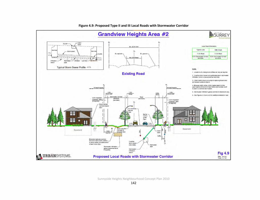
Sunnyside Heights Neighbourhood Concept Plan 2010
142
Figure 4.9: Proposed Type II and III Local Roads with Stormwater Corridor
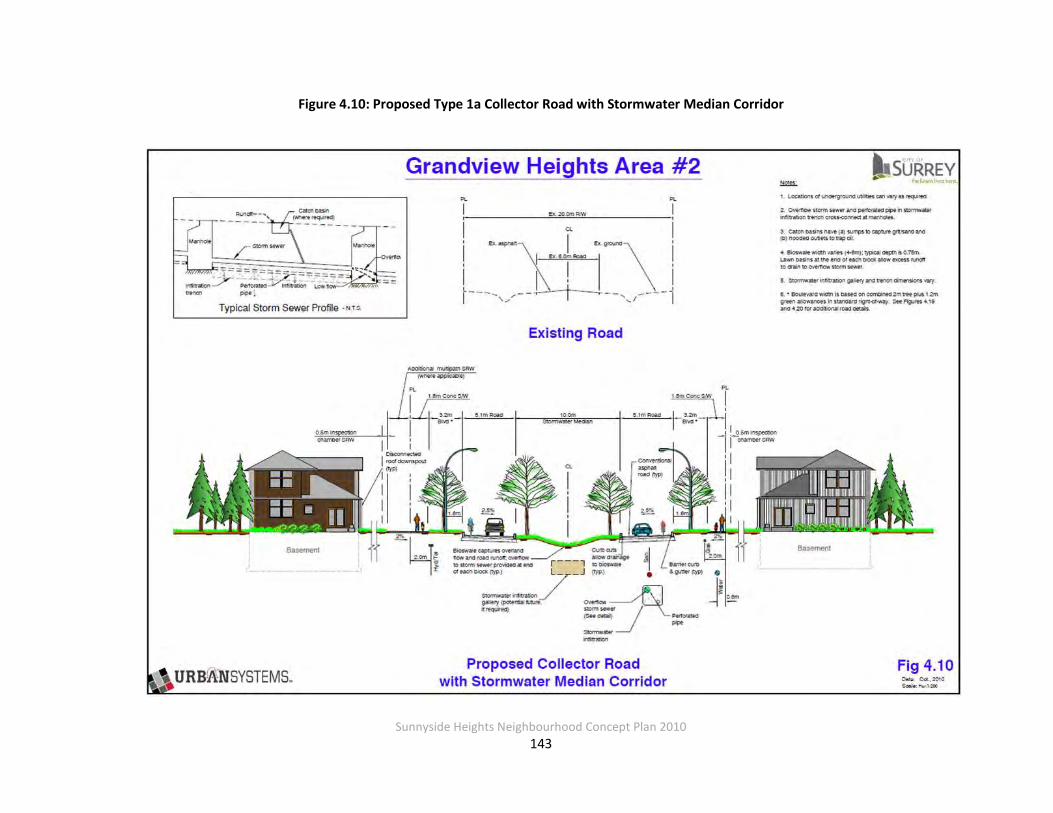
Sunnyside Heights Neighbourhood Concept Plan 2010
143
Figure 4.10: Proposed Type 1a Collector Road with Stormwater Median Corridor

Sunnyside Heights Neighbourhood Concept Plan 2010
144
Figure 4.11: Proposed 20.0-metre Stormwater Corridor
Sunnyside Heights Neighbourhood Concept Plan 2010
145
Major Storm Conveyance For those storms which exceed the capacity of the various on-site and public BMPs, conveyance will be provided by trunk storm sewers and open channels.
Right-of-Way Acquisitions/Dedications
The stormwater management concept for Grandview Heights, Area #2 calls for the use of drainage corridors running along almost all of the east-west roads and some of the north-south
roads, for all road classifications. These drainage corridors are mostly 5 m wide (80 percent of length); however, some are 10 m wide (20 percent of length). Runoff from the roadways and
private property flows to bioswales constructed within the corridor. The use of these corridors and bioswales is an innovative approach that eliminates the need for downstream detention
ponds and keeps drainage flows closer to pre-development levels compared to a detention pond system.
This drainage corridor approach for the most part does require roads to be 5 m wider than the
standard 20 m local road dedication, with a smaller number being 10 m wider. Corridors are located on the uphill side of the road to capture overland flow from adjacent upslope lands. For the east-west roads this means the corridors are located on the north side. For north-south
roads the corridors are on either the east side or west sides. Locations are shown on the Land use Concept Plan.
Proposed Approach for Acquiring and Constructing Drainage Corridors
Typically subdivision results in up to 20 m being dedicated for local roads and 22 m for collectors. It is proposed that dedication of an additional 2.5 m per side (in addition to the local
10 or 11 m collector road dedication) would be required where drainage corridors are needed. Where 10 m median stormwater corridors are identified, an additional dedication of 5 metres
per side would be required. The financial arrangements proposed for these various acquisitions are discussed in Section 4.7 Infrastructure Financing and Funding.
These requirements will need to be included in the design criteria manual, which will require
revision to the Subdivision and Development Bylaw to allow for these unique requirements for this NCP area.

Sunnyside Heights Neighbourhood Concept Plan 2010
146
The construction of the bioswale is also required within the drainage corridor. The financial arrangements proposed for this construction are discussed in Section 4.7 Infrastructure
Financing and Funding.
Phasing and Implementation Issues
Acquisition of the corridors will primarily occur as development takes place. This will likely result in discontinuities of bioswale operation. This will be a particular problem for the 10 m central
median corridors where whole blocks would need to be acquired before construction could take place.
Similar to acquisition, construction will most likely take place on a development-by-
development basis, which will mean that transitions in pavement widths will be needed as will interim means of draining the discontinuous sections of bioswale (i.e. temporary lawn basins
and leads). These interim items will have to be removed and/or plugged as adjacent sections of bioswale are constructed. Where feasible the city could, through the DCC program, acquire
critical missing links in the drainage corridors. Road allowance widths of 12.5 m for each side and the requirement for a 5 m bioswale results in
the road pavement, curbs and sidewalk etc. being shifted to the side of the road without the bioswale (see Figure 4.9). This leads to three potential development phasing scenarios, which
are discussed below based on assuming a 10.5 m road pavement.
Scenario 1 Development takes place on both sides of the road at the same time. This is the simplest
scenario, allows the full road and bioswale cross section to be built in one application, and generates no future phasing or cost sharing issues.
Scenario 2
Development takes place first on the non bioswale side of the road. Under this condition the initial developers would build an 8 m road structure with curbs, sidewalks, and street lights on
their side of the road but leave the construction of the bioswale, the extra parking lane, and centre sidewalk for when the other side of the road develops. This may require the use of a latecomer agreement to share the cost of the road infrastructure. It would be advantageous if a
right-of-way could be acquired for the adjoining property so the road could be completed.

Sunnyside Heights Neighbourhood Concept Plan 2010
147
Scenario 3
Development takes place first on the side of the road identified for the drainage swale. As the bioswale and centre sidewalk take up virtually all the space to the centre line of the road, the
developer will have to construct some road beyond the centre line for access and connectivity. At a minimum a 6 m half road should be constructed; however, there is sufficient room to
construct an 8 m road complete with curbs and streetlights. The far side sidewalk and parking lane would be left until the far side develops. This scenario would have the option for a
latecomer agreement to recover some costs.
4.3.6 Cost Estimates and Financing Approach
The cost estimates for the DCC eligible infrastructure are based on the principle that
development is responsible for funding the services that front, and/or are adjacent to, the development lands. DCC eligible items include trunks and other items that serve the overall
catchment. These DCC items are itemized in
Table 4.26.
Table 4.26: Stormwater Management Cost Estimates and Financing Approach
Capital Item Total Cost
Costs Recovery Approach for Area 2
City-Wide DCCs Area Specific DCC Utility
Trunks1 $3,546,000 $1,418,400 $2,127,600 $0
Ditch Erosion Protection2 $63,900 $25,560 $38,340 $0
Stormwater Corridors / Detention Pond Option $21,593,100 $5,266,040 $16,327,060 $0
Total $25,203,000 $6,710,000 $18,493,000 $0
Notes:
1. Costs updated to January 2010 construction costs; trunk unit rate costs provided by the City (February 2010).
2. Assumes 25% of ditches in NCP area require protection.

Sunnyside Heights Neighbourhood Concept Plan 2010
148
As shown in Table 4.27, anticipated DCC revenues are far less than eligible anticipated costs. To pay for the additional costs an area specific DCC is recommended. Details of the area specific
DCC are included in Section 4.7.5.
Table 4.27: Estimated DCC Revenues and Expenditures – Stormwater
Estimated DCC Revenues DCC Eligible Costs Balance
$6,710,000 $25,203,000 -$18,493,000
Notes: 1. DCCs based on the average development yield for the area. 2. DCC revenues do not include potential DCC revenues from commercial or
institutional development within Area #2.
4.3.7 Ten Year Servicing Plan
It is recommended that the City review its 2010-2019 10 Year Servicing Plan to determine
whether the works recommended in this report overlap with current projects included in the 10 Year Servicing Plan. The current 10 Year Servicing Plan identifies no works within the NCP area.
It does identify item 11650, a storm sewer upgrade on 24 Avenue east of 168 Street just outside the NCP boundary. This item is not impacted by the NCP.

Sunnyside Heights Neighbourhood Concept Plan 2010
149
4.4 TRANSPORTATION
4.4.1 Introduction
This section of the report provides an assessment of traffic impacts and recommended
transportation improvements as part of the planned land use development for the Grandview Heights Area #2 located in South Surrey. Updates to the bicycle and pedestrian networks,
transit services and facilities, and roadway network will be required to accommodate increased travel activity to, from, and within this area based on anticipated growth and development.
These improvements will provide travel choices for residents of Grandview Heights to walk, cycle or take transit which are not safe or convenient options today.
The recommendations made in this report are in line with Surrey’s vision of developing
Grandview Heights “as a complete community with a mix of residential densities, small commercial nodes, community facilities, schools, parks, pathways, trees and protected areas."
The guiding principles for transportation provide for “special road and pathway standards to preserve rural character, a modified grid road system with greenways to encourage walking and cycling.”
4.4.2 Study Area
The triangular study area is located in South Surrey just east of Highway 99 bounded by 24th Avenue, 168th Street and 16th Avenue. Land use is rural with generally low density, single use
residential properties throughout the study area. The only significant non-rural, non-residential land uses in the area are located sporadically along 24th Avenue, including a corner grocery store
at 168th Street and 24th Avenue.
The study area is surrounded by other neighbourhoods as part of the overall Grandview Heights area including Grandview Corners, Morgan Crossing, Morgan Heights and North Grandview.
Travel to and from Grandview Heights NCP Area #2 is expected to be influenced by development in these neighbouring communities. While NCP Area #2 is not expected to attract a significant
number of trips (other than those generated by the small commercial node at 24th Avenue and 168th Street), residents of NCP Area #2 are expected to travel to and from local recreational and
shopping destinations. Large scale retail in Grandview Corners and the commercial/residential
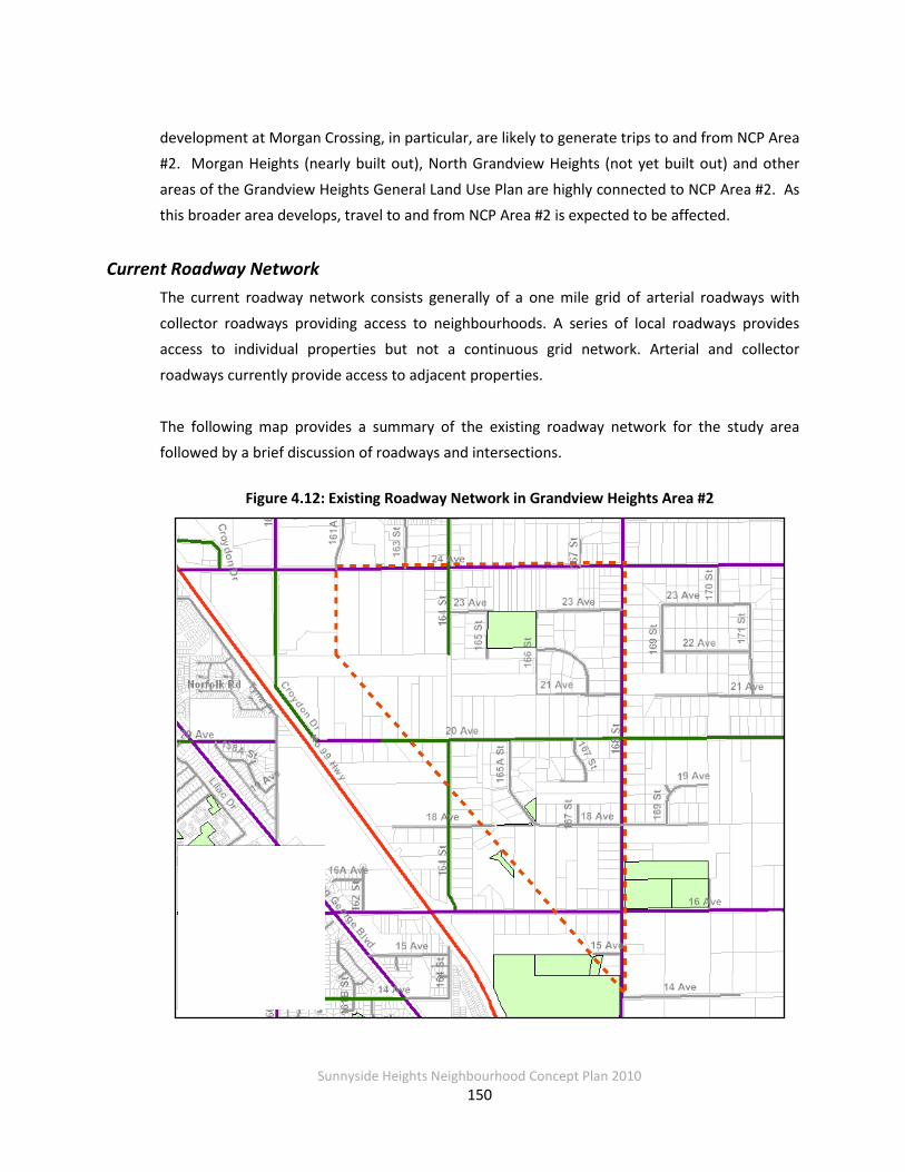
Sunnyside Heights Neighbourhood Concept Plan 2010
150
development at Morgan Crossing, in particular, are likely to generate trips to and from NCP Area #2. Morgan Heights (nearly built out), North Grandview Heights (not yet built out) and other
areas of the Grandview Heights General Land Use Plan are highly connected to NCP Area #2. As this broader area develops, travel to and from NCP Area #2 is expected to be affected.
Current Roadway Network The current roadway network consists generally of a one mile grid of arterial roadways with
collector roadways providing access to neighbourhoods. A series of local roadways provides access to individual properties but not a continuous grid network. Arterial and collector
roadways currently provide access to adjacent properties.
The following map provides a summary of the existing roadway network for the study area followed by a brief discussion of roadways and intersections.
Figure 4.12: Existing Roadway Network in Grandview Heights Area #2
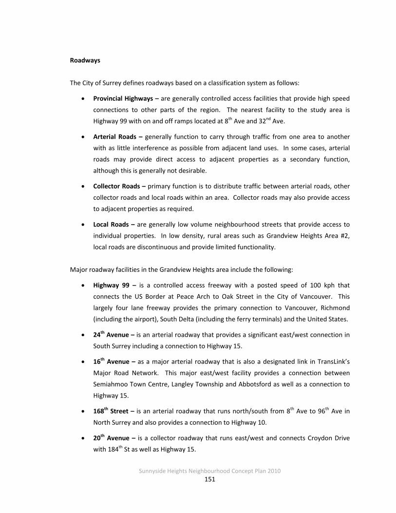
Sunnyside Heights Neighbourhood Concept Plan 2010
151
Roadways
The City of Surrey defines roadways based on a classification system as follows:
• Provincial Highways – are generally controlled access facilities that provide high speed
connections to other parts of the region. The nearest facility to the study area is Highway 99 with on and off ramps located at 8th Ave and 32nd Ave.
• Arterial Roads – generally function to carry through traffic from one area to another with as little interference as possible from adjacent land uses. In some cases, arterial roads may provide direct access to adjacent properties as a secondary function,
although this is generally not desirable.
• Collector Roads – primary function is to distribute traffic between arterial roads, other
collector roads and local roads within an area. Collector roads may also provide access to adjacent properties as required.
• Local Roads – are generally low volume neighbourhood streets that provide access to individual properties. In low density, rural areas such as Grandview Heights Area #2,
local roads are discontinuous and provide limited functionality. Major roadway facilities in the Grandview Heights area include the following:
• Highway 99 – is a controlled access freeway with a posted speed of 100 kph that connects the US Border at Peace Arch to Oak Street in the City of Vancouver. This
largely four lane freeway provides the primary connection to Vancouver, Richmond (including the airport), South Delta (including the ferry terminals) and the United States.
• 24th Avenue – is an arterial roadway that provides a significant east/west connection in South Surrey including a connection to Highway 15.
• 16th Avenue – as a major arterial roadway that is also a designated link in TransLink’s
Major Road Network. This major east/west facility provides a connection between Semiahmoo Town Centre, Langley Township and Abbotsford as well as a connection to
Highway 15.
• 168th Street – is an arterial roadway that runs north/south from 8th Ave to 96th Ave in
North Surrey and also provides a connection to Highway 10.
• 20th Avenue – is a collector roadway that runs east/west and connects Croydon Drive with 184th St as well as Highway 15.

Sunnyside Heights Neighbourhood Concept Plan 2010
152
• 164th St – is a collector roadway that is currently discontinuous through the study area.
All collector and arterial roadways are currently two lane facilities within the study area. Posted speeds are 50 and 60 kph for collector and arterial roadways respectively. Access to King
George Highway with overpasses across Highway 99 includes 16th and 24th Avenue.
Intersections There are signalized intersections currently at 16th and 24th Avenue both along 168th Street. All
approaches to these two intersections include an exclusive left turn bay and shared through and right turn lane. All left turns at these two signalized intersection are permissive with the eastbound left turn at 16th Ave and 168th St provided with a protected/permissive phase.
There is currently four-way stop control at 20th Avenue and 168th Street and two-way stop
control at 24th Ave and 164th St with priority along 24th Ave. Access from local streets to arterial and collectors is usually with stop sign control.
Current Transit Services and Facilities
There are no transit services currently available for travel to and from Grandview Heights Area #2. For regional transit services, the South Surrey Park and Ride facility located at King George
Highway and Highway 99 provides connections to North Surrey, Richmond and Vancouver. The following map highlights the existing service coverage in South Surrey relative to the study area.
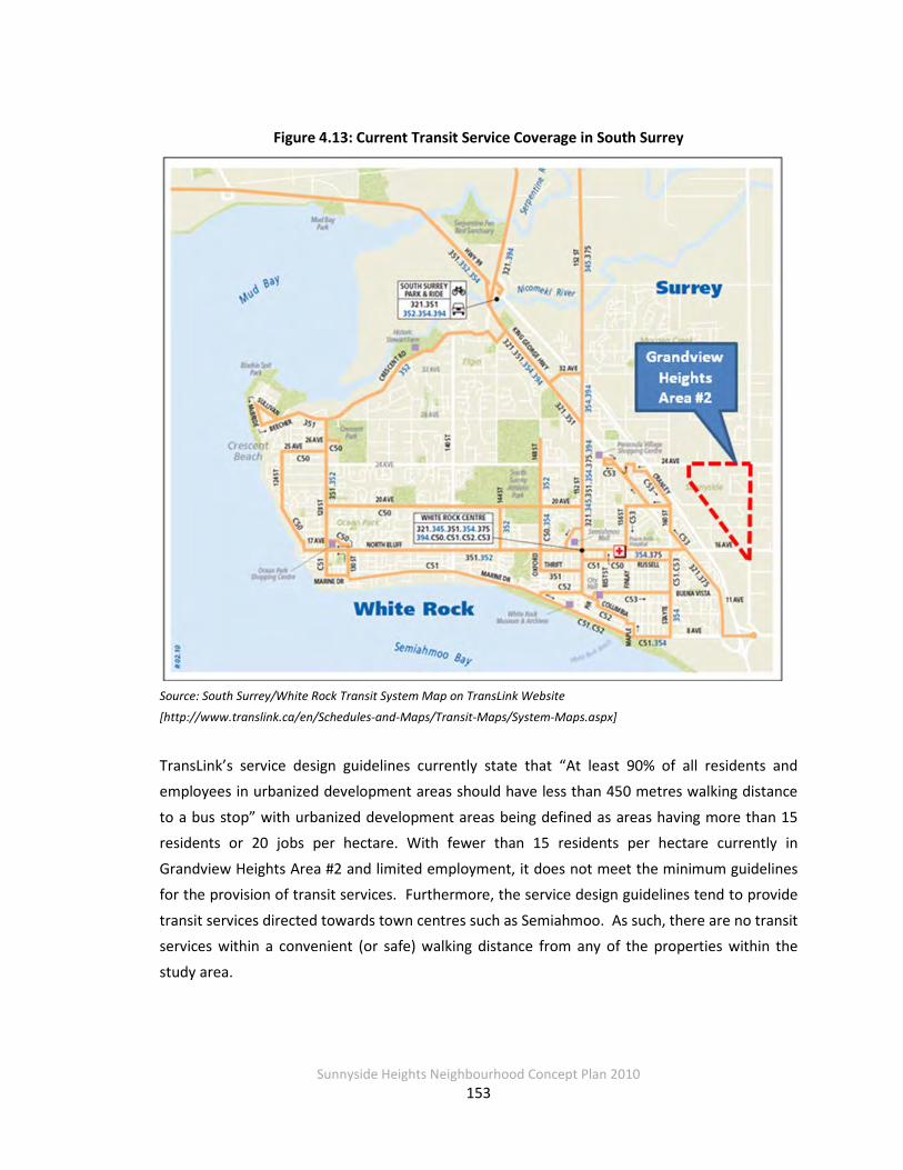
Sunnyside Heights Neighbourhood Concept Plan 2010
153
Figure 4.13: Current Transit Service Coverage in South Surrey
Source: South Surrey/White Rock Transit System Map on TransLink Website
[http://www.translink.ca/en/Schedules-and-Maps/Transit-Maps/System-Maps.aspx]
TransLink’s service design guidelines currently state that “At least 90% of all residents and employees in urbanized development areas should have less than 450 metres walking distance
to a bus stop” with urbanized development areas being defined as areas having more than 15 residents or 20 jobs per hectare. With fewer than 15 residents per hectare currently in
Grandview Heights Area #2 and limited employment, it does not meet the minimum guidelines for the provision of transit services. Furthermore, the service design guidelines tend to provide
transit services directed towards town centres such as Semiahmoo. As such, there are no transit services within a convenient (or safe) walking distance from any of the properties within the
study area.

Sunnyside Heights Neighbourhood Concept Plan 2010
154
Future growth in this area will push the population density above the minimum threshold for the provision of transit services as defined in TransLink’s Service Design Guidelines. As these are
just guidelines, there are a number of other factors that influence the transit planning process in Metro Vancouver. TransLink, through the development of the South of Fraser Area Transit Plan,
has identified a number of service improvements in South Surrey including the study area that are discussed further in Section 4.4.4.2.
Current Walking and Cycling Facilities
Currently there are limited walking and cycling facilities in the study area. The following map shows the current sidewalk coverage in the Grandview Heights Area #2.
The only roadway with any sidewalk coverage within the study area is the north side of 18th Ave
between 165A and 168th St. Furthermore, there are no designated cycling routes or facilities within the study area. As such, walking and cycling are not safe or convenient modes of travel given the lack of sidewalk, pedestrian and cycling facilities. There are plans to provide a
complete network of sidewalks, multi-use corridors and cycling facilities as part of the planned improvements discussed further in Section 4.4.5.1. These improvements will allow residents
and travelers to walk and cycle on safe and convenient facilities that are designated for these modes of travel.

Sunnyside Heights Neighbourhood Concept Plan 2010
155
Figure 4.14: Current Sidewalk Coverage in Grandview Heights Area #2
4.4.3 Current Traffic Conditions
The analysis of current traffic conditions was based on the Synchro traffic operations model using updated traffic count and signal timing information from the City of Surrey. This analysis
was used to assess the level of service (LOS) at signalized and stop control intersections along arterial roadways in the study area.
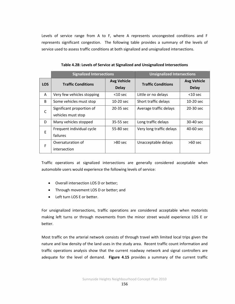
Sunnyside Heights Neighbourhood Concept Plan 2010
156
Levels of service range from A to F, where A represents uncongested conditions and F represents significant congestion. The following table provides a summary of the levels of
service used to assess traffic conditions at both signalized and unsignalized intersections.
Table 4.28: Levels of Service at Signalized and Unsignalized Intersections
Signalized Intersections Unsignalized Intersections
LOS Traffic Conditions Avg Vehicle
Delay Traffic Conditions
Avg Vehicle
Delay
A Very few vehicles stopping <10 sec Little or no delays <10 sec
B Some vehicles must stop 10-20 sec Short traffic delays 10-20 sec
C Significant proportion of vehicles must stop
20-35 sec Average traffic delays 20-30 sec
D Many vehicles stopped 35-55 sec Long traffic delays 30-40 sec
E Frequent individual cycle
failures
55-80 sec Very long traffic delays 40-60 sec
F Oversaturation of
intersection
>80 sec Unacceptable delays >60 sec
Traffic operations at signalized intersections are generally considered acceptable when automobile users would experience the following levels of service:
• Overall intersection LOS D or better;
• Through movement LOS D or better; and
• Left turn LOS E or better.
For unsignalized intersections, traffic operations are considered acceptable when motorists making left turns or through movements from the minor street would experience LOS E or
better.
Most traffic on the arterial network consists of through travel with limited local trips given the nature and low density of the land uses in the study area. Recent traffic count information and
traffic operations analysis show that the current roadway network and signal controllers are adequate for the level of demand. Figure 4.15 provides a summary of the current traffic
Sunnyside Heights Neighbourhood Concept Plan 2010
157
volumes and levels of service at key intersections in the study area during the afternoon peak hour which is the busiest time period of the day.
Both signalized intersections along 168th St operate at a LOS B with all individual turning
movements operating at LOS C or better. The north and southbound left turns at 24th Ave and 164th St are currently operating at LOS E both based on stop control. As identified above, all
study intersections are currently operating at acceptable levels of service.
Given that most peak hour traffic movements operate at a level of service C or better today, there are no immediate short term needs to upgrade signals or intersection configurations.
However, the future level of development in the study area and the South Surrey area generally will require improvements such as road widening and signal upgrades as discussed further in
Section 4.4.5.
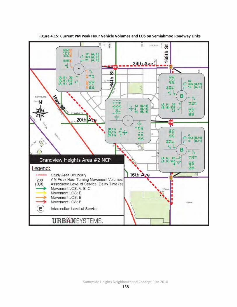
Sunnyside Heights Neighbourhood Concept Plan 2010
158
Figure 4.15: Current PM Peak Hour Vehicle Volumes and LOS on Semiahmoo Roadway Links
Sunnyside Heights Neighbourhood Concept Plan 2010
159
Travel Patterns Travel to and from Grandview Heights Area #2 consists largely of people using their private automobiles. Land use in the study area is generally single use, low density residential, which
leaves the automobile as the only viable mode of transportation for most people to get to and from places of work, education, shopping and recreation. Furthermore, the lack of transit
services and inadequate walking and cycling facilities do not provide convenient or safe choices for people to travel without using their automobiles. The future land use and transportation
plan for this area, however, will provide more choices for people to use alternate modes of transport as described later in this report. Furthermore, with a more complete community with
nearby shops and amenities, people will have more opportunities to access places of shopping, recreation and socializing using alternate modes of transport including walking, cycling and
taking transit.
4.4.4 Proposed Development
The Grandview Heights Area #2 is planned to be developed from a primarily rural and low
density residential area to a more densely populated urban/suburban neighbourhood. Approximately 2,200 people currently reside in the study area with plans to significantly
increase the density and variety of housing types. Population forecasts developed for the study area indicate that up to 11,300 people will make the Grandview Heights Area #2 their home. This represents the full build out scenario anticipated to occur over the next 20 years. The
following table provides an inventory of the land use types used to assess the transportation impacts for this area.
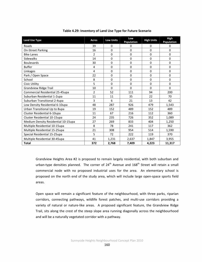
Sunnyside Heights Neighbourhood Concept Plan 2010
160
Table 4.29: Inventory of Land Use Type for Future Scenario
Land Use Type Acres Low Units Low Population High Units High
Population Roads 39 0 0 0 0 On-Street Parking 16 0 0 0 0 Bike Lanes 2 0 0 0 0 Sidewalks 14 0 0 0 0 Boulevards 30 0 0 0 0 Buffer 4 0 0 0 0 Linkages 4 0 0 0 0 Park / Open Space 22 0 0 0 0 School 8 0 0 0 0 Civic Utility 5 0 0 0 0 Grandview Ridge Trail 10 0 0 0 0 Commercial Residential 25-45upa 2 52 111 94 200 Suburban Residential 1-2upa 11 11 35 22 70 Suburban Transitional 2-4upa 3 6 21 13 42 Low Density Residential 6-10upa 48 287 926 479 1,543 Urban Transitional Up to 8upa 19 152 489 152 489 Cluster Residential 6-10upa 11 67 216 112 360 Cluster Residential 10-15upa 24 235 726 352 1,089 Medium Density Residential 10-15upa 27 269 833 404 1,250 Multiple Residential 10-15upa 8 78 241 117 362 Multiple Residential 15-25upa 21 308 954 514 1,590 Special Residential 15-25upa 5 72 222 119 370 Multiple Residential 30-45upa 41 1,231 2,637 1,847 3,955 Total 372 2,768 7,409 4,223 11,317
Grandview Heights Area #2 is proposed to remain largely residential, with both suburban and urban-type densities planned. The corner of 24th Avenue and 168th Street will retain a small
commercial node with no proposed industrial uses for the area. An elementary school is proposed on the north end of the study area, which will include large open-space sports field
areas.
Open space will remain a significant feature of the neighbourhood, with three parks, riparian corridors, connecting pathways, wildlife forest patches, and multi-use corridors providing a
variety of natural or nature-like areas. A proposed significant feature, the Grandview Ridge Trail, sits along the crest of the steep slope area running diagonally across the neighbourhood
and will be a naturally vegetated corridor with a pathway.

Sunnyside Heights Neighbourhood Concept Plan 2010
161
Planned Improvements As the Grandview Heights area densifies and more people live, work, and play in this area, more
travel activity will result. Added transportation infrastructure will be required to accommodate the increased demands for travelling to, from and within the study area. As such, transportation
infrastructure (described in detail in Section 4.4.5) will be required to provide more capacity for the following modes of travel:
Walking – a more complete network of sidewalks, trails, and walkways for people to travel by
foot around the Grandview Heights area. Better pedestrian facilities would also encourage transit use as riders would have better and safer access to bus stops and transit services.
Cycling – more on-road and off-road routes to promote cycling in and around the Grandview
Heights area including connections to other parts of South Surrey. More facilities will help support the convenience, safety and reliability of cycling within Grandview Heights and the surrounding neighbourhoods.
Transit – more transit service as outlined in the South of Fraser Area Transit Plan to provide a
competitive alternative to driving for longer trips. Improved transit facilities such as sheltered bus stops and safe walkways and waiting areas to enhance the customer experience while
waiting for a bus or transferring between routes.
Auto – increased turning and through capacity along key corridors such that reasonable levels of service are maintained on the roadway network and at intersections. Improvements would
include added turn lanes and through lanes as well as signal and signal timing upgrades to manage traffic flows efficiently.
South of Fraser Area Transit Plan The South of Fraser Area (SoFA) Transit Plan sets out a long-range transit plan and vision for
improved transit services in the South of Fraser Area including Grandview Heights. The SoFA plan sets out a short-term implementation plan as well as a longer term strategy. An extensive
public and stakeholder consultation process was carried out over two years to build support for this plan, which was approved by the TransLink Board in the spring of 2008.

Sunnyside Heights Neighbourhood Concept Plan 2010
162
Several improvements will be implemented in the South Surrey area that will connect the Grandview Heights area to other parts of Surrey and beyond. Existing transit services are largely
configured to move people from South of Fraser communities to Vancouver and the central core of Metro Vancouver. The changes in transit services as part of the SoFA plan provide more
connections between South of Fraser communities to support local travel.
Relevant service improvements include a conventional transit route between Semiahmoo Town Centre and Langley City Centre via 24th Ave. This new route will provide a connection through
the Grandview Heights area that does not exist today and will provide access to the Campbell Heights industrial area. Other relevant service improvements include a new community shuttle
service throughout the Grandview Heights area that will connect people to regional rapid bus services at a new exchange facility in the Semiahmoo Town Centre. The map on the following
page (Figure 4.16) highlights the relevant service improvements to the year 2013.
Figure 4.16: Proposed South of Fraser Transit Improvements to 2013
Source: South of Fraser Transit Plan, Phase 3 Report, 2013 Implementation Plan, Nov 2007.
New Route between Semiahmoo
Town Centre and Langley City Centre via 24th Avenue New Community
Shuttle Service within Grandview Heights

Sunnyside Heights Neighbourhood Concept Plan 2010
163
South Surrey Long-Term Road Network Plan The City of Surrey has, as part of their strategic planning process, identified road network
improvements to accommodate growth in vehicle volumes. The 10 Year Servicing Plan (2010-2019) identifies transportation needs for arterials, major collectors and local roads. This plan
also identifies projects that are cost shared with the Province as well as projects related to pedestrians, cyclists, and transit.
The following list of transportation projects has been identified as part of the 10 Year Servicing
Plan and will have an impact on travel to and from Grandview Heights Area #2.
Table 4.30: List of Road Projects Identified in the 10 Year Servicing Plan
Project ID Project Name Project Location
10056 New Arterial Construction (On-Ramps) Highway 99 and 24th Avenue
7438 Ultimate Arterial Widening King George Hwy: 24th Avenue to 152nd St.
10084 Interchange Highway 99 at 152nd Street
10627 Ultimate Arterial Widening (4 lane) 16th Avenue: Highway 99 – 168th Street Note: Please refer to Table 4.35 for a list of the 10 Year Servicing Plan projects that fall within the study area.
Further to the list of projects mentioned above, Surrey has identified roadway network improvements over a longer time horizon. Over the next 30-year period, the following list of projects will likely be required to accommodate the increase in vehicle volumes as the South
Surrey area continues to grow.
Table 4.31: List of Road Projects Identified as Long Term Needs
Project #
Project Name Project Location
1 20th Avenue Connector 20th Avenue: King George Hwy to Croydon
2 24th Avenue Widening to 4 Lanes GP 24th Avenue: 176th St to King George Hwy
3 16th Avenue Widening to 4 Lanes GP* 16th Avenue: 176th St to King George Hwy
4 16th Avenue Interchange Highway 99 at 16th Avenue *potential ultimate 6 lane facility

Sunnyside Heights Neighbourhood Concept Plan 2010
164
These projects represent longer term needs and a significant expansion of roadway capacity as the South Surrey area continues to develop and become more congested. Furthermore, these
projects will have an impact on travel to and from the Grandview Heights area and have been included as part of the transportation modelling. In this regard, the travel impact including the
distribution of trips on the roadway network based on these improvements has been captured as part of this analysis.
The following provides a description of each of these projects and its significance to the study
area:
• 20th Ave Connector – this project has been identified as a key link to connect
communities on either side of Highway 99. It has also been recognized to provide a more complete roadway network in the South Surrey area to support efficient traffic circulation. A multi-use pathway along 20th Ave from Grandview Heights to Semiahmoo
will provide a significant east/west facility for cycling across Highway 99.
• 24th and 16th Ave Widening – both of these roadways will require widening from two to
four lanes as part of growing travel needs in the South Surrey area. The majority of traffic on these facilities is regional through travel.
• 16th Ave Interchange – this project is required to provide an alternate access point to Highway 99 for commuters based on the growth trends in South Surrey.
Site-Generated Traffic Congestion levels will increase as the study area becomes denser and the surrounding neighbourhoods in the South Surrey area continue to develop. The recently updated South
Surrey Sub-Area model was used to forecast traffic conditions on the roadway network. Full build out land use numbers were used for the 2031 horizon including development within
Grandview Heights and the rest of the region.
This traffic demand forecasting model is based on the regional EMME model that was further calibrated for conditions in the South Surrey area. The EMME model is a multi-modal
equilibrium model that is used to forecast travel and traffic conditions for future horizons. There are three main components to this model described as follows:
• Traffic Zone System – a system of zones used to store demographic and travel information throughout the Metro Vancouver region.

Sunnyside Heights Neighbourhood Concept Plan 2010
165
• Road and Transit Networks – digital representation of the roadway and transit networks.
• Four-Step Modelling Procedure – a set of mathematical equations used to predict travel behaviour. The four steps comprise of the following:
1. Trip Generation – trip generation and attraction rates are used to calculate the total number of trips by purpose to and from each traffic zone. The
independent variables used are population by age group and employment by industrial classification. Trip purposes include work, post secondary, grade school and other.
2. Trip Distribution – a gravity model is used to distribute trips by purpose between origin and destination traffic zone pairs. Attractiveness of trip making
between zones is based on the level of trip activity and the generalized cost of travel between traffic zones. Generalized costs of travel include the distance
and out-of-pocket costs associated with trip making using the value of travel time.
3. Mode Split – a logit model is used to determine the proportion of trips by mode of travel including automobile, transit and walk/bike. Separate matrices for
trips by purpose and mode are calculated.
4. Traffic Assignment – once the number of auto and transit trips has been
calculated, they are then assigned to the road and transit networks respectively.
The advantage of using the EMME-based model is that it captures the socio-economic impacts of travel including, but not limited to, the following:
• Supply of transit services
• Growing and aging population trends, with lower peak hour trip rates for people in the older age groups (65+)
• Cost of travel including fuel prices, parking costs and transit fares
• Road network improvements including widening of 16th and 24th Ave and addition of the 20th Ave connector
• Densification and mixture of land uses
• Employment trends
• Background growth in other parts of South Surrey and the Lower Mainland
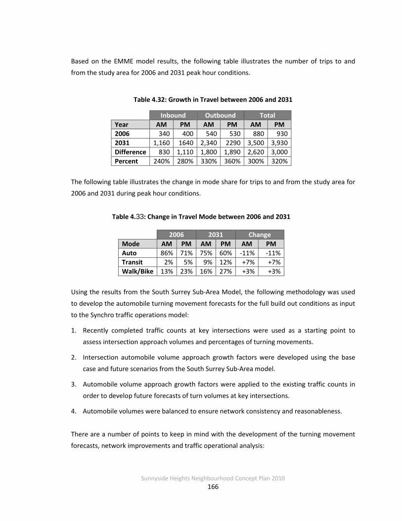
Sunnyside Heights Neighbourhood Concept Plan 2010
166
Based on the EMME model results, the following table illustrates the number of trips to and from the study area for 2006 and 2031 peak hour conditions.
Table 4.32: Growth in Travel between 2006 and 2031
Inbound Outbound Total Year AM PM AM PM AM PM 2006 340 400 540 530 880 930 2031 1,160 1640 2,340 2290 3,500 3,930 Difference 830 1,110 1,800 1,890 2,620 3,000 Percent 240% 280% 330% 360% 300% 320%
The following table illustrates the change in mode share for trips to and from the study area for 2006 and 2031 during peak hour conditions.
Table 4.33: Change in Travel Mode between 2006 and 2031
2006 2031 Change Mode AM PM AM PM AM PM Auto 86% 71% 75% 60% -11% -11% Transit 2% 5% 9% 12% +7% +7% Walk/Bike 13% 23% 16% 27% +3% +3%
Using the results from the South Surrey Sub-Area Model, the following methodology was used
to develop the automobile turning movement forecasts for the full build out conditions as input to the Synchro traffic operations model:
1. Recently completed traffic counts at key intersections were used as a starting point to assess intersection approach volumes and percentages of turning movements.
2. Intersection automobile volume approach growth factors were developed using the base case and future scenarios from the South Surrey Sub-Area model.
3. Automobile volume approach growth factors were applied to the existing traffic counts in order to develop future forecasts of turn volumes at key intersections.
4. Automobile volumes were balanced to ensure network consistency and reasonableness.
There are a number of points to keep in mind with the development of the turning movement forecasts, network improvements and traffic operational analysis:

Sunnyside Heights Neighbourhood Concept Plan 2010
167
• The turning movement forecasts are a simplification of reality and therefore should be interpreted with caution. Traffic flows are very dynamic and can change significantly
from day to day and season to season. What is being shown in this analysis is the most likely average weekday peak conditions for the future.
• As congestion levels increase slowly over time, people’s tolerance of congestion will also increase as they become more accustomed to driving in a denser and more urbanized
environment that is designed to give more priority for pedestrians, cyclists and transit users.
Without any improvements, future traffic conditions on the roadway network within the
Grandview Heights area will deteriorate significantly. Roadway network improvements were then developed for critical turn movements that were unacceptable in terms of the level of
service criteria. The following section describes the required transportation improvements in order to support the future needs of automobile users in the Grandview Heights area.
4.4.5 Future Transportation Network
The following improvements for each mode of travel will be required in order to accommodate future travel demands anticipated as part of the development of the Grandview Heights Area #2
and surrounding South Surrey area. Furthermore, these enhancements will provide choices for people to travel using alternate mode of transport such as walking, cycling and transit.
Walking and Cycling Network Plan
The connectivity of the local road network within the study area has an impact on the amount of walking trips. As the street grid and land use are denser within the study area, pedestrians have
more opportunities and quicker routes to get to their destination. All local roadways are to be built to Surrey’s standard and will include sidewalks on both sides in
order to provide an adequate walkway network within the study area. These will be especially important to provide safe access to schools and parks and commercial areas.
The following map highlights the network of sidewalks and walking trails that will be included as
part of the transportation plan for Grandview Heights Area #2. The following sub-section provides a description of some of the key facilities in the study area.

Sunnyside Heights Neighbourhood Concept Plan 2010
168
Figure 4.17: Proposed Pedestrian Network within Grandview Heights Area #2
Grandview Ridge Trail
A pedestrian pathway has been identified in the land use plan for this area that will provide a continuous north-south connection. This will also provide a recreational facility for residents to

Sunnyside Heights Neighbourhood Concept Plan 2010
169
enjoy the natural features of this area. Special treatments at roadway crossings will be required since visibility will likely be obstructed by trees and shrubbery and a trail crossing might not be
immediately obvious for auto drivers. The following map highlights some of the recommended safety features for Grandview Ridge trail crossings at collector roadways.
Figure 4.18: Grandview Ridge Trail Safety Features at Collector Roadway Crossings
Treatments at all roadway crossings including local streets should include similar features that generally enhance the safety and visibility of pedestrians. At local roadway crossings, features
such as curb bulges, bollards and pedestrian crossing lane markings would enhance the comfort for trail users. Additional features at collector roadway crossings such as 20th Ave and 164th St
could also include signage and possible pedestrian crossing signals to showcase walking as a more prominent mode of transport.
Multi-Use Corridors
Multi-use pathways have been identified along key corridors to provide a safe facility for pedestrians, cyclists, roller bladers and other vulnerable users that are physically separated from
the roadway. Three such corridors have been identified along 16th, 20th and 24th Avenues. A multi-use corridor has been identified along 20th Avenue to provide a continuous east-west

Sunnyside Heights Neighbourhood Concept Plan 2010
170
linkage to the Semiahmoo Town Centre. This is to be provided as a 4.0 m facility on the north side of the roadway.
Cycling Lanes
As part of the 16th and 24th Avenue arterial widening projects, 1.8 m cycling lanes will be
provided on both sides of the roadway. Furthermore, the upgrading of 20th Ave and 164th St to the updated collector standard will include extra roadway width to provide a safe route for
cyclists. In order to provide safe access to 24th Avenue, a bicycle activation button should be included at the intersections controlled by traffic signals.
Transit Services and Facilities Plan
As mentioned earlier, TransLink has identified a number of transit improvements as part of the South of Fraser Area Transit Plan. In order to maximize the ridership on these new routes, there are enhancements that would be necessary to improve pedestrian access to these new services.
In addition to the above walking network improvements, we want to ensure that the future
Rapid Transit route (bus, light rail, or streetcar) along 24th Avenue connecting Semiahmoo Town Centre to Langley City Centre via Campbell Heights has adequate bus stop facilities. It is planned
to accommodate Rapid transit within designated travel lanes, one lane per direction. These should include two bus bays in both the east and westbound directions as per TransLink’s
standard bus stop spacing. The likely location of these would be the far side at the 164th and 168th Street intersections. Each bus bay should include sheltered and lit waiting areas, walkway
or sidewalk connections to the pedestrian network.
For the new Community Shuttle route, planned for 164th Street, adequate bus stop facilities should be provided along the proposed route. The 164th Street alignment meets TransLink’s
criteria for both the catchment area and pedestrian accessibility. These should include bus bulges or bus bays, shelters, benches, lighting and info tubes with schedule information to enhance the travel experience for transit users. Similar to the bus stops along 24th Avenue,
adequate sidewalk and other pedestrian facilities should be provided to improve walk access to these bus stops.

Sunnyside Heights Neighbourhood Concept Plan 2010
171
Roadway Network and Intersection Plan To accommodate walking, cycling, transit and parking needs, the City of Surrey has developed
proposed pavement widths for the various categories of roadways. These widths are shown in Figures 4.19 and 4.20 with allocation for the various roadway users including space for medians,
boulevards and other features that would provide a network of complete streets.
The roadways developed as part of this Grandview Heights Area #2 NCP will be in accordance to the standards shown in Figure 4.19 and 4.20. Typical road cross-sections where there are
drainage corridors are graphically shown in Figures 4.9 and 4.10.
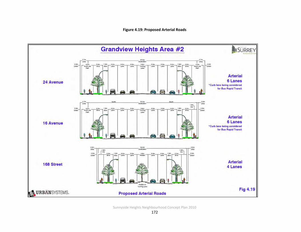
Sunnyside Heights Neighbourhood Concept Plan 2010
172
Figure 4.19: Proposed Arterial Roads
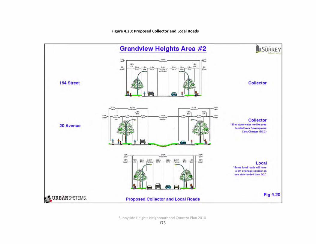
Sunnyside Heights Neighbourhood Concept Plan 2010
173
Figure 4.20: Proposed Collector and Local Roads

Sunnyside Heights Neighbourhood Concept Plan 2010
174
4.4.6 Required Roadway Network Improvements
Based on the traffic analysis outlined above, the improvements to the various components of
the roadway network required to support increased traffic demands are as follows:
Intersections 24th Avenue/164th Street
• Upgrade to signalized intersection (all four approaches already contain left turn bays)
• Add channelized right turns at all four approaches
24th Avenue/168th Street
• Upgrade signal to accommodate protected left turn phasing
• Add additional through lanes east and westbound
• Add channelized right turns for all four approaches
20th Avenue/164th Street
• Upgrade intersection to a roundabout
• East and westbound approach volumes warrant a two lane roundabout with north and southbound volumes only requiring one lane
• The following conceptual configuration with major and minor approach links should be
considered:

Sunnyside Heights Neighbourhood Concept Plan 2010
175
Figure 4.21: Grandview Area #2 Future 20th Avenue/164th Street Roundabout
20th Avenue/168th Street
• Upgrade to signalized intersection
• Add minimum 30 m left turn bays at all four approaches
16th Avenue/168th Street
• Upgrade signal to accommodate protected left turn phasing
• Add additional through lanes east and westbound with channelized right turns
Arterial and Collector Roadways
The intersection upgrades mentioned above can accommodate the increased volumes due to the Grandview Heights Area #2 development, but the arterial roadways will need to be widened
to achieve reasonable levels of service in the future given the overall growth trends in the South

Sunnyside Heights Neighbourhood Concept Plan 2010
176
Surrey area. The additional traffic from the Grandview Heights Area #2 does not trigger the
need to widen either 24th or 16th Avenue as most of the current and future traffic on these arterials is attributed to through traffic. 16th Avenue has been identified for future widening as
part of Surrey’s 10 Year Servicing Plan and 24th Avenue has been indentified in longer term plans.
164th Street does not currently exist between 20th Ave and 23rd Ave; however there is an existing
right-of-way (ROW) allowance that follows the existing grid pattern for numbered streets. It was determined early in the draft NCP process that constructing a road within the existing 164th Street ROW would not be feasible due to costs resulting from the earthwork and impacts to
existing properties along that alignment. As a result, a “re-alignment” routing was chosen and incorporated into the NCP.
As the process of finalizing the NCP continued, the city retained Urban Systems to prepare
preliminary alignment designs and comparative construction cost estimates for both of the options. The results of the investigation determined that using the existing 164th Street corridor
would be more costly in terms of construction, the design geometry less desirable and the environmental impacts would be greater, which would also result in additional mitigation
requirements elsewhere in the NCP study area. As such, the proposed alignment for 164th St presented in this report is the preferred option for going forward.
Internal Roadway Network The approved land use plan identified corridors for the local roadway network as shown in
Figure 4.25 below. This network is intended to provide a much more continuous street grid for better traffic circulation, access to neighbourhoods as well as a more complete pedestrian
network with sidewalks. The principles used to develop the internal roadway network were to encourage internal connectivity with no cul-de-sacs, open and connected neighbourhoods and
safer streets for walking and cycling. This finer grid also allows traffic to disperse throughout the network lowering the amount of vehicle volumes on any specific local street. Access to single
family developments would be through laneways providing additional connectivity and dispersal of automobile traffic.
The network identifies a number of what are termed “flex streets”. These streets provide a
critical element of connectivity but their exact alignment is flexible. Provided that these streets

Sunnyside Heights Neighbourhood Concept Plan 2010
177
provide the same degree of connectivity as the ones identified in the land use plan alternative
alignments may be acceptable.
All local roadways should be built to Surrey’s standard two-way road with parking on both sides with 11 m of pavement. The intersection at 21st Avenue and 164th Street should be stop control
considering that 21st Avenue will be a through local across the drainage corridor. Consideration should also be given for possible traffic circles at local roadway intersections. With the local
roadway cross section providing wider lanes for cyclists and sidewalks on both sides with boulevards, there is little need for any additional traffic calming. Furthermore, having parking on both sides of the streets provides for additional traffic calming as motorists would be less likely
to speed through areas with parked cars.
Access to and from collectors and arterials should be provided with stop control with allowance for left turns both inbound and outbound from the study area to maintain adequate traffic
circulation between the local and collector/arterial networks.
Traffic circles are identified in the Land Use Plan on the diagonal section of 161 A Street at 22, 21 and 19th Avenues, which would be a development requirement when these roads are
widened or constructed as part of adjacent development. As has been discussed in Section 4.4.6 a more major roundabout has been identified at the intersection of two collector roads 164
Street and 20 Avenue. This roundabout at the intersection of the collectors is a DCC funded item.

Sunnyside Heights Neighbourhood Concept Plan 2010
178
Figure 4.22: Grandview Area #2 Future Roadway Network Plan

Sunnyside Heights Neighbourhood Concept Plan 2010
179
Parking Management Plan
On-street parking will be provided along both sides of all local and collector roadways within the study area. Parking on both sides of the street will also provide additional traffic calming as
motorists will drive slower alongside parked vehicles. Summary of Transportation Improvements
The above mentioned improvements will help facilitate the movement of people and traffic
throughout the Grandview Heights Area #2 as it develops. Figure 4.23 below summarizes the future turning movements and levels of service with the improved roadway network. Figure
4.24 on the following page provides an overall summary of the transportation network improvements.
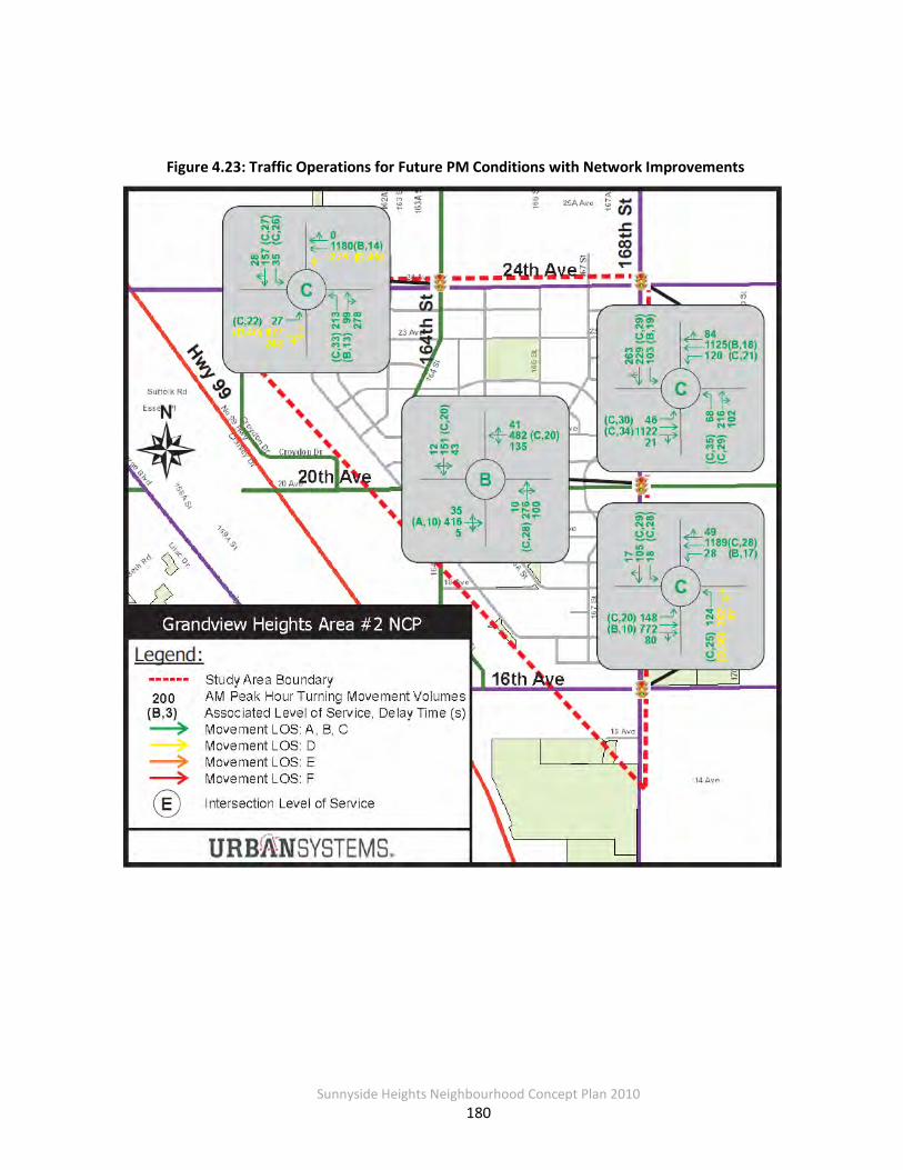
Sunnyside Heights Neighbourhood Concept Plan 2010
180
Figure 4.23: Traffic Operations for Future PM Conditions with Network Improvements

Sunnyside Heights Neighbourhood Concept Plan 2010
181
Based on the future traffic volumes and level of service analysis with the recommended roadway
improvements, all movements are at LOS D or better. These improvements satisfy the need for traffic mobility and provide enough roadway capacity for acceptable levels of service for future conditions.
Figure 4.24: Summary of Transportation Improvements
Notes: Future widening of 16th and 24th Avenues are needed based on overall growth in South
Surrey traffic, not solely triggered by Area #2 traffic.
4.4.7 Cost Estimates and Financing Approach
The cost estimates for the infrastructure needed for growth are based on the principle that development is responsible for funding the local and collector road infrastructure that fronts
and/or is adjacent to the development lands. Because there is a higher standard for collector roads compared to local roads, an upsizing approach is utilized with the cost to upgrade from
the local to the collector road standard being included as a DCC eligible item. Where there is a collector arterial intersection only the collector road component of the works has been shown
Upgrade to signalized intersection.Add channelized right turns at all four approaches.
Upgrade signal to accommodate protected left turn phase.Add additional east/westbound through lanes and channelized right turns at all four approaches.
LEGENDStudy Area BoundaryProvincial HighwayArterial RoadwaysCollector RoadwaysLocal Streets (existing)
Upgrade Traffic Signal
Implement Roundabout
Implement Major – Minor Roundabout as shown in concept.
Upgrade signal to accommodate protected left turn phase.Add additional east/westbound through lanes and channelized right turns for east/westbound approaches.
Upgrade to signalized intersection and add left turn lanes for east and westbound approaches.
Notes:• This figure only shows improvements to the arterial/collector road network and not the proposed additions to the local road network.•All signal timings to be optimized as required.•Adequate right of way and bus stop facilities should be reserved for the proposed bus route along 24th Ave including safe pedestrian crossings.•A pedestrian pathway along the Grandview Ridge Trail has been identified in the land use plan for this area that will provide a continuous north-south connection.•A multi-use corridors have been identified along 16th, 20th
and 24th Aves to provide east-west linkage. These are to be provided as 4.0 m facilities for pedestrians, cyclists, roller bladers, etc.•Additional curb lane width will be provided on all collector and arterial roadways for a safer cycling network.

Sunnyside Heights Neighbourhood Concept Plan 2010
182
as arterial road works are treated separately and are funded through the overall city wide
arterial road DCC program. DCC eligible items include collector road works and other items that serve the overall NCP. This financing approach for Collector Roads is summarized in Table 4.33.
Table 4.34: Collector Road Cost Estimates and Financing Approach
Capital Item Total Cost Costs Recovery Approach for Area 2
City-Wide DCCs Other
24 Ave / 164 St Traffic Signal $150,000 $150,000 $0
20 Ave / 164 St Roundabout $1,534,000 $1,534,000 $0
20 Ave / 168 St Traffic Signal $150,000 $150,000 $0
20 Ave Upgrade to Collector Standard $970,000 $970,000 $0
164 St Upgrade to Collector Standard $870,000 $870,000 $0
Total $3,674,000 $3,674,000 $0 Notes:
1. Costs updated to January 2010 construction costs
As shown in Table 4.34, anticipated transportation DCC revenues from Area #2 are expected to
exceed the costs of making needed transportation improvements to support development in Area #2.
As mentioned above Arterial Roads are treated on an overall city wide basis rather than an NCP
by NCP basis. This is primarily due to the fact that the impact of arterial traffic is spread out over a wider area than the individual NCP. Also, as outlined previously the analysis does not
indicate that traffic from the NCP triggers the need for any arterial widening other than the upgrading of 168th Street at the intersection with 20th Avenue and the upgrading of the intersection at 24th Avenue and 168th Street. Widening of the arterial roads through and
adjacent to the NCP will be driven by overall growth in city wide traffic. However, to confirm that in the longer term there will be sufficient DCCs collected from this NCP to fund the cost to
widened the NCP side of adjacent arterials, 168th Street 16th – 24th Avenues 16 Avenue Hydro Corridor to 168 Street and 24th Avenue 161A – 168th Street has been estimated to be $13.25

Sunnyside Heights Neighbourhood Concept Plan 2010
183
million. As can be seen from Table 4.35 below there is a substantial surplus in the arterial DCCs
which can be used for arterial road needs in the wider Grandview – South Surrey area such as a contribution towards the new 20th Avenue overpass at Highway 99.
Table 4.35: Estimated DCC Revenues and Expenditures – Transportation
Estimated DCC Revenues
Estimated Additional DCC Expenditures Balance
Non-Arterial Roads $5,370,000 $3,674,000 $1,696,000
Arterial Roads $24,576,000 $13,250,000 $11,326,000
Notes: 1. DCCs based on the average development yield for the area. 2. DCC revenues do not include potential DCC revenues from commercial or institutional development within Area #2. 3. Arterial Road expenditures are long term needs and are not triggered by traffic growth in this NCP alone.
4.4.8 Ten Year Servicing Plan
It is recommended that the City review its 2010-2019 10 Year Servicing Plan to determine
whether the works recommended in this report overlap with current projects included in the 10 Year Servicing Plan. Table 4.36 lists projects currently identified in the 10 Year Servicing Plan
that fall within the transportation study area. These projects should be reviewed.
Table 4.36: 10 Year Servicing Plan Projects to Review – Transportation
10 Year Servicing Plan Project ID
7453 10619 10627
10628 10637 11754
Sunnyside Heights Neighbourhood Concept Plan 2010
184
4.5 Utilities (Power, Telecommunications, Natural Gas)
4.5.1 Power
Currently NCP Area #2 is provided with electrical power by overhead power lines (except for a number of existing 1 acre subdivisions, which have underground power internal to the
subdivision). All new hydro lines needed to service NCP Area #2 will be installed underground as per current City policy. BC Hydro will expand its system as development proceeds.
4.5.2 Telecommunications/Cable
Currently, NCP Area #2 is serviced by overhead telephone lines. As development proceeds, new lines will have to be installed underground to comply with the City’s Subdivision and Development Bylaw. New telephone and cable service will be extended as needed as
development proceeds.
4.5.3 Natural Gas
The gas system that currently services NCP Area #2 will be improved and expanded as needed.

Sunnyside Heights Neighbourhood Concept Plan 2010
185
4.6 Development Phasing The phasing of development within Grandview Heights NCP Area #2 will be dictated by the
provision of sanitary sewer services. Under the proposed land use plan, all new development will require a sanitary sewer connection to the City’s system. Those properties that can be connected to the City’s sanitary sewer system by gravity will likely develop before properties
that require pumping.
The sanitary sewer gravity catchment will service a large area upstream of the approximately 90 m contour extending form 24th Avenue south to approximately 20th Avenue – this area is
considered Phase 1 (see Figure 4.25). The remaining area of NCP #2, which requires the construction of a pump station and force main, is considered Phase 2. The pump station will be
located south of 14th Avenue just east of 168th Street. The force main will be constructed from the new pump station parallel to the BC Hydro right-of-way until 20th Avenue then located
under a future road west of 164th Street to a connection at approximately 23rd Avenue and 162nd Street.
The pump station and force main must be constructed first before any development within
Phase 2. Once the pump station is operational, development can proceed in conjunction with the collection system.

Sunnyside Heights Neighbourhood Concept Plan 2010
186
Figure 4.25: Proposed Development Phasing

Sunnyside Heights Neighbourhood Concept Plan 2010
187
4.7 Infrastructure Financing and Funding This Section summarizes cost estimates for providing needed water, sanitary sewer, storm
drainage, and transportation infrastructure to NCP Area #2 and provides recommendations for financing these costs.
4.7.1 Financing Approach
The City of Surrey has taken the following approach to infrastructure funding in the NCP area:
1. The long-term DCC revenues and expenditures for major collector roads, water, sanitary and
drainage works must balance within NCP Area #2. Arterial road widening is assumed to be funded over time through DCCs and not DCCs solely generated from the NCP area. If the
NCP’s total DCCs are less than the expenditures, the NCP may still go ahead, but the costs above the revenues generated through the specific NCP DCCs will only be provided by the
City when the works become a City priority.
2. The short-term annual DCC revenues and expenditures must also balance, or the
development community within the NCP must address the short-term cash flow problem.
3. City Council has stated that City will not specify sequencing of development among NCPs at
this time.
4. The City will not fund interim works.
5. The City-wide based DCC collection and expenditure program is the basis of all DCC capital works.
6. The City of Surrey has endorsed the use of DCC Front-ender Agreements as a method of reimbursing developers for front ending the cost of major engineering infrastructure that is within the current 10 Year Servicing Plan.
7. A Development Works Agreement can be considered to cover the cost of major infrastructure items that are not included in the DCC program.

Sunnyside Heights Neighbourhood Concept Plan 2010
188
4.7.2 Financing Summary
In addition to frontage works (to be funded fully by the developer), the development of NCP #2 will require investments in the major engineering infrastructure components. As discussed in
previous sections, these major components will be funded primarily through DCCs, with the need for other funding mechanisms (i.e. Development Works Agreement).
After reviewing the DCC contribution from the Highway 99 Corridor NCP based on expected
flows, it was determined that a DCC rate adjustment is necessary for the Highway 99 Corridor area in relation to the contributory flows that will be generated by development in that area. As
a result, an adjustment to the Highway 99 Corridor area specific DCC rates will be necessary to account for the revised sanitary servicing costs.
Table 4.37: Major Engineering Infrastructure Costs to Service NCP Area #2
Notes:
1. Does not include local servicing costs. 2. Sanitary Sewer values include adjustment to Hwy 99 Corridor Plan DCC
4.7.3 DCC Revenues and Expenditures
The following table summarizes the estimated DCC revenues and construction costs for each engineering service. The revenues are based on the City’s proposed DCC Bylaw and growth
estimates from the Stage 1 Land Use Concept. Because the Stage 1 NCP contained both high and low growth estimates, DCC revenues were calculated under both scenarios and then
averaged. Estimated DCC revenues do not include potential revenues from the commercial node
Infrastructure Estimated Costs City-Wide DCCs Development
Works Agreement
Sanitary Sewer(2) $12,523,000 $7,434,000 $5,089,000
Water $3,027,000 $4,335,000 $0
Stormwater $25,203,000 $6,710,000 $18,493,000
Collector Roads $3,674,000 $3,674,000 $0
Arterial Roads $13,250,000 $24,576,000
Total $57,677,000 $46,729,000 $,23,582,000

Sunnyside Heights Neighbourhood Concept Plan 2010
189
or from institutional development (e.g., the school site). The detailed DCC revenue calculation is
shown in Appendix B. Both costs and revenues are in 2010 dollars.
Table 4.38: Estimated DCC Revenues and Expenditures to Build-Out of NCP Area #2
Infrastructure Estimated DCC Revenues
Estimated Additional DCC Eligible Costs
Balance
Sanitary Sewer(4) $7,434,000 $12,523,000 -$5,089,000
Water $4,335,000 $3,027,000 $21,090
Stormwater
Management $6,710,000 $25,203,000 -$18,493,000
Non Arterial $5,370,000 $3,674,000 $1,696,000
Subtotal $23,849,000 $44,427,000 -$21,864,910
Arterial $24,576,000 $13,250,000 $11,326,000
TOTAL $48,425,000 $57,677,000 -$10,538,910 Notes: 1. DCCs based on the average development yield for the area. 2. DCC revenues do not include potential DCC revenues from commercial or institutional development within Area #2. 3. Arterial roads are dealt with on a city-wide basis, not on an NCP-by-NCP basis. 4. Sanitary Sewer values include adjustment to Hwy 99 Corridor Plan DCC
The sanitary sewer deficit for the pump station and force main will need to be covered through other funding mechanisms, and a Development Works Agreement is proposed. The stormwater
deficit for specific drainage corridor BMP costs as noted in Section 4.3.6 is recommended to be funded through an area specific DCC, further discussion is included in Section 4.7.5.
4.7.4 Sanitary Sewer Pump Station and Force Main
As identified in Section 4.1.5 there is a shortfall between what is generated by DCCs and the trunk/pump station needs typically funded by DCCs. This shortfall is created by one item,
namely the sewer pump station to service Catchment 2 (the southern catchment). This pump station also services other areas, comprising the Highway 99 Corridor, (which provides a $1.8 million contribution) and the future NCPs Grandview Area #3 and a portion of Area #5.
However, because Areas #3 and #5 are in the future and have no official status, funding from these areas cannot be built into the financial model at this time. Deferring the pumping capacity

Sunnyside Heights Neighbourhood Concept Plan 2010
190
for NCP Area # 3 and #5 reduces the pump station cost to $10.1 million. This leaves a $5.089
million shortfall for the pump station to be funded by NCP Area #2. This funding situation is further complicated due to the fact that Catchment 1 (the northern catchment) does not
physically need the pump station to be able to develop.
The proposed funding approach to overcome this shortfall and fund the pump station for Catchment 2 would be through a Development Works Agreement. Under this approach a
developer, or group of developers, would frontend the pump station with cost recovery through a combination of a DCC Front-enders Agreement over the entire NCP area ($3.23 million) and a Development Works Agreement ($5.089 million) over Catchment 2.
A Development Works Agreement requires assent of the property owners within the defined
benefiting area namely Catchment 2. To recover the $5.089 million shortfall, the Development Works Agreement charge would be about $20,500 an acre, based on a net developable area in
Catchment 2 of 116.0 ac. Catchment 2 also has the option of waiting until NCP Area # 3 and #5 are finalized and then jointly funding the pump station and force main with these two other
NCPs.
4.7.5 Financing Drainage Corridors
As discussed in Sections 4.3.5 to implement the drainage corridors requires an additional road
allowance width of 5 metres and in some cases 10 metres. While most properties have some form of drainage corridor adjacent to them there are some locations that do not.
To equalize the impact of road dedications it is proposed that the cost of the stormwater
corridors be reimbursed to the fronting property owner from a combination of drainage DCC Front-enders Agreement and Development Works Agreement for the drainage service areas
shown on Figure 4.26. This reimbursement would be at the rate of $750,000 an acre. A Development Works Agreement requires the consent of the owners of properties within the
benefitting service area. Based on the net developable area of each drainage servicing area, the value of the Development Works Agreement for each area is estimated in Table 4.39. As
mentioned in Section 4.3.5, an option to implement a traditional detention pond instead of stormwater corridors was assessed for a limited catchment area. This limited area is shown on
Figure 4.26 as Service Area ‘B’.

Sunnyside Heights Neighbourhood Concept Plan 2010
191
Figure 4.26 Drainage Service Areas

Sunnyside Heights Neighbourhood Concept Plan 2010
192
Table 4.39: Estimated Value of Development Works Agreement (DWA)
Drainage Service Area
Stormwater Management Approach
Servicing Cost
Estimated DCC Revenues
Balance (DWA) Value
A (north) Stormwater corridors $11,020,000 $3,411,000 $7,609,000
B (central) Detention pond or stormwater corridor
$7,000,000 $1,119,000 $5,881,000
C (south) Stormwater corridors $7,183,000 $2,180,000 $5,003,000
If the front-ending developer is not successful in achieving sufficient support for a Development
Works Agreement, the developer will have the choice of:
• Moving forward with the project and absorbing the shortfall;
• Re-initiating the voting process with new boundaries or owners; or
• Deciding not to move forward with the project.
The 20 metre drainage corridors in the higher density multifamily areas would remain a development requirement and are not included in the area specific DCC.
Sunnyside Heights Neighbourhood Concept Plan 2010
193
PART 5: COMMUNITY SERVICES & AMENITIES
To address the amenity needs of the proposed new development in Sunnyside Heights, all development proposals at the time of rezoning or building permit issuance will be required to
make a monetary contribution toward the provision of new police, fire protection and library services and toward the development of the parks, open spaces and pathways.
The monetary contributions toward police, fire and library materials will offset the capital costs
of providing these services to the new development and are applied on a standardized basis in all of Surrey's Neighbourhood Concept Plan areas. The monetary contributions toward parks, open spaces and pathway development are based upon an estimate of the capital costs of these
improvements for this particular NCP area. The total cost is divided by the anticipated number of dwelling units and acreages in the case of non-residential development to ensure an
equitable contribution arrangement.
5.1 Services and Amenities
5.1.1 Parkland Development
The Sunnyside Heights community will contain one neighbourhood school/park site, two
neighbourhood park areas, and a riparian area. The Open Space areas include the Grandview Ridge Trail, a 2 km trail that runs at the top of a ridge line running north –south through the
plan area. Portions of this trail run through park areas, and portions through multi-family sites.
Two gateway features are to be constructed at 20th Avenue & 168 Street at the eastern entrance into Sunnyside Heights from 168 Street. The remaining entrance features will be
constructed through the development of multi- family sites.
The estimated cost of developing park and related amenities in the future Sunnyside Heights community is approximately $2,972,427.00. This amount includes estimated amounts for the

Sunnyside Heights Neighbourhood Concept Plan 2010
194
construction of the gateway features along 168 Street. This results in a contribution of $1,082.00 (in 2010 dollars) per dwelling unit.
5.1.2 Library and Library Material
A study of library requirements in Surrey's new neighbourhoods has established that a contribution of $135.54 (in 2010 dollars) per dwelling unit (non-residential development is
exempt) is necessary to cover the capital costs for library materials and services, which is sensitive to population growth. Consequently, a total of approximately $372,463.92 will be
collected from Sunnyside Heights towards materials such as books, computers and CDs.
5.1.3 Fire and Police Protection
Future development in this neighbourhood will drive the need to upgrade existing fire and
police protection facilities. A study of fire protection requirements in Surrey's new neighbourhoods has established that a contribution of $260.24 per dwelling unit and $1,040.96
per acre of non-residential development (in 2010 dollars) will cover the capital costs for fire protection. A contribution of $60.25 per dwelling unit and $240.92 per acre of non-residential
development will cover the capital costs for police protection. This will result in a total capital contribution from Sunnyside Heights of approximately $1,002,444.48 toward fire protection and
$232,060.92 toward police protection.
5.2 Summary of Amenity Funding Arrangements
A summary of the applicable amenity contributions (per dwelling unit or hectare/acre) and the estimated revenue the City can expect to receive from the Sunnyside Heights NCP area is documented in the following table.

Sunnyside Heights Neighbourhood Concept Plan 2010
195
Table 5.1 Summary of Amenity Funding Arrangements
SUNNYSIDE HEIGHTS NEIGHBOURHOOD CONCEPT PLAN AMENITY CONTRIBUTIONS
Per Unit Contribution All
Residential Approx. 2748 dwelling units (@
base densities
Per Acre Contribution All
Non-Residential Approx. 276 acres 112 ha.)
Anticipated
Revenue
Police Protection $60.25 per
dwelling $240.92 per acre $232,060.92
Fire Protection $260.24 per dwelling
$1,040.96 per acre $1,002,444.48
Development of Park/Pathways and
Placemaking Features
$1,082.00 per dwelling
n/a $2,973,336.00
Library Materials $135.54 per
dwelling n/a $372,463.92
Total Contribution (per unit or per acre)
$1,538.03 per dwelling
$1,281.88 per acre
Total Anticipated Revenue
$4,226,506.44 $353,798.88 $4,580,305.32
The above-noted per unit amenity contributions are derived from estimated base densities in the residential designations and the number of dwelling units (excluding any coach houses and
secondary suites) anticipated. The estimated costs of the various amenities are distributed evenly to each dwelling unit. Therefore, if the number of dwelling units in a proposed
development is lower than that anticipated by the NCP, the applicant will be expected to "top up" the amenity fees based on the number of the dwelling units used to calculate the amenity
charge to ensure that there is no shortfall in the funding for the proposed amenities.
Sunnyside Heights Neighbourhood Concept Plan 2010
196
PART 6.0 IMPLEMENTATION
6.1 OCP Amendments
The entire area covered by the Sunnyside Heights NCP is currently designated Suburban in the OCP. Although the NCP Land Use Plan anticipates changes to the OCP designations in Sunnyside Heights, the determination of the precise boundaries of these changes cannot be established
until a detailed survey plan is presented. It is, therefore, recommended that any necessary changes to the OCP designations in the Sunnyside Heights area proceed concurrently with site
specific rezoning applications as has been the City’s normal practice.
6.2 Rezoning
The residential lands will need to be rezoned before development can proceed. Rezoning will be completed in a logical staged manner. Areas suitable for development will be rezoned when
owners make application consistent with this plan.
6.3 Subdivision
Future subdivision will be consistent with both the NCP and the ultimate zoning. As noted in the section on phasing, subdivision will be dependent upon market conditions and at a pace
determined by the landowners. Detailed subdivision patterns will be determined at the subdivision application stage.
Sunnyside Heights Neighbourhood Concept Plan 2010
197
6.4 Development Permit Area Guidelines
All multiple residential developments will be reviewed in accordance with the Development Permit Guidelines of the Official Community Plan and the requirements of this NCP.
6.5 Design Guidelines The Neighbourhood Concept Plan contains design guidelines for land uses that are intended to
provide general direction to achieve the desired neighbourhood character, preserve and enhance natural space, encourage pedestrian access to destination areas, and achieve the
overall development objectives defined in the final Neighbourhood Concept Plan.
The design guidelines make recommendations regarding the interface between residential areas and public spaces, stormwater corridors and on-site drainage works, as well as architectural
elements appropriate for residential and commercial buildings. These guidelines will be used by City staff to guide the developers in coordinating the design among individual development
applications and to ensure that the desired neighbourhood character is achieved in Sunnyside Heights.
The Design Guidelines will be implemented through Building Schemes for single family developments, which will be registered on the lots and administered by design consultants hired
by the developers and approved by the City. For row housing, town housing and other multiple unit residential developments, commercial and business park developments, the Design
Guidelines will be implemented through Development Permits.

Sunnyside Heights Neighbourhood Concept Plan 2010
198
6.6 Amenity Contributions
Surrey’s policy is that NCPs address funding arrangements for the provision of community facilities, amenities, and services (such as park development, police, fire, and library materials)
that are translated into specific contribution requirements and adopted by Council in the Zoning Bylaw. The amenity contribution is payable upon subdivision for single-family subdivisions or
upon issuance of building permits for multiple development and other uses.
The bylaw provides that the base rates for amenity contributions are adjusted annually on March 1st based on Vancouver’s annual average consumer price index (CPI) for the preceding
year.
6.7 Zoning By-law Amendment
To enact the amenity contribution requirements, the Zoning By-law requires an amendment to add Sunnyside Heights to the list of Neighbourhood Concept Plans within which monetary
contributions are required. The proposed amendments to Schedule G of the Zoning By-law, to incorporate the amenity fees for Sunnyside Heights, were proposed concurrently with the approval of the Stage 2 plan.
6.8 NCP Amendments Any proposed major or minor amendments to this Neighbourhood Concept Plan must be
undertaken in accordance with Council’s approved Neighbourhood Concept Plan amendment policy contained in Part 5, Division A of the OCP.

Sunnyside Heights Neighbourhood Concept Plan 2010
A
APPENDICES
Sunnyside Heights Neighbourhood Concept Plan 2010
B
APPENDIX A.1 Sanitary Sewer
NOTE: The proposed sanitary network and analysis contained in Appendix A.1 is based on a prior version of the final road network. The sanitary network should be refined at the detailed design phase with the City’s approval.

Sunnyside Heights Neighbourhood Concept Plan 2010
C
APPENDIX A.2 Water
NOTE: The proposed water network and analysis contained in Appendix A.2 is based on a prior version of the final road network. The water network should be refined at the detailed design phase with the City’s approval.

Sunnyside Heights Neighbourhood Concept Plan 2010
D
APPENDIX A.3 Stormwater Management

Sunnyside Heights Neighbourhood Concept Plan 2010
E
APPENDIX A.4 Transportation

Sunnyside Heights Neighbourhood Concept Plan 2010
F
APPENDIX B DCC Revenue Estimates


