The following file is part of the Arizona Department of Mines and Mineral Resources Mining Collection ACCESS STATEMENT These digitized collections are accessible for purposes of education and research. We have indicated what we know about copyright and rights of privacy, publicity, or trademark. Due to the nature of archival collections, we are not always able to identify this information. We are eager to hear from any rights owners, so that we may obtain accurate information. Upon request, we will remove material from public view while we address a rights issue. CONSTRAINTS STATEMENT The Arizona Geological Survey does not claim to control all rights for all materials in its collection. These rights include, but are not limited to: copyright, privacy rights, and cultural protection rights. The User hereby assumes all responsibility for obtaining any rights to use the material in excess of “fair use.” The Survey makes no intellectual property claims to the products created by individual authors in the manuscript collections, except when the author deeded those rights to the Survey or when those authors were employed by the State of Arizona and created intellectual products as a function of their official duties. The Survey does maintain property rights to the physical and digital representations of the works. QUALITY STATEMENT The Arizona Geological Survey is not responsible for the accuracy of the records, information, or opinions that may be contained in the files. The Survey collects, catalogs, and archives data on mineral properties regardless of its views of the veracity or accuracy of those data. CONTACT INFORMATION Mining Records Curator Arizona Geological Survey 1520 West Adams St. Phoenix, AZ 85007 602-771-1601 http://www.azgs.az.gov [email protected]
Transcript
The following file is part of the
Arizona Department of Mines and Mineral Resources Mining Collection
ACCESS STATEMENT
These digitized collections are accessible for purposes of education and research. We have indicated what we know about copyright and rights of privacy, publicity, or trademark. Due to the nature of archival collections, we are not always able to identify this information. We are eager to hear from any rights owners, so that we may obtain accurate information. Upon request, we will remove material from public view while we address a rights issue.
CONSTRAINTS STATEMENT
The Arizona Geological Survey does not claim to control all rights for all materials in its collection. These rights include, but are not limited to: copyright, privacy rights, and cultural protection rights. The User hereby assumes all responsibility for obtaining any rights to use the material in excess of “fair use.”
The Survey makes no intellectual property claims to the products created by individual authors in the manuscript collections, except when the author deeded those rights to the Survey or when those authors were employed by the State of Arizona and created intellectual products as a function of their official duties. The Survey does maintain property rights to the physical and digital representations of the works.
QUALITY STATEMENT
The Arizona Geological Survey is not responsible for the accuracy of the records, information, or opinions that may be contained in the files. The Survey collects, catalogs, and archives data on mineral properties regardless of its views of the veracity or accuracy of those data.
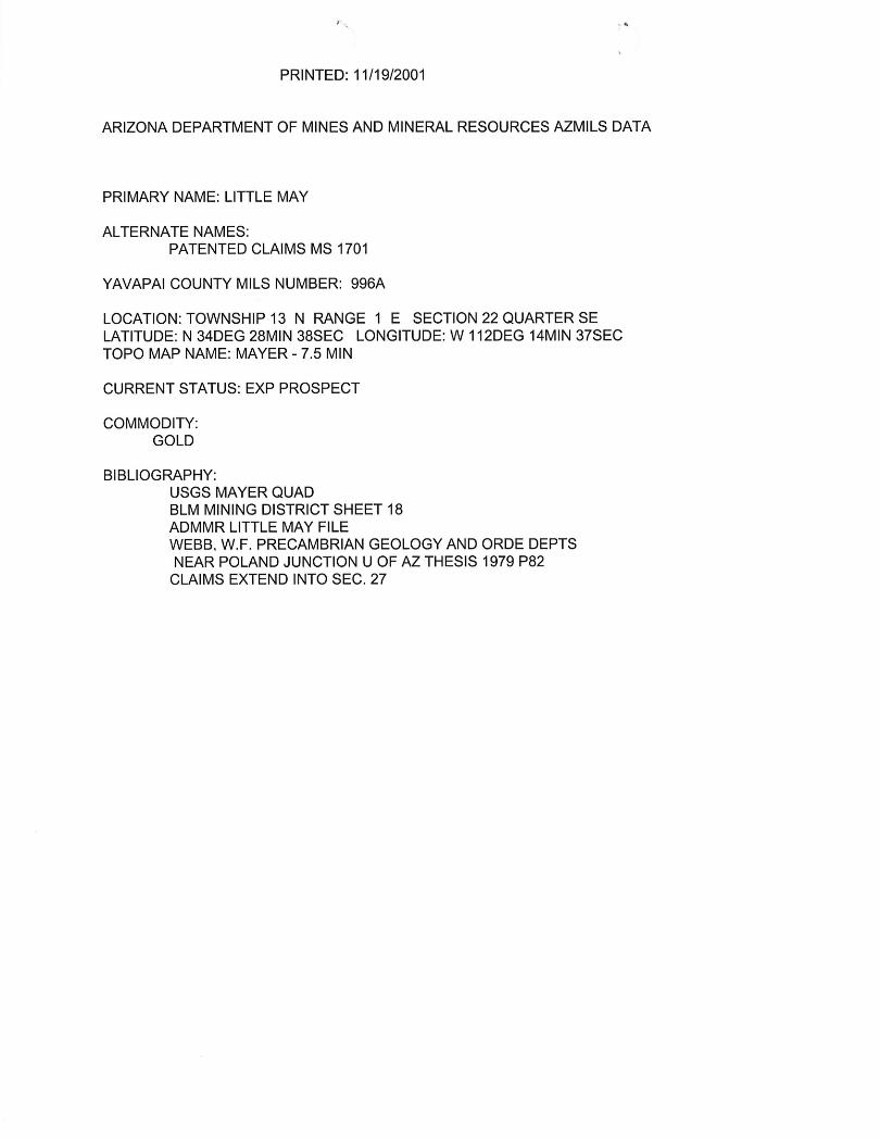
ARIZONA DEPARTMENT OF MINES AND MINERAL RESOURCES AZMILS DATA
PRIMARY NAME: LITTLE MAY
ALTERNATE NAMES: PATENTED CLAIMS MS 1701
YAVAPAI COUNTY MILS NUMBER: 996A
LOCATION: TOWNSHIP 13 N RANGE 1 E SECTION 22 QUARTER SE LATITUDE: N 34DEG 28MIN 38SEC LONGITUDE: W 112DEG 14MIN 37SEC TOPO MAP NAME: MAYER - 7.5 MIN
CURRENT STATUS: EXP PROSPECT
COMMODITY: GOLD
BIBLIOGRAPHY: USGS MAYER QUAD BLM MINING DISTRICT SHEET 18 ADMMR LITTLE MAY FILE WEBB. W.F. PRECAMBRIAN GEOLOGY AND ORDE DEPTS NEAR POLAND JUNCTION U OF AZ THESIS 1979 P82
CLAIMS EXTEND INTO SEC. 27
UNITED STATES DEPARTMENT OF THE INTERIOR
GEOLOGICAL SURVEY
COpy
MR. D. M. KEf1rRO - JIumboldt
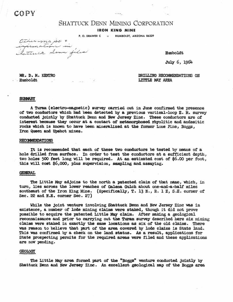
SHATTUCK DENN MINING CORPORATION IRON KING MINE
P. O. DRAWER C HUMBOLDT, ARIZONA 86329
Humboldt
Jul7 6; 1964
llRIUJ:NG RECOMMSlmATIONS em Ll'l'fLE MAY AREA
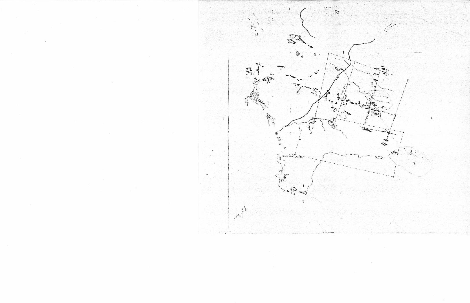
A Turam (electro-nas;netiC) survey carried out in June confirmed the presence ot two conductors which ba4 beendetaeted by a prev.l.oua v~1cal-loop B. M. survey eondueted Jointly .by Shattuck Denn and. !feW Jerse7 Zinc. 1'hese conduotors are of interest because the,. occur at a contact at metaaorpboaed %'hyoll tic ana ande$i tic rocks wbich 1s lmoVn to have been minere.l1zed at the tOi'mer Lone Pine, Boggs} Iron Queen ana Upshot mines.
It 18 recaumended that :eaeh of these two con4uctors be tested by means of a hole drilled from surface. In order to test the eonductortl at a sUfficient depth., two hole8 500 teet long Will be :required. At an eat1nated eost of $6.00 per toot, this Will coat $6,000, plus s~8ion, sampling and Usaying.
The Little May adjoins to the north a. patented claim of that ~, Wbieb j in turn, lies across the lower reaches of GelleDa Gulch about one-and .. -balf' miles Southeast of the Iron King Mine.. (Specifically, T. 13 N. JR. 1 E, S .. E. eorner of See. 22 and If.l. corner Sec. 27)
While the Joint venture involVing SbattuCk J)enn and New Jersey Zinc was in existence, a number of lode min1ng claimS were staked.. though it did not prove possible to acquire the patented Little May claim. After _king a _ologiea.l reconnaissance and prior to carrying out the ·Turam survey described here siX mining claims were sta.ke4 inexaet~ the same locations as six of the old cl.a.1ma. There was reason to believe tba;t part of . the areacovere4 by lode claims is State land.. This was confirmed. by a cheek on the land statue. As a result I applications tor state prospecting perm1 ts for the required areas were filed and these applications are now pending.
GEOLOOI
The Little Mr\Y area. toraed part ot the "Bossa" vent.ure conc1ucted JOintly 'by Sbattuck Denn and New JeratI!)f Zinc. An excellent geological uap of .the Boggs ' area
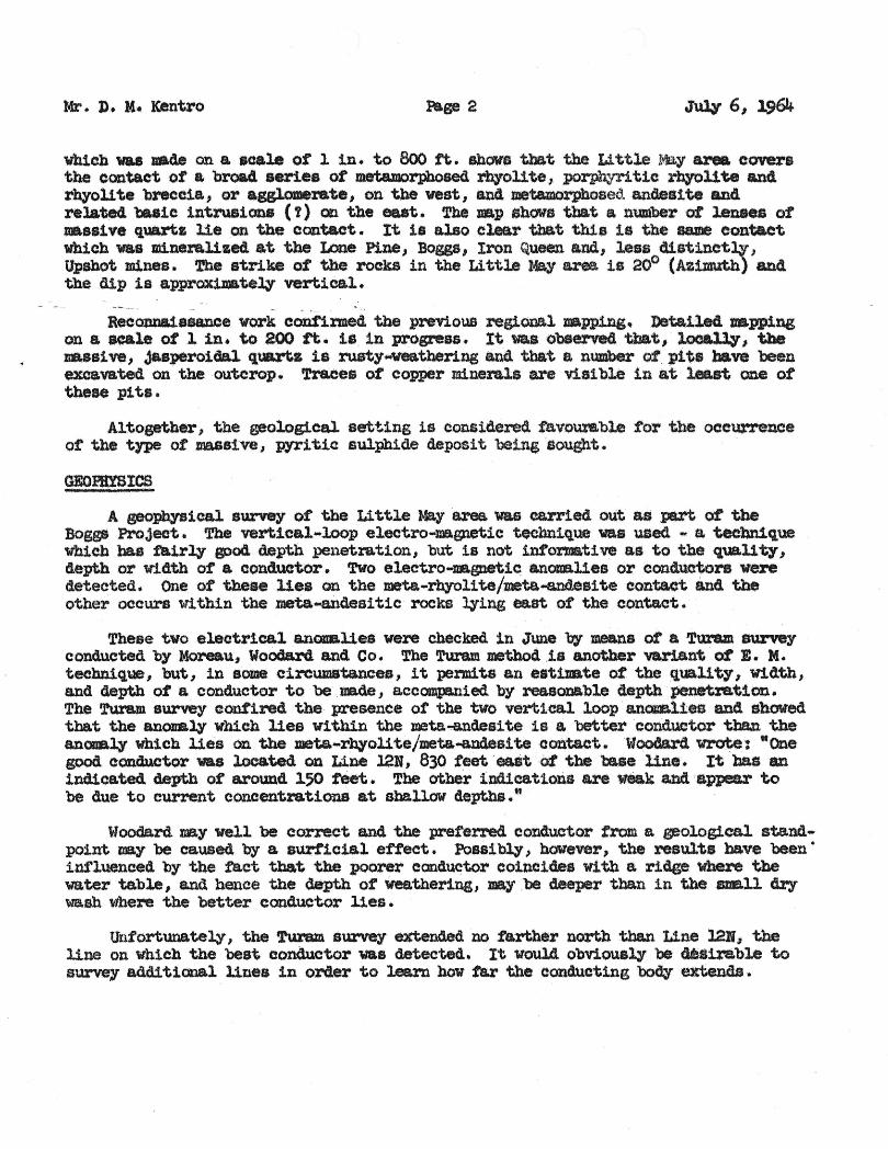
Mr. J). H. ICentro Page 2 Jul¥ 6, 1964
whiCh wu raade on a. scale o't 1 in. to 800 tt.. show. that the Li ttle ~ area. eovers the contact of a. brQa4 aeriee at metamorphosed rhyolite, porphyri tic rbfoll te and rbyoll te breccia, or agglomerate I on the vest I and metamorphosed. andes! te and related baslc intrusions (t) on the eaat. The.p .hows tbat fa number of l.enaes of _as1ve qw&rtz lie on the contact. It i& also clear that this 1s tnt: same contact Wh!. Ch .. was B11ner&lize4 at the Lone Pine, Bogs I Iron Queen and, lesa 41st1netl¥, Upshot mines. ~e str1ke at the rockS in the Little May area 18 20° (AI1muth) ana. the dip 1s approx1mate~ vertical.
- -- , .
RecQflD&1aaance work eont1rmed the previoUS regional Dapping.Detaile4 trapping on a acaleot 1 :Ln. to 200 ft. is in progress. It ... observed tbat, local')", the JJa8s1ve~ Ja8;pero1ial quartz is rusty-weathenng and that a number of pits have been excavated on the outcrop. TraCes ot copper minerals are visible in at least one of tbese pits.
Altogether I the geological setting is eonsiderecl. favourable tor tbe occ\Q,"rence ot the t1,Pe or masslve I pyri tiasulpb1de deposit being.ought. -
GEOPlYSICS
A geophy'sieaJ. survey of the Little May area. was carried out &$ pa:rt of the Boggs Project. The vertical-loop eleetro-magnetie technique was used ... a teehn1que wh1cbbas ftUrly good depth penetration, but is not informative as to tbe quality, depth or Width at a conductor. 'No eleetro-nagnetle anonaUes or cond.uctors were detected. One of theae -lies on themeta-rhyoli te/meta-&ldesi teconta.ctand the otber occurs Within the meta-andesi tie rocks :qing ee.atot the contact. -
These two electrical anonaUes were checked in June by means or a -Turam survey conducted by Moreau, Woodard and Co. The Tu.ram method. is another variant o:t E. M. tecbniqlJ2e, but, in 80M c1rcumstanaea, it permits anest1l¥ate of the quality, Width, and depth ot a conductor to be _made, a.ccompanied by realOlI&ble depthpenetrat1on. The TuramsurWy contiredthe presence ot the two vertical loop · an0ll8l.1es and allowed that the anoualy which lies within the meta-a.ndesite is a betterconduetor than the anaae.q which lies 00 . the meta-rh¥Ql1te/meta-andes.itecontact.~lC»Odard~:: -One good condwltor was located onLine 12K, 830 teet -eaSt ·o: tbe'ta.le ·line. It baa au 1ndicat.ed depth ot around 150 :teet. The other indications are W8&t.k ·and ;appea.r to be due to eurrent concentrations at aba.llow depths."
Woodard nay well be correct and tthe preferred.conduet,or trom a geological st.a.nd ... pOint _7 be caused by a surficial effect. Po88i~} baw'ever, thereaults have been· influenced by tbe fact tbat the poorer conductor coinCide. with a. ridge ·\«here the water table, and hence the depth ot weathering, _y ,be deeper than in the aua11 Cry wash Whe~ the better conduetor Ues.
Unfortunately I the Turam survey extended notartber north tha.n Line l2li I the line on which the beet conductor was detected. It vould obviously be 4e~U.rable to survey additional linea in order to learn how tar the conducting ~extends ..
Mr. )). M !Centro ~ 6,1964
'lbe nature of these two conductors should be tested by drilliDg_ Both should be 4r1l.le4, but t1rat priority ahoul4 be g1 Yen to the western anQl.ftq wlUeb coincides With the meta-rbyollte/meta...andeslte contact. The bet.ter conductor should also.-])e teste4" beCause Lt. eould represent a aulphi4e ~ in an a,na1oaous poI&ition V1 th respect to the_Jar U thological. contact as tbe ttpootvalJ." ore·bod1es at the tron KiDS Mine.
ce: Mr. W. J. La Horte File (2)
. :'< • . -~.
Humboldt
Oct. 28 I 1964
MR. C. R. SUNDEEN DRILLIBG RESUI:1'S - LmLE MAY AREA
Two diamond drill holes were eomplete4 in the Little lOy area. during october. As discussed in P. Gilmour'. report of Jul¥ 6; 1964, these holes were drilled to test tvo geophysical ancmalies in an area ot ta~ble .. looking rbyol1 tic rocks. The resulta ot tbi.s drilling were eaaentlal.l.y nega.t1 ve. and the project has been abandoned, at least for the present.
Both drill holes intersected substantial aeetlons of aertei tic -siliceous ... rbjol1 tic rocks ot the t,-pe in Which -.1 ve sulphide orebodies usually occur I but no significant mineralization was 8DCountere4. SiX intervals from each hole were selected tor assay to J&k.e certain that no go14 or silver values might go undetectedJ on~ traces of these elements were :round (OIIl8 sold assay showed 0.00 oZ./T). In LM #1 it was not possible to determine the source ot the geophySical response, though the oonduct! ve horizon was certainly teatea.. The anonaly tested by LM 1/2 was very probably ca.used by a narrow pyritic and pOsSibly graphitic horizon intersected in the general viCinity ot the conductor axis. The drill core from at #1 also contained an anaa10us amount ot magnetite, the significance of which 1s uncertain.
1M #1 was drilled to a depth ot 506 teet, and 1M #2 to 550 teet, a. total ot 1056 feet.
Due to the lack of any encouraglng indications in ' these two holes, the project bas ' been terminated. Because the state pZ'08pect1ng permits are valld until Aug-ust 19, 1966, Without further work or rental. requirements , abould any favorable targets become apparent in the meantime I the ground Will still be in our possession and available. Assessment work will be necessary to bold the three Little May federal mining cl$1ms it 1 t is thought advisable to do so.