158
Beaufort Regional Environmental Assessment (BREA) Data Mining Project March 31, 2011

Beaufort Regional Environmental Assessment (BREA)
Data Mining Project
March 31, 2011
Beaufort Sea Data Mining Project
Prepared for:
Beaufort Regional Environmental Assessment (BREA)
Prepared and Edited by:
Maxime Geoffroy and
Laurie Bisson Gauthier
ArcticNet Inc. Pavillon Alexandre-Vachon, Room 4081
1045, avenue de la Médecine, Laval University
Quebec City (Québec) G1V 0A6 [email protected]
March 31, 2011
Table of contents
Table of contents ..................................................................................................................... 1
List of Tables ........................................................................................................................... 2
List of Figures .......................................................................................................................... 2
List of Acronyms ..................................................................................................................... 4
Glossary ................................................................................................................................... 4
1. Background ....................................................................................................................... 18
2. Objectives........................................................................................................................... 18
3. Data sources ....................................................................................................................... 19
4. Environmental data mining in Beaufort Sea .................................................................. 20
4.1. Data mining summary and topical data gaps ............................................................... 20
4.1.1 Atmosphere ............................................................................................................. 20
4.1.2 Ice and physical oceanography ............................................................................... 21
4.1.3 Chemical oceanography ......................................................................................... 21
4.1.4 Primary production and microbiology .................................................................... 22
4.1.5 Zooplankton ............................................................................................................ 23
4.1.6 Marine fish .............................................................................................................. 23
4.1.7 Anadromous fish..................................................................................................... 24
4.1.8 Marine mammals .................................................................................................... 24
4.1.9 Noise in the environment ........................................................................................ 25
4.1.10 Marine and migratory birds .................................................................................. 25
4.1.11 Benthos ................................................................................................................. 25
4.1.12 Geology ................................................................................................................ 26
4.1.13 Coastal erosion and longshore sediment transport ............................................... 26
4.2. Science programs summary and geographical data gaps ............................................. 26
4.2.1 Canadian Arctic Shelf Exchange Study (CASES) ................................................. 28
4.2.2 Circumpolar Flaw Lead (CFL) system study ......................................................... 31
4.2.3 ArcticNet expeditions ............................................................................................ 33
4.2.4 IPY-GEOTRACES ................................................................................................. 38
4.2.5 MALINA ............................................................................................................... 38
ArcticNet - BREA data mining project 1

4.2.6 ARDEX ................................................................................................................. 40
4.2.7 Beaufort Gyre Exploration Project (BGEP) - JWACS and JOIS ........................... 40
4.3. Summary of the main data gaps ................................................................................... 41
5. Future updates .................................................................................................................. 45
6. References .......................................................................................................................... 45
7. Annex (Valued ecosystem components and indicators) ................................................ 49
List of Tables
Table 1. Deck operations that were carried out at sampling stations during Leg 4a of the Arcticnet 2009 expedition. Operations vary from one Leg to another following sampling requirements. ........................................................................................................................... 27
Table 2. Indicators and geographical areas identified as data gaps (X symbols). This table only summarizes the science programs detailed in section 2. A description of the criteria for the classification of an indicator as data gap can be found at section 4.1. .............................. 43
Table 3. Air quality metadata ................................................................................................ 50
Table 4. Weather metadata .................................................................................................... 54
Table 5. Snow and ice metadata ............................................................................................ 61
Table 6. Ocean circulation and water masses metadata ........................................................ 73
Table 7. Contaminants metadata ........................................................................................... 86
Table 8. Biochemical cycles metadata .................................................................................. 93
Table 9. Primary production and microbiology metadata ................................................... 106
Table 10. Zooplankton distribution and abundance metadata ............................................. 123
Table 11. Zooplankton trophic interactions and contaminant loads metadata .................... 127
Table 12. Marine fish distribution and abundance metadata .............................................. 129
Table 13. Marine fish trophic interactions and contaminant loads metadata ...................... 132
Table 14. Anadromous fish distribution and abundance metadata ..................................... 133
Table 15. Anadromous fish trophic interactions and contaminant loads metadata ............. 134
Table 16. Inuvialuit fishing activities (anadromous fish) metadata .................................... 135
ArcticNet - BREA data mining project 2

Table 17. Marine mammal distribution and abundance metadata ...................................... 136
Table 18. Marine mammal trophic interactions and contaminant loads metadata ............. 138
Table 19. Inuvialuit hunting activities (marine mammals) metadata .................................. 140
Table 20. Ambient marine noise conditions metadata ........................................................ 141
Table 21. Marine and migratory bird distribution and abundance metadata .......................142
Table 22. Marine and migratory bird trophic interaction and contaminant loads metadata 143
Table 23. Inuvialuit hunting activities (marine and migratory birds) metadata .................. 144
Table 24. Benthic fauna distribution and abundance metadata ........................................... 145
Table 25. Benthic fauna trophic interactions and contaminant loads metadata .................. 148
Table 26. Geotechnical seafloor characteristics metadata .................................................. 149
Table 27. Seafloor mapping metadata ................................................................................. 153
Table 28. Coastal erosion and longshore sediment transport metadata .............................. 154
List of Figures
Figure 1. Sampling locations and cruise track of the CCGS Pierre Radisson during CASES 2002. Blue circles (CA-01 to CA-08) indicate the location of CASES moorings deployed from the CCGS Sir Wilfrid Laurier. (Source: Fortier 2002)14 ................................................ 29
Figure 2. CASES study area with position of the moorings deployed from the CCGS Radisson in September 2002 and the sampling transects covered by the CCGS Amundsen in fall of 2003 and spring/summer of 2004. The overwintering position of the Amundsen in Franklin bay is indicated by the yellow star. (Source: Fortier and Barber 2008)31 ................ 30
Figure 3. CASES study area, bathymetry, and location of moorings and sampling stations (Source: Mucci et al. 2008)32 .................................................................................................. 31
Figure 4. a) Distributed open-water sample sites sampled in the fall of 2007 and the summer of 2008; b) drift stations and fast ice stations sampled in winter and spring of 2007-2008. (Source: Barber et al. 2010)33 ................................................................................................. 32
Figure 5. Mooring locations (CA-04, CA-05, CA-08 and CA16) during CFL 2007-2008. .. 33
Figure 6. Sampling stations in Beaufort Sea throughout ArcticNet 2005. ............................ 34
ArcticNet - BREA data mining project 3

Figure 7. Sampling locations and cruise track of the CCGS Amundsen in Beaufort Sea throughout ArcticNet 2006. .................................................................................................... 35
Figure 8. a) Map of offshore Exploration Licenses (EL) awarded to Imperial Oil and BP by the Department of Indian and Northern Affairs in 2007 and 2008; b) Map of the biogeochemical sampling grids covering EL446 (July 2009) and EL449 & EL451 (August 2010). (Source: Robert et al. 2010) 34 ..................................................................................... 36
Figure 9. Sampling stations in Beaufort Sea during Leg 4a of ArcticNet 2009. ................... 37
Figure 10. Sampling stations in Beaufort Sea during Leg 3 of ArcticNet 2010. ................... 37
Figure 11. Sampling locations and cruise track during IPY-GEOTRACES in 2009. ........... 38
Figure 12. Sampling locations and cruise track during MALINA in 2009. (Source: http://www.obs-vlfr.fr/Malina/about_us.html) ....................................................................... 39
Figure 13. Sampling locations during ARDEX 2004. Helicopter stations are in yellow and CCGS Nahidik stations are in red. (Source: www.cen.ulaval.ca) ........................................... 40
Figure 14. Sampling locations and cruise track during the JOIS-2008 expedition. (Source: Zimmerman et al. 2008)27 ....................................................................................................... 41
Figure 15. BREA's area of interest ....................................................................................... 42
List of Acronyms
ADCP ................................................................................... Acoustic Doppler Current Profiler AIM ......................................................................................................... Arctic Ice Monitoring AMSR-E ........................... Enhanced-resolution Advanced Microwave Scanning Radiometer ASTIS .................................................... Arctic Sciences and Technology Information System AVOS ............................................................................. Automatic Voluntary Observing Ship BGEP .................................................................................. Beaufort Gyre Exploration Project BGFE ............................................................................ Beaufort Gyre Freshwater Experiment BLMs ............................................. Boundary Layer Conductivity and Temperature Monitors BPDEs .................................................................................... PolybrominatedDiphenyl Ethers BPR .................................................................................................. Bottom Pressure Recorder BREA ............................................................... Beaufort Regional Environmental Assessment BrO ..................................................................................................................... Bromine oxide BSStRPA......................................................... Beaufort Sea Strategic Regional Plan of Action BTRs ........................................................................................ Bottom Temperature Recorders C3O ...................................................................................................... Canada’s Three Oceans CaCO3 .......................................................................................................... Calcium carbonate CARD-FISH ............ Catalyzed Reporter Deposition for Fluorescence In Situ Hybridization CASES ......................................................................... Canadian Arctic Shelf Exchange Study CCGS ............................................................................................ Canadian Coast Guard Ship CDOM................................................................................. Colored Dissolved Organic Matter
ArcticNet - BREA data mining project 4
CEOS ............................................................................. Centre for Earth Observation Science CFC ........................................................................................................... Chlorofluorocarbons CF-IRMS......................................................... Continuous Flow Ion Ratio Mass Spectrometry CFL ............................................................................... Circumpolar Flaw Lead System Study CGPS.............................................................. acquired-ContinuousGlobal Positioning System CH4 ............................................................................................................................... Methane CO .................................................................................................................. Carbon monoxide CO2 ..................................................................................................................... Carbon dioxide CSA .................................................................................................... Canadian Space Agency CTD................................................................................Conductivity, Temperature and Depth CVAAS ........................................................... Cold Vapour Atomic Absorption Spectroscopy DAPI ......................................................................................... 4', 6-diamidino-2-phenylindole DCHO .................................................................................................. Dissolved Carbohydrate DFAA ........................................................................................... Dissolved Free Amino Acids DFO..................................................................... Department of Fisheries and Oceans Canada DGM ............................................................................................. Dissolved Gaseous Mercury DIC ................................................................................................ Dissolved Inorganic Carbon DMHg ............................................................................................................ Dimethylmercury DMS ................................................................................................................. Dimethylsulfide DMSP ........................................................................................ Dimethylsulfonium propionate DNA ...................................................................................................... Deoxyribonucleic Acid DOC ................................................................................................. Dissolved Organic Carbon DOM ................................................................................................. Dissolved Organic Matter DON .............................................................................................. Dissolved Organic Nitrogen DW .......................................................................................................................... Dry Weight EEA ....................................................................................... Extracellular Enzymatic Activity EEM spectroscopy ................................................... Excitation Emission Matrix spectroscopy EFM ............................................................................................. Epifluorescence Microscopy EL ....................................................................................................... Exploration Licence area EPS .................................................................................................... Exopolymeric Substances ESA ................................................................................................... European Space Agency ESRF ............................................................................. Environmental Studies Research Fund ETS ................................................................................................... Electron Transfer System FCM ................................................................................................................. Flow Cytometry FDOM ........................................................................... Fluorescent Dissolved Organic Matter FNU................................. Fluorescence, Nomarski interference and Uthermöhl sedimentation GCAFS ........................................... Gas Chromatography Atomic Fluorescence Spectroscopy GEM .............................................................................................. Gaseous Elemental Mercury GHz ............................................................................................................................ Gigahertz GPR scan .................................................................................. Ground Penetrating Radar scan GPS ................................................................................................. Global Positioning System H2 ............................................................................................................................ Dihydrogen H2O ................................................................................................................................... Water HCH ..................................................................................................... Hexachlorocyclohexane HCL............................................................................................................... Hydrochloric acid Hg(p) ................................................................................................ Particulate–phase mercury
ArcticNet - BREA data mining project 5

HgCL2............................................................................................................ Mercuric chloride HgP ............................................................................................................ Particulate Mercury HPLC .................................................................... High-Performance Liquid Chromatography HyperOCR ................................................................ Hyperspectral Ocean Colour Radiometer ICPMS........................................................... Inductively Coupled Plasma Mass Spectrometry INRS ..................................................................... Institut National de Recherche Scientifique IORVL ............................................................................ Imperial Oil Resources Ventures Ltd IPS ................................................................................................................ Ice-Profiling Sonar IPY ....................................................................................................... International Polar Year IR................................................................................................................................... Infrared IRGA ....................................................................................................... Infrared Gas Analyzer IRIS .................................................................................. Internally Recording Imaging Sonar JOIS......................................................................................................... Joint Ocean Ice Study JWACS ............................................................................. Joint Western Arctic Climate Study LADCP .................................................................... Lower Acoustic Doppler Current Profiler LAWAS ........................................................................................................ Laser Wave Slope LGT ......................................................................................................... Lateral Gene Transfer LiDAR......................................................................................... Light Detection And Ranging LVP ...................................................................................................... Large Volume Pumping MeHg ............................................................................................................... Methyl mercury MERIS .................................................................. Medium-Resolution Imaging Spectrometer MMHg..................................................................................................... Mono-methylmercury MMP ................................................................. McLane Moored temperature-salinity Profiler MOBs .......................................................................................... Meteorological Ocean Buoys MODIS ....................................................... Moderate-Resolution Imaging Spectroradiometer MVP ...................................................................................................... Moving Vessel Profiler MY ......................................................................................................................... Multi-Year N2 .............................................................................................................................. Dinitrogen NH4 ......................................................................................................................... Ammonium NO2
-.................................................................................................................................. Nitrite NO3
-................................................................................................................................. Nitrate O3 ..................................................................................................................................... Ozone OASIS OOTI ...................................... Ocean Atmosphere Sea Ice Snowpack Out On The Ice O-buoy .................................................................................................................... Ocean-buoy OH- .................................................................................................................. Hydroxyl radical PAR .................................................................................. Photosynthetically Active Radiation PBDEs ..................................................................................... PolybrominatedDiphenyl Ethers PCBs ................................................................................................ Polychlorinated Biphenyls PCO2 .................................................................................. Partial Pressure of Carbon Dioxide PCR ................................................................................................ Polymerase Chain Reaction PCSP ...................................................................................... Polar Continental Shelf Program pEPS ................................................................ Particulate Extracellular Polymeric Substances PFAS ................................................................................ Perfluorinated Alkylated Substances PFOA ..................................................................................................... Perfluorooctanoic acid PFOS ........................................................................................... Perfluorooctane sulfonic acid PFPD ................................................................................. Pulsed Flame Photometric Detector
ArcticNet - BREA data mining project 6

pH ................................................................................................................ Hydrogen potential PIC ............................................................................................... Particulate Inorganic Carbon PIM ............................................................................................... Particulate Inorganic Matter PNF ......................................................................................... Profiler of Natural Fluorescence PO4
3- ........................................................................................................................... Phosphate POC ................................................................................................. Particulate Organic Carbon POM ................................................................................................. Particulate Organic Matter PON.............................................................................................. Particulate Organic Nitrogen POPs ............................................................................................. Persistent Organic Pollutants PRR ................................................................................ Profiling Reflectance and Radiometer PUF ............................................................................................................. Polyurethane Foam PUIFs ........................................................................... Potentially Unmanageable Ice Features Q-PCR ........................................................................ QuantitativePolymerase Chain Reaction RCM ..................................................................................................... Recorder Current Meter RGM ............................................................................................... Reactive Gaseous Mercury RNA ................................................................................................................ Ribonucleic acid ROV ............................................................................................... Remotely Operated Vehicle SAR .................................................................................................. Synthetic-Aperture Radar SBD ................................................................................................................. Short Burst Data SBR .................................................................................................. Surface Based Radiometer SCAMP .................................................. Self-Contained Autonomous Microstructure Profiler SeaWIFF ............................................................................ Sea-Viewing Wide-of-view Sensor Si(OH)4 ..................................................................................................................... Silicicacid Si .................................................................................................................................... Silicate SM-ADCP .................................................... Ship Mounted Acoustic Doppler Current Profiler SODAR sensor ............................................................... Sonic Detection And Ranging Sensor SOLAS ..................................................................... Surface Ocean-Lower Atmosphere Study SPAR................................................................... Surface Photosynthetically Active Radiation SPM............................................................................................. Suspended Particulate Matter SRP ............................................................................................. Soluble Reactive Phosphorus SWE .................................................................................................... Snow Water Equivalent TA ..................................................................................................................... Total Alkalinity TAlk .................................................................................................................. Total Alkalinity TAM .............................................................................................. Total Atmospheric Mercury TCO2 ........................................................................................................ Total Carbon dioxide THg ...................................................................................................................... Total mercury TOC......................................................................................................... Total Organic Carbon TON ...................................................................................................... Total Organic Nitrogen TSS ........................................................................................................ Total Suspended Solids ULS ....................................................................................................... Upward Looking Sonar UNCLOS......................................................... United Nations Convention on Law Of the Sea UQAR .................................................................................. Université du Québec à Rimouski UV ............................................................................................................................. Ultraviolet VPR ..................................................................................................... VideoPlankton Recorder XBT.......................................................................................... Expendable Bathythermograph XCP ................................................................................................ ExpendableCurrent Profiler
ArcticNet - BREA data mining project 7
XCTD ............................................ Expendable Conductivity, Temperature and Depth profiler
Glossary
Aerosol Suspension of very small airborne particles of a liquid or solid in a gas.
Albedo The ratio of the amount of radiation reflected from an object's surface compared to the amount that strikes it. The ratio varies according to the texture, color, and expanse of the object's surface and is reported in percentage.
Alkalinity A measure of a material's ability to neutralize acids, usually determined using titration.
Alkenone Long-chain (37-39 carbon atoms) di-, tri-, and tetraunsaturated methyl and ethyl ketone produced by certain phytoplankton (coccolithophorids), which biosynthetically control the degree of unsaturation (number of carbon-carbon double bonds) in response to water temperature.The survival of this temperature signal in marine sediment sequences provides a temporal record of sea surface temperatures that reflects past climate.
Amino acid One of 20 naturally-occurring hydrocarbon molecules that, in combination, form proteins in living organisms.
Amphipod An order of malacostracan crustaceans characterized by the absence of carapace and generally laterally compressed body.
Anadromous Pertaining to fish that spend a part of their life cycle in the sea and return to freshwater streams to spawn.
Anisakidae A family of intestinal roundworms.
Aphotic zone The zone of the water column in which most photosynthetic algae cannot survive due to light deficiency.
Aragonite A mineral identical in composition with calcite or carbonate of lime, but differing from it in its crystalline form.
Archaea Prokaryotic organisms evolutionarily distinct from bacteria; their gene expression (transcription and translation) is close to the eukaryotic pattern.
ArcticNet - BREA data mining project 8
Autotrophic An organism that produces complex organic compounds (such as carbohydrates, fats, and proteins) from simple inorganic molecules using energy from light (by photosynthesis) or inorganic chemical reactions (chemosynthesis).
Bacterioplankton The bacterial component of the plankton that drifts in the water column.
Bacterivory The ingestion of bacteria as energy supply.
Bathymetry Science of measuring water depth to determine ocean bottom topography.
Benthic Organism occurring at the surface or inside the seabed.
Benthos Group of organisms living at the surface or inside the seabed.
Biomarkers Substance used as an indicator of a biological state.
Biomass The total mass of all living organisms in a given habitat, expressed in terms of wet or dry weight per unit area.
Bioturbation The displacement and mixing of sediment particles (i.e. sediment reworking) and solutes by fauna or flora.
Centrifugation Separation process, which uses the action of centrifugal force to promote accelerated settling of particles in a solid-liquid mixture.
Chiral Characterized by nonsuperimposable mirror images.
Chitinase Digestive enzymes that break down glycosidic bonds in chitin.
Chloride A binary compound of chlorine with another element or radical.
Chlorophyll Any of a group of green pigments found in photosynthetic organisms.
Chromatography Method of separating mixtures and identifying their components.
Ciliate A protozoan with a microscopic appendage extending from the surface of the cell.
ArcticNet - BREA data mining project 9

Copepods Group of small crustaceans found in the sea and nearly every freshwater habitat. Most species are planktonic, but some species are benthic.
Coulometric titration A method of titration in which the titrating agent is produced in a solution by electrolysis and the required amount of the agent is determined by measuring the number of coulombs used when preparing it.
Cryosphere Component of the Earth System that contains water in its frozen state.
Densitometry Measure of the optical density of a substance by shining light on it and measuring its transmission.
Diatom Dominant planktonic algal form characterized by asiliceous test.
Dimethylsulfide A low molecular weight, organosulfur compound that is produced industrially, while also being commonly found in nature. Oceanic dimethyl sulfide is the dominant natural source for sulfur in the atmosphere.
Dinocyst A dormant zygotic stage in the life cycle of dinoflagellates.
Dinoflagellate Any member of a protozoan clade characterized by two flagella, one in the equatorial region of the body and other trailing; cells naked or with a test of cellulose plates.
Ecology The study of the relationships between living organisms and their environment.
Eddy In oceanic circulation, a circular movement of water usually formed between two adjacent currents flowing counter to each other, or along the edge of a permanent current.
Endobenthic Living within the sediment of the seabed.
Endosulfan An off-patent organochlorine insecticide and acaricide.
Epibenthic Living at the surface of the seabed.
Escherichia coli A bacterial species which inhabits the intestinal tract of man and other warm-blooded animals.
ArcticNet - BREA data mining project 10
Eukaryote A higher organism; its cells have a membrane-defined nucleus and other defined organelles.
Euphotic zone The superficial layer of the ocean within the range of effective light penetration (for photosynthesis).
Fatty acid Organic acid composed of a hydrocarbon chain of varying length; constituents of triglycerides and related lipids.
FIBOX Instrument that measures O2 depletion in time using sensors glued to the bottom of a 500ml Erlenmeyer.
Flow cytometry Means of measuring certain physical and chemical characteristics of cells or particles suspended in a fluid stream, passing them by a beam of laser light.
Fluorescence Emission of electromagnetic radiation as visible light.
Fluorimetry Use of a fluorometer to measure fluorescence.
Foraminifer Marine microorganism characterized by a calcareous shell with openings where pseudopods protrude.
Foraminifera Protozoan group, typically producing a calcareous test.
Geochemistry The study of materials and chemical reactions in rocks, minerals, magma, seawater, and soil.
Glucosidase Enzyme catalyzing the hydrolysis of the glycosidic linkage to release smaller sugars.
Gravimetry A class of analytical procedures, called gravimetric analysis relying upon weighing a sample of material.
Heterotrophic Deriving energy from externally produced organic compounds.
Holocene The current geologic epoch, which began after the Pleistocene, about 10,000 years ago, when the last ice age ended.
Ichthyoplankton The fish component of plankton, mainly composed of the egg and larval stages.
ArcticNet - BREA data mining project 11
Ikaite The mineral name for the hexahydrate of calcium carbonate, CaCO3·6H2O. It is only found in a metastable state, and decomposes rapidly once removed from near-freezing water.
Incubation Maintaining an organism at the most favorable temperature for its development.
Irradiance Emission of rays of light.
Isopod Group of terrestrial and aquatic crustaceans with seven pairs of legs adapted for crawling.
Isotope One of two or more atoms with the same number of protons in the nucleus, but a different number of neutrons and, therefore, a different mass.
Kinorhynchs Phylum of small marine pseudocoelomate invertebrates that are widespread in mud or sand at all depths as part of the meiofauna.
Leg The course and distance sailed by a ship on a single tack.
Leucine Essential amino acid obtained through proteins hydrolysis.
Lignin Complex polymer combining with cellulose to form the woody cell walls of plants.
Lugol Solution of elemental iodine and potassium iodide in water.
Mass spectrometry Analytical technique wherein ions are separated according to their ratio of charge to mass. From the mass spectrum produced, the atomic weight of the particle can be deduced.
Meiofauna Benthic organisms ranging from 0.1 to 0.5 mm in size.
Mesic Refers to environmental conditions characterized by intermediate moisture level as compared to wet conditions (Hydric) or dry conditions (Xeric).
Metazoan Organism comprised in the subkingdom Metazoa; all animals except protozoans and sponges.
Muktuk Inuit/Eskimo meal of frozen whale skin and blubber.
ArcticNet - BREA data mining project 12

Nano Prefix that divides a basic unit by one billion (10-9).
Nauplius (Pl. Nauplii) Crustacean larva characterized by three pairs of locomotive organs (corresponding to the antennules, antennae, and mandibles), a median eye, and little or no segmentation of the body.
Nematodes Un-segmented round worms, some of which are parasitic.
Nepheloid layer Layer of water in the deep ocean basin, above the ocean floor, that contains significant amounts of suspended sediment.
Organic contaminants Synthetic trace organics include pesticides and polychlorinated biphenyls (PCB's).
Organochlorine pesticide Insecticide composed primarily of carbon, hydrogen, and chlorine. They break down slowly and can remain in the environment long after application and in organisms long after exposure.
Organohalogen Organic compounds that contain at least one halogen (fluorine [F], chlorine [Cl], bromine [Br], or iodine [I]) bonded to carbon.
Orthophosphate A salt of phosphoric acid.
Orthosilicic acid Water-soluble form of silicon.
Otolith Calcified structures in the inner ear of vertebrates. As it grows in a daily increment pattern, it is used for age determination in fish.
Ozone A form of oxygen comprising 3 molecules, usually found in the stratosphere, and responsible for filtering out much of the sun's ultraviolet radiation.
Paleoceanography The study of the history of the oceans in the geologic past with regard to circulation, chemistry, biology, geology and patterns of sedimentation.
Paleoenvironment The past environment of an area during a given period of its history.
Paleomagnetism The study of the record of the Earth's magnetic field in rocks.
ArcticNet - BREA data mining project 13

Palynology The science that studies contemporary and fossil palynomorphs, including pollen, spores, orbicules, dinoflagellate cysts, acritarchs, chitinozoans and scolecodonts, together with Particulate Organic Matter (POM) and kerogen found in sedimentary rocks and sediments.
Pelagic Occurring in the upper water column of the open ocean.
Perfluorooctane sulfonic A man-made fluorosurfactant and global pollutant.
Phaeopigment Non-photosynthetic pigment being the degradation product of algal chlorophyll pigments. It is commonly formed during and after marine phytoplankton blooms.
Photobleaching Photochemical destruction of a fluorophore.
Photochemistry Branch of chemistry that studies chemical reactions resulting from the influence of light or radiation.
Photopigment Pigment undergoing a chemical change when absorbing light.
Phylotype Biological classification of an organism by its phylogenetic relationships to other organisms.
Phylum In taxonomy and systematics, the highest level of classification below the kingdom.
Phytoflash In situ Submersible Active Fluorometer that can be used to determine the quantum efficiency of phytoplankton in both oligotrophic and mesotrophic environments.
Phytoplankton Autotrophic component of plankton. Mainly comprised of microscopic algae drifting in the upper layers of the ocean.
Pico A prefix that divides a basic unit by one trillion (10-12).
Picoplankton The fraction of plankton composed by cells of radius measuring between 0.2 and 2 μm.
Plankton Minute floating forms of microscopic plants and animals in water which cannot get about to any extent under their own
ArcticNet - BREA data mining project 14

power. They form the important beginnings of food chains for larger animals.
Polychaete A class of annelid worms that are abundant and species-rich in the marine environment.
Polychlorinated biphenyls Chemicals characterized by varying numbers of chlorine atoms attached to two connected benzene rings.
Polynya A large body of open water or an area covered by very thin ice that persists for most of the winter in polar regions.
Polyurethane Polymer containing the urethane radical; a wide variety of synthetic forms are used as adhesives, plastics, paints and rubber.
Potentiometry An electroanalytical technique based on the measurement of the electromotive force of an electrochemical cell comprised of a measuring and a reference electrode.
Prokaryote Cellular microorganism in which chromosomes are not isolated from the cytoplasm by a membrane (nucleus-free cells).
Protease Enzyme that speeds the breakdown of proteins into amino acids.
Protist A member of the paraphyletic kingdom Protista, generally considered to include the protozoan groups and eukaryotic algae.
Pteropod Term applied to what is now considered as two separate taxonomic groups of specialized free-swimming pelagic sea snails and sea slugs, marine opisthobranch gastropods.
Radioisotopic Pertaining to radioactive isotopes
Radiometry Measurement of the strength of radiant energy using a radiometer.
Redox Shortened term for reduction/oxidation reactions. Redox are a cascade of reactions in which an electron transfer takes place.
Ribosomal Pertaining to the ribosome, the cell organelle responsible for manufacturing proteins.
ArcticNet - BREA data mining project 15
Salmonella A bacterium that may cause intestinal infection and diarrhea.
Silicate Salts derived from silica or silicic acids.
Solitons Quantum generated in the way of a solitary wave that travels without losing energy.
Spectrophotometry The determination of the structure or quantity of substances by measuring their capacity to absorb light of various wavelengths.
Spectroscopy Analysis of the interaction between electromagnetic radiation and matter. Different types of radiation interact in characteristic ways with different samples of matter; the interaction is often unique and serves as a diagnostic and fingerprint for the presence of a particular material in a sample.
Stamukhi lake Lake occurring throughout winter, spring, and early summer near large river inflows along the Arctic coastline, and are the result of freshwater retention behind the thick barrier of rubble ice (stamukhi) that forms at the outer limit of land-fast sea ice.
Streamflow The water discharge of a natural channel.
Sulfur dioxide A pungent, colorless, gas formed primarily by the combustion of fossil fuels; becomes a pollutant at high concentration.
Synechococcus A unicellular cyanobacterium, widespread in the marine environment.
Thermocouple A thermometer consisting of two wires of different metals that are joined at both ends; one junction is at the temperature to be measured and the other is held at a fixed lower temperature; the current generated in the circuit is proportional to the temperature difference.
Thymidine A nucleoside component of DNA composed of thymine and deoxyribose.
Toxoplasma Type of parasitic microorganism infecting vertebrates.
Transmittance Fraction of energy passing through a body without being absorbed.
ArcticNet - BREA data mining project 16
Trichinella Genus of parasitic roundworms of the phylum Nematoda that cause trichinosis.
Trophic Pertaining to food or nutrition.
Tropospheric Pertaining to the lowest layer of the atmosphere in which weather phenomena occur.
Tundra A type of treeless ecosystem dominated by lichens, mosses, grasses, and woody plants. Tundra is found at high latitudes (arctic tundra) and high altitudes (alpine tundra). Arctic tundra is underlain by permafrost and is usually water saturated.
Turbellarian Free-living aquatic ciliate flatworm of the class Turbellaria
Turbidity Muddiness created by stirring up sediment, or having foreign particles suspended.
Zooplankton The animal component of plankton, which consists mainly of small crustaceans.
.
ArcticNet - BREA data mining project 17

1. Background
The Beaufort Regional Environmental Assessment (BREA) is an initiative to address oil and gas related issues in Beaufort Sea from a regional approach. The proposal was initiated and supported by stakeholders from the Inuvialuit Settlement Region, territorial and federal governments, and industry. It is a response to recommendations from the Beaufort Sea Strategic Regional Plan of Action (BSStRPA, 2008).
As environmental studies and planning for offshore exploration and production evolve, BREA will complement the existing work being conducted by the private sector in a regional perspective. It will assist in preparing all parties, including the federal government, to respond to new investments in oil and gas in previously unexplored areas of Beaufort Sea. The scientific information generated through BREA will allow more appropriate environmental assessments and regulatory processes for industry and regulators.
A necessary step to determine research priorities for future work to be undertaken through BREA is to review data collected during previous research programs and to identify environmental data gaps. In 2008, the Environmental Studies Research Fund (ESRF) conducted a data mining project with the objective to report data gaps relevant to the regulatory review, assessment and management of effects associated with offshore oil and gas exploration and development in the Canadian Beaufort Sea1. However, the scope of this study was mainly on technical reports and environmental assessments from industry and governmental agencies and did not cover academic-led science programs.
2. Objectives
Over the past decade, significant investments have been made through academic-led programs to research the Beaufort Sea environment. The objective of this report is to review and document the data collected in Beaufort Sea through these academic-led initiatives, mainly in the south Canadian Beaufort Sea-Mackenzie Shelf-Amundsen Gulf region, through the following research programs:
1. ArcticNet 2010 expedition including sampling conducted in and around EL446 and EL449 in collaboration with BP.
2. ArcticNet 2009 expedition including sampling conducted in and around EL446 and EL449 in collaboration with IORVL.
3. GEOTRACES and MALINA 2009 expeditions conducted in collaboration with ArcticNet as a contribution to the International Polar Year (IPY).
4. The Circumpolar Flaw Lead (CFL) System Study overwintering megaprogram conducted during the International Polar Year (IPY) in 2007-2008.
5. ArcticNet expeditions in 2005 and 2006.
ArcticNet - BREA data mining project 18

6. The Canadian Arctic Shelf Exchange Study (CASES) sampling program expedition conducted from 2002-2004 and including an overwintering expedition in 2003-2004.
A secondary objective of the report is to update the data collection efforts of other non-academic-led oceanographic programs in Beaufort Sea area over the last few years. In this report, the following program is documented:
7. The Beaufort Gyre Exploration Project (BGEP), based on the Joint Ocean Ice Study (JOIS, 2005-2010) and the Joint Western Arctic Climate Study (JWACS, 2003-2004).
This review provides BREA stakeholders with information as to what has been collected where (metadata), as well as indication of the environmental data gaps (topical and geographical) for Beaufort Sea.
3. Data sources
The following sources were scrutinized to record all relevant metadata:
1. The Polar Data Catalogue (307 metadata sets from the Beaufort Sea area and ~700 Radarsat images).2
2. All ArcticNet's annual reports, mission plans and cruise reports (which include reports of MALINA and GEOTRACES missions).3, 4
3. CFL's cruise reports.5-12 4. CASES' cruise reports.13-21 5. Some ArcticNet affiliated scientists in charge of studies related to valued ecosystem
components in Beaufort Sea were contacted to ensure that all past and recent studies are included.
6. BGEP's cruise reports.22-29
ArcticNet - BREA data mining project 19

4. Environmental data mining in Beaufort Sea
4.1. Data mining summary and topical data gaps
Based on the tables in annex (section 7), this section summarises all data collected throughout the science programs detailed in the objectives (section 2). In this report, research topics (hereafter referred to as “indicatorsˮ) were identified as data gaps if, during these science programs, 1) they were not or rarely studied compared to other indicators, and/or 2) sampling was limited to specific locations rather than covering a large area, and/or 3) sampling was restricted to a short period of time compared to sampling for other indicators. As physical, biological and geochemical processes constantly vary and as few are fully understood, all components and indicators would benefit from additional sampling effort. However, sampling related to topics identified as data gaps was scarce compared to other indicators.
4.1.1 Atmosphere Summary. Air quality and meteorological data were continuously recorded throughout CASES, CFL and ArcticNet missions. Sensors located on top of the CCGS Amundsen bridge recorded atmospheric CO2 and H2O concentrations while others located on a tower at the ship’s bow monitored winds, precipitations, temperature and irradiance. Meteorological data were collected by the team of Tim N. Papakyriakou (University of Manitoba). Cloud cover concentration and ceiling were also recorded by an all-sky camera and a ceilometer. Radiometer-equipped weather balloons were regularly launched and transmitted wind, temperature and humidity profiles. Metocean buoys were also deployed at the ocean-atmosphere or ice-atmosphere interface to record meteorological data near the surface. During CFL, the OASIS project focussed on atmospheric turbulences. Gary Stern's team (DFO Winnipeg) regularly collected air samples to measure ozone and contaminant concentrations (e.g. mercury, pesticides, organic contaminants), and ice-atmosphere buoys were deployed at different locations to monitor CO2 and ozone concentrations as part of JWACS and JOIS expeditions. During CFL, the SOLAS project focussed on the atmospheric concentration of DMS and other aerosols. Throughout all expeditions, meteorological data were continuously recorded by an Automatic Voluntary Observing Ship (AVOS) system installed on all Canadian Coast Guard icebreakers. Two satellites, ENVISAT and MODIS, also recorded irradiance, aerosol concentrations and cloud imagery since 2002. Data gaps. Several atmospheric variables were collected during all oceanographic expeditions documented in this report. However, atmospheric contaminant concentrations were not measured during JWACS and JOIS expeditions in the Deep Canada Basin. The
ArcticNet - BREA data mining project 20
studies documented in this report were mostly field-based and no data resulting from modeling of the atmospheric conditions were reported. 4.1.2 Ice and physical oceanography Summary. Ice and physical oceanography were priorities of CFL, CASES, ArcticNet, JWACS and JOIS missions. Several instruments were moored since 2002, mainly to record bottom ice depth and roughness, currents and water masses characteristics (e.g. salinity and temperature). Yves Gratton's team (INRS) deployed a CTD-rosette equipped with probes and sensors (oxygen, pH, fluorescence, nitrates and irradiance) at most station sampled along the cruise track of the CCGS Amundsen and a Moving Vessel Profiler (MVP) regularly measured on-track temperature and salinity profiles. The ship-mounted ADCP and thermosalinograph continuously measured currents and surface layer properties during all expeditions mentioned above. Turbulence in the water column was measured during CFL and JOIS 2009 expeditions. Snow and ice samples were collected on a regular basis by David G. Barber's team (University of Manitoba). Ice thickness and roughness, wave characteristics, surface temperature and ice/ocean surface microwave emissions were also monitored. Ice buoys and GPS beacons were regularly deployed to track ice motion during several months. Aerial ice surveys were occasionally conducted, and satellites (RADARSAT, MOBIS, ENVISAT) continuously monitored the ice and snow cover during the past decade. Data gaps. Knowledge on extreme and Potentially Unmanageable Ice Features (PUIFs) composed of old multiyear ice was identified as high priority for the construction of off-shore oil platforms. However, such features were not studied throughout the science programs detailed in section 2. Moreover, academic-led programs focussing on snow and ice characteristics were mostly conducted in southeastern Beaufort Sea and characteristics in the Deep Canada Basin are not as documented, especially during winter. Finally, ice and physical oceanography studies documented in the annex (section 7) were mostly field-based or remote sensing observational studies and no data from modeling studies were reported. 4.1.3 Chemical oceanography Summary. The concentration of contaminants (e.g. mercury, pesticides, organic contaminants) in sediments, water, air and living organisms (mainly zooplankton and fish larvae) was measured during ArcticNet, CFL and CASES expeditions (Gary Stern's team). Contaminant concentrations in snow and sea ice were also measured during CASES and CFL programs. Water samples were collected during GEOTRACES 2009 for estimating concentrations of trace-metals and of isotopes of various elements (e.g. Ra, Th, Pa, I, Si, Cr).
ArcticNet - BREA data mining project 21
Large-scale efforts have also been conducted to quantify water and atmospheric CO2 and CO concentrations and to describe the carbon cycle. Since 2002, an extensive program using long-term moored sediment traps was developed by Louis Fortier's team (Université Laval) to measure vertical particle fluxes. Sinking export of organic material was also measured from free-drifting sediment traps by Christine Michel's team (DFO Winnipeg). Oxygen, DMS and DMSP concentrations in the atmosphere and water were regularly measured throughout all missions documented in this report, with greater sampling efforts during the Arctic SOLAS program in 2009. Nutrient concentration profiles were determined on selected transects during CASES, CFL and ArcticNet surveys by Jean-Éric Tremblay's team (Université Laval). Finally, total gas concentration in ice was measured throughout the CFL expedition. Data gaps. Even if contaminant concentrations in sediments, water and atmosphere were regularly measured, little information is available from JWACS and JOIS expeditions in the Deep Canada Basin. Moreover, throughout the science programs detailed in section 2, studies on contaminant concentrations in fish were limited to larval and juvenile stages, and concentrations in marine mammals were only resolved for ringed seals and belugas near specific Inuit communities (mainly Ulukhaktok and Tuktoyaktuk). 4.1.4 Primary production and microbiology Summary. Understanding the dynamics of phytoplankton was highly prioritized throughout CASES, CFL, ArcticNet, JWACS and JOIS expeditions, particularly near marginal ice zones. Chlorophyll a and phaeopigment concentration profiles, along with turbidity data, were regularly measured from rosette sampling and from CTD sensors. Michel Gosselin's team (UQAR) determined the evolution of phytoplankton biomass and diversity on several transects in southeastern Beaufort Sea. In the same area, Christine Michel's team used free-drifting sediments traps to study primary production, Connie Lovejoy's team (Université Laval) studied microbial diversity and Jody Deming's team (University of Washington) documented viral abundance and diversity. Finally, PAR intensity was measured during all programs mentioned above using a probe on the CTD-rosette. Sea ice algae diversity and abundance, as well as chlorophyll a concentration in sea ice, were also measured, mainly during CASES, CFL, JWACS and JOIS expeditions. Sediment samples were regularly collected and analyzed for diatom markers, which are used as indicators of past primary production. During the MALINA expedition in 2009, several primary production indicators were measured and compared with remotely-sensed data (e.g. data from the SeaWIFS satellite). Data gaps. Primary production studies mostly focussed on phytoplankton biomass and diversity. Sampling of ice algae and water during the spring phytoplankton bloom, a crucial
ArcticNet - BREA data mining project 22
period for primary production in Beaufort Sea, was limited to specific locations in Amundsen Gulf and Franklin Bay during CASES and CFL programs. Lab-based incubation studies were scarce during the science programs documented in this report and no data from primary production modeling studies were reported. 4.1.5 Zooplankton Summary. Diversity, abundance, as well as vertical and horizontal distribution of zooplankton, were studied throughout ArcticNet, CASES and CFL programs (Louis Fortier's team). Since 2007, experiments and incubations were conducted to evaluate copepods egg production and respiration rates from samples collected in Amundsen Gulf. A Video Plankton Recorder (VPR) camera was used throughout CASES and MALINA programs to estimate diversity and abundance of zooplankton. Contaminant concentrations and stable isotope ratios in the zooplankton assemblage of southeastern Beaufort Sea were regularly measured (Gary Stern's team). Zooplankton samples were also collected during JWACS and JOIS missions for taxonomy, DNA analysis and biomass measurements. Data gaps. Knowledge about zooplankton contaminant concentrations and trophic interactions (based on stable isotope ratios) is limited in the Deep Canada Basin. Throughout the science programs documented in this report, respiration rates studies based on incubation experiments were restricted to samples collected in Amundsen Gulf. No modeling study related to zooplankton, or to the Beaufort Sea marine ecosystem in general, was reported. 4.1.6 Marine fish Summary. Existing data on marine fish mainly concern the larval and juvenile stages of the Arctic cod (Boreogadus saida) from southeastern Beaufort Sea. Sampling of the adult stage of Arctic cod was limited to a very specific area of Amundsen Gulf (Franklin Bay) during the CASES program and to opportunistic catches when deploying a multi-net sampler during CFL. An echosounder operated onboard the CCGS Amundsen continuously recorded fish echoes throughout CASES, CFL and ArcticNet expeditions. The resulting echograms were used to document the distribution of the adult stage, but in situ sampling for echo validation was only performed during CASES. Contaminant concentration and stable isotope ratios were also measured in the larval and juveniles stages collected in southeastern Beaufort Sea (Gary Stern's team). Data gaps. Knowledge about the distribution and ecology of adult marine fish in Beaufort Sea is scarce. Hydroacoustics data allowed documenting winter abundance and distribution of Arctic cod in Amundsen Gulf. However, no fish aggregation was detected the rest of the year, possibly due to a coastal and surface-related distribution. Moreover, echo validation was limited to the fish collected during CASES. Other recent US-led studies monitored the distribution of fish on the Alaskan Shelf and Slope (not detailed in this report), but basic
ArcticNet - BREA data mining project 23
biological data and distribution of adult populations of marine fish represent major gaps in the area. Information on contaminant concentrations in the adult stage and modeling-based studies is non-existent for the science programs documented in this report. Finally, no data on Inuvialuit marine fishing activities in coastal areas were reported. 4.1.7 Anadromous fish Summary. No academic-led study documenting the abundance or behaviour of anadromous fish in Beaufort Sea was conducted during the science programs detailed in section 2. However, DFO-led studies focussed on the effects of climate changes on Char collected in lakes (James Reist's team) and on mercury concentration in estuarine fish (Gary Stern's team). A previous data gaps analysis report1 also mentioned DFO-led studies on anadromous fish of the Mackenzie Delta. Data gaps. Data on anadromous fish distribution and migrations in Beaufort Sea are scarce compared to other indicators. Throughout the science programs detailed in this report, only one study documenting contaminant concentration was conducted and none analyzed stable isotopes ratios for trophic interactions. A single study was related to Inuvialuit fishing of anadromous fish and no modeling-based study was reported. 4.1.8 Marine mammals Summary. The distribution of marine mammals was monitored through long-term moored hydrophones that were deployed since 2005 by Yvan Simard's team (DFO Mont-Joli). In collaboration with Cornell University, hydrophones were also moored by ArcticNet in and around Exploration License areas (EL) 446, 449 and 451 during the 2008 and 2009 field seasons. Inuit wildlife observers were employed onboard the CGGS Amundsen to record encounters with marine mammals. Remote sensing studies and aerial surveys documenting distribution of belugas, bowhead whales and ringed seals were conducted. Finally, contaminant concentrations in belugas and ringed seals, as well as the general health situation of marine wildlife, were occasionally monitored. Only three studies documenting marine mammals harvested during Inuvialuit hunting activities in Beaufort Sea were conducted during the programs detailed in this report. Data gaps. Throughout the science programs previously mentioned, observations of marine mammal abundance were generally opportunistic rather than based on a rigorous survey. Programs documenting contaminant concentrations in marine mammals were limited to ringed seals and belugas near specific communities (mainly Ulukhaktok and Tuktoyaktuk). No study analyzing stable isotopes ratios for trophic interactions was reported and biological data were rarely collected. Information on Inuivialuit marine mammals hunting activities is also identified as a data gap due to community-based studies scarcity compared to other indicators.
ArcticNet - BREA data mining project 24

4.1.9 Noise in the environment Summary. Monitoring of ambient marine noise was limited to the hydrophones moored in southeastern Beaufort Sea (Yvan Simard's team), Deep Canada Basin and western Beaufort Sea (JWACS and JOIS programs). No study of ambient atmospheric noise was conducted throughout the science programs documented in this report. Data gaps. Apart from the moorings deployed in and around EL 446, 449 and 451 during the 2009 and 2010 field seasons, hydrophones were generally installed on mooring lines principally dedicated to physical oceanography. Consequently, no hydrophone arrays were deployed to systematically record environmental noise and vocalizations of marine mammals. As no study of ambient atmospheric noise was conducted throughout the science programs detailed in section 2, this indicator is considered as a data gap in Beaufort Sea. 4.1.10 Marine and migratory birds Summary. Knowledge about the abundance and distribution of marine and migratory birds is mostly limited to opportunistic encounters recorded by Inuit wildlife observers onboard the CCGS Amundsen. Other studies specifically focussed on breeding activities on Herschel Island, on the abundance and diversity around the Queen Elizabeth Islands, and on the Cape Parry murre colony. The health condition of King Eiders collected near Ulukhaktok was also monitored. Data gaps. As studies on birds were limited to specific populations or to opportunistic encounters during the science programs documented in this report, distribution and abundance of marine and migratory birds are considered as data gaps. Also, no study analyzing stable isotopes ratios to identify trophic interactions of birds was reported. Data related to Inuvialuit marine and migratory birds hunting were limited to two studies documenting health conditions of harvested animals. 4.1.11 Benthos Summary. The abundance and diversity of epibenthic and endobenthic fauna were regularly monitored by Alec Aitken's team (University of Saskatchewan) during CASES and by Philippe Archambault's team (UQAR) since 2007, using an Agassiz trawl and a box corer. Nutrient and chlorophyll a concentrations, bioturbation and biomarkers in the sediments were also measured since 2007. Throughout CASES, a bottom triggered camera was regularly deployed to study benthic diversity. During ArcticNet 2009 and 2010 expeditions, a camera-equipped Remotely Operated Vehicle (ROV) recorded videos of the sea bottom on specific transects. Finally, benthic community was sampled to measure contaminant concentrations throughout CASES, CFL and ArcticNet programs. (Gary Stern's team).
ArcticNet - BREA data mining project 25
Data gaps. The benthic community of the Deep Canada Basin was not documented during JWACS and JOIS programs. Studies analyzing stable isotopes ratios to identify trophic interactions in the benthic community were scarce throughout the science programs detailed in section 2. No model of the benthic community was developed. 4.1.12 Geology Summary. Bottom mapping and geological surveys were highly prioritized since 2002. The Geological Survey of Canada (Steve Blasco's team) conducted piston and box core transects for biochemistry analysis and paleoceanography on the Shelf and Slope of southeastern Beaufort Sea throughout CASES, CFL and ArcticNet programs. Sub-bottom mapping transects were conducted by the Ocean Mapping Group at the University of New-Brunswick (John E. Hughes Clarke's team) since 2004. A multibeam echosounder was concurrently operated to map the seafloor. Finally, images from the camera mounted on the ROV were used to document special features of the seafloor (e.g. mud volcanoes). Data gaps. Large-scale efforts were conducted to map and document the geotechnical characteristics of the seafloor during the science programs documented in this report, especially in Amundsen Gulf and on the Mackenzie Shelf and Slope. However, due to the CCGS Amundsen's draft, bottom and sub-bottom mapping of the coastal areas was limited to one survey onboard the Heron launch in 2006. Extensive mapping surveys of the Deep Canada Basin were conducted onboard the CCGS Louis St-Laurent and USCGC Healy throughout the United Nations Convention on Law of the Sea (UNCLOS) program (not detailed in this report). 4.1.13 Coastal erosion and longshore sediment transport Summary. Monitoring of coastal erosion and water level variations was limited to very specific areas (Herschel Island and Inuit communities) during the science programs detailed in this report. Bottom mapping of the coastal seafloor was conducted nearby Sachs Harbour onboard the Heron launch in 2006. GPS stations also monitored vertical motion of the coast and the ENVISAT satellite provided remotely-sensed images of coastal erosion. Data gaps. Throughout the science programs detailed in section 2, studies of coastal erosion and longshore sediment transport were limited to specific locations. Coastal bottom mapping data are also very limited compared to other indicators. These indicators are thus identified as data gaps. Finally, modeling of the coastal erosion was not conducted through these programs. 4.2. Science programs summary and geographical data gaps
Most of the existing data were collected in Amundsen Gulf and on the Mackenzie Shelf and Slope areas during CASES, CFL and ArcticNet expeditions. During these programs,
ArcticNet - BREA data mining project 26
oceanographic stations were defined according to the sampling activities that were conducted (e.g. full, basic, nutrients, mooring or CTD station). An example is provided in table 1.
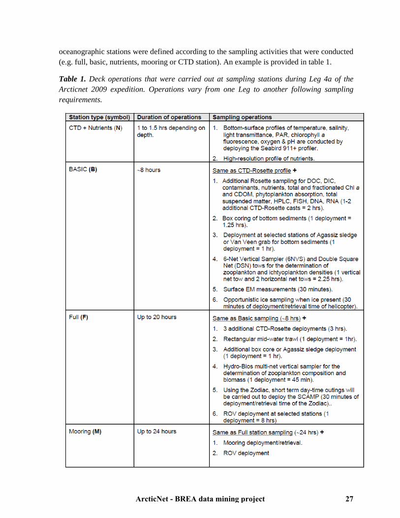
Table 1. Deck operations that were carried out at sampling stations during Leg 4a of the Arcticnet 2009 expedition. Operations vary from one Leg to another following sampling requirements.
ArcticNet - BREA data mining project 27

Data were also collected during JWACS and JOIS expeditions (regrouped as the ''Beaufort Gyre Exploration Project'', BGEP), which focussed on the Deep Canada Basin and western Beaufort Sea. However, several indicators were not studied trough JWACS and JOIS expeditions and are consequently considered as data gaps in the Deep Canada Basin. Winter data are limited to CASES and CFL overwintering surveys, respectively conducted in Franklin Bay and Amundsen Gulf. Finally, three programs (GEOTRACES, MALINA and ARDEX) focussed on distinct indicators in specific areas. This section summarises the principal expeditions reported in this report.
4.2.1 Canadian Arctic Shelf Exchange Study (CASES) (http://www.cases.Québec-ocean.ulaval.ca/welcome_fr.asp) The CASES expedition was an international effort under Canadian leadership to understand the biogeochemical and ecological consequences of sea ice variability and changes on the eastern Beaufort Sea Shelf. In preparation for this overwintering program conducted in 2003-2004, two expeditions were conducted in fall of 2002. During the first expedition, eight lines supporting current meters and sediment traps were moored in the study area as part of the September 6 to September 24 expedition of the CCGS Sir Wilfrid Laurier. From September 22 to October 14, the second expedition completed a multidisciplinary synoptic survey of the physical and biogeochemical properties of the study area onboard the CCGS Pierre Radisson. During these 22 days, 34 scientists sampled over 110 stations covering the Mackenzie Shelf and Amundsen Gulf area (Fig. 1).30
ArcticNet - BREA data mining project 28

Figure 1. Sampling locations and cruise track of the CCGS Pierre Radisson during CASES 2002. Blue circles (CA-01 to CA-08) indicate the location of CASES moorings deployed from the CCGS Sir Wilfrid Laurier. (Source: Fortier 2002)14
The main thrust of the field program was the one-year (September 24, 2003 to September 09, 2004) survey of the CCGS Amundsen in Beaufort Sea. This arctic mission of unprecedented scope comprised three major parts: 1) a fall survey covering Amundsen Gulf and the Mackenzie Shelf and Slope (Fig. 2 and 3) from September to December 2003, including the recovery of the eight moorings deployed in 2002 and the deployment of 17 new mooring arrays; 2) overwintering (December 12, 2003 to June 1, 2004) of the ship in Franklin Bay for the monitoring of winter evolution of the ecosystem; and 3) spring/summer spatial survey of the region to monitor the Stamukhi Lake break-up, the opening of the Cape Bathurst Polynya and the development of the summer ecosystem, including the recovery and redeployment in August 2004 of 7 of the 17 oceanographic moorings. The annual mission of the CCCGS Sir Wilfrid Laurier to the study area was the opportunity to recover the remaining 10 moorings and to extend the sampling of the ecosystem until September 9, 2004. Overall, the CASES field program logged 543 days at sea, 377 of these days being directly chartered by CASES and 166 being contributed by national and international partners. This
ArcticNet - BREA data mining project 29
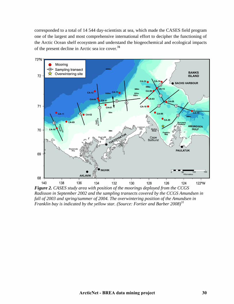
corresponded to a total of 14 544 day-scientists at sea, which made the CASES field program one of the largest and most comprehensive international effort to decipher the functioning of the Arctic Ocean shelf ecosystem and understand the biogeochemical and ecological impacts of the present decline in Arctic sea ice cover.31
Figure 2. CASES study area with position of the moorings deployed from the CCGS Radisson in September 2002 and the sampling transects covered by the CCGS Amundsen in fall of 2003 and spring/summer of 2004. The overwintering position of the Amundsen in Franklin bay is indicated by the yellow star. (Source: Fortier and Barber 2008)31
ArcticNet - BREA data mining project 30
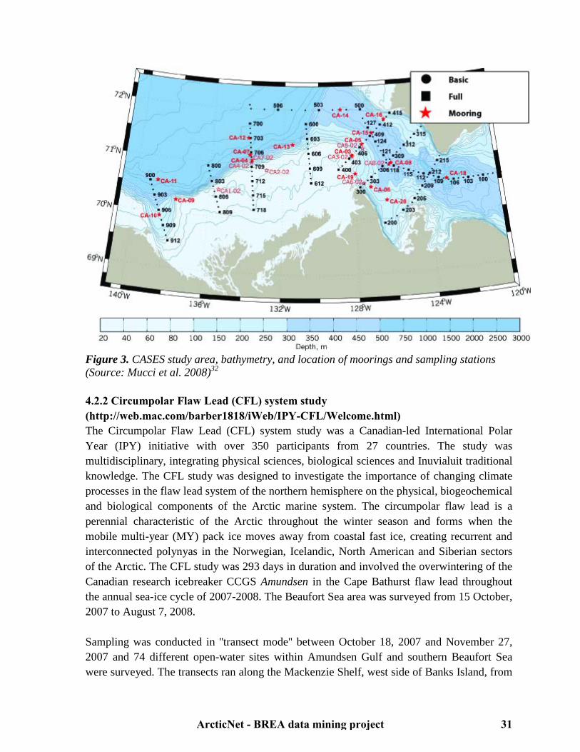
Figure 3. CASES study area, bathymetry, and location of moorings and sampling stations (Source: Mucci et al. 2008)32 4.2.2 Circumpolar Flaw Lead (CFL) system study (http://web.mac.com/barber1818/iWeb/IPY-CFL/Welcome.html) The Circumpolar Flaw Lead (CFL) system study was a Canadian-led International Polar Year (IPY) initiative with over 350 participants from 27 countries. The study was multidisciplinary, integrating physical sciences, biological sciences and Inuvialuit traditional knowledge. The CFL study was designed to investigate the importance of changing climate processes in the flaw lead system of the northern hemisphere on the physical, biogeochemical and biological components of the Arctic marine system. The circumpolar flaw lead is a perennial characteristic of the Arctic throughout the winter season and forms when the mobile multi-year (MY) pack ice moves away from coastal fast ice, creating recurrent and interconnected polynyas in the Norwegian, Icelandic, North American and Siberian sectors of the Arctic. The CFL study was 293 days in duration and involved the overwintering of the Canadian research icebreaker CCGS Amundsen in the Cape Bathurst flaw lead throughout the annual sea-ice cycle of 2007-2008. The Beaufort Sea area was surveyed from 15 October, 2007 to August 7, 2008. Sampling was conducted in ''transect mode'' between October 18, 2007 and November 27, 2007 and 74 different open-water sites within Amundsen Gulf and southern Beaufort Sea were surveyed. The transects ran along the Mackenzie Shelf, west side of Banks Island, from
ArcticNet - BREA data mining project 31
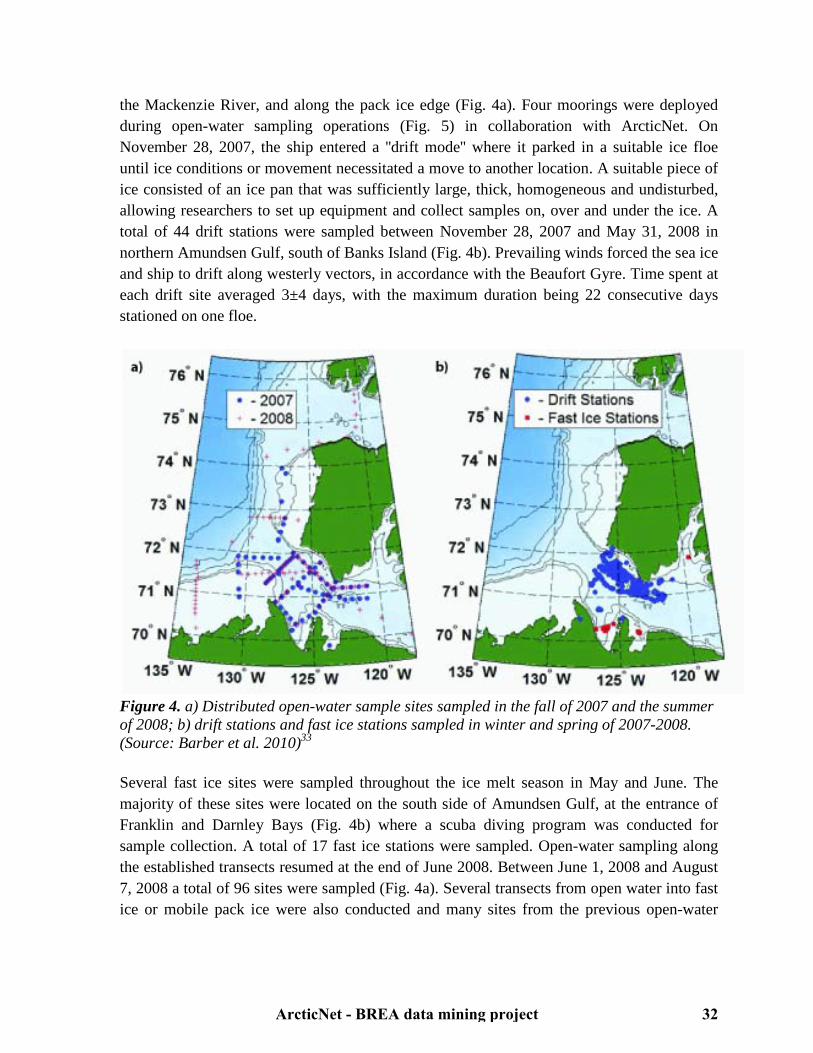
the Mackenzie River, and along the pack ice edge (Fig. 4a). Four moorings were deployed during open-water sampling operations (Fig. 5) in collaboration with ArcticNet. On November 28, 2007, the ship entered a ''drift mode'' where it parked in a suitable ice floe until ice conditions or movement necessitated a move to another location. A suitable piece of ice consisted of an ice pan that was sufficiently large, thick, homogeneous and undisturbed, allowing researchers to set up equipment and collect samples on, over and under the ice. A total of 44 drift stations were sampled between November 28, 2007 and May 31, 2008 in northern Amundsen Gulf, south of Banks Island (Fig. 4b). Prevailing winds forced the sea ice and ship to drift along westerly vectors, in accordance with the Beaufort Gyre. Time spent at each drift site averaged 3±4 days, with the maximum duration being 22 consecutive days stationed on one floe.
Figure 4. a) Distributed open-water sample sites sampled in the fall of 2007 and the summer of 2008; b) drift stations and fast ice stations sampled in winter and spring of 2007-2008. (Source: Barber et al. 2010)33 Several fast ice sites were sampled throughout the ice melt season in May and June. The majority of these sites were located on the south side of Amundsen Gulf, at the entrance of Franklin and Darnley Bays (Fig. 4b) where a scuba diving program was conducted for sample collection. A total of 17 fast ice stations were sampled. Open-water sampling along the established transects resumed at the end of June 2008. Between June 1, 2008 and August 7, 2008 a total of 96 sites were sampled (Fig. 4a). Several transects from open water into fast ice or mobile pack ice were also conducted and many sites from the previous open-water
ArcticNet - BREA data mining project 32
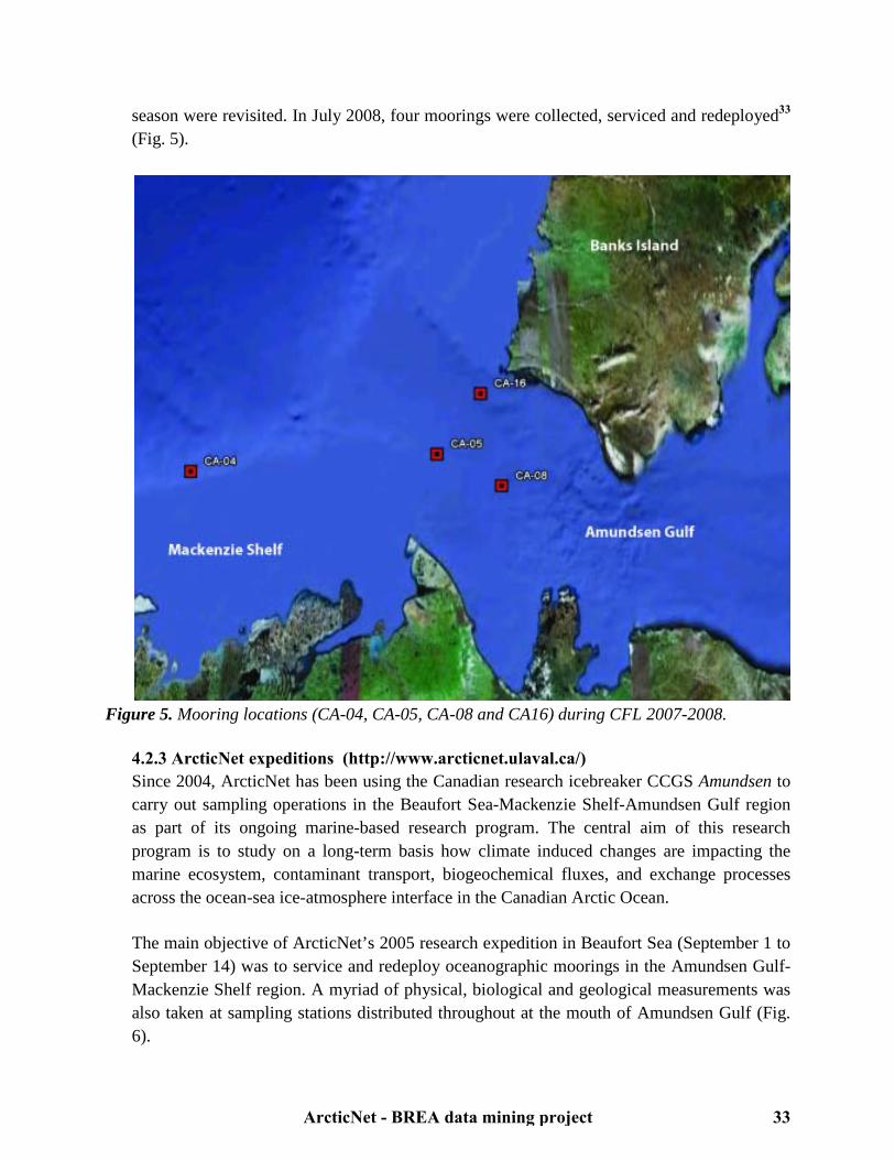
season were revisited. In July 2008, four moorings were collected, serviced and redeployed33
(Fig. 5).
Figure 5. Mooring locations (CA-04, CA-05, CA-08 and CA16) during CFL 2007-2008.
4.2.3 ArcticNet expeditions (http://www.arcticnet.ulaval.ca/) Since 2004, ArcticNet has been using the Canadian research icebreaker CCGS Amundsen to carry out sampling operations in the Beaufort Sea-Mackenzie Shelf-Amundsen Gulf region as part of its ongoing marine-based research program. The central aim of this research program is to study on a long-term basis how climate induced changes are impacting the marine ecosystem, contaminant transport, biogeochemical fluxes, and exchange processes across the ocean-sea ice-atmosphere interface in the Canadian Arctic Ocean. The main objective of ArcticNet’s 2005 research expedition in Beaufort Sea (September 1 to September 14) was to service and redeploy oceanographic moorings in the Amundsen Gulf-Mackenzie Shelf region. A myriad of physical, biological and geological measurements was also taken at sampling stations distributed throughout at the mouth of Amundsen Gulf (Fig. 6).
ArcticNet - BREA data mining project 33

Figure 6. Sampling stations in Beaufort Sea throughout ArcticNet 2005. Throughout ArcticNet 2006, the CCGS Amundsen surveyed the Beaufort Sea from September 30 to October 19. In addition to servicing and redeploying moorings, ArcticNet scientists sampled 44 oceanographic stations (Fig. 7). In total, over 100 ArcticNet researchers, students and technicians from twelve Canadian universities, four federal departments and two institutions from the United States were involved in the 2006 expedition.
ArcticNet - BREA data mining project 34
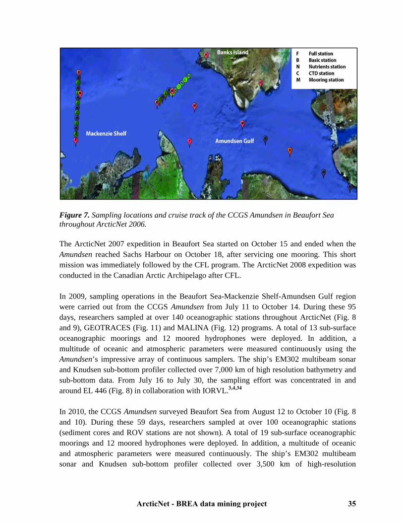
Figure 7. Sampling locations and cruise track of the CCGS Amundsen in Beaufort Sea throughout ArcticNet 2006. The ArcticNet 2007 expedition in Beaufort Sea started on October 15 and ended when the Amundsen reached Sachs Harbour on October 18, after servicing one mooring. This short mission was immediately followed by the CFL program. The ArcticNet 2008 expedition was conducted in the Canadian Arctic Archipelago after CFL. In 2009, sampling operations in the Beaufort Sea-Mackenzie Shelf-Amundsen Gulf region were carried out from the CCGS Amundsen from July 11 to October 14. During these 95 days, researchers sampled at over 140 oceanographic stations throughout ArcticNet (Fig. 8 and 9), GEOTRACES (Fig. 11) and MALINA (Fig. 12) programs. A total of 13 sub-surface oceanographic moorings and 12 moored hydrophones were deployed. In addition, a multitude of oceanic and atmospheric parameters were measured continuously using the Amundsen’s impressive array of continuous samplers. The ship’s EM302 multibeam sonar and Knudsen sub-bottom profiler collected over 7,000 km of high resolution bathymetry and sub-bottom data. From July 16 to July 30, the sampling effort was concentrated in and around EL 446 (Fig. 8) in collaboration with IORVL.3,4,34 In 2010, the CCGS Amundsen surveyed Beaufort Sea from August 12 to October 10 (Fig. 8 and 10). During these 59 days, researchers sampled at over 100 oceanographic stations (sediment cores and ROV stations are not shown). A total of 19 sub-surface oceanographic moorings and 12 moored hydrophones were deployed. In addition, a multitude of oceanic and atmospheric parameters were measured continuously. The ship’s EM302 multibeam sonar and Knudsen sub-bottom profiler collected over 3,500 km of high-resolution
ArcticNet - BREA data mining project 35

bathymetry and sub-bottom data. From August 12 to August 26, the sampling effort was concentrated in and around ELs 449 and 451 (Fig. 8) in collaboration with BP.34
Figure 8. a) Map of offshore Exploration Licenses (EL) awarded to Imperial Oil and BP by the Department of Indian and Northern Affairs in 2007 and 2008; b) Map of the biogeochemical sampling grids covering EL446 (July 2009) and EL449 & EL451 (August 2010). (Source: Robert et al. 2010) 34
ArcticNet - BREA data mining project 36
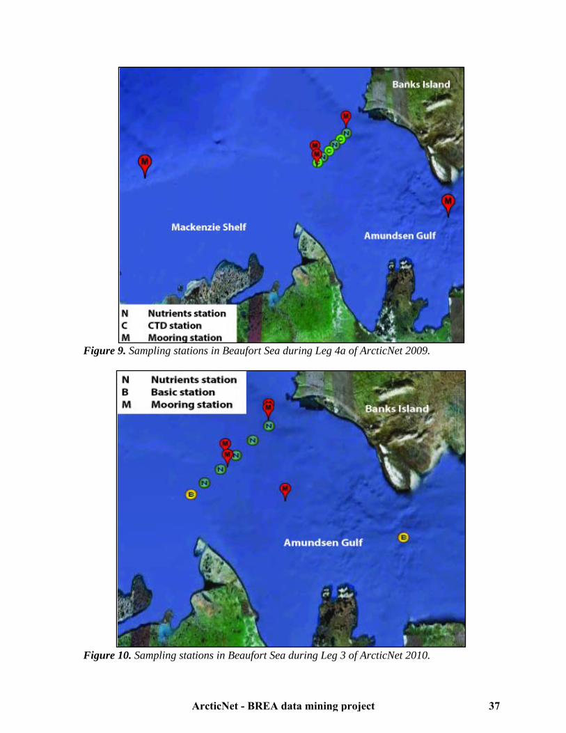
Figure 9. Sampling stations in Beaufort Sea during Leg 4a of ArcticNet 2009.
Figure 10. Sampling stations in Beaufort Sea during Leg 3 of ArcticNet 2010.
ArcticNet - BREA data mining project 37
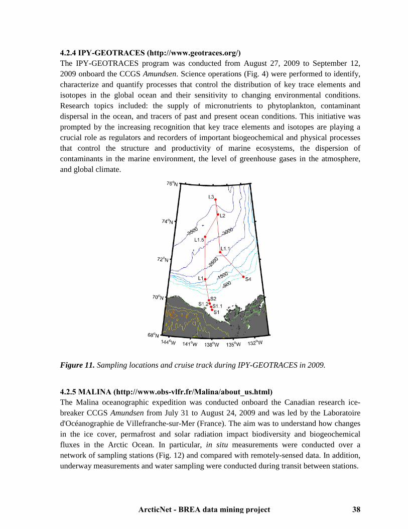
4.2.4 IPY-GEOTRACES (http://www.geotraces.org/) The IPY-GEOTRACES program was conducted from August 27, 2009 to September 12, 2009 onboard the CCGS Amundsen. Science operations (Fig. 4) were performed to identify, characterize and quantify processes that control the distribution of key trace elements and isotopes in the global ocean and their sensitivity to changing environmental conditions. Research topics included: the supply of micronutrients to phytoplankton, contaminant dispersal in the ocean, and tracers of past and present ocean conditions. This initiative was prompted by the increasing recognition that key trace elements and isotopes are playing a crucial role as regulators and recorders of important biogeochemical and physical processes that control the structure and productivity of marine ecosystems, the dispersion of contaminants in the marine environment, the level of greenhouse gases in the atmosphere, and global climate.
Figure 11. Sampling locations and cruise track during IPY-GEOTRACES in 2009.
4.2.5 MALINA (http://www.obs-vlfr.fr/Malina/about_us.html) The Malina oceanographic expedition was conducted onboard the Canadian research ice-breaker CCGS Amundsen from July 31 to August 24, 2009 and was led by the Laboratoire d'Océanographie de Villefranche-sur-Mer (France). The aim was to understand how changes in the ice cover, permafrost and solar radiation impact biodiversity and biogeochemical fluxes in the Arctic Ocean. In particular, in situ measurements were conducted over a network of sampling stations (Fig. 12) and compared with remotely-sensed data. In addition, underway measurements and water sampling were conducted during transit between stations.
ArcticNet - BREA data mining project 38
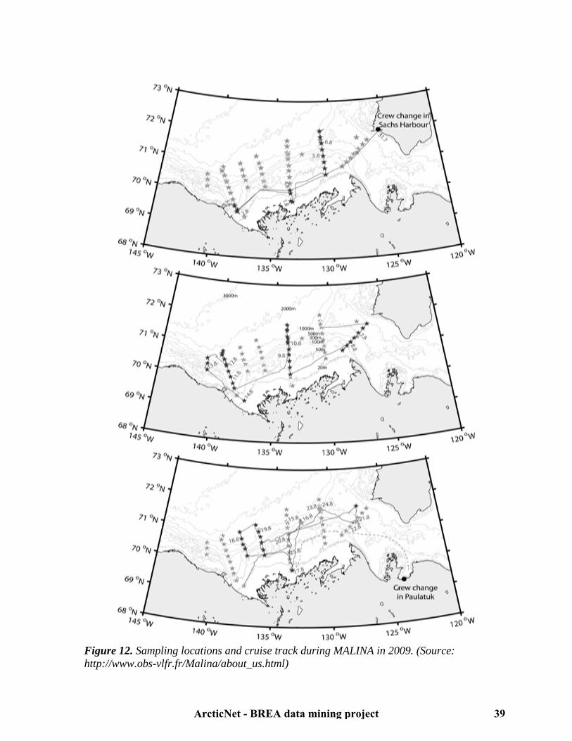
Figure 12. Sampling locations and cruise track during MALINA in 2009. (Source: http://www.obs-vlfr.fr/Malina/about_us.html)
ArcticNet - BREA data mining project 39

4.2.6 ARDEX (http://www.cen.ulaval.ca/warwickvincent/ardexheader.html)
The initial sampling phase of ARDEX (Fig.13) was conducted by helicopter, from July 21 to 26, 2004. A second phase was conducted onboard the CCGS Nahidik from July 26 to August 3, 2004. ARDEX was a satellite program of CASES that allowed extending measurements into the Mackenzie River, freshwater-saltwater transition zone and delta. The primary objectives of ARDEX were to evaluate the properties of dissolved organic matter (DOM) in the river and coastal waters, and the photochemical, geochemical and biological processes regulating DOM dynamics. ARDEX data considered in the present report are limited to the Mackenzie Delta.
Figure 13. Sampling locations during ARDEX 2004. Helicopter stations are in yellow and CCGS Nahidik stations are in red. (Source: www.cen.ulaval.ca)
4.2.7 Beaufort Gyre Exploration Project (BGEP) - JWACS and JOIS (http://www.whoi.edu/beaufortgyre/index.html) The JWACS program was launched in 2002, and consisted in a scientific collaboration between Canada, the United States, Japan and China. The objective was to examine the impacts of climate variability on biological and physical ocean processes in the Canadian Basin and on Mackenzie Shelf (Fig. 14). Research topics included atmospheric science, potential environmental effects of oil and gas exploitation, physical and biological oceanography. JWACS was followed by the JOIS program in 2005, a scientific collaboration among researchers from Canada, the United States and Japan. Both programs were conducted from the CCGS Louis St-Laurent in late summer and fall.
ArcticNet - BREA data mining project 40

Figure 14. Sampling locations and cruise track during the JOIS-2008 expedition. (Source: Zimmerman et al. 2008)27 4.3. Summary of the main data gaps
The following table summarises indicators and geographical areas (within BREA's area of interest, Fig. 15) that were studied and/or sampled less frequently than others throughout all science programs detailed in section 2.
ArcticNet - BREA data mining project 41
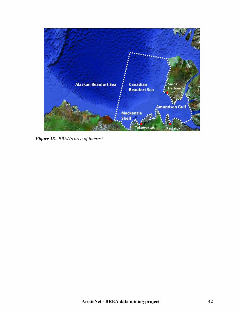
Figure 15. BREA's area of interest
ArcticNet - BREA data mining project 42

Table 2. Indicators and geographical areas identified as data gaps (X symbols). This table only summarizes the science programs detailed in section 2. A description of the criteria for the classification of an indicator as data gap can be found at section 4.1.
Geographical areas
Indicators Deep Canada Basin Amundsen Gulf Mackenzie Delta, Shelf and Slope
Adult fish (marine and anadromous) abundance and distribution
X X X
Adult fish (marine and anadromous) biological data X X X Ambient atmospheric noise X X X Ambient marine noise X X X Atmospheric contaminant concentrations X Benthic community biological data X Benthic community contaminant concentrations X Benthic community diversity and abundance X Benthic community trophic interactions X X X Coastal erosion X X Coastal mapping X X Contaminant concentrations in adult fish (marine and anadromous)
X X X
Contaminant concentrations in marine mammals X X X Contaminant concentrations in sediments and water X Contaminant concentrations in zooplankton X Extreme and Potentially Unmanageable Ice Features (PUIFs)
X X X
Fish trophic interactions (marine and anadromous) X X X Geotechnical seafloor characteristics X Inuvialuit fishing activities (marine and anadromous fish) X X Inuvialuit hunting activities (birds and marine mammals) X X Longshore sediment transport X X Marine and migratory bird abundance and distribution X X X
ArcticNet - BREA data mining project 43

Marine and migratory bird biological data X X X Marine and migratory bird contaminant concentrations X X X Marine and migratory bird trophic interactions X X X Marine mammal abundance and distribution X X X Marine mammal biological data X X X Marine mammal trophic interactions X X X Primary production data during the phytoplankton bloom X X Zooplankton incubation experiments X X X Zooplankton trophic interactions X
ArcticNet - BREA data mining project 44
5. Future updates
Due to time limitation, the following non-academic-led oceanographic program in Beaufort Sea was not documented in this data mining report: • The Canada's Three Ocean (C3O) program conducted during the International Polar Year (IPY) in 2007-2008 by Fisheries and Oceans Canada (DFO). A list of relevant peer-reviewed publications and technical reports published after the ESRF data mining study1 (2008) should also be provided in future updates. Principal sources to be considered (in order of priority) are: 1. The Arctic Science and Technology Information System (ASTIS) database (4000-5000 publications related to Beaufort Sea). 2. The Department of Fisheries and Oceans Canada Online Catalogue (WAVES). 3. The Canadian IPY Publication Database.
6. References 1Kavik-Axys Inc. (2008) Biophysical Research Requirements for Beaufort Sea Hydrocarbon Development. Environmental Studies Research Fund (ESRF). Report #163. Calgary, Canada, 124 pp.
2Polar Data Catalogue website. http://polardata.ca 3Fortier, M. (2009) ArcticNet 2009 Leg 2a Cruise Report CCGS Amundsen 16 July to 30 July 2009. ArcticNet, Québec, Canada, 136 pp. 4Papakyriakou, T. (2009) ArcticNet 2009 Leg 3b Cruise Report CCGS Amundsen 12 September to 8 October 2009. ArcticNet, Québec, Canada, 161 pp. 5Tremblay, J-E. (2007) Circumpolar Flaw Lead Cruise Report Leg 3 27 September – 7 November 2007. University of Manitoba. Winnipeg, Canada, 78 pp. 6Barber, DG., Stern, G. (2007) Circumpolar Flaw Lead Cruise Report Leg 4 8 November – 20 December 2007. University of Manitoba, Winnipeg, Canada, 98 pp. 7Deming, J., Papakyriakou, T. (2008) Circumpolar Flaw Lead Cruise Report Leg 5 21 December 2007 – 31 January 2008. University of Manitoba, Winnipeg, Canada, 97 pp. 8Macdonald, R., Stern, G. (2008) Circumpolar Flaw Lead Cruise Report Leg 6 01 February – 12 March 2008. University of Manitoba, Winnipeg, Canada, 88 pp.
ArcticNet - BREA data mining project 45
9David, B., Papakyriakou, T. (2008) Circumpolar Flaw Lead Cruise Report Leg 7 13 March – 24 April 2008. University of Manitoba, Winnipeg, Canada, 116 pp. 10Gosselin, M., Tremblay, J-E., David, B. (2008) Circumpolar Flaw Lead Cruise Report Leg 8 25 April – 5 June 2008. University of Manitoba, Winnipeg, Canada, 128 pp.
11Mundy, C.J., David, B. (2008) Circumpolar Flaw Lead Cruise Report Leg 9 6 June – 17 July 2008. University of Manitoba, Winnipeg, Canada, 112 pp.
12Stern, G. (2008) Circumpolar Flaw Lead Cruise Report Leg 10 18 July – 7 August 2008. University of Manitoba, Winnipeg, Canada, 69 pp. 13Melling, H. (2002) Cruise Report: Joint Western Arctic Climate Study 2002 Canadian Arctic Shelf Exchange Study Beaufort Sea CCGS Sir Wilfrid Laurier September 6 – September 24, 2002. Université Laval, Québec, Canada, 16 pp. (www.cases.Québec-ocean.ulaval.ca/Laurier% 202002%20Science%20Cruise%20report.pdf) 14Fortier, M. (2002) CASES Canadian Arctic Shelf Exchange Study CASES 2002 cruise report & preliminary data report 20 September to 14 October 2002 expedition onboard the CCGS Pierre Radisson. Université Laval, Québec, Canada, 74 pp. (http://www.cases.Québec-ocean. ulaval.ca/Radisson2002report.pdf) 15Miller, L. (2003) CASES2003, Leg 2 (0304) CCGS Amundsen Cruise Report 16 October to 26 November. Université Laval, Québec, Canada, 85 pp. (http://www.cases.Québec-ocean.ulaval.ca /CASES0304_leg2_cruise_report.pdf) 16Nozais, C. (2003) CASES2003, Leg 3 (0305) CCGS Amundsen Cruise & Preliminary Data Report 26 November 2003 to 06 January 2004. Université Laval, Québec, Canada, 36 pp. (http://www.cases.Québec-ocean.ulaval.ca/CASES0304_leg3_cruise_report.pdf) 17Deming, J. (2004) CASES2004, Leg 4 (0401) CCGS Amundsen Cruise Report 7 January to 18 February. Université Laval, Québec, Canada, 6 pp. (www.cases.Québec-ocean.ulaval.ca/ CASES0304_ leg4_cruise_report%28partial%29.pdf) 18Deming, J. (2004) CASES2004, Leg 5 (0402) CCGS Amundsen Cruise Report18 February to 31 March. Université Laval, Québec, Canada, 67 pp. (http://www.cases.Québec-ocean.ulaval.ca/ CASES0304_leg5_cruise_report%28long%29.pdf) 19Anonymous. (2004) CASES2003, Leg 8 (0305) CCGS Amundsen Cruise & Preliminary Data Report. Université Laval, Québec, Canada, 85 pp. (http://www.cases.Québec-ocean.ulaval.ca/ CASES0304_leg8_cruise_report.pdf) 20Rochon, A. (2004) CASES 2004, Leg 9 CCGS Amundsen Cruise & Preliminary Data Report and ArcticNet Preliminary Cruise Report 05 August to 25 August 2004. Université Laval,
ArcticNet - BREA data mining project 46

Québec, Canada, 55 pp. (www.cases.Québecocean.ulaval.ca/CASES0304_leg9_cruise_report. pdf) 21Hardenberg, BV. (2004) Cruise Report for the Joint DFO / CASES / ArcticNet Science Program aboard the CCGS Sir Wilfrid Laurier, 3 – 22 September 2004. Université Laval, Québec, Canada, 28 pp. (www.cases.Québecocean.ulaval.ca/CASES0304_Leg10%28Laurier% 29_cruise_report.pdf) 22Hardenberg, BV. (2003) JWACS/BGFE Canada Basin Climate Study – 2003 Cruise Report. Institute of Ocean Sciences, Sidney, Canada, 13 pp. (http://www.whoi.edu/beaufortgyre/pdfs/ 2003- 21_Cruise_Report.pdf) 23Zimmerman, S., McLaughlin, F. (2004) 2004 Joint Western Arctic Circulation Study and Beaufort Gyre Freshwater Experiment Cruise Report: Beaufort Sea and Canada Basin CCGS Louis S. St-Laurent 29 July – 2 September, 2004. Institute of Ocean Sciences, Sidney, Canada, 21 pp. (http://www.whoi.edu/beaufortgyre/pdfs/2004-16_Cruise_Report.pdf) 24Zimmerman, S., McLaughlin, F. (2005) 2005 Joint Western Arctic Circulation Study and Beaufort Gyre Observing System Cruise Report: Beaufort Sea and Canada Basin CCGS Louis S. St-Laurent 29 July – 1 September, 2005. Institute of Ocean Sciences, Sidney, Canada, 20 pp. (http://www.whoi.edu/beaufortgyre/pdfs/2005-04_Cruise_Report.pdf) 25Zimmerman, S., McLaughlin, F. (2006) Joint Ocean Ice Study (JOIS) 2006 Cruise Report: Report on the Oceanographic Research Conducted aboard the CCGS Louis S. St-Laurent, July 20 to October 2, 2006. Institute of Ocean Sciences, Sidney, Canada, 38 pp. (http://www.whoi.edu/ beaufortgyre/pdfs/2006-18_Cruise_Report.pdf) 26Zimmerman, S., Eert, J., McLaughlin, F. (2007) Joint Ocean Ice Study (JOIS) 2007 Cruise Report: Report on the Oceanographic Research Conducted aboard the CCGS Louis S. St Laurent, July 26 to August 31, 2007. Institute of Ocean Sciences, Sidney, Canada, 39 pp. (http://www .whoi. edu/beaufortgyre/pdfs/2007-20_Cruise_Report.pdf) 27Zimmermann, S., Kawai, M., Mclaughlin, F. (2008) Joint Ocean Ice Study (JOIS) 2008 Cruise Report: Report on the Oceanographic Research Conducted aboard the CCGS Louis S. St Laurent, July 17 to August 21, 2008. Institute of Ocean Sciences, Sidney, Canada, 57 pp. (http://www. whoi.edu/beaufortgyre/pdfs/2008-30_Cruise_Report.pdf) 28Zimmerman, S., McLaughlin, F. (2009) Joint Ocean Ice Study (JOIS) 2009 Cruise Report: Report on the Oceanographic Research Conducted aboard the CCGS Louis S. St-Laurent, September 17 to October 15, 2009. Institute of Ocean Sciences, Sidney, Canada, 54 pp. (http://www.whoi.edu/beaufortgyre/pdfs/2009-20_Cruise_Report.pdf) 29Williams, B. (2010) Joint Ocean Ice Study (JOIS) 2010 Cruise Report: Report on the Oceanographic Research Conducted aboard the CCGS Louis S. St-Laurent, September 15 to October 15, 2010. Institute of Ocean Sciences, Sidney, Canada, 60 pp. (http://www.whoi.edu/ beaufortgyre/pdfs/2010-07_Cruise_Report.pdf)
ArcticNet - BREA data mining project 47
30Canadian Arctic Shelf Exchange Study (CASES) website. http://www.cases.Québec-ocean.ulaval.ca/welcome.asp 31 Fortier, L., Barber, DG., (2008) An introduction to the Canadian Arctic Shelf Study In: Fortier L, Barber D, Michaud J (eds) On thin ice: A synthesis of the Canadian Arctic Shelf Exchange Study (CASES). Aboriginal Issues Press, Winnipeg, pp 1-12. 32Mucci, A., Forest, A., Fortier, L. et al. (2008) Organic and inorganic fluxes In: Fortier L, Barber D, Michaud J (eds) On thin ice: A synthesis of the Canadian Arctic Shelf Exchange Study (CASES). Aboriginal Issues Press, Winnipeg, pp 113-142. 33 Barber, DG., Asplin, MG., Gratton, Y., Lukovich, JV., Galley, RJ., Raddatz, RL., Leitch, D. (2010) The International Polar Year (IPY) Circumpolar Flaw Lead (CFL) System Study: Overview and the physical system. Atmos Ocean 48:225-243. 34 Robert, D., Lévesque, M., Gagnon, J. (2010) Data from the environment and marine resources assessment of Imperial Oil/BP Exploration License Areas 446, 449 and 451 (Beaufort Sea), in the summers of 2009 and 2010. Québec, Canada, 70 pp.
ArcticNet - BREA data mining project 48

7. Annex (Valued ecosystem components and indicators)
7.1. Atmosphere 7.1.1. Air quality 7.1.2. Weather
7.2. Ice and physical oceanography 7.2.1. Snow and ice 7.2.2. Ocean circulation and water masses
7.3. Chemical oceanography 7.3.1. Contaminants 7.3.2. Biochemical cycles
7.4. Primary production and microbiology 7.5. Zooplankton
7.5.1. Distribution and abundance 7.5.2. Trophic interactions and contaminant loads
7.6. Marine fish 7.6.1. Distribution and abundance 7.6.2. Trophic interactions and contaminant loads 7.6.3. Inuvialuit fishing activities (no metadata)
7.7. Anadromous fish 7.7.1. Distribution and abundance 7.7.2. Trophic interactions and contaminant loads 7.7.3. Inuvialuit fishing activities
7.8. Marine mammals 7.8.1. Distribution and abundance 7.8.2. Trophic interactions and contaminant loads 7.8.3. Inuvialuit hunting activities
7.9. Noise in the environment 7.9.1. Ambient marine noise conditions 7.9.2. Ambient atmospheric noise conditions (no metadata)
7.10. Marine and migratory birds 7.10.1. Distribution and abundance 7.10.2. Trophic interactions and contaminant loads 7.10.3. Inuvialuit hunting activities
7.11. Benthos 7.11.1. Distribution and abundance 7.11.2. Trophic interactions and contaminant loads
7.12. Geology 7.12.1. Geotechnical seafloor characteristics 7.12.2. Seafloor mapping
7.13. Coastal erosion and longshore sediment transport
ArcticNet - BREA data mining project 49

7.1. Atmosphere7.1.1. Air quality
Table 3: Air quality metadataStudy Originators Contact person Study area Type of study Begin date End date Link to data Details Reference
Aerosol optical depth measurements in 2007
Alexander Smirnov, Luc Rainville
Alexander Smirnov, Goddard Earth Sciences and Technology Center, University of Maryland, [email protected]
Alaskan Slope and Shelf, Deep Canada Basin, Mackenzie Shelf and Slope, North Beaufort Sea
Field-based (CCGS Louis St-Laurent) direct observational study
2007-07-26 2007-08-31 [email protected] Aerosol optical depth measurements were taken using a hand-held sunphotometer (Microtops II) when the sun disk was completely free of clouds or fog. 152 solar scans were performed.
JOIS 2007
Air sampling for organic contaminants during CASES
Eric Braekevelt, Allison MacHutchon, Gary Stern, Robie Macdonald, Paul Helm
Gary Stern, Department of Fisheries and Oceans Canada, [email protected]
Mackenzie Shelf and Slope, Amundsen Gulf, Franklin Bay, southeastern Beaufort Sea
Field-based (CCGS Laurier, Radisson and Amundsen) and lab-based (mass-spectrometry) observational study
2002-09-22 2004-08-10 [email protected] Air was sampled at the bow of the ship on a glass fibre filter and Polyurethane Foam (PUF) for the measurement of organic contaminant and mercury concentrations. Air samples were collected for about 48 hours per sample.
CASES 2002-2004
Air sampling for organic contaminants, POPs and PBDEs in 2006
Debbie Armstrong, Joanne DeLaronde, Allyson MacHutchon, Corinne Pomerleau, Gary Stern
Gary Stern, Department of Fisheries and Oceans Canada, [email protected]
Amundsen Gulf, Mackenzie Shelf and Slope, southeastern Beaufort Sea
Field-based (CCGS Amundsen) and lab-based (mass-spectrometry) observational study
2006-09-28 2006-11-09 [email protected] Air was sampled at the bow of the ship on a glass fibre filter and Polyurethane Foam (PUF) for the measurement of organic contaminant and mercury concentrations. Air samples were collected for about 48 hours per sample.
ArcticNet 2006
Air sampling for organic contaminants, HCH, POPs and PBDEs in 2005
Debbie Armstrong, Joanne DeLaronde, Allyson MacHutchon, Corinne Pomerleau, Gary Stern
Gary Stern, Department of Fisheries and Oceans Canada, [email protected]
Amundsen Gulf, Mackenzie Shelf and Slope, southeastern Beaufort Sea
Field-based (CCGS Amundsen) and lab-based (mass-spectrometry) observational study
2005-09-01 2005-09-14 [email protected] Air was sampled at the bow of the ship on a glass fibre filter and Polyurethane Foam (PUF) for the measurement of organic contaminant and mercury concentrations. Air samples were collected for about 48 hours per sample.
ArcticNet 2005
Air sampling for pesticides concentrations during CFL
Liisa Jantunen,Fiona Wong,Terry Bidleman,Anya Gawor
Ashley Gaden, University of Manitoba, [email protected]
Mackenzie Shelf and Slope, Amundsen Gulf, Deep Canada Basin, southeastern Beaufort Sea
Field-based (CCGS Amundsen) and lab-based (mass-spectrometry) observational study
2008-04-25 2008-07-17 [email protected] The air sampler was at the bow of the ship. Samples were continuously collected on a glass fibre filter and Polyurethane Foam (PUF) to determine the occurrence and levels of banned organochlorine pesticides and currently used pesticides.
Polar Data Catalogue (ID 1702)
Arctic-SOLAS DMS and atmospheric chemistry data in 2007
Steve Sjostedt, Jon Abbatt
Jon Abbatt, University of Toronto, [email protected]
Southeastern Beaufort Sea, Amundsen Gulf
Field-based (CCGS Amundsen) and lab-based (spectrometry, scans, proton-transfer-reaction, UV absorption, fluorescence) observational study
2007-09-27 2007-11-08 [email protected] Air samples were continuously collected at the bow of the ship and on top of the bridge and analyzed for aerosol composition, particles sizes, volatile organic compound composition, ozone and sulfur dioxide concentrations.
Polar Data Catalogue (ID 767)
Atmospheric composition and stucture during the OASIS-CANADA CFL expedition
Jan Bottenheim, Staebler, Steffen, Whiteway, Shepson, Friess, Platt
Jan Bottenheim, Environment Canada, [email protected]
Amundsen Gulf Field-based (CCGS Amundsen) direct observational study and lab-based (spectroscopy) observational study
2008-02-07 2008-04-12 [email protected] Chemical and meteorological data were continuously recorded from sensors: ozone, sulphur dioxide concentrations, gaseous (GEM) and particulate (HgP) mercury speciation and Bromine (BrO) concentrations.
Polar Data Catalogue (ID 1844)
Atmospheric composition and stucture during the OASIS-CANADA-OOTI CFL expedition
Jan Bottenheim, Simpson, Netcheva, Staebler, Steffen
Jan Bottenheim, Environment Canada, [email protected]
Amundsen Gulf Ice-based direct observational study and lab-based (spectroscopy) observational study
2008-02-07 2008-04-12 [email protected] Chemical and meteorological data were continuously recorded from sensors: ozone, gaseous (GEM), particulate mercury speciation (HgP) and Bromine (BrO) concentrations.
Polar Data Catalogue (ID 1843)
Atmospheric data from Mixed-Layer and Met/Ocean buoys in 2009
David G. Barber, Tim N. Papakyriakou
David G. Barber, University of Manitoba, [email protected]
Southeastern Beaufort Sea, Amundsen Gulf, Mackenzie Shelf and Slope (EL 446)
Field-based (buoys deployed from the CCGS Amundsen) direct observational study
2009-09-14 2009-10-01 [email protected] CO2 and H20 atmospheric concentrations were recorded from buoys deployed at the sea-atmosphere interface.
ArcticNet 2009 expedition in collaboration with IORVL
ArcticNet - BREA data mining project 50
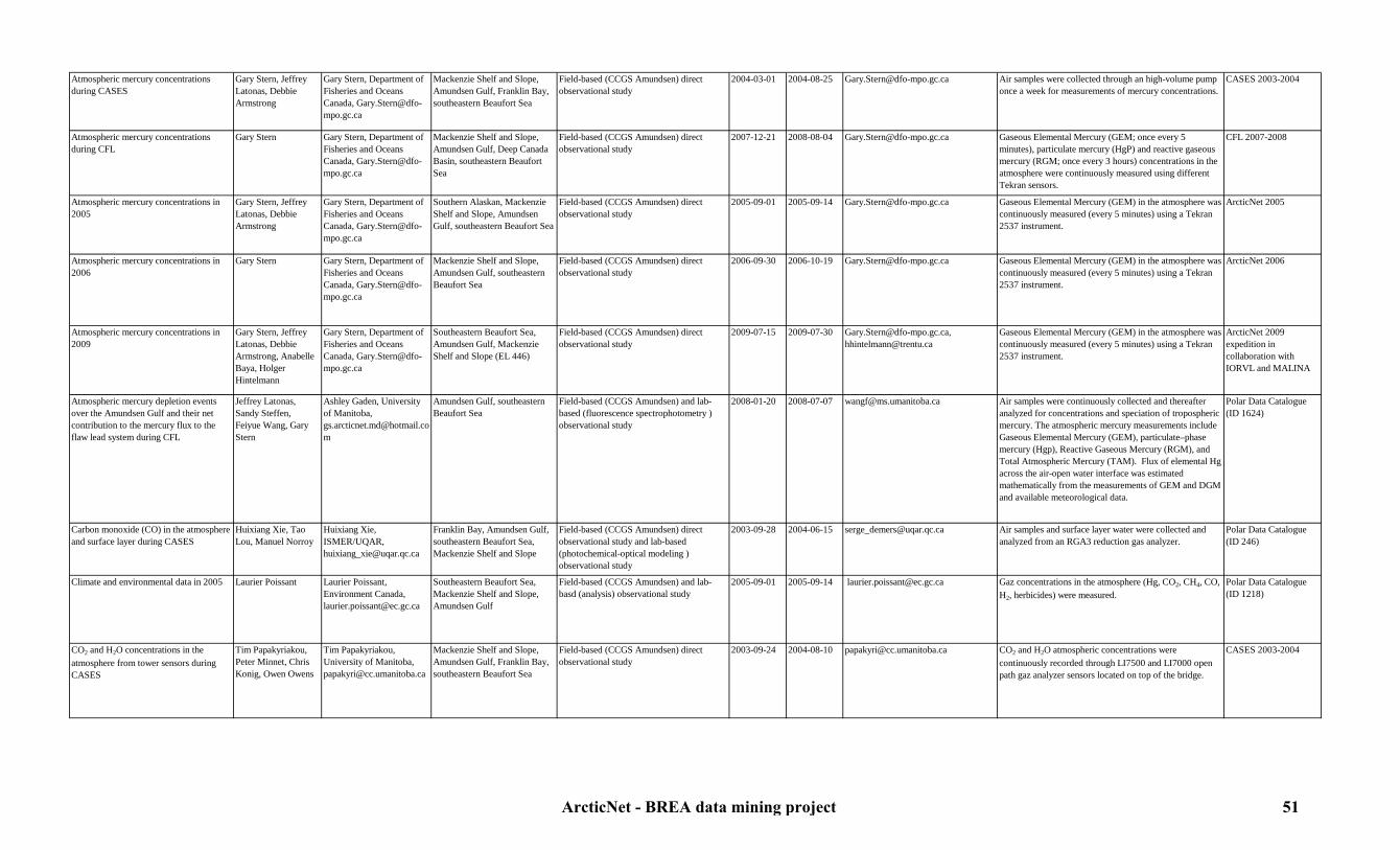
Atmospheric mercury concentrations during CASES
Gary Stern, Jeffrey Latonas, Debbie Armstrong
Gary Stern, Department of Fisheries and Oceans Canada, [email protected]
Mackenzie Shelf and Slope, Amundsen Gulf, Franklin Bay, southeastern Beaufort Sea
Field-based (CCGS Amundsen) direct observational study
2004-03-01 2004-08-25 [email protected] Air samples were collected through an high-volume pump once a week for measurements of mercury concentrations.
CASES 2003-2004
Atmospheric mercury concentrations during CFL
Gary Stern Gary Stern, Department of Fisheries and Oceans Canada, [email protected]
Mackenzie Shelf and Slope, Amundsen Gulf, Deep Canada Basin, southeastern Beaufort Sea
Field-based (CCGS Amundsen) direct observational study
2007-12-21 2008-08-04 [email protected] Gaseous Elemental Mercury (GEM; once every 5 minutes), particulate mercury (HgP) and reactive gaseous mercury (RGM; once every 3 hours) concentrations in the atmosphere were continuously measured using different Tekran sensors.
CFL 2007-2008
Atmospheric mercury concentrations in 2005
Gary Stern, Jeffrey Latonas, Debbie Armstrong
Gary Stern, Department of Fisheries and Oceans Canada, [email protected]
Southern Alaskan, Mackenzie Shelf and Slope, Amundsen Gulf, southeastern Beaufort Sea
Field-based (CCGS Amundsen) direct observational study
2005-09-01 2005-09-14 [email protected] Gaseous Elemental Mercury (GEM) in the atmosphere was continuously measured (every 5 minutes) using a Tekran 2537 instrument.
ArcticNet 2005
Atmospheric mercury concentrations in 2006
Gary Stern Gary Stern, Department of Fisheries and Oceans Canada, [email protected]
Mackenzie Shelf and Slope, Amundsen Gulf, southeastern Beaufort Sea
Field-based (CCGS Amundsen) direct observational study
2006-09-30 2006-10-19 [email protected] Gaseous Elemental Mercury (GEM) in the atmosphere was continuously measured (every 5 minutes) using a Tekran 2537 instrument.
ArcticNet 2006
Atmospheric mercury concentrations in 2009
Gary Stern, Jeffrey Latonas, Debbie Armstrong, Anabelle Baya, Holger Hintelmann
Gary Stern, Department of Fisheries and Oceans Canada, [email protected]
Southeastern Beaufort Sea, Amundsen Gulf, Mackenzie Shelf and Slope (EL 446)
Field-based (CCGS Amundsen) direct observational study
2009-07-15 2009-07-30 [email protected], [email protected]
Gaseous Elemental Mercury (GEM) in the atmosphere was continuously measured (every 5 minutes) using a Tekran 2537 instrument.
ArcticNet 2009 expedition in collaboration with IORVL and MALINA
Atmospheric mercury depletion events over the Amundsen Gulf and their net contribution to the mercury flux to the flaw lead system during CFL
Jeffrey Latonas, Sandy Steffen,Feiyue Wang, Gary Stern
Ashley Gaden, University of Manitoba, [email protected]
Amundsen Gulf, southeastern Beaufort Sea
Field-based (CCGS Amundsen) and lab-based (fluorescence spectrophotometry ) observational study
2008-01-20 2008-07-07 [email protected] Air samples were continuously collected and thereafter analyzed for concentrations and speciation of tropospheric mercury. The atmospheric mercury measurements include Gaseous Elemental Mercury (GEM), particulate–phase mercury (Hgp), Reactive Gaseous Mercury (RGM), and Total Atmospheric Mercury (TAM). Flux of elemental Hg across the air-open water interface was estimated mathematically from the measurements of GEM and DGM and available meteorological data.
Polar Data Catalogue (ID 1624)
Carbon monoxide (CO) in the atmosphere and surface layer during CASES
Huixiang Xie, Tao Lou, Manuel Norroy
Huixiang Xie, ISMER/UQAR, [email protected]
Franklin Bay, Amundsen Gulf, southeastern Beaufort Sea, Mackenzie Shelf and Slope
Field-based (CCGS Amundsen) direct observational study and lab-based (photochemical-optical modeling ) observational study
2003-09-28 2004-06-15 [email protected] Air samples and surface layer water were collected and analyzed from an RGA3 reduction gas analyzer.
Polar Data Catalogue (ID 246)
Climate and environmental data in 2005 Laurier Poissant Laurier Poissant, Environment Canada, [email protected]
Southeastern Beaufort Sea, Mackenzie Shelf and Slope, Amundsen Gulf
Field-based (CCGS Amundsen) and lab-basd (analysis) observational study
2005-09-01 2005-09-14 [email protected] Gaz concentrations in the atmosphere (Hg, CO2, CH4, CO, H2, herbicides) were measured.
Polar Data Catalogue (ID 1218)
CO2 and H2O concentrations in the atmosphere from tower sensors during CASES
Tim Papakyriakou, Peter Minnet, Chris Konig, Owen Owens
Tim Papakyriakou, University of Manitoba, [email protected]
Mackenzie Shelf and Slope, Amundsen Gulf, Franklin Bay, southeastern Beaufort Sea
Field-based (CCGS Amundsen) direct observational study
2003-09-24 2004-08-10 [email protected] CO2 and H2O atmospheric concentrations were continuously recorded through LI7500 and LI7000 open path gaz analyzer sensors located on top of the bridge.
CASES 2003-2004
ArcticNet - BREA data mining project 51

CO2 and H2O concentrations in the atmosphere from tower sensors during CASES
Tim Papakyriakou, Peter Minnet, Chris Konig, Owen Owens
Tim Papakyriakou, University of Manitoba, [email protected]
Mackenzie Shelf and Slope, Amundsen Gulf, Franklin Bay, southeastern Beaufort Sea
Field-based (CCGS Radisson and Amundsen) direct observational study
2002-09-22 2004-08-10 [email protected] CO2 and H2O atmospheric concentrations were continuously recorded through LI7500 and LI7000 open path gaz analyzer sensors located on top of the bridge.
CASES 2002-2004
CO2 and H2O concentrations in the atmosphere from tower sensors during CFL
Tim Papakyriakou Tim Papakyriakou, University of Manitoba, [email protected]
Mackenzie Shelf and Slope, Amundsen Gulf, Deep Canada Basin, southeastern Beaufort Sea
Field-based (CCGS Amundsen) direct observational study
2007-10-15 2008-08-07 [email protected] CO2 and H2O atmospheric concentrations were continuously recorded through LI7500 and LI7000 open path gaz analyzer sensors located on top of the bridge.
CFL 2007-2008
CO2 and H2O concentrations in the atmosphere from tower sensors in 2005
Tim Papakyriakou Tim Papakyriakou, University of Manitoba, [email protected]
Amundsen Gulf, Mackenzie Shelf and Slope, southeastern Beaufort Sea
Field-based (CCGS Amundsen) direct observational study
2005-09-01 2005-09-14 [email protected] CO2 and H2O atmospheric concentrations were continuously recorded through LI7500 and LI7000 open path gaz analyzer sensors located on top of the bridge.
ArcticNet 2005
CO2 and H2O concentrations in the atmosphere from tower sensors in 2006
Tim Papakyriakou Tim Papakyriakou, University of Manitoba, [email protected]
Amundsen Gulf, Mackenzie Shelf and Slope, southeastern Beaufort Sea
Field-based (CCGS Amundsen) direct observational study
2006-09-30 2006-10-19 [email protected] CO2 and H2O atmospheric concentrations were continuously recorded through LI7500 and LI7000 open path gaz analyzer sensors located on top of the bridge.
ArcticNet 2006
CO2 and H2O concentrations in the atmosphere from tower sensors in 2009
Tim Papakyriakou Tim Papakyriakou, University of Manitoba, [email protected]
South Alaskan Beaufort Sea, southeastern Beaufort Sea, Amundsen Gulf, Mackenzie Shelf and Slope (EL 446)
Field-based (CCGS Amundsen and buoys) direct observational study
2009-07-13 2009-10-16 [email protected] CO2 and H2O atmospheric concentrations were continuously recorded through LI7500 and LI7000 open path gaz analyzer sensors located on top of the bridge. Meteorological/Oceans buoys with CO2 and H2O sensors were also deployed.
ArcticNet 2009 expedition in collaboration with MALINA and IORVL
CO2 and H2O concentrations in the atmosphere from tower sensors in 2010
Bruce Johnson, Tim Papakyriakou
Tim Papakyriakou, University of Manitoba, [email protected]
Amundsen Gulf, Mackenzie Shelf and Slope (EL 449, 451), southeastern Beaufort Sea, Deep Canada Basin
Field-based (CCGS Amundsen) direct observational study
2010-08-26 2010-10-10 [email protected] CO2 and H2O atmospheric concentrations were continuously recorded through LI7500 and LI7000 open path gaz analyzer sensors located on top of the bridge.
ArcticNet 2010 expedition in collaboration with BP
CO2 and H2O concentrations in the atmosphere from tower sensors on the ice during CFL
Tim Papakyriakou, Bruce Johnson, Elizabeth Shadwick, Alexander Makshtas, Sergey Shutilin, Peter Bogorodsky
Tim Papakyriakou, University of Manitoba, [email protected]
Mackenzie Shelf and Slope, Amundsen Gulf, Deep Canada Basin, southeastern Beaufort Sea
Ice-based direct observational study 2008-01-09 2008-06-03 [email protected] CO2 and H2O atmospheric concentrations above the ice were recorded through LI7500 and LI7000 open path gaz analyzer sensors.
CFL 2007-2008
ENVISAT (MERIS sensor) satellite data European Space Agency (ESA)
European Space Agency (ESA), http://earth.esa.int/cgi-bin/contactus
All Beaufort Sea Remote sensing study 2002-03-01 In progress http://envisat.esa.int/instruments/meris/ Remote sensing dataset for aerosol type and optical thickness.
MERIS dataset
MODIS satellite data NASA Jack Xiong,MODIS Project Scientist, [email protected]
All Beaufort Sea Remote sensing study 2002-05-04 In progress http://modis.gsfc.nasa.gov/data/dataprod/index.php
Remote sensing dataset for aerosol product, Angstrom exponent, aerosol optical thickness and the downwelling diffuse attenuation coefficient at 490 nm.
MODIS dataset
ArcticNet - BREA data mining project 52

Multi media contaminant survey in 2005 Philippe Constant,Laurier Poissant,Martin Pilote,Fabien Aulagnier
Laurier Poissant, Environment Canada, [email protected]
Amundsen Gulf, Mackenzie Shelf and Slope, southeastern Beaufort Sea
Field-based (CCGS Amundsen) direct observational study
2005-08-05 2005-09-29 [email protected] GEM, pesticides, ozone and trace gas concentrations in the atmosphere were continuously measured.
Polar Data Catalogue (ID 1076)
O-buoys data during JWACS and JOIS Andrey Proshutinsky, Willie Ostrom, Rick Krishfield, Kris Newhall, Jim Dunn, Tim Eglinton, Steve Manganini, Luc Rainville, Brian Hogue, Sarah Zimmermann, Fiona McLaughlin
Andrey Proshutinsky, Woods Hole Oceanographic Institution, [email protected], Rick Krishfield, Woods Hole Oceanographic Institution, [email protected], Fiona McLaughlin, Department of Fisheries and Oceans Canada, [email protected]
Alaskan Slope and Shelf, Deep Canada Basin, Mackenzie Shelf and Slope, North Beaufort Sea
Ice-based and computer-based (analysis) direct observational study
2003-08-22 2010-10-02 [email protected], [email protected], [email protected]
O-buoys were deployed on the ice to monitor atmospheric O3, BrO and CO2 concentrations for up to two years.
JWACS and JOIS 2003-2010
ArcticNet - BREA data mining project 53

7.1. Atmosphere7.1.2. Weather
Table 4: Weather metadataStudy Originators Contact person Study area Type of study Begin date End date Link to data Details Reference
All-sky camera imagery during CASES David G. Barber, Tim Papakyriakou
David G. Barber, University of Manitoba, [email protected]
Mackenzie Shelf and Slope, Amundsen Gulf, Franklin Bay, southeastern Beaufort Sea
Field-based (CCGS Amundsen and Radisson) direct observational study
2002-09-22 2004-08-12 [email protected], [email protected]
All-sky photography were taken every 17-seconds using a video camera and an acryllic hemispherical mirror dome installed on top of the bridge.
CASES 2002-2004
All-sky camera imagery during CFL David G. Barber David G. Barber, University of Manitoba, [email protected]
Mackenzie Shelf and Slope, Amundsen Gulf, Deep Canada Basin, southeastern Beaufort Sea
Field-based (CCGS Amundsen) direct observational study
2007-10-15 2008-08-07 [email protected] All-sky photography were taken every 15-minutes using a creative webcam and an acryllic hemispherical mirror dome installed on top of the bridge.
CFL 2007-2008, Polar Data Catalogue (ID 1570)
All-sky camera imagery in 2005 David G. Barber, Tim Papakyriakou
David G. Barber, University of Manitoba, [email protected]
Amundsen Gulf, Mackenzie Shelf and Slope, southeastern Beaufort Sea
Field-based (CCGS Amundsen) direct observational study
2005-09-01 2005-09-14 [email protected], [email protected]
All-sky photography were taken every 17-seconds using a video camera and an acryllic hemispherical mirror dome installed on top of the bridge.
ArcticNet 2005
All-sky camera imagery in 2006 David G. Barber, Tim Papakyriakou
David G. Barber, University of Manitoba, [email protected]
Amundsen Gulf, Mackenzie Shelf and Slope, southeastern Beaufort Sea
Field-based (CCGS Amundsen) direct observational study
2006-09-30 2006-10-19 [email protected], [email protected]
All-sky photography were taken every 17-seconds using a video camera and an acryllic hemispherical mirror dome installed on top of the bridge.
ArcticNet 2006
All-sky camera imagery in 2009 Matthew Asplin,Lauren Candlish, David G. Barber
David G. Barber, University of Manitoba, [email protected]
South Alaskan Beaufort Sea, southeastern Beaufort Sea, Amundsen Gulf, Mackenzie Shelf and Slope (EL 446)
Field-based (CCGS Amundsen) direct observational study
2009-07-13 2009-10-16 [email protected] All-sky photography were taken every 15-minutes using a creative webcam and an acryllic hemispherical mirror dome installed on top of the bridge.
Polar Data Catalogue (ID 10110)
All-sky camera imagery in 2010 Matthew Asplin,Lauren Candlish, David G. Barber
David G. Barber, University of Manitoba, [email protected]
Amundsen Gulf, Mackenzie Shelf and Slope (EL 449, 451), southeastern Beaufort Sea, Deep Canada Basin
Field-based (CCGS Amundsen) direct observational study
2010-08-26 2010-10-10 [email protected] All-sky photography were taken every 15-minutes using a creative webcam and an acryllic hemispherical mirror dome installed on top of the bridge.
ArcticNet 2010 expedition in collaboration with BP
Atmospheric data from radiosondes on weather balloons during CFL
Alexander Makshtas, Sergey Shutilin, Peter Bogorodsky, David G. Barber
Alexander Makshtas, Antarctic Research Institute, [email protected]
Mackenzie Shelf and Slope, Amundsen Gulf, Deep Canada Basin, southeastern Beaufort Sea
Field-based (balloons launched from the CCGS Amundsen) direct observational study
2008-01-17 2008-07-31 [email protected], [email protected]
Vertical profiles of temperature, pressure, relative humidity, wind speed and wind direction were obtained using Vaisala RS92G GPS wind-finding radiosondes. The sondes were flown 250 m above the ship by 300 gm and 200 gm helium-filled balloons attached on the flight deck. An 8-channel uncoded GPS receiver in each sonde automatically detected all satellite signals in visible range. and the raw data were transmitted to the ground station every 0.5 seconds during the flight.
CFL 2007-2008
Atmospheric data from Mixed-Layer and Met/Ocean buoys in 2009
David G. Barber, Tim N. Papakyriakou
David G. Barber, University of Manitoba, [email protected]
Southeastern Beaufort Sea, Amundsen Gulf, Mackenzie Shelf and Slope (EL 446)
Field-based (buoys deployed from the CCGS Amundsen) direct observational study
2009-09-14 2009-10-01 [email protected] Atmospheric data were recorded from buoys deployed at the sea-atmosphere interface: Data inlcude Photosynthetically Active Radiation (PAR), air temperature, relative humidity, wind speed and direction and atmospheric pressure.
ArcticNet 2009 expedition in collaboration with IORVL
ArcticNet - BREA data mining project 54

Atmospheric data from Polar Ocean Profiling System (POPs) buoys during CFL
David G. Barber David G. Barber, University of Manitoba, [email protected]
Southeastern Beaufort Sea, Amundsen Gulf
Ice-based (buoys deployed on the ice) direct observational study
2008-06-02 2008-06-05 [email protected] Atmospheric data were recorded from buoys deployed at the ice-atmosphere interface. Data include: incoming shortwave radiation, air and surface temperature, relative humidity, wind speed and direction, and atmospheric pressure.
CFL 2007-2008
Atmospheric data from radiosondes on weather balloons during CASES
David G. Barber, Tim Papakyriakou, Peter Minnet, Chris Konig, Owen Owens
David G. Barber, University of Manitoba, [email protected]
Mackenzie Shelf and Slope, Amundsen Gulf, Franklin Bay, southeastern Beaufort Sea
Field-based (balloons launched from the CCGS Amundsen and Laurier) direct observational study
2002-09-25 2004-08-10 [email protected]; [email protected]
Vertical profiles of temperature, pressure, relative humidity, wind speed and wind direction were obtained using Vaisala RS92G GPS wind-finding radiosondes. The sonde was flown by 300 gm and 200 gm helium-filled balloons at a target ascent rate of 2 to 5 m/s to ensure a good vertical resolution through the boundary layer. An 8-channel uncoded GPS receiver in each sonde automatically detected all satellite signals in visible range. Raw data were transmitted to the ground station every 0.5 seconds during the flight.
CASES 2002-2004
Atmospheric data from radiosondes on weather balloons in 2009
David G. Barber, Tim Papakyriakou
David G. Barber, University of Manitoba, [email protected]
Southeastern Beaufort Sea, Amundsen Gulf, Mackenzie Shelf and Slope (EL 446)
Field-based (balloons launched from the CCGS Amundsen) direct observational study
2009-07-17 2009-10-16 [email protected], [email protected]
Vertical profiles of temperature, pressure, relative humidity, wind speed and wind direction were obtained using Vaisala RS92G GPS wind-finding radiosondes. The sonde was flown by 300 gm and 200 gm helium-filled balloons at a target ascent rate of 2 to 5 m/s to ensure a good vertical resolution through the boundary layer. An 8-channel uncoded GPS receiver in each sonde automatically detected all satellite signals in visible range. Raw data were transmitted to the ground station every 0.5 seconds during the flight.
ArcticNet 2009 expedition in collaboration with IORVL
Atmospheric data from radiosondes on weather balloons in 2010
David G. Barber, Tim Papakyriakou
David G. Barber, University of Manitoba, [email protected]
Amundsen Gulf, Mackenzie Shelf and Slope (EL 449, 451), southeastern Beaufort Sea, Deep Canada Basin
Field-based (balloons launched from the CCGS Amundsen) direct observational study
2010-08-26 2010-10-10 [email protected], [email protected]
Vertical profiles of temperature, pressure, relative humidity, wind speed and wind direction were obtained using Vaisala RS92G GPS wind-finding radiosondes. The sonde was flown by 300 gm and 200 gm helium-filled balloons at a target ascent rate of 2 to 5 m/s to ensure a good vertical resolution through the boundary layer. An 8-channel uncoded GPS receiver in each sonde automatically detected all satellite signals in visible range. Raw data were transmitted to the ground station every 0.5 seconds during the flight.
ArcticNet 2010 expedition in collaboration with BP
Atmospheric data from sensors on a meteorological tower during CASES
David G. Barber, Tim Papakyriakou, Peter Minnet, Chris Konig, Owen Owens
Tim Papakyriakou, University of Manitoba, [email protected]
Mackenzie Shelf and Slope, Amundsen Gulf, Franklin Bay, southeastern Beaufort Sea
Field-based (CCGS Amundsen and Radisson) direct observational study
2002-09-20 2004-08-12 [email protected] Sensors on a tower at the bow of the ship were continously recording micrometeorological data: wind speed and direction, atmospheric and surface temperature, relative humidity, atmospheric pressure, irradiance (downwelling, solar, long-wave, PAR and UV) and GPS position.
CASES 2002-2004
Atmospheric data from sensors on a meteorological tower during CFL
Tim Papakyriakou, Brent Else, Alexander Makshtas, Sergey Shutilin, Peter Bogorodsky
Tim Papakyriakou, University of Manitoba, [email protected]
Mackenzie Shelf and Slope, Amundsen Gulf, Deep Canada Basin, southeastern Beaufort Sea
Field-based (CCGS Amundsen) direct observational study
2007-10-15 2008-08-07 [email protected] Sensors on a tower at the bow of the ship were continously recording micrometeorological data: wind speed and direction, atmospheric and surface temperature, relative humidity, atmospheric pressure, irradiance (downwelling, solar, long-wave, PAR and UV) and GPS position.
ArcticNet-CFL 2007-2008
ArcticNet - BREA data mining project 55

Atmospheric data from sensors on a meteorological tower in 2005
David G. Barber, Tim Papakyriakou
Tim Papakyriakou, University of Manitoba, [email protected]
Amundsen Gulf, Mackenzie Shelf and Slope, southeastern Beaufort Sea
Field-based (CCGS Amundsen) direct observational study
2005-09-01 2005-09-14 [email protected] Sensors on a tower at the bow of the ship were continously recording micrometeorological data: wind speed and direction, atmospheric and surface temperature, relative humidity, atmospheric pressure, irradiance (downwelling, solar, long-wave, PAR and UV) and GPS position.
ArcticNet 2005
Atmospheric data from sensors on a meteorological tower in 2006
David G. Barber, Tim Papakyriakou
Tim Papakyriakou, University of Manitoba, [email protected]
Amundsen Gulf, Mackenzie Shelf and Slope, southeastern Beaufort Sea
Field-based (CCGS Amundsen) direct observational study
2006-09-30 2006-10-19 [email protected] Sensors on a tower at the bow of the ship were continously recording micrometeorological data: wind speed and direction, atmospheric and surface temperature, relative humidity, atmospheric pressure, irradiance (downwelling, solar, long-wave, PAR and UV) and GPS position.
ArcticNet 2006
Atmospheric data from sensors on a meteorological tower in 2009
David G. Barber, Tim Papakyriakou
Tim Papakyriakou, University of Manitoba, [email protected]
South Alaskan Beaufort Sea, southeastern Beaufort Sea, Amundsen Gulf, Mackenzie Shelf and Slope (EL 446)
Field-based (CCGS Amundsen) direct observational study
2009-07-13 2009-10-16 [email protected] Sensors on a tower at the bow of the ship were continously recording micrometeorological data: wind speed and direction, atmospheric and surface temperature, relative humidity, atmospheric pressure, irradiance (downwelling, solar, long-wave, PAR and UV) and GPS position.
ArcticNet 2009 expedition in collaboration with IORVL and Malina
Atmospheric data from sensors on a meteorological tower in 2010
David G. Barber, Tim Papakyriakou
Tim Papakyriakou, University of Manitoba, [email protected]
Amundsen Gulf, Mackenzie Shelf and Slope (EL 449, 451), southeastern Beaufort Sea, Deep Canada Basin
Field-based (CCGS Amundsen) direct observational study
2010-08-26 2010-10-10 [email protected] Sensors on a tower at the bow of the ship were continously recording micrometeorological data: wind speed and direction, atmospheric and surface temperature, relative humidity, atmospheric pressure, irradiance (downwelling, solar, long-wave, PAR and UV) and GPS position.
ArcticNet 2010 expedition in collaboration with BP
Atmospheric data from sensors on ice during CASES
C.J. Mundy, Chris Konig, Tim Papakyriakou
Tim Papakyriakou, University of Manitoba, [email protected]
Franklin Bay (Amundsen Gulf) Ice-based direct observational study 2004-02-18 2004-03-31 [email protected] Sensors on a tower on the ice were recording micrometeorological data: wind speed and direction, atmospheric and surface temperature, relative humidity, atmospheric pressure, radiation balance, PAR, heat fluxes and thermocouples.
CASES 2003-2004
Atmospheric data from sensors on ice during CFL
Tim Papakyriakou, Bruce Johnson, Elizabeth Shadwick, Alexander Makshtas, Sergey Shutilin, Peter Bogorodsky
Tim Papakyriakou, University of Manitoba, [email protected]
Darnley Bay, Amundsen Gulf Ice-based direct observational study 2008-01-09 2008-06-03 [email protected] Sensors on a tower on the ice were recording micrometeorological data: wind speed and direction, atmospheric and surface temperature, relative humidity, atmospheric pressure, radiation balance, light intensity and thermocouples.
CFL 2007-2008
Atmospheric profiling radiometer data collected during CFL
Matthew Asplin,Lauren Candlish,David G. Barber
David G. Barber, University of Manitoba, [email protected]
Mackenzie Shelf and Slope, Amundsen Gulf, Deep Canada Basin, southeastern Beaufort Sea
Field-based (CCGS Amundsen) direct observational study
2007-10-15 2008-08-04 [email protected] Atmospheric data were continuously recorded from the surface up to 10km using a Radiometrics TP/WVP 3000A Profiling Radiometer. The instrument was located directly behind the wheelhouse and has a clear view of the sky. The upward-looking radome passively monitors microwave radiation in the 22-29gHz range, and the 51-59gHz range. Data include: cloud height and vertical profiles of temperature, relative humidity, atmospheric pressure, water vapour and and an estimate of the total water content in the integrated atmospheric column.
CFL 2007-2008, Polar Data Catalogue (ID 1554)
ArcticNet - BREA data mining project 56
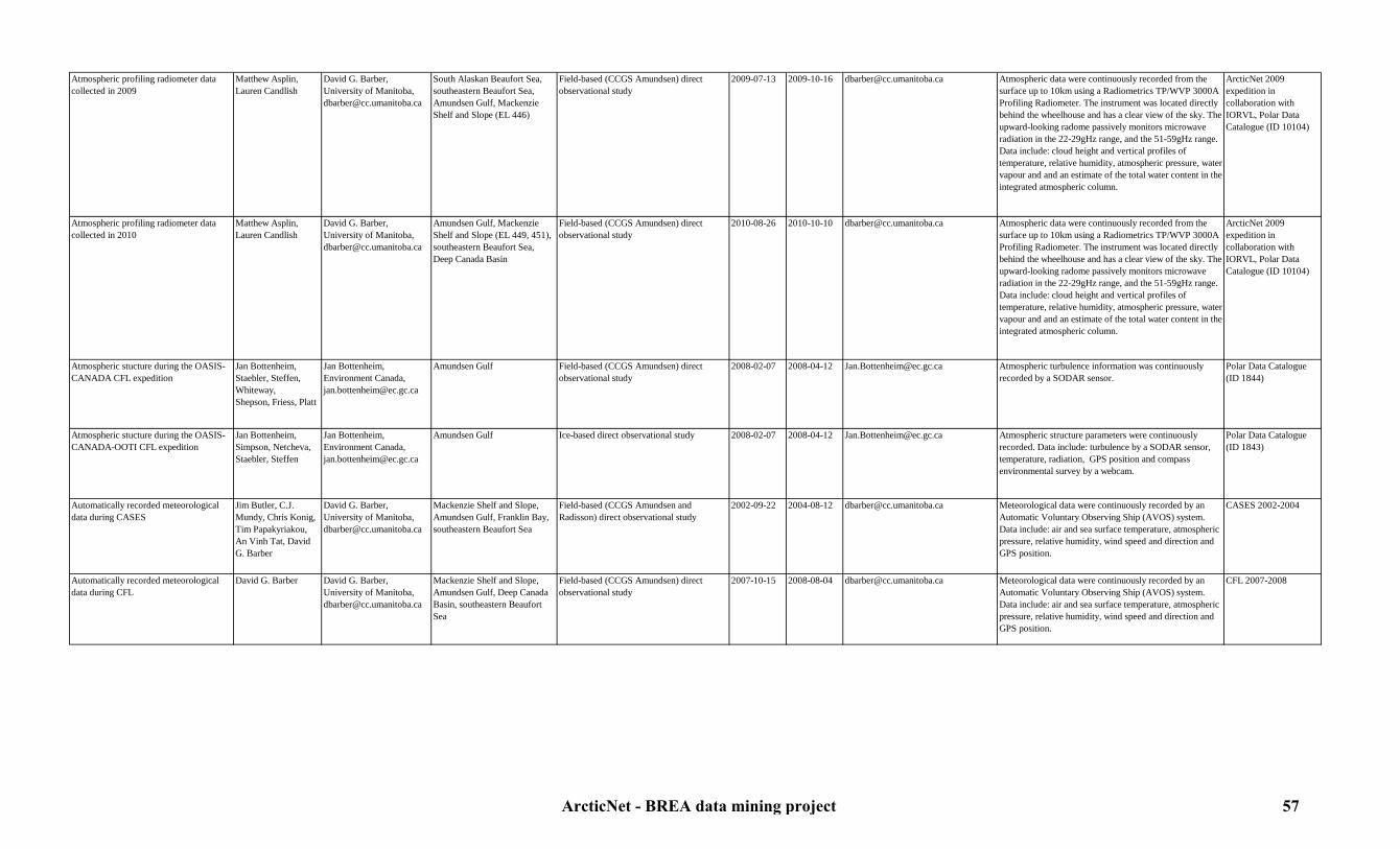
Atmospheric profiling radiometer data collected in 2009
Matthew Asplin,Lauren Candlish
David G. Barber, University of Manitoba, [email protected]
South Alaskan Beaufort Sea, southeastern Beaufort Sea, Amundsen Gulf, Mackenzie Shelf and Slope (EL 446)
Field-based (CCGS Amundsen) direct observational study
2009-07-13 2009-10-16 [email protected] Atmospheric data were continuously recorded from the surface up to 10km using a Radiometrics TP/WVP 3000A Profiling Radiometer. The instrument was located directly behind the wheelhouse and has a clear view of the sky. The upward-looking radome passively monitors microwave radiation in the 22-29gHz range, and the 51-59gHz range. Data include: cloud height and vertical profiles of temperature, relative humidity, atmospheric pressure, water vapour and and an estimate of the total water content in the integrated atmospheric column.
ArcticNet 2009 expedition in collaboration with IORVL, Polar Data Catalogue (ID 10104)
Atmospheric profiling radiometer data collected in 2010
Matthew Asplin,Lauren Candlish
David G. Barber, University of Manitoba, [email protected]
Amundsen Gulf, Mackenzie Shelf and Slope (EL 449, 451), southeastern Beaufort Sea, Deep Canada Basin
Field-based (CCGS Amundsen) direct observational study
2010-08-26 2010-10-10 [email protected] Atmospheric data were continuously recorded from the surface up to 10km using a Radiometrics TP/WVP 3000A Profiling Radiometer. The instrument was located directly behind the wheelhouse and has a clear view of the sky. The upward-looking radome passively monitors microwave radiation in the 22-29gHz range, and the 51-59gHz range. Data include: cloud height and vertical profiles of temperature, relative humidity, atmospheric pressure, water vapour and and an estimate of the total water content in the integrated atmospheric column.
ArcticNet 2009 expedition in collaboration with IORVL, Polar Data Catalogue (ID 10104)
Atmospheric stucture during the OASIS-CANADA CFL expedition
Jan Bottenheim, Staebler, Steffen, Whiteway, Shepson, Friess, Platt
Jan Bottenheim, Environment Canada, [email protected]
Amundsen Gulf Field-based (CCGS Amundsen) direct observational study
2008-02-07 2008-04-12 [email protected] Atmospheric turbulence information was continuously recorded by a SODAR sensor.
Polar Data Catalogue (ID 1844)
Atmospheric stucture during the OASIS-CANADA-OOTI CFL expedition
Jan Bottenheim, Simpson, Netcheva,Staebler, Steffen
Jan Bottenheim, Environment Canada, [email protected]
Amundsen Gulf Ice-based direct observational study 2008-02-07 2008-04-12 [email protected] Atmospheric structure parameters were continuously recorded. Data include: turbulence by a SODAR sensor, temperature, radiation, GPS position and compass environmental survey by a webcam.
Polar Data Catalogue (ID 1843)
Automatically recorded meteorological data during CASES
Jim Butler, C.J. Mundy, Chris Konig, Tim Papakyriakou, An Vinh Tat, David G. Barber
David G. Barber, University of Manitoba, [email protected]
Mackenzie Shelf and Slope, Amundsen Gulf, Franklin Bay, southeastern Beaufort Sea
Field-based (CCGS Amundsen and Radisson) direct observational study
2002-09-22 2004-08-12 [email protected] Meteorological data were continuously recorded by an Automatic Voluntary Observing Ship (AVOS) system. Data include: air and sea surface temperature, atmospheric pressure, relative humidity, wind speed and direction and GPS position.
CASES 2002-2004
Automatically recorded meteorological data during CFL
David G. Barber David G. Barber, University of Manitoba, [email protected]
Mackenzie Shelf and Slope, Amundsen Gulf, Deep Canada Basin, southeastern Beaufort Sea
Field-based (CCGS Amundsen) direct observational study
2007-10-15 2008-08-04 [email protected] Meteorological data were continuously recorded by an Automatic Voluntary Observing Ship (AVOS) system. Data include: air and sea surface temperature, atmospheric pressure, relative humidity, wind speed and direction and GPS position.
CFL 2007-2008
ArcticNet - BREA data mining project 57

Automatically recorded meteorological data during JOIS
Jane Eert, Svien Vagle, Celine Gueguen, Patricia Ramlal, Sarah Zimmermann
Jane Eert, Department of Fisheries and Oceans Canada, [email protected], Svien Vagle, Department of Fisheries and Oceans Canada, [email protected], Celine Gueguen, Trent University, [email protected]
Alaskan Slope and Shelf, Deep Canada Basin, Mackenzie Shelf and Slope, North Beaufort Sea
Field-based (CCGS Louis St-Laurent) direct observational study
2007-07-26 2010-10-15 [email protected], [email protected], [email protected]
Meteorological data were continuously recorded by an Automatic Voluntary Observing Ship (AVOS) system. Data include: air and sea surface temperature, atmospheric pressure, relative humidity, wind speed and direction and GPS position.
JOIS 2007-2010
Automatically recorded meteorological data in 2005
David G. Barber David G. Barber, University of Manitoba, [email protected]
Amundsen Gulf, Mackenzie Shelf and Slope, southeastern Beaufort Sea
Field-based (CCGS Amundsen) direct observational study
2005-09-01 2005-09-14 [email protected] Meteorological data were continuously recorded by an Automatic Voluntary Observing Ship (AVOS) system. Data include: air and sea surface temperature, atmospheric pressure, relative humidity, wind speed and direction and GPS position.
ArcticNet 2005
Automatically recorded meteorological data in 2006
David G. Barber David G. Barber, University of Manitoba, [email protected]
Amundsen Gulf, Mackenzie Shelf and Slope, southeastern Beaufort Sea
Field-based (CCGS Amundsen) direct observational study
2006-09-30 2006-10-19 [email protected] Meteorological data were continuously recorded by an Automatic Voluntary Observing Ship (AVOS) system. Data include: air and sea surface temperature, atmospheric pressure, relative humidity, wind speed and direction and GPS position.
ArcticNet 2006
Automatically recorded meteorological data in 2009
David G. Barber David G. Barber, University of Manitoba, [email protected]
Southeastern Beaufort Sea, Amundsen Gulf, Mackenzie Shelf and Slope (EL 446), Deep Canada Basin
Field-based (CCGS Amundsen) direct observational study
2009-07-13 2009-10-16 [email protected] Meteorological data were continuously recorded by an Automatic Voluntary Observing Ship (AVOS) system. Data include: air and sea surface temperature, atmospheric pressure, relative humidity, wind speed and direction and GPS position.
ArcticNet 2009 expedition in collaboration with IORVL
Automatically recorded meteorological data in 2010
David G. Barber David G. Barber, University of Manitoba, [email protected]
Amundsen Gulf, Mackenzie Shelf and Slope (EL 449, 451), southeastern Beaufort Sea, Deep Canada Basin
Field-based (CCGS Amundsen) direct observational study
2010-08-26 2010-10-10 [email protected] Meteorological data were continuously recorded by an Automatic Voluntary Observing Ship (AVOS) system. Data include: air and sea surface temperature, atmospheric pressure, relative humidity, wind speed and direction and GPS position.
ArcticNet 2010 expedition in collaboration with BP
Ceilometer data in 2010 Matthew Asplin, David G. Barber
David G. Barber, University of Manitoba, [email protected]
Amundsen Gulf, Mackenzie Shelf and Slope (EL 449, 451), southeastern Beaufort Sea, Deep Canada Basin
Field-based (CCGS Amundsen) direct observational study
2010-08-26 2010-10-10 [email protected] The Vaisala CT25K laser ceilometer was located on top of the bridge and measured cloud height and vertical visibility using pulsed diode laser LIDAR (Light Detection And Ranging) technology.
ArcticNet 2010 expedition in collaboration with BP
Ceilometer data during CASES David G. Barber David G. Barber, University of Manitoba, [email protected]
Mackenzie Shelf, Amundsen Gulf, Franklin Bay southeastern Beaufort Sea
Field-based (CCGS Amundsen) direct observational study
2003-09-24 2004-08-12 [email protected] The Vaisala CT25K laser ceilometer was located on top of the bridge and measured cloud height and vertical visibility using pulsed diode laser LIDAR (Light Detection And Ranging) technology.
CASES 2003-2004
Ceilometer data during CFL David G. Barber David G. Barber, University of Manitoba, [email protected]
Mackenzie Shelf and Slope, Amundsen Gulf, Deep Canada Basin, southeastern Beaufort Sea
Field-based (CCGS Amundsen) direct observational study
2007-10-15 2008-08-04 [email protected] The Vaisala CT25K laser ceilometer was located on top of the bridge and measured cloud height and vertical visibility using pulsed diode laser LIDAR (Light Detection And Ranging) technology.
CFL 2007-2008, Polar Data Catalogue (ID 1571)
Ceilometer data in 2005 David G. Barber, Tim Papakyriakou
David G. Barber, University of Manitoba, [email protected]
Amundsen Gulf, Mackenzie Shelf and Slope, southeastern Beaufort Sea
Field-based (CCGS Amundsen) direct observational study
2005-09-01 2005-09-14 [email protected] The Vaisala CT25K laser ceilometer was located on top of the bridge and measured cloud height and vertical visibility using pulsed diode laser LIDAR (Light Detection And Ranging) technology.
ArcticNet 2005
ArcticNet - BREA data mining project 58

Ceilometer data in 2006 David G. Barber, Tim Papakyriakou
David G. Barber, University of Manitoba, [email protected]
Amundsen Gulf, Mackenzie Shelf and Slope, southeastern Beaufort Sea
Field-based (CCGS Amundsen) direct observational study
2006-09-30 2006-10-19 [email protected] The Vaisala CT25K laser ceilometer was located on top of the bridge and measured cloud height and vertical visibility using pulsed diode laser LIDAR (Light Detection And Ranging) technology.
ArcticNet 2006
Ceilometer data in 2009 Matthew Asplin,Lauren Candlish
David G. Barber, University of Manitoba, [email protected]
Southeastern Beaufort Sea, Amundsen Gulf, Mackenzie Shelf and Slope (EL 446)
Field-based (CCGS Amundsen) direct observational study
2009-07-15 2009-10-16 [email protected] The Vaisala CT25K laser ceilometer was located on top of the bridge and measured cloud height and vertical visibility using pulsed diode laser LIDAR (Light Detection And Ranging) technology.
ArcticNet 2009 expedition in collaboration with IORVL and MALINA, Polar Data Catalogue (ID 10105)
Climate and environmental data in 2005 Laurier Poissant Laurier Poissant, Environment Canada, [email protected]
Southeastern Beaufort Sea, Mackenzie Shelf and Slope, Amundsen Gulf
Field-based (CCGS Amundsen) direct observational study
2005-09-01 2005-09-14 [email protected] Meteorological data from weather sensors (temperature, humidity, radiations, winds).
Polar Data Catalogue (ID 1218)
Cloud physics and atmospheric observations during CASES
David G. Barber, Alexandre Langlois, Owen Owens, An Vinh Tat
David G. Barber, University of Manitoba, [email protected]
Franklin Bay (Amundsen Gulf) Field-based (CCGS Amundsen) direct observational study
2003-11-26 2004-01-06 [email protected] Visual observations of cloud cover and types, atmospheric pressure, horizontal visibility and precipitations (type and amount) were noted hourly.
CASES 2003-2004
ENVISAT (MERIS sensor) satellite atmospheric data
European Space Agency (ESA)
European Space Agency (ESA), http://earth.esa.int/cgi-bin/contactus
All Beaufort Sea Remote sensing study 2002-03-01 In progress http://envisat.esa.int/instruments/meris/ Remote sensing dataset for cloud type and optical thickness, cloud top height, cloud top albedo and water vapour.
MERIS data set
Ice surface winds data in 2009 David G. Barber, Tim Papakyriakou
David G. Barber, University of Manitoba, [email protected]
Mackenzie Shelf and Slope, Amundsen Gulf, southeastern Beaufort Sea
Ice-based direct observational study 2009-08-31 2009-09-09 [email protected], [email protected]
A CSAT3 3-D ultrasonic anemometer was deployed on the ice to measure wind speed in three dimensions, average horizontal wind speed and direction or turbulent fluctuations of horizontal and vertical wind.
ArcticNet 2009 expedition in collaboration with IORVL
Marine wind prognosis charts and digital data
Arctic Weather Centre
Ells LeDrew, CCIN, [email protected]
Canadian Beaufort Sea Database 1998-07-01 1998-10-31 [email protected] The dataset consists of data files and charts of experimental marine wind prognosis documenting cryospheric variability in the Canadian Arctic during the extreme warm summer of 1998.
Polar Data Catalogue (ID 1815)
Meteorological Ocean Buoys (MOBs) data during CFL
Mukesh Gupta,David G. Barber,Natalie Asselin, Klaus Hochheim,Lauren Candlish
David G. Barber, University of Manitoba, [email protected]
Mackenzie Shelf and Slope, Amundsen Gulf, Deep Canada Basin, southeastern Beaufort Sea
Field-based (buoys deployed from The CCGS Amundsen) direct observational study
2008-06-16 2008-07-30 [email protected] Buoys were used to investigate sea surface roughness conditions. Accelerometers were used to generate a 3-dimensional wave-spectrum time series. A Vaisala ultrasonic wind sensor measured surface wind speed and direction. A GPS receiver on the top of the buoy, and a radio transmitter transmitted a signal every 15 minutes.
CFL 2007-2008, Polar Data Catalogue (ID 1411)
Meteorological Ocean Buoys (MOBs) data in 2009
David G. Barber, Tim N. Papakyriakou
David G. Barber, University of Manitoba, [email protected]
Mackenzie Slope (EL 446) Field-based (buoys deployed from The CCGS Amundsen) direct observational study
2009-07-20 2009-09-29 [email protected] Buoys were used to investigate sea surface roughness conditions. Accelerometers were used to generate a 3-dimensional wave-spectrum time series. A Vaisala ultrasonic wind sensor measured surface wind speed and direction. A GPS receiver on the top of the buoy, and a radio transmitter transmitted a signal every 15 minutes.
ArcticNet 2009 expedition in collaboration with IORVL
ArcticNet - BREA data mining project 59

MODIS satellite data NASA Jack Xiong,MODIS Project Scientist, [email protected]
All Beaufort Sea Remote sensing study 2002-05-04 In progress http://modis.gsfc.nasa.gov/data/dataprod/index.php
Remote sensing dataset for total precipitable water (water vapor), cloud product, atmospheric profiles and cloud mask.
MODIS data set
Polar Continental Shelf Project (PCSP) weather observations
David Atkinson Ells LeDrew, CCIN, [email protected]
Canadian Beaufort Sea Database 1974-01-01 1993-12-31 [email protected] Approximately 53 000 weather observations were taken from 600 unique sites throughout the Canadian Arctic Archipelago. Individual time series include dry-bulb temperature, wind direction and speed, total cloud cover and screen-height dry-bulb temperature.
Polar Data Catalogue (ID 1818)
Precipitations data during CASES An Vinh Tat, David G. Barber
David G. Barber, University of Manitoba, [email protected]
Mackenzie Shelf and Slope, Amundsen Gulf, Franklin Bay, southeastern Beaufort Sea
Field-based (CCGS Amundsen) direct observational study
2003-11-07 2004-01-06 [email protected] Rain and snow precipitations were measured using a Nipher precipitation gauge.
CASES 2003-2004
Precipitations data during CFL Mukesh Gupta,Matthew Asplin,Lauren Candlish, David G. Barber
David G. Barber, University of Manitoba, [email protected]
Mackenzie Shelf and Slope, Amundsen Gulf, Deep Canada Basin, southeastern Beaufort Sea
Field-based (CCGS Amundsen) direct observational study
2007-10-15 2008-08-04 [email protected] Rain and snow precipitations were measured using a laser precipitation gauge.
Polar Data Catalogue (ID 1556)
Precipitations data in 2009 Matthew Asplin,Lauren Candlish, David G. Barber
David G. Barber, University of Manitoba, [email protected]
Southeastern Beaufort Sea, Amundsen Gulf, Mackenzie Shelf and Slope (EL 446)
Field-based (CCGS Amundsen) direct observational study
2009-07-15 2009-10-16 [email protected] Rain and snow precipitations were measured using a laser precipitation gauge.
ArcticNet 2009 expedition in collaboration with IORVL, Polar Data Catalogue (ID 10103)
Precipitations data in 2010 Matthew Asplin,Lauren Candlish, David G. Barber
David G. Barber, University of Manitoba, [email protected]
Amundsen Gulf, Mackenzie Shelf and Slope (EL 449, 451), southeastern Beaufort Sea, Deep Canada Basin
Field-based (CCGS Amundsen) direct observational study
2010-08-26 2010-10-10 [email protected] Rain and snow precipitations were measured using a laser precipitation gauge.
ArcticNet 2010 expedition in collaboration with BP
ArcticNet - BREA data mining project 60

7.2. Ice and physical oceanography7.2.1. Snow and ice
Table 5: Snow and ice metadataStudy Originators Contact person Study area Type of study Begin date End date Link to data Details Reference
Aerial ice images during CASES David G. Barber David G. Barber, University of Manitoba, [email protected]
Mackenzie Shelf and Slope, Amundsen Gulf, Franklin Bay, southeastern Beaufort Sea
Helicopter-based direct observational study 2002-09-22 2002-10-14 [email protected] A CANON DV camera was mounted on the helicopter skid gear to record continuous images of the surface roughness, snow distribution and melt pond distribution.
CASES 2002
Aerial ice images during CFL David G. Barber David G. Barber, University of Manitoba, [email protected]
Mackenzie Shelf and Slope, Amundsen Gulf, Deep Canada Basin, southeastern Beaufort Sea
Helicopter-based direct observational study 2008-04-08 2008-06-03 [email protected] A CANON DV camera was mounted on the helicopter skid gear to record continuous images of the surface roughness, snow distribution and melt pond distribution.
CFL 2007-2008
Aerial ice images in 2009 David G. Barber David G. Barber, University of Manitoba, [email protected]
Southeastern Beaufort Sea, Amundsen Gulf, Mackenzie Shelf and Slope (EL 446), Deep Canada Basin
Helicopter-based direct observational study 2009-07-23 2009-10-03 [email protected] A CANON DV camera was mounted on the helicopter skid gear to record continuous images of the surface roughness, snow distribution and melt pond distribution.
ArcticNet 2009 expedition in collaboration with IORVL
Aerial ice images in 2010 David G. Barber David G. Barber, University of Manitoba, [email protected]
North of Cape Bathurst (Mackenzie Shelf, Amundsen Gulf)
Helicopter-based direct observational study 2010-08-18 2010-08-18 [email protected] A CANON DV camera was mounted on the helicopter skid gear to record continuous images of the surface roughness, snow distribution and melt pond distribution.
ArcticNet 2010 expedition in collaboration with BP
Aerial ice surface images during JOIS Jennifer Hutchings, Alice Orlich, Kazutaka Tataeyama, Kohei Mizobata
Jennifer Hutchings, International Arctic Research Center, [email protected], Kohei Mizobata, Tokyo University of Marine Science and Technology, [email protected]
Alaskan Slope and Shelf, Deep Canada Basin, Mackenzie Shelf and Slope, North Beaufort Sea
Helicopter-based direct observational study 2006-07-20 2010-10-13 [email protected], [email protected]
During helicopter flights, notes were taken of ice coverage and distribution, types and state of melt. Photographs were taken as a record of ice conditions.
JOIS 2006-2010
Blowing snow data during CASES Mark Gordon, Peter Taylor
David G. Barber, University of Manitoba, [email protected]
Franklin Bay (Amundsen Gulf) Ice-based direct observational study 2004-02-18 2004-03-31 [email protected] Snow depth and number of particles were measured using a spectrum radio (RF400).
CASES 2003-2004
Canadian Ice Service Archive (CISA) The Canadian Ice Service and contributors
ArcticNet Data Manager, [email protected]
Canadian Beaufort Sea Database 1968-01-01 2009-01-01 http://www.ice.ec.gc.ca/app/WsvPageDsp.cfm?id=11872&Lang=eng
Historical dataset of climatic ice atlases and ice cover graphs.
Polar Data Catalogue (ID 1176)
Canadian snow data CD by province Meteorological Service of Canada, Environment Canada
Ells LeDrew, CCIN, [email protected]
Canadian Beaufort Sea Database 1956-01-01 2003-07-31 [email protected] Database include daily ruler measurements of snow depth and Snow Water Equivalent (SWE) and snow depth measurements from snow surveys taken weekly, biweekly or monthly.
Polar Data Catalogue (ID 1744)
C-band scatterometer experiment data during CASES
Philip Hwang, David G. Barber, Ken Asmus
David G. Barber, University of Manitoba, [email protected]
Mackenzie Shelf and Slope, Amundsen Gulf, Franklin Bay, southeastern Beaufort Sea
Field-based (CCGS Amundsen) direct observational study
2003-10-18 2004-08-05 [email protected] A C-band polarimetric scatterometer collected the backscattering signature of new ice, first year ice, and multiyear ice. This instrument was mounted on the port side of the ship. Incidence angles ranged from 20 to 60 degrees in 5 degree steps, with a swath of 60 degrees in the azimuth. Several scans were collected for statistical purposes (generally 5).
CASES 2003-2004
ArcticNet - BREA data mining project 61

C-band scatterometer experiment data during CFL
David G. Barber,Dustin Isleifson, Klaus Hochheim, Mukesh Gupta,
David G. Barber, University of Manitoba, [email protected]
Mackenzie Shelf and Slope, Amundsen Gulf, Deep Canada Basin, southeastern Beaufort Sea
Field-based (CCGS Amundsen) direct observational study
2007-10-18 2008-08-07 [email protected] A C-band polarimetric scatterometer collected the backscattering signature of new ice, first year ice, and multiyear ice. This instrument was mounted on the port side of the ship. Incidence angles ranged from 20 to 60 degrees in 5 degree steps, with a swath of 60 degrees in the azimuth. Several scans were collected for statistical purposes (generally 5).
CFL 2007-2008, Polar Data Catalogue (ID 1412)
C-band scatterometer experiment data in 2005
David G. Barber, Tim Papakyriakou, Jens Ehn, Philip Hwang, Xin Jin
Tim Papakyriakou, University of Manitoba, [email protected], David G. Barber, University of Manitoba, [email protected]
Amundsen Gulf, Mackenzie Shelf and Slope, southeastern Beaufort Sea
Field-based (CCGS Amundsen) direct observational study
2005-09-01 2005-09-14 [email protected], [email protected]
A C-band polarimetric scatterometer collected the backscattering signature of new ice, first year ice, and multiyear ice. This instrument was mounted on the port side of the ship. Incidence angles ranged from 20 to 60 degrees in 5 degree steps, with a swath of 60 degrees in the azimuth. Several scans were collected for statistical purposes (generally 5).
ArcticNet 2005
C-band scatterometer experiment data in 2006
Tim Papakyriakou, David G. Barber
Tim Papakyriakou, University of Manitoba, [email protected], David G. Barber, University of Manitoba, [email protected]
Amundsen Gulf, Mackenzie Shelf and Slope, southeastern Beaufort Sea
Field-based (CCGS Amundsen) direct observational study
2006-09-30 2006-10-19 [email protected], [email protected]
A C-band polarimetric scatterometer collected the backscattering signature of new ice, first year ice, and multiyear ice. This instrument was mounted on the port side of the ship. Incidence angles ranged from 20 to 60 degrees in 5 degree steps, with a swath of 60 degrees in the azimuth. Several scans were collected for statistical purposes (generally 5).
ArcticNet 2006
C-band scatterometer experiment data in 2009
Mukesh Gupta,Dustin Isleifson,Klaus Hochheim, David G. Barber
David G. Barber, University of Manitoba, [email protected]
Southeastern Beaufort Sea, Amundsen Gulf, Mackenzie Shelf and Slope (EL 446)
Field-based (CCGS Amundsen) direct observational study
2009-07-15 2009-10-16 [email protected] A C-band polarimetric scatterometer collected the backscattering signature of new ice, first year ice, and multiyear ice. This instrument was mounted on the port side of the ship. Incidence angles ranged from 20 to 60 degrees in 5 degree steps, with a swath of 60 degrees in the azimuth. Several scans were collected for statistical purposes (generally 5).
Polar Data Catalogue (ID 10109), ArcticNet 2009 expedition in collaboration with IORVL
C-band scatterometer experiment data in 2010
David G. Barber David G. Barber, University of Manitoba, [email protected]
Deep Canada Basin Field-based (CCGS Amundsen) direct observational study
2010-08-18 2010-08-18 [email protected] A C-band polarimetric scatterometer collected the backscattering signature of new ice, first year ice, and multiyear ice. This instrument was mounted on the port side of the ship. Incidence angles ranged from 20 to 60 degrees in 5 degree steps, with a swath of 60 degrees in the azimuth. Several scans were collected for statistical purposes (generally 5).
ArcticNet 2010 expedition in collaboration with BP
ENVISAT (MERIS sensor) snow and ice satellite data
European Space Agency (ESA)
European Space Agency (ESA), http://earth.esa.int/cgi-bin/contactus
All Beaufort Sea Remote sensing study 2002-03-01 In progress http://envisat.esa.int/instruments/meris/ Remote sensing imagery dataset for mapping of sea ice cover.
MERIS dataset
GPS ice motion beacon data collected during CFL
Matthew Asplin,Phil Hwang,Klaus Hochheim,Lauren Candlish,David G. Barber
David G. Barber, University of Manitoba, [email protected]
Mackenzie Shelf and Slope, Amundsen Gulf, Deep Canada Basin, southeastern Beaufort Sea
Ice-based and remote sensing direct observational study
2007-11-15 2008-08-12 [email protected] Ice motion data were recorded from the Oceanetic (1989) model 703 Iridium Ice tracking beacons, or ‘ice drift beacons’. Beacon life expectancy was on the order of 10 months for continuous operation, although the measurement duration is typically less as the beacons will sink if the ice floe they are installed upon melts or breaks up. GPS positions and time and date stamps were reported and transmitted through a Short Burst Data (SBD) packet to the Iridium modem system by email.
Polar Data Catalogue (ID 1569)
ArcticNet - BREA data mining project 62
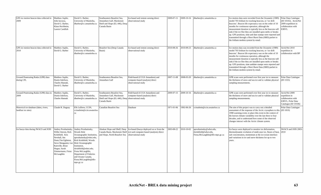
GPS ice motion beacon data collected in 2009
Matthew Asplin,John Iacozza,David G. Barber,Klaus Hochheim,Lauren Candlish
David G. Barber, University of Manitoba, [email protected]
Southeastern Beaufort Sea, Amundsen Gulf, Mackenzie Shelf and Slope (EL 446), Deep Canada Basin
Ice-based and remote sensing direct observational study
2009-07-15 2009-10-16 [email protected] Ice motion data were recorded from the Oceanetic (1989) model 703 Iridium Ice tracking beacons, or ‘ice drift beacons’. Beacon life expectancy was on the order of 10 months for continuous operation, although the measurement duration is typically less as the beacons will sink if the ice floe they are installed upon melts or breaks up. GPS positions, time and date stamps were reported and transmitted through a Short Burst Data (SBD) packet to the Iridium modem system by email.
Polar Data Catalogue (ID 10102), ArcticNet 2009 expedition in collaboration with IORVL
GPS ice motion beacon data collected in 2010
Matthew Asplin, David G. Barber
David G. Barber, University of Manitoba, [email protected]
Beaufort Sea (Deep Canada Basin)
Ice-based and remote sensing direct observational study
2010-08-26 2010-09-23 [email protected] Ice motion data was recorded from the Oceanetic (1989) model 703 Iridium Ice tracking beacons, or ‘ice drift beacons’. Beacon life expectancy was on the order of 10 months for continuous operation, although the measurement duration is typically less as the beacons will sink if the ice floe they are installed upon melts or breaks up. GPS positions, time anddate stamps were reported and transmitted through a Short Burst Data (SBD) packet to the Iridium modem system by email.
ArcticNet 2010 expedition in collaboration with BP
Ground Penetrating Radar (GPR) data during CFL
Matthew Asplin,Dustin Isleifson,Charles Hannah, David G. Barber
David G. Barber, University of Manitoba, [email protected]
Southeastern Beaufort Sea, Amundsen Gulf
Field-based (CCGS Amundsen) and computer-based (analysis) direct observational study
2007-11-08 2008-03-20 [email protected] GPR scans were performed over first year ice to measure the thickness of snow and sea ice and to validate physical sampling measurements.
Polar Data Catalogue (ID 1555)
Ground Penetrating Radar (GPR) data in 2009
Matthew Asplin,Dustin Isleifson,Charles Hannah
David G. Barber, University of Manitoba, [email protected]
Southeastern Beaufort Sea, Amundsen Gulf, Mackenzie Shelf and Slope (EL 446), Deep Canada Basin
Field-based (CCGS Amundsen) and computer-based (analysis) direct observational study
2009-07-15 2009-10-16 [email protected] GPR scans were performed over first year ice to measure the thickness of snow and sea ice and to validate physical sampling measurements.
ArcticNet 2009 expedition in collaboration with IORVL, Polar Data Catalogue (ID 10106)
Historical ice database (lakes, rivers, landfast ice sites)
Claude R. Duguay Ells LeDrew, CCIN, [email protected]
Canadian Beaufort Sea Database 1971-01-06 1992-06-26 [email protected] The aim of this project was to carry out a detailed assessment of the response of the Arctic cryosphere to this 1998 warming event, to place this event in the context of the known climate variability over the last three to four decades, and to understand how some of the observed changes interact with the Arctic climate system.
Polar Data Catalogue (ID 1810)
Ice buoys data during JWACS and JOIS Andrey Proshutinsky, Willie Ostrom, Rick Krishfield, Kris Newhall, Jim Dunn,Tim Eglinton, Steve Manganini, Luc Rainville, Brian Hogue, Sarah Zimmermann, Fiona McLaughlin
Andrey Proshutinsky, Woods Hole Oceanographic Institution, [email protected], Rick Krishfield, Woods Hole Oceanographic Institution, [email protected], Fiona McLaughlin, Department of Fisheries and Oceans Canada, [email protected]
Alaskan Slope and Shelf, Deep Canada Basin, Mackenzie Shelf and Slope, North Beaufort Sea
Ice-based (buoys deployed on or from the ice) and computer-based (analysis) direct observational study
2003-08-22 2010-10-02 [email protected], [email protected], [email protected]
Ice buoys were deployed to monitor ice deformation, thermodynamic evolution of multi-year ice, fluxes of heat, salt concentration, momentum at the ice-ocean interface and variations in ice and snow thickness for up to two years.
JWACS and JOIS 2003-2010
ArcticNet - BREA data mining project 63

Ice data from moorings during CFL Luc Michaud, Sylvain Blondeau, Pascal Massot, David G. Barber
David G. Barber, University of Manitoba, [email protected]
Mackenzie slope, Amundsen Gulf, Stations CA04, CA05, CA16
Field-based (long-term moorings) direct observational study
2007-10-17 2008-07-29 [email protected] Upward Looking Sonars (ULS) were moored for one year and continuously recorded sea ice depth and concentration.
CFL 2007-2008
Ice data from moorings during JOIS/CASES
David Walsh, Humfrey Melling
David Walsh, International Arctic research center, University of Alaska Fairbanks, [email protected], Humfrey Melling,Department of Fisheries and Oceans Canada, [email protected]
Mackenzie Canyon (Mackenzie Shelf), Kugmallut Channel (Amundsen Gulf), Stations ASB, ITC01-1, BMH01-9
Field-based (long-term moorings) direct observational study
2001-09-24 2002-09-11 [email protected], [email protected]
Upward Looking Sonars (ULS) and Ice Profiler Sonars (IPS4, W-IPS) were moored for one year and continuously recorded sea ice depth and concentration.
JOIS/CASES 2002
Ice data from moorings during JWACS and JOIS
Sarah Zimmermann, Fiona McLaughlin, Jane Eert
Fiona McLaughlin, Department of Fisheries and Oceans Canada, [email protected], Jane Eert, [email protected]., Fisheries and Oceans Canada
Alaskan Slope and Shelf, Deep Canada Basin, Mackenzie Shelf and Slope, North Beaufort Sea
Field-based (long-term moorings) direct observational study
2002-X-X 2010-10-11 http://www.whoi.edu/beaufortgyre Upward Looking Sonars (ULS) and Ice Profiler Sonars (IPS) were moored for one year and continuously recorded sea ice depth and concentration.
JWACS and JOIS 2002-2010
Ice data from moorings in 2008-2009 Luc Michaud, Sylvain Blondeau, Pascal Massot, David G. Barber
David G. Barber, University of Manitoba, [email protected]
Mouth of the Amundsen Gulf, Station CA05, CA16
Field-based (long-term moorings) direct observational study
2008-07-25 2009-10-12 [email protected] Upward Looking Sonars (ULS) were moored for one year and continuously recorded sea ice depth and concentration.
ArcticNet 2008-2009
Ice data from moorings in 2009-2010 Luc Michaud, Sylvain Blondeau, Pascal Massot, David G. Barber
David G. Barber, University of Manitoba, [email protected]
Mouth of the Amundsen Gulf, Station CA05, CA16
Field-based (long-term moorings) direct observational study
2009-10-12 2010-09-24 [email protected] Upward Looking Sonars (ULS) were moored for one year and continuously recorded sea ice depth and concentration.
ArcticNet 2009-2010
Ice mass balance buoys data in 2009 David G. Barber David G. Barber, University of Manitoba, [email protected]
Southeastern Beaufort Sea, Amundsen Gulf, Mackenzie Shelf and Slope (EL 446), Deep Canada Basin
Ice-based and remote sensing direct observational study
2009-09-09 2009-10-16 [email protected] The sea ice mass balance systems remotely measured physical properties of the floe in which they were installed as well as some basic meteorological variables and geographic position. Data include: sea ice temperature, 2m air temperature, sea level presure, bottom thickness change, surface thickness change and GPS position. Data were transmitted to a remote logging computer at CEOS in Winnipeg via iridium satellite modem communication.
ArcticNet 2009 expedition in collaboration with IORVL
Ice observations data during JOIS Jennifer Hutchings, Alice Orlich, Kazutaka Tataeyama, Kohei Mizobata
Jennifer Hutchings, [email protected], Kohei Mizobata, [email protected]
Alaskan Slope and Shelf, Deep Canada Basin, Mackenzie Shelf and Slope, North Beaufort Sea
Field-based (CCGS Louis St-Laurent) direct observational study
2006-07-20 2010-10-13 [email protected], [email protected]
Every hour an observation of ice conditions was recorded. Each observation was made from the bridge, and photos were taken to document the pack ice. RADAR was used to estimate concentration of ice types, and lead information.
JOIS 2006-2010
ArcticNet - BREA data mining project 64
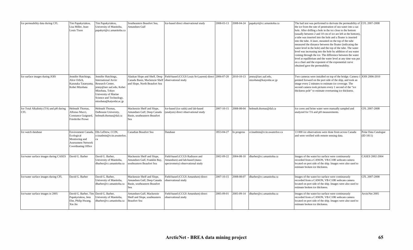
Ice permeability data during CFL Tim Papakyriakou, Lisa Miller, Jean-Louis Tison
Tim Papakyriakou, University of Manitoba, [email protected]
Southeastern Beaufort Sea, Amundsen Gulf
Ice-based direct observational study 2008-03-13 2008-04-24 [email protected] The bail test was performed to derivate the permeability of the ice from the rate of penetration of sea water into a sac hole. After drilling a hole in the ice close to the bottom (usually between 2 and 10 cm of ice are left at the bottom), a tube was inserted into the hole and a floater is inserted into the tube. A laser, mounted on the top of the tube measured the distance between the floater (indicating the water level in the hole) and the top of the tube. The water level was increasing into the hole by addition of sea water coming through the ice. The difference between the water level at equilibrium and the water level at any time was put on a chart and the exponent of the exponential curve obtained gave the permeability.
CFL 2007-2008
Ice surface images during JOIS Jennifer Hutchings, Alice Orlich, Kazutaka Tataeyama, Kohei Mizobata
Jennifer Hutchings, International Arctic Research Center, [email protected], Kohei Mizobata, Tokyo University of Marine Science and Technology, [email protected]
Alaskan Slope and Shelf, Deep Canada Basin, Mackenzie Shelf and Slope, North Beaufort Sea
Field-based (CCGS Louis St-Laurent) direct observational study
2006-07-20 2010-10-13 [email protected], [email protected]
Two cameras were installed on top of the bridge. Camera 1 pointed forward on the port side of the ship, and took an image every 2 minutes to estimate ice coverage. The second camera took pictures every 1 second of the “ice thickness pole” to estimate overturning ice thickness.
JOIS 2006-2010
Ice Total Alkalinity (TA) and pH during CFL
Helmuth Thomas, Alfonso Mucci, Constance Guignard, Friederike Prowe
Helmuth Thomas, Dalhousie University, [email protected]
Mackenzie Shelf and Slope, Amundsen Gulf, Deep Canada Basin, southeastern Beaufort Sea
Ice-based (ice raids) and lab-based (analysis) direct observational study
2007-10-15 2008-08-04 [email protected] Ice cores and brine water were manually sampled and analyzed for TA and pH measurements.
CFL 2007-2008
Ice watch database Environment Canada, Ecological Monitoring and Assessment Network Coordinating Office
Ells LeDrew, CCIN, [email protected]
Canadian Beaufort Sea Database 1853-04-27 In progress [email protected] 13 000 ice observations were done from across Canada and were verified with remote sensing data.
Polar Data Catalogue (ID 1811)
Ice/water surface images during CASES David G. Barber David G. Barber, University of Manitoba, [email protected]
Mackenzie Shelf and Slope, Amundsen Gulf, Franklin Bay, southeastern Beaufort Sea
Field-based (CCGS Radisson and Amundsen) and lab-based (mass-spectrometry) observational study
2002-09-22 2004-08-10 [email protected] Images of the water/ice surface were continuously recorded from a CANON, VB-C10R webcam camera located on port side of the ship. Images were also used to estimate broken ice thickness.
CASES 2002-2004
Ice/water surface images during CFL David G. Barber David G. Barber, University of Manitoba, [email protected]
Mackenzie Shelf and Slope, Amundsen Gulf, Deep Canada Basin, southeastern Beaufort Sea
Field-based (CCGS Amundsen) direct observational study
2007-10-15 2008-08-07 [email protected] Images of the water/ice surface were continuously recorded from a CANON, VB-C10R webcam camera located on port side of the ship. Images were also used to estimate broken ice thickness.
CFL 2007-2008
Ice/water surface images in 2005 David G. Barber, Tim Papakyriakou, Jens Ehn, Philip Hwang, Xin Jin
David G. Barber, University of Manitoba, [email protected]
Amundsen Gulf, Mackenzie Shelf and Slope, southeastern Beaufort Sea
Field-based (CCGS Amundsen) direct observational study
2005-09-01 2005-09-14 [email protected] Images of the water/ice surface were continuously recorded from a CANON, VB-C10R webcam camera located on port side of the ship. Images were also used to estimate broken ice thickness.
ArcticNet 2005
ArcticNet - BREA data mining project 65

Ice/water surface images in 2006 Tim Papakyriakou, David G. Barber
Tim Papakyriakou, University of Manitoba, [email protected], David G. Barber, University of Manitoba, [email protected]
Amundsen Gulf, Mackenzie Shelf and Slope, southeastern Beaufort Sea
Field-based (CCGS Amundsen) direct observational study
2006-09-30 2006-10-19 [email protected], [email protected]
Images of the water/ice surface were continuously recorded from a CANON, VB-C10R webcam camera located on port side of the ship. Images were also used to estimate broken ice thickness.
ArcticNet 2006
Ice/water surface images in 2009 David G. Barber David G. Barber, University of Manitoba, [email protected]
Southern Alaskan Shelf, southeastern Beaufort Sea, Amundsen Gulf, Mackenzie Shelf and Slope (EL 446)
Field-based (CCGS Amundsen) direct observational study
2009-07-15 2009-10-16 [email protected] Images of the water/ice surface were continuously recorded from a CANON, VB-C10R webcam camera located on port side of the ship. Images were also used to estimate broken ice thickness.
ArcticNet 2009 expedition in collaboration with IORVL and MALINA
Ice/water surface images in 2010 David G. Barber David G. Barber, University of Manitoba, [email protected]
Amundsen Gulf, Mackenzie Shelf and Slope (EL 449, 451), southeastern Beaufort Sea, Deep Canada Basin
Field-based (CCGS Amundsen) direct observational study
2010-08-26 2010-10-10 [email protected] Images of the water/ice surface were continuously recorded from a CANON, VB-C10R webcam camera located on port side of the ship. Images were also used to estimate broken ice thickness.
ArcticNet 2010 expedition in collaboration with BP
Laser profiling or Laser Wave Slope (LAWAS) data during CFL
Mukesh Gupta,Matthew Asplin,David G. Barber, Phil Hwang,Dustin Isleifson
David G. Barber, University of Manitoba, [email protected]
Mackenzie Shelf and Slope, Amundsen Gulf, Deep Canada Basin, southeastern Beaufort Sea
Field-based (CCGS Amundsen) direct observational study
2007-10-18 2008-08-08 [email protected] The ocean/ice surface roughness in marginal ice zone was measured using a laser profiling instrument mounted on the front deck. The profiler also had a motion pack which measured the acceleration in x, y and z directions.
Polar Data Catalogue (ID 1271)
Laser profiling or Laser Wave Slope (LAWAS) data in 2009
Mukesh Gupta,Matthew Asplin,Phil Hwang,Dustin Isleifson
David G. Barber, University of Manitoba, [email protected]
Southeastern Beaufort Sea, Amundsen Gulf, Mackenzie Shelf and Slope (EL 446), Deep Canada Basin
Field-based (CCGS Amundsen) direct observational study
2009-07-15 2009-10-16 [email protected] The ocean/ice surface roughness in marginal ice zone was measured using a laser profiling instrument mounted on the front deck. The profiler also had a motion pack which measured the acceleration in x, y and z directions.
ArcticNet 2009 expedition in collaboration with IORVL, Polar Data Catalogue (ID 10099)
Laser profiling or Laser Wave Slope (LAWAS) data in 2010
David G. Barber David G. Barber, University of Manitoba, [email protected]
Amundsen Gulf, Mackenzie Shelf and Slope (EL 449, 451), southeastern Beaufort Sea, Deep Canada Basin
Field-based (CCGS Amundsen) direct observational study
2010-08-26 2010-10-10 [email protected] The ocean/ice surface roughness in marginal ice zone was measured using a laser profiling instrument mounted on the front deck. The profiler also had a motion pack which measured the acceleration in x, y and z directions.
ArcticNet 2010 expedition in collaboration with BP
Light intensity under various sea ice, snow and solar zenith angle conditions during CFL
David G. Barber, Klaus Hochheim, Andrea Rossnagel,Monika Pucko
David G. Barber, University of Manitoba, [email protected]
Mackenzie Shelf and Slope, Amundsen Gulf, Deep Canada Basin, southeastern Beaufort Sea
Ice-based direct observational study 2008-03-23 2008-08-04 [email protected] The impact of sea ice (and related environmental parameters) on light intensity under various sea ice, snow and solar zenith angle regimes during the spring transition period was measured. Data include: PAR above and under the ice down to 60 m, albedo, snow properties (temperature, grain size, salinity) and upper ocean properties (conductivity and temperature) along with other relevant surface validation data. Measurements were done in fast ice floes, in leads and in the marginal ice zone. The ultimate intent is to extrapolate these observations/results to regional scales.
CFL 2008
Marine hazards and Arctic ice monitoring Humfrey Melling,World Data Center for Glaciology
Humfrey Melling, Department of Fisheries and Oceans, [email protected]
Mackenzie Shelf and Slope, Alaskan Shelf, Deep Canada Basin
Field-based (long-term moorings) direct observational study
1990-01-01 2011-01-01 http://nsidc.org/data/g02177.html; http://imb.crrel.usace.army.mil/thickdat.htm
Ice-Profiling Sonar (IPS), Upward-Looking Sonar (ULS) and ADCP were moored for one or two years and continuously recorded sea ice thickness distribution, concentration, velocity, deep ice keels, rubble fields, vast thick floes, multi-year ice, high ice speeds, storm waves and storm surges.
Polar Data Catalogue (ID 10231)
ArcticNet - BREA data mining project 66

Melt season duration on Canadian Arctic ice caps, 2000-2008
Martin Sharp,Gabriel Wolken,Libo Wang
Gabriel Wolken, Department of Earth and Atmospheric Science, University of Alberta, [email protected]
Canadian Beaufort Sea Database 2000-01-01 2008-01-01 [email protected] This data set contains maps of melt onset, freeze-up, duration, and extent on Canadian Arctic ice caps from 2000-2008. These maps were developed using enhanced resolution QuikSCAT scatterometer data and validated with ground reference data (surface air temperature).
Polar Data Catalogue (ID 1339)
Microwave emissions coming off the sea ice, surface snow and sea water during CASES
Klaus Hocheim,Philip Hwang,David G. Barber, Mukesh Gupta,Dustin Isleifson
David G. Barber, University of Manitoba, [email protected]
Mackenzie Shelf and Slope, Amundsen Gulf, Deep Canada Basin, southeastern Beaufort Sea
Field-based (CCGS Amundsen) and computer-based (analysis) direct observational study
2003-10-10 2004-08-05 [email protected] A surface-based radiometer (SBR) continuously recorded microwave emissions coming off the sea ice, surface snow and sea water. Data were used to study the turbulence in the boundary layer and to identify the type of sea ice.
CASES 2003-2004
Microwave emissions coming off the sea ice, surface snow and sea water during CFL
Klaus Hocheim,Philip Hwang,David G. Barber, Mukesh Gupta,Dustin Isleifson
David G. Barber, University of Manitoba, [email protected]
Mackenzie Shelf and Slope, Amundsen Gulf, Deep Canada Basin, southeastern Beaufort Sea
Field-based (CCGS Amundsen) and computer-based (analysis) direct observational study
2007-10-25 2008-08-01 [email protected] A Surface-Based Radiometer (SBR) continuously recorded microwave emissions coming off the sea ice, surface snow and sea water. Data were used to study the turbulence in the boundary layer and to identify the type of sea ice.
Polar Data Catalogue (ID 1483)
Microwave emissions coming off the sea ice, surface snow and sea water in 2005
David G. Barber, Tim Papakyriakou, Jens Ehn, Philip Hwang, Xin Jin
David G. Barber, University of Manitoba, [email protected]
Amundsen Gulf, Mackenzie Shelf and Slope, southeastern Beaufort Sea
Field-based (CCGS Amundsen) and computer-based (analysis) direct observational study
2005-09-01 2005-09-14 [email protected] A Surface-Based Radiometer (SBR) continuously recorded microwave emissions coming off the sea ice, surface snow and sea water. Data were used to study the turbulence in the boundary layer and to identify the type of sea ice.
ArcticNet 2005
Microwave emissions coming off the sea ice, surface snow and sea water in 2006
Tim Papakyriakou, David G. Barber
David G. Barber, University of Manitoba, [email protected]
Amundsen Gulf, Mackenzie Shelf and Slope, southeastern Beaufort Sea
Field-based (CCGS Amundsen) and computer-based (analysis) direct observational study
2006-09-30 2006-10-19 [email protected] A Surface-Based Radiometer (SBR) continuously recorded microwave emissions coming off the sea ice, surface snow and sea water. Data were used to study the turbulence in the boundary layer and to identify the type of sea ice.
ArcticNet 2006
Microwave emissions coming off the sea ice, surface snow and sea water in 2009
Klaus Hocheim,Mukesh Gupta,Matthew Asplin,Phil Hwang,Dustin Isleifson, David G. Barber
David G. Barber, University of Manitoba, [email protected]
Southeastern Beaufort Sea, Amundsen Gulf, Mackenzie Shelf and Slope (EL 446), Deep Canada Basin
Field-based (CCGS Amundsen) and computer-based (analysis) direct observational study
2009-07-15 2009-10-16 [email protected] A Surface-Based Radiometer (SBR) continuously recorded microwave emissions coming off the sea ice, surface snow and sea water. Data were used to study the turbulence in the boundary layer and to identify the type of sea ice.
ArcticNet 2009 expedition in collaboration with IORVL, Polar Data Catalogue (ID 10097)
Microwave emissions coming off the sea ice, surface snow and sea water in 2010
David G. Barber David G. Barber, University of Manitoba, [email protected]
Amundsen Gulf, Mackenzie Shelf and Slope, southeastern Beaufort Sea, Deep Canada Basin
Field-based (CCGS Amundsen) and computer-based (analysis) direct observational study
2010-08-26 2010-10-10 [email protected] A Surface-Based Radiometer (SBR) continuously recorded microwave emissions coming off the sea ice, surface snow and sea water. Data were used to study the turbulence in the boundary layer and to identify the type of sea ice.
ArcticNet 2010 expedition in collaboration with BP
MODIS snow and ice satellite data NASA Jack Xiong,MODIS Project Scientist, [email protected]
All Beaufort Sea Remote sensing study 2002-05-04 In progress http://modis.gsfc.nasa.gov/data/dataprod/index.php
Remote sensing imagery dataset for snow and sea ice cover
MODIS dataset
Ocean / sea ice surface temperature during CASES
David G. Barber, Tim Papakyriakou, Peter Minnet, Chris Konig, Owen Owens
David G. Barber, University of Manitoba, [email protected]
Mackenzie Shelf and Slope, Amundsen Gulf, Franklin Bay, southeastern Beaufort Sea
Field-based (CCGS Radisson and Amundsen) and computer-based (analysis) direct observational study
2002-09-23 2004-08-12 [email protected] An infrared transducer (interferometer) continuously measured the ocean surface temperature in the infrared region of the electromagnetic spectrum. Measurements of IR over ice and open ocean allowed calculations of heat fluxes over the oceans.
CASES 2002-2004
ArcticNet - BREA data mining project 67
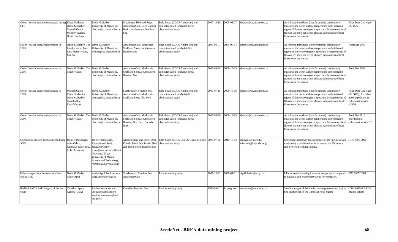
Ocean / sea ice surface temperature during CFL
Klaus Hocheim, David G. Barber,Mukesh Gupta,Matthew Asplin,Dustin Isleifson
David G. Barber, University of Manitoba, [email protected]
Mackenzie Shelf and Slope, Amundsen Gulf, Deep Canada Basin, southeastern Beaufort Sea
Field-based (CCGS Amundsen) and computer-based (analysis) direct observational study
2007-10-15 2008-08-07 [email protected] An infrared transducer (interferometer) continuously measured the ocean surface temperature in the infrared region of the electromagnetic spectrum. Measurements of IR over ice and open ocean allowed calculations of heat fluxes over the oceans.
Polar Data Catalogue (ID 1572)
Ocean / sea ice surface temperature in 2005
David G. Barber, Tim Papakyriakou, Jens Ehn, Philip Hwang, Xin Jin
David G. Barber, University of Manitoba, [email protected]
Amundsen Gulf, Mackenzie Shelf and Slope, southeastern Beaufort Sea
Field-based (CCGS Amundsen) and computer-based (analysis) direct observational study
2005-09-01 2005-09-14 [email protected] An infrared transducer (interferometer) continuously measured the ocean surface temperature in the infrared region of the electromagnetic spectrum. Measurements of IR over ice and open ocean allowed calculations of heat fluxes over the oceans.
ArcticNet 2005
Ocean / sea ice surface temperature in 2006
David G. Barber, Tim Papakyriakou
David G. Barber, University of Manitoba, [email protected]
Amundsen Gulf, Mackenzie Shelf and Slope, southeastern Beaufort Sea
Field-based (CCGS Amundsen) and computer-based (analysis) direct observational study
2006-09-30 2006-10-19 [email protected] An infrared transducer (interferometer) continuously measured the ocean surface temperature in the infrared region of the electromagnetic spectrum. Measurements of IR over ice and open ocean allowed calculations of heat fluxes over the oceans.
ArcticNet 2006
Ocean / sea ice surface temperature in 2009
Mukesh Gupta,Klaus Hochheim,David G. Barber,Ryan Galley,Kerri Warner
David G. Barber, University of Manitoba, [email protected]
Southeastern Beaufort Sea, Amundsen Gulf, Mackenzie Shelf and Slope (EL 446)
Field-based (CCGS Amundsen) and computer-based (analysis) direct observational study
2009-07-15 2009-10-16 [email protected] An infrared transducer (interferometer) continuously measured the ocean surface temperature in the infrared region of the electromagnetic spectrum. Measurements of IR over ice and open ocean allowed calculations of heat fluxes over the oceans.
Polar Data Catalogue (ID 9808), ArcticNet 2009 expedition in collaboration with IORVL
Ocean / sea ice surface temperature in 2010
David G. Barber, Tim Papakyriakou
David G. Barber, University of Manitoba, [email protected]
Amundsen Gulf, Mackenzie Shelf and Slope, southeastern Beaufort Sea, Deep Canada Basin
Field-based (CCGS Amundsen) and computer-based (analysis) direct observational study
2006-09-30 2006-10-19 [email protected] An infrared transducer (interferometer) continuously measured the ocean surface temperature in the infrared region of the electromagnetic spectrum. Measurements of IR over ice and open ocean allowed calculations of heat fluxes over the oceans.
ArcticNet 2010 expedition in collaboration with BP
On-track ice surface measurements during JOIS
Jennifer Hutchings, Alice Orlich, Kazutaka Tataeyama, Kohei Mizobata
Jennifer Hutchings, International Arctic Research Center, [email protected], Kohei Mizobata, Tokyo University of Marine Science and Technology, [email protected]
Alaskan Slope and Shelf, Deep Canada Basin, Mackenzie Shelf and Slope, North Beaufort Sea
Field-based (CCGS Louis St-Laurent) direct observational study
2006-07-20 2010-10-13 [email protected], [email protected]
Continuous underway measurements of ice thickness were made using a passive microwave system, an EM sensor and a forward looking camera.
JOIS 2006-2010
Palsar images from Japanese sattelites during CFL
David G. Barber, André April
André April, Ice forecaster, [email protected]
Southeastern Beaufort Sea, Amundsen Gulf
Remote sensing study 2007-12-21 2008-01-31 [email protected] 8 Palsar remote sensing ice-cover images were compared to Radarsat and local observations for validation.
CFL 2007-2008
RADARSAT-1 SAR imagery of the ice cover
Canadian Space Agency (CSA)
Earth observation and utilization applications section, [email protected]
Canadian Beaufort Sea Remote sensing study 1996-01-01 In progress [email protected] Satellite images of the blanket coverage (snow and ice) in fine beam mode of the Canadian Polar region.
CSA RADARSAT-1 images dataset
ArcticNet - BREA data mining project 68
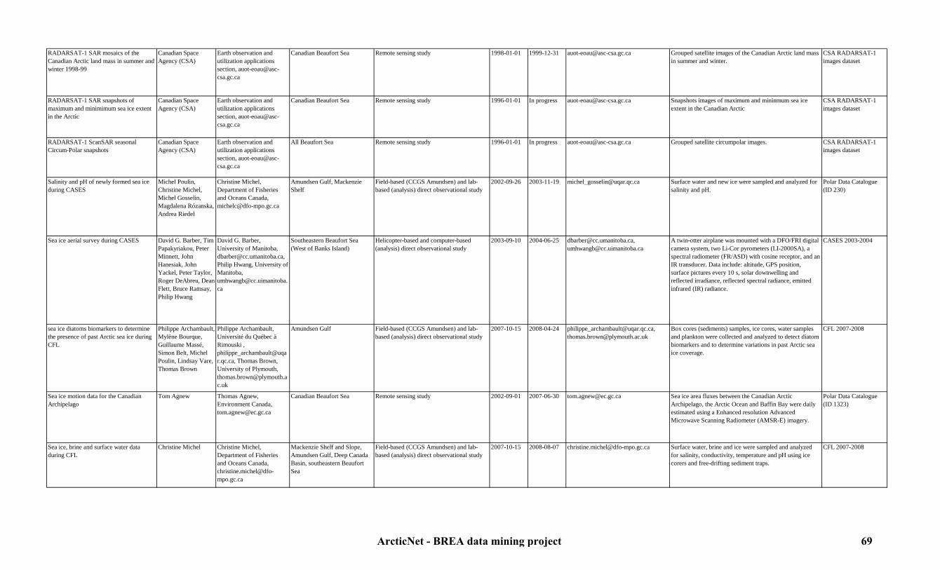
RADARSAT-1 SAR mosaics of the Canadian Arctic land mass in summer and winter 1998-99
Canadian Space Agency (CSA)
Earth observation and utilization applications section, [email protected]
Canadian Beaufort Sea Remote sensing study 1998-01-01 1999-12-31 [email protected] Grouped satellite images of the Canadian Arctic land mass in summer and winter.
CSA RADARSAT-1 images dataset
RADARSAT-1 SAR snapshots of maximum and minimimum sea ice extent in the Arctic
Canadian Space Agency (CSA)
Earth observation and utilization applications section, [email protected]
Canadian Beaufort Sea Remote sensing study 1996-01-01 In progress [email protected] Snapshots images of maximum and mininmum sea ice extent in the Canadian Arctic
CSA RADARSAT-1 images dataset
RADARSAT-1 ScanSAR seasonal Circum-Polar snapshots
Canadian Space Agency (CSA)
Earth observation and utilization applications section, [email protected]
All Beaufort Sea Remote sensing study 1996-01-01 In progress [email protected] Grouped satellite circumpolar images. CSA RADARSAT-1 images dataset
Salinity and pH of newly formed sea ice during CASES
Michel Poulin,Christine Michel,Michel Gosselin,Magdalena Rózanska,Andrea Riedel
Christine Michel, Department of Fisheries and Oceans Canada, [email protected]
Amundsen Gulf, Mackenzie Shelf
Field-based (CCGS Amundsen) and lab-based (analysis) direct observational study
2002-09-26 2003-11-19 [email protected] Surface water and new ice were sampled and analyzed for salinity and pH.
Polar Data Catalogue (ID 230)
Sea ice aerial survey during CASES David G. Barber, Tim Papakyriakou, Peter Minnett, John Hanesiak, John Yackel, Peter Taylor, Roger DeAbreu, Dean Flett, Bruce Ramsay, Philip Hwang
David G. Barber, University of Manitoba, [email protected], Philip Hwang, University of Manitoba,[email protected]
Southeastern Beaufort Sea (West of Banks Island)
Helicopter-based and computer-based (analysis) direct observational study
2003-09-10 2004-06-25 [email protected], [email protected]
A twin-otter airplane was mounted with a DFO/FRI digital camera system, two Li-Cor pyrometers (LI-2000SA), a spectral radiometer (FR/ASD) with cosine receptor, and an IR transducer. Data include: altitude, GPS position, surface pictures every 10 s, solar downwelling and reflected irradiance, reflected spectral radiance, emitted infrared (IR) radiance.
CASES 2003-2004
sea ice diatoms biomarkers to determine the presence of past Arctic sea ice during CFL
Philippe Archambault, Mylène Bourque, Guillaume Massé, Simon Belt, Michel Poulin, Lindsay Vare, Thomas Brown
Philippe Archambault, Université du Québec à Rimouski , [email protected], Thomas Brown, University of Plymouth, [email protected]
Amundsen Gulf Field-based (CCGS Amundsen) and lab-based (analysis) direct observational study
2007-10-15 2008-04-24 [email protected], [email protected]
Box cores (sediments) samples, ice cores, water samples and plankton were collected and analyzed to detect diatom biomarkers and to determine variations in past Arctic sea ice coverage.
CFL 2007-2008
Sea ice motion data for the Canadian Archipelago
Tom Agnew Thomas Agnew, Environment Canada, [email protected]
Canadian Beaufort Sea Remote sensing study 2002-09-01 2007-06-30 [email protected] Sea ice area fluxes between the Canadian Arctic Archipelago, the Arctic Ocean and Baffin Bay were daily estimated using a Enhanced resolution Advanced Microwave Scanning Radiometer (AMSR-E) imagery.
Polar Data Catalogue (ID 1323)
Sea ice, brine and surface water data during CFL
Christine Michel Christine Michel, Department of Fisheries and Oceans Canada,[email protected]
Mackenzie Shelf and Slope, Amundsen Gulf, Deep Canada Basin, southeastern Beaufort Sea
Field-based (CCGS Amundsen) and lab-based (analysis) direct observational study
2007-10-15 2008-08-07 [email protected] Surface water, brine and ice were sampled and analyzed for salinity, conductivity, temperature and pH using ice corers and free-drifting sediment traps.
CFL 2007-2008
ArcticNet - BREA data mining project 69

Snow and ice facies on Canadian Arctic ice caps, 1999-2005
Martin Sharp,Gabriel Wolken
Gabriel Wolken, Department of Earth and Atmospheric Sciences, University of Alberta, [email protected]
Canadian Beaufort Sea Database 1999-01-01 2005-01-01 [email protected] This data set was developed to monitor the interannual variability in snow and ice facies on Canadian Arctic ice caps and provide estimates of relative mass balance between measurement years.It contains maps of snow and ice facies on Canadian Arctic ice caps from 1999-2005. Snow and ice facies maps were interpreted from post-freeze-up bi-weekly averaged backscatter from enhanced resolution QuikSCAT scatterometer data and validated with ground reference data (snow pits and optical remote sensing).
Polar Data Catalogue (ID 1341)
Snow and ice physical properties during CASES
David G. Barber, Tim Papakyriakou, Owen Owens, Alexandre Langlois, An Vinh Tat, C.J. Mundy, Christina Blouw, Chris Konig, Jens Ehn, Ryan Galley, Philip Hwang
David G. Barber, University of Manitoba, [email protected]
Mackenzie Shelf and Slope, Amundsen Gulf, Franklin Bay, southeastern Beaufort Sea
Ice-based (ice-raids) direct observational study
2003-09-24 2004-08-10 [email protected] Snow and ice were sampled manually during ''ice raids''. Collected variables in the snow and/or frost flowers were: Temperature profile, stratified samples for salinity, snow grain samples (photographically analyzed), density (derived by using a known volume physical sample and measuring the weight) and derived liquid water content (measured using a capacitance plate technique). Collected variables in the ice were: Thickness, freeboard, temperature and salinity profiles, microstructural analysis (including vertical for the complete core and horizontal sections in the top layers of drift stations).
CASES 2003-2004
Snow and ice physical properties during CFL
Dustin Isleifson,David G. Barber, Tim Papakyriakou, Mukesh Gupta,Monika Pucko,Matthew Asplin, Natalia Goryunova, Vladimir Shevchenko, Klaus Hochheim, Pascal Collin
David G. Barber, University of Manitoba, [email protected], Tim Papakyriakou, University of Manitoba, [email protected]
Mackenzie Shelf and Slope, Amundsen Gulf, Deep Canada Basin, southeastern Beaufort Sea
Ice-based (ice-raids) direct observational study
2007-10-15 2008-08-04 [email protected], [email protected]
Snow and ice were sampled manually during ''ice raids''. Collected variables in the snow and/or frost flowers were: Temperature profile, stratified samples for salinity, conductivity, pH, snow grain (photographically analyzed), density (derived by using a known volume physical sample and measuring the weight), derived liquid water content (measured using a capacitance plate technique) and elemental composition. Collected variables in the ice were: Thickness, freeboard, temperature, salinity and conductivity profiles, pH, texture, microstructural analysis (including vertical for the complete core and horizontal sections in the top layers of drift stations), total gas content and elemental composition.
CFL 2007-2008, Polar Data Catalogue (ID 1413, 1574, 1603, 1604, 1605, 1606, 1414)
Snow and ice physical properties during JOIS
Jennifer Hutchings, Alice Orlich, Fiona McLaughlin, Kristina Brown, Kazutaka Tataeyama, Kohei Mizobata
Jennifer Hutchings, International Arctic Research Center, [email protected], Kohei Mizobata, Tokyo University of Marine Science and Technology, [email protected], Fiona McLaughlin, Department of Fisheries and Oceans Canada, [email protected]
Alaskan Slope and Shelf, Deep Canada Basin, Mackenzie Shelf and Slope, North Beaufort Sea
Field-based (CCGS Louis St-Laurent) direct observational study
2006-07-20 2010-10-15 [email protected], [email protected], [email protected]
Snow and ice were sampled manually during ''ice raids''. Data include: Snow depth, skin temperature, internal temperature, density, salinity, storategy (crystal type and size) and ice thickness.
JOIS 2006-2010
ArcticNet - BREA data mining project 70
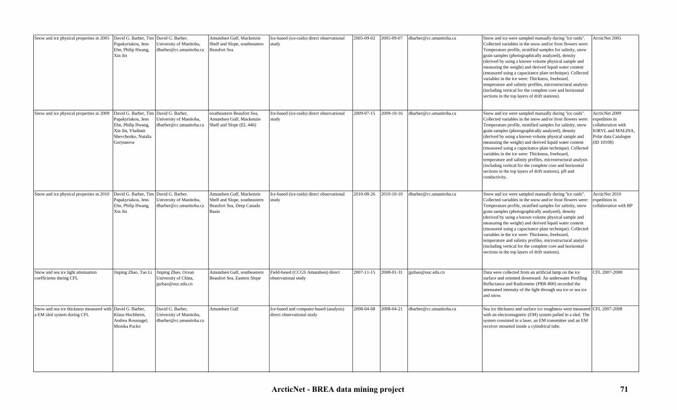
Snow and ice physical properties in 2005 David G. Barber, Tim Papakyriakou, Jens Ehn, Philip Hwang, Xin Jin
David G. Barber, University of Manitoba, [email protected]
Amundsen Gulf, Mackenzie Shelf and Slope, southeastern Beaufort Sea
Ice-based (ice-raids) direct observational study
2005-09-02 2005-09-07 [email protected] Snow and ice were sampled manually during ''ice raids''. Collected variables in the snow and/or frost flowers were: Temperature profile, stratified samples for salinity, snow grain samples (photographically analyzed), density (derived by using a known volume physical sample and measuring the weight) and derived liquid water content (measured using a capacitance plate technique). Collected variables in the ice were: Thickness, freeboard, temperature and salinity profiles, microstructural analysis (including vertical for the complete core and horizontal sections in the top layers of drift stations).
ArcticNet 2005
Snow and ice physical properties in 2009 David G. Barber, Tim Papakyriakou, Jens Ehn, Philip Hwang, Xin Jin, Vladimir Shevchenko, Natalia Goryunova
David G. Barber, University of Manitoba, [email protected]
southeastern Beaufort Sea, Amundsen Gulf, Mackenzie Shelf and Slope (EL 446)
Ice-based (ice-raids) direct observational study
2009-07-15 2009-10-16 [email protected] Snow and ice were sampled manually during ''ice raids''. Collected variables in the snow and/or frost flowers were: Temperature profile, stratified samples for salinity, snow grain samples (photographically analyzed), density (derived by using a known volume physical sample and measuring the weight) and derived liquid water content (measured using a capacitance plate technique). Collected variables in the ice were: Thickness, freeboard, temperature and salinity profiles, microstructural analysis (including vertical for the complete core and horizontal sections in the top layers of drift stations), pH and conductivity.
ArcticNet 2009 expedition in collaboration with IORVL and MALINA, Polar data Catalogue (ID 10108)
Snow and ice physical properties in 2010 David G. Barber, Tim Papakyriakou, Jens Ehn, Philip Hwang, Xin Jin
David G. Barber, University of Manitoba, [email protected]
Amundsen Gulf, Mackenzie Shelf and Slope, southeastern Beaufort Sea, Deep Canada Basin
Ice-based (ice-raids) direct observational study
2010-08-26 2010-10-10 [email protected] Snow and ice were sampled manually during ''ice raids''. Collected variables in the snow and/or frost flowers were: Temperature profile, stratified samples for salinity, snow grain samples (photographically analyzed), density (derived by using a known volume physical sample and measuring the weight) and derived liquid water content (measured using a capacitance plate technique). Collected variables in the ice were: Thickness, freeboard, temperature and salinity profiles, microstructural analysis (including vertical for the complete core and horizontal sections in the top layers of drift stations).
ArcticNet 2010 expedition in collaboration with BP
Snow and sea ice light attenuation coefficients during CFL
Jinping Zhao, Tao Li Jinping Zhao, Ocean University of China, [email protected]
Amundsen Gulf, southeastern Beaufort Sea, Eastern Slope
Field-based (CCGS Amundsen) direct observational study
2007-11-15 2008-01-31 [email protected] Data were collected from an artificial lamp on the icesurface and oriented downward. An underwater Profiling Reflectance and Radiometer (PRR-800) recorded the attenuated intensity of the light through sea ice or sea ice and snow.
CFL 2007-2008
Snow and sea ice thickness measured with a EM sled system during CFL
David G. Barber, Klaus Hochheim, Andrea Rossnagel,Monika Pucko
David G. Barber, University of Manitoba, [email protected]
Amundsen Gulf Ice-based and computer-based (analysis) direct observational study
2008-04-08 2008-04-21 [email protected] Sea ice thickness and surface ice roughness were measured with an electromagnetic (EM) system pulled in a sled. The system consisted in a laser, an EM transmitter and an EM receiver mounted inside a cylindrical tube.
CFL 2007-2008
ArcticNet - BREA data mining project 71
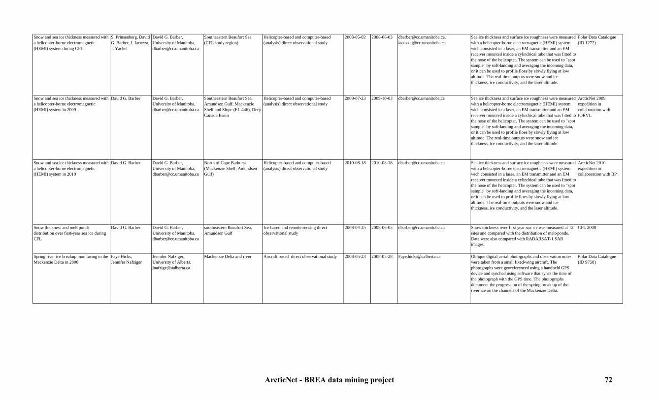
Snow and sea ice thickness measured with a helicopter-borne electromagnetic (HEMI) system during CFL
S. Prinsenberg, David G. Barber, J. Iacozza, J. Yackel
David G. Barber, University of Manitoba, [email protected]
Southeastern Beaufort Sea (CFL study region)
Helicopter-based and computer-based (analysis) direct observational study
2008-05-02 2008-06-03 [email protected], [email protected]
Sea ice thickness and surface ice roughness were measured with a helicopter-borne electromagnetic (HEMI) system wich consisted in a laser, an EM transmitter and an EM receiver mounted inside a cylindrical tube that was fitted to the nose of the helicopter. The system can be used to "spot sample" by soft-landing and averaging the incoming data, or it can be used to profile floes by slowly flying at low altitude. The real-time outputs were snow and ice thickness, ice conductivity, and the laser altitude.
Polar Data Catalogue (ID 1272)
Snow and sea ice thickness measured with a helicopter-borne electromagnetic (HEMI) system in 2009
David G. Barber David G. Barber, University of Manitoba, [email protected]
Southeastern Beaufort Sea, Amundsen Gulf, Mackenzie Shelf and Slope (EL 446), Deep Canada Basin
Helicopter-based and computer-based (analysis) direct observational study
2009-07-23 2009-10-03 [email protected] Sea ice thickness and surface ice roughness were measured with a helicopter-borne electromagnetic (HEMI) system wich consisted in a laser, an EM transmitter and an EM receiver mounted inside a cylindrical tube that was fitted to the nose of the helicopter. The system can be used to "spot sample" by soft-landing and averaging the incoming data, or it can be used to profile floes by slowly flying at low altitude. The real-time outputs were snow and ice thickness, ice conductivity, and the laser altitude.
ArcticNet 2009 expedition in collaboration with IORVL
Snow and sea ice thickness measured with a helicopter-borne electromagnetic (HEMI) system in 2010
David G. Barber David G. Barber, University of Manitoba, [email protected]
North of Cape Bathurst (Mackenzie Shelf, Amundsen Gulf)
Helicopter-based and computer-based (analysis) direct observational study
2010-08-18 2010-08-18 [email protected] Sea ice thickness and surface ice roughness were measured with a helicopter-borne electromagnetic (HEMI) system wich consisted in a laser, an EM transmitter and an EM receiver mounted inside a cylindrical tube that was fitted to the nose of the helicopter. The system can be used to "spot sample" by soft-landing and averaging the incoming data, or it can be used to profile floes by slowly flying at low altitude. The real-time outputs were snow and ice thickness, ice conductivity, and the laser altitude.
ArcticNet 2010 expedition in collaboration with BP
Snow thickness and melt ponds distribution over first-year sea ice during CFL
David G. Barber David G. Barber, University of Manitoba, [email protected]
southeastern Beaufort Sea, Amundsen Gulf
Ice-based and remote sensing direct observational study
2008-04-25 2008-06-05 [email protected] Snow thickness over first year sea ice was measured at 12 sites and compared with the distribution of melt-ponds. Data were also compared with RADARSAT-1 SAR images.
CFL 2008
Spring river ice breakup monitoring in the Mackenzie Delta in 2008
Faye Hicks,Jennifer Nafziger
Jennifer Nafziger, University of Alberta, [email protected]
Mackenzie Delta and river Aircraft based direct observational study 2008-05-23 2008-05-28 [email protected] Oblique digital aerial photographs and observation notes were taken from a small fixed-wing aircraft. The photographs were georeferenced using a handheld GPS device and synched using software that syncs the time of the photograph with the GPS time. The photographs document the progression of the spring break up of the river ice on the channels of the Mackenzie Delta.
Polar Data Catalogue (ID 9758)
ArcticNet - BREA data mining project 72

7.2. Ice and physical oceanography7.2.2. Ocean circulation and water masses
Table 6: Ocean circulation and water masses metadataStudy Originators Contact person Study area Type of study Begin date End date Link to data Details Reference
Alkalinity and pH measurements in the water column during MALINA 2009
Alfonso Mucci, Brunon Lansard, R. Sampere
Alfonso Mucci, McGill University, [email protected]
Mackenzie Shelf and Slope, Amundsen Gulf, southeastern Beaufort Sea
Field-based (rosette from the CCGS Amundsen) and lab-based (potentiometry, spectrophotometry, HPLC) observational study
2009-07-31 2009-08-24 [email protected] Water was sampled to measure and validate pH, alkalinity, hydroxyl radicals (OH), and diacids composition.
ArcticNet 2009 expedition in collaboration with MALINA
Biochemistry data from the water column during JOIS
Andrey Proshutinsky, Willie Ostrom, Rick Krishfield, Sarah Zimmermann, Fiona McLaughlin, Jane Eert, Mike Dempsey, Bill Williams
Andrey Proshutinsky, Woods Hole Oceanographic Institution, [email protected], Fiona McLaughlin, Department of Fisheries and Oceans Canada, [email protected]
Alaskan Slope and Shelf, Deep Canada Basin, Mackenzie Shelf and Slope, North Beaufort Sea
Field-based (rosette from the CCGS Louis St-Laurent) and lab-based (analysis) observational study
2003-08-11 2010-10-14 http://www.whoi.edu/beaufortgyre Water was sampled and analyzed for salinity and alkalinity.
JWACS and JOIS 2003-2010
Boundary layer turbulence and characteristics during CFL
Yves Gratton, Louis Prieur, Shannon Nudds, Richard Marsden, Maria Sharatunova
Yves Gratton, Institut National de la Recherche Scientifique-Eau,terre,environnement, [email protected]
Amundsen Gulf Ice-based direct observational study 2008-03-13 2008-04-24 [email protected] Acoustic Doppler Current Profilers (ADCPs) were deployed under the ice to determine the turbulence properties as a function of depth (up to 7 m below the ice) and larger scale water properties (i.e. internal waves and solitons) up to 25 m under the ice. Boundary Layer Conductivity and Temperature Monitors (BLMs) were deployed to to obtain eddy correlation estimates of turbulent salinity and temperature flux at the ice-water interface.
CFL 2007-2008
Canadian pan-Arctic river discharge and streamflow data
Stephen Déry, Marco Hernandez-Henriquez, Theo Mlynowski, Jason Burford, Eric Wood
Theo Mlynowski, University of Northern British Columbia, [email protected]
Mackenzie Delta and river database 1964-01-01 2008-12-31 http://nhg.unbc.ca/ipy/index.html River discharge values were measured annually, monthly, and daily. Additional information in the dataset include: river name, hydrometric gauge numbers for each river, latitude and longitude coordinates of each gauge (accompanied by a map), and total drainage area.
Polar Data Catalogue (ID 1861)
Coastal CTD data from the Heron in 2006 John E. Hughes Clarke
John E. Hughes Clarke, University of New-Brunswick, [email protected]
Amundsen Gulf, Mackenzie Shelf and Slope, southeastern Beaufort Sea
Field-based (Heron) and computer-based (analysis) direct observational study
2006-09-30 2006-10-19 [email protected] CTD casts were performed to measure temperature, conductivity and pressure (with a Sea-Bird 911 probe), oxygen (Sea-Bird 43), pH (Seabird 18), fluorescence (Seapoint fluorometer), nitrates (Satlantic MBARI ISUS), transmittance (Wetlabs C-Star transmissometer), PAR/Irradiance and SPAR/Irradiance (Biospherical Instruments QC2300).
ArcticNet 2006
Coastal water level data from 2004-2007 Donald L. Forbes, Wayne Pollard, Trevor Bell
Donald L. Forbes, Memorial University of Newfoundland, [email protected], Wayne Pollard, Mc Gill University, [email protected], Trevor bell, Memorial University of Newfoundland, [email protected]
Tuktoyaktuk and Ulukhaktok Land-based and remote sensing direct observational study
2004-X-X 2007-X-X [email protected], [email protected], [email protected]
A tide gauge co-located with an Acquired-Continuous GPS (CGPS) monitored variations in coastal water level.
ArcticNet project 1.2: Coastal vulnerability in a warming Arctic
ArcticNet - BREA data mining project 73
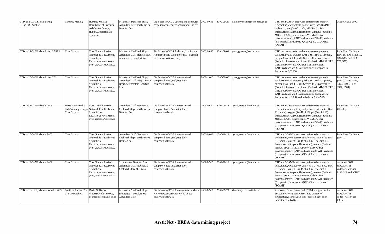
CTD and SCAMP data during JOIS/CASES 2002
Humfrey Melling Humfrey Melling,Department of Fisheries and Oceans Canada, [email protected]
Mackenzie Delta and Shelf, Amundsen Gulf, southeastern Beaufort Sea
Field-based (CCGS Laurier) and computer-based (analysis) direct observational study
2002-09-08 2002-09-21 [email protected] CTD and SCAMP casts were performed to measure temperature, conductivity and pressure (Sea-Bird 911 probe), oxygen (Sea-Bird 43), pH (Seabird 18), fluorescence (Seapoint fluorometer), nitrates (Satlantic MBARI ISUS), transmittance (Wetlabs C-Star transmissometer), PAR/Irradiance and SPAR/Irradiance (Biospherical Instruments QC2300) and turbulence (SCAMP).
JOIS/CASES 2002
CTD and SCAMP data during CASES Yves Gratton Yves Gratton, Institut National de la Recherche Scientifique Eau,terre,environnement, [email protected]
Mackenzie Shelf and Slope, Amundsen Gulf, Franklin Bay, southeastern Beaufort Sea
Field-based (CCGS Radisson, Laurier and Amundsen) and computer-based (analysis) direct observational study
2002-09-22 2004-09-09 [email protected] CTD casts were performed to measure temperature, conductivity and pressure (with a Sea-Bird 911 probe), oxygen (Sea-Bird 43), pH (Seabird 18), fluorescence (Seapoint fluorometer), nitrates (Satlantic MBARI ISUS), transmittance (Wetlabs C-Star transmissometer), PAR/Irradiance and SPAR/Irradiance (Biospherical Instruments QC2300).
Polar Data Catalogue (ID 513, 516, 518, 519, 520, 521, 522, 524, 525, 526)
CTD and SCAMP data during CFL Yves Gratton Yves Gratton, Institut National de la Recherche Scientifique-Eau,terre,environnement, [email protected]
Mackenzie Shelf and Slope, Amundsen Gulf, Deep Canada Basin, southeastern Beaufort Sea
Field-based (CCGS Amundsen) and computer-based (analysis) direct observational study
2007-10-15 2008-08-07 [email protected] CTD casts were performed to measure temperature, conductivity and pressure (with a Sea-Bird 911 probe), oxygen (Sea-Bird 43), pH (Seabird 18), fluorescence (Seapoint fluorometer), nitrates (Satlantic MBARI ISUS), transmittance (Wetlabs C-Star transmissometer), PAR/Irradiance and SPAR/Irradiance (Biospherical Instruments QC2300) and turbulence (SCAMP).
Polar Data Catalogue (ID 800, 936, 1496, 1497, 1498, 1499, 1500, 1501)
CTD and SCAMP data in 2005 Marie-Emmanuelle Rail, Véronique Lago, Yves Gratton
Yves Gratton, Institut National de la Recherche Scientifique-Eau,terre,environnement, [email protected]
Amundsen Gulf, Mackenzie Shelf and Slope, southeastern Beaufort Sea
Field-based (CCGS Amundsen) and computer-based (analysis) direct observational study
2005-09-01 2005-09-14 [email protected] CTD and SCAMP casts were performed to measure temperature, conductivity and pressure (with a Sea-Bird 911 probe), oxygen (Sea-Bird 43), pH (Seabird 18), fluorescence (Seapoint fluorometer), nitrates (Satlantic MBARI ISUS), transmittance (Wetlabs C-Star transmissometer), PAR/Irradiance and SPAR/Irradiance (Biospherical Instruments QC2300) and turbulence (SCAMP).
Polar Data Catalogue (ID 449)
CTD and SCAMP data in 2006 Yves Gratton Yves Gratton, Institut National de la Recherche Scientifique-Eau,terre,environnement, [email protected]
Amundsen Gulf, Mackenzie Shelf and Slope, southeastern Beaufort Sea
Field-based (CCGS Amundsen) and computer-based (analysis) direct observational study
2006-09-30 2006-10-19 [email protected] CTD and SCAMP casts were performed to measure temperature, conductivity and pressure (with a Sea-Bird 911 probe), oxygen (Sea-Bird 43), pH (Seabird 18), fluorescence (Seapoint fluorometer), nitrates (Satlantic MBARI ISUS), transmittance (Wetlabs C-Star transmissometer), PAR/Irradiance and SPAR/Irradiance (Biospherical Instruments QC2300) and turbulence (SCAMP).
Polar Data Catalogue (ID 502)
CTD and SCAMP data in 2009 Yves Gratton Yves Gratton, Institut National de la Recherche Scientifique-Eau,terre,environnement, [email protected]
Southeastern Beaufort Sea, Amundsen Gulf, Mackenzie Shelf and Slope (EL 446)
Field-based (CCGS Amundsen) and computer-based (analysis) direct observational study
2009-07-15 2009-10-16 [email protected] CTD and SCAMP casts were performed to measure temperature, conductivity and pressure (with a Sea-Bird 911 probe), oxygen (Sea-Bird 43), pH (Seabird 18), fluorescence (Seapoint fluorometer), nitrates (Satlantic MBARI ISUS), transmittance (Wetlabs C-Star transmissometer), PAR/Irradiance and SPAR/Irradiance (Biospherical Instruments QC2300) and turbulence (SCAMP).
ArcticNet 2009 expedition in collaboration with MALINA and IORVL
CTD and turbidity data collected in 2009 David G. Barber, Tim N. Papakyriakou
David G. Barber, University of Manitoba, [email protected]
Mackenzie Shelf and Slope, southeastern Beaufort Sea, Amundsen Gulf
Field-based (CCGS Amundsen and zodiac) and computer-based (analysis) direct observational study
2009-07-18 2009-09-29 [email protected] A Idronaut Ocean Seven 304 CTD-T equipped with a Seapoint turbidity sensor measured profiles of temperature, salinity, and side-scattered light as an indicator of turbidity.
ArcticNet 2009 expedition in collaboration with IORVL
ArcticNet - BREA data mining project 74
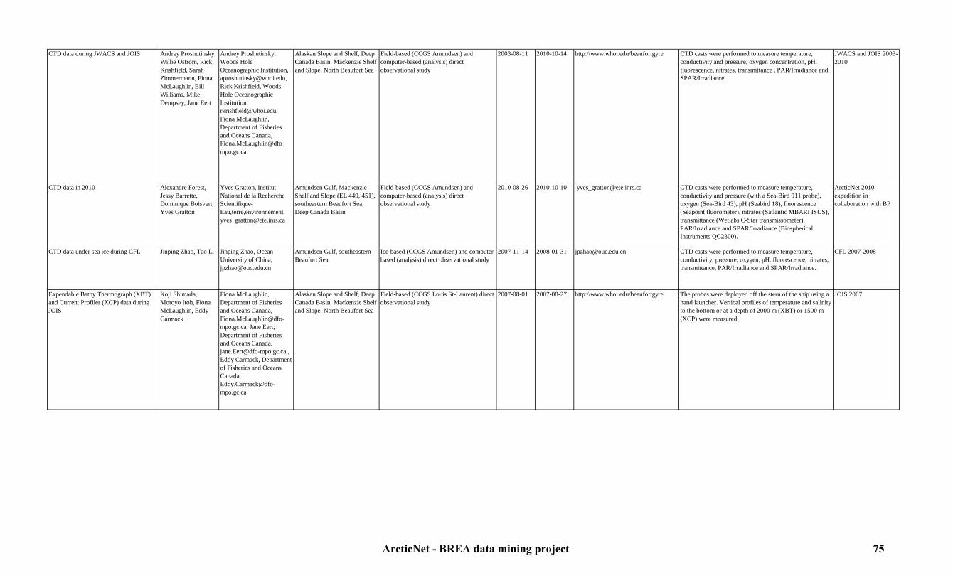
CTD data during JWACS and JOIS Andrey Proshutinsky, Willie Ostrom, Rick Krishfield, Sarah Zimmermann, Fiona McLaughlin, Bill Williams, Mike Dempsey, Jane Eert
Andrey Proshutinsky, Woods Hole Oceanographic Institution, [email protected], Rick Krishfield, Woods Hole Oceanographic Institution, [email protected], Fiona McLaughlin, Department of Fisheries and Oceans Canada, [email protected]
Alaskan Slope and Shelf, Deep Canada Basin, Mackenzie Shelf and Slope, North Beaufort Sea
Field-based (CCGS Amundsen) and computer-based (analysis) direct observational study
2003-08-11 2010-10-14 http://www.whoi.edu/beaufortgyre CTD casts were performed to measure temperature, conductivity and pressure, oxygen concentration, pH, fluorescence, nitrates, transmittance , PAR/Irradiance and SPAR/Irradiance.
JWACS and JOIS 2003-2010
CTD data in 2010 Alexandre Forest, Jessy Barrette, Dominique Boisvert, Yves Gratton
Yves Gratton, Institut National de la Recherche Scientifique-Eau,terre,environnement, [email protected]
Amundsen Gulf, Mackenzie Shelf and Slope (EL 449, 451), southeastern Beaufort Sea, Deep Canada Basin
Field-based (CCGS Amundsen) and computer-based (analysis) direct observational study
2010-08-26 2010-10-10 [email protected] CTD casts were performed to measure temperature, conductivity and pressure (with a Sea-Bird 911 probe), oxygen (Sea-Bird 43), pH (Seabird 18), fluorescence (Seapoint fluorometer), nitrates (Satlantic MBARI ISUS), transmittance (Wetlabs C-Star transmissometer), PAR/Irradiance and SPAR/Irradiance (Biospherical Instruments QC2300).
ArcticNet 2010 expedition in collaboration with BP
CTD data under sea ice during CFL Jinping Zhao, Tao Li Jinping Zhao, Ocean University of China, [email protected]
Amundsen Gulf, southeastern Beaufort Sea
Ice-based (CCGS Amundsen) and computer-based (analysis) direct observational study
2007-11-14 2008-01-31 [email protected] CTD casts were performed to measure temperature, conductivity, pressure, oxygen, pH, fluorescence, nitrates, transmittance, PAR/Irradiance and SPAR/Irradiance.
CFL 2007-2008
Expendable Bathy Thermograph (XBT) and Current Profiler (XCP) data during JOIS
Koji Shimada, Motoyo Itoh, Fiona McLaughlin, Eddy Carmack
Fiona McLaughlin, Department of Fisheries and Oceans Canada, [email protected], Jane Eert, Department of Fisheries and Oceans Canada, [email protected]., Eddy Carmack, Department of Fisheries and Oceans Canada, [email protected]
Alaskan Slope and Shelf, Deep Canada Basin, Mackenzie Shelf and Slope, North Beaufort Sea
Field-based (CCGS Louis St-Laurent) direct observational study
2007-08-01 2007-08-27 http://www.whoi.edu/beaufortgyre The probes were deployed off the stern of the ship using a hand launcher. Vertical profiles of temperature and salinity to the bottom or at a depth of 2000 m (XBT) or 1500 m (XCP) were measured.
JOIS 2007
ArcticNet - BREA data mining project 75

Expendable Conductivity, Temperature and Depth Profiler (XCTD) during JWACS and JOIS
Andrey Proshutinsky, Willie Ostrom, Rick Krishfield, Motoyo Itoh, Koji Shimada, Kohei Mizobata, Fiona McLaughlin, Eddy Carmack, Sarah Zimmermann
Andrey Proshutinsky, Woods Hole Oceanographic Institution, [email protected], Fiona McLaughlin, Department of Fisheries and Oceans Canada, [email protected], Jane Eert, Department of Fisheries and Oceans Canada, [email protected]., Eddy Carmack, Department of Fisheries and Oceans Canada, [email protected]
Alaskan Slope and Shelf, Deep Canada Basin, Mackenzie Shelf and Slope, North Beaufort Sea
Field-based (CCGS Louis St-Laurent) direct observational study
2003-08-02 2010-10-13 http://www.whoi.edu/beaufortgyre XCTD probes were deployed off the stern of the ship using a hand launcher. Vertical profiles of temperature and salinity to the bottom or at a depth of 1100 m were measured.
JWACS and JOIS 2003-2010
Hyperspectral Ocean Colour Radiometer (HyperOCR) during CFL
David G. Barber, Klaus Hochheim, Andrea Rossnagel,Monika Pucko
David G. Barber, University of Manitoba, [email protected]
Southeastern Beaufort Sea (CFL study region), Amundsen Gulf
Field-based (CCGS Amundsen, skippy boat and divers) direct observational study
2008-04-07 2008-06-21 [email protected] The HyperOCR was used to measure downwelling and upwelling irradiance in water.
CFL 2007-2008
Hyperspectral Ocean Colour Radiometer (HyperOCR) in 2009
David G. Barber, Matthew Asplin, John Iacozza, Tao Li, Chris Stammers
David G. Barber, University of Manitoba, [email protected]
Southeastern Beaufort Sea, Amundsen Gulf, Mackenzie Shelf and Slope (EL 446)
Field-based (CCGS Amundsen) direct observational study
2009-07-18 2009-07-27 [email protected] The HyperOCR was used to measure downwelling and upwelling irradiance in water.
ArcticNet 2009 expedition in collaboration with IORVL and Malina
Ice buoys data during JWACS and JOIS Andrey Proshutinsky, Willie Ostrom, Rick Krishfield, Kris Newhall, Jim Dunn,Tim Eglinton, Steve Manganini, Luc Rainville, Brian Hogue, Sarah Zimmermann, Fiona McLaughlin
Andrey Proshutinsky, Woods Hole Oceanographic Institution, [email protected], Rick Krishfield, Woods Hole Oceanographic Institution, [email protected], Fiona McLaughlin, Department of Fisheries and Oceans Canada, [email protected]
Alaskan Slope and Shelf, Deep Canada Basin, Mackenzie Shelf and Slope, North Beaufort Sea
Ice-based (buoys deployed on or from the ice) and computer-based (analysis) direct observational study
2003-08-22 2010-10-02 [email protected], [email protected], [email protected]
Ice buoys were deployed to monitor seawater temperature and salinity, fluxes of heat, salt, and momentum at the ice-ocean interface for up to two years.
JWACS and JOIS 2003-2010
Inherent and apparent optical properties during CASES
Pierre Larouche,Selima Ben Mustapha,Simon Bélanger,Corinne Bourgeault-Brunelle,Shilin Tang
Pierre Larouche, Institut Maurice-Lamontagne, [email protected]
Mackenzie Shelf and Slope, Amundsen Gulf, Franklin Bay, southeastern Beaufort Sea
Field-based (rosette from the CCGS Amundsen) and lab-based (radiometry) observational study
2003-09-24 2004-08-12 [email protected] Water was sampled and analyzed for Lu and Ed using hyperspectral sensors.
CASES 2003-2004, Polar Data Catalogue (ID 1118)
ArcticNet - BREA data mining project 76
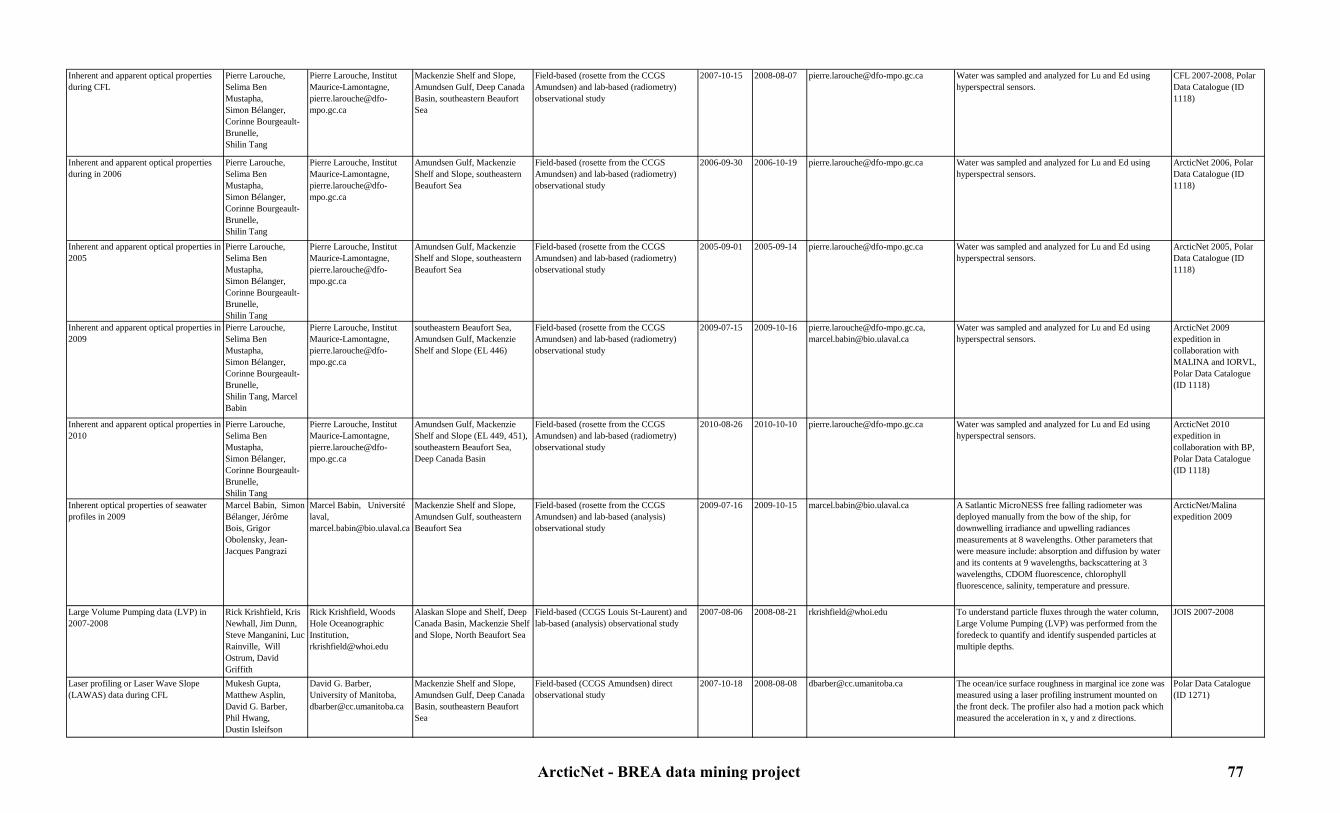
Inherent and apparent optical properties during CFL
Pierre Larouche,Selima Ben Mustapha,Simon Bélanger,Corinne Bourgeault-Brunelle,Shilin Tang
Pierre Larouche, Institut Maurice-Lamontagne, [email protected]
Mackenzie Shelf and Slope, Amundsen Gulf, Deep Canada Basin, southeastern Beaufort Sea
Field-based (rosette from the CCGS Amundsen) and lab-based (radiometry) observational study
2007-10-15 2008-08-07 [email protected] Water was sampled and analyzed for Lu and Ed using hyperspectral sensors.
CFL 2007-2008, Polar Data Catalogue (ID 1118)
Inherent and apparent optical properties during in 2006
Pierre Larouche,Selima Ben Mustapha,Simon Bélanger,Corinne Bourgeault-Brunelle,Shilin Tang
Pierre Larouche, Institut Maurice-Lamontagne, [email protected]
Amundsen Gulf, Mackenzie Shelf and Slope, southeastern Beaufort Sea
Field-based (rosette from the CCGS Amundsen) and lab-based (radiometry) observational study
2006-09-30 2006-10-19 [email protected] Water was sampled and analyzed for Lu and Ed using hyperspectral sensors.
ArcticNet 2006, Polar Data Catalogue (ID 1118)
Inherent and apparent optical properties in 2005
Pierre Larouche,Selima Ben Mustapha,Simon Bélanger,Corinne Bourgeault-Brunelle,Shilin Tang
Pierre Larouche, Institut Maurice-Lamontagne, [email protected]
Amundsen Gulf, Mackenzie Shelf and Slope, southeastern Beaufort Sea
Field-based (rosette from the CCGS Amundsen) and lab-based (radiometry) observational study
2005-09-01 2005-09-14 [email protected] Water was sampled and analyzed for Lu and Ed using hyperspectral sensors.
ArcticNet 2005, Polar Data Catalogue (ID 1118)
Inherent and apparent optical properties in 2009
Pierre Larouche,Selima Ben Mustapha,Simon Bélanger,Corinne Bourgeault-Brunelle,Shilin Tang, Marcel Babin
Pierre Larouche, Institut Maurice-Lamontagne, [email protected]
southeastern Beaufort Sea, Amundsen Gulf, Mackenzie Shelf and Slope (EL 446)
Field-based (rosette from the CCGS Amundsen) and lab-based (radiometry) observational study
2009-07-15 2009-10-16 [email protected], [email protected]
Water was sampled and analyzed for Lu and Ed using hyperspectral sensors.
ArcticNet 2009 expedition in collaboration with MALINA and IORVL, Polar Data Catalogue (ID 1118)
Inherent and apparent optical properties in 2010
Pierre Larouche,Selima Ben Mustapha,Simon Bélanger,Corinne Bourgeault-Brunelle,Shilin Tang
Pierre Larouche, Institut Maurice-Lamontagne, [email protected]
Amundsen Gulf, Mackenzie Shelf and Slope (EL 449, 451), southeastern Beaufort Sea, Deep Canada Basin
Field-based (rosette from the CCGS Amundsen) and lab-based (radiometry) observational study
2010-08-26 2010-10-10 [email protected] Water was sampled and analyzed for Lu and Ed using hyperspectral sensors.
ArcticNet 2010 expedition in collaboration with BP, Polar Data Catalogue (ID 1118)
Inherent optical properties of seawater profiles in 2009
Marcel Babin, Simon Bélanger, Jérôme Bois, Grigor Obolensky, Jean-Jacques Pangrazi
Marcel Babin, Université laval, [email protected]
Mackenzie Shelf and Slope, Amundsen Gulf, southeastern Beaufort Sea
Field-based (rosette from the CCGS Amundsen) and lab-based (analysis) observational study
2009-07-16 2009-10-15 [email protected] A Satlantic MicroNESS free falling radiometer was deployed manually from the bow of the ship, for downwelling irradiance and upwelling radiances measurements at 8 wavelengths. Other parameters that were measure include: absorption and diffusion by water and its contents at 9 wavelengths, backscattering at 3 wavelengths, CDOM fluorescence, chlorophyll fluorescence, salinity, temperature and pressure.
ArcticNet/Malina expedition 2009
Large Volume Pumping data (LVP) in 2007-2008
Rick Krishfield, Kris Newhall, Jim Dunn, Steve Manganini, Luc Rainville, Will Ostrum, David Griffith
Rick Krishfield, Woods Hole Oceanographic Institution, [email protected]
Alaskan Slope and Shelf, Deep Canada Basin, Mackenzie Shelf and Slope, North Beaufort Sea
Field-based (CCGS Louis St-Laurent) and lab-based (analysis) observational study
2007-08-06 2008-08-21 [email protected] To understand particle fluxes through the water column, Large Volume Pumping (LVP) was performed from the foredeck to quantify and identify suspended particles at multiple depths.
JOIS 2007-2008
Laser profiling or Laser Wave Slope (LAWAS) data during CFL
Mukesh Gupta,Matthew Asplin,David G. Barber, Phil Hwang,Dustin Isleifson
David G. Barber, University of Manitoba, [email protected]
Mackenzie Shelf and Slope, Amundsen Gulf, Deep Canada Basin, southeastern Beaufort Sea
Field-based (CCGS Amundsen) direct observational study
2007-10-18 2008-08-08 [email protected] The ocean/ice surface roughness in marginal ice zone was measured using a laser profiling instrument mounted on the front deck. The profiler also had a motion pack which measured the acceleration in x, y and z directions.
Polar Data Catalogue (ID 1271)
ArcticNet - BREA data mining project 77

Laser profiling or Laser Wave Slope (LAWAS) data in 2009
Mukesh Gupta,Matthew Asplin,Phil Hwang,Dustin Isleifson, David G. Barber
David G. Barber, University of Manitoba, [email protected]
Southeastern Beaufort Sea, Amundsen Gulf, Mackenzie Shelf and Slope (EL 446), Deep Canada Basin
Field-based (CCGS Amundsen) direct observational study
2009-07-15 2009-10-16 [email protected] The ocean/ice surface roughness in marginal ice zone was measured using a laser profiling instrument mounted on the front deck. The profiler also had a motion pack which measured the acceleration in x, y and z directions.
ArcticNet 2009 expedition in collaboration with IORVL, Polar Data Catalogue (ID 10099)
Laser profiling or Laser Wave Slope (LAWAS) data in 2010
David G. Barber David G. Barber, University of Manitoba, [email protected]
Amundsen Gulf, Mackenzie Shelf and Slope (EL 449, 451), southeastern Beaufort Sea, Deep Canada Basin
Field-based (CCGS Amundsen) direct observational study
2010-08-26 2010-10-10 [email protected] The ocean/ice surface roughness in marginal ice zone was measured using a laser profiling instrument mounted on the front deck. The profiler also had a motion pack which measured the acceleration in x, y and z directions.
ArcticNet 2010 expedition in collaboration with BP
Light penetration and absortion measurements during MALINA 2009
Edouard Leymarie, R. Sampere, V. Wright, S. Hooker, J. Ehn, D. Doxaran, D. Antoine, M. Chami
Edouard Leymarie; Laboratoire océanographique de Villefranche-sur-Mer; [email protected]
Mackenzie Shelf and Slope, Amundsen Gulf, southeastern Beaufort Sea
Field-based (CCGS Amundsen) direct observational study
2009-07-31 2009-08-24 [email protected] Several different sensors were deployed to measure light absorption, absorption and attenuation coefficients, backscaterring coefficients, Ed, Lu, Es, irradiance, light field, radiance, volume scattering function, and retrodiffusion.
ArcticNet 2009 expedition in collaboration with MALINA
Light profiles in the water column during CASES
Pierre Larouche, Michel Gosselin
Michel Gosselin, Institut des sciences de la mer (ISMER), [email protected]
Mackenzie Shelf and Slope, Amundsen Gulf, Franklin Bay, southeastern Beaufort Sea
Field-based (CCGS Amundsen, Radisson and Laurier) direct observational study
2002-09-22 2004-09-09 [email protected] Secchi disk and Profiler of Natural Fluorescence (PNF 300) casts were performed to estimate water transparency and light in the water column.
CASES 2002-2004
Light profiles in the water column during CFL
Pierre Larouche, Michel Gosselin
Michel Gosselin, Institut des sciences de la mer (ISMER), [email protected]
Mackenzie Shelf and Slope, Amundsen Gulf, Deep Canada Basin, southeastern Beaufort Sea
Field-based (CCGS Amundsen) direct observational study
2007-10-15 2008-08-07 [email protected] Secchi disk and Profiler of Natural Fluorescence (PNF 300) casts were performed to estimate water transparency and light in the water column.
CFL 2007-2008
Light profiles in the water column in 2005 Pierre Larouche, Michel Gosselin
Michel Gosselin, Institut des sciences de la mer (ISMER), [email protected]
Amundsen Gulf, Mackenzie Shelf and Slope, southeastern Beaufort Sea
Field-based (CCGS Amundsen) direct observational study
2005-09-01 2005-09-14 [email protected] Secchi disk and Profiler of Natural Fluorescence (PNF 300) casts were performed to estimate water transparency and light in the water column.
ArcticNet 2005
Light profiles in the water column in 2006 Pierre Larouche, Michel Gosselin
Michel Gosselin, Institut des sciences de la mer (ISMER), [email protected]
Amundsen Gulf, Mackenzie Shelf and Slope, southeastern Beaufort Sea
Field-based (CCGS Amundsen) direct observational study
2006-09-30 2006-10-19 [email protected] Secchi disk and Profiler of Natural Fluorescence (PNF 300) casts were performed to estimate water transparency and light in the water column.
ArcticNet 2006
Light profiles in the water column in 2009 Pierre Larouche, Michel Gosselin
Michel Gosselin, Institut des sciences de la mer (ISMER), [email protected]
Southeastern Beaufort Sea, Amundsen Gulf, Mackenzie Shelf and Slope (EL 446)
Field-based (CCGS Amundsen) direct observational study
2009-07-15 2009-10-16 [email protected] Secchi disk and Profiler of Natural Fluorescence (PNF 300) casts were performed to estimate water transparency and light in the water column.
ArcticNet 2009 expedition in collaboration with MALINA and IORVL
Light profiles in the water column in 2010 Pierre Larouche, Michel Gosselin
Michel Gosselin, Institut des sciences de la mer (ISMER), [email protected]
Amundsen Gulf, Mackenzie Shelf and Slope (EL 449, 451), southeastern Beaufort Sea, Deep Canada Basin
Field-based (CCGS Amundsen) direct observational study
2010-08-26 2010-10-10 [email protected] Secchi disk and Profiler of Natural Fluorescence (PNF 300) casts were performed to estimate water transparency and light in the water column.
ArcticNet 2010 expedition in collaboration with BP
Lower Acoustic Doppler Current Profiler (LADCP) data in 2009
Yves Gratton, Claudie Marec, Marc Picheral, Louis Prieur
Yves Gratton, Institut National de la Recherche Scientifique-Eau,terre,environnement, [email protected]
Southeastern Beaufort Sea, Amundsen Gulf, Mackenzie Shelf and Slope (EL 446)
Field-based (CCGS Amundsen) and computer-based (analysis) direct observational study
2009-07-18 2009-10-16 [email protected] A Lowered Acoustic Doppler Current Profiler (LADCP) was attached to the frame of the rosette to measure vertical profiles of horizontal current velocities at each station.
ArcticNet 2009 expedition in collaboration with IORVL and Malina
Lower Acoustic Doppler Current Profiler (LADCP) data in 2010
Alexandre Forest, Jessy Barrette, Dominique Boisvert, Yves Gratton
Yves Gratton, Institut National de la Recherche Scientifique-Eau,terre,environnement, [email protected]
Amundsen Gulf, Mackenzie Shelf and Slope (EL 449, 451), southeastern Beaufort Sea, Deep Canada Basin
Field-based (CCGS Amundsen) and computer-based (analysis) direct observational study
2010-08-26 2010-10-10 [email protected] A Lowered Acoustic Doppler Current Profiler (LADCP) was attached to the frame of the rosette to measure vertical profiles of horizontal current velocities at each station.
ArcticNet 2010 expedition in collaboration with BP
ArcticNet - BREA data mining project 78
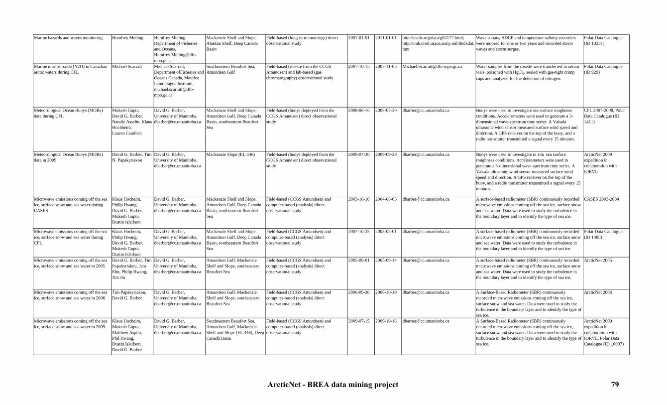
Marine hazards and waves monitoring Humfrey Melling Humfrey Melling, Department of Fisheries and Oceans, [email protected]
Mackenzie Shelf and Slope, Alaskan Shelf, Deep Canada Basin
Field-based (long-term moorings) direct observational study
2007-01-01 2011-01-01 http://nsidc.org/data/g02177.html; http://imb.crrel.usace.army.mil/thickdat.htm
Wave sonars, ADCP and temperature-salinity recorders were moored for one or two years and recorded storm waves and storm surges.
Polar Data Catalogue (ID 10231)
Marine nitrous oxide (N2O) in Canadian arctic waters during CFL
Michael Scarratt Michael Scarratt, Department ofFisheries and Oceans Canada, Maurice Lamontagne Institute, [email protected]
Southeastern Beaufort Sea, Amundsen Gulf
Field-based (rosette from the CCGS Amundsen) and lab-based (gas chromatography) observational study
2007-10-15 2007-11-05 [email protected] Water samples from the rosette were transferred to serum vials, poisoned with HgCl2, sealed with gas-tight crimp caps and analyzed for the detection of nitrogen.
Polar Data Catalogue (ID 929)
Meteorological Ocean Buoys (MOBs) data during CFL
Mukesh Gupta,David G. Barber,Natalie Asselin, Klaus Hochheim,Lauren Candlish
David G. Barber, University of Manitoba, [email protected]
Mackenzie Shelf and Slope, Amundsen Gulf, Deep Canada Basin, southeastern Beaufort Sea
Field-based (buoys deployed from the CCGS Amundsen) direct observational study
2008-06-16 2008-07-30 [email protected] Buoys were used to investigate sea surface roughness conditions. Accelerometers were used to generate a 3-dimensional wave-spectrum time series. A Vaisala ultrasonic wind sensor measured surface wind speed and direction. A GPS receiver on the top of the buoy, and a radio transmitter transmitted a signal every 15 minutes.
CFL 2007-2008, Polar Data Catalogue (ID 1411)
Meteorological Ocean Buoys (MOBs) data in 2009
David G. Barber, Tim N. Papakyriakou
David G. Barber, University of Manitoba, [email protected]
Mackenzie Slope (EL 446) Field-based (buoys deployed from the CCGS Amundsen) direct observational study
2009-07-20 2009-09-29 [email protected] Buoys were used to investigate in situ sea surface roughness conditions. Accelerometers were used to generate a 3-dimensional wave-spectrum time series. A Vaisala ultrasonic wind sensor measured surface wind speed and direction. A GPS receiver on the top of the buoy, and a radio transmitter transmitted a signal every 15 minutes.
ArcticNet 2009 expedition in collaboration with IORVL
Microwave emissions coming off the sea ice, surface snow and sea water during CASES
Klaus Hocheim,Philip Hwang,David G. Barber, Mukesh Gupta,Dustin Isleifson
David G. Barber, University of Manitoba, [email protected]
Mackenzie Shelf and Slope, Amundsen Gulf, Deep Canada Basin, southeastern Beaufort Sea
Field-based (CCGS Amundsen) and computer-based (analysis) direct observational study
2003-10-10 2004-08-05 [email protected] A surface-based radiometer (SBR) continuously recorded microwave emissions coming off the sea ice, surface snow and sea water. Data were used to study the turbulence in the boundary layer and to identify the type of sea ice.
CASES 2003-2004
Microwave emissions coming off the sea ice, surface snow and sea water during CFL
Klaus Hocheim,Philip Hwang,David G. Barber, Mukesh Gupta,Dustin Isleifson
David G. Barber, University of Manitoba, [email protected]
Mackenzie Shelf and Slope, Amundsen Gulf, Deep Canada Basin, southeastern Beaufort Sea
Field-based (CCGS Amundsen) and computer-based (analysis) direct observational study
2007-10-25 2008-08-01 [email protected] A surface-based radiometer (SBR) continuously recorded microwave emissions coming off the sea ice, surface snow and sea water. Data were used to study the turbulence in the boundary layer and to identify the type of sea ice.
Polar Data Catalogue (ID 1483)
Microwave emissions coming off the sea ice, surface snow and sea water in 2005
David G. Barber, Tim Papakyriakou, Jens Ehn, Philip Hwang, Xin Jin
David G. Barber, University of Manitoba, [email protected]
Amundsen Gulf, Mackenzie Shelf and Slope, southeastern Beaufort Sea
Field-based (CCGS Amundsen) and computer-based (analysis) direct observational study
2005-09-01 2005-09-14 [email protected] A surface-based radiometer (SBR) continuously recorded microwave emissions coming off the sea ice, surface snow and sea water. Data were used to study the turbulence in the boundary layer and to identify the type of sea ice.
ArcticNet 2005
Microwave emissions coming off the sea ice, surface snow and sea water in 2006
Tim Papakyriakou, David G. Barber
David G. Barber, University of Manitoba, [email protected]
Amundsen Gulf, Mackenzie Shelf and Slope, southeastern Beaufort Sea
Field-based (CCGS Amundsen) and computer-based (analysis) direct observational study
2006-09-30 2006-10-19 [email protected] A Surface-Based Radiometer (SBR) continuously recorded microwave emissions coming off the sea ice, surface snow and sea water. Data were used to study the turbulence in the boundary layer and to identify the type of sea ice.
ArcticNet 2006
Microwave emissions coming off the sea ice, surface snow and sea water in 2009
Klaus Hocheim,Mukesh Gupta,Matthew Asplin,Phil Hwang,Dustin Isleifson, David G. Barber
David G. Barber, University of Manitoba, [email protected]
Southeastern Beaufort Sea, Amundsen Gulf, Mackenzie Shelf and Slope (EL 446), Deep Canada Basin
Field-based (CCGS Amundsen) and computer-based (analysis) direct observational study
2009-07-15 2009-10-16 [email protected] A Surface-Based Radiometer (SBR) continuously recorded microwave emissions coming off the sea ice, surface snow and sea water. Data were used to study the turbulence in the boundary layer and to identify the type of sea ice.
ArcticNet 2009 expedition in collaboration with IORVL, Polar Data Catalogue (ID 10097)
ArcticNet - BREA data mining project 79
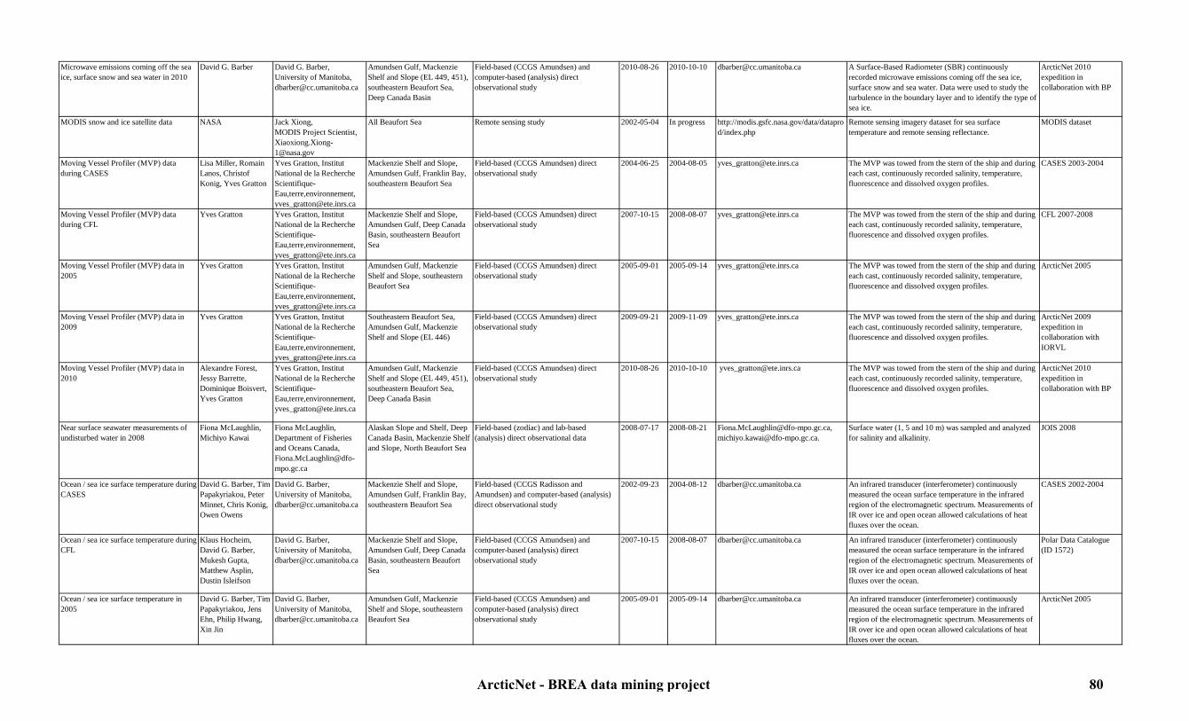
Microwave emissions coming off the sea ice, surface snow and sea water in 2010
David G. Barber David G. Barber, University of Manitoba, [email protected]
Amundsen Gulf, Mackenzie Shelf and Slope (EL 449, 451), southeastern Beaufort Sea, Deep Canada Basin
Field-based (CCGS Amundsen) and computer-based (analysis) direct observational study
2010-08-26 2010-10-10 [email protected] A Surface-Based Radiometer (SBR) continuously recorded microwave emissions coming off the sea ice, surface snow and sea water. Data were used to study the turbulence in the boundary layer and to identify the type of sea ice.
ArcticNet 2010 expedition in collaboration with BP
MODIS snow and ice satellite data NASA Jack Xiong,MODIS Project Scientist, [email protected]
All Beaufort Sea Remote sensing study 2002-05-04 In progress http://modis.gsfc.nasa.gov/data/dataprod/index.php
Remote sensing imagery dataset for sea surface temperature and remote sensing reflectance.
MODIS dataset
Moving Vessel Profiler (MVP) data during CASES
Lisa Miller, Romain Lanos, Christof Konig, Yves Gratton
Yves Gratton, Institut National de la Recherche Scientifique-Eau,terre,environnement, [email protected]
Mackenzie Shelf and Slope, Amundsen Gulf, Franklin Bay, southeastern Beaufort Sea
Field-based (CCGS Amundsen) direct observational study
2004-06-25 2004-08-05 [email protected] The MVP was towed from the stern of the ship and during each cast, continuously recorded salinity, temperature, fluorescence and dissolved oxygen profiles.
CASES 2003-2004
Moving Vessel Profiler (MVP) data during CFL
Yves Gratton Yves Gratton, Institut National de la Recherche Scientifique-Eau,terre,environnement, [email protected]
Mackenzie Shelf and Slope, Amundsen Gulf, Deep Canada Basin, southeastern Beaufort Sea
Field-based (CCGS Amundsen) direct observational study
2007-10-15 2008-08-07 [email protected] The MVP was towed from the stern of the ship and during each cast, continuously recorded salinity, temperature, fluorescence and dissolved oxygen profiles.
CFL 2007-2008
Moving Vessel Profiler (MVP) data in 2005
Yves Gratton Yves Gratton, Institut National de la Recherche Scientifique-Eau,terre,environnement, [email protected]
Amundsen Gulf, Mackenzie Shelf and Slope, southeastern Beaufort Sea
Field-based (CCGS Amundsen) direct observational study
2005-09-01 2005-09-14 [email protected] The MVP was towed from the stern of the ship and during each cast, continuously recorded salinity, temperature, fluorescence and dissolved oxygen profiles.
ArcticNet 2005
Moving Vessel Profiler (MVP) data in 2009
Yves Gratton Yves Gratton, Institut National de la Recherche Scientifique-Eau,terre,environnement, [email protected]
Southeastern Beaufort Sea, Amundsen Gulf, Mackenzie Shelf and Slope (EL 446)
Field-based (CCGS Amundsen) direct observational study
2009-09-21 2009-11-09 [email protected] The MVP was towed from the stern of the ship and during each cast, continuously recorded salinity, temperature, fluorescence and dissolved oxygen profiles.
ArcticNet 2009 expedition in collaboration with IORVL
Moving Vessel Profiler (MVP) data in 2010
Alexandre Forest, Jessy Barrette, Dominique Boisvert, Yves Gratton
Yves Gratton, Institut National de la Recherche Scientifique-Eau,terre,environnement, [email protected]
Amundsen Gulf, Mackenzie Shelf and Slope (EL 449, 451), southeastern Beaufort Sea, Deep Canada Basin
Field-based (CCGS Amundsen) direct observational study
2010-08-26 2010-10-10 [email protected] The MVP was towed from the stern of the ship and during each cast, continuously recorded salinity, temperature, fluorescence and dissolved oxygen profiles.
ArcticNet 2010 expedition in collaboration with BP
Near surface seawater measurements of undisturbed water in 2008
Fiona McLaughlin, Michiyo Kawai
Fiona McLaughlin, Department of Fisheries and Oceans Canada, [email protected]
Alaskan Slope and Shelf, Deep Canada Basin, Mackenzie Shelf and Slope, North Beaufort Sea
Field-based (zodiac) and lab-based (analysis) direct observational data
2008-07-17 2008-08-21 [email protected], [email protected].
Surface water (1, 5 and 10 m) was sampled and analyzed for salinity and alkalinity.
JOIS 2008
Ocean / sea ice surface temperature during CASES
David G. Barber, Tim Papakyriakou, Peter Minnet, Chris Konig, Owen Owens
David G. Barber, University of Manitoba, [email protected]
Mackenzie Shelf and Slope, Amundsen Gulf, Franklin Bay, southeastern Beaufort Sea
Field-based (CCGS Radisson and Amundsen) and computer-based (analysis) direct observational study
2002-09-23 2004-08-12 [email protected] An infrared transducer (interferometer) continuously measured the ocean surface temperature in the infrared region of the electromagnetic spectrum. Measurements of IR over ice and open ocean allowed calculations of heat fluxes over the ocean.
CASES 2002-2004
Ocean / sea ice surface temperature during CFL
Klaus Hocheim, David G. Barber,Mukesh Gupta,Matthew Asplin,Dustin Isleifson
David G. Barber, University of Manitoba, [email protected]
Mackenzie Shelf and Slope, Amundsen Gulf, Deep Canada Basin, southeastern Beaufort Sea
Field-based (CCGS Amundsen) and computer-based (analysis) direct observational study
2007-10-15 2008-08-07 [email protected] An infrared transducer (interferometer) continuously measured the ocean surface temperature in the infrared region of the electromagnetic spectrum. Measurements of IR over ice and open ocean allowed calculations of heat fluxes over the ocean.
Polar Data Catalogue (ID 1572)
Ocean / sea ice surface temperature in 2005
David G. Barber, Tim Papakyriakou, Jens Ehn, Philip Hwang, Xin Jin
David G. Barber, University of Manitoba, [email protected]
Amundsen Gulf, Mackenzie Shelf and Slope, southeastern Beaufort Sea
Field-based (CCGS Amundsen) and computer-based (analysis) direct observational study
2005-09-01 2005-09-14 [email protected] An infrared transducer (interferometer) continuously measured the ocean surface temperature in the infrared region of the electromagnetic spectrum. Measurements of IR over ice and open ocean allowed calculations of heat fluxes over the ocean.
ArcticNet 2005
ArcticNet - BREA data mining project 80

Ocean / sea ice surface temperature in 2006
David G. Barber, Tim Papakyriakou
David G. Barber, University of Manitoba, [email protected]
Amundsen Gulf, Mackenzie Shelf and Slope, southeastern Beaufort Sea
Field-based (CCGS Amundsen) and computer-based (analysis) direct observational study
2006-09-30 2006-10-19 [email protected] An infrared transducer (interferometer) continuously measured the ocean surface temperature in the infrared region of the electromagnetic spectrum. Measurements of IR over ice and open ocean allowed calculations of heat fluxes over the ocean.
ArcticNet 2006
Ocean / sea ice surface temperature in 2009
Mukesh Gupta,Klaus Hochheim,David G. Barber,Ryan Galley,Kerri Warner
David G. Barber, University of Manitoba, [email protected]
Southeastern Beaufort Sea, Amundsen Gulf, Mackenzie Shelf and Slope (EL 446)
Field-based (CCGS Amundsen) and computer-based (analysis) direct observational study
2009-07-15 2009-10-16 [email protected] An infrared transducer (interferometer) continuously measured the ocean surface temperature in the infrared region of the electromagnetic spectrum. Measurements of IR over ice and open ocean allowed calculations of heat fluxes over the ocean.
Polar Data Catalogue (ID 9808); ArcticNet 2009 expedition in collaboration with IORVL
Ocean / sea ice surface temperature in 2010
David G. Barber, Tim Papakyriakou
David G. Barber, University of Manitoba, [email protected]
Amundsen Gulf, Mackenzie Shelf and Slope (EL 449, 451), southeastern Beaufort Sea, Deep Canada Basin
Field-based (CCGS Amundsen) and computer-based (analysis) direct observational study
2006-09-30 2006-10-19 [email protected] An infrared transducer (interferometer) continuously measured the ocean surface temperature in the infrared region of the electromagnetic spectrum. Measurements of IR over ice and open ocean allowed calculations of heat fluxes over the ocean.
ArcticNet 2010 expedition in collaboration with BP
On-track current data during CASES Luc Michaud, Pascal Massot, Yves Gratton
Yves Gratton, Institut National de la Recherche Scientifique-Eau,terre,environnement, [email protected]
Mackenzie Shelf and Slope, Amudsen Gulf, Franklin Bay, southeastern Beaufort Sea
Field based (CCGS Amundsen) direct observational data
2003-09-30 2004-10-09 [email protected] A Ship Mounted Acoustic Doppler Current Profiler (SM-ADCP) was continuously recording the net current speed and direction.
CASES 2003-2004
On-track current data during CFL Luc Michaud, Pascal Massot, Yves Gratton
Yves Gratton, Institut National de la Recherche Scientifique-Eau,terre,environnement, [email protected]
Mackenzie Shelf and Slope, Amundsen Gulf, Deep Canada Basin, southeastern Beaufort Sea
Field based (CCGS Amundsen) direct observational data
2007-10-18 2008-08-07 [email protected] A Ship Mounted Acoustic Doppler Current Profiler (SM-ADCP) was continuously recording the net current speed and direction.
CFL 2007-2008
On-track current data during JOIS Svien Vagle, Fiona McLaughlin , Mike Dempsey
Svien Vagle, Department of Fisheries and Oceans Canada, [email protected], Fiona McLaughlin, Department of Fisheries and Oceans Canada, [email protected]
Alaskan Slope and Shelf, Deep Canada Basin, Mackenzie Shelf and Slope, North Beaufort Sea
Field based (CCGS Louis St-Laurent) direct observational data
2008-07-17 2010-10-15 [email protected], [email protected]
A Ship Mounted Acoustic Doppler Current Profiler (SM-ADCP) was continuously recording the net current speed and direction.
JOIS 2008-2010
On-track current data in 2005 Luc Michaud, Pascal Massot, Yves Gratton
Yves Gratton, Institut National de la Recherche Scientifique-Eau,terre,environnement, [email protected]
Mackenzie Shelf and Slope, Amudsen Gulf, southeastern Beaufort Sea
Field based (CCGS Amundsen) direct observational data
2005-09-01 2005-09-14 [email protected] A Ship Mounted Acoustic Doppler Current Profiler (SM-ADCP) was continuously recording the net current speed and direction.
ArcticNet 2005
On-track current data in 2006 Luc Michaud, Pascal Massot, Yves Gratton
Yves Gratton, Institut National de la Recherche Scientifique-Eau,terre,environnement, [email protected]
Mackenzie Shelf and Slope, Amudsen Gulf, southeastern Beaufort Sea
Field based (CCGS Amundsen) direct observational data
2006-09-30 2006-10-19 [email protected] A Ship Mounted Acoustic Doppler Current Profiler (SM-ADCP) was continuously recording the net current speed and direction.
ArcticNet 2006
On-track current data in 2009 Yves Gratton, Claudie Marec, Marc Picheral, Louis Prieur
Yves Gratton, Institut National de la Recherche Scientifique-Eau,terre,environnement, [email protected]
Southern Alaskan Beaufort Sea, Mackenzie Shelf and Slope, Amundsen Gulf, southeastern Beaufort Sea
Field based (CCGS Amundsen) direct observational data
2009-07-11 2009-10-16 [email protected] A Ship Mounted Acoustic Doppler Current Profiler (SM-ADCP) was continuously recording the net current speed and direction.
ArcticNet 2009 expedition in collaboration with IORVL and Malina
On-track current data in 2010 Alexandre Forest, Jessy Barrette, Dominique Boisvert, Yves Gratton
Yves Gratton, Institut National de la Recherche Scientifique-Eau,terre,environnement, [email protected]
Amundsen Gulf, Mackenzie Shelf and Slope (EL 449, 451), southeastern Beaufort Sea, Deep Canada Basin
Field based (CCGS Amundsen) direct observational data
2010-X-X 2010-X-X [email protected] A Ship Mounted Acoustic Doppler Current Profiler (SM-ADCP) was continuously recording the net current speed and direction.
ArcticNet 2010 expedition in collaboration with BP
ArcticNet - BREA data mining project 81

On-track sea surface temperature, conductivity and salinity during CASES
Luc Michaud, Pascal Massot, Yves Gratton
Yves Gratton, Institut National de la Recherche Scientifique-Eau,terre,environnement, [email protected]
Mackenzie Shelf and Slope, Amundsen Gulf, Franklin Bay, southeastern Beaufort Sea
Field based (CCGS Amundsen) direct observational data
2003-09-30 2004-10-09 [email protected] A thermosalinograph was continuously recording sea surface temperature, conductivity and salinity.
CASES 2003-2004
On-track sea surface temperature, conductivity and salinity during CFL
Luc Michaud, Pascal Massot, Yves Gratton
Yves Gratton, Institut National de la Recherche Scientifique-Eau,terre,environnement, [email protected]
Mackenzie Shelf and Slope, Amundsen Gulf, Deep Canada Basin, southeastern Beaufort Sea
Field based (CCGS Amundsen) direct observational data
2007-10-18 2008-08-07 [email protected] A thermosalinograph was continuously recording sea surface temperature, conductivity and salinity.
CFL 2007-2008
On-track sea surface temperature, conductivity and salinity in 2005
Luc Michaud, Pascal Massot, Yves Gratton
Yves Gratton, Institut National de la Recherche Scientifique-Eau,terre,environnement, [email protected]
Amundsen Gulf, Mackenzie Shelf and Slope, southeastern Beaufort Sea
Field based (CCGS Amundsen) direct observational data
2005-09-01 2005-09-14 [email protected] A thermosalinograph was continuously recording sea surface temperature, conductivity and salinity.
ArcticNet 2005
On-track sea surface temperature, conductivity and salinity in 2006
Luc Michaud, Pascal Massot, Yves Gratton
Yves Gratton, Institut National de la Recherche Scientifique-Eau,terre,environnement, [email protected]
Amundsen Gulf, Mackenzie Shelf and Slope, southeastern Beaufort Sea
Field based (CCGS Amundsen) direct observational data
2006-09-30 2006-10-19 [email protected] A thermosalinograph was continuously recording sea surface temperature, conductivity and salinity.
ArcticNet 2006
On-track sea surface temperature, conductivity and salinity in 2009
Yves Gratton, Claudie Marec, Marc Picheral, Louis Prieur
Yves Gratton, Institut National de la Recherche Scientifique-Eau,terre,environnement, [email protected]
Southeastern Beaufort Sea, Amundsen Gulf, Mackenzie Shelf and Slope (EL 446)
Field based (CCGS Amundsen) direct observational data
2009-07-11 2009-10-16 [email protected] A thermosalinograph was continuously recording sea surface temperature, conductivity and salinity.
ArcticNet 2009 expedition in collaboration with IORVL and Malina
On-track sea surface temperature, conductivity and salinity in 2010
Alexandre Forest, Jessy Barrette, Dominique Boisvert, Yves Gratton
Yves Gratton, Institut National de la Recherche Scientifique-Eau,terre,environnement, [email protected]
Amundsen Gulf, Mackenzie Shelf and Slope (EL 449, 451), southeastern Beaufort Sea, Deep Canada Basin
Field based (CCGS Amundsen) direct observational data
2010-X-X 2010-X-X [email protected] A thermosalinograph was continuously recording sea surface temperature, conductivity and salinity.
ArcticNet 2010 expedition in collaboration with BP
On-track sea surface temperature, conductivity, salinity and fluorescence during JOIS
Svien Vagle, Sarah Zimmermann, Jane Eert, Celine Gueguen, Patricia Ramlal
Jane Eert, Department of Fisheries and Oceans Canada, [email protected], Svien Vagle, Department of Fisheries and Oceans Canada, [email protected], Celine Gueguen, Trent university, [email protected]
Alaskan Slope and Shelf, Deep Canada Basin, Mackenzie Shelf and Slope, North Beaufort Sea
Field based (CCGS Louis St-Laurent) direct observational data
2007-07-26 2010-10-15 [email protected] SBE 21 and SBE 38 thermosalinographs were continuously recording sea surface temperature, conductivity, salinity and fluorescence.
JOIS 2007-2010
On-track upper layer characteristics during CFL
Tim Papakyriakou, Tim Papakyriakou, University of Manitoba, [email protected]
Mackenzie Shelf and Slope, Amundsen Gulf, Deep Canada Basin, southeastern Beaufort Sea
Field based (CCGS Amundsen) direct observational data
2007-10-15 2008-08-07 [email protected] Surface water temperature, salinity, pH, and redox were continuously measured using a system located in the engine room of the Amundsen. The water was pumped and analyzed using a LI-7000 gas analyzer in a closed loop.
CFL 2007-2008
On-track upper layer characteristics in 2009
Brent Else, Emmelia Stainton, Meredith Pind, Tim Papakyriakou
Tim Papakyriakou, University of Manitoba, [email protected]
Mackenzie Shelf and Slope, Amundsen Gulf, Deep Canada Basin, southeastern Beaufort Sea
Field based (CCGS Amundsen) direct observational data
2009-07-11 2009-10-16 [email protected] Surface water temperature, salinity, pH, and redox were continuously measured using a system located in the engine room of the Amundsen. The water was pumped and analyzed using a LI-7000 gas analyzer in a closed loop.
ArcticNet 2009 expedition in collaboration with IORVL and Malina
ArcticNet - BREA data mining project 82
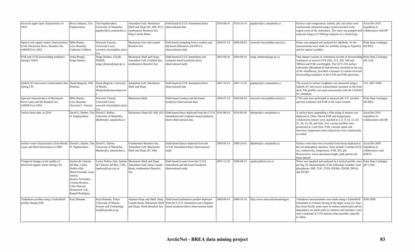
On-track upper layer characteristics in 2010
Bruce Johnson, Tim Papakyriakou
Tim Papakyriakou, University of Manitoba, [email protected]
Amundsen Gulf, Mackenzie Shelf and Slope (EL 449, 451), southeastern Beaufort Sea, Deep Canada Basin
Field based (CCGS Amundsen) direct observational data
2010-08-26 2010-10-10 [email protected] Surface water temperature, salinity, pH, and redox were continuously measured using a system located in the engine room of the Amundsen. The water was pumped and analyzed using a LI-7000 gas analyzer in a closed loop.
ArcticNet 2010 expedition in collaboration with BP
Optical and organic matter characteristics of the Mackenzie River, Beaufort Sea (ARDEX) in 2004
Milla Rautio,Leira Retamal, Catherine Vallières
Warwick Vincent, Université Laval, [email protected]
Mackenzie river and coastal Beaufort Sea
Field-based (sampling from a zodiac) and lab-based (filtrations and HPLC) observational study
2004-07-24 2004-08-03 [email protected] Water was sampled and analyzed for alkalinity. In situ measurements were made for turbidity (using an Aquaflo) and for optical variables.
Polar Data Catalogue (ID 803)
PAR and UVR downwelling irradiance during CASES
Sonia Brugel,Serge Demers
Serge Demers, UQAR-ISMER, [email protected]
Mackenzie Shelf and Slope, Amundsen Gulf, Franklin Bay, southeastern Beaufort Sea
Field-based (CCGS Amundsen) and computer-based (analysis) direct observational study
2003-09-30 2004-08-10 [email protected] This dataset consists of continuous records of downwelling irradiances at several UVR (305, 313, 320, 340 and 380nm) and PAR wavelengths. The GUV-510 surface radiometer (Biospherical Instruments), mounted on the top of the wheelhouse, provided a measure of cosine-corrected downwelling irradiance in the UVR and PAR spectrums.
Polar Data Catalogue (ID 214)
QuikSCAT microwave scatterometer data during CFL
Darek Bogucki, Will Drennan
Darek Bogucki, University of Miami, [email protected]
Amundsen Gulf, Mackenzie Shelf and Slope
Field based (CCGS Amundsen) direct observational data
2007-10-15 2007-11-05 [email protected] The ocean/ice surface roughness was measured using a QuikSCAT microwave scatterometer mounted on the front deck. The profiler was used concurrently with the LAWAS for validation.
CFL 2007-2008
Spectral characteristics of Mackenzie River water and the Beaufort sea (ARDEX) in 2004
Milla Rautio,Leira Retamal,Warwick F. Vincent
Warwick Vincent, Université Laval, [email protected]
Mackenzie Delta Field-based (zodiac) and lab-based (analysis) observational data
2004-07-24 2004-08-03 [email protected] CTD casts were performed to measure pH, UV, incident spectral irradiance and PAR in the water column.
Polar Data Catalogue (ID 895)
Surface buoy data in 2010 David G. Barber, Tim N. Papakyriakou
David G. Barber, University of Manitoba, [email protected]
Mackenzie Slope (EL 449, 451) Field-based (buoy deployed from the CCGS Amundsen) and computer-based (analysis) direct observational data
2010-08-24 2010-09-20 [email protected] A surface buoy suspending a 45m string of sensors was deployed at 250m. Eleven PAR and temperature/ conductivity sensors were attached at 3, 6, 9, 12, 15, 20, 25, 30, 35, 40, and 45m. Two current profilers were positioned at 3 and 45m. PAR, currents speed and direction, temperature and conductivity were continuously recorded.
ArcticNet 2010 expedition in collaboration with BP
Surface water characteristics from Mixed-Layer and Met/Ocean buoys in 2009
David G. Barber, Tim N. Papakyriakou
David G. Barber, University of Manitoba, [email protected]
Southeastern Beaufort Sea, Amundsen Gulf, Mackenzie Shelf and Slope (EL 446)
Field-based (buoys deployed from the CCGS Amundsen) direct observational study
2009-09-14 2009-10-01 [email protected] Surface water data were recorded from buoys deployed at the sea-atmosphere interface. Data include: Currents (0-50 m), conductivity, temperature, PAR, DO, pH, fluorescence, waves maximum height, peak period and mean spread.
ArcticNet 2009 expedition in collaboration with IORVL
Temporal changes in the quality of dissolved organic matter during CFL
Institut de Ciències del Mar, Carlos Pedrós-Alió,Marta Estradal, Laura Alonso,Beatriz Fernández, Cristina Romera,Cèlia Marrasé, Montserrat Coll, Raquel Rodríguez
Carlos Pedrós-Alió, Institut de Ciències del Mar, CSIC, [email protected]
Mackenzie Shelf and Slope, Amundsen Gulf, Deep Canada Basin, southeastern Beaufort Sea
Field-based (rosette from the CCGS Amundsen) and lab-based (analysis) observational study
2007-12-20 2008-08-15 [email protected] Water was sampled and analyzed in a vertical profile, once per leg, for measurements of the following variables: total phosphorus, SRP, TOC, TON, FDOM, CDOM, DFAA, and DCHO.
Polar Data Catalogue (ID 1244)
Turbulence profiles using a TurboMAP profiler during JOIS
Koji Shimada Koji Shimada, Tokyo University of Marine Science and Technology, [email protected]
Alaskan Slope and Shelf, Deep Canada Basin, Mackenzie Shelf and Slope, North Beaufort Sea
Field-based (turbulence profiler deployed from the CCGS Amundsen) and computer-based (analysis) direct observational study
2009-09-19 2009-10-14 http://www.whoi.edu/beaufortgyre Turbulence measurements were made using a TurboMAP instrument to evaluate mixing in the upper ocean (i.e. heat flux from Pacific water layer to surface mixed layer and its dependency on small scale ice motions and latitude). Casts were conducted at CTD stations when possible, typically to 500m.
JOIS 2009
ArcticNet - BREA data mining project 83

Turbulence profiles using a VMP during CFL
Caroline Sévigny, Yves Gratton, Peter Galbraith, Daniel Bourgault, Rick Marsden
Caroline Sévigny, Institut National de la Recherche Scientifique-Eau,terre,environnement, [email protected], Daniel Bourgault, Memorial University, daniel.bourgault @ mun . Ca, Yves Gratton, Institut National de la Recherche Scientifique-Eau,terre,environnement, [email protected]
Mackenzie Shelf and Slope, Amundsen Gulf, Deep Canada Basin, southeastern Beaufort Sea
Field-based (CCGS Amundsen and zodiac) and computer-based (analysis) direct observational study
2007-10-15 2008-01-03 [email protected], daniel.bourgault @ mun . Ca, [email protected]
The Vertical Microstructure Profiler (VMP) was a loosely-tethered free-fall profiler. It was equipped with a suite of microstructure sensors that can measure mm-scale water properties from which the turbulence intensity can be inferred. Data also inlcude CTD profiles (depth, temperature and salinity).
CFL 2007-2008
Underwater PAR and UVR downwelling irradiance profiles during CASES
Sonia Brugel,Serge Demers
Serge Demers, UQAR-ISMER, [email protected]
Mackenzie Shelf and Slope, Amudsen Gulf, Franklin Bay, southeastern Beaufort Sea
Field-based (CCGS Amundsen) and computer-based (analysis) direct observational study
2004-06-04 2004-08-09 [email protected] This dataset consists of vertical profiles of underwater downwelling irradiances at several UVR (305, 313, 320, 340 and 380nm) and PAR wavelengths. Vertical light profiles were performed using a PUV-511 underwater radiometer (Biospherical Instruments) that provided a measure of cosine-corrected downwelling irradiance in the UVR and PAR spectrums.
Polar Data Catalogue (ID 215)
Water colum alkalinity and pH data during IPY-GEOTRACES 2009
Constance Guignard Constance Guignard, McGill University, [email protected]
Mackenzie Delta, Shelf and Slope, Deep Canada Basin
Field-based (rosette from the CCGS Amundsen) and lab-based (spectrophotometer) observational study
2009-08-27 2009-09-12 [email protected] pH and alkalinity measurements were performed on each sample of the water column.
ArcticNet 2009 expedition in collaboration with IPY-GEOTRACES
Water level recorder data in 2007 Wayne Pollard, Michel Allard
Wayne Pollard, Mc Gill University, [email protected], Michel Allard, Centre d'études Nordiques (CEN), Université Laval, [email protected]
Pauline Cove (Herschel Island) Land-based direct observational study and modelling
2007-X-X 2007-X-X [email protected], [email protected]
A water level recorder monitored variations in coastal water level for constructing a digital water elevation model.
ArcticNet project 2.4: Climate and coastal landscape instability, socio-economic and ecological impacts
Water masses characteristics from moorings during CASES
Luc Michaud, Sylvain Blondeau, Pascal Massot, Yves Gratton
Yves Gratton, Institut National de la Recherche Scientifique-Eau,terre,environnement, [email protected]
Mackenzie Shelf and Slope, southeastern Beaufort Sea, Amundsen Gulf, Franklin Bay, (stations CA01, CA02, CA04, CA05, CA06, CA07, CA08, CA09, CA10, CA11, CA12, CA13, CA15, CA16, CA18, CA19, CA20)
Field-based (long-term moorings) direct observational study
2003-10-02 2004-09-29 [email protected] Acoustic Doppler Current Profiler (ADCP), temperature-salinity recorder (SBE37, SBE26, ALEC, ACT), Recorder Current Meter (RCM), light recorder (ACL), turbidity and chlorophyll recorder (ACLW) were moored for one or two years and continuously recorded pressure, salinity, conductivity, temperature and currents speed and direction.
CASES 2003-2004
Water masses characteristics from moorings during CFL
Luc Michaud, Sylvain Blondeau, Pascal Massot, Yves Gratton
Yves Gratton, Institut National de la Recherche Scientifique-Eau,terre,environnement, [email protected]
Mackenzie Slope, southeastern Beaufort Sea, Amundsen Gulf, (stations CA04, CA05, CA08, CA16)
Field-based (long-term moorings) direct observational study
2007-10-18 2008-07-29 [email protected] Temperature-salinity recorder (SBE37, ACTW, MMP), recorder current meters (Continental, RCM, Aquadopp), light recorder (ALW), turbidity and oxygen concentration recorder (RBR-XR), turbidity and chlorophyll recorder (ACLW), nitrates probe (ISUS) were moored for one year and recorded continuously.
CFL 2007-2008
ArcticNet - BREA data mining project 84

Water masses characteristics from moorings during JOIS/CASES
Sarah Zimmermann, Fiona McLaughlin, David Walsh, Koji Shimada, Humfrey Melling, Hirokatsu Uno
Fiona McLaughlin, Department of Fisheries and Oceans Canada, [email protected], Humfrey Melling,Department of Fisheries and Oceans, [email protected]
Southern Alaskan Beaufort Sea (Barrow Canyon, Kugmallut Channel), Mackenzie Delta, Amundsen Gulf (Stations AG05, ASB, NSJ01, BCE01-2, BCC01-2, BCW01-2, ITC01-2
Field-based (long-term moorings) direct observational study
2001-09-12 2002-10-02 http://www.whoi.edu/beaufortgyre, [email protected], [email protected]
Bottom Pressure Recorder (BPR), temperature-salinity recorder (CTD), McLane Moored temperature-salinity Profiler (MMP), Recording Current Meters (RDI, RCM), Internally Recording Imaging Sonar (IRIS) and Acoustic Doppler Current Profiler (ADCP) were moored for one year and continuously recorded pressure, salinity, conductivity, temperature and currents speed and direction.
JOIS/CASES 2001-2002
Water masses characteristics from moorings during JWACS and JOIS
Sarah Zimmermann, Fiona McLaughlin, Jane Eert, Andrey Proshutinsky, Willie Ostrom, Rick Krishfield, Jim Dunn
Fiona McLaughlin, Department of Fisheries and Oceans Canada, [email protected]
Alaskan Slope and Shelf, Deep Canada Basin, Mackenzie Shelf and Slope, North Beaufort Sea
Field-based (long-term moorings) direct observational study
2002-X-X 2010-10-11 http://www.whoi.edu/beaufortgyre, [email protected], [email protected]
Bottom Pressure Recorder (BPR), temperature-salinity recorder (CTD), McLane Moored temperature-salinity Profiler (MMP), Recording Current Meters (RDI, RCM) and Acoustic Doppler Current Profiler (ADCP) were moored for one year and continuously recorded pressure, salinity, conductivity, temperature and currents speed and direction.
JWACS and JOIS 2002-2010
Water masses characteristics from moorings in 2003-2005
Luc Michaud, Sylvain Blondeau, Pascal Massot, Yves Gratton
Yves Gratton, Institut National de la Recherche Scientifique-Eau,terre,environnement, [email protected]
Mackenzie Slope, (station CA13)
Field-based (long-term moorings) direct observational study
2003-10-09 2005-09-04 [email protected] Acoustic Doppler Current Profiler (ADCP), temperature-salinity recorder (SBE37), Recorder Current Meter (RCM) were moored for two years and continuously recorded pressure, salinity, conductivity, temperature and currents speed and direction.
CASES-ArcticNet 2005
Water masses characteristics from moorings in 2004-2005
Luc Michaud, Sylvain Blondeau, Pascal Massot, Yves Gratton
Yves Gratton, Institut National de la Recherche Scientifique-Eau,terre,environnement, [email protected]
Mackenzie Shelf and Slope, southeastern Beaufort Sea, Amundsen Gulf, Franklin Bay, (stations CA04, CA07, CA15, CA18, CA20)
Field-based (long-term moorings) direct observational study
2004-07-17 2005-09-04 [email protected] Acoustic Doppler Current Profiler (ADCP), temperature-salinity recorder (SBE37, ALEC), Recorder Current Meter (RCM), turbidity and chlorophyll recorder (ACLW) were moored for one year and recorded continuously.
CASES 2004, ArcticNet 2005
Water masses characteristics from moorings in 2005-2006
Luc Michaud, Sylvain Blondeau, Pascal Massot, Yves Gratton
Yves Gratton, Institut National de la Recherche Scientifique-Eau,terre,environnement, [email protected]
Mackenzie Shelf and Slope, southeastern Beaufort Sea, Amundsen Gulf, (stations CA04, CA05, CA08, CA18)
Field-based (long-term moorings) direct observational study
2005-08-17 2006-10-07 [email protected] Acoustic Doppler Current Profiler (ADCP), temperature-salinity recorder (SBE37, SBE26, ALEC), Recorder Current Meter (RCM) were moored for one year and continuously recorded pressure, salinity, conductivity, temperature and currents speed and direction.
ArcticNet 2005-2006
Water masses characteristics from moorings in 2006-2007
Luc Michaud, Sylvain Blondeau, Pascal Massot, Yves Gratton
Yves Gratton, Institut National de la Recherche Scientifique-Eau,terre,environnement, [email protected]
Mackenzie Shelf and Slope, southeastern Beaufort Sea, Amundsen Gulf, (station CA18)
Field-based (long-term moorings) direct observational study
2006-10-01 2007-10-24 [email protected] Recording Current Meter (RCM) were moored for one year and continuously recorded currents speed and direction.
ArcticNet 2006-2007
Water masses characteristics from moorings in 2008-2009
Luc Michaud, Sylvain Blondeau, Pascal Massot, Yves Gratton
Yves Gratton, Institut National de la Recherche Scientifique-Eau,terre,environnement, [email protected]
Mouth of the Amundsen Gulf, (stations CA05, CA16)
Field-based (long-term moorings) direct observational study
2008-07-25 2009-10-12 [email protected] Temperature-salinity recorder (SBE37, ALEC, MMP), Recorder Current Meter (RCM), light recorder (ALW), turbidity and oxygen concentration recorder (RBR), turbidity and chlorophyll recorder (ACLW), Acoustic Doppler Current Profiler (ADCP), nitrates probe (ISUS) were moored for one year and recorded continuously.
CFL 2008 and ArcticNet 2009
Water masses characteristics from moorings in 2009-2010
Luc Michaud, Sylvain Blondeau, Pascal Massot, Yves Gratton
Yves Gratton, Institut National de la Recherche Scientifique-Eau,terre,environnement, [email protected]
Mouth of the Amundsen Gulf, (stations CA05, CA16)
Field-based (long-term moorings) direct observational study
2009-10-13 2010-09-24 [email protected] Temperature-salinity recorder (SBE26, ALEC, MMP), Recorder Current Meter (RCM), light recorder (ALW), turbidity and oxygen concentration recorder (RBR), turbidity and chlorophyll recorder (ACLW), Acoustic Doppler Current Profiler (ADCP), nitrates probe (ISUS) were moored for one year and recorded continuously.
ArcticNet 2009-2010
ArcticNet - BREA data mining project 85

7.3. Chemical oceanography7.3.1. Contaminants
Table 7: Contaminants metadataStudy Originators Contact person Study area Type of study Begin date End date Link to data Details Reference
Air and water sampling for HCH, POP and pesticide concentrations during CFL
Liisa Jantunen,Fiona Wong,Terry Bidleman,Anya Gawor, Gary Stern, Crispin Halsall, Sabino del Vento
Ashley Gaden, University of Manitoba, [email protected]
Mackenzie Shelf and Slope, Amundsen Gulf, Deep Canada Basin, southeastern Beaufort Sea
Field-based (CCGS Amundsen) and lab-based (mass-spectrometry) observational study
2007-07-01 2008-07-01 [email protected] The air sampler was at the bow of the ship. Samples were continuously collected on a glass fibre filter and Polyurethane Foam (PUF) to determine the occurrence and levels of banned organochlorine pesticides, currently used pesticides, HCH, Polychlorinated Biphenyls (PCBs), as well as ‘emerging’ contaminants such as the Perfluorinated Alkylated Substances (PFAS). Water samples were collected by filter water through a glass fibre filter followed by a solid phase absorbent. Data generated included concentration of semi-volatile contaminants in air and water and chiral signature of chiral components.
CFL 2007-2008, Polar Data Catalogue (ID 1702)
Air sampling for organic contaminants during CASES
Eric Braekevelt, Allison MacHutchon, Gary Stern, Robie Macdonald, Paul Helm
Gary Stern, Department of Fisheries and Oceans Canada, [email protected]
Mackenzie Shelf and Slope, Amundsen Gulf, Franklin Bay, southeastern Beaufort Sea
Field-based (CCGS Laurier, Radisson and Amundsen) and lab-based (mass-spectrometry) observational study
2002-09-22 2004-08-10 [email protected] The air sampler was at the bow of the ship. Samples were collected on a glass fibre filter and Polyurethane Foam (PUF) for the analysis of organic contaminants and mercury. Air samples were collected for about 48 hours per sample.
CASES 2002-2004
Air sampling for organic contaminants, POPs and PBDEs in 2005
Debbie Armstrong, Joanne DeLaronde, Allyson MacHutchon, Corinne Pomerleau, Gary Stern
Gary Stern, Department of Fisheries and Oceans Canada, [email protected]
Amundsen Gulf, Mackenzie Shelf and Slope, southeastern Beaufort Sea
Field-based (CCGS Amundsen) and lab-based (mass-spectrometry) observational study
2005-09-01 2005-09-14 [email protected] The air sampler was set up at the bow of the ship. Samples were collected on a glass fibre filter and Polyurethane Foam (PUF) for the analysis of organic contaminants, POPs and PBDEs concentrations. Air samples were collected for about 48 hours per sample.
ArcticNet 2005
Air sampling for organic contaminants, POPs and PBDEs in 2006
Debbie Armstrong, Joanne DeLaronde, Allyson MacHutchon, Corinne Pomerleau, Gary Stern
Gary Stern, Department of Fisheries and Oceans Canada, [email protected]
Amundsen Gulf, Mackenzie Shelf and Slope, southeastern Beaufort Sea
Field-based (CCGS Amundsen) and lab-based (mass-spectrometry) observational study
2006-09-28 2006-11-09 [email protected] The air sampler was set up at the bow of the ship. Samples were collected on a glass fibre filter and Polyurethane Foam (PUF) for the analysis of organic contaminants, POPs and PBDEs concentrations. Air samples were collected for about 48 hours per sample.
ArcticNet 2006
Atmospheric mercury concentrations during CASES
Gary Stern, Jeffrey Latonas, Debbie Armstrong
Gary Stern, Department of Fisheries and Oceans Canada, [email protected]
Mackenzie Shelf and Slope, Amundsen Gulf, Franklin Bay, southeastern Beaufort Sea
Field-based (CCGS Amundsen) direct observational study
2004-03-01 2004-08-25 [email protected] Air samples were collected through an high-volume pump once a week for measurements of mercury concentrations.
CASES 2003-2004
Atmospheric mercury concentrations during CFL
Gary Stern Gary Stern, Department of Fisheries and Oceans Canada, [email protected]
Mackenzie Shelf and Slope, Amundsen Gulf, Deep Canada Basin, southeastern Beaufort Sea
Field-based (CCGS Amundsen) direct observational study
2007-12-21 2008-08-04 [email protected] Gaseous Elemental Mercury (GEM; once every 5 minutes), particulate mercury (HgP) and Reactive Gaseous Mercury (RGM; once every 3 hours) concentrations in the atmosphere were continuously measured using different Tekran sensors.
CFL 2007-2008
Atmospheric mercury concentrations in 2005
Gary Stern, Jeffrey Latonas, Debbie Armstrong
Gary Stern, Department of Fisheries and Oceans Canada, [email protected]
Southern Alaskan, Mackenzie Shelf and Slope, Amundsen Gulf
Field-based (CCGS Amundsen) direct observational study
2005-09-01 2005-09-14 [email protected] Gaseous Elemental mercury (GEM) in the atmosphere was continuously measured (every 5 minutes) using a Tekran 2537 instrument.
ArcticNet 2005
Atmospheric mercury concentrations in 2006
Gary Stern Gary Stern, Department of Fisheries and Oceans Canada, [email protected]
Mackenzie Shelf and Slope, Amundsen Gulf, southeastern Beaufort Sea
Field-based (CCGS Amundsen) direct observational study
2006-09-30 2006-10-19 [email protected] Gaseous Elemental Mercury (GEM) in the atmosphere was continuously measured (every 5 minutes) using a Tekran 2537 instrument.
ArcticNet 2006
ArcticNet - BREA data mining project 86

Atmospheric mercury concentrations in 2009
Gary Stern, Jeffrey Latonas, Debbie Armstrong, Anabelle Baya, Holger Hintelmann
Gary Stern, Department of Fisheries and Oceans Canada, [email protected]
Southeastern Beaufort Sea, Amundsen Gulf, Mackenzie Shelf and Slope (EL 446)
Field-based (CCGS Amundsen) direct observational study and lab-based (mercury analyzers ) observational study
2009-07-15 2009-07-30 [email protected], [email protected]
Gaseous Elemental Mercury (GEM) in the atmosphere was continuously measured (every 5 minutes) using a Tekran 2537 instrument.
ArcticNet 2009 expedition in collaboration with IORVL and MALINA
Atmospheric mercury depletion events over the Amundsen Gulf and their net contribution to the mercury flux to the flaw lead system during CFL
Jeffrey Latonas, Sandy Steffen, Feiyue Wang, Gary Stern
Ashley Gaden, University of Manitoba, [email protected]
Amundsen Gulf, southeastern Beaufort Sea
Field-based (CCGS Amundsen) and lab-based (fluorescence spectrophotometry ) observational study
2008-01-20 2008-07-07 [email protected] Air samples were continuously collected and thereafter analyzed for concentrations and speciation of tropospheric mercury. The atmospheric mercury measurements include Gaseous Elemental Mercury (GEM), particulate–phase mercury (Hgp), Reactive Gaseous Mercury (RGM), and Total Atmospheric Mercury (TAM). Flux of elemental Hg across the air-open water interface was estimated mathematically from the measurements of GEM and DGM and available meteorological data.
Polar Data Catalogue (ID 1624)
Biochemistry data from the water column during JOIS
Andrey Proshutinsky, Willie Ostrom, Rick Krishfield, Sarah Zimmermann, Fiona McLaughlin, Jane Eert, Mike Dempsey, Bill Williams
Andrey Proshutinsky, Woods Hole Oceanographic Institution, [email protected], Rick Krishfield, Woods Hole Oceanographic Institution, [email protected], Fiona McLaughlin, Department of Fisheries and Oceans Canada, [email protected]
Alaskan Slope and Shelf, Deep Canada Basin, Mackenzie Shelf and Slope, North Beaufort Sea
Field-based (rosette from the CCGS Louis St-Laurent) and lab-based (analysis) observational study
2003-08-11 2010-10-14 http://www.whoi.edu/beaufortgyre Water was sampled and analyzed for CFC, Plutonium, Freon 11-12-13, HCH, and black carbon.
JWACS and JOIS 2003-2010
Black carbon (soot) over ice in 2008 Stephen Warren, Thomas Grenfell, Kristin Brown
Stephen Warren, University of Washington, [email protected]
Alaskan Slope and Shelf, Deep Canada Basin, Mackenzie Shelf and Slope, North Beaufort Sea
Field-based (CCGS Louis St-Laurent) and lab-based (analysis) observational study
2008-07-17 2008-08-21 [email protected] Samples of the upper snow layer (0-2cm) and lower granular layer (2-10cm) were taken from a 45cm x 45cm snow pit dug out with a metal spatula for the evaluation of black carbon (soot) concentration in Arctic sea ice and snow.
JOIS 2008
Community-based monitoring of beluga health
Lisa Loseto,Peter Ross,Stephen Raverty,Marie Noel
Steven Ferguson, Department of Fisheries and Oceans Canada, [email protected]
Hendrickson Island, Tuktoyaktuk
Field-based and lab-based (analysis) observational study
2007-07-01 2009-07-30 [email protected] This study evaluated a)the risk of adverse health effects associated with exposure to contaminants, b)the nutritional condition as it related to diet quality and c) the incidence of diseases and parasites in beluga whales in the western Canadian Arctic. Sampling efforts took place on Hendrickson Island, just outside of Tuktoyaktuk.Twenty-four harvested whales were sampled in partnership with community based sampling programs. Tissues sampled for contaminant-related health studies included muktuk, muscle, liver, kidney, blood and urine. Additional tissues collected for disease and parastic diagnostics included lung, heart, lymph nodes, thyroid, spleen and any apparent lessions on tissues.
Polar Data Catalogue (ID 1716)
ArcticNet - BREA data mining project 87
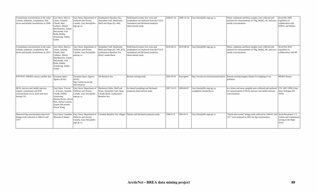
Contaminant concentrations in the water column, sediments, zooplankton, fish larvea and benthic invertebrates in 2009
Gary Stern, Marcos Lemes, Amanda Chaulk, Marc Cadieux, Allison MacHutchon, Joanne DeLaronde, Gail Boila, Debbie Armstrong, Ashley Gaden
Gary Stern, Department of Fisheries and Oceans Canada, [email protected]
Southeastern Beaufort Sea, Amundsen Gulf, Mackenzie Shelf and Slope (EL 446)
Field-based (rosette, box cores and zooplankton net deployed from the CCGS Amundsen) and lab-based (analysis) observational study
2009-07-16 2009-10-16 [email protected] Water, sediments and biota samples were collected and analyzed for measurements of THg, MeHG, HC and trace metals concentrations.
ArcticNet 2009 expedition in collaboration with IORVL and Malina
Contaminant concentrations in the water column, sediments, zooplankton, fish larvea and benthic invertebrates in 2010
Gary Stern, Marcos Lemes, Amanda Chaulk, Marc Cadieux, Allison MacHutchon, Joanne DeLaronde, Gail Boila, Debbie Armstrong, Ashley Gaden
Gary Stern, Department of Fisheries and Oceans Canada, [email protected]
Amundsen Gulf, Mackenzie Shelf and Slope (EL 449, 451), southeastern Beaufort Sea, Deep Canada Basin
Field-based (rosette, box cores and zooplankton net deployed from the CCGS Amundsen) and lab-based (analysis) observational study
2010-08-12 2010-08-26 [email protected] Water, sediments and biota samples were collected and analyzed for measurements of THg, MeHG, HC and trace metals concentrations.
ArcticNet 2010 expedition in collaboration with BP
ENVISAT (MERIS sensor) satellite data European Space Agency (ESA)
European Space Agency (ESA), http://earth.esa.int/cgi-bin/contactus
All Beaufort Sea Remote sensing study 2002-03-01 In progress http://envisat.esa.int/instruments/meris/ Remote sensing imagery dataset for mapping of sea pollution.
MERIS dataset
HCH, mercury and methyl mercury, organic contaminant and POP concentrations in ice, brine and snow during CFL
Gary Stern, Vincent L. St-Louis, Amanda Chaulk, Debbie Armstrong,Monika Pucko, Alexis Burt, Jeffrey Latonas, Joanne DeLaronde, Feiyue Wang
Gary Stern, Department of Fisheries and Oceans Canada, [email protected]
Mackenzie Delta, Shelf and Slope, Amundsen Gulf, Deep Canada Basin, southeastern Beaufort Sea
Ice-based (sampling) and lab-based (analysis) observational study
2007-10-15 2008-08-07 [email protected], [email protected]
Ice, brines and snow sampled were collected and analyzed for measurements of HCH, mercury and methyl mercury concentrations.
CFL 2007-2008, Polar data Catalogue (ID 1620)
Historical Hg concentrations data from beluga teeth collected in 1960-61 and 1977
Gary Stern, Canadian Museum of Nature
Gary Stern, Department of Fisheries and Oceans Canada, [email protected]
Canadian Beaufort Sea villages Dataset and lab-based (analysis) study 1960-X-X 2005-X-X [email protected] "Newly-discovered" beluga teeth collected in 1960-61 and 1977 were analyzed in 2005 for Hg concentration.
ArcticNet project 1.3: Carbon and contaminant cycling in the High Arctic
ArcticNet - BREA data mining project 88
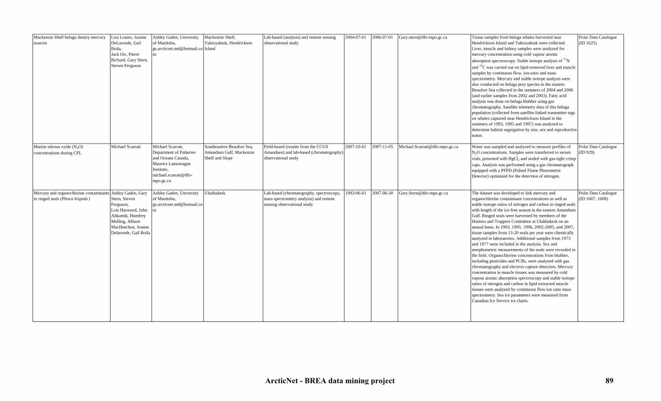
Mackenzie Shelf beluga dietary mercury sources
Lisa Loseto, Joanne DeLaronde, Gail Boila,Jack Orr, Pierre Richard, Gary Stern, Steven Ferguson
Ashley Gaden, University of Manitoba, [email protected]
Mackenzie Shelf,Tuktoyaktuk, Hendrickson Island
Lab-based (analysis) and remote sensing observational study
2004-07-01 2006-07-01 [email protected] Tissue samples from beluga whales harvested near Hendrickson Island and Tuktoyaktuk were collected. Liver, muscle and kidney samples were analyzed for mercury concentration using cold vapour atomic absorption spectroscopy. Stable isotope analysis of 15N and 13C was carried out on lipid-removed liver and muscle samples by continuous flow, ion-ratio and mass spectrometry. Mercury and stable isotope analysis were also conducted on beluga prey species in the eastern Beaufort Sea collected in the summers of 2004 and 2006 (and earlier samples from 2002 and 2003). Fatty acid analysis was done on beluga blubber using gas chromatography. Satellite telemetry data of this beluga population (collected from satellite-linked transmitter tags on whales captured near Hendrickson Island in the summers of 1993, 1995 and 1997) was analyzed to determine habitat segregation by size, sex and reproductive status.
Polar Data Catalogue (ID 1625)
Marine nitrous oxide (N2O) concentrations during CFL
Michael Scarratt Michael Scarratt, Department of Fisheries and Oceans Canada, Maurice Lamontagne Institute, [email protected]
Southeastern Beaufort Sea, Amundsen Gulf, Mackenzie Shelf and Slope
Field-based (rosette from the CCGS Amundsen) and lab-based (chromatography) observational study
2007-10-01 2007-11-05 [email protected] Water was sampled and analyzed to measure profiles of N2O concentrations. Samples were transferred to serum vials, poisoned with HgCl2 and sealed with gas-tight crimp caps. Analysis was performed using a gas chromatograph equipped with a PFPD (Pulsed Flame Photometric Detector) optimized for the detection of nitrogen.
Polar Data Catalogue (ID 929)
Mercury and organochlorine contaminants in ringed seals (Phoca hispida )
Ashley Gaden, Gary Stern, Steven Ferguson,Lois Harwood, John Alikamik, Humfrey Melling, Allison MacHutchon, Joanne Delaronde, Gail Boila
Ashley Gaden, University of Manitoba, [email protected]
Ulukhaktok Lab-based (chromatography, spectroscopy, mass spectrometry analysis) and remote sensing observational study
1993-06-01 2007-06-30 [email protected] The dataset was developed to link mercury and organochlorine contaminant concentrations as well as stable isotope ratios of nitrogen and carbon in ringed seals with length of the ice-free season in the eastern Amundsen Gulf. Ringed seals were harvested by members of the Hunters and Trappers Committee at Ulukhaktok on an annual basis. In 1993, 1995, 1996, 2002-2005, and 2007, tissue samples from 13-20 seals per year were chemically analyzed in laboratories. Additional samples from 1973 and 1977 were included in the analysis. Sex and morphometric measurements of the seals were recorded in the field. Organochlorine concentrations from blubber, including pesticides and PCBs, were analyzed with gas chromatography and electron capture detection. Mercury concentration in muscle tissues was measured by cold vapour atomic absorption spectroscopy and stable isotope ratios of nitrogen and carbon in lipid-extracted muscle tissues were analyzed by continuous flow ion ratio mass spectrometry. Sea ice parameters were measured from Canadian Ice Service ice charts.
Polar Data Catalogue (ID 1607, 1608)
ArcticNet - BREA data mining project 89

Mercury concentration and stable isotope ratios in zooplankton in 2005-2006
Corinne Pomerleau, Joanne DeLaronde,Allison MacHutchon, Gail Boila,Bruno Rosenberg, Gary Stern
Gary Stern, Department of Fisheries and Oceans Canada, [email protected]
Amundsen Gulf, Mackenzie Shelf and Slope, southeastern Beaufort Sea
Field-based (nets deployed from the CCGS Amundsen) and lab-based (analysis) observational study
2005-08-05 2006-09-27 [email protected] Zooplankton (Calanus spp . Euchaeta sp . and hyperiid amphipod Themisto spp. ) was sampled and analyzed for total mercury and methylmercury concentrations and stable isotope ratios. Measurements were done using a Cold Vapour Atomic Absorption Spectroscopy (CVAAS) for Hg analysis, a Gas Chromatography Atomic Fluorescence Spectroscopy (GCAFS) for MMHg analysis and a Continuous Flow Ion Ratio Mass Spectrometry (CF-IRMS) for carbon and nitrogen isotopic analyses.
Polar Data Catalogue (ID 1632)
Mercury concentrations and rates of biogeochemical transformations from 2005 to 2008
Jane L. Kirk,Igor Lehnherr, Vincent St.Louis
Vincent St.Louis, University of Alberta, [email protected]
Mackenzie Shelf and Slope, Amundsen Gulf, Deep Canada Basin, southeastern Beaufort Sea
Field-based (rosette deployed from the CCGS Amundsen) and lab-based (mass-spectroscopy techniques and incubation) observational study
2005-08-16 2008-08-08 [email protected] Water samples were collected at the surface, middle, bottom and chlorophyll maximum in the water column and were analysed for total Hg, MMHg, DMHg and GEM concentrations. To quantify rates of biogeochemical Hg transformations in the water column, some water samples were amended with Hg stable-isotope tracers, namely 198Hg(II) and MM199Hg, and incubated on-board the ship for up to 25 hours before being preserved by acidification or freezing.
Polar Data Catalogue (ID 976)
MMHg and DMHg concentrations in sea water in 2009
Anabelle Baya, Holger Hintelmann
Holger Hintelmann, Trent University, [email protected]
Southern Alaskan Beaufort Sea, Mackenzie Shelf and Slope, Amundsen Gulf, southeastern Beaufort Sea
Field-based (rosette deployed from the CCGS Amundsen) and lab-based (analysis) observational study
2009-07-11 2009-10-16 [email protected] MMHg and DMHg concentrations profiles in the water column were measured.
ArcticNet 2009 expedition in collaboration with IORVL and Malina
Multi media contaminant survey in 2005 Philippe Constant,Laurier Poissant,Martin Pilote,Fabien Aulagnier
Laurier Poissant, Environment Canada, [email protected]
Amundsen Gulf, Mackenzie Shelf and Slope, southeastern Beaufort Sea
Field-based (CCGS Amundsen) direct observational study
2005-09-01 2005-09-14 [email protected] GEM, pesticides and trace gas concentrations in the atmosphere were continuously measured.
Polar Data Catalogue (ID 1076-1218)
Near surface seawater measurements of undisturbed water in 2008
Fiona McLaughlin, Michiyo Kawai
Fiona McLaughlin, Department of Fisheries and Oceans Canada, [email protected], Michiyo Kawai, Department of Fisheries and Oceans Canada, [email protected].
Alaskan Slope and Shelf, Deep Canada Basin, Mackenzie Shelf and Slope, North Beaufort Sea
Field-based (zodiac) and lab-based (analysis) direct observational study
2008-07-17 2008-08-21 [email protected], [email protected].
Surface water (1, 5 and 10 m) was sampled and analyzed for DIC, CO2, Ba, 18O and nutrients concentrations.
JOIS 2008
Nutrients transect in the Mackenzie River and the Beaufort sea (ARDEX) in 2004
Warwick Vincent,Lance Lesack,Craig A. Emmerton
Warwick Vincent, Université Laval, [email protected]
Mackenzie Delta Field based (sampling) and lab-based (fluorescence analysis) observational study
2004-07-24 2004-08-03 [email protected] Water was sampled and analyzed for MeHg concentrations Polar Data Catalogue (ID 816)
Organic contaminant and mercury concentrations in snow and sea ice during CASES
Eric Braekevelt, Allison MacHutchon, Gary Stern
Gary Stern, Department of Fisheries and Oceans Canada, [email protected]
Mackenzie Shelf and Slope, Amundsen Gulf, Franklin Bay, southeastern Beaufort Sea
Ice-based (sampling) and lab-based (analysis) observational study
2002-09-22 2004-08-25 [email protected] Ice, brines and snow sampled were collected and analyzed for measurement of mercury, methyl mercury concentrations, organic contaminant, organohalogen, HCH and endosulfan concentrations.
CASES 2002-2004
Organic contaminant and mercury concentrations in water, sediments and suspended sediments during CFL
Dan Leitch, Jesse Carrie, Scott Coughtrey, Neil Rentz, Debbie Armstrong, Feiyue Wang, Gary Stern
Gary Stern, Department of Fisheries and Oceans Canada, [email protected]
Mackenzie Delta, Shelf and Slope, Amundsen Gulf, Deep Canada Basin, southeastern Beaufort Sea
Field-based (zodiac and rosette from the CCGS Amundsen) and lab-based (analysis) observational study
2007-10-15 2008-08-07 [email protected], [email protected]
Profiles of organic contaminant, HCH, Perfluorooctanoic Acid (PFOA), Perfluorooctane Sulfonic acid (PFOS), mercury and methyl mercury concentrations in the water column and sediments were measured using a Tekran Hg analyzer.
CFL 2007-2008, Polar data Catalogue (ID 1668-1640)
ArcticNet - BREA data mining project 90

Organic contaminant and mercury concentrations in water, sediments, suspended sediments, zooplankton and fish during CASES
Gary Stern, Robie Macdonald, Paul Helm, Eric Braekevelt, Tara Businski
Gary Stern, Department of Fisheries and Oceans Canada, [email protected]
Mackenzie Shelf and Slope, Amundsen Gulf, Franklin Bay, southeastern Beaufort Sea
Field-based (rosette, box cores and zooplankton net deployed from the CCGS Radisson and Amundsen) and lab-based (analysis) observational study
2002-09-22 2004-08-25 [email protected] Profiles of organic contaminant, methyl mercury and mercury concentrations in the water column and sediments were measured, as well as concentrations in sediments, zooplankton and fish.
CASES 2002-2004
Organic contaminant, POP, PBDE, methyl mercury and mercury concentrations in water, sediments, zooplankton and fish larvea in 2005
Eric Braekevelt, Allison MacHutchon, Gary Stern
Gary Stern, Department of Fisheries and Oceans Canada, [email protected]
Amundsen Gulf, Mackenzie Shelf and Slope, southeastern Beaufort Sea
Field-based (rosette, box cores and zooplankton net deployed from the CCGS Amundsen) and lab-based (analysis) observational study
2005-09-01 2005-09-14 [email protected] Water, sediments and biota samples were collected and analyzed for measurement of organic contaminant, POP, PBDE, methyl mercury and mercury concentrations.
ArcticNet 2005
Organic contaminant, POP, PBDE, methyl mercury and mercury concentrations in water, sediments, zooplankton and fish larvea in 2006
Eric Braekevelt, Allison MacHutchon, Gary Stern
Gary Stern, Department of Fisheries and Oceans Canada, [email protected]
Amundsen Gulf, Mackenzie Shelf and Slope, southeastern Beaufort Sea
Field-based (rosette, box cores and zooplankton net deployed from the CCGS Amundsen) and lab-based (analysis) observational study
2006-09-28 2006-11-09 [email protected] Water, sediments and biota samples were collected and analyzed for measurement of organic contaminants, POPs, PBDEs, methyl mercury and mercury concentrations.
ArcticNet 2006
Sampling of estuarine fish for Hg and fatty acid analysis in 2005
Gary Stern, Feiyue Wang
Gary Stern, Department of Fisheries and Oceans Canada, [email protected]
Mackenzie Delta Field-based (CCGS Nahidik) and lab-based (analysis) observational study
2005-07-27 2005-08-20 [email protected], [email protected]
Estuarine fish were collected for mercury and fatty acids analysis to determine their importance in the Beaufort Beluga diet.
ArcticNet project 1.3: Carbon and contaminant cycling in the High Arctic
Sediment samples for contaminant analysis during JOIS/CASES 2002
Kavik-Axys Environmental Consultants and Devon Petroleum
Kavik-Axys Environmental Consultants, [email protected]
Mackenzie Delta, Kugmallit Bay
Field-based (box cores deployed from the CCGS Amundsen) and lab-based (analysis) observational study
2002-09-13 2002-09-13 [email protected] Sediment samples were collected and analyzed for measurement of mercury, methyl mercury and organic contaminant concentrations.
JOIS/CASES 2002
Sediments cores for contaminant concentrations during CASES
Alec Aitken, David B. Scott, André Rochon, Peta Mudie, Kathy Conlan, Jean-Marc Gagnon, Dennis Darby, Steve Blasco, Gary Stern
Gary Stern, Department of Fisheries and Oceans Canada, [email protected]
Mackenzie Shelf and Slope, Amundsen Gulf, southeastern Beaufort Sea
Field-based (box corer deployed from the CCGS Radisson) and lab-based (analysis) observational study
2002-09-20 2002-10-14 [email protected] Sediments samples were collected and analyzed for mercury and organic contaminant concentrations.
CASES 2002
Shore zone sensitivity to potential petroleum contamination in 2004-2007
Donald L. Forbes, Wayne Pollard, Trevor Bell
Donald L. Forbes, Memorial University of Newfoundland, [email protected], Wayne Pollard, Mc Gill University, [email protected], Trevor bell, Memorial University of Newfoundland, [email protected]
Sachs Harbour Field-based study 2004-X-X 2007-X-X [email protected], [email protected], [email protected]
Shore-zone sensitivity to potential petroleum contamination were investigated.
ArcticNet project 1.2: Coastal vulnerability in a warming Arctic
Temporal evolution of a melting ice core during CFL
Gary Stern Gary Stern, Department of Fisheries and Oceans Canada, [email protected]
Amundsen Gulf Ice-based and lab-based (controlled melting of an ice-core) observational study
2008-01-15 2008-01-29 [email protected] Ice cores were stored inside clean plastic sleeves and hung in vertical position to allow dripping from the bottom of the plastic sleeve. The experiment set-up was at an air temperature of about 10–15° C. Meltwater samples were collected for HCH concentrations.
CFL 2007-2008
ArcticNet - BREA data mining project 91
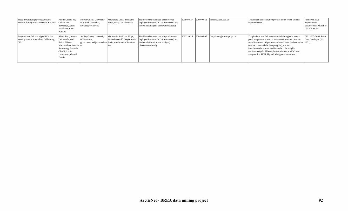
Trace metals sample collection and analysis during IPY-GEOTRACES 2009
Kristin Orians, Jay Cullen, Ian Beveridge, Jason McAlister, Elena Ramirez
Kristin Orians, University of British Columbia, [email protected]
Mackenzie Delta, Shelf and Slope, Deep Canada Basin
Field-based (trace metal clean rosette deployed from the CCGS Amundsen) and lab-based (analysis) observational study
2009-08-27 2009-09-12 [email protected] Trace metal concentration profiles in the water column were measured.
ArcticNet 2009 expedition in collaboration with IPY-GEOTRACES
Zooplankton, fish and algae HCH and mercury data in Amundsen Gulf during CFL
Alexis Burt, Joanne DeLaronde, Gail Boila, Allison MacHutchon, Debbie Armstrong, Amanda Chaulk, Louis Letourneau, Gerald Darnis
Ashley Gaden, University of Manitoba, [email protected]
Mackenzie Shelf and Slope, Amundsen Gulf, Deep Canada Basin, southeastern Beaufort Sea
Field-based (rosette and zooplankton net deployed from the CCGS Amundsen) and lab-based (filtration and analysis) observational study
2007-10-15 2008-08-07 [email protected] Zooplankton and fish were sampled through the moon-pool, in open water and at ice covered stations. Species were live sorted. Algae were collected from the bottom ice (via ice cores and the dive program), the ice interface/surface water and from the chlorophyll a maximum depth. All samples were frozen at -25C and analysed for, HCH, Hg and MeHg concentrations.
CFL 2007-2008, Polar Data Catalogue (ID 1621)
ArcticNet - BREA data mining project 92

7.3. Chemical oceanography7.3.2. Biochemical cycles
Table 8: Biochemical cycles metadataStudy Originators Contact person Study area Type of study Begin date End date Link to data Details Reference
Annual dynamics of bacterial biomass and production during CASES
Christine Martineau,Milla Rautio, Ramon Terrado, Marie-Ève Garneau, Sébastien Roy, Leira Retamal,Catherine Vallières,Patricia Ramlal
Warwick Vincent, Université Laval, [email protected]
Mackenzie Shelf and Slope, Franklin Bay, Amundsen Gulf, southeastern Beaufort Sea
Field-based (rosette deployed from the CCGS Amundsen) and lab-based (spectrophotometry, epifluorescence and centrifugation) observational study
2003-11-04 2004-08-06 [email protected] Water samples were collected at a 200 m and analyzed for CDOM absorption coefficient at 320 nm and bacterial carbon production measured with 3H-leucine incorporation method.
Polar Data Catalogue (ID 597, 815)
Arctic SOLAS DMS data in 2007 Sonia Michaud,Michael Scarratt,Myriam Luce, Maurice Levasseur
Maurice Levasseur, Université Laval, [email protected]
Southeastern Beaufort Sea, Amundsen Gulf
Field-based (rosette and pump from the CCGS Amundsen) and lab-based (incubation, analysis) observational study
2007-09-27 2007-08-11 [email protected] DMSP and DMS water concentrations were determined at fixed depths and at selected stations. During transit time, near surface DMS measurements were conducted every 2 hours.
Polar Data Catalogue (ID 904)
Arctic-SOLAS DMS and atmospheric chemistry data in 2007
Steve Sjostedt, Jon Abbatt
Jon Abbatt, University of Toronto, [email protected]
Southeastern Beaufort Sea, Amundsen Gulf
Field-based (CCGS Amundsen) and lab-based (spectrometry, scans, proton-transfer-reaction, UV absorption, fluorescence) observational study
2007-09-27 2007-11-08 [email protected] Air samples were continuously collected at the bow of the ship and on top of the bridge and analyzed for aerosol composition, particles sizes, volatile organic compound composition, ozone and sulfur dioxide.
Polar Data Catalogue (ID 767)
Biochemical data in sea ice and water during CFL
David G. Barber, Pascale Collin, Lisa Miller, Huixiang Xie, Pierre Larouche, Helmuth Thomas
Helmuth Thomas, Dalhousie University, [email protected]
Mackenzie Shelf and Slope, Amundsen Gulf, Deep Canada Basin, southeastern Beaufort Sea
Field-based (rosette from the CCGS Amundsen) and lab-based (analysis) observational study
2007-10-15 2008-08-01 [email protected], [email protected]
Ice cores and water were collected and analyzed for DIC, DOC, CDOM, CO concentrations, delta 13C, and FDOM concentrations. The water was collected at 0 m, 5 m, 10 m, 12 m, 25 m, 50 m, 100 m, 180 m, 200 m and 250 m.
CFL 2007-2008
Biochemical study of newly formed sea ice during CASES
Michel Poulin,Christine Michel,Michel Gosselin,Magdalena Rózanska, Andrea Riedel
Christine Michel, Department of Fisheries and Oceans Canada, [email protected]
Amundsen Gulf, Mackenzie Shelf and Slope, southeastern Beaufort Sea
Field-based (CCGS Amundsen) and lab-based (analysis) direct observational study
2002-09-26 2003-11-19 [email protected] Surface waters and new ice were sampled and analyzed for nutrients (NH4, NO2, NO3, Si(OH)4, PO4) and DOC concentrations..
Polar Data Catalogue (ID 230)
Biochemistry data from the water column during CASES/JOIS
Humfrey Melling Humfrey Melling,Department of Fisheries and Oceans Canada, [email protected]
Mackenzie Shelf and Slope, Amundsen Gulf, Franklin Bay, southeastern Beaufort Sea
Field-based (rosette from the CCGS Laurier) and lab-based (analysis) observational study
2002-09-18 2002-09-22 http://www.whoi.edu/beaufortgyre Water was sampled and analyzed for 137Cesium, 129Iodine, Plutonium, dissolved organic oxygen, PO4, NO3, SiO4, 18O, CDOM, DIC, 13C, Barium, O2, TCO2, POC, PON, DOC, Americium, Ammonium, TOC, TON, total suspended solids, urea, Helium, Tritium, DO14C, DI14C, and CHO.
CASES/JOIS 2002
ArcticNet - BREA data mining project 93

Biochemistry data from the water column during JWACS and JOIS
Andrey Proshutinsky, Willie Ostrom, Rick Krishfield, Sarah Zimmermann, Fiona McLaughlin, Jane Eert, Mike Dempsey, Bill Williams
Andrey Proshutinsky, Woods Hole Oceanographic Institution, [email protected], Rick Krishfield, Woods Hole Oceanographic Institution, [email protected], Fiona McLaughlin, Departement of Fisheries and Oceans Canada, [email protected]
Alaskan Slope and Shelf, Deep Canada Basin, Mackenzie Shelf and Slope, North Beaufort Sea
Field-based (rosette from the CCGS Louis St-Laurent) and lab-based (analysis) observational study
2003-08-11 2010-10-14 http://www.whoi.edu/beaufortgyre Water was sampled and analyzed for 137Cesium, 129Iodine, Plutonium, dissolved organic oxygen, PO4, NO3, SiO4, 18O, CDOM, DIC, 13C, Barium, O2, TCO2, POC, PON, DOC, Americium, Ammonium, TOC, TON, total suspended solids, urea, Helium, Tritium, DO14C, DI14C, and CHO.
JWACS and JOIS 2003-2010
Carbon and nutrient fluxes in sea ice, brine and surface water during CFL
Christine Michel, Owen Owens
Christine Michel, Department of Fisheries & Oceans Canada,[email protected]
Mackenzie Shelf and Slope, Amundsen Gulf, Deep Canada Basin, southeastern Beaufort Sea
Field-based (CCGS Amundsen) and lab-based (analysis) observational study
2007-10-15 2008-08-07 [email protected] Surface waters, brine and ice were sampled and analyzed for inorganic nutrients, DOC, DON, POC, PON and pCO2
using ice corers and free-drifting sediment traps.
CFL 2007-2008
Carbon monoxide (CO) in surface water and the water column during CASES
Huixiang Xie, Tao Lou, Manuel Norroy
Huixiang Xie, ISMER/UQAR, [email protected]
Mackenzie Shelf and Slope, Amundsen Gulf, Franklin Bay, southeastern Beaufort Sea
Field-based (rosette and bucket deployed from the CCGS Amundsen) observational study and lab-based (photochemical incubation and photochemical-optical modeling) observational study
2003-09-28 2004-06-15 [email protected] Water was sampled and analyzed for CO concentration, microbial CO consumption and photoproduction.
Polar Data Catalogue (ID 246)
CO2 and H2O concentrations in the atmosphere from tower sensors during CASES
Tim Papakyriakou, Peter Minnet, Chris Konig, Owen Owens
Tim Papakyriakou, University of Manitoba, [email protected]
Mackenzie Shelf and Slope, Amundsen Gulf, Franklin Bay, southeastern Beaufort Sea
Field-based (CCGS Radisson and Amundsen) direct observational study
2002-09-22 2004-08-10 [email protected] CO2 and H2O atmospheric concentrations were continuously recorded through LI7500 and LI7000 open path gaz analyzer sensors located on top of the bridge.
CASES 2002-2004
CO2 and H2O concentrations in the atmosphere from tower sensors during CFL
Tim Papakyriakou Tim Papakyriakou, University of Manitoba, [email protected]
Mackenzie Shelf and Slope, Amundsen Gulf, Deep Canada Basin, southeastern Beaufort Sea
Field-based (CCGS Amundsen) direct observational study
2007-10-15 2008-08-07 [email protected] CO2 and H2O atmospheric concentrations were continuously recorded through LI7500 and LI7000 open path gaz analyzer sensors located on top of the bridge.
CFL 2007-2008
CO2 and H2O concentrations in the atmosphere from tower sensors in 2005
Tim Papakyriakou Tim Papakyriakou, University of Manitoba, [email protected]
Amundsen Gulf, Mackenzie Shelf and Slope, southeastern Beaufort Sea
Field-based (CCGS Amundsen) direct observational study
2005-09-01 2005-09-14 [email protected] CO2 and H2O atmospheric concentrations were continuously recorded through LI7500 and LI7000 open path gaz analyzer sensors located on top of the bridge.
ArcticNet 2005
CO2 and H2O concentrations in the atmosphere from tower sensors in 2006
Tim Papakyriakou Tim Papakyriakou, University of Manitoba, [email protected]
Amundsen Gulf, Mackenzie Shelf and Slope, southeastern Beaufort Sea
Field-based (CCGS Amundsen) direct observational study
2006-09-30 2006-10-19 [email protected] CO2 and H2O atmospheric concentrations were continuously recorded through LI7500 and LI7000 open path gaz analyzer sensors located on top of the bridge.
ArcticNet 2006
CO2 and H2O concentrations in the atmosphere from tower sensors in 2009
Tim Papakyriakou Tim Papakyriakou, University of Manitoba, [email protected]
South Alaskan Beaufort Sea, southeastern Beaufort Sea, Amundsen Gulf, Mackenzie Shelf and Slope (EL 446)
Field-based (CCGS Amundsen and buoy) direct observational study
2009-07-13 2009-10-16 [email protected] CO2 and H2O atmospheric concentrations were continuously recorded through LI7500 and LI7000 open path gaz analyzer sensors located on top of the bridge.
ArcticNet 2009 expedition in collaboration with MALINA and IORVL
CO2 and H2O concentrations in the atmosphere from tower sensors in 2010
Bruce Johnson, Tim Papakyriakou
Tim Papakyriakou, University of Manitoba, [email protected]
Amundsen Gulf, Mackenzie Shelf and Slope (EL 449, 451), southeastern Beaufort Sea, Deep Canada Basin
Field-based (CCGS Amundsen) direct observational study
2010-08-26 2010-10-10 [email protected] CO2 and H2O atmospheric concentrations were continuously recorded through LI7500 and LI7000 open path gaz analyzer sensors located on top of the bridge.
ArcticNet 2010 expedition in collaboration with BP
ArcticNet - BREA data mining project 94

CO2 fluxes by accumulation chamber during CASES
Tim Papakyriakou, Owen Owens
Tim Papakyriakou, University of Manitoba, [email protected]
Franklin Bay, Amundsen Gulf Ice-based direct observational study 2003-11-26 2004-02-17 [email protected] The goal of these measurements was to evaluate the CO2
gas transfert at the sea ice-atmosphere interface. The chamber was connected in a closed loop between the air pump (3 L min-1) and an IRGA (Licor 6262). The measurement of pCO2 in the chamber was recorded every 30 sec for at least 5 min and the CO2 was measured continuously.
CASES 2003-2004
CO2 fluxes by accumulation chamber during CFL
Tim Papakyriakou,Gauthier Carnat,Frederic Brabant,Nicolas-Xavier Geilfus,Bruno Delille
Tim Papakyriakou, University of Manitoba, [email protected]
Mackenzie Shelf and Slope, Amundsen Gulf, Deep Canada Basin, southeastern Beaufort Sea
Ice-based direct observational study 2007-10-15 2008-07-18 [email protected] The goal of these measurements was to evaluate the CO2
gas transfert at the sea ice-atmosphere interface. The chamber was connected in a closed loop between the air pump (3 L min-1) and an IRGA (Licor 6262). The measurement of pCO2 in the chamber was recorded every 30 sec for at least 5 min and the CO2 was measured continuously.
CFL 2007-2008, Polar Data Catalogue (ID 1598)
Concentrations of biochemical components in ice and snow during CFL
Tim Papakyriakou, Gauthier Carnat, Nes Sutherland, Helmuth Thomas, Alfonso Mucci, Constance Guignard, Friederike Prowe, Maurice Levasseur, Ann-Lyse Norman
Tim Papakyriakou, University of Manitoba, [email protected], Helmuth Thomas, Dalhousie University, [email protected]
Mackenzie Shelf and Slope, Amundsen Gulf, Deep Canada Basin, southeastern Beaufort Sea
Ice-based and lab-based (gas chromatography) observational study
2007-11-14 2008-08-04 [email protected], [email protected], [email protected]
Water, snow and ice were sampled and analyzed for measurements of the DMS, DMSP, N2, O2,
18O and CO2
concentrations profiles.
CFL 2007-2008, Polar Data Catalogue (ID 1600, 1601, 1602)
Dissolved 223Ra, 224Ra, 226Ra and 228Ra data during IPY-GEOTRACES 2009
Erika Sternberg-Bousserez, Helmuth Thomas
Helmuth Thomas, Dalhousie University, [email protected]
Mackenzie Delta, Shelf and Slope, Deep Canada Basin
Field-based (rosette from the CCGS Amundsen) and lab-based (analysis) observational study
2009-08-27 2009-09-12 [email protected] Dissolved 223Ra, 224Ra, 226Ra and 228Ra concentration profiles were measured using gamma spectrometry and an alpha counter
ArcticNet 2009 expedition in collaboration with IPY-GEOTRACES
Dissolved 230Th, 231Pa and 129I during IPY-GEOTRACES 2009
Roger Francois, Maureen Soon, Bart De Baere
Roger François, University of Britich Columbia, [email protected]
Mackenzie Delta, Shelf and Slope, Deep Canada Basin
Field-based (rosette from the CCGS Amundsen) and lab-based (filtration and analysis) observational study
2009-08-27 2009-09-12 [email protected] Dissolved 230Th, 231Pa and 129I concentration profiles were measured by exposing the filtered samples to a chemical reaction.
ArcticNet 2009 expedition in collaboration with IPY-GEOTRACES
Dissolved and particulate 234Th during IPY-GEOTRACES 2009
Nes Sutherland, Lisa Miller
Lisa Miller, DFO, [email protected]
Mackenzie Delta, Shelf and Slope, Deep Canada Basin
Field-based (large-volume pumps and rosette from the CCGS Amundsen) and lab-based (analysis) observational study
2009-08-27 2009-09-12 [email protected] Dissolved and particulate 234Th concentrations profiles were measured.
ArcticNet 2009 expedition in collaboration with IPY-GEOTRACES
Dissolved Inorganic Carbon (DIC) during IPY-GEOTRACES 2009
Constance Guignard, Helmuth Thomas
Helmuth Thomas, Dalhousie University, [email protected]
Mackenzie Delta, Shelf and Slope, Deep Canada Basin
Field-based (rosette from the CCGS Amundsen) and lab-based (spectrophotometer) observational study
2009-08-27 2009-09-12 [email protected] DIC concentration measurements were performed on each sample of the water column.
ArcticNet 2009 expedition in collaboration with IPY-GEOTRACES
Dissolved Inorganic Carbon (DIC), alkalinity and pH data during IPY-GEOTRACES 2009
Constance Guignard Constance Guignard, McGill University, [email protected]
Mackenzie Delta, Shelf and Slope, Deep Canada Basin
Field-based (rosette from the CCGS Amundsen) and lab-based (filtration and analysis) observational study
2009-08-27 2009-09-12 [email protected] Dissolved Inorganic Carbon (DIC) concentrations, Total Alkalinity (TA) and pH profiles were measured from water samples at several depths.
ArcticNet 2009 expedition in collaboration with IPY-GEOTRACES
ArcticNet - BREA data mining project 95
Dissolved Inorganic Carbon (DIC), delta 13C, Total Alkalinity (TA) and pH data from water, brine, snow and ice during CASES
Michael Arychuk, Tim Papakyriakou, Owen Owens
Michael Arychuk, Department of Fisheries and Oceans Canada, [email protected]
Mackenzie River, Franklin Bay, Amundsen Gulf, southeastern Beaufort Sea
Ice, field-based (CCGS Amundsen) and lab-based (analysis) observational study
2004-01-07 2004-02-17 [email protected] Dissolved Inorganic Carbon (DIC) concentrations, delta 13C, Total Alkalinity (TA) and pH were measured in water, ice, brine and snow samples using a VINDTA3C.
CASES 2003-2004
Dissolved Inorganic Carbon (DIC), delta 13C, Total Alkalinity (TA) and pH data from water, brine, snow and ice during CFL
Helmuth Thomas, Tim Papakyriakou, Brent Else, Nes Sutherland, Alfonso Mucci
Helmuth Thomas, Dalhousie University, [email protected], Tim Papakyriakou, University of Manitoba, [email protected]
Mackenzie Shelf and Slope, Amundsen Gulf, Deep Canada Basin, southeastern Beaufort Sea
Ice, field-based (CCGS Amundsen) and lab-based (analysis) observational study
2007-09-29 2008-08-02 [email protected], [email protected]
Dissolved Inorganic Carbon (DIC) concentrations, delta 13C, Total Alkalinity (TA) and pH were measured in water, ice, brine and snow samples using a VINDTA3C.
CFL 2007-2008
Dissolved Organic Carbon (DOC) and Total Suspended Solids (TSS) concentrations in the water column in 2009
Gary Stern, Imperial Oil
Gary Stern, Department of Fisheries and Oceans Canada, [email protected]
Mackenzie slope (EL 446) Field-based (rosette from the CCGS Amundsen) and lab-based (fitration and analysis) observational study
2009-07-16 2009-07-30 [email protected] Dissolved Organic Carbon (DOC) and Total Suspended Solids (TSS) concentration profiles were measured.
ArcticNet 2009 expedition in collaboration with IORVL
Dissolved organic carbon distribution during CFL
Christine Michel, Geneviève Tremblay
Christine Michel, Department of Fisheries and Oceans Canada, [email protected]
Mackenzie Shelf and Slope, Amundsen Gulf, southeastern Beaufort Sea
Field-based (rosette from the CCGS Amundsen) and lab-based (filtration and analysis) observational study
2007-09-29 2007-11-03 [email protected] The distribution and concentration of Dissolved Organic Carbon (DOC) in the euphotic and aphotic zone were measured. Euphotic zone sampling depths corresponded to surface irradiances between 0.2 and 100% as well as the chlorophyll a maximum depth. Aphotic zone sampling depths ranged from 75 m to the bottom waters.
Polar Data Catalogue (ID 998)
Dissolved organic carbon distribution in 2006
Christine Michel,Laurel McFadden,Kary Proteau,Bernard LeBlanc
Christine Michel, Department of Fisheries and Oceans Canada, [email protected]
Amundsen Gulf, Mackenzie Shelf and Slope, southeastern Beaufort Sea
Field-based (rosette from the CCGS Amundsen) and lab-based (filtration and analysis) observational study
2006-09-04 2006-10-17 [email protected] The distribution and concentration of Dissolved Organic Carbon (DOC) in the euphotic and aphotic zone were measured. Euphotic zone sampling depths corresponded to surface irradiances between 0.2 and 100% as well as the chlorophyll a maximum depth. Aphotic zone sampling depths ranged from 75 m to the bottom waters.
Polar Data Catalogue (ID 926)
Dissolved organic matter (including lignin and photoreactivity) transects of the Mackenzie River, Beaufort Sea (ARDEX) in 2004
Christopher Osburn, Warwick Vincent
Warwick Vincent, Université Laval, [email protected]
Mackenzie Delta Field-based (sampling) and lab-based (filtration and spectroscopy analysis) observational study
2004-07-24 2004-08-03 [email protected] Water samples were collected for d13C, DOC, DIC, amino acids carbohydrates, EEM, sychronous fluorescence and near IR reflectance. Photobleaching experiments and dissolved lignin extractions were performed.
Polar Data Catalogue (ID 802)
Inherent and apparent optical properties during CASES
Pierre Larouche,Selima Ben Mustapha, Simon Bélanger, Corinne Bourgeault-Brunelle,Shilin Tang
Pierre Larouche, Institut Maurice-Lamontagne, [email protected]
Mackenzie Shelf and Slope, Amundsen Gulf, Franklin Bay, southeastern Beaufort Sea
Field-based (rosette from the CCGS Amundsen) and lab-based (HPLC, radiometry) observational study
2003-09-24 2004-08-12 [email protected] Water was sampled and analyzed for total suspended matter and CDOM as indicators of light penetration.
CASES 2003-2004, Polar Data Catalogue (ID 1118)
ArcticNet - BREA data mining project 96

Inherent and apparent optical properties during CFL
Pierre Larouche,Selima Ben Mustapha, Simon Bélanger, Corinne Bourgeault-Brunelle,Shilin Tang
Pierre Larouche, Institut Maurice-Lamontagne, [email protected]
Mackenzie Shelf and Slope, Amundsen Gulf, Deep Canada Basin, southeastern Beaufort Sea
Field-based (rosette from the CCGS Amundsen) and lab-based (HPLC, radiometry) observational study
2007-10-15 2008-08-07 [email protected] Water was sampled and analyzed for total suspended matter and CDOM as indicators of light penetration.
CFL 2007-2008, Polar Data Catalogue (ID 1118)
Inherent and apparent optical properties in 2005
Pierre Larouche,Selima Ben Mustapha, Simon Bélanger, Corinne Bourgeault-Brunelle,Shilin Tang
Pierre Larouche, Institut Maurice-Lamontagne, [email protected]
Amundsen Gulf, Mackenzie Shelf and Slope, southeastern Beaufort Sea
Field-based (rosette from the CCGS Amundsen) and lab-based (HPLC, radiometry) observational study
2005-09-01 2005-09-14 [email protected] Water was sampled and analyzed for total suspended matter and CDOM as indicators of light penetration.
ArcticNet 2005, Polar Data Catalogue (ID 1118)
Inherent and apparent optical properties in 2006
Pierre Larouche,Selima Ben Mustapha, Simon Bélanger, Corinne Bourgeault-Brunelle,Shilin Tang
Pierre Larouche, Institut Maurice-Lamontagne, [email protected]
Amundsen Gulf, Mackenzie Shelf and Slope, southeastern Beaufort Sea
Field-based (rosette from the CCGS Amundsen) and lab-based (HPLC, radiometry) observational study
2006-09-30 2006-10-19 [email protected] Water was sampled and analyzed for total suspended matter and CDOM as indicators of light penetration.
ArcticNet 2006, Polar Data Catalogue (ID 1118)
Inherent and apparent optical properties in 2009
Pierre Larouche,Selima Ben Mustapha, Simon Bélanger, Corinne Bourgeault-Brunelle,Shilin Tang
Pierre Larouche, Institut Maurice-Lamontagne, [email protected]
Southeastern Beaufort Sea, Amundsen Gulf, Mackenzie Shelf and Slope (EL 446)
Field-based (rosette from the CCGS Amundsen) and lab-based (HPLC, radiometry) observational study
2009-07-15 2009-10-16 [email protected], [email protected]
Water was sampled and analyzed for total suspended matter and CDOM as indicators of light penetration.
ArcticNet 2009 expedition in collaboration with MALINA and IORVL, Polar Data Catalogue (ID 1118)
Inherent and apparent optical properties in 2010
Pierre Larouche,Selima Ben Mustapha, Simon Bélanger, Corinne Bourgeault-Brunelle,Shilin Tang
Pierre Larouche, Institut Maurice-Lamontagne, [email protected]
Amundsen Gulf, Mackenzie Shelf and Slope, southeastern Beaufort Sea, Deep Canada Basin
Field-based (rosette from the CCGS Amundsen) and lab-based (HPLC, radiometry) observational study
2010-08-26 2010-10-10 [email protected] Water was sampled and analyzed for total suspended matter and CDOM as indicators of light penetration.
ArcticNet 2010 expedition in collaboration with BP, Polar Data Catalogue (ID 1118)
Marine photochemistry data during CFL Cédric G. Fichot, Simon Bélanger, Ron Benner
Ronald Benner, University of South Carolina, [email protected]
Mackenzie Shelf and Slope, Amundsen Gulf, southeastern Beaufort Sea
Field-based (CCGS Amundsen) and lab-based (fitration and fluorescence analysis) observational study
2008-07-19 2008-08-02 [email protected], [email protected]
Hyperspectral remote sensing reflectance was measured using a Satlantic® HyperSAS and water was sampled and analyzed for determination of DOM composition and for photochemistry experiments to study photoreactivity of the DOM samples.
CFL 2007-2008
Mercury concentrations and rate of biogeochemical transformations in 2006-2007
Jane L. Kirk,Igor Lehnherr
Vincent St.Louis, University of Alberta, Department of Biological Sciences, University of Alberta, [email protected]
Mackenzie Shelf and Slope, Amundsen Gulf, Deep Canada Basin, southeastern Beaufort Sea
Field-based (rosette deployed from the CCGS Amundsen) and lab-based (analysis) observational study
2006-09-28 2007-12-20 [email protected] Water samples were collected at the surface, middle, bottom and at chlorophyll maximum in the water column and were analyzed for sulfate and Dissolved Organic Carbon (DOC) concentrations.
Polar Data Catalogue (ID 976)
Metal-biota interactions data during IPY-GEOTRACES 2009
Maite Maldonado, Christopher Payne, Dave Semeniuk, Rebecca Taylor
Maite Maldonado, University of British Columbia, [email protected]
Mackenzie Delta, Shelf and Slope, Deep Canada Basin
Field-based (CCGS Amundsen) and lab-based (fitration and analysis) observational study
2009-08-27 2009-09-12 [email protected] Phytoplankton community, photosynthetic efficiency, irradiance curve,, nutrients concentrations and trace metals ratios in particles were measured to study metal-biota interactions.
ArcticNet 2009 expedition in collaboration with IPY-GEOTRACES
ArcticNet - BREA data mining project 97

Microbial meditation of carbon and trace element cycling data during IPY-GEOTRACES 2009
Richard Rivkin, Michelle Hale, Adam Hamilton, Jane Tucker
Richard Rivkin,Memorial University, [email protected]
Mackenzie Delta, Shelf and Slope, Deep Canada Basin
Field-based (rosette from the CCGS Amundsen) and lab-based (fitration and analysis) observational study
2009-08-27 2009-09-12 [email protected] The goal of this project was to characterize the microbial community and determine its role in the cycling of carbon and trace elements. Sampling depths were selected to represent light depths and major water mass layers.
ArcticNet 2009 expedition in collaboration with IPY-GEOTRACES
MODIS satellite carbon data NASA Jack Xiong,MODIS Project Scientist, [email protected]
All Beaufort Sea Remote sensing study 2002-05-04 In progress http://modis.gsfc.nasa.gov/data/dataprod/index.php
Remote sensing imagery dataset for particulate organic and inorganic carbon concentrations.
MODIS dataset
Multi media contaminant survey in 2005 Philippe Constant,Laurier Poissant,Martin Pilote,Fabien Aulagnier
Laurier Poissant, Environment Canada, [email protected]
Amundsen Gulf, Mackenzie Shelf and Slope, southeastern Beaufort Sea
Field-based (CCGS Amundsen) and lab-based (analysis) observational study
2005-09-01 2005-09-14 [email protected] CO, CH4 and CO2 concentrations in the atmosphere were continuously measured.
Polar Data Catalogue (ID 1076-1218)
Natural variations in nitrogen isotopes in nitrate during IPY-GEOTRACES 2009
Jonathan Gagnon, Daniel Sigman
Daniel Sigman,Princeton Univeristy, [email protected]
Mackenzie Delta, Shelf and Slope, Deep Canada Basin
Field-based (rosette deployed from the CCGS Amundsen) and lab-based (filtration and analysis) observational study
2009-08-27 2009-09-12 [email protected] Water was sampled and analyzed for d15N-nitrate. ArcticNet 2009 expedition in collaboration with IPY-GEOTRACES
Natural variations in silicon isotopes during IPY-GEOTRACES 2009
Diana Varela, Maite Hernandez
Diana Varela, University of Victoria, [email protected]
Mackenzie Delta, Shelf and Slope, Deep Canada Basin
Field-based (rosette and large-volume pumps deployed from the CCGS Amundsen) and lab-based (filtration and analysis) observational study
2009-08-27 2009-09-12 [email protected] Water was sampled and analyzed for the measurement of 30Si in dissolved Si, particulate silica and biogenic Si.
ArcticNet 2009 expedition in collaboration with IPY-GEOTRACES
Nitrates data from moored sensors from 2007 to 2010
Luc Michaud, Sylvain Blondeau, Pascal Massot, Yves Gratton
Yves Gratton, Institut National de la Recherche Scientifique-Eau,terre,environnement, [email protected]
Mackenzie Slope, southeastern Beaufort Sea, Amundsen Gulf (Stations CA08, CA05, CA16)
Field-based (long-term moorings) direct observational study
2007-10-30 2010-09-24 [email protected] Nitrates probes (ISUS) were moored for one year and continuously recorded nitrates concentrations.
CFL 2007-2008, ArcticNet 2009-2010
Nutrients data in 2005 Johannie Martin, Jean-Eric Tremblay
Jean-Eric Tremblay, Université Laval, [email protected]
Amundsen Gulf, Mackenzie Shelf and Slope, southeastern Beaufort Sea
Field-based (rosette deployed from the CCGS Amundsen) and lab-based (fluorometry, autoanalyzer3) observational study
2005-09-01 2005-09-14 [email protected] Water was sampled and analyzed for measurements of ammonium, nitrates, nitrites, ortophosphate and orthosilicic acid.
Polar Data Catalogue (ID 811)
Nutrients data in 2006 Johannie Martin, Jonathan Gagnon, Jean-Eric Tremblay
Jean-Eric Tremblay, Université Laval, [email protected]
Amundsen Gulf, Mackenzie Shelf and Slope, southeastern Beaufort Sea
Field-based (rosette deployed from the CCGS Amundsen) and lab-based (fluorometry, autoanalyzer3) observational study
2006-09-30 2006-10-19 [email protected] Water was sampled and analyzed for measurements of ammonium, nitrates, nitrites, ortophosphate and orthosilicic acid.
Polar Data Catalogue (ID 810)
Nutrients data during CASES Neil Price, Jean-Eric Tremblay, Dustin Raab, Kyle Simpson
Neil Price, McGill University, [email protected]
Mackenzie Shelf and Slope, Amundsen Gulf, Franklin Bay, southeastern Beaufort Sea
Field-based (rosette deployed from the CCGS Amundsen and Radisson) and lab-based (fluorometry, autoanalyzer3) observational study
2002-09-22 2004-09-09 [email protected] Water was sampled and analyzed for measurements of ammonium, nitrates, nitrites, ortophosphate and orthosilicic acid.
CASES 2002-2004
Nutrients data during CFL Johannie Martin, Jonathan Gagnon, Jean-Eric Tremblay
Jean-Eric Tremblay, Université Laval, [email protected]
Mackenzie Shelf and Slope, Amundsen Gulf, Deep Canada Basin, southeastern Beaufort Sea
Field-based (rosette deployed from the CCGS Amundsen) and lab-based (fluorometry, autoanalyzer3) observational study
2007-10-15 2008-08-07 [email protected] Water was sampled and analyzed for measurements of ammonium, nitrates, nitrites, ortophosphate and orthosilicic acid.
Polar Data Catalogue (ID 779)
Nutrients data in 2009 Jean-Éric Tremblay, P. Raimbault, Huixiang Xie, R. Benner
Jean-Eric Tremblay, Université Laval, [email protected]
Southeastern Beaufort Sea, Amundsen Gulf, Mackenzie Shelf and Slope (EL 446)
Field-based (rosette deployed from the CCGS Amundsen) and lab-based (mass-spectrometry, oxydation, HPLC) observational study
2009-07-15 2009-10-16 [email protected] Water was sampled and analyzed for measurements of ammonium, nitrates and nitrites assimilation and production, urea, sugars, aragonite, nitrogen (N), phosphates (P), silicates (Si), ortophosphate, orthosilicic acid, organic compounds, and amino acids.
ArcticNet 2009 expedition in collaboration with IORVL and MALINA
ArcticNet - BREA data mining project 98

Nutrients data in 2010 Myriam Bergeron, Simon Pineault,Jonathan Gagnon, Jean-Eric Tremblay
Jean-Eric Tremblay, Université Laval, [email protected]
Amundsen Gulf, Mackenzie Shelf and Slope (EL 449, 451), southeastern Beaufort Sea, Deep Canada Basin
Field-based (rosette deployed from the CCGS Amundsen) and lab-based (fluorometry, autoanalyzer3) observational study
2010-08-26 2010-10-10 [email protected] Water was sampled and analyzed for measurements of ammonium, nitrates, nitrites, ortophosphate and orthosilicic acid.
ArcticNet 2010 expedition in collaboration with BP
Nutrients transect in the Mackenzie River and in the Beaufort sea (ARDEX) in 2004
Warwick Vincent,Lance Lesack, Craig A. Emmerton
Warwick Vincent, Université Laval, [email protected]
Mackenzie Delta Field based (sampling) and lab-based (fluorescence analysis) observational study
2004-07-24 2004-08-03 [email protected] Water was sampled and analyzed for organic and inorganic nutrients, POC, PIC and DOC concentrations.
Polar Data Catalogue (ID 816)
On-track dissolved CO2 and O2 in the upper layer during CFL
Tim Papakyriakou, Tim Papakyriakou, University of Manitoba, [email protected]
Mackenzie Shelf and Slope, Amundsen Gulf, Deep Canada Basin, southeastern Beaufort Sea
Field based (CCGS Amundsen) direct observational study
2007-10-15 2008-08-07 [email protected] Dissolved CO2 and O2 concentrations in the surface water were continuously measured using a system located in the engine room of the Amundsen. The water was pumped and analyzed using a LI-7000 gas analyzer in a closed loop.
CFL 2007-2008
On-track dissolved CO2 and O2 in the upper layer in 2009
Brent Else, Emmelia Stainton, Meredith Pind, Tim Papakyriakou
Tim Papakyriakou, University of Manitoba, [email protected]
Mackenzie Shelf and Slope (EL 446), Amundsen Gulf, Deep Canada Basin, southeastern Beaufort Sea
Field based (CCGS Amundsen) direct observational study
2009-07-11 2009-10-16 [email protected] Dissolved CO2 and O2 concentrations in the surface water were continuously measured using a system located in the engine room of the Amundsen. The water was pumped and analyzed using a LI-7000 gas analyzer in a closed loop.
ArcticNet 2009 expedition in collaboration with IORVL and Malina
On-track dissolved CO2 and O2 in the upper layer in 2010
Bruce Johnson, Tim Papakyriakou
Tim Papakyriakou, University of Manitoba, [email protected]
Amundsen Gulf, Mackenzie Shelf and Slope (EL 449, 451), southeastern Beaufort Sea, Deep Canada Basin
Field based (CCGS Amundsen) direct observational study
2010-08-26 2010-10-10 [email protected] Dissolved CO2 and O2 concentrations in the surface water were continuously measured using a system located in the engine room of the Amundsen. The water was pumped and analyzed using a LI-7000 gas analyzer in a closed loop.
ArcticNet 2010 expedition in collaboration with BP
On-track major & minor gas analysis during IPY-GEOTRACES 2009
Kristina Brown, Elisabeth Asher
Roger François, University of Britich Columbia, [email protected]
Mackenzie Delta, Shelf and Slope, Deep Canada Basin
Field-based (CCGS Amundsen) and lab-based (mass spectrometry analysis) observational study
2009-08-27 2009-09-12 [email protected] Dissolved gases (H2O, N2, O2, Ar, DMS, CO2) were measured by a Membrane Inlet Mass Spectrometer (MIMS). Gas samples were extracted using a sampling cuvette, a silicone membrane and then ionized by the quadrupole mass spectrometer. The mass/charge ratio of each gas was measured every 30 seconds during continuous flow analysis. Ion current measurements were calibrated to absolute concentrations for DMS and an atmospheric saturation ratio of DO2/Ar.
ArcticNet 2009 expedition in collaboration with IPY-GEOTRACES
On-track sea surface water biochemistry data using a seawater loop during JOIS
Svein Vagle, Sarah Zimmermann, Jane Eert, Celine Gueguen, Patricia Ramlal
Jane Eert, Department of Fisheries and Oceans Canada, [email protected], Svien Vagle, Department of Fisheries and Oceans Canada, [email protected], Celine Gueguen, Trent university, [email protected]
Alaskan Slope and Shelf, Deep Canada Basin, Mackenzie Shelf and Slope, North Beaufort Sea
Field-based (CCGS Louis St-Laurent) direct observational study
2007-07-26 2010-10-15 [email protected], [email protected], [email protected]
Surface-water was continuously analyzed for CDOM, total gas, oxygen, nutrients, barium, 18O, DIC, methane, pCO2
and POC concentrations.
JOIS 2007-2010
Optical and organic matter characteristics in the Mackenzie River and in the Beaufort Sea (ARDEX) in 2004
Milla Rautio,Leira Retamal, Catherine Vallières
Warwick Vincent, Université Laval, [email protected]
Mackenzie River and coastal Beaufort Sea
Field-based (sampling from a zodiac) and lab-based (filtrations and HPLC) observational study
2004-07-24 2004-08-03 [email protected] Water was sampled and analyzed for suspended particular matters and for particulate organic matter (C, N).
Polar Data Catalogue (ID 803)
ArcticNet - BREA data mining project 99

Organic carbon measurements during MALINA 2009
Atsushi Matsuoka, Alfonso Mucci, Bruno Lansard, Edouard Leymarie, A. Bricaud, V. Wright, S. Hooker, D Doxaran, Simon Bélanger, R. Sampere, Huixiang Xie, R. Benner, Marcel Babin, R. Reynolds, M. Picheral
Atsushi Matsuoka, Laboratoire d’Océanographie de Villefranche-sur-mer, [email protected]
Mackenzie Shelf and Slope, Amundsen Gulf, southeastern Beaufort Sea
Field-based (rosette deployed from the CCGS Amundsen) and lab-based (spectrophotometer, gas analyzer, oxydation, infrared analyzer, gravimetry) observational study
2009-07-31 2009-08-24 [email protected], [email protected]
Water was sampled and analyzed for measurements of aragonite and calcite saturation, CDOM absorption and fluorescence, CO photoproduction, CO2 and CO3
concentrations, DIC and DOC, POC, particle size and distribution, suspended particulate material, and HCO2
concentrations.
ArcticNet 2009 expedition in collaboration with MALINA
Organic matter concentrations in water and sediments in the Mackenzie Delta from 2003 to 2008
Dan Leitch, Jesse Carrie, Scott Coughtrey, Neil Rentz, Debbie Armstrong, Feiyue Wang, Gary Stern
Gary Stern, Department of Fisheries and Oceans Canada, [email protected]
Mackenzie Delta, Tuktuyaktuk Field-based (sampling) and lab-based (analysis) observational study
2003-07-25 2008-08-14 [email protected], [email protected]
Profiles of organic carbon, sulfate and chloride were measured using a Rock-Eval pyrolysis and a Tekran Hg analyzer.
Polar data Catalogue (ID 1668)
Particulate organic carbon fluxes (234Th-derived) during CASES
J. Kirk Cochran, David Amiel, Alex Kolker
J. Kirk Cochran, Stony Brook University, [email protected]
Mackenzie Shelf and Slope, Amundsen Gulf, Franklin Bay, southeastern Beaufort Sea
Field-based (rosette and large-volume pumps deployed from the CCGS Radisson) and lab-based (filtration and analysis) observational study
2002-09-23 2002-10-14 [email protected] Th-234 profiles were measured to determine particulate organic carbon fluxes in the area. Th-234 was measured by in situ pumping to separate particulate fractions (>70 um and 1-70 um) and small volume (2 L). Water samples were collected by rosette for measurement of total Th-234. Samples were counted at sea using low background beta detectors. POC was measured on the filters in the shore-based laboratory for calculation of POC/Th-234 ratios on the particles. The deficit in total Th-234 relative to its parent, U-238, was calculated from the water column profiles, integrated to 100 m, and multiplied by the POC/Th-234 ratio on the >70 um particles to determine POC fluxes at 100 m.
CASES 2002
Particulate organic carbon fluxes (234Th-derived) during CFL
J. Kirk Cochran, Alisha Renfro, David Hirschberg
J. Kirk Cochran, Stony Brook University, [email protected]
Mackenzie Shelf and Slope, Amundsen Gulf, Deep Canada Basin, southeastern Beaufort Sea
Field-based (rosette and large-volume pumps deployed from the CCGS Amundsen) and lab-based (filtration and analysis) observational study
2008-06-06 2008-07-17 [email protected] 234Th profiles were measured to determine particulate organic carbon fluxes in the area. Samples were counted at sea using low background beta detectors. POC was measured on the filters in the shore-based laboratory for calculation of POC/234Th ratios on the particles. The deficit in total 234Th relative to its parent, 238U, was calculated from the water column profiles, integrated to 100 m, and multiplied by the POC/234Th ratio on the >70 um particles to determine POC fluxes at 100 m.
CFL 2007-2008
ArcticNet - BREA data mining project 100

Particulate organic carbon fluxes (234Th-derived) in 2006
J. Kirk Cochran J. Kirk Cochran, Stony Brook University, [email protected]
Amundsen Gulf, Mackenzie Shelf and Slope, southeastern Beaufort Sea
Field-based (rosette and large-volume pumps deployed from the CCGS Amundsen) and lab-based (filtration and analysis) observational study
2006-10-01 2006-10-25 [email protected] 234Th profiles were measured to determine particulate organic carbon fluxes in the area. Samples were counted at sea using low background beta detectors. POC was measured on the filters in the shore-based laboratory for calculation of POC/234Th ratios on the particles. The deficit in total 234Th relative to its parent, 238U, was calculated from the water column profiles, integrated to 100 m, and multiplied by the POC/234Th ratio on the >70 um particles to determine POC fluxes at 100 m.
Polar Data Catalogue (ID 10211)
pCO2 transect in the Mackenzie River and the Beaufort Sea (ARDEX) in 2004
Warwick Vincent,Patricia Ramlal
Warwick Vincent, Université Laval, [email protected]
Mackenzie Delta Field-based (pump sampling) observational study
2004-07-24 2004-08-03 [email protected] Gas fluxes were measured using a continous flow of surface water through a gas equilibrator that splits the gas flow between an oxygen sensor and a LiCor GasHound infrared CO2 analyzer. System was turned on to measure CO2 and O2 at 1 min intervals (ship moving in the Mackenzie river) or at 1h intervals (ship remained on station). Discrete samples were collected for PCO2 and DIC concentrations.
Polar Data Catalogue (ID 892)
Photobiogeochemical cycling of carbon monoxide in spring and autumn during CASES
Serge Demers,Warwick F. Vincent,Simon Bélanger,Huixiang Xie,Tim N. Papakyriakou
Warwick Vincent, Université Laval, [email protected]
Mackenzie Shelf, Amundsen Gulf
Field-based (bucket and rosette deployed from the CCGS Amundsen) and lab-based (analysis) observational study
2003-09-26 2004-06-22 [email protected] Samples were collected for determining surface water carbon monoxide (CO) concentration, CO profiles, air-sea gas exchange, microbial uptake kinetics and CO photoproduction.
Polar Data Catalogue (ID 9837)
Precipitation of CaCO3 in sea ice and brine during CFL
Tim Papakyriakou,Gauthier Carnat,Frederic Brabant,Nicolas-Xavier Geilfus,Bruno Delille
Tim Papakyriakou, University of Manitoba, [email protected]
Mackenzie Shelf and Slope, Amundsen Gulf, Deep Canada Basin, southeastern Beaufort Sea
Ice, field-based (CCGS Amundsen) and lab-based (ICPMS, C isotope analysis) observational study
2007-11-28 2008-06-18 [email protected], [email protected]
Ice cores (cut at a 10 cm resolution) and brine samples were analyzed to measure CaCO3 concentration profiles (ICPMS, C isotopes).
Polar Data Catalogue (ID 1599)
Rates of carbon fixation by marine phytoplankton during CFL
Kevin Arrigo, Molly Palmer
Kevin Arrigo, Stanford University, [email protected]
southeastern Beaufort Sea, Franklin Bay, Amundsen Gulf
Field-based (rosette from the CCGS Amundsen) and lab-based (filtration, incubations, HPLC and other analysis) observational study
2008-06-07 2008-07-06 [email protected] Ice, melt ponds and open water were sampled and analyzed to determine rates of carbon fixation by the phytoplankton assemblage.
CFL 2007-2008
Samples of suspended marine particles from large volume pumps during IPY-GEOTRACES 2009
Roger Francois, Maureen Soon, Bart De Baere, Nes Sutherland
Roger François, University of Britich Columbia, [email protected]
Mackenzie Delta, Shelf and Slope, Deep Canada Basin
Field-based (pumps deployed from the CCGS Amundsen) and lab-based (analysis) observational study
2009-08-27 2009-09-12 [email protected] Six large volume in-situ pumps (McLane) were deployed simultaneously at different depths to measure 230Th, 231Pa, 228Ra/226Ra, 234Th, Ca, Al, Si, P, POC, PON and alkenones concentrations.
ArcticNet 2009 expedition in collaboration with IPY-GEOTRACES
Sampling for isotopes analysis during MALINA 2009
Beat Gasser, Alfonso Mucci, Bruno Lansard
Beat Gasser, International Atomic Energy Agency, [email protected]
Mackenzie Shelf and Slope, Amundsen Gulf, southeastern Beaufort Sea
Field-based (box and CASQ corer deployed from the CCGS Amundsen) and lab-based (spectrometry) observational study
2009-07-31 2009-08-24 [email protected], [email protected] Water was sampled and analyzed for measurements of delta 13C, delta 18O, delta 15C, 226Ra/228Ra, 234Th, and 238U.
ArcticNet 2009 expedition in collaboration with MALINA
ArcticNet - BREA data mining project 101
Sampling for Nd isotope analyses during IPY-GEOTRACES 2009
Roger Francois, Margheleray Amini
Roger François, University of Britich Columbia, [email protected]
Mackenzie Delta, Shelf and Slope, Deep Canada Basin
Field-based (rosette deployed from the CCGS Amundsen) and lab-based (analysis) observational study
2009-08-27 2009-09-12 [email protected] Water profiles were sampled, filtered and acidified with HCl (pH2) to measure Nd isotopes.
ArcticNet 2009 expedition in collaboration with IPY-GEOTRACES
Sea ice inorganic carbon system during CASES
Lisa Miller Lisa Miller, Department of Fisheries and Oceans Canada, [email protected]
Franklin Bay, Amundsen Gulf Ice-based and lab-based (coulorimetry, potentiometry, catalytic combustion, chromatography) observational study
2003-11-30 2004-05-30 [email protected] Full core profiles with 10-cm resolution were sampled and analyzed for total inorganic and organic carbon concentrations, alkalinity, salinity and pCO2.
Polar Data Catalogue (ID 250)
Sea ice sampling for chemical parameters during IPY-GEOTRACES 2009
Kristina Brown Roger François, University of Britich Columbia, [email protected]
Mackenzie Delta, Shelf and Slope, Deep Canada Basin
Field-based (CCGS Amundsen) and lab-based (analysis) observational study
2009-08-30 2009-09-10 [email protected] Ice cores and surface water were sampled and analyzed for inorganic and organic carbon parameters, chemical tracer concentrations (DIC/TA, 13C-DIC, 13C-POC, 18O, 13C-TOC, Salinity, & NH4) and ikaite (CaCO3•6H2O) precipitation in multi-year sea ice.
ArcticNet 2009 expedition in collaboration with IPY-GEOTRACES
Sea ice total gas content during CFL Tim Papakyriakou,Gauthier Carnat,Frederic Brabant,Nicolas-Xavier Geilfus, Bruno Delille
Tim Papakyriakou, University of Manitoba, [email protected]
Mackenzie Shelf and Slope, Amundsen Gulf, Deep Canada Basin, southeastern Beaufort Sea
Ice-based (sampling) and lab-based (analysis) observational study
2007-11-28 2008-06-18 [email protected], [email protected]
Total gas volume (content in mL STP of gas per kg of ice) was measured using a melting-refreezing method coupled with a Toepler pump extraction.
Polar Data Catalogue (ID 1606)
Seasonal study of nutrients and organic matter in first-year sea ice during CASES
Michel Poulin,Christine Michel,Michel Gosselin,Magdalena Rózanska,Andrea Riedel
Michel Gosselin, Institut des sciences de la mer (ISMER), [email protected]
Franklin Bay, Amundsen Gulf Field-based (CCGS Amundsen) and lab-based (analysis) observational study
2004-02-24 2004-06-20 [email protected] Surface waters and the bottom 3-5 cm of ice cores were routinely analyzed for: salinity, pH, nutrients (NH4, NO2, NO3, Si(OH)4, and PO4), dissolved organic carbon and nitrogen (DOC, DON), Exopolymeric Substances (EPS), particulate Inorganic Carbon (PIC), Particulate Organic Carbon and Nitrogen (POC, PON), total and >5 µm chlorophyll a and phaeopigments, bacterial abundances/biomass, protist (excluding diatoms) abundances/biomass and ice algal/phytoplankton taxonomy. This data set also includes vertical and spatial profiles of ice algal distribution as well as measurements of sea ice primary production, bacterivory and sea ice algal and bacterial sinking velocities.
Polar Data Catalogue (ID 232)
Sea-surface microlayer distribution in the Arctic Archipelago and its effect on air-sea gas exchange of CO2 in 2009
Oliver Wurl, Eunice Wurl, Tim N. Papakyriakou
Tim Papakyriakou, University of Manitoba, [email protected]
Amundsen Gulf Field-based (ice cage and small boat) and lab-based (polarographic analyzer, spectrophotometry) observational study
2009-10-14 2009-10-16 [email protected] Sea surface water and surface microlayer between ice floes were collected with the glass plate technique. Surface water and bulkwater samples were collected at 1 m depth by suction through a 60 mL syringe and analyzed on board on surface-active substances (surfactants) using a polarographic analyzer. Samples were analyzed to measure air-sea gas exchange processes (carbon dioxide, methane, nitrous oxide, and dimethylsuphide).
ArcticNet 2009 expedition
Seawater sample collection for Cr isotopes measurements during IPY-GEOTRACES 2009
Margheleray Amini Margheleray Amini, University of Saskatchewan, [email protected]
Mackenzie Delta, Shelf and Slope, Deep Canada Basin
Field-based (rosette deployed from the CCGS Amundsen) and lab-based (analysis) observational study
2009-08-27 2009-09-12 [email protected] Water profiles were sampled, filtered and analyzed to measure soluble Cr(VI) and insoluble Cr(III) isotopic composition.
ArcticNet 2009 expedition in collaboration with IPY-GEOTRACES
ArcticNet - BREA data mining project 102

Sediment geochemistry during CASES Cedric Magen, Gwenaelle Chaillou, Sean A. Crowe,Bjorn Sundby, Alfonso Mucci
Cedric Magen, McGill University, [email protected]
Mackenzie Shelf and Slope, Amundsen Gulf, Franklin Bay, southeastern Beaufort Sea
Field-based (coastal sediments sampling using a box-core) and lab-based (analysis) observational study
2003-10-20 2004-07-30 [email protected] [email protected]
The source and fate of organic carbon in coastal sediments were examined. Data include: CORG:N ratios, d13C and d15N stable isotopes composition, Mn and Fe oxide concentrations.
Polar Data Catalogue (ID 299)
Sinking export of organic material during CASES (biochemical data from free-drifting sediment traps)
Christine Michel, Jody Deming, Bernard Leblanc, Paul Wassmann, Don Diebel, Josef Wiktor, André Rochon, Kirk Cochran, Michel Gosselin, Thomas Juul-Pedersen
Christine Michel, Department of Fisheries and Oceans Canada, [email protected]
Franklin Bay, Mackenzie Shelf and Slope, Amundsen Gulf, southeastern Beaufort Sea
Field-based (Free-drifting sediment traps deployed from the CCGS Radisson and Amundsen) and lab-based (spectrometry, microscopy) observational study
2002-09-22 2004-08-10 [email protected], [email protected]
Particles were sampled and analyzed for measurements of PIC, POC, PON, DOC, DON, stables isotopes, BioSi, Exopolymeric Substances (EPS), fecal pellets abundance and carbon contents, and thorium concentration.
CASES 2002-2004, Polar data Catalogue (ID 228, 229)
Sinking export of organic material during CFL (biochemical data from free-drifting sediment traps)
Christine Michel, Geneviève Tremblay
Christine Michel, Department of Fisheries and Oceans Canada, [email protected]
Mackenzie Shelf and Slope, Amundsen Gulf, southeastern Beaufort Sea
Field-based (Free-drifting sediment traps deployed from the CCGS Amundsen) and lab-based (spectrometry, microscopy) observational study
2007-10-15 2008-08-05 [email protected] Particles were sampled and analyzed for measurements of PIC, POC, PON, DOC, DON, stables isotopes, BioSi, Exopolymeric Substances (EPS), fecal pellets abundance and carbon contents, and thorium concentration.
CFL 2007-2008, Polar Data Catalogue (ID 997)
Sinking export of organic material in 2005 (biochemical data from free-drifting sediment traps)
Christine Michel, Michel Gosselin, Michel Poulin, Amandine Lapoussière
Christine Michel, Department of Fisheries and Oceans Canada, [email protected]
Amundsen Gulf, Mackenzie Shelf and Slope, southeastern Beaufort Sea
Field-based (Free-drifting sediment traps deployed from the CCGS Amundsen) and lab-based (spectrometry, microscopy) observational study
2005-09-01 2005-09-14 [email protected] Particles were sampled and analyzed for measurements of PIC, POC, PON, DOC, DON, stables isotopes, BioSi, Exopolymeric Substances (EPS), fecal pellets abundance and carbon contents, and thorium concentration.
ArcticNet 2005
Sinking export of organic material in 2006 (biochemical data from free-drifting sediment traps)
Christine Michel, Michel Gosselin, Michel Poulin
Christine Michel, Department of Fisheries and Oceans Canada, [email protected]
Amundsen Gulf, Mackenzie Shelf and Slope, southeastern Beaufort Sea
Field-based (Free-drifting sediment traps deployed from the CCGS Amundsen) and lab-based (spectrometry, microscopy) observational study
2006-09-30 2006-10-19 [email protected] Particles were sampled and analyzed for measurements of PIC, POC, PON, DOC, DON, stables isotopes, BioSi, Exopolymeric Substances (EPS), fecal pellets abundance and carbon contents, and thorium concentration.
ArcticNet 2006, Polar Data Catalogue (ID 1118)
Snow and ice biochemical properties during JOIS
Jennifer Hutchings, Alice Orlich, Fiona McLaughlin, Kristina Brown, Kazutaka Tataeyama, Kohei Mizobata
Jennifer Hutchings, International Arctic Research Center, [email protected], Fiona McLaughlin, Department of Fisheries and Oceans Canada, [email protected], Kohei Mizobata, Tokyo University of Marine Science and Technology, [email protected]
Alaskan Slope and Shelf, Deep Canada Basin, Mackenzie Shelf and Slope, North Beaufort Sea
Field-based (CCGS Louis St-Laurent) and lab-based (analysis) observational study
2006-07-20 2010-10-15 [email protected], [email protected], [email protected]
Surface water, snow and ice cores were sampled manually during ''ice raids'' to examine the chemistry of the ice and near-ice water for δ13C-DIC, δ13C-POC, 18O, alkalinity, salinity, chl a, and δ13CDOC concentrations.
JOIS 2006-2010
Spectral characteristics of the Mackenzie River water and the Beaufort Sea (ARDEX) in 2004
Milla Rautio,Leira Retamal,Warwick F. Vincent
Warwick Vincent, Université Laval, [email protected]
Mackenzie Delta Field-based (sampling) and lab-based (analysis) observational study
2004-07-24 2004-08-03 [email protected] CTD casts and water sampling were performed to measure DIC, DOC, CDOM and POC concentrations in the water column.
Polar Data Catalogue (ID 895)
ArcticNet - BREA data mining project 103

Stable isotopes composition in seawater during CASES
Takahiro Nakanishi Takahiro Nakashini, National Institute of Radiological Sciences (Japan),[email protected]
Amundsen Gulf, Mackenzie Shelf and Slope, southeastern Beaufort Sea
Field-based (rosette and box cores from the CCGS Amundsen) and lab-based (analysis) observational study
2003-10-16 2003-11-26 [email protected] Water and sediment samples were collected and analyzed to measure 210Pb concentration. Suspended particulate matter (SPM) and zooplankton were also collected to measure carbon isotopes (13C and 15N).
CASES 2003-2004
Suspended POC (d13C) and PON (d15N) in seawater and zooplankton during CASES
Sohei Matsuda, Makoto Sampei
Don Diebel, Memorial University, Newfoundland, [email protected]
Mackenzie Shelf, Amundsen Gulf
Long term moorings (sediment traps), field-based (hydrobios and rosette from the CCGS Amundsen) and lab-based (microscopy and analysis) observational study
2003-12-10 2004-01-03 [email protected] Zooplankton and water were sampled to determinegut evacuation rates, fecal pellet composition and suspended POC (d13C), PON (d15N) to compare with swimmers and particulate matter in the long-term sediment traps.
CASES 2003-2004
Temporal changes in the quality of dissolved organic matter during CFL
Institut de Ciències del Mar, Carlos Pedrós-Alió,Marta Estradal, Laura Alonso,Beatriz Fernández, Cristina Romera,Cèlia Marrasé, Montserrat Coll, Raquel Rodríguez
Carlos Pedrós-Alió, Institut de Ciències del Mar, CSIC, [email protected]
Mackenzie Shelf and Slope, Amundsen Gulf, Deep Canada Basin, southeastern Beaufort Sea
Field-based (rosette from the CCGS Amundsen) and lab-based (analysis) observational study
2007-12-20 2008-08-15 [email protected] Water was sampled and analyzed to measure total phosphorus, SRP, TOC, TON, FDOM, CDOM, DFAA, and DCHO concentration profiles.
Polar Data Catalogue (ID 1244)
Trace metals sample collection and analysis during IPY-GEOTRACES 2009
Kristin Orians, Jay Cullen, Ian Beveridge, Jason McAlister, Elena Ramirez
Kristin Orians, University of British Columbia; [email protected]
Mackenzie Delta, Shelf and Slope, Deep Canada Basin
Field-based (rosette deployed from the CCGS Amundsen) and lab-based (analysis) observational study
2009-08-27 2009-09-12 [email protected] Water profiles were sampled, filtered and acidified to measure total dissolved Fe, Cu, Cd, Zn, Al, Mn, Ga, Pb, and Pb isotopes.
ArcticNet 2009 expedition in collaboration with IPY-GEOTRACES
Vertical particle flux data from moored sediment traps during JOIS
Tim Eglinton Tim Eglinton, [email protected]
Alaskan Slope and Shelf, Deep Canada Basin, Mackenzie Shelf and Slope, North Beaufort Sea
Field-based (long-term moorings) and lab-based (analysis) observational study
2007-08-10 2010-10-15 http://www.whoi.edu/beaufortgyre Sediment traps were moored for one year and continuously collected sinking material for the determination of Dry Weight (DW), Particulate Organic Carbon (POC) and Particulate Nitrogen (PN) fluxes.
JOIS 2007-2010
Vertical particle flux data from moored sediment traps during JOIS/CASES
Fiona A. McLaughlin Fiona McLaughlin, Department of Fisheries and Oceans Canada, [email protected]
Amundsen Gulf Field-based (long-term moorings) and lab-based (analysis) observational study
2001-09-12 2002-09-20 [email protected] A sediment trap was moored for one year and continuously collected sinking material for the determination of Dry Weight (DW), Particulate Organic Carbon (POC) and Particulate Nitrogen (PN) fluxes.
JOIS/CASES 2001-2002
Vertical particle flux from 2002 to 2010 Alexandre Forest,Makoto Sampei,Louis Fortier,Catherine Lalande,Ryosuke Makabe
Louis Fortier, Université Laval, [email protected]
Amundsen Gulf, Mackenzie Shelf and Slope, southeastern Beaufort Sea, Deep Canada Basin
Field-based (long-term moorings) and lab-based (analysis) observational study
2002-09-20 2010-08-31 [email protected] Sediment traps were moored for one year and continuously collected sinking material for the determination of Dry Weight (DW), Particulate Organic Carbon (POC) and Particulate Nitrogen (PN) fluxes.
Polar Data Catalogue (ID 10476)
Water carbonate chemistry and water masses distribution in 2009
Alfonso Mucci Alfonso Mucci, McGill University, [email protected]
Southeastern Beaufort Sea, Amundsen Gulf
Field-based (rosette from the CCGS Amundsen) and lab-based (coulometric titration, potentiometric titration) observational study
2009-10-09 2009-10-16 [email protected], [email protected]
Water was sampled and analyzed to measure total Dissolved Inorganic Carbon (DIC) concentrations, total alkalinity and pH profiles as well as the CO2 gradient across the air-sea interface.
ArcticNet 2009 expedition
ArcticNet - BREA data mining project 104

Water carbonate chemistry during CASES Alfonso Mucci, Lisa Miller
Alfonso Mucci, McGill University, [email protected]
Mackenzie Shelf and Slope, Amundsen Gulf, Franklin Bay, southeastern Beaufort Sea
Field-based (rosette from the CCGS Amundsen and Radisson) and lab-based (coulometric titration, potentiometric titration) observational study
2002-09-22 2004-08-10 [email protected], [email protected]
Water was sampled and analyzed to measure total Dissolved Inorganic Carbon (DIC) concentrations, total alkalinity and pH profiles as well as the CO2 gradient across the air-sea interface.
Polar Data Catalogue (ID 152)
Water Column d13C-DIC & major/minor gas sampling from the rosette during IPY-GEOTRACES 2009
Kristina Brown, Elisabeth Asher
Roger François, University of Britich Columbia, [email protected]
Mackenzie Delta, Shelf and Slope, Deep Canada Basin
Field-based (rosette deployed from the CCGS Amundsen) and lab-based (analysis) observational study
2009-08-27 2009-09-12 [email protected] Water samples for analyses of stable carbon isotopes (13C/12C) in Dissolved Inorganic Carbon (DIC) were collected in conjunction with carbonate system parameters (DIC, TA, pH).
ArcticNet 2009 expedition in collaboration with IPY-GEOTRACES
Water column organic carbon data during CASES
Lisa Miller Lisa Miller, Department of Fisheries and Oceans Canada, [email protected]
Mackenzie Shelf and Slope, Amundsen Gulf, Franklin Bay, southeastern Beaufort Sea
Field-based (rosette from the CCGS Amundsen and Radisson) and lab-based (coulometric titration, potentiometric titration) observational study
2002-09-22 2004-08-18 [email protected] Water was sampled and analyzed for DOC and TOC concentration profiles.
Polar Data Catalogue (ID 251)
ArcticNet - BREA data mining project 105
7.4. Primary production and microbiology
Table 9: Primary production and microbiology metadataStudy Originators Contact person Study area Type of study Begin date End date Link to data Details Reference
Annual dynamics of bacterial biomass and production during CASES
Christine Martineau,Milla Rautio,Ramon Terrado,Marie-Ève Garneau,Sébastien Roy, Leira Retamal,Catherine Vallières,Patricia Ramlal
Warwick Vincent, Université Laval, [email protected]
Mackenzie Delta, Shelf and Slope, Amundsen Gulf, Franklin Bay, southeastern Beaufort Sea
Field-based (Rosette deployed from the CCGS Amundsen) and lab-based (spectrophotometry, epifluorescence and centrifugation, incubation) observational study
2003-11-04 2004-08-06 [email protected] Water samples were collected at a 200-m deep and analyzed for chlorophyll a concentration, bacterial abundance and bacterial carbon production measured with 3H-leucine incorporation method.
Polar Data Catalogue (ID 597) and (ID 815)
Algae HCH and mercury data in Amundsen Gulf during CFL
Alexis Burt, Joanne DeLaronde, Gail Boila, Allison MacHutchon, Debbie Armstrong, Amanda Chaulk, Louis Letourneau, Gerald Darnis
Ashley Gaden, University of Manitoba, [email protected]
Mackenzie Shelf and Slope, Amundsen Gulf, Deep Canada Basin, southeastern Beaufort Sea
Field-based (rosette and zooplankton net deployed from the CCGS Amundsen) and lab-based (filtration and analysis) observational study
2008-01-31 2008-07-13 [email protected] Algae were collected from the bottom ice (via ice cores and the dive program), the ice interface/surface water and from the chlorophyll a maximum depth. All samples were frozen at -25C and analyzed for, HCH, Hg and MeHg concentrations.
Polar Data Catalogue (ID 1621)
Archaea in particle-rich waters during CASES
Llyd E. Wells Jody Deming, University of Washington, [email protected]
Mackenzie Delta, Shelf and Slope, Amundsen Gulf, Franklin Bay, southeastern Beaufort Sea
Field-based (rosette deployed from the CCGS Radisson) and lab-based (analysis) observational study
2002-09-23 2002-10-12 http://www.ocean.washington.edu/people/faculty/deming/shortvita.html
DAPI staining and fluorescent in situ hybridization were used to examine total bacterioplankton and archaeal distributions in surface waters and in deeper nepheloid layers and particle-poor waters across the shelf.
Polar Data Catalogue (ID 248)
Bacteria and archaea diversity and enzymatic activities during CFL
Jody Deming, Ewert Sarmiento
Jody Deming, University of Washington, [email protected]
Mackenzie Shelf and Slope, Amundsen Gulf, Deep Canada Basin, southeastern Beaufort Sea
Field-based (rosette and pumps from the CCGS Amundsen) and lab-based (fluorometry, microscopy analysis) observational study
2008-01-15 2008-07-17 [email protected] Water was sampled and analyzed for lipids, amino acids, carbohydrates, 13C, POM, POC, PON and chlorophyll-a concentrations,as well as for bacterial diversity and abundance.
CFL 2007-2008
Bacteria, archaea and lipids from the nepheloid layer, snow and frost flowers during JWACS and JOIS
Andrey Proshutinsky, Willie Ostrom, Rick Krishfield, Sarah Zimmermann, Fiona McLaughlin, Jane Eert, Mike Dempsey, Bill Williams
Andrey Proshutinsky, Woods Hole Oceanographic Institution, [email protected], Rick Krishfield, Woods Hole Oceanographic Institution, [email protected], Fiona McLaughlin, Department of Fisheries and Oceans Canada, [email protected]
Alaskan Slope and Shelf, Deep Canada Basin, Mackenzie Shelf and Slope, North Beaufort Sea
Field-based (rosette from the CCGS Louis St-Laurent) and lab-based (analysis) observational study
2003-08-11 2010-10-14 http://www.whoi.edu/beaufortgyre Water was sampled and analyzed for biogenic silica concentrations, phytoplankton cells size, chlorophyll-a concentration, bacterial abundance and composition, phaeopigments, DNA, and RNA composition.
JWACS and JOIS 2003-2010
ArcticNet - BREA data mining project 106
Bacterial carbon production, biomass and community respiration during CFL
Roxane Maranger Roxane Maranger, University of Montreal, [email protected]
Mackenzie Shelf and Slope, Amundsen Gulf, Deep Canada Basin, southeastern Beaufort Sea
Ice and field-based (rosette from the CCGS Amundsen) and lab-based (leucine incorporation, FIBOX, incubations analysis) observational study
2007-10-25 2008-08-07 [email protected] Ice and water sampled were collected and analyzed for bacterial biomass and carbon production, community respiration and NO2 profiles.
CFL 2007-2008
Bacterial transect over the Mackenzie Shelf in 2002
Warwick Vincent,Christine Martineau
Warwick Vincent, Dépt de biologie & Centre d'Études Nordiques, Université Laval, [email protected]
Mackenzie Shelf Field-based (rosette deployed from the CCGS Radisson) and lab-based (fluorometry, analysis) observational study
2002-09-22 2002-10-14 [email protected] Water was sampled and analyzed to evaluate the offshore pattern in prokaryotic community composition and production of the Mackenzie River plume. Data include: temperature, salinity, suspended particulate material, dissolved organic carbon, chlorophyll a, bacteria and picocyanobacteria abundance. Bacterial community composition was assessed by catalyzed reporter deposition for fluorescence in situ hybridization.
Polar Data Catalogue (ID 116)
Biochemical data from free-drifting sediment traps in 2005
Christine Michel, Michel Gosselin, Michel Poulin, Amandine Lapoussière
Christine Michel, Department of Fisheries and Oceans Canada, [email protected]
Amundsen Gulf, Mackenzie Shelf and Slope, southeastern Beaufort Sea
Field-based (Free-drifting sediment traps deployed from the CCGS Amundsen) and lab-based (spectrometry, microscopy) observational study
2005-09-01 2005-09-14 [email protected] Surface water samples were analyzed for chlorophyll-a, phaeopigments, abundance and diversity of bacteria and protists, ExoPolymeric Substances (EPS) and bacterial activity using free-drifting sediment traps.
ArcticNet 2005
Biochemical data from free-drifting sediment traps in 2006
Christine Michel, Michel Gosselin, Michel Poulin
Christine Michel, Department of Fisheries and Oceans Canada, [email protected]
Amundsen Gulf, Mackenzie Shelf and Slope, southeastern Beaufort Sea
Field-based (Free-drifting sediment traps deployed from the CCGS Amundsen) and lab-based (spectrometry, microscopy) observational study
2006-09-30 2006-10-19 [email protected] Surface water samples were analyzed for chlorophyll-a, phaeopigments, abundance and diversity of bacteria and protists, ExoPolymeric Substances (EPS) and bacterial activity using free-drifting sediment traps.
ArcticNet 2006, Polar Data Catalogue (ID 1118)
Biochemical study of newly formed sea ice during CASES
Jody Deming Jody Deming, University of Washington, [email protected]
southeastern Beaufort Sea, Amundsen Gulf
Ice-based (snow sampling), field-based (rosette from the CCGS Amundsen) and lab-based (analysis) direct observational study
2008-01-20 2008-01-29 [email protected] Water and snow were sampled and analyzed to detect and track a nepheloid layer of resuspended sediments and their associated organic and microbial assemblages moving laterally across the shelf. Data include: lipids, bacteria and archaea diversity.
CFL 2007-2008
Biochemistry data from the water column during JOIS
Michel Poulin,Christine Michel,Michel Gosselin,Magdalena Rózanska,Andrea Riedel
Christine Michel, Department of Fisheries and Oceans Canada, [email protected]
Amundsen Gulf, Mackenzie Shelf
Field-based (CCGS Amundsen) and lab-based (microscopy, spectrometry) observational study
2002-09-26 2003-11-19 [email protected] Surface water samples were analyzed for chlorophyll-a, phaeopigments, abundance and diversity of bacteria and protists, ExoPolymeric Substances (EPS) and bacterial activity using free-drifting sediment traps.
Polar Data Catalogue (ID 230)
Cell lysis during a dilution experiment and related DMSP release during CFL
Tim Papakyriakou, Lisa Miller, Jean-Louis Tison
Tim Papakyriakou, University of Manitoba, [email protected]
Southeastern Beaufort Sea, Amundsen Gulf
Field-based (rosette from the CCGS Amundsen) and lab-based derived study
2008-03-13 2008-04-24 [email protected] The purposes of this experiment were to show how cell lysis provoked by an osmotic choc can affect different compounds and to look at the rate this osmotic choc and those cell lysis were occuring. Nutrients, chlorophyll-a , DMSP and salinity measurements were performed.
CFL 2007-2008
Census of marine phytoplankton, sea ice protists and algae in the Canadian High Arctic and Sub-Arctic
Michel Poulin ArcticNet Data Manager, [email protected]
Canadian Beaufort Sea Database 1950-01-01 2010-12-31 [email protected] This database consist in the inventory of Arctic marine phytoplankton and sea ice algae and protists from published and unpublished data sources. The objective is to understand functional and species biodiversity in relation to habitat diversity.
Polar data Catalogue (ID 10191)
ArcticNet - BREA data mining project 107
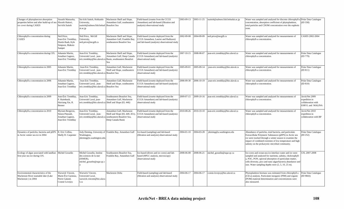
Changes of phytoplancton absorption properties before and after build-up of sea ice cover during CASES
Atsushi Matsuoka,Hiroshi Hattori,Sei-Ichi Saitoh
Sei-Ichi Saitoh, Hokkaido University, [email protected]
Mackenzie Shelf and Slope, Amundsen Gulf, southeastern Beaufort Sea
Field-based (rosette from the CCGS Amundsen) and lab-based (filtration and analysis) observational study
2003-09-13 2003-11-25 [email protected] Water was sampled and analyzed for discrete chlorophyll-a concentration, absorption coefficient of phytoplankton, total particles and CDOM concentration over the euphotic zone.
Polar Data Catalogue (ID 358)
Chlorophyll-a concentration during CASES
Neil Price, Jean-Eric Tremblay, Dustin Raab, Kyle Simpson, Makoto Sampei
Neil Price, McGill University, [email protected]
Mackenzie Shelf and Slope, Amundsen Gulf, Franklin Bay, southeastern Beaufort Sea
Field-based (rosette deployed from the CCGS Amundsen, Laurier and Radisson) and lab-based (analysis) observational study
2002-09-08 2004-09-09 [email protected] Water was sampled and analyzed for measurements of chlorophyll-a concentration.
CASES 2002-2004
Chlorophyll-a concentration during CFL Johannie Martin, Jonathan Gagnon, Jean-Eric Tremblay
Jean-Eric Tremblay, Université Laval, [email protected]
Mackenzie Shelf and Slope, Amundsen Gulf, Deep Canada Basin, southeastern Beaufort Sea
Field-based (rosette deployed from the CCGS Amundsen) and lab-based (analysis) observational study
2007-10-15 2008-08-07 [email protected] Water was sampled and analyzed for measurements of chlorophyll-a concentration.
Polar Data Catalogue (ID 779)
Chlorophyll-a concentration in 2005 Johannie Martin, Jean-Eric Tremblay
Jean-Eric Tremblay, Université Laval, [email protected]
Amundsen Gulf, Mackenzie Shelf and Slope, southeastern Beaufort Sea
Field-based (rosette deployed from the CCGS Amundsen) and lab-based (analysis) observational study
2005-09-01 2005-09-14 [email protected] Water was sampled and analyzed for measurements of chlorophyll-a concentration.
Polar Data Catalogue (ID 811)
Chlorophyll-a concentration in 2006 Johannie Martin, Jonathan Gagnon, Jean-Eric Tremblay
Jean-Eric Tremblay, Université Laval, [email protected]
Amundsen Gulf, Mackenzie Shelf and Slope, southeastern Beaufort Sea
Field-based (rosette deployed from the CCGS Amundsen) and lab-based (analysis) observational study
2006-09-30 2006-10-19 [email protected] Water was sampled and analyzed for measurements of chlorophyll-a concentration.
Polar Data Catalogue (ID 810)
Chlorophyll-a concentration in 2009 Jean-Éric Tremblay, P. Raimbault, Huixiang Xie, R. Benner
Jean-Eric Tremblay, Université Laval, [email protected]
Southeastern Beaufort Sea, Amundsen Gulf, Mackenzie Shelf and Slope (EL 446)
Field-based (rosette deployed from the CCGS Amundsen) and lab-based (analysis) observational study
2009-07-15 2009-10-16 [email protected] Water was sampled and analyzed for measurements of chlorophyll-a concentration.
ArcticNet 2009 expedition in collaboration with IORVL and MALINA
Chlorophyll-a concentration in 2010 Myriam Bergeron, Simon Pineault, Jonathan Gagnon, Jean-Eric Tremblay
Jean-Eric Tremblay, Université Laval, [email protected]
Amundsen Gulf, Mackenzie Shelf and Slope (EL 449, 451), southeastern Beaufort Sea, Deep Canada Basin
Field-based (rosette deployed from the CCGS Amundsen) and lab-based (analysis) observational study
2010-08-26 2010-10-10 [email protected] Water was sampled and analyzed for measurements of chlorophyll-a concentration.
ArcticNet 2010 expedition in collaboration with BP
Dynamics of particles, bacteria and pEPS in Arctic winter sea ice in 2004
R. Eric Collins, Shelly D. Carpenter
Jody Deming, University of Washington, [email protected]
Franklin Bay, Amundsen Gulf Ice-based (sampling) and lab-based (filtration and analysis) observational study
2004-01-10 2004-03-28 [email protected] Abundance of particles, total bacteria, and particulate Extracellular Polymeric Substances (pEPS) in Arctic sea ice were tracked through a winter season to examine the impact of combined extremes of low temperature and high salinity on the prokaryotic microbial community.
Polar Data Catalogue (ID 252)
Ecology of algae associated with landfast first-year sea ice during CFL
Michel Gosselin Michel Gosselin, Institut des sciences de la mer (ISMER), [email protected]
Southeastern Beaufort Sea, Franklin Bay, Amundsen Gulf
Ice-based (divers and ice cores) and lab-based (HPLC analysis, microscopy) observational study
2008-06-08 2008-06-21 [email protected] Ice-cores and ocean-sea ice interface water and ice were sampled and analyzed for nutrients, salinity, cholorophyll-a, POC, PON, spectral absorption of particulate matter, cells diversity, pico and nano algae/bacteria abundance and size. Water sampling depths were (2, 5, 10, 25 m).
CFL 2007-2008
Environmental characteristics of the Mackenzie River stamukhi lake (Lake Mackenzie ) in 2004
Warwick Vincent,Marie-Ève Garneau,Pierre Galand,Connie Lovejoy
Warwick Vincent, Université Laval, [email protected]
Mackenzie Delta Field-based (sampling) and lab-based (filtration and analysis) observational study
2004-06-17 2004-06-17 [email protected] Phytoplankton biomass was estimated from chlorophyll a (Chl a) analysis. Particulate inorganic (PIM) and organic (POM) material determination and concentrations were also measured.
Polar Data Catalogue (ID 9843)
ArcticNet - BREA data mining project 108

ENVISAT (MERIS sensor) satellite ocean color data
European Space Agency (ESA)
European Space Agency (ESA), http://earth.esa.int/cgi-bin/contactus
All Beaufort Sea Remote sensing study 2002-03-01 In progress http://envisat.esa.int/instruments/meris/ Ocean color data was recorded to help clarify the magnitude and variability of chlorophyll-a, yellow substance, suspended matter and algal pigment indices.
MERIS dataset
Filtration of particles for alkenones and biomarker analysis during IPY-GEOTRACES 2009
Maite Hernandez, Maureen Soon, Markus Kienast
Markus Kienast, Dalhousie University, [email protected]
Mackenzie Delta, Shelf and Slope, Deep Canada Basin
Field-based (rosette deployed from the CCGS Amundsen) and lab-based (analysis) direct observational study
2009-08-27 2009-09-12 [email protected] Water profiles were sampled and analyzed to measure alkenone abundance and unsaturation patterns in suspended matter in the photic zone to: compare surface temperature and salinity measurements in order to confirm or refine the applicability of this proxy at the lower end of the temperature range, and to explore the potential of the tetra unsaturated compound as a paleo salinity tracer.
ArcticNet 2009 expedition in collaboration with IPY-GEOTRACES
Heterotrophic production rates in the Mackenzie River stamukhi lake (Lake Mackenzie) in 2004
Warwick Vincent,Christine Martineau,Marie-Ève Garneau,Pierre Galand,Connie Lovejoy
Warwick Vincent, Université Laval, [email protected]
Mackenzie Delta Field-based (water sampling) and lab-based (incubation and radioisotopic analysis) observational study
2004-06-17 2004-06-17 [email protected] Heterotrophic production rates were estimated from incubations and radioisotopic analysis.
Polar Data Catalogue (ID 9839)
HPLC pigment analysis of the phytoplankton community in Franklin Bay during CASES
Warwick Vincent,Marie-Josée Martineau
Warwick Vincent, Centre d'Études Nordiques, Univertsité Laval, [email protected]
Franklin Bay, Amundsen Gulf Field-based (rosette deployed from the CCGS Amundsen) and lab-based (filtration and HPLC analysis) observational study
2003-10-19 2004-08-06 [email protected] Upper mixed-layer microbial plankton communities were sampled 5m below the water surface and analyzed to obtain a detailed description of the pigments associated with the phytoplankton community.
Polar Data Catalogue (ID 226)
Ice algae community samples during CFL Stig Falk-Petersen, Anette Wold, Michel Gosselin
Michel Gosselin, [email protected], Institut des sciences de la mer (ISMER), Stig Falk-Petersen, Norwegian Polar Institute, [email protected], Anette Wold, Norwegian Polar Institute, [email protected]
Southeastern Beaufort Sea, Amundsen Gulf
Ice-based (divers and ice cores) and lab-based (HPLC analysis, microscopy) observational study
2008-03-18 2008-04-16 [email protected], [email protected], [email protected]
Ice algae were sampled and analyzed for fatty acids and particulate phosphorus concentrations.
CFL 2007-2008
ArcticNet - BREA data mining project 109

Ice metazoan meiofauna and bacteria community during CFL
Chantal Lacoste and Maike Kramer, Michel Gosselin, Maike Kramer
Chantal Lacoste, Institut des Sciences de la Mer (ISMER),Université du Québec à Rimouski (UQAR),[email protected], Michel Gosselin, Institut des sciences de la mer (ISMER), [email protected], Maike Kramer, Institut für Polarökologie,[email protected]
Southeastern Beaufort Sea, Amundsen Gulf
Ice-based (divers and ice cores) and lab-based (analysis) observational study
2008-03-25 2008-06-02 [email protected], [email protected], [email protected]
Ice samples were analyzed for stable isotopes, POM, abundance, biomass and composition of sea ice meiofauna and bacterial abundance.
CFL 2008
Inherent and apparent optical properties during CASES
Pierre Larouche,Selima Ben Mustapha,Simon Bélanger,Corinne Bourgeault-Brunelle,Shilin Tang
Pierre Larouche, Institut Maurice-Lamontagne, [email protected]
Mackenzie Shelf and Slope, Amundsen Gulf, Franklin Bay, southeastern Beaufort Sea
Field-based (rosette from the CCGS Amundsen) and lab-based (HPLC, radiometry) observational study
2003-09-24 2004-08-12 [email protected] Water was sampled and analyzed for pigments determination and phytoplancton light absorption coefficient as indicators of light penetration.
CASES 2003-2004, Polar Data Catalogue (ID 1118)
Inherent and apparent optical properties during CFL
Pierre Larouche,Selima Ben Mustapha,Simon Bélanger,Corinne Bourgeault-Brunelle,Shilin Tang
Pierre Larouche, Institut Maurice-Lamontagne, [email protected]
Mackenzie Shelf and Slope, Amundsen Gulf, Deep Canada Basin, southeastern Beaufort Sea
Field-based (rosette from the CCGS Amundsen) and lab-based (HPLC, radiometry) observational study
2007-10-15 2008-08-07 [email protected] Water was sampled and analyzed for pigments determination and phytoplancton light absorption coefficient as indicators of light penetration.
CFL 2007-2008, Polar Data Catalogue (ID 1118)
Inherent and apparent optical properties in 2005
Pierre Larouche,Selima Ben Mustapha,Simon Bélanger,Corinne Bourgeault-Brunelle,Shilin Tang
Pierre Larouche, Institut Maurice-Lamontagne, [email protected]
Amundsen Gulf, Mackenzie Shelf and Slope, southeastern Beaufort Sea
Field-based (rosette from the CCGS Amundsen) and lab-based (HPLC, radiometry) observational study
2005-09-01 2005-09-14 [email protected] Water was sampled and analyzed for pigments determination and phytoplancton light absorption coefficient as indicators of light penetration.
ArcticNet 2005, Polar Data Catalogue (ID 1118)
Inherent and apparent optical properties in 2006
Pierre Larouche,Selima Ben Mustapha,Simon Bélanger,Corinne Bourgeault-Brunelle,Shilin Tang
Pierre Larouche, Institut Maurice-Lamontagne, [email protected]
Amundsen Gulf, Mackenzie Shelf and Slope, southeastern Beaufort Sea
Field-based (rosette from the CCGS Amundsen) and lab-based (HPLC, radiometry) observational study
2006-09-30 2006-10-19 [email protected] Water was sampled and analyzed for pigments determination and phytoplancton light absorption coefficient as indicators of light penetration.
ArcticNet 2006, Polar Data Catalogue (ID 1118)
Inherent and apparent optical properties in 2009
Pierre Larouche,Selima Ben Mustapha,Simon Bélanger,Corinne Bourgeault-Brunelle,Shilin Tang, Marcel Babin
Pierre Larouche, Institut Maurice-Lamontagne, [email protected]
Southeastern Beaufort Sea, Amundsen Gulf, Mackenzie Shelf and Slope (EL 446)
Field-based (rosette from the CCGS Amundsen) and lab-based (HPLC, radiometry) observational study
2009-07-15 2009-10-16 [email protected], [email protected]
Water was sampled and analyzed for pigments determination and phytoplancton light absorption coefficient as indicators of light penetration.
ArcticNet 2009 expedition in collaboration with MALINA and IORVL, Polar Data Catalogue (ID 1118)
ArcticNet - BREA data mining project 110

Inherent and apparent optical properties in 2010
Pierre Larouche,Selima Ben Mustapha,Simon Bélanger,Corinne Bourgeault-Brunelle,Shilin Tang
Pierre Larouche, Institut Maurice-Lamontagne, [email protected]
Amundsen Gulf, Mackenzie Shelf and Slope (EL 449, 451), southeastern Beaufort Sea, Deep Canada Basin
Field-based (rosette from the CCGS Amundsen) and lab-based (HPLC, radiometry) observational study
2010-08-26 2010-10-10 [email protected] Water was sampled and analyzed for pigments determination and phytoplancton light absorption coefficient as indicators of light penetration.
ArcticNet 2010 expedition in collaboration with BP, , Polar Data Catalogue (ID 1118)
Inherent optical properties of seawater profiles in 2009
Marcel Babin, Simon Bélanger, Jérôme Bois, Grigor Obolensky, Jean-Jacques Pangrazi
Marcel Babin, Université laval, [email protected]
Mackenzie Shelf and Slope, Amundsen Gulf, southeastern Beaufort Sea
Field-based (CCGS Amundsen) direct observational study
2009-07-16 2009-10-15 [email protected] A Satlantic MicroNESS free falling radiometer was deployed manually from the bow of the ship, for downwelling irradiance and upwelling radiances measurements at 8 wavelengths. Other parameters that were measure include: absorption and diffusion by water and its contents at 9 wavelengths, backscattering at 3 wavelengths, CDOM fluorescence, chlorophyll fluorescence, salinity, temperature and pressure.
ArcticNet/Malina expedition 2009
Light penetration and absortion measurements during MALINA 2009
Edouard Leymarie, R. Sampere, V. Wright, S. Hooker, J. Ehn, D. Doxaran, D. Antoine
Edouard Leymarie, Laboratoire océanographique de Villefranche-sur-Mer, [email protected]
Mackenzie Shelf and Slope, Amundsen Gulf, southeastern Beaufort Sea
Field-based (CCGS Amundsen) direct observational study
2009-07-31 2009-08-24 [email protected] Several different sensors were deployed to measure light absorption, absorption and attenuation coefficients, backscaterring coefficients, Ed, Lu, Es, irradiance, the light field, radiance, and retrodiffusion.
ArcticNet 2009 expedition in collaboration with MALINA
Light profiles in the water column during CASES
Pierre Larouche, Michel Gosselin
Michel Gosselin, Institut des sciences de la mer (ISMER), [email protected]
Mackenzie Shelf and Slope, Amundsen Gulf, Franklin Bay, southeastern Beaufort Sea
Field-based (CCGS Amundsen) direct observational study
2002-09-22 2004-09-09 [email protected] Secchi disk and Profiler of Natural Fluorescence (PNF 300) casts were performed to estimate water transparency and light in the water column.
CASES 2002-2004
Light profiles in the water column during CFL
Pierre Larouche, Michel Gosselin
Michel Gosselin, Institut des sciences de la mer (ISMER), [email protected]
Mackenzie Shelf and Slope, Amundsen Gulf, Deep Canada Basin, southeastern Beaufort Sea
Field-based (CCGS Amundsen) direct observational study
2007-10-15 2008-08-07 [email protected] Secchi disk and Profiler of Natural Fluorescence (PNF 300) casts were performed to estimate water transparency and light in the water column.
CFL 2007-2008
Light profiles in the water column in 2005 Pierre Larouche, Michel Gosselin
Michel Gosselin, Institut des sciences de la mer (ISMER), [email protected]
Amundsen Gulf, Mackenzie Shelf and Slope, southeastern Beaufort Sea
Field-based (CCGS Amundsen) direct observational study
2005-09-01 2005-09-14 [email protected] Secchi disk and Profiler of Natural Fluorescence (PNF 300) casts were performed to estimate water transparency and light in the water column.
ArcticNet 2005
Light profiles in the water column in 2006 Pierre Larouche, Michel Gosselin
Michel Gosselin, Institut des sciences de la mer (ISMER), [email protected]
Amundsen Gulf, Mackenzie Shelf and Slope, southeastern Beaufort Sea
Field-based (CCGS Amundsen) direct observational study
2006-09-30 2006-10-19 [email protected] Secchi disk and Profiler of Natural Fluorescence (PNF 300) casts were performed to estimate water transparency and light in the water column.
ArcticNet 2006
Light profiles in the water column in 2009 Pierre Larouche, Michel Gosselin
Michel Gosselin, Institut des sciences de la mer (ISMER), [email protected]
Southeastern Beaufort Sea, Amundsen Gulf, Mackenzie Shelf and Slope (EL 446)
Field-based (CCGS Amundsen) direct observational study
2009-07-15 2009-10-16 [email protected] Secchi disk and Profiler of Natural Fluorescence (PNF 300) casts were performed to estimate water transparency and light in the water column.
ArcticNet 2009 expedition in collaboration with MALINA and IORVL
ArcticNet - BREA data mining project 111

Light profiles in the water column in 2010 Pierre Larouche, Michel Gosselin
Michel Gosselin, Institut des sciences de la mer (ISMER), [email protected]
Amundsen Gulf, Mackenzie Shelf and Slope (EL 449, 451), southeastern Beaufort Sea, Deep Canada Basin
Field-based (CCGS Amundsen) direct observational study
2010-08-26 2010-10-10 [email protected] Secchi disk and Profiler of Natural Fluorescence (PNF 300) casts were performed to estimate water transparency and light in the water column.
ArcticNet 2010 expedition in collaboration with BP
Marine photochemistry data during CFL Cédric G. Fichot, Simon Bélanger, Ron Benner
Ronald Benner, University of South Carolina, [email protected]
Mackenzie Shelf and Slope, Amundsen Gulf, southeastern Beaufort Sea
Field-based (CCGS Amundsen) and lab-based (fitration and fluorescence analysis) observational study
2008-07-19 2008-08-02 [email protected], [email protected]
Hyperspectral remote-sensing reflectance was measured using a Satlantic® HyperSAS and water was sampled and analyzed for determination of DOM composition and for photochemistry experiments to study photoreactivity of the DOM samples.
CFL 2007-2008
Metal-biota interactions data during IPY-GEOTRACES 2009
Maite Maldonado, Christopher Payne, Dave Semeniuk, Rebecca Taylor
Maite Maldonado, University of British Columbia, [email protected]
Mackenzie Delta, Shelf and Slope, Deep Canada Basin
Field-based (CCGS Amundsen) and lab-based (fitration and analysis) observational study
2009-08-27 2009-09-12 [email protected] Phytoplankton community, photosynthetic efficiency, irradiance curve, nutrients concentrations and trace metal ratios in particles were measured to study metal-biota interactions.
ArcticNet 2009 expedition in collaboration with IPY-GEOTRACES
Microbial abundance and distribution in newly formed sea ice (Lateral Gene Transfer, LGT) during CFL
Jody Deming, Eric Collins, Shelly Carpenter
Jody Deming, University of Washington, [email protected]
Southeastern Beaufort Sea, Amundsen Gulf
Field-based (CCGS Amundsen) and lab-based (filtration, analysis) observational study
2007-11-09 2007-12-21 [email protected] Sea water, brine and ice were sampled and analyzed for bacteria and viruses abundance, salinity, EPS , POC/PON, chlorophyll a, Extracellular Polymeric Substances (pEPS), inorganic particles, suspended particulate matter concentrations and dissolved DNA.
CFL 2007, Polar Data Catalogue (ID 9759)
Microbial abundance and distribution in sea ice during CASES
Steve Vance, Jody Deming
Jody Deming, University of Washington, [email protected]
Mackenzie Delta, Shelf and Slope, Amundsen Gulf, Franklin Bay, southeastern Beaufort Sea
Field-based (CCGS Amundsen) and lab-based (filtration, analysis) observational study
2003-11-26 2004-10-06 [email protected] Sea water and ice cores were sampled and analyzed for salinity, EPS concentration and dissolved DNA.
CASES 2003-2004
Microbial and viral diversity during CFL Connie Lovejoy, Carles Pedrós Alió Montserrat Coll, Maria Raquel Rodriguez, Ramon Terrado, Corina Brussard
Connie Lovejoy, Université Laval, [email protected]
Mackenzie Shelf and Slope, Amundsen Gulf, Deep Canada Basin, southeastern Beaufort Sea
Field-based (rosette deployed from the CCGS Amundsen) and lab-based (filtration, HPLC, analysis) observational study
2007-12-22 2008-08-04 [email protected] Water was sampled to study and compare microbial diversity, abundance, respiration and production (virus, bacteria, archaea and eukaryotes) using a phenol-chloroform DNA extraction. Samples were analyzed for Si isotopes, chlorophyll-a, DOM, TOC, amino acids, carbohydrates, total phosphorus and NO2 concentration.
CFL 2007-2008
Microbial and viral production and diversity during CASES
André Comeau, Marie-Ève Garneau, Connie Lovejoy
Connie Lovejoy, Université Laval,[email protected]
Mackenzie Shelf, Amundsen Gulf
Field-based (rosette deployed from the CCGS Amundsen) and lab-based (filtration and analysis) observational study
2002-09-22 2003-11-19 [email protected] Biomass measurements included Chl a, bacteria, pico- and nano-eukaryote abundance by both Flow Cytometry (FCM) and EpiFluorescence Microscopy (EFM) and ciliate abundance (lugols preserved samples). Macromolecular ratios of particulate material, (POC, PON, POC, Proteins, DNA, RNA) were used to obtain an indication of the physiological and nutritional state of the microplankton community.
CASES 2002-2004
ArcticNet - BREA data mining project 112
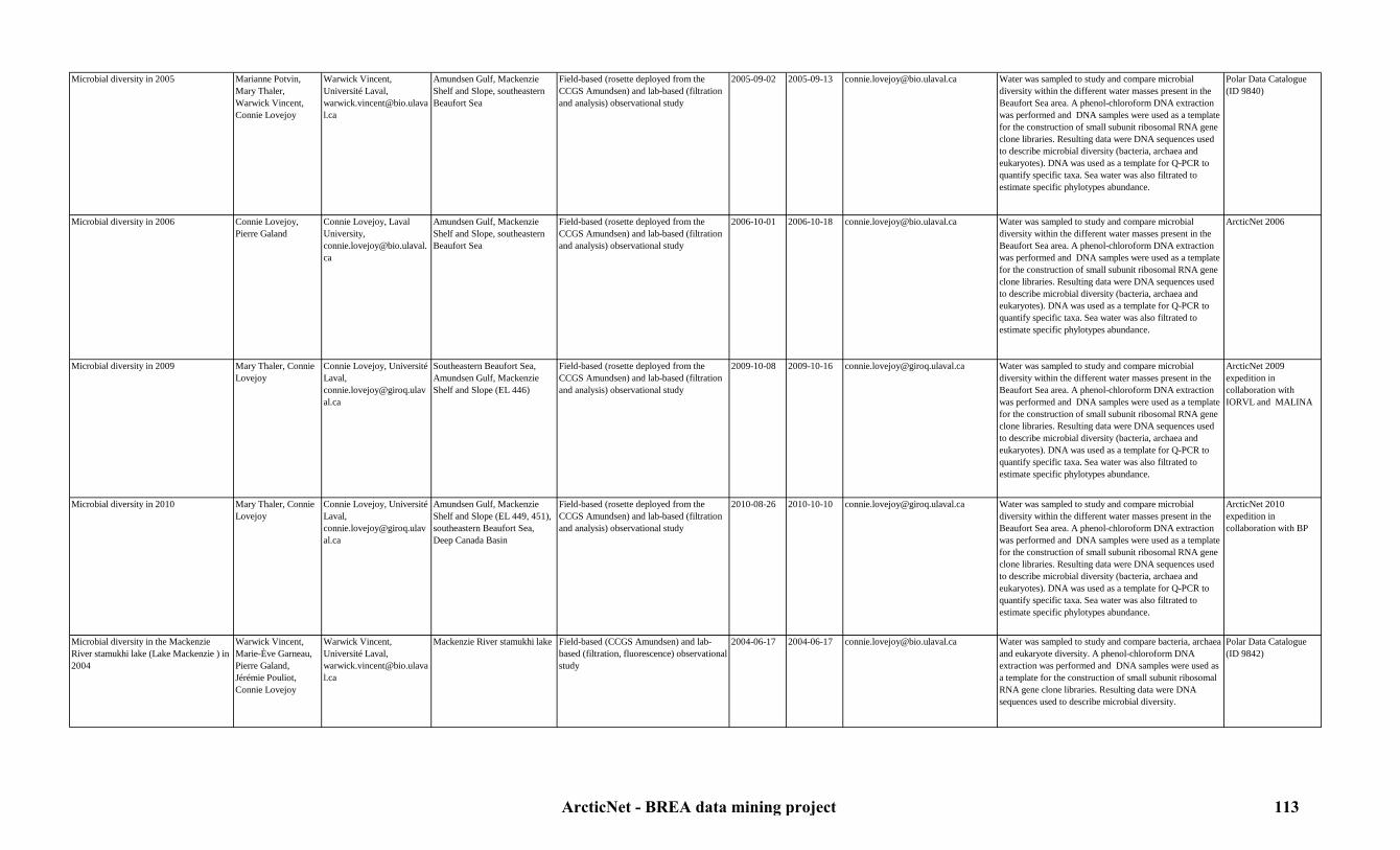
Microbial diversity in 2005 Marianne Potvin,Mary Thaler, Warwick Vincent, Connie Lovejoy
Warwick Vincent, Université Laval, [email protected]
Amundsen Gulf, Mackenzie Shelf and Slope, southeastern Beaufort Sea
Field-based (rosette deployed from the CCGS Amundsen) and lab-based (filtration and analysis) observational study
2005-09-02 2005-09-13 [email protected] Water was sampled to study and compare microbial diversity within the different water masses present in the Beaufort Sea area. A phenol-chloroform DNA extraction was performed and DNA samples were used as a template for the construction of small subunit ribosomal RNA gene clone libraries. Resulting data were DNA sequences used to describe microbial diversity (bacteria, archaea and eukaryotes). DNA was used as a template for Q-PCR to quantify specific taxa. Sea water was also filtrated to estimate specific phylotypes abundance.
Polar Data Catalogue (ID 9840)
Microbial diversity in 2006 Connie Lovejoy, Pierre Galand
Connie Lovejoy, Laval University, [email protected]
Amundsen Gulf, Mackenzie Shelf and Slope, southeastern Beaufort Sea
Field-based (rosette deployed from the CCGS Amundsen) and lab-based (filtration and analysis) observational study
2006-10-01 2006-10-18 [email protected] Water was sampled to study and compare microbial diversity within the different water masses present in the Beaufort Sea area. A phenol-chloroform DNA extraction was performed and DNA samples were used as a template for the construction of small subunit ribosomal RNA gene clone libraries. Resulting data were DNA sequences used to describe microbial diversity (bacteria, archaea and eukaryotes). DNA was used as a template for Q-PCR to quantify specific taxa. Sea water was also filtrated to estimate specific phylotypes abundance.
ArcticNet 2006
Microbial diversity in 2009 Mary Thaler, Connie Lovejoy
Connie Lovejoy, Université Laval,[email protected]
Southeastern Beaufort Sea, Amundsen Gulf, Mackenzie Shelf and Slope (EL 446)
Field-based (rosette deployed from the CCGS Amundsen) and lab-based (filtration and analysis) observational study
2009-10-08 2009-10-16 [email protected] Water was sampled to study and compare microbial diversity within the different water masses present in the Beaufort Sea area. A phenol-chloroform DNA extraction was performed and DNA samples were used as a template for the construction of small subunit ribosomal RNA gene clone libraries. Resulting data were DNA sequences used to describe microbial diversity (bacteria, archaea and eukaryotes). DNA was used as a template for Q-PCR to quantify specific taxa. Sea water was also filtrated to estimate specific phylotypes abundance.
ArcticNet 2009 expedition in collaboration with IORVL and MALINA
Microbial diversity in 2010 Mary Thaler, Connie Lovejoy
Connie Lovejoy, Université Laval,[email protected]
Amundsen Gulf, Mackenzie Shelf and Slope (EL 449, 451), southeastern Beaufort Sea, Deep Canada Basin
Field-based (rosette deployed from the CCGS Amundsen) and lab-based (filtration and analysis) observational study
2010-08-26 2010-10-10 [email protected] Water was sampled to study and compare microbial diversity within the different water masses present in the Beaufort Sea area. A phenol-chloroform DNA extraction was performed and DNA samples were used as a template for the construction of small subunit ribosomal RNA gene clone libraries. Resulting data were DNA sequences used to describe microbial diversity (bacteria, archaea and eukaryotes). DNA was used as a template for Q-PCR to quantify specific taxa. Sea water was also filtrated to estimate specific phylotypes abundance.
ArcticNet 2010 expedition in collaboration with BP
Microbial diversity in the Mackenzie River stamukhi lake (Lake Mackenzie ) in 2004
Warwick Vincent,Marie-Ève Garneau,Pierre Galand,Jérémie Pouliot,Connie Lovejoy
Warwick Vincent, Université Laval, [email protected]
Mackenzie River stamukhi lake Field-based (CCGS Amundsen) and lab-based (filtration, fluorescence) observational study
2004-06-17 2004-06-17 [email protected] Water was sampled to study and compare bacteria, archaea and eukaryote diversity. A phenol-chloroform DNA extraction was performed and DNA samples were used as a template for the construction of small subunit ribosomal RNA gene clone libraries. Resulting data were DNA sequences used to describe microbial diversity.
Polar Data Catalogue (ID 9842)
ArcticNet - BREA data mining project 113

Microbial meditation of carbon and trace element cycling data during IPY-GEOTRACES 2009
Richard Rivkin, Michelle Hale, Adam Hamilton, Jane Tucker
Richard Rivkin, Memorial University, [email protected]
Mackenzie Delta, Shelf and Slope, Deep Canada Basin
Field-based (rosette from the CCGS Amundsen) and lab-based (fitration and analysis) observational study
2009-08-27 2009-09-12 [email protected] The goal of this project was to characterize the microbial community and determine its role in the cycling of carbon and trace elements. Sampling depths were selected to represent light depths and major water mass layers.
ArcticNet 2009 expedition in collaboration with IPY-GEOTRACES
MODIS satellite ocean color data NASA Jack Xiong,MODIS Project Scientist, [email protected]
All Beaufort Sea Remote sensing study 2002-05-04 In progress http://modis.gsfc.nasa.gov/data/dataprod/index.php
Remote sensing imagery dataset for chlorophyll-a and PAR.
MODIS dataset
Nutrient transects in the Mackenzie River and in the Beaufort sea (ARDEX) in 2004
Warwick Vincent,Lance Lesack,Craig A. Emmerton
Warwick Vincent, Université Laval, [email protected]
Mackenzie Delta Field based (sampling) and lab-based (fluorescence analysis) observational study
2004-07-24 2004-08-03 [email protected] Water was sampled and analyzed for cholorophyll-a Polar Data Catalogue (ID 816)
Optical and organic matter characteristics in the Mackenzie River and in the Beaufort Sea (ARDEX) in 2004
Milla Rautio,Leira Retamal, Catherine Vallières,
Warwick Vincent, Université Laval, [email protected]
Mackenzie River and coastal Beaufort Sea
Field-based (sampling from a zodiac) and lab-based (filtrations and HPLC) observational study
2004-07-24 2004-08-03 [email protected] Water was sampled and analyzed for cholorophyll-a and phytoplankton pigments.
Polar Data Catalogue (ID 803)
PAR and UVR downwelling irradiance during CASES
Sonia Brugel,Serge Demers
Serge Demers, UQAR-ISMER, [email protected]
Franklin Bay, Mackenzie Shelf and Slope, Amundsen Gulf, southeastern Beaufort Sea
Field-based (CCGS Amundsen) and computer-based (analysis) direct observational study
2003-09-30 2004-08-10 [email protected] This dataset consists of continuous records of downwelling irradiances at several UVR (305, 313, 320, 340 and 380nm) and PAR wavelengths. The GUV-510 surface radiometer (Biospherical Instruments), mounted on the top of the wheelhouse, provided a measure of cosine-corrected downwelling irradiance in the UVR and PAR spectrums.
Polar Data Catalogue (ID 214)
Particle-associated microbial community dynamics during CFL
Shelly Carpenter,Eric Collins,Min Lin,Marcela Ewert-Sarmiento,Colleen Kellogg
Shelly Carpenter, University of washington, [email protected]
Mackenzie Shelf and Slope, Amundsen Gulf, Deep Canada Basin, southeastern Beaufort Sea
Field-based (rosette and pumps deployed from the CCGS Amundsen) and lab-based (filtration and analysis) observational study
2007-11-09 2008-07-10 [email protected] Water was sampled and analyzed to assess microbial community structure on sinking (>60 µm) and suspended particles (<60 µm) in reference to the free-living community (0.2–1 µm), using microbial DNA to: measure extracellular protease, glucosidase and chitinase activities associated with these particle classes and to quantify associated particulate amino acids, lipids and carbohydrates.
Polar Data Catalogue (ID 9756)
Particle-associated microbial community dynamics in 2006
Jody W. Deming Jody W. Deming, University of Washington, [email protected]
Southeastern Beaufort Sea, Amundsen Gulf, Mackenzie Shelf and Slope
Field-based (rosette and pumps deployed from the CCGS Amundsen) and lab-based (filtration and fluorescence analysis) observational study
2006-10-01 2006-10-19 [email protected] Water was sampled to assess microbial community structure on sinking and suspended particles. Samples were analyzed for bacteria abundance, Extracellular Enzymatic Activity (EEA), chlorophyll a, POC/PON and Suspended Particulate Matter (SPM) concentrations.
ArcticNet 2006
Photobiogeochemical cycling of carbon monoxide in spring and autumn during CASES
Serge Demers,Warwick F. Vincent,Simon Bélanger,Huixiang Xie,Tim Papakyriakou
Warwick Vincent, Université Laval, [email protected]
Franklin Bay, Mackenzie Shelf and Slope, Amundsen Gulf, southeastern Beaufort Sea
Field-based (bucket and rosette deployed from the CCGS Amundsen) and lab-based (analysis) observational study
2003-09-26 2004-06-22 [email protected] Samples were collected for determining surface water carbon monoxide (CO) concentration, CO profiles, air-sea gas exchange, microbial uptake kinetics and CO photoproduction.
Polar Data Catalogue (ID 9837)
ArcticNet - BREA data mining project 114

Photosynthetically Available Radiation data (PAR) during JOIS
Svien Vagle, Sarah Zimmermann, Jane Eert, Celine Gueguen, Patricia Ramlal
Jane Eert, Department of Fisheries and Oceans Canada, [email protected], Svien Vagle, Department of Fisheries and Oceans Canada, [email protected]
Alaskan Slope and Shelf, Deep Canada Basin, Mackenzie Shelf and Slope, North Beaufort Sea
Field-based (CCGS Louis St-Laurent) direct observational study
2008-07-17 2010-10-15 [email protected], [email protected]
PAR was measured continuously from a sensor located on top of the hangar.
JOIS 2008-2010
Physiological state of phytoplankton in fall 2002
Christian Nozais,Serge Demers,Irene Schloss,
Serge Demers, UQAR-ISMER, [email protected]
Canadian southeastern Beaufort Sea
Field-based (CCGS Amundsen) and lab-based (fluorometry) observational study
2002-09-23 2002-10-13 [email protected] This dataset consists of vertical profiles of discrete depth to determine the physiological state of phytoplankton using a pulse amplitude modulated fluorometer.
Polar Data Catalogue (ID 221)
Phytoplancton pigment composition during CFL
Pierre Larouche, Michel Gosselin
Michel Gosselin, Institut des sciences de la mer (ISMER), [email protected]
Amundsen Gulf Ice based and lab-based (HPLC analysis) observational study
2008-03-24 2008-04-05 [email protected] Water was sampled with a pump under the thinner ice of refreezing flaw lead and filtration were performed for cholorophyll determination (HPLC techniques), chlorophyll-a and algal pigments.
CFL 2007-2008
Picoplankton communities in the Mackenzie River and Beaufort Sea (ARDEX)
Warwick Vincent,Catherine Vallières
Warwick Vincent, Université Laval, [email protected]
Mackenzie Delta Field-based (sampling) and lab-based (microscopy) observational study
2004-07-24 2004-08-03 [email protected] Concentrations of bacteria, picocyanobacteria and picoeukaryotes were determined using epifluorescence microscopy.
Polar Data Catalogue (ID 893)
Primary production data in sea ice, brine and surface water during CASES
Christine Michel, Jody Deming, Bernard Leblanc, Paul Wassmann, Don Diebel, Josef Wiktor, André Rochon, Kirk Cochran, Michel Gosselin,Thomas Juul-Pedersen
Christine Michel, Department of Fisheries and Oceans Canada, [email protected]
Franklin Bay, Mackenzie Shelf and Slope, Amundsen Gulf, southeastern Beaufort Sea
Field-based (Free-drifting sediment traps deployed from the CCGS Radisson and Amundsen) and lab-based (spectrometry, microscopy) observational study
2002-09-22 2004-08-10 [email protected], [email protected]
Surface water, brine and ice were sampled and analyzed for chlorophyll-a, phaeopigments, abundance and diversity of bacteria and protists, ExoPolymeric Substances (EPS) and bacterial activity using ice corers and free-drifting sediment traps.
CASES 2002-2004, Polar data Catalogue (ID 228, 229)
Primary production data in sea ice, brine and surface water during CFL
Christine Michel, Geneviève Tremblay
Christine Michel, Department of Fisheries & Oceans Canada,[email protected]
Mackenzie Shelf and Slope, Amundsen Gulf, Deep Canada Basin, southeastern Beaufort Sea
Field-based (CCGS Amundsen) and lab-based (analysis, microscopy) observational study
2007-10-15 2008-08-07 [email protected] Surface water, brine and ice were sampled and analyzed for chlorophyll-a, phaeopigments, abundance and diversity of bacteria and protists, exopolymeric substances (EPS) and bacterial activity using ice corers and free-drifting sediment traps.
CFL 2007-2008, Polar Data Catalogue (ID 997)
Primary productivity data during IPY-GEOTRACES 2009
Diana Varela, Arielle Kobryn
Diana Varela, University of Victoria, [email protected]
Mackenzie Delta, Shelf and Slope, Deep Canada Basin
Field-based (rosette deployed from the CCGS Amundsen) and lab-based (filtration, incubation and other analysis) observational study
2009-08-27 2009-09-12 [email protected] Net and new (NO3-driven) primary (phytoplankton) productivity was measured and the composition of the phytoplankton assemblage was analyzed using a FlowCam. Triplicate samples were obtained at 4 depths in the euphotic zone, at 50, 10, 1 and 0.1% of incident surface irradiance. The contribution of the < and >5 µm size fraction to primary productivity was investigated. Biogenic silica concentrations were also measured.
ArcticNet 2009 expedition in collaboration with IPY-GEOTRACES
ArcticNet - BREA data mining project 115

Production, biomass, abundance and taxonomic composition of phytoplankton during CASES
Michel Gosselin, Michel Poulin
Michel Gosselin, Institut des sciences de la mer (ISMER), [email protected]
Mackenzie Shelf and Slope, Amundsen Gulf, Franklin Bay, southeastern Beaufort Sea
Field-based (rosette deployed from the CCGS Radisson, Laurier and Amundsen) and lab-based (analysis) observational study
2002-09-22 2004-09-09 [email protected] The general objective of this study was to determine the influence of environmental factors on the phytoplankton distribution. At each station, samples were collected for the determination of size-fractionated chlorophyll a and pheopigments, POC, PON, TOC, DOC, phytoplankton cells identification and enumeration, pico- and nanophytoplankton abundance, heterotrophic bacteria abundance, and pigment signature by HPLC.
CASES 2003-2004, Polar Data Catalogue (ID 9786)
Production, biomass, abundance and taxonomic composition of phytoplankton during CFL
Michel Gosselin, Michel Poulin
Michel Gosselin, Institut des sciences de la mer (ISMER), [email protected]
Mackenzie Shelf and Slope, Amundsen Gulf, Deep Canada Basin, southeastern Beaufort Sea
Field-based (rosette deployed from the CCGS Amundsen) and lab-based (analysis) observational study
2007-10-15 2008-08-07 [email protected] The general objective of this study was to determine the influence of environmental factors on the phytoplankton distribution. At each station, samples were collected for the determination of size-fractionated chlorophyll a and pheopigments, POC, PON, TOC, DOC, phytoplankton cells identification and enumeration, pico- and nanophytoplankton abundance, heterotrophic bacteria abundance, heterotrophic protist abundance and pigment signature by HPLC. Size-fractionated primary production was determined at 7 optical depths using the 14C-method (JGOFS protocol) with on-deck in situ simulated incubations.
CFL 2007-2008, Polar Data Catalogue (ID 9786)
Production, biomass, abundance and taxonomic composition of phytoplankton in 2005
Michel Gosselin, Michel Poulin
Michel Gosselin, Institut des sciences de la mer (ISMER), [email protected]
Amundsen Gulf, Mackenzie Shelf and Slope, southeastern Beaufort Sea
Field-based (rosette deployed from the CCGS Amundsen) and lab-based (analysis) observational study
2005-09-01 2005-09-14 [email protected] The general objective of this study was to determine the influence of environmental factors on the phytoplankton distribution. At each station, samples were collected for the determination of size-fractionated chlorophyll a and pheopigments, POC, PON, TOC, DOC, phytoplankton cells identification and enumeration, pico- and nanophytoplankton abundance and heterotrophic protist abundance. Size-fractionated primary production was determined at 7 optical depths using the 14C-method (JGOFS protocol) with on-deck in situ simulated incubations.
CFL 2007-2008, Polar Data Catalogue (ID 9786)
Production, biomass, abundance and taxonomic composition of phytoplankton in 2006
Michel Gosselin, Michel Poulin
Michel Gosselin, Institut des sciences de la mer (ISMER), [email protected]
Amundsen Gulf, Mackenzie Shelf and Slope, southeastern Beaufort Sea
Field-based (rosette deployed from the CCGS Amundsen) and lab-based (analysis) observational study
2006-09-30 2006-10-19 [email protected] The general objective of this study was to determine the influence of environmental factors on the phytoplankton distribution. At each station, samples were collected for the determination of size-fractionated chlorophyll a and pheopigments, POC, PON, TOC, DOC, phytoplankton cells identification and enumeration, pico- and nanophytoplankton abundance, heterotrophic bacteria abundance, heterotrophic protist abundance and pigment signature by HPLC. Size-fractionated primary production was determined at 7 optical depths using the 14C-method (JGOFS protocol) with on-deck in situ simulated incubations.
ArcticNet 2006, Polar Data Catalogue (ID 9786)
ArcticNet - BREA data mining project 116

Production, biomass, abundance and taxonomic composition of phytoplankton in 2009
Michel Gosselin, Michel Poulin
Michel Gosselin, Institut des sciences de la mer (ISMER), [email protected]
southeastern Beaufort Sea, Amundsen Gulf, Mackenzie Shelf and Slope (EL 446)
Field-based (rosette deployed from the CCGS Amundsen) and lab-based (analysis) observational study
2009-07-15 2009-10-16 [email protected] The general objective of this study was to determine the influence of environmental factors on the phytoplankton distribution. At each station, samples were collected for the determination of size-fractionated chlorophyll a and pheopigments, POC, PON, TOC, DOC, phytoplankton cells identification and enumeration, pico- and nanophytoplankton abundance, heterotrophic bacteria abundance, heterotrophic protist abundance and pigment signature by HPLC. Photosynthesis and irradiance curves were measured for size-fractionated primary production (>0.7 µm; >5 µm) at the maximum of fluorescence and at 50% of surface irradiance.
ArcticNet 2007, Polar Data Catalogue (ID 9786)
Production, biomass, abundance and taxonomic composition of phytoplankton in 2010
Michel Gosselin, Michel Poulin
Michel Gosselin, Institut des sciences de la mer (ISMER), [email protected]
Amundsen Gulf, Mackenzie Shelf and Slope (EL 449, 451), southeastern Beaufort Sea, Deep Canada Basin
Field-based (rosette deployed from the CCGS Amundsen) and lab-based (analysis) observational study
2010-09-23 2010-10-10 [email protected] The general objective of this study was to determine the influence of environmental factors on the phytoplankton distribution. At each station, samples were collected for the determination of size-fractionated chlorophyll a and pheopigments, POC, PON, TOC, DOC, phytoplankton cells identification and enumeration, pico- and nanophytoplankton abundance, heterotrophic bacteria abundance, heterotrophic protist abundance and pigment signature by HPLC. Size-fractionated primary production was determined at 7 optical depths using the 14C-method (JGOFS protocol) with on-deck in situ simulated incubations. Photosynthesis and irradiance curves were measured for size-fractionated primary production (>0.7 µm; >5 µm) at the maximum of fluorescence and at 50% of surface irradiance.
ArcticNet 2007, Polar Data Catalogue (ID 9786)
Protist communities determination using environmental DNA analysis during CASES
Ramon Terrado,Warwick F. Vincent,Connie Lovejoy
Warwick Vincent, Université Laval, [email protected]
Franklin Bay Field-based (rosette deployed from the CCGS Amundsen) and lab-based (filtration and analysis) observational study
2003-11-01 2004-07-30 [email protected] Water was sampled to study and compare protists diversity. A phenol-chloroform DNA extraction was performed and DNA samples were used as a template for the construction of small subunit ribosomal RNA gene clone libraries. Resulting data were DNA sequences used to describe protists diversity. DNA was used as a template for Q-PCR for taxonomic affiliation and phylogenetic analyses.
Polar Data Catalogue (ID 9838)
Protist community of the Mackenzie River and Beaufort Sea (ARDEX)
Catherine Vallières,Warwick F. Vincent
Warwick Vincent, Université Laval, [email protected]
Mackenzie Delta Field-based (sampling) and lab-based (microscopy and other analysis) observational study
2004-07-24 2004-08-03 [email protected] Water samples were analyzed with the FNU method (Fluorescence, Nomarski interference and Uthermöhl sedimentation) to examine the autotrophic and heterotrophic protist communities. Sedimented cells were counted and classified according to trophic level, phylum and size range.
Polar Data Catalogue (ID 894)
Rates of carbon fixation by marine phytoplankton during CFL
Kevin Arrigo, Molly Palmer
Kevin Arrigo, Stanford University, [email protected]
southeastern Beaufort Sea, Franklin Bay, Amundsen Gulf
Field-based (rosette from the CCGS Amundsen) and lab-based (filtration, incubations, HPLC and other analysis) observational study
2008-06-07 2008-07-06 [email protected] Ice, melt ponds and open water were sampled and analyzed to determine rates of carbon fixation by the phytoplankton assemblage.
CFL 2007-2008
Samples of suspended marine particles from large volume in situ pumps during IPY-GEOTRACES 2009
Roger Francois, Maureen Soon, Bart De Baere, Nes Sutherland
Roger François, University of Britich Columbia, [email protected]
Mackenzie Delta, Shelf and Slope, Deep Canada Basin
Field-based (pumps deployed from the CCGS Amundsen) and lab-based (filtration and analysis) observational study
2009-08-27 2009-09-12 [email protected] Water was sampled and filtrated to measure 230Th, 231Pa, 234Th, Ca, Al, Si, P, POC, PON and alkenones concentrations.
ArcticNet 2009 expedition in collaboration with IPY-GEOTRACES
ArcticNet - BREA data mining project 117

Sea ice diatoms biomarkers to determine the presence of past Arctic sea ice during CFL
Philippe Archambault, Mylène Bourque, Guillaume Massé, Simon Belt, Michel Poulin, Lindsay Vare, Thomas Brown
Philippe Archambault, Université du Québec à Rimouski, [email protected], Thomas Brown, University of Plymouth, [email protected]
Amundsen Gulf, Mackenzie Shelf and Slope, southeastern Beaufor Sea
Field-based (CCGS Amundsen) and lab-based (analysis) observational study
2007-10-15 2008-04-24 [email protected], [email protected]
Box cores (sediments) samples, ice cores, water samples and plankton were collected and analyzed to detect diatoms biomarkers and to determine variations in past Arctic sea ice
CFL 2007-2008
Sea ice diatoms biomarkers to determine the presence of past Arctic sea ice in 2005
Michel Poulin, Guillaume Massé, Simon Belt
Michel Poulin, [email protected]
Amundsen Gulf, Mackenzie shelf and slope, southeastern Beaufort Sea
Field-based (CCGS Amundsen) and lab-based (centrifugation, mass-chromatography spectrometry) observational study
2005-09-01 2005-09-13 [email protected] Box cores (sediments) and plankton samples were collected and analyzed to detect diatom biomarkers and to determine variations in past Arctic sea ice
ArcticNet 2005
Sea ice microbial processes during the dark winter period during CFL
Christine Michel, G. Niemi, A. Niemi
Christine Michel, Department of Fisheries and Oceans Canada, [email protected]
Amundsen Gulf Field-based (CCGS Amundsen) and lab-based (analysis) observational study
2007-12-20 2008-01-27 [email protected] Ice, brine and surface water samples were analyzed for inorganic nutrients, chlorophyll a, dissolved and particulate organic carbon, exopolymeric particles, bacteria and protists.
Polar Data Catalogue (ID1023)
Seasonal study of nutrients and organic matter in first-year sea ice during CASES
Michel Poulin,Christine Michel,Michel Gosselin,Magdalena Rózanska,Andrea Riedel
Michel Gosselin, Institut des sciences de la mer (ISMER), [email protected]
Franklin Bay, Amundsen Gulf Field-based (CCGS Amundsen) and lab-based (analysis) observational study
2004-02-24 2004-06-20 [email protected] Surface waters and the bottom 3-5 cm of ice cores were routinely analyzed for: salinity, pH, nutrients (NH4, NO2, NO3, Si(OH)4, and PO4), dissolved organic carbon and nitrogen (DOC, DON), exopolymeric substances (EPS), particulate inorganic carbon (PIC), particulate organic carbon and nitrogen (POC, PON), total and >5 µm chlorophyll a and phaeopigments, bacterial abundances/biomass, protist (excluding diatoms) abundances/biomass and ice algal/phytoplankton taxonomy. This dataset also includes vertical and spatial profiles of ice algal distribution as well as measurements of sea ice primary production, bacterivory and sea ice algal and bacterial sinking velocities.
Polar Data Catalogue (ID 232)
SeaWIFS satellite ocean color data NASA Goddard Space Flight Center, Institut Maurice-Lamontagne
Pierre Larouche, Institut Maurice-Lamontagne, [email protected]
All Beaufort Sea Remote sensing study 1997-08-01 In progress [email protected] Ocean color data was recorded to help clarify the magnitude and variability of chlorophyll and primary production by marine phytoplankton, and to determine the distribution and timing of spring blooms.
SEAWIFS dataset
Sediment cores for palinology data during MALINA 2009
André Rochon, I. Tolosa
André Rochon, ISMER-UQAR, [email protected]
Mackenzie Shelf and Slope, Amundsen Gulf, southeastern Beaufort Sea
Field-based (box and CASQ corer deployed from the CCGS Amundsen) and lab-based (microscopy, flamme ionization detection, combustion isotope ratio) observational study
2009-07-31 2009-08-24 [email protected] Sediments cores were sampled and analyzed for dinoflagellates cysts, foraminifera, pollen and spores abundance and diversity, and for lipids biomarkers.
ArcticNet 2009 expedition in collaboration with MALINA
Sediments cores for paleoenvironment data during CASES
Alec Aitken, David B. Scott, André Rochon, Peta Mudie, Kathy Conlan, Jean-Marc Gagnon, Dennis Darby, Steve Blasco
Steve Blasco, Geological Survey of Canada, [email protected]
Mackenzie Shelf and Slope, Amundsen Gulf, southeastern Beaufort Sea
Field-based (CCGS Radisson) and lab-based (analysis) obervational study
2002-09-20 2002-10-14 [email protected] Sediments were sampled and analyzed for radio isotope (13C, 210Pb,234Th), palynology, dinocysts, C tot , Cinorg, foraminifers, ice rafted debris and phytoplankton fluxes.
CASES 2002
ArcticNet - BREA data mining project 118

Significance of viruses in ice, water column, algal and bacterial samples during CFL
Corina Brussaard Corina Brussaard, Royal Netherlands Institute for Sea Research, [email protected]
Southeastern Beaufort Sea, Franklin Bay, Amundsen Gulf
Field-based (rosette from the CCGS Amundsen) and lab-based (filtration, incubation) observational study
2008-04-29 2008-06-03 [email protected] Water column was sampled at surface and chlorophyll maximum and\or bottom for measurements of bacteria abundance, diversity, grazing rate, viral-inducedmortality and for algae abundance, diversity, growth rate, viral lysis rate and grazing rate. Ice cores were analyzed for the frequency of virus-infected bacteria and abundance and diversity of viruses and bacteria.
CFL 2008
Spatial and seasonal abundances of viruses and bacteria during CASES
Jerome Payet Curtis Suttle, University of British Columbia, [email protected]
Amundsen Gulf, Mackenzie Shelf, southeastern Beaufort Sea
Field-based (rosette from the CCGS Amundsen) and lab-based (microscopy, flow cytometry) observational study
2003-11-04 2004-08-10 [email protected] The spatial and seasonal distributions of viruses in relation to biotic (bacteria, chlorophyll-a) and abiotic variables (temperature, salinity and depth) were investigated.
Polar Data Catalogue (ID 151)
Spatial and temporal variations of particle-associated bacteria on the Mackenzie Shelf during CASES
Warwick Vincent,Christine Martineau,Milla Rautio,Sébastien Roy
Warwick Vincent, Université Laval, [email protected]
Mackenzie Shelf Field-based (rosette from the CCGS Amundsen) and lab-based (analysis) observational study
2004-06-30 2004-07-11 [email protected] Surface water was sampled and analyzed for measurements of temperature, salinity, Colored Dissolved Organic Matter (CDOM), Suspended Particulate Material (SPM), Particulate Organic Material (POM), chlorophyll a, prokaryote abundance, and leucine and thymidine uptake rates to estimate bacterial production. Bacteria and Archaea relative abundance was estimated using Catalyzed Reporter Deposition for Fluorescence In Situ Hybridization (CARD-FISH).
Polar Data Catalogue (ID 2099)
Spatial distribution of bacteria abundance during CASES
Sonia Brugel,Christian Nozais,Serge Demers,Claude Belzile
Serge Demers, UQAR-ISMER, [email protected]
Mackenzie Delta, Shelf and Slope, Amundsen Gulf, Franklin Bay, southeastern Beaufort Sea
Field-based (CCGS Radisson and Amundsen) and lab-based (flow cytometry) observational study
2002-09-23 2004-08-10 [email protected] This dataset consists of vertical profiles of discrete depth sampled to determine bacteria abundance. Bacteria concentrations were counted by flow cytometry.
Polar Data Catalogue (ID 216)
Spatial distribution of small phytoplankton (<20µm) during CASES
Sonia Brugel,Christian Nozais,Serge Demers
Serge Demers, UQAR-ISMER, [email protected]
Mackenzie Delta, Shelf and Slope, Amundsen Gulf, Franklin Bay, southeastern Beaufort Sea
Field-based (rosette from the CCGS Radisson and Amundsen) and lab-based (analysis) observational study
2002-09-23 2004-08-10 [email protected] This dataset consists of vertical water column profiles at discrete depth (0 to 100m) to determine small phytoplankton cell abundance. Small phytoplankton cells were counted by flow cytometry, the 3 and 10µm tresholds were used to separate picophytoplankton (<3µm), small nanophytoplankton (3-10µm) and large nanophytoplankton (10-20µm).
Polar Data Catalogue (ID 211, 212)
Species composition and activities of microbial communities during CFL
Cèlia Marrasé Cèlia Marrasé, Institut de Ciències del Mar, [email protected]
Southeastern Beaufort Sea, Franklin Bay, Amundsen Gulf
Field-based (rosette from the CCGS Amundsen) and lab-based (filtration, incubation) observational study
2007-11-08 2007-12-20 [email protected] Water was sampled and analyzed for dissolvedorganic carbon, amino acids, carbohydrates, f-DOM, chlorophyll-a and communities composition (eukaryotes, nanoflagellates, virus, and ciliates). Incubations were also perfomed to quantify bacterivory, virus diversity and production.
CFL 2007
Species composition of phytoplancton and carbon and nitrogen production during JOIS
Mi Sun Yun Mi Sun Yun, Korea Polar Research Institute (KOPRI)
Alaskan Slope and Shelf, Deep Canada Basin, Mackenzie Shelf and Slope, North Beaufort Sea
Field-based (CCGS Louis St-Laurent) and lab-based (incubation, microscopy and other analysis) observational study
2009-09-17 2009-10-15 http://www.whoi.edu/beaufortgyre Water and ice cores were sampled and analyzed to 1) quantify carbon and nitrogen uptakes by phytoplankton using stable isotopes; 2) define and compare the effects of light and nutrients on phytoplankton sampled in the chl a maximum layer; 3) identify phytoplankton species composition; and to 4) measure the physiological characteristics of phytoplankton.
JOIS 2009
ArcticNet - BREA data mining project 119

Taxonomic composition of phytoplankton during CASES
Sonia Brugel, Michel Poulin
Michel Poulin, Canadian Museum of Nature, Research Division, [email protected]
Mackenzie Delta, Shelf and Slope, Amundsen Gulf, Franklin Bay, southeastern Beaufort Sea
Field-based (rosette from the CCGS Amundsen and CCGS Radisson) and lab-based (microscopy) observational study
2002-09-23 2004-08-10 [email protected] This dataset consists of taxonomic identifiaction of the phytoplanktonic community. Water samples were taken at one or 3 depth (fluorescence maximum, and/or surface and 1% light) for cells indentification to genus or species level when possible or placed in size categories of the different phytoplanktonic groups.
Polar Data Catalogue (ID 203)
Temporal changes in bacterivory and herbivory during CFL
Institut de Ciències del Mar, Carlos Pedrós-Alió,Cèlia Marrasé, Montserrat Coll, Raquel Rodríguez, Marta Estradal,Laura Alonso, Beatriz Fernández,Cristina Romera
Carlos Pedrós-Alió, Institut de Ciències del Mar, [email protected]
Mackenzie Shelf and Slope, Amundsen Gulf, Deep Canada Basin, southeastern Beaufort Sea
Field-based (rosette from the CCGS Amundsen) and lab-based (analysis) observational study
2007-12-20 2008-07-15 [email protected] Water samples were filtrated and analyzed to determine flux of carbon between bacteria and small flagellates such as micromonas and microbial predatory eukaryotes. Data include: fluxes of carbon from bacteria and small flagellates to heterotrophic flagellates and ciliates in the water column. The rates were determined by the dissapearance of FLB method and by the grazing on a micromonas culture.
Polar Data Catalogue (ID 1242)
Temporal changes in bacterivory during CASES
Institut de Ciències del Mar, Carlos Pedrós-Alió,Maddalena Bayer, Fernando Unrein,Vanessa Balagué,Òscar Guadayol, Dolors Vaqué, Marta Estrada, Laura Alonso, Jordi Felipe, Montserrat Vidal,Connie Lovejoy
Carlos Pedrós-Alió, Institut de Ciències del Mar, [email protected]
Mackenzie Shelf and Slope, Amundsen Gulf, Franklin Bay, southeastern Beaufort Sea
Field-based (rosette from the CCGS Amundsen) and lab-based (analysis) observational study
2003-12-20 2004-08-15 [email protected] Water samples were filtrated and analyzed to determine flux of carbon between bacteria and small flagellates such as micromonas and microbial predatory eukaryotes. Data include: fluxes of carbon from bacteria and small flagellates to heterotrophic flagellates and ciliates in the water column. The rates were determined by the dissapearance of FLB method and by the grazing on a micromonas culture.
Polar Data Catalogue (ID 1239)
Temporal changes in the heterotrophic activity of the prokaryotic plankton during CFL
Institut de Ciències del Mar, Carlos Pedrós-Alió,Cèlia Marrasé, Montserrat Coll, Raquel Rodríguez,Marta Estradal, Laura Alonso, Beatriz Fernández, Cristina Romera
Carlos Pedrós-Alió, Institut de Ciències del Mar, [email protected]
Mackenzie Shelf and Slope, Amundsen Gulf, Deep Canada Basin, southeastern Beaufort Sea
Lab-based (fluorescence, microautoradiography) derived observational study
2007-12-20 2008-07-15 [email protected] Prokaryotic plankton assemblage were inoculated twice per leg to measure there patterns of degradation of organic compounts at different times of the year at three different depths. In situ hybridization was used to determine the percentages of cells belonging to different phylogenetic groups active in the uptake of the mentioned compounds: bicarbonate and leucine at different times of the year.
Polar Data Catalogue (ID 1243)
Temporal changes in the heterotrophic activity of the prokaryotic plankton in Franklin Bay area during CASES
Institut de Ciències del Mar, Carlos Pedrós-Alió,Vanessa Balagué,Fernando Unrein,Connie Lovejoy, Maddalena Bayer, Òscar Guadayol, Dolors Vaqué, Marta Estrada, Laura Alonso, Jordi Felipe, Montserrat Vidal
Carlos Pedrós-Alió, Institut de Ciències del Mar, [email protected]
Franklin Bay, Mackenzie Shelf and Slope, Amundsen Gulf, southeastern Beaufort Sea
Lab-based (incubation, fluorescence, microautoradiography) derived observational study
2003-04-01 2004-08-15 [email protected] The ability of phytoplankton communities to cope with increased light and nutrients depending of their origin was measured. Samples were incubated under artificial light, with addition of nutrients in different combinations. The parameters measured during the incubations were chlorophyll-a, flagellates, large phytoplankton and inorganic nutrients. Prokaryotic plankton assemblage were inoculated twice per leg to measure there patterns of degradation of organic compounts at different times of the year at three different depths. In situ hybridization was used to determine the percentages of cells belonging to different phylogenetic groups active in the uptake of the mentioned compounds: aminoacids, ATP, and leucine at different times of the year.
Polar Data Catalogue (ID 1240, 1241)
ArcticNet - BREA data mining project 120
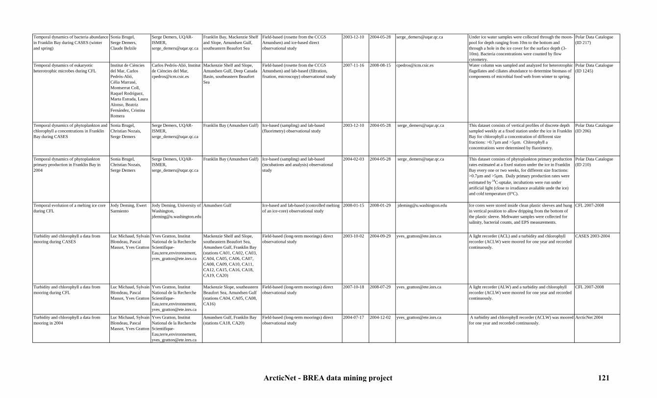
Temporal dynamics of bacteria abundance in Franklin Bay during CASES (winter and spring)
Sonia Brugel,Serge Demers,Claude Belzile
Serge Demers, UQAR-ISMER, [email protected]
Franklin Bay, Mackenzie Shelf and Slope, Amundsen Gulf, southeastern Beaufort Sea
Field-based (rosette from the CCGS Amundsen) and ice-based direct observational study
2003-12-10 2004-05-28 [email protected] Under ice water samples were collected through the moon-pool for depth ranging from 10m to the bottom and through a hole in the ice cover for the surface depth (3-10m). Bacteria concentrations were counted by flow cytometry.
Polar Data Catalogue (ID 217)
Temporal dynamics of eukaryotic heterotrophic microbes during CFL
Institut de Ciències del Mar, Carlos Pedrós-Alió, Cèlia Marrasé,Montserrat Coll, Raquel Rodríguez, Marta Estrada, Laura Alonso, Beatriz Fernández, Cristina Romera
Carlos Pedrós-Alió, Institut de Ciències del Mar, [email protected]
Mackenzie Shelf and Slope, Amundsen Gulf, Deep Canada Basin, southeastern Beaufort Sea
Field-based (rosette from the CCGS Amundsen) and lab-based (filtration, fixation, microscopy) observational study
2007-11-16 2008-08-15 [email protected] Water column was sampled and analyzed for heterotrophic flagellates and ciliates abundance to determine biomass of components of microbial food web from winter to spring.
Polar Data Catalogue (ID 1245)
Temporal dynamics of phytoplankton and chlorophyll a concentrations in Franklin Bay during CASES
Sonia Brugel,Christian Nozais,Serge Demers
Serge Demers, UQAR-ISMER, [email protected]
Franklin Bay (Amundsen Gulf) Ice-based (sampling) and lab-based (fluorimetry) observational study
2003-12-10 2004-05-28 [email protected] This dataset consists of vertical profiles of discrete depth sampled weekly at a fixed station under the ice in Franklin Bay for chlorophyll a concentration of different size fractions: >0.7µm and >5µm. Chlorophyll a concentrations were determined by fluorimetry.
Polar Data Catalogue (ID 206)
Temporal dynamics of phytoplankton primary production in Franklin Bay in 2004
Sonia Brugel,Christian Nozais,Serge Demers
Serge Demers, UQAR-ISMER, [email protected]
Franklin Bay (Amundsen Gulf) Ice-based (sampling) and lab-based (incubations and analysis) observational study
2004-02-03 2004-05-28 [email protected] This dataset consists of phytoplankton primary production rates estimated at a fixed station under the ice in Franklin Bay every one or two weeks, for different size fractions: >0.7µm and >5µm. Daily primary production rates were estimated by 14C-uptake, incubations were run under artificial light (close to irradiance available unde the ice) and cold temperature (0°C).
Polar Data Catalogue (ID 210)
Temporal evolution of a melting ice core during CFL
Jody Deming, Ewert Sarmiento
Jody Deming, University of Washington, [email protected]
Amundsen Gulf Ice-based and lab-based (controlled melting of an ice-core) observational study
2008-01-15 2008-01-29 [email protected] Ice cores were stored inside clean plastic sleeves and hung in vertical position to allow dripping from the bottom of the plastic sleeve. Meltwater samples were collected for salinity, bacterial counts, and EPS measurements.
CFL 2007-2008
Turbidity and chlorophyll a data from mooring during CASES
Luc Michaud, Sylvain Blondeau, Pascal Massot, Yves Gratton
Yves Gratton, Institut National de la Recherche Scientifique-Eau,terre,environnement, [email protected]
Mackenzie Shelf and Slope, southeastern Beaufort Sea, Amundsen Gulf, Franklin Bay (stations CA01, CA02, CA03, CA04, CA05, CA06, CA07, CA08, CA09, CA10, CA11, CA12, CA15, CA16, CA18, CA19, CA20)
Field-based (long-term moorings) direct observational study
2003-10-02 2004-09-29 [email protected] A light recorder (ACL) and a turbidity and chlorophyll recorder (ACLW) were moored for one year and recorded continuously.
CASES 2003-2004
Turbidity and chlorophyll a data from mooring during CFL
Luc Michaud, Sylvain Blondeau, Pascal Massot, Yves Gratton
Yves Gratton, Institut National de la Recherche Scientifique-Eau,terre,environnement, [email protected]
Mackenzie Slope, southeastern Beaufort Sea, Amundsen Gulf (stations CA04, CA05, CA08, CA16)
Field-based (long-term moorings) direct observational study
2007-10-18 2008-07-29 [email protected] A light recorder (ALW) and a turbidity and chlorophyll recorder (ACLW) were moored for one year and recorded continuously.
CFL 2007-2008
Turbidity and chlorophyll a data from mooring in 2004
Luc Michaud, Sylvain Blondeau, Pascal Massot, Yves Gratton
Yves Gratton, Institut National de la Recherche Scientifique-Eau,terre,environnement, [email protected]
Amundsen Gulf, Franklin Bay (stations CA18, CA20)
Field-based (long-term moorings) direct observational study
2004-07-17 2004-12-02 [email protected] A turbidity and chlorophyll recorder (ACLW) was moored for one year and recorded continuously.
ArcticNet 2004
ArcticNet - BREA data mining project 121

Turbidity and chlorophyll a data from mooring in 2008-2009
Luc Michaud, Sylvain Blondeau, Pascal Massot, Yves Gratton
Yves Gratton, Institut National de la Recherche Scientifique-Eau,terre,environnement, [email protected]
Mouth of the Amundsen Gulf (stations CA05, CA16)
Field-based (long-term moorings) direct observational study
2008-07-25 2009-10-12 [email protected] A light recorder (ALW) and a turbidity and chlorophyll recorder (ACLW) were moored for one year and recorded continuously.
CFL 2008 and ArcticNet 2009
Turbidity and chlorophyll a data from mooring in 2009-2010
Luc Michaud, Sylvain Blondeau, Pascal Massot, Yves Gratton
Yves Gratton, Institut National de la Recherche Scientifique-Eau,terre,environnement, [email protected]
Mouth of the Amundsen Gulf (stations CA05, CA16)
Field-based (long-term moorings) direct observational study
2009-10-13 2010-09-24 [email protected] A light recorder (ALW) and a turbidity and chlorophyll recorder (ACLW) were moored for one year and recorded continuously.
ArcticNet 2009-2010
Underwater PAR and UVR downwelling irradiance profiles during CASES
Sonia Brugel,Serge Demers
Serge Demers, UQAR-ISMER, [email protected]
Franklin Bay, Mackenzie Shelf and Slope, Amundsen Gulf, southeastern Beaufort Sea
Field-based (CCGS Amundsen) and computer-based (analysis) direct observational study
2004-06-04 2004-08-09 [email protected] This dataset consists of vertical profiles of underwater downwelling irradiances at several UVR (305, 313, 320, 340 and 380nm) and PAR wavelengths. Vertical light profiles were performed using a PUV-511 underwater radiometer (Biospherical Instruments) that provided a measure of cosine-corrected downwelling irradiance in the UVR and PAR spectrums.
Polar Data Catalogue (ID 215)
Underwater PAR and UVR downwelling irradiance profiles during CASES
Sonia Brugel,Serge Demers
Serge Demers, UQAR-ISMER, [email protected]
Mackenzie Shelf and Slope, Amudsen Gulf, Franklin Bay, southeastern Beaufort Sea
Field-based (CCGS Amundsen) and computer-based (analysis) direct observational study
2004-06-04 2004-08-10 [email protected] This dataset consists of vertical profiles of underwater downwelling irradiances at several UVR (305, 313, 320, 340 and 380nm) and PAR wavelengths. Vertical light profiles were performed using a PUV-511 underwater radiometer (Biospherical Instruments) that provided a measure of cosine-corrected downwelling irradiance in the UVR and PAR spectrums.
Polar Data Catalogue (ID 214, 215)
Viability of phytoplankton and photoprotection in 2008
Suzanne Roy,Michel Gosselin,Eva Alou Font
Suzanne Roy, UQAR, [email protected]
Mackenzie Shelf and Slope, Amundsen Gulf, Deep Canada Basin, southeastern Beaufort Sea
Field-based (rosette an pump from the CCGS Amundsen) and lab-based (filtration, HPLC) observational study
2008-04-24 2008-07-16 [email protected] Under ice and open water were sampled and analyzed for transparency (Secchi disk and the profiling natural fluorometer), vertical radiation profiles (IL1700 Radiometer), concentration of pigments and protein D1, protein and cell viability quantification and photosynthetic response (Walz Xe-PAM fluorometer and the fluorimeter Turner Designs 10-AU).
Polar Data Catalogue (ID 9934)
Viral abundance in Arctic winter sea-ice brine during CASES
Llyd E. Wells, Jody Deming
Jody Deming, University of Washington, [email protected]
Franklin Bay (Amundsen Gulf) Field-based (CCGS Amundsen) and lab-based (filtration, incubation, microscopy) observational study
2004-02-29 2004-03-21 [email protected] Incubations were performed to compare viral abundance in brine, seawater and ice from different locations.
Polar Data Catalogue (ID 247)
Water samples for primary production and microbiology during MALINA 2009
Daniel Vaulot, C. Jeanthon, D. Bœuf, F. Joux, E. Ortega, G. Chaillou, Connie Lovejoy, Y. Huot, Michel Gosselin, Simon Bélanger, V. Wright, S. Hooker, J. Ras, H. Claustre, P. Coupel, R. Benner
Daniel Vaulot, Station biologique de Roscoff, [email protected]
Mackenzie Shelf and Slope, Amundsen Gulf, southeastern Beaufort Sea
Field-based (rosette from the CCGS Amundsen) and lab-based (microscopy, fluorimetry, cytometry, incubations, PCR, HPLC) observational study
2009-07-31 2009-08-24 Daniel Vaulot ([email protected]) Water was sampled to calculate bacteria abundance, diversity, activity, growth, respiration, diversity and genomics of heterotrophs, concentration of lignin fenols, abundance and diversity of phytoplankton, synechococcus, coccolithophorids, archaea and virus.
ArcticNet 2009 expedition in collaboration with MALINA
ArcticNet - BREA data mining project 122

7.5. Zooplankton7.5.1. Distribution and abundance
Table 10: Zooplankton distribution and abundance metadataStudy Originators Contact person Study area Type of study Begin date End date Link to data Details Reference
Abundance and vertical distribution of the mesozooplankton using a Video Plankton Recorder (VPR) during CASES
Piotr Trela, Don Deibel, Tara Businski, Don Deibel
Don Deibel, Ocean Science Centre of Memorial University of Newfoundland, [email protected]
Mackenzie Shelf and Slope, Amundsen Gulf, Franklin Bay, southeastern Beaufort Sea
Field-based (CCGS Amundsen) direct observational study
2003-09-30 2004-08-10 [email protected] Fine scale vertical distribution and abundance of mesozooplankton and their prey were dertemined using images from a Video Plankton Recorders.The VPR package includes a SeaBird CTD and an in situ fluorometer, so that zooplankton distribution can be related to hydrographic and phytoplankton vertical structure.
CASES 2003-2004
Canadian Arctic zooplankton population genetics
John Nelson,Svein Vagle,University of Victoria,Fisheries and Oceans Canada
ArcticNet Data Manager, [email protected]
Canadian Beaufort Sea Field-based (sampling) and lab-based (analysis) observational study
2001-01-01 In progress [email protected], www.meds-sdmm.dfo-mpo.gc.ca/isdm-gdsi/index-eng.html
Genetic analysis of Calanus glacialis and of other zooplankton species was conducted to monitor the pelagic ecosystem boundary between the Pacific and Arctic oceans.
Polar Data Catalogue (ID 10216)
Data from an Underwater Vision Profiler 5 (UVP5) collected in 2009
Marc Picheral, Yves Gratton, Claudie Marec, Louis Prieur
Marc Picheral, Laboratoire d’Océanographie de Villefranche-sur-mer, [email protected]
Mackenzie Shelf and Slope, Amundsen Gulf, southeastern Beaufort Sea
Field-based (CCGS Amundsen) direct observational study
2009-07-16 2009-08-24 [email protected] Fine scale vertical distribution and abundance of mesozooplankton and their prey were determined using images from a an Underwater Vision Profiler 5 (UVP5) mounted on the CTD-rosette.
ArcticNet 2009 expedition in collaboration with Malina
Data on evolution of arctic arthropods during CASES
David Rees David Rees, Université du Québec à Rimouski, [email protected]
Amundsen Gulf, Mackenzie Shelf and Slope, southeastern Beaufort Sea
Field-based (CCGS Amundsen) and lab-based (DNA sequencing) obervational study
2003-10-22 2003-11-20 [email protected] Samples were obtained from vertical and horizontal net tows, hydrobios, box cores, epibenthic sled and baited traps. 125 individuals of 17 species were collected (3 isopods, 9 amphipods and 5 shrimps). Haemolyph was extracted from each individual and used for later analysis of genome size by image analysis densitometry. Specimens were preserved for DNA 51 sequencing.
CASES 2003-2004
Data on the overwintering strategy of zooplankton, microzooplankton and large-sized copepods during CASES
Ryosuke Makabe, Hiroshi Sasaki
Hiroshi Sasaki, Senshu University of Ishinomaki, [email protected]
Mackenzie Shelf and slope, Amundsen Gulf
Field-based (CCGS Amundsen) and lab-based (analysis) observational study
2004-08-06 2004-08-10 [email protected] Zooplankton comunities were sampled for a better understanding of overwintering strategies. Large-sized zooplankton were collected using tucker net tows to observe seasonal variation in the communities and to compare with compositions of swimmers caught with the long-term sediment traps. Small-sized zooplankton and copepod fecal pellets were sampled using ring net tows. Water samples were also collected for microzooplankton abundance and specific cell cycles, which indicate their in situ growth rates.
CASES 2003-2004
ArcticNet - BREA data mining project 123

Egg production data for the Arctic copepods Calanus glacialis, Calanus.marshallae, Calanus.hyperboreus and Metridia longa during CASES
Alexandre Forest,Louis Létourneau,Gérald Darnis,Marc Ringuette,Anna Prokopowicz, Louis Fortier
Louis Fortier, Université Laval, [email protected]
Mackenzie Shelf and Slope, Amundsen Gulf, Franklin Bay, southeastern Beaufort Sea
Field-based (plankton nets deployed from the CCGS Amundsen) and lab-based (incubation) observational study
2003-10-20 2004-08-14 [email protected] Calanus glacialis, Calanus marshallae, Calanus hyperboreus and Metridia longa were sampled and incubated for egg production experiments. Data include: egg production rates, clutch size and gonad maturation index.
Polar Data Catalogue (ID 261)
Egg production data for the Arctic copepods Calanus glacialis, Calanus.marshallae, Calanus.hyperboreus and Metridia longa during CFL
Anaïs Aubert, Hélen Cloutier, Samuel Lauzon, Louis Létourneau,Gérald Darnis,Marc Ringuette, Louis Fortier
Louis Fortier, Université Laval, [email protected]
Mackenzie Shelf and Slope, Amundsen Gulf, Deep Canada Basin, southeastern Beaufort Sea
Field-based (plankton nets deployed from the CCGS Amundsen) and lab-based (incubation) observational study
2007-11-11 2008-07-28 [email protected] Calanus glacialis, Calanus marshallae, Calanus hyperboreus and Metridia longa were sampled and incubated for egg production experiments. Data include: egg production rates, clutch size and gonad maturation index.
Polar Data Catalogue (ID 1704)
Experiments on the influence of ocean acidification and melting of sea ice on shells of Pteropod, Limacina helicina in 2010
Michiyo Kawai, John Nelson
John Nelson, Department of Fisheries and Oceans Canada, [email protected]
Alaskan Slope and Shelf, Deep Canada Basin, Mackenzie Shelf and Slope, North Beaufort Sea
Field-based (plankton nets deployed from CCGS Louis S. St-Laurent) and lab-based (incubation and analysis) observational study
2010-09-15 2010-10-15 [email protected] Limacina helicina samples were collected and incubated in aragonite-undersaturated water. Water was analized for DIC/TA and nutrients after 6 days and shells of Limacina helicina were checked using SEM to know if they had any damage resulting from aragonite-undersaturated waters.
JOIS 2010
Ice amphipods ecology during CFL Stig Falk-Petersen, Anette Wold
Stig Falk-Petersen, Norwegian Polar Institute, [email protected], Anette Wold, Norwegian Polar Institute, [email protected]
Amundsen Gulf Ice-based (baited traps deployed under ice floes) and lab-based (analysis) observational study
2008-03-26 2008-04-16 [email protected], [email protected]
Amphipods were collected and sorted by species and size group. Samples were analyzed for population biology genetics, lipids and stable isotope analysis.
CFL 2007-2008
Lipid and stable isotope composition of Calanus glacialis and C.hyperboreus during CFL
Stig Falk-Petersen, Anette Wold
Stig Falk-Petersen, Norwegian Polar Institute, [email protected], Anette Wold, Norwegian Polar Institute, [email protected]
Amundsen Gulf Field-based (plankton nets deployed from the CCGS Amundsen) and lab-based (analysis) observational study
2008-03-18 2008-04-16 [email protected], [email protected]
Zooplankton (Calanus glacialis and Calanus Hyperboreus ) were sampled and analyzed for dry weight, lipid content, C and N stable isotope composition, lipid class composition, fatty acid and fatty alcohol composition.
CFL 2007-2008
Mesozooplankton vertical distribution during CASES
Louis Létourneau,Gérald Darnis,Luc Michaud,Anna prokopowicz,Louis Fortier
Louis Fortier, Université Laval, [email protected]
Mackenzie Shelf and Slope, Amundsen Gulf, Franklin Bay, southeastern Beaufort Sea
Field-based (hydrobios deployed from the CCGS Pierre Radisson) and lab-based (taxonomy) observational study
2002-09-22 2004-08-07 [email protected] 300 animals per sample were counted and identified to species or to the lowest possible taxonomical level when species identification proved difficult. Copepod developmental stages were also recorded. Species and developmental stages biomass (ind. m-2) and density (ind. m-3) were determinated based on taxa identification, individual counts, volume of water sampled and station depth.
CASES 2002-2004, Polar Data Catalogue (ID 213, 259)
Mesozooplankton vertical distribution during CFL
Louis Fortier, Samuel Lauzon,Louis Létourneau,Gérald Darnis,Marc Ringuette
Louis Fortier, Université Laval, [email protected]
Mackenzie Shelf and Slope, Amundsen Gulf, Deep Canada Basin, southeastern Beaufort Sea
Field-based (hydrobios deployed from the CCGS Amundsen) and lab-based (taxonomy) observational study
2007-10-21 2008-08-08 [email protected] 300 animals per sample were counted and identified to species or to the lowest possible taxonomical level when species identification proved difficult. Copepod developmental stages were also recorded. Species and developmental stages biomass (ind. m-2) and density (ind. m-3) were determinated based on taxa identification, individual counts, volume of water sampled and station depth.
Polar Data Catalogue (ID 1703)
ArcticNet - BREA data mining project 124

Mesozooplankton vertical distribution in 2005
Louis Létourneau,Gérald Darnis,Luc Michaud,Anna Prokopowicz,Louis Fortier
Louis Fortier, Université Laval, [email protected]
Amundsen Gulf, Mackenzie Shelf and Slope, southeastern Beaufort Sea
Field-based (hydrobios deployed from the CCGS Amundsen) and lab-based (taxonomy) observational study
2005-09-01 2005-09-14 [email protected] 300 animals per sample were counted and identified to species or to the lowest possible taxonomical level when species identification proved difficult. Copepod developmental stages were also recorded. Species and developmental stages biomass (ind. m-2) and density (ind. m-3) were determinated based on taxa identification, individual counts, volume of water sampled and station depth.
ArcticNet 2005
Mesozooplankton vertical distribution in 2006
Louis Létourneau,Gérald Darnis,Luc Michaud,Anna Prokopowicz,Louis Fortier
Louis Fortier, Université Laval, [email protected]
Amundsen Gulf, Mackenzie Shelf and Slope, southeastern Beaufort Sea
Field-based (hydrobios deployed from the CCGS Amundsen) and lab-based (taxonomy) observational study
2006-09-30 2006-10-19 [email protected] 300 animals per sample were counted and identified to species or to the lowest possible taxonomical level when species identification proved difficult. Copepod developmental stages were also recorded. Species and developmental stages biomass (ind. m-2) and density (ind. m-3) were determinated based on taxa identification, individual counts, volume of water sampled and station depth.
ArcticNet 2006
Mesozooplankton vertical distribution in 2009
Louis Fortier, Dominique Robert, Makoto Sampei,Gérald Darnis, Cyril Aubry, Shani Rousseau, Maxime Geoffroy
Louis Fortier, Université Laval, [email protected]
Southeastern Beaufort Sea, Amundsen Gulf, Mackenzie Shelf and Slope (EL 446)
Field-based (hydrobios deployed from the CCGS Amundsen) and lab-based (taxonomy) observational study
2009-07-16 2009-10-16 [email protected] 300 animals per sample were counted and identified to species or to the lowest possible taxonomical level when species identification proved difficult. Copepod developmental stages were also recorded. Species and developmental stages biomass (ind. m-2) and density (ind. m-3) were determinated based on taxa identification, individual counts, volume of water sampled and station depth.
ArcticNet 2009 expedition in collaboration with IORVL
Mesozooplankton vertical distribution in 2010
Louis Fortier, Dominique Robert, Makoto Sampei,Gérald Darnis, Cyril Aubry, Shani Rousseau, Maxime Geoffroy
Louis Fortier, Université Laval, [email protected]
Amundsen Gulf, Mackenzie Shelf and Slope (EL 449, 451), southeastern Beaufort Sea, Deep Canada Basin
Field-based (hydrobios deployed from the CCGS Amundsen) and lab-based (taxonomy) observational study
2010-08-12 2010-10-10 [email protected] 300 animals per sample were counted and identified to species or to the lowest possible taxonomical level when species identification proved difficult. Copepod developmental stages were also recorded. Species and developmental stages biomass (ind. m-2) and density (ind. m-3) were determinated based on taxa identification, individual counts, volume of water sampled and station depth.
ArcticNet 2010 expedition in collaboration with BP
Microzooplankton population in sea ice composition during CASES
Takashi Ota, ShinyaYamamoto
Takashi Ota, Ishinomaki Senshu University Japan, [email protected]
Franklin Bay (Amundsen Gulf) Field-based (CCGS Amundsen) and lab-based (dilution, microscopy) observational study
2004-02-18 2004-03-31 [email protected] Surface water (collected every 6 days from 3, 5, 10 m depths) and sea ice cores were sampled and analyzed to document the diversity, abundance and vertical distribution of microzooplankton (mainly protozoa) in sea ice.
CASES 2004
ArcticNet - BREA data mining project 125

Respiration, biomass and Electron Transfer System (ETS) activity during CFL
Louis Fortier, Gérald Darnis
Louis Fortier, Université Laval, [email protected]
Mackenzie Shelf and Slope, Amundsen Gulf, Deep Canada Basin, southeastern Beaufort Sea
Field-based (Plankton net deployed from the CCGS Amundsen) and lab-based (taxonomy, incubation) observational study
2007-12-26 2008-06-05 [email protected] Zooplankton samples were collected and fractionated for biomass and ETS activity experiments. Samples were incubated in a Pyrex plate filled with water and heated to 40°C on a hot plate. ETS experiments were performed on individual copepods, females and copepodite stage 5, of Calanus finmarchicus, Calanus hyperboreus and Metridia longa . Copepods were incubated to measure oxygen consumption in sealed chambers to obtain derived respiration from the activity of the Electron Transfer System (ETS).
CFL 2007-2008
Stable isotope composition in zooplankton during CASES
Takahiro Nakanishi Takahiro Nakashini, National Institute of Radiological Sciences (Japan),[email protected]
Mackenzie Slope, Amundsen Gulf
Field-based (hydrobios from the CCGS Amundsen) and lab-based (analysis) observational study
2003-10-18 2003-11-19 [email protected] Zooplankton was sampled and analyzed for diversity and 13C and 15N composition.
CASES 2003-2004
Zoolankton abundance from hydroacoustics data during JOIS
Humfrey Melling Humfrey Melling, Department of Fisheries and Oceans Canada, [email protected]
Alaskan Slope and Shelf, Deep Canada Basin, Mackenzie Shelf and Slope, North Beaufort Sea
Field-based (long-term moorings) and computer-based (analysis) observational study
1990-01-01 2010-10-13 [email protected] Ice-Profiling Sonar (IPS), Upward-Looking Sonar (ULS), wave sonars and ADCP were moored for one or two years and recorded data on zooplankton abundance from the decadal variation of marine hazards and Arctic Ice Monitoring (AIM) program.
Polar Data Catalogue (ID 10231)
Zooplankton data from 2002-2010 Andrey Proshutinsky, Willie Ostrom, Rick Krishfield, Kelly Young, Kenny Scozzafava, John Nelson, Chelsea Stanley, Zoe Sandwith, Peter Peterson, Bill Williams, Lori Waters, Brian Hunt, Russ Hopcroft, Sarah Zimmermann, Fiona McLaughlin, Amanda Byrd
Andrey Proshutinsky, Woods Hole Oceanographic Institution, [email protected], Fiaona McLaughlin, Department of Fisheries and Oceans Canada, [email protected], John Nelson, Department of Fisheries and Oceans Canada, [email protected]
Alaskan Slope and Shelf, Deep Canada Basin, Mackenzie Shelf and Slope, North Beaufort Sea
Field-based (plankton nets deployed from the CCGS Louis S. St-Laurent) and lab-based (taxonomy, DNA analysis) observational study
2002-X-X 2010-10-13 http://www.whoi.edu/beaufortgyre, [email protected], [email protected], [email protected]
Zooplankton was collected using a Bongo net and analyzed for identification, DNA, and biomass measurements. Two 100m deep casts were performed per station.
JWACS/ BGEP(BGFE), JOIS 2003-2004-2005-2006-2007-2008-2009-2010
ArcticNet - BREA data mining project 126

7.5. Zooplankton7.5.2. Trophic interactions and contaminant loads
Table 11: Zooplankton trophic interactions and contaminant loads metadataStudy Originators Contact person Study area Type of study Begin date End date Link to data Details Reference
Carbon isotope ratios in zooplankton during CASES
Takahiro Nakanishi Takahiro Nakashini, National Institute of Radiological Sciences (Japan),[email protected]
Amundsen Gulf, Mackenzie Shelf and Slope, southeastern Beaufort Sea
Field-based (rosette and box cores from the CCGS Amundsen) and lab-based (analysis) observational study
2003-10-16 2003-11-26 [email protected] Zooplankton was collected to measure carbon isotope (13C and 15N) ratios in zooplankton.
CASES 2003-2004
Contaminant concentrations in zooplankton and benthic invertebrates in 2010
Gary A. Stern, Marcos Lemes, Amanda Chaulk, Marc Cadieux, Allison MacHutchon, Joanne DeLaronde, Gail Boila, Debbie Armstrong, Ashley Gaden
Gary Stern, Department of Fisheries and Oceans Canada, [email protected]
Amundsen Gulf, Mackenzie Shelf and Slope (EL 449, 451), southeastern Beaufort Sea, Deep Canada Basin
Field-based (zooplankton nets deployed from the CCGS Amundsen) and lab-based (analysis) observational study
2010-08-12 2010-08-26 [email protected] Zooplankton and benthic invertebrates samples were collected and analyzed for THg, MeHG, HC and trace metals concentrations.
ArcticNet 2010 expedition in collaboration with BP
Contaminant concentrations in zooplankton in 2009
Gary A. Stern, Marcos Lemes, Amanda Chaulk, Marc Cadieux, Allison MacHutchon, Joanne DeLaronde, Gail Boila, Debbie Armstrong, Ashley Gaden
Gary Stern, Department of Fisheries and Oceans Canada, [email protected]
Southeastern Beaufort Sea, Amundsen Gulf, Mackenzie Shelf and Slope (EL 446)
Field-based (zooplankton nets deployed from the CCGS Amundsen) and lab-based (analysis) observational study
2009-07-16 2009-10-16 [email protected] Zooplankton samples were collected and analyzed for THg, MeHG, HC and trace metals concentrations.
ArcticNet 2009 expedition in collaboration with IORVL and Malina
Hg concentration, stable isotope ratios and fatty acids in zooplankton during CASES
Gary Stern, Robie Macdonald, Paul Helm, Eric Braekevelt, Allison MacHutchon
Gary Stern, Department of Fisheries and Oceans Canada, [email protected]
Mackenzie Shelf and Slope, Amundsen Gulf, Franklin Bay, southeastern Beaufort Sea
Field-based (plankton nets deployed from the CCGS Amundsen) and lab-based (analysis) observational study
2002-09-22 2004-08-25 [email protected] Zooplankton and fish were sampled and analyzed for stable isotopes (N and C), fatty acids, organic contaminant, Hg and MeHg concentrations.
CASES 2002-2004
Material sources in zooplankton diet during CASES
Don Diebel, Tara Buzinski
Don Diebel, Memorial University,[email protected]
Mackenzie Shelf and Slope, Amundsen Gulf, Franklin Bay, southeastern Beaufort Sea
Field-based (plankton nets deployed from the CCGS Radisson and Amundsen) and lab-based (analysis) observational study
2002-09-24 2004-01-06 [email protected] Zooplankton, faecal pellets and SPM were sampled and analyzed for minerology, terrestrial biomarkers, lipid, fatty acid and sterol composition to determine the source of food material in the diet of copepods and appendicularians.
CASES 2002-2004
ArcticNet - BREA data mining project 127

Mercury and methyl mercury concentrations in zooplankton during CFL
Alexis Burt, Joanne DeLaronde, Gail Boila, Allison MacHutchon, Debbie Armstrong, Amanda Chaulk, Louis Letourneau, Gerald Darnis, Gary Stern
Gary Stern, Department of Fisheries and Oceans Canada, [email protected]
Mackenzie Shelf and Slope, Amundsen Gulf, Deep Canada Basin, southeastern Beaufort Sea
Field-based (zooplankton nets deployed from the CCGS Amundsen) and lab-based (filtration and analysis) observational study
2007-10-15 2008-08-07 [email protected] Zooplankton was sampled, live sorted and analyzed for, HCH, Hg and MeHg concentrations.
CFL 2007-2008, Polar Data Catalogue (ID 1621)
Mercury concentration and stable isotope ratios in zooplankton in 2005-2006
Corinne Pomerleau, Joanne DeLaronde,Allison MacHutchon, Gail Boila,Bruno Rosenberg, Gary Stern
Gary Stern, Department of Fisheries and Oceans Canada, [email protected]
Amundsen Gulf, Mackenzie Shelf and Slope, southeastern Beaufort Sea
Field-based (nets deployed from the CCGS Amundsen) and lab-based (analysis) observational study
2005-08-05 2006-09-27 [email protected] Zooplankton (Calanus spp . Euchaeta sp . and hyperiid amphipod Themisto spp. ) was sampled and analyzed for total mercury and methylmercury concentrations and stable isotope ratios. Measurements were done using a Cold Vapour Atomic Absorption Spectroscopy (CVAAS) for Hg analysis, a Gas Chromatography Atomic Fluorescence Spectroscopy (GCAFS) for MMHg analysis and a Continuous Flow Ion Ratio Mass Spectrometry (CF-IRMS) for carbon and nitrogen isotopic analyses.
Polar Data Catalogue (ID 1632)
Organic contaminant, POP, PBDE, methyl mercury and mercury concentrations, stable isotope ratios and fatty acids in zooplankton and fish larvea in 2006
Eric Braekevelt, Allison MacHutchon, Gary Stern
Gary Stern, Department of Fisheries and Oceans Canada, [email protected]
Amundsen Gulf, Mackenzie Shelf and Slope, southeastern Beaufort Sea
Field-based (zooplankton net deployed from the CCGS Amundsen) and lab-based (analysis) observational study
2006-09-28 2006-11-09 [email protected] Zooplankton was sampled and analyzed for organic contaminant, POP, PBDE, methyl mercury and mercury concentrations, stable isotope ratios and fatty acids.
ArcticNet 2006
Organic contaminant, POP, PBDE, methyl mercury and mercury concentrations, stable isotope ratios and fatty acids in zooplankton in 2005
Eric Braekevelt, Allison MacHutchon, Gary Stern
Gary Stern, Department of Fisheries and Oceans Canada, [email protected]
Amundsen Gulf, Mackenzie Shelf and Slope, southeastern Beaufort Sea
Field-based (zooplankton nets deployed from the CCGS Amundsen) and lab-based (analysis) observational study
2005-09-01 2005-09-14 [email protected] Zooplankton was sampled and analyzed for organic contaminant, POP, PBDE, methyl mercury and mercury concentrations, stable isotope ratios and fatty acids.
ArcticNet 2005
Organic contaminant, POP, PBDE, methyl mercury and mercury concentrations, stable isotope ratios and fatty acids in zooplankton in 2009
Gary A. Stern, Marcos Lemes, Amanda Chaulk, Marc Cadieux, Allison MacHutchon, Joanne DeLaronde, Gail Boila, Debbie Armstrong, Ashley Gaden
Gary Stern, Department of Fisheries and Oceans Canada, [email protected]
Southeastern Beaufort Sea, Amundsen Gulf, Mackenzie Shelf and Slope (EL 446)
Field-based (zooplankton net deployed from the CCGS Amundsen) and lab-based (analysis) observational study
2009-07-16 2009-10-16 [email protected] Zooplankton was sampled and analyzed for organic contaminant, POP, PBDE, methyl mercury and mercury concentrations, stable isotope ratios and fatty acids.
ArcticNet 2009 expedition in collaboration with IORVL and Malina
Organic contaminant, POP, PBDE, methyl mercury and mercury concentrations, stable isotope ratios and fatty acids in zooplankton in 2010
Gary A. Stern, Marcos Lemes, Amanda Chaulk, Marc Cadieux, Allison MacHutchon, Joanne DeLaronde, Gail Boila, Debbie Armstrong, Ashley Gaden
Gary Stern, Department of Fisheries and Oceans Canada, [email protected]
Amundsen Gulf, Mackenzie Shelf and Slope (EL 449, 451), southeastern Beaufort Sea, Deep Canada Basin
Field-based (rosette, box cores and zooplankton net deployed from the CCGS Amundsen) and lab-based (analysis) observational study
2010-08-12 2010-08-26 [email protected] Zooplankton was sampled and analyzed for organic contaminant, POP, PBDE, methyl mercury and mercury concentrations, stable isotope ratios and fatty acids.
ArcticNet 2010 expedition in collaboration with BP
ArcticNet - BREA data mining project 128
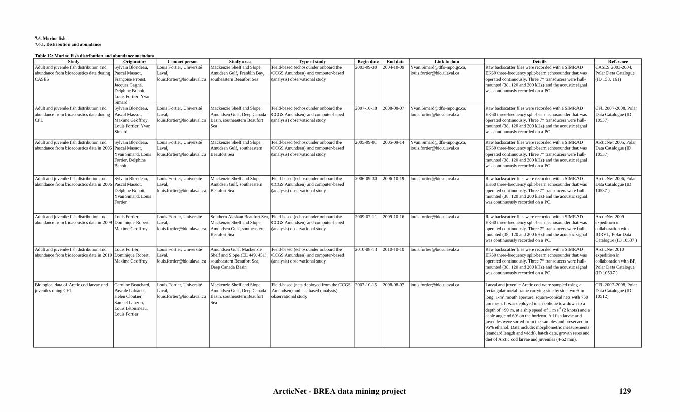
7.6. Marine fish7.6.1. Distribution and abundance
Table 12: Marine Fish distribution and abundance metadataStudy Originators Contact person Study area Type of study Begin date End date Link to data Details Reference
Adult and juvenile fish distribution and abundance from bioacoustics data during CASES
Sylvain Blondeau,Pascal Massot,Françoise Proust,Jacques Gagné,Delphine Benoit, Louis Fortier, Yvan Simard
Louis Fortier, Université Laval, [email protected]
Mackenzie Shelf and Slope, Amudsen Gulf, Franklin Bay, southeastern Beaufort Sea
Field-based (echosounder onboard the CCGS Amundsen) and computer-based (analysis) observational study
2003-09-30 2004-10-09 [email protected], [email protected]
Raw backscatter files were recorded with a SIMRAD EK60 three-frequency split-beam echosounder that was operated continuously. Three 7° transducers were hull-mounted (38, 120 and 200 kHz) and the acoustic signal was continuously recorded on a PC.
CASES 2003-2004, Polar Data Catalogue (ID 158, 161)
Adult and juvenile fish distribution and abundance from bioacoustics data during CFL
Sylvain Blondeau,Pascal Massot,Maxime Geoffroy, Louis Fortier, Yvan Simard
Louis Fortier, Université Laval, [email protected]
Mackenzie Shelf and Slope, Amundsen Gulf, Deep Canada Basin, southeastern Beaufort Sea
Field-based (echosounder onboard the CCGS Amundsen) and computer-based (analysis) observational study
2007-10-18 2008-08-07 [email protected], [email protected]
Raw backscatter files were recorded with a SIMRAD EK60 three-frequency split-beam echosounder that was operated continuously. Three 7° transducers were hull-mounted (38, 120 and 200 kHz) and the acoustic signal was continuously recorded on a PC.
CFL 2007-2008, Polar Data Catalogue (ID 10537)
Adult and juvenile fish distribution and abundance from bioacoustics data in 2005
Sylvain Blondeau,Pascal Massot,Yvan Simard, Louis Fortier, Delphine Benoit
Louis Fortier, Université Laval, [email protected]
Mackenzie Shelf and Slope, Amudsen Gulf, southeastern Beaufort Sea
Field-based (echosounder onboard the CCGS Amundsen) and computer-based (analysis) observational study
2005-09-01 2005-09-14 [email protected], [email protected]
Raw backscatter files were recorded with a SIMRAD EK60 three-frequency split-beam echosounder that was operated continuously. Three 7° transducers were hull-mounted (38, 120 and 200 kHz) and the acoustic signal was continuously recorded on a PC.
ArcticNet 2005, Polar Data Catalogue (ID 10537)
Adult and juvenile fish distribution and abundance from bioacoustics data in 2006
Sylvain Blondeau,Pascal Massot,Delphine Benoit,Yvan Simard, Louis Fortier
Louis Fortier, Université Laval, [email protected]
Mackenzie Shelf and Slope, Amudsen Gulf, southeastern Beaufort Sea
Field-based (echosounder onboard the CCGS Amundsen) and computer-based (analysis) observational study
2006-09-30 2006-10-19 [email protected] Raw backscatter files were recorded with a SIMRAD EK60 three-frequency split-beam echosounder that was operated continuously. Three 7° transducers were hull-mounted (38, 120 and 200 kHz) and the acoustic signal was continuously recorded on a PC.
ArcticNet 2006, Polar Data Catalogue (ID 10537 )
Adult and juvenile fish distribution and abundance from bioacoustics data in 2009
Louis Fortier, Dominique Robert, Maxime Geoffroy
Louis Fortier, Université Laval, [email protected]
Southern Alaskan Beaufort Sea, Mackenzie Shelf and Slope, Amundsen Gulf, southeastern Beaufort Sea
Field-based (echosounder onboard the CCGS Amundsen) and computer-based (analysis) observational study
2009-07-11 2009-10-16 [email protected] Raw backscatter files were recorded with a SIMRAD EK60 three-frequency split-beam echosounder that was operated continuously. Three 7° transducers were hull-mounted (38, 120 and 200 kHz) and the acoustic signal was continuously recorded on a PC.
ArcticNet 2009 expedition in collaboration with IORVL, Polar Data Catalogue (ID 10537 )
Adult and juvenile fish distribution and abundance from bioacoustics data in 2010
Louis Fortier, Dominique Robert, Maxime Geoffroy
Louis Fortier, Université Laval, [email protected]
Amundsen Gulf, Mackenzie Shelf and Slope (EL 449, 451), southeastern Beaufort Sea, Deep Canada Basin
Field-based (echosounder onboard the CCGS Amundsen) and computer-based (analysis) observational study
2010-08-13 2010-10-10 [email protected] Raw backscatter files were recorded with a SIMRAD EK60 three-frequency split-beam echosounder that was operated continuously. Three 7° transducers were hull-mounted (38, 120 and 200 kHz) and the acoustic signal was continuously recorded on a PC.
ArcticNet 2010 expedition in collaboration with BP, Polar Data Catalogue (ID 10537 )
Biological data of Arctic cod larvae and juveniles duing CFL
Caroline Bouchard,Pascale Lafrance,Hélen Cloutier, Samuel Lauzon,Louis Létourneau,Louis Fortier
Louis Fortier, Université Laval, [email protected]
Mackenzie Shelf and Slope, Amundsen Gulf, Deep Canada Basin, southeastern Beaufort Sea
Field-based (nets deployed from the CCGS Amundsen) and lab-based (analysis) observational study
2007-10-15 2008-08-07 [email protected] Larval and juvenile Arctic cod were sampled using a rectangular metal frame carrying side by side two 6-m long, 1-m2 mouth aperture, square-conical nets with 750 um mesh. It was deployed in an oblique tow down to a depth of ~90 m, at a ship speed of 1 m s-1 (2 knots) and a cable angle of 60º on the horizon. All fish larvae and juveniles were sorted from the samples and preserved in 95% ethanol. Data include: morphometric measurements (standard length and width), hatch date, growth rates and diet of Arctic cod larvae and juveniles (4-62 mm).
CFL 2007-2008, Polar Data Catalogue (ID 10512)
ArcticNet - BREA data mining project 129

Biological data of Arctic cod larvae and juveniles during CASES
Pascale Lafrance,Simon Lebel,Louis Létourneau, Louis Fortier
Louis Fortier, Université Laval, [email protected]
Mackenzie Shelf and Slope, Amudsen Gulf, Franklin Bay, southeastern Beaufort Sea
Field-based (nets deployed from the CCGS Amundsen and CCGS Pierre Radisson) and lab-based (analysis) observational study
2002-09-22 2004-09-09 [email protected] Larval and juvenile Arctic cod were sampled using a rectangular metal frame carrying side by side two 6-m long, 1-m2 mouth aperture, square-conical nets with 750 um mesh. It was deployed in an oblique tow down to a depth of ~90 m, at a ship speed of 1 m s-1 (2 knots) and a cable angle of 60º on the horizon. All fish larvae and juveniles were sorted from the samples and preserved in 95% ethanol. Data include: morphometric measurements (standard length and width), hatch date, growth rates and diet of Arctic cod larvae and juveniles (4-55mm) in relation to the prey assemblage prevailing in the fall of 2002, 2003 and 2004.
CASES 2002-2004, Polar Data Catalogue (ID 200, 10509)
Biological data of Arctic cod larvae and juveniles in 2005
Caroline Bouchard,Pascale Lafrance,Hélen Cloutier,Louis Létourneau, Louis Fortier
Louis Fortier, Université Laval, [email protected]
Amundsen Gulf, Mackenzie Shelf and Slope, southeastern Beaufort Sea
Field-based (nets deployed from the CCGS Amundsen) and lab-based (analysis) observational study
2005-09-01 2008-09-14 [email protected] Larval and juvenile Arctic cod were sampled using a rectangular metal frame carrying side by side two 6-m long, 1-m2 mouth aperture, square-conical nets with 750 um mesh. It was deployed in an oblique tow down to a depth of ~90 m, at a ship speed of 1 m s-1 (2 knots) and a cable angle of 60º on the horizon. All fish larvae and juveniles were sorted from the samples and preserved in 95% ethanol. Data include: morphometric measurements (standard length and width), hatch date, growth rates and diet of Arctic cod larvae and juveniles (4-62 mm).
ArcticNet 2005, Polar Data Catalogue (ID 1698, 10512)
Biological data of Arctic cod larvae and juveniles in 2006
Caroline Bouchard,Pascale Lafrance,Hélen Cloutier,Louis Létourneau,Louis Fortier
Louis Fortier, Université Laval, [email protected]
Amundsen Gulf, Mackenzie Shelf and Slope, southeastern Beaufort Sea
Field-based (nets deployed from the CCGS Amundsen) and lab-based (analysis) observational study
2006-09-30 2006-10-19 [email protected] Larval and juvenile Arctic cod were sampled using a rectangular metal frame carrying side by side two 6-m long, 1-m2 mouth aperture, square-conical nets with 750 um mesh. It was deployed in an oblique tow down to a depth of ~90 m, at a ship speed of 1 m s-1 (2 knots) and a cable angle of 60º on the horizon. All fish larvae and juveniles were sorted from the samples and preserved in 95% ethanol. Data include: morphometric measurements (standard length and width), hatch date, growth rates and diet of Arctic cod larvae and juveniles (4-62 mm).
ArcticNet 2006, Polar Data Catalogue (ID 10512)
Biological data of Arctic cod larvae and juveniles in 2009
Dominique Robert, Cyril Aubry, Maxime GeoffroyHélen Cloutier,Louis Fortier
Louis Fortier, Université Laval, [email protected]
South Alaskan Beaufort Sea, southeastern Beaufort Sea, Amundsen Gulf, Mackenzie Shelf and Slope (EL 446)
Field-based (nets deployed from the CCGS Amundsen) and lab-based (analysis) observational study
2009-07-16 2009-10-16 [email protected] Larval and juvenile Arctic cod were sampled using a rectangular metal frame carrying side by side two 6-m long, 1-m2 mouth aperture, square-conical nets with 750 um mesh. It was deployed in an oblique tow down to a depth of ~90 m, at a ship speed of 1 m s-1 (2 knots) and a cable angle of 60º on the horizon. All fish larvae and juveniles were sorted from the samples and preserved in 95% ethanol. Data include: morphometric measurements (standard length and width), hatch date, growth rates and diet of Arctic cod larvae and juveniles (4-62 mm).
ArcticNet 2009, Polar Data Catalogue (ID 10512)
Biological data of Arctic cod larvae and juveniles in 2010
Dominique Robert, Cyril Aubry, Maxime GeoffroyHélen Cloutier,Louis Fortier
Louis Fortier, Université Laval, [email protected]
Amundsen Gulf, Mackenzie Shelf and Slope (EL 449, 451), southeastern Beaufort Sea, Deep Canada Basin
Field-based (nets deployed from the CCGS Amundsen) and lab-based (analysis) observational study
2010-08-13 2010-10-10 [email protected] Larval and juvenile Arctic cod were sampled using a rectangular metal frame carrying side by side two 6-m long, 1-m2 mouth aperture, square-conical nets with 750 um mesh. It was deployed in an oblique tow down to a depth of ~90 m, at a ship speed of 1 m s-1 (2 knots) and a cable angle of 60º on the horizon. All fish larvae and juveniles were sorted from the samples and preserved in 95% ethanol. Data include: morphometric measurements (standard length and width), hatch date, growth rates and diet of Arctic cod larvae and juveniles (4-62 mm).
ArcticNet 2010, Polar Data Catalogue (ID 10512)
ArcticNet - BREA data mining project 130

Biological data of marine Arctic fish from 2005 to 2007
Jacques A. Gagne Jacques Gagne, Department of Fisheries and Oceans Canada, [email protected]
Mackenzie Shelf and Slope, Amundsen Gulf, Franklin Bay, southeastern Beaufort Sea
Field-based (CCGS Amundsen), ice-based (net deployments) and lab-based (analysis) observational study
2005-12-01 2008-04-30 [email protected] Juvenile and adult marine fish were collected and characterized to describe the basic biological characteristics (e.g. growth, feeding) of various marine forage fish species in the Canadian Arctic. Fish were sampled mostly with gillnets, sometimes with handlines and occasionaly from other instruments (e.g. hydrobios). Data include: age, size, condition, sex, maturity and gut content.
Polar Data Catalogue (ID 249)
Fish distribution in relation to physico-chemical and bathymetric characteristics of their habitat in 2002
Richard Crawford Richard Crawford, Prince William Sound Science Center,[email protected]
Alaskan and Canadian Shelf and Slope
Field-based (sampling), computer based (analysis), and lab based (analysis) observational study
2002-09-X 2002-10-X [email protected] An echosounder and an ADCP were used to study fish distribution. A bongo net was used to sample plankton and larval fish. Fish backscatter was related to physico-chemical and bathymetric characteristics of their habitat.
JWACS 2002
ArcticNet - BREA data mining project 131
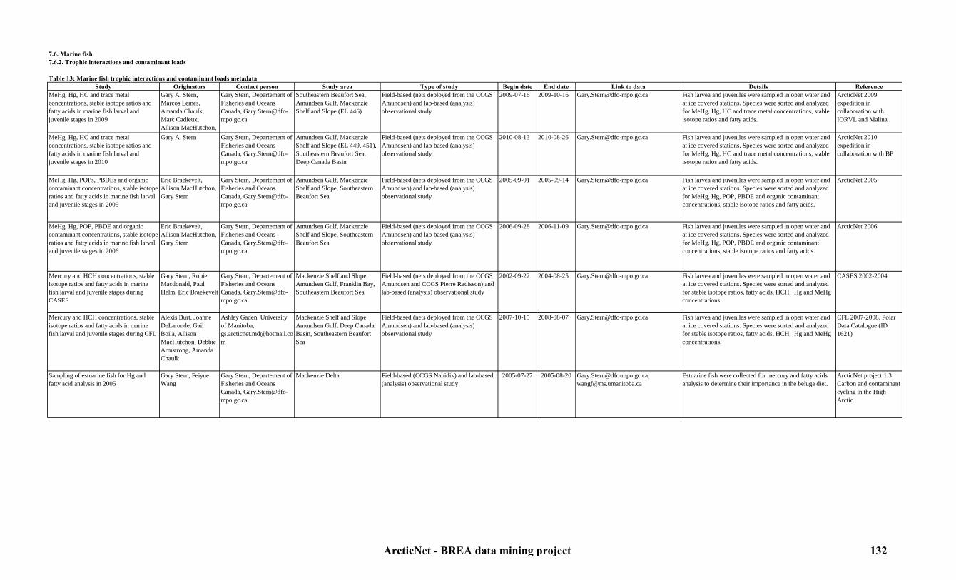
7.6. Marine fish7.6.2. Trophic interactions and contaminant loads
Table 13: Marine fish trophic interactions and contaminant loads metadataStudy Originators Contact person Study area Type of study Begin date End date Link to data Details Reference
MeHg, Hg, HC and trace metal concentrations, stable isotope ratios and fatty acids in marine fish larval and juvenile stages in 2009
Gary A. Stern, Marcos Lemes, Amanda Chaulk, Marc Cadieux, Allison MacHutchon,
Gary Stern, Departement of Fisheries and Oceans Canada, [email protected]
Southeastern Beaufort Sea, Amundsen Gulf, Mackenzie Shelf and Slope (EL 446)
Field-based (nets deployed from the CCGS Amundsen) and lab-based (analysis) observational study
2009-07-16 2009-10-16 [email protected] Fish larvea and juveniles were sampled in open water and at ice covered stations. Species were sorted and analyzed for MeHg, Hg, HC and trace metal concentrations, stable isotope ratios and fatty acids.
ArcticNet 2009 expedition in collaboration with IORVL and Malina
MeHg, Hg, HC and trace metal concentrations, stable isotope ratios and fatty acids in marine fish larval and juvenile stages in 2010
Gary A. Stern Gary Stern, Departement of Fisheries and Oceans Canada, [email protected]
Amundsen Gulf, Mackenzie Shelf and Slope (EL 449, 451), Southeastern Beaufort Sea, Deep Canada Basin
Field-based (nets deployed from the CCGS Amundsen) and lab-based (analysis) observational study
2010-08-13 2010-08-26 [email protected] Fish larvea and juveniles were sampled in open water and at ice covered stations. Species were sorted and analyzed for MeHg, Hg, HC and trace metal concentrations, stable isotope ratios and fatty acids.
ArcticNet 2010 expedition in collaboration with BP
MeHg, Hg, POPs, PBDEs and organic contaminant concentrations, stable isotope ratios and fatty acids in marine fish larval and juvenile stages in 2005
Eric Braekevelt, Allison MacHutchon, Gary Stern
Gary Stern, Departement of Fisheries and Oceans Canada, [email protected]
Amundsen Gulf, Mackenzie Shelf and Slope, Southeastern Beaufort Sea
Field-based (nets deployed from the CCGS Amundsen) and lab-based (analysis) observational study
2005-09-01 2005-09-14 [email protected] Fish larvea and juveniles were sampled in open water and at ice covered stations. Species were sorted and analyzed for MeHg, Hg, POP, PBDE and organic contaminant concentrations, stable isotope ratios and fatty acids.
ArcticNet 2005
MeHg, Hg, POP, PBDE and organic contaminant concentrations, stable isotope ratios and fatty acids in marine fish larval and juvenile stages in 2006
Eric Braekevelt, Allison MacHutchon, Gary Stern
Gary Stern, Departement of Fisheries and Oceans Canada, [email protected]
Amundsen Gulf, Mackenzie Shelf and Slope, Southeastern Beaufort Sea
Field-based (nets deployed from the CCGS Amundsen) and lab-based (analysis) observational study
2006-09-28 2006-11-09 [email protected] Fish larvea and juveniles were sampled in open water and at ice covered stations. Species were sorted and analyzed for MeHg, Hg, POP, PBDE and organic contaminant concentrations, stable isotope ratios and fatty acids.
ArcticNet 2006
Mercury and HCH concentrations, stable isotope ratios and fatty acids in marine fish larval and juvenile stages during CASES
Gary Stern, Robie Macdonald, Paul Helm, Eric Braekevelt
Gary Stern, Departement of Fisheries and Oceans Canada, [email protected]
Mackenzie Shelf and Slope, Amundsen Gulf, Franklin Bay, Southeastern Beaufort Sea
Field-based (nets deployed from the CCGS Amundsen and CCGS Pierre Radisson) and lab-based (analysis) observational study
2002-09-22 2004-08-25 [email protected] Fish larvea and juveniles were sampled in open water and at ice covered stations. Species were sorted and analyzed for stable isotope ratios, fatty acids, HCH, Hg and MeHg concentrations.
CASES 2002-2004
Mercury and HCH concentrations, stable isotope ratios and fatty acids in marine fish larval and juvenile stages during CFL
Alexis Burt, Joanne DeLaronde, Gail Boila, Allison MacHutchon, Debbie Armstrong, Amanda Chaulk
Ashley Gaden, University of Manitoba, [email protected]
Mackenzie Shelf and Slope, Amundsen Gulf, Deep Canada Basin, Southeastern Beaufort Sea
Field-based (nets deployed from the CCGS Amundsen) and lab-based (analysis) observational study
2007-10-15 2008-08-07 [email protected] Fish larvea and juveniles were sampled in open water and at ice covered stations. Species were sorted and analyzed for stable isotope ratios, fatty acids, HCH, Hg and MeHg concentrations.
CFL 2007-2008, Polar Data Catalogue (ID 1621)
Sampling of estuarine fish for Hg and fatty acid analysis in 2005
Gary Stern, Feiyue Wang
Gary Stern, Departement of Fisheries and Oceans Canada, [email protected]
Mackenzie Delta Field-based (CCGS Nahidik) and lab-based (analysis) observational study
2005-07-27 2005-08-20 [email protected], [email protected]
Estuarine fish were collected for mercury and fatty acids analysis to determine their importance in the beluga diet.
ArcticNet project 1.3: Carbon and contaminant cycling in the High Arctic
ArcticNet - BREA data mining project 132

7.7. Anadromous fish7.7.1. Distribution and abundance
Table 14: Anadromous fish distribution and abundance metadataStudy Originators Contact person Study area Type of study Begin date End date Link to data Details Reference
Climate variability and change effects on char near Sachs Harbour
Jennie Knopp, Jim Reist, Chris Furgal
Jim Reist, Department of Fisheries and Oceans Canada, [email protected]
Sachs Harbour Field based direct observational study and lab-based (analysis) observational study
2008-01-01 In progress [email protected] Char biodiversity and climate variability and change effects on Arctic char near Sachs Harbour were monitored. The study was based on local and scientific knowledge on char fishing activities and biodiversity.
Polar Data Catalogue (ID 1057)
Climate variability and change effects on lake and anadromous fish from 2006 to 2008
Heidi Swanson,Karen Kidd, Chantelle Sawatzky
Chantelle Sawatzky, Department of Fisheries and Oceans Canada, [email protected]
Lakes in Nunavut and NWT Field-based (sampling) and lab-based (analysis) observational study
2006-07-07 2008-10-31 [email protected] Cisco (Coregonus artedii ), lake whitefish (Coregonus clupeaformi s), ninespine stickleback (Pungitius pungitius ), lake trout (Salvelinus namaycush ) and Arctic char (Salvelinus alpinus ) were sampled in six lakes. Fish were analyzed for 1) stable isotope ratios of carbon, nitrogen, sulfur to examine the food web structure and the anadromy; 2) otolith microchemistry to determine migration patterns in anadromous fish; and 3) for mercury, trace metal and organic contaminant concentrations. Data also include: length, weight, age, sex, maturity, stomach contents, gill raker counts (lake trout and Arctic char), and pyloric caecae counts (lake trout and Arctic char).
Polar Data Catalogue (ID 1058)
ArcticNet - BREA data mining project 133

7.7. Anadromous fish7.7.2. Trophic interactions and contaminant loads
Table 15: Anadromous fish trophic interactions and contaminant loads metadataStudy Originators Contact person Study area Type of study Begin date End date Link to data Details Reference
Climate variability and change effects on lake and anadromous fish from 2006 to 2008
Heidi Swanson,Karen Kidd, Chantelle Sawatzky
Chantelle Sawatzky, Department of Fisheries and Oceans Canada, [email protected]
Lakes in Nunavut and NWT Field-based (sampling) and lab-based (analysis) observational study
2006-07-07 2008-10-31 [email protected] Cisco (Coregonus artedii ), lake whitefish (Coregonus clupeaformi s), ninespine stickleback (Pungitius pungitius ), lake trout (Salvelinus namaycush ) and Arctic char (Salvelinus alpinus ) were sampled in six lakes. Fish were analyzed for 1) stable isotope ratios of carbon, nitrogen, sulfur to examine the food web structure and the anadromy; 2) otolith microchemistry to determine migration patterns in anadromous fish; and 3) for mercury, trace metal and organic contaminant concentrations. Data also include: length, weight, age, sex, maturity, stomach contents, gill raker counts (lake trout and Arctic char), and pyloric caecae counts (lake trout and Arctic char).
Polar Data Catalogue (ID 1058)
Sampling of estuarine fish for Hg and fatty acid analysis in 2005
Gary Stern, Feiyue Wang
Gary Stern, Departement of Fisheries and Oceans Canada, [email protected]
Mackenzie Delta Field-based (CCGS Nahidik) and lab-based (analysis) observational study
2005-07-27 2005-08-20 [email protected], [email protected]
Estuarine fish were collected for mercury and fatty acids analysis to determine their importance in the beluga diet.
ArcticNet project 1.3: Carbon and contaminant cycling in the High Arctic
ArcticNet - BREA data mining project 134

7.7. Anadromous fish7.7.3. Inuvialuit fishing activities
Table 16: Inuvialuit fishing activities (anadromous fish) metadataStudy Originators Contact person Study area Type of study Begin date End date Link to data Details Reference
Climate variability and change effects on char near Sachs Harbour
Jennie Knopp, Jim Reist, Chris Furgal
Jim Reist, Department of Fisheries and Oceans Canada, [email protected]
Sachs Harbour Field based direct observational study and lab-based (analysis) observational study
2008-01-01 In progress [email protected] Char biodiversity and climate variability and change effects on Arctic char near Sachs Harbour were monitored. The study was based on local and scientific knowledge on char fishing activities and biodiversity.
Polar Data Catalogue (ID 1057)
ArcticNet - BREA data mining project 135
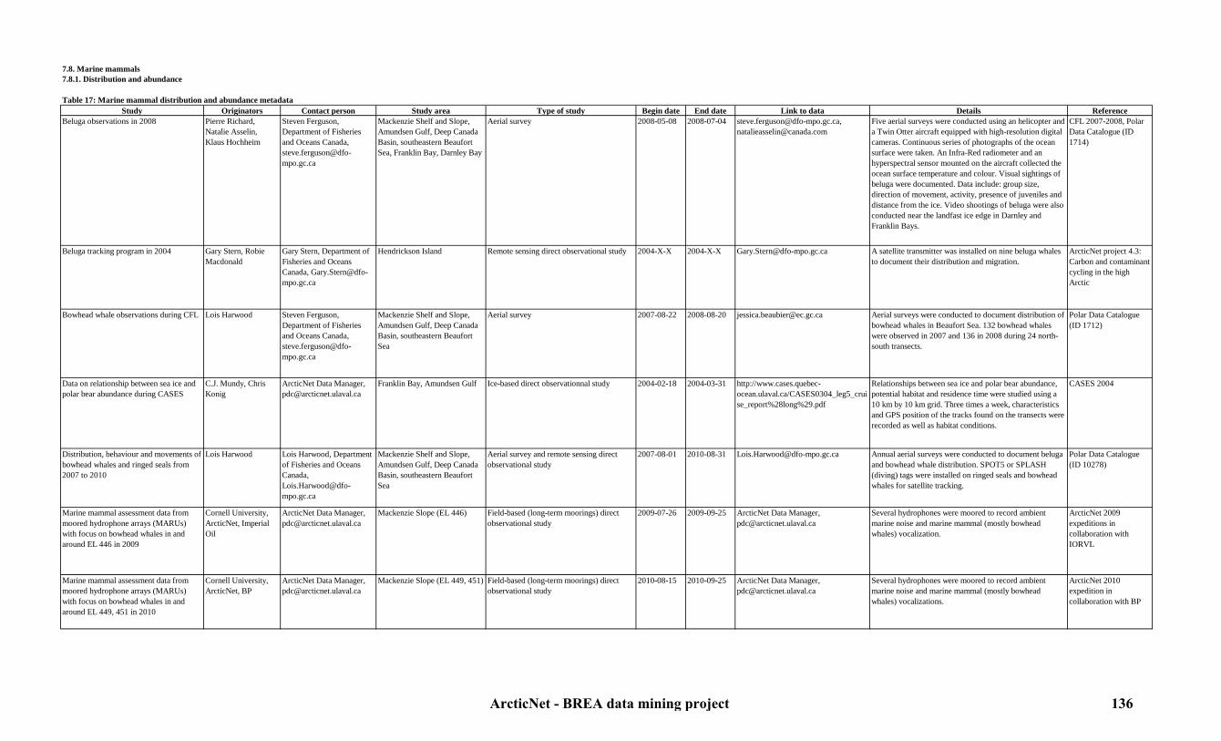
7.8. Marine mammals7.8.1. Distribution and abundance
Table 17: Marine mammal distribution and abundance metadataStudy Originators Contact person Study area Type of study Begin date End date Link to data Details Reference
Beluga observations in 2008 Pierre Richard,Natalie Asselin,Klaus Hochheim
Steven Ferguson, Department of Fisheries and Oceans Canada, [email protected]
Mackenzie Shelf and Slope, Amundsen Gulf, Deep Canada Basin, southeastern Beaufort Sea, Franklin Bay, Darnley Bay
Aerial survey 2008-05-08 2008-07-04 [email protected], [email protected]
Five aerial surveys were conducted using an helicopter and a Twin Otter aircraft equipped with high-resolution digital cameras. Continuous series of photographs of the ocean surface were taken. An Infra-Red radiometer and an hyperspectral sensor mounted on the aircraft collected the ocean surface temperature and colour. Visual sightings of beluga were documented. Data include: group size, direction of movement, activity, presence of juveniles and distance from the ice. Video shootings of beluga were also conducted near the landfast ice edge in Darnley and Franklin Bays.
CFL 2007-2008, Polar Data Catalogue (ID 1714)
Beluga tracking program in 2004 Gary Stern, Robie Macdonald
Gary Stern, Department of Fisheries and Oceans Canada, [email protected]
Hendrickson Island Remote sensing direct observational study 2004-X-X 2004-X-X [email protected] A satellite transmitter was installed on nine beluga whales to document their distribution and migration.
ArcticNet project 4.3: Carbon and contaminant cycling in the high Arctic
Bowhead whale observations during CFL Lois Harwood Steven Ferguson, Department of Fisheries and Oceans Canada, [email protected]
Mackenzie Shelf and Slope, Amundsen Gulf, Deep Canada Basin, southeastern Beaufort Sea
Aerial survey 2007-08-22 2008-08-20 [email protected] Aerial surveys were conducted to document distribution of bowhead whales in Beaufort Sea. 132 bowhead whales were observed in 2007 and 136 in 2008 during 24 north-south transects.
Polar Data Catalogue (ID 1712)
Data on relationship between sea ice and polar bear abundance during CASES
C.J. Mundy, Chris Konig
ArcticNet Data Manager, [email protected]
Franklin Bay, Amundsen Gulf Ice-based direct observationnal study 2004-02-18 2004-03-31 http://www.cases.quebec-ocean.ulaval.ca/CASES0304_leg5_cruise_report%28long%29.pdf
Relationships between sea ice and polar bear abundance, potential habitat and residence time were studied using a 10 km by 10 km grid. Three times a week, characteristics and GPS position of the tracks found on the transects were recorded as well as habitat conditions.
CASES 2004
Distribution, behaviour and movements of bowhead whales and ringed seals from 2007 to 2010
Lois Harwood Lois Harwood, Department of Fisheries and Oceans Canada, [email protected]
Mackenzie Shelf and Slope, Amundsen Gulf, Deep Canada Basin, southeastern Beaufort Sea
Aerial survey and remote sensing direct observational study
2007-08-01 2010-08-31 [email protected] Annual aerial surveys were conducted to document beluga and bowhead whale distribution. SPOT5 or SPLASH (diving) tags were installed on ringed seals and bowhead whales for satellite tracking.
Polar Data Catalogue (ID 10278)
Marine mammal assessment data from moored hydrophone arrays (MARUs) with focus on bowhead whales in and around EL 446 in 2009
Cornell University, ArcticNet, Imperial Oil
ArcticNet Data Manager, [email protected]
Mackenzie Slope (EL 446) Field-based (long-term moorings) direct observational study
2009-07-26 2009-09-25 ArcticNet Data Manager, [email protected]
Several hydrophones were moored to record ambient marine noise and marine mammal (mostly bowhead whales) vocalization.
ArcticNet 2009 expeditions in collaboration with IORVL
Marine mammal assessment data from moored hydrophone arrays (MARUs) with focus on bowhead whales in and around EL 449, 451 in 2010
Cornell University, ArcticNet, BP
ArcticNet Data Manager, [email protected]
Mackenzie Slope (EL 449, 451) Field-based (long-term moorings) direct observational study
2010-08-15 2010-09-25 ArcticNet Data Manager, [email protected]
Several hydrophones were moored to record ambient marine noise and marine mammal (mostly bowhead whales) vocalizations.
ArcticNet 2010 expedition in collaboration with BP
ArcticNet - BREA data mining project 136

Marine mammal vocalizations during JOIS
Humfrey Melling Humfrey Melling,Department of Fisheries and Oceans Canada,World Data Center for Glaciology
Alaskan Slope and Shelf, Deep Canada Basin, Mackenzie Shelf and Slope, North Beaufort Sea
Field-based (long-term moorings) direct observational study
2007-01-01 2011-01-01 [email protected] Hydrophones were moored for one year and continously recorded the ambient marine noise and marine mammal vocalizations.
Polar Data Catalogue (ID 10231)
Passive acoustic data from moorings in 2005-2006
Luc Michaud, Sylvain Blondeau, Pascal Massot, Yvan Simard
Yvan Simard, Université du Québec à Rimouski, [email protected]
Mackenzie Slope, Amundsen Gulf (stations CA04, CA08)
Field-based (long-term moorings) direct observational study
2005-09-06 2006-10-07 [email protected] AURAL hydrophones were moored for one year and continously recorded the ambient marine noise.
ArcticNet 2005-2006
Passive acoustic data from moorings in 2006-2007
Luc Michaud, Sylvain Blondeau, Pascal Massot, Yvan Simard
Yvan Simard, Université du Québec à Rimouski, [email protected]
Mackenzie Slope, Amundsen Gulf CA04, CA08)
Field-based (long-term moorings) direct observational study
2006-10-12 2007-10-23 [email protected] AURAL hydrophones were moored for one year and continously recorded the ambient marine noise.
ArcticNet 2006 - CFL 2007
Passive acoustic data from moorings in 2007-2008
Luc Michaud, Sylvain Blondeau, Pascal Massot, Yvan Simard
Yvan Simard, Université du Québec à Rimouski, [email protected]
Mackenzie Slope, Amundsen Gulf (stations CA04, CA05, CA08, CA16)
Field-based (long-term moorings) direct observational study
2007-10-17 2008-07-29 [email protected] AURAL hydrophones were moored for one year and continously recorded the ambient marine noise.
CFL 2007-2008
Passive acoustic data from moorings in 2008-2009
Luc Michaud, Sylvain Blondeau, Pascal Massot, Yvan Simard
Yvan Simard, Université du Québec à Rimouski, [email protected]
Mouth of the Amundsen Gulf (stations CA05, CA16)
Field-based (long-term moorings) direct observational study
2008-07-25 2009-10-12 [email protected] AURAL hydrophones were moored for one year and continously recorded the ambient marine noise.
CFL 2008 - ArcticNet 2009
Passive acoustic data from moorings in 2009-2010
Luc Michaud, Sylvain Blondeau, Pascal Massot, Yvan Simard
Yvan Simard, Université du Québec à Rimouski, [email protected]
Mouth of the Amundsen Gulf (stations CA05, CA16)
Field-based (long-term moorings) direct observational study
2009-10-12 2010-09-24 [email protected] AURAL hydrophones were moored for one year and continously recorded the ambient marine noise.
ArcticNet 2009-2010
Wildlife observation data during CASES Joe Illasiak, Joe Ruben Sr, Joshua Oliktoak
ArcticNet Data Manager, [email protected]
Mackenzie Shelf and Slope, Amundsen Gulf, Franklin Bay, southeastern Beaufort Sea
Field-based (CCGS Amundsen) direct observational study
2003-10-17 2004-09-12 [email protected], http://www.cases.quebec-ocean.ulaval.ca/CASES0304_Leg10%28Laurier%29_cruise_report.pdf
An Inuit wildlife observer was sporadically employed onboard the Amundsen to record opportunistic encounters with wildlife.
CASES 2003-2004
Wildlife observation data during CFL Inuit wildlife observers
Dan Leitch, University of Manitoba, [email protected]
Mackenzie Shelf and Slope, Amundsen Gulf, Deep Canada Basin, southeastern Beaufort Sea
Field-based (CCGS Amundsen) direct observational study
2007-10-21 2008-08-02 [email protected] An Inuit wildlife observer was sporadically employed onboard the Amundsen to record opportunistic encounters with wildlife.
CFL 2007-2008
Wildlife observation data during JOIS Ian Green Fiona McLaughlin, Department of Fisheries and Oceans Canada, [email protected]
Alaskan Slope and Shelf, Deep Canada Basin, Mackenzie Shelf and Slope, North Beaufort Sea
Field-based (CCGS Louis St-Laurent) direct observational study
2006-07-20 2006-10-02 [email protected] An Inuit wildlife observer was employed onboard the Louis St-Laurent to record opportunistic encounters with wildlife.
JOIS 2006
Wildlife observation data in 2006 Philip Inuktalik ArcticNet Data Manager, [email protected]
Amundsen Gulf, southeastern Beaufort Sea
Field-based (CCGS Amundsen) direct observational study
2006-09-28 2006-10-19 [email protected] An Inuit wildlife observer was sporadically employed onboard the Amundsen to record opportunistic encounters with wildlife.
ArcticNet 2006
Wildlife observation data in 2009 Joey Illasiak, Kavik Axys
ArcticNet Data Manager, [email protected]
Mackenzie Slope (EL 446) Field-based (CCGS Amundsen) direct observational study
2009-09-16 2009-09-30 [email protected] An Inuit wildlife observer was sporadically employed onboard the Amundsen to record opportunistic encounters with wildlife.
ArcticNet 2009 expedition in collaboration with IORVL
Wildlife observation data in 2010 Inuit wildlife observers
ArcticNet Data Manager, [email protected]
Mackenzie Slope (EL 449, 451) Field-based (CCGS Amundsen) direct observational study
2010-08-12 2010-10-07 [email protected] An Inuit wildlife observer was employed onboard the Amundsen to record opportunistic encounters with wildlife.
ArcticNet 2010 expedition in collaboration with BP
ArcticNet - BREA data mining project 137
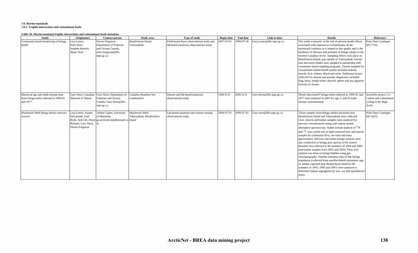
7.8. Marine mammals7.8.2. Trophic interactions and contaminant loads
Table 18: Marine mammal trophic interactions and contaminant loads metadataStudy Originators Contact person Study area Type of study Begin date End date Link to data Details Reference
Community-based monitoring of beluga health
Lisa Loseto,Peter Ross,Stephen Raverty,Marie Noel
Steven Ferguson, Department of Fisheries and Oceans Canada, [email protected]
Hendrickson Island, Tuktoyaktuk
Field-based direct observational study and lab-based (analysis) observational study
2007-07-01 2009-07-30 [email protected] This study evaluated a) the risk of adverse health effects associated with exposure to contaminants, b) the nutritional condition as it related to diet quality and c) the incidence of diseases and parasites in beluga whales in the western Canadian Arctic. Sampling efforts took place on Hendrickson Island, just outside of Tuktoyaktuk.Twenty-four harvested whales were sampled in partnership with community based sampling programs. Tissues sampled for contaminant-related health studies included muktuk, muscle, liver, kidney, blood and urine. Additional tissues collected for disease and parastic diagnostics included lung, heart, lymph nodes, thyroid, spleen and any apparent lessions on tissues.
Polar Data Catalogue (ID 1716)
Historical age and stable isotope data from beluga teeth collected in 1960-61 and 1977
Gary Stern, Canadian Museum of Nature
Gary Stern, Department of Fisheries and Oceans Canada, [email protected]
Canadian Beaufort Sea communities
Dataset and lab-based (analysis) observational study
1960-X-X 2005-X-X [email protected] 'Newly-discovered'' beluga teeth collected in 1960-61 and 1977 were analyzed in 2005 for age, C and N stable isotope concentrations
ArcticNet project 1.3: Carbon and contaminant cycling in the High Arctic
Mackenzie Shelf beluga dietary mercury sources
Lisa Loseto, Joanne DeLaronde, Gail Boila, Jack Orr, Pierre Richard, Gary Stern, Steven Ferguson
Ashley Gaden, University of Manitoba, [email protected]
Mackenzie Shelf,Tuktoyaktuk, Hendrickson Island
Lab-based (analysis) and remote sensing observational study
2004-07-01 2006-07-01 [email protected] Tissue samples from beluga whales harvested near Hendrickson Island and Tuktoyaktuk were collected. Liver, muscle and kidney samples were analyzed for mercury concentrations using cold vapour atomic absorption spectroscopy. Stable isotope analysis of 15N and 13C was carried out on lipid-removed liver and muscle samples by continuous flow, ion-ratio and mass spectrometry. Mercury and stable isotope analysis were also conducted on beluga prey species in the eastern Beaufort Sea collected in the summers of 2004 and 2006 (and earlier samples from 2002 and 2003). Fatty acid analysis was done on beluga blubber using gas chromatography. Satellite telemetry data of this beluga population (collected from satellite-linked transmitter tags on whales captured near Hendrickson Island in the summers of 1993, 1995 and 1997) were analyzed to determine habitat segregation by size, sex and reproductive status.
Polar Data Catalogue (ID 1625)
ArcticNet - BREA data mining project 138

Mercury and organochlorine contaminants in ringed seals (Phoca hispida )
Ashley Gaden, Gary Stern, Steven Ferguson,Lois Harwood, John Alikamik, Humfrey Melling, Allison MacHutchon, Joanne Delaronde, Gail Boila
Ashley Gaden, University of Manitoba, [email protected]
Ulukhaktok Lab-based (chromatography, spectroscopy, mass spectrometry analysis) and remote sensing observational study
1993-06-01 2007-06-30 [email protected] The dataset was developed to link mercury and organochlorine contaminant concentrations as well as stable isotope ratios of nitrogen and carbon in ringed seals with length of the ice-free season in the eastern Amundsen Gulf. Ringed seals were harvested by members of the Hunters and Trappers Committee at Ulukhaktok on an annual basis. In 1993, 1995, 1996, 2002-2005, and 2007, tissue samples from 13-20 seals per year were chemically analyzed in laboratories. Additional samples from 1973 and 1977 were included in the analysis. Sex and morphometric measurements of the seals were recorded in the field. Organochlorine concentrations from blubber, including pesticides and PCBs, were analyzed with gas chromatography and electron capture detection. Mercury concentration in muscle tissues was measured by cold vapour atomic absorption spectroscopy and stable isotope ratios of nitrogen and carbon in lipid-extracted muscle tissues were analyzed by continuous flow ion ratio mass spectrometry. Sea ice parameters were measured from Canadian Ice Service ice charts.
Polar Data Catalogue (ID 1607, 1608)
Monitoring of Trichinella,Toxoplasma, Anisakidae, E.coli 0157:H7 and Salmonella sp . in Canadian Arctic wildlife
Brett Elkin,Andria Jones,Alvin Gajadhar,Lorry Forbes,Manon Simard, Ted Leighton
Manon Simard, Makivik Corporation, [email protected]
Canadian Beaufort Sea Field-based direct observational study and lab-based (analysis) observational study
2007-04-01 In progress [email protected], [email protected]
The objective of this study is 1) to document the distribution and abundance of Trichinella and Toxoplasma in Arctic wildlife, 2) to provide regional infrastructure, equipment and training for wildlife sampling, coordinating and diagnosing diseases of food safety interest, and 3) to develop/refine simplified field diagnostic tests for Toxoplasma and E.coli 0157:H7. Data include: species, age, sex, tissue collected, collection date, hunter name, GPS location, community, region and disease diagnosis.
Polar Data Catalogue (ID 703)
Reproduction and body condition of ringed seals near Sachs Harbour and Ulukhaktok
Lois Harwood Lois Harwood, Department of Fisheries and Oceans Canada, [email protected]
Ulukhaktok, Sachs Harbour Field-based direct observational study and lab-based (analysis) observational study
1992-01-01 2008-12-31 [email protected] Ringed seal's body condition measurements include: blubber thickness in the chest and hip, standard length, axillary girth, age, sex and body weight. Samples in fertile females include: teeth for aging, liver, kidney, muscle, blubber for contaminants, lung, blood, lymph, nasal swabs for disease, claws, fur, and whiskers skin punch for DNA. 100 ringed seals and 3-5 bearded seals were sampled annually. Community-based observations were also recorded to relate changes in seal reproduction and condition to changing ice conditions. Ulukhaktok data range from 1992 to 2008 and Sachs Harbour data from 2003 to 2007.
Polar Data Catalogue (ID 10277)
Sampling of estuarine fish for Hg and fatty acid analysis in 2005
Gary Stern, Feiyue Wang
Gary Stern, Department of Fisheries and Oceans Canada, [email protected]
Mackenzie Delta Field-based (CCGS Nahidik) and lab-based (analysis) observational study
2005-07-27 2005-08-20 [email protected], [email protected]
Estuarine fish were collected for mercury and fatty acid analysis to determine their importance in the beluga diet.
ArcticNet project 1.3: Carbon and contaminant cycling in the High Arctic
ArcticNet - BREA data mining project 139

7.8. Marine mammals7.8.3. Inuvialuit hunting activities
Table 19: Inuvialuit hunting activities metadataStudy Originators Contact person Study area Type of study Begin date End date Link to data Details Reference
Community-based monitoring of beluga health
Lisa Loseto,Peter Ross,Stephen Raverty,Marie Noel
Steven Ferguson, Department of Fisheries and Oceans Canada, [email protected]
Hendrickson Island, Tuktoyaktuk
Field-based direct observational study and lab-based (analysis) observational study
2007-07-01 2009-07-30 [email protected] This study evaluated a) the risk of adverse health effects associated with exposure to contaminants, b) the nutritional condition as it related to diet quality and c) the incidence of diseases and parasites in beluga whales in the western Canadian Arctic. Sampling efforts took place on Hendrickson Island, just outside of Tuktoyaktuk.Twenty-four harvested whales were sampled in partnership with community based sampling programs. Tissues sampled for contaminant-related health studies included muktuk, muscle, liver, kidney, blood and urine. Additional tissues collected for disease and parastic diagnostics included lung, heart, lymph nodes, thyroid, spleen and any apparent lessions on tissues.
Polar Data Catalogue (ID 1716)
Monitoring of Trichinella,Toxoplasma, Anisakidae, E.coli 0157:H7 and Salmonella sp . in Canadian Arctic wildlife
Brett Elkin,Andria Jones,Alvin Gajadhar,Lorry Forbes,Manon Simard, Ted Leighton
Manon Simard, Makivik Corporation, [email protected]
Canadian Beaufort Sea Field-based direct observational study and lab-based (analysis) observational study
2007-04-01 In progress [email protected], [email protected]
The objective of this study is 1) to document the distribution and abundance of Trichinella and Toxoplasma in Arctic wildlife, 2) to provide regional infrastructure, equipment and training for wildlife sampling, coordinating and diagnosing diseases of food safety interest, and 3) to develop/refine simplified field diagnostic tests for Toxoplasma and E.coli 0157:H7. Data include: species, age, sex, tissue collected, collection date, hunter name, GPS location, community, region and disease diagnosis.
Polar Data Catalogue (ID 703)
Reproduction and body condition of ringed seals near Sachs Harbour and Ulukhaktok
Lois Harwood Lois Harwood, Department of Fisheries and Oceans Canada, [email protected]
Ulukhaktok, Sachs Harbour Field-based direct observational study and lab-based (analysis) observational study
1992-01-01 2008-12-31 [email protected] Ringed seal's body condition measurements include: blubber thickness in the chest and hip, standard length, axillary girth, age, sex and body weight. Samples in fertile females include: teeth for aging, liver, kidney, muscle, blubber for contaminants, lung, blood, lymph, nasal swabs for disease, claws, fur, and whiskers skin punch for DNA. 100 ringed seals and 3-5 bearded seals were sampled annually. Community-based observations were also recorded to relate changes in seal reproduction and condition to changing ice conditions. Ulukhaktok data range from 1992 to 2008 and Sachs Harbour data from 2003 to 2007.
Polar Data Catalogue (ID 10277)
ArcticNet - BREA data mining project 140

7.9. Noise in the environment7.9.1. Ambient marine noise conditions
Table 20: Ambiaent marine noise conditions metadataStudy Originators Contact person Study area Type of study Begin date End date Link to data Details Reference
Ambiant marine noise data during JOIS Humfrey Melling Humfrey Melling,Department of Fisheries and Oceans,World Data Center for Glaciology
Alaskan Slope and Shelf, Deep Canada Basin, Mackenzie Shelf and Slope, North Beaufort Sea
Field-based (long-term moorings) direct observational study
2007-01-01 2011-01-01 [email protected] Hydrophones were moored for one year and continously recorded the ambient marine noise.
Polar Data Catalogue (ID 10231)
Marine mammal assessment data from moored hydrophone arrays (MARUs) with focus on bowhead whales in and around EL 446 in 2009
Cornell University, ArcticNet, Imperial Oil
ArcticNet Data Manager, [email protected]
Mackenzie Slope (EL 446) Field-based (long-term moorings) direct observational study
2009-07-26 2009-09-25 ArcticNet Data Manager, [email protected]
Several hydrophones were moored to record ambient marine noise and marine mammal (mostly bowhead whales) vocalization.
ArcticNet 2009 expeditions in collaboration with IORVL
Marine mammal assessment data from moored hydrophone arrays (MARUs) with focus on bowhead whales in and around EL 449, 451 in 2010
Cornell University, ArcticNet, BP
ArcticNet Data Manager, [email protected]
Mackenzie Slope (EL 449, 451) Field-based (long-term moorings) direct observational study
2010-08-15 2010-09-25 ArcticNet Data Manager, [email protected]
Several hydrophones were moored to record ambient marine noise and marine mammal (mostly bowhead whales) vocalization.
ArcticNet 2010 expedition in collaboration with BP
Passive acoustic data from moorings in 2005-2006
Luc Michaud, Sylvain Blondeau, Pascal Massot, Yvan Simard
Yvan Simard, Université du Québec à Rimouski, [email protected]
Mackenzie Slope, Amundsen Gulf (stations CA04, CA08)
Field-based (long-term moorings) direct observational study
2005-09-06 2006-10-07 [email protected] AURAL hydrophones were moored for one year and continously recorded the ambient marine noise.
ArcticNet 2005-2006
Passive acoustic data from moorings in 2006-2007
Luc Michaud, Sylvain Blondeau, Pascal Massot, Yvan Simard
Yvan Simard, Université du Québec à Rimouski, [email protected]
Mackenzie slope, Amundsen Gulf CA04, CA08)
Field-based (long-term moorings) direct observational study
2006-10-12 2007-10-23 [email protected] AURAL hydrophones were moored for one year and continously recorded the ambient marine noise.
ArcticNet 2006 - CFL 2007
Passive acoustic data from moorings in 2007-2008
Luc Michaud, Sylvain Blondeau, Pascal Massot, Yvan Simard
Yvan Simard, Université du Québec à Rimouski, [email protected]
Mackenzie slope, Amundsen Gulf (stations CA04, CA05, CA08, CA16)
Field-based (long-term moorings) direct observational study
2007-10-17 2008-07-29 [email protected] AURAL hydrophones were moored for one year and continously recorded the ambient marine noise.
CFL 2007-2008
Passive acoustic data from moorings in 2008-2009
Luc Michaud, Sylvain Blondeau, Pascal Massot, Yvan Simard
Yvan Simard, Université du Québec à Rimouski, [email protected]
Mouth of the Amundsen Gulf (stations CA05, CA16)
Field-based (long-term moorings) direct observational study
2008-07-25 2009-10-12 [email protected] AURAL hydrophones were moored for one year and continously recorded the ambient marine noise.
CFL 2008 - ArcticNet 2009
Passive acoustic data from moorings in 2009-2010
Luc Michaud, Sylvain Blondeau, Pascal Massot, Yvan Simard
Yvan Simard, Université du Québec à Rimouski, [email protected]
Mouth of the Amundsen Gulf (stations CA05, CA16)
Field-based (long-term moorings) direct observational study
2009-10-12 2010-09-24 [email protected] AURAL hydrophones were moored for one year and continously recorded the ambient marine noise.
ArcticNet 2009-2010
ArcticNet - BREA data mining project 141
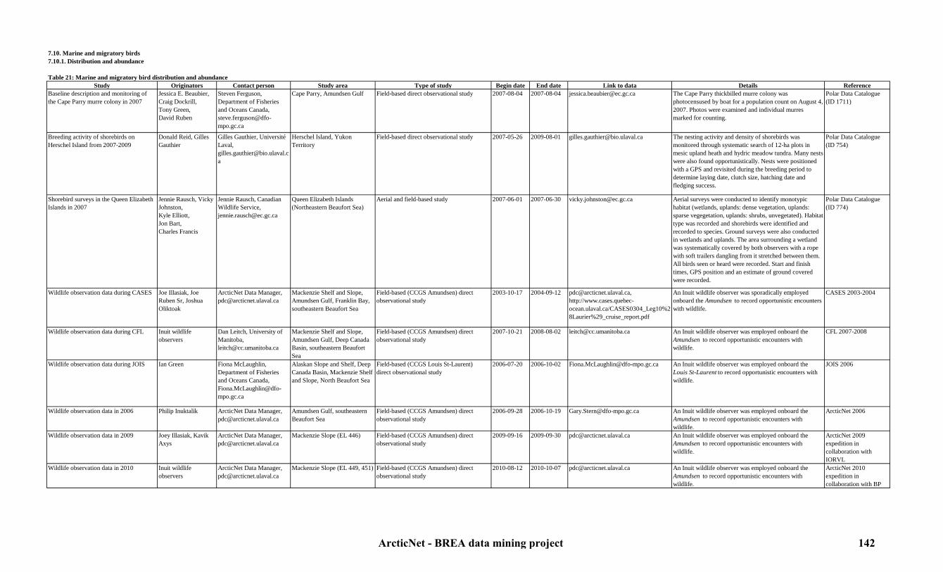
7.10. Marine and migratory birds7.10.1. Distribution and abundance
Table 21: Marine and migratory bird distribution and abundanceStudy Originators Contact person Study area Type of study Begin date End date Link to data Details Reference
Baseline description and monitoring of the Cape Parry murre colony in 2007
Jessica E. Beaubier,Craig Dockrill,Tony Green,David Ruben
Steven Ferguson, Department of Fisheries and Oceans Canada, [email protected]
Cape Parry, Amundsen Gulf Field-based direct observational study 2007-08-04 2007-08-04 [email protected] The Cape Parry thickbilled murre colony was photocensused by boat for a population count on August 4, 2007. Photos were examined and individual murres marked for counting.
Polar Data Catalogue (ID 1711)
Breeding activity of shorebirds on Herschel Island from 2007-2009
Donald Reid, Gilles Gauthier
Gilles Gauthier, Université Laval, [email protected]
Herschel Island, Yukon Territory
Field-based direct observational study 2007-05-26 2009-08-01 [email protected] The nesting activity and density of shorebirds was monitored through systematic search of 12-ha plots in mesic upland heath and hydric meadow tundra. Many nests were also found opportunistically. Nests were positioned with a GPS and revisited during the breeding period to determine laying date, clutch size, hatching date and fledging success.
Polar Data Catalogue (ID 754)
Shorebird surveys in the Queen Elizabeth Islands in 2007
Jennie Rausch, Vicky Johnston,Kyle Elliott,Jon Bart,Charles Francis
Jennie Rausch, Canadian Wildlife Service, [email protected]
Queen Elizabeth Islands (Northeastern Beaufort Sea)
Aerial and field-based study 2007-06-01 2007-06-30 [email protected] Aerial surveys were conducted to identify monotypic habitat (wetlands, uplands: dense vegetation, uplands: sparse vegegetation, uplands: shrubs, unvegetated). Habitat type was recorded and shorebirds were identified and recorded to species. Ground surveys were also conducted in wetlands and uplands. The area surrounding a wetland was systematically covered by both observers with a rope with soft trailers dangling from it stretched between them. All birds seen or heard were recorded. Start and finish times, GPS position and an estimate of ground covered were recorded.
Polar Data Catalogue (ID 774)
Wildlife observation data during CASES Joe Illasiak, Joe Ruben Sr, Joshua Oliktoak
ArcticNet Data Manager, [email protected]
Mackenzie Shelf and Slope, Amundsen Gulf, Franklin Bay, southeastern Beaufort Sea
Field-based (CCGS Amundsen) direct observational study
2003-10-17 2004-09-12 [email protected], http://www.cases.quebec-ocean.ulaval.ca/CASES0304_Leg10%28Laurier%29_cruise_report.pdf
An Inuit wildlife observer was sporadically employed onboard the Amundsen to record opportunistic encounters with wildlife.
CASES 2003-2004
Wildlife observation data during CFL Inuit wildlife observers
Dan Leitch, University of Manitoba, [email protected]
Mackenzie Shelf and Slope, Amundsen Gulf, Deep Canada Basin, southeastern Beaufort Sea
Field-based (CCGS Amundsen) direct observational study
2007-10-21 2008-08-02 [email protected] An Inuit wildlife observer was employed onboard the Amundsen to record opportunistic encounters with wildlife.
CFL 2007-2008
Wildlife observation data during JOIS Ian Green Fiona McLaughlin, Department of Fisheries and Oceans Canada, [email protected]
Alaskan Slope and Shelf, Deep Canada Basin, Mackenzie Shelf and Slope, North Beaufort Sea
Field-based (CCGS Louis St-Laurent) direct observational study
2006-07-20 2006-10-02 [email protected] An Inuit wildlife observer was employed onboard the Louis St-Laurent to record opportunistic encounters with wildlife.
JOIS 2006
Wildlife observation data in 2006 Philip Inuktalik ArcticNet Data Manager, [email protected]
Amundsen Gulf, southeastern Beaufort Sea
Field-based (CCGS Amundsen) direct observational study
2006-09-28 2006-10-19 [email protected] An Inuit wildlife observer was employed onboard the Amundsen to record opportunistic encounters with wildlife.
ArcticNet 2006
Wildlife observation data in 2009 Joey Illasiak, Kavik Axys
ArcticNet Data Manager, [email protected]
Mackenzie Slope (EL 446) Field-based (CCGS Amundsen) direct observational study
2009-09-16 2009-09-30 [email protected] An Inuit wildlife observer was employed onboard the Amundsen to record opportunistic encounters with wildlife.
ArcticNet 2009 expedition in collaboration with IORVL
Wildlife observation data in 2010 Inuit wildlife observers
ArcticNet Data Manager, [email protected]
Mackenzie Slope (EL 449, 451) Field-based (CCGS Amundsen) direct observational study
2010-08-12 2010-10-07 [email protected] An Inuit wildlife observer was employed onboard the Amundsen to record opportunistic encounters with wildlife.
ArcticNet 2010 expedition in collaboration with BP
ArcticNet - BREA data mining project 142
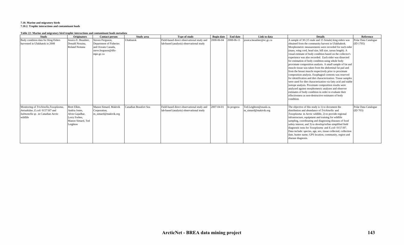
7.10. Marine and migratory birds7.10.2. Trophic interactions and contaminant loads
Table 22: Marine and migratory bird trophic interactions and contaminant loads metadataStudy Originators Contact person Study area Type of study Begin date End date Link to data Details Reference
Body condition data for King Eiders harvested in Ulukhatok in 2008
Jessica E. Beaubier,Donald Notaina,Roland Noitana
Steven Ferguson, Department of Fisheries and Oceans Canada, [email protected]
Ulukhatok Field-based direct observational study and lab-based (analysis) observational study
2008-06-04 2008-06-11 [email protected] A sample of 30 (15 male and 15 female) king eiders was obtained from the community harvest in Ulukhaktok. Morphometric measurements were recorded for each eider (mass, wing cord, head size, bill size, tarsus length). A visual estimate of body condition based on the collector's experience was also recorded. Each eider was dissected for estimation of body condition using whole body proximate composition analysis. A small sample of fat and muscle tissue was taken from the abdominal fat pad and from the breast muscle respectively prior to proximate composition analysis. Esophageal contents was reserved for identification and diet characterization. Tissue samples were used for diet characterization via fatty acid and stable isotope analysis. Proximate composition results were analyzed against morphometric analyses and observer estimates of body condition in order to evaluate their effectiveness as non-destructive estimates of body condition.
Polar Data Catalogue (ID 1705)
Monitoring of Trichinella,Toxoplasma, Anisakidae, E.coli 0157:H7 and Salmonella sp . in Canadian Arctic wildlife
Brett Elkin,Andria Jones,Alvin Gajadhar,Lorry Forbes,Manon Simard, Ted Leighton
Manon Simard, Makivik Corporation, [email protected]
Canadian Beaufort Sea Field-based direct observational study and lab-based (analysis) observational study
2007-04-01 In progress [email protected], [email protected]
The objective of this study is 1) to document the distribution and abundance of Trichinella and Toxoplasma in Arctic wildlife, 2) to provide regional infrastructure, equipment and training for wildlife sampling, coordinating and diagnosing diseases of food safety interest, and 3) to develop/refine simplified field diagnostic tests for Toxoplasma and E.coli 0157:H7. Data include: species, age, sex, tissue collected, collection date, hunter name, GPS location, community, region and disease diagnosis.
Polar Data Catalogue (ID 703)
ArcticNet - BREA data mining project 143

7.10. Marine and migratory birds7.10.3. Inuvialuit hunting activities
Table 23: Inuvialuit hunting activities (marine and migratory birds) metadataStudy Originators Contact person Study area Type of study Begin date End date Link to data Details Reference
Body condition data for King Eiders harvested in Ulukhatok in 2008
Jessica E. Beaubier,Donald Notaina,Roland Noitana
Steven Ferguson, Department of Fisheries and Oceans Canada, [email protected]
Ulukhatok Field-based direct observational study and lab-based (analysis) observational study
2008-06-04 2008-06-11 [email protected] A sample of 30 (15 male and 15 female) king eiders was obtained from the community harvest in Ulukhaktok. Morphometric measurements were recorded for each eider (mass, wing cord, head size, bill size, tarsus length). A visual estimate of body condition based on the collector's experience was also recorded. Each eider was dissected for estimation of body condition using whole body proximate composition analysis. A small sample of fat and muscle tissue was taken from the abdominal fat pad and from the breast muscle respectively prior to proximate composition analysis. Esophageal contents was reserved for identification and diet characterization. Tissue samples were used for diet characterization via fatty acid and stable isotope analysis. Proximate composition results were analyzed against morphometric analyses and observer estimates of body condition in order to evaluate their effectiveness as non-destructive estimates of body condition.
Polar Data Catalogue (ID 1705)
Monitoring of Trichinella,Toxoplasma, Anisakidae, E.coli 0157:H7 and Salmonella sp . in Canadian Arctic wildlife
Brett Elkin,Andria Jones,Alvin Gajadhar,Lorry Forbes,Manon Simard, Ted Leighton
Manon Simard, Makivik Corporation, [email protected]
Canadian Beaufort Sea Field-based direct observational study and lab-based (analysis) observational study
2007-04-01 In progress [email protected], [email protected]
The objective of this study is 1) to document the distribution and abundance of Trichinella and Toxoplasma in Arctic wildlife, 2) to provide regional infrastructure, equipment and training for wildlife sampling, coordinating and diagnosing diseases of food safety interest, and 3) to develop/refine simplified field diagnostic tests for Toxoplasma and E.coli 0157:H7. Data include: species, age, sex, tissue collected, collection date, hunter name, GPS location, community, region and disease diagnosis.
Polar Data Catalogue (ID 703)
ArcticNet - BREA data mining project 144

7.11. Benthos7.11.1. Distribution and abundance
Table 24: Benthic fauna distribution and abundance metadataStudy Originators Contact person Study area Type of study Begin date End date Link to data Details Reference
Benthic abundance and diversity during CASES
Melanie Simard,Phillippe Archambault,Christine McClelland,Nathalie Morata,Alec Aitken
Alec Aitken, Department of Geography, University of Saskatchewan, [email protected]
Mackenzie Shelf and Slope, Amundsen Gulf, Franklin Bay, southeastern Beaufort Sea
Field-based (CCGS Pierre Radisson and Amundsen) direct observational study and lab-based (analysis) obervational study
2002-07-24 2004-09-24 [email protected] A 0.25 m2 box corer was used to sample 3 reps/station on the Amundsen cruises and 1 rep/ station on the Radisson cruise. Depth sampled was ~15 cm. Macrofauna was elutriated from the sediment and identified to species level. Sediment samples taken from a separate section of the macrofaunal sample were frozen and analyzed for grain size, N and C concentrations.
Polar Data Catalogue (ID 341)
Benthic abundance and diversity during CFL
Phillippe Archambault, Heike Link
Philippe Archambault, Institut des sciences de la mer (ISMER), [email protected]
Mackenzie Shelf and Slope, Amundsen Gulf, Deep Canada Basin, southeastern Beaufort Sea
Field-based (box corer and Agassiz trawl deployed from the CCGS Amundsen) direct observational study
2007-10-15 2008-08-07 [email protected] An Agassiz trawl was towed on the seabed at a speed of 1.5 knots for about 8 minutes to survey macroepibenthic species diversity and abundance. Organisms were counted and identified to the lowest taxonomical level possible. Endobenthic fauna was sampled using a box corer. The volume of sediments sieved (to separate sediment from the endofauna) from each box core was measured to estimate endobenthic fauna density in each sample. Each specimen was identified to the lowest taxonomical level possible. Organisms of each taxonomical group were numbered and weighed.
CF 2007-2008
Benthic abundance and diversity in 2009 Philippe Archambault, Mélanie Lévesque, Cindy Grant, Heike Link, Maeva Gauthier
Philippe Archambault, Institut des sciences de la mer (ISMER), [email protected]
Southeastern Beaufort Sea, Amundsen Gulf, Mackenzie Shelf and Slope (EL 446)
Field-based (box corer and Agassiz trawl deployed from the CCGS Amundsen) direct observational study
2009-07-16 2009-10-16 [email protected] An Agassiz trawl was towed on the seabed at a speed of 1.5 knots for about 8 minutes to survey macroepibenthic species diversity and abundance. Organisms were counted and identified to the lowest taxonomical level possible. Endobenthic fauna was sampled using a box corer. The volume of sediments sieved (to separate sediment from the endofauna) from each box core was measured to estimate endobenthic fauna density in each sample. Each specimen was identified to the lowest taxonomical level possible. Organisms of each taxonomical group were numbered and weighed.
ArcticNet 2009 expedition in collaboration with IORVL and MALINA
Benthic abundance and diversity in 2010 Philippe Archambault, Mélanie Lévesque, Cindy Grant
Philippe Archambault, Institut des sciences de la mer (ISMER), [email protected]
Amundsen Gulf, Mackenzie Shelf and Slope (EL 449, 451), southeastern Beaufort Sea, Deep Canada Basin
Field-based (box corer and Agassiz trawl deployed from the CCGS Amundsen) direct observational study
2010-08-12 2010-10-07 [email protected] An Agassiz trawl was towed on the seabed at a speed of 1.5 knots for about 8 minutes to survey macroepibenthic species diversity and abundance. Organisms were counted and identified to the lowest taxonomical level possible. Endobenthic fauna was sampled using a box corer. The volume of sediments sieved (to separate sediment from the endofauna) from each box core was measured to estimate endobenthic fauna density in each sample. Each specimen was identified to the lowest taxonomical level possible. Organisms of each taxonomical group were numbered and weighed.
ArcticNet 2010 expedition in collaboration with BP
Benthic community data from bottom triggered camera during CASES
Amy Chiuchiolo, Hélène Hégaret
Amy Chiuchiolo, University of Connecticut, [email protected]
Southeastern Beaufort Sea, Franklin Bay, Amundsen Gulf
Field-based (CCGS Amundsen) direct obervational study
2003-10-16 2004-08-12 [email protected] Pictures of the bottom community were taken at stations shallower than 280 m using a bottom camera for the identification of benthic species.
CASES 2003-2004
ArcticNet - BREA data mining project 145

Carbon utilisation by the benthic community during CFL
Dieter Piepenburg,Paul Renaud, Tobias Tamelander
Paul Renaud, Akvaplan-niva Norway, [email protected]
Southeastern Beaufort Sea, Franklin Bay, Amundsen Gulf
Field-based (CCGS Amundsen) and lab-based (incubation) obervational study
2008-03-24 2008-04-21 [email protected] Carbon utilisation (respiration and sediment properties) by the benthic community was surveyed using a box corer and a Remotely Operated Vehicle (ROV). Sediment samples were analyzed for Chlorophyll, C and N concentrations. Video-recorded material was used for quantitative determinations of the benthic habitat and the epifauna.
CFL 2008
Coastal marine habitat surveys on southwestern Banks Island in 2005
Tanya Brown, Evan Edinger
Evan Edinger, Memorial University, [email protected]
Sachs Harbour Field-based and lab-based (analysis) observational study
2005-07-16 2005-08-10 [email protected], [email protected]
90 grab samples and 49 bottom video transects were done in a series of shore-perpendicular transects, at 200, 700, and 1200 m from shore. Grab samples and videos were analyzed for bottom type, sediment composition and relative composition and abundance of fauna and flora.
Polar Data Catalogue (ID 9841)
Data on evolution of arctic arthropods during CASES
David Rees David Rees, Université du Québec à Rimouski, [email protected]
Amundsen Gulf, Mackenzie Shelf and Slope, southeastern Beaufort Sea
Field-based (CCGS Amundsen) and lab-based (DNA sequencing) obervational study
2003-10-22 2003-11-20 [email protected] Samples were obtained from vertical and horizontal net tows, hydrobios, box cores, epibenthic sled and baited traps. 125 individuals of 17 species were collected (3 isopods, 9 amphipods and 5 shrimps). Haemolyph was extracted from each individual and used for later analysis of genome size by image analysis densitometry. Specimens were preserved for DNA 51 sequencing.
CASES 2003
Data on the relation between sedimentary organic matter and benthic macrofaunal community in 2009
Sam Bentley, Lina Marie Stolze
Samuel Bentley, Memorial University, [email protected]
Amundsen Gulf Field-based (box corer deployed from the CCGS Amundsen) and lab-based (analysis) obervational study
2009-10-14 2009-10-16 [email protected] Sediments samples were analyzed to describe the physical and chemical properties of a benthic habitat. Benthic macrofaunal community was associated to seabed structures (vertical and lateral), and bioturbation depths and rates.
ArcticNet 2009 expedition
Metazoan meiofauna spatial distribution during CASES
Sonia Brugel,Christian Nozais,Serge Demers,Aurélie Bessière
Serge Demers, UQAR-ISMER, [email protected]
Mackenzie Shelf and Slope, Amundsen Gulf, Franklin Bay, southeastern Beaufort Sea
Field-based (CCGS Amundsen) direct observational study
2003-10-01 2004-08-10 [email protected] This dataset consists of abundances of the main meiofaunal groups from the first top centimeters of the sediments. Meiofauna was separated in 6 mains groups: nematodes, copepods, crustacean nauplii, turbellarians, kinorhynchs and polychaetes.
Polar Data Catalogue (ID 218)
Sediment samples for faunal census using a van Veen grab sampler during JOIS/CASES 2002
Kathy Conlan Kathy Conlan, Canadian National Museum of Nature, [email protected]
South Alaskan Beaufort Sea, Mackenzie Delta, Amundsen Gulf
Field-based (CCGS Pierre Radisson) and lab-based (analysis) obervational study
2002-09-08 2002-09-10 [email protected] Sediment samples for faunal census were acquired in triplicate at 24 sites using an 18-inch van Veen grabsampler (to a maximum depth of 500 m).
JOIS/CASES 2002
Utilisation of the sediments by the benthic community during CFL
Philippe Archambault, Mylène Bourque, Guillaume Massé, Simon Belt, Michel Poulin, Lindsay Vare
Philippe Archambault, Institut des sciences de la mer (ISMER), [email protected]
Southeastern Beaufort Sea, Mackenzie Shelf and slope, Amundsen Gulf
Field-based (box corer deployed from the CCGS Amundsen) and lab-based (analysis) observational study
2007-10-15 2008-08-07 [email protected] Box corer sediment samples were analyzed to determine pigment, biomarker chlorophyll-a and organic carbon concentrations, as well as the carbon utilisation, bioturbation and nutrient recycling by the benthic community.
CFL 2007-2008
Utilisation of the sediments by the benthic community in 2009
Philippe Archambault, Mélanie Lévesque, Cindy Grant, Heike Link, Maeva Gauthier
Philippe Archambault, Institut des sciences de la mer (ISMER), [email protected]
Southeastern Beaufort Sea, Amundsen Gulf, Mackenzie Shelf and Slope (EL 446)
Field-based (box corer deployed from the CCGS Amundsen) and lab-based (analysis) observational study
2009-07-16 2009-10-16 [email protected] Box corer sediment samples were analyzed to determine pigment, biomarker chlorophyll-a and organic carbon concentrations, as well as the carbon utilisation, bioturbation and nutrient recycling by the benthic community.
ArcticNet 2009 expedition in collaboration with IORVL and MALINA
Visual exploration of a mud volcano at station 10 in EL 446 using a Remotely Operated Vehicle (ROV) in 2009
Luc Michaud, Pascal Massot, Philippe Archambault
Philippe Archambault, Institut des sciences de la mer (ISMER), [email protected]
Mackenzie Slope (station 10, EL 446)
Field-based (ROV deployed from the CCGS Amundsen) direct observational study
2009-07-28 2009-07-28 [email protected] A camera mounted on a Remotely Operated Vehicle (ROV) recorded images of the benthic community near a mud volcano in the EL 446.
ArcticNet 2009 expedition in collaboration with IORVL
ArcticNet - BREA data mining project 146

Visual exploration of a mud volcano at station BP10-PC43 using a Remotely Operated Vehicle (ROV) in 2010
Luc Michaud, Pascal Massot, Philippe Archambault
Philippe Archambault, Institut des sciences de la mer (ISMER), [email protected]
Mackenzie Slope (station BP10-PC43)
Field-based (ROV deployed from the CCGS Amundsen) direct observational study
2010-09-16 2010-09-17 [email protected] A camera mounted on a Remotely Operated Vehicle (ROV) recorded images of the benthic community near a mud volcano located on the Mackenzie Slope.
ArcticNet 2010 expedition in collaboration with BP
Visual exploration transects in and around EL 446 using a Remotely Operated Vehicle (ROV) in 2009
Luc Michaud, Pascal Massot, Philippe Archambault
Philippe Archambault, Institut des sciences de la mer (ISMER), [email protected]
Mackenzie Slope (EL 446) Field-based (ROV deployed from the CCGS Amundsen) direct observational study
2009-09-29 2009-10-02 [email protected] A camera mounted on a Remotely Operated Vehicle (ROV) recorded images of the benthic community in the EL 446.
ArcticNet 2009 expedition in collaboration with IORVL
ArcticNet - BREA data mining project 147

7.11. Benthos7.11.2. Trophic interactions and contaminant loads
Table 25: Benthic fauna trophic interactions and contaminant loads metadataStudy Originators Contact person Study area Type of study Begin date End date Link to data Details Reference
Contaminant (THg and MeHG) concentrations in benthic invertebrates in 2010
Gary A. Stern Gary Stern, Department of Fisheries and Oceans Canada, [email protected]
Amundsen Gulf, Mackenzie Shelf and Slope (EL 449, 451), southeastern Beaufort Sea, Deep Canada Basin
Field-based (CCGS Amundsen) and lab-based (analysis) observational study
2010-08-12 2010-08-26 [email protected] Benthic invertebrates were taken from the sieved top portion of the box core. A subset of epibenthic organisms sampled from the Agassiz trawl was also analyzed. The length and weight of some organisms were measured and recorded before being freeze-dried, acid-digested, and then run for THg and MeHg using cold vapour atomic absorption spectroscopy.
ArcticNet 2010 expedition in collaboration with BP
Data from benthic community incubations during MALINA 2009
Heike Link, Philippe Archambault, G. Chaillou
Philippe Archambault, Institut des sciences de la mer (ISMER), [email protected]
Mackenzie Shelf and Slope, Amundsen Gulf, southeastern Beaufort Sea
Lab-based (incubation, oxydation, autoanalyzer) observational study
2009-07-31 2009-08-24 [email protected] Benthic species were incubated for measurements of DOC, nutrients and oxygen use, and bioturbation of sediments.
ArcticNet 2009 expedition in collaboration with MALINA
Mercury concentrations and stable isotope ratios in hyperbenthic zooplankton during CASES
Tara Businski, Gary Stern
Gary Stern, Department of Fisheries and Oceans Canada, [email protected]
Franklin Bay (Amundsen Gulf) Field-based (CCGS Amundsen) and lab-based (analysis) observational study
2004-02-18 2004-03-31 [email protected] The hyperbenthic zooplankton assemblage was sampled and analyzed for stable isotope ratios, fatty acid, Hg and MeHg concentrations.
CASES 2003-2004
Mercury concentrations in benthic invertebrates in 2009
Gary A. Stern, Joanne DeLaronde,
Gary Stern, Department of Fisheries and Oceans Canada, [email protected]
Southeastern Beaufort Sea, Amundsen Gulf, Mackenzie Shelf and Slope (EL 446), Deep Canada Basin
Field-based (CCGS Amundsen) and lab-based (analysis) observational study
2009-07-16 2009-10-16 [email protected] Benthic invertebrates were taken from the sieved top portion of the box core. A subset of epibenthic organisms sampled from the Agassiz trawl was also analyzed. The length and weight of some organisms were measured and recorded before being freeze-dried, acid-digested, and then run for THg and MeHg using cold vapour atomic absorption spectroscopy.
ArcticNet 2009 expedition in collaboration with IORVL
ArcticNet - BREA data mining project 148

7.12. Geology7.12.1. Geotechnical seafloor characteristics
Table 26: Geotechnical seafloor characteristics metadataStudy Originators Contact person Study area Type of study Begin date End date Link to data Details Reference
210Pb concentrations in sediments during CASES
Takahiro Nakanishi Takahiro Nakashini, National Institute of Radiological Sciences (Japan),[email protected]
Mackenzie Slope, Amundsen Gulf
Field-based (box-core from the CCGS Amundsen) and lab-based (analysis) direct observational study
2003-10-18 2003-11-19 [email protected] Sediments were sampled and analyzed for 210Pb concentrations.
CASES 2003-2004
Coastal marine habitat surveys on southwestern Banks Island in 2005
Tanya Brown Evan Edinger, Memorial University, [email protected]
Sachs Harbour Field-based and lab-based (analysis) observational study
2005-07-16 2005-08-10 [email protected], [email protected]
90 grab samples and 49 bottom video transects were done in a series of shore-perpendicular transects, at 200, 700, and 1200 m from shore. Grab samples and videos were analyzed for bottom type, sediment composition and relative composition and abundance of fauna and flora.
Polar Data Catalogue (ID 9841)
Coastal sub-bottom mapping transects from the Heron launch in 2006
John E. Hughes Clarke
John E. Hughes Clarke, Ocean Mapping Group, UNB, [email protected]
Amundsen Gulf (DeSalis Bay and Sachs Harbour)
Field-based (echosounder onboard the Heron) and computer-based (analysis) observational study
2006-09-30 2006-10-19 [email protected], http://www.omg.unb.ca/Projects/Arctic/basemaps/index.html
Coastal sediment characteristics were monitored using a Knudsen K320R sub-bottom profiler mounted on a small boat.
ArcticNet 2006
Data on the relation between sedimentary organic matter and benthic macrofaunal community in 2009
Sam Bentley, Lina Marie Stolze
Samuel Bentley, Memorial University, [email protected]
Amundsen Gulf Field-based (box corer deployed from the CCGS Amundsen) and lab-based (analysis) obervational study
2009-10-14 2009-10-16 [email protected] Sediments samples were analyzed to describe the physical and chemical properties of a benthic habitat. Benthic macrofaunal community was associated to seabed structures (vertical and lateral), and bioturbation depths and rates.
ArcticNet 2009 expedition
Geotechnical data collection program using box and piston cores in 2009
Fugro Jacques GeoSurveys Inc. (FJGI), Steve Blasco
Steve Blasco, Geological Survey of Canada, [email protected]
Southeastern Beaufort Sea, Amundsen Gulf, Mackenzie Shelf and Slope (EL 446)
Field-based (box and piston corers deployed from the CCGS Amundsen) and lab-based (analysis) observational study
2009-09-12 2009-10-16 [email protected] Box core samples were used for the analysis of the superficial layer. Data include: shear strength based on torvanes and penetrometers as well as soil properties based on moisture contents. Piston cores were used to test the soil at depth or to prepare for geochemical analysis onshore. Data include: shear strength using torvanes, penetrometers, undrained triaxial tests and lab vanes as well as soil properties based on unit weights and moisture contents.
ArcticNet 2009 expedition in collaboration with IORVL
Geotechnical data collection program using box and piston cores in 2010
Fugro Jacques GeoSurveys Inc. (FJGI), Steve Blasco
Steve Blasco, Geological Survey of Canada, [email protected]
Mackenzie Shelf and Slope (EL 449, 451)
Field-based (box and piston corers deployed from the CCGS Amundsen) and lab-based (analysis) observational study
2010-08-26 2010-09-23 [email protected] Box core samples were used for the analysis of the superficial layer. Data include: shear strength based on torvanes and penetrometers as well as soil properties based on moisture contents. Piston cores were used to test the soils at depth or to prepare for geochemical analysis onshore. Data include: shear strength using torvanes, penetrometers, undrained triaxial tests and lab vanes as well as soil properties based on unit weights and moisture contents.
ArcticNet 2010 expedition in collaboration with BP
Physical and geological properties of sediments during MALINA 2009
André Rochon, Jacques Giraudeau, G. Masse, I. Bouloubassi
André Rochon, ISMER-UQAR, [email protected]
Mackenzie Shelf and Slope, Amundsen Gulf, southeastern Beaufort Sea
Field-based (box and CASQ corer deployed from the CCGS Amundsen) and lab-based (spectroscopy) observational study
2009-07-31 2009-08-24 [email protected] Sediments cores were sampled and analyzed for Gamma density, magnetic susceptibility, P waves speed, alkanes, electric resistivity, C25 monoinsaturated hydrocarbon, and trace metals.
ArcticNet 2009 expedition in collaboration with MALINA
ArcticNet - BREA data mining project 149
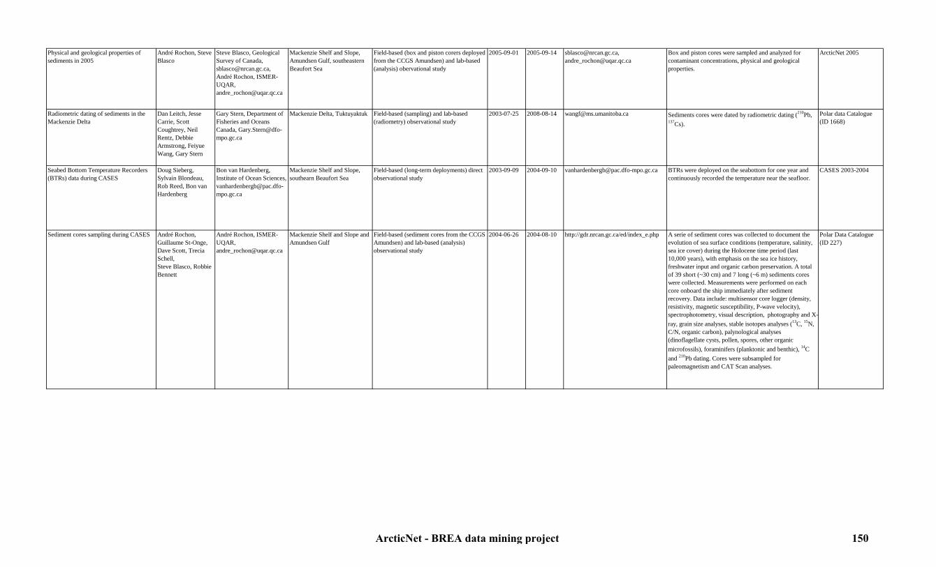
Physical and geological properties of sediments in 2005
André Rochon, Steve Blasco
Steve Blasco, Geological Survey of Canada, [email protected], André Rochon, ISMER-UQAR, [email protected]
Mackenzie Shelf and Slope, Amundsen Gulf, southeastern Beaufort Sea
Field-based (box and piston corers deployed from the CCGS Amundsen) and lab-based (analysis) obervational study
2005-09-01 2005-09-14 [email protected], [email protected]
Box and piston cores were sampled and analyzed for contaminant concentrations, physical and geological properties.
ArcticNet 2005
Radiometric dating of sediments in the Mackenzie Delta
Dan Leitch, Jesse Carrie, Scott Coughtrey, Neil Rentz, Debbie Armstrong, Feiyue Wang, Gary Stern
Gary Stern, Department of Fisheries and Oceans Canada, [email protected]
Mackenzie Delta, Tuktuyaktuk Field-based (sampling) and lab-based (radiometry) observational study
2003-07-25 2008-08-14 [email protected] Sediments cores were dated by radiometric dating (210Pb, 137Cs).
Polar data Catalogue (ID 1668)
Seabed Bottom Temperature Recorders (BTRs) data during CASES
Doug Sieberg, Sylvain Blondeau, Rob Reed, Bon van Hardenberg
Bon van Hardenberg, Institute of Ocean Sciences, [email protected]
Mackenzie Shelf and Slope, southearn Beaufort Sea
Field-based (long-term deployments) direct observational study
2003-09-09 2004-09-10 [email protected] BTRs were deployed on the seabottom for one year and continuously recorded the temperature near the seafloor.
CASES 2003-2004
Sediment cores sampling during CASES André Rochon, Guillaume St-Onge,Dave Scott, Trecia Schell,Steve Blasco, Robbie Bennett
André Rochon, ISMER-UQAR, [email protected]
Mackenzie Shelf and Slope and Amundsen Gulf
Field-based (sediment cores from the CCGS Amundsen) and lab-based (analysis) observational study
2004-06-26 2004-08-10 http://gdr.nrcan.gc.ca/ed/index_e.php A serie of sediment cores was collected to document the evolution of sea surface conditions (temperature, salinity, sea ice cover) during the Holocene time period (last 10,000 years), with emphasis on the sea ice history, freshwater input and organic carbon preservation. A total of 39 short (~30 cm) and 7 long (~6 m) sediments cores were collected. Measurements were performed on each core onboard the ship immediately after sediment recovery. Data include: multisensor core logger (density, resistivity, magnetic susceptibility, P-wave velocity), spectrophotometry, visual description, photography and X-ray, grain size analyses, stable isotopes analyses (13C, 15N, C/N, organic carbon), palynological analyses (dinoflagellate cysts, pollen, spores, other organic microfossils), foraminifers (planktonic and benthic), 14C and 210Pb dating. Cores were subsampled for paleomagnetism and CAT Scan analyses.
Polar Data Catalogue (ID 227)
ArcticNet - BREA data mining project 150
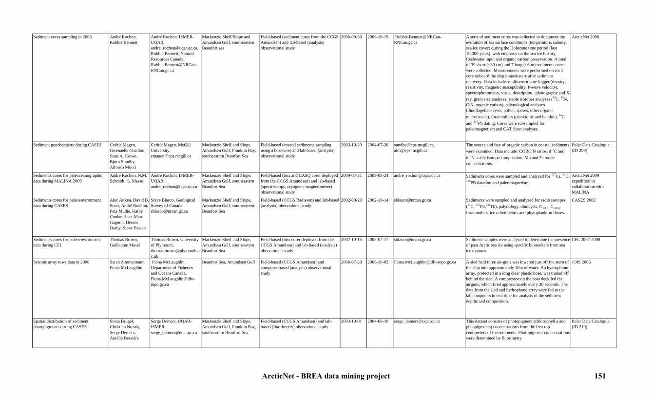
Sediment cores sampling in 2006 André Rochon, Robbie Bennett
André Rochon, ISMER-UQAR, [email protected], Robbie Bennett, Natural Resources Canada, [email protected]
Mackenzie Shelf/Slope and Amundsen Gulf, southeastern Beaufort sea
Field-based (sediment cores from the CCGS Amundsen) and lab-based (analysis) observational study
2006-09-30 2006-10-19 [email protected]
A serie of sediment cores was collected to document the evolution of sea surface conditions (temperature, salinity, sea ice cover) during the Holocene time period (last 10,000 years), with emphasis on the sea ice history, freshwater input and organic carbon preservation. A total of 39 short (~30 cm) and 7 long (~6 m) sediments cores were collected. Measurements were performed on each core onboard the ship immediately after sediment recovery. Data include: multisensor core logger (density, resistivity, magnetic susceptibility, P-wave velocity), spectrophotometry, visual description, photography and X-ray, grain size analyses, stable isotopes analyses (13C, 15N, C/N, organic carbon), palynological analyses (dinoflagellate cysts, pollen, spores, other organic microfossils), foraminifers (planktonic and benthic), 14C and 210Pb dating. Cores were subsampled for paleomagnetism and CAT Scan analyses.
ArcticNet 2006
Sediment geochemistry during CASES Cedric Magen, Gwenaelle Chaillou, Sean A. Crowe,Bjorn Sundby, Alfonso Mucci
Cedric Magen, McGill University, [email protected]
Mackenzie Shelf and Slope, Amundsen Gulf, Franklin Bay, southeastern Beaufort Sea
Field-based (coastal sediments sampling using a box-core) and lab-based (analysis) observational study
2003-10-20 2004-07-30 [email protected], [email protected]
The source and fate of organic carbon in coastal sediments were examined. Data include: CORG:N ratios, d13C and d15N stable isotope composition, Mn and Fe oxide concentrations.
Polar Data Catalogue (ID 299)
Sediments cores for paleoceanographic data during MALINA 2009
André Rochon, N.M. Schmidt, G. Masse
André Rochon, ISMER-UQAR, [email protected]
Mackenzie Shelf and Slope, Amundsen Gulf, southeastern Beaufort Sea
Field-based (box and CASQ corer deployed from the CCGS Amundsen) and lab-based (spectroscopy, cryogenic magnetometer) observational study
2009-07-31 2009-08-24 [email protected] Sediments cores were sampled and analyzed for 137Cs, 14C, 210PB datation and paleomagnetism.
ArcticNet 2009 expedition in collaboration with MALINA
Sediments cores for paleoenvironment data during CASES
Alec Aitken, David B. Scott, André Rochon, Peta Mudie, Kathy Conlan, Jean-Marc Gagnon, Dennis Darby, Steve Blasco
Steve Blasco, Geological Survey of Canada, [email protected]
Mackenzie Shelf and Slope, Amundsen Gulf, southeastern Beaufort Sea
Field-based (CCGS Radisson) and lab-based (analysis) obervational study
2002-09-20 2002-10-14 [email protected] Sediments were sampled and analyzed for radio isotopes (13C, 210Pb,234Th), palynology, dinocysts, C tot , Cinorg, foraminifers, ice rafted debris and phytoplankton fluxes.
CASES 2002
Sediments cores for paleoenvironment data during CFL
Thomas Brown, Guillaume Massé
Thomas Brown, University of Plymouth, [email protected]
Mackenzie Shelf and Slope, Amundsen Gulf, southeastern Beaufort Sea
Field-based (box corer deployed from the CCGS Amundsen) and lab-based (analysis) obervational study
2007-10-15 2008-07-17 [email protected] Sediment samples were analyzed to determine the presence of past Arctic sea ice using specific biomarkers from sea ice diatoms.
CFL 2007-2008
Seismic array tows data in 2006 Sarah Zimmermann, Fiona McLaughlin
Fiona McLaughlin, Department of Fisheries and Oceans Canada, [email protected]
Beaufort Sea, Amundsen Gulf Field-based (CCGS Amundsen) and computer-based (analysis) observational study
2006-07-20 2006-10-02 [email protected] A sled held three air-guns was lowered just off the stern of the ship into approximately 10m of water. An hydrophone array, protected in a long clear plastic hose, was trailed off behind the sled. A compressor on the boat deck fed the airguns, which fired approximately every 20 seconds. The data from the sled and hydrophone array were fed to the lab computers in real time for analysis of the sediment depths and composition.
JOIS 2006
Spatial distribution of sediment photopigments during CASES
Sonia Brugel,Christian Nozais,Serge Demers,Aurélie Bessière
Serge Demers, UQAR-ISMER, [email protected]
Mackenzie Shelf and Slope, Amundsen Gulf, Franklin Bay, southeastern Beaufort Sea
Field-based (CCGS Amundsen) and lab-based (fluorimetry) obervational study
2003-10-01 2004-08-10 [email protected] This dataset consists of photopigment (chlorophyll a and pheopigments) concentrations from the first top centimeters of the sediments. Photopigment concentrations were determined by fluorimetry.
Polar Data Catalogue (ID 219)
ArcticNet - BREA data mining project 151

Sub-bottom mapping transects during CASES
Jonathan Beaudoin, Steve Brucker, Jason Bartlett, Kristian Llewellyn
John E. Hughes Clarke, Ocean Mapping Group, UNB, [email protected], Steve Blasco, Geological Survey of Canada, [email protected]
Mackenzie Shelf and Slope, Amundsen Gulf
Field-based (echosounder onboard the CCGS Amundsen) and computer-based (analysis) observational study
2004-06-25 2004-08-10 http://www.omg.unb.ca/omg/Projects.html
Sediment characteristics were monitored using a Knudsen K320R sub-bottom profiler.
CASES 2003-2004
Sub-bottom mapping transects during CFL
John E. Hughes Clarke
John E. Hughes Clarke, Ocean Mapping Group, UNB, [email protected], Steve Blasco, Geological Survey of Canada, [email protected]
Amundsen Gulf, southeastern Beaufort Sea
Field-based (echosounder onboard the CCGS Amundsen) and computer-based (analysis) observational study
2007-10-15 2007-11-06 http://www.omg.unb.ca/omg/Projects.html
Sediment characteristics were monitored using a Knudsen K320R sub-bottom profiler.
CFL 2007-2008
Sub-bottom mapping transects in 2005 Robbie Bennett, John E. Hughes Clarke
John E. Hughes Clarke, Ocean Mapping Group, UNB, [email protected], Steve Blasco, Geological Survey of Canada, [email protected]
Mackenzie Shelf and Slope, southeastern Beaufort sea
Field-based (echosounder onboard the CCGS Amundsen) and computer-based (analysis) observational study
2005-09-05 2005-09-14 http://www.omg.unb.ca/omg/Projects.html
Sediment characteristics were monitored using a Knudsen K320R sub-bottom profiler.
ArcticNet 2005
Sub-bottom mapping transects in 2006 Robbie Bennett, John E. Hughes Clarke
John E. Hughes Clarke, Ocean Mapping Group, UNB, [email protected], Steve Blasco, Geological Survey of Canada, [email protected]
Mackenzie Shelf and Slope, southeastern Beaufort sea
Field-based (echosounder onboard the CCGS Amundsen) and computer-based (analysis) observational study
2006-09-30 2006-10-19 http://www.omg.unb.ca/omg/Projects.html
Sediment characteristics were monitored using a Knudsen K320R sub-bottom profiler.
ArcticNet 2006
Sub-bottom mapping transects in 2009 Steve Blasco,Kevin MacKillop,Kate Jarrett,Bob Murphy,Katie Blasco, John E. Hughes Clarke
John E. Hughes Clarke, Ocean Mapping Group, UNB, [email protected], Steve Blasco, Geological Survey of Canada, [email protected]
Alaskan Shelf, southeastern Beaufort Sea, Amundsen Gulf, Mackenzie Shelf and Slope (EL 446)
Field-based (echosounder onboard the CCGS Amundsen) and computer-based (analysis) observational study
2009-07-11 2009-10-16 http://www.omg.unb.ca/omg/Projects.html
Sediment characteristics were monitored using a Knudsen K320R sub-bottom profiler.
ArcticNet 2009 expedition in collaboration with IORVL
Sub-bottom mapping transects in 2010 Steve Blasco,Kevin MacKillop,Kate Jarrett,Greg Middleton,Robbie Bennett,Justin Buis,Carrie Breton,Katie Blasco, John E. Hughes Clarke
John E. Hughes Clarke, Ocean Mapping Group, UNB, [email protected], Steve Blasco, Geological Survey of Canada, [email protected]
Mackenzie Shelf and Slope (EL 449, 451)
Field-based (echosounder onboard the CCGS Amundsen) and computer-based (analysis) observational study
2010-08-13 2010-09-23 http://www.omg.unb.ca/omg/Projects.html
Sediment characteristics were monitored using a Knudsen K320R sub-bottom profiler.
ArcticNet 2010 expedition in collaboration with BP
Visual exploration of a mud volcano in 2009
Luc Michaud, Sylvain Blondeau , Pascal Massot, Louis Fortier
Louis Fortier, Université Laval, [email protected]
Mackenzie Slope (station 10; EL 446)
Field-based (ROV deployed from the CCGS Amundsen) direct observational study
2009-07-28 2009-07-28 [email protected] A camera mounted on a Remotely Operated Vehicle (ROV) recorded images of a mud volcano in the EL 446.
ArcticNet 2009 expedition in collaboration with IORVL
Visual exploration of a mud volcano in 2010
Luc Michaud, Pascal Massot, Steve Blasco, NRCan, Canadian Museum of Nature
Steve Blasco, Geological Survey of Canada, [email protected]
Mackenzie Slope (station BP10-PC43)
Field-based (ROV deployed from the CCGS Amundsen) direct observational study
2010-09-16 2010-09-17 [email protected] A camera mounted on a Remotely Operated Vehicle (ROV) recorded images of a mud volcano on the Mackenzie Slope.
ArcticNet 2010 expedition in collaboration with BP
Visual exploration transects in 2006 Sylvain Blondeau, Vincent Auger, Luc Michaud, Steve Blasco
Steve Blasco, Geological Survey of Canada, [email protected]
Mackenzie Slope (EL 446) Field-based (ROV deployed from the CCGS Amundsen) direct observational study
2009-09-29 2009-10-02 [email protected] A camera mounted on a Remotely Operated Vehicle (ROV) recorded images of the sea bottom in the EL 446.
ArcticNet 2009 expedition in collaboration with IORVL
ArcticNet - BREA data mining project 152

7.12. Geology7.12.2. Seafloor mapping
Table 27: Seafloor mapping metadataStudy Originators Contact person Study area Type of study Begin date End date Link to data Details Reference
Coastal seabed mapping transects from the Heron launch in 2006
John E. Hughes Clarke
John E. Hughes Clarke, Ocean Mapping Group, UNB, [email protected]
Amundsen Gulf (DeSalis Bay and Sachs Harbour)
Field-based (echosounder onboard the Heron) and computer-based (analysis) observational study
2006-09-30 2006-10-19 http://www.omg.unb.ca/Projects/Arctic/basemaps/index.html
3D coastal seabed mapping was performed using a Kongsberg-Simrad EM300 multibeam echosounder mounted on a small boat.
ArcticNet 2006, Polar Data catalogue (ID 1038)
Seabed mapping transects during CASES Jonathan Beaudoin, Steve Brucker, Jason Bartlett, Kristian Llewellyn
John E. Hughes Clarke, Ocean Mapping Group, UNB, [email protected], Steve Blasco, Geological Survey of Canada, [email protected]
Mackenzie Shelf and Slope, Amundsen Gulf
Field-based (echosounder onboard the CCGS Amundsen) and computer-based (analysis) observational study
2004-06-25 2004-08-10 http://www.omg.unb.ca/Projects/Arctic/basemaps/index.html
3D seabed mapping was performed using a Kongsberg-Simrad EM300 multibeam echosounder.
CASES 2003-2004, Polar Data catalogue (ID 1038)
Seabed mapping transects during CFL John E. Hughes Clarke
John E. Hughes Clarke, Ocean Mapping Group, UNB, [email protected], Steve Blasco, Geological Survey of Canada, [email protected]
Amundsen Gulf, southeastern Beaufort Sea
Field-based (echosounder onboard the CCGS Amundsen) and computer-based (analysis) observational study
2007-10-15 2007-11-06 http://www.omg.unb.ca/Projects/Arctic/basemaps/index.html
3D seabed mapping was performed using a Kongsberg-Simrad EM300 multibeam echosounder.
CFL 2007-2008, Polar Data catalogue (ID 1038)
Seabed mapping transects in 2005 Robbie Bennett, John E. Hughes Clarke
John E. Hughes Clarke, Ocean Mapping Group, UNB, [email protected], Steve Blasco, Geological Survey of Canada, [email protected]
Mackenzie Shelf and Slope, southeastern Beaufort sea
Field-based (echosounder onboard the CCGS Amundsen) and computer-based (analysis) observational study
2005-09-05 2005-09-14 http://www.omg.unb.ca/Projects/Arctic/basemaps/index.html
3D seabed mapping was performed using a Kongsberg-Simrad EM300 multibeam echosounder.
ArcticNet 2005, Polar Data catalogue (ID 1038)
Seabed mapping transects in 2006 Robbie Bennett, John E. Hughes Clarke
John E. Hughes Clarke, Ocean Mapping Group, UNB, [email protected], Steve Blasco, Geological Survey of Canada, [email protected]
Mackenzie Shelf and Slope, southeastern Beaufort sea
Field-based (echosounder onboard the CCGS Amundsen) and computer-based (analysis) observational study
2006-09-30 2006-10-19 http://www.omg.unb.ca/Projects/Arctic/basemaps/index.html
3D seabed mapping was performed using a Kongsberg-Simrad EM300 multibeam echosounder.
ArcticNet 2006, Polar Data catalogue (ID 1038)
Seabed mapping transects in 2009 Steve BlascoKevin MacKillopKate JarrettBob MurphyKatie Blasco, John E. Hughes Clarke
John E. Hughes Clarke, Ocean Mapping Group, UNB, [email protected], Steve Blasco, Geological Survey of Canada, [email protected]
Alaskan Shelf, southeastern Beaufort Sea, Amundsen Gulf, Mackenzie Shelf and Slope (EL 446)
Field-based (echosounder onboard the CCGS Amundsen) and computer-based (analysis) observational study
2009-07-11 2009-10-16 http://www.omg.unb.ca/Projects/Arctic/basemaps/index.html
3D seabed mapping was performed using a Kongsberg-Simrad EM300 multibeam echosounder.
ArcticNet 2009 expedition in collaboration with IORVL, Polar Data catalogue (ID 1038)
Seabed mapping transects in 2010 Steve Blasco,Kevin MacKillop,Kate Jarrett,Greg Middleton,Robbie Bennett,Justin Buis,Carrie Breton,Katie Blasco, John E. Hughes Clarke
John E. Hughes Clarke, Ocean Mapping Group, UNB, [email protected], Steve Blasco, Geological Survey of Canada, [email protected]
Mackenzie Shelf and Slope (EL 449, 451)
Field-based (echosounder onboard the CCGS Amundsen) and computer-based (analysis) observational study
2010-08-13 2010-09-23 http://www.omg.unb.ca/Projects/Arctic/basemaps/index.html
3D seabed mapping was performed using a Kongsberg-Simrad EM300 multibeam echosounder.
ArcticNet 2010 expedition in collaboration with BP, Polar Data catalogue (ID 1038)
ArcticNet - BREA data mining project 153

7.13. Coastal erosion and longshore sediment transport
Table 28: Coastal erosion and longshore sediment transport metadataStudy Originators Contact person Study area Type of study Begin date End date Link to data Details Reference
Annual shoreline surveys from 2004 to 2007
Donald L. Forbes, Wayne Pollard, Trevor Bell, Hugues Lantuit
Donald L. Forbes, Memorial University of Newfoundland, [email protected] and Wayne Pollard, Mc Gill University, [email protected], Trevor bell, Memorial University of Newfoundland, [email protected], Hugues Lantuit, AWI, [email protected]
Yukon coast Land-based direct observational study 2004-X-X 2007-X-X [email protected], [email protected], [email protected], [email protected]
Detailed geophysical surveys using ground-penetrating radar and capacitive coupled resistivity were carried out to investigate coastal permafrost, ground ice, organic carbon and erosion porcesses in unlithified ice-rich deposits of the Yukon coast.
ArcticNet project 1.2: Coastal vulnerability in a warming Arctic
Coastal breakup processes and spring flooding data from 2005 to 2007
Donald L. Forbes, Wayne Pollard, Trevor Bell
Donald L. Forbes, Memorial University of Newfoundland, [email protected] and Wayne Pollard, Mc Gill University, [email protected], Trevor bell, Memorial University of Newfoundland, [email protected]
Mackenzie Delta, Tuktoyaktuk Remote sensing study 2005-X-X 2007-X-X [email protected], [email protected], [email protected]
Breakup processes and spring flooding in the coastal region of the Mackenzie Delta were monitored.
ArcticNet project 1.2: Coastal vulnerability in a warming Arctic
Coastal erosion data from Herschel Island (Yukon Territory) for the 1952-2000 period
Hugues Lantuit Nicole Couture, McGill University, [email protected]
Herschel Island Aerial survey and remote sensing study 1952-01-01 2000-12-31 [email protected] Data were collected using archive air photos and recent IKONOS imagery for the calculation of coastal erosion rates of the Herschel Island shoreline.
Polar Data Catalogue (ID 9978)
Coastal land level data from 2004-2007 Donald L. Forbes, Wayne Pollard, Trevor Bell
Donald L. Forbes, Memorial University of Newfoundland, [email protected] and Wayne Pollard, Mc Gill University, [email protected]
Inuvik, Tuktoyaktuk, Sachs Harbour, Ulukhaktok
Land-based and remote sensing direct observational study
2004-X-X 2007-X-X [email protected], [email protected]
GPS (CGPS) data to measure land vetical motion (uplift or subsidence) were continuously collected at Inuvik, Tuktoyaktuk, Sachs Harbour and Ulukhaktok.
ArcticNet project 1.2: Coastal vulnerability in a warming Arctic
Coastal profile surveys and mapping from 2004 to 2007
Donald L. Forbes, Wayne Pollard, Trevor Bell, Hugues Lantuit
Donald L. Forbes, Memorial University of Newfoundland, [email protected] and Wayne Pollard, Mc Gill University, [email protected], Trevor bell, Memorial University of Newfoundland, [email protected], Hugues Lantuit, AWI, [email protected]
Sachs Harbour Land-based and remote sensing study 2003-X-X 2007-X-X [email protected], [email protected], [email protected], [email protected]
Coastal geomorphology and sedimentology studies including coastal profile surveys and mapping were conducted to assess the degree of ongoin geomorphic change and consequent risks and hazards to infrastructure in Sachs Harbour. In 2006, coastal sites (first established in 2003) were surveyed to document the extent of change over the intervening three years.
ArcticNet project 1.2: Coastal vulnerability in a warming Arctic
ArcticNet - BREA data mining project 154
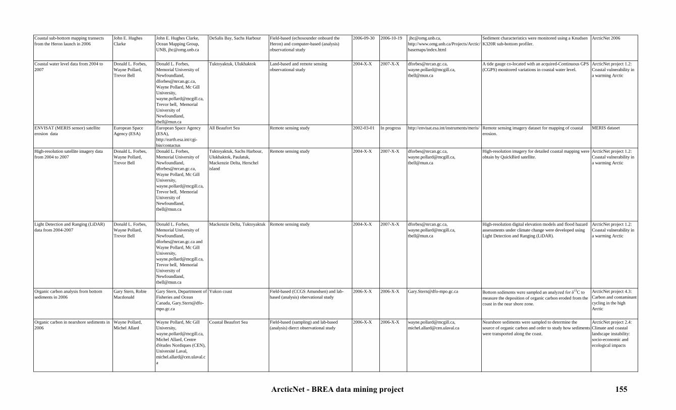
Coastal sub-bottom mapping transects from the Heron launch in 2006
John E. Hughes Clarke
John E. Hughes Clarke, Ocean Mapping Group, UNB, [email protected]
DeSalis Bay, Sachs Harbour Field-based (echosounder onboard the Heron) and computer-based (analysis) observational study
2006-09-30 2006-10-19 [email protected], http://www.omg.unb.ca/Projects/Arctic/basemaps/index.html
Sediment characteristics were monitored using a Knudsen K320R sub-bottom profiler.
ArcticNet 2006
Coastal water level data from 2004 to 2007
Donald L. Forbes, Wayne Pollard, Trevor Bell
Donald L. Forbes, Memorial University of Newfoundland, [email protected], Wayne Pollard, Mc Gill University, [email protected], Trevor bell, Memorial University of Newfoundland, [email protected]
Tuktoyaktuk, Ulukhaktok Land-based and remote sensing observational study
2004-X-X 2007-X-X [email protected], [email protected], [email protected]
A tide gauge co-located with an acquired-Continuous GPS (CGPS) monitored variations in coastal water level.
ArcticNet project 1.2: Coastal vulnerability in a warming Arctic
ENVISAT (MERIS sensor) satellite erosion data
European Space Agency (ESA)
European Space Agency (ESA), http://earth.esa.int/cgi-bin/contactus
All Beaufort Sea Remote sensing study 2002-03-01 In progress http://envisat.esa.int/instruments/meris/ Remote sensing imagery dataset for mapping of coastal erosion.
MERIS dataset
High-resolution satellite imagery data from 2004 to 2007
Donald L. Forbes, Wayne Pollard, Trevor Bell
Donald L. Forbes, Memorial University of Newfoundland, [email protected], Wayne Pollard, Mc Gill University, [email protected], Trevor bell, Memorial University of Newfoundland, [email protected]
Tuktoyaktuk, Sachs Harbour, Ulukhaktok, Paulatuk, Mackenzie Delta, Herschel island
Remote sensing study 2004-X-X 2007-X-X [email protected], [email protected], [email protected]
High-resolution imagery for detailed coastal mapping were obtain by QuickBird satellite.
ArcticNet project 1.2: Coastal vulnerability in a warming Arctic
Light Detection and Ranging (LiDAR) data from 2004-2007
Donald L. Forbes, Wayne Pollard, Trevor Bell
Donald L. Forbes, Memorial University of Newfoundland, [email protected] and Wayne Pollard, Mc Gill University, [email protected], Trevor bell, Memorial University of Newfoundland, [email protected]
Mackenzie Delta, Tuktoyaktuk Remote sensing study 2004-X-X 2007-X-X [email protected], [email protected], [email protected]
High-resolution digital elevation models and flood hazard assessments under climate change were developed using Light Detection and Ranging (LiDAR).
ArcticNet project 1.2: Coastal vulnerability in a warming Arctic
Organic carbon analysis from bottom sediments in 2006
Gary Stern, Robie Macdonald
Gary Stern, Departmnent of Fisheries and Ocean Canada, [email protected]
Yukon coast Field-based (CCGS Amundsen) and lab-based (analysis) obervational study
2006-X-X 2006-X-X [email protected] Bottom sediments were sampled an analyzed for δ13C to measure the deposition of organic carbon eroded from the coast in the near shore zone.
ArcticNet project 4.3: Carbon and contaminant cycling in the high Arctic
Organic carbon in nearshore sediments in 2006
Wayne Pollard, Michel Allard
Wayne Pollard, Mc Gill University, [email protected], Michel Allard, Centre d'études Nordiques (CEN), Université Laval, [email protected]
Coastal Beaufort Sea Field-based (sampling) and lab-based (analysis) dierct observational study
2006-X-X 2006-X-X [email protected], [email protected]
Nearshore sediments were sampled to determine the source of organic carbon and order to study how sediments were transported along the coast.
ArcticNet project 2.4: Climate and coastal landscape instability: socio-economic and ecological impacts
ArcticNet - BREA data mining project 155

Sediment cores from shallow marine coastal basins in 2006-2007
Trevor Bell,Rod Smith, Bryan Martin
Bryan Martin, Memorial University, [email protected]
Sachs Harbour, Banks Island Field-based (from a sea ice platform) and lab-based (analysis) observational study
2006-04-21 2007-05-02 [email protected] Seabead cores were obtained from a sea ice platform. Cores along the shallow sills were used to determine how the sill changes through time as well as determining a specific height at which sea level overtopped the lowest section. Cores in the deepest sections of the basins were used to determine the period in which the basin changed from freshwater to marine (changes in diatom compositions).
Polar Data Catalogue (ID 884)
Shore zone sensitivity to potential petroleum contamination from 2004 to 2007
Donald L. Forbes, Wayne Pollard, Trevor Bell
Donald L. Forbes, Memorial University of Newfoundland, [email protected], Wayne Pollard, Mc Gill University, [email protected], Trevor bell, Memorial University of Newfoundland, [email protected]
Sachs Harbour Field-based study 2004-X-X 2007-X-X [email protected], [email protected], [email protected]
Shore-zone sensitivity to potential petroleum contamination was investigated.
ArcticNet project 1.2: Coastal vulnerability in a warming Arctic
Shoreline features and mapping data from 2004 to 2007
Wayne Pollard, Michel Allard
Wayne Pollard, Mc Gill University, [email protected], Michel Allard, Centre d'études Nordiques (CEN), Université Laval, [email protected]
Yukon coast Land-based and remote sensing study 2004-X-X 2008-X-X [email protected], [email protected]
Surveys of shoreline features, including block failures and thermo-erosional niches were done annually.Yukon coast was mapped using a high resolution GPS.
ArcticNet project 5.4: Climate and coastal landscape instability: Socio-economic and ecological impacts
Water level data near Pauline Cove in 2007
Wayne Pollard, Michel Allard
Wayne Pollard, Mc Gill University, [email protected], Michel Allard, Centre d'études Nordiques (CEN), Université Laval, [email protected]
Pauline Cove (Herschel Island) Land-based direct observational study and modeling study
2007-X-X 2007-X-X [email protected], [email protected]
A water level recorder monitored variations in coastal water level for constructing a digital water elevation model.
ArcticNet project 2.4: Climate and coastal landscape instability, socio-economic and ecological impacts
ArcticNet - BREA data mining project 156


