Description The site is located at the junction of the Metro Red Line, the Purple Line light‐rail, and the Capital Crescent Trail, and is directly accessed from the commercial development along Wisconsin Avenue and the mixed residential and retail development along Woodmont Avenue. Redevelopment will allow up to a maximum of 937,184 sf. of total development, including residential and commercial portions up to 878,610 square feet each, with a maximum standard building height of 250 feet. Provision of affordable housing beyond the minimum requirement could yield additional density and/or height. Final distribution of residential and commercial density will be determined during Preliminary and Site Plan review. The former Community Paint and Hardware Store, currently housing a United Bank branch, is located on the southwest corner of the Property and is a designated Historic Site. Potential relocation of this building may have a significant impact on the site design and will be resolved at Site Plan. The site is located within the boundary of the draft Bethesda Downtown Plan, currently under review by the Planning Board in advance of County Council review and approval. Staff Recommends Approval of the Sketch Plan with conditions. MONTGOMERY COUNTY PLANNING DEPARTMENT THE MARYLAND‐NATIONAL CAPITAL PARK AND PLANNING COMMISSION MCPB Item No. Date: 2.11.16 7272 Wisconsin Avenue: Sketch Plan No. 320160040 Elza Hisel‐McCoy, Regulatory Supervisor, Area 1, elza.hisel‐[email protected], 301.495.2115 Robert Kronenberg, Chief, Area 1, [email protected], 301.495.2187 For up to 937,184 total square feet of mixed‐use development, with 12.5% MPDUs, that will accommodate the Bethesda Purple Line Station, the southern entrance to the Bethesda Red Line Station, and the Capital Crescent Trail; Current use: office and retail uses, including the Regal Bethesda 10 Cinema complex; Located in the southwest quadrant of the intersection of Wisconsin Avenue and Elm Street; 2.69 gross acres zoned CR 8.0 C 7.5 R 7.5 H 250 in the 2014 Bethesda Purple Line Station Plan Minor Master Plan Amendment area; Applicant: CP 7272 Wisconsin Avenue, LLC c/o Carr Properties; Accepted as complete on December 1, 2015. Summary Completed: 2.1.16
Transcript
Description
The site is located at the junction of the Metro Red Line, the Purple Line light‐rail, and the Capital Crescent Trail, and is directly accessed from the commercial development along Wisconsin Avenue and the mixed residential and retail development along Woodmont Avenue.
Redevelopment will allow up to a maximum of 937,184 sf. of total development, including residential and commercial portions up to 878,610 square feet each, with a maximum standard building height of 250 feet. Provision of affordable housing beyond the minimum requirement could yield additional density and/or height. Final distribution of residential and commercial density will be determined during Preliminary and Site Plan review.
The former Community Paint and Hardware Store, currently housing a United Bank branch, is located on the southwest corner of the Property and is a designated Historic Site. Potential relocation of this building may have a significant impact on the site design and will be resolved at Site Plan.
The site is located within the boundary of the draft Bethesda Downtown Plan, currently under review by the Planning Board in advance of County Council review and approval.
Staff Recommends Approval of the Sketch Plan with conditions.
MONTGOMERY COUNTY PLANNING DEPARTMENT THEMARYLAND‐NATIONALCAPITALPARKANDPLANNINGCOMMISSION
MCPB Item No. Date: 2.11.16
7272 Wisconsin Avenue: Sketch Plan No. 320160040
Elza Hisel‐McCoy, Regulatory Supervisor, Area 1, elza.hisel‐[email protected], 301.495.2115
For up to 937,184 total square feet of mixed‐use development, with 12.5% MPDUs, that will accommodate the Bethesda Purple Line Station, the southern entrance to the Bethesda Red Line Station, and the Capital Crescent Trail;
Current use: office and retail uses, including the Regal Bethesda 10 Cinema complex;
Located in the southwest quadrant of the intersection of Wisconsin Avenue and Elm Street;
2.69 gross acres zoned CR 8.0 C 7.5 R 7.5 H 250 in the 2014 Bethesda Purple Line Station Plan Minor Master Plan Amendment area;
SECTION 1: RECOMMENDATION AND CONDITIONS Staff recommends Approval of Sketch Plan No.320160040, 7272 Wisconsin Avenue, for up to 937,184 square feet of total development, including components of residential and/or commercial development of no more than 878,610 square feet each, including 12.5% MPDUs, on the Subject Property. Provision of affordable housing beyond the minimum requirement could yield additional density at time of Preliminary Plan. The site will accommodate the Bethesda Purple Line Station, the southern entrance to the Bethesda Red Line Station, and the Capital Crescent Trail, including all necessary easements. Approval is subject to the following binding elements and conditions: Binding Elements
1. Maximum density and height; 2. Approximate location of lots and public dedications; 3. General location and extent of public open space; 4. General location of vehicular access points; and 5. Public benefit schedule. All other elements of the Sketch Plan are illustrative.
Recommended Conditions of Approval
1. Density
The development is limited to a maximum of 937,184 square feet of total development on the Subject Property, including components of residential and/or commercial development of no more than 878,610 square feet each. The maximum amount and distribution of residential and non‐residential uses, including number of dwelling units, will be determined at Preliminary Plan.
2. Height The development is limited to the maximum height of 250 feet.
3. Incentive Density The development must be constructed with the public benefits listed below, unless modifications are made under Section 59.7.3.3.I. Total points must equal at least 100 and be chosen from at least four categories as required by Section 59.4.5.4.A.2.a. The requirements of Division 59.4.7 and the CR Zone Incentive Density Implementation Guidelines must be fulfilled for each public benefit proposed. Final points will be established at site plan approval. a. Major Public Facilities (Section 59.4.7.3.A), achieved through accommodation, including all
necessary easements, of a multi‐modal transit hub for the Purple Line; b. Transit Proximity (Section 59.4.7.3.B), achieved though accommodation and access to both a new
portal for the Red Line and a Purple Line Station including all necessary easements; c. Connectivity and Mobility (Section 59.4.7.3.C), achieved through upgraded, sheltered pedestrian
connections and easements for the new Red Line Metro southern portal adjacent to the site; d. Quality Building Design (Section 59.4.7.3.E), achieved through Exceptional Design and Structured
Parking; and e. Protection and Enhancement of the Natural Environment (Section 59.4.7.3.F), achieved through the
purchase of BLTs and provision of a vegetated roof.
3
4. Moderately Priced Dwelling Units (MPDUs) The Applicant must provide a minimum of 12.5 percent of the total number of units as Moderately Priced Dwelling Units on the Subject Property, in accordance with Chapter 25A.
5. Public Space The Applicant must provide a minimum of 5 percent of the Subject Property as Public Open Space. Final location, configuration, and character to be determined at Site Plan.
6. Transportation
Consistent with the recommendations of the Bethesda Purple Line Station Minor Master Plan Amendment, the Applicant must: a. provide within the Subject Property the space necessary for the Bethesda Purple Line Station,
including, but not limited to, the tracks, platform, mezzanine for access to both the Red Line elevators and Purple Line platform, required ventilation facilities, and access points;
b. locate the street‐level access points for the mezzanine described in Condition 6.a. on site; c. construct the on‐site portion of the Capital Crescent Trail (CCT), with final alignment and design to be
determined at Site Plan; d. reserve within the Subject Property a minimum 10,000 square foot area abutting the CCT dedicated
to a full‐service bicycle storage facility; e. provide all necessary easements for the facilities listed in subparagraphs 6.a.‐6.d. ; f. coordinate with the Maryland Transit Administration (MTA), State Highway Administration (SHA), the
Montgomery County Department of Transportation (MCDOT), Montgomery County Planning Department, and other necessary agencies to develop and implement the design and construction of the facilities identified in Condition 6.
7. Historic Preservation
a. Before Site Plan review, the Applicant, in coordination with Planning Department and Historic Preservation Commission staff, must submit a Preliminary Consultation to the Historic Preservation Commission to determine if the Community Paint and Hardware Historic Site may be moved from the Subject Property and, if so, where it will be relocated.
b. If the Historic Site is to be relocated, the new location must meet the following criteria: i. Within Downtown Bethesda ii. Proximate to Wisconsin Avenue so as to allow a clearly defined visual connection to the
Avenue. c. Any activity impacting the Historic Site must be approved by the Historic Preservation Commission.
8. Future Coordination for Preliminary and/or Site Plan
a. In addition to any other requirements for Preliminary Plans under Chapter 50, the following must be addressed at Preliminary Plan:
i. Implementation of the transportation improvements; ii. Adequate Public Facilities review iii. Provision of turning templates for the proposed access points
b. In addition to any other requirements for Site Plans under Chapter 59, the following must be addressed at Site Plan:
i. Design: 1. Streetscape details; 2. Demonstration of how each public benefit satisfies the Zoning Ordinance and
Incentive Density Implementation Guideline requirements; 3. Provision of a minimum 20ft building setback from the street curb along
Wisconsin Avenue to accommodate high volumes of pedestrian traffic;
4
4. Building design to articulate a low to mid‐rise base to relate to pedestrian scale with as many active lining uses as possible and modulate massing above the base along Wisconsin Avenue, Elm Street and Woodmont Plaza to reduce the tower impacts;
5. Vary building tower heights with the highest along Wisconsin Avenue; 6. Provide façade articulation to reduce building bulk and add visual interest; 7. Façade treatments along any above‐ground structured parking floors facing a
public road or public space must fully integrate these floors into the design of the facade;
8. Integrate sustainable design systems and materials to improve building performance;
9. Provide additional information on the design of the Wisconsin/Elm corner plaza and the Purple Line entry off of Woodmont Plaza as critical public gateways to the transit stations; and
10. Maximize windows, entries, and other openings on Elm Street.
ii. Capital Crescent Trail design: 1. Straighten the trail alignment through the building so that the prevailing
alignment is more “straight” than curvilinear; 2. Coordinate a smooth transition to the trail at the western property line; 3. Show the future eastern limits of the tunnel under Wisconsin (to the eastern
ROW line on MD 355); 4. Consider an art component in tunnel; and 5. Work to minimize vertical change for the Capital Crescent Trail.
5
SECTION 2: SITE DESCRIPTION Site Vicinity The subject site (Subject Property or Property), also known as the Apex Building is located on the west side of Wisconsin Avenue at the intersection with Elm Street in Downtown Bethesda, in the 2014 Bethesda Purple Line Station Plan Minor Master Plan Amendment (Sector Plan) area. The Property is bounded by Elm Street to the north, Wisconsin Avenue to the east, and commercial development to the south and west.
Figure 1‐Vicinity Map
The area surrounding the Property is developed with a mix of low‐, mid‐, and high‐rise office uses. There are
mid‐and high‐rise multi‐family residential uses to the south along Bethesda Avenue and to the northwest along
Woodmont Avenue. To the west along Woodmont Avenue and beyond is the Bethesda Row restaurant and
retail area. The Capital Crescent Trail (currently the Georgetown Branch Trail) regional recreational and
transportation facility connecting Georgetown and Silver Spring runs underneath the site.
6
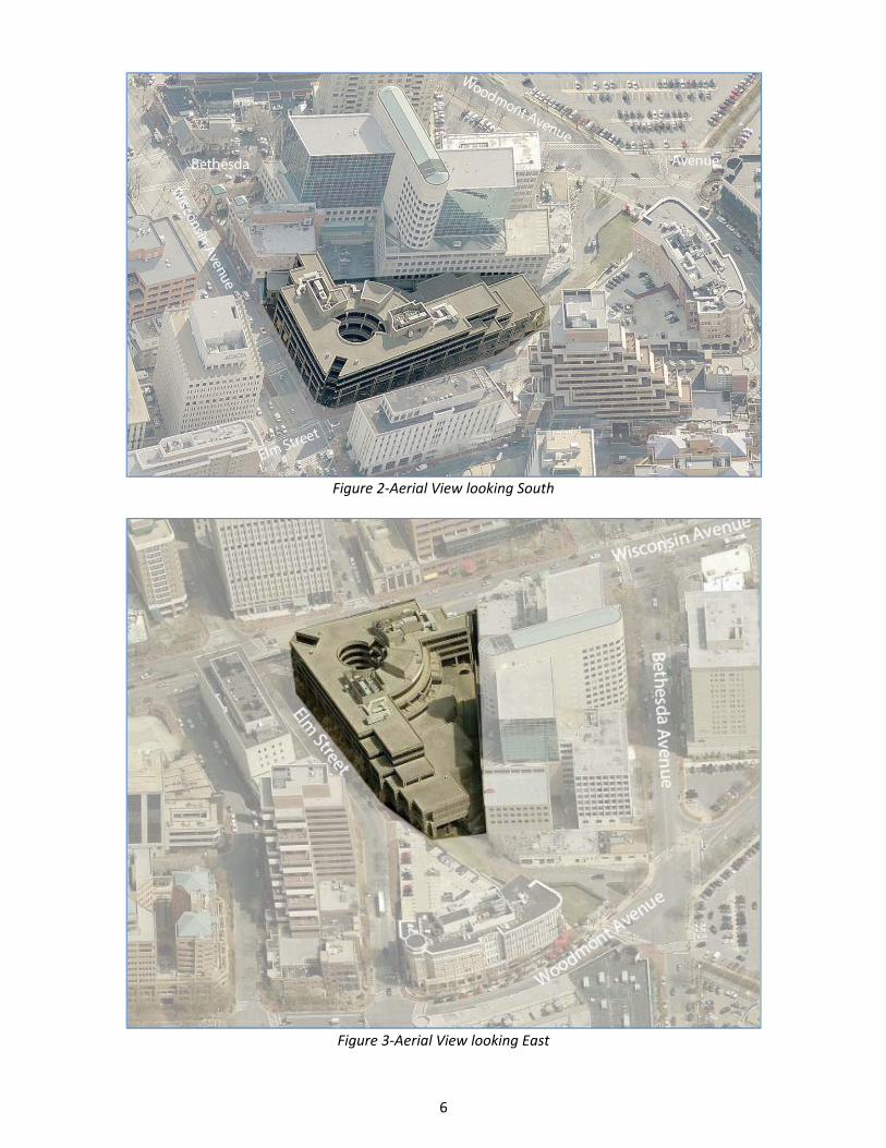
Figure 2‐Aerial View looking South
Figure 3‐Aerial View looking East
7
The Property is zoned CR 8.0, C 7.5, R 7.5, H 250. The immediately adjacent properties are also zoned CR, but only for a 5.0 FAR, with maximum building heights ranging from 90 feet to 145 feet. To the south along Wisconsin Avenue, the properties are zoned CR 3.0, with building heights ranging from 35 feet to 120 feet. Across Woodmont Avenue to the west the properties are zoned CRT or CR, with densities between 1.5 and 2.25 FAR and building heights of 40 feet to 75 feet.
Figure 4‐Zoning Map Site Analysis The 2.69‐acre Property is improved with a 5‐story building containing office and retail uses, including the Regal Bethesda 10 Cinema Complex. The Property slopes down to the west about 14 feet towards Woodmont Avenue. The sole vehicular access to the Property is presently located off Wisconsin Avenue, in the southeast corner of the site. Pedestrian access to the building’s retail and office entrances is located along Wisconsin Avenue, at the corner with Elm Street. Pedestrian and bicycle access beneath the building to the Georgetown Branch Trail is provided from Woodmont Plaza to the west and Elm Street Park across Wisconsin Avenue to the east. There are no specimen trees, floodplains, streams, forests, wetlands or their associated buffers located on the Property. Staff approved a Natural Resource Inventory/Forest Stand Delineation (NRI/FSD) for the Project on December 22, 2015. The Property contains the Community Paint and Hardware Store Historic Site in the southeast corner of the Property.
8
SECTION 3: PROJECT DESCRIPTION
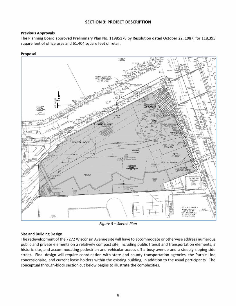
Previous Approvals The Planning Board approved Preliminary Plan No. 11985178 by Resolution dated October 22, 1987, for 118,395 square feet of office uses and 61,404 square feet of retail. Proposal
Figure 5 – Sketch Plan
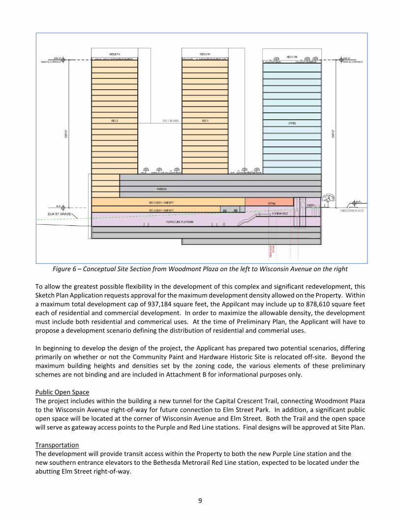
Site and Building Design The redevelopment of the 7272 Wisconsin Avenue site will have to accommodate or otherwise address numerous public and private elements on a relatively compact site, including public transit and transportation elements, a historic site, and accommodating pedestrian and vehicular access off a busy avenue and a steeply sloping side street. Final design will require coordination with state and county transportation agencies, the Purple Line concessionaire, and current lease‐holders within the existing building, in addition to the usual participants. The conceptual through‐block section cut below begins to illustrate the complexities.
9
Figure 6 – Conceptual Site Section from Woodmont Plaza on the left to Wisconsin Avenue on the right
To allow the greatest possible flexibility in the development of this complex and significant redevelopment, this Sketch Plan Application requests approval for the maximum development density allowed on the Property. Within a maximum total development cap of 937,184 square feet, the Appilcant may include up to 878,610 square feet each of residential and commercial development. In order to maximize the allowable density, the development must include both residential and commerical uses. At the time of Preliminary Plan, the Applicant will have to propose a development scenario defining the distribution of residential and commerial uses. In beginning to develop the design of the project, the Applicant has prepared two potential scenarios, differing primarily on whether or not the Community Paint and Hardware Historic Site is relocated off‐site. Beyond the maximum building heights and densities set by the zoning code, the various elements of these preliminary schemes are not binding and are included in Attachment B for informational purposes only. Public Open Space The project includes within the building a new tunnel for the Capital Crescent Trail, connecting Woodmont Plaza to the Wisconsin Avenue right‐of‐way for future connection to Elm Street Park. In addition, a significant public open space will be located at the corner of Wisconsin Avenue and Elm Street. Both the Trail and the open space will serve as gateway access points to the Purple and Red Line stations. Final designs will be approved at Site Plan. Transportation The development will provide transit access within the Property to both the new Purple Line station and the new southern entrance elevators to the Bethesda Metrorail Red Line station, expected to be located under the abutting Elm Street right‐of‐way.
10
Bicycle access to the site will be via the CCT running through a lower level of the building, with access to Georgetown and Silver Spring. The Sector Plan recommends the construction of a 10,000 square foot bicycle storage facility in the building next to the trail. Pedestrian access will be provided from the Wisconsin Avenue and Elm Street sidewalks, as well as on the CCT from Woodmont Plaza. The Applicant will be working to maximize pedestrian entrances along the two streets to help activate the ground floor. Vehicular access to the Property is proposed directly from both Elm Street and Wisconsin Avenue. The project currently envisions automobile garage access from both streets, with truck loading access only from Wisconsin Avenue.
Adequate Public Facilities Adequate Public Facilities (APFO) review will be conducted at the time of Preliminary Plan review. Although the Property is not eligible for formal APF review at Sketch Plan, the Zoning Ordinance requires Applicants to submit an “estimated range of peak hour trips.” Given that within the maximum total development, almost 94 percent of the total could be either office uses, with higher traffic generation rates, or residential uses, with significantly lower generation rates, at this stage of design, there is a high degree of variability in that estimated range. Comparing just two potential scenarios, each weighted heavily for either office development or residential development, the range for morning peak hour trips is from 1,134 to 127, while the evening peak hour trip range runs from 1,085 to 78. (See Attachment C for the numbers.) At the time of Preliminary Plan, the Applicant will refine the proposed land use mix and determine the estimated peak hour trips associated with that mix. The traffic impact to be studied as part of the Preliminary Plan will be somewhere between the two scenarios submitted as part of this Sketch Plan. Transportation Policy Area Review (TPAR) Since the proposed development is within the Bethesda CBD Policy Area, the Application is considered to beadequate under the roadway test and exempt from the transit test set forth in the 2012‐2016 Subdivision Staging Policy. As a result, the proposed development is not required to pay the transportation impact tax to satisfy the TPAR requirement.
Community Outreach The Applicant has met all signage, noticing, and submission meeting requirements. On November 30, 2015, the Applicant held a pre‐submittal public meeting at the Property. Staff has received phone inquiries from property owners and residents with respect to timing of the Project and the future Purple Line.
11
SECTION 4: PROJECT ANALYSIS AND FINDINGS
The purpose of a Sketch Plan is to identify general land uses, development intensity, and public benefits for the optional method of development in the CR, CRT, EOF or LSC Zones. The Sketch Plan is intended to be conceptual in nature with an emphasis on building densities, massing, heights and anticipated uses, the locations of open and public use spaces, the general circulation patterns for all modes of transportation, an estimated range of peak hour trips and relationships between existing or proposed adjacent buildings and rights‐of‐way. Details of the proposed development are determined during Preliminary and Site Plan review. Section 59‐7.3.3.E of the Zoning Ordinance states: “To approve a sketch plan the Planning Board must find that the following elements are appropriate in concept and appropriate for further detailed review at site plan. The sketch plan must:” 1. meet the objectives, general requirements, and standards of this Chapter;
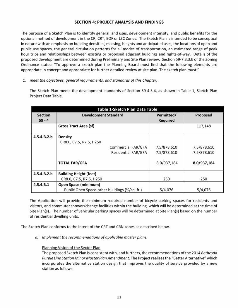
The Sketch Plan meets the development standards of Section 59‐4.5.4, as shown in Table 1, Sketch Plan Project Data Table.
The Application will provide the minimum required number of bicycle parking spaces for residents and visitors, and commuter shower/change facilities within the building, which will be determined at the time of Site Plan(s). The number of vehicular parking spaces will be determined at Site Plan(s) based on the number of residential dwelling units.
The Sketch Plan conforms to the intent of the CRT and CRN zones as described below.
a) Implement the recommendations of applicable master plans. Planning Vision of the Sector Plan The proposed Sketch Plan is consistent with, and furthers, the recommendations of the 2014 Bethesda Purple Line Station Minor Master Plan Amendment. The Project realizes the “Better Alternative” which incorporates the alternative station design that improves the quality of service provided by a new station as follows:
Table 1‐Sketch Plan Data Table Section 59 ‐ 4
Development Standard Permitted/ Required
Proposed
Gross Tract Area (sf) 117,148
4.5.4.B.2.b Density CR8.0, C7.5, R7.5, H250
Commercial FAR/GFA Residential FAR/GFA
TOTAL FAR/GFA
7.5/878,610 7.5/878,610
8.0/937,184
7.5/878,610 7.5/878,610
8.0/937,184
4.5.4.B.2.b Building Height (feet) CR8.0, C7.5, R7.5, H250
250
250
4.5.4.B.1 Open Space (minimum) Public Open Space‐other buildings (%/sq. ft.)
5/4,076
5/4,076
12
The Purple Line platform would be larger and, without interrupting columns, would provide more room for riders and trains;
The Purple Line station platform would be straight, eliminating gaps between the train and the platform;
The Red Line Metro south entrance would be located within the new building with access to high‐speed elevators directly from the street;
CCT users would have a choice to cross Wisconsin Avenue either in a new tunnel or at street level;
The 90‐foot‐tall ventilation tower would be incorporated into a new building and the over‐run tracks would be significantly shortened, leaving more of Woodmont Plaza available for public enjoyment;
The station area can accommodate space for full‐service bike storage (i.e., a “bike station”).
The Project is consistent with the Sector Plan’s recommendation to encourage coordinated redevelopment of the site, especially as it relates to realizing a vision to construct a better‐designed Purple Line station and a new tunnel for the CCT. It will provide new housing and employment uses in the downtown. The Project promotes the Sector Plan objective of reducing auto dependence by integrating a combination of uses near transit options, such as WMATA Metrobus service and the future Purple Line station, and near downtown retail, businesses, public facilities, and recreational amenities. The Project’s streetscape enhancements, including new sidewalks, streetlights and street trees allows for increased pedestrian access and connectivity, provides access to shared roadways and shared use paths recommended in the Sector Plan, and provides a human‐scaled streetscape. Land Use and Zoning The Application takes full advantage of the density and height provisions promoted by the Sector Plan, which increased the density from a 5.0 FAR to an 8.0 FAR and a height increase from 143 feet to 250 feet. The additional building height offers greater flexibility to accommodate the numerous program elements of the improved station and trail. Infrastructure The Sector Plan emphasizes (page 15) that “the top priority public benefits for this Plan area are the provision of space on the Apex Building site necessary for planning, construction and operation of the ‘major public facilities’ of the improved transit station and the CCT tunnel”. With the increased height and density, the Applicant proposes to accommodate the new Purple Line Station, which includes the Red Line Metro south entrance and the CCT trail through the building. The proposed infrastructure is consistent with Sector Plan recommendations. Public Open Space The proposed public use spaces are consistent with the Sector Plan recommendations for redevelopment of the station entrances, at the corner of Wisconsin Avenue and Elm Street, and the CCT tunnel.
b) Target opportunities for redevelopment of single‐use commercial areas and surface parking lots with
a mix of uses. The Project will redevelop the existing 5‐story office and retail building with over 900,000 square feet of mixed‐use development, including both residential and commercial uses – possibly to include a movie theatre – as well as the significant public uses of the CCT, Purple Line Station, and Metro Station entrance, as well as public space and residential amenity space.
13
c) Encourage development that integrates a combination of housing types, mobility options, commercial services, and public facilities and amenities, where parking is prohibited between the building and the street. The Project will offer a diversity of uses including multi‐family units targeted to a wide range of incomes, commercial uses including office, retail and possibly a cinema, above the future Purple Line station. The development will also include a new tunnel for the CCT incorporated into the design of the building.
d) Allows a flexible mix of uses, densities, and building heights appropriate to various settings to ensure compatible relationships with adjoining neighborhoods. The Project proposes to maximize the density above the future Purple Line Station to a height of 250 feet and a density of 8.0 FAR. With the Property located above access to two transit lines along central Wisconsin Avenue, this redevelopment will set a new “high point” for transit‐oriented development in Downtown Bethesda. It is located away from nearby single‐family neighborhoods, buffered by open space and lower‐scale development.
e) Integrate an appropriate balance of employment and housing opportunities. In order to maximize the amount of development allowed on this site, the plan must provide both commercial and residential development. While market expectations will guide the final distribution of uses, the Subject Property is located between the Wisconsin Avenue business corridor and the growing Woodmont Avenue residential/retail area. The development will take advantage of this location to provide an appropriate balance of commercial and residential uses that will provide both employment and housing opportunities.
f) Standardize optional method development by establishing minimum requirements for the provision of public benefits that will support and accommodate density above the standard method limit. The Project will provide the required public benefits from a minimum of four categories to achieve the desired incentive density above the standard method limit. The five categories include major public facilities, transit proximity, connectivity and mobility, quality building design, and protection and enhancement of the natural environment.
2. substantially conform with the recommendations of the applicable master plan; As discussed in Finding 1.a) above, the Project substantially conforms to the Bethesda Purple Line Station Minor Master Plan Amendment.
3. satisfy any development plan or schematic development plan in effect on October 29, 2014; The Sketch Plan is not subject to a development plan or schematic development plan.
4. under Section 7.7.1.B.5, for a property where the zoning classification on October 29, 2014 was the result of
a Local Map Amendment, satisfy any green area requirement in effect on October 29, 2014; any green area under this provision includes and is not in addition to any open space requirement of the property’s zoning on October 30, 2014; The Property’s zoning classification on October 29, 2014 was not a result of a Local Map Amendment.
14
5. achieve compatible internal and external relationships between existing and pending nearby development;
As discussed above, the redevelopment of this site will establish a new center of activity for Downtown Bethesda, uniting several nearby places into one defined area. By design, the building heights on the site are taller than existing and proposed development on the surrounding blocks, with those blocks helping to transition from this transit center to the lower‐density residential neighborhoods not far from the Property. The CCT, station plaza, and other amenities will further attract people to and through the site, promoting the surrounding properties. The proposed buildings and open spaces are compatible with existing and proposed nearby buildings, open spaces and uses.
6. provides satisfactory general vehicular, pedestrian, and bicyclist access, circulation, parking, and loading;
The Project provides satisfactory general vehicular, pedestrian, and bicyclist access, circulation, parking, and loading. The CCT tunnel runs through the site and will feature a significant bicycle storage facility that will attract cyclists and promote alternatives to automobile trips. Adequate parking will be provided on‐site to accommodate all users of the Property, and access to parking and loading are located to minimize pedestrian‐vehicular conflicts within the constraints of the site.
7. propose an outline of public benefits that supports the requested incentive density and is appropriate for the specific community; The Application includes public benefits that address the general incentive and density considerations required by Section 59.4.7.1.B. The public benefits: a. Take into consideration “the recommendations of the applicable master plan” by providing major public
facilities; b. Meet the 2012 Commercial/Residential Zones Incentive Density Implementation Guidelines (CR
Guidelines) by providing the proper calculations and criteria for each public benefit; c. Meet “any design guidelines adopted for the applicable master plan area” by providing residential units
within walking distance of the new Metro Red Line station entrance, the Purple Line station, public open space, and safe pedestrian‐friendly connections;
d. Are appropriate for “the size and configuration of the site” by improving the existing configuration of surface parking lots and replacing them with structured parking to allow for public use and public open spaces close to transit;
e. Adequately address “the relationship of the site to adjacent properties” by designing the building at an appropriate scale for the surroundings with varied tower heights and massing and by creating areas of open space that complement the existing character of the area;
f. Consider “the presence or lack of similar public benefits nearby” through the provision of affordable housing, environmental benefits, public open space, and pedestrian connections, all of which are currently needed in this area; and
g. Provide “enhancements beyond the elements listed in an individual public benefit that increase public access to, or enjoyment of, the benefit” which will be developed and assessed during Preliminary and Site Plan reviews.
The development must be constructed with the public benefits listed in Table 2, unless modifications are made under Section 59.7.3.3.I. Total points must equal at least 100 and be chosen from at least four categories as required by Section 59.4.5.4.A.2. The requirements of Division 59.4.7.1 and the CR Zone Incentive Density Implementation Guidelines must be fulfilled for each public benefit. Final points will be established at Site Plan approval.
15
Table 2 ‐ Public Benefits Calculations Public Benefit Incentive Density Points
Max Allowed Requested Recommended
59.4.7.3.A: Major Public Facility 70 57 57
59.4.7.3.B: Transit Proximity 50 50 50
59.4.7.3.C: Connectivity and Mobility
Transit Access Improvement 20 20 20
59.4.7.3.E: Quality of Building and Site Design
Exceptional Design 10 5 5
Structured Parking 20 15 15
59.4.7.3.F: Protection and Enhancement of the Natural Environment
Building Lot Terminations (BLTs) 30 18 18
Vegetated Roof 15 5 5
TOTAL 170 170
Major Public Facilities The Property will incorporate the proposed Purple Station and the Red Line (south portal) as part of the Application. The Proposal advances the “Better Alternative” described in the Bethesda Purple Line Station Minor Master Plan and describes the planning, construction and operation of the major public facility as “the top priority benefit for this Plan area.” Staff supports the Applicant’s request for 57 points.
Transit Proximity The Property is located directly on top of the proposed Purple Line station and Red Line (south portal) connection, which allows the development to be eligible for Level 2 transit as defined in the Zoning Ordinance. Staff supports the Applicant’s request for 50 points. Connectivity and Mobility Transit Access Improvements: The Applicant is constructing new access to the future Purple Line Station and improving access to the Red Line Station through a new south portal entrance. Staff supports the Applicant’s request for 20 points. Quality of Building and Site Design Exceptional Design: The Applicant requests 5 points for building or site design that enhances the character of a setting. Per the CR Guidelines, incentive density of 5 points is appropriate for development that meets at least four of the guideline criteria and 10 points is appropriate for development that meets all six criteria. The Applicant asserts that the Project will meet 4 of the 6 criteria. Staff supports the Applicant’s request at this time with further details and refinement to be provided at the time of Site Plan(s). Structured Parking: The Applicant requests 15 points for structured parking for parking above and below grade. This incentive is granted on a sliding scale based on the percentage of spaces provided above and below grade, and the Applicant anticipates 95% of all parking will be structured below grade with final parking counts to be determined at Site Plan(s). Staff supports 15 points for the below‐grade parking at this time.
Protection and Enhancement of the Natural Environment Building Lot Termination: The Applicant requests 18 points for the for the purchase of 3 Building Lot Terminations (BLTs) easements. Section 59.4.7.3.F requires the Applicant to purchase BLT easements equal
16
to 7.5 percent of the incentive density for every 31,500 square feet of gross floor area comprising the 7.5 percent incentive density floor area. The Applicant is required to purchase 2.09 BLTs under the following calculation: 937,184 sf. (8.0 FAR) – 58,574 sf. (.5 FAR) = 878,610 sf. /31,500 =27.89 x .075 = 2.09. The Applicant is permitted 9 points for each required BLT resulting in 18 points. Staff supports this request. Vegetated Roof: The Applicant requests 5 points for providing vegetated roofs with a soil depth of at least 4 inches and covering at least 33% of the total roof excluding space for mechanical equipment on the multi‐family building. The CR Guidelines recommend 7.5 points for development that meets the Zoning Ordinance requirements. Staff supports the 5 points as recommended in the CR Guidelines because the Project meets the requirement of the Zoning Ordinance.
8. establish a feasible and appropriate provisional phasing plan for all structures, uses, rights‐of‐way, sidewalks,
dedications, public benefits, and future preliminary and site plan applications. The development will be built in one phase. The phasing may be sequenced or modified to account for construction of the Purple Line. Phasing will be discussed in more detail at the time of Site Plan.
ATTACHMENTS A. Agency Letters B. Design Studies C. Traffic Impact Scenarios