O‘ahu Office P.O. Box 1114 Kailua, Hawai‘i 96734 Ph.: (808) 262-9972 Fax: (808) 262-4950 www.culturalsurveys.com Maui Office 1860 Main St. Wailuku, Hawai‘i 96793 Ph: (808) 242-9882 Fax: (808) 244-1994 Draft Archaeological Inventory Survey Report for the City Center (Section 4) of the Honolulu High-Capacity Transit Corridor Project, Kalihi, Kapālama, Honolulu, and Waikīkī Ahupua‘a, Honolulu District, Island of O‘ahu TMK: [1] 1-2, 1-5, 1-7, 2-1, 2-3 (Various Plats and Parcels) Volume II: Cultural, Historical and Archaeological Background Prepared for The City and County of Honolulu and The Federal Transit Administration On Behalf of PB Americas, Inc. Prepared by Hallett H. Hammatt, Ph.D. Cultural Surveys Hawai‘i, Inc. Kailua, Hawai‘i (Job Code: KALIHI 23) April 2013
Archaeological Inventory Survey HHCTCP City Center (Section 4) ii TMK: [1] 1-2, 1-5, 1-7, 2-1, 2-3 (Various Plats and Parcels)
Table of Contents Section 1 Mythological and Traditional Accounts ................................................................ 1
1.1 Kalihi ............................................................................................................................................. 1 1.1.1 Kalihi-Uka .............................................................................................................................. 1 1.1.2 Kalihi Kai ................................................................................................................................ 1 1.1.3 Kalihi Place Names ................................................................................................................. 4
1.2 Kapālama ....................................................................................................................................... 5 1.2.1 Fishponds of Kapālama and Iwilei ......................................................................................... 6 1.2.2 Traditional Accounts of Battles at Niuhelewai Stream in Kapālama ..................................... 6 1.2.3 Kapālama Place Names .......................................................................................................... 7
1.3 Honolulu ........................................................................................................................................ 8 1.3.1 Honolulu Place Names............................................................................................................ 9
1.4 Kaka‘ako and Vicinity ................................................................................................................. 10 1.4.1 Overview ............................................................................................................................... 10 1.4.2 Place Names .......................................................................................................................... 13 1.4.3 Mo‘olelo Associated with Place Names ............................................................................... 13
2.1 Kalihi ........................................................................................................................................... 20 2.1.1 Early Historic Period ............................................................................................................ 20 2.1.2 LCA Documentation ............................................................................................................. 23
2.2 Kapālama ..................................................................................................................................... 28 2.2.1 Early Post-Contact Period ..................................................................................................... 28 2.2.2 Mid-1800s and the Māhele ................................................................................................... 33 2.2.3 Nineteenth Century ............................................................................................................... 37
2.3 Honolulu ...................................................................................................................................... 40 2.3.1 Early Post-Contact ................................................................................................................ 40 2.3.2 1800 to 1850: Honolulu in Transition ................................................................................... 47 2.3.3 The Māhele ........................................................................................................................... 50 2.3.4 1850-1900s ........................................................................................................................... 53 2.3.5 Twentieth-Century Development ......................................................................................... 64
2.4 Kaka‘ako ...................................................................................................................................... 69 2.4.1 Early Post-Contact History ................................................................................................... 69 2.4.2 Mid-Nineteenth Century and the Māhele ............................................................................. 70 2.4.3 Late Nineteenth Century ....................................................................................................... 75 2.4.4 Early Twentieth-Century Land Reclamation Projects .......................................................... 86 2.4.5 Urban Expansion in the Kaka‘ako Area ............................................................................... 88
Archaeological Inventory Survey HHCTCP City Center (Section 4) iv TMK: [1] 1-2, 1-5, 1-7, 2-1, 2-3 (Various Plats and Parcels)
List of Figures Figure 1. U.S. Geological Survey 7.5-Minute Series Topographic Map (1998), Honolulu
Quadrangle, showing the boundaries of the ahupua‘a traversed by the study corridor ..2 Figure 2. This Kotzebue 1817 map of South O‘ahu with an overlay of the Transit Alignment
shows the density of habitations, agriculture, and fishponds (“Рыбныя Пруды”) around Kalihi Stream. Note the islands off Kalihi Basin (this early map should be understood as a “sketch”). ............................................................................................3
Figure 3. 1884 Map of Honolulu, Kewalo Section, by S. E. Bishop (Reg. Map 1090), showing the location of the Transit Alignment and traditional place names in the vicinity .......11
Figure 4. 1897 Map of Honolulu by M. D. Monsarrat (Reg. Map 1910), showing the location of the southeastern portion of the Transit Alignment and traditional place names in the vicinity (the Ala Moana Center Station is in Kālia) ................................................12
Figure 5. 1825 map of the South Coast of Woahoo [O‘ahu] by Charles R. Malden, a lieutenant on the English ship, H.M.S. Blonde with an overlay of the Transit Alignment ............22
Figure 6. 1884 (circa) photograph of grass shacks in Kalihi Valley (colorized in Photoshop software for contrast) (Hawai‘i State Archives) ............................................................24
Figure 7. Photograph of Kalihi Valley, taken between 1883-1905 (Hawai‘i State Archives) ......24 Figure 8. 1897 Map of Honolulu by M. D. Monsarrat (Reg. Map 1910), showing the location
of the northwestern portion of the Transit Alignment and traditional Hawaiian fishponds (loko) in the vicinity ......................................................................................25
Figure 9. Aerial photograph (source: U.S. Geological Survey Orthoimagery 2005), showing the locations of Land Commission Awards (LCAs shown in purple shading) in Kalihi near the study corridor ........................................................................................27
Figure 10. 1855 Map of Honolulu by Lt. Joseph de La Passe of the French vessel, L`Eurydice (map reprinted in Fitzpatrick 1986:82-83), showing lo‘i, habitations, and fishponds (including Kūwili and Kawa ponds between the Iwilei and Chinatown Stations) in the vicinity of the northwestern portion of the study corridor ......................................30
Figure 11. This 1825 pencil sketch “View of Saltwater Fish Ponds near Honoruru, Sandwich Islands,” by Robert Dampier, artist on the HMS Blonde shows fishponds in the foreground that are probably Kawa and Kūwili I ponds (original at Bernice Pauahi Bishop Museum; reprinted in Forbes 1992:76). ............................................................31
Figure 12. This 1885 map of Kalihi and Kapālama, makai sections, by J.F. Brown shows a traditional Hawaiian landscape of small kuleana LCA parcels extending across the Kapālama plain near the Transit Corridor. Note that much of the Iwilei Station and Transit Alignment to the southeast is located in the former Kūwili Fishpond. ...........34
Figure 13. Aerial photograph (source: U.S. Geological Survey Orthoimagery 2005), showing the locations of Land Commission Awards (LCAs) in Kapālama near the study corridor .........................................................................................................................35
Figure 14. This 1881 map of O‘ahu by the Hawaiian Government Survey shows that much of the vicinity of the Chinatown Station was still offshore in 1881. ................................38
Figure 15. 1866 (ca.) photograph of O‘ahu Prison (Bishop Museum photograph; reprinted in Scott 1968:855) ............................................................................................................39
Figure 16. 1919 U.S. War Department topographic map, Honolulu Quadrangle, showing the Kalihi-Kapālama portion of the study corridor ............................................................41
Cultural Surveys Hawai‘i Job Code: KALIHI 23
Archaeological Inventory Survey HHCTCP City Center (Section 4) v TMK: [1] 1-2, 1-5, 1-7, 2-1, 2-3 (Various Plats and Parcels)
Figure 17. O‘ahu Jail at Kalihi ca. 1921 – photo from the May 1921 issue of Paradise of the Pacific, reprinted by Honolulu Magazine (Honolulu Magazine 2006) .......................42
Figure 18. 1933 U.S. War Department topographic map, Honolulu Quadrangle, showing the Kalihi-Kapālama portion of the study corridor ............................................................43
Figure 19. 1943 U.S. War Department topographic map, Honolulu Quadrangle, showing the Kalihi-Kapālama portion of the study corridor ............................................................44
Figure 20. 1953 U.S Army Mapping Service topographic map, Honolulu Quadrangle, showing the Kalihi-Kapālama portion of the study corridor ......................................................45
Figure 21. 1978 U.S. Geological Survey Orthophoto of Honolulu showing the Kalihi- Kapālama portion of the study corridor .......................................................................46
Figure 22. This Paul Rockwood drawing (from ‘Ī‘ī 1959), adapted from the compiliation by Dorothy Barrere (1957) of the layout of early Honolulu (circa 1810) between Nu‘uanu Stream and Kaka‘ako, features an overlay of the project alignment. (The Rockwood reconstruction should be understood as schematic.) .................................48
Figure 23. Aerial photograph (source: U.S. Geological Survey Orthoimagery 2005), showing the locations of LCAs (shown highlighted in purple) within and in the immediate vicinity of the east Kapālama and Downtown Honolulu portion of the study corridor .........................................................................................................................51
Figure 24. This 1855 Map of Honolulu by Lt. Joseph de La Passe of the French vessel, L`Eurydice (source: Fitzpatrick 1986:82-83), shows urban development in the vicinity of the Downtown Honolulu portion of the study corridor. Note that large portions of the study corridor are indicated to be either at the edge of the coastline or are completely offshore. ..........................................................................................54
Figure 25. Honolulu Harbor Esplanade at the base of Fort Street, ca. 1880 (Bishop Museum Archives) ......................................................................................................................55
Figure 26. 1887 W. A. Wall Hawaiian Government Survey Map of Honolulu and Vicinity, showing continued urban expansion of the Downtown Honolulu area, particularly dredging and land reclamation associated with Honolulu Harbor along the Transit Alignment ....................................................................................................................56
Figure 27. 1897 Map of Honolulu by M.D. Monsarrat (Reg. Map 1910), showing the location of Quarantine Island, site of the modern-day Sand Island ...........................................58
Figure 28. 1898 photograph of the Hawaiian Tramways Co. mule-drawn tram cars on steel rails on the corner of Fort and Hotel Streets (view to the south), Honolulu (J.J. William Private Collection, reprinted in Simpson and Brizdle 2000:16) ....................60
Figure 29. 1890 photograph of the O‘ahu Railway and Land Company Depot built on the filled in Kūwili I Pond (John Cotton Wright collection; photo reprinted in Scott 1968:858) .....................................................................................................................62
Figure 30. 1897 Map of Honolulu by M.D. Monsarrat (Reg. Map 1910) showing the location of the Honolulu OR&L Co. railway depot in relation to the study corridor ................63
Figure 31. 1919 U.S. War Department topographic map, Honolulu Quadrangle, showing the Downtown Honolulu portion of the study corridor .....................................................65
Figure 32. 1933 U.S. Army War Department topographic map, Honolulu Quadrangle, showing the Downtown Honolulu portion of the study corridor .................................66
Figure 33. 1943 U.S. War Department topographic map, Honolulu Quadrangle, showing the Downtown Honolulu portion of the study corridor .....................................................67
Cultural Surveys Hawai‘i Job Code: KALIHI 23
Archaeological Inventory Survey HHCTCP City Center (Section 4) vi TMK: [1] 1-2, 1-5, 1-7, 2-1, 2-3 (Various Plats and Parcels)
Figure 34. 1953 U.S. Army Mapping Service topographic map, Honolulu Quadrangle, showing the Downtown Honolulu portion of the study corridor (U.S. Army Mapping Service 1953) ................................................................................................68
Figure 35. Portion of 1834 sketch by anonymous illustrator entitled “Town of Honolulu: Island of Woahoo: Sandwich Islands” – the central large thatched structure is an earlier Kawaiah‘o Church (original sketch at Bernice P. Bishop Museum; reprinted in Grant et al. 2000:64-65) ...........................................................................................71
Figure 36. 1850 sketch by Paul Emmert (original sketch at Hawaiian Historical Society; reprinted in Grant et al. 2000:5) ...................................................................................71
Figure 37. Circa 1887 photograph of Honolulu and Waikīkī; Kawaiaha‘o Church in left foreground; the Kaka‘ako area within the marshlands seen in the right upper background (original photograph at Hawai‘i State Archives, Henry L. Chase Collection; reprinted in Stone 1983:84-85) .................................................................72
Figure 38. Aerial photograph (source: U.S. Geological Survey Orthoimagery 2005), showing the locations of LCAs (shown highlighted in purple) within, and in the immediate vicinity of, the Kaka‘ako portion of the Transit Alignment ........................................73
Figure 39. 1884 map of Honolulu, Kewalo section, by S. E. Bishop (Reg. Map 1090), showing the location of the Transit of Venus Observatory site (150 m northwest of the Civic Center Station on the mauka side of the corridor) in relation to the study corridor .........................................................................................................................76
Figure 40. This 1874 photograph of Transit of Venus station at ‘Āpua, near Honolulu, view to north (Bishop Museum Archives, reprinted in Chauvin 2004:iii) shows the pond (part of ‘Auwaiolimu) in the foreground, the long barracks/workshops and other buildings of the station in the mid-ground, and the spire of Kawaiaha‘o Church in the background. ........................................................................................................77
Figure 41. This sketch of the Transit of Venus station at ‘Āpua, near Honolulu, view to east (sketch from Illustrated London News, January 23, 1875; reprinted in Chauvin 2004:108) depicts armed guards keeping curious onlookers outside the fenced enclosure. .....................................................................................................................77
Figure 42. This 1883 Hawaiian Government Survey map of the Honolulu Water Works System by W.D. Alexander shows the grid system in the vicinity of the Kaka‘ako Station, which represent salt pans. ...............................................................................80
Figure 43. 1838 sketch of “Honolulu Salt Pan, near Kaka‘ako” drawn by French visitor Auguste Borget (the salt pans were long linear depressions as shown in foreground) original sketch at Peabody Essex Museum, Salem, Mass; reprinted in Grant 2000:64-65) ........................................................................................................81
Figure 44. This 1845 sketch of “Native Church [Kawaiaha‘o Church], Oahu, from the Old Salt Pans,” drawn by John B. Dale, from the U.S. Exploring Expedition led by Lt. Charles Wilkes (J. Welles Henderson Collection, reprinted in Forbes 1992:126) very likely depicts the salt pans in the Ka‘ākaukukui area. .........................................81
Figure 45. 1902 photograph of Kewalo brine basins (original photograph at Bernice P. Bishop Museum; reprinted in Scott 1968:579) ........................................................................82
Figure 46. 1884 map of Honolulu, Kewalo section, by S. E. Bishop (Reg. Map 1090), showing the location of the Leper Hospital site in relation to the study corridor(s) ..................84
Cultural Surveys Hawai‘i Job Code: KALIHI 23
Archaeological Inventory Survey HHCTCP City Center (Section 4) vii TMK: [1] 1-2, 1-5, 1-7, 2-1, 2-3 (Various Plats and Parcels)
Figure 47. 1887 Hawaiian Government Survey Map of Honolulu and Vicinity, by W.A. Wall, showing the vicinity of the Kaka‘ako portion of the study corridor ............................89
Figure 48. 1897 Map of Honolulu by M. D. Monsarrat (Reg. Map 1910), showing the vicinity of the Kaka‘ako portion of the study corridor .............................................................90
Figure 49. 1919 U.S. War Department topographic map, Honolulu Quadrangle, showing the Kaka‘ako vicinity of the study corridor .......................................................................92
Figure 50. 1933 U.S. War Department topographic map, Honolulu Quadrangle, showing the Kaka‘ako vicinity of the study corridor .......................................................................93
Figure 51. 1943 U.S. War Department topographic map, Honolulu Quadrangle, showing the Kaka‘ako vicinity of the study corridor .......................................................................94
Figure 52. 1953 U.S. Army Mapping Service topographic map, Honolulu Quadrangle, showing the Kaka‘ako vicinity of the study corridor (U.S. Army Mapping Service 1953) ............................................................................................................................95
Figure 53. Aerial photograph (source: U.S. Geological Survey Orthoimagery 2005), showing the locations of LCAs within and in the immediate vicinity of the Kālia portion of the study corridor .........................................................................................................96
Figure 54. This aerial photograph shows the Kona ahupua‘a through which the HHCTCP project corridor runs: Kalihi, Kapālama, Nu‘uanu, Pauoa, Makiki and Mānoa. Māhele land awards are shown clustered primarily within the valley mouths and along the coastal plains, with less intense cultivation and settlement within the upper valleys. Of note are the coastal plains of Kapālama, Nu‘uanu, and Pauoa, which formed a virtually continuous zone of agricultural use and settlement. A string of large fishponds bordered the western ahupua‘a while the Kaka‘ako area contained large tracts of salt ponds and numerous ponds within the swampy coastal terrain of Makiki. (Source: U.S. Geological Survey 2005) .............................99
Figure 55. This aerial photograph shows Kalihi Ahupua‘a, including: the ahupua‘a boundaries, major streams, areas of concentrated kuleana LCAs, coastal fishponds, and the location of several large ‘ili. Note the large concentration of LCAs within the coastal floodplains along Kalihi Stream as well as the small cluster of kuleana awards in the far uplands of the valley. (Source: U.S. Geological Survey 2005) .....101
Figure 56. 1883 J. F. Brown survey map showing Kalihi Valley and areas of concentrated kuleana LCAs (Brown 1883a). Note the contiguous area of LCAs extending from the mouth of Kalihi Valley toward the coast and the discrete cluster of LCAs in the valley uplands. .....................................................................................................102
Figure 57. This close-up of the 1883 J. F. Brown survey map (Brown 1883b) shows the mouth of Kalihi Stream, the concentration of LCAs accompanying the stream into the lower floodplain, and a small cluster of LCAs on the shoreline amidst a string of fishponds. Note that the ‘ili of Mokauea does not document any kuleana awards; however, lo‘i certainly existed in this area as well (as indicated by land claim descriptions for LCAs 7175 and 1255). ...........................................................103
Figure 58. Aerial photograph showing Kapālama Ahupua‘a, including: the ahupua‘a boundaries, Kapālama and Niuhelewai Streams, an area of concentrated kuleana LCAs within the coastal floodplain, and coastal fishponds (Source: U.S. Geological Survey 2005). ..........................................................................................106
Cultural Surveys Hawai‘i Job Code: KALIHI 23
Archaeological Inventory Survey HHCTCP City Center (Section 4) viii TMK: [1] 1-2, 1-5, 1-7, 2-1, 2-3 (Various Plats and Parcels)
Figure 59. This close-up of 1885 J. F. Brown survey map shows the concentration of kuleana LCAs on the coastal plains between Kapālama and Niuhelewai Streams and extending eastwards from Niuhelewai Stream. West coastal Kalihi appears to have had little habitation or agriculture. ................................................................107
Figure 60. This aerial photograph shows Nu‘uanu Ahupua‘a, including: the ahupua‘a boundaries; Nu‘uanu and Waolani Streams, along with several feeder streams; an area of concentrated kuleana LCAs within lower Nu‘uanu Valley, extending down from the area of Pū‘iwa and across the coastal floodplain to the shoreline; coastal fishponds; and a cluster of LCAs in the vicinity of Iwilei. (Source: U.S. Geological Survey 2005) ...........................................................................................109
Figure 61. This 1888 W. D. Alexander survey map shows kuleana awards granted within lower Nu‘uanu Valley and extensive systems of ‘auwai (irrigation canals). The map indicates that the entirety of Waolani Valley consisted of Grant 168 to T.C.B. Rooke; according to the land use pattern described by E.S. Handy (see above discussion), this area also contained lo‘i terracing. .........................................111
Figure 62. 1890 S. E. Bishop survey map (Reg. Map 1532) showing Māhele land awards and scattered houses within the upper coastal plains of Nu‘uanu, between Bates and School Streets ......................................................................................................112
Figure 63. 1886 J. F. Brown and E.D. Baldwin survey map (Reg. Map 1150) showing Māhele land awards and houses or commercial structures within the lower coastal plains of Nu‘uanu Ahupua‘a ......................................................................................113
Figure 64. Aerial photograph showing Pauoa Ahupua‘a, including: the ahupua‘a boundaries, Pauoa Stream, and a continuous cluster of LCAs stretching from near the shoreline to deep within the narrow finger of Pauoa Valley (Source: U.S. Geological Survey 2005) ...........................................................................................114
Figure 65. This 1913 survey map by M.D. Monsarrat and H.E. Newton shows LCAs within the upper portion of Pauoa Valley. Note the almost continuous taro lands along the stream, kula lands sloping up the ridges, scattered house sites, and three springs in the area furthest up valley. ........................................................................115
Figure 66. This 1913 map by M.D. Monsarrat and H.E. Newton shows LCAs within the lower portion of Pauoa Valley just mauka of Punchbowl Crater. The map details scattered house sites amidst extensive wetland taro fields. Two springs are also indicated within the northern, upland portion of the map. ........................................116
Figure 67. This 1885 A. C. Alexander survey map (Reg. Map 1389) shows LCAs within Pauoa Ahupua‘a in the area just north of Beretania Street. Note the numerous large LCAs awarded to royalty, ali‘i, and Westerners. The map also shows many large urban structures, such as a gymnasium and Chinese Church, reflecting the urban growth of Honolulu. .........................................................................................117
Figure 68. This 1891 S. E. Bishop survey map (Reg. Map 1556) shows LCAs within the Downtown Honolulu area. The majority of awards went to Hawaiian royalty, ali‘i, Westerners, companies such as C. Brewer & Co., or missionary establishments. ...........................................................................................................118
Figure 69. Aerial photograph showing Makiki Ahupua‘a, including: the ahupua‘a boundaries, several intermittent streams, several scattered clusters of LCAs,
Cultural Surveys Hawai‘i Job Code: KALIHI 23
Archaeological Inventory Survey HHCTCP City Center (Section 4) ix TMK: [1] 1-2, 1-5, 1-7, 2-1, 2-3 (Various Plats and Parcels)
numerous fishponds within the lower coastal plain, and an extensive area of salt pans (Source: U.S. Geological Survey 2005) ............................................................120
Figure 70. 1873 W. D. Alexander survey map (Reg. Map 1071) showing narrow LCA clusters along Kanealole, Moleka, Maunalaha, and Makiki Streams, as well as a lack of LCA claims in the plains just east of Punchbowl Crater ...............................122
Figure 71. 1884 T. Y. Awana survey map (Reg. Map 1090) showing the coastal area of Makiki Ahupua‘a, in the present-day Kaka‘ako area, including: wide swamp lands below King Street, numerous fishponds, extensive coastal salt pans, scattered Māhele awards, and clusters of kuleana extending eastward from Downtown Honolulu ..................................................................................................123
Figure 72. Previous archaeological studies in coastal Kalihi and western Kapālama in the vicinity of the study corridor (Source: U.S. Geological Survey 2005) ......................125
Figure 73. Previous archaeological studies in southeastern Kapālama and coastal Honolulu in the vicinity of the study corridor (Source: U.S. Geological Survey 2005) ............133
Figure 74. Previous archaeological studies in northwestern Kaka‘ako in the vicinity of the study corridor (Source: U.S. Geological Survey 2005) .............................................141
Figure 75. Previous archaeological studies in southeastern Kaka‘ako in the vicinity of the study corridor (Source: U.S. Geological Survey 2005) .............................................142
Figure 76. Previous archaeological studies in the general vicinity of the Kālia end of the project corridor (Source: U.S. Geological Survey 2005) ..........................................156
Cultural Surveys Hawai‘i Job Code: KALIHI 23
Archaeological Inventory Survey HHCTCP City Center (Section 4) x TMK: [1] 1-2, 1-5, 1-7, 2-1, 2-3 (Various Plats and Parcels)
List of Tables Table 1. LCAs in Kalihi in the Vicinity of the Study Corridor (in numeric order) .......................28 Table 2. LCAs in Kāpalama in the Vicinity of the Study Corridor (in numeric order) .................36 Table 3. LCAs in Honolulu in the Vicinity of the Study Corridor (in numeric order) ..................52 Table 4. LCAs in Kaka‘ako in the Vicinity of the Study Corridor (in numeric order) .................74 Table 5. LCAs in Kālia in the Vicinity of the Study Corridor (in numeric order) ........................91 Table 6. Sampling of LCA Claims Within Kalihi Ahupua‘a .......................................................104 Table 7. Previous Archaeological Studies in the Vicinity of the Kalihi-Kapālama Portion of
the Study Corridor (arranged chronologically) ..............................................................126 Table 8. Previous Archaeological Studies in the Vicinity of the Downtown Honolulu Portion
of the Study Corridor (arranged chronologically) ..........................................................134 Table 9. Previous Archaeological Studies in the Vicinity of the Kaka‘ako Portion of the
study corridor (arranged chronologically) ......................................................................143 Table 10. Previous Archaeological Studies in the Immediate Vicinity of the Kālia Portion
of the Study Corridor (arranged chronologically) ..........................................................155 Table 11. Previously Reported Discoveries of Human Skeletal Remains near the City Center
Project Area (from west to east) ...................................................................................162
Cultural Surveys Hawai‘i Job Code: KALIHI 23 Mythological and Traditional Accounts
Archaeological Inventory Survey HHCTCP City Center (Section 4) 1 TMK: [1] 1-2, 1-5, 1-7, 2-1, 2-3 (Various Plats and Parcels)
Section 1 Mythological and Traditional Accounts In 1873, S. K. Kuhano described the ancient O‘ahu land divisions (from Kame‘elehiwa
1992:330). O‘ahu was divided into six moku (districts), consisting of Kona, ‘Ewa, Wai‘anae, Waialua, Ko‘olauloa, and Ko‘olaupoko. These moku were further divided into 86 ahupua‘a (land division within a moku). The Honolulu High-Capacity Transit Corridor Project (HHCTCP) City Center (Section 4) corridor extends from Kalihi Stream in the west to the Ala Moana Center in the east and is entirely in Kona District. The HHCTCP City Center Section traverses the ahupua‘a of Kalihi, Kapālama, Honolulu, and Waikīkī (the Kālia land section, or ‘ili) (Figure 1). The latter two ahupua‘a are more modern districts and may traditionally have been part of the ahupua‘a of Pauoa, Makiki, and Mānoa (see Section 3). An overview of the mythological and traditional accounts pertinent to the City Center Section is presented below by land area. The popular and convenient designation “Kaka‘ako” is used for an area between Honolulu and Waikīkī that may traditionally have been part of Makiki Ahupua‘a (see Figure 1 and Section 3).
1.1 Kalihi
1.1.1 Kalihi-Uka Many of the stories of upland Kalihi concern the goddess Haumea, who is thought of as the
progenitor of the Hawaiian race (Malo 1951:5). She is a sister of the gods Kāne and Kanaloa and the mother of the Hawaiian goddess Pele and her sisters and brothers. Kalihi Valley was the first earthly residence of Papa, the human form of the goddess Haumea (Beckwith 1970:276).
In her human body as Papa, Haumea lives on Oahu as the wife of Wakea; in her spirit body as Haumea she returns to the divine land of the gods in Nu‘umealani [a legendary place] and changes her form from age to youth and returns to marry with her children and grandchildren. Some place these transformations on Oahu at the heiau of Ka-ieie (the pandanus vine) built for her worship in Kalihi valley [Beckwith 1970:278].
According to Beckwith (1970:278), the heiau (place of worship) at which Papa transformed into Haumea was Ka‘ie‘ie Heiau in the uplands of Kalihi Valley, well north of the project alignment. She lived there with one of her sons, whom she did not marry, named Ki‘o. He was “named for the deposits (ki‘o) of gum on the kukui trees above Kalihi” (Kamakau 1991:134).
Haumea was known for her regeneration abilities, whether this is manifested as food for the people or the powers of female reproduction to secure the existence of humankind. Because of these powers, she is often considered the goddess of childbirth (Beckwith 1970:283).
1.1.2 Kalihi Kai Most of the recorded myths for Kalihi are situated in the mauka (inland) areas of Kalihi-Uka,
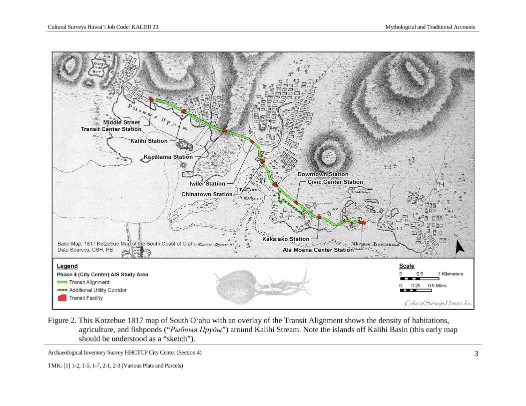
and there is very little documented information for the makai (seaward) areas. One story for the Kalihi Kai area provides an account of a shark guardian named Makali‘i, known to frequent the waters of Kalihi Kai, particularly near Kahaka‘aulana, the little islets off Sand Island (Oppenheimer 1976:15). These islets can be seen in an 1817 map of South O‘ahu (Figure 2) by Otto von Kotzebue, commander of the Russian ship Rurick, who had visited O‘ahu during the previous year.
Cultural Surveys Hawai‘i Job Code: KALIHI 23 Mythological and Traditional Accounts
Archaeological Inventory Survey HHCTCP City Center (Section 4) 2 TMK: [1] 1-2, 1-5, 1-7, 2-1, 2-3 (Various Plats and Parcels)
Figure 1. U.S. Geological Survey 7.5-Minute Series Topographic Map (1998), Honolulu Quadrangle, showing the boundaries of the ahupua‘a traversed by the study corridor
Cultural Surveys Hawai‘i Job Code: KALIHI 23 Mythological and Traditional Accounts
Archaeological Inventory Survey HHCTCP City Center (Section 4) 3 TMK: [1] 1-2, 1-5, 1-7, 2-1, 2-3 (Various Plats and Parcels)
Figure 2. This Kotzebue 1817 map of South O‘ahu with an overlay of the Transit Alignment shows the density of habitations, agriculture, and fishponds (“Рыбныя Пруды”) around Kalihi Stream. Note the islands off Kalihi Basin (this early map should be understood as a “sketch”).
Cultural Surveys Hawai‘i Job Code: KALIHI 23 Mythological and Traditional Accounts
Archaeological Inventory Survey HHCTCP City Center (Section 4) 4 TMK: [1] 1-2, 1-5, 1-7, 2-1, 2-3 (Various Plats and Parcels)
It was at Kahaka‘aulana that Makali‘i had his cave. Native Hawaiians (Kānaka maoli) who inhabited Mokauea in the 1970s noted that during the time of Makali‘i’s residence in his cave at Kahaka‘aulana, the sand patterns changed above his cave and that fishing was good for the akule (bigeye scad, Trachurops crumenophthalmus) (Oppenheimer 1976:15). Kahaka‘aulana was also noted as a place in Kalihi Harbor that was used as a passage for travelers going from Kou (adjacent to Nu‘uanu Stream and Honolulu Harbor) toward Pu‘uloa (Pearl Harbor).
Kahakaaulana: The narrow place in the Kalihi harbour inlet, and formerly the place where travelers used to swim across to Kalaekao or Puuloa to avoid the long detour by way of Moanalua [Sterling and Summers 1978: 322].
In Place Names of Hawai‘i, Kahaka‘aulana is listed as the old name for Sand Island (Pukui et al. 1974:62). As a literal translation, Kahaka‘aulana means “the floating swimmers pass by,” perhaps referring to the travelers who would make their way to or from Pu‘uloa by swimming through the channels of Moanalua, Kalihi, and Kapālama instead of walking. As an alternative, this may refer to the fishermen’s containers that float by as fishermen fished for crabs and seaweed (Pukui et al. 1974:62).
1.1.3 Kalihi Place Names The project corridor cuts a narrow swath across the lower portion of Kalihi (Kalihi Kai)
Ahupua‘a. A detailed study of historic maps (see particularly Figure 16 and Figure 18) and the land documents presented in Volume III could significantly augment the broad overview of place names in the vicinity of the project corridor in Kalihi Ahupua‘a, as summarized below:
Apili Fishpond Fishpond located at western tip of Alexander Adams LCA No. 803 ‘āpana 5 (see Figure 16 and Figure 18) and 250 m south of the Middle Street Transit Center. Apili was the closest of the many fishponds of coastal Kalihi to the project corridor (approx. 200 m makai). It appears an area inland of the fish pond was also known as Apili (see Figure 14).
Kaliawa Name of George Beckley’s (LCA 818) Kalihi farm and fishing grounds – (Kaliheawa) understood to lie northeast of the Middle Street Transit Center
(see Figure 14).
Kaluapulu Name associated with Hewahewa’s LCA 3237 Kalihi lands 300 m east of the mouth of Kalihi Stream (see Figure 14 and Volume III, LCA 3237).
Kaluaopalena Place name on Monsarrat map (see Figure 8) in the vicinity of Hewahewa’s “Kaluapulu” near the mouth of Kalihi Stream.
Kawaiholo Name associated with Alexander Adams LCA No. 803 ‘āpana 5 (elongated mauka/makai) traversed by the transit corridor 300 m northwest of Kalihi Station (Figure 8 and Figure 9).
Kiona Name associated with Nahinu’s LCA 10498 located 100 m mauka of the (Kionawawana) Middle Street Transit Center (Figure 9, see also Volume III, LCA 10498).
Mokauea Lands on the east edge of Alexander Adams LCA No. 803 ‘āpana 5. Seemingly a large ‘ili of land running mauka/makai, including the vicinity of Kalihi Station (see Figure 8) (and also Mokauea Island).
Cultural Surveys Hawai‘i Job Code: KALIHI 23 Mythological and Traditional Accounts
Archaeological Inventory Survey HHCTCP City Center (Section 4) 5 TMK: [1] 1-2, 1-5, 1-7, 2-1, 2-3 (Various Plats and Parcels)
Niau Lands on edge of Alexander Adams LCA No. 803 ‘āpana 5 (Figure 9, see also Volume III, LCA No. 803).
Pāhounui Name of coastal fishpond, but the place name may have included land immediately mauka (see Figure 8 and Figure 14).
‘Umi Name of Alexander Adams LCA No. 803 ‘āpana 3 located 100 m northeast of the Middle Street Transit Center (see Figure 8 and Figure 9). It appears the ‘Umi land area was bound on the west and north by a major curve of Kalihi Stream.
Wanana Name associated with Nahinu’s LCA 10498 (see Figure 9) located 100 m (Kionawawana) mauka of the Middle Street Transit Center (see Volume III, LCA 10498).
1.2 Kapālama The place name Kapālama is often understood to refer to an enclosure (pā) of lama wood that
surrounded the place of residence of high ranking ali‘i (chiefs) (Pukui et al. 1974:87). McAllister (1933:88) relates: “Kapalama is said to have obtained its name from an establishment in which the young ali‘i were kept just before pairing off for offspring.” This information probably came from Nathaniel Emerson, who translated David Malo’s “Ka Mo‘olelo Hawai‘i.” Emerson added many notes to his English translation, including the following:
Hoonoho ia means put in an establishment, placed under the care of a guardian or duenna [chaperone]. Such an establishment was surrounded by an enclosure, pa, made of the sacred lama . . . Hence this special care or guardianship was called palama. It is said that an establishment of this kind was anciently placed at that suburb of Honolulu which to this day bears the name of Ka-pa-lama [Malo 1951:139; note by N. B. Emerson].
Westervelt (1923:165) attributes the O‘ahu place name to a chiefess of O‘ahu who lived in that area. This chiefess was named Kapālama, the grandmother of Lepeamoa (Hawaiian for “cockscomb”). A chief of Kaua‘i, named Keāhua, traveled to O‘ahu to take Kauhao, the daughter of Kapālama, as his wife. He angered a kupua (supernatural being that can change form) called Akuapehuale (god of swollen billows [surges or waves]), who forced the couple to hide in the uplands of the Wailua River valley of Kaua‘i.
Keāhua’s daughter was born as an egg and was adopted by the chiefess Kapālama to raise on O‘ahu at her home, also named Kapālama. When the egg hatched, Lepeamoa was a bird with feathers all the colors of the rainbow. She became able to turn herself into a beautiful young woman wearing a feather lei. The girl was so beautiful that a rainbow was always present above her. The girl was guarded by her ancestress, Keaolewa (“the moving cloud”), who could also change forms between human and bird. The lower ridge separating Kapālama and Nu‘uanu (‘Ālewa Heights) may have been named for this ancestress.
The parents of Lepeamoa had another child, a son called Kau‘ilani, who was so strong that he was able to defeat the kupua who had threatened his parents. After Kau‘ilani’s victory over the kupua, he went to find his sister, searching for the rainbow sign of her presence. In her compound, he found Kapālama, who advised him to hide in Lepeamoa’s house, wait until she
Cultural Surveys Hawai‘i Job Code: KALIHI 23 Mythological and Traditional Accounts
Archaeological Inventory Survey HHCTCP City Center (Section 4) 6 TMK: [1] 1-2, 1-5, 1-7, 2-1, 2-3 (Various Plats and Parcels)
was asleep in her bird form, and catch and hold her until she acknowledged him as her brother. Her advice worked, and Lepeamoa lived with her brother thereafter (Westervelt 1923:164-184).
1.2.1 Fishponds of Kapālama and Iwilei The Iwilei Station is understood as at least partly within the former location of Kūwili
Fishpond (see Figure 12). According to Māhele documents, Kūwili Pond (Kūwili I), Kawa Pond, and the land surrounding them in the ‘ili of Kūwili were considered part of the ahupua‘a of Honolulu, not Kapālama. However, these ponds are surrounded by Kapālama lands and were an important resource for the inhabitants of the area.
Kūwili literally means “stand swirling” (Pukui et al. 1974:125). Kūwili [Kūwili I] Pond is mentioned in the legend of Kū‘ula, the fish god of Hawai‘i. As related by Moke Manu, ‘Ai‘ai, son of Kū‘ula, gave the sacred pā (fishhook), called Kahuai, to his son, Puniaiki, who used it to summon a school of aku (ocean bonito, Katsuwonus pelamys) in Honolulu Harbor. The aku “unprecedented in number, fairly leaped into the canoes . . . and the shore people shouted as the akus which filled the harbor swam toward the fishpond of Kuwili and on to the mouth of Leleo stream” (Manu 1998:247-248). No oral traditions, legends, or other ethnographic information have been found regarding Kawa Fishpond. The Hawaiian word “kawa” literally translates as a precipice or leaping place or the pool below a precipice into which swimmers leap (Pukui and Elbert 1986:139).
Three other ponds in the vicinity were Loko Kūwili II and Loko Kapukui in Kapālama and Loko Kealia in Iwilei. Pukui et al. (1974) do not give meanings for Loko Kapukui or Loko Kealia, but keālia is the Hawaiian word for salt bed, which may indicate that at least one of these ponds was used for salt collection.
1.2.2 Traditional Accounts of Battles at Niuhelewai Stream in Kapālama Two accounts of traditional Hawaiian warfare suggest mass killings in the vicinity of
“Niuhelewai,” which is the stream generally now known as Kapālama Canal (flowing past the Kapālama Transit Center). These slaughters may have occurred far from the project corridor.
1.2.2.1 Kahahawai‘a’s defeat of Kahāhana (A.D. 1780-1783) Niuhelewai Stream was the location for a famous battle between Kahahawa‘i, the war chief of
Kahekili, king of Maui, and the O‘ahu ruling chief Kahāhana. Fornander (1919:498) states in a footnote to a story that Niuhelewai was the name of the locality of the Pālama cane field between the fire and pumping stations. Ross Cordy (2002:19) places Kahāhana’s reign of O‘ahu around the year 1780 to his death in 1783 after this battle.
I ka wa e noho ana o Kahekili he ‘lii no Maui, a o Kahahana he ‘lii no Oahu nei iloko oia kau i holo mai ai o Kahahawai me na koa e kaua ia Oahu. Ma keia kaua ana ua hee a ua luku ia na kanaka Oahu, ma Niuhelewai, a ua hoi ka wai i uka o ka muliwai, no ka piha i na kanaka. Translation: When Kahekili was reigning as king of Maui, and Kahahana was king of Oahu, it was during this period that Kahahawai with a number of warriors came to make
Cultural Surveys Hawai‘i Job Code: KALIHI 23 Mythological and Traditional Accounts
Archaeological Inventory Survey HHCTCP City Center (Section 4) 7 TMK: [1] 1-2, 1-5, 1-7, 2-1, 2-3 (Various Plats and Parcels)
war on Oahu. In this battle the people of Oahu were defeated and slaughtered at Niuhelewai, and the waters of the stream were turned back, the stream being dammed by the corpses of the men (Fornander 1919:498-499).
1.2.2.2 The Rebellions of the ‘Ewa and Kona Chiefs (post 1783) After Kahāhana’s death, the chiefs of Maui took over O‘ahu. Some of the chiefs from the
O‘ahu districts of ‘Ewa and Kona conceived a plot to murder their new overlords, but the Maui chiefs were warned. Although the main backers of the plot were the chiefs of Waipi‘o and ‘Ewa, they were temporarily able to convince Kahekili that the conspiracy originated on Kaua‘i, thus the phrase, Waipi‘o kīmopō, “Waipi‘o of the secret rebellion” (Pukui 1983: #2918). Eventually the truth was revealed and:
A no kēia mea, ulu maila ke kaua kūloko o Kona me ‘Ewa, nā moku o O‘ahu i luku nui ‘ia; ua luku ‘ia nā moku o O‘ahu i luku nui ‘ia; ua luku ‘ia nā kāne, nā wāhine a me nā keiki, a ua pani kūmano ‘ia nā kahawai a me nā muliwai i nā heana o nā kānaka o Kona a me ‘Ewa. ‘O nā kahawai i ‘oi aku ka nui o nā heana, a ho‘i hou ka wai i uka, ‘o ia nō ‘o Makaho a me Niuhelewai ma Kona, a ‘o Kaho‘ā‘ia‘i ho‘i ko ‘Ewa. He kūmukena ka nui o nā mea he make, ke lilo ka wai i mea ‘awa-‘awa ke inu aku. Ua ‘ōlelo mai ho‘i ka po‘e ‘ike maka “O ka lolo ka mea i ‘awa-‘awa ai ‘o ka wai” (Kamakau 1996:91, Ka Nūpepa Kū‘oko‘a, March 30, 1867).
Translation:
. . . the districts of Kona and ‘Ewa were attacked, and men, women, and children were massacred, until the streams of Makaho and Niuhelewai in Kona [in Kapālama] and of Kahoa‘ai‘ai in ‘Ewa were choked with the bodies of the dead, and their waters became bitter to the taste, as eyewitnesses say, from the brains that turned the water bitter. All the Oahu chiefs were killed and the chiefesses tortured (Kamakau 1992:138).
1.2.3 Kapālama Place Names The project corridor cuts a narrow swath across the lower portion of Kapālama Ahupua‘a. A
detailed study of historic maps (see particularly Figure 12) and the land documents presented in Volume III significantly augment the broad overview of place names in the vicinity of the project corridor in Kapālama Ahupua‘a as summarized below:
Iwilei Famous as a former center of prostitution and the home of Sadie Thompson (Somerset Maugham’s character in the short story Rain); Lit. “collarbone or a unit of measurement” (Pukui et al. 1974:57) (see Figure 8 and Figure 12).
Kahololoa Coastal area on west side of mouth of Nu‘uanu Stream (see Figure 8).
Kalaepōhaku A higher, rocky area (“the stone promontory”) in southeast Kapālama.
Kanāueue Name of a fishpond near the site of the old O‘ahu Railway Station at Iwilei; Lit. “the rotating.” This name was used in a risqué song: “Aia i
Cultural Surveys Hawai‘i Job Code: KALIHI 23 Mythological and Traditional Accounts
Archaeological Inventory Survey HHCTCP City Center (Section 4) 8 TMK: [1] 1-2, 1-5, 1-7, 2-1, 2-3 (Various Plats and Parcels)
Kūwili ‘o Kanāueue, nāue a‘e kāua ‘eā i ka ‘ai ho‘opau: There at Stand Aswirl is Rotation, we rotate and eat everything up” (Pukui et al. 1974:84).
Kaukahōkū An ‘Ili of Kapālama near Dillingham Boulevard and Ala Kawa Street; Lit. “the stars have arisen” (Thrum 1922:640).
Kawa Name of large fishpond and surrounding area (see Figure 8 and Figure 12).
Kealia Name of fishpond and surrounding area near west side of the mouth of Nu‘uanu Stream.
Kumuhahani An ‘Ili of Kapālama makai of Dillingham Boulevard across from central Honolulu Community College; Lit. “just cause of pursuit” (Thrum 1922:655)
Kumupali An ‘Ili of Kapālama in Central Honolulu Community College; Lit. “cliff base” (Thrum 1922:654).
Kumuulu An ‘Ili of Kapālama mauka of Dillingham Boulevard and just east of Kapālama Canal; Lit. “breadfruit tree” (Thrum 1922:654).
Kūwili Name of large fishpond and surrounding area; Lit. “stand swirling” (Pukui et al. 1974:125) (see Figure 8 and Figure 12.
Niuhelewai Former name of stream (now Kapālama Canal; see Figure 16) and an adjacent area mentioned in two accounts of slaughter.
Poepoe; Kapoepoe An ‘Ili of Kapālama makai of Dillingham Boulevard and just east of the Kapālama Canal; Lit. “circular” (Thrum 1922:666).
Pulehu; Kapulehu An ‘Ili of Kapālama in southeast Honolulu Community College; Lit. “to roast on coals” (Thrum 1922:668).
1.3 Honolulu The area that today comprises the portion of Downtown Honolulu that surrounds Honolulu
Harbor was known to the Hawaiians as “Kou,” a center of population and activity, similar to Waikīkī, its preeminent neighbor to the southeast. Kou stretched from “Nu‘uanu to Alakea Streets and from Hotel Street to the sea” (McAllister 1933:80) and possessed shoreward fishponds and irrigated fields fed by streams descending from the Nu‘uanu and Pauoa Valleys (see Figure 2).
Kou was “noted for kōnane (pebble game, like checkers) and for ulu maika (bowling), and is said to be named for the executive officer (ilāmuku) of Chief Kākuhihewa of O‘ahu” (Pukui et al. 1974). Pukui (1983: saying # 1128) relates the poetical saying, Hui aka nā maka i Kou (“the faces will meet at Kou”) in reference to Kou as a place where chiefs gathered to play games and sport, and where the people gathered to watch them. In the accounts of the Pele and Hi‘iaka saga (Emerson 1915:168; Nogelmeier 2006:402-420), Hi‘iaka from Hawai‘i Island and Lohi‘au, chief of Kaua‘i, joined with Pele‘ula, chiefess of O‘ahu, for pleasure at Kou. This vignette probably
Cultural Surveys Hawai‘i Job Code: KALIHI 23 Mythological and Traditional Accounts
Archaeological Inventory Survey HHCTCP City Center (Section 4) 9 TMK: [1] 1-2, 1-5, 1-7, 2-1, 2-3 (Various Plats and Parcels)
was based on a long tradition of Kou as a royal center where the ali‘i [chiefly class] would meet and entertain.
1.3.1 Honolulu Place Names The HHCTCP City Center Section corridor cuts a narrow swath across the lower portion of
Honolulu Ahupua‘a. Much of the project corridor lies on reclaimed land that was open sea until near the end of the 1800s. Undoubtedly, many traditional place names were lost owing to early replacement with new place names (see “Nihoa” below) and Western street names. A detailed study of historic maps (see particularly Figure 22) and the land documents presented in Volume III could significantly augment the broad overview of place names in the vicinity of the project corridor in Honolulu Ahupua‘a as summarized below:
Honoka‘upu Former land section along the waterfront beyond the seaward end of Alakea Street, Downtown Honolulu; it was an old surfing area and one-time site of a coconut grove named for a chief. Lit. “the albatross bay” (Pukui et al. 1974:49) (see Figure 22).
Honuakaha Old section of Honolulu where there was a coconut grove and where Kīna‘u and Keōpūolani resided (Barrere 1957); particularly associated with a small pox hospital and an attendant cemetery circa 1853 (see Figure 22).
Ho‘okuku Liholiho Kamehameha resided there (Barrere 1957) (see Figure 22).
Kapu‘ukolo Old section of Honolulu bounded by Nu‘uanu Stream and Honolulu Harbor (Pukui et al. 1974:90) “where white men and such dwelt” (Barrere 1957) (see Figure 22).
Ke kai o Māmala The surf in the outer entrance of Honolulu Harbor named for the chiefess Māmala who loved to play kōnane, drink ‘awa, and ride the surf (Pukui et al. 1974:106).
Kou Old name until 1800 for Honolulu Harbor and vicinity, including the area from Nu‘uanu Avenue to Alakea Street and from Hotel Street to the sea, noted for kōnane (pebble game, like checkers) and ulu maika (bowling), and said to be named for the executive officer (ilāmuku) of Chief Kākuhihewa of O‘ahu. (Pukui et al. 1974:117-118).
Kuloloia Former beach extending from about the foot of Fort Street to Kaka‘ako, Honolulu (Pukui et al. 1974:175; ‘Ī‘ī 1959:65, 90) (see Figure 22). “Ku-lolo-ia was a beautiful sand beach below Hale-kauila St., extending as far as the present Bishop Street. A big pond also named Ku-lolo-ia adjoined Hale-kauila St. at a point above the present Honolulu Iron Works at Kākā-‘ako. A stream from it flowed down right where the old Inter-Island dry-dock was” (Kekahuna 1958:5). This place name is refered to in LCA records associated S. Kaunuohua, who had ties to the Kamehameha royal line (LCA 738, refer to Volume III), LCA records associated with M. Kekauonohi (LCA 191, ‘Āpana 3, refer to Volume III), and Native Hawaiian chants, for example: “He e-a wale no ke kai o Kuloloia-e,” from
Cultural Surveys Hawai‘i Job Code: KALIHI 23 Mythological and Traditional Accounts
Archaeological Inventory Survey HHCTCP City Center (Section 4) 10 TMK: [1] 1-2, 1-5, 1-7, 2-1, 2-3 (Various Plats and Parcels)
He Kanikau No Ka Moi Iolani Kamehameha IV—B. Pauahi, dirge (kanikau) Haleakala, Honoulu, Jan. 19, 1864; Ka Nupepa Kuokoa, Janary 23, 1964, and “Mai ka pa-ana laau mua ana i ka wai o Keomo a ka hui lokahi ana a na mokupuni i ke Kai o Ku-loloia” –D. Kalākaua, Dec. 28, 1878 campaign broadside against W. Lunalilo—from the T.C. Heuck Collection.
Moku‘aikaua Name of residence of Kalanimōkū, south of Fort Street and approx. 120 m north of the Downtown Station (also called “Papakenene”), “the land long bore the name of Moku‘aikaua” (Barrere 1957) (see Figure 22 for location of residence of Kalanimōkū).
Nihoa Waterfront area in Downtown Honolulu formerly owned by Ka‘ahumanu and named by her in honor of her visit to Nihoa Island (‘Ī‘ī 1959:166). Bareere states that “on the shore at Nihoa …was a shipyard where foreign style vessels were being made by Hawaiians under the tutelage of whites” (Barrere 1957) (see Figure 22).
Pākākā Old canoe landing, Honolulu Harbor. Wharf built in 1827 at the same site. Lit. “to skim” (as stones over water) (Pukui et al. 1974:175) (see Figure 22).
Pāpū Fort formerly at the foot of Fort Street built in 1816 and destroyed in 1857 (Pukui et al. 1974:30).
1.4 Kaka‘ako and Vicinity
1.4.1 Overview The southeastern portion of the study area largely lies within the urban district currently
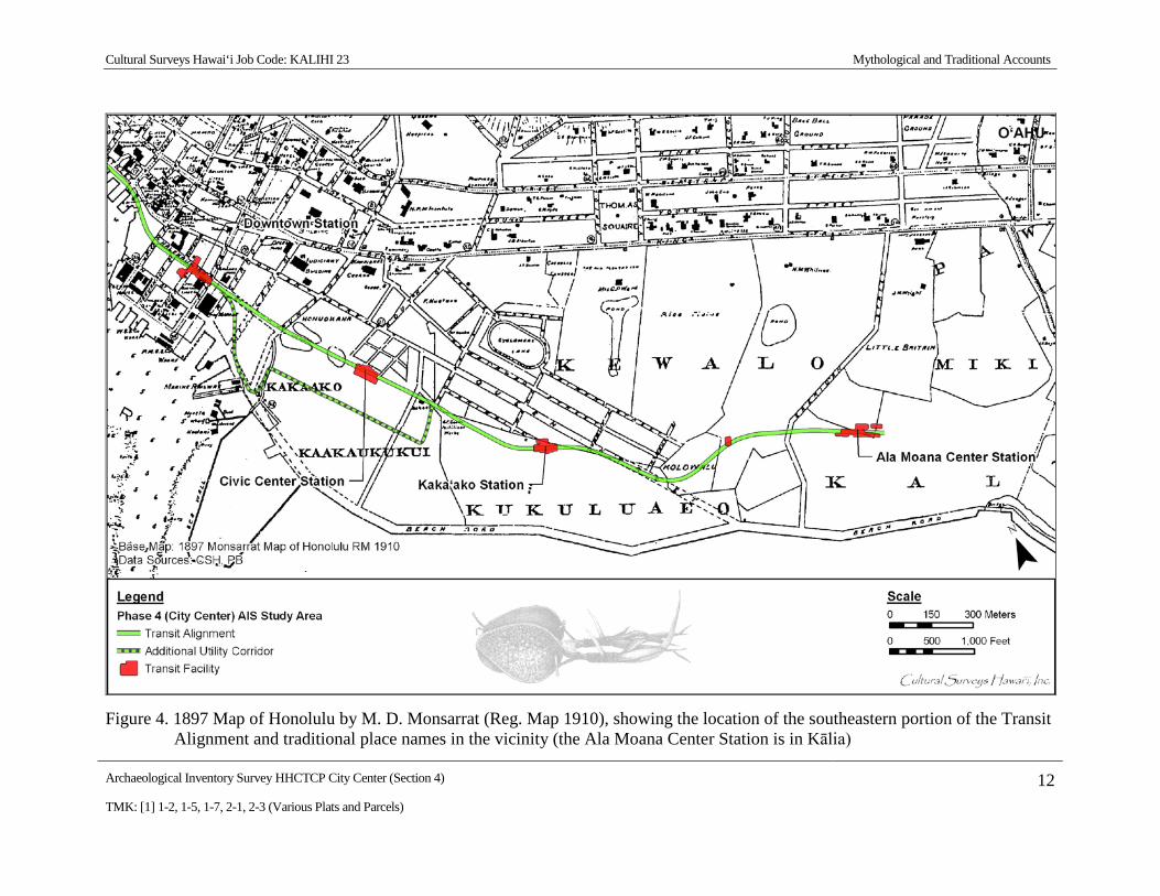
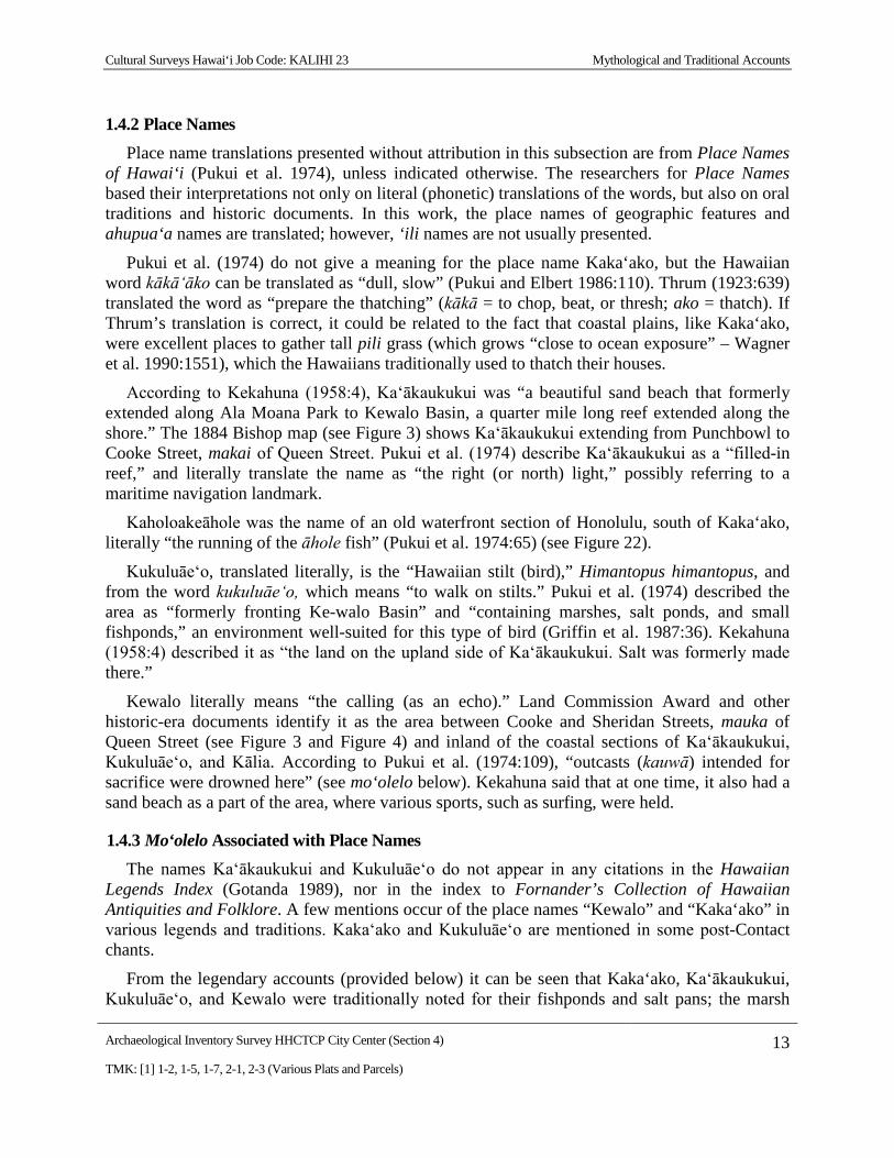
known as “Kaka‘ako.” Late nineteenth-century maps indicate that this area was traditionally broken down into several traditional land units (‘ili) known as Ka‘ākaukukui, Kukuluāe‘o, and Kewalo (Figure 3 and Figure 4).
The original location and extent of an area called Kaka‘ako is discussed by the knowledgeable Native Hawaiian Henry Kekahuna (1958:4), who was born on Hawai‘i Island in 1891 but was a long-time resident of O‘ahu. He placed it “on the ‘Ewa side of Ke-walo to Ku-lolo-ia Stream, where the Honolulu Iron Works and Fort Armstrong are now.” Kekahuna (1958:4) further noted that in Kaka‘ako “there were formerly scattered dunes of white sand there . . . Gilbert Islanders (Kilipaki) squated there, and made a living by fishing, collecting coral for curios, and catching octopus.” Kekahuna’s description refers to the area that now includes One Waterfront Plaza (between South and Punchbowl Streets). The 1884 map of the “Kewalo” section of Honolulu by S. E. Bishop (Figure 3) does not show an area named Kaka‘ako at all. On an 1897 map of Honolulu by M. D. Monsarrat, the area near the wharfs is labeled Kaka‘ako (see Figure 4).
Until well into the twentieth century (see Figure 49), Kaka‘ako and the surrounding area were sometimes referred to as something of a wasteland, or empty space, between the better-known locations of Kou (modern-day Honolulu) and Waikīkī. This area was known traditionally for its low-lying marshes, fishponds, and salt making.
Cultural Surveys Hawai‘i Job Code: KALIHI 23 Mythological and Traditional Accounts
Archaeological Inventory Survey HHCTCP City Center (Section 4) 11 TMK: [1] 1-2, 1-5, 1-7, 2-1, 2-3 (Various Plats and Parcels)
Figure 3. 1884 Map of Honolulu, Kewalo Section, by S. E. Bishop (Reg. Map 1090), showing the location of the Transit Alignment and traditional place names in the vicinity
Cultural Surveys Hawai‘i Job Code: KALIHI 23 Mythological and Traditional Accounts
Archaeological Inventory Survey HHCTCP City Center (Section 4) 12 TMK: [1] 1-2, 1-5, 1-7, 2-1, 2-3 (Various Plats and Parcels)
Figure 4. 1897 Map of Honolulu by M. D. Monsarrat (Reg. Map 1910), showing the location of the southeastern portion of the Transit Alignment and traditional place names in the vicinity (the Ala Moana Center Station is in Kālia)
Cultural Surveys Hawai‘i Job Code: KALIHI 23 Mythological and Traditional Accounts
Archaeological Inventory Survey HHCTCP City Center (Section 4) 13 TMK: [1] 1-2, 1-5, 1-7, 2-1, 2-3 (Various Plats and Parcels)
1.4.2 Place Names Place name translations presented without attribution in this subsection are from Place Names
of Hawai‘i (Pukui et al. 1974), unless indicated otherwise. The researchers for Place Names based their interpretations not only on literal (phonetic) translations of the words, but also on oral traditions and historic documents. In this work, the place names of geographic features and ahupua‘a names are translated; however, ‘ili names are not usually presented.
Pukui et al. (1974) do not give a meaning for the place name Kaka‘ako, but the Hawaiian word kākā‘āko can be translated as “dull, slow” (Pukui and Elbert 1986:110). Thrum (1923:639) translated the word as “prepare the thatching” (kākā = to chop, beat, or thresh; ako = thatch). If Thrum’s translation is correct, it could be related to the fact that coastal plains, like Kaka‘ako, were excellent places to gather tall pili grass (which grows “close to ocean exposure” – Wagner et al. 1990:1551), which the Hawaiians traditionally used to thatch their houses.
According to Kekahuna (1958:4), Ka‘ākaukukui was “a beautiful sand beach that formerly extended along Ala Moana Park to Kewalo Basin, a quarter mile long reef extended along the shore.” The 1884 Bishop map (see Figure 3) shows Ka‘ākaukukui extending from Punchbowl to Cooke Street, makai of Queen Street. Pukui et al. (1974) describe Ka‘ākaukukui as a “filled-in reef,” and literally translate the name as “the right (or north) light,” possibly referring to a maritime navigation landmark.
Kaholoakeāhole was the name of an old waterfront section of Honolulu, south of Kaka‘ako, literally “the running of the āhole fish” (Pukui et al. 1974:65) (see Figure 22).
Kukuluāe‘o, translated literally, is the “Hawaiian stilt (bird),” Himantopus himantopus, and from the word kukuluāe‘o, which means “to walk on stilts.” Pukui et al. (1974) described the area as “formerly fronting Ke-walo Basin” and “containing marshes, salt ponds, and small fishponds,” an environment well-suited for this type of bird (Griffin et al. 1987:36). Kekahuna (1958:4) described it as “the land on the upland side of Ka‘ākaukukui. Salt was formerly made there.”
Kewalo literally means “the calling (as an echo).” Land Commission Award and other historic-era documents identify it as the area between Cooke and Sheridan Streets, mauka of Queen Street (see Figure 3 and Figure 4) and inland of the coastal sections of Ka‘ākaukukui, Kukuluāe‘o, and Kālia. According to Pukui et al. (1974:109), “outcasts (kauwā) intended for sacrifice were drowned here” (see mo‘olelo below). Kekahuna said that at one time, it also had a sand beach as a part of the area, where various sports, such as surfing, were held.
1.4.3 Mo‘olelo Associated with Place Names The names Ka‘ākaukukui and Kukuluāe‘o do not appear in any citations in the Hawaiian
Legends Index (Gotanda 1989), nor in the index to Fornander’s Collection of Hawaiian Antiquities and Folklore. A few mentions occur of the place names “Kewalo” and “Kaka‘ako” in various legends and traditions. Kaka‘ako and Kukuluāe‘o are mentioned in some post-Contact chants.
From the legendary accounts (provided below) it can be seen that Kaka‘ako, Ka‘ākaukukui, Kukuluāe‘o, and Kewalo were traditionally noted for their fishponds and salt pans; the marsh
Cultural Surveys Hawai‘i Job Code: KALIHI 23 Mythological and Traditional Accounts
Archaeological Inventory Survey HHCTCP City Center (Section 4) 14 TMK: [1] 1-2, 1-5, 1-7, 2-1, 2-3 (Various Plats and Parcels)
lands where pili grass and other plants could be collected; ceremonial sites such as Pu‘ukea Heiau, Kewalo Spring, and Kawailumalumai Pond, at which sacrifices were made (see discussion below in Section 1.4.3.2); and their trails (see Figure 22) that allowed transport between the more populated areas of Waikīkī and Honolulu. Important chiefs were born in the area and conducted religious rites, and maka‘āinana (commoners) traveled to the area to procure food and other resources. Some maka‘āinana probably also lived in the area, with a higher likelihood adjacent to ponds and trails.
1.4.3.1 Kaka‘ako Kaka‘ako is mentioned in Thrum’s version of the legend of Kū‘ula, the god presiding over the
fish, and his son ‘Ai‘ai, who was the first to teach the Hawaiians how to make various fishing lines and nets, the first to set up a ko‘a kū‘ula, a rock shrine (first in Hāna Maui) on which the fishermen would place their first catch as an offering to Kū‘ula, and the first to set up ko‘a ia, fishing stations where certain fish were known to gather. Leaving his birthplace in Maui, ‘Ai‘ai traveled around the islands, establishing ko‘a kū‘ula and ko‘a ia. On O‘ahu, he landed first at Makapu‘u in Ko‘olaupoko then traveled clockwise around the island.
Aiai came to Kalia [Waikīkī] and so on to Kakaako. Here he was befriended by a man named Apua, with whom he remained several days, observing and listening to the murmurs of the chief named Kou. This chief was a skillful aku [bonito (Katsuwonus pelamis)] fisherman, his grounds being outside of Mamala until you came to Moanalua. There was none so skilled as he, and generous withal, giving akus to the people throughout the district [Thrum 1998:242].
1.4.3.2 Kewalo Kewalo was famous for freshwater springs, as seen in the proverb “Ka wai huahua‘i o
Kewalo,” which translates as “the bubbling water of Kewalo.” Two springs are mentioned in a traditional story of the Waters of Ha‘o. This legend tells of two children of the chief Ha‘o who ran away from their cruel stepmother. They stayed a time with the caretakers of Kewalo Spring, which may have been located close to the trail that connected Waikīkī and Honolulu. The children then left when they heard that the chiefess had sent men to look for them. The two children followed the moonlit trail across the plain toward Kou (Honolulu), but finally collapsed from weariness and thirst. In a dream, the boy’s mother told him to pull up a plant close to his feet. When he did, he found a spring under the plant, which was called the Water of Ha‘o, or Kawaiaha‘o. This spring was located at the western end of the trail, near Kawaiaha‘o Church in Kaka‘ako (Pukui 1988:87-89).
Kewalo also once had a famous fishpond that was used to drown members of a pariah caste (kauwā) or kapu (taboo) breakers as the first step in a sacrificial ritual known as Kānāwai Kaihehe‘e (Kamakau 1991:6) or Ke-kai-he‘ehe‘e, which translates as “sea sliding along,” suggesting the victims were slid under the sea (Westervelt 1963:16). Kewalo is described as:
A fishpond and surrounding land on the plains below King Street, and beyond. It contains a spring rather famous in the times previous to the conversion to Christianity, as the place where victims designed for the Heiau of Kanelaau on Punchbowl slopes, was first drowned. The priest holding the victim’s head under
Cultural Surveys Hawai‘i Job Code: KALIHI 23 Mythological and Traditional Accounts
Archaeological Inventory Survey HHCTCP City Center (Section 4) 15 TMK: [1] 1-2, 1-5, 1-7, 2-1, 2-3 (Various Plats and Parcels)
water would say to her or him on any signs of struggling, “Moe malie i ke kai o ko haku.” “Lie still in the waters of your superiors.” From this it was called Kawailumalumai, “Drowning waters” [Sterling and Summers 1978:292].
Kewalo is mentioned in legend as a place resorted to for thatch. A man named Kapoi “went to the Kewalo marsh near the beach, where tall pili grass was growing, to get a bundle of the grass to use as thatching.” (Westervelt 1963:133). While there, Kapoi found seven owl eggs and took them home to cook for his supper. An owl perched on the fence surrounding his house cried out “O Kapoi, give me my eggs!” After several such pleas, Kapoi eventually returned the eggs. In return, the owl became his ‘aumakua (family god) and instructed him to build a heiau (pre-Christian place of worship) named Mānoa. Kapoi built the heiau, placed some bananas on the altar as a sacrifice, and set the kapu days for its dedication. The king of O‘ahu, Kākuhihewa, who was building his own heiau in Waikīkī, had made a law that if any man among his people erected a heiau and set the kapu before him, that man should die. Kapoi was seized and taken to the heiau of Kūpalaha, at Waikīkī. Kapoi’s ‘aumakua owl asked for aid from the king of the owls at Owl’s Hill (Pu‘u Pu‘eo) in Mānoa, who gathered all of the owls of the islands. They flew to Kūpalaha and battled the king’s men, who finally surrendered. From this time, the owl was considered a powerful akua (god). The battle area was known as Kukaeunahio-ka-pueo, which means “the confused noise of owls rising in masses” (Westervelt 1963:135-137; Thrum 1998:200-202).
Kewalo was the birthplace of the great chief Hua-nui-ka-la-la‘ila‘i, as mentioned in this mele (story) chanted by Kamakau (1991:24):
‘O Hua-a-Kamapau ke ‘li‘i Hua-a-Kamapau the chief O Honolulu o Waikīkī O Honolulu, of Waikīkī I hanau no la i kahua la i Kewalo, Was born at Kewalo, ‘O Kālia la kahua Kālia was the place [the site] O Makiki la ke ēwe, At Makiki the placenta, I Kānelā‘au i Kahehuna ke piko, At Kānelā‘au at Kahehuna the navel cord, I Kalo i Pauoa ka ‘a‘a; At Kalo at Pauoa the caul; I uka i Kaho‘iwai i Upland at Kaho‘iwai, at Kanaloaho‘okau . . . Kanaloaho‘okau. . .
The chief Hua was famous for his love of cultivation and his care for the people. His heiau, called Pu‘ukea, was in Kukuluāe‘o in Honolulu (exact location unknown); it is mentioned in a traditional wānana (prophecy) recorded by Kamakau (1991:24-25).
[Ka makaua ua kahi o ‘Ewa] [The increasing “first rain” of ‘Ewa] Ua puni ka i‘a o Mokumoa, Overcomes the fish of Mokumoa, Ua kau i‘a ka nene; Washes up fish to the nene plants; Ua ha‘a kalo ha‘a nu; Lays low the taro as it patters down; Ha‘a ka i‘a o kewalo, Lays low the fish of Kewalo, Ha‘a na ‘ualu o Pahua, Lays low the sweet potatoes of Pahua, Ha‘a ka mahiki i Pu‘ukea, Lays low the mahiki grass at Pu‘ukea, Ha‘a ka unuunu i Pele‘ula, Lays low the growing things at Pele‘ula Ha‘a Makaaho i ke ala. Lays low Makaaho [Makāho] in its path E Kū e, ma ke kaha ka ua, e Kū, O Kū, the rain goes along the edge [of the
Cultural Surveys Hawai‘i Job Code: KALIHI 23 Mythological and Traditional Accounts
Archaeological Inventory Survey HHCTCP City Center (Section 4) 16 TMK: [1] 1-2, 1-5, 1-7, 2-1, 2-3 (Various Plats and Parcels)
island], O Kū [I ‘ai ‘na ka i‘a o Maunalua] . . . [Eating” the fish of Maunalua] . . .
The chant above mentions the mahiki grass of Pu‘ukea Heiau. The Hawaiian term mahiki means “to peel off” (Andrews 2003:369). The word was also used to describe a rite to exorcise an evil spirit, as the skilled kahuna (priest) “peeled” the malicious spirit from the afflicted (Pukui et al. 1972:75-77). Used in the ritual was a shrimp called mahiki or a native grass called mahiki (Pukui and Elbert 1986:202). Mahiki, (also called ‘aki‘aki, is a tufted rush (Sporobolos sp.) found near the seashore. The ethnologist, Mary Pukui, states that even during her youth, parents put “tī leaves, or hala, or ‘aki‘aki grass, in a little sea-salt water and [would] have the child drink it” (Pukui et al. 1972:163) to rid them of badly behaving spirits. The use of this grass in a ritual may explain its association with a ceremonial heiau, or it may simply be that the Kukuluāe‘o coast was a good habitat and thus a favored place for healers to collect this type of grass.
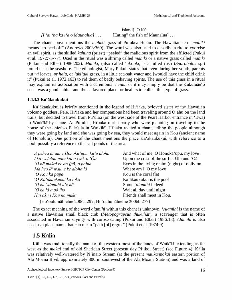
1.4.3.3 Ka‘ākaukukui Ka‘ākaukukui is briefly mentioned in the legend of Hi‘iaka, beloved sister of the Hawaiian
volcano goddess, Pele. Hi‘iaka and her companions had been traveling around O‘ahu on the land trails, but decided to travel from Pu‘uloa (on the west side of the Pearl Harbor entrance in ‘Ewa) to Waikīkī by canoe. At Pu‘uloa, Hi‘iaka met a party who were planning on traveling to the house of the chiefess Pele‘ula in Waikīkī. Hi‘iaka recited a chant, telling the people although they were going by land and she was going by sea, they would meet again in Kou (ancient name of Honolulu). One portion of the chant mentions the place Ka‘ākaukukui, with reference to a pool, possibly a reference to the salt ponds of the area:
A pehea lā au, e Honoka‘upu, ku‘u aloha And what of me, O Honoka‘upu, my love I ka welelau nalu kai o Uhi, o ‘Ōa Upon the crest of the surf at Uhi and ‘Oā ‘O nā makai ke ao (pō) o poina Eyes in the living realm (night) of oblivion Ma hea lā wau, e ke aloha lā Where am I, O my love ‘O Kou ka papa Kou is the coral flat ‘O Ka‘ākaukukui ka loko Ka‘ākaukukui is the pool ‘O ka ‘alamihi a‘e nō Some ‘alamihi indeed ‘O ka lā a pō iho Wait all day until night Hui aku i Kou nā maka. Friends shall meet in Kou. (Ho‘oulumāhiehie 2006a:297; Ho‘oulumāhiehie 2006b:277)
The exact meaning of the word alamihi within this chant is unknown. ‘Alamihi is the name of a native Hawaiian small black crab (Metopograpsus thukuhar), a scavenger that is often associated in Hawaiian sayings with corpse eating (Pukui and Elbert 1986:18). Alamihi is also used as a place name that can mean “path [of] regret” (Pukui et al. 1974:9).
1.5 Kālia Kālia was traditionally the name of the western-most of the lands of Waikīkī extending as far
west as the makai end of old Sheridan Street (present day Pi‘ikoi Street) (see Figure 4). Kālia was relatively well-watered by Pi‘inaio Stream (at the present mauka/makai eastern portion of Ala Moana Blvd. approximately 800 m southwest of the Ala Moana Station) and was a land of
Cultural Surveys Hawai‘i Job Code: KALIHI 17 Mythological and Traditional Accounts
Archaeological Inventory Survey HHCTCP City Center (Section 4) 17 TMK: [1] 1-2, 1-5, 1-7, 2-1, 2-3 (Various Plats and Parcels)
lo‘i kalo, fish ponds and denser habitations than the bleaker lands of Kewalo and Kukuluāe‘o to the west. According to Martha Beckwith (1970), by the end of the fourteenth century, Waikīkī had become "the ruling seat of the chiefs of O‘ahu." George Kanahele relates that the ruling chief Ma‘ilikūkāhi made the decision:
..to move his capital from ‘Ewa to Waikīkī around 1400. As a result, for the next 400 years – and until Honolulu became the trading center of the Kingdom of Hawai‘i in the early 1800s – Waikīkī remained one of the main political and economic centers of O‘ahu. (Kanahele 1995:62)
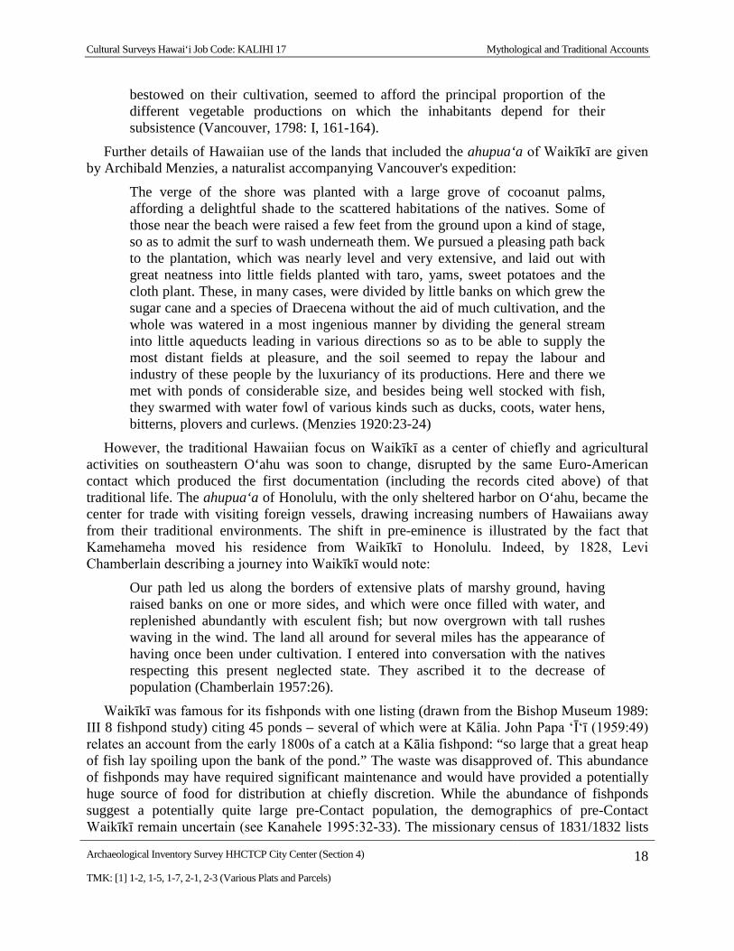
Chiefly residences, however, were only one element of a complex of features which were able to sustain a large population that characterized Waikīkī in late pre-Contact times. Beginning in the fifteenth century, a vast system of irrigated taro fields was constructed, extending across the littoral plain from Waikīkī to lower Mānoa and Pālolo valleys. This field system - an impressive feat of engineering, the design of which is traditionally attributed to the chief Kalamakua - took advantage of streams descending from Makiki, Mānoa, and Pālolo valleys, which also provided ample fresh water for the Hawaiians living in the ahupua‘a. Water was also available from springs in nearby Mō‘ili‘ili and Punahou. Closer to the Waikīkī shoreline, coconut groves and fishponds dotted the landscape. A sizeable population developed amidst this Hawaiian-engineered abundance. Captain George Vancouver, arriving at "Whyteete" in 1792, captured something of this profusion in his journals:
On shores, the villages appeared numerous, large, and in good repair; and the surrounding country pleasingly interspersed with deep, though not extensive valleys; which, with the plains near the sea-side, presented a high degree of cultivation and fertility.
[Our] guides led us to the northward through the village, to an exceedingly well-made causeway, about twelve feet broad, with a ditch on each side.
This opened our view to a spacious plain, which, in the immediate vicinity of the village, had the appearance of the open common fields in England; but, on advancing, the major part appeared to be divided into fields of irregular shape and figure, which were separated from each other by low stone walls, and were in a very high state of cultivation. These several portions of land were planted with the eddo or taro root, in different stages of inundation; none being perfectly dry, and some from three to six or seven inches under water. The causeway led us near a mile from the beach, at the end of which was the water we were in quest of. It was a rivulet five or six feet wide, and about two or three feet deep, well banked up, and nearly motionless; some small rills only, finding a passage through the dams that checked the sluggish stream, by which a constant supply was afforded to the taro plantations.
[We] found the plain in a high state of cultivation, mostly under immediate crops of taro; and abounding with a variety of wild fowl, chiefly of the duck kind...The sides of the hills, which were at some distance, seemed rocky and barren; the intermediate vallies, which were all inhabited, produced some large trees, and made a pleasing appearance. The plain, however, if we may judge from the labour
Cultural Surveys Hawai‘i Job Code: KALIHI 17 Mythological and Traditional Accounts
Archaeological Inventory Survey HHCTCP City Center (Section 4) 18 TMK: [1] 1-2, 1-5, 1-7, 2-1, 2-3 (Various Plats and Parcels)
bestowed on their cultivation, seemed to afford the principal proportion of the different vegetable productions on which the inhabitants depend for their subsistence (Vancouver, 1798: I, 161-164).
Further details of Hawaiian use of the lands that included the ahupua‘a of Waikīkī are given by Archibald Menzies, a naturalist accompanying Vancouver's expedition:
The verge of the shore was planted with a large grove of cocoanut palms, affording a delightful shade to the scattered habitations of the natives. Some of those near the beach were raised a few feet from the ground upon a kind of stage, so as to admit the surf to wash underneath them. We pursued a pleasing path back to the plantation, which was nearly level and very extensive, and laid out with great neatness into little fields planted with taro, yams, sweet potatoes and the cloth plant. These, in many cases, were divided by little banks on which grew the sugar cane and a species of Draecena without the aid of much cultivation, and the whole was watered in a most ingenious manner by dividing the general stream into little aqueducts leading in various directions so as to be able to supply the most distant fields at pleasure, and the soil seemed to repay the labour and industry of these people by the luxuriancy of its productions. Here and there we met with ponds of considerable size, and besides being well stocked with fish, they swarmed with water fowl of various kinds such as ducks, coots, water hens, bitterns, plovers and curlews. (Menzies 1920:23-24)
However, the traditional Hawaiian focus on Waikīkī as a center of chiefly and agricultural activities on southeastern O‘ahu was soon to change, disrupted by the same Euro-American contact which produced the first documentation (including the records cited above) of that traditional life. The ahupua‘a of Honolulu, with the only sheltered harbor on O‘ahu, became the center for trade with visiting foreign vessels, drawing increasing numbers of Hawaiians away from their traditional environments. The shift in pre-eminence is illustrated by the fact that Kamehameha moved his residence from Waikīkī to Honolulu. Indeed, by 1828, Levi Chamberlain describing a journey into Waikīkī would note:
Our path led us along the borders of extensive plats of marshy ground, having raised banks on one or more sides, and which were once filled with water, and replenished abundantly with esculent fish; but now overgrown with tall rushes waving in the wind. The land all around for several miles has the appearance of having once been under cultivation. I entered into conversation with the natives respecting this present neglected state. They ascribed it to the decrease of population (Chamberlain 1957:26).
Waikīkī was famous for its fishponds with one listing (drawn from the Bishop Museum 1989: III 8 fishpond study) citing 45 ponds – several of which were at Kālia. John Papa ‘Ī‘ī (1959:49) relates an account from the early 1800s of a catch at a Kālia fishpond: “so large that a great heap of fish lay spoiling upon the bank of the pond.” The waste was disapproved of. This abundance of fishponds may have required significant maintenance and would have provided a potentially huge source of food for distribution at chiefly discretion. While the abundance of fishponds suggest a potentially quite large pre-Contact population, the demographics of pre-Contact Waikīkī remain uncertain (see Kanahele 1995:32-33). The missionary census of 1831/1832 lists
Cultural Surveys Hawai‘i Job Code: KALIHI 17 Mythological and Traditional Accounts
Archaeological Inventory Survey HHCTCP City Center (Section 4) 19 TMK: [1] 1-2, 1-5, 1-7, 2-1, 2-3 (Various Plats and Parcels)
a relatively large population for “Waikiki” of 2,571 (Schmitt 1973:19), but this appears to include all land between Honolulu and Waimanalo (including, for example, Mānoa and Pālolo), and the population of Kālia remains uncertain.
Other than the names of Kālia, Pi‘inaio, and the fishponds, we know of no other place names in the immediate vicinity.