Page 1
1
Version 8/08rev
ENVIRONMENTAL ASSESSMENT WORKSHEET
Note to preparers: This form and EAW Guidelines are available at the Environmental Quality
Board’s website at: EQB Website: http://www.eqb.state.mn.us/EnvRevGuidanceDocuments.htm. The
Environmental Assessment Worksheet provides information about a project that may have the potential
for significant environmental effects. The EAW is prepared by the Responsible Governmental Unit or its
agents to determine whether an Environmental Impact Statement should be prepared. The project
proposer must supply any reasonably accessible data for — but should not complete — the final
worksheet. The complete question as well as the answer must be included if the EAW is prepared
electronically.
Note to reviewers: Comments must be submitted to the RGU during the 30-day comment period
following notice of the EAW in the EQB Monitor. Comments should address the accuracy and
completeness of information, potential impacts that warrant further investigation and the need for an EIS.
1. Project title: Fargo-Moorhead Flood Risk Management Project
2. Proposer:
Flood Diversion Board of Authority
Robert Zimmerman
City Engineer
City of Moorhead
PO Box 779
Moorhead, MN 56561-0779
(218) 299-5393
[email protected]
3. RGU
Stuart Arkley
EIS Project Manager
Minnesota DNR
500 Lafayette Road
St. Paul, MN 55155
(651) 259-5089
[email protected]
4. Reason for EAW Preparation
☒EIS Scoping ☐Mandatory EAW ☐Citizen Petition ☐Proposer Volunteered
If EAW or EIS is mandatory give EQB rule category subpart number and
subpart name:
Mandatory EIS 4410.4400, subpart 18, Construction of a Class I dam. The information contained in this
Scoping Environmental Assessment Worksheet (EAW) is supplemented by the Final Feasibility Report
and Environmental Impact Statement, Fargo-Moorhead Metropolitan Area Flood Risk Management, July
2011, U.S. Army Corps of Engineers (hereafter referred to as the FFREIS).
5. Project location
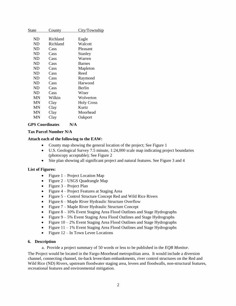
The Fargo-Moorhead Flood Risk Management Project (Project) would be located in Cass County, North
Dakota and Clay County, Minnesota with some impacts in Richland County, North Dakota and Wilkin
County, Minnesota. See attached maps (Figures 1-4) for Project feature locations. The Project’s
construction design features include, but are not limited to, a 30-mile long diversion channel, a 6-mile
long connecting channel, 12 miles of tie-back embankments, 4 miles of overflow embankment,
levee/floodwall features in Fargo, North Dakota and Moorhead, Minnesota. Operation of the constructed
features would raise flood stages on approximately 33,000-acres within a 60-square mile (38,400-acre)
staging area. The Project features and affected areas are located within the following townships:
Page 2
2
State County City/Township
ND Richland Eagle
ND Richland Walcott
ND Cass Pleasant
ND Cass Stanley
ND Cass Warren
ND Cass Barnes
ND Cass Mapleton
ND Cass Reed
ND Cass Raymond
ND Cass Harwood
ND Cass Berlin
ND Cass Wiser
MN Wilkin Wolverton
MN Clay Holy Cross
MN Clay Kurtz
MN Clay Moorhead
MN Clay Oakport
GPS Coordinates N/A
Tax Parcel Number N/A
Attach each of the following to the EAW:
County map showing the general location of the project; See Figure 1
U.S. Geological Survey 7.5 minute, 1:24,000 scale map indicating project boundaries
(photocopy acceptable); See Figure 2
Site plan showing all significant project and natural features. See Figure 3 and 4
List of Figures:
Figure 1 – Project Location Map
Figure 2 – USGS Quadrangle Map
Figure 3 – Project Plan
Figure 4 – Project Features at Staging Area
Figure 5 – Control Structure Concept Red and Wild Rice Rivers
Figure 6 – Maple River Hydraulic Structure Overflow
Figure 7 – Maple River Hydraulic Structure Concept
Figure 8 – 10% Event Staging Area Flood Outlines and Stage Hydrographs
Figure 9 – 5% Event Staging Area Flood Outlines and Stage Hydrographs
Figure 10 – 2% Event Staging Area Flood Outlines and Stage Hydrographs
Figure 11 – 1% Event Staging Area Flood Outlines and Stage Hydrographs
Figure 12 – In Town Levee Locations
6. Description
a. Provide a project summary of 50 words or less to be published in the EQB Monitor.
The Project would be located in the Fargo-Moorhead metropolitan area. It would include a diversion
channel, connecting channel, tie-back levee/dam embankments, river control structures on the Red and
Wild Rice (ND) Rivers, upstream floodwater staging area, levees and floodwalls, non-structural features,
recreational features and environmental mitigation.
Page 3
3
b. Give a complete description of the proposed project and related new construction. Attach
additional sheets as necessary. Emphasize construction, operation methods and features that will
cause physical manipulation of the environment or will produce wastes. Include modifications to
existing equipment or industrial processes and significant demolition, removal or remodeling of
existing structures. Indicate the timing and duration of construction activities.
This Project would be federally-sponsored and would be designed and constructed to Federal standards by
the U.S. Army Corps of Engineers (USACE). The Project would be owned and operated by a local
government unit or group of local government units anticipated to be under a joint powers agreement.
The Project consists of a diversion channel system including, but not limited to, excavated channels, a
channel inlet control structure, tie-back levee/dam embankments, river control structures on the Red and
Wild Rice (ND) Rivers, an upstream floodwater staging area (staging area), hydraulic structures on
tributaries, levees and floodwalls in the Fargo Moorhead metro area, non-structural features (such as buy-
out, relocation, or raising individual structures), recreation features (such as multipurpose trails), and
environmental mitigation projects located inside and outside the Project area.
When operated, the Project would divert a portion of the Red River flow upstream of the Fargo-Moorhead
Metropolitan Area (metropolitan area), intercept flow at the Wild Rice, Sheyenne, Maple, Lower Rush
and Rush Rivers, and return it to the Red River downstream of the metropolitan area. The Project would
minimize the need for emergency flood-fighting up to a 1-percent chance (100-year) flood event on the
Red River in the metropolitan area, and it would reduce 0.2-percent (500-year) flood stages to
approximately 40 feet on the U.S.G.S. Fargo gage. Subject to approvals and appropriation of funds,
construction could potentially begin in 2013. Construction is expected to take a minimum of 8.5 years, if
sufficient funding is appropriated.
The Project can be described as having the following two components within its geographical range: (1)
those areas that will be affected by construction of Project features; and (2) those areas that will be
affected by operation of the Project (e.g. staging area and areas that would be protected from flooding). A
brief explanation of the Project features (see Figures 3 and 4 for locations) is provided below. Additional
information will be provided in the Environmental Impact Statement (EIS).
Diversion Channel – This is a 30-mile long channel that would be located west of the metropolitan area.
(A separate 6-mile long connecting channel from the Red River to the diversion inlet control structure is
described further below.) The diversion channel would extend from the inlet control structure near Cass
County Road 17, just southeast of Horace, ND, downstream to its outlet near Georgetown, Minnesota.
The path of the diversion would take it west of Horace, West Fargo, and Harwood. The capacity of the
diversion channel at the inlet control structure is 20,000 cfs, with increases in capacity at and beyond the
tributary crossings to account for the additional flow from those tributaries. The diversion channel would
have a maximum bottom width of 300 feet and a variable-width low-flow channel that would meander
within a 200-foot belt width within the 300-foot bottom width. The maximum depth of the low-flow
channel within the diversion channel would be approximately 30 feet below existing ground. Soil
excavated from the diversion channel would be placed into excavated material berms adjacent to the
channel. The maximum width of the Project footprint along the diversion is approximately one half mile
including the diversion channel and excavated material berms. Where flows in the diversion are expected
to be higher than the existing ground, the right-bank berms (east side of diversion channel) would
incorporate engineered levee sections. Drainage ditches adjacent to the berms would be necessary to
intercept local drainage and direct it to the nearest inlet structure.
The Rush River and Lower Rush River would be diverted into the diversion channel, thus flows
downstream of the diversion intersection would cease in the existing channels, except for local drainage.
The low flow portion of the diversion channel is proposed to be constructed with sinuosity as a way of
Page 4
4
mitigating for lost habitat in the Lower Rush and Rush River channels between the diversion channel and
the Sheyenne River.
County road, highway and railroad relocations would include crossings over the diversion channel.
County road crossings would be spaced at approximately three mile intervals. Other roads intersected by
the diversion would be terminated at the diversion or reconnected to the local road network. Within the
staging area I-29, U.S. Highway 75, and the railroad near U.S. Highway 75 would be raised slightly
above the 1% chance flood elevation.
Proposed fill activities associated with construction of the Project would include: partially filling the
portions of river channels abandoned to construct the structures on the Red, Wild Rice, Sheyenne, and
Maple Rivers; excavation for the diversion channel and sidecasting excavated material within
approximately 600 feet along both sides of the diversion channel (including wetland areas); and placing
fill into wetlands along the excavated material berm alignments. Material would be moved and placed
mechanically. Cranes, backhoes, scrapers, dump trucks and other heavy machinery suited to working
with rock would be used to deliver and place rock materials and other embankment fill during
construction. Riprap would generally be placed in a systematic manner to ensure a continuous uniform
layer of well-graded stone. Stone placed underwater would not be cast across the surface of the water.
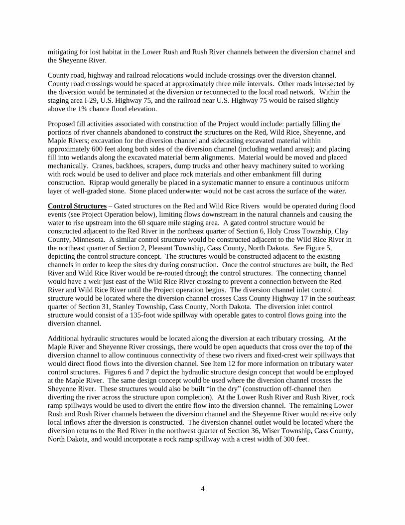
Control Structures – Gated structures on the Red and Wild Rice Rivers would be operated during flood
events (see Project Operation below), limiting flows downstream in the natural channels and causing the
water to rise upstream into the 60 square mile staging area. A gated control structure would be
constructed adjacent to the Red River in the northeast quarter of Section 6, Holy Cross Township, Clay
County, Minnesota. A similar control structure would be constructed adjacent to the Wild Rice River in
the northeast quarter of Section 2, Pleasant Township, Cass County, North Dakota. See Figure 5,
depicting the control structure concept. The structures would be constructed adjacent to the existing
channels in order to keep the sites dry during construction. Once the control structures are built, the Red
River and Wild Rice River would be re-routed through the control structures. The connecting channel
would have a weir just east of the Wild Rice River crossing to prevent a connection between the Red
River and Wild Rice River until the Project operation begins. The diversion channel inlet control
structure would be located where the diversion channel crosses Cass County Highway 17 in the southeast
quarter of Section 31, Stanley Township, Cass County, North Dakota. The diversion inlet control
structure would consist of a 135-foot wide spillway with operable gates to control flows going into the
diversion channel.
Additional hydraulic structures would be located along the diversion at each tributary crossing. At the
Maple River and Sheyenne River crossings, there would be open aqueducts that cross over the top of the
diversion channel to allow continuous connectivity of these two rivers and fixed-crest weir spillways that
would direct flood flows into the diversion channel. See Item 12 for more information on tributary water
control structures. Figures 6 and 7 depict the hydraulic structure design concept that would be employed
at the Maple River. The same design concept would be used where the diversion channel crosses the
Sheyenne River. These structures would also be built “in the dry” (construction off-channel then
diverting the river across the structure upon completion). At the Lower Rush River and Rush River, rock
ramp spillways would be used to divert the entire flow into the diversion channel. The remaining Lower
Rush and Rush River channels between the diversion channel and the Sheyenne River would receive only
local inflows after the diversion is constructed. The diversion channel outlet would be located where the
diversion returns to the Red River in the northwest quarter of Section 36, Wiser Township, Cass County,
North Dakota, and would incorporate a rock ramp spillway with a crest width of 300 feet.
Page 5
5
Ditches and smaller hydraulic structures would be required along the diversion to handle existing drains
and ditches cut off by the diversion. Ditches running outside and parallel to the diversion would direct
local drainage to a reasonable number of diversion inlet locations. Existing ditches, field swales, and
drain tile would be directed into these parallel ditches. The larger inlets, such as Drain 14 (a drainage
ditch which runs generally south to north from Davenport to the Maple River near its mouth), would be
open inlets like the Lower Rush River and Rush River. These larger inlets would be either concrete drop
structures or rock ramps. The smaller inlets would be culvert structures with flap gates and energy
dissipation chambers at the outlet of the culvert in the diversion channel. The culvert flap gates would
prevent water from backing up out of the diversion after the local peaks have passed. Uncontrolled inlets
(inlets without flap gates) would be placed at rivers and drains that have either natural levees or spoil piles
along them which would prevent widespread back-up flooding from the diversion for events up through
the 1% event. The Project goal is to maintain the existing 100-year floodplain outside the diversion
channel. Hydraulic structure and inlet design will be further discussed in the EIS.
Project Operation- The Project would go into operation by partially closing the Red River and Wild
Rice River control structure gates so that a stage of 35.0 feet is not exceeded at the USGS gage in Fargo.
At this stage, the flow through Fargo would be approximately 17,000 cubic feet per second (cfs). A flow
of 17,000 cfs at the Fargo gage is approximately a 10% chance or 10-year flood event.
Stage gages and stage-discharge rating curves will be developed at the Red River and Wild Rice River
control structures to determine when the combined flow of the two rivers reaches 17,000 cfs. At this
combined discharge the gates would be partially closed and inundation of the staging area would begin.
The connecting channel between the diversion inlet and the Wild Rice River may or may not be allowed
to fill prior to closing the Red River and Wild Rice River control structure gates. This has yet to be
determined. Regardless, flow would not be allowed out of the Wild Rice River into the connecting
channel, between the Wild Rice River and the Red River, until the Red River and Wild Rice River control
structure gates are partially closed. The diversion inlet control structure gates would not be opened prior
to partially closing the Red River and Wild Rice River control structure gates. Since it takes time for
water to travel from the Red River and Wild Rice River control structures to the Fargo gage, the stage at
the Fargo gage will be less than 35.0 feet when the Red River and Wild Rice River control structure gates
are partially closed and the diversion inlet control structure gates are opened.
Modeling completed to date indicates that the stage at the Fargo gage will likely be around 30 feet when
the control structure gates are operated, but the exact stage will depend on the shape of the inflow
hydrographs. Operation of the diversion inlet control structure gates (timing and flow) will depend on
what is observed on the Maple River, with the goal of having reduced diversion flows during peak Maple
River flows at the diversion.
A stage of 35.0 feet would be maintained at the USGS Fargo gage through the use of the Red River and
Wild Rice River control structure gates until the staging area elevation reaches elevation 922.2 NAVD 88
(the staging elevation would just reach elevation 922.2 for the 1% (100-year) event). Once the staging
elevation reaches 922.2, the Red and Wild Rice River control structures would be fully or partially
opened as necessary to maintain the upstream staging elevation of 922.2 while not exceeding a stage of
40.0 feet at the Fargo gage (a USGS stage of 40.0 would occur for the expected 0.2% (500-yr) event).
Once a stage of 40.0 feet is achieved at the Fargo gage, a stage of 40.0 feet would be maintained by
allowing flow to exit the staging area over the overflow embankment and being routed overland to the
west, eventually entering the Sheyenne River and its floodplain.
The staging area water surface elevation would be allowed to rise to an elevation that provides a
minimum acceptable height of freeboard on the tie-back embankments. The minimum acceptable height
of freeboard has yet to be determined, but it is anticipated to be between 4 and 5 feet. The inflow design
flood (IDF) discharge has yet to be determined and therefore the exact pool elevation for the IDF has yet
Page 6
6
to be determined. Modeling completed to date indicates the IDF pool elevation will be between 923.5
and 925.1. Given the uncertainty in the minimum acceptable height of freeboard and the IDF pool
elevation, the tie-back embankment elevation is expected to be between 927.5 and 930.1.
Emergency measures would be employed within the risk reduction area to reduce flood damages when
the stage is between 35.0 and 40.0 feet. If the upstream staging water surface elevation is forecasted to
reach the point of minimum acceptable freeboard, an evacuation order would be issued for the
metropolitan area. Once water is flowing over the overflow embankment and the upstream staging
elevation reaches the point of minimum acceptable freeboard, the Red and Wild Rice River control
structures would be opened further to maintain the minimum freeboard, and stages would rise above 40.0
feet at the USGS Fargo gage.
Levees and Floodwalls – Levees would include planned earthen embankments and floodwall structures
in the metropolitan area in low areas adjacent to the Red River.
Levees and floodwalls would be constructed and existing levees would be improved in the risk reduction
area (metropolitan area) such that the levee/floodwall system would be FEMA-accredited for a flood
causing a stage of 35.0 feet at the USGS gage in Fargo. With the Project in place, the 100-yr flood stage
at the USGS gage in Fargo would be 35.0 feet. Freeboard for floodwall segments is four feet and for
earthen levee segments is three feet plus one foot for settlement/topsoil. Interior drainage facilities would
be required to handle both open and blocked drainage conditions. One storm sewer lift station would be
modified in Moorhead and three existing levee projects would be accredited per FEMA standards. The
locations of levees, floodwalls and non-structural measures in Fargo include the following:
El Zagal golf course near 3rd
Street North, between 14th Avenue and 15
th Avenue North
Mickelson Field levee extension near North Terrace and North River Road
2nd
Street North from NP Avenue to 5th Avenue North
2nd
Street South at Main Avenue (non-structural measures)
Linden Avenue in the Belmont neighborhood (non-structural measures)
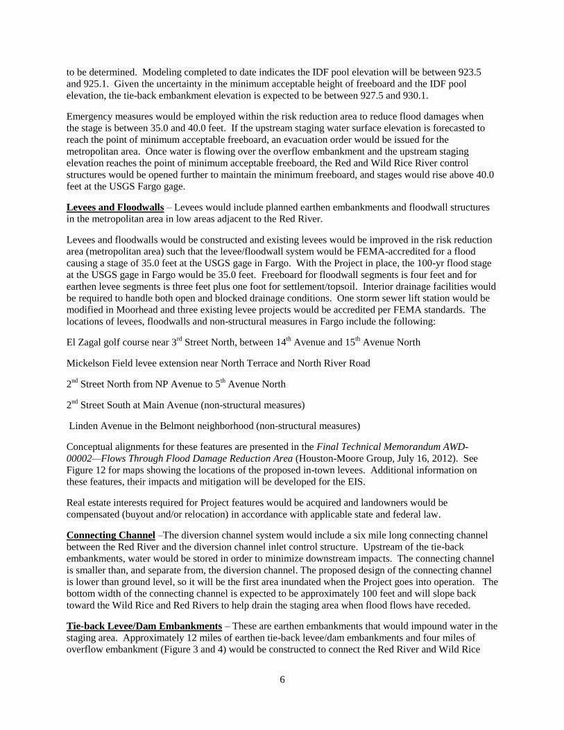
Conceptual alignments for these features are presented in the Final Technical Memorandum AWD-
00002—Flows Through Flood Damage Reduction Area (Houston-Moore Group, July 16, 2012). See
Figure 12 for maps showing the locations of the proposed in-town levees. Additional information on
these features, their impacts and mitigation will be developed for the EIS.
Real estate interests required for Project features would be acquired and landowners would be
compensated (buyout and/or relocation) in accordance with applicable state and federal law.
Connecting Channel –The diversion channel system would include a six mile long connecting channel
between the Red River and the diversion channel inlet control structure. Upstream of the tie-back
embankments, water would be stored in order to minimize downstream impacts. The connecting channel
is smaller than, and separate from, the diversion channel. The proposed design of the connecting channel
is lower than ground level, so it will be the first area inundated when the Project goes into operation. The
bottom width of the connecting channel is expected to be approximately 100 feet and will slope back
toward the Wild Rice and Red Rivers to help drain the staging area when flood flows have receded.
Tie-back Levee/Dam Embankments – These are earthen embankments that would impound water in the
staging area. Approximately 12 miles of earthen tie-back levee/dam embankments and four miles of
overflow embankment (Figure 3 and 4) would be constructed to connect the Red River and Wild Rice
Page 7
7
River control structures and the diversion inlet control structure to high ground and prevent water from
circumventing the Project. These features together fall within the definition of a Class I dam under
Minnesota Rules 6115.0340. Approximately 6 miles of tie-back levees would be located in Minnesota
and 6 miles in North Dakota. The four mile long overflow embankment would be located along Cass
County Highway 17 (ND) south of the diversion inlet control structure.
Staging Area – This is a 60-square mile area upstream of the Red and Wild Rice River control structure
and tie-back levee/dam embankment where floodwater would be staged when the Project is in operation.
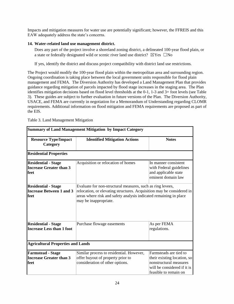
The Flood Diversion Board of Authority (Diversion Authority) has policies in place that would be applied
to land acquisition and mitigation within the defined staging area. These policies are described in the
“Land Management Plan Fargo-Moorhead (FM) Area Flood Risk Reduction Project, Version 1 (Plan)
(available for viewing at: Fargo Moorhead Diversion Authority website, Library section:
http://www.fmdiversion.com/library.asp). Federal funding is involved in portions of the Project.
Therefore, as described in the Plan, all real estate transactions would have to comply with federal
“Uniform Relocation Assistance and Real Property Acquisition Policies Act of 1970,” and Title IV,
“Uniform Relocations Act Amendments of 1987” where applicable. State law also applies to real estate
acquisitions. Additional background information and answers to frequently asked questions regarding
land acquisition have been made available by the Diversion Authority at: Fargo Moorhead Diversion
Authority website: http://www.fmdiversion.com/mitigation.asp. The Plan is a living document that would
be updated periodically as appropriate during development of the Project. The policies as described in the
current Plan are as follows:
Residential and commercial structures (not associated with specific active farmsteads)
Homes, structures, and businesses that would experience greater than three feet of inundation for the 1
percent chance event would be acquired or relocated. Areas having 1-3 feet of inundation would be
evaluated for non-structural measures, such as ring levees, relocation, or elevating structures. Acquisition
may also be considered in these areas should a risk and safety analysis indicate these measures to be
inappropriate. The impacts of relocations and acquisitions will be discussed in the EIS. Flowage
easements are proposed to be purchased for areas that would have inundation less than one foot. The
purpose of the flowage easements would be to compensate for use limitations during project induced
periods of inundation. The inundation thresholds for decision making described above are subject to
ongoing review and may be updated in future versions of the Plan. Figures 8, 9, 10 and 11 are maps
outlining the areas to be impacted with the Project in place based on the 10%, 5%, 2% and 1% flood
events, respectively. The blue shading indicates areas that would be inundated with water without the
Project and the red shading shows the additional areas that would be inundated with the Project in place.
See Item 14 for more information on floodplain impacts.
Farmsteads
The criteria outlined above would generally apply to active farmsteads. However, farmsteads tend to be
tied to their existing location to a greater extent than other structures due to the necessity of multiple
associated buildings to create a viable operating unit. Vegetative shelters and direct access to farm lands
are also needed. These characteristics warrant the consideration of nonstructural measures to allow active
farmsteads to remain in operation within the staging area. The Diversion Authority would assess the
depth of flooding, duration of the flood event, and access to the site when making decisions regarding the
appropriate use of nonstructural measures. In any event where farmsteads would experience greater than
3 feet of flooding, a buyout would be offered to the landowner prior to consideration of other options.
Agricultural Lands
Page 8
8
It is anticipated that flowage easements would be acquired over most land within the staging area. A
property-by-property analysis would be conducted to ensure that the specifics of each parcel are taken
into consideration when determining the appropriate mitigation. All agricultural land not within the
footprint of the diversion and associated infrastructure could continue to be farmed.
Non-structural Features – These are measures that would protect structures. They include ring levees,
relocation, acquisition/buyout or elevating structures. Mitigation would occur to homes/properties
impacted by floodwater as outlined in Table 5.
Environmental Mitigation – The Diversion Authority has proposed a number of actions that would
reduce Project impacts to wetlands, cultural resources, fish passage, channel abandonment, turbidity,
aquatic habitat, and other resources. Several features would be constructed to mitigate for unavoidable
environmental impacts of the Project. These features would be constructed at various sites, some of
which have not yet been selected and would be determined during the design phase of the Project as
additional coordination is completed. Mitigation would be accomplished in a watershed context, within
the same watershed as the impact to the fullest extent possible. A detailed description of the basis for
mitigation can be found in Attachment 6 of the FFREIS. The approximate magnitude of the Project’s
environmental impacts and the proposed mitigation actions are discussed in various sections (see
Questions 11, 17, 25). Additional detail on mitigation measures and plans will be presented in the EIS.
Recreation features – Recreation features may include multipurpose trails, parking areas, benches,
interpretive signage, fishing structures, and trailheads with restrooms, potable water and picnic facilities.
Recreation features will be located along the diversion channel on land purchased to construct project
features.
a. Explain the project purpose; if the project will be carried out by a governmental unit, explain the
need for the project and identify its beneficiaries.
The Project would be federally-funded and would be designed and constructed by the USACE in
partnership with the Project’s non-federal sponsors. Upon completion of the Project, all features
(including mitigation features) would be owned, operated and maintained in perpetuity by the non-federal
sponsors.
Need - The Fargo-Moorhead Metropolitan area is located within the area from approximately 12 miles
west to 5 miles east of the Red River and from 20 miles north to 20 miles south of Interstate Highway 94.
This area has a high risk of flooding. The Red River, Wild Rice River (N.D.), Sheyenne River, Maple
River, Lower Rush River and the Rush River all contribute to the flood risk. Average annual national
economic flood damages in the metropolitan area are estimated to be more than $194.8 million (FFREIS,
Section 2.3, History and Future without Project Conditions), and a failure of emergency flood measures
could result in loss of life. Flooding in Fargo-Moorhead typically occurs in late March and early April as
a result of spring snowmelt. Flooding poses a significant risk of damage to urban and rural infrastructure
and disrupts transportation throughout the metropolitan area. The Fargo-Moorhead area is a regional
center for healthcare, education, government, and commerce. Infrastructure at risk in the Fargo-Moorhead
area includes several Regional medical centers, three college campuses, and city and county government
headquarters offices.
The Red River has exceeded the National Weather Service flood stage of 18 feet in 49 of the past 111
years (1902 through 2012), and recently every year from 1993 through 2011. The record-setting Red
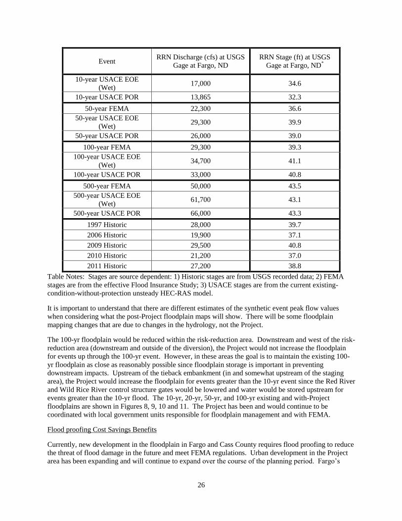
River flood stage in 2009 at Fargo was 40.82 feet on the Fargo gage. Official estimates vary for the 1-
percent chance event flow and stage. The hydrologic record of the Red River shows a trend of increasing
magnitude and frequency of flooding in recent decades.
Page 9
9
During preparation of the FFREIS, a panel of experts in hydrology and climate change was convened to
elicit opinions on how to appropriately reflect this trend (FFREIS Appendix A, Hydrology). The panel
concluded that the hydrologic record showed a “dry” period in the early decades of the 20th Century and a
“wet” period in later years continuing to the present and recommended developing revised flow frequency
curves separately for the dry and wet periods. The revised flow frequency curves showed the 1-percent
chance event flow to be approximately 34,700 cfs at present; 32,900 cfs in 2035; and 31,300 cfs in 2060.
The hydraulic modeling developed for the FFREIS and calibrated to the 2009 flood event indicated that a
flow of 34,700 cfs at the Fargo gage would produce a stage of 42.4 feet (FFREIS Appendix B, Hydraulic
Engineering). The analyses described in the FFREIS were based upon the Expert Opinion Elicitation
panel’s hydrologic recommendations, which result in significantly higher stages for the 1-percent chance
event than on the current FEMA Flood Insurance Rate Maps. The DNR concurs with this approach and
will utilize the recommendations of the EOE in the EIS.
Purpose - The purpose of the Project is to reduce flood risk, flood damages and flood protection costs
related to flooding in the metropolitan area. To the extent technically and fiscally feasible, the Project
would:
reduce flood risk potential associated with a long history of frequent flooding on local
streams including the Red River of the North, Sheyenne, Wild Rice, Maple, Rush and Lower
Rush Rivers passing through or into the metropolitan area,
qualify substantial portions of the metropolitan area for 100-year flood accreditation by
FEMA under the National Flood Insurance Program, and
reduce flood risk for floods exceeding the 1% event (100-year flood or greater), given the
importance of the metropolitan area to the region and recent frequencies of potentially
catastrophic flood events.
7. Project magnitude data
A total of 8,200 acres would be directly impacted by diversion channel, connecting channel, tieback
levees, and control structure construction. Approximately 60 square miles would be adversely affected by
temporary staging of floodwater upstream in the staging area.
(TABLE BELOW NOT APPLICABLE)
Number of residential units: NA; Unattached: NA; Attached: NA; Maximum units per building: NA
Commercial, industrial or institutional building area (gross floor space): total square feet
Indicate areas of specific uses (in square feet):
Office Manufacturing
Retail Other industrial
Warehouse Institutional
Light industrial Agricultural
Other commercial (specify)
Building height If over 2 stories, compare to heights of nearby buildings
Page 10
10
8. Permits and approvals required
List all known local, state and federal permits, approvals and financial assistance for the project.
Include modifications of any existing permits, governmental review of plans and all direct and
indirect forms of public financial assistance including bond guarantees, Tax Increment Financing and
infrastructure. Certain final decisions are prohibited until all appropriate environmental review has
been completed. See Minnesota Rules, Chapter 4410.3100.
No permits/approvals for the project have been applied for to-date. Permits and approvals that may be
required for the Project include, but may not be limited to, the following:
Table 1. Permits and Approvals
PERMIT/APPROVAL GOVERNING AGENCY Responsibility
Clean Water Act-Section 404 USACE Federal Government
(unless feature is
constructed by Local
Sponsors)
National Environmental
Policy Act (NEPA)
USACE Federal Government
Rivers and Harbors Act of
1899-Section 9 and 10
USACE Federal
Government(unless
feature is constructed
by Local Sponsors)
Clean Water Act-Section 401
Certification, Water Quality –
ND
ND Department of Health
Federal Government
Clean Water Act-Section 401
Certification, Water Quality –
MN
Minnesota Pollution Control Agency
(MPCA)
Federal Government
Conditional Letter of Map
Revision (CLOMR)
Federal Emergency Management
Agency (FEMA)
Local Sponsors
Letter of Map Revision
(LOMR)
FEMA Local Sponsors
Floodplain Permit City of Fargo Local Sponsors
Floodplain Permit City of Moorhead Local Sponsors
Dewatering ND Department of Health Contractor
Dewatering MN Department of Natural Resources Contractor
NPDES Storm water ND Department of Health Contractor/Owner
Page 11
11
PERMIT/APPROVAL GOVERNING AGENCY Responsibility
NPDES Storm water MPCA Contractor/Owner
Storm water Permit City of Fargo Contractor/Owner
Storm water Permit City of Moorhead Contractors/Owner
Sovereign Lands ND State Water Commission Local Sponsors
Construction ND State Water Commission Local Sponsors
Application to Drain ND State Water Commission and Cass
County Joint WRD
Local Sponsors
Construction/Floodplain
Approval
Buffalo-Red River Watershed District Local Sponsors
Subsurface Drain Cass County Joint WRD Local Sponsors
Memorandum of
Understanding
ND Department of Transportation Local Sponsors
Cooperative Construction
Agreement
MN Department of Transportation Local Sponsors
Section 106 Clearance ND State Historical Society Federal Government
Section 106 Consultation MN State Historic Preservation Office Federal Government
Dam Safety MN Department of Natural Resources
(MNDNR)
Local Sponsors
Public/Protected Waters MNDNR Local Sponsors
MN Wetland Conservation
Act
Minnesota Local Government Unit Local Sponsors
Floodplain Harwood Township Contractor
Floodplain Clay County Local Sponsors
Building Harwood Township Contractor
Two Rivers WRD
Application
Two Rivers WRD Local Sponsors
Zoning/Rezoning? Clay County, MN Local Sponsors
Zoning/Rezoning? Cass County, ND Local Sponsors
Page 12
12
PERMIT/APPROVAL GOVERNING AGENCY Responsibility
Aquatic Nuisance Species
Rule
ND Game and Fish Department Contractor
Prime and Unique Farmlands Natural Resources Conservation
Service
Federal Government
9. Land Use
Describe current and recent past land use and development on the site and on adjacent lands. Discuss
project compatibility with adjacent and nearby land uses. Indicate whether any potential conflicts
involve environmental matters. Identify any potential environmental hazards due to past site uses,
such as soil contamination or abandoned storage tanks, or proximity to nearby hazardous liquid or gas
pipelines.
The majority of the land that would be affected by the Project is currently used to plant row crops and for
other agricultural uses. The Project would affect approximately 250-300 farmsteads and rural residences
directly within the Project footprint and in the staging area. Land use changes would occur along and
near the proposed diversion alignments with the purchase of Project right-of-way, although agricultural
uses would be allowed within the staging area and potentially on some portions of the diversion channel
excavated material berms. Land affected by the levee/floodwall system within the flood risk reduction
area is currently residential, commercially developed, or existing public infrastructure.
Some of the staging area that is currently zoned residential or retail would no longer be available for those
uses. There are opportunities to convert agricultural portions to wetlands, grasslands, wooded areas or
other uses (a significant part of the staging area is currently farmland). Land in the diversion channel
right-of-way would be impacted. An estimated 6,000 acres of prime and unique farmland would be
directly or indirectly impacted with the construction of the Project. Owners of agricultural lands
purchased for the Project would be compensated at fair market value. The Project is expected to split or
divide some farms into separate parcels. In some cases, farmers would have to detour around the
diversion channel using established roadways or specially constructed access roads to access their
property and conduct farming operations. The number of farms under active use that would be divided by
the proposed diversion channel route is unknown at this time.
In general, agricultural land within the staging area would continue to be farmable. Farmers would still
qualify for multi-peril crop insurance to provide coverage related to naturally occurring risks. However,
crop insurance would not cover losses occurring due to operation of the Project. According to the USDA,
if farmers can plant before the late planting date then federal crop insurance would be available as it is
now for impacts not related to operation of the Project. Rules for a crop planted after the final planting
date are in accordance with federal crop insurance policies. If farmers cannot plant because of operation
of the Project, they would not qualify for crop insurance. The Diversion Authority is researching the
availability of insurance that could mitigate the risks of not being able to plant because of operation of the
Project.
Using existing data sources to identify existing or potential environmental contamination, Phase 1
Environmental Site Assessments (ESAs) are currently in progress for the proposed diversion alignment.
Additional Phase 1 ESAs would be conducted at all Project locations. The results from those assessments
will inform any Phase 2 investigations that may be necessary to obtain additional data about the nature
and extent of potential contamination sources identified as part of the Phase I ESAs. All construction
activities would require an approved spill containment program. As properties are purchased and
inventoried, any hazardous or toxic substances would be disposed of per applicable regulations by a
qualified contractor. The number, location, size, etc. of any above or below ground storage tanks would
Page 13
13
be mostly defined by the Phase 1 ESAs. If any additional tanks or other environmental hazards are
discovered during the purchase process they would be addressed at that time. The work done in a Phase I
ESA is defined by ASTM E1527-05.
Impacts and mitigation measures for land use are potentially significant. However, the FFREIS and this
EAW adequately address the state’s concerns.
10. Cover Types
Estimate the acreage of the site with each of the following cover types before and after development.
Table 2. Land Cover
Land Cover Type Before
(acres)
After (acres)
Wetlands (Types
1-8)
Open Water 1 63
Type 1 1,477* 100-200
Type 2 120 1,200 -2,000**
Type 3 106 100-200
Type 6 1 Minimal
Type 7 60 0
Lawn/Landscaping <100 0
Wooded/Forest 71 0
Impervious Surface 50 (approx.) 50 (approx.)
Brush/Grassland 100 2,000-2,200
Storm water Pond Same as Open Water
Cropland 6,000 1,900***
(approx.)
TOTAL 8,086 5,213-7,013
Table Notes:
Much of the Type 1 wetland was double-counted as cropland, which accounts for the acreage
discrepancy.
Note for Type 2 After, the current wetland mitigation plan uses the bottom of the diversion
channel for wetland creation. Additional detail on wetland replacement will be provided in
the EIS.
Note for Cropland After, this indicates the area on the outside (“left bank”) of the diversion
channel excavated material berms may include cutting and bailing of vegetation for hay after
the Project is constructed. Tilling of the left bank would not be permitted.
Other (describe): The staging area is approximately 60 square miles and is defined by the red outline in
Figures 2, 3 and 4. There are approximately 33,000 acres within this area that would be impacted by an
additional one foot or more of water at the 100-year event. Wetlands within this area have not been
Page 14
14
delineated because the areas that are wetland now would remain wetland with the Project. The areas that
are farmed would continue to be farmed. Some homes and farmsteads and the lawn/landscaping
associated with them would be transformed to either farmland or wetland once they were bought out and
removed.
If Before and After totals are not equal, explain why:
The before and after totals are not equal because some acres are double counted. For example, the
majority of the impacted wetlands are also cropland and/or grasslands.
Cover type impacts are not considered to be potentially significant; however, additional analysis and
detail beyond that provided in the Scoping EAW and FFREIS will be provided in the EIS.
11. Fish, wildlife, and ecologically sensitive resources
a. Identify fish and wildlife resources and habitats on or near the site and describe how they would be
affected by the project. Describe any measures to be taken to minimize or avoid impacts.
Type of Site/Type of Habitat – Wetland habitat affected by the Project is a mix of wet meadow, shallow
marsh, shallow open water, floodplain forest, and farmed seasonally flooded wetland. Farmed seasonally
flooded wetlands constitute the vast majority of the affected acreage (1,477 acres).
The aquatic habitats located within the Project area consist of riverine habitat and are typical of the Red,
Wild Rice, Sheyenne, Rush, Lower Rush and Maple Rivers. Depths on the Red River and the tributaries
generally vary from 1 to 2 feet near shoreline areas to about 5-20 feet at mid-channel locations, depending
on the tributary and season. Substrates present include a mixture of silt, sand, and clay. The river
channel is approximately 100 feet wide in the vicinity of the Red River control structure. Tributary river
channels are approximately 20-80 feet wide where the diversion channel would cross the other tributaries.
Upland habitat in the Project area is mainly cropland, with a mixture of hay ground, pasture, hobby farms
and suburban dwellings. Wooded areas include mostly a mixture of bottomland hardwood tree species
and low vegetation. The small percentage of upland wooded area is made up of shelter belts planted near
farmsteads and homes or along field edges. These shelter belts include some coniferous trees but mostly
small shrubs and fast growing tree species.
Birds and mammals that inhabit the rural portions of the Project area include raptors, gray partridge,
pheasant, mourning dove, waterfowl, fox squirrel, white-tailed deer, red fox, raccoon, mink, badger,
striped skunk, white-tailed jackrabbit, beaver, muskrat, and numerous song birds. The riparian vegetation
(forested floodplain) associated with the Red, Wild Rice and Sheyenne Rivers represents most of the
terrestrial wildlife habitat that presently exists within the Project area. Other than this limited riparian
habitat, wildlife resources in the Project area are limited to those species that can reside in drainage ways,
shelterbelts, cultivated fields and road right-of-ways.
Habitat within the urban areas is limited primarily to manicured lawns and landscaped areas. These areas
provide limited habitat for wildlife species. Therefore, wildlife resources are mostly limited to songbirds,
reptiles, amphibians and small mammals.
The total surface area that would be directly impacted by Project features includes approximately 8,200
acres. Of these areas, disturbance caused by Project-related construction would be limited to the
diversion channel, connecting channel, excavated material berms, tie-back levee footprints, and
construction areas of the river crossing structures. Forested land in the staging area would be inundated
with water while the Project operates (greater than a 10 year event). Some tree loss may occur in the
staging area depending on the frequency, depth and duration of flooding, and operation relative to the
Page 15
15
growing season. The majority of tree species in the Project area are floodplain tree species (such species
generally have a high tolerance to flooding).
There would be some areas where upland forest and riparian forested areas would be cleared or otherwise
impacted. The diversion channel and Project features would impact approximately 60 acres of forested
wetland and 71 acres of upland forest.
The loss of these wooded areas would be permanent but would be mitigated for by converting farmed
wetland along the Red River into floodplain forest at a 2:1 ratio (262 acres). There would also be tree
plantings as part of the recreational features. A table identifying proposed mitigation measures is
included in response to Item 30 of this Scoping EAW. The other upland areas to be disturbed are
currently farmed and have reduced natural resource value. Portions of the excavated material berms
would be available for farming after completion. All other disturbed upland areas would be replanted
with native species, primarily grasses that would have positive impacts on the area’s overall habitat value.
Overall, the Project would have a permanent impact on the terrestrial habitat identified but the eventual
changes in vegetative cover through the proposed mitigation measures would have some long term
beneficial impacts on the avian and small mammal groups.
As part of the assessment of impacts to wetland resources and based on recommendations from an
interagency mitigation team that was convened by the USACE, the Minnesota Routine Assessment
Methodology for Evaluating Wetland Functions (MnRAM Version 3.3) was used to assess the functions
of wetlands within the diversion channel corridors.
The primary functions assessed as part of the MnRAM include:
Maintenance of Hydrologic Regime,
Maintenance of Wetland Water Quality,
Maintenance of Character of Wildlife Habitat,
Aesthetics/Recreation/Education/Cultural Benefit,
Flood/Storm-water Attenuation, and
Downstream Water Quality.
Due to the similarity of the identified wetlands, functionality was not assessed on every wetland. Instead,
at least one randomly-chosen basin representative of each type of wetland found within the diversion
channel alignment was assessed for typical functionality. The types of wetlands found within the
diversion channel corridor, in accordance with the Eggers & Reed wetland classification system, are
farmed seasonally flooded basin (PEMAf is the corresponding Cowardin classification), fresh wet
meadow (PEMB), shallow marsh (PEMC), floodplain forest (PFO1A) and shallow open water (PUBH).
European settlement of the Project area involved extensive drainage in order to make production of
agricultural crops possible, and much of the land within the proposed diversion channel alignment is
currently used for agricultural purposes. Although the surface drainage systems (ditches) make
agricultural production possible in many areas in most years, the ditches have not effectively removed
hydrology from the surface in those areas determined to be wetland. These wetlands are farmed in most
years, although crops are often lost, especially in the deepest parts of these shallow depressions.
Wetlands in this area have been significantly impacted by agricultural practices, including the drainage of
the natural hydrology, tilling of the soils and loss of the natural vegetation. The shallow marsh and
floodplain forest wetland types, although usually left untouched by direct agricultural activity, have been
affected by land uses in the area.
Farmed Seasonally Flooded Wetlands
Page 16
16
Wetlands found within active agricultural lands provide limited levels of functionality due to the
extensive drainage and overall alteration that has taken place in the region. Over eighty percent of
wetlands within the Project area are depressional field ditches and depressional isolated wetlands of the
seasonally flooded basin type. Due to the extensive drainage systems, these seasonally flooded wetlands
generally function at a low level for Maintenance of Hydrologic Regime and Maintenance of Wetland
Water Quality (per MnRAM). When drainage moves water off the landscape more quickly than in a
natural setting, wetlands do not have the opportunity to continually feed the downstream system with a
supply of water, and the agricultural impacts directly affect the ability of the wetlands to maintain water
quality within the basin. Because the wetlands are found within agricultural fields where many are
regularly farmed, they also function at a low level for Maintenance of Character of Wildlife Habitat, and
Aesthetics/Recreation/Education/Cultural Benefit (per MnRAM). Without natural vegetation, there is
limited opportunity to provide wildlife habitat, but they do provide some resting habitat for migrating
water birds. Theses wetlands provide limited aesthetic or recreational value.
The depressional wetlands within agricultural fields do, however, generally provide moderate to high
functionality for Flood/Storm-water Attenuation and Downstream Water Quality (per MnRAM). Those
wetlands that have been shaped into shallow field ditches provide a moderate level of flood/storm water
attenuation because they are able to hold some of the water on the landscape for at least a short period of
time. Shallow isolated depressional wetlands provide a high level of functionality for flood/storm water
attenuation, as they are able to hold the water on the landscape until it can evaporate or infiltrate, rather
than run off to nearby over-stressed water courses. All crop field wetlands provide a moderate level of
functionality for protection of downstream water quality because they are able to filter at least some of the
nutrients from the agricultural runoff before the water enters nearby waterways. The seasonally flooded
depressional wetlands generally do not provide any level of function for amphibian or fish habitat or
shoreline protection; therefore MnRAM analysis was not applicable for these functions.
Fresh Wet Meadow and Shallow Marsh Wetlands
Fresh wet meadow and shallow marsh wetlands that are not actively farmed within the diversion corridor
provide similar levels of functionality as those described above for farmed seasonally flooded wetlands,
with a few noted differences. For Maintenance of Wetland Water Quality (per MnRAM), wet meadows
and shallow marshes provide a moderate level of functionality. With natural vegetation present, such as
cattails (Typha sp.), the water quality within the wetland is treated through the plants’ uptake of nutrients.
These wetlands also provide a moderate level of wildlife habitat because of the natural vegetation.
Floodplain Forest Wetlands
Floodplain forest wetlands provide a moderate level of functionality for maintenance of the hydrologic
regime, as they are able to gradually feed the river system with water stored in the soils following flood
events. In addition, the forest canopy provides a moderate level of function for wildlife habitat.
Floodplain forest restoration is planned as mitigation for impacted stream riparian areas consisting of
floodplain forest wetlands.
Shallow Open Water Wetlands
In the proposed diversion channel corridor, there are two areas classified as shallow open water. One is a
constructed storm water retention pond at the west edge of Prairie Rose, and the other is located adjacent
to the Wild Rice River and is surrounded by a floodplain forest on private property. The storm water
retention pond functions at a high level for flood and storm water attenuation as well as protection of
downstream water quality, and it functions at a low to moderate level for most other functions, such as
amphibian and wildlife habitat and maintenance of hydrologic regime. The shallow open water basin
adjacent to the Wild Rice River performs at a low to moderate level for all measured functions. While it
Page 17
17
can provide a moderate level of flood/storm water attenuation and water quality protection, its outlet to
the Wild Rice River is too low and not constricted, minimizing its ability to retain water. This basin
provides a moderate level of wildlife and fish habitat, providing protection for water fowl and spawning
habitat for fish.
As indicated above, most of the seasonally flooded wetlands assessed in the Project area are low
functioning wetlands. The seasonally flooded wetlands make up the vast majority of wetland types
within the review area. Many wetlands in the Lake Agassiz basin are embedded within an agricultural
landscape where they are subject to varying degrees of siltation. Current agronomic practices include re-
spreading of sediment from ditch clean outs onto shallow depressions and swales in the crop fields as well
as general field leveling to improve agricultural production. Cultivation of wetland catchment areas has
exacerbated soil erosion; wetlands in agricultural fields receive more sediment from upland areas than
wetlands in grassland landscapes and hence are subject to premature filling (i.e., they have shorter
topographic lives). Associated impacts from increased turbidity, sediment deposition, and increased
surface water input have impaired natural wetland functions. Although trapping of sediments by wetlands
is often cited as a water quality benefit, sediment input from agricultural fields has the potential to
completely fill wetlands and shorten their effective life-span. Flooding from the Red River of the North,
laden with very fine sediments, likely increases the sediment load deposited in these shallow basins
during flooding.
Potentially significant impacts are possible. The potential impacts associated with sediment deposition
(associated both with river sources sediment and that mobilized from fields in additionally inundated
areas) will be evaluated further in the EIS.
While the Project is under construction, sediment loading to wetlands could be increased. Both soil
erosion and sedimentation best management practices (BMPs) should be developed as construction-phase
conditions in NPDES storm water permits. These would help to avoid and minimize the potential for
potentially significant impacts related to construction storm water runoff. Once the Project is
constructed, normal farming practices would continue within the staging area resulting in sedimentation
potential from agricultural runoff similar to the existing condition. Along the diversion channel, the area
on the outside (“left bank”) of the excavated material berms may include cutting and bailing of vegetation
for hay after the Project is constructed. Tilling of the left bank would not be permitted, so there should be
no additional sedimentation of wetlands as the result of the diversion channel construction.
b. Are any state-listed (endangered, threatened or special concern) species, rare plant communities or
other sensitive ecological resources on or near the site? ☒Yes ☐No
If yes, describe the resource and how it would be affected by the project. Describe any measures that
will be taken to minimize or avoid adverse impacts. Provide the license agreement number (LA-586)
and/or Division of Ecological Resources contact number (ERDBClick here to enter text.) from which
the data were obtained and attach the response letter from the DNR Division of Ecological Resources.
Indicate if any additional survey work has been conducted within the site and describe the results.
Much of the following is taken from the FFREIS section 5.2.1.9.
Federal Species
One federally-listed threatened or endangered species, the whooping crane (Grus americanus), is listed as
endangered for Cass and Richland Counties. One federally-listed threatened or endangered species, the
western prairie fringed orchid (Platanthera praeclara), is listed as threatened for Clay County. One
species, the Dakota skipper (Hesperia dacotae), is on the candidate species list for Clay County. No
Page 18
18
species are listed for Wilkin County, Minnesota. The Fish and Wildlife Service’s records do not indicate
any individuals of any of these species within the Project area (FWS letter in the FFREIS, Appendix Q).
Bald eagles and their nests are protected from take and disturbance, respectively, per the Bald and Golden
Eagle Protection Act. The Fish and Wildlife Service verified the location of two bald eagle nests within
the Project area inside of the area protected by the diversion, but several miles from any proposed
construction. A third nest has been identified approximately five miles upstream of the Red River control
structure that may be impacted by the Project due to staged floodwater.
The eagle nests would not be directly impacted by the Project construction due to location, but the nests
would be monitored during the spring before construction. Nests were monitored in the spring of 2011
and only two nests remained at that time. In addition, the area protected by the diversion inside the
Project area would continue to be monitored during the upcoming years to ensure that no new nests would
be impacted by Project construction. The nest located upstream of the Red River control structure may be
impacted by staged water weakening the root system of the tree or killing the tree in the event that
prolonged flooding occurs over the course of one or more consecutive growing seasons. There would be
raptor nest surveys completed in the spring of the year preceding construction within or near any affected
wooded areas. A raptor survey was completed near the outlet structure during the spring of 2012. Two
eagle nests were identified and observed during the survey. Both nests were active, but it was
determined that neither nest would be impacted by construction in this area.
State Listed Species
Minnesota Special Concern Species and Threatened and Endangered Species with Potential to Occur in
Clay County.
There are 15 Minnesota-listed threatened and endangered species and 34 special concern species that are
known or have the potential to occur in Clay County, Minnesota (see Sections 1.9.1 and 1.9.2 of
Appendix F of the FFREIS) (The source of this data was the MNDNR Data Deli, as of 2009). The vast
majority of these known occurrences of listed species are located on the east portion of the county and
thus not be affected by the project. There is one bird species (bald eagle), one fish species (lake
sturgeon), and one mussel species (black sandshell) with moderate potential to occur within the Project
area.
Direct impacts to the lake sturgeon would likely be minimal as the lake sturgeon would avoid
construction activity. The ability for lake sturgeon to migrate could be occasionally affected during
operation of the Project, which is anticipated to be less frequently than approximately a 10 percent chance
flood event. With in-town levees, the Project would only operate during floods where peak flows would
exceed approximately a 10% event. Historically, these floods have been the result of snow melt events,
with flows above 17,000 cfs having only occurred during March and April. Aadland (2010)
approximated the lake sturgeon spawning period on the Red River to be early May through mid-
June. While this is not the only period when fish may move, it is likely the period of greatest concern for
lake sturgeon. However, this lake sturgeon spawning period would be outside of the period when flows
above 17,000 cfs have occurred historically.
Given the low frequency of operation, and the fact that Project operations would generally occur outside
of the sturgeon spawning period, adverse effects due to loss of connectivity are not expected to be
significant. However, additional information on this issue will be presented in the EIS.
Page 19
19
With the addition of mitigation at Drayton Dam, connectivity would be improved at the last major
impediment on the Red River in the U.S. Additional impacts could occur from stranding within the
diversion channel or limited the ability of fish to navigate hydraulic control structures.
Previous mussel surveys have collected black sandshell from the Red River in the Project area. In-water
construction activities under any diversion channel alternative could result in mortality of black sandshell
mussels. Impacts would generally be limited to the Project footprint.
North Dakota Special Status Species with Potential to Occur in Cass County
There are 52 Special Status Species with potential to occur in Cass County, North Dakota (see section
1.9.3 of Appendix F of the FFREIS). Of these listed species, five have a moderate potential of occurring
within the Project area. The other species listed either have no potential or low potential of occurring
within in the Project area.
The five species that have a moderate chance of occurring in the Project area include two bird species
(whip-poor-will and northern cardinal), and three mussel species (Wabash pigtoe, black sandshell, and the
mapleleaf).
Habitat used for nesting by either the cardinal or the whip-poor-will may be disturbed or removed during
Project construction. To the extent practicable, vegetation clearing activities would be done so as to avoid
affecting nesting individuals. Nonetheless, some limited take of individuals may occur incidental to
construction activities. It is expected that any limited take would have no long lasting effect on the
affected migratory bird species.
Project impacts to forested land would occur during the winter months so bird species would not
impacted during their nesting and rearing periods. This action would minimize the risk of any impacts to
either listed bird species.
In-water construction activities could result in mortality of black sandshell, mapleleaf and Wabash pigtoe
mussels. Previous mussel surveys have collected these species from the Red River in the Project area.
All three have been collected from the Sheyenne River in the vicinity of the proposed aqueduct. Black
sandshell have been collected from the Wild Rice River in the area of the control structure. Mussel
surveys conducted in October 2011 indicated that there would be no appreciable impact to mussels as a
result of the Project.
Construction of the levee/floodwall system within the flood risk reduction area is not expected to cause
appreciable impacts to any listed species. Impacts of proposed environmental mitigation projects would
be determined as those projects are developed. Impacts of the Drayton Dam modifications in Drayton,
ND will be presented in the EIS.
Impacts and mitigation measures for fish, wildlife and ecologically sensitive resources are not expected to
be potentially significant based on the 2009 data used for the FFREIS. However, additional analysis and
detail beyond that provided in the Scoping EAW and FFREIS will be provided in the EIS.
12. Physical impacts on Water Resources.
Will the project involve the physical or hydrologic alteration — dredging, filling, stream diversion,
outfall structure, diking, and impoundment — of any surface waters such as a lake, pond, wetland,
stream or drainage ditch? ☒Yes ☐No
If yes, identify water resource affected and give the DNR Public Waters Inventory number(s) if the
water resources affected are on the PWI: Click here to enter text. Describe alternatives considered and
Page 20
20
proposed mitigation measures to minimize impacts.
The Red River and Wolverton Creek are MNDNR Protected Watercourses represented on PWI maps.
The Project involves diverting the Red, Wild Rice (ND), Sheyenne (ND), and Maple (ND) Rivers during
flood events and the Lower Rush and Rush Rivers (ND) permanently. Wolverton Creek would
experience changes while the Project is in operation due to water being staged.
Wetland impacts are predicted to occur either directly within the Project footprint, or indirectly through
reduced hydraulic connectivity of wetlands to the river because of reduced river flood discharge.
Wetlands potentially impacted because of altered connectivity would be mitigated by creating wetland
habitat in the bottom of the diversion channel. Approximately 1,700 acres of wetlands would be filled or
excavated along the diversion channel alignment or the route of the tie-back embankments.
The temporarily and seasonally-flooded depressional basins within the Project area are precipitation-
driven wetlands that are not dependent upon the flood events from the Red River for their sustaining
hydrology. Snowmelt and summer storms on the low-permeability soils are adequate to support wetland
hydrology for these systems. Less inundation in the ‘protected area’ due to the Project would, therefore,
have little to no impact on the wetland hydrology of these wetlands. Potential effects of more inundation,
depending on the recurrence of larger storm events and the operation of the Project, would also likely
have no lasting impact on the temporary and seasonally-flooded wetland basins in the staging area. If,
however, larger storm events triggering the use of the staging area were to occur more often than
predicted, the potential exists for the wetlands to remain inundated longer than normal into the growing
season, rather than just temporarily or seasonally. Prolonged higher than normal standing water could
also cause several small, isolated basins to form one, larger basin, although this may not be the case if the
areas are currently tiled. This is not likely to have a long-term negative impact because it is expected that
there would be interceding years with no flooding, allowing the systems to return to their temporarily or
seasonally-flooded condition.
Wetlands in the staging area receive increased sedimentation as floodwaters recede from the area.
Consecutive years of sedimentation, or a build up over many years could change wetland types or even
convert wetlands to uplands.
Description of the Proposed Discharge Sites
Location – For Red River control structure construction, material would be placed just upstream of river
mile 476, but off to the side of the channel and would have fill impacts when the channel gets diverted
toward the structure; at these locations the channel would have to be filled to help divert the flow toward
the structure. No construction material would need to be placed in the Red River for the diversion outlet
since energy dissipation would be handled within the diversion channel upstream of the connection with
the Red River. For the control structures, aqueducts and other hydraulic structures, construction material
would be placed into the Red River for approximately 200 feet just downstream of river mile 477 and also
at the crossings of the Wild Rice, Sheyenne, Maple, Lower Rush and Rush Rivers.
Size - Approximately 14 acres of riverine habitat below the Ordinary High Water level would be affected
by the abandonment of river channel for the construction of the Red River control structure.
Approximately 11 riverine acres at the Wild Rice River crossing, 8 riverine acres at the Sheyenne River
crossing, 10 riverine acres at the Maple River crossing, 3 riverine acres at the Lower Rush River crossing
and 3 riverine acres at the Rush River crossing would be affected by the proposed fill activities.
Approximately 1,700 acres of wetlands, not including riverine areas, would be affected by either fill
activities or excavation along the diversion channel route. A total additional area of approximately 50
riverine acres would be affected.
Page 21
21
The FFREIS describes an estimate of upstream miles and acres of aquatic habitat upstream of the Red
River and Wild Rice River control structures that would have reduced access (up to 400 miles of
upstream aquatic habitat for the Red River control structure to equal approximately 3,700 acres of aquatic
habitat). A quantitative estimate was not provided in the FFREIS for potential geomorphic effects area,
but it is understood that any potential for upstream geomorphic effects would occur within the area of
backwater influence which has been extensively mapped for the 1 percent chance event. The area of
potential effect varies by flood height.
Hydrologic Effects
The Project will affect the hydrology of various river reaches and intervening areas in different ways.
Upstream staging area
The frequency of flooding in the area upstream of the Red and Wild Rice River control structures and the
diversion inlet structure will be unchanged up to a flow of 17,000 cfs (a 10% or 10-year event) at the
USGS gage in Fargo. Flows exceeding 17,000 cfs will result in a larger inundated area upstream of the
control structures and an increase in the frequency of inundation for flows exceeding 17,000 cfs. The
inundated areas for various events are illustrated in Figures 8, 9, 10 and 11.
Red and Wild Rice Rivers downstream of control structures
The frequency of flooding in the area downstream of the diversion inlet and the control structures on the
Red and Wild Rice Rivers would be unchanged up to a flow of 17,000 cfs (a 10% chance or 10-year flood
event) at the USGS gage in Fargo. A flow of 17,000 cfs is expected to result in a stage of 35 feet at the
Fargo gage. Flows that would exceed 17,000 cfs at the Fargo gage will trigger operation of the project as
described in Item 6. Flows between a 10% chance (10-year) and 1% chance (100-year) event would be
limited to 17,000 cfs at the Fargo gage. Flows greater than the 1% chance event up to approximately
100,000 cfs (in excess of a 500-year event) would be limited to a stage of 40 feet through the metropolitan
area and contained within a levee/floodwall system supplemented by emergency measures.
Sheyenne and Maple Rivers downstream of aqueducts
Flows crossing the diversion channel via the Sheyenne and Maple River aqueducts would be limited so as
to be contained within the banks of the existing rivers and drains within the benefitted area. The existing
Sheyenne Diversion projects, including both the Horace to West Fargo Diversion and the West Fargo
Diversion, would be maintained and continue to operate. The hydrologic regime in the natural Sheyenne
River channel would be similar to existing conditions up through the 50% chance or 2-yr event. Higher
flows would be reduced due to the diversion of flow into the proposed diversion. Flows in the Maple
River aqueduct up to approximately 1700 cfs (a 60% or 1.7-year event) would not be affected, but higher
flows would be partially diverted. This flow is high enough to maintain channel forming flows on the
Maple River and the Sheyenne River all the way to its mouth.
Rush and Lower Rush rivers and Drain 14 downstream of the diversion channel
The Rush and Lower Rush Rivers and Drain 14, as well as several smaller tributaries, would be diverted
into the diversion channel. Flows downstream of the intersection would cease in the existing channels,
except for local drainage. These channels would likely remain wetlands, and water levels will depend on
local inflows and backwater effects from the Sheyenne River.
Areas adjacent to the diversion channel
The frequency of flooding left of the left bank of the diversion channel (west of the channel) would
Page 22
22
remain relatively unchanged; project features would be designed to minimize hydrologic impacts to all
streams and ditches upstream of the point at which they intersect the diversion channel.
Flood frequency to the right of the right bank of the diversion channel (east of the channel) would be
substantially reduced. The largest stage reductions would occur along the southern 2/3 of the diversion
alignment; flood stage reductions east of the northern third of the diversion channel would be diminished
by backwater effects from the Red River.
Groundwater
Shallow groundwater near the ground surface would likely be lowered in the immediate vicinity of the
diversion channel. The effects of the channel on shallow groundwater are expected to be contained
within the footprint of the channel and adjacent excavated material berms.
Deeper groundwater in the Project area includes the West Fargo Aquifer which occurs around West
Fargo. This aquifer is at least 70 feet deep, and it appears to be deep enough to avoid impacts that could
occur from Project structures or excavation associated with the Project. Additional data analyses and
design refinements would verify local variations in the hydrogeology during Project design. The Project
is not expected to have adverse impacts to the cumulative condition of aquifers or shallow groundwater in
the region.
Piezometers have been installed and data is being collected from them. More would be installed to
monitor changes in ground water elevation during and after construction. The information would also be
used to verify assumptions made during analysis.
Red River downstream of the diversion channel outlet
At the diversion outlet, there would be minor impacts to flood stages. Hydrologic changes on the Red
River downstream of the outlet would be minimal.
Geomorphology
While flood flows would be reduced along streams within the risk-reduction area, the geomorphology
study by West Consultants in 2012 concluded that affected streams are "not prone to significant change in
morphology over short or even moderate periods of time." Geomorphic change based on the rarity of an
event should account for the fact that the frequency of larger hydrologic events has increased over the last
40 years of record. Further, climate change and recent land use activities in the basin are likely to
continue to increase or add uncertainty to predicted geomorphic changes. The study conducted by West
also concludes that bank stability and riparian vegetation density are expected to slightly increase in the
reaches that are protected from high flows and that bank stability and riparian vegetation density are
expected to slightly decrease in the staging area upstream of the diversion alignment as a result of more
frequent overbank inundation and sedimentation. The extent of the decreases associated with riparian
vegetation in the staging area is ultimately dependent on the timing and duration of the inundation and
will need to be monitored. The Rush and Lower Rush Rivers were modeled for shear stress and these
results recognized potential impacts to channel geometry. The identified impacts need to be assessed for
the other tributaries, but appear likely for the Wild Rice River, at least. Additionally, since all flow in the
Rush and Lower Rush will be diverted by the diversion alignment, local runoff and backwater from the
Sheyenne River are expected to cause sedimentation in the portion of these streams located downstream
from the diversion. Therefore, the channel size for these reaches would be expected to increase over time,
a result of the increased width/depth ratio and increased lateral migration that results.
Remaining information is needed on the water surface and thalweg (bed) profiles for each of the
tributaries as they flow into or across the diversion, including the Sheyenne, Maple, Wild Rice, Rush and
Page 23
23
Lower Rush Rivers. This is needed to evaluate pre-and post-Project slopes and potential geomorphic
impacts. Shear stress calculations are shown for the Rush but do not include longitudinal profiles for
various flood scenarios, with and without operation of the diversion. This information (longitudinal
profiles with water surface and thalweg elevations) for the tributaries and main stem Red River is also
needed to firmly establish expected impacts due to operation of the diversion and storage reservoir.
Diversion bed stability is a critical aspect of the long-term maintenance requirements for the Project, as
well as habitat for biota occupying the diversion channel. To optimize the design to minimize erosion,
optimize sediment transport and meet habitat requirements for biota within the channel, assessment of the
Project needs to include consideration of dimension, pattern, profile, and materials for the lower flow
channel.
Actual impacts to all of the channels associated with the Project will result from the hydrologic conditions
encountered, the operation of the various Project components and local and regional conditions and
context. As a result, there is a large measure of uncertainty, which will require an adaptive management
approach to optimize the Project’s benefits, minimize impacts, and identify changes resulting from the
project. A critical part of adaptive management is ongoing, responsive monitoring. Details of the
sampling design for monitoring channel changes, response actions and action thresholds need to be
developed and recommended to the permitting agencies.
The impact of the riparian vegetation decreases in the staging area is ultimately dependent on the timing
and duration of the inundation and will need to be monitored.
13. Water use
Will the project involve installation or abandonment of any water wells, connection to or changes in
any public water supply or appropriation of any ground or surface water (including dewatering)?
☒Yes ☐No
If yes, as applicable, give location and purpose of any new wells; public supply affected, changes to
be made, and water quantities to be used; the source, duration, quantity and purpose of any
appropriations; and unique well numbers and DNR appropriation permit numbers, if known. Identify
any existing and new wells on the site map. If there are no wells known on site, explain methodology
used to determine.
It is likely that several private wells would be affected by the Project. Where structures and farmsteads
are removed, wells would be abandoned per applicable state regulations. Where wells that may be
affected by operation of the Project would remain, appropriate modifications would be made to prevent
contamination of groundwater/drinking water. The number and locations of affected wells would be
determined during the design phase of the Project.
There would be approximately six rural water line crossings/relocations in North Dakota. The relocation
and/or abandonment of these lines would be a local sponsor responsibility and this coordination effort is
now taking place. Work would occur in accordance with applicable federal, state and local drinking
water regulations.
Temporary de-watering may be required at sites where structures would be built (inlet control structure
and outlet to Red River, and at river crossings). Discharge of this water would be regulated per applicable
federal/state regulations as part of the construction contract. Homes purchased and removed as a result of
the Project would have their service lines cut and capped per applicable state/city regulations if they are
connected to a rural or municipal water supply system. The number of houses (if any) that may be
purchased would be determined as the plans are finalized.
Page 24
24
Impacts and mitigation measures for water use are potentially significant; however, the FFREIS and this
EAW adequately address the state’s concerns.
14. Water-related land use management district.
Does any part of the project involve a shoreland zoning district, a delineated 100-year flood plain, or
a state or federally designated wild or scenic river land use district? ☒Yes ☐No
If yes, identify the district and discuss project compatibility with district land use restrictions.
The Project would modify the 100-year flood plain within the metropolitan area and surrounding region.
Ongoing coordination is taking place between the local government units responsible for flood plain
management and FEMA. The Diversion Authority has developed a Land Management Plan that provides
guidance regarding mitigation of parcels impacted by flood stage increases in the staging area. The Plan
identifies mitigation decisions based on flood level thresholds at the 0-1, 1-3 and 3+ foot levels (see Table
3). These guides are subject to further evaluation in future versions of the Plan. The Diversion Authority,
USACE, and FEMA are currently in negotiation for a Memorandum of Understanding regarding CLOMR
requirements. Additional information on flood mitigation and FEMA requirements are proposed as part of
the EIS.
Table 3. Land Management Mitigation
Summary of Land Management Mitigation by Impact Category
Resource Type/Impact
Category
Identified Mitigation Actions Notes
Residential Properties
Residential - Stage
Increase Greater than 3
feet
Acquisition or relocation of homes In manner consistent
with Federal guidelines
and applicable state
eminent domain law
Residential - Stage
Increase Between 1 and 3
feet
Evaluate for non-structural measures, such as ring levees,
relocation, or elevating structures. Acquisition may be considered in
areas where risk and safety analysis indicated remaining in place
may be inappropriate.
Residential - Stage
Increase Less than 1 foot
Purchase flowage easements As per FEMA
regulations.
Agricultural Properties and Lands
Farmstead - Stage
Increase Greater than 3
feet
Similar process to residential. However,
offer buyout of property prior to
consideration of other options.
Farmsteads are tied to
their existing location, so
nonstructural measures
will be considered if it is
feasible to remain on
Page 25
25
site.
Farmstead - Stage
Increase Between 1 and 3
feet
Evaluate for non-structural measures, such as ring levees,
relocation, or elevating structures. Acquisition may be considered in
areas where risk and safety analysis indicated remaining in place
may be inappropriate.
Farmstead - Stage
Increase Less than 1 foot
Purchase flowage easements planned As per FEMA
regulations.
Agricultural Lands Acquisition of flowage easements planned Lands within the staging
area will be analyzed on
a property-by-property
basis. All agricultural
land not directly
impacted by the Project
can continue to be
farmed
Hydrology
During development of the FFREIS, the approach to hydrology for the Red River was updated. The
hydrology utilized the recommendations of an Expert Opinion Elicitation (EOE) panel that concluded the
region is in a wet cycle. The EOE panel included a field of experts in hydrology and hydraulics from
several Federal and State agencies that are familiar with the Red River watershed and climate change.
Based on this recommendation the period of record was broken into a dry cycle (1902-1941) and a wet
cycle (1942-2009) to develop the hydrology for the Project. The economic analysis used 100% of the wet
cycle hydrology for Year 0, an 80/20 wet/dry split for Year 25, and a 65/35 wet/dry split for Year 50. The
USACE hydrology also included a full Period of Record (POR) analysis that included records from 1902
to 2009 along with the historic 1897 flood event. The wet cycle hydrology is being used to assess how
the Project would operate.
The following table provides a summary of the FEMA effective hydrology as well as the hydrology
developed for the USACE feasibility study. Historic discharges are also provided for the 1997, 2006,
2009, 2010, and 2011 historic flood events. The project will revise the 1% floodplain and documentation
of theses revisions must be submitted to FEMA, including updated hydrology.
Table 4. FEMA Effective Hydrology.
Event RRN Discharge (cfs) at USGS
Gage at Fargo, ND
RRN Stage (ft) at USGS
Gage at Fargo, ND*
10-year FEMA 10,300 29.5
Page 26
26
Event RRN Discharge (cfs) at USGS
Gage at Fargo, ND
RRN Stage (ft) at USGS
Gage at Fargo, ND*
10-year USACE EOE
(Wet) 17,000 34.6
10-year USACE POR 13,865 32.3
50-year FEMA 22,300 36.6
50-year USACE EOE
(Wet) 29,300 39.9
50-year USACE POR 26,000 39.0
100-year FEMA 29,300 39.3
100-year USACE EOE
(Wet) 34,700 41.1
100-year USACE POR 33,000 40.8
500-year FEMA 50,000 43.5
500-year USACE EOE
(Wet) 61,700 43.1
500-year USACE POR 66,000 43.3
1997 Historic 28,000 39.7
2006 Historic 19,900 37.1
2009 Historic 29,500 40.8
2010 Historic 21,200 37.0
2011 Historic 27,200 38.8
Table Notes: Stages are source dependent: 1) Historic stages are from USGS recorded data; 2) FEMA
stages are from the effective Flood Insurance Study; 3) USACE stages are from the current existing-
condition-without-protection unsteady HEC-RAS model.
It is important to understand that there are different estimates of the synthetic event peak flow values
when considering what the post-Project floodplain maps will show. There will be some floodplain
mapping changes that are due to changes in the hydrology, not the Project.
The 100-yr floodplain would be reduced within the risk-reduction area. Downstream and west of the risk-
reduction area (downstream and outside of the diversion), the Project would not increase the floodplain
for events up through the 100-yr event. However, in these areas the goal is to maintain the existing 100-
yr floodplain as close as reasonably possible since floodplain storage is important in preventing
downstream impacts. Upstream of the tieback embankment (in and somewhat upstream of the staging
area), the Project would increase the floodplain for events greater than the 10-yr event since the Red River
and Wild Rice River control structure gates would be lowered and water would be stored upstream for
events greater than the 10-yr flood. The 10-yr, 20-yr, 50-yr, and 100-yr existing and with-Project
floodplains are shown in Figures 8, 9, 10 and 11. The Project has been and would continue to be
coordinated with local government units responsible for floodplain management and with FEMA.
Flood proofing Cost Savings Benefits
Currently, new development in the floodplain in Fargo and Cass County requires flood proofing to reduce
the threat of flood damage in the future and meet FEMA regulations. Urban development in the Project
area has been expanding and will continue to expand over the course of the planning period. Fargo’s
Page 27
27
population has grown from 47,000 in 1960 to over 93,000 in 2006, an average growth rate of over 2
percent per year (straight-line growth). Much of the area available for future growth is within the 100-
year floodplain and future development with the Project in place would benefit from the saving of flood
proofing costs in those areas removed from the floodplain. Flood proofing measures include raising the
grade of developable land with fill, waterproofing basement foundations, and building ring dikes around
developable parcels.
Impacts and mitigation measures for water-related land use management district resources are potentially
significant.
15. Water surface use.
Will the project change the number or type of watercraft on any water body? ☐Yes ☒No
If yes, indicate the current and projected watercraft usage and discuss any potential overcrowding or
conflicts with other uses.
During most flow conditions, the Project would have no effect on watercraft. The control structures on
the Red and Wild Rice Rivers would allow watercraft to pass except during floods when the gates are in
operation. Floods typically occur in March and April when river traffic is minimal, due in part to
extremely cold water and a higher than usual amount of debris in the water.
16. Erosion and sedimentation.
Give the acreage to be graded or excavated and the cubic yards of soil to be moved:
Acres = 6,000(+); cubic yards = 46 million.
Describe any steep slopes or highly erodible soils and identify them on the site map. Describe any
erosion and sedimentation control measures to be used during and after project construction.
The inside slopes of the excavated material berms would be constructed with 7:1 slopes. The outside
slopes of these berms would be built with 10:1 slopes. At the toe of slope on the inside slopes of the
excavated material berms, a 2% grade would be established up to the edge of the diversion channel. The
outer sideslopes of the diversion channel would be constructed with 7:1 sideslopes and the low-flow
channel at the base would have 4:1 sideslopes. Erosion and sediment control measures would be in
compliance with applicable construction permits. The soils in the Project area are not considered highly
erodible. The foundation soils typically consist of varying amounts of alluvium on top of the glacially
deposited lake clays. Near the river, more alluvium is present; outside of the river corridor, lake clays
exist. The foundation soils generally classify as low and high plasticity clays, with the majority being
high plasticity clays. High plasticity clays offer more resistance to erosive velocities than most other soil
types. Clays have internal strength that sands and most silts do not possess, making them more resistant
to erosion. Due to the lack of steep slopes and the high plasticity, soil erosion rates in the Red River
Valley are anticipated to be relatively slow.
Impacts and mitigation measures for erosion and sedimentation are potentially significant; however, the
FFREIS and this EAW adequately address the state’s concerns.
17. Water quality: surface water runoff.
a. Compare the quantity and quality of site runoff before and after the project. Describe permanent
controls to manage or treat runoff. Describe any stormwater pollution prevention plans.
Page 28
28
b. Identify routes and receiving water bodies for runoff from the site; include major downstream
water bodies as well as the immediate receiving waters. Estimate impact runoff on the quality of
receiving waters.
The Project would not change the quantity or quality of storm water runoff within the metropolitan area,
but it would alter existing drainage patterns where the diversion channel crosses existing surface drainage
systems. The Project would significantly reduce problems associated with riverine flooding throughout
the metropolitan area. The Project would be designed to have minimal effects on Red River flows up to a
10 percent flood event and safely convey larger flood flows around and through the metropolitan area.
The Project would result in significantly less erosion and pollution than the without-Project condition due
to the conversion of cropland to permanent vegetation and significant erosion and sediment generated as a
result of emergency measures currently used for flood fighting that would be required less frequently.
Water quality in the Red River of the North main stem is generally impaired for much of its length in the
continental U.S. Point and non-point sources of pollution result in high concentrations of several
pollutants. This results in non-support of aquatic life and overall use and partial support of swimming,
agriculture, and wildlife uses. These impairments are largely due to various agricultural activities, urban
runoff, septic systems, channelization, dredging, stream bank modifications, dams and other stressors.
Water quality within tributaries of the Project area faces similar limitations.
The removal of river substrate and the placement of rock would result in moderate increases in suspended
solids in the river water during the construction period. Once the construction has been completed, water
quality would return to pre-Project conditions. Erosion from storm water runoff from the terrestrial
construction areas also could have the potential to negatively impact surface water quality during
construction and until the area has developed a protective ground cover. In order to minimize any erosion
and sedimentation that could occur, a Storm Water Pollution Prevention Plan (SWPPP) would be
prepared for the site, and the measures indicated in the plan would be implemented. The SWPPP would
contain specific construction measures (e.g., silt curtains, silt fences, drainage swales, hay bales, etc.) to
reduce or eliminate runoff impacts during construction activities and reduce the potential for soil erosion
after construction. Best management practices (BMPs) as provided by the U.S. Environmental Protection
Agency (USEPA), Storm Water Pollution Prevention Plan Guidance from the North Dakota Department
of Health NDPDES program, or in the Minnesota Pollution Control Agency’s “Protecting Water Quality
in Urban Areas: A Manual” would be used. The construction contractor would also be required to
implement protective measures to prevent spillage of chemicals, fuels, oils, greases, bituminous materials,
waste washings, herbicides, insecticides, or any other materials associated with construction activities,
and keep these materials from entering drainages. With implementation of measures identified in the
SWPPP and the incorporation of BMPs to reduce spillage, the Project would be anticipated to have
temporary, minor adverse impacts on surface waters.
The Project would not be expected to substantially affect broad-scale channel stability and erosion. As
such, the Project would not be anticipated to have a substantial long-term adverse effect on water clarity
or water quality.
Impacts and mitigation measures for surface water runoff are potentially significant; however, the
FFREIS and this EAW adequately address the state’s concerns.
18. Water quality: wastewaters
a. Describe sources, composition and quantities of all sanitary, municipal and industrial wastewater
produced or treated at the site.
b. Describe waste treatment methods or pollution prevention efforts and give estimates of
composition after treatment. Identify receiving waters, including major downstream water bodies
Page 29
29
(identifying any impaired waters), and estimate the discharge impact on the quality of receiving
waters. If the project involves on-site sewage systems, discuss the suitability of site conditions for
such systems.
c. If wastes will be discharged into a publicly owned treatment facility, identify the facility, describe
any pretreatment provisions and discuss the facility's ability to handle the volume and composition of
wastes, identifying any improvements necessary.
The Project would likely impact Individual Sewage Treatment Systems (ISTS) near Project features and
in the staging area. Where ISTS are impacted, the Project would abandon, modify or replace them as
necessary to comply with applicable State and local regulations. Details would be developed during the
design phase of the Project.
Impacts and mitigation measures for wastewaters are potentially significant; however, the FFREIS and
this EAW adequately address the state’s concerns.
19. Geologic hazards and soil conditions
a. Approximate depth (in feet) to ground water: 5-feet minimum; average: 10-feet;
depth to bedrock: 190-200 feet minimum; average: 200-300 feet
Describe any of the following geologic site hazards to ground water and also identify them on the site
map: sinkholes, shallow limestone formations or karst conditions. Describe measures to avoid or
minimize environmental problems due to any of these hazards.
No sinkholes, shallow limestone bedrock, or karst topography conditions are known in the Project
vicinity.
b. Describe the soils on the site, giving NRCS (SCS) classifications, if known. Discuss soil texture
and potential for groundwater contamination from wastes or chemicals spread or spilled onto the
soils. Discuss any mitigation measures to prevent such contamination.
The majority of subsurface soils in the Project area are lake clays derived from glacial Lake Agassiz.
These soils are noted for their relatively high liquid limits and moisture contents. They are “tight”, poorly
drained and should not be excessively susceptible to infiltration from wastes or chemicals. By USCS
classification they are primarily fat clays with some silty interbeds. At the immediate ground surface
there typically exists an organic rich topsoil layer ranging from 1-4 feet in thickness. Locally,
alluvial/fluvial overbank deposits consisting of all grain sizes and heavily interbedded may be found, but
these are of limited horizontal extent and generally not more than 10-20 feet thick. The Project would
need to have an approved spill containment program per USACE requirements.
Impacts and mitigation measures for geologic hazards and soils are potentially significant; however, the
FFREIS and this EAW adequately address the state’s concerns.
20. Solid wastes, hazardous wastes, storage tanks
a. Describe types, amounts and compositions of solid or hazardous wastes, including solid animal
manure, sludge and ash, produced during construction and operation. Identify method and location of
disposal. For projects generating municipal solid waste, indicate if there is a source separation plan;
describe how the project will be modified for recycling. If hazardous waste is generated, indicate if
there is a hazardous waste minimization plan and routine hazardous waste reduction assessments.
b. Identify any toxic or hazardous materials to be used or present at the site and identify measures to
be used to prevent them from contaminating groundwater. If the use of toxic or hazardous materials
Page 30
30
will lead to a regulated waste, discharge or emission, discuss any alternatives considered to minimize
or eliminate the waste, discharge or emission.
c. Indicate the number, location, size and use of any above or below ground tanks to store petroleum
products or other materials, except water. Describe any emergency response containment plans.
Phase 1 Environmental Site Assessments (ESAs) are currently in progress for the proposed diversion
alignment. Additional Phase 1 ESAs would be conducted at all Project locations and throughout the
staging area. The results from those assessments would be used to implement any Phase 2 investigations
that may be necessary. All construction activities would require an approved spill containment program.
As properties are purchased and inventoried, any hazardous or toxic substances would be disposed of per
applicable regulations by a qualified contractor. The number, location, size, etc. of any above or below
ground storage tanks would be mostly defined by the Phase 1 ESA. If any additional tanks or other
environmental hazards are discovered during the purchase process they would be dealt with at that time.
Impacts and mitigation measures for solid wastes, hazardous wastes and storage tanks are potentially
significant; however, the FFREIS and this EAW adequately address the state’s concerns.
21. Traffic.
Parking spaces added:
Existing spaces (if project involves expansion):
Estimated total average daily traffic generated:
Estimated maximum peak hour traffic generated and time of occurrence:
Indicate source of trip generation rates used in the estimates.
If the peak hour traffic generated exceeds 250 vehicles or the total daily trips exceeds 2,500, a traffic
impact study must be prepared as part of the EAW. Using the format and procedures described in the
Minnesota Department of Transportation’s Traffic Impact Study Guidance (available at: Minnesota
Department of Transportation’s website, Resources section:
http://www.dot.state.mn.us/accessmanagement/pdf/manualchapters/chapter5.pdf) or a similar local
guidance, provide an estimate of the impact on traffic congestion on affected roads and describe any
traffic improvements necessary. The analysis must discuss the project’s impact on the regional
transportation system.
Much of the following is based on the FFREIS.
The Project itself is not considered a generator of traffic. A number of rural section line roads would be
impacted with some roads being cut off at the diversion channel. The diversion alignment intersects
approximately 30 existing roads. Approximately 19 new bridges would be constructed across the
diversion channel alignment. Interstate 29 and U.S. Highway 75 would be raised through the staging
area.
The overall traffic patterns would remain largely the same. However, consolidation of traffic at the bridge
crossings of the diversion channel will occur. The roadways being cut off at the diversion channel are
low volume township roads with typically less than 100 vehicles per day. Therefore, the increase in
traffic volumes at the bridge crossing locations is anticipated to be minor.
The Project would result in the modification of traffic patterns for local residences and farmsteads that are
close to the diversion channel alignment. Altered traffic patterns may result in increased volumes on
corridors not planned or designed to carry increased loads. At these specific locations, roadway
improvements may be required. It is important to note that the selected bridge crossing locations would
limit the overall impact to through traffic intersecting the diversion.
Page 31
31
In some locations, farm fields would be bisected by the diversion channel, which may result in “remnant”
parcels that are separated from the associated farm operations. Owners of such parcels would be given a
purchase offer in accordance with the Uniform Act (see Item 6 for discussion of the Land Management
Plan). In cases where ownership of the parcel remains intact, additional transportation time for farm
equipment and modifications to parcel access may be necessary. These changes would result in minor
impacts to daily traffic patterns.
A large amount of land upstream of the diversion inlet would be used for staging water during high flows.
As a result, a number of residences and farmsteads would be acquired. Traffic patterns in the staging area
would change permanently. Much of this area, currently used for access to local residences, would be
used as a throughway for those commuting to and from the metropolitan area on Interstate 29, or to and
from locations to the east or west. During high flows, water in the staging area would prevent commuting
along east-west routes. Interstate 29 and Minnesota Highway 75 would be elevated so that traffic can
continue during high flows. The railroad bridge at this location would also be raised.
With the diversion channel in place, the need to close highway and railroad bridges and the airport during
high water events would be significantly diminished when compared to the without-Project condition.
Project construction could have some short-term negative impacts on normal community traffic patterns
due to the construction activity and truck hauling. These effects would be attenuated through the
appropriate placement of construction and safety signage and use of road detours. These effects would be
temporary and would terminate when Project construction is complete.
Bridges would be constructed approximately every three miles to cross the proposed diversion channel.
These bridges would provide access for emergency vehicles, school bus routes, postal workers and local
traffic. Bridges would be constructed prior to excavation of the diversion channel to minimize impacts to
traffic.
Impacts and mitigation measures for traffic are potentially significant; however, the FFREIS and this
EAW adequately address the state’s concerns.
22. Vehicle-related air emissions.
Estimate the effect of the project's traffic generation on air quality, including carbon monoxide levels.
Discuss the effect of traffic improvements or other mitigation measures on air quality impacts.
The existing traffic volumes are not anticipated to increase or decrease appreciably as a result of Project
construction. Traffic patterns would shift slightly as a result of the consolidation of some roadways to the
routes containing bridges over the diversion channel. These shifts involve primarily local traffic and
would cause changes in travel routes. It is not anticipated that the Project would have any long term
impacts on air emissions.
23. Stationary source air emissions.
Describe the type, sources, quantities and compositions of any emissions from stationary sources of
air emissions such as boilers, exhaust stacks or fugitive dust sources. Include any hazardous air
pollutants (consult EAW Guidelines for a listing) and any greenhouse gases (such as carbon dioxide,
methane, nitrous oxide) and ozone-depleting chemicals (chloro-fluorocarbons, hydrofluorocarbons,
perfluorocarbons or sulfur hexafluoride). Also describe any proposed pollution prevention techniques
and proposed air pollution control devices. Describe the impacts on air quality.
The constructed Project would not be a source of air emissions.
24. Odors, noise and dust.
Page 32
32
Will the project generate odors, noise or dust during construction or during operation? ☒Yes ☐No
If yes, describe sources, characteristics, duration, quantities or intensity and any proposed measures to
mitigate adverse impacts. Also identify locations of nearby sensitive receptors and estimate impacts
on them. Discuss potential impacts on human health or quality of life. (Note: fugitive dust generated
by operations may be discussed at item 23 instead of here.)
The following information is taken from the FFREIS.
Air Quality
The USEPA has established primary and secondary National Ambient Air Quality Standards (NAAQS)
under the provisions of the Clean Air Act (CAA). The CAA not only established the NAAQS, but also
set emission limits for certain air pollutants from specific sources, set new source performance standards
based on best demonstrated technologies, and established national emissions standards for hazardous air
pollutants.
The USEPA classifies the air quality within an air quality control region according to whether the region
meets or exceeds Federal primary and secondary NAAQS. Primary standards define levels of air quality
necessary to protect public health with an adequate margin of safety. Secondary standards define levels
of air quality necessary to protect public welfare (i.e., soils, vegetation, and wildlife) from any known or
anticipated adverse effects of a pollutant. Federal NAAQS are currently established for seven pollutants
(known as “criteria pollutants”); including carbon monoxide (CO), nitrogen dioxide (NO2), ozone (O3),
sulfur dioxide (SO2), lead (Pb), particulate matter equal to or less than 10 micrometers in aerodynamic
diameter (PM10), and very fine particulate matter (PM2.5).
The metropolitan area is considered a NAAQS Attainment Area for all air quality parameters (USEPA
2009). This indicates existing concentrations of air pollutants are below the established standard(s) and
limited increases in emissions are allowable. Therefore, the General Conformity Rule under the CAA
does not apply.
The North Dakota air quality standards are the same as those established by the USEPA, except for a
more restrictive sulfur dioxide level. North Dakota’s Air Quality Program includes a Fugitive Dust
Control Regulation, Chapter 33-15-17 which is primarily complaint driven (North Dakota Department of
Health 2009; Bachman 2009). Cass County, North Dakota’s Dust Control Guidelines pertain to dust
control on county or local roads (Cass County Highway Department 2004). Fargo has a Nuisance
Ordinance that includes the generation of fugitive dust. However, no particulate values are included in
the ordinance. Implementation of the ordinance is complaint driven. If complaints are received, the City
works with parties involved to resolve the issue. The ordinance is interpreted more loosely for
construction related dust issues (Shocker 2009).
Heavy equipment would produce small amounts of hydrocarbons in exhaust emissions compared to total
hydrocarbon emissions in the area. The construction contractor would be required to maintain the
vehicles on the sites in good working order to minimize exhaust emissions. Fugitive dust could also
result from construction activities, so contractors would be required to conduct dust suppression activities.
Adverse impacts to air quality resulting from the activities would be minor and short term in nature.
The Minnesota air quality standards are the same as those established by the CAA, except for more
restrictive levels of Sulfur Dioxide, Small Particulates and Lead. Clay County, Minnesota does not have
a specific air quality regulation or fugitive dust ordinance. Fugitive dust is regulated under permits issued
when doing construction/development. Fugitive dust issues are also addressed on a complaint basis. If a
Page 33
33
fugitive dust problem is identified, the County would work with the contractor to remedy the situation
(Magnusson 2009).
Impacts and mitigation measures for odors, noise and dust are potentially significant; however, the
FFREIS and this EAW adequately address the state’s concerns.
25. Nearby resources.
Are any of the following resources on or in proximity to the site?
Archaeological, historical or architectural resources? ☒Yes ☐No
Prime or unique farmlands or land within an agricultural preserve? ☒Yes ☐No
Designated parks, recreation areas or trails? ☒Yes ☐No
Scenic views and vistas? ☐Yes ☒No
Other unique resources? ☐Yes ☒No
If yes, describe the resource and identify any project-related impacts on the resource. Describe any
measures to minimize or avoid adverse impacts.
There are prehistoric archeological, historic archeological and architectural sites within the Project area.
A Programmatic Agreement Among the U.S. Army Corps of Engineers, St. Paul District, the North
Dakota State Historic Preservation Officer, and the Minnesota Historic Preservation Officer Regarding
the Fargo-Moorhead Metro Flood Risk Management Project, Cass County, North Dakota and Clay
County, Minnesota was signed in June and July 2011. This programmatic agreement stipulates what the
USACE must do to comply with Section 106 of the National Historic Preservation Act in connection with
the Project.
Stipulation A requires the use of professionally qualified archeologists, historians, and
architectural historians to conduct or directly supervise all cultural resources identification,
evaluation, and mitigation related to the Project.
Stipulation B requires contractors to conduct a literature and records search of the site and
previous survey report files at the appropriate State Historic Preservation Office.
Stipulation C requires the USACE or the non-Federal sponsors or their contractors to conduct
a Phase I cultural resources investigation of all previously uninventoried Project areas to
locate any cultural resources within the Project’s area of potential effects.
Stipulation D requires the USACE or its contractors to evaluate the National Register of
Historic Places eligibility of all cultural resources sites or structures over 50 years old located
within the Project area.
Stipulation E requires the USACE to avoid or minimize Project-related adverse effects to
historic properties (National Register eligible or listed sites, structures, buildings, districts, or
objects) to the extent practicable. Where adverse effects due to the Project are not avoidable,
the USACE would mitigate the adverse effects.
Stipulation F specifies that the USACE would follow NAGPRA for federal or tribal lands and
the appropriate state’s burial laws for all other lands if a burial is encountered in the Project
area.
Stipulation G requires the USACE to consult and coordinate with Indian tribes regarding the
Project to identify sites of traditional religious or cultural importance to the tribe within the
Project area.
Stipulation H requires that all artifacts collected during survey, evaluation, and mitigation
conducted for the Project, which are not returned to their landowners, are curated at a facility
meeting 36 CFR Part 79.
Page 34
34
Stipulation I recommends monitoring of construction earthwork at areas near rivers, which
have high potential for deeply buried archeological resources, by a qualified professional
archeologist in order to minimize or avoid construction delays.
Stipulation J deals with discoveries of buried cultural resources during Project construction.
The Phase I cultural resources investigation of the Project area started in 2010 and is ongoing, with survey
areas added as the Project area is shifted and further defined. To date, 12 prehistoric archeological sites,
23 prehistoric isolated artifacts, 14 historic archeological sites, 11 architectural sites, and 11 linear
resources (railroads, highways, drains/ditches) have been identified in the North Dakota portion of the
Project area and 1 prehistoric archeological site, and 1 historic archeological site lead (Red River trail
21Cyr) have been identified in the Minnesota portions of the Project area.
Phase II testing and evaluation contracts have been awarded for archeological sites located in the Project
area from the diversion outlet to the Maple River. Cultural resources work on the Project’s staging area
and any in-town levee alignments would be completed prior to construction as required by the
Programmatic Agreement. The staging area is included as part of the Project’s area of potential effects in
the 5th WHEREAS clause to the Programmatic Agreement and all stipulations of the agreement (see
above) apply equally to the staging area. An Amendment to the Programmatic Agreement, which would
add the in-town levees and environmental mitigation areas to the Project’s area of potential effects, is
being routed for signatures. The TCP study for the Project included the staging area.
Phase I cultural resources survey of the staging area was not started until the Project’s southern alignment
from the Red River to the Sheyenne River was decided upon. There are two National Register of Historic
Places listed historic properties in the area which would be affected by the Project: the Comstock Public
School in Comstock, MN and the Bernard Bernhardson House (log cabin) along the Red River in the
Comstock vicinity. Any unavoidable adverse effects from Project operation to these historic buildings
would be mitigated per Stipulation E of the Programmatic Agreement. Other known cultural resources
sites in the area include four additional buildings in Comstock and five prehistoric archeological sites in
Minnesota and leads to three historic archeological sites and one log cabin in North Dakota.
Construction of levee and floodwall features in Fargo may result in impacts to parks, recreation areas, or
trails. Other levees already in place would also be certified as part of the Project. For example, the City
of Fargo is currently constructing a levee that will impact Mickelson Field (see Figure 3 above); this levee
would be certified through the proposed Project. As part of the separate ongoing levee construction
project, the city is working with the Fargo Parks District to mitigate the impacts (including potential
relocation of ball fields). With a commitment in place to manage and enhance recreational features
surrounding the Project, the Diversion Authority is currently developing a Recreation Master Plan to
address potential recreational impacts.
The Farmland Protection Policy Act (FPPA) requires that potential impacts to prime farmlands be
identified and avoided as possible for federally funded projects. Coordination has been done with the
United States Department of Agriculture – Natural Resource Conservation Service to identify the quantity
of Prime and Unique Farmland that would be impacted by the Project. Through this coordination it was
determined that approximately 80-90% of the farmland in the Project footprint is considered prime and
Unique farmland. Also see Appendix F Environmental Section 1.5 of the FFREIS. Farmland impacts are
described in response to Item 9.
Impacts and mitigation measures for archaeological and cultural resources are not expected to be
significant.
26. Visual Impacts
Will the project create adverse visual impacts during construction or operation? Such as glare from
Page 35
35
intense lights, lights visible in wilderness areas and large visible plumes from cooling towers or
exhaust stacks? ☐Yes ☒No
If yes, explain.
These impacts are not expected to be significant and this topic will not be included in the EIS.
27. Compatibility with plans and land use regulations.
Is the project subject to an adopted local comprehensive plan, land use plan or regulation, or other
applicable land use, water, or resource management plan of a local, regional, state or federal agency?
☒Yes ☐No
If yes, describe the plan, discuss its compatibility with the project and explain how any conflicts will
be resolved. If no, explain.
The Project is sponsored by a federal agency (USACE), and the Diversion Authority (consisting of Cass
County (ND), Clay County (MN), city of Fargo (ND), city of Moorhead (MN), Cass County (ND) Joint
Water Resources District, and the Buffalo-Red River Watershed District (MN)). Coordination with all
affected units of government is ongoing as part of Project development. The following local
comprehensive plans and resource management plans are relevant to the area of the Project:
The City of Fargo adopted its current Comprehensive Plan in 2012. Permanent flood protection
(including the Project) was identified as a top priority in the plan. The City also prepared a
Citywide Comprehensive Flood Protection Plan in 2012.
The City of Moorhead updated its 2004 Comprehensive Plan in 2009.
Cass County, ND adopted its Comprehensive Plan in 2005.
Clay County, MN updated its Comprehensive Plan in 2001.
The Buffalo Red River Watershed District (BRRWD) revised Watershed Management Plan
(WMP) was approved by the Minnesota Board of Water and Soil Resources in June 2010.
The Red River Basin Commission prepared a Natural Resources Framework Plan (NRFP) in
2005 which articulated basin-wide goals for the reduction of risk for flood damages for people,
property, and the environment in the main stem floodplain and in tributary waters. The RRBC
followed up its NRFP in 2011 with the Long Term Flood Solutions (LTFS) report (September
2011), which identified the metropolitan area as one of the “most critical areas of the basin”
which “must be addressed as soon as possible.” The LTFS provides recommendations for action
in support of the Project.
Outreach was conducted in the form of email and/or telephone calls to the associated agencies (as part of
research for Item 29) to confirm that the goals and policies described in these plans are compatible with
the Project. The City of Moorhead, City of Fargo, Clay County, Cass County and Buffalo-Red River
Watershed District have established development goals and objectives to alleviate the impacts of
flooding. The City of Moorhead and City of Fargo plans make reference to levees, flood walls, dikes,
diversions and property buyouts, all of which are components of the proposed Project.
Impacts and mitigation measures for compatibility with plans and land use regulations are not expected to
be significant; however, additional analysis and detail beyond that provided in the Scoping EAW and
FFREIS will be provided in the EIS.
28. Impact on infrastructure and public services.
Will new or expanded utilities, roads, other infrastructure or public services be required to serve the
project? ☒Yes ☐No.
Page 36
36
If yes, describe the new or additional infrastructure or services needed. (Note: any infrastructure that
is a connected action with respect to the project must be assessed in the EAW; see EAW Guidelines
for details.)
Existing roads, utilities and surface drainage systems would be modified as necessary where they intersect
the Project. Approximately 19 bridges would be constructed over the diversion channel to replace
existing roadways. Other roadways would be terminated at the diversion channel and routed to other
existing roadways. These features are included in the overall Project description in Item 6.b. of this
EAW.
There would be a non-public roadway constructed parallel to both sides of the diversion that would be
used for inspection and maintenance of the channel. There would be several hydraulic structures
constructed along the diversion channel, and some would require electric power to operate gates, pumps,
or other features.
An Operations Plan for the Project has not been drafted yet. The Diversion Authority would receive the
Project from the USACE when complete along with plans to operate the Project with Diversion Authority
staff. The Diversion Authority would anticipate receiving a set of rules or guidelines for operation and
maintenance of the Project which would be required to be adhered to according to agreements between
the Diversion Authority and the USACE.
Impacts and mitigation measures for infrastructure and public services are not expected to be significant.
29. Cumulative potential effects.
Minnesota Rule part 4410.1700, subpart 7, item B requires that the RGU consider the "cumulative
potential effects of related or anticipated future projects" when determining the need for an
environmental impact statement.
Identify any past, present or reasonably foreseeable future projects that may interact with the project
described in this EAW in such a way as to cause cumulative potential effects. (Such future projects
would be those that are actually planned or for which a basis of expectation has been laid.)
Describe the nature of the cumulative potential effects and summarize any other available information
relevant to determining whether there is potential for significant environmental effects due to these
cumulative effects (or discuss each cumulative potential effect under appropriate item(s) elsewhere
on this form).
As part of the outreach to local planning agencies for Item 27, information was requested for any past,
present, or reasonably foreseeable projects. The projects that were identified as most likely to interact
with the Project were for related drainage or flood protection projects that have been or will be built or
implemented complementary to the Project’s goals.
Examples of some of the responses resulting from this effort include the following:
The City of Fargo Comprehensive Flood Protection plan1 includes acquisitions and flood risk
reduction projects within city limits totaling approximately $250 million in value. These separate
projects support the goals of the proposed diversion, with a portion of the projects included as part of
the increased flow through town elements of the Project.
1Fargo Comprehensive Flood Protection Plan found at:
http://www.cityoffargo.com/CityInfo/Departments/Engineering/FloodControlProjectsandProtection/CitywideCompr
ehensivePlan/
Page 37
37
Similarly, the City of Moorhead has several flood mitigation projects planned, with total value of
approximately $24 million. These projects or acquisitions are also complementary to the goals of the
Project.
The Cass County Joint Water Resources District identified a pair of near term (by 2014) projects to
reconstruct portions of Cass County Drains #13 and 14. Standard NPDES permitting requirements
are followed to minimize potential adverse effects from this drain maintenance work.
County Engineers from Cass County and Clay County indicated no impacts in conflict; generally
projects consisted of routine, scheduled roadway maintenance actions that do not affect drainage.
Due to the connected nature of the projects identified above and Project, significant cumulative effects are
generally not anticipated There is however a potential for cumulative potential effects to the floodplain
water-related land use management district from the Project and other flood mitigation and flood damage
reduction projects. The specific nature or extent of these effects has not yet been identified. Further
information on this topic is proposed as part of the EIS.
30. Other potential environmental effects
If the project may cause any adverse environmental impacts not addressed by items 1 to 28, identify
and discuss them here, along with any proposed mitigation.
Dam Safety
Loss of life would be reduced at Drayton Dam mitigation project and significantly reduced in the
metropolitan area during frequent flood fights that would no longer be necessary. However, the Project’s
Red River control structure combined with the tie-back levees are classified by the State of Minnesota as
a Class I Dam based on a high potential for loss of life in the unlikely event that the Project would fail or
be operated improperly. Additional information regarding Project operation and contingency plans will
be provided in the EIS.
Mitigation
Specific mitigation measures have been identified, such the low flow channel within the diversion, and
other mitigation measures are still conceptual, such as the forest replacement. In some cases there is not
complete agreement on whether or not mitigation is needed or if proposed mitigation is suitable. The table
below identifies some mitigation actions that have been discussed or proposed. The USACE has proposed
the use of an adaptive management program to address potential uncertainty of environmental effects. A
successful adaptive management program identifies specific monitoring and reporting requirements with
triggers or standards that indicate adaptation is needed. In addition specific adaptations or menus of
adaptation, and identification of triggers/thresholds for implementation are needed as well as
identification of responsible parties for all aspects of the adaptive management plan. The availability of
financial assurance for actions should also be considered. Additional information on mitigation measures,
suitability, and adaptive management are proposed as part of the State EIS.
Table 5: Environmental Impacts and Proposed Mitigation Actions
Resource Impact Type Impact Mitigation Action Category
Red River Aquatic
Footprint
14 acres Stream Restoration/Aquatic Habitat
Wild Rice
River
Aquatic
Footprint
11 acres Stream Restoration/Aquatic Habitat
Sheyenne
River
Aquatic
Footprint
8 to 9 acres Stream Restoration/Aquatic Habitat
Page 38
38
Resource Impact Type Impact Mitigation Action Category
Maple River Aquatic
Footprint
11 acres Stream Restoration/Aquatic Habitat
Rush River Channel
Abandonment
2.3 miles
abandoned from
where the
diversion starts on
the west side to the
Sheyenne river
Sinuous low-flow channel in the
diversion channel
Lower Rush
River
Channel
Abandonment
2.7 miles
abandoned from
where the
diversion starts on
the west side to the
Sheyenne river
Sinuous low-flow channel in the
diversion channel
Red River Connectivity Portions of
hydrograph w/
complete
disconnect
Biotic Connectivity - Reduce
frequency of operation by constructing
in-town levees.
Red River Connectivity Hydrograph for
floods above
17,000 cfs at least
partially impeded
Biotic Connectivity - Construct
Drayton Dam Fish Passage. Reduce
frequency of operation by constructing
in-town levees.
Wild Rice Connectivity Portions of
hydrograph w/
partial or complete
disconnect
Biotic Connectivity - Construct Wild
Rice Dam Fish Passage.
Project area Wetlands 1,700 acres Wetland Creation
Project area Forest 131 acres Floodplain Forest Restoration
31. Summary of issues
Do not complete this section if the EAW is being done for EIS scoping; instead, address relevant
issues in the draft Scoping Decision document, which must accompany the EAW.
List any impacts and issues identified above that may require further investigation before the project
is begun. Discuss any alternatives or mitigative measures that have been or may be considered for
these impacts and issues, including those that have been or may be ordered as permit conditions.
Page 39
39
RGU CERTIFICATION. (The Environmental Quality Board will only accept SIGNED Environmental
Assessment Worksheets for public notice in the EQB Monitor.)
I hereby certify that:
The information contained in this document is accurate and complete to the best of my
knowledge.
The EAW describes the complete project; there are no other projects, stages or components
other than those described in this document, which are related to the project as connected
actions or phased actions, as defined at Minnesota Rules, parts 4410.0200, subparts 9b and 60,
respectively.
Copies of this EAW are being sent to the entire EQB distribution list.
Signature
Date
Title
Environmental Assessment Worksheet was prepared by the staff of the Environmental Quality Board at
the Minnesota Department of Administration, Office of Geographic and Demographic Analysis. For
additional information, worksheets or for EAW Guidelines, contact: Environmental Quality Board, 658
Cedar St., St. Paul, MN 55155, 651-201-2492, or visit the EQB's website: http://www.eqb.state.mn.us.