Page 1
EIA Study Brief No. ESB-198/2008
Providing Sufficient Water Depth for Kwai Tsing Container Basin and its Approach Channel December 2008
- 1 -
ENVIRONMENTAL IMPACT ASSESSMENT ORDINANCE (CAP. 499)
SECTION 5 (7)
ENVIRONMENTAL IMPACT ASSESSMENT STUDY BRIEF NO. ESB- 198/2008
PROJECT TITLE : PROVIDING SUFFICIENT WATER DEPTH FOR KWAI TSING
CONTAINER BASIN AND ITS APPROACH CHANNEL
(hereinafter known as the “Project”)
NAME OF APPLICANT : CIVIL ENGINEERING AND DEVELOPMENT DEPARTMENT
(hereinafter known as the “Applicant”)
1. BACKGROUND
1.1 An application (No. ESB-198/2008) for an Environmental Impact Assessment (EIA) Study
Brief under section 5(1)(a) of the Environmental Impact Assessment Ordinance (EIAO)
was submitted by the Applicant on 22 October 2008 with a project profile (No.
PP-369/2008) (hereafter referred as the “Project Profile”).
1.2 The Kwai Tsing Container Terminals (KTCT) is located in the north-western part of the
harbour which have nine container terminals with 24 berths of 7,694 metres of deep sea
frontage and have been operated by five companies with each responsible for maintaining a
strip of seabed of approximately 50m wide along the terminals. The existing containerships
navigate through the Northern Fairway and Western Fairway to reach KTCT. The existing
seabed levels for KCTC and these Fairways are in the range of –15.5mC.D. and –16.5m
C.D..
1.3 According to the Project Definition Statement by the Permanent Secretary of Transport and
Housing, to facilitate safe navigation of new generation of ultra large containerships to
KCTC, it is necessary to deepen the seabed to at least –17m.C.D..
1.4 The Project is to dredge about 5.5 million cubic metres of sediment at the KCTC, Northern
Fairway and Western Fairway to achieve the seabed level of -17.m.C.D, and includes
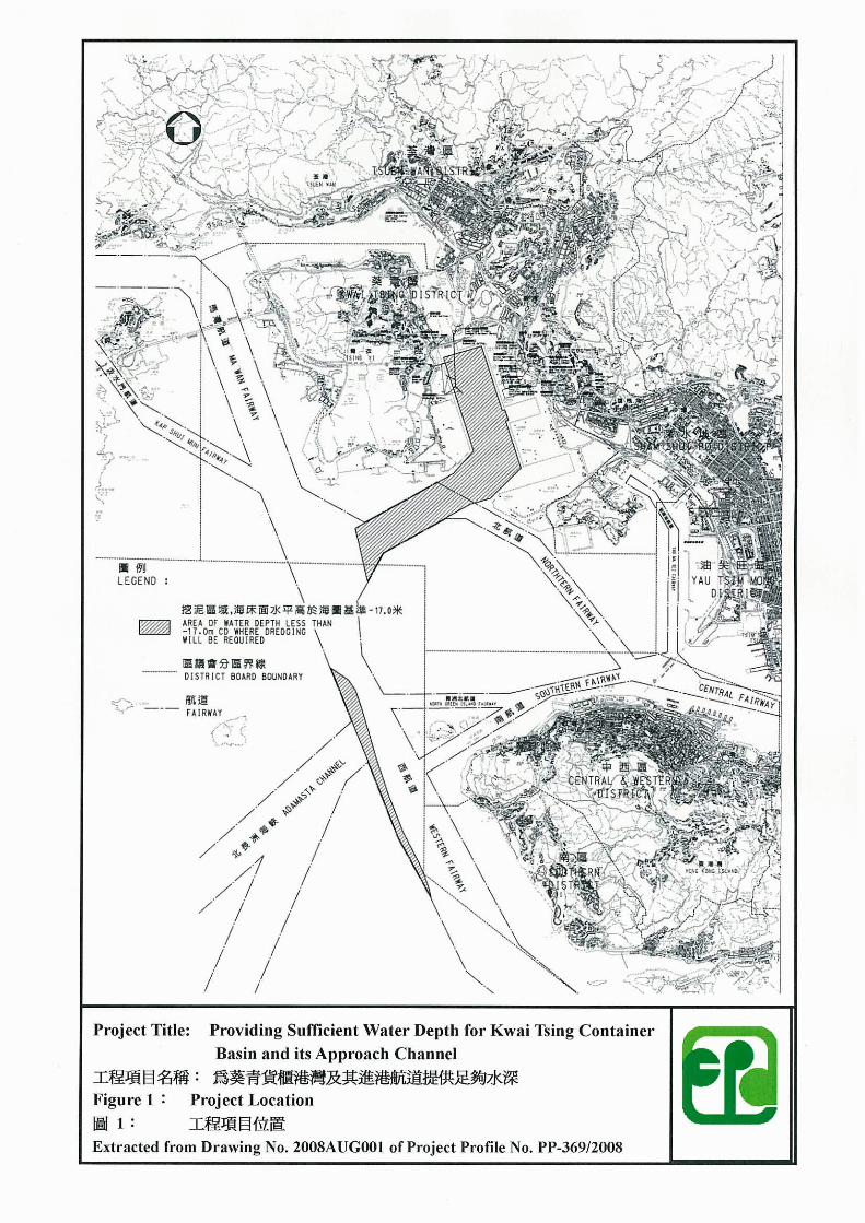
maintenance dredging for the operation of the Project. Location plan of the Project is
shown in Drawing No.2008AUG001 at the Appendix of the Project Profile and is
reproduced at Figure 1 of this study brief.
1.5 The Project is a designated project under item C.12 of Schedule 2 of the EIAO, which
specifies that a dredging operation exceeding 500 000 m3 or a dredging operation which
(a) is less than 500 m from the nearest boundary of an existing or planned
(i) site of special scientific interest;
(ii) site of cultural heritage;
(iii) bathing beach;
(iv) marine park or marine reserve;
(v) fish culture zone;
(vi) wild animal protection area;
(vii) coastal protection area; or
(viii) conservation area; or
(b) is less than 100 m from a seawater intake point.
1.6 During the course of the study, if any new designated project, e.g. Item C.10 – A marine
Page 2
EIA Study Brief No. ESB-198/2008
Providing Sufficient Water Depth for Kwai Tsing Container Basin and its Approach Channel December 2008
- 2 -
dumping area, is identified to be required for the implementation of the Project, the
Applicant shall submit separate application(s) under relevant section(s) of the EIAO.
Further, if the implementation of the Project is dependent on the newly identified
designated project(s), the project proponent should include the latest EIA findings of the
newly identified designated project(s) into this EIA report prior to submission for approval.
1.7 Pursuant to section 5(7)(a) of the EIAO, the Director of Environmental Protection (the
Director) issues this EIA Study Brief to the Applicant to carry out an EIA study.
1.8 The purpose of this EIA study is to provide information on the nature and extent of
environmental impacts arising from construction and operation which includes
maintenance dredging of the Project, and the related activities taking place concurrently.
This information will contribute to decisions by the Director on :
(i) the acceptability of adverse environmental consequences that are likely to arise as
a result of the Project and associated works;
(ii) the conditions and requirements for the detailed design, construction and operation
of the Project and associated works, including taking into account their
interconnection and development programmes, to mitigate against adverse
environmental consequences; and
(iii) the acceptability of residual impacts after the proposed mitigation measures are
implemented.
2. OBJECTIVES OF THE EIA STUDY
2.1 The objectives of the EIA study are as follows:
(i) to describe the Project and associated works together with the requirements,
implememtation programme and any phasing programme for carrying out the
Project;
(ii) to identify and describe elements of community and environment likely to be
affected by the Project and associated works and/or likely to cause adverse impacts
to the Project and associated works, including both the natural and man-made
environment and the associated environmental constraints;
(iii) to provide information on the consideration of alternatives (such as various
dredging methods/technologies and mitigation measures) with a view to avoiding or
minimizing the potential environmental impacts to the environmentally sensitive
areas and other sensitive uses, in particular Tsing Yi, Ma Wan, Kwai Chung, Green
Island, Lamma Island, Kau Yi Island, Peng Chau, Siu Kau Yi Chau, Sunshine
Island, Hei Ling Chau, Sandy Bay, Pak Kok, Shek Kok Tsui, Ap Lei Chau, Tsuen
Wan, etc.;
(iv) to compare the environmental benefits and disbenefits of each of the alternative
options and to provide reasons for selecting the preferred option(s) by means of
describing the role environmental factors played in the selection;
(v) to identify and quantify emission sources, including air and gaseous emission, noise
Page 3
EIA Study Brief No. ESB-198/2008
Providing Sufficient Water Depth for Kwai Tsing Container Basin and its Approach Channel December 2008
- 3 -
emission, dredged mud and waste generation, and to determine the significance of
impacts on sensitive receivers and potential affected uses;
(vi) to identify and quantify any potential loss or damage and other potential impacts to
ecological and fisheries resources, flora, fauna and natural habitats and to propose
measures to mitigate these impacts;
(vii) to identify any potential visual and glare impacts and to propose measures to
mitigate these impacts;
(viii) to identify any negative impacts on marine archaeological resources and to propose
measures to mitigate these impacts;
(ix) to propose measures to avoid or the provision of infrastructures or mitigation
measures to minimize risk, visually intrusive sediment plume dispersion, pollution,
environmental disturbance and nuisance during construction and operation of the
Project and associated works;
(x) to investigate the feasibility, practicability, effectiveness and implications of the
proposed mitigation measures;
(xi) to identify, predict and evaluate the residual environmental impacts (i.e. after
practicable mitigation) and the cumulative effects expected to arise during the
construction and operation of the Project and associated works, taking into account
the relevant programmes on re-provisioning of the affected facilities, in relation to
the sensitive receivers and potentially affected uses;
(xii) to identify, assess and specify methods, measures and standards to be included in
the detailed design, construction and operation of the Project and associated works
which are necessary to mitigate these environmental impacts and cumulative effects
and reduce them to acceptable levels;
(xiii) to investigate the extent of the secondary environmental impacts that may arise
from the proposed mitigation measures and to identify constraints associated with
the mitigation measures recommended in the EIA study, as well as the provision of
any necessary modification; and
(xiv) to design and specify environmental monitoring and audit requirements to check
the effective implementation of the recommended environmental protection and
pollution control measures adopted.
3. DETAILED REQUIREMENTS OF THE EIA STUDY
3.1 The Purpose
3.1.1 The purpose of this Study Brief is to scope the key issues of the EIA study and to specify
the environmental issues that are required to be reviewed and assessed in the EIA report.
The Applicant has to demonstrate in the EIA report that the criteria in the relevant sections
of the Technical Memorandum on the Environmental Impact Assessment Process of the
EIAO (hereinafter referred to as the “TM”) are met.
Page 4
EIA Study Brief No. ESB-198/2008
Providing Sufficient Water Depth for Kwai Tsing Container Basin and its Approach Channel December 2008
- 4 -
3.2 The Scope
3.2.1 The scope of this EIA study shall cover the Project proposed in the Project Profile and
mentioned in sections 1.3 and 1.4 above. As mentioned in the Project Profile and section
1.6 above, the Applicant shall make separate application(s) under relevant sections of the
EIAO for any newly identified designated project(s) during the course of the study.
3.2.2 The EIA study shall address the likely key issues described below, together with any other
key issues identified during the course of the EIA study and the cumulative environmental
impacts of the Project, through interaction or in combination with other existing,
committed and planned and known potential developments in the vicinity of the Project:
(i) The potential water quality impacts arising from the dredging, maintenance
dredging and any other marine works activities for the construction and operation
of the project. Particular attention shall be given to potential release of toxic
contaminants and potential increase of suspended solids affecting water sensitive
receivers and uses such as beaches, seawater intakes and fish culture zones at Ma
Wan, Lo Tik Wan , Sok Kwa Wan and Cheung Sha Wan, and all coral sites
within or close to the dredging areas including but not limited to Green Island,
Kau Yi Chau, Peng Chau, Siu Kau Yi Chau, Sunshine Island, Hei Ling Chau at
the west of the dredging area in the Western Fairway and Sandy Bay, Pak Kok,
Shek Kok Tsui, Ap Lei Chau at southeast of the dredging area in Western
Fairway;.
(ii) The hydrodynamic and water quality impacts including those to coastal area as a
result of the changes in flow regime, flushing capacity, and water quality in Hong
Kong waters during construction and operation of the Project on the relevant
water system(s). Particular attention shall be given to the hydrodynamic,
dispersion and dilution effects on the Ma Wan Channel and the sewage effluent
discharged from the Harbour Area Treatment Scheme’s (HATS) sewage
submarine outfall at the Stonecutters Island and other submarine outfalls within
the project area;
(iii) Morphological change of seabed profile on the sensitive areas and existing or
potential beneficial uses in the related water control zones and disturbance to the
ecologically sensitive areas/ habitats;
(iv) The potential noise impact caused by the construction and operation of the Project
associated with construction vessels and equipment;
(v) The potential impact on waste management and caused by waste generation (the
disposal during the construction and operation of the Project, in particular, the
disposal of dredged sediment during dredging;
(vi) The potential impact on capture and culture fisheries during the construction and
operation of the Project, such as loss or disturbance of sites of fisheries
importance, effect on fish culture zone, in particular Ma Wan, Lo Tik Wan, Sok
Kwa Wan and Cheung Sha Wan Fish Culture Zones, and disruption of fisheries
operations;
(vii) The potential impact on ecology during the construction and operation of the
Project, such as marine ecological impact due to loss or disturbance of benthic
Page 5
EIA Study Brief No. ESB-198/2008
Providing Sufficient Water Depth for Kwai Tsing Container Basin and its Approach Channel December 2008
- 5 -
habitats, intertidal habitat and foraging grounds, and effect on habitats for marine
mammals like Chinese White Dolphin, Finless Porpoise, corals, marine benthic
communities, and intertidal organisms;
(viii) The potential glare impacts during construction on nearby residents in Tsing Yi,
Kwai Chung, Tsuen Wan, Lamma Island, Western and Southern Districts, and
uses of Route 8; and
(ix) The potential cumulative environmental impacts of the Project through interaction
or in combination with other existing, committed and planned projects in their
vicinity, and that those impacts may have a bearing on the environmental
acceptability of the Project. Consideration shall be given to account for impacts
from likely concurrent projects, including Container Terminal No.10 in Southwest
Tsing Yi, Proposed dredging for marine sand at South of Tsing Yi, Proposed
laying of submarine cable between Kennedy Town & Outlying Islands, Proposed
submarine cable from Tong Fuk to Chung Hom Kok, Dredging operations &
seawalls modification works carried out by the container terminals’operators in
associated with this seabed deepening project, Marine borrow & dumping areas at
South of Tsing Yi, etc.
3.3 Consideration of Alternatives
3.3.1 Need of the Project
3.3.1.1 The Applicant shall provide information on the need of the Project, including the purpose
and objectives of the Project and describe the scenarios with and without the Project.
3.3.2 Consideration of Other Construction Methods and Sequence of Works
3.3.2.1 Having regard to the cumulative effects of the construction period and the severity of the
construction impacts to the affected sensitive receivers, the Applicant shall explore other
alternative construction methods (including those indicated in the Project Profile, i.e. the
closed grab dredger method, the trailer suction dredger and other possible methods to be
investigated during the course of the EIA study) and sequences of works for the Project,
with a view to proposing the best practical method to avoid prolonged adverse
environmental impacts to the maximum practicable extent. A comparison of the
environmental benefits and dis-benefits of applying different construction methods and
sequence of works shall be made to demonstrate the role played by environmental factors
in the selection of the preferred option.
3.3.2.2 The EIA report shall include the consideration of the following alternatives:-
i) Scope and Sequence of Works of the Project at KTCT, Northern Fairway and
Western Fairway with a view to avoiding or minimising any adverse impacts on
air quality, noise, water quality, visual, glare, etc.;
ii) scale, size, layout and configuration of the dredging with a view to avoiding or
minimising any adverse impacts on water quality, fisheries, ecology, etc., in
particular any adverse impacts on hydrodynamic and water quality, in particular
coral communities (including all hard corals, octocorals and black corals) and
important habitats for marine mammals; and
Page 6
EIA Study Brief No. ESB-198/2008
Providing Sufficient Water Depth for Kwai Tsing Container Basin and its Approach Channel December 2008
- 6 -
iii) construction method for any dredging and marine works with a view to avoiding
or minimising any adverse impacts on water quality, waste management &
disposal, fisheries, ecology, etc.
3.3.3 Need for Maintenance Dredging
3.3.3.1 The Applicant shall also investigate the impacts of maintenance dredging during
operation stage. The Applicant shall assess and quantify the frequency and extent of
maintenance dredging, dredging method(s) to be adopted, and the associated noise,
ecological, fisheries and water quality impacts.
3.4 Technical Requirements
3.4.1 The Applicant shall conduct the EIA study to address all environmental aspects of the
activities described in Sections 3.1, 3.2 and 3.3 above. The assessment shall be based on
the best and latest information available during the course of the EIA study. The Applicant
shall clearly state in the EIA report the time frame and work programmes of the Project and
other concurrent projects, and assess the cumulative environmental impacts from the
Project and interacting projects as identified in the EIA study.
3.4.2 The EIA study shall include the following technical requirements on specific impacts.
3.4.3 Water Quality Impact
3.4.3.1 The Applicant shall follow the criteria and guidelines for evaluating and assessing water
pollution as stated in Annexes 6 and 14 of the TM.
3.4.3.2 The study area for this water quality impact assessment shall cover the North Western
Water Control Zone, Western Buffer Water Control Zone, Victoria Harbour Water Control
Zone and Southern Water Control Zone as designated under the Water Pollution Control
Ordinance (WPCO). Sensitive receivers including, but not limiting to, beaches, recreation
and tourism related uses, seawater intakes, cooling water intakes, salt water pumping
stations (SWPSs) of the Water Supplies Department (WSD), marine parks, Chinese White
Dolphin and Finless Porpoise habitats, fish culture zones, Sites of Special Scientific
Interest (SSSIs), artificial reefs, corals, fishing, spawning and nursery grounds of
commercially important species in the above areas shall be addressed in the water quality
assessment. The assessment shall cover the sensitive receivers at Ma Wan, Tsuen Wan,
Tsing Yi, Kwai Chung, Ting Kau and along Castle Peak Road, Sham Shui Po, Green Island,
Peng Chau and Kau Yi Chau. The Study Area shall be extended to include other areas if
they are found to be affected during the course of the EIA study and have a bearing on the
environmental acceptability of the Project.
3.4.3.3The Applicant shall identify and analyse in the assessment the physical, chemical and
biological disruptions of marine, coastal, estuarine and fresh water system(s) arising from
construction and operation of the Project.
3.4.3.4 The Applicant shall predict, quantify and assess any water quality impacts arising from the
Project and the sensitive receivers by appropriate mathematical modelling and/or other
techniques proposed by the Applicant and approved by the Director. The mathematical
modelling requirements are set out in Appendix A attached to this Study Brief. Possible
impacts due to the dredging, transportation and disposal of dredged materials and other
marine works activities shall include but not be limited to changes in hydrology, flow
Page 7
EIA Study Brief No. ESB-198/2008
Providing Sufficient Water Depth for Kwai Tsing Container Basin and its Approach Channel December 2008
- 7 -
regime, silting, sediment erosion and deposition patterns, morphological change of seabed
profile, water and sediment quality, fisheries, marine organisms/community. The prediction
shall include possible different construction stages or sequences, different construction
methods, and different operational stages for the preferred option identified in section 3.3
of this Study Brief. Affected sensitive receivers shall be identified by the assessment tool
with indications of degree of severity.
3.4.3.5 The Applicant shall take into account and include the construction and operational stages or
sequences of the Project in the assessment. The assessment shall have regard to the phasing,
frequency, duration and rate of dredging, and its sediment loading. Essentially the
assessment shall address the following in the water quality impact assessment :-
General
(i) Collection and review of background information on the existing water system(s)
and their respective catchments, and sensitive receivers which might be affected by
the Project, associated works, supporting facilities and essential infrastructures
during construction and operation;
(ii) Characterization of water and sediment quality of the related water system(s) and
sensitive receivers, which might be affected by the Project, associated works,
supporting facilities and essential infrastructures during construction and operation,
based on existing information or appropriate site survey/tests;
(iii) Identification and analysis of existing and future activities and beneficial uses
related to the water system(s) and identification of water sensitive receivers. The
Applicant shall refer to inter alia those developments and uses earmarked on the
relevant Outline Zoning Plans, Development Permission Area Plans, Outline
Development Plans and Layout Plans;
(iv) Identification of pertinent water and sediment quality objectives, criteria and
standards for the water system(s) and the sensitive receivers identified in (i), (ii)
&(iii) above including ecological and fisheries sensitive receivers for the
assessments covered in Sections 3.4.7 and 3.4.8;
(v) Review of the construction sequences and methods, and operation of the Project and
associated works to identify any alteration of water courses, change of shoreline or
bathymetry and change of flow regimes. The selected method shall take into
consideration the need to protect relevant water sensitive receivers and let the
marine sediments be left in place and not be disturbed as far as possible;
(vi) Identify, analyse and quantify existing and likely future water and sediment
pollution sources and loading (including maintenance dredging during operational
phase of the Project). An emission inventory on the quantities and characteristics of
these existing and likely future pollution sources in the Study Area shall be
provided. Field investigation and laboratory tests, as appropriate, shall be conducted
to fill in any relevant information gaps;
Impact Prediction
(vii) Prediction and quantification, by mathematical modelling or other technique approved
by the Director, of impacts on the water system(s) and the sensitive receivers due to
Page 8
EIA Study Brief No. ESB-198/2008
Providing Sufficient Water Depth for Kwai Tsing Container Basin and its Approach Channel December 2008
- 8 -
those alterations and changes identified in (v) above and the pollution sources
identified in (vi) above. The mathematical modelling requirements are set out in
Appendix A of this Study Brief. Possible impacts include changes in hydrology, flow
regime, silting, sediment erosion or deposition, water and sediment quality and the
effects on the marine organism or fisheries due to such changes in the affected water
bodies. The prediction shall include possible different construction stages of the
Project;
(viii) Identification and quantification of dredging, sediment/mud transportation and
disposal activities and requirements. Potential dumping ground(s) to be involved
shall also be identified and cumulative environmental impacts during their
operation shall be evaluated. Field investigation, sampling, chemical and biological
laboratory tests to characterize the sediment/mud concerned shall be conducted as
appropriate. The potential for the release of contaminants during dredging shall be
addressed using the chemical testing results derived from sediment and marine
water samples collected on site and relevant historic data. Appropriate laboratory
tests such as elutriate tests and sediment pore water (interstitial water) analyses
shall be performed on the sediment samples to simulate and quantify the degree of
mobilization of various contaminants such as metals, oxygen demand, ammonia,
trace organic contaminants (including PCBs, PAHs, TBT and chlorinated pesticides)
into the water column during dredging. The ranges of parameters to be analyzed;
the number, location, depth of sediment, type and methods of sampling; sample
preservation; and chemical and biological laboratory test methods to be used shall
be subject to the approval of the Director. The Applicant shall also assess the
pattern of the sediment deposition and the potential increase in turbidity and
suspended solid levels in the water column and at the sensitive receivers due to the
disturbance of sediments during dredging;
(ix) Predict, quantify and assess impacts on the hydrodynamic regime, water and
sediment quality of the water system(s) and the sensitive receivers due to the
activities identified above. The prediction and quantification of impacts caused by
sediment re-suspension and dispersion and contaminants release shall be carried out
by mathematical modelling requirements as set out in Appendix A of this Study
Brief or other techniques to be approved by the Director;
(x) Assessment of cumulative impacts due to other concurrent and planned projects,
activities or pollution sources in the vicinity of the identified water system(s) and
sensitive receivers that may have a bearing on the environmental acceptability of
the Project through mathematical modelling or other technique approved by the
Director;
(xi) Review, evaluate and identify alternative options and the best practicable method for
dredging to minimize, to the maximum extent, marine mud disturbance, and the
need for dumping. The selected method shall take into consideration the need to
protect ecological sensitive receivers identified at various locations as required
under Section 3.4.7;
(xii) Recommendation of appropriate mitigation measures to avoid or minimize the
impacts identified above, in particular suitable methods and arrangement for
dredging, filling and mud disposal, shall be recommended to mitigate any adverse
impact. Evaluation and quantification of residual impacts on the water system(s)
and the sensitive receivers with regard to the appropriate water and sediment quality
Page 9
EIA Study Brief No. ESB-198/2008
Providing Sufficient Water Depth for Kwai Tsing Container Basin and its Approach Channel December 2008
- 9 -
objectives, criteria, standards or guidelines shall be assessed using appropriate
mathematical models as set out in Appendix A to this Study Brief;
3.4.3.6The Applicant shall compare the environmental benefits and dis-benefits of different
possible design and construction method of the Project with a view to avoiding or
minimising the adverse environmental effect on Ma Wan Channel, Fish Culture Zones at
Ma Wan, Lo Tik Wan, So Kwu Wan and Cheung Sha Wan, coral sites at Green Island,
Kau Yi Island, Peng Chau, Siu Kau Yi Chau, Sunshine Island, Hei Ling Chau, Sandy Bay,
Pak Kok, Shek Kok Tsui and Ap Lei Chau, bathing beaches and recreational and tourism
related uses at Ma Wan, Tsing Yi, Kwai Chung, Tsuen Wan and, seawater intakes at Ma
Wan, Tsing Yi and Cheung Sha Wan, WSD’s seawater pumping stations at Tsing Yi,
Tsuen Wan, Cheung Sha Wan, Kennedy Town, Sandy Bay and HATS’ submarine sewage
outfall at the Stonecutters Island, and morphological change of the seabed during
construction and operation stages. The Applicant shall describe clearly the potential impact
on the benthic organisms at the related seabed areas, frequency and rate of dredging and
recurrent water quality impacts of the maintenance dredging activities due to the Project
alone and the cumulative impact with concurrent projects.
3.4.3.7The Applicant shall evaluate the need of maintenance dredging at operation stage of the
Project. The cumulative water quality impacts arising from maintenance dredging and
other interfacing projects within the Study Area shall be assessed with reference to the
frequency and rate of maintenance dredging required as identified in section 3.3 of this
Study Brief.
3.4.4 Construction Stage Air Quality Impact
3.4.4.1 The Applicant shall follow the criteria and guidelines for evaluating and assessing air
quality impact as stated in Section 1 of Annex 4 and Annex 12 of the TM, respectively.
3.4.4.2 The study area for air quality impact assessment shall be defined by a distance of 500
metres from the Project boundary shown in Appendix A of this Study Brief or other project
locations as identified in the EIA which shall be extended to include major existing,
planned and committed air pollutant emission sources that may have a bearing on the
environmental acceptability of the Project. The assessment shall include the existing,
planned and committed sensitive receivers within the study area as well as areas where air
quality may be potentially affected by the Project. Such assessment shall be based on the
best available information at the time of the assessment.
3.4.4.3 The air quality impact assessment shall include the following:
(i) Background and Analysis of Activities
(a) Provision of background information relating to air quality issues relevant to
the Project, e.g. description of the types of activities of the Project that may
affect air quality during construction stage.
(b) Giving an account, where appropriate, of the consideration/measures that have
been taken into consideration in the planning of the Project to abate the air
pollution impact. That is, the Applicant shall consider alternative construction
methods / phasing programmes to minimize the construction dust impact.
(c) Presentation of the background air quality levels in the assessment area for the
Page 10
EIA Study Brief No. ESB-198/2008
Providing Sufficient Water Depth for Kwai Tsing Container Basin and its Approach Channel December 2008
- 10 -
purpose of evaluating the cumulative construction air quality impacts.
(ii) Identification of Air Sensitive Receivers (ASRs) and Examination of
Emission/Dispersion Characteristics
(a) Identification and description of existing and planned / committed ASRs that
would likely be affected by the Project including those earmarked on the
relevant Outline Zoning Plans, Outline Development Plans and Layout Plans
and other relevant published land use plans, including plans and drawings
published by Lands Department and any land use and development application
approved by the Town Planning Board. The Applicant shall select the
assessment points of the identified ASRs that represent the worst impact point
of these ASRs. A map showing the location and description such as name of
buildings, their uses and height of the selected assessment points shall be given.
The separation distances of these ASRs from the nearest emission sources shall
also be given.
(b) Provide a list of air pollution emission sources, including any nearby emission
sources which are likely to have impact related to the Project based on the
analysis of the construction activities in Sub-section 3.4.4.3(i)(a) above.
Examples of construction stage emission sources such as stock piling on barge.
Confirmation of the validity of the assumptions and the magnitude of the
activities (e.g. volume of dredging materials handled e.t.c.) shall be obtained
from the relevant government department/authorities and documented.
(iii) Constructional Dust Impact
The applicant shall follow the requirements stipulated under the Air Pollution
Control (Construction Dust) Regulation to ensure that construction dust impacts are
controlled within the relevant standards as stipulated in Section 1 of Annex 4 of the
TM. A monitoring and audit programme for the construction phase shall be devised
to verify the effectiveness of the control measures proposed so as to ensure proper
construction dust control.
3.4.5 Noise Impact
3.4.5.1 The Applicant shall follow the criteria and guidelines for evaluating and assessing noise
impact as stated in Annexes 5 and 13 of the TM.
3.4.5.2 The noise impact assessment shall include the following :-
(i) Determination of Assessment Area
The study area for the noise impact assessment shall generally include areas within a
distance of 300m from the Project boundary as shown in Appendix A of this Study
Brief or other Project locations as identified in the EIA. Subject to the agreement of
the Director, the assessment area can be reduced accordingly if the first layer of
noise sensitive receivers (NSRs), closer than 300m from the outer Project limit,
provides acoustic shielding to those receivers at distances further away from the
Project. The assessment area shall be expanded to include NSRs at distances over
300m from the Project if those NSRs are affected by the construction and operation
of the Project.
Page 11
EIA Study Brief No. ESB-198/2008
Providing Sufficient Water Depth for Kwai Tsing Container Basin and its Approach Channel December 2008
- 11 -
(ii) Provision of Background Information and Existing Noise Levels
(a) The Applicant shall provide background information relevant to the Project,
including relevant previous or current studies. Unless required for determining
the planning standards, such as those for planning of fixed noise sources, no
existing noise levels are particularly required.
(b) The Applicant shall note the existing background noise due to operational
noise from existing operations of the container terminals and provide
information in view of considering the noise impacts from the Project and its
mitigations.
(iii) Identification of Noise Sensitive Receivers
(a) The Applicant shall refer to Annex 13 of the TM when identifying the NSRs.
The NSRs shall include existing NSRs and planned/committed noise sensitive
developments and uses earmarked on the relevant Outline Zoning Plans,
Outline Development Plans, Layout Plans and other relevant published land
use plans, including plans and drawings published by Lands Department and
any land use and development applications approved by the Town Planning
Board. Photographs of existing NSRs shall be appended to the EIA report.
(b) The Applicant shall select assessment points to represent the identified NSRs
for carrying out quantitative noise assessment described below. A map
showing the location and description such as name of building, use, and
number of floors of each and every selected assessment point shall be given.
For planned noise sensitive land uses without committed site layouts, the
Applicant shall use the relevant planning parameters to work out
representative site layouts for noise assessment purpose.
(iv) Provision of an Emission Inventory of the Noise Sources
The Applicant shall provide an inventory of noise sources including representative
construction equipment for the purpose of carrying out the construction noise
assessment, such as those used for tunnelling and other construction works, and
vehicular and marine traffic flow, fixed plant equipment and helicopter noise
sources, as appropriate, for operational noise assessment. Confirmation of the
validity of the inventory shall be obtained from the relevant government
departments/authorities and documented in the EIA report.
(v) Construction Noise Assessment
(a) The assessment shall cover the cumulative noise impacts due to the
construction works of the Project, associated works, supporting facilities and
essential infrastructures and other concurrent projects identified during the
course of the EIA study.
(b) The Applicant shall carry out assessment of noise impact from construction
(excluding percussive piling) of the Project during daytime, i.e. 7am to 7pm,
on weekdays other than general holidays in accordance with methodology in
paragraphs 5.3 and 5.4 of Annex 13 of the TM. The criteria in Table 1B of
Annex 5 of TM shall be adopted in the assessment.
Page 12
EIA Study Brief No. ESB-198/2008
Providing Sufficient Water Depth for Kwai Tsing Container Basin and its Approach Channel December 2008
- 12 -
(c) If the unmitigated construction noise levels are found exceeding the relevant
criteria, the Applicant shall propose practicable direct mitigation measures
(including movable barriers, enclosures, quieter alternative methods,
rescheduling and restricting hours of operation of noisy tasks) to minimize the
impact. If the mitigated noise levels still exceed the relevant criteria, the
duration of the noise exceedance at the affected NSR shall be given.
(d) The Applicant shall, as far as practicable, formulate a reasonable construction
programme so that no work will be required in restricted hours as defined
under the Noise Control Ordinance (NCO). In case the Applicant needs to
evaluate whether construction works in restricted hours as defined under the
NCO are feasible or not in the context of programming construction works,
reference should be made to relevant technical memoranda issued under the
NCO. In case the Applicant considers that there is an unavoidable need to
conduct certain type of construction works during the restricted hours, detailed
justifications shall be provided with the assessment of the degree and duration
of the noise impact. Regardless of the results of construction noise impact
assessment for restricted hours, the Noise Control Authority will process
Construction Noise Permit (CNP) application, if necessary, based on the NCO,
the relevant technical memoranda issued under the NCO, and the
contemporary conditions/situations. This aspect shall be explicitly stated in the
noise chapter and the conclusions and recommendations chapter in EIA report.
(vi) Assessment of Side Effects and Constraints
The Applicant shall identify, assess and propose means to minimize any side effects
and to resolve any potential constraints due to the inclusion of any recommended
direct mitigation measures.
3.4.6 Waste Management Implications
3.4.6.1 The Applicant shall follow the criteria and guidelines for evaluating and assessing waste
management implications as stated in Annexes 7 and 15 of the TM.
3.4.6.2The assessment of waste management implications shall cover the following:
(i) Analysis of Activities and Waste Generation
The Applicant shall identify the quantity, quality and timing of the wastes arising as
a result of the construction and operation activities of the Project, based on the
sequence and duration of these activities, e.g. any dredged/excavated sediment/mud,
construction and demolition materials, floating refuse and other wastes which will be
generated during construction and operation stages. The Applicant shall adopt design,
general layout, construction methods and programme to minimize the generation of
public fill/inert construction and demolition (C&D) materials and maximize the use
of public fill/inert C&D materials for other construction works, e.g. reclamation
work.
(ii) Proposal for Waste Management
(a) Prior to considering the disposal options for various types of wastes,
Page 13
EIA Study Brief No. ESB-198/2008
Providing Sufficient Water Depth for Kwai Tsing Container Basin and its Approach Channel December 2008
- 13 -
opportunities for reducing waste generation, on-site or off-site re-use and
recycling shall be fully evaluated. Measures that can be taken in the planning
and design stages e.g. by modifying the design approach and in the
construction stage for maximizing waste reduction shall be separately
considered;
(b) After considering the opportunities for reducing waste generation and
maximizing re-use, the types and quantities of the wastes required to be
disposed of as a consequence shall be estimated and the disposal
methods/options for each type of waste shall be described in detail. The
disposal methods/options recommended for each type of wastes shall take
into account the result of the assessment in item (d) below;
(c) The EIA report shall also state clearly the transportation routings and the
frequency of the trucks/vessels involved, any barging point or conveyor
system to be used, the stockpiling areas and the disposal outlets for the wastes
identified; and
(d) The impact caused by handling (including stockpiling, labelling, packaging &
storage), collection, transportation and re-use/disposal of wastes shall be
addressed in detail and appropriate mitigation measures shall be proposed.
This assessment shall cover the following areas:
- potential hazard;
- air and odour emissions;
- noise;
- wastewater discharge; and
- public transport.
(iii) Dredging/Excavation, Filling and Dumping
(a) Identification and quantification as far as practicable of dredging/excavation,
fill extraction, filling, reclamation, sediment/mud transportation and disposal
activities and requirements shall be conducted. Potential fill source and
dumping ground to be involved shall also be identified. Field investigation,
sampling and chemical and biological laboratory tests to characterize the
sediment/mud concerned shall be conducted as appropriate. The ranges of
parameters to be analyzed; the number, type and methods of sampling;
sample preservation; chemical and biological laboratory test methods to be
used shall be agreed with the Director (with reference to Section 4.4.2(c) of
the TM) prior to the commencement of the tests. The categories of
sediment/mud which are to be disposed of in accordance with a permit
granted under the Dumping at Sea Ordinance (DASO) shall be identified by
both chemical and biological tests and their quantities shall be estimated. If
the presence of any serious contamination of sediment/mud which requires
special treatment/disposal is confirmed, the Applicant shall identify the most
appropriate treatment and/or disposal arrangement and demonstrate its
feasibility. The Applicant shall provide supporting document, such as
agreement by the relevant facilities management authorities, to demonstrate
the viability of any treatment/disposal plan.
(b) Identification and evaluation of the best practical dredging/excavation
methods to minimize dredging/excavation and dumping requirements and
Page 14
EIA Study Brief No. ESB-198/2008
Providing Sufficient Water Depth for Kwai Tsing Container Basin and its Approach Channel December 2008
- 14 -
demand for fill sources based on the criterion that existing sediment/mud
shall be left in place and not to be disturbed as far as possible.
3.4.7 Marine Ecological Impact
3.4.7.1 The Applicant shall follow the criteria and guidelines for evaluating and assessing
ecological impact as stated in Annexes 8 and 16 of the TM.
3.4.7.2 The assessment area for marine ecological impact shall be same as the assessment area for
water quality impact assessment and shall also include any other areas likely to be
impacted by the Project.
3.4.7.3 In the ecological impact assessment, the Applicant shall examine the flora, fauna and
other components of the ecological habitats within the assessment area. The aim shall be
to protect, maintain or rehabilitate the natural environment. In particular, the Project, shall
avoid or minimise impacts on recognised sites of conservation importance and wildlife
groups or habitats/species of conservation important such as important habitats of wildlife
and marine mammals such as Finless Porpoise and Chinese White Dolphin, marine
benthic communities, intertidal habitats and coral communities. All coral sites within or
close to the dredging areas including but not limited to Green Island, Kau Yi Chau, Peng
Chau, Siu Kau Yi Chau, Sunshine Island, Hei Ling Chau at the west of the dredging area
in the Western Fairway and Sandy Bay, Pak Kok, Shek Kok Tsui, Ap Lei Chau at
southeast of the dredging area in Western Fairway shall be covered.The assessment shall
identify and quantify as far as possible the potential ecological impacts to the natural
environment and the associated wildlife groups and habitats/species arising from the
Project including their construction and operation phases.
3.4.7.4 The assessment shall include the followings:
(i) Review of the findings of relevant studies/surveys and collation of the available
information regarding the ecological characters of the assessment area;
(ii) Evaluation of information collected and identification of any information gap
relating to the assessment of potential ecological impact;
(iii) Carrying out necessary ecological field surveys, the duration of which shall be at
least 4 months, and investigation to verify the information collected, fill the
information gaps identified in (ii) above and to fulfil the objectives of the EIA study.
The field surveys shall include but not limited to corals, marine benthic
communities and intertidal habitats. The corals surveys should cover subtidal
habitats within the dredging area, seawall modification works area and other areas
where marine works would be undertaken;
(iv) Establishment of the general ecological profile of the Study Area based on data of
relevant previous studies/surveys and results of the ecological field surveys, and
taking into consideration the seasonal variations, and description of the
characteristics of each habitat found; major information to be provided shall
include :
(a) description of the physical environment, including recognized sites/
habitats of conservation importance, and assessment of whether these
sites/habitats will be affected by the Project, associated works, supporting
facilities and essential infrastructures or not;
Page 15
EIA Study Brief No. ESB-198/2008
Providing Sufficient Water Depth for Kwai Tsing Container Basin and its Approach Channel December 2008
- 15 -
(b) habitat maps of suitable scale showing the types and locations of
habitats/species in the Study Area with special attention to those with
conservation interests, including the followings :
� coral communities (including all hard corals, octocorals and black
corals);
� marine benthic communities and intertidal habitats (including rocky
shores and sandy shores);
� marine mammals, in particular Finless Porpoises and Chinese White
Dolphin; and
� any other habitats/species identified as having special conservation
interest by this EIA study.
(c) ecological characteristics of each habitat type such as extent, substrate,
size, type, species present, dominant species found, species diversity and
abundance, community structure, ecological value and inter-dependence of
the habitats and species, and presence of any features of ecological
importance;
(d) representative colour photos of each habitat type and any important
ecological features identified; and
(e) species found that are rare, endangered and/or listed under local legislation,
international conventions for conservation of wildlife/ habitats or red data
books.
(v) Investigation and description of the existing wildlife uses of the various habitats
with special attention to those wildlife groups and habitats with conservation
interests, including coral communities, important benthic communities and intertidal
habitats, and marine mammals (e.g. Finless Porpoises and Chinese White Dolphin),
in the context of the Project, associated works, supporting facilities and essential
infrastructures;
(vi) Using suitable methodology (e.g. water quality modeling) and considering also
other works activities from other projects reasonably likely to occur at the same
time, identification and quantification as far as possible of any direct (e.g. loss of
habitats due to dredging, and marine works), indirect (e.g. changes in water qualities,
hydrodynamics properties, sedimentation rates and pattern, hydrology, noise and
other disturbance generated by the construction and operation activities, including
maintenance dredging if any, etc), primary, secondary and cumulative ecological
impacts from destruction of habitats, reduction of species abundance/diversity, loss
of feeding grounds, reduction of ecological carrying capacity, habitat fragmentation,
and in particular the followings :
(a) Potential impacts to marine benthic communties and intertidal habitats
(including rocky shores and sandy shores);
(b) Potential deterioration or disturbance to corals (including hard corals,
octocorals and black corals);
(c) Potential impacts on marine ecology due to dredging and disposal of
Page 16
EIA Study Brief No. ESB-198/2008
Providing Sufficient Water Depth for Kwai Tsing Container Basin and its Approach Channel December 2008
- 16 -
contaminated mud; and
(d) Potential impacts to marine habitats/species of conservation value, including
Finless Porpoises, Chinese White Dolphin and any others discovered during
the course of the study;
(e) Potential impacts on Chinese White Dolphin and Finless Porpoise associated
with potential bioaccumulation of toxic contaminants such as POPs and
heavy metals, from the disturbed or dredged sediment or other potential
sources. The significance and acceptability of the predicted impacts shall be
evaluated using well-defined criteria;
(f) Potential risk of Chinese White Dolphin and Finless Porpoise colliding with
marine vessels during construction; and
(g) Change in marine traffic volume, distribution and pattern during the
operational stage, and the consequential increase or decrease in risk of
Chinese White Dolphin and Finless Porpoise colliding with marine vessels;
(vii) Evaluation of significance and acceptability of the ecological impacts by making
reference to the criteria in Annex 8 of the TM;
(viii) Evaluation of ecological impact based on the best and latest information available
during the course of the EIA study, using quantitative approach as far as practicable
and covering construction and operation phases of the Project;
(ix) Recommendations for possible alternatives, such as modification/change of
construction methods, position, scale, size, layout and configuration of reclamation,
and practicable mitigation measures to avoid, minimize and/or compensate for the
adverse ecological impacts identified during construction and operation of the
Project;
(x) Evaluation of the feasibility and effectiveness of the recommended mitigation
measures and definition of the scope, type, location, implementation arrangement,
resources requirement, subsequent management and maintenance of such measures;
(xi) Determination and quantification as far as possible of the residual ecological
impacts after implementation of the proposed mitigation measures;
(xii) Evaluation of the severity and acceptability of the residual ecological impacts using
well-defined criteria and determine if off-site mitigation measures are necessary to
mitigate the residual impacts; and
(xiii) Review of the need for and recommendation on any ecological monitoring and audit
programme required.
3.4.8 Fisheries Impact
3.4.8.1 The Applicant shall follow the criteria and guidelines for evaluating and assessing
fisheries impact as stated in Annexes 9 and 17 of the TM.
Page 17
EIA Study Brief No. ESB-198/2008
Providing Sufficient Water Depth for Kwai Tsing Container Basin and its Approach Channel December 2008
- 17 -
3.4.8.2 The assessment area for fisheries impact assessment shall be same as the assessment area
for water quality impact assessment and shall also include any other areas likely to be
impacted by the Project, associated works, supporting facilities and essential
infrastructures. Special attention shall be given to the fishing activities and fishing,
spawning and nursery grounds within the assessment area and the following Fish Culture
Zones (FCZs):
(a) Ma Wan FCZ
(b) Lo Tik Wan FCZ
(c) Sok Kwu Wan FCZ
(d) Cheung Sha Wan FCZ
3.4.8.3 The assessment shall cover any potential short and long-term impacts on both capture and
culture fisheries, during the decommissioning, construction and operation phases. Existing
information available from relevant studies/surveys regarding the assessment area shall be
reviewed. Based on the review results, the assessment shall identify data gap and
determine if there is any need for field surveys. If field surveys are considered necessary,
the assessment shall recommend appropriate methodology, duration and timing for the
field surveys.
3.4.8.4 The fisheries impact assessment shall include the following tasks:
(i) Description of the physical environmental background;
(ii) Description and quantification of the existing capture and culture fisheries
activities;
(iii) Description and quantification of the existing fisheries resources (e.g. major
fisheries products and stocks);
(iv) Identification of parameters e.g. water quality parameters and areas that will be
affected;
(v) Identification and evaluation of any direct and indirect, onsite and offsite impacts
on capture fisheries such as loss or disturbance of fishing grounds, spawning and
nursery grounds and disruption of fishing activities;
(vi) Identification and evaluation of any direct and indirect, onsite and offsite impacts
on culture fisheries such as water quality deterioration in fish culture zone;
(vii) Recommendations on any onsite and offsite environmental mitigation measures
with justification, description of scope and programme, feasibility as well as staff
and financial implications including those related to subsequent management and
maintenance requirements of such recommendations; and
(viii) Review of the need for monitoring and, if necessary, recommendation of
monitoring and audit programme.
3.4.9 Landscape, Visual and Glare Impact
3.4.9.1 The Applicant shall follow the criteria and guidelines as stated in Annexes 10 and 18 of
the TM and the EIAO Guidance Note No. 8/2002 on the preparation of Landscape and
Page 18
EIA Study Brief No. ESB-198/2008
Providing Sufficient Water Depth for Kwai Tsing Container Basin and its Approach Channel December 2008
- 18 -
Visual Impact Assessment under the EIAO. Landscape and visual impacts during
construction and operation phases within the study area and the related works areas shall
be assessed.
3.4.9.2 The assessment area for the landscape, visual and glare impact assessment shall include
areas within a 500m distance from the site boundary of the Project, associated works,
supporting facilities and essential infrastructures, while the assessment area for the visual
impact assessment shall be defined by the visual envelop of the Project, associated works,
supporting facilities and essential infrastructures. The assessment for the visual impact
assessment shall cover the areas of Ma Wan, Tsing Yi, Kwai Chung, Tsuen Wan,
Northeast Lantau, Northwestern part of Hong Kong Island and those areas affected by
glare or any uncomfortable eye feeling caused by light interference from direct
man-made light sources generated from the Project. The defined visual envelope shall be
shown on a plan and documented in the EIA report.
3.4.10 Cultural Heritage Impact
3.4.10.1The Applicant shall follow the criteria and guidelines for evaluating and assessing the
cultural heritage impacts as stated in Annexes 10 and 19 of the TM.
3.4.10.2The Applicant shall engage a qualified marine archaeologist to review information to
identify whether there is any possible existence of sites of objects of cultural heritage, for
example shipwreck, within seabed that will be affected by the marine and dredging works
of the Project. The result of the review shall be presented as a written report and charts. If
possible existence of sites or objects of cultural heritage are found, a Marine
Archaeological Investigation (MAI) shall be required. The MAI shall be carried out by a
qualified marine archaeologist who shall obtain a Licence from the Antiquities Authority
under the provision of the Antiquities and Monuments Ordinance (Cap 53). The
requirements of the MAI are set out in Appendix B of this EIA study brief.
3.4.11 Hazard to Life
3.4.11.1 The Applicant shall follow the criteria for evaluating hazard to life as stated in Annex 4 of
the TM.
3.4.11.2 The Applicant shall carry out a hazard assessment for the potential risk to construction
workers and users during construction stages of the Project due to their presence within
the consultation zones of PHIs (LPG/oil depots). The hazard assessment shall include the
followings:
(i) Identification of hazardous scenario associated with the operation of the existing
PHIs present in the study area of the Project with a view to determining a set of
relevant hazard scenarios to be included in a Quantitative Risk Assessment (QRA);
(ii) Execution of a QRA of the set of hazardous scenarios determined in (i), expressing
population risks in both individual and societal terms;
(iii) Comparison of individual and societal risk with the criteria for evaluating hazard to
life stipulated in Annex 4 of the TM;and
(iv) Identification and assessment of practicable and cost-effective risk mitigation
measures,
Page 19
EIA Study Brief No. ESB-198/2008
Providing Sufficient Water Depth for Kwai Tsing Container Basin and its Approach Channel December 2008
- 19 -
3.4.11.3The methodology to be used in the hazard assessment shall be consistent with previous
studies having similar issues (e.g. EIA study for the Permanent Aviation Fuel facility for
Hong Kong International Airport) or otherwise be agreed by the Director prior to carrying
out of the hazard assessment.
3.4.12 Summary of Environmental Outcomes
3.4.12.1 The EIA report shall contain a summary of the key environmental outcomes arising from
the EIA study, including estimated population protected from various environmental
impacts, the environmentally sensitive areas protected, environmentally friendly options
considered and incorporated in the preferred option, environmental designs recommended,
key environmental problems avoided, compensation areas included and the environmental
benefits of the environmental protection measures recommended.
3.4.13 Environmental Monitoring and Audit (EM&A) Requirements
3.4.13.1 The Applicant shall identify and justify in the EIA study whether there is any need for
EM&A activities during the construction and operation phases of the Project, and, if
affirmative, to define the scope of the EM&A requirements for the Project.
3.4.13.2 Subject to the confirmation of the EIA study findings, the Applicant shall comply with the
requirements as stipulated in Annex 21 of the TM. The Applicant shall also propose
real-time reporting of monitoring data for the Project through a dedicated internet website.
3.4.13.3 The Applicant shall prepare a project implementation schedule (in the form of a checklist
as shown in Appendix C to this EIA Study Brief) containing all the EIA study
recommendations and mitigation measures with reference to the implementation
programme of the Project.
4. DURATION OF VALIDITY
4.1 The Applicant shall notify the Director of the commencement of the EIA study. If the EIA
study does not commence within 36 months after the date of the issuance of this EIA
study brief, the Applicant shall apply to the Director for a fresh EIA study brief before
commencement of the EIA study.
5. REPORTING REQUIREMENTS
5.1 In preparing the EIA report, the Applicant shall refer to Annex 11 of the TM for the
contents of an EIA report. The Applicant shall also refer to Annex 20 of the TM, which
stipulates the guidelines for the review of an EIA report.
5.2 The Applicant shall supply the Director with the following number of copies of the EIA
report and the executive summary:
(i) 50 copies of the EIA report in English and 80 copies of the executive summary
(each bilingual in both English and Chinese) as required under section 6(2) of the
EIAO to be supplied at the time of application for approval of the EIA report.
Page 20
EIA Study Brief No. ESB-198/2008
Providing Sufficient Water Depth for Kwai Tsing Container Basin and its Approach Channel December 2008
- 20 -
(ii) When necessary, addendum to the EIA report and the executive summary
submitted in sub-section 5.2 (i) above as required under section 7(1) of the EIAO,
to be supplied upon advice by the Director for public inspection.
(iii) 20 copies of the EIA report in English and 50 copies of the executive summary
(each bilingual in both English and Chinese) with or without Addendum as
required under section 7(5) of the EIAO, to be supplied upon advice by the
Director for consultation with the Advisory Council on the Environment.
5.3 The Applicant shall, upon request, make additional copies of the above documents
available to the public, subject to payment by the interested parties of full costs of
printing.
5.4 In addition, to facilitate the public inspection of the EIA report via the EIAO Internet
Website, the applicant shall provide electronic copies of both the EIA report and the
executive summary prepared in HyperText Markup Language (HTML) (version 4.0 or
later) and in Portable Document Format (PDF version 1.3 or later), unless otherwise
agreed by the Director. For the HTML version, a content page capable of providing
hyperlink to each section and sub-section of the EIA report and the executive summary
shall be included in the beginning of the document. Hyperlinks to figures, drawings and
tables in the EIA report and executive summary shall be provided in the main text from
where the respective references are made. Graphics in the report shall be in interlaced GIF
format unless otherwise agreed by the Director.
5.5 The electronic copies of the EIA report and the executive summary shall be submitted to
the Director at the time of application for approval of the EIA report.
5.6 When the EIA report and the executive summary are made available for public inspection
under section 7(1) of the EIAO, the content of the electronic copies of the EIA report and
the executive summary must be the same as the hard copies and the Director shall be
provided with the most updated electronic copies.
5.7 To promote environmentally friendly and efficient dissemination of information, both
hardcopies and electronic copies of future EM&A reports recommended by the EIA study
shall be required and their format shall be agreed by the Director.
6. OTHER PROCEDURAL REQUIREMENTS
6.1 If there is any change in the name of Applicant for this EIA Study Brief during the course
of the EIA study, the Applicant must notify the Director immediately.
6.2 If there is any key change in the scope of the Project mentioned in sections 1.2 and 1.3 of
this EIA Study Brief and in Project Profile (No. PP-369/2008), the Applicant must seek
confirmation from the Director in writing on whether or not the scope of issues covered by
this EIA Study Brief can still cover the key changes, and the additional issues, if any, that
the EIA study must also address. If the changes to the Project fundamentally alter the key
scope of the EIA study brief, the Applicant shall apply to the Director for a fresh EIA
Study Brief.
--- END OF EIA STUDY BRIEF ---
Page 21
EIA Study Brief No. ESB-198/2008
Providing Sufficient Water Depth for Kwai Tsing Container Basin and its Approach Channel December 2008
- 21 -
December 2008
Environmental Assessment Division,
Environmental Protection Department
Page 23
EIA Study Brief No. ESB-198/2008
Providing Sufficient Water Depth for Kwai Tsing Container Basin and its Approach Channel December 2008
1
Appendix A
Hydrodynamic and Water Quality Modelling Requirements
Modelling software general
1. The modelling software shall be fully 3-dimensional capable of accurately simulating
the stratified condition, salinity transport, and effects of wind and tide on the water
body within the model area.
2. The modelling software shall consist of hydrodynamic, water quality, sediment
transport, thermal and particle dispersion modules. All modules shall have been
proven with successful applications locally and overseas.
3. The hydrodynamic, water quality, sediment transport and thermal modules shall be
strictly mass conserved at all levels.
4. An initial dilution model shall be used to characterize the initial mixing of the effluent
discharge, and to feed the terminal level and size of the plume into the far field water
quality modules where necessary. The initial dilution model shall have been proven
with successful applications locally and overseas.
Model details – Calibration & Validation
1. The models shall be properly calibrated and validated against applicable existing
and/or newly collected field data before their use in this study in the Hong Kong
waters, the Pearl Estuary and the Dangan (Lema) Channel. The field data set for
calibration and validation shall be agreed with EPD.
2. Tidal data shall be calibrated and validated in both frequency and time domain
manner.
3. For the purpose of calibration and validation, the model shall run for not less than 15
days of real sequence of tide (excluding model spin up) in both dry and wet seasons
with due consideration of the time required to establish initial conditions.
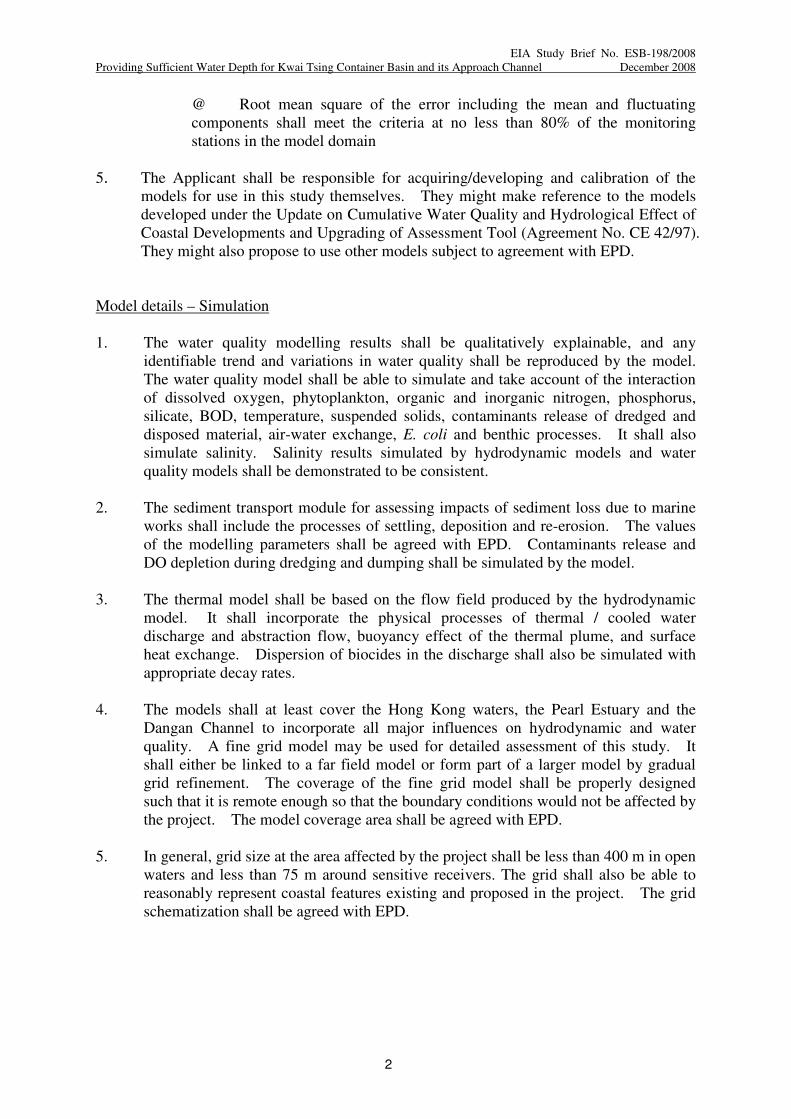
4. In general the hydrodynamic models shall be calibrated to the following criteria:
Criteria Level of fitness
with field data
• tidal elevation (@) < 8 %
• maximum phase error at high water and low water < 20 minutes
• maximum current speed deviation < 30 %
• maximum phase error at peak speed < 20 minutes
• maximum direction error at peak speed < 15 degrees
• maximum salinity deviation < 2.5 ppt
Page 24
EIA Study Brief No. ESB-198/2008
Providing Sufficient Water Depth for Kwai Tsing Container Basin and its Approach Channel December 2008
2
@ Root mean square of the error including the mean and fluctuating
components shall meet the criteria at no less than 80% of the monitoring
stations in the model domain
5. The Applicant shall be responsible for acquiring/developing and calibration of the
models for use in this study themselves. They might make reference to the models
developed under the Update on Cumulative Water Quality and Hydrological Effect of
Coastal Developments and Upgrading of Assessment Tool (Agreement No. CE 42/97).
They might also propose to use other models subject to agreement with EPD.
Model details – Simulation
1. The water quality modelling results shall be qualitatively explainable, and any
identifiable trend and variations in water quality shall be reproduced by the model.
The water quality model shall be able to simulate and take account of the interaction
of dissolved oxygen, phytoplankton, organic and inorganic nitrogen, phosphorus,
silicate, BOD, temperature, suspended solids, contaminants release of dredged and
disposed material, air-water exchange, E. coli and benthic processes. It shall also
simulate salinity. Salinity results simulated by hydrodynamic models and water
quality models shall be demonstrated to be consistent.
2. The sediment transport module for assessing impacts of sediment loss due to marine
works shall include the processes of settling, deposition and re-erosion. The values
of the modelling parameters shall be agreed with EPD. Contaminants release and
DO depletion during dredging and dumping shall be simulated by the model.
3. The thermal model shall be based on the flow field produced by the hydrodynamic
model. It shall incorporate the physical processes of thermal / cooled water
discharge and abstraction flow, buoyancy effect of the thermal plume, and surface
heat exchange. Dispersion of biocides in the discharge shall also be simulated with
appropriate decay rates.
4. The models shall at least cover the Hong Kong waters, the Pearl Estuary and the
Dangan Channel to incorporate all major influences on hydrodynamic and water
quality. A fine grid model may be used for detailed assessment of this study. It
shall either be linked to a far field model or form part of a larger model by gradual
grid refinement. The coverage of the fine grid model shall be properly designed
such that it is remote enough so that the boundary conditions would not be affected by
the project. The model coverage area shall be agreed with EPD.
5. In general, grid size at the area affected by the project shall be less than 400 m in open
waters and less than 75 m around sensitive receivers. The grid shall also be able to
reasonably represent coastal features existing and proposed in the project. The grid
schematization shall be agreed with EPD.
Page 25
EIA Study Brief No. ESB-198/2008
Providing Sufficient Water Depth for Kwai Tsing Container Basin and its Approach Channel December 2008
3
Modelling assessment
1. The assessment shall include the construction and operation phases of the project.
Where appropriate, the assessment shall also include maintenance dredging.
Scenarios to be assessed shall cover the baseline condition and scenarios with various
different options proposed by the Applicant in order to quantify the environmental
impacts and improvements that will be brought about by these options.
Corresponding pollution load, bathymetry and coastline shall be adopted in the model
set up.
2. Hydrodynamic, water quality, sediment transport and thermal modules, where
appropriate, shall be run for (with proper model spin up) at least a real sequence of 15
days spring-neap tidal cycle in both the dry season and the wet season.
3. The results shall be assessed for compliance of Water Quality Objectives. Any
changes in hydrodynamic regime shall be assessed. Daily erosion / sedimentation
rate shall be computed and its ecological impact shall be assessed.
4. The impact on identified sensitive receivers shall be assessed.
5. Cumulative impacts due to other projects, activities or pollution sources within a
boundary to the agreement of EPD shall also be predicted and quantified.
- END -
Page 26
EIA Study Brief No. ESB-198/2008
Providing Sufficient Water Depth for Kwai Tsing Container Basin and its Approach Channel December 2008
1
Appendix B
Guidelines for Marine Archaeological Investigation (MAI)
The standard practice for MAI should consist of four separate tasks, i.e. (1) Baseline Review,
(2) Geophysical Survey, (3) Establishing Archaeological Potential and (4) Remote Operated
Vehicle (ROV)/Visual Diver Survey/Watching Brief.
(1) Baseline Review
1.1 A baseline review should be conducted to collate the existing information in order
to identify the potential for archaeological resources and, if identified, their likely
character, extent, quality and value.
1.2 The baseline review will focus on known sources of archive data. It will include:
a. Geotechnical Engineering Office (GEO) – the Department holds extensive
seabed survey data collected from previous geological research.
b. Marine Department, Hydrographic Office - the Department holds a
substantial archive of hydrographic data and charts.
c. The Royal Naval Hydrographic Department in the UK - the Department
maintains an archive of all survey data collected by naval hydrographers.
1.3 The above data sources will provide historical records and more detailed
geological analysis of submarine features which may have been subsequently
masked by more recent sediment deposits and accumulated debris.
(2) Geophysical Survey
2.1 Extensive geophysical survey of the study area should deploy high resolution
boomer, side scan sonar, an echo sounder and high resolution multi beam sonar.
The multi beam data must be presented as processed digital terrain models to
facilitate the archaeological analysis. The data received from the survey would be
analysed in detail to provide:
a. Exact definition of the areas of greatest archaeological potential.
b. Assessment of the depth and nature of the seabed sediments to define
which areas consist of suitable material to bury and preserve
archaeological material.
c. Detailed examination of the boomer and side scan sonar records to map
anomalies in and on the seabed which may be archaeological material.
d. Detailed examination of the multi beam sonar data to assess the
archaeological potential of the sonar contacts.
Page 27
EIA Study Brief No. ESB-198/2008
Providing Sufficient Water Depth for Kwai Tsing Container Basin and its Approach Channel December 2008
2
(3) Establishing Archaeological Potential
3.1 The data examined during Task 1 and 2 will be analysed to provide an indication
of the likely character and extent of archaeological resources within the study area.
This would facilitate formulation of a strategy for investigation.
3.2 The results would be presented as a written report and charts. If there is no
indication of archaeological material there would be no need for further work.
3.3 Charts should be presented at 1:500 scale and show each survey contact. Its
dimensions and exact location should also be shown.
(4) Remote Operated Vehicle (ROV)/Visual Diver Survey/Watching Brief
4.1 Subject to the outcome of Task 1, 2 and 3, accepted marine archaeological practice
would be to plan a field evaluation programme to acquire more detailed data on
areas identified as having archaeological potential. The areas of archaeological
interest can be inspected by ROV or divers. ROV or a team of divers with both still
and video cameras would be used to record all seabed features of archaeological
interest.
4.2 Owing to the heavy marine traffic in Hong Kong, the ROV/visual diver survey
may not be feasible to achieve the target. If that is the case, an archaeological
watching brief is the most appropriate way to monitor the dredging operations in
areas of identified high potential to obtain physical archaeological information.
4.3 A sampling strategy for an archaeological watching brief would be prepared based
on the results of Task 1, 2 and 3 to focus work on the areas of greatest
archaeological potential. Careful monitoring of the dredging operations would
enable immediate identification and salvage of archaeological material. If
archaeological material is found, the AMO should be contacted immediately to
seek guidance on its significance and appropriate mitigation measures would be
prepared.
4.4 If Task 4 is undertaken, the results would be presented in a written report with
charts.
Report
Three copies of the final report should be submitted to the AMO for record.
- END -
Page 28
EIA Study Brief No. ESB-198/2008
Providing Sufficient Water Depth for Kwai Tsing Container Basin and its Approach Channel December 2008
1
Appendix C
IMPLEMENTATION SCHEDULE of Recommended Mitigation Measures
EIA
Ref.
EM&A
Ref.
Recommended
Mitigation
Measures
Objectives of the
Recommended
Measure & Main
Concerns to
address
Who to
implement
the
measure ?
Location
of the
measure
When to
implement
the
measure ?
What
requirements
or standards
for the
measure to
achieve
- END -