Research Library Research Library Resource management technical reports Natural resources research 1988 Evaluating prime agricultural land in the Shire of Manjimup Evaluating prime agricultural land in the Shire of Manjimup V T. Read Follow this and additional works at: https://researchlibrary.agric.wa.gov.au/rmtr Part of the Agriculture Commons, Natural Resources Management and Policy Commons, and the Soil Science Commons Recommended Citation Recommended Citation Read, V T. (1988), Evaluating prime agricultural land in the Shire of Manjimup. Department of Primary Industries and Regional Development, Western Australia, Perth. Report 80. This report is brought to you for free and open access by the Natural resources research at Research Library. It has been accepted for inclusion in Resource management technical reports by an authorized administrator of Research Library. For more information, please contact [email protected].
Transcript
Research Library Research Library
Resource management technical reports Natural resources research
1988
Evaluating prime agricultural land in the Shire of Manjimup Evaluating prime agricultural land in the Shire of Manjimup
V T. Read
Follow this and additional works at: https://researchlibrary.agric.wa.gov.au/rmtr
Part of the Agriculture Commons, Natural Resources Management and Policy Commons, and the Soil
Science Commons
Recommended Citation Recommended Citation Read, V T. (1988), Evaluating prime agricultural land in the Shire of Manjimup. Department of Primary
Industries and Regional Development, Western Australia, Perth. Report 80.
This report is brought to you for free and open access by the Natural resources research at Research Library. It has been accepted for inclusion in Resource management technical reports by an authorized administrator of Research Library. For more information, please contact [email protected].
Evaluating Prime Agricultural Landin the Shire of Manjimup
V.T. Read
Resource Management Technical Report No.80
Disclaimer
The contents of this report were based on the best available information at the time ofpublication. It is based in part on various assumptions and predictions. Conditions may changeover time and conclusions should be interpreted in the light of the latest information available.
Chief Executive Officer, Department of Agriculture Western Australia 2001
EVALUATING PRIME AGRICULTURAL LAND INT HE SHIRE OF MANJIMUP
APPENDIX I Map Unit Descriptions............................................................................... 31
(from McArthur et al., 1986) ........................................................................................... 31
APPENDIX II. Land Quality Information......................................................................... 35
EVALUATING PRIME AGRICULTURAL LAND INT HE SHIRE OF MANJIMUP
1
Preface
The identification of prime agricultural land in the Shire of Manjimup is one part of alarger study which is aimed at developing the concept of prime land and identifyingwhere it exists on a State-wide basis. Four Shires of the central Avon Valley (Beverley,York, Northam and Toodyay) as well as the Shire of Albany have also been consideredin detail.
The requirement to define and identify prime agricultural land arises from a review ofrural land planning policy by the State Planning Commission. The new strategy willencourage local government authorities to protect their best land for agriculture fromsub-division and development.
Deriving a definition of prime agricultural land is complex. Factors that determineprimeness of land for agriculture are discussed in a separate report (Read, 1988). Theywere considered in the definition used in this report.
The prime agricultural land project is funded by the National Soil ConservationProgramme through the Division of Resource Management of the Western AustralianDepartment of Agriculture.
This report follows field investigations and discussions with staff from the Manjimupoffice of the Department of Agriculture and representatives of industries related toagriculture.
EVALUATING PRIME AGRICULTURAL LAND INT HE SHIRE OF MANJIMUP
2
1. Introduction
1.1 Objectives of the research
The study of prime agricultural land in the Shire of Manjimup was undertaken with thefollowing objectives:
• assess an industry-based approach to evaluating prime agricultural land;
• to identify requirements of industries related to agriculture for land resources withinthe Shire of Manjimup;
• to assess the map units and information relevant to the Shire of Manjimup that isprovided by CSIRO for agricultural land evaluation.
As this study is one of a series undertaken to determine the preferred approach toidentifying prime agricultural land, it was not a specific objective to provide a definitivedescription of areas that should be classified as prime for agriculture. Instead, this studyis compared with others in a final report (Read, j~ prep.) which does attempt to classifyprime agricultural land.
1.2 Scope of the research
The approach used to identify prime agricultural land in this study is by interpretation ofavailable information and by discussion with people who have local agriculturalexperience. Due to time limitations, the study has not included any detailed survey ofphysical resources to supplement existing information where it is deficient.
Within the areas of prime agricultural land, there will be anomalies due largely todifferent mapping scales of information used. There will also be isolated pockets of landthat meet the requirements of a prime classification that have not been considered.
Boundaries of land units that may be prime agricultural land should receive circumspectconsideration. In many situations, the changes in landform are subtle and the fieldsurveyor should estimate a median value along the gradient of change to establish aboundary. Site specific requirements for boundary resolution may require more detailedinformation.
The map units used in this study were originally prepared at a scale of 1:50,000. Thisregional scale is not intended to provide information that is suitable for use at the locallevel (e.g. re-alignment of paddock boundaries).
1.3 The concept of prime agricultural land
Consideration of factors that determine primeness of land for agriculture is provided ingreater detail in a separate report (Read, 1988) than is required for this study. Thatreport also reviews the relevant literature.
EVALUATING PRIME AGRICULTURAL LAND INT HE SHIRE OF MANJIMUP
3
It would be an over-simplification of the land evaluation process to assess onlyagronomic requirements for agriculture when determining prime agricultural land. It isimportant for the land to be productive for either a wide range of agricultural products orfor one specific use. However, it is also important to consider non-agronomic factors.
Some areas that are productive according to agronomic criteria may not be consideredto be prime for agriculture as they are subject to the processes of land degradation.Wind erosion is not potentially serious in the Shire of Manjimup. Water erosion may be aproblem on steep slopes when cultivated. Problems of induced soil and water salinityalso occur in areas with annual rainfall less than approximately 1000 mm.
Some areas may be productive for a range of products or a specific product in a localregion. However, when compared with the total production for the State, the importanceof these products from this region may be diminished. This introduces the necessity todecide whether the evaluation of the land is for benefit of just the local region, or for theState. This study is one part of a statewide study so it adopts the broader perspective,however the significance of viable local economies is not ignored.
From a statewide perspective, it is possible to consider another factor that effects theclassification of prime agricultural land - the opportunity cost of the agricultural land use.If land with requirements for a specific agricultural commodity is not in short supplywithin the State (e.g. land for wheat production or grazing) then the effect on the Stateeconomy by not producing this commodity in a local area may be insignificant. Thegross income from the agricultural use of this land should be compared with thepotential income from other uses.
In addition to a comparison of monetary benefits from alternative uses of the land, thereare other values that should be considered (externalities). These include the potential fora particular land use to provide employment. Social requirements for open space (i.e.the value of non-productive use) should also be considered here.
A further factor in the concept of prime agricultural land is the existence of, or potentialfor significant infrastructural investment. This investment may be by the public or theprivate sectors. Where a major investment exists (e.g. reservoirs for irrigation,processing plant), then land that is required to ensure the continued viable use of thesefacilities should have priority for that use. Where an area is geographically well suited toindustrialize an agricultural product (e.g. proximity to transport, workforce, markets),then consideration should be given to preserving this potential by excluding otherpermanent land uses.
A definition of prime agricultural land that represents these factors is as follows:
• that land which occurs where the agronomic factors (e.g. soil and management)and environmental factors (e.g. climate, water quality and availability) combine sothat the value to society from agriculture is greater than the value from alternativeuses of the land.
EVALUATING PRIME AGRICULTURAL LAND INT HE SHIRE OF MANJIMUP
4
1.4 The method used to evaluate prime agricultural land
The land evaluation process used in this study is summarized as follows:
• determine the relative importance of each major agricultural commodity producedin the Shire of Manjimup (information from the Australian Bureau of Statistics usedon a statewide basis);
• identify the land requirements of agricultural commodities that are produced in thearea and are significant to total State production (advisers from the local office ofthe Department of Agriculture assisted in this process);
• obtain relevant physical information (i.e. for climate, geology, landform, soils andnatural drainage);
• identify environmental restrictions to agriculture (e.g. saline water supplies, frosts);
• identify imposed restrictions to agriculture (e.g. clearing restrictions);
• correlate significant agricultural commodity production with existing relevant mapunits (landform and soils units as mapped by H.M. Churchward of CSIRO);
• determine specific land requirements for the continuing viability of existing orpotential infrastructural investments.
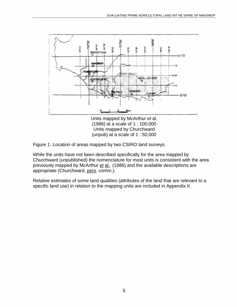
1.5 Relevant map units
The location of areas where landforms and soils were mapped by CSIRO is shown inFigure 1. They were drawn from black and white aerial photographs (1:40,000 scale) inassociation with geological maps. The effect of drainage on the landscape and soil typewere key factors in the interpretation made during the mapping procedure. Detaileddescriptions of these units are given by McArthur ..et al. (1986). A brief description of theunits that are relevant to the Shire of Manjimup is included in Appendix I of this report.
EVALUATING PRIME AGRICULTURAL LAND INT HE SHIRE OF MANJIMUP
5
Units mapped by McArthur et al.(1986) at a scale of 1 : 100,000Units mapped by Churchward
(unpub) at a scale of 1 : 50,000
Figure 1. Location of areas mapped by two CSIRO land surveys.
While the units have not been described specifically for the area mapped byChurchward (unpublished) the nomenclature for most units is consistent with the areapreviously mapped by McArthur et al.. (1986) and the available descriptions areappropriate (Churchward, pers. comm.).
Relative estimates of some land qualities (attributes of the land that are relevant to aspecific land use) in relation to the mapping units are included in Appendix II.
EVALUATING PRIME AGRICULTURAL LAND INT HE SHIRE OF MANJIMUP
6
2. Description of the Area
2.1 Geographic synopsis
The Shire of Manjimup is located approximately 260 km south-south-east of Perth. Thearea of the Shire is 689,400 ha, of which 14.6% has been alienated for agriculture. Mostof the remaining area is managed for timber production and nature conservation by theDepartment of Conservation and Land Management. There are 512 rural establishmentswhich occupy the 100,900 ha of alienated land. Many are primarily for horticulture. Theaverage establishment size of these is 67 ha (Houghton and Associates, 1982). In thedrier area east of the Manjimup townsite, the properties are large as landholders aredependent upon grazing. Of the alienated area, 79% has been cleared (A.B.S.,1985/86).
The population of the Shire is 10,140* with about 50% of the people residing in thetowns of Manjimup (4150)**, Pemberton (871)**, Walpole (291)** and Northcliffe (<200)**.
* 1986 census
**1981 census
2.2 Landforms and soils
Remnants of the Great Plateau occur in the north of the Shire between Yornup andPalgarup. This is represented by the Bevan and Collis mapping units of Churchward(unpublished) which approximate the Wilga and Hester mapping units of Churchwardand McArthur (1980). These areas have deeply weathered lateritic profiles withassociated duricrust. They are flat or gently undulating with gravelly duplex soils or greysands and areas of swamp. Some areas are prone to winter waterlogging. Where theduricrust is common, tillage is limited. Soil salinization associated with clearing occurs inareas where the annual rainfall is generally less than 1000 mm.
The drainage systems of the Donnelly, Warren and Shannon River basins havedissected the ancient landscape to form valley sides with younger, well drained duplexsoils and red-brown earths (the major valley units of McArthur et al.. in press). Thevalleys are separated by divides which can contain remnants of the former lateriticprofiles where gravelly duplex soils occur. On the crests and associated flat areas, thesesoils are prone to winter waterlogging. The upper slopes of the divides have well drainedloams and duplex soils (the Crowea and Mattaband units of McArthur et al. in press).The degree of dissection increases as the drainage systems progress towards the coastand the slopes of the valley sides increase correspondingly.
Further south, the landscape adjacent to Northcliffe becomes flat and swampy. Theseareas of humus and peaty podsols (the Quagering and Angove units of McArthur et al,.,in press) are interspersed by areas of brown and yellow duplex soils (the Collis units)which are better drained and well suited for agricultural purposes. The Blackwater unit
EVALUATING PRIME AGRICULTURAL LAND INT HE SHIRE OF MANJIMUP
7
consists of humus podsols with swamps and linear dunes. This unit is extensivebetween Northcliffe and Windy Harbour.
Along the coast the landform consists of parabolic dunes (the Meerup units). These areconsolidated inland but unstable near to the coast. Although previously used for summergrazing, these land units have limited agricultural value.
2.3 Climate
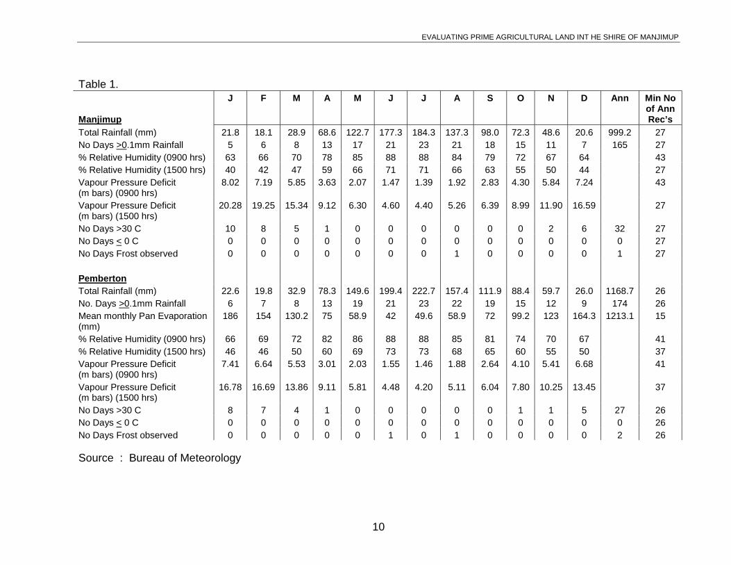
The Shire of Manjimup experiences a Mediterranean climate which is typified by coolwet winters and warm dry summers. The seasonal distribution of rainfall for recordingsat Manjimup and Pemberton may be interpreted from Table 1. For both places, 72% ofthe annual average rainfall falls during the five wettest months (May to September)when monthly rainfall exceeds the potential monthly evaporation. Rainy days arefrequent (more than 160 days/year with rainfall > 0.1 mm) with most days in the monthsfrom May to September (inclusive) experiencing rain.
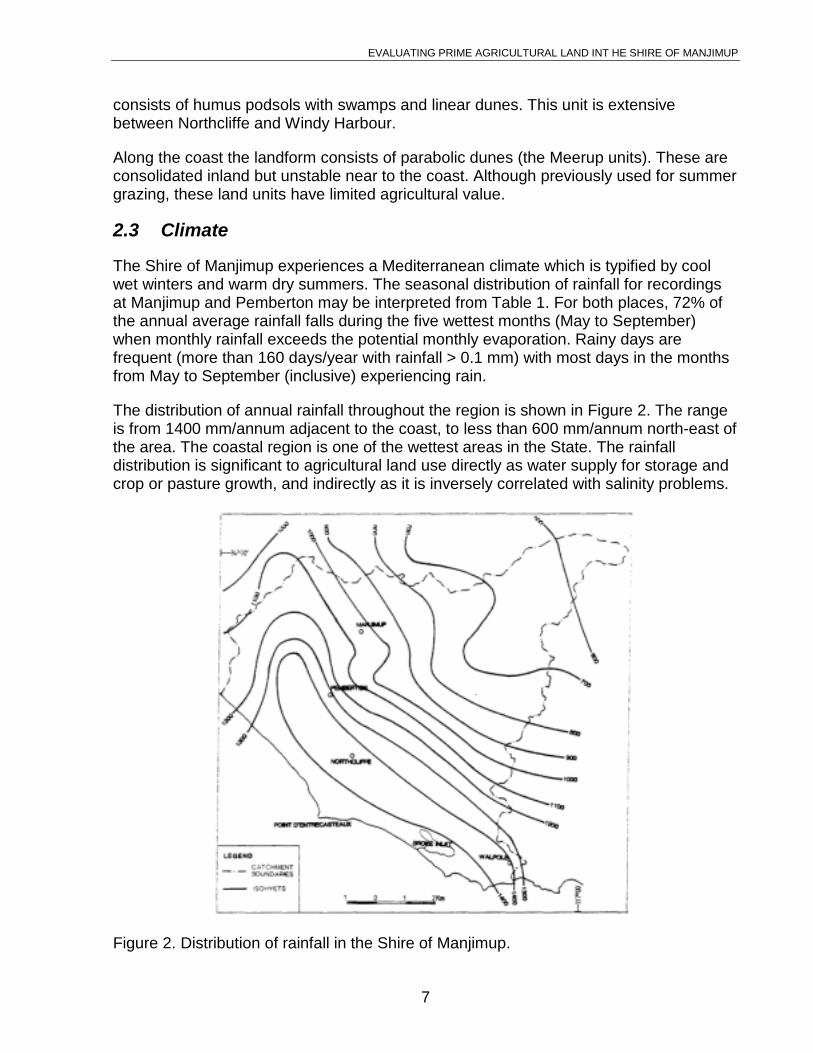
The distribution of annual rainfall throughout the region is shown in Figure 2. The rangeis from 1400 mm/annum adjacent to the coast, to less than 600 mm/annum north-east ofthe area. The coastal region is one of the wettest areas in the State. The rainfalldistribution is significant to agricultural land use directly as water supply for storage andcrop or pasture growth, and indirectly as it is inversely correlated with salinity problems.
Figure 2. Distribution of rainfall in the Shire of Manjimup.
EVALUATING PRIME AGRICULTURAL LAND INT HE SHIRE OF MANJIMUP
8
The region is relatively free from very low temperatures and frosts (Table 1) althoughsome years may be severe (e.g. 11 frosts recorded during August, 1966 in Manjimup)which is not expressed by the mean value statistics.
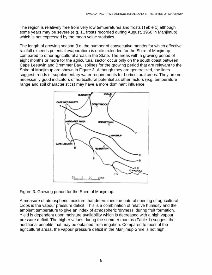
The length of growing season (i.e. the number of consecutive months for which effectiverainfall exceeds potential evaporation) is quite extended for the Shire of Manjimupcompared to other agricultural areas in the State. The areas with a growing period ofeight months or more for the agricultural sector occur only on the south coast betweenCape Leeuwin and Bremmer Bay. Isolines for the growing period that are relevant to theShire of Manjimup are shown in Figure 3. Although they are generalized, the linessuggest trends of supplementary water requirements for horticultural crops. They are notnecessarily good indicators of horticultural potential as other factors (e.g. temperaturerange and soil characteristics) may have a more dominant influence.
Figure 3. Growing period for the Shire of Manjimup.
A measure of atmospheric moisture that determines the natural ripening of agriculturalcrops is the vapour pressure deficit. This is a combination of relative humidity and theambient temperature to give an index of atmospheric ‘dryness’ during fruit formation.Yield is dependent upon moisture availability which is decreased with a high vapourpressure deficit. The higher values during the summer months (Table 1) suggest theadditional benefits that may be obtained from irrigation. Compared to most of theagricultural areas, the vapour pressure deficit in the Manjimup Shire is not high.
EVALUATING PRIME AGRICULTURAL LAND INT HE SHIRE OF MANJIMUP
9
2.4 Natural drainage, water quality and clearing controls
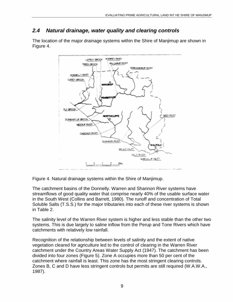
The location of the major drainage systems within the Shire of Manjimup are shown inFigure 4.
Figure 4. Natural drainage systems within the Shire of Manjimup.
The catchment basins of the Donnelly. Warren and Shannon River systems havestreamflows of good quality water that comprise nearly 40% of the usable surface waterin the South West (Collins and Barrett, 1980). The runoff and concentration of TotalSoluble Salts (T.S.S.) for the major tributaries into each of these river systems is shownin Table 2.
The salinity level of the Warren River system is higher and less stable than the other twosystems. This is due largely to saline inflow from the Perup and Tone Rivers which havecatchments with relatively low rainfall.
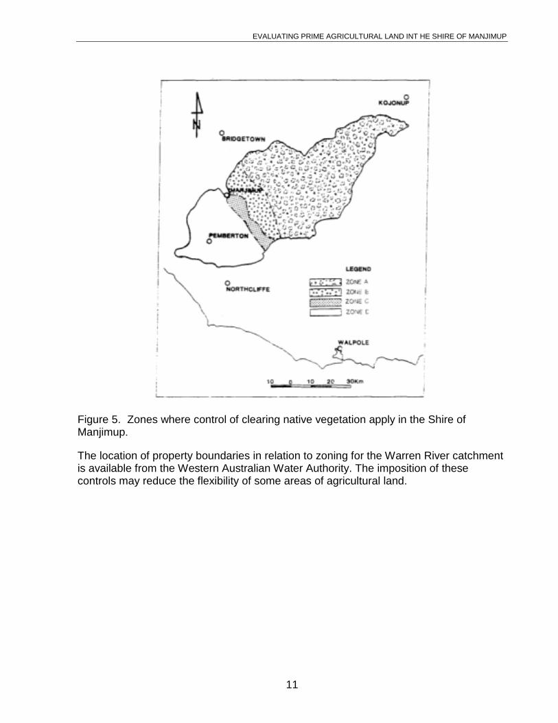
Recognition of the relationship between levels of salinity and the extent of nativevegetation cleared for agriculture led to the control of clearing in the Warren Rivercatchment under the Country Areas Water Supply Act (1947). The catchment has beendivided into four zones (Figure 5). Zone A occupies more than 50 per cent of thecatchment where rainfall is least. This zone has the most stringent clearing controls.Zones B, C and D have less stringent controls but permits are still required (W.A.W.A.,1987).
EVALUATING PRIME AGRICULTURAL LAND INT HE SHIRE OF MANJIMUP
No Days >30 C 8 7 4 1 0 0 0 0 0 1 1 5 27 26No Days < 0 C 0 0 0 0 0 0 0 0 0 0 0 0 0 26No Days Frost observed 0 0 0 0 0 1 0 1 0 0 0 0 2 26
Source : Bureau of Meteorology
EVALUATING PRIME AGRICULTURAL LAND INT HE SHIRE OF MANJIMUP
11
Figure 5. Zones where control of clearing native vegetation apply in the Shire ofManjimup.
The location of property boundaries in relation to zoning for the Warren River catchmentis available from the Western Australian Water Authority. The imposition of thesecontrols may reduce the flexibility of some areas of agricultural land.
EVALUATING PRIME AGRICULTURAL LAND INT HE SHIRE OF MANJIMUP
12
Table 2. Drainage basins in the Shire of Manjimup
Basin Tributaries Area(ha)
Cleared(%)
Estimated long-term average
runoff (m3 x 106)
Salinity T.S.S.(mSm-1)
Donnelly Carey 11,800 3.5 35.5 23
Fly 6,700 24.5 23 23
Donnelly 81,700 21.5 140 34
Warren Treen 6,100 28.7 18.5 20
Lefroy 25,700 27.8 50 28
Wilgarup 45,000 32.0 30 140
Perup 64,500 18.5 19 376
Tone 103,500 65.0 24 618
Warren 403,500 32.8 359 121
Dombakup 11,500 15.7 42 21
Shannon Shannon 35,000 2.5 78 21
Deep 45,700 0 75 23
Gardner 42,000 16.5 124 21
Weld 2,400 0 57 23
Source: Collins and Barrett, 1980.
EVALUATING PRIME AGRICULTURAL LAND INT HE SHIRE OF MANJIMUP
13
3. Agricultural Land Use
3.1 Introduction
Recognition of the potential for agriculture in the Shire of Manjimup has, in the past,been retarded by the decline of several industries. These include:
• The Group Settlement Schemes which attempted dairy farming in an unknownenvironment on sandy soils with trace-element deficiencies or on heavier soilscarrying dense native vegetation, including the massive karri trees (Eucalyptusdiversicolor) which were difficult to clear with the methods used in the early 1920’s.
• the tobacco industry which failed due to unacceptable quality of the produce;
• limited summer grazing along the coast which became uneconomic;
• fruit orchards which did not have adequate water supply to supplement the qualityand quantity of produce;
• the apple industry which experienced changed economic circumstances with theloss of the European market following the formation of the European EconomicCommunity;
• the hops industry which ceased due to a small and unreliable market;
• fruit canning industry which is unlikely to expand to earlier expectations due tomarket competition and decline in consumption.
More recently, the Manjimup area has been reappraised by horticulturalists due to thefollowing factors:
• high rainfall which is relatively reliable with some summer rains;
• long growing season;
• good potential for surface water storage;
• well drained loamy soils;
• low land values compared with traditional horticultural area closer to Perth;
• recognition of fruits and vegetables that are suitable to the area (e.g. cauliflowers,avocados, Nashi fruit, Chinese cabbage, onions, summer lettuce);
• recognition of the potential for viticulture;
• recent development by the Manjimup food processing industry.
The future agricultural use of the land will largely be determined by opportunities forhorticulture as the returns per unit area are considerably higher than for the moreextensive agricultural uses. The traditional grazing and small-scale cropping enterpriseswill continue to be practiced on available land that is not suited or currently used forhorticulture.
EVALUATING PRIME AGRICULTURAL LAND INT HE SHIRE OF MANJIMUP
14
The requirements for land for horticulture will be determined by market demand forproduce. The markets have two components:
1. local requirements - growth is at approximately 2% p.a. with some sections (e.g.processed foods) increasing at up to 6% p.a. Competition from other states (e.g.for canned fruit and citrus products) may limit growth;
2. export - the export of horticultural produce from the region is primarily to south-east Asia. Although subject to competition from other suppliers, the growth indemand for the export of vegetables over the next decade is expected to be 10%p.q. (A.A.C.M., 1987 p. 39).
The following sections describe the current and potential land uses and their land userequirements in relation to the mapped landform and soils units.
3.2 Rainfed agriculture
3.2.1 Livestock
Pasture for domestic livestock (cattle, sheep and small numbers of goats) grows on allsoil types providing fertilizers and trace elements are regularly applied as required.Limitations occur where shallow soil depths are associated with conditions in the soilprofile that induce winter waterlogging (i.e. a layer of low permeability that impedesinfiltration). These conditions may occur with yellow (duplex) and humic podzols whichare common in the following landform units:
• Bevan; as occurs on the major flat divides north of Manjimup.
• Crowea; particularly with the CRy association where it occurs on hill crests anddivides.
• Quagering
• Angove
• Major valleys; along the drainage course and associated terraces.
• Minor valleys.
While waterlogging may limit pasture growth during winter months, these areas providegood summer growth. With careful management, landholders may benefit by varying thegrazing intensity in relation to the seasonal pasture growth pattern. Taken over acomplete season, the earning capacity of the waterlogged soils is not significantlyreduced.
The current district average stocking rate is 9 Dry Sheep Equivalents/ha (land requiredfor 8 D.S.E.’s = land required for 1 head of cattle) although with improved stock andpasture management, the stocking rate could be 15 D.S.E. ‘s/ha.
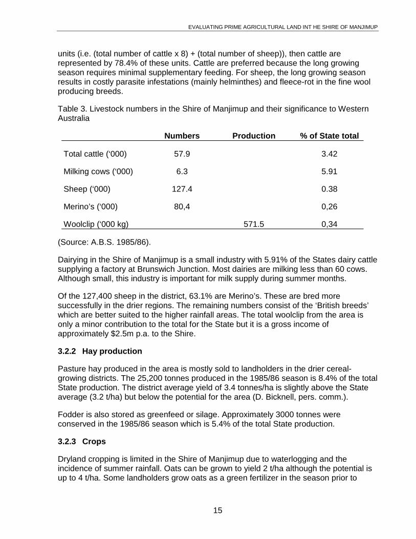
Table 3 shows the number of livestock in the Shire of Manjimup and an indication oftheir significance on a State-wide basis. If the district is evaluated in terms of livestock
EVALUATING PRIME AGRICULTURAL LAND INT HE SHIRE OF MANJIMUP
15
units (i.e. (total number of cattle x 8) + (total number of sheep)), then cattle arerepresented by 78.4% of these units. Cattle are preferred because the long growingseason requires minimal supplementary feeding. For sheep, the long growing seasonresults in costly parasite infestations (mainly helminthes) and fleece-rot in the fine woolproducing breeds.
Table 3. Livestock numbers in the Shire of Manjimup and their significance to WesternAustralia
Numbers Production % of State total
Total cattle (‘000) 57.9 3.42
Milking cows (‘000) 6.3 5.91
Sheep (‘000) 127.4 0.38
Merino’s (‘000) 80,4 0,26
Woolclip (‘000 kg) 571.5 0,34
(Source: A.B.S. 1985/86).
Dairying in the Shire of Manjimup is a small industry with 5.91% of the States dairy cattlesupplying a factory at Brunswich Junction. Most dairies are milking less than 60 cows.Although small, this industry is important for milk supply during summer months.
Of the 127,400 sheep in the district, 63.1% are Merino’s. These are bred moresuccessfully in the drier regions. The remaining numbers consist of the ‘British breeds’which are better suited to the higher rainfall areas. The total woolclip from the area isonly a minor contribution to the total for the State but it is a gross income ofapproximately $2.5m p.a. to the Shire.
3.2.2 Hay production
Pasture hay produced in the area is mostly sold to landholders in the drier cereal-growing districts. The 25,200 tonnes produced in the 1985/86 season is 8.4% of the totalState production. The district average yield of 3.4 tonnes/ha is slightly above the Stateaverage (3.2 t/ha) but below the potential for the area (D. Bicknell, pers. comm.).
Fodder is also stored as greenfeed or silage. Approximately 3000 tonnes wereconserved in the 1985/86 season which is 5.4% of the total State production.
3.2.3 Crops
Dryland cropping is limited in the Shire of Manjimup due to waterlogging and theincidence of summer rainfall. Oats can be grown to yield 2 t/ha although the potential isup to 4 t/ha. Some landholders grow oats as a green fertilizer in the season prior to
EVALUATING PRIME AGRICULTURAL LAND INT HE SHIRE OF MANJIMUP
16
planting potatoes.
Lupins are grown on the lighter textured soils north and east of Manjimup. During the1985/86 season, only 200 ha were grown however the area planted is expected toincrease.
3.3 Vegetables
3.3.1 The relative importance of vegetable production
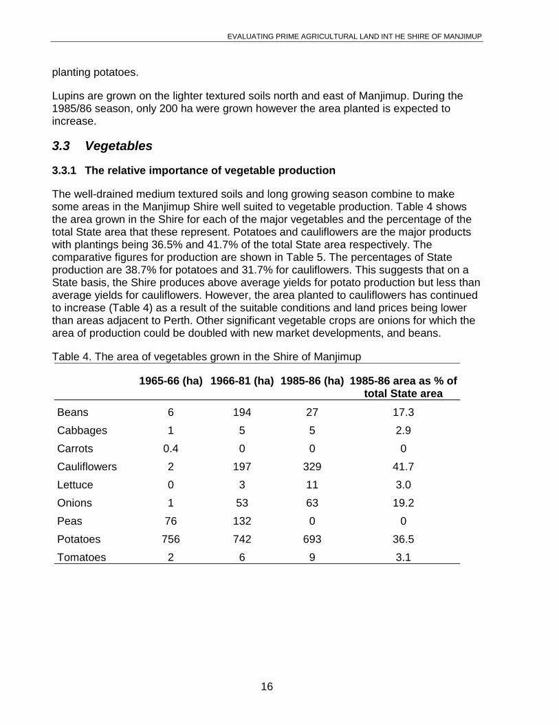
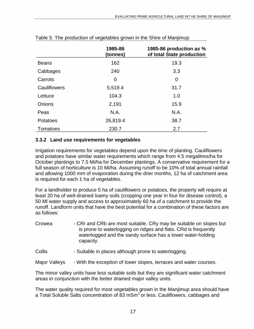
The well-drained medium textured soils and long growing season combine to makesome areas in the Manjimup Shire well suited to vegetable production. Table 4 showsthe area grown in the Shire for each of the major vegetables and the percentage of thetotal State area that these represent. Potatoes and cauliflowers are the major productswith plantings being 36.5% and 41.7% of the total State area respectively. Thecomparative figures for production are shown in Table 5. The percentages of Stateproduction are 38.7% for potatoes and 31.7% for cauliflowers. This suggests that on aState basis, the Shire produces above average yields for potato production but less thanaverage yields for cauliflowers. However, the area planted to cauliflowers has continuedto increase (Table 4) as a result of the suitable conditions and land prices being lowerthan areas adjacent to Perth. Other significant vegetable crops are onions for which thearea of production could be doubled with new market developments, and beans.
Table 4. The area of vegetables grown in the Shire of Manjimup
1965-66 (ha) 1966-81 (ha) 1985-86 (ha) 1985-86 area as % oftotal State area
Beans 6 194 27 17.3
Cabbages 1 5 5 2.9
Carrots 0.4 0 0 0
Cauliflowers 2 197 329 41.7
Lettuce 0 3 11 3.0
Onions 1 53 63 19.2
Peas 76 132 0 0
Potatoes 756 742 693 36.5
Tomatoes 2 6 9 3.1
EVALUATING PRIME AGRICULTURAL LAND INT HE SHIRE OF MANJIMUP
17
Table 5. The production of vegetables grown in the Shire of Manjimup
1985-86(tonnes)
1985-86 production as %of total State production
Beans 162 19.3
Cabbages 240 3.3
Carrots 0 0
Cauliflowers 5,519.4 31.7
Lettuce 104.3 1.0
Onions 2,191 15.9
Peas N.A. N.A.
Potatoes 26,819.4 38.7
Tomatoes 230.7 2.7
3.3.2 Land use requirements for vegetables
Irrigation requirements for vegetables depend upon the time of planting. Cauliflowersand potatoes have similar water requirements which range from 4.5 megalitres/ha forOctober plantings to 7.5 Mi/ha for December plantings. A conservative requirement for afull season of horticulture is 10 Mi/ha. Assuming runoff to be 10% of total annual rainfalland allowing 1000 mm of evaporation during the drier months, 12 ha of catchment areais required for each 1 ha of vegetables.
For a landholder to produce 5 ha of cauliflowers or potatoes, the property will require atleast 20 ha of well-drained loamy soils (cropping one year in four for disease control), a50 Ml water supply and access to approximately 60 ha of a catchment to provide therunoff. Landform units that have the best potential for a combination of these factors areas follows:
Crowea - CRr and CRb are most suitable. CRy may be suitable on slopes butis prone to waterlogging on ridges and flats. CRd is frequentlywaterlogged and the sandy surface has a lower water-holdingcapacity.
Collis - Suitable in places although prone to waterlogging.
Major Valleys - With the exception of lower slopes, terraces and water courses.
The minor valley units have less suitable soils but they are significant water catchmentareas in conjunction with the better drained major valley units.
The water quality required for most vegetables grown in the Manjimup area should havea Total Soluble Salts concentration of 83 mSm1 or less. Cauliflowers, cabbages and
EVALUATING PRIME AGRICULTURAL LAND INT HE SHIRE OF MANJIMUP
18
tomatoes will tolerate up to 250 mSm-1 T.S.S. Of the major tributaries to the threedrainage basins (2.4), the Wilgarup, Perup, Tone and upper Warren rivers have T.S.S.in excess of 83 mSm-1. Of these, the Wilgarup and the upper Warren rivers have lessthan 250 mSm-1 (Table 2). While the water quality in the main water course of the majortributaries may be marginal, the quality in some minor tributaries is quite suitable. Thissituation occurs on the Wilgarup river where the main watercourse is saline but theminor catchments are used for horticulture.
Areas with lateritic soil profiles that have less than 1000 mm rainfall may have salinesoils. These are more likely to occur on the Bevan and Mattaband units north and eastof Manjimup. Vegetable production is limited on these saline soils.
3.3.3 Process-industry requirements for land
The vegetable crops that are used for processing (canning, freezing, french fries andsnack foods) are peas and potatoes. Tomatoes grown in the area have been processedbut were not successful.
Peas have been grown under contract to the Albany-based processing plant run bySouthern Processors (formerly Hunts Foods Pty Ltd) for many years. The area grown isapproximately 2000 ha and is expected to at least double. Approximately 30% of thisarea has been and should continue to be within the Shire of Manjimup (i.e. 600 haincreasing to 1200 ha). Recently, an existing firm in Manjimup was purchased by Edgell-Birds Eye (a division of Petersville Industries Ltd). This company plans to beginprocessing 2000 tonnes of peas by November, 1988. The irrigated area required tosupply this quantity is approximately 600 ha grown each year.
The total area that will be required for processing pea crops within the Shire each year isin excess of 1800 ha. However, land used for peas is also suitable for potatoes andother horticultural crops. Peas are frequently grown in rotation with potatoes for diseasecontrol purposes as well as for efficient use of irrigation facilities.
Potatoes are processed by A.P.D. Snack Foods with most of the supply coming from theManjimup district. Potatoes have previously been purchased through the PotatoMarketing Board which has controlled the source of supply.
Intentions for the newly acquired Edgell-Birdseye plant in Manjimup are forapproximately 50,000 tonnes/annum of potatoes to be processed into French friesannually. The aim is to eventually increase this to a maximum production level of100,000 tonnes/annum. This level of production will require further infrastructuralinvestment by the company. Arrangements are underway with landholders to supplythese potatoes which will be in addition to their previous marketing outlets.
Assuming conservatively that the average yield of potatoes will be 36 t/ha (the Stateaverage yield), approximately 1400 ha will be required each year to supply this industry,increasing to 2800 ha in full production. For pest control purposes (potato cystnematode and white-fringed weavil), it is recommended that land be used to grow
EVALUATING PRIME AGRICULTURAL LAND INT HE SHIRE OF MANJIMUP
19
potatoes only one year in four. The total area of arable land that will be required in theshort term is 5600 ha but this will subsequently increase to 11,200 ha.
The potatoes will be grown from late September until June so relatively high rates ofirrigated water will be necessary. Assuming 12 ha of catchment area is required for each1 ha of potatoes grown annually (3.2.2), then 33,600 ha will be required for water supplyin the long term. While it is recognized that this area need not be used exclusively forwater catchment, there will be a requirement to give this land use priority over otheruses that may divert the supply or reduce the quality of the water. The areas required forwater catchment will need to be in close proximity to the soil types that are best suitedfor potato production.
In addition to water requirements for the potato growers, Edgell-Birdseye hasconstructed a 500 Ml reservoir for processing purposes. Water is pumped from a weirlocated on Smith Brook, 7 km south-east of Manjimup. The water quality and supplyfrom the 3700 ha catchment area for the weir (Figure 6) has been guaranteed by theState Government. This may influence some land-use decisions for this area.
3.4 Fruit
3.4.1 The relative importance of fruit production
The Shire of Manjimup has been a significant fruit producing area in the State over along period. It is favoured seasonally and by the potential for economic storage of goodquality water. The distance from the major markets in Perth is a disadvantage for thesoft-bodied fruits. These can be grown more competitively in the Darling Ranges, east ofPerth. The citrus fruits are not well suited to the area.
Table 6 shows the relative importance of local production for each of the major fruitcategories over the past two decades. The percentage of the State’s production ofapples grown in the Manjimup Shire has increased significantly from 20.9% to 32.2%during this period. This is due largely to the State-wide tree-pull scheme since 1972which has reduced production proportionately more in other areas with less reliablewater supplies. Some less efficient orchards have been removed from the Manjimuparea so that the average yield for the area has increased.
Table 6. The percentage of State fruit production grown in the Shire of Manjimup
EVALUATING PRIME AGRICULTURAL LAND INT HE SHIRE OF MANJIMUP
20
Other managerial changes have resulted in current State production levels beingapproximately the same now compared with twenty years ago when there were twice asmany trees (Cripps, 1986). Major yield increases in the near future are not expected.The number of apple trees in the Manjimup area is unlikely to rise significantly as theState now exports about 20% of total production which is down from 40% two decadesago (Cripps, 1986) and the local markets has low growth rates.
While the major variety of apples grown in the area is the Granny Smith (71.3% of totalShire apple production in the 1985-86 season), the Red Delicious is more dependentupon the area for top quality production. Of the total State production, 50.7% of RedDelicious apples were grown in the Manjimup area during the 1985-86 season. This isan increase from 35.8% of State production since the 1975-76 season.
The Manjimup Shire produces a significant proportion of the State’s peaches (Table 6).Some varieties are grown for canning at the processing plant now owned by Edgell-Birdseye. The requirement for this fruit will continue at the present level but the future ofthis market outlet is not guaranteed.
3.4.2 Land use requirements for fruit
The general requirements for fruit production are well drained soils with adequatesupplementary supplies of good quality water. Different fruits and their varieties mayhave more specific requirements such as aspect or landscape position.
The landform and soils units that are suitable for fruit production are consistent withthose that are suitable for vegetables (3.3.2).
Water requirements are also comparable with vegetables. Approximately 10 Ml storageis required for each 1 ha of orchard. The catchment area for this storage requirement isestimated to be 12 ha for each 1 ha of orchard. The stored water should contain lessthan 250 mSm-1 T.S.S. for apples and pears, but less than 83 mSm~ for most othertypes of fruit.
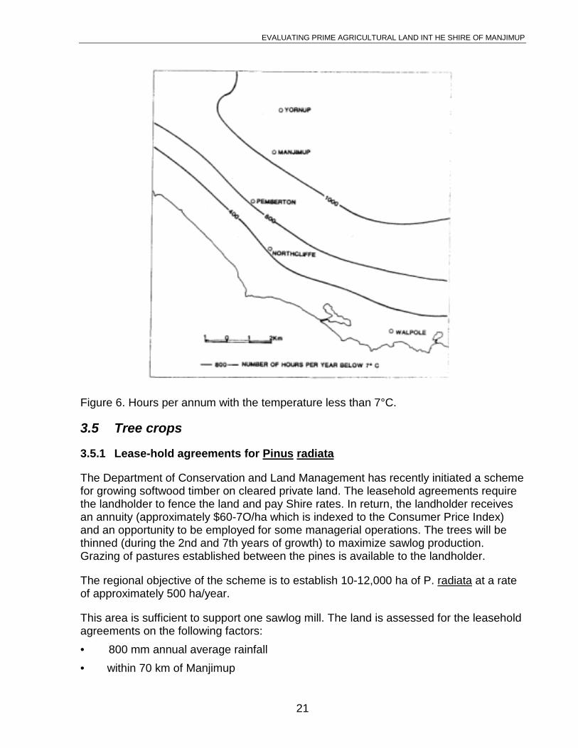
An important environmental determinant of fruit production is temperature. Localizedareas that are prone to periods of consecutive frosts are less suitable. However areasthat do not have a sufficient amount of time with low temperatures are also less suitableas the cold is required for flower opening and for bud establishment. Figure 7 shows theapproximate gradient of the increasing period of coldness away from the coast. The totalnumber of hours annually with temperatures less than 7°C is a relative index for somefruit types. Cherries, for example, require in excess of 1000 hrs per annum less than7°C. Other fruits that respond to low temperatures are the stone fruits, particularlypeaches and nectarines. The Manjimup Shire is better suited for chill response than theadjacent fruit growing areas of Bridgetown and Donnybrook.
EVALUATING PRIME AGRICULTURAL LAND INT HE SHIRE OF MANJIMUP
21
Figure 6. Hours per annum with the temperature less than 7°C.
3.5 Tree crops
3.5.1 Lease-hold agreements for Pinus radiata
The Department of Conservation and Land Management has recently initiated a schemefor growing softwood timber on cleared private land. The leasehold agreements requirethe landholder to fence the land and pay Shire rates. In return, the landholder receivesan annuity (approximately $60-7O/ha which is indexed to the Consumer Price Index)and an opportunity to be employed for some managerial operations. The trees will bethinned (during the 2nd and 7th years of growth) to maximize sawlog production.Grazing of pastures established between the pines is available to the landholder.
The regional objective of the scheme is to establish 10-12,000 ha of P. radiata at a rateof approximately 500 ha/year.
This area is sufficient to support one sawlog mill. The land is assessed for the leaseholdagreements on the following factors:
• 800 mm annual average rainfall
• within 70 km of Manjimup
EVALUATING PRIME AGRICULTURAL LAND INT HE SHIRE OF MANJIMUP
22
• minimum area of 40 ha
• free from waterlogging
• reasonable access (drainage lines, bogginess and rock outcropping)
• feasibility of fire control
• soil type
• 50 cm soil depth
• absence of deep sands
Soil types are assessed for each location on a 100 m x 100 m grid. Estimates of yield inrelation to soil type determine the viability of the site and the annuity which is offered tothe landholder. The production of pines is related to soil fertility so a larger annuity isoffered for the better areas. However, soils which are best suited for horticulture will beinfrequently planted to pines as the annuity would not be comparable with returns frommixed grazing and horticultural enterprises (Treloar, 1984).
3.5.2 Hardwoods for chip/pulp production
The Western Australian Chip and Pulp company are currently supplied with timber frompublic forests. A combination of anticipated future supply shortfall and intentions toexpand the industry, has lead this company to encourage private landholders to planthardwood species (Eucalyptus globulus, E. spliqna, E. grandis and ~. diversicolor). Thecompany supplies the seedlings but it is the responsibility of the landholder to maintainthe plantation. Opportunities exist for the landholder to harvest the trees for thecompany. Payment will be by a volume of timber. The rate will be the same as theroyalty paid for timber harvested from the public forests (currently $lO.29/m3).
The siting of plantations depends upon the landholders willingness to grow trees inpreference to other enterprises. The minimum area considered by the company is 5 ha.The company is aiming to plant up to 10% of private land by the year 2005.
3.6 Viticulture
The area occupied by vineyards at present in the Shire of Manjimup is small however itis expected that it could expand substantially. The quality of water supply and suitabilityof the soils are likely to attract existing and intending viticulturalists from otherestablished areas which are limited by salinity.
EVALUATING PRIME AGRICULTURAL LAND INT HE SHIRE OF MANJIMUP
23
4. Evaluation of Land Available for Agricultural Use
4.1 Availability of land
While the total area of the Manjimup Shire is large (689,400 ha), only 14.6% (100,900ha) has been alienated for agriculture. Almost all of the remaining land is managed bythe Department of Conservation and Land Management for timber production,recreation and nature conservation. It is unlikely that any significantly large areas of landwill be alienated in the foreseeable future.
Over 20% of the agricultural area remains uncleared, however the potential to increasethe area that is suitable for horticulture is limited. Figure 5 shows areas within the Shirewhere there may be restrictions on clearing of native vegetation. The most stringentcontrols (Zones A and B) occur east of Manjimup where salinity levels are generally toohigh for most horticultural crops. However, the areas where the potential production ishigh (from Pemberton to Manjimup) still do have some controls.
The valley sides of the dissected landforms contain soils that are suitable for horticulturehowever these are almost totally developed for agriculture. The agricultural areas thatremain uncleared are the less productive, sandy lateritic soils that are associated withthe Great Plateau (section 2.2) so the potential to expand the area of horticultural land isfurther limited.
For land to be suitable for the major horticultural crops, there must be an available watersupply of suitable quality and yield. Although there are some drainage tributaries withacceptably low salt concentrations, the area with annual average rainfall less than 1000mm is generally considered to be too saline for horticulture (W.A. Dept. Agric, 1974).Figure 2 shows the 1000 mm isohyet and so indicates the area east of this line which isunlikely to be suitable.
In the higher rainfall areas, there are restrictions on developing the potential of the landfor horticulture due to the conflicting demands for available water. Many of the sites thatare suitable for water catchment have already had dams constructed there. Other sitesfor which dam construction is intended require a permit from a committee administeredby the Water Authority of Western Australia, and they need to be licensed. The criteriathat is currently used by the committee to evaluate applications for dams is based onlocal experience of streamflow and demand for water. With the competition for the waterused by horticulturalists increasing due to requirements for recreation, fish farming andother uses, the W.A.W.A. is currently developing a more objective approach based onhydrological information obtained for significant catchments (W. Tingey, pers. comm.).This approach should enable more equitable distribution of the water resources but maylimit the number and size of dams that can be constructed.
The areas that will be assessed with priority are the Treen Brook, Upper Lefroy Brook,Smith Brook and the Donnelly River-Big Brook catchments. These areas are importanthorticultural areas in the Shire of Manjimup.
EVALUATING PRIME AGRICULTURAL LAND INT HE SHIRE OF MANJIMUP
24
4.2 Significance of agricultural land use in the Shire of Manjimup
It is clear from the statistics used in Section 3 that the Shire of Manjimup is significant tothe total State production in some horticultural crops. In recent years, the production ofpotatoes, cauliflowers and peas have been major crops. Other products, includingonions and wine grapes are expected to become major contributions to total Stateproduction.
Physical factors that favour the production of these crops are adequate water supplywhich is of good quality as well as well drained soils.
Other significant crops are less dependent upon these physical resources. Plantations oftree crops to support existing or intended timber processing industries are sufficientlyproductive in the high rainfall zone on landform units that are less suitable forhorticulture. The supply of such land is not limited.
EVALUATING PRIME AGRICULTURAL LAND INT HE SHIRE OF MANJIMUP
25
5. Conclusions
5.1 An industry-based approach to evaluating prime agriculturalland
In a previous study (Read, in prep.(a)), prime agricultural land was evaluated in thecentral Avon Valley by mapping units of land on the basis of soils, topography and landdegradation risk. It was recognized that this approach did not reflect the value to societyof the best of these land units for agriculture.
In this study, a more direct approach has been attempted. In addition to a broadevaluation of available physical resource information, the importance of each agriculturalindustry was identified by a statistical assessment of its contribution to total Stateproduction. Horticultural industries were clearly the more important by these criteria.
The potato industry was taken to represent these industries in the approach toevaluating prime agricultural land. It is recognised that land that is most suitable forpotato production is also most suitable for a wide range of other horticultural andagricultural production.
This approach to evaluation does consider more directly the areas of land wherepotential for land-use conflict exists. It also emphasises the value that the localcommunity as well as the State derives from the land, rather than evaluating thephysical resources of the land in isolation.
While the investment locally in agriculture-related process industries can be encouragedby ensuring security in the availability of suitable land, it is the composite value tosociety that should have priority. Employment and new agricultural opportunities shouldbe considered in conjunction with the requirements for open space, environmentalquality and other less tangible values to society.
To map areas of land as being prime for agriculture on the basis of existing industries,then to have these areas with priority for a particular industry may be detrimental to thedevelopment of alternative industries. In the Shire of Manjimup, the most significantpotential for new and existing agricultural industries requires land similar to that requiredby the potato industry. Considering the land required for water catchment and the croprotation for potatoes, other horticultural industries can develop contemporaneously.
5.2 Industry requirements for land
This study has shown that land within the State that has a high capability for theproduction of potatoes, cauliflowers, peas and apples is important to the State andshould have priority for these uses.
The potential for other horticultural crops has also been discussed. Some will have landrequirements that are consistent with the established crops. Others (e.g. wine grapes-)
EVALUATING PRIME AGRICULTURAL LAND INT HE SHIRE OF MANJIMUP
26
are not sufficiently well tried in the area to be conclusive about physical resourcerequirements.
5.3 Assessing the physical resource information
Prime agricultural land as it is defined (1.3) probably does occur within the Shire ofManjimup however the small scale and incomplete availability of physical resourceinformation make a broad assessment of limited use.
A map of prime agricultural land for the Shire could include the Crowea, Collis and MajorValley landform units with a delineation to exclude areas with an annual rainfall less than1000 mm where induced salinity may be a limitation. Such a map at this stage of landuse planning within the Shire would be counter-productive. The scale of the landscapeto which intensive agricultural industries and other uses (e.g. hobby farms) may respondcomplies with the minor scale of variability within the landscape. This is not accountedfor in the map units used in this study.
The landform and soil units provide a general guide to the occurrence of the physicalresources but more detailed information of sites is required in response to specific landuse conflicts. It would not be within the best interests of the Shire or the State to excludeall but agricultural use from these broad map units on the basis of them being classifiedgenerally as prime agricultural land.
The map units may be used as an initial guide after which each site should be evaluatedto show the value to society of its agricultural use compared with the proposedalternative land use.
The potato industry was identified as one industry possible requiring protection of theland resource to ensure its future economic viability. The recent investment in aprocessing plant by Edgell-Birds Eye has increased opportunities for employment andfurther potato production within the district. Because of this, the land requirement for thisindustry was considered in detail
Land required to maintain the viability of the Edgell-Birds Eye processing plant in theShire has been estimated to be about 34,000 ha (3.3.3). This estimate includes landrequired for water catchment to provide irrigation of the crops. The processing plantcould remain viable if some of the land that is suitable for potato production were nolonger available for agricultural use. The effect would be that less productive land wouldbe used and a lower yield accepted. Alternatively, more potatoes could be grown inareas other than in the Shire of Manjimup. This will depend upon the price offered togrowers in these areas and the cost of transport.
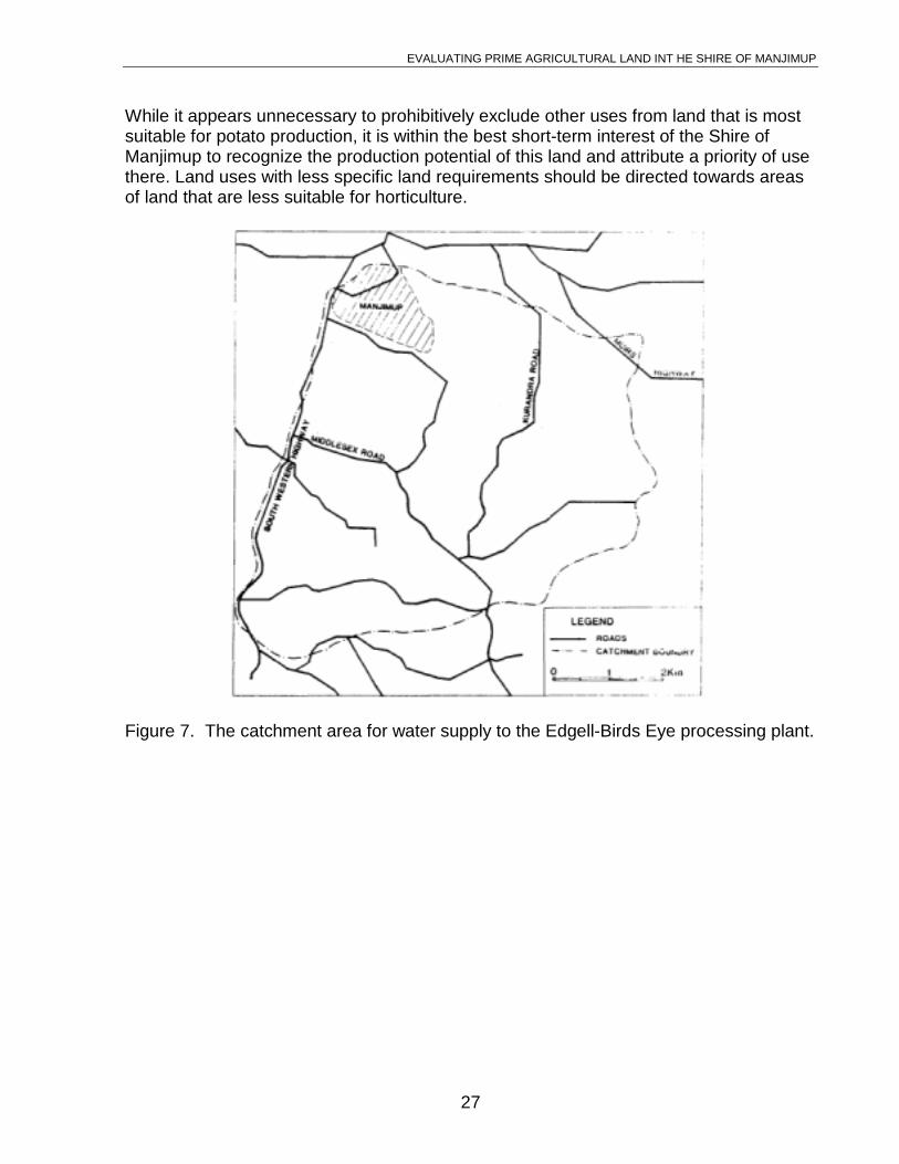
A more direct land requirement in the Shire of Manjimup by the Edgell-Birds Eyecompany is for protection of the 37 km2 catchment (Figure 6) that contributes to the 500Ml dam that has been constructed. The Ministry for Water Resources has guaranteedthis protection so the area should be identified by planners, and land uses that may bedetrimental to water yield should be avoided.
EVALUATING PRIME AGRICULTURAL LAND INT HE SHIRE OF MANJIMUP
27
While it appears unnecessary to prohibitively exclude other uses from land that is mostsuitable for potato production, it is within the best short-term interest of the Shire ofManjimup to recognize the production potential of this land and attribute a priority of usethere. Land uses with less specific land requirements should be directed towards areasof land that are less suitable for horticulture.
Figure 7. The catchment area for water supply to the Edgell-Birds Eye processing plant.
EVALUATING PRIME AGRICULTURAL LAND INT HE SHIRE OF MANJIMUP
28
Acknowledgements
The initial interpretation of landforms and soils was enhanced by assistance in the fieldfrom Bill McArthur. Recognition of land qualities and relevant landscape units foragronomic uses was with the assistance of Dave Bicknell. Trevor Boughton and MarkWebb assisted with the horticultural uses.
The manager of Edgell-Birds Eye, Terry Moore, provided information on therequirements for his company.
The text of this report was reviewed by Jim Dixon, Kerry Hawley, Murray Hegney, PeterKing, Gottfried Scholz and Martin Wells.
The figures were drawn by Richard Hulajko.
EVALUATING PRIME AGRICULTURAL LAND INT HE SHIRE OF MANJIMUP
29
References
Australian Agricultural Consulting and Management Company Pt7 Ltd (1987).Horticultural Demand for Water and Land. Consultants’ report to Water AuthorityWest. Australia.
Bicknell, D. pers. comm. Dept. Agriculture, Manjimup District Office.
Churchward, H.M. Unpublished CSIRO maps.
Churchward, N.M. and McArthur, W.M. (1980). Landforms and Soils of the DarlingSystem, Western Australia. In: Atlas of Natural Resources, Darling System, West.Australia. Dept. Conservation and Environ., West. Australia.
Collins, P.D.K. and Barrett, D.F. (1980). Shannon, Warren and Donnelly River BasinsWater Resources Survey. Public Works Department, Water Resources BranchReport No. W.R.B. 6.
Cripps, J. (1986). Apple Varieties. Proc. of Seminar, Staying in Business in Fruit. W.A.Dept. Agriculture, Sept. 23, 1986.(b)ghton, G.D. and Associates (1982). ManjimupLand Use Study. Consultants to Shire of Manjimup. Unpublished report.
McArthur, W.M. and Clifton, A.L. (1975). Forestry and Agriculture in relation to Soils inthe Pemberton Area of W.A. Soil and Land Use Series No. 54. C.S.I.R.O.,Australia.
McArthur, W.M.,, Churchward, N.M., Sewell, P.L. and Bartle, G.A. (1986). Landformsand soils of the south coast and hinterland, W.A. Northcliffe to Manypeaks.C.S.I.R.O., Div. Ground Water Resear., West. Australia.
Read, V.T. (1988). The Concept of Prime Agricultural Land - a Western AustralianPerspective. Tech. Report No. 72, Division of Resour. Manag., West. Aust. Dept.Agric.
Read, V.T. ( prep.(a)). Evaluating Prime Agricultural Land in the Central Avon Valley,Western Australia, Division of Resour. Manag., West. Aust. Dept. Agric.
Read, V.T. ( prep.(b)). Evaluation of Land in Western Australia that Requires Priority forAgricultural Use. Division of Resour. Manag., West. Aust. Dept. Agric.
Tingey, W. (personal communication). Water Authority of Western Australia, BunburyRegional Office.
Treloar, D.W.G. (1984). A Feasibility Study Concerning the Lease of ManjimupFarmland for Pine Forests. Forest Department of Western Australia Project Report.
Water Authority of Western Australia (1987). Guidelines for the Granting of Licences toClear Indigenous Vegetation.
EVALUATING PRIME AGRICULTURAL LAND INT HE SHIRE OF MANJIMUP
30
Western Australian Department of Agriculture (1974). The influence of land use onstream salinity in the Manjimup area, Western Australia. Tech. Bull. No. 27.
EVALUATING PRIME AGRICULTURAL LAND INT HE SHIRE OF MANJIMUP
31
APPENDIX I Map Unit Descriptions
(from McArthur et al., 1986)
Unit BEVAN (BE)
Geomorphology Gently undulating terrain of the Great Plateau. Minor valleysseparated by broad divides. Deeply weathered profiles abovegranitic rocks with few fresh rock exposures.
Soils Yellow duplex (podzolic) soils which may have a yellow,structureless B horizon (BEy) or a yellow-brown B horizon withweak structure (BEb). Some ferruginous gravels occur insurface horizons. Boulders of cemented duricrust may bepresent. Soils are slightly saline in the surface and again atdepth (> 80 cm). There is a slight increase of a mildly acidtrend with depth.
Native Vegetation Jarrah-marri tall open forest with Banksia grandis dominatedunderstorey.
Unit CROWEA (CR)
Geomorphology Crests and upper slopes of spurs and ridges. Deeplyweathered rock forming an extensive kaolinitic substrate.
Soils Yellow duplex soils which may be as follows:
CRb - brown gravelly A horizons over a mottled clay subsoil(7.5 YR)*
CRy -pale grey-brown sand to sandy loam surface overyellow, yellow-brown or grey mottled clay subsoil (10YR)
CRd - grey sandy surface, strongly bleached A2 horizon over apale yellow, brown or grey mottled subsoil.
The soils have a slightly acid trend.
Native Vegetation Karri-marri tall open forests dominates on CRb white marri-jarrah tall open forest dominates on CRy and CRd. Banksiagrandis dominates in the understorey.
Unit KEYSTONE (K)
Geomorphology Hills and ridges with 60-100 metres relief, with some graniteoutcrop on upper slopes.
EVALUATING PRIME AGRICULTURAL LAND INT HE SHIRE OF MANJIMUP
32
Soils Duplex soils with brown gravelly surface horizons over ayellow-brown and red-brown clay subsoil (7.5 YR). Someduricrust on crests and upper slopes. There is a neutral toslightly acid trend.
* Coding for soil colour from a Munsell Chart.
Native Vegetation Karri-marri tall open forest with an understorey dominated byAcacia pentadenia.
Unit MATTABAND (MT)
Geomorphology Hills and hilly terrain with 20-60 metre relief including someminor valleys. Deeply weathered granite with sporadic rockoutcrop.
Soils Yellow duplex soils with a brown gravelly sandy loam surfaceover a yellow-brown or brown mottled clay B horizon (7.5 YR).
Native Vegetation Karri-marri-jarrah tall open forest with an understoreydominated by Allocasuarina decussata, Banksia grandis andAgonis flexuosa.
Unit COLLIS (CO)
Geomorphology Low hills or low hilly terrain with smooth flanking slopes; reliefless than 20 metres. Deeply weathered profile over granitewith some lateritic duricrust.
Soils The dominant soil types are as follows:
COy - yellow duplex soils with gravelly pale grey-brown sandor loamy sand over mottled yellow, grey or brown clay(10 YR)
COb - yellow duplex soils with gravelly light brown sandy loamsurface over yellow-brown, brown and red-brownmottled clay (7.5 YR)
COd - yellow duplex soil with grey sandy surface, and A2
horizon over a pale yellow, yellow-brown or greymottled sandy clay.
Native Vegetation Marri-jarrah tall open forest with a Banksia grandis dominatedunderstorey.
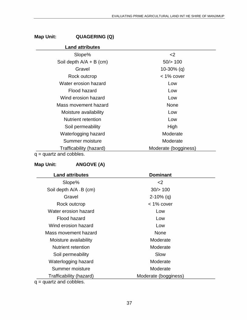
Unit QUAGERING (Q)
EVALUATING PRIME AGRICULTURAL LAND INT HE SHIRE OF MANJIMUP
33
Geomorphology Flat or broadly convex crests and valley divides; someswamps; relief is less than 20 metres.
Soils Unconsolidated sandy sediments, often with rounded cobbles.
Native Vegetation Stunted jarrah low open woodland with Banksia illicifoliadominating in the understorey.
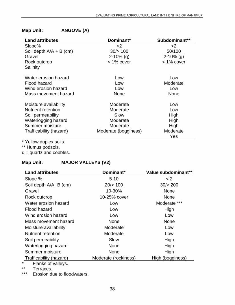
Unit ANGOVE (A)
Geomorphology Gentle slopes and heads of broad swampy valleys; less than20 metres relief.
Soils Shallow unconsolidated sandy sediments with roundedcobbles included. Yellow duplex soils with grey-brown sandover a pale yellow or grey mottled clay.
Native Vegetation Dense heath dominated by Agonis parviceps.
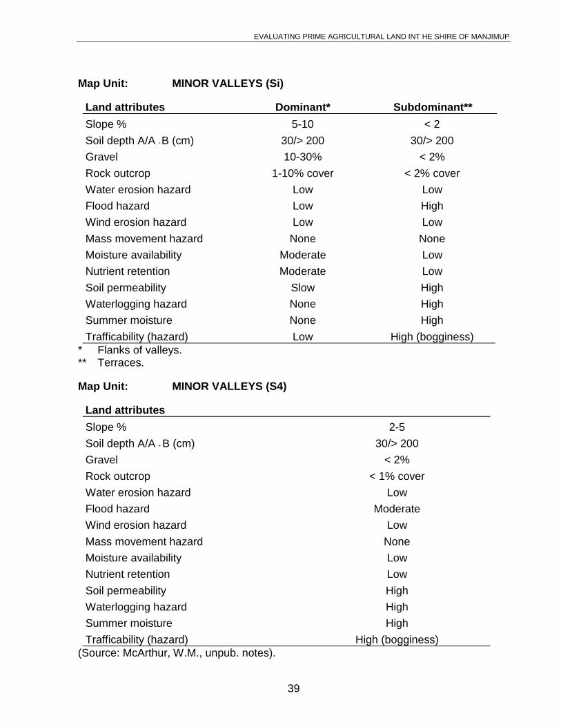
Unit MAJOR VALLEYS (V1_4)
Geomorphology V1 - deep valleys incised into the old lateritic landscape, 40-60metres deep, 15-30° slopes with occasional rock outcrops.
V2 - valleys 20-40 metres deep with 10-20° slopes; rockoutcrops less frequent.
V3 - valleys traversing hill belts of moderate to low relief, 20-40metres deep with frequent granite exposure.