Forest to Stirlings - a nature conservation plan Connecting people and nature The suspected weed that turned out to be the presumed-extinct Cranbrook pea after a site visit discussing funding for bushland protection between farmer Bill O’Halloran (shown right) and Greening Australia’s Wendy Bradshaw in 2000, lead to publicity that resulted in a number of populations being discovered and protected. We strive to balance living in our landscape and caring for nature. This conservation plan was developed consultatively by the Gillamii Centre and Green Skills with the assistance of Gondwana Link Ltd. The plan focuses on the landscape between the Walpole Wilderness Area and the Stirling Range National Park.
Transcript
Forest to Stirlings - a nature conservation plan
Connecting people and nature
The suspected weed that turned out to be the presumed-extinct Cranbrook pea after a site visit discussing funding for bushland protection between farmer Bill O’Halloran (shown right) and Greening Australia’s Wendy Bradshaw in 2000, lead to publicity that resulted in a number of populations being discovered and protected.
We strive to balance living in our landscape and caring for nature.
This conservation plan was developed consultatively by the Gillamii Centre and Green Skills with the assistance of Gondwana Link Ltd. The plan focuses on the landscape between the Walpole Wilderness Area and the Stirling Range National Park.
2
Our focus area
The western part of the area has many plantation forestry properties, most containing important remnant vegeta-tion and associated fauna. This wetter region of the Forest to Stirlings landscape has more natural vegetation - primarily forest. As we move east towards the Stirling Range National Park, the forest changes into woodlands and mallee heath as the rainfall tapers off, and the plantation/forestry dominated landscape changes to broadacre farming (grain cropping/livestock) with more farmland relative to bush.
Threats to the biodiversity values of this area are in part linked to changes that have come about from past agricul-tural clearing such as fragmentation of bush, changes in water flows and rising salinity. These issues are well known within the community who are continuing to take active steps to address these threatening processes.
Gondwana Link is an ambitious ecological vision that aims to link areas of bush from the wet forests of the far south west (near Margaret River) to the mallee and woodland to the east (near Kalgoorlie). Our focus area is the Forest to Stirlings landscape stretching roughly 70 km from the Walpole Wilderness Area (Mt. Roe National Park) to the west and the Stirling Range National Park to the east. This plan builds on the following key ecological features of the area:
• numerous vegetation types ranging from forest in the west to mallee-heath/woodland in the east
• many wetlands with important plants and animals • very high plant species richness • situated at the junction of a number of catchments flowing in different directions • represents the end of the range for a number of species (e.g. marron, red-tailed black cockatoo)
Walpole Wilderness Area
• 363,000 hectares • comprises 10 major national
parks • protects ½ the old growth
jarrah and karri forests • approximately 2000 higher
plant species and over 600 species of fungi
• 235 orchids (65% of West-ern Australia’s total)
• giant old-growth tingle forests
• mammals such as the quokka, rare & endemic frogs, crayfish and trapdoor spider
• high value waterways, wet-lands and associated biodiversity
• strong Noongar Aboriginal cultural values
• 115,920 hectares
• highest peak is Bluff Knoll; at 1095 metres above sea level
• more than 1500 plant species, including 87 found nowhere else
• 138 orchid species (38% of Western Australia’s total).
• species unique to some of the peaks in the range
• high cultural signifi-cance for the Mineng and Goreng people
Wetter
750mm/yr
Drier
450mm/yr Rainfall gradient
Stirling Range National Park
3
Our groups The two major groups leading the development and implementation of this nature conservation plan are the Gillamii Centre and Green Skills. These groups, together with a number of others, have been working with the landholders of the area for over 20 years to help them conserve their important natural assets on their properties.
Who we work with so far We consult with a range of stakeholders who provide information, guidance, technical expertise, passion, dedica-tion, commitment and the range of skills needed to help us achieve our conservation goals, which so far includes:
Birds Australia – Contractors - Co-operative Research Centres - Dept. of Agriculture and Food (WA) - Dept. of Environment and Conservation - Dept. of Planning and Infrastructure - Dept. of Water - Gondwana Link - Green-ing Australia - Land for Wildlife – Landholders - Nurseries - Seed Suppliers - Oyster Harbour Catchment Group - Timber Plantation Companies - Poorrarecup upgrade committee - Shire of Cranbrook - Shire of Plantagenet - South Coast Natural Resource Management – Universities - Wilson Inlet Catchments Council.
What success looks like for us Resilient, healthy bush and its wildlife connecting the Walpole Wilderness Area and the Stirling Range National Park across our agricultural landscape.
How we developed our plan We used the Conservation Action Planning* methodology to identify eight key conservation “targets”** as the focus for our protection and restoration efforts. If we improve the viability of each of these targets, we believe we will improve the ecological condition of the entire system. Each target includes “nested” targets (species or com-munities with similar needs, threats or situation) and has different characteristics or attributes that need to be con-sidered when developing strategies for their protection. In an initial assessment of the viability of the targets for this plan, most were determined to be in fair condition.
Note: The word target in the context of conservation target can be substituted by conservation/biodiversity asset.
* Conservation Action Planning (CAP) is a powerful tool to guide conserva-tion teams to develop focused strategies and measures of success. CAP is The Nature Conservancy's (www.nature.org/) version of the Open Standards for the Practice of Conservation www.conservationmeasures.org/initiatives/standards-for-project-management
** Focal Conservation Targets – A limited suite of species, communities and ecological systems that are chosen to represent and encompass the full array of biodiversity found in a project area. They are the basis for setting goals, carrying out conservation actions, and measuring conservation effectiveness. In theory, conservation of the focal targets will ensure the conservation of all native biodiversity within functional landscapes.
The Gillamii Centre was established in 1993 with local farmers believing that there was a need for a community- based centre to promote and streamline land care management. The vision of the group is to improve the condition of the agricultural
landscape for future generations. “We wish to encourage and lead in the efficient use of resources across the commu-nity while protecting and enhancing the natural environ-ment”. www.gillamii.org.au/
Green Skills is an innovative not-for-profit organisation that has been leading the way since 1989 in developing and managing environmental projects that assist all levels of regional and metro-politan communities to effectively imple-
ment a vision for a sustainable future. Green Skills strives for a community in which all people share and experience the principles of biodiversity and ecological integrity; equity and human rights, long-term economic health and personal well being. www.greenskills.org.au/
4
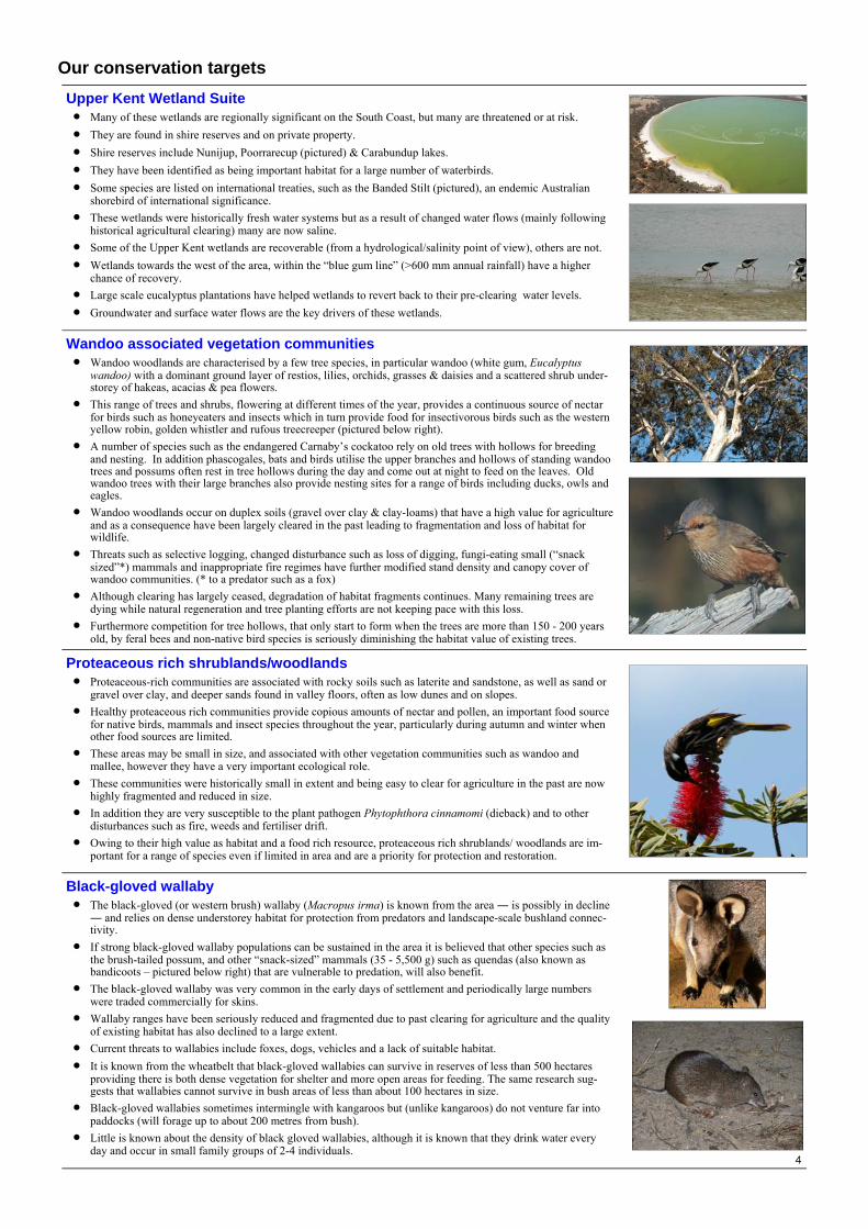
Our conservation targets Upper Kent Wetland Suite • Many of these wetlands are regionally significant on the South Coast, but many are threatened or at risk. • They are found in shire reserves and on private property. • Shire reserves include Nunijup, Poorrarecup (pictured) & Carabundup lakes. • They have been identified as being important habitat for a large number of waterbirds. • Some species are listed on international treaties, such as the Banded Stilt (pictured), an endemic Australian
shorebird of international significance. • These wetlands were historically fresh water systems but as a result of changed water flows (mainly following
historical agricultural clearing) many are now saline. • Some of the Upper Kent wetlands are recoverable (from a hydrological/salinity point of view), others are not. • Wetlands towards the west of the area, within the “blue gum line” (>600 mm annual rainfall) have a higher
chance of recovery. • Large scale eucalyptus plantations have helped wetlands to revert back to their pre-clearing water levels. • Groundwater and surface water flows are the key drivers of these wetlands.
Wandoo associated vegetation communities • Wandoo woodlands are characterised by a few tree species, in particular wandoo (white gum, Eucalyptus
wandoo) with a dominant ground layer of restios, lilies, orchids, grasses & daisies and a scattered shrub under-storey of hakeas, acacias & pea flowers.
• This range of trees and shrubs, flowering at different times of the year, provides a continuous source of nectar for birds such as honeyeaters and insects which in turn provide food for insectivorous birds such as the western yellow robin, golden whistler and rufous treecreeper (pictured below right).
• A number of species such as the endangered Carnaby’s cockatoo rely on old trees with hollows for breeding and nesting. In addition phascogales, bats and birds utilise the upper branches and hollows of standing wandoo trees and possums often rest in tree hollows during the day and come out at night to feed on the leaves. Old wandoo trees with their large branches also provide nesting sites for a range of birds including ducks, owls and eagles.
• Wandoo woodlands occur on duplex soils (gravel over clay & clay-loams) that have a high value for agriculture and as a consequence have been largely cleared in the past leading to fragmentation and loss of habitat for wildlife.
• Threats such as selective logging, changed disturbance such as loss of digging, fungi-eating small (“snack sized”*) mammals and inappropriate fire regimes have further modified stand density and canopy cover of wandoo communities. (* to a predator such as a fox)
• Although clearing has largely ceased, degradation of habitat fragments continues. Many remaining trees are dying while natural regeneration and tree planting efforts are not keeping pace with this loss.
• Furthermore competition for tree hollows, that only start to form when the trees are more than 150 - 200 years old, by feral bees and non-native bird species is seriously diminishing the habitat value of existing trees.
Proteaceous rich shrublands/woodlands • Proteaceous-rich communities are associated with rocky soils such as laterite and sandstone, as well as sand or
gravel over clay, and deeper sands found in valley floors, often as low dunes and on slopes. • Healthy proteaceous rich communities provide copious amounts of nectar and pollen, an important food source
for native birds, mammals and insect species throughout the year, particularly during autumn and winter when other food sources are limited.
• These areas may be small in size, and associated with other vegetation communities such as wandoo and mallee, however they have a very important ecological role.
• These communities were historically small in extent and being easy to clear for agriculture in the past are now highly fragmented and reduced in size.
• In addition they are very susceptible to the plant pathogen Phytophthora cinnamomi (dieback) and to other disturbances such as fire, weeds and fertiliser drift.
• Owing to their high value as habitat and a food rich resource, proteaceous rich shrublands/ woodlands are im-portant for a range of species even if limited in area and are a priority for protection and restoration.
Black-gloved wallaby • The black-gloved (or western brush) wallaby (Macropus irma) is known from the area ― is possibly in decline
― and relies on dense understorey habitat for protection from predators and landscape-scale bushland connec-tivity.
• If strong black-gloved wallaby populations can be sustained in the area it is believed that other species such as the brush-tailed possum, and other “snack-sized” mammals (35 - 5,500 g) such as quendas (also known as bandicoots – pictured below right) that are vulnerable to predation, will also benefit.
• The black-gloved wallaby was very common in the early days of settlement and periodically large numbers were traded commercially for skins.
• Wallaby ranges have been seriously reduced and fragmented due to past clearing for agriculture and the quality of existing habitat has also declined to a large extent.
• Current threats to wallabies include foxes, dogs, vehicles and a lack of suitable habitat. • It is known from the wheatbelt that black-gloved wallabies can survive in reserves of less than 500 hectares
providing there is both dense vegetation for shelter and more open areas for feeding. The same research sug-gests that wallabies cannot survive in bush areas of less than about 100 hectares in size.
• Black-gloved wallabies sometimes intermingle with kangaroos but (unlike kangaroos) do not venture far into paddocks (will forage up to about 200 metres from bush).
• Little is known about the density of black gloved wallabies, although it is known that they drink water every day and occur in small family groups of 2-4 individuals.
5
Jarrah/Marri associated vegetation communities • Jarrah/Marri varies from Forest to Low Woodland occurring on a range of soil types including granites, laterites
and deep sands. • The dominant over-storey trees are Jarrah (Eucalyptus marginata) and Marri (Corymbia calophylla). • Understorey species include banksias and other proteaceous plants, sheoaks, grass trees, melaleucas & tea trees
and a range of acacias and members of the pea family. • This diverse vegetation type is susceptible to a range of threats including dieback, rabbits and kangaroos and the
effects of a drying climate. • Jarrah & Marri forests and woodlands offer a diverse range of habitat and food sources for fauna, and the range of
“snack sized” (35 - 5,500 g) have been identified as an important part of these systems.
Carnaby's black cockatoo • This target comprises primarily Carnaby’s cockatoo (Calyptorhynchus latirostris) with two other black cockatoo
species, Baudin's (Calyptorhynchus baudinii) and the red-tailed black cockatoo (Calyptorhynchus magnificus) as “nested” targets.
• All three species are reliant on very old trees for the provision of hollows in which to nest and rear their young. • All three birds occur in the Forest to Stirlings area, and owing to the steep climatic and vegetation gradients across
the area, two of these species, Baudin’s cockatoo and the red-tailed black cockatoo are probably close to the east-ern-most extent of their range.
• Nesting hollows for Carnaby’s cockatoos need to be located within 12 km of its favoured food source - pro-teaceous-rich shrublands, for these birds to derive sufficient energy to maintain themselves and their chicks.
• Owing primarily to the requirement for both large old trees (which are at risk of dying/ being removed on many farms) and healthy proteaceous rich shrublands (which are at risk from fragmentation, Phytophthora dieback etc.) it is perhaps not surprising that Carnaby’s cockatoo is classified endangered.
Stirling Range outliers • Ridge and hill vegetation extending westwards from the western part of the Stirling Range National Park to
Geekabee Hill (approximately15km west of Cranbrook). • Occur primarily on Stirling Range sandstone and quartzite and are dependent on specific fire requirements. • These hilltops comprise high diversity, distinctive areas, with more similarities with the Stirling Range vegetation
than with ironstones to the north and south, and occupy a distinctive landform. • These outliers may include more than one vegetation type and need to be investigated further to determine floristic
and structural components and relationships to other vegetation systems. • They have high floral biodiversity (and endemism) and include Sukey Hill near Cranbrook. • Threats to these systems include fragmentation and Phytophthora dieback for susceptible species.
West Balicup Wetland Suite • These historically saline wetlands are part of a system described as a stagnant regional aquifer in which there is
very little underground movement of water. • The Balicup wetlands were formed in a dryer climate when salts were closer to the surface. The lakes dried up and
blow outs caused lunettes (crescent shaped ridges) to form that were rich in salt and gypsum. • Long term evaporation with little groundwater movement has caused extreme salinity, in some cases up to three
times the concentration of seawater. • The wetlands may be considered to be “windows” to the groundwater. • Excessive phosphorus run-off from farmland may in fact be more harmful than salt for these systems, causing
toxic blue-green algae outbreaks in warm weather due to eutrophication (depleted bioavailable oxygen). • Some of these wetlands get a pink tinge at certain times, attributable to a salt tolerant algae (Dunaliella salina). • The fringing vegetation of these systems is crucial for ecological balance and it is important to consider the
broader valley feeding these wetlands, rather than just the wetlands themselves when considering strategies for intervention.
• Some of the Balicup wetlands are contained within substantial nature reserves and have been recognised as being nationally significant, being listed in the National Directory of Important Wetlands in Australia.
• Some Balicup wetlands are considered regionally significant on the South Coast, and occur in both nature reserves and on private property.
• The nature reserves include the major lakes Balicup, Camel, and Jebarjup, many of which have been identified as being important habitat for a large number of waterbirds, particularly those listed on international treaties.
6
Critical threats to our conservation area
All of the conservation targets are impacted by multiple threats, which act together to alter their viability. Based on information that the team had access to, the main threats for each conservation target were identified and ranked. Key threats identified so far identified include: • loss of vegetation cover and soil carbon leading to inefficient water cycling (including reduced rainfall) on
agricultural land, • clearing (past and present, mechanical and through ongoing grazing) leading to loss of habitat and fragmen-
tation of remnants. • habitat loss, exacerbated by a range of factors including salinity, inappropriate fire regimes, road and other
infrastructure development, invasion by weeds, • Phytophthora cinnamomi (dieback), and • loss of habitat for Carnaby’s black cockatoo such as competition for hollows & removal of paddock trees.
Predation by introduced carnivores is exacerbated by loss of habitat (such as dense understorey that provides pro-tection for native fauna) that affects numerous species, including many of the smaller native mammals and birds that pollinate local plants. As bushland becomes more fragmented, many plants and animals are unable to move between remnants, leading to ongoing local extinctions. This leads to disruption of ecosystem processes that ‘maintain the landscape’ - through interactions between plants, animals, fungi and micro-organisms with each other and the soil, air, water and sunlight. While fires are a part of natural landscapes in Australia, inappropriate fire regimes can destroy some vegetation types completely, particularly when fires are too frequent or too severe to allow seed to set between fires. Many of the Proteaceae (e.g. Banksia, Hakea) are susceptible to fire, but the biggest threat to this family is the spread of Phytophthora cinnamomi, as it will kill many of the species that are both ecologically important as well as being spectacular and characteristic of the area.
7
Key threats for each conservation target
Threats
Upper Kent
Wetland Suite
Wandoo associated vegetation communi-
ties
Protea- ceous rich
shrub-lands/
woodlands
Black gloved wallaby
Jarrah/Marri
associated vegetation communi-
ties
Carnaby's black
cockatoo
Stirling Range outliers
West Balicup Wetland
Suite
Overall Threat Rank
Drying Climate High High High Medium High Very High Medium Medium Very High
Fragmentation due to historical clearing High High High High Medium Very High Medium Very High
Wildfire Medium High High Medium Medium High Low Low High
Loss of food sources within foraging distance of nesting sites
Very High High
Phytophthora dieback Medium High High Low High
Current Clearing (development, infrastructure, farming) Low Medium High Medium Medium
Clearing-induced hydrological change High Medium Medium Medium
Current removal of paddock trees Medium High Medium
Grazing (rabbits, kangaroos, livestock & feral pigs) Medium Medium Medium Medium Medium Low Low Low Medium
Competition for hollows Low High Medium
Marri canker High Medium
Weeds Low Medium Medium Low Medium Low Low Medium Medium
Carnivores (foxes, cats, pigs, kookaburras) Medium Medium Medium Medium
Deaths by vehicles Medium Medium Medium
Prescribed burning (current practices) Low Medium Low
Barriers (fences, roads) Medium Low
Nutrient & weed seed drift Medium Low
Loss of mycovores (fungi eat-ers such as woylies & quenda) Medium Low
Shooting of native species Medium Low
Water abstraction Medium Low
High water use by plantation forests Low Low Low Low
Threat Status for Targets and Project High High High High High Very High Medium Medium Very High
Conservation Targets
8
Strategic directions
Our conservation goal in the Forest to Stirlings area is to enhance the viability of each conservation target, which means we need to improve the condition, the size and/or the processes that maintain these targets and eliminate or reduce the threats to them. By doing this for our eight conservation targets, we should also improve the ecological health of the rest of the system because many of the processes and the threats are common to many components of the ecosystem. During the strategy setting part of the process it was acknowledged that more information is needed for some of the targets, and some of these requirements have been brought into the strategies below. The Proteaceous rich shrublands/woodlands target, also came under a lot of discussion and it was acknowledged that despite members of the working group undertaking a brief field survey, further research and survey requirements are required for this important target. A range of objectives and strategies (listed as bullet points) have been developed to enhance the status of the iden-tified conservation targets as follows overleaf (only highest ranked strategies described here).
Exciting stories such as a number of sightings of bandicoots (quendas) in recent times in the vicinity of the Leh-man and Walsh properties near Cranbrook ― where extensive revegetation and bushland protection has been carried out, together with their location close to the Stirling Range National Park― is testimony to the need for strategic planning and the possibility of extending the ranges of these rare animals in the Stirling to Forest link.
Southern Brown Bandicoot (quenda)
9
Overall enabling strategies for all conservation targets Objective: Ensure that enabling strategies (in particular funding, capacity building & communications) for the Gillamii Centre and Green Skills and associated groups are scoped and developed by 2012, to ensure the effective implementation of conservation strategies through to 2020 and beyond.
• Develop and implement a long-term funding strategy for conservation interventions in the Forest to Stirlings Land-scape.
• Increase the capacity of the Gillamii Centre and Green Skills to plan, implement, monitor and review conservation interventions in the Forest to Stirlings Landscape.
• Develop and implement a strategy for communicating the value of the biodiversity of the Forest to Stirlings landhold-ers, local authorities and visitors.
Conservation strategies for each conservation target Upper Kent Wetland Suite Objective: To improve the management and condition of biodiversity in the Upper Kent Wetland Suite in the Forest to Stirlings Functional Landscape by 2020.
• Undertake hydrological assessments on key pilot priority sites to determine condition and future prospects • Implement new/known perennial pastures/ agroforestry/ other high water use options for agriculture • Develop decision making framework for optimising location of restoration works • Fencing of priority remnants • Ensure that there are ongoing culling programs for kangaroos • Revegetation of key areas for biodiversity including buffering & connecting remnants • Build knowledge base of fire history, and investigate if there are any requirements for small cool fires • Inform landholders and land managers on best fire management practices for remnants • Ensure that monitoring takes place to keep track of water quality trends
Wandoo associated vegetation communities Objective: To improve the condition and connectivity of Wandoo associated vegetation communities in the Forest to Stirlings Functional Landscape by 2015.
• Identification of key wandoo areas requiring fencing • Fencing of key wandoo remnants • Connecting critical areas of bushland • Ensure public lands (and private forestry land) are well managed for fire, grazing pressure etc. • Establish location of protectable areas for dieback control • Link to groups monitoring wandoo decline to assist with wandoo health information
Proteaceous rich shrublands/woodlands Objective: To improve the condition and conservation status of Proteaceous rich shrublands/woodlands in the Forest to Stirlings Functional Landscape by 2020.
• Identify and map the extent of proteaceous rich communities • Fence proteaceous rich remnants • Ensure high quality composition, structure & function are included in all revegetation projects • Include proteaceous revegetation in key areas • Increase regional capacity to apply best direct seeding (and other revegetation) practices • Implement rabbit control program • Increase proportion of proteaceous plants in Carbon Offset programs • Build knowledge base of fire history, and investigate if there are any requirements for small cool fires • Implement entrance signage for landholders – bio-security • Inform landholders on best fire management practices for remnants • Undertake Phosphite applications in key areas if practicable • Targeted education on Proteaceae and dieback risk
Objectives and strategies
10
Black gloved wallaby Objective: To improve the habitat and conservation status of black gloved wallabies (and fauna with similar habi-tat requirements/threats) in the Forest to Stirlings Functional Landscape by 2015.
• Undertake community survey of black gloved wallaby and other fauna species (in particular bandicoots) • Undertake targeted community survey - spotlighting, remote cameras, targeting specific areas such as reserves (co-
ordinated survey) • Undertake habitat protection (fencing) of good quality bush that has the potential to support black gloved wallabies
and create important habitat linkages • Restoration of key areas of habitat with high linkage value on previously cleared land using high quality revegetation/
restoration practices • Develop an integrated fox and cat (and rabbit) control program for the broader region, that considers a range of meas-
ures including: sponsorship for a bounty on shooting foxes and cats; annual fox shoots; a larger scale approach to make fox control do-able over regional scales (through NRM groups; Dept. Agriculture etc.) and integrated pilot pro-jects in key habitat areas.
Jarrah/marri associated vegetation communities Objective: To improve the condition and connectivity of Jarrah/marri associated vegetation communities in the Forest to Stirlings Functional Landscape by 2015.
• Identification of key jarrah/marri areas requiring fencing • Fencing of key jarrah/marri remnants • Connecting critical areas of bushland • Ensure public lands (and private forestry land) are well managed for fire, grazing pressure etc. • Establish location of protectable areas for dieback control
Carnaby's Black Cockatoo Objective: To improve the habitat and conservation status of black cockatoos in the Forest to Stirlings Functional Landscape by 2015.
• Identify key nesting sites (trees with hollows within critical distance of key feeding sites) • Fence key remnants • Plant Carnaby’s black cockatoo food sources in all revegetation • Introduce pilot feral bee control program to measure the reduction in competition for nesting hollows • Reduce competition for nesting hollows & predation from feral birds
Stirling Range Outliers Objective: To improve the management and condition (from “Good” to “Very Good”) of the Stirling Range outliers in the Forest to Stirlings Functional Landscape by 2020.
• Fencing of Stirling Range outlier remnant vegetation • Ensure public lands (and private forestry land) are well managed for fire, grazing pressure etc. • Establish location of protectable areas for dieback control
West Balicup Wetland Suite Objective: To improve the condition of the West Balicup Wetland Suite in the Forest to Stirlings Functional Landscape by 2020.
• Implement new/known perennial pastures/ agroforestry/ other high water use options for agriculture • Develop decision making framework for optimising location of restoration works • Fencing priority remnants • Ensure that there are ongoing culling programs for kangaroos • Revegetation of key areas for biodiversity including buffering & connecting remnants • Build knowledge base of fire history, and investigate if there are any requirements for small cool fires • Inform landholders and land managers on fire best management practices for remnants • Ensure that monitoring takes place to keep track of water quality trends
Future strategies This plan will be reviewed regularly as we learn more about the responses of the landscape and ecosystems to our management, and in particular as we become better informed by some of our further surveys and investigations. Future reviews of this plan will likely yield additional strategies. It is hoped that the strategies identified in this plan will go a long way towards abating the critical threats to our conservation targets.
11
Measuring our success The key question that a group involved in conservation needs to answer is: “Are the conservation strategies we are using having their intended impact?” To answer this question, we are collecting and planning to collect further data on a number of indicators that gauge how well we are keeping the critical threats in check and, in turn, whether the viability of our conservation targets is improving. To date a monitoring framework has been devel-oped (see below) and the most critical and practical methods to develop and implement our monitoring program further are being investigated.
Conservation Target Indicator
Upper Kent Wetland Suite • Area and condition of native vegetation • Fringing vegetation assessment • Water health using physical, chemical and biological Ausrivas indices
Wandoo associated vegetation communities
• Proximity to other Wandoo woodlands and to other vegetation communities
• Suite of fauna • Range of ant activity • Understorey & recruitment • Crown condition of wandoo trees • Total area of healthy target vegetation (hectares)
Proteaceous rich shrublands/woodlands • Disturbance within natural regime • Presence of key pollinators • Diversity of species age classes
Black gloved wallaby • Area and condition of native vegetation • Importance of movement and the effect of fences • Number/ percentage of potential suitable habitat occupied
Jarrah/Marri associated vegetation communities
• Complete range of age classes of woodland species across the area • Presence of healthy understorey including proteaceous communities • Crown condition of key tree species • Total area of healthy target vegetation (hectares)
Carnaby's black cockatoo • Discrete populations within critical range • Extent and location of proteaceous rich shrublands • Availability of hollows for breeding and nearby food sources
Stirling Range outliers • Proximity to other outliers and to other vegetation communities • Fire age mosaic • Vegetation assessment
West Balicup Wetland Suite • Area and condition of native vegetation • Fringing vegetation assessment • Water health using physical, chemical and biological Ausrivas indices
12
How can you get involved?
Please contact one of the following groups to find out how you can get involved: The Gillamii Centre www.gillamii.org.au/ Green Skills www.greenskills.org.au/ Gondwana Link www.gondwanalink.org
This plan is under ongoing review. For the more detailed, current version please see: http://conpro.tnc.org/1721/
Suggested Citation for this booklet: Gondwana Link, 2011. Forest to Stirlings – A Nature Conservation Plan - Connecting people and nature. Booklet outlining key elements of the Gillamii-Green Skills Conservation Action Plan. Albany, Western Australia.
We are very grateful to all the photographers whose images appear in this booklet. They include: Eve and Jim Parry, Wendy Bradshaw, Katrina Syme, Amanda Keesing, Ray Garstone, Stefanie Griebel, Geoff Taylor, Basil Schur, Raana Scott, Geraldine Janicke, Ian Mayo, Barry Heydenrych, Sandra Gilfillan, and images courtesy of Australian Plantation Forest Company, Wilderness Society and the Centre for Excellence in Natural Resource Management.
The development of the plan was led by Barry Heydenrych who was seconded to Gondwana Link from Greening Australia for this work, and the team included the following: Genevieve Harvey (Gillamii Centre), Basil Schur (Green Skills), Bill Hollingworth (Bandicoot & Green Valley Nurseries), Wendy Bradshaw (South Coast Natural Resource Management), Geoff Rolland (Australian Plantation Forest Company) and Sylvia Leighton (Land for Wildlife). We are very grateful for funds provided for plan development and booklet production from The Nature Conservancy, Diversicon Environmental Foundation, The Thomas Foundation and Bigididge Pty. Ltd. The Gillamii Centre and Green Skills would also like to thank the following for their support: