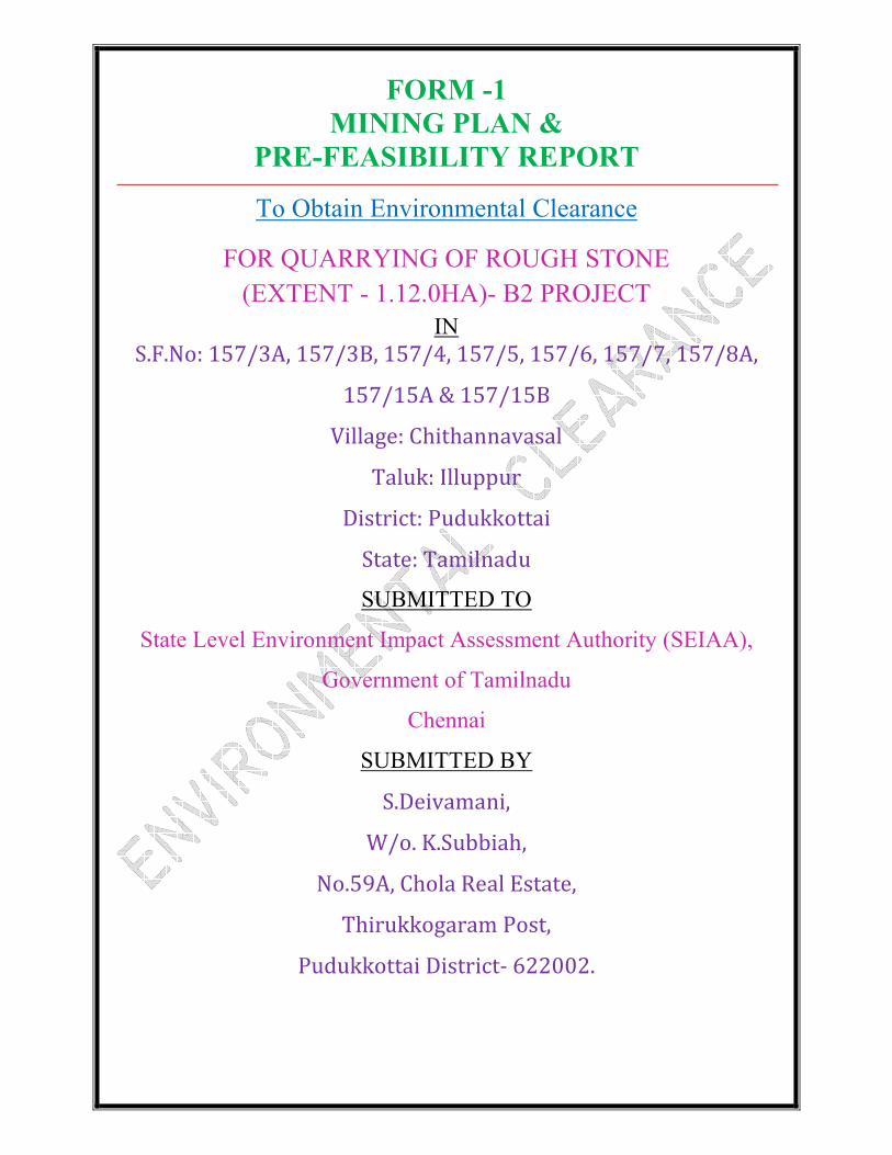
Page 1
FORM -1
MINING PLAN &
PRE-FEASIBILITY REPORT
To Obtain Environmental Clearance
FOR QUARRYING OF ROUGH STONE
(EXTENT - 1.12.0HA)- B2 PROJECT
IN
S.F.No: 157/3A, 157/3B, 157/4, 157/5, 157/6, 157/7, 157/8A,
157/15A & 157/15B
Village: Chithannavasal
Taluk: Illuppur
District: Pudukkottai
State: Tamilnadu
SUBMITTED TO
State Level Environment Impact Assessment Authority (SEIAA),
Government of Tamilnadu
Chennai
SUBMITTED BY
S.Deivamani,
W/o. K.Subbiah,
No.59A, Chola Real Estate,
Thirukkogaram Post,
Pudukkottai District- 622002.
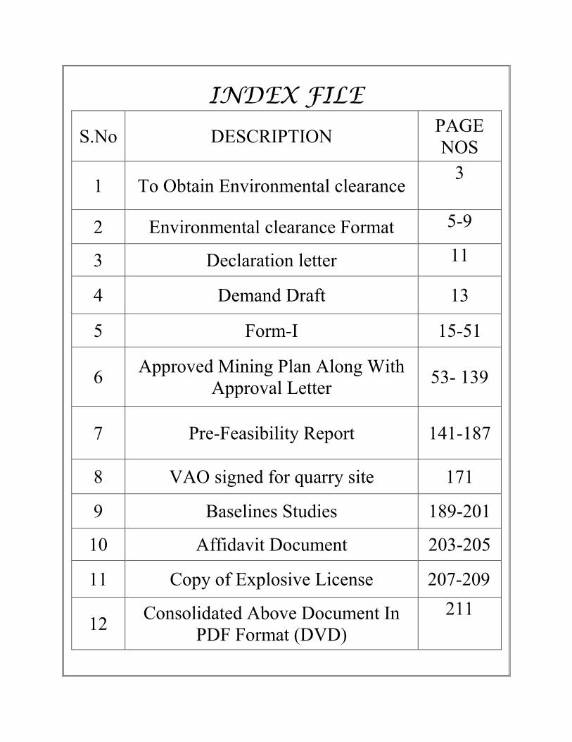
Page 2
INDEX FILE
S.No DESCRIPTION PAGE
NOS
1 To Obtain Environmental clearance 3
2 Environmental clearance Format 5-9
3 Declaration letter 11
4 Demand Draft 13
5 Form-I 15-51
6 Approved Mining Plan Along With
Approval Letter 53- 139
7 Pre-Feasibility Report 141-187
8 VAO signed for quarry site 171
9 Baselines Studies 189-201
10 Affidavit Document 203-205
11 Copy of Explosive License 207-209
12 Consolidated Above Document In
PDF Format (DVD)
211
Page 3
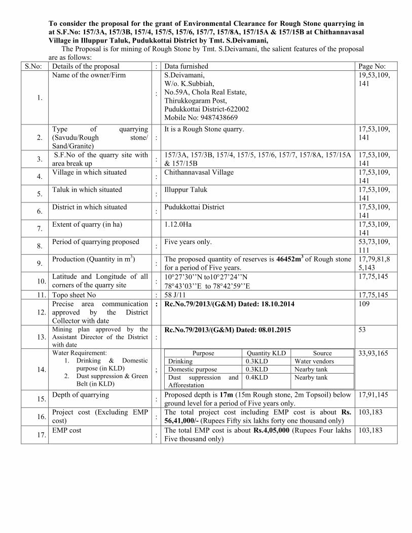
To consider the proposal for the grant of Environmental Clearance for Rough Stone quarrying in
at S.F.No: 157/3A, 157/3B, 157/4, 157/5, 157/6, 157/7, 157/8A, 157/15A & 157/15B at Chithannavasal
Village in Illuppur Taluk, Pudukkottai District by Tmt. S.Deivamani, The Proposal is for mining of Rough Stone by Tmt. S.Deivamani, the salient features of the proposal
are as follows:
S.No: Details of the proposal : Data furnished Page No:
1.
Name of the owner/Firm
:
S.Deivamani,
W/o. K.Subbiah,
No.59A, Chola Real Estate,
Thirukkogaram Post,
Pudukkottai District-622002
Mobile No: 9487438669
19,53,109,
141
2.
Type of quarrying
(Savudu/Rough stone/
Sand/Granite)
:
It is a Rough Stone quarry. 17,53,109,
141
3. S.F.No of the quarry site with
area break up :
157/3A, 157/3B, 157/4, 157/5, 157/6, 157/7, 157/8A, 157/15A
& 157/15B
17,53,109,
141
4. Village in which situated
: Chithannavasal Village 17,53,109,
141
5. Taluk in which situated
: Illuppur Taluk 17,53,109,
141
6. District in which situated
: Pudukkottai District 17,53,109,
141
7. Extent of quarry (in ha)
1.12.0Ha 17,53,109,
141
8. Period of quarrying proposed
: Five years only. 53,73,109,
111
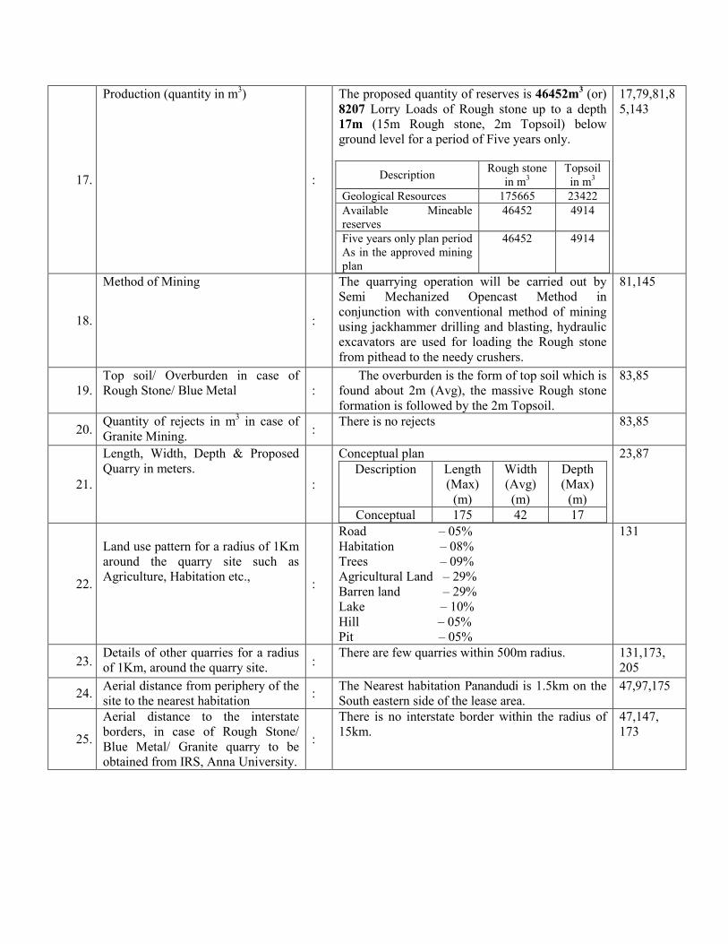
9. Production (Quantity in m
3)
: The proposed quantity of reserves is 46452m
3 of Rough stone
for a period of Five years.
17,79,81,8
5,143
10. Latitude and Longitude of all
corners of the quarry site :
10°27’30’’N to10°27’24’’N
78°43’03’’E to 78°42’59’’E
17,75,145
11. Topo sheet No : 58 J/11 17,75,145
12.
Precise area communication
approved by the District
Collector with date
: Rc.No.79/2013/(G&M) Dated: 18.10.2014 109
13. Mining plan approved by the
Assistant Director of the District
with date :
Rc.No.79/2013/(G&M) Dated: 08.01.2015 53
14.
Water Requirement:
1. Drinking & Domestic
purpose (in KLD)
2. Dust suppression & Green
Belt (in KLD)
;
Purpose Quantity KLD Source
Drinking 0.3KLD Water vendors
Domestic purpose 0.3KLD Nearby tank
Dust suppression and
Afforestation
0.4KLD Nearby tank
33,93,165
15. Depth of quarrying
: Proposed depth is 17m (15m Rough stone, 2m Topsoil) below
ground level for a period of Five years only.
17,91,145
16. Project cost (Excluding EMP
cost) :
The total project cost including EMP cost is about Rs.
56,41,000/- (Rupees Fifty six lakhs forty one thousand only)
103,183
17. EMP cost
: The total EMP cost is about Rs.4,05,000 (Rupees Four lakhs
Five thousand only)
103,183
Page 4
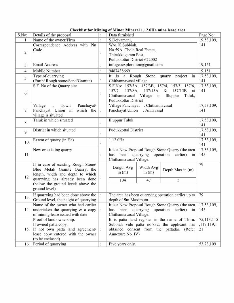
Checklist for Mining of Minor Mineral 1.12.0Ha mine lease area
S.No: Details of the proposal : Data furnished Page No:
1. Name of the owner/Firm : S.Deivamani, 19,53,109,
141
2.
Correspondence Address with Pin
Code :
W/o. K.Subbiah,
No.59A, Chola Real Estate,
Thirukkogaram Post,
Pudukkottai District-622002
3. Email Address : [email protected] 19,151
4. Mobile Number : 9487438669 19,151
5. Type of quarrying
(Earth/ Rough stone/Sand/Granite) :
It is a Rough Stone quarry project in
Chithannavasal village.
17,53,109,
141
6.
S.F. No of the Quarry site
:
S.F.No: 157/3A, 157/3B, 157/4, 157/5, 157/6,
157/7, 157/8A, 157/15A & 157/15B at
Chithannavasal Village in Illuppur Taluk,
Pudukkottai District
17,53,109,
141
7.
Village , Town Panchayat/
Panchayat Union in which the
village is situated
:
Village Panchayat : Chithannavasal
Panchayat Union : Annavasal
17,53,109,
141
8. Taluk in which situated
: Illuppur Taluk 17,53,109,
141
9. District in which situated
: Pudukkottai District 17,53,109,
141
10. Extent of quarry (in Ha)
: 1.12.0Ha 17,53,109,
141
11.
New or existing quarry
:
It is a New Proposal Rough Stone Quarry (the area
has been quarrying operation earlier) in
Chithannavasal Village.
17,53,109,
145
12.
If in case of existing Rough Stone/
Blue Metal/ Granite Quarry, the
length, width and depth to which
quarrying has already been done
(below the ground level/ above the
ground level)
:
Length Avg
in (m)
Width Avg
in (m) Depth Max in (m)
104 47 5
79
13. If quarrying had been done above the
Ground level, the height of quarrying
: The area has been quarrying operation earlier up to
depth of 5m Maximum.
79
14.
Name of the owner who had earlier
undertaken the quarrying & a copy
of mining lease issued with date
:
It is a New Proposal Rough Stone Quarry (the area
has been quarrying operation earlier) in
Chithannavasal Village.
17,53,109,
145
15.
Proof of land ownership.
If owned patta copy.
If not own patta land agreement/
lease copy entered with the owner
(to be enclosed)
:
It is patta land register in the name of Thiru.
Subbiah vide patta no.832, the applicant has
obtained consent from the pattadar. (Refer
Annexure No. IV)
75,113,115
,117,119,1
21
16. Period of quarrying : Five years only. 53,73,109
Page 5
17.
Production (quantity in m3)
:
The proposed quantity of reserves is 46452m3 (or)
8207 Lorry Loads of Rough stone up to a depth
17m (15m Rough stone, 2m Topsoil) below
ground level for a period of Five years only.
Description Rough stone
in m3
Topsoil
in m3
Geological Resources 175665 23422
Available Mineable
reserves
46452 4914
Five years only plan period
As in the approved mining
plan
46452 4914
17,79,81,8
5,143
18.
Method of Mining
:
The quarrying operation will be carried out by
Semi Mechanized Opencast Method in
conjunction with conventional method of mining
using jackhammer drilling and blasting, hydraulic
excavators are used for loading the Rough stone
from pithead to the needy crushers.
81,145
19.
Top soil/ Overburden in case of
Rough Stone/ Blue Metal :
The overburden is the form of top soil which is
found about 2m (Avg), the massive Rough stone
formation is followed by the 2m Topsoil.
83,85
20. Quantity of rejects in m
3 in case of
Granite Mining. :
There is no rejects 83,85
21.
Length, Width, Depth & Proposed
Quarry in meters.
:
Conceptual plan
Description Length
(Max)
(m)
Width
(Avg)
(m)
Depth
(Max)
(m)
Conceptual 175 42 17
23,87
22.
Land use pattern for a radius of 1Km
around the quarry site such as
Agriculture, Habitation etc., :
Road – 05%
Habitation – 08%
Trees – 09%
Agricultural Land – 29%
Barren land – 29%
Lake – 10%
Hill – 05%
Pit – 05%
131
23. Details of other quarries for a radius
of 1Km, around the quarry site. :
There are few quarries within 500m radius. 131,173,
205
24. Aerial distance from periphery of the
site to the nearest habitation :
The Nearest habitation Panandudi is 1.5km on the
South eastern side of the lease area.
47,97,175
25.
Aerial distance to the interstate
borders, in case of Rough Stone/
Blue Metal/ Granite quarry to be
obtained from IRS, Anna University.
:
There is no interstate border within the radius of
15km.
47,147,
173
Page 6
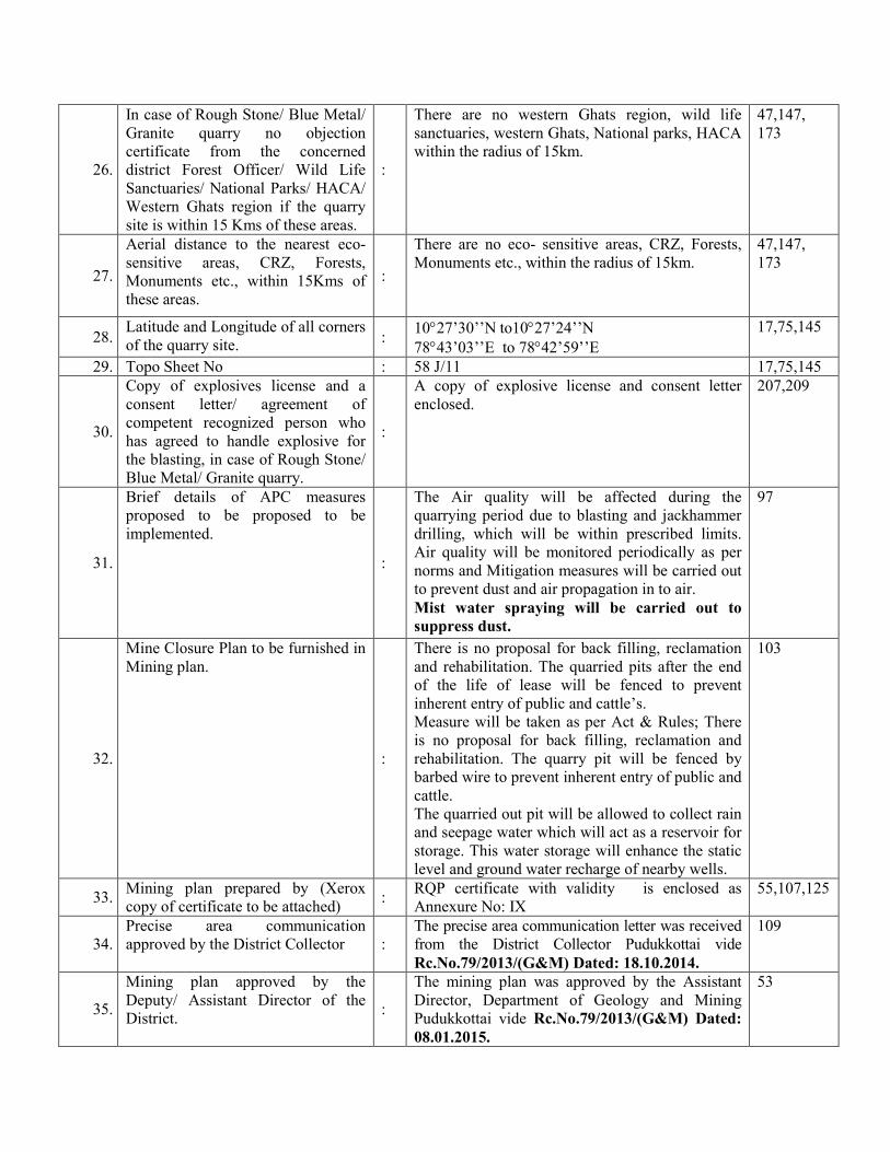
26.
In case of Rough Stone/ Blue Metal/
Granite quarry no objection
certificate from the concerned
district Forest Officer/ Wild Life
Sanctuaries/ National Parks/ HACA/
Western Ghats region if the quarry
site is within 15 Kms of these areas.
:
There are no western Ghats region, wild life
sanctuaries, western Ghats, National parks, HACA
within the radius of 15km.
47,147,
173
27.
Aerial distance to the nearest eco-
sensitive areas, CRZ, Forests,
Monuments etc., within 15Kms of
these areas.
:
There are no eco- sensitive areas, CRZ, Forests,
Monuments etc., within the radius of 15km.
47,147,
173
28. Latitude and Longitude of all corners
of the quarry site. :
10°27’30’’N to10°27’24’’N
78°43’03’’E to 78°42’59’’E
17,75,145
29. Topo Sheet No : 58 J/11 17,75,145
30.
Copy of explosives license and a
consent letter/ agreement of
competent recognized person who
has agreed to handle explosive for
the blasting, in case of Rough Stone/
Blue Metal/ Granite quarry.
:
A copy of explosive license and consent letter
enclosed.
207,209
31.
Brief details of APC measures
proposed to be proposed to be
implemented.
:
The Air quality will be affected during the
quarrying period due to blasting and jackhammer
drilling, which will be within prescribed limits.
Air quality will be monitored periodically as per
norms and Mitigation measures will be carried out
to prevent dust and air propagation in to air.
Mist water spraying will be carried out to
suppress dust.
97
32.
Mine Closure Plan to be furnished in
Mining plan.
:
There is no proposal for back filling, reclamation
and rehabilitation. The quarried pits after the end
of the life of lease will be fenced to prevent
inherent entry of public and cattle’s.
Measure will be taken as per Act & Rules; There
is no proposal for back filling, reclamation and
rehabilitation. The quarry pit will be fenced by
barbed wire to prevent inherent entry of public and
cattle.
The quarried out pit will be allowed to collect rain
and seepage water which will act as a reservoir for
storage. This water storage will enhance the static
level and ground water recharge of nearby wells.
103
33. Mining plan prepared by (Xerox
copy of certificate to be attached) :
RQP certificate with validity is enclosed as
Annexure No: IX
55,107,125
34.
Precise area communication
approved by the District Collector :
The precise area communication letter was received
from the District Collector Pudukkottai vide
Rc.No.79/2013/(G&M) Dated: 18.10.2014.
109
35.
Mining plan approved by the
Deputy/ Assistant Director of the
District. :
The mining plan was approved by the Assistant
Director, Department of Geology and Mining
Pudukkottai vide Rc.No.79/2013/(G&M) Dated:
08.01.2015.
53
Page 7
36.
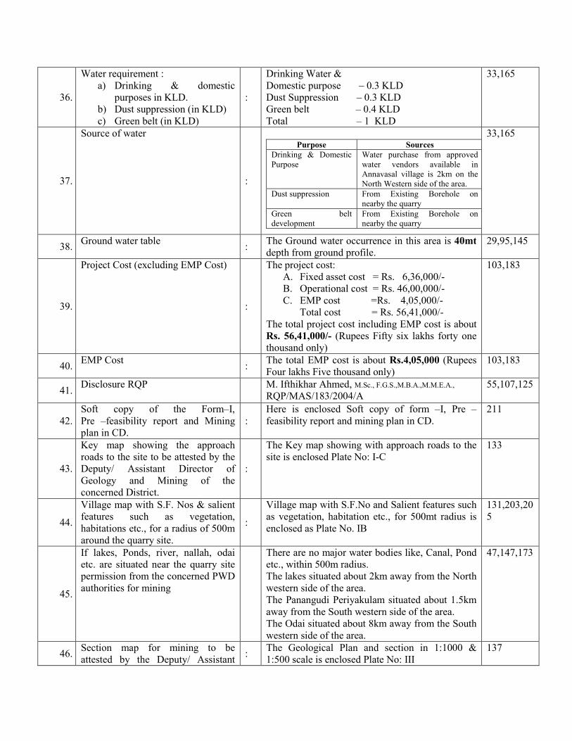
Water requirement :
a) Drinking & domestic
purposes in KLD.
b) Dust suppression (in KLD)
c) Green belt (in KLD)
:
Drinking Water &
Domestic purpose – 0.3 KLD
Dust Suppression – 0.3 KLD
Green belt – 0.4 KLD
Total – 1 KLD
33,165
37.
Source of water
:
Purpose Sources
Drinking & Domestic
Purpose
Water purchase from approved
water vendors available in
Annavasal village is 2km on the
North Western side of the area.
Dust suppression From Existing Borehole on
nearby the quarry
Green belt
development
From Existing Borehole on
nearby the quarry
33,165
38. Ground water table
: The Ground water occurrence in this area is 40mt
depth from ground profile.
29,95,145
39.
Project Cost (excluding EMP Cost)
:
The project cost:
A. Fixed asset cost = Rs. 6,36,000/-
B. Operational cost = Rs. 46,00,000/-
C. EMP cost =Rs. 4,05,000/-
Total cost = Rs. 56,41,000/-
The total project cost including EMP cost is about
Rs. 56,41,000/- (Rupees Fifty six lakhs forty one
thousand only)
103,183
40. EMP Cost
: The total EMP cost is about Rs.4,05,000 (Rupees
Four lakhs Five thousand only)
103,183
41. Disclosure RQP
M. Ifthikhar Ahmed, M.Sc., F.G.S.,M.B.A.,M.M.E.A.,
RQP/MAS/183/2004/A
55,107,125
42.
Soft copy of the Form–I,
Pre –feasibility report and Mining
plan in CD.
:
Here is enclosed Soft copy of form –I, Pre –
feasibility report and mining plan in CD.
211
43.
Key map showing the approach
roads to the site to be attested by the
Deputy/ Assistant Director of
Geology and Mining of the
concerned District.
:
The Key map showing with approach roads to the
site is enclosed Plate No: I-C
133
44.
Village map with S.F. Nos & salient
features such as vegetation,
habitations etc., for a radius of 500m
around the quarry site.
:
Village map with S.F.No and Salient features such
as vegetation, habitation etc., for 500mt radius is
enclosed as Plate No. IB
131,203,20
5
45.
If lakes, Ponds, river, nallah, odai
etc. are situated near the quarry site
permission from the concerned PWD
authorities for mining
There are no major water bodies like, Canal, Pond
etc., within 500m radius.
The lakes situated about 2km away from the North
western side of the area.
The Panangudi Periyakulam situated about 1.5km
away from the South western side of the area.
The Odai situated about 8km away from the South
western side of the area.
47,147,173
46. Section map for mining to be
attested by the Deputy/ Assistant :
The Geological Plan and section in 1:1000 &
1:500 scale is enclosed Plate No: III
137
Page 8
Director of Geology and Mining of
the concerned District.
47.
Photograph of the proposed Mining
site with S.No and attested by at
least VAO.
:
The Photo of the Mines site attached by VAO is
enclosed.
171
48. Form –I To be signed by applicant : I am hereby signed 51
49. Pre- Feasibility Report to be signed
by Both applicant and RQP. :
Pre-feasibility report has been signed by the
applicant and RQP
187
50.
First and last page and the page at
which quantity of mining has been
worked out to be signed by the
Deputy/Assistant Director of
Geology and Mining of the
concerned District.
:
First page and last page and the quantity proposed
in the plan have been signed by the Assistant
Director of Geology and Mining.
69,107
51.
Affidavit from the applicant that
child labour is not being employed in
the mining activity.
:
There is no child labor using in this quarry and
enclosed
203,205
52.
Affidavit from the applicant
regarding planting of trees around
the quarry site in fulfillment of the
Green belt commitment furnished.
:
Affidavit from the applicant regarding the
proposal for planting trees around the quarry and
fulfillment of greenbelt commitment is enclosed
203,205
53.
Details (POD) Regarding
communicating the proposal to the
members of the committee.
:
1. Signature of the applicant
S.Deivamani,
Page 9
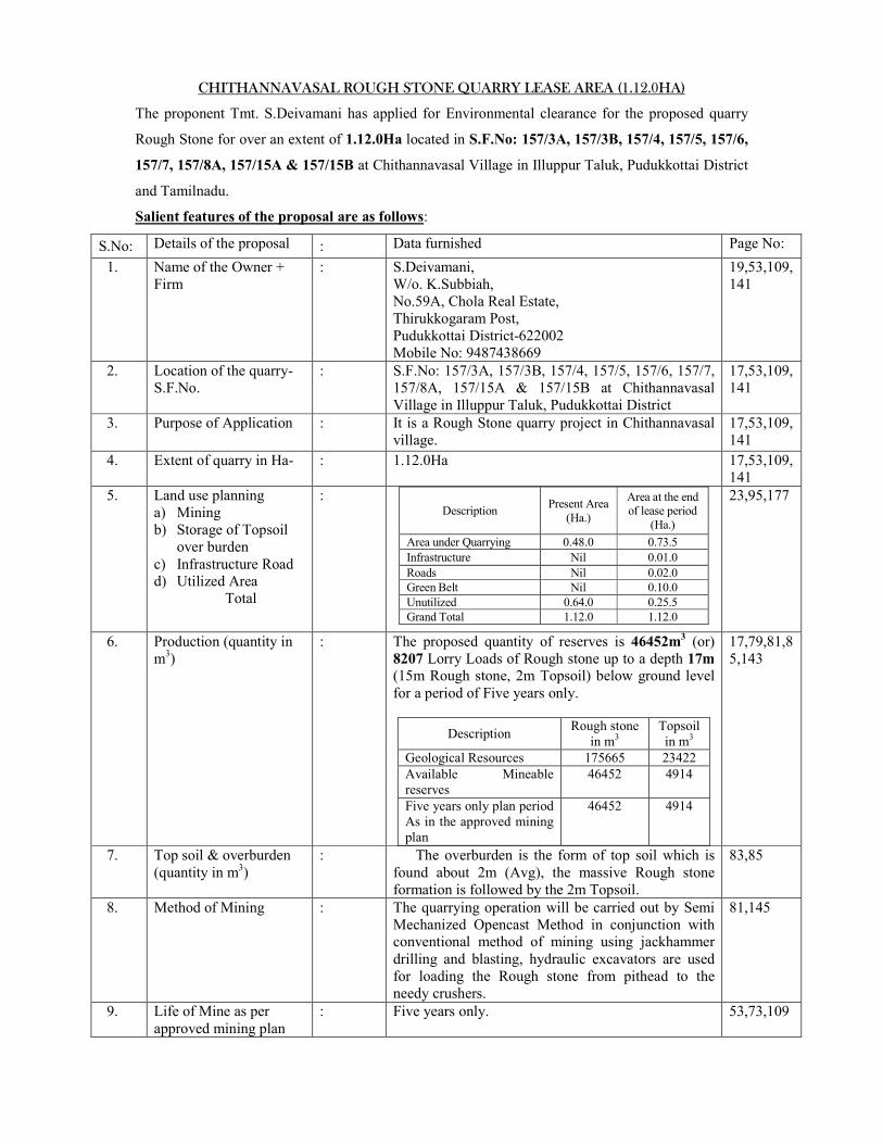
CHITHANNAVASAL ROUGH STONE QUARRY LEASE AREA (1.12.0HA)
The proponent Tmt. S.Deivamani has applied for Environmental clearance for the proposed quarry
Rough Stone for over an extent of 1.12.0Ha located in S.F.No: 157/3A, 157/3B, 157/4, 157/5, 157/6,
157/7, 157/8A, 157/15A & 157/15B at Chithannavasal Village in Illuppur Taluk, Pudukkottai District
and Tamilnadu.
Salient features of the proposal are as follows:
S.No: Details of the proposal : Data furnished Page No:
1. Name of the Owner +
Firm
: S.Deivamani,
W/o. K.Subbiah,
No.59A, Chola Real Estate,
Thirukkogaram Post,
Pudukkottai District-622002
Mobile No: 9487438669
19,53,109,
141
2. Location of the quarry-
S.F.No.
: S.F.No: 157/3A, 157/3B, 157/4, 157/5, 157/6, 157/7,
157/8A, 157/15A & 157/15B at Chithannavasal
Village in Illuppur Taluk, Pudukkottai District
17,53,109,
141
3. Purpose of Application : It is a Rough Stone quarry project in Chithannavasal
village.
17,53,109,
141
4. Extent of quarry in Ha- : 1.12.0Ha 17,53,109,141
5. Land use planning
a) Mining
b) Storage of Topsoil
over burden
c) Infrastructure Road d) Utilized Area
Total
:
Description Present Area
(Ha.)
Area at the end of lease period
(Ha.)
Area under Quarrying 0.48.0 0.73.5
Infrastructure Nil 0.01.0
Roads Nil 0.02.0
Green Belt Nil 0.10.0
Unutilized 0.64.0 0.25.5
Grand Total 1.12.0 1.12.0
23,95,177
6. Production (quantity in
m3)
: The proposed quantity of reserves is 46452m3 (or)
8207 Lorry Loads of Rough stone up to a depth 17m
(15m Rough stone, 2m Topsoil) below ground level
for a period of Five years only.
Description Rough stone
in m3
Topsoil
in m3
Geological Resources 175665 23422
Available Mineable
reserves
46452 4914
Five years only plan period
As in the approved mining
plan
46452 4914
17,79,81,8
5,143
7. Top soil & overburden
(quantity in m3)
: The overburden is the form of top soil which is
found about 2m (Avg), the massive Rough stone
formation is followed by the 2m Topsoil.
83,85
8. Method of Mining : The quarrying operation will be carried out by Semi
Mechanized Opencast Method in conjunction with conventional method of mining using jackhammer
drilling and blasting, hydraulic excavators are used
for loading the Rough stone from pithead to the
needy crushers.
81,145
9. Life of Mine as per
approved mining plan
: Five years only. 53,73,109
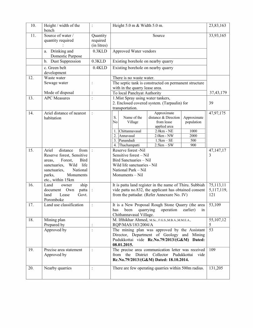
Page 10
10. Height / width of the bench
: Height 5.0 m & Width 5.0 m. 23,83,163
11. Source of water / quantity required
:
Quantity required
(in litres)
Source
33,93,165
a. Drinking and
Domestic Purpose
0.3KLD Approved Water vendors
b. Dust Suppression 0.3KLD Existing borehole on nearby quarry
c. Green belt
development
0.4KLD Existing borehole on nearby quarry
12. Waste water
Sewage water
Mode of disposal
:
:
There is no waste water.
37,43,179
The septic tank is constructed on permanent structure with in the quarry lease area.
To local Panchyat Authority
13. APC Measures : 1.Mist Spray using water tankers,
2. Enclosed covered system. (Tarpaulin) for
transportation.
39
14. Ariel distance of nearest
habitation
: S.
No
Name of the
Village
Approximate
distance & Direction
from lease
applied area
Approximate
population
1. Chittannavasal 2.0km - NE 1000
2. Annavasal 2.0km - NW 2000
3. Panandudi 1.5km – SE 500
4. Thachampatti 2.5km – SW 900
47,97,175
15. Ariel distance from
Reserve forest, Sensitive
areas, Forest, Bird
sanctuaries, Wild life
sanctuaries, National
parks, Monuments etc., within 15km
: Reserve forest -Nil
Sensitive forest – Nil
Bird Sanctuaries – Nil
Wild life sanctuaries - Nil
National Park – Nil
Monuments – Nil
47,147,17
3
16. Land owner ship document Own patta
land Lease Govt.
Poromboke
:
It is patta land register in the name of Thiru. Subbiah vide patta no.832, the applicant has obtained consent
from the pattadar. (Refer Annexure No. IV)
75,113,115,117,119,
121
17. Land use classification : It is a New Proposal Rough Stone Quarry (the area
has been quarrying operation earlier) in
Chithannavasal Village.
53,109
18. Mining plan
Prepared by
:
M. Ifthikhar Ahmed, M.Sc., F.G.S.,M.B.A.,M.M.E.A.,
RQP/MAS/183/2004/A
55,107,12
5
Approved by : The mining plan was approved by the Assistant
Director, Department of Geology and Mining
Pudukkottai vide Rc.No.79/2013/(G&M) Dated:
08.01.2015.
53
19. Precise area statement
Approved by
: The precise area communication letter was received
from the District Collector Pudukkottai vide
Rc.No.79/2013/(G&M) Dated: 18.10.2014.
109
20. Nearby quarries : There are few operating quarries within 500m radius. 131,205
Page 11
21. Nearby lake / river/ odai / channel etc.
: There are no major water bodies like, Canal, Pond etc., within 500m radius.
The lakes situated about 2km away from the North
western side of the area. The Panangudi Periyakulam situated about 1.5km
away from the South western side of the area.
The Odai situated about 8km away from the South
western side of the area.
47,147,173
22. Latitude / Longitude : 10°27’30’’N to10°27’24’’N
78°43’03’’E to 78°42’59’’E
17,75,145
23. GI Sheet No. : 58 J/11 17,75,145
24. Project Cost(Project cost
+ EMP cost)
: The project cost:
A. Fixed asset cost = Rs. 6,36,000/-
B. Operational cost = Rs. 46,00,000/-
C. EMP cost =Rs. 4,05,000/-
Total cost = Rs. 56,41,000/-
The total project cost including EMP cost is about
Rs. 56,41,000/- (Rupees Fifty six lakhs forty one
thousand only)
103,183
25. EMP Cost (Capital and recurring)
: The total EMP cost is about Rs.4,05,000 (Rupees Four lakhs Five thousand only)
103,183
26. Water table : The Ground water occurrence in this area is 40mt depth from ground profile.
29,95,145
27. Interstate boundary : There is no interstate boundary within the radius of 15km.
47,147,173
28. Western Ghats : There is no western Ghats region within the radius of
15km.
47,147,17
3
Page 12
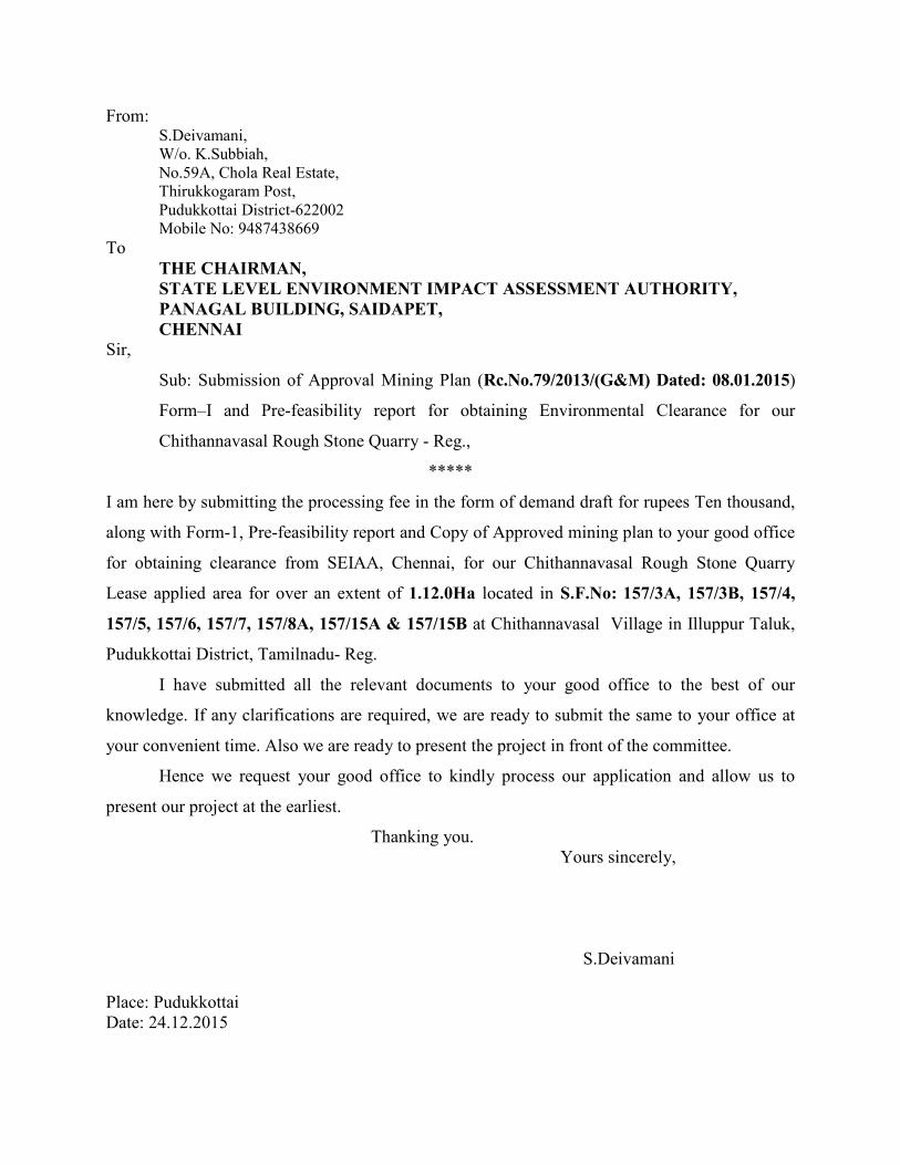
From: S.Deivamani,
W/o. K.Subbiah,
No.59A, Chola Real Estate,
Thirukkogaram Post,
Pudukkottai District-622002
Mobile No: 9487438669 To
THE CHAIRMAN,
STATE LEVEL ENVIRONMENT IMPACT ASSESSMENT AUTHORITY,
PANAGAL BUILDING, SAIDAPET,
CHENNAI
Sir,
Sub: Submission of Approval Mining Plan (Rc.No.79/2013/(G&M) Dated: 08.01.2015)
Form–I and Pre-feasibility report for obtaining Environmental Clearance for our
Chithannavasal Rough Stone Quarry - Reg.,
*****
I am here by submitting the processing fee in the form of demand draft for rupees Ten thousand,
along with Form-1, Pre-feasibility report and Copy of Approved mining plan to your good office
for obtaining clearance from SEIAA, Chennai, for our Chithannavasal Rough Stone Quarry
Lease applied area for over an extent of 1.12.0Ha located in S.F.No: 157/3A, 157/3B, 157/4,
157/5, 157/6, 157/7, 157/8A, 157/15A & 157/15B at Chithannavasal Village in Illuppur Taluk,
Pudukkottai District, Tamilnadu- Reg.
I have submitted all the relevant documents to your good office to the best of our
knowledge. If any clarifications are required, we are ready to submit the same to your office at
your convenient time. Also we are ready to present the project in front of the committee.
Hence we request your good office to kindly process our application and allow us to
present our project at the earliest.
Thanking you.
Yours sincerely,
S.Deivamani
Place: Pudukkottai
Date: 24.12.2015